Embed Size (px)
Citation preview
L E A R N I N G O U T C O M E S
• explain the purpose of latitude, longitude, parallels, and meridians
• locate on a world map the continents, major landforms, majorbodies of water, and climatic and vegetation zones
• appreciate the diversity of the global natural environment
Place and LocationPlace and Location11absolute locationboundariescharacteristicsclimatecoordinate systemdividedrainage basineastingsecozoneEl Niñofunctional characteristicsgeologic regionsGlobal Positioning System
(GPS)gridhuman characteristicslandform regionslatitudelocationlongitudenatural forcesnorthingsphysical characteristicsphysical regionsregionrural regionssoil regionstime zonesurban regionsvegetationwilderness regions
KEY VOCABULARYKEY VOCABULARY
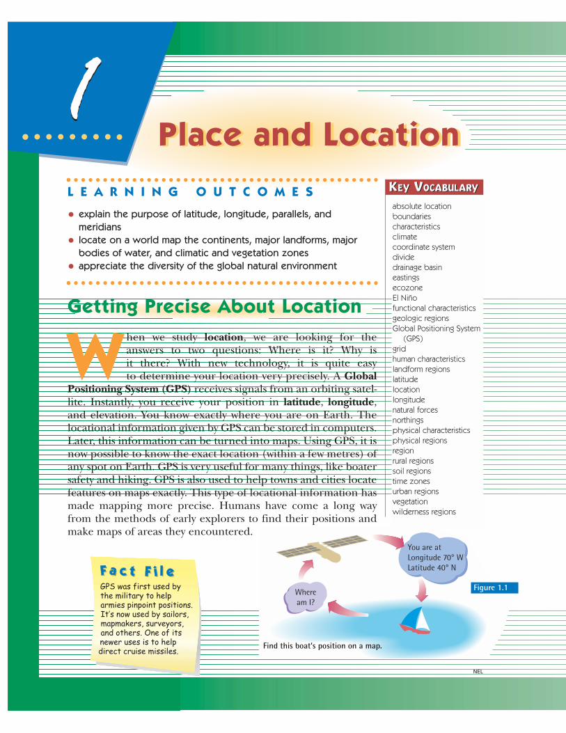
Getting Precise About Location
W hen we study location, we are looking for theanswers to two questions: Where is it? Why is it there? With new technology, it is quite easy to determine your location very precisely. A Global
Positioning System (GPS) receives signals from an orbiting satel-lite. Instantly, you receive your position in latitude, longitude,and elevation. You know exactly where you are on Earth. Thelocational information given by GPS can be stored in computers.Later, this information can be turned into maps. Using GPS, it isnow possible to know the exact location (within a few metres) ofany spot on Earth. GPS is very useful for many things, like boatersafety and hiking. GPS is also used to help towns and cities locatefeatures on maps exactly. This type of locational information hasmade mapping more precise. Humans have come a long wayfrom the methods of early explorers to find their positions andmake maps of areas they encountered.
NEL
Find this boat’s position on a map.
Wheream I?
You are atLongitude 70° W Latitude 40° N
Figure 1.1GPS was first used by the military to help armies pinpoint positions. It’s now used by sailors, mapmakers, surveyors, and others. One of its newer uses is to help direct cruise missiles.
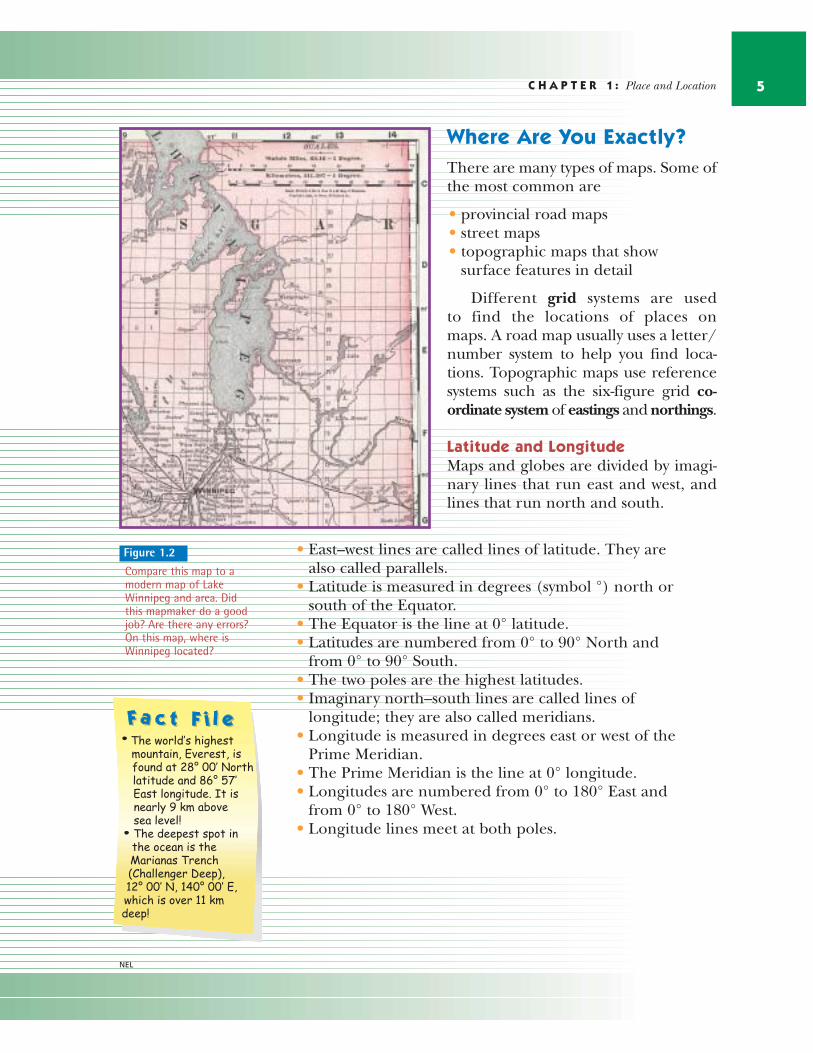
C H A P T E R 1 : Place and Location 5
Where Are You Exactly?There are many types of maps. Some ofthe most common are
• provincial road maps• street maps• topographic maps that show
surface features in detail
Different grid systems are used to find the locations of places on maps. A road map usually uses a letter/number system to help you find loca-tions. Topographic maps use referencesystems such as the six-figure grid co-ordinate system of eastings and northings.
Latitude and Longitude Maps and globes are divided by imagi-nary lines that run east and west, andlines that run north and south.
• East–west lines are called lines of latitude. They arealso called parallels.
• Latitude is measured in degrees (symbol °) north orsouth of the Equator.
• The Equator is the line at 0° latitude.• Latitudes are numbered from 0° to 90° North and
from 0° to 90° South. • The two poles are the highest latitudes.• Imaginary north–south lines are called lines of
longitude; they are also called meridians.• Longitude is measured in degrees east or west of the
Prime Meridian.• The Prime Meridian is the line at 0° longitude.• Longitudes are numbered from 0° to 180° East and
from 0° to 180° West.• Longitude lines meet at both poles.
Figure 1.2
Compare this map to amodern map of LakeWinnipeg and area. Didthis mapmaker do a goodjob? Are there any errors?On this map, where isWinnipeg located?
NEL
Absolute LocationIt is important to be able to locate places precisely. We needto be able to give the absolute location of a spot on Earth.When natural resources are found, the absolute locationmust be determined. The absolute location makes theresources the property of one country and not another.Suppose oil is found along the border of two countries witha clearly defined boundary. It is important to know exactlywhere the oil field lies to determine who owns it.
Oil was discovered in the Gulf of Mexico. Part of the Gulfbelongs to the United States. Part belongs to Mexico. It wasvery important to find out how much of the oil was in theUnited States and how much was inMexico. Canada and the United States dis-pute who has the right to fish for salmon inparts of the Pacific Ocean. They need toknow the absolute locations of the bound-aries between the states of Washingtonand Alaska with the province of BritishColumbia. Absolute location affects tradeand economic growth. It is also importantto help resolve conflictbetween groups, com-panies, or countries.
U N I T 1 : Investigating Geography6
NEL
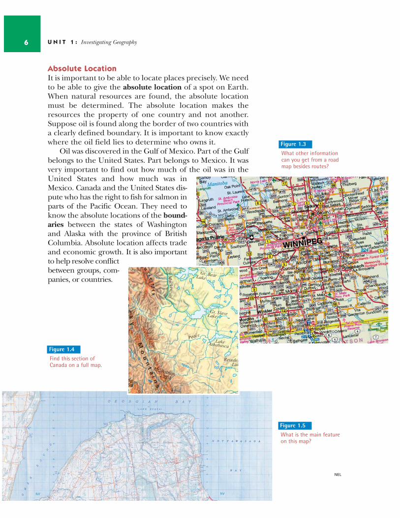
Figure 1.3
What other informationcan you get from a roadmap besides routes?
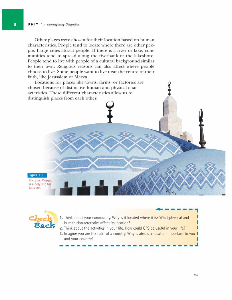
Figure 1.5
What is the main featureon this map?
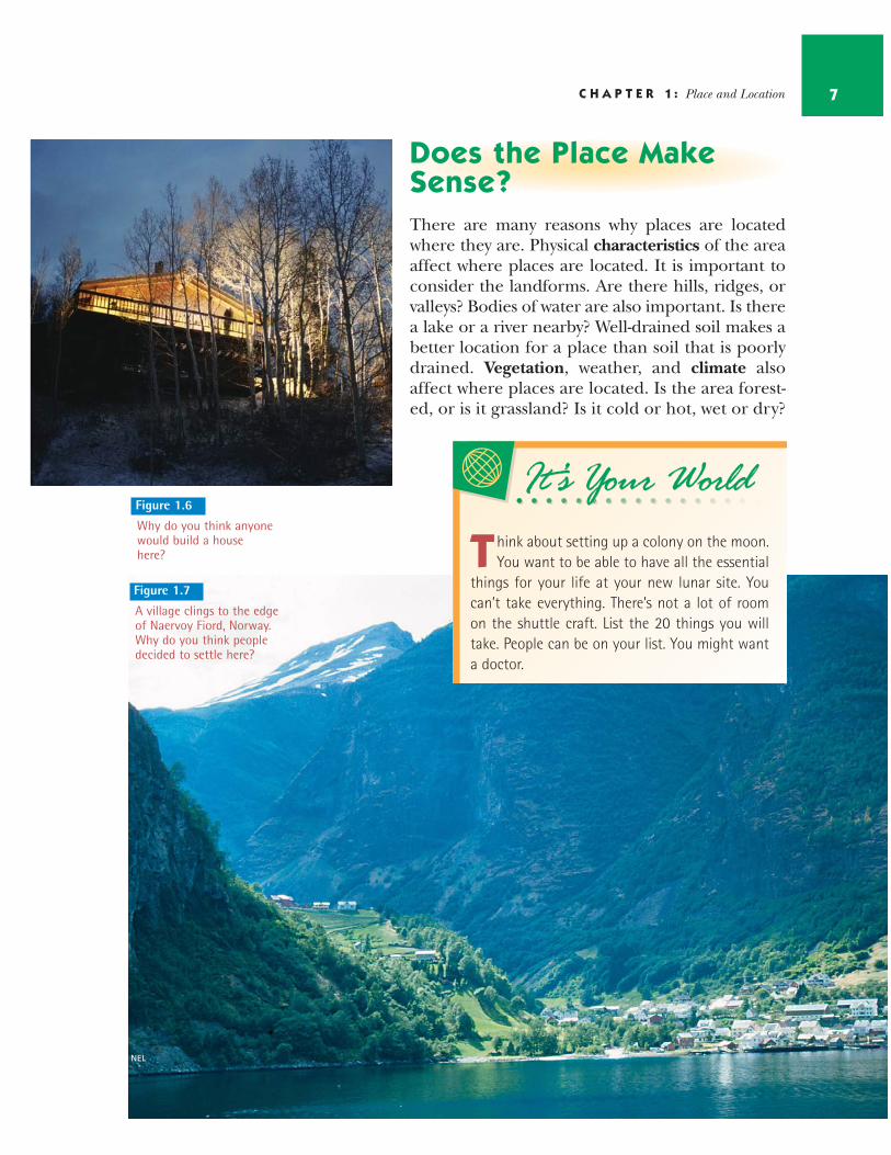
Figure 1.4
Find this section ofCanada on a full map.
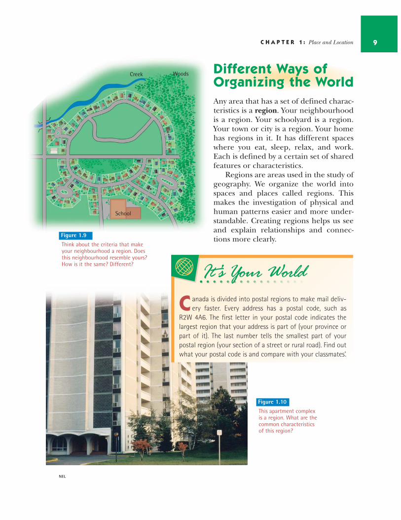
Does the Place MakeSense?There are many reasons why places are locatedwhere they are. Physical characteristics of the areaaffect where places are located. It is important toconsider the landforms. Are there hills, ridges, orvalleys? Bodies of water are also important. Is therea lake or a river nearby? Well-drained soil makes abetter location for a place than soil that is poorlydrained. Vegetation, weather, and climate alsoaffect where places are located. Is the area forest-ed, or is it grassland? Is it cold or hot, wet or dry?
C H A P T E R 1 : Place and Location 7
Figure 1.6It’s Your WorldIt’s Your World
T hink about setting up a colony on the moon.You want to be able to have all the essential
things for your life at your new lunar site. Youcan’t take everything. There’s not a lot of roomon the shuttle craft. List the 20 things you willtake. People can be on your list. You might wanta doctor.
Figure 1.7
A village clings to the edge of Naervoy Fiord, Norway. Why do you think peopledecided to settle here?
Why do you think anyonewould build a househere?
NEL
Other places were chosen for their location based on humancharacteristics. People tend to locate where there are other peo-ple. Large cities attract people. If there is a river or lake, com-munities tend to spread along the riverbank or the lakeshore.People tend to live with people of a cultural background similarto their own. Religious reasons can also affect where peoplechoose to live. Some people want to live near the centre of theirfaith, like Jerusalem or Mecca.
Locations for places like towns, farms, or factories arechosen because of distinctive human and physical char-acteristics. These different characteristics allow us to distinguish places from each other.
U N I T 1 : Investigating Geography8
NEL
1. Think about your community. Why is it located where it is? What physical andhuman characteristics affect its location?
2. Think about the activities in your life. How could GPS be useful in your life? 3. Imagine you are the ruler of a country. Why is absolute location important to you
and your country?
Figure 1.8
The Blue Mosqueis a holy site forMuslims.
Different Ways of Organizing the WorldAny area that has a set of defined charac-teristics is a region. Your neighbourhoodis a region. Your schoolyard is a region.Your town or city is a region. Your homehas regions in it. It has different spaceswhere you eat, sleep, relax, and work.Each is defined by a certain set of sharedfeatures or characteristics.
Regions are areas used in the study ofgeography. We organize the world intospaces and places called regions. Thismakes the investigation of physical andhuman patterns easier and more under-standable. Creating regions helps us seeand explain relationships and connec-tions more clearly.
C H A P T E R 1 : Place and Location 9
NEL
It’s Your WorldIt’s Your World
C anada is divided into postal regions to make mail deliv-ery faster. Every address has a postal code, such as
R2W 4A6. The first letter in your postal code indicates thelargest region that your address is part of (your province orpart of it). The last number tells the smallest part of yourpostal region (your section of a street or rural road). Find outwhat your postal code is and compare with your classmates’.
Figure 1.10
This apartment complexis a region. What are thecommon characteristicsof this region?
Creek Woods
School
Figure 1.9
Think about the criteria that makeyour neighbourhood a region. Doesthis neighbourhood resemble yours? How is it the same? Different?
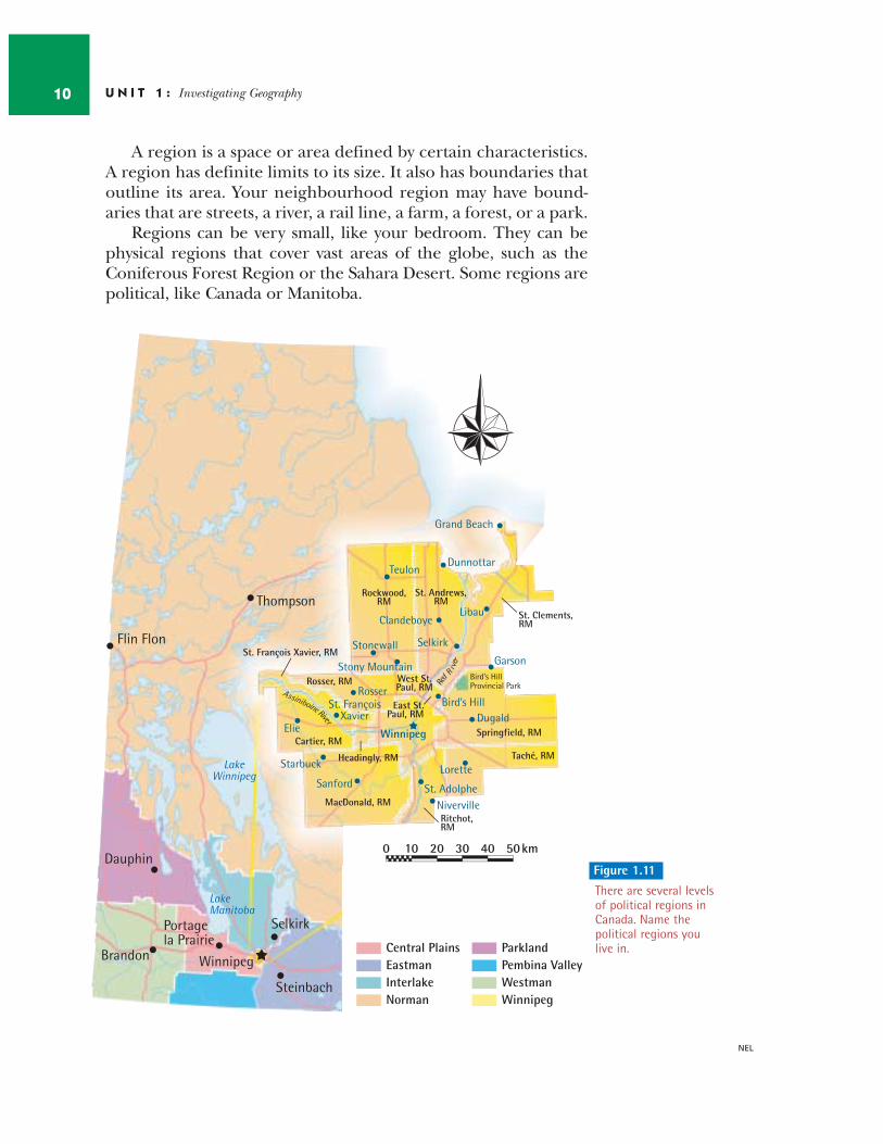
A region is a space or area defined by certain characteristics.A region has definite limits to its size. It also has boundaries thatoutline its area. Your neighbourhood region may have bound-aries that are streets, a river, a rail line, a farm, a forest, or a park.
Regions can be very small, like your bedroom. They can bephysical regions that cover vast areas of the globe, such as theConiferous Forest Region or the Sahara Desert. Some regions arepolitical, like Canada or Manitoba.
U N I T 1 : Investigating Geography10
Winnipeg
Thompson
Flin Flon
Dauphin
Portage la Prairie
Brandon
Steinbach
Selkirk
Lake Winnipeg
Lake Manitoba
Winnipeg
Central Plains Eastman Interlake Norman
Parkland Pembina Valley Westman
Bird’s Hill Provincial Park Re
d Riv
er
Assiniboine River
St. François Xavier, RM
Rosser, RM
Cartier, RM
Headingly, RM
West St. Paul, RM
Springfield, RM
Taché, RM
MacDonald, RM
Ritchot, RM
East St. Paul, RM
St. Andrews, RM
St. Clements, RM
Rockwood, RM
Grand Beach
Teulon Dunnottar
Clandeboye Libau
Selkirk Stonewall
Stony Mountain
Rosser
Elie
St. François Xavier
Garson
Bird’s Hill Dugald
Winnipeg
Lorette
St. Adolphe Niverville
Sanford
Starbuck
0 10 20 30 40 50 km
Figure 1.11
There are several levelsof political regions inCanada. Name thepolitical regions youlive in.
NEL
C H A P T E R 1 : Place and Location 11
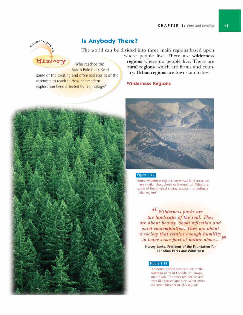
Is Anybody There?The world can be divided into three main regions based upon
where people live. There are wildernessregions where no people live. There arerural regions, which are farms and coun-try. Urban regions are towns and cities.
Wilderness Regions
NEL
C
ONNECTION
STO
C
ONNECTION
STO
HistoryHistoryHistoryWho reached the
South Pole first? Readsome of the exciting and often sad stories of theattempts to reach it. How has modernexploration been affected by technology?
QW ilderness parks arethe landscape of the soul. They
are about beauty, about reflection and quiet contemplation. They are about
a society that retains enough humility to leave some part of nature alone...
Harvey Locke, President of the Foundation forCanadian Parks and Wilderness
“
”
Figure 1.12
Some wilderness regions cover vast land areas buthave similar characteristics throughout. What aresome of the physical characteristics that define apolar region?
Figure 1.13
The Boreal Forest covers much of thenorthern parts of Canada, of Europe,and of Asia. The trees are needle-leaftrees like spruce and pine. What othercharacteristics define this region?
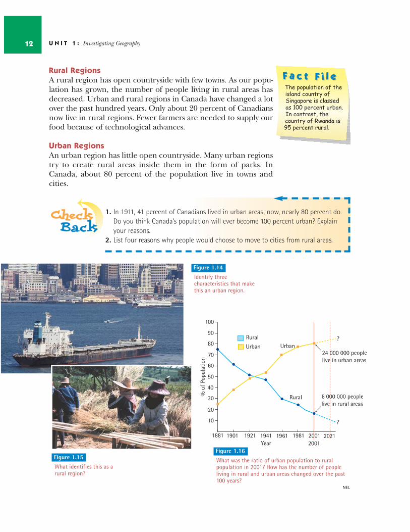
Rural RegionsA rural region has open countryside with few towns. As our popu-lation has grown, the number of people living in rural areas hasdecreased. Urban and rural regions in Canada have changed a lotover the past hundred years. Only about 20 percent of Canadiansnow live in rural regions. Fewer farmers are needed to supply ourfood because of technological advances.
Urban RegionsAn urban region has little open countryside. Many urban regionstry to create rural areas inside them in the form of parks. InCanada, about 80 percent of the population live in towns andcities.
U N I T 1 : Investigating Geography12
NEL
The population of the island country of Singapore is classed as 100 percent urban. In contrast, the country of Rwanda is 95 percent rural.
1. In 1911, 41 percent of Canadians lived in urban areas; now, nearly 80 percent do.Do you think Canada’s population will ever become 100 percent urban? Explainyour reasons.
2. List four reasons why people would choose to move to cities from rural areas.
10
20
30
40
50
60
80
70
90
100
1881 1901 1921 1941 1961 198120012001 2021
Rural
Rural
Urban Urban
Year
% o
f Po
pula
tion
24 000 000 peoplelive in urban areas
6 000 000 peoplelive in rural areas
?
?
Figure 1.15
What identifies this as arural region?
Figure 1.14
Identify threecharacteristics that makethis an urban region.
Figure 1.16
What was the ratio of urban population to ruralpopulation in 2001? How has the number of peopleliving in rural and urban areas changed over the past100 years?
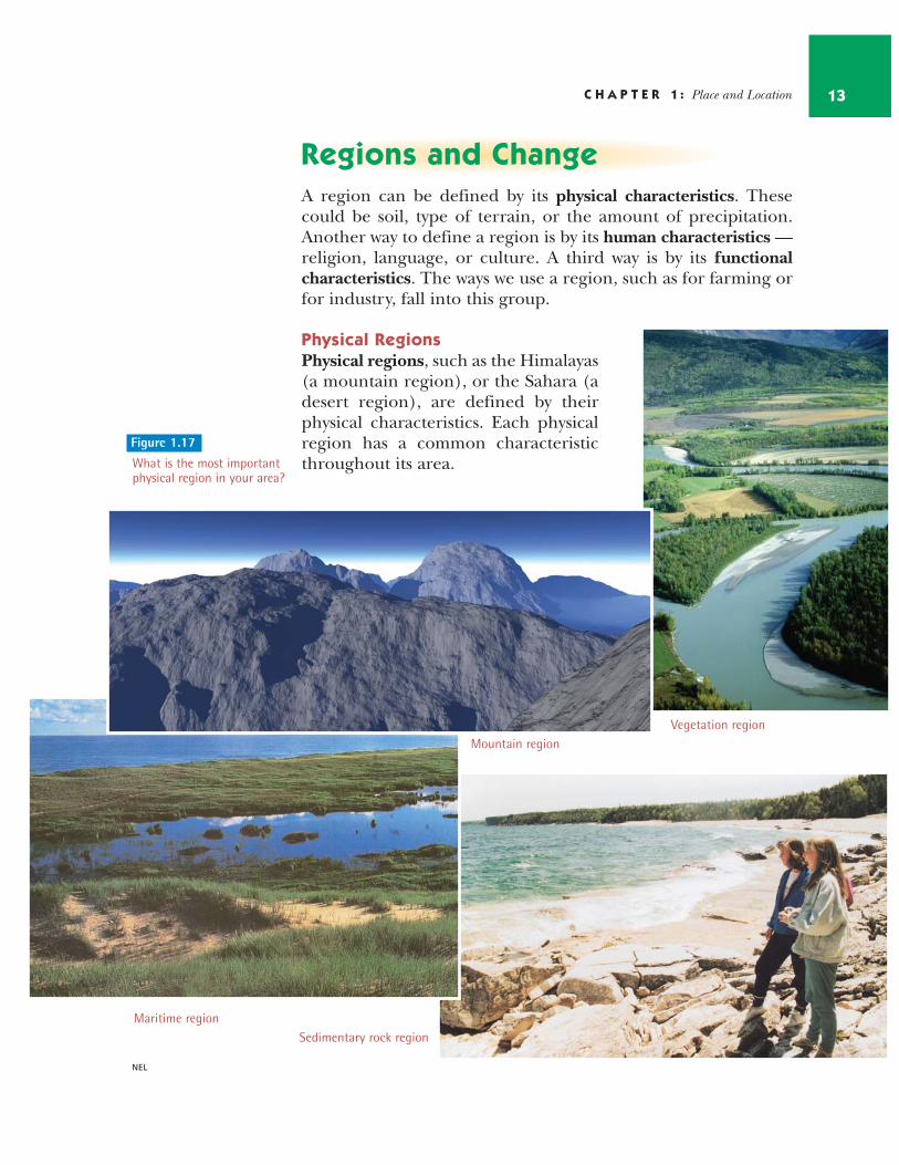
Regions and ChangeA region can be defined by its physical characteristics. Thesecould be soil, type of terrain, or the amount of precipitation.Another way to define a region is by its human characteristics —religion, language, or culture. A third way is by its functionalcharacteristics. The ways we use a region, such as for farming orfor industry, fall into this group.
Physical RegionsPhysical regions, such as the Himalayas(a mountain region), or the Sahara (adesert region), are defined by theirphysical characteristics. Each physicalregion has a common characteristicthroughout its area.
C H A P T E R 1 : Place and Location 13
NEL
Sedimentary rock region
Mountain regionVegetation region
Figure 1.17
What is the most importantphysical region in your area?
Maritime region
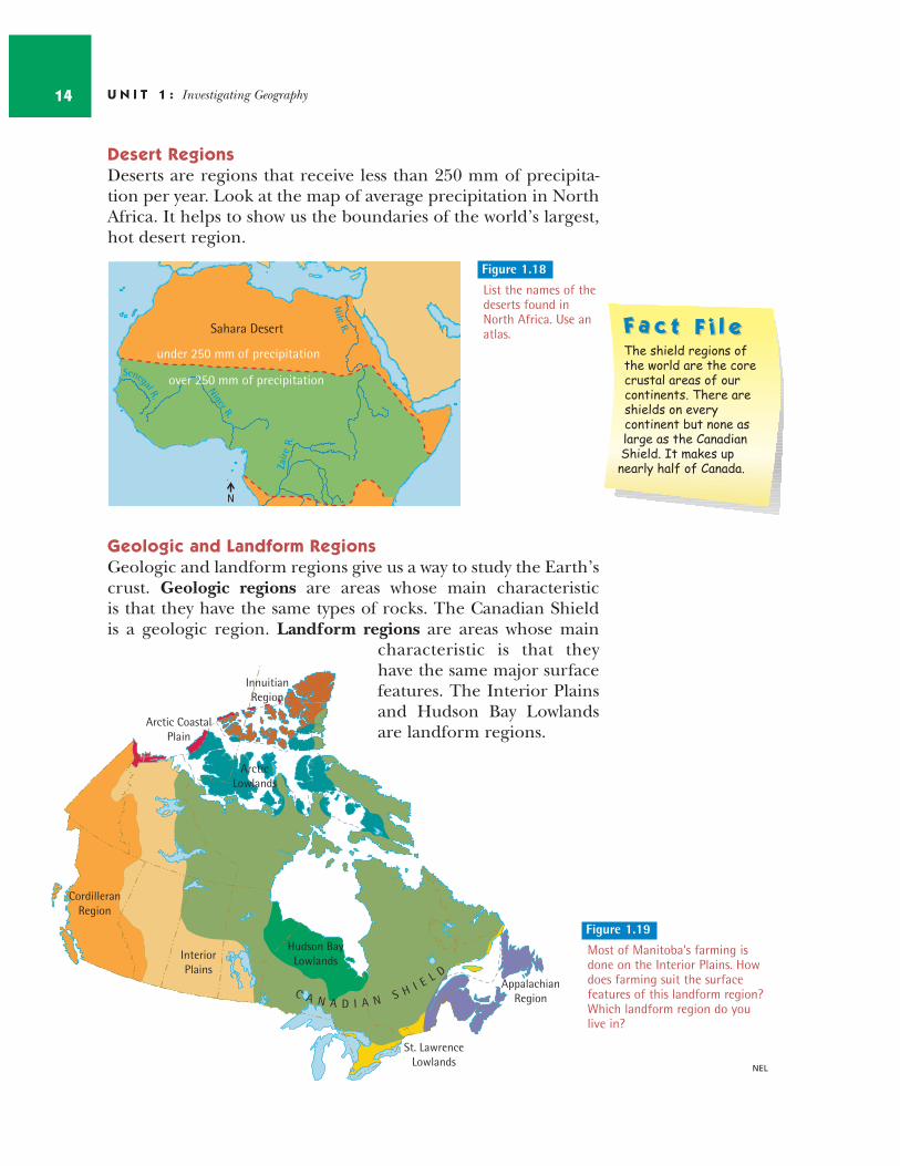
Desert RegionsDeserts are regions that receive less than 250 mm of precipita-tion per year. Look at the map of average precipitation in NorthAfrica. It helps to show us the boundaries of the world’s largest,hot desert region.
Geologic and Landform RegionsGeologic and landform regions give us a way to study the Earth’scrust. Geologic regions are areas whose main characteristic is that they have the same types of rocks. The Canadian Shield is a geologic region. Landform regions are areas whose main
characteristic is that theyhave the same major surfacefeatures. The Interior Plainsand Hudson Bay Lowlandsare landform regions.
U N I T 1 : Investigating Geography14
NEL
Figure 1.18
List the names of thedeserts found inNorth Africa. Use anatlas.
Niger R.
Senegal R.
Nile
R.
Zaire
R.
under 250 mm of precipitation
over 250 mm of precipitationover 250 mm of precipitationover 250 mm of precipitation
Sahara Desert
N
Arctic CoastalPlain
CordilleranRegion
InteriorPlains
St. LawrenceLowlands
AppalachianRegion
InnuitianRegion
ArcticLowlands
Hudson BayLowlands
C A N A D I A N S H I E L D
The shield regions of the world are the core crustal areas of our continents. There are shields on every continent but none as large as the Canadian Shield. It makes up nearly half of Canada.
Figure 1.19
Most of Manitoba's farming isdone on the Interior Plains. Howdoes farming suit the surfacefeatures of this landform region?Which landform region do youlive in?
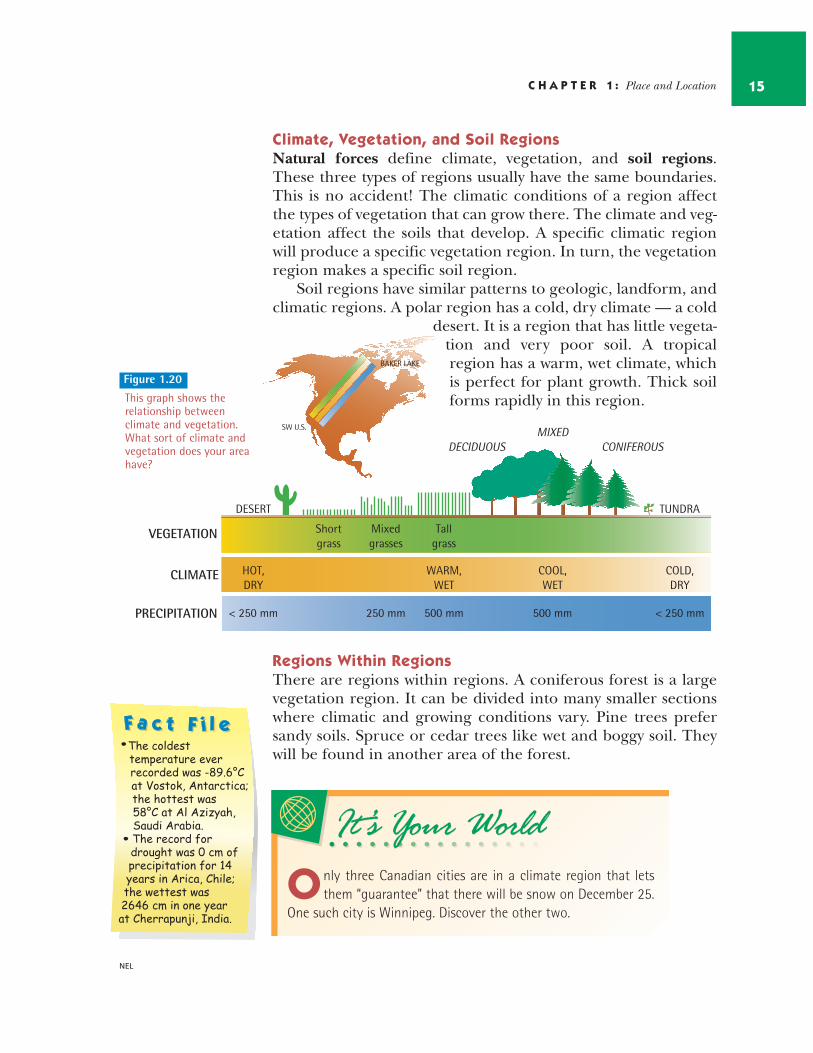
Climate, Vegetation, and Soil RegionsNatural forces define climate, vegetation, and soil regions.These three types of regions usually have the same boundaries.This is no accident! The climatic conditions of a region affectthe types of vegetation that can grow there. The climate and veg-etation affect the soils that develop. A specific climatic regionwill produce a specific vegetation region. In turn, the vegetationregion makes a specific soil region.
Soil regions have similar patterns to geologic, landform, andclimatic regions. A polar region has a cold, dry climate — a cold
desert. It is a region that has little vegeta-tion and very poor soil. A tropicalregion has a warm, wet climate, whichis perfect for plant growth. Thick soilforms rapidly in this region.
Regions Within RegionsThere are regions within regions. A coniferous forest is a largevegetation region. It can be divided into many smaller sectionswhere climatic and growing conditions vary. Pine trees prefersandy soils. Spruce or cedar trees like wet and boggy soil. Theywill be found in another area of the forest.
C H A P T E R 1 : Place and Location 15
NEL
It’s Your WorldIt’s Your World
O nly three Canadian cities are in a climate region that letsthem “guarantee” that there will be snow on December 25.
One such city is Winnipeg. Discover the other two.
Figure 1.20
This graph shows therelationship betweenclimate and vegetation.What sort of climate andvegetation does your areahave?
VEGETATION
CLIMATE
PRECIPITATION
DESERT
HOT,DRY
< 250 mm 250 mm
Shortgrass
Mixedgrasses
Tallgrass
WARM,WET
500 mm
COOL,WET
500 mm
COLD,DRY
< 250 mm
TUNDRA
DECIDUOUSMIXED
CONIFEROUS
BAKER LAKE
SW U.S.

Weather Changes RegionsSometimes changes in the weather patterns inanother area of the world can cause changes inour regions. Amazingly, the pattern of ocean cur-rents over 8000 kilometres away affects our liveshere in Manitoba. El Niño is a huge mass of verywarm water that appears frequently off the coastof northern South America. Since 1985, El Niñohas affected the weather in our regions severaltimes. El Niño caused changes in our weather in1986, 1991, 1994, and 1997–98. It is difficult to pre-dict what effect an “El Niño” year will have on the
weather in North America.However, more storms,higher precipitation, andmore extreme seasonaltemperatures can result.
U N I T 1 : Investigating Geography16
NEL
El Niño is the name for warmer-than-normal sea surface temper-atures in the Pacific Ocean off the west coast of South America. La Niña is the name for colder-than- normal sea surface temperatures in the Pacific Ocean. La Niña tends to have the opposite effect on weather patterns in other regions.
1. Choose a capital city in one of the provinces of Canada. In point form, describethe physical region it is in. Think about the different ways you could describe thephysical region it is in. Think about landforms, type of rocks, climate, vegetation,and soil.
2. Describe the region you live in asa) a climate regionb) a soil regionc) a landform regiond) a vegetation region
3. Look at a map of Canada. Where do most people live? What is the connectionbetween physical regions and where most communities are located?
Figure 1.21
The strongest El Niño on recordwas in 1997–98. In that winter,western Canada was unusuallywarm, and the southern andwestern parts of the UnitedStates suffered many storms.
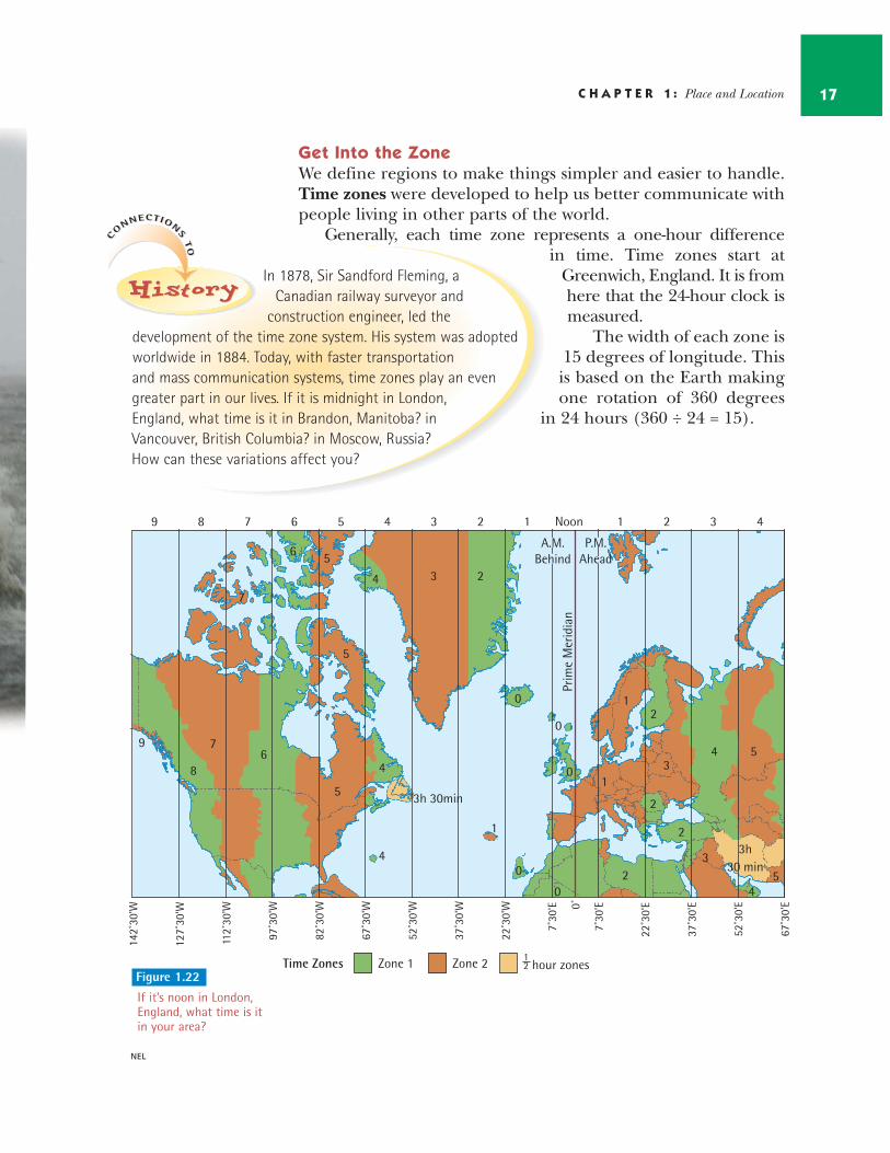
Get Into the ZoneWe define regions to make things simpler and easier to handle.Time zones were developed to help us better communicate withpeople living in other parts of the world.
Generally, each time zone represents a one-hour difference in time. Time zones start at
Greenwich, England. It is fromhere that the 24-hour clock ismeasured.
The width of each zone is15 degrees of longitude. Thisis based on the Earth makingone rotation of 360 degrees
in 24 hours (360 ÷ 24 = 15).
C H A P T E R 1 : Place and Location 17
NEL
C
ONNECTION
STO
C
ONNECTION
STO
HistoryHistoryHistoryIn 1878, Sir Sandford Fleming, a
Canadian railway surveyor andconstruction engineer, led the
development of the time zone system. His system was adoptedworldwide in 1884. Today, with faster transportation and mass communication systems, time zones play an evengreater part in our lives. If it is midnight in London, England, what time is it in Brandon, Manitoba? inVancouver, British Columbia? in Moscow, Russia?How can these variations affect you?
9 8 7 6 5 4 3 2 1 Noon 1 2 3 4
A.M.Behind
P.M.Ahead
Prim
e M
erid
ian
9
8
76
5
4
3
3h 30min
2
1
0
0
0
0
0
1
1
2
2
3
2
23
4
4
5
3h30 min
5
5
4
6 5
7
4
142˚
30'W
127˚
30'W
112˚
30'W
97˚3
0'W
82˚3
0'W
67˚3
0'W
52˚3
0'W
37˚3
0'W
22˚3
0'W
7˚30
'E
7˚30
'E
22˚3
0'E
37˚3
0'E
52˚3
0'E
67˚3
0'E0˚
Zone 1 Zone 2 1 hour zones2Time ZonesFigure 1.22
If it’s noon in London,England, what time is itin your area?
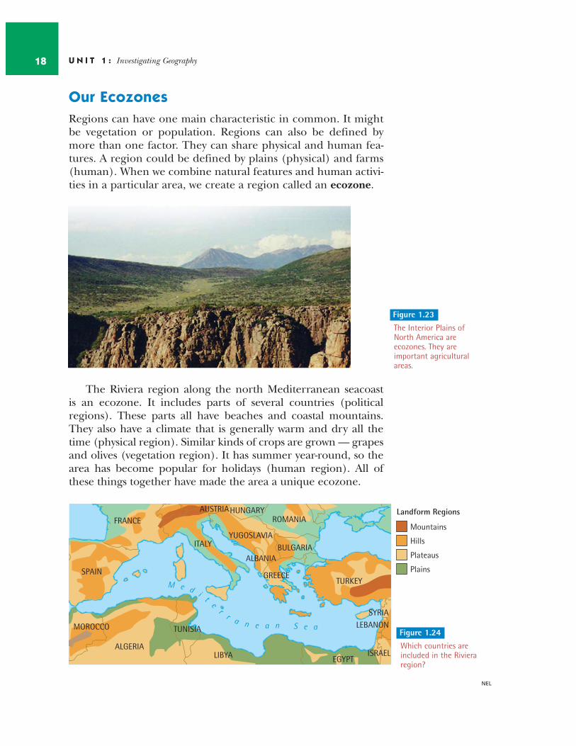
Our Ecozones Regions can have one main characteristic in common. It mightbe vegetation or population. Regions can also be defined bymore than one factor. They can share physical and human fea-tures. A region could be defined by plains (physical) and farms(human). When we combine natural features and human activi-ties in a particular area, we create a region called an ecozone.
The Riviera region along the north Mediterranean seacoast is an ecozone. It includes parts of several countries (politicalregions). These parts all have beaches and coastal mountains.They also have a climate that is generally warm and dry all thetime (physical region). Similar kinds of crops are grown — grapesand olives (vegetation region). It has summer year-round, so thearea has become popular for holidays (human region). All ofthese things together have made the area a unique ecozone.
U N I T 1 : Investigating Geography18
NEL
Figure 1.23
The Interior Plains of North America areecozones. They areimportant agriculturalareas.
ITALYYUGOSLAVIA
ROMANIA
BULGARIA
TURKEYGREECESPAIN
ALGERIA
AUSTRIA
ALBANIA
HUNGARYFRANCE
TUNISIA
LIBYA EGYPTISRAEL
SYRIALEBANONMOROCCO
M e d i te
rr a n e a n S e a
Landform Regions
Mountains
Hills
Plateaus
Plains
Figure 1.24
Which countries areincluded in the Rivieraregion?
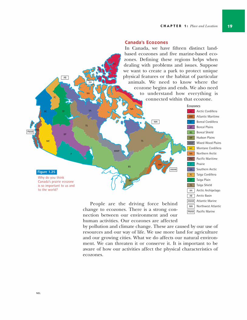
Canada’s EcozonesIn Canada, we have fifteen distinct land-based ecozones and five marine-based eco-zones. Defining these regions helps whendealing with problems and issues. Supposewe want to create a park to protect uniquephysical features or the habitat of particular
animals. We need to know where the ecozone begins and ends. We also need
to understand how everything is connected within that ecozone.
People are the driving force behindchange to ecozones. There is a strong con-nection between our environment and ourhuman activities. Our ecozones are affectedby pollution and climate change. These are caused by our use ofresources and our way of life. We use more land for agricultureand our growing cities. What we do affects our natural environ-ment. We can threaten it or conserve it. It is important to beaware of how our activities affect the physical characteristics ofecozones.
C H A P T E R 1 : Place and Location 19
NEL
Figure 1.25
Why do you thinkCanada’s prairie ecozoneis so important to us andto the world?
TS
TS
TP
TC
SA
P
PM
NA
NA
MC
MWP
HP
BS
BP
BC
AM
AC
Arctic Cordillera
Atlantic Maritime
Boreal Cordillera
Boreal Plains
Boreal Shield
Hudson Plains
Mixed Wood Plains
Montane Cordillera
Northern Arctic
Pacific Maritime
Prairie
Southern Arctic
Taiga Cordillera
Taiga Plain
Taiga Shield
Arctic Archipelago
Arctic Basin
Atlantic Marine
Northwest Atlantic
Pacific Marine
EcozonesAC
AM
BC
BP
BS
HP
MWP
MC
NA
PM
P
SA
TC
TP
TS
AA
AB
AMAR
NW
PMAR
PMAR
NW
AMAR
AB
AA
Regional BoundariesSome regional boundaries are natural.They can be rivers, the crests ofmountains, coastlines, and bodiesof water. Sometimes naturalboundaries such as mountainsact as obstacles, or barriers.Others, such as rivers, sepa-rate, but they also allow con-tact and communication.
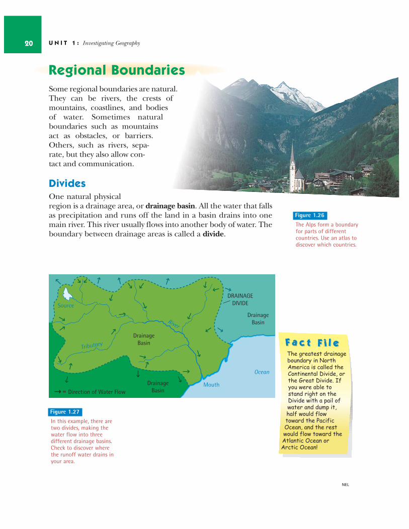
DividesOne natural physicalregion is a drainage area, or drainage basin. All the water that fallsas precipitation and runs off the land in a basin drains into onemain river. This river usually flows into another body of water. Theboundary between drainage areas is called a divide.
U N I T 1 : Investigating Geography20
NEL
Direction of Water Flow
DrainageBasin
DrainageBasin
Ocean
DrainageBasin
DRAINAGEDIVIDE
=
Source
Mouth
River
Tributary
Figure 1.26
The Alps form a boundaryfor parts of differentcountries. Use an atlas todiscover which countries.
Figure 1.27
In this example, there aretwo divides, making thewater flow into threedifferent drainage basins.Check to discover wherethe runoff water drains inyour area.
The greatest drainage boundary in North America is called the Continental Divide, or the Great Divide. If you were able to stand right on the Divide with a pail of water and dump it, half would flow toward the Pacific Ocean, and the rest would flow toward the Atlantic Ocean or Arctic Ocean!
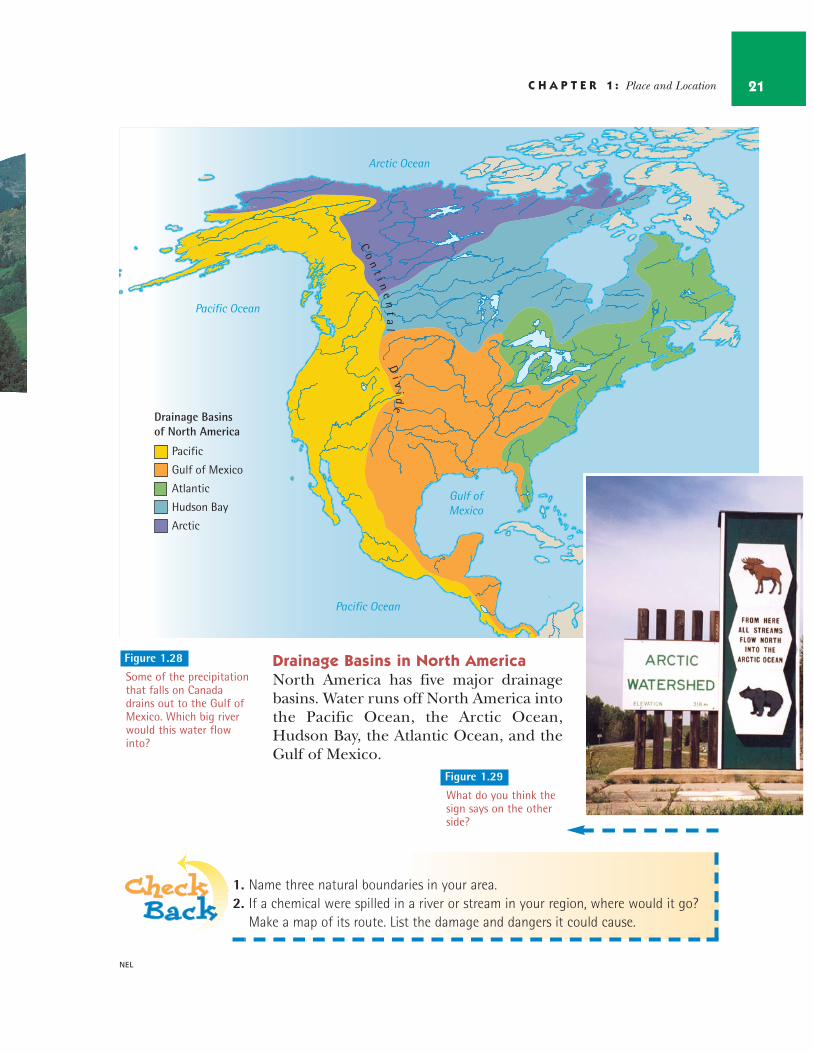
Drainage Basins in North AmericaNorth America has five major drainagebasins. Water runs off North America intothe Pacific Ocean, the Arctic Ocean,Hudson Bay, the Atlantic Ocean, and theGulf of Mexico.
C H A P T E R 1 : Place and Location 21
NEL
Drainage Basins of North America
Pacific
Gulf of Mexico
Atlantic
Hudson Bay
Arctic
Arctic Ocean
Atlantic Ocean
Pacific Ocean
Pacific Ocean
Gulf ofMexico
Co
nt
i ne
nt
al
Di v
ide
Figure 1.28
Some of the precipitationthat falls on Canadadrains out to the Gulf ofMexico. Which big riverwould this water flowinto?
1. Name three natural boundaries in your area.2. If a chemical were spilled in a river or stream in your region, where would it go?
Make a map of its route. List the damage and dangers it could cause.
Figure 1.29
What do you think thesign says on the otherside?
U N I T 1 : Investigating Geography22
NEL
Skills for Active DemocraticCitizenship
Study the words to our national anthem, “O Canada.”a) What characteristics does the songwriterrecognize as important about our country? b) Find out about the history of our nationalanthem. Why is it important for our country tohave a national anthem?c) Why is it important that people show theirrespect during “O Canada”?
You live in a physical region of Canada. It ispart of an ecozone.a) What can you do to help conserve the envi-ronment in your ecozone? Make a list of possi-ble ideas. Choose two that you can put intoaction and make part of your daily life.b) In small groups, suggest what your class cando to help conserve and protect the ecozone inwhich you live. Make a list of all of your ideas.Choose two that your class can put into actionimmediately. c) Share your conservation plan with the othergroups. Create a master list of actions. Displaythis master list. At the end of each week, reviewthe list and evaluate how your class is doing.Decide what you are doing well and congratu-late yourselves. Identify what you could do better, and work to improve your actions.
Skills for Managing Ideas andInformation
Imagine that you can create your very own eco-zone. To plan your ecozone, create a chart withthese questions: a) What shape will your ecozone be?b) Which landforms will be in your ecozone?c) What bodies of water will be in your ecozone?d) What will be the climate in your ecozone?e) What vegetation will be in your ecozone?Remember that your climate will affect the vegetation.f) What kind of soil will be in your ecozone?g) Where will communities be located in your ecozone? h) What natural resources will your ecozone have?i) How will people use these resources to makea living?j) Where will people go for holidays in your ecozone?
Create a map of your imaginary ecozone thatshowsa) the major landformsb) the major bodies of waterc) the climate zonesd) the vegetation zonese) the main communitiesf) the location of your natural resourcesg) the location of any protected areas or parks
Your map must have a compass rose and a legend.
4
3
2
1
Critical and Creative ThinkingSkills
How do you describe to someone how to get toyour place, your city hall, or some other loca-tion? Write down your directions to a locationsome distance away. Did you use direction anddistance, or mainly landmarks in your descrip-tion? If you used mainly direction and distance,your description emphasized map skills.However, if you used mainly landmarks, youemphasized places that stand out as unique oreasily seen.
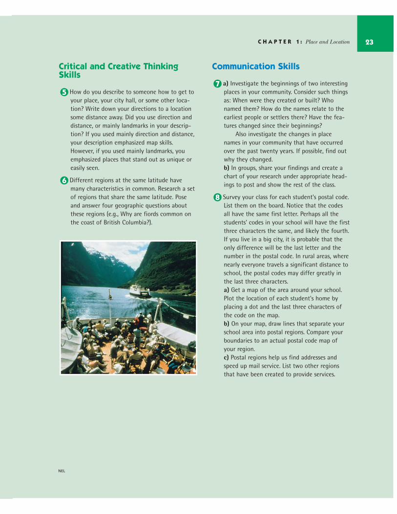
Different regions at the same latitude havemany characteristics in common. Research a setof regions that share the same latitude. Poseand answer four geographic questions aboutthese regions (e.g., Why are fiords common onthe coast of British Columbia?).
Communication Skills
a) Investigate the beginnings of two interestingplaces in your community. Consider such thingsas: When were they created or built? Whonamed them? How do the names relate to theearliest people or settlers there? Have the fea-tures changed since their beginnings?
Also investigate the changes in placenames in your community that have occurredover the past twenty years. If possible, find outwhy they changed.b) In groups, share your findings and create achart of your research under appropriate head-ings to post and show the rest of the class.
Survey your class for each student's postal code.List them on the board. Notice that the codesall have the same first letter. Perhaps all thestudents' codes in your school will have the firstthree characters the same, and likely the fourth.If you live in a big city, it is probable that theonly difference will be the last letter and thenumber in the postal code. In rural areas, wherenearly everyone travels a significant distance toschool, the postal codes may differ greatly inthe last three characters.a) Get a map of the area around your school.Plot the location of each student's home byplacing a dot and the last three characters ofthe code on the map.b) On your map, draw lines that separate yourschool area into postal regions. Compare yourboundaries to an actual postal code map ofyour region.c) Postal regions help us find addresses andspeed up mail service. List two other regionsthat have been created to provide services.
8
7
6
5
C H A P T E R 1 : Place and Location 23
NEL