Embed Size (px)
Citation preview
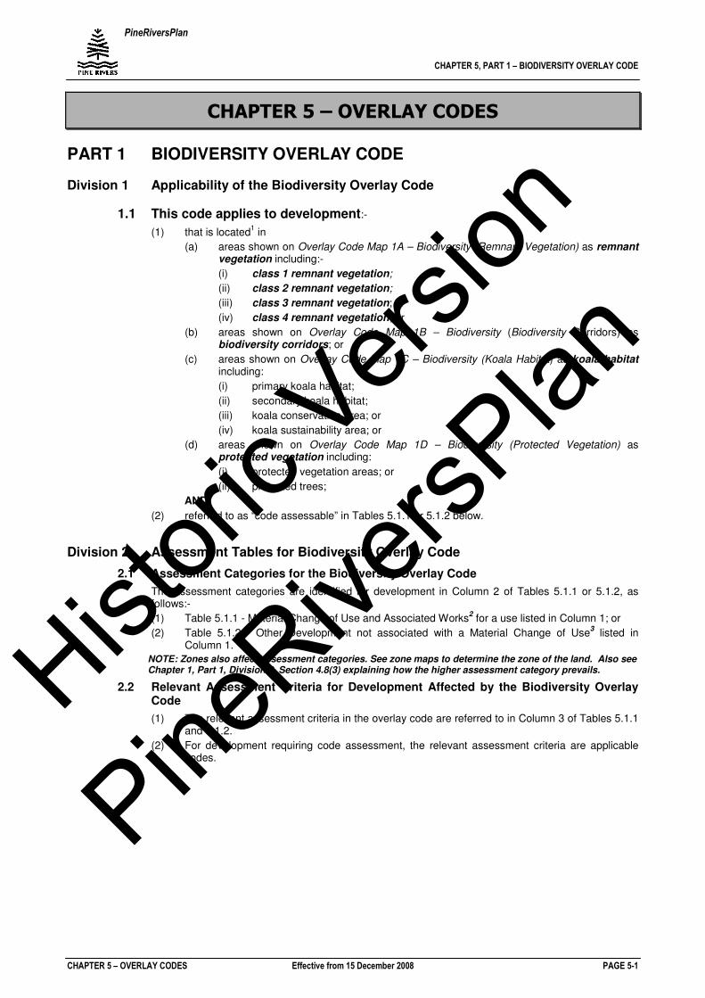
PineRiversPlan
CHAPTER 5, PART 1 – BIODIVERSITY OVERLAY CODE
CHAPTER 5 – OVERLAY CODES Effective from 15 December 2008 PAGE 5-1
CHAPTER 5 – OVERLAY CODES
PART 1 BIODIVERSITY OVERLAY CODE
Division 1 Applicability of the Biodiversity Overlay Code
1.1 This code applies to development:-
(1) that is located1 in
(a) areas shown on Overlay Code Map 1A – Biodiversity (Remnant Vegetation) as remnant vegetation including:-
(i) class 1 remnant vegetation;
(ii) class 2 remnant vegetation;
(iii) class 3 remnant vegetation; or
(iv) class 4 remnant vegetation; or
(b) areas shown on Overlay Code Map 1B – Biodiversity (Biodiversity Corridors) as biodiversity corridors; or
(c) areas shown on Overlay Code Map 1C – Biodiversity (Koala Habitat) as koala habitat including:
(i) primary koala habitat;
(ii) secondary koala habitat;
(iii) koala conservation area; or
(iv) koala sustainability area; or
(d) areas shown on Overlay Code Map 1D – Biodiversity (Protected Vegetation) as protected vegetation including:
(i) protected vegetation areas; or
(ii) protected trees;
AND
(2) referred to as “code assessable” in Tables 5.1.1 or 5.1.2 below.
Division 2 Assessment Tables for Biodiversity Overlay Code
2.1 Assessment Categories for the Biodiversity Overlay Code
The assessment categories are identified for development in Column 2 of Tables 5.1.1 or 5.1.2, as follows:-
(1) Table 5.1.1 - Material Change of Use and Associated Works2 for a use listed in Column 1; or
(2) Table 5.1.2 - Other Development not associated with a Material Change of Use3 listed in
Column 1.
NOTE: Zones also affect assessment categories. See zone maps to determine the zone of the land. Also see Chapter 1, Part 1, Division 2, Section 4.8(3) explaining how the higher assessment category prevails.
2.2 Relevant Assessment Criteria for Development Affected by the Biodiversity Overlay Code
(1) The relevant assessment criteria in the overlay code are referred to in Column 3 of Tables 5.1.1 and 5.1.2.
(2) For development requiring code assessment, the relevant assessment criteria are applicable codes.
Histori
c Vers
ion
PineRive
rsPlan
PineRiversPlan
CHAPTER 5, PART 1 – BIODIVERSITY OVERLAY CODE
CHAPTER 5 – OVERLAY CODES Effective from 15 December 2008 PAGE 5-2
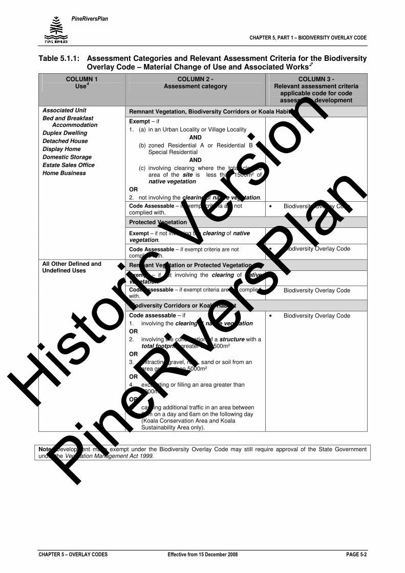
Table 5.1.1: Assessment Categories and Relevant Assessment Criteria for the Biodiversity Overlay Code – Material Change of Use and Associated Works2
COLUMN 1 Use
4
COLUMN 2 - Assessment category
COLUMN 3 - Relevant assessment criteria
applicable code for code assessable development
Remnant Vegetation, Biodiversity Corridors or Koala Habitat
Exempt – if
1. (a) in an Urban Locality or Village Locality
AND
(b) zoned Residential A or Residential B or Special Residential
AND
(c) involving clearing where the total cleared area of the site is less than 1500m² of native vegetation
OR
2. not involving the clearing of native vegetation.
Code Assessable – if exempt criteria are not complied with.
• Biodiversity Overlay Code
Protected Vegetation
Exempt – if not involving the clearing of native vegetation.
Associated Unit
Bed and Breakfast Accommodation
Duplex Dwelling
Detached House
Display Home
Domestic Storage
Estate Sales Office
Home Business
Code Assessable – if exempt criteria are not complied with.
• Biodiversity Overlay Code
Remnant Vegetation or Protected Vegetation
Exempt – if not involving the clearing of native vegetation.
Code assessable – if exempt criteria are not complied with.
• Biodiversity Overlay Code
Biodiversity Corridors or Koala Habitat
All Other Defined and Undefined Uses
Code assessable – if
1. involving the clearing of native vegetation
OR
2. involving the construction of a structure with a total footprint greater than 500m²
OR
3. extracting gravel, rock, sand or soil from an area greater than 5000m²
OR
4. excavating or filling an area greater than 5000m²
OR
5. causing additional traffic in an area between 6pm on a day and 6am on the following day (Koala Conservation Area and Koala Sustainability Area only).
• Biodiversity Overlay Code
Note: Development made exempt under the Biodiversity Overlay Code may still require approval of the State Government under the Vegetation Management Act 1999.
Histori
c Vers
ion
PineRive
rsPlan
PineRiversPlan
CHAPTER 5, PART 1 – BIODIVERSITY OVERLAY CODE
CHAPTER 5 – OVERLAY CODES Effective from 15 December 2008 PAGE 5-3
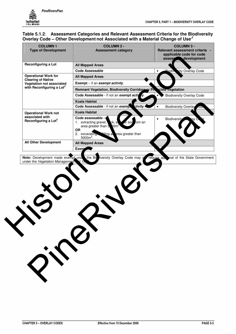
Table 5.1.2: Assessment Categories and Relevant Assessment Criteria for the Biodiversity Overlay Code – Other Development not Associated with a Material Change of Use3
COLUMN 1 Type of Development
COLUMN 2 - Assessment category
COLUMN 3 - Relevant assessment criteria -
applicable code for code assessable development
All Mapped Areas Reconfiguring a Lot
Code Assessable • Biodiversity Overlay Code
All Mapped Areas
Exempt – if an exempt activity.
Remnant Vegetation, Biodiversity Corridors or Protected Vegetation
Code Assessable - if not an exempt activity. • Biodiversity Overlay Code
Koala Habitat
Operational Work for Clearing of Native Vegetation not associated with Reconfiguring a Lot5
Code Assessable - if not an exempt activity. • Biodiversity Overlay Code
Koala Habitat Operational Work not associated with Reconfiguring a Lot5
Code assessable – if
1. extracting gravel, rock, sand or soil from an area greater than 5000m2
OR 2. excavating or filling an area greater than
5000m2.
• Biodiversity Overlay Code
All Mapped Areas All Other Development
Exempt
Note: Development made exempt under the Biodiversity Overlay Code may still require approval of the State Government under the Vegetation Management Act 1999.
Histori
c Vers
ion
PineRive
rsPlan
PineRiversPlan
CHAPTER 5, PART 1 – BIODIVERSITY OVERLAY CODE
CHAPTER 5 – OVERLAY CODES Effective from 15 December 2008 PAGE 5-4
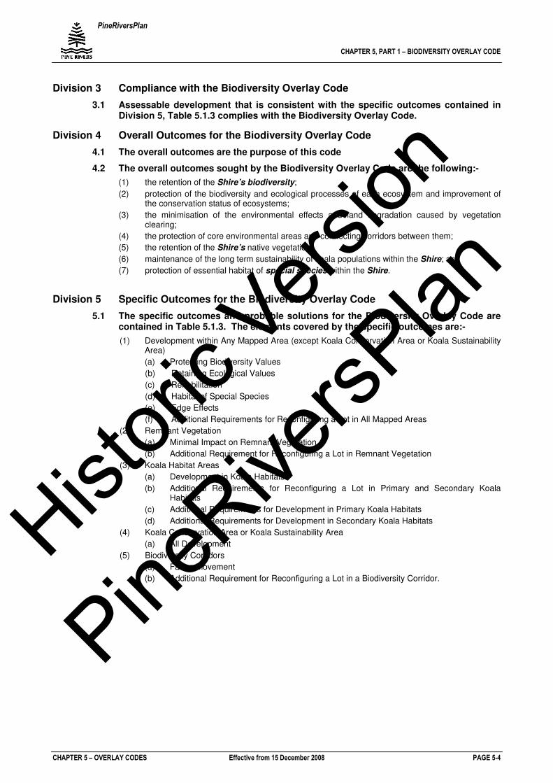
Division 3 Compliance with the Biodiversity Overlay Code
3.1 Assessable development that is consistent with the specific outcomes contained in Division 5, Table 5.1.3 complies with the Biodiversity Overlay Code.
Division 4 Overall Outcomes for the Biodiversity Overlay Code
4.1 The overall outcomes are the purpose of this code
4.2 The overall outcomes sought by the Biodiversity Overlay Code are the following:-
(1) the retention of the Shire’s biodiversity;
(2) protection of the biodiversity and ecological processes of each ecosystem and improvement of the conservation status of ecosystems;
(3) the minimisation of the environmental effects and land degradation caused by vegetation clearing;
(4) the protection of core environmental areas and connecting corridors between them;
(5) the retention of the Shire’s native vegetation;
(6) maintenance of the long term sustainability of koala populations within the Shire; and
(7) protection of essential habitat of special species within the Shire.
Division 5 Specific Outcomes for the Biodiversity Overlay Code
5.1 The specific outcomes and probable solutions for the Biodiversity Overlay Code are contained in Table 5.1.3. The elements covered by the specific outcomes are:-
(1) Development within Any Mapped Area (except Koala Conservation Area or Koala Sustainability Area)
(a) Protecting Biodiversity Values
(b) Retaining Ecological Values
(c) Rehabilitation
(d) Habitat of Special Species
(e) Edge Effects
(f) Additional Requirements for Reconfiguring a Lot in All Mapped Areas
(2) Remnant Vegetation
(a) Minimal Impact on Remnant Vegetation
(b) Additional Requirement for Reconfiguring a Lot in Remnant Vegetation
(3) Koala Habitat Areas
(a) Development in Koala Habitats
(b) Additional Requirements for Reconfiguring a Lot in Primary and Secondary Koala Habitats
(c) Additional Requirements for Development in Primary Koala Habitats
(d) Additional Requirements for Development in Secondary Koala Habitats
(4) Koala Conservation Area or Koala Sustainability Area
(a) All Development
(5) Biodiversity Corridors
(a) Fauna Movement
(b) Additional Requirement for Reconfiguring a Lot in a Biodiversity Corridor.
Histori
c Vers
ion
PineRive
rsPlan
PineRiversPlan
CHAPTER 5, PART 1 – BIODIVERSITY OVERLAY CODE
CHAPTER 5 – OVERLAY CODES Effective from 15 December 2008 PAGE 5-5
Table 5.1.3: Specific Outcomes and Probable Solutions for Assessable Development
Specific Outcomes for Assessable Development
Probable Solutions
Note 1: Planning Scheme Policy PSP31 Demonstrating Compliance with the Biodiversity and Waterways Overlay Codes provides guidance on demonstrating compliance with this code.
Note 2: Where the proposed development involves vegetation clearing which may require approval under the Vegetation Management Act, the State Government will be involved with the application as a concurrence agency. In such a situation, Council will advise the applicant after the receipt of an application.
Development Within any Mapped Areas (except Koala Conservation Area or Koala Sustainability Area)
Protecting Biodiversity Values
SO 1 Development siting, scale, layout and design retains and protects biodiversity values of the site and surrounding properties and minimises adverse environmental impacts such as (but not limited to) soil erosion, land degradation and degradation of water quality.
PS 1 Any construction does not encroach into resources of ecological significance such as:-
(1) areas of remnant vegetation, koala habitat or protected vegetation;
(2) within biodiversity corridors;
(3) within 20m of the centre line of any gully or drainage depression within a mapped area; and
(4) within 50m of any wetland area within a mapped area.
Retaining Ecological Values
SO 2 The long term use and management of land ensures the ecological values are retained and enhanced with time.
PS 2 No solution provided.
Rehabilitation
SO 3 Rehabilitation of disturbed areas is undertaken to a high standard.
PS 3 Disturbed or cleared areas are rehabilitated in accordance with the provisions of Planning Scheme Policy PSP31 Demonstrating Compliance with the Biodiversity and Waterways Overlay Codes.
Habitat of Special Species
SO 4 The specific habitat requirements of special species (fauna and flora) are retained or enhanced where the presence or likely presence of any special species within the site has been identified in observation or investigation.
PS 4 Any disturbance does not encroach into habitat areas of special species identified in observation or through investigation.
Edge Effects
SO 5 Any proposed use does not result in the short- or long-term degradation of ecological values of the site and surrounding properties due to edge effects.
Such edge effects can include but are not limited to:-
(1) escape of non-native garden plants into natural areas resulting in weed problems;
(2) intrusion of pets into natural areas interfering with fauna;
(3) increased access by people and vehicles disturbing vegetation and fauna; and
(4) changes in quality or flow regimes interfering with vegetation and nearby streams.
PS 5.1 Development is concentrated within a particular cleared area of the site.
AND
PS 5.2 Minimise the length of interface between the development and natural areas, both internally and externally to the site.
Additional Requirements for Reconfiguring a Lot in All Mapped Areas
SO 6 The extent of vegetation clearing to facilitate subdivision is carried out in a way which limits any adverse environmental impact on the site and avoids disturbance of remnant vegetation.
PS 6 Development is focused on an area of the site that is already cleared.
SO 7 The size of and location of building pads and mandatory building areas minimises the impacts on the ecological values of the site associated with:-
(1) waterways;
(2) gullies/drainage lines;
(3) wetlands; and
(4) habitat trees.
PS 7.1 A mandatory building area is identified on any new lot containing:-
(1) remnant vegetation;
(2) koala habitat;
(3) biodiversity corridors; or
(4) protected vegetation.
AND
PS 7.2 Building pads are located in areas that are already
Histori
c Vers
ion
PineRive
rsPlan
PineRiversPlan
CHAPTER 5, PART 1 – BIODIVERSITY OVERLAY CODE
CHAPTER 5 – OVERLAY CODES Effective from 15 December 2008 PAGE 5-6
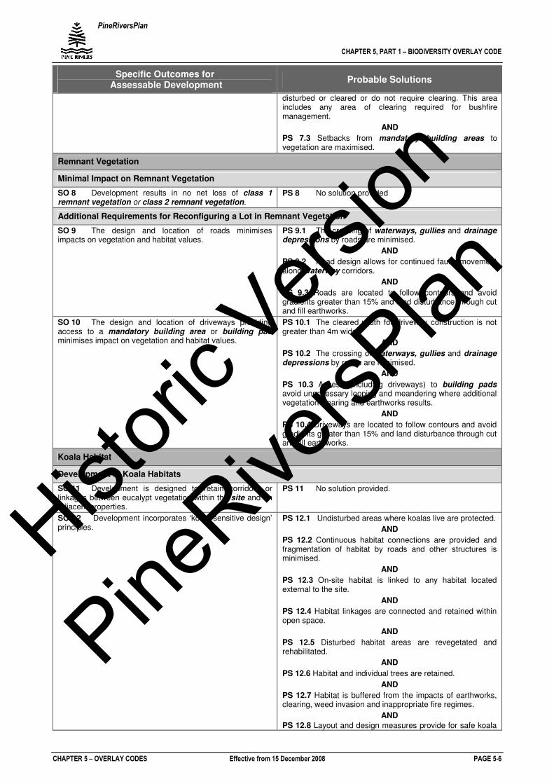
Specific Outcomes for Assessable Development
Probable Solutions
disturbed or cleared or do not require clearing. This area includes any area of clearing required for bushfire management.
AND
PS 7.3 Setbacks from mandatory building areas to vegetation are maximised.
Remnant Vegetation
Minimal Impact on Remnant Vegetation
SO 8 Development results in no net loss of class 1 remnant vegetation or class 2 remnant vegetation.
PS 8 No solution provided
Additional Requirements for Reconfiguring a Lot in Remnant Vegetation
SO 9 The design and location of roads minimises impacts on vegetation and habitat values.
PS 9.1 The crossing of waterways, gullies and drainage depressions by roads are minimised.
AND
PS 9.2 Road design allows for continued fauna movement along waterway corridors.
AND
PS 9.3 Roads are located to follow contours and avoid gradients greater than 15% and land disturbance through cut and fill earthworks.
SO 10 The design and location of driveways providing access to a mandatory building area or building pad minimises impact on vegetation and habitat values.
PS 10.1 The cleared width for driveway construction is not greater than 4m wide.
AND
PS 10.2 The crossing of waterways, gullies and drainage depressions by roads are minimised.
AND
PS 10.3 Access (including driveways) to building pads avoid unnecessary looping and meandering where additional vegetation clearing and earthworks results.
AND
PS 10.4 Driveways are located to follow contours and avoid gradients greater than 15% and land disturbance through cut and fill earthworks.
Koala Habitat
Development in Koala Habitats
SO 11 Development is designed to retain corridors or linkages between eucalypt vegetation within the site and on adjacent properties.
PS 11 No solution provided.
SO 12 Development incorporates ‘koala sensitive design’ principles.
PS 12.1 Undisturbed areas where koalas live are protected.
AND
PS 12.2 Continuous habitat connections are provided and fragmentation of habitat by roads and other structures is minimised.
AND
PS 12.3 On-site habitat is linked to any habitat located external to the site.
AND
PS 12.4 Habitat linkages are connected and retained within open space.
AND
PS 12.5 Disturbed habitat areas are revegetated and rehabilitated.
AND
PS 12.6 Habitat and individual trees are retained.
AND
PS 12.7 Habitat is buffered from the impacts of earthworks, clearing, weed invasion and inappropriate fire regimes.
AND
PS 12.8 Layout and design measures provide for safe koala
Histori
c Vers
ion
PineRive
rsPlan
PineRiversPlan
CHAPTER 5, PART 1 – BIODIVERSITY OVERLAY CODE
CHAPTER 5 – OVERLAY CODES Effective from 15 December 2008 PAGE 5-7
Specific Outcomes for Assessable Development
Probable Solutions
movement, including:
(1) koala friendly fencing;
(2) landscaping utilises native vegetation;
(3) koala habitat is retained within road verges, parks and residential lots; and
(4) road design, alignment and construction increases visibility, reduces speed and provides for safe road crossing opportunities in order to minimise the impact of road traffic.
Additional Requirements for Reconfiguring a Lot in Primary and Secondary Koala Habitats
SO 13 Dogs are contained within a designated area or mandatory building area on lots located in koala habitat to minimise dog attacks on koalas within the allotment.
PS 13 A koala exclusion fence is to be erected around the mandatory building area, or smaller area around the detached house to contain domestic dogs and exclude koalas.
Additional Requirements for Development in Primary Koala Habitat
SO 14 Development within primary koala habitat does not diminish the existing high koala habitat values.
PS 14.1 There is no net loss of native vegetation.
AND
PS 14.2 Vegetation clearing to facilitate driveway access does not exceed 4m in width.
SO 15 Degraded or cleared areas exclusive of any building pad are replanted with native eucalyptus trees in accordance with Planning Scheme Policy PSP31 Demonstrating Compliance with the Biodiversity and Waterways Overlay Codes.
PS 15 No solution provided.
Additional Requirements for Development in Secondary Koala Habitat
SO 16 Development scale, layout and design retains and protects koala habitat values in secondary koala habitats.
PS 16.1 Development is designed to retain koala habitat trees in park, open space and drainage areas and road reserves and avoid fragmentation of vegetation on the site
AND
PS 16.2 Allotments retain koala habitat trees on parts of any allotments exclusive of:-
(1) the area required for the construction of a dwelling on a residential property;
(2) the area required for the construction of any buildings on a non residential property; and
(3) areas required for driveway access and parking.
Koala Conservation Area or Koala Sustainability Area
All Development
SO 17 Development located in the Koala Conservation Area or Koala Sustainability Area complies with the relevant koala conservation criteria contained in the Nature Conservation (Koala) Conservation Plan 2006 and Management Program 2006-2016.
PS 17 Development located in the Koala Conservation Area or Koala Sustainability Area complies with the relevant koala conservation criteria contained in the Nature Conservation (Koala) Conservation Plan 2006 and Management Program 2006-2016.
Biodiversity Corridors
Fauna Movement
SO 18 The design and scale of development avoids the fragmentation of vegetation on the site and facilitates fauna movement in the corridor.
PS 18.1 Continuity between existing vegetation remnants and areas of ecological significance on the site or adjoining properties are retained.
AND
PS 18.2 Large continuous areas of remnant vegetation are retained.
AND
PS 18.3 Fauna movement is not constrained through the construction of barriers.
AND
PS 18.4 A continuous 100m wide corridor is maintained through the site.
Histori
c Vers
ion
PineRive
rsPlan
PineRiversPlan
CHAPTER 5, PART 1 – BIODIVERSITY OVERLAY CODE
CHAPTER 5 – OVERLAY CODES Effective from 15 December 2008 PAGE 5-8
Specific Outcomes for Assessable Development
Probable Solutions
Additional Requirements for Reconfiguring a Lot in a Biodiversity Corridor
SO 19 Road intrusions within a biodiversity corridor are minimised.
PS 19 No solution provided.
SO 20 The length of common boundary between a biodiversity corridor and a road or a driveway is minimised.
PS 20 No solution provided.
SO 21 At wildlife crossing points, such as riparian areas, roads are designed to minimise traffic conflicts with the wildlife with the use of speed control devices, lighting, signage or other design options as appropriate.
PS 21 No solution provided.
SO 22 Where appropriate, endemic vegetation is reinstated to restore continuous vegetated corridors.
PS 22 Revegetation and rehabilitated is undertaken in accordance with the provisions of Planning Scheme Policy PSP31 Demonstrating Compliance with the Biodiversity and Waterways Overlay Codes.
Histori
c Vers
ion
PineRive
rsPlan
PineRiversPlan
CHAPTER 5, PART 1 – BIODIVERSITY OVERLAY CODE
CHAPTER 5 – OVERLAY CODES Effective from 15 December 2008 PAGE 5-9
Schedule A to the Biodiversity Overlay Code – Additional Defined Terms
For the purposes of this code, the following meanings apply to critical terms used in the code:-
(1) Areas of Ecological Significance
Areas of ecological significance are those areas mapped on the Biodiversity and Waterways Overlays.
(2) Biodiversity Corridor
A strip or block of habitat connecting otherwise isolated units of suitable habitats that allows the dispersal of organisms and the consequent mixing of genes. A corridor is also beneficial to plant populations that have been isolated due to fragmentation. A corridor may include areas that are presently degraded or cleared but still offer the potential to act as a linkage if rehabilitated or allowed to regenerate.
(3) Building Pad
Location of house on an allotment. The building pad includes any ancillary structures and the extent of any vegetation clearing required.
(4) Class 1 Remnant Vegetation
A category of vegetation with a conservation status recorded, by Council vegetation mapping, as being endangered.
(5) Class 2 Remnant Vegetation
A category of vegetation with a conservation status recorded, by Council vegetation mapping, as being exceptional value. Specifically, this includes regional ecosystems with (from PRSC, 2001):
(a) very high flora species richness;
(b) very high fauna species richness;
(c) the presence of endemic species;
(d) the presence of rare or threatened or other priority species;
(e) the presence of migratory species;
(f) a highly productive ecosystem;
(g) a major primary producer role and habitat for aquatic ecosystems; or
(h) a major primary producer role and habitat for marine ecosystems.
(6) Class 3 Remnant Vegetation
A category of vegetation with a conservation status recorded, by Council vegetation mapping, as being of concern.
(7) Class 4 Remnant Vegetation
A category of remnant vegetation with a conservation status recorded, by Council vegetation mapping, as being not of concern.
(8) Clearing
Damaging or destroying vegetation by ring barking, topping, lopping, poisoning, burning, flooding, draining, or otherwise injuring vegetation including cutting down or pushing over. In addition to this, damaging the root zone by compaction, excavation or filling within the drip zone or 10xDBH* (whichever is greater) of the vegetation that may destroy or seriously affect the vegetation. Partial clearing such as the removal of understorey or thinning of native vegetation or the removal of dead habitat trees is classed as clearing for the purpose of this code.
This does not include:- (a) maintaining existing open pastures, lawns or created gardens; and (b) grazing of native pasture by stock.
* DBH = Diameter of the tree when measured at breast height (1300mm above ground level)
(9) Drainage Depression
Level to gently inclined, long, narrow, shallow open depression with smoothly concave cross-section, rising to moderately inclined side slopes, eroded or aggraded by sheet wash. (McDonald et. al. 1990, Pg. 30)
(10) Edge Effects
The influence of two communities, upon their adjoining margins or fringes, affecting the composition and density of the populations in these bordering areas. Where development adjoins a natural area, such influence can result in its degradation due to weed invasion, pets, nutrient loads, increased fire frequency etc.
(11) Exempt Activity8
The clearing of vegetation where the clearing is one or more of the following:
(a) entirely located within a mandatory building area
(b) within 10m from a lawful existing building
Histori
c Vers
ion
PineRive
rsPlan
PineRiversPlan
CHAPTER 5, PART 1 – BIODIVERSITY OVERLAY CODE
CHAPTER 5 – OVERLAY CODES Effective from 15 December 2008 PAGE 5-10
(c) reasonably necessary for emergency access or immediately required in response to an accident or emergency
(d) reasonably necessary to remove or reduce the risk that the vegetation poses serious personal injury or damage to infrastructure
6
(e) reasonably necessary to construct and maintain a 4 metres wide driveway where the driveway is the only access to a lawful dwelling or approved building pad
(f) reasonably necessary to construct and maintain a fence which is required by legislation (e.g. swimming pool, dog enclosure) and not exceeding 2m in width either side of the fence.
(g) non-native plants (except where the plant is a significant tree and within a watercourse or within 5 metres of the bed and banks of a watercourse unless written Council consent is obtained).
(h) reasonably necessary to allow safe use of a public road or development of trunk infrastructure within the road reserve
(i) reasonably required for the purposes of maintenance or works within a registered easement for public infrastructure or drainage purposes.
(j) in accordance with an existing bushfire management plan previously accepted by Council (The bushfire management plan must cover the use being applied for.)
(k) pruning as per Australian Standard AS 4373-2007 – Pruning of Amenity Trees
(12) Gully
Open depression with short, precipitous walls and moderately inclined to very gently inclined floor or small stream channel, eroded by channelled stream flow and consequent collapse and water-aided mass movement.” (McDonald et. al. 1990, Pg. 31)
(13) Habitat Trees
Trees which contain hollow limbs and fissures frequently utilised by wildlife as nesting or roosting sites. Habitat trees are either living mature to old aged trees or dead old trees (stags).
(14) Koala Exclusion Fence
To be a fence that is made of appropriate materials that a koala cannot easily grip, including, for example tin panels and has a gap of less than 10cm between the ground and the fence. Nearby trees and shrubs should be at least 3m away from the exclusion fencing.
(15) Koala Habitat
(a) a woodland where koalas currently live; or
(b) a partially or completely cleared area that is used by koalas to cross from one woodland where koalas currently live to another woodland where koalas currently live; or
(c) a woodland where koalas do not currently live if the woodland:
(i) primarily consists of koala habitat trees; and
(ii) is reasonably suitable to sustain koalas.
Koala Habitat also includes primary and secondary koala habitat and koala conservation and koala sustainability areas as mapped within Overlay Code Map 1(c). Koala conservation and koala sustainability areas reflect the State Government mapping under the Nature Conservation (Koala) Conservation Plan 2006-2016.
(16) Koala Habitat Trees
A tree of any of the following genera: Eucalyptus, Corymbia, Angophora, Lophostermon or Melaleuca.
(17) Koala Habitat Values
Those characteristics of an area that make it suitable as habitat or refuge for koalas. These characteristics include the nature, extent, condition and connectivity of an area and its relation to other areas of habitat.
(18) Mandatory Building Area
An area within a property where the location and extent of construction (including vegetation clearing) has been identified and applied as a condition of development. Construction outside the building area or movement of the building area would require an application to Council. Other terms for mandatory building area include:-
(a) designated building pad;
(b) mandatory building pad;
(c) designated building area;
(d) building location envelope; and
(e) defined building pad or area
(19) Mapped Areas
Is any area mapped on the Biodiversity Code Overlay Maps:-
(a) Overlay Map 1A – Biodiversity (Remnant Vegetation)
(b) Overlay Map 1B - Biodiversity (Biodiversity Corridors)
(c) Overlay Map 1C - Biodiversity (Koala Habitat)
Histori
c Vers
ion
PineRive
rsPlan
PineRiversPlan
CHAPTER 5, PART 1 – BIODIVERSITY OVERLAY CODE
CHAPTER 5 – OVERLAY CODES Effective from 15 December 2008 PAGE 5-11
(d) Overlay Map 1D - Biodiversity (Protected Vegetation)
(20) Native Vegetation
Plants native to the southeast Queensland bioregion7, other than grasses and non-woody herbage.
(21) Protected Vegetation
Vegetation previously protected by Local Law 45 (Tree Preservation).
(22) Pruning
Canopy maintenance in accordance with the Australian Standard AS 4373 – 2007 - Pruning of amenity trees, as an acceptable tree management technique that would not require approval under the Planning Scheme (This does NOT include lopping or topping as defined in AS 4373-2007.)
(23) Remnant Vegetation
A category of native vegetation with a conservation status recorded, by Council vegetation mapping, as being remnant. This includes class 1 (endangered) remnant vegetation, class 2 (exceptional value) remnant vegetation, class 3 (of concern) remnant vegetation and class 4 (not of concern) remnant vegetation.
(24) Resources of Ecological Significance
Resources of ecological significance are the variety, integrity and attributes (composition, structure and function) of regional ecosystems and aquatic ecosystems.
(25) Significant Tree
A native tree with a stem or trunk with a diameter of 10cm or more measured at 1.3m from the ground.
(26) Special Species
Species of flora and fauna identified in the following:-
(a) listed in the Conservation (Wildlife) Regulation 1994 of the Nature Conservation Act 1992 as ‘presumed extinct’, ‘endangered’, ‘vulnerable’ or ‘rare’ (as defined by the act);
(b) listed as ‘critically endangered’, ‘endangered’ or ‘vulnerable’ in The Environment Protection and Biodiversity Conservation Regulations 2000 of the Environment Protection and Biodiversity Conservation (EPBC) Act 2000; or
(c) declared to be so by resolution of Council.
(27) Wetland
“Almost level closed, or almost closed depression with a seasonal or permanent water table at or above the surface, commonly aggraded by overland stream flow and sometimes biological (peat) accumulation.
The definitions of landform elements described in this code and related planning scheme policies are taken directly from the Australian Soil and Land Survey – Field handbook (2
nd Ed., 1990) McDonald, Isbell, Speight, Walter & Hopkins.
Inkata Press, Melbourne.
Defining and Protecting Resources of Ecological Significance in the Pine Rivers Shire: The Condition and Biodiversity Values of Regional Ecosystems (2001) Pine Rivers Shire Council.
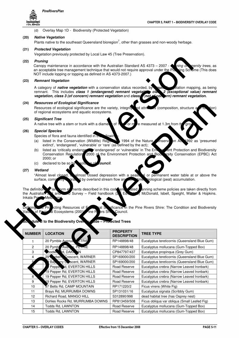
Schedule B to the Biodiversity Overlay Code – Protected Trees
NUMBER LOCATION PROPERTY DESCRIPTION
TREE TYPE
1 20 Pymble Avenue, PETRIE RP148898/48 Eucalyptus tereticornis (Queensland Blue Gum)
2 20 Pymble Avenue, PETRIE RP148898/48 Eucalyptus mollucana (Gum-Topped Box)
3 Goodwin Rd, DAKABIN CP847797/437 Eucalyptus propinqua (Grey Gum)
4 29 Bayberry Crescent, WARNER SP169000/200 Eucalyptus tereticornis (Queensland Blue Gum)
5 29 Bayberry Crescent, WARNER SP169000/200 Eucalyptus tereticornis (Queensland Blue Gum)
6 19 Pepper Rd, EVERTON HILLS Road Reserve Eucalyptus crebra (Narrow Leaved Ironbark)
7 19 Pepper Rd, EVERTON HILLS Road Reserve Eucalyptus crebra (Narrow Leaved Ironbark)
8 19 Pepper Rd, EVERTON HILLS Road Reserve Eucalyptus crebra (Narrow Leaved Ironbark)
9 19 Pepper Rd, EVERTON HILLS Road Reserve Eucalyptus crebra (Narrow Leaved Ironbark)
10 97 Betts Rd, CAMP MOUNTAIN RP171220/2 Ficus virens (White Fig)
11 Brays Rd, MURRUMBA DOWNS SP131031/16 Eucalyptus signata (Scribbly Gum)
12 Richard Road, MANGO HILL S312890/998 dead habitat tree (has Osprey nest)
13 Dohles Rocks Rd, MURRUMBA DOWNS RP813459/508 Ficus obliqua var obliqua (Small Leafed Fig)
14 Todds Rd, LAWNTON Road Reserve Eucalyptus mollucana (Gum-Topped Box)
15 Todds Rd, LAWNTON Road Reserve Eucalyptus mollucana (Gum-Topped Box)
Histori
c Vers
ion
PineRive
rsPlan
PineRiversPlan
CHAPTER 5, PART 1 – BIODIVERSITY OVERLAY CODE
CHAPTER 5 – OVERLAY CODES Effective from 15 December 2008 PAGE 5-11A
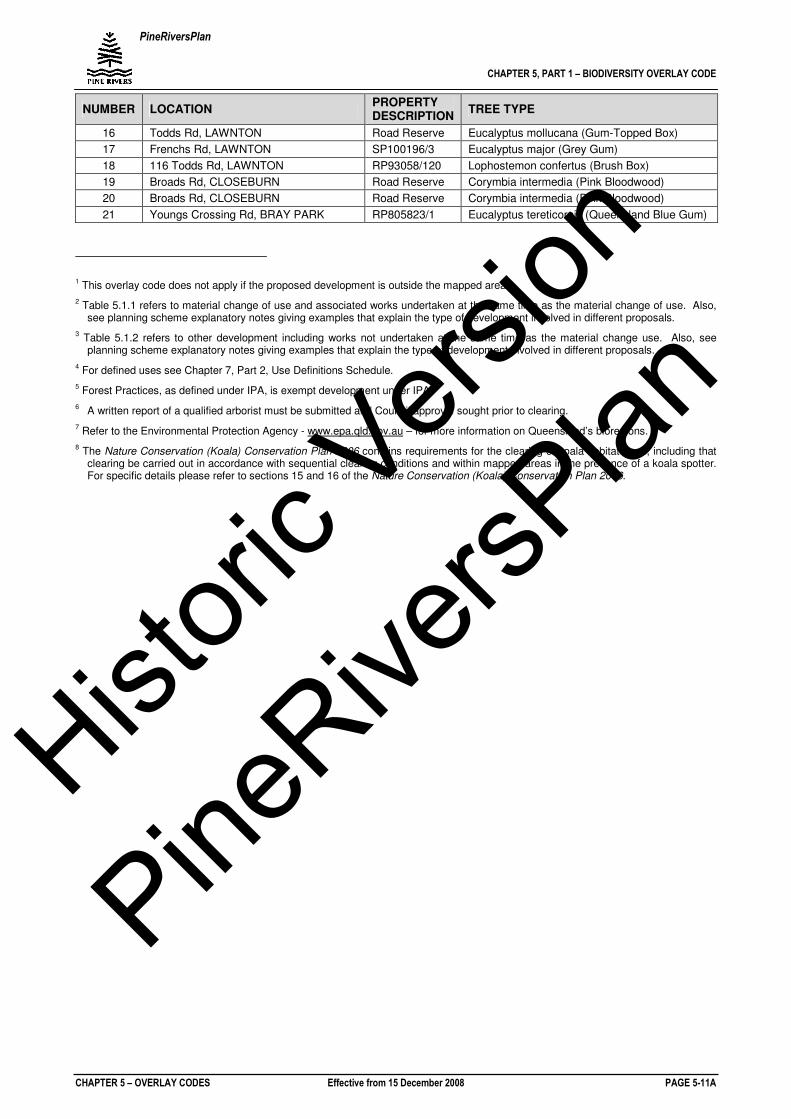
NUMBER LOCATION PROPERTY DESCRIPTION
TREE TYPE
16 Todds Rd, LAWNTON Road Reserve Eucalyptus mollucana (Gum-Topped Box)
17 Frenchs Rd, LAWNTON SP100196/3 Eucalyptus major (Grey Gum)
18 116 Todds Rd, LAWNTON RP93058/120 Lophostemon confertus (Brush Box)
19 Broads Rd, CLOSEBURN Road Reserve Corymbia intermedia (Pink Bloodwood)
20 Broads Rd, CLOSEBURN Road Reserve Corymbia intermedia (Pink Bloodwood)
21 Youngs Crossing Rd, BRAY PARK RP805823/1 Eucalyptus tereticornis (Queensland Blue Gum)
1 This overlay code does not apply if the proposed development is outside the mapped areas.
2 Table 5.1.1 refers to material change of use and associated works undertaken at the same time as the material change of use. Also,
see planning scheme explanatory notes giving examples that explain the type of development involved in different proposals.
3 Table 5.1.2 refers to other development including works not undertaken at the same time as the material change use. Also, see
planning scheme explanatory notes giving examples that explain the type of development involved in different proposals.
4 For defined uses see Chapter 7, Part 2, Use Definitions Schedule.
5 Forest Practices, as defined under IPA, is exempt development under IPA.
6 A written report of a qualified arborist must be submitted and Council approval sought prior to clearing.
7 Refer to the Environmental Protection Agency - www.epa.qld.gov.au – for more information on Queensland’s bioregions.
8 The Nature Conservation (Koala) Conservation Plan 2006 contains requirements for the clearing of koala habitat trees, including that
clearing be carried out in accordance with sequential clearing conditions and within mapped areas in the presence of a koala spotter. For specific details please refer to sections 15 and 16 of the Nature Conservation (Koala) Conservation Plan 2006.
Histori
c Vers
ion
PineRive
rsPlan