Embed Size (px)
Citation preview
Upper Mississippi River Early Warning Monitoring Network
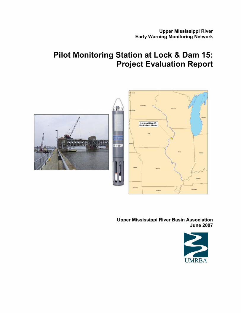
Pilot Monitoring Station at Lock & Dam 15: Project Evaluation Report
Upper Mississippi River Basin Association June 2007

Cover photos courtesy of U.S. Army Corps of Engineers (Rock Island District) and YSI, Inc.
Upper Mississippi River Basin Association 415 Hamm Building 408 St. Peter Street St. Paul, MN 55105 651-224-2880 www.urmba.org

Upper Mississippi River Early Warning Monitoring Network (UMR-EWMN) Pilot Monitoring Station at Lock and Dam 15: Project Evaluation Report Prepared by the: Upper Mississippi River Basin Association 415 Hamm Building 408 St. Peter Street St. Paul, MN 55105 In consultation with the:
Upper Mississippi River Early Warning Monitoring Network Scoping Group
Upper Mississippi River Water Suppliers Coalition
Upper Mississippi River Hazardous Spills Coordination Group Under Cooperative Agreement X995856-11-0 with US EPA Region 5.
Table of Contents Pilot Project Overview .............................................................................................................. 1 Project History .......................................................................................................................... 1 Pilot Implementation ................................................................................................................. 2 Evaluation of System Components ........................................................................................... 5 Conclusions ............................................................................................................................... 7 Next Steps ................................................................................................................................. 8 Reference .................................................................................................................................. 9 Appendix 1: Map of the Upper Mississippi River (not displayed in online version) ............... 10 Appendix 2: 2006 Data Summary for Pilot Probe at L&D 15 ................................................. 11
1
Pilot Project Overview In August 2002, the Upper Mississippi River Early Warning Monitoring Network (UMR EWMN) Scoping Group was formed to assess the potential for establishing a warning network on the Upper Mississippi River. One result of the Scoping Group’s work was the installation of a YSI Model 6600 EDS water quality sonde at Mississippi River Lock and Dam 15 (L&D 15) in Rock Island, Illinois on November 13, 2003. The instrument collected water quality data and transmitted the data in real-time to a public access website until the monitor was removed from operation in March 2007. The purpose of the probe and its data dissemination was to examine the potential for using remote water monitoring systems as early warning devices on the Upper Mississippi River (UMR). This evaluation report summarizes the lessons learned from the operation of the pilot monitoring station at L&D 15 and the implications for a more comprehensive early warning monitoring network on the UMR. Project History Setting and Need The Upper Mississippi River (UMR) supplies 23 community public water systems which in turn provide well over 2 million people with drinking water. The river and its corridor are also home to many wastewater, chemical, industrial and power plants. These plants, as well as riverside communities, require infrastructure to function, including roads, railroads and pipelines. Industrial facilities, communities, and associated infrastructure can be potential spill sources for petroleum products and other hazardous materials. Appendix 1 displays a generalized map of potential spill sources and drinking water intakes on the UMR. Early warning of a spill event can help speed response and reduce adverse impacts. Early warning systems have been developed or are being developed for a number of major water bodies in the United States (including the Ohio River and Susquehanna River) and Europe. However, a system capable of providing such an early warning does not currently exist on the UMR. In addition to alerting responders of a spill event, a monitoring network can provide benefits both in terms of water security and in providing real-time information regarding the river’s overall water quality. Depending on its design, a warning network can help to detect incidents of intentional contamination, either through monitoring for specific contaminants of concern or by incorporating broad-spectrum sensing approaches. A network can also be designed to incorporate parameters that are of environmental significance for river water quality and ecosystem management. Providing information on a real-time basis would represent a great advancement in how monitoring is typically employed to characterize the river’s condition. UMR EWMN Scoping Group To assess the potential for establishing such a warning system, an interdisciplinary Upper Mississippi River Early Warning Monitoring Network (UMR EWMN) Scoping Group was formed in August 2002. The UMR EWMN Scoping Group consists of participants from water utilities, state and federal agencies, and other experts in water quality monitoring and data management. The group identified the following project issues early in its discussion: (1) equipment (2) water quality parameters to be measured, (3) monitoring frequency, (4) spatial distribution of stations, (5) potential operators and (6) communication and information
2
dissemination. The Scoping Group has worked in cooperation with the UMR Hazardous Spills Coordination Group and the Upper Mississippi River Water Suppliers Coalition to address these issues. Pilot Monitoring Station The Scoping Group chose to pursue the installation of a pilot monitor as a method of testing both the technology and organization needed to implement an EWMN on the UMR. Following a review of potential sites, L&D 15 was selected as a secure site located near both a drinking water intake and potential spill sources, with personnel available to aid the project. Instrument Selection Consideration of a water monitoring instrument for the pilot project was based in part on the parameters viewed as priorities for monitoring. Results of surveys sent out to UMR water suppliers in 2003 indicated that they were primarily interested in monitoring the following parameters: oil and petrochemicals, bacteria, atrazine, ammonia, and algae. Although all these parameters could not be addressed simultaneously due to instrument limitations and cost, they helped guide the instrument selection process. A monitoring device that could detect petroleum products was sought, along with a multi-parameter water quality probe. It was determined that the preferred instruments for this project were the YSI Model 6600 EDS water quality sonde for measuring multiple water quality parameters, and the Turner Designs TD-4100 fluorescence detector for detecting petroleum products in water. Pilot Implementation Instrument Deployment In October of 2003, the EWMN Scoping Group received a YSI 6600 EDS sonde on loan from the manufacturer. Then, in November of 2003, following discussion and site assessments, the device was installed at L&D 15, near the City of Rock Island intake. Probes were installed in the sonde that allowed for the collection of the following data:
Dissolved Oxygen (DO) Chlorophyll Oxidation-Reduction Potential (ORP) pH Temperature Conductivity Turbidity
Shortly after the installation of the YSI sonde, the Scoping Group chose to delay the purchase of a fluorescence detector. The project became more focused on investigating data acquisition, dissemination, and communication components of the network, which could be accomplished with just the mulitparameter monitor in place. However, the Group remained interested in the possibility of integrating a petroleum-specific detection device as an eventual component of a monitoring system.

3
Instrument Data, Calibration and Maintenance The YSI multi-parameter instrument collected real time water quality data from its deployment in November 2003 to it removal in March 2007. However, it was not until June 2005 that a maintenance and calibration routine was established which allowed for the collection of accurate data for most parameters. Subsequently, Iowa American Water-Davenport and the City of Moline successfully shared maintenance and calibration responsibilities in 2006 and 2007. Following the resolution of initial calibration challenges, and the development of a routine calibration schedule, the device was able to generally produce reliable data across parameters, with the caveat that chlorophyll values were relative rather than specifically accurate, due to calibration procedures relying on a rhodamine surrogate. See Appendix 2 for a summary of data produced by the probe in 2006, a time during which the greatest accuracy in parameters was established. Pilot station data has been used by the City of Moline as a check against their routine raw water sampling data. The data from the YSI instrument has been comparable to that of the City of Moline’s data, an indication of the relative accuracy and reliability of the pilot station data. During the deployment of the monitor it was necessary to replace the DO probe (June 2005) and the pH/ORP probe (November 2005). More recently, in June 2006, dissolved oxygen and chlorophyll readings became compromised due to water infiltration into the bulkhead. Additionally, in March 2007, the pH/ORP and DO probes again required replacement. However, given the known problems with bulkhead integrity, the decision was made to remove the monitor from deployment, pending further discussion by the Scoping Group regarding whether to continue use of the multiparameter sonde, pursue alternate technology, or discontinue the pilot station altogether. Data Transmission and Availability Beyond the collection of data, it was important that the data be transmitted to a location where it could be both shared and stored. The U.S. Army Corps of Engineers (USACE), Rock Island District, provided both the hardware and software to allow for data telemetry and posting of data on a publicly available website (www.rivergages.com). The availability of the data allowed for access by the Scoping Group to review the information being generated by the pilot monitor. No difficulties regarding the collection, transmission, and availability of data were reported during the deployment of the sonde. Notification System A core element of any early warning monitoring network is the ability to communicate and disseminate information regarding spills and/or water quality changes. In addition to providing the data on a public access website the Scoping Group chose to pursue a system designed to notify certain individuals via an automated e-mail message whenever a predetermined trigger value was surpassed. pH, a simple parameter where historic levels and fluctuations were well known, was selected to test the warning system. Values were set at 7.5 for the lower trigger, and 9.2 for the upper trigger. These values were chosen based on previously collected pH data indicating that these triggers would likely be periodically, but not constantly, exceeded, thereby initiating the e-mail notification system, allowing project participants to test, modify, and improve the system.

4
The pilot email notification system became operational in August 2006 and functioned successfully through March 2007, when the monitor was removed from service. Email notifications were generated both as a result of measurement excursions and due to zero values resulting from temporary probe removal and calibration activities. The emails contained a simple message requesting that the recipient review the data available on the RiverGages web site. Individuals on the notification list successfully received notification within an hour of the excursion taking place. One issue that was not resolved during the test period was method of automatically disabling the notification system during calibration and maintenance. Costs Personnel Costs A number of local, state and federal-level entities have been involved with the pilot monitoring station. Some roles have been more formal – such as the calibration and maintenance work performed by Iowa American Water-Davenport and City of Moline staff, data and equipment support from USACE, and administrative support from UMRBA. Most other participants have had contributing, but less formal roles in the effort. At some level, all participants have provided personnel time in support of the project. There has not yet been an effort to fully capture the costs associated with the personnel time dedicated to the project. However, a recent estimate related to calibration and maintenance indicates that, once beyond the initial learning curve, the time commitment needed for calibration and maintenance of the instrument is between 4 and 8 hours per month (for once-a-month calibration work on the sonde). Therefore, a mid-range estimate of annual time commitment would then be 72 hours per year per instrument. Administrative costs could be estimated by UMRBA staff costs over the past year, which have been approximately $3000. Equipment Cost As noted above, the pilot project has not incurred the full costs of purchasing the sonde and supporting equipment. However, in considering what the full expenses would be to reproduce such a monitoring station, these costs would need to be considered and could be estimated using the original bid for the equipment of $21,840. Additionally, installation, housing construction, and telemetry hardware/software were provided by USACE. Therefore, a more accurate and comprehensive estimate of equipment cost to install a similar station would be approximately $30,000. Following installation, it appears that annual equipment and maintenance costs run from $500 to $1000 per year. Estimated Total Costs Total costs can be estimated by considering the actual costs incurred under the project, as well as costs that were avoided through in-kind contributions and equipment loans, but would typically be incurred if the project were to be replicated. Costs can further be broken out in terms of start-up costs and ongoing, annual costs, as shown on the following page:
5
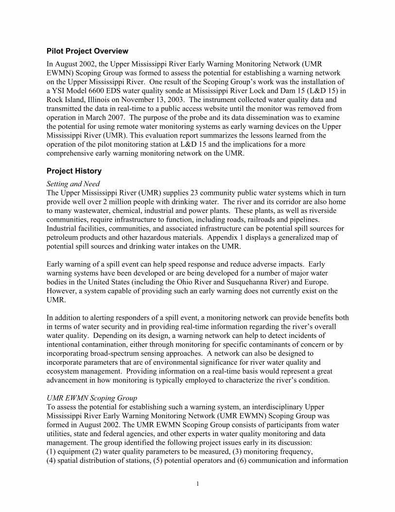
Table 1: Estimated Start-Up Costs for Pilot Station Costs Incurred Costs Avoided Total Costs Equipment $0 $21,840 $21,840 Installation $0 $3,000 (est.) $3,000 Telemetry/Data/IT $0 $5,000 (est.) $5,000 Total $0 $29,840 $29,840
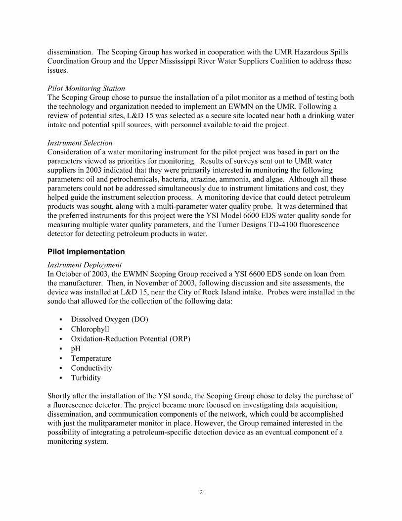
Table 2: Estimated Ongoing Annual Costs Costs Incurred Costs Avoided Total Costs Equipment & Repair $1000 $0 $1,000 Personnel-Calibration and Maintenance
$0 $2000 (est.) $2000
Telemetry/Data/IT $0 $500 (est.) $500 Admin./Coordination $3000 $0 $3000 Total $4000 $2,500 $6,500
Evaluation of System Components Equipment Once staff were dedicated to probe calibration and a calibration routine established, the YSI multi-parameter instrument has proved to be generally reliable and capable of producing useful, real-time data. The instrument was deployed in October of 2003 and was in continuous, calibrated operation since from June 2005 to March 2007. It has produced reliable data for this time period, with the following exceptions: 1) during calibration events , 2) the recent failure of chlorophyll, dissolved oxygen and pH/ORP probes as discussed above, and 3) chlorophyll readings as “relative” values. Clearly, durability of some systems components is a potential issue to consider. However, it appears that the probes were generally able to meet their expected life span for field deployment. The pilot station has provided valuable information to the Scoping Group both in terms of the parameters monitored and the insight into logistical and planning needs for an EWMN network. However, while the instrument’s successful production of data was encouraging, its functionality as a petroleum product early warning device is very limited. At best, the parameters may respond indirectly to a petroleum spill. Without the installation of an additional device allowing for the specific detection of petroleum products, early warning capability remains very limited. The YSI instrument coupled with a petroleum-detecting device would provide a much more complete detection network. Also, in order to implement an effective early warning monitoring network, instruments would have to be placed at multiple locations along the Upper Mississippi River, with deployment of instrumentation made to match potential spill threats and resources to be protected in a given area. This would require the purchase of multiple instruments and the allocation of resources to support personnel responsible for calibration and maintenance. Communication Network The data communication and dissemination system, activated and maintained by the USACE, has also produced accurate and timely information. A possible improvement upon this system would be to activate an “on-off switch” in a timely manner in order to disable the e-mail notification mechanism during times of routine maintenance and calibration so as not to create a

6
false alarm and/or create nuisance e-mails for the recipients. Also, it may be necessary to consider forms of notification (pager, cell phone, etc.) that provide for more reliable 24-hour communication of information. Costs Although the project did not encounter the full costs that could be associated with the implementation of a network (due to in-kind contributions and equipment loans), it appear that a significant amount of resources, in terms of both equipment and personnel costs, would be needed to implement a successful EWMN on the UMR. These costs must be balanced against the benefits of avoiding the adverse consequences of a contamination event, although such an analysis is beyond the scope of this document.
Funding The current pilot project has been funded under a cooperative agreement with between UMRBA and U.S. EPA, and greatly supported by in-kind contributions from the water utilities and USACE. However, the cooperative agreement funding was only intended as “seed” money for a network. While it can potentially continue to support a single monitoring station for a short period of time, another funding source must be identified that can provide for both ongoing and potentially expanded function of the UMR EWMN. Additionally, in-kind contributions may not be sustainable for participants over a longer period of time or for multiple installations. Therefore, unless a permanent source of dedicated funding can be identified, the project may need to be discontinued, and the potential for broader EWMN is quite limited. Organizational/Institutional Issues The pilot project has demonstrated the need for an organizational structure and staff to accomplish tasks such as instrument installation, maintenance, calibration, data telemetry, data dissemination, and project coordination/administration. To date, the pilot station has been supported via a collaborative effort involving several members of the Scoping Group. The USACE has provided a location for the monitor, as well as data telemetry equipment, and display/storage of monitoring data via the RiverGages website. The instrument has been calibrated and maintained utilizing in kind support from the Iowa-American Water Company, the City of Moline Water Department, and funding from the U.S. EPA Region 5. UMRBA has provided coordination and administrative functions. While this organizational structure has functioned to support the pilot monitor in the short run, a more formal structure may be required to both sustain a pilot station and expand the project to a full-scale regional early warning system. A single management entity may be desirable for a UMR EWMN in order to allow for coordinated receipt and dispersal of funds, data management, technical support, planning, and general project oversight. In the Journal of the American Water Works Association, Gullick et al. provided a description of the organizational structures of established early warning systems in the United States (Gullick et al, 2004). The systems described are coordinated and operated by a single organization which then communicates the nature of any detected spill to local utilities. The article also indicates that the systems (in most cases) have instruments located at utility and industrial sites, both of which provide space for the instrumentation as well as workers to maintain the instruments.
7
A single entity responsible for the system would ideally have the ability to operate on an interstate basis. Organizations with this ability include USGS, USACE, U.S. EPA, and the UMRBA (and potentially the UMRWSC if it was incorporated into a more formal entity). However, it is not clear at this time whether any of these organizations have both the capacity to undertake this role and the interest in taking this role, even if funding were to become available. Alternatively, it may be possible for a single state or jurisdiction to take the lead on the network, but this could raise problems if monitors in other states or jurisdictions needed support as part of the network. Conclusions In light of the component evaluation above, the following conclusions can be drawn from the pilot project: 1) Equipment: The YSI 6600 EDS multiparameter probe, with appropriate maintenance and calibration, can provide real-time, accurate water quality information. This water quality data can pick up disturbances to the river and is of value for water suppliers in day-to-day operations. However, the multi-parameter probe does not provide petroleum-specific detection capabilities. Therefore, a UMR EWMN would need to be supplemented with petroleum-detecting capability. Additionally, to provide true early-warning capacity, the number of monitoring stations would need to be significantly expanded and matched to existing threats/protection needs. 2) Communication Network: An email communication network can provide quick and directed notification regarding water quality events. The current email system would need some refinement to minimize the number of reports triggered by routine maintenance events. More broadly, however, the ability of an email system to reach appropriate entities and individuals on a 24-hour basis needs to be more fully investigated. It is possible that an email system may be part of an overall communication network that includes phone, pager, and other communication means. 3) Costs: While there are certainly significant up-front capital costs, and ongoing costs for operation and maintenance, the overall expenses associated with a potential early warning monitoring system do not appear to be unreasonable given the scale and critical nature of the resource. Even when considering that many expenses that would typically be encountered have been avoided or deferred in the pilot project, it appears that similar stations could likely be installed for approximately $30,000 each and maintained for about $6500 per year per station. However, it should be noted that if stations were expanded to include a petroleum-detecting fluorescence meter, initial capital costs per station may more than double due to the expense of the device and more complex infrastructure requirements. As noted earlier, these estimated costs should be compared to the estimated benefits of reducing the adverse effects of a contamination event. 4) Funding: Future funding for the UMR EWMN appears to be a significant challenge. While funds provided through EPA’s cooperative agreement and in-kind contributions from project partners have been critical in initiating the pilot program, an ongoing source of funds is needed. The Scoping Group and UMR Hazardous Spills Coordination Group have recently become more
8
focused on this element and are seeking to find a source or sources of funding which can continue and expand the network. 5) Institutional and Organizational Issues: Along with funding, institutional and organizational issues appear to be the biggest challenges impeding progress in the development a EWMN. As noted previously, most successful large river early warning monitoring systems are operated through a single entity (or a single entity that in turn distributes and manages funds). On the UMR, there has not been a clear “home” for the EWMN. UMRBA has taken the lead in administrative issues, but its limited staff and budget, along with its physical location in St. Paul, Minnesota have prevented it from becoming the overall implementing entity. It is also not clear that the operation of such a system fits within the organization’s overall mission as currently defined. The USACE, American Water, and the City of Moline have also all played important technical roles to date, but have not emerged as a clear “lead organization”. It will be important for the Scoping Group and UMR Hazardous Spills Group to determine the best lead entity in the event that funds can be obtained, so that a clear recipient and manager of those funds is in place. Overall: The pilot project has demonstrated that the technology and technical expertise exists to create a functional EWMN on the UMR. The primary challenges facing the potential expansion of the network at this point are funding and institutional/organizational issues. An additional issue will be the incorporation of specific petroleum-detecting equipment. Should the Scoping Group and UMR Hazardous Spills Group seek to expand the network, they will need to address these issues with as much energy as the threshold issues of technology and communications were initially addressed. Next Steps Regarding the Existing Pilot Monitor at Lock & Dam 15 The multiparameter sonde at Lock & Dam 15 operated from November 2003 to March 2007. As a test site, it has provided valuable information, both in terms of water quality specifically and in informing the Scoping Group regarding the feasibility of an EWMN on the UMR. However, recent maintenance issues have resulted in at least a temporary end to its deployment. The Scoping Group, along with the UMR Water Suppliers Coalition and the UMR Hazardous Spills Coordination Group, must now make a decision regarding the future of the pilot station. Options may include: 1) discontinuing the pilot station, 2) resuming the pilot station with a multiparameter sonde, 3) installing petroleum-detection equipment at the pilot station, and 4) installing a different technology and/or combinations of technologies at the pilot station. Regarding an Expanded UMR EWMN The larger decision the Scoping Group, along with the Water Suppliers Coalition and Spills Group, have to make is whether to pursue an expansion of the network, both in terms of physical locations and instrumentation. Ideally, a UMR EWMN would consist of monitoring devices located throughout the UMR, with locations strategically chosen based on a “susceptibility and suitability analysis” incorporating factors such as contaminant sources, water use, and population. It would also incorporate devices specifically designed to detect petroleum as well as potentially including broad-spectrum biomonitoring apparatus. The Scoping Group and UMR Spills Group must decide whether to pursue an expanded network and how to pursue such an expansion. Currently, a draft proposal for an expanded network has been developed as a tool to

9
potentially facilitate such an expansion effort. Even if these groups do not decide to pursue an expansion, this is not necessarily mean that they do not support such a system, simply that they have chosen not to be the entity to pursue it. If an expansion is pursued, it will have to be done with the knowledge that obstacles in terms of funding and organizational/institutional capacity must be addressed. Funding If an ongoing effort to support either a pilot station or expanding network is pursued, a new and dedicated source of funding must be identified. Without appropriate funding mechanisms in place, progress toward a UMR EWMN is likely to be slow and sporadic, if any progress can be made at all. The Scoping Group must continue to pursue any viable means for ongoing funding should they elect to continue their work in pursuit of an EWMN. Institutional Arrangement Similar to funding considerations, a long term institutional “home” for the EWMN must be established for there to be success in this effort. Lack of single responsible entity will continue to be liability both in terms of coordination and funding opportunities, until the Scoping Group is able to identify a lead agency for the project. Reference Gullick, R.W.; Gaffney, L.J.; Crockett, C.S.; Schulte, J.; & Gavin, A.J. Developing Regional
Early Warning Systems For US Source Waters. Journal AWWA, 96:6:68

10
Appendix 1: Map of the Upper Mississippi River Map not displayed in online version of report due to potential security concerns.
11
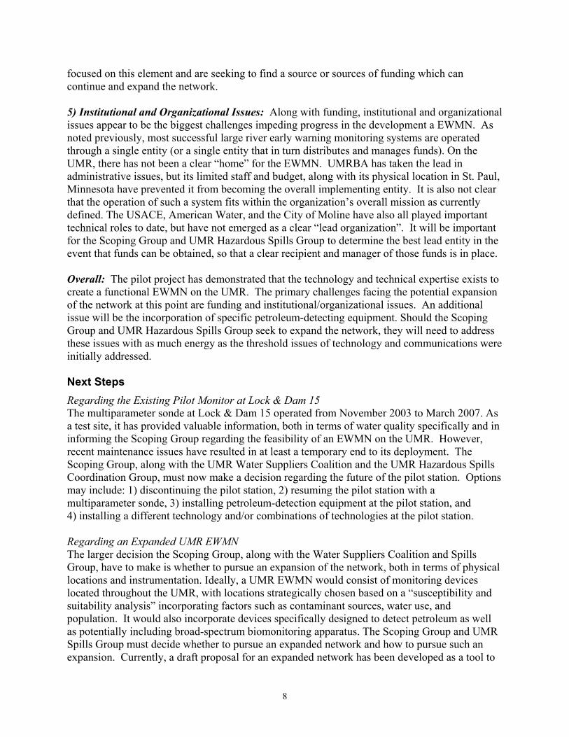
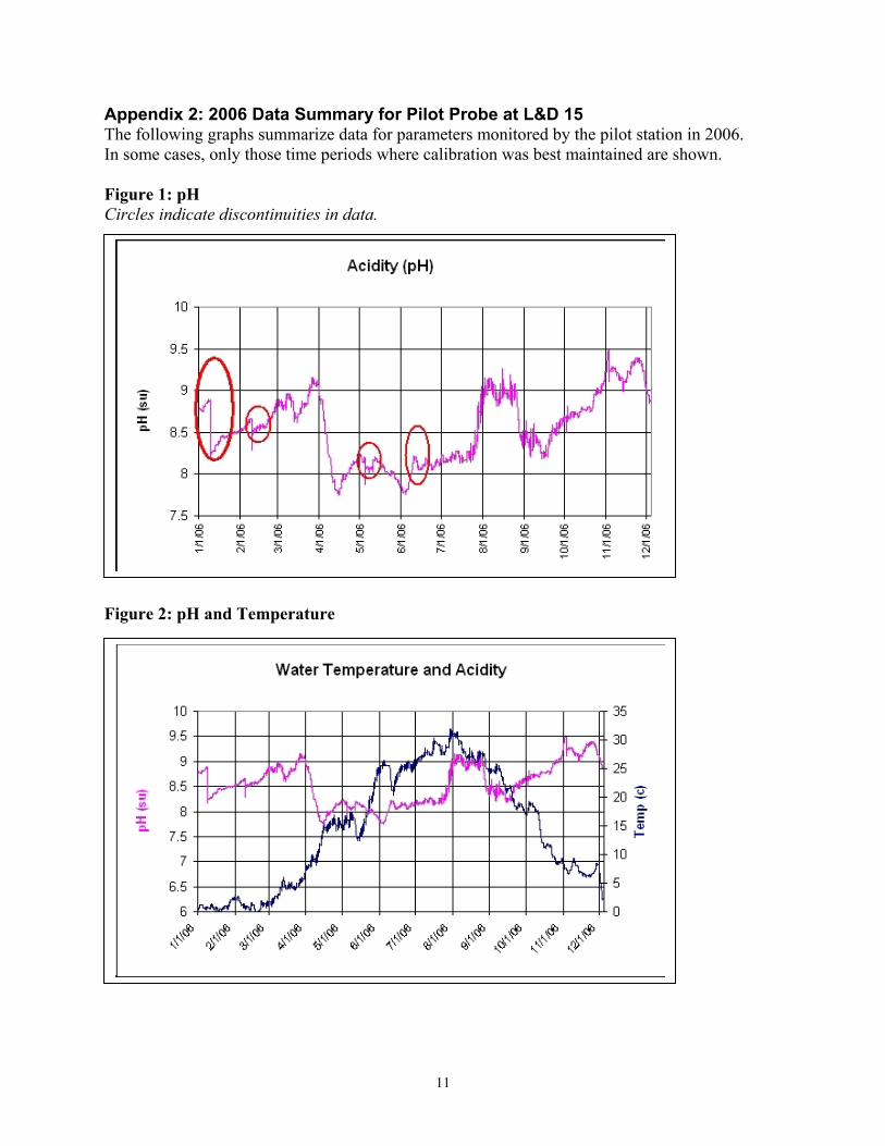
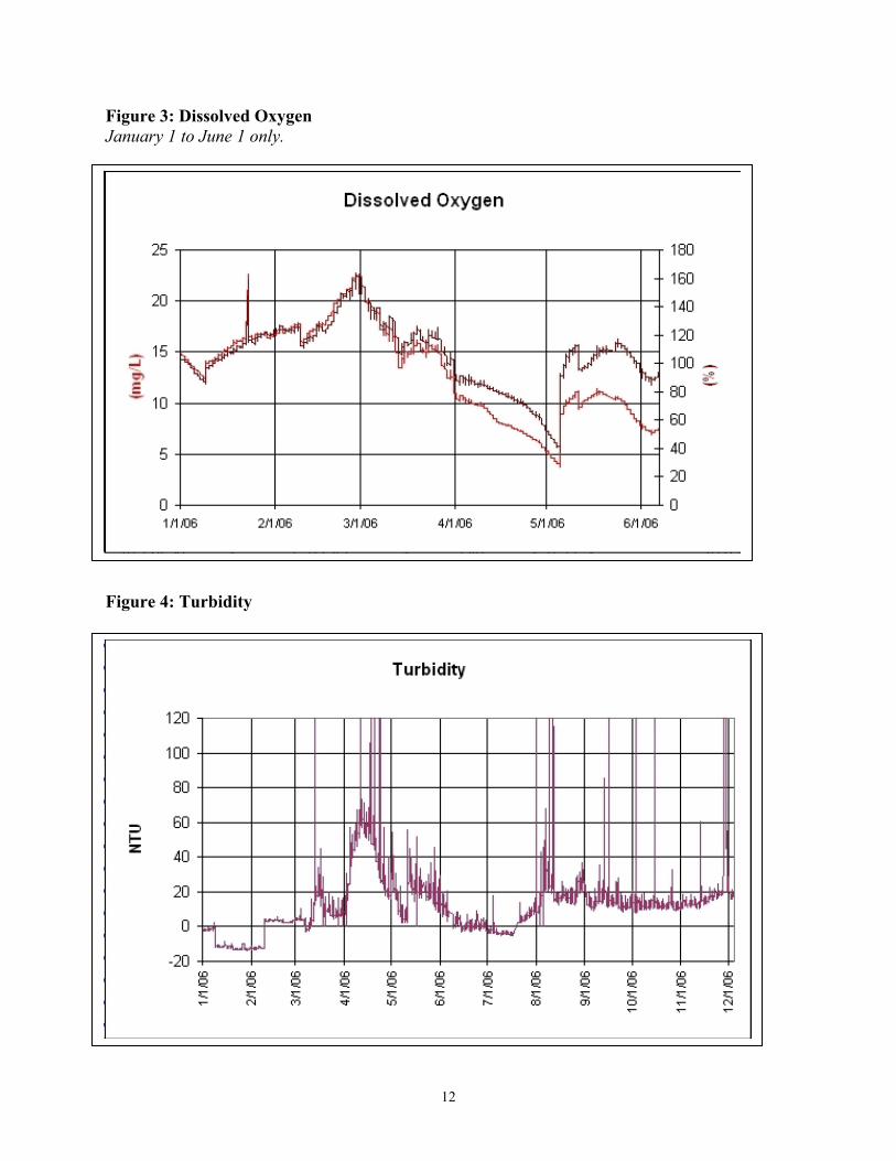
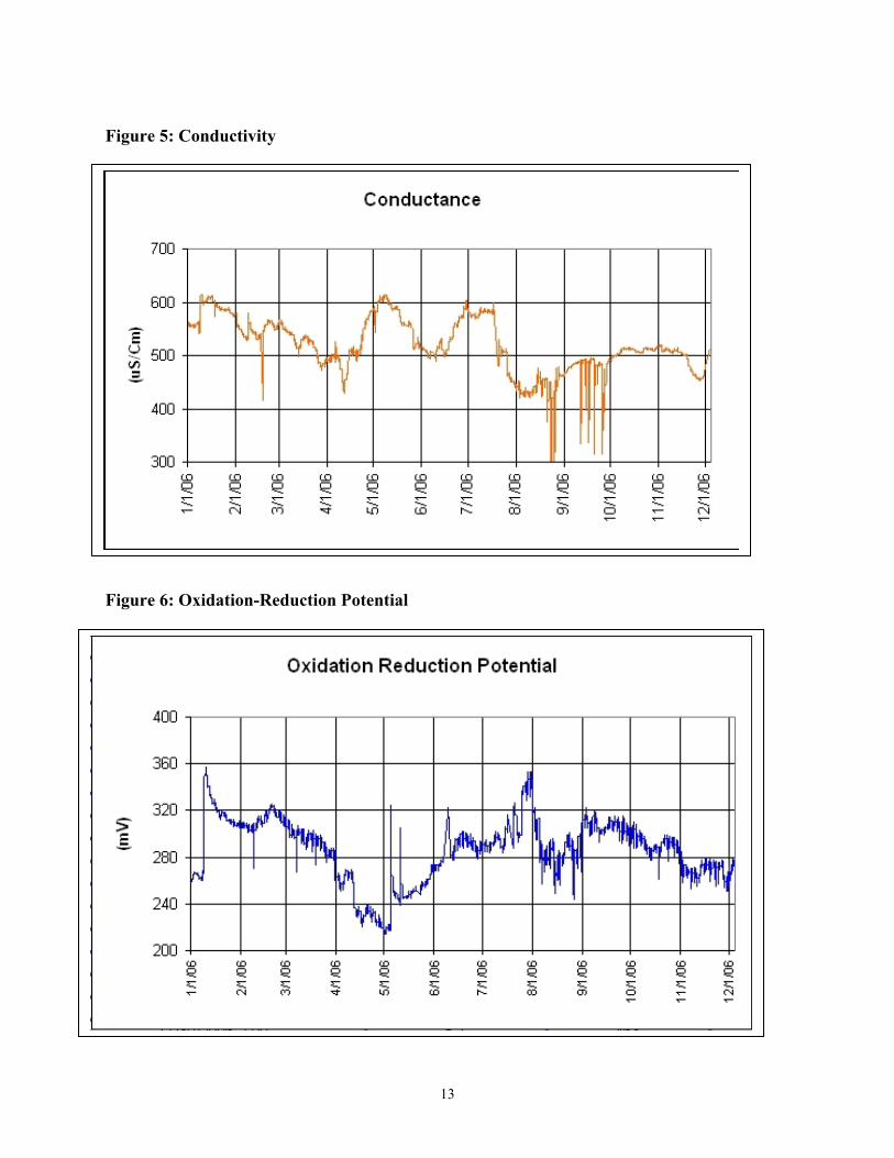
Appendix 2: 2006 Data Summary for Pilot Probe at L&D 15 The following graphs summarize data for parameters monitored by the pilot station in 2006. In some cases, only those time periods where calibration was best maintained are shown. Figure 1: pH Circles indicate discontinuities in data. Figure 2: pH and Temperature
12
Figure 3: Dissolved Oxygen January 1 to June 1 only. Figure 4: Turbidity
13
Figure 5: Conductivity Figure 6: Oxidation-Reduction Potential

14
Figure 7: Chlorophyll February 1 to May 1 only.