Embed Size (px)
Citation preview
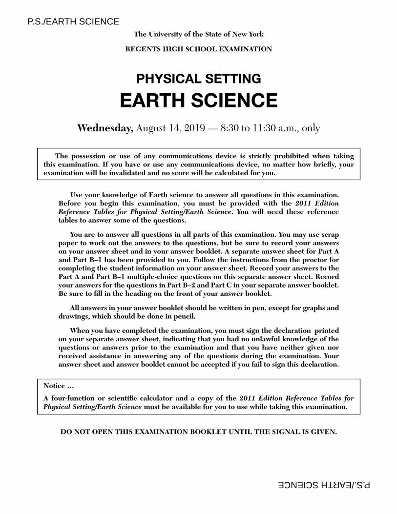
P.S./EARTH SCIENCE P.S./EARTH SCIENCE
The University of the State of New York
REGENTS HIGH SCHOOL EXAMINATION
PHYSICAL SETTING
EARTH SCIENCEWednesday, August 14, 2019 — 8:30 to 11:30 a.m., only
The possession or use of any communications device is strictly prohibited when taking this examination. If you have or use any communications device, no matter how briefl y, your examination will be invalidated and no score will be calculated for you.
Use your knowledge of Earth science to answer all questions in this examination. Before you begin this examination, you must be provided with the 2011 Edition Reference Tables for Physical Setting/Earth Science. You will need these reference tables to answer some of the questions.
You are to answer all questions in all parts of this examination. You may use scrap paper to work out the answers to the questions, but be sure to record your answers on your answer sheet and in your answer booklet. A separate answer sheet for Part A and Part B–1 has been provided to you. Follow the instructions from the proctor for completing the student information on your answer sheet. Record your answers to the Part A and Part B–1 multiple-choice questions on this separate answer sheet. Record your answers for the questions in Part B–2 and Part C in your separate answer booklet. Be sure to fi ll in the heading on the front of your answer booklet.
All answers in your answer booklet should be written in pen, except for graphs and drawings, which should be done in pencil.
When you have completed the examination, you must sign the declaration printed on your separate answer sheet, indicating that you had no unlawful knowledge of the questions or answers prior to the examination and that you have neither given nor received assistance in answering any of the questions during the examination. Your answer sheet and answer booklet cannot be accepted if you fail to sign this declaration.
Notice …
A four-function or scientifi c calculator and a copy of the 2011 Edition Reference Tables for
Physical Setting/Earth Science must be available for you to use while taking this examination.
DO NOT OPEN THIS EXAMINATION BOOKLET UNTIL THE SIGNAL IS GIVEN.
P.S./E. Sci.–Aug. ’19 [2]
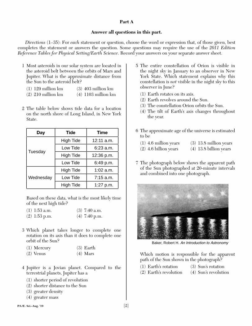
1 Most asteroids in our solar system are located in the asteroid belt between the orbits of Mars and Jupiter. What is the approximate distance from the Sun to the asteroid belt?(1) 129 million km (3) 403 million km(2) 210 million km (4) 1103 million km
2 The table below shows tide data for a location on the north shore of Long Island, in New York State.
Day Tide Time
Tuesday
High Tide 12:11 a.m.Low Tide 6:23 a.m.High Tide 12:36 p.m.Low Tide 6:49 p.m.
WednesdayHigh Tide 1:02 a.m.Low Tide 7:15 a.m.High Tide 1:27 p.m.
Based on these data, what is the most likely time of the next high tide?(1) 1:53 a.m. (3) 7:40 a.m.(2) 1:53 p.m. (4) 7:40 p.m.
3 Which planet takes longer to complete one rotation on its axis than it does to complete one orbit of the Sun?(1) Mercury (3) Earth(2) Venus (4) Mars
4 Jupiter is a Jovian planet. Compared to the terrestrial planets, Jupiter has a(1) shorter period of revolution(2) shorter distance to the Sun(3) greater density(4) greater mass
5 The entire constellation of Orion is visible in the night sky in January to an observer in New York State. Which statement explains why this constellation is not visible in the night sky to this observer in June?(1) Earth rotates on its axis.(2) Earth revolves around the Sun.(3) The constellation Orion orbits the Sun.(4) The tilt of Earth’s axis changes throughout
the year.
6 The approximate age of the universe is estimated to be(1) 4.6 million years (3) 13.8 million years(2) 4.6 billion years (4) 13.8 billion years
7 The photograph below shows the apparent path of the Sun photographed at 20-minute intervals and combined into one photograph.
Baker, Robert H. An Introduction to Astronomy
Which motion is responsible for the apparent path of the Sun shown in the photograph?(1) Earth’s rotation (3) Sun’s rotation(2) Earth’s revolution (4) Sun’s revolution
Part A
Answer all questions in this part.
Directions (1–35): For each statement or question, choose the word or expression that, of those given, best completes the statement or answers the question. Some questions may require the use of the 2011 Edition Reference Tables for Physical Setting/Earth Science. Record your answers on your separate answer sheet.
P.S./E. Sci.–Aug. ’19 [3] [OVER]
8 The mass extinction of the dinosaurs, approximately 65.5 million years ago, is inferred by most scientists to have been caused by(1) a large energy surge from the surface of the
Sun(2) the occurrence of a major ice age(3) an impact event occurring on Earth’s surface(4) earthquakes occurring along crustal plate
boundaries
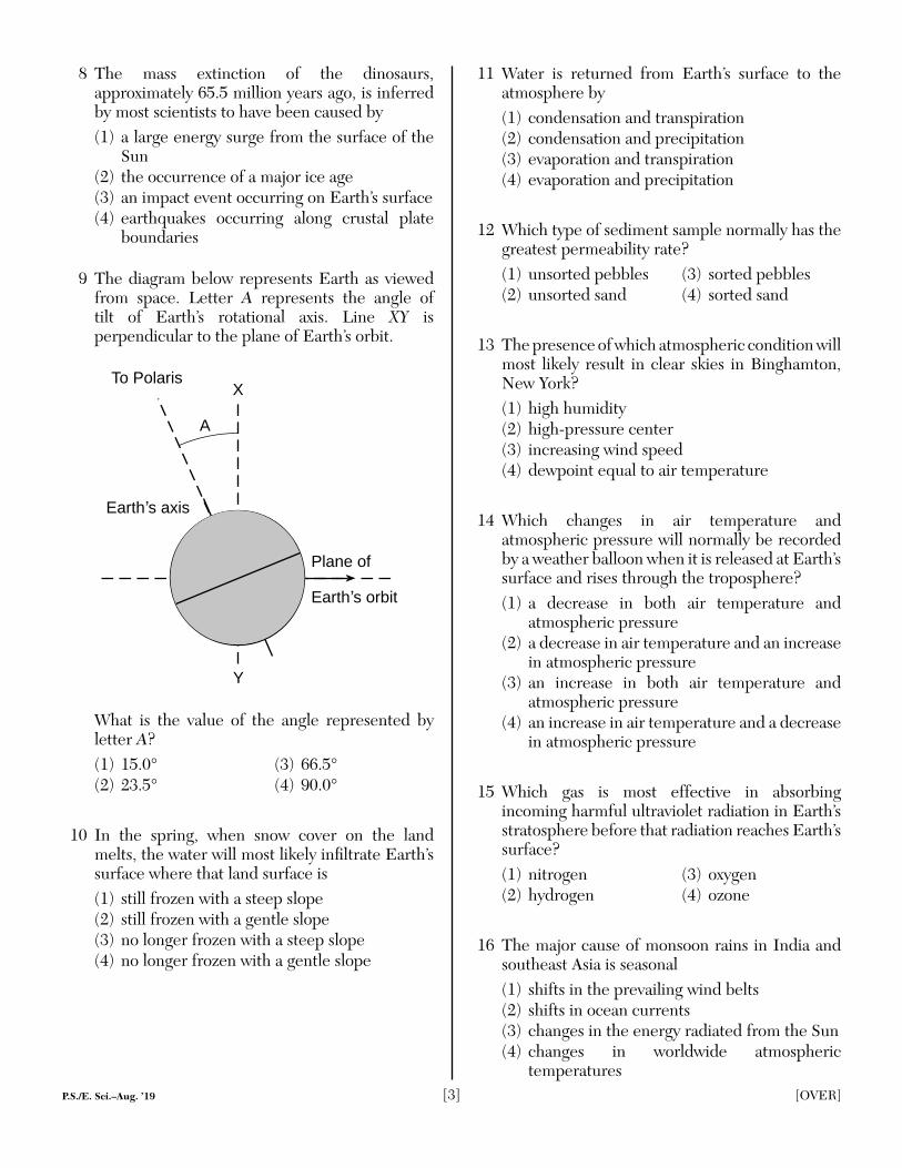
9 The diagram below represents Earth as viewed from space. Letter A represents the angle of tilt of Earth’s rotational axis. Line XY is perpendicular to the plane of Earth’s orbit.
Earth s axis
To PolarisX
Y
A
Plane of
Earth s orbit
What is the value of the angle represented by letter A?(1) 15.0° (3) 66.5°(2) 23.5° (4) 90.0°
10 In the spring, when snow cover on the land melts, the water will most likely infi ltrate Earth’s surface where that land surface is(1) still frozen with a steep slope(2) still frozen with a gentle slope(3) no longer frozen with a steep slope(4) no longer frozen with a gentle slope
11 Water is returned from Earth’s surface to the atmosphere by(1) condensation and transpiration(2) condensation and precipitation(3) evaporation and transpiration(4) evaporation and precipitation
12 Which type of sediment sample normally has the greatest permeability rate?(1) unsorted pebbles (3) sorted pebbles(2) unsorted sand (4) sorted sand
13 The presence of which atmospheric condition willmost likely result in clear skies in Binghamton, New York?(1) high humidity(2) high-pressure center(3) increasing wind speed(4) dewpoint equal to air temperature
14 Which changes in air temperature and atmospheric pressure will normally be recorded by a weather balloon when it is released at Earth’s surface and rises through the troposphere?(1) a decrease in both air temperature and
atmospheric pressure(2) a decrease in air temperature and an increase
in atmospheric pressure(3) an increase in both air temperature and
atmospheric pressure(4) an increase in air temperature and a decrease
in atmospheric pressure
15 Which gas is most effective in absorbing incoming harmful ultraviolet radiation in Earth’s stratosphere before that radiation reaches Earth’s surface?(1) nitrogen (3) oxygen(2) hydrogen (4) ozone
16 The major cause of monsoon rains in India and southeast Asia is seasonal(1) shifts in the prevailing wind belts(2) shifts in ocean currents(3) changes in the energy radiated from the Sun(4) changes in worldwide atmospheric
temperatures
P.S./E. Sci.–Aug. ’19 [4]
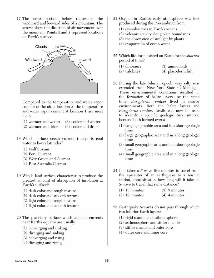
17 The cross section below represents the windward and leeward sides of a mountain. The arrows show the direction of air movement over the mountain. Points X and Y represent locations on Earth’s surface.
Windward LeewardX
Y
Clouds
Compared to the temperature and water vapor content of the air at location X, the temperature and water vapor content at location Y are most likely(1) warmer and wetter (3) cooler and wetter(2) warmer and drier (4) cooler and drier
18 Which surface ocean current transports cool water to lower latitudes?(1) Gulf Stream(2) Peru Current(3) West Greenland Current(4) East Australia Current
19 Which land surface characteristics produce the greatest amount of absorption of insolation at Earth’s surface?(1) dark color and rough texture(2) dark color and smooth texture(3) light color and rough texture(4) light color and smooth texture
20 The planetary surface winds and air currents near Earth’s equator are usually(1) converging and sinking(2) diverging and sinking(3) converging and rising(4) diverging and rising
21 Oxygen in Earth’s early atmosphere was fi rst produced during the Precambrian from(1) cyanobacteria in Earth’s oceans(2) volcanic activity along plate boundaries(3) the absorption of sunlight by plants(4) evaporation of ocean water
22 Which life-form existed on Earth for the shortest period of time?(1) dinosaurs (3) ammonoids(2) trilobites (4) placoderm fi sh
23 During the late Silurian epoch, very salty seas extended from New York State to Michigan. These environmental conditions resulted in the formation of halite layers. At the same time, Eurypterus remipes lived in nearby environments. Both the halite layers and Eurypterus remipes fossils can now be used to identify a specifi c geologic time interval because both formed over a(1) large geographic area and in a short geologic
time(2) large geographic area and in a long geologic
time(3) small geographic area and in a short geologic
time(4) small geographic area and in a long geologic
time
24 If it takes a P-wave fi ve minutes to travel from the epicenter of an earthquake to a seismic station, approximately how long will it take an S-wave to travel that same distance?(1) 15 minutes (3) 9 minutes(2) 12 minutes (4) 4 minutes
25 Earthquake S-waves do not pass through which two interior Earth layers?(1) rigid mantle and asthenosphere(2) asthenosphere and stiffer mantle(3) stiffer mantle and outer core(4) outer core and inner core
P.S./E. Sci.–Aug. ’19 [5] [OVER]
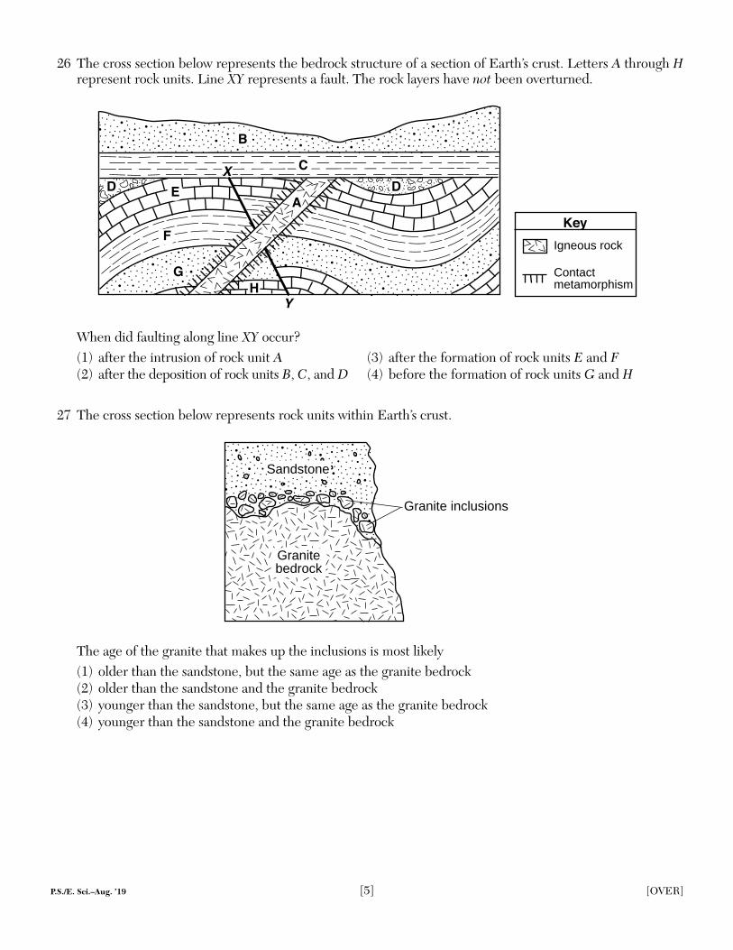
26 The cross section below represents the bedrock structure of a section of Earth’s crust. Letters A through H represent rock units. Line XY represents a fault. The rock layers have not been overturned.
Igneous rock
Contactmetamorphism
Key
A
B
C
D E
F
G
X
Y
D
H
When did faulting along line XY occur?(1) after the intrusion of rock unit A (3) after the formation of rock units E and F(2) after the deposition of rock units B, C, and D (4) before the formation of rock units G and H
27 The cross section below represents rock units within Earth’s crust.
Granite inclusions
Granite bedrock
Sandstone
The age of the granite that makes up the inclusions is most likely(1) older than the sandstone, but the same age as the granite bedrock(2) older than the sandstone and the granite bedrock(3) younger than the sandstone, but the same age as the granite bedrock(4) younger than the sandstone and the granite bedrock
P.S./E. Sci.–Aug. ’19 [6]
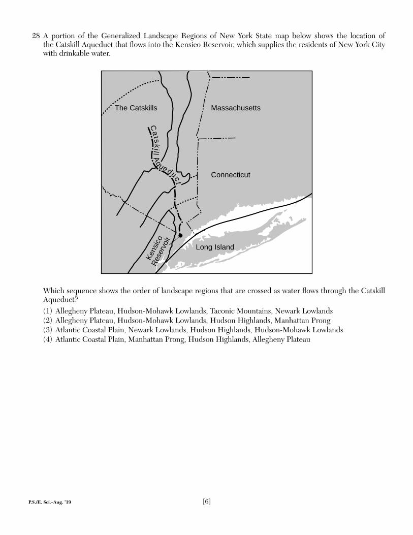
28 A portion of the Generalized Landscape Regions of New York State map below shows the location of the Catskill Aqueduct that fl ows into the Kensico Reservoir, which supplies the residents of New York City with drinkable water.
Massachusetts
Connecticut
The Catskills
Long Island
Kens
icoRe
serv
oir
Catskill A
queduct
Which sequence shows the order of landscape regions that are crossed as water fl ows through the Catskill Aqueduct?(1) Allegheny Plateau, Hudson-Mohawk Lowlands, Taconic Mountains, Newark Lowlands(2) Allegheny Plateau, Hudson-Mohawk Lowlands, Hudson Highlands, Manhattan Prong(3) Atlantic Coastal Plain, Newark Lowlands, Hudson Highlands, Hudson-Mohawk Lowlands(4) Atlantic Coastal Plain, Manhattan Prong, Hudson Highlands, Allegheny Plateau
P.S./E. Sci.–Aug. ’19 [7] [OVER]
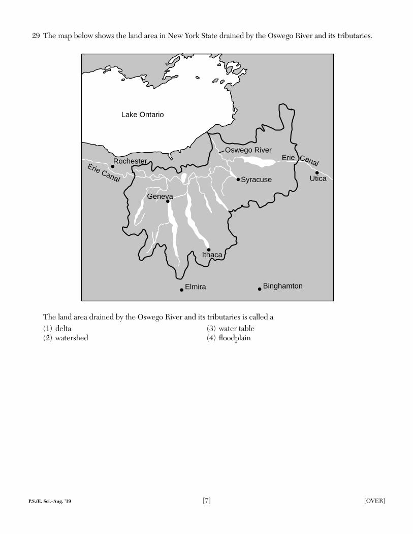
29 The map below shows the land area in New York State drained by the Oswego River and its tributaries.
Lake Ontario
Rochester
BinghamtonElmira
Ithaca
Syracuse Utica
Erie CanalErie Canal
Oswego River
Geneva
The land area drained by the Oswego River and its tributaries is called a(1) delta (3) water table(2) watershed (4) fl oodplain
P.S./E. Sci.–Aug. ’19 [8]
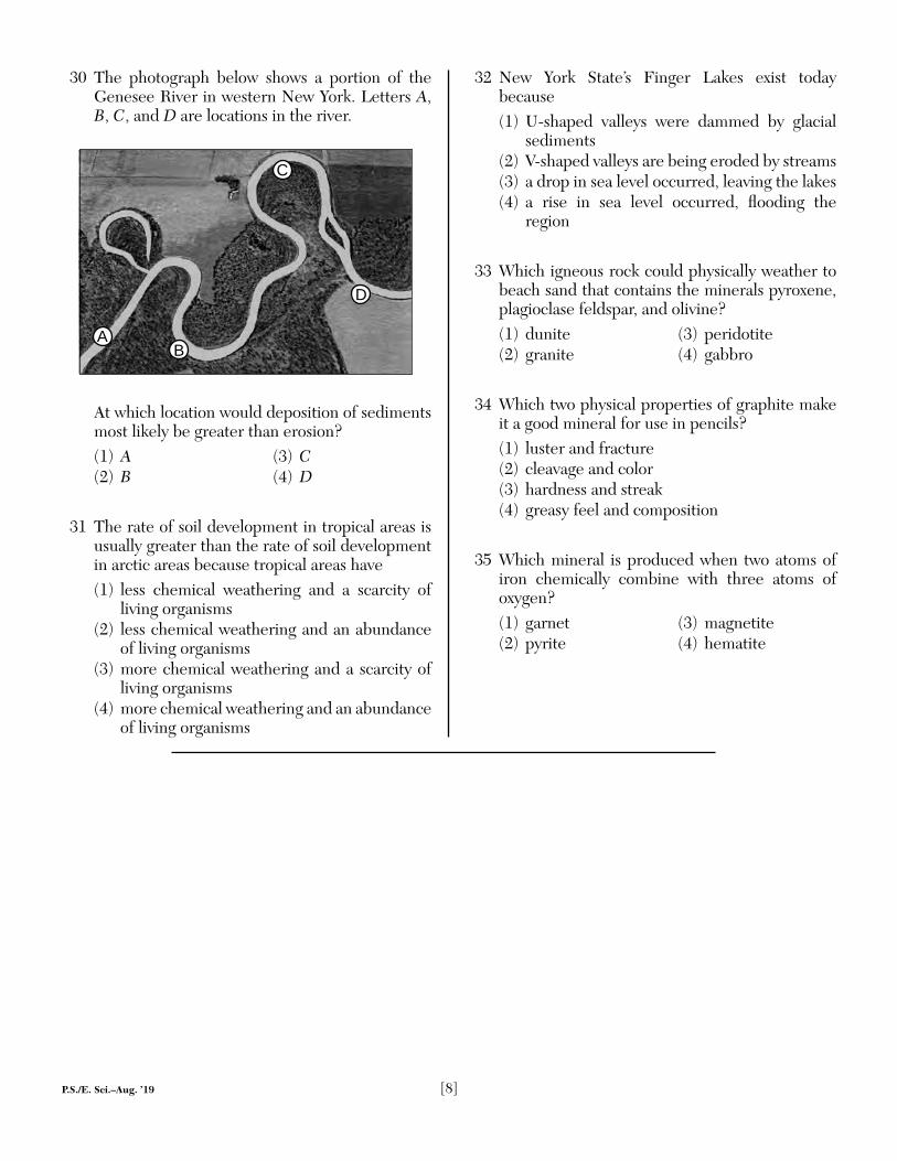
30 The photograph below shows a portion of the Genesee River in western New York. Letters A, B, C, and D are locations in the river.
C
D
BA
At which location would deposition of sediments most likely be greater than erosion?(1) A (3) C(2) B (4) D
31 The rate of soil development in tropical areas is usually greater than the rate of soil development in arctic areas because tropical areas have(1) less chemical weathering and a scarcity of
living organisms(2) less chemical weathering and an abundance
of living organisms(3) more chemical weathering and a scarcity of
living organisms(4) more chemical weathering and an abundance
of living organisms
32 New York State’s Finger Lakes exist today because(1) U-shaped valleys were dammed by glacial
sediments(2) V-shaped valleys are being eroded by streams(3) a drop in sea level occurred, leaving the lakes(4) a rise in sea level occurred, fl ooding the
region
33 Which igneous rock could physically weather to beach sand that contains the minerals pyroxene, plagioclase feldspar, and olivine?(1) dunite (3) peridotite(2) granite (4) gabbro
34 Which two physical properties of graphite make it a good mineral for use in pencils?(1) luster and fracture(2) cleavage and color(3) hardness and streak(4) greasy feel and composition
35 Which mineral is produced when two atoms of iron chemically combine with three atoms of oxygen?(1) garnet (3) magnetite(2) pyrite (4) hematite
P.S./E. Sci.–Aug. ’19 [9] [OVER]
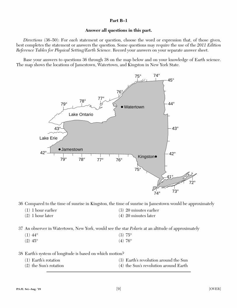
Base your answers to questions 36 through 38 on the map below and on your knowledge of Earth science. The map shows the locations of Jamestown, Watertown, and Kingston in New York State.
76°
75°
74° 73°
72°
77°78°79°
79° 78° 77°76°
75° 74°
42°
43°
44°
45°
41°
43°
42°
Lake Erie
Lake Ontario
Jamestown
Watertown
Kingston
36 Compared to the time of sunrise in Kingston, the time of sunrise in Jamestown would be approximately(1) 1 hour earlier (3) 20 minutes earlier(2) 1 hour later (4) 20 minutes later
37 An observer in Watertown, New York, would see the star Polaris at an altitude of approximately(1) 44° (3) 75°(2) 45° (4) 76°
38 Earth’s system of longitude is based on which motion?(1) Earth’s rotation (3) Earth’s revolution around the Sun(2) the Sun’s rotation (4) the Sun’s revolution around Earth
Part B–1
Answer all questions in this part.
Directions (36–50): For each statement or question, choose the word or expression that, of those given, best completes the statement or answers the question. Some questions may require the use of the 2011 Edition Reference Tables for Physical Setting/Earth Science. Record your answers on your separate answer sheet.
P.S./E. Sci.–Aug. ’19 [10]
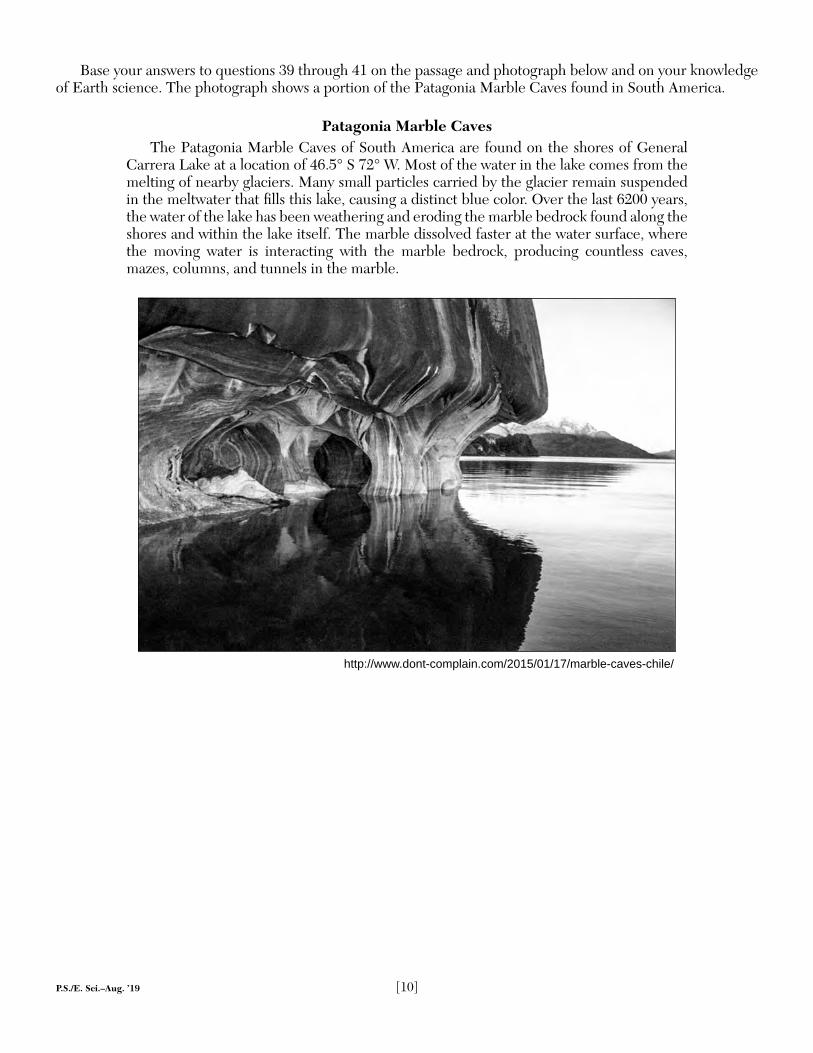
Base your answers to questions 39 through 41 on the passage and photograph below and on your knowledge of Earth science. The photograph shows a portion of the Patagonia Marble Caves found in South America.
Patagonia Marble CavesThe Patagonia Marble Caves of South America are found on the shores of General
Carrera Lake at a location of 46.5° S 72° W. Most of the water in the lake comes from the melting of nearby glaciers. Many small particles carried by the glacier remain suspended in the meltwater that fi lls this lake, causing a distinct blue color. Over the last 6200 years, the water of the lake has been weathering and eroding the marble bedrock found along the shores and within the lake itself. The marble dissolved faster at the water surface, where the moving water is interacting with the marble bedrock, producing countless caves, mazes, columns, and tunnels in the marble.
http://www.dont-complain.com/2015/01/17/marble-caves-chile/
P.S./E. Sci.–Aug. ’19 [11] [OVER]
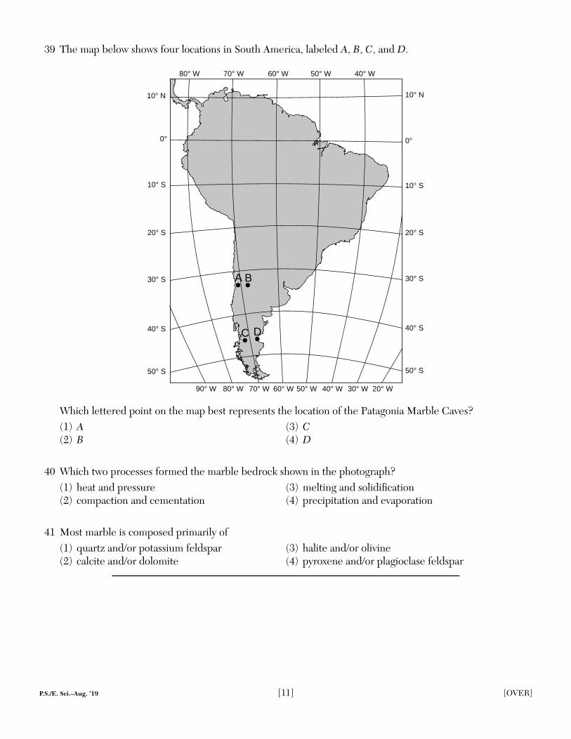
39 The map below shows four locations in South America, labeled A, B, C, and D.
50° W 40° W 30° W 20° W60° W70° W80° W90° W
40° S
20° S
0°
80° W 70° W 60° W 50° W 40° W
30° S
10° S
10° N
50° S
A B
C D 40° S
20° S
0°
30° S
10° S
10° N
50° S
Which lettered point on the map best represents the location of the Patagonia Marble Caves?(1) A (3) C(2) B (4) D
40 Which two processes formed the marble bedrock shown in the photograph?(1) heat and pressure (3) melting and solidifi cation(2) compaction and cementation (4) precipitation and evaporation
41 Most marble is composed primarily of(1) quartz and/or potassium feldspar (3) halite and/or olivine(2) calcite and/or dolomite (4) pyroxene and/or plagioclase feldspar
P.S./E. Sci.–Aug. ’19 [12]
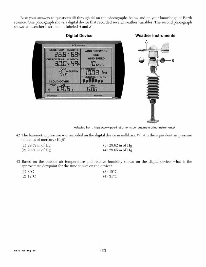
Base your answers to questions 42 through 44 on the photographs below and on your knowledge of Earth science. One photograph shows a digital device that recorded several weather variables. The second photograph shows two weather instruments, labeled A and B.
INSIDE TEMP HUMIDITY
°C %
SUNNY
CLOUD COVER
TIME AM DATE
OUTSIDE TEMP HUMIDITY
°C %
PRESSURE
PRESSURE TREND
WIND DIRECTION
SSE
WIND SPEED
Digital Device
mb
KNOTS
42 The barometric pressure was recorded on the digital device in millibars. What is the equivalent air pressure in inches of mercury (Hg)?(1) 29.59 in of Hg (3) 29.62 in of Hg(2) 29.60 in of Hg (4) 29.65 in of Hg
43 Based on the outside air temperature and relative humidity shown on the digital device, what is the approximate dewpoint for the time shown on the device?(1) 8°C (3) 18°C(2) 12°C (4) 31°C
A
B
Adapted from: https://www.pce-instruments.com/us/measuring-instruments/
Weather Instruments
P.S./E. Sci.–Aug. ’19 [13] [OVER]
44 Which table correctly identifi es weather instruments A and B and the weather variable that each measures?
Weather Instrument
Weather Variable
Measured
A wind vane wind directionB anemometer wind speed
( 1 )
Weather Instrument
Weather Variable
Measured
A wind vane wind speedB anemometer wind direction
( 3 )
Weather Instrument
Weather Variable
Measured
A anemometer wind speedB wind vane wind direction
Weather Instrument
Weather Variable
Measured
A anemometer wind directionB wind vane wind speed
( 2 ) ( 4 )
GO ON TO THE NEXT PAGE ➯
P.S./E. Sci.–Aug. ’19 [14]
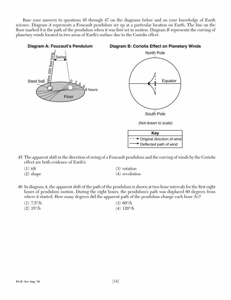
Base your answers to questions 45 through 47 on the diagrams below and on your knowledge of Earth science. Diagram A represents a Foucault pendulum set up at a particular location on Earth. The line on the fl oor marked 0 is the path of the pendulum when it was fi rst set in motion. Diagram B represents the curving of planetary winds located in two areas of Earth’s surface due to the Coriolis effect.
Swing
Wire
200
feet
long
Floor
0 2 4 68 hours
Steel ball
Diagram A: Foucault’s Pendulum
Key
Original direction of windDeflected path of wind
(Not drawn to scale)
North Pole
Equator
Diagram B: Coriolis Effect on Planetary Winds
South Pole
45 The apparent shift in the direction of swing of a Foucault pendulum and the curving of winds by the Coriolis effect are both evidence of Earth’s(1) tilt (3) rotation(2) shape (4) revolution
46 In diagram A, the apparent shift of the path of the pendulum is shown at two-hour intervals for the fi rst eight hours of pendulum motion. During the eight hours, the pendulum’s path was displaced 60 degrees from where it started. How many degrees did the apparent path of the pendulum change each hour (h)?(1) 7.5°/h (3) 60°/h(2) 15°/h (4) 120°/h
P.S./E. Sci.–Aug. ’19 [15] [OVER]
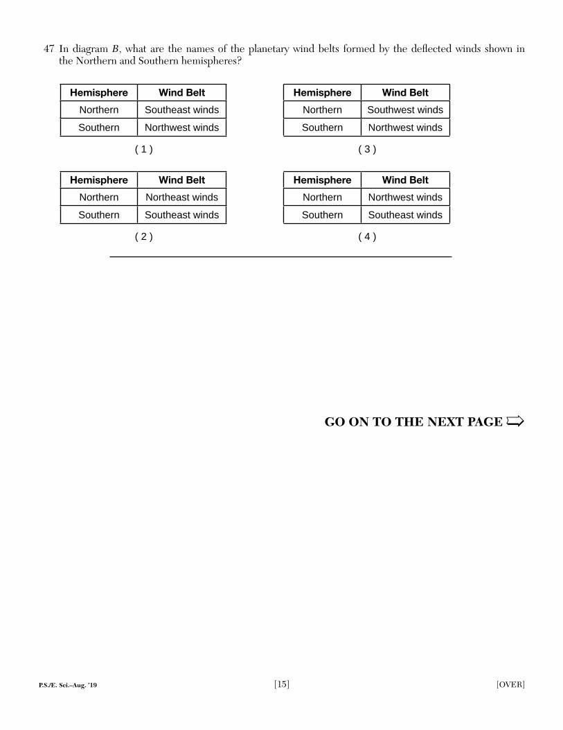
47 In diagram B, what are the names of the planetary wind belts formed by the defl ected winds shown in the Northern and Southern hemispheres?
Hemisphere Wind BeltNorthern Southeast windsSouthern Northwest winds
Hemisphere Wind BeltNorthern Southwest windsSouthern Northwest winds
Hemisphere Wind BeltNorthern Northeast windsSouthern Southeast winds
Hemisphere Wind BeltNorthern Northwest windsSouthern Southeast winds
( 1 ) ( 3 )
( 2 ) ( 4 )
GO ON TO THE NEXT PAGE ➯
P.S./E. Sci.–Aug. ’19 [16]
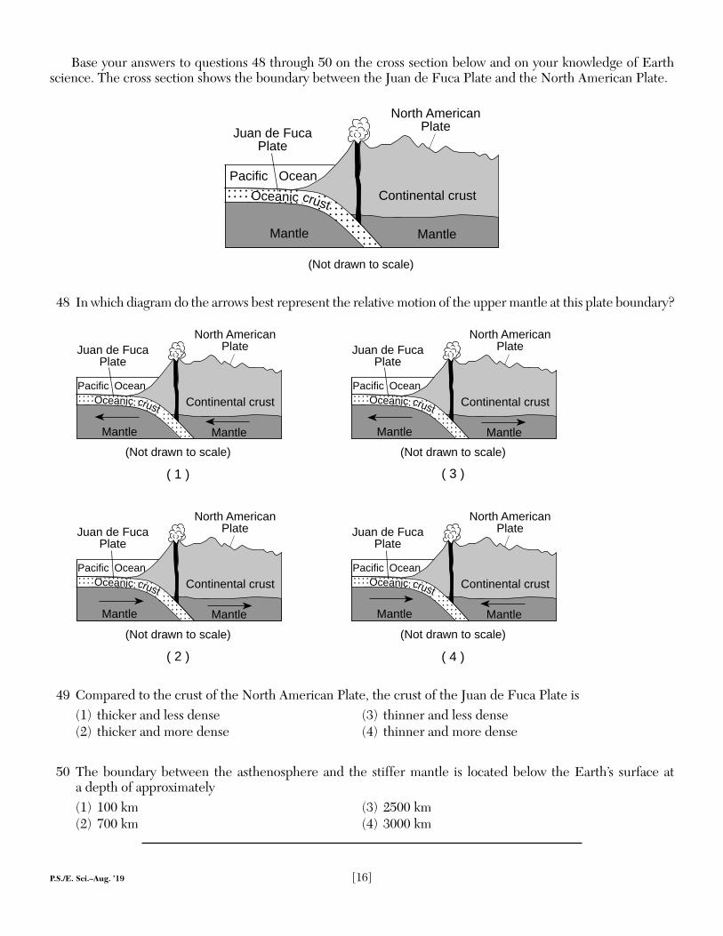
Base your answers to questions 48 through 50 on the cross section below and on your knowledge of Earth science. The cross section shows the boundary between the Juan de Fuca Plate and the North American Plate.
Continental crust
Mantle
Pacific Ocean
Juan de FucaPlate
North AmericanPlate
Mantle
(Not drawn to scale)
Oceanic crust
48 In which diagram do the arrows best represent the relative motion of the upper mantle at this plate boundary?
(Not drawn to scale)
( 3 )
Continental crust
Mantle
Pacific
Juan de Fuca Plate
North AmericanPlate
Mantle
OceanicOcean
crust
(Not drawn to scale)
( 2 )
(Not drawn to scale)
( 1 )
(Not drawn to scale)
( 4 )
Continental crust
Mantle
Pacific
Juan de Fuca Plate
North AmericanPlate
Mantle
OceanicOcean
crust
Continental crust
Mantle
Pacific
Juan de Fuca Plate
North AmericanPlate
Mantle
OceanicOcean
crust
Continental crust
Mantle
Pacific
Juan de Fuca Plate
North AmericanPlate
Mantle
OceanicOcean
crust
49 Compared to the crust of the North American Plate, the crust of the Juan de Fuca Plate is(1) thicker and less dense (3) thinner and less dense(2) thicker and more dense (4) thinner and more dense
50 The boundary between the asthenosphere and the stiffer mantle is located below the Earth’s surface at a depth of approximately(1) 100 km (3) 2500 km(2) 700 km (4) 3000 km
P.S./E. Sci.–Aug. ’19 [17] [OVER]
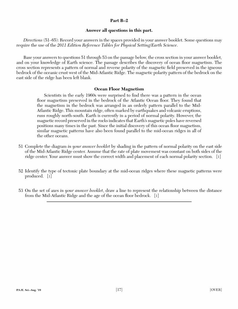
Base your answers to questions 51 through 53 on the passage below, the cross section in your answer booklet, and on your knowledge of Earth science. The passage describes the discovery of ocean fl oor magnetism. The cross section represents a pattern of normal and reverse polarity of the magnetic fi eld preserved in the igneous bedrock of the oceanic crust west of the Mid-Atlantic Ridge. The magnetic polarity pattern of the bedrock on the east side of the ridge has been left blank.
Ocean Floor MagnetismScientists in the early 1960s were surprised to fi nd there was a pattern in the ocean
fl oor magnetism preserved in the bedrock of the Atlantic Ocean fl oor. They found that the magnetism in the bedrock was arranged in an orderly pattern parallel to the Mid-Atlantic Ridge. This mountain ridge, often marked by earthquakes and volcanic eruptions, runs roughly north-south. Earth is currently in a period of normal polarity. However, the magnetic record preserved in the rocks indicates that Earth’s magnetic poles have reversed positions many times in the past. Since the initial discovery of this ocean fl oor magnetism, similar magnetic patterns have also been found parallel to the mid-ocean ridges in all of the other oceans.
51 Complete the diagram in your answer booklet by shading in the pattern of normal polarity on the east side of the Mid-Atlantic Ridge center. Assume that the rate of plate movement was constant on both sides of the ridge center. Your answer must show the correct width and placement of each normal polarity section. [1]
52 Identify the type of tectonic plate boundary at the mid-ocean ridges where these magnetic patterns were produced. [1]
53 On the set of axes in your answer booklet, draw a line to represent the relationship between the distance from the Mid-Atlantic Ridge and the age of the ocean fl oor bedrock. [1]
Part B–2
Answer all questions in this part.
Directions (51–65): Record your answers in the spaces provided in your answer booklet. Some questions may require the use of the 2011 Edition Reference Tables for Physical Setting/Earth Science.
P.S./E. Sci.–Aug. ’19 [18]
Base your answers to questions 54 through 56 on the photograph below and on your knowledge of Earth science. The photograph is of a rock sample composed of pebbles that have been cemented together.
www.geolsoc.org.uk
54 Identify the name of the sedimentary rock. [1]
55 Identify the total possible range of particle diameters, in centimeters, for a particle to be classifi ed as a pebble. [1]
56 Describe the evidence from the photograph that supports the inference that the particles in this rock were most likely transported by running water. [1]
Base your answers to questions 57 through 59 on the diagrams below and on your knowledge of Earth science. The diagrams represent a model of the disintegration of a sample of the radioactive isotope carbon-14 (14C).
Original sample After one half-life
Carbon - 14Stabledisintegrationproduct
Key
57 Determine the number of carbon-14 atoms that would most likely remain at the end of the second half-life. [1]
58 Identify the stable disintegration product that is produced when carbon-14 decays. [1]
59 Identify the radioactive isotope that has a half-life that is approximately the same as the estimated age of Earth, by using the Radioactive Decay Data table in the Earth Science Reference Tables. [1]
P.S./E. Sci.–Aug. ’19 [19] [OVER]
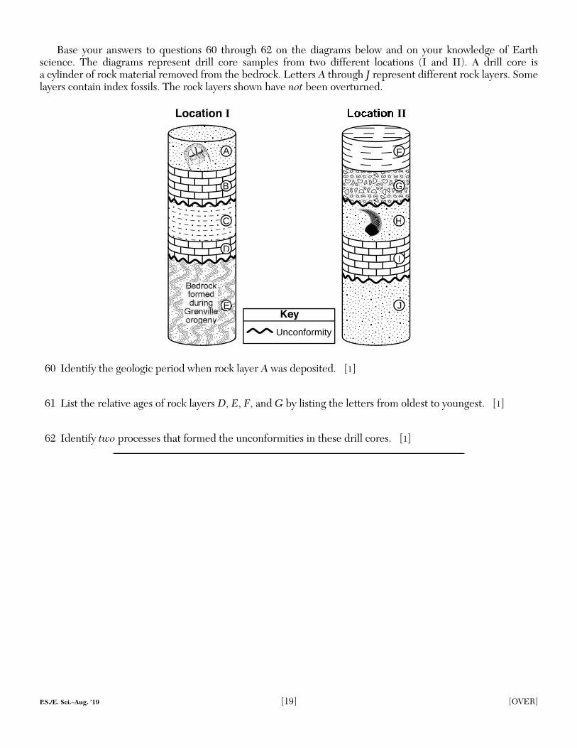
Base your answers to questions 60 through 62 on the diagrams below and on your knowledge of Earth science. The diagrams represent drill core samples from two different locations (I and II). A drill core is a cylinder of rock material removed from the bedrock. Letters A through J represent different rock layers. Some layers contain index fossils. The rock layers shown have not been overturned.
II
J
I
H
FF
GG
Unconformity
Key
Location I
D
B
AA
C
60 Identify the geologic period when rock layer A was deposited. [1]
61 List the relative ages of rock layers D, E, F, and G by listing the letters from oldest to youngest. [1]
62 Identify two processes that formed the unconformities in these drill cores. [1]
P.S./E. Sci.–Aug. ’19 [20]
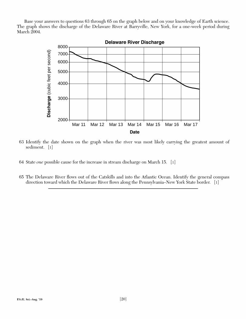
Base your answers to questions 63 through 65 on the graph below and on your knowledge of Earth science. The graph shows the discharge of the Delaware River at Barryville, New York, for a one-week period during March 2004.
80007000
6000
5000
4000
3000
2000
Delaware River Discharge
Date
Dis
ch
arg
e (c
ubic
feet
per
sec
ond)
Mar 11 Mar 12 Mar 13 Mar 14 Mar 15 Mar 16 Mar 17
63 Identify the date shown on the graph when the river was most likely carrying the greatest amount of sediment. [1]
64 State one possible cause for the increase in stream discharge on March 15. [1]
65 The Delaware River fl ows out of the Catskills and into the Atlantic Ocean. Identify the general compass direction toward which the Delaware River fl ows along the Pennsylvania–New York State border. [1]
P.S./E. Sci.–Aug. ’19 [21] [OVER]
Base your answers to questions 66 through 68 on the topographic map below and on your knowledge of Earth science. The map shows an eroded drumlin at Chimney Bluffs State Park along the shoreline of Lake Ontario east of Rochester, New York. Lines AB and CD are reference lines. Elevations are shown in feet.
0 0.5 1
MilesContour interval = 10 feet
Chimney Bluffs
C
D
A B
350
Lake Ontario
300
400
250
N
250
66 Calculate the gradient along the line between points A and B in feet per mile. [1]
67 On the grid in your answer booklet, construct a topographic profi le along line CD by plotting the elevation of each contour line that crosses line CD. The elevations for points C and D have been plotted on the grid. Connect all nine plots with a line from point C to point D to complete the profi le. [1]
68 Describe one piece of evidence represented by the contour lines on the map that indicates the north side of Chimney Bluffs is steep. [1]
Part C
Answer all questions in this part.
Directions (66–85): Record your answers in the spaces provided in your answer booklet. Some questions may require the use of the 2011 Edition Reference Tables for Physical Setting/Earth Science.
P.S./E. Sci.–Aug. ’19 [22]
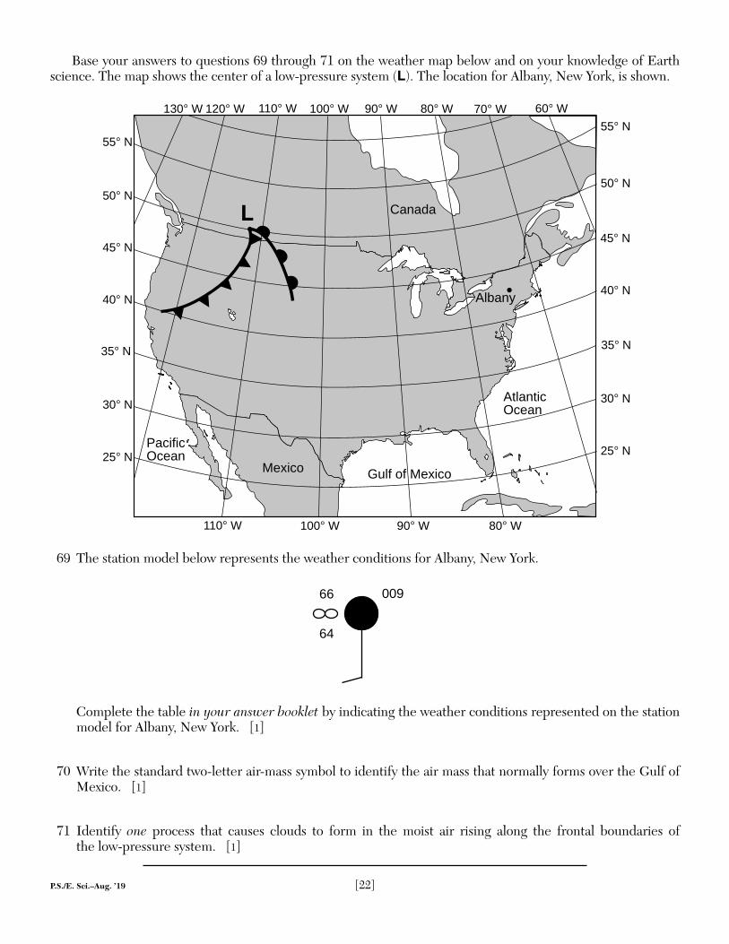
Base your answers to questions 69 through 71 on the weather map below and on your knowledge of Earth science. The map shows the center of a low-pressure system (L). The location for Albany, New York, is shown.
PacificOcean
AtlanticOcean
Gulf of MexicoMexico
Canada
Albany
L
120° W 110° W 100° W 90° W 80° W 70° W 60° W55° N
45° N
40° N
35° N
30° N
25° N
50° N
55° N
45° N
40° N
35° N
30° N
25° N
50° N
110° W 100° W 90° W 80° W
130° W
69 The station model below represents the weather conditions for Albany, New York.
009
64
66
Complete the table in your answer booklet by indicating the weather conditions represented on the station model for Albany, New York. [1]
70 Write the standard two-letter air-mass symbol to identify the air mass that normally forms over the Gulf of Mexico. [1]
71 Identify one process that causes clouds to form in the moist air rising along the frontal boundaries of the low-pressure system. [1]
P.S./E. Sci.–Aug. ’19 [23] [OVER]
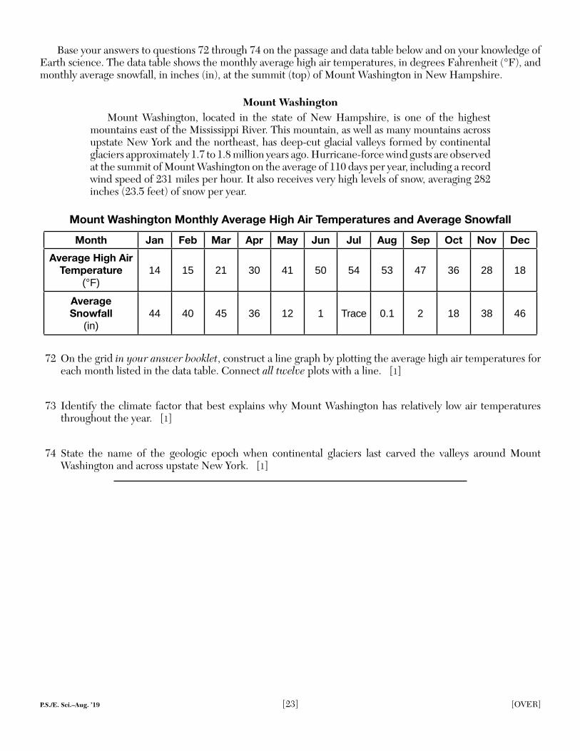
Base your answers to questions 72 through 74 on the passage and data table below and on your knowledge of Earth science. The data table shows the monthly average high air temperatures, in degrees Fahrenheit (°F), and monthly average snowfall, in inches (in), at the summit (top) of Mount Washington in New Hampshire.
Mount WashingtonMount Washington, located in the state of New Hampshire, is one of the highest
mountains east of the Mississippi River. This mountain, as well as many mountains across upstate New York and the northeast, has deep-cut glacial valleys formed by continental glaciers approximately 1.7 to 1.8 million years ago. Hurricane-force wind gusts are observed at the summit of Mount Washington on the average of 110 days per year, including a record wind speed of 231 miles per hour. It also receives very high levels of snow, averaging 282 inches (23.5 feet) of snow per year.
Mount Washington Monthly Average High Air Temperatures and Average Snowfall
Month Jan Feb Mar Apr May Jun Jul Aug Sep Oct Nov DecAverage High Air
Temperature (°F)
14 15 21 30 41 50 54 53 47 36 28 18
AverageSnowfall
(in)44 40 45 36 12 1 Trace 0.1 2 18 38 46
72 On the grid in your answer booklet, construct a line graph by plotting the average high air temperatures for each month listed in the data table. Connect all twelve plots with a line. [1]
73 Identify the climate factor that best explains why Mount Washington has relatively low air temperatures throughout the year. [1]
74 State the name of the geologic epoch when continental glaciers last carved the valleys around Mount Washington and across upstate New York. [1]
P.S./E. Sci.–Aug. ’19 [24]
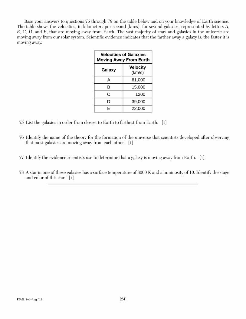
Base your answers to questions 75 through 78 on the table below and on your knowledge of Earth science. The table shows the velocities, in kilometers per second (km/s), for several galaxies, represented by letters A, B, C, D, and E, that are moving away from Earth. The vast majority of stars and galaxies in the universe are moving away from our solar system. Scientifi c evidence indicates that the farther away a galaxy is, the faster it is moving away.
Velocities of Galaxies Moving Away From Earth
Galaxy Velocity (km/s)
A 61,000B 15,000C 1200D 39,000E 22,000
75 List the galaxies in order from closest to Earth to farthest from Earth. [1]
76 Identify the name of the theory for the formation of the universe that scientists developed after observing that most galaxies are moving away from each other. [1]
77 Identify the evidence scientists use to determine that a galaxy is moving away from Earth. [1]
78 A star in one of these galaxies has a surface temperature of 8000 K and a luminosity of 10. Identify the stage and color of this star. [1]
P.S./E. Sci.–Aug. ’19 [25] [OVER]
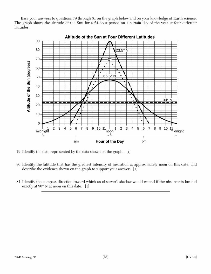
Base your answers to questions 79 through 81 on the graph below and on your knowledge of Earth science.The graph shows the altitude of the Sun for a 24-hour period on a certain day of the year at four differentlatitudes.
Alt
itu
de o
f th
e S
un
(deg
rees
)
Altitude of the Sun at Four Different Latitudes
Hour of the Day
0
midnight
90
10
20
30
40
50
60
70
80
1 2 3 4 5 6 7 8 9 10 11noon
1 2 3 4 5 6 7 8 9 10 11midnight
am pm
23.5° N
66.5° N
0°
90° N
79 Identify the date represented by the data shown on the graph. [1]
80 Identify the latitude that has the greatest intensity of insolation at approximately noon on this date, and describe the evidence shown on the graph to support your answer. [1]
81 Identify the compass direction toward which an observer’s shadow would extend if the observer is located exactly at 90° N at noon on this date. [1]
P.S./E. Sci.–Aug. ’19 [26]
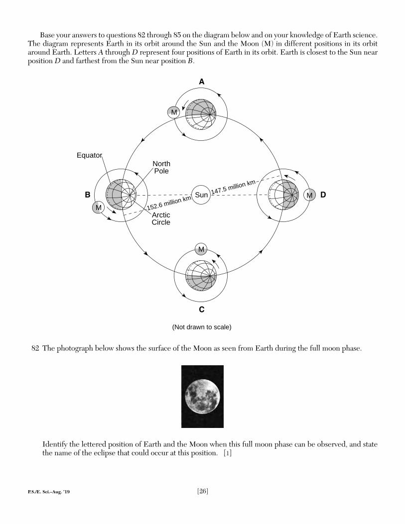
Base your answers to questions 82 through 85 on the diagram below and on your knowledge of Earth science. The diagram represents Earth in its orbit around the Sun and the Moon (M) in different positions in its orbit around Earth. Letters A through D represent four positions of Earth in its orbit. Earth is closest to the Sun near position D and farthest from the Sun near position B.
Sun
C
(Not drawn to scale)
A
ArcticCircle
North Pole
Equator
B
M
M
MM
D
152.6 million km147.5 million km
82 The photograph below shows the surface of the Moon as seen from Earth during the full moon phase.
Identify the lettered position of Earth and the Moon when this full moon phase can be observed, and state the name of the eclipse that could occur at this position. [1]
P.S./E. Sci.–Aug. ’19 [27]
83 Identify the Northern Hemisphere season that is beginning at position A. [1]
84 Explain why the gravitational attraction between the Sun and Earth increases as Earth moves from position C to position D. [1]
85 Describe one piece of evidence shown by the diagram that indicates this is a heliocentric model. [1]

P.S./EARTH SCIENCE P.S./EARTH SCIENCE
Printed on Recycled Paper


![PHYSICAL SETTING EARTH SCIENCE - nysedregents.org · P.S./E. Sci.–June ’19 [3] [OVER] 3 The diagram below shows Earth in orbit around the Sun, and the Moon in orbit around Earth](https://img.pdfslide.us/doc/110x75/5e05c6aea9b76e2c071a7079/physical-setting-earth-science-pse-sciajune-a19-3-over-3-the-diagram.jpg)
![[XLS] · Web viewSheet1 P.S. KAPSULI BARAIT MODEL V.M. BHAUNKHAL P.S. TARAM P.S. TARAM NEW H.S. TARAM P.S. GHJEERA P.S BAURARA G.I.C. BHAUNKHAL P.S. AJOLI U.P.S. AJOLI TALLI P.S. AJOLI](https://img.pdfslide.us/doc/110x75/5aad8db97f8b9a8f498e67bf/xls-viewsheet1-ps-kapsuli-barait-model-vm-bhaunkhal-ps-taram-ps-taram.jpg)