Embed Size (px)
Citation preview
P.S./EARTH SCIENCE P.S./EARTH SCIENCE
The University of the State of New York
REGENTS HIGH SCHOOL EXAMINATION
PHYSICAL SETTING
EARTH SCIENCEThursday, August 18, 2016 — 8:30 to 11:30 a.m., only
The possession or use of any communications device is strictly prohibited when taking this examination. If you have or use any communications device, no matter how briefl y, your examination will be invalidated and no score will be calculated for you.
Use your knowledge of Earth science to answer all questions in this examination. Before you begin this examination, you must be provided with the 2011 Edition Reference Tables for Physical Setting/Earth Science. You will need these reference tables to answer some of the questions.
You are to answer all questions in all parts of this examination. You may use scrap paper to work out the answers to the questions, but be sure to record your answers on your answer sheet and in your answer booklet. A separate answer sheet for Part A and Part B–1 has been provided to you. Follow the instructions from the proctor for completing the student information on your answer sheet. Record your answers to the Part A and Part B–1 multiple-choice questions on this separate answer sheet. Record your answers for the questions in Part B–2 and Part C in your separate answer booklet. Be sure to fi ll in the heading on the front of your answer booklet.
All answers in your answer booklet should be written in pen, except for graphs and drawings, which should be done in pencil.
When you have completed the examination, you must sign the declaration printed on your separate answer sheet, indicating that you had no unlawful knowledge of the questions or answers prior to the examination and that you have neither given nor received assistance in answering any of the questions during the examination. Your answer sheet and answer booklet cannot be accepted if you fail to sign this declaration.
Notice …
A four-function or scientifi c calculator and a copy of the 2011 Edition Reference Tables for Physical Setting/Earth Science must be available for you to use while taking this examination.
DO NOT OPEN THIS EXAMINATION BOOKLET UNTIL THE SIGNAL IS GIVEN.
P.S./E. Sci.–Aug. ’16 [2]
1 Compared to the Sun, the star Betelgeuse is(1) less luminous and warmer(2) less luminous and cooler(3) more luminous and warmer(4) more luminous and cooler
2 Which evidence best supports scientists’ infer-ences about the origin and age of the universe?(1) the existence of planets(2) cosmic background radiation(3) formation of star constellations(4) similar composition of Earth and the Moon
3 Earth’s planetary winds curve to the right in the Northern Hemisphere due to(1) the Coriolis effect(2) the Doppler effect(3) the tilt of Earth’s axis(4) Earth’s gravity
4 Which process releases 334 Joules (J) of energy for each gram of water?(1) melting (3) vaporization(2) freezing (4) condensation
5 After a heavy rainstorm, vegetation on a hillslope was completely removed. How will this removal of vegetation affect the relative amounts of infi ltration and runoff that occur during the next heavy rainstorm?(1) Infi ltration and runoff will both be less.(2) Infi ltration and runoff will both be greater.(3) Infi ltration will be less and runoff will be
greater.(4) Infi ltration will be greater and runoff will be
less.
6 Hurricane season in the North Atlantic Ocean offi cially begins in June and ends in November. Which ocean surface conditions are responsible for the development of hurricanes?(1) warm water temperatures and low
evaporation rates(2) warm water temperatures and high
evaporation rates(3) cool water temperatures and low
evaporation rates(4) cool water temperatures and high
evaporation rates
7 The seasonal shifts of Earth’s planetary wind and moisture belts are due to changes in the(1) distance between Earth and the Sun(2) amount of energy given off by the Sun(3) latitude that receives the Sun’s vertical rays(4) rate of Earth’s rotation on its axis
8 Which condition will most likely result in the formation of a cloud?(1) wind speed decreasing(2) air pressure increasing(3) cool, moist air sinking(4) warm, moist air rising
9 Which climate condition generally results from both an increase in distance from the equator and an increase in elevation above sea level?(1) cooler temperatures(2) warmer prevailing winds(3) increased precipitation(4) increased air pressure
10 Most of which type of electromagnetic radiation is given off by Earth’s surface at night?(1) gamma rays (3) visible light(2) ultraviolet light (4) infrared rays
Part A
Answer all questions in this part.
Directions (1–35): For each statement or question, choose the word or expression that, of those given, best completes the statement or answers the question. Some questions may require the use of the 2011 Edition Reference Tables for Physical Setting/Earth Science. Record your answers on your separate answer sheet.
P.S./E. Sci.–Aug. ’16 [3] [OVER]
11 Large volcanic eruptions sometimes send dust and ash into the stratosphere. After these eruptions, global air temperatures are often(1) cooler than normal because the atmosphere
is less transparent(2) cooler than normal because the atmosphere
is more transparent(3) warmer than normal because the atmosphere
is less transparent(4) warmer than normal because the atmosphere
is more transparent
12 Which list contains three major greenhouse gases found in Earth’s atmosphere?(1) carbon dioxide, methane, and water vapor(2) carbon dioxide, oxygen, and nitrogen(3) hydrogen, oxygen, and methane(4) hydrogen, water vapor, and nitrogen
13 During which geologic epoch does the New York State rock record consist of weakly consolidated to unconsolidated sediments?(1) Early Permian (3) Late Cretaceous(2) Early Jurassic (4) Pliocene
14 The New York State index fossil Valcouroceras is classifi ed as a(1) coral (3) eurypterid(2) crinoid (4) nautiloid
15 The convection currents responsible for moving tectonic plates occur in which Earth layer?(1) crust (3) stiffer mantle(2) rigid mantle (4) asthenosphere
16 The map below shows the inferred shape of the North American landmass in the past. The location of Florida is labeled.
Florida
Which event was occurring on Earth when Florida was located at the equator?(1) The dome-like uplift of the Adirondack
region began.(2) The earliest dinosaurs appeared on Earth.(3) Oceanic oxygen began to enter the atmosphere.(4) Earth’s fi rst coral reefs were forming.
17 Which geologic feature is composed of the youngest crustal bedrock?(1) Peru-Chile Trench(2) Mid-Atlantic Ridge(3) Adirondack Mountains(4) San Andreas Fault
18 If a seismic station is 3200 km from an earthquake epicenter, what is the time needed for an S-wave to travel from the epicenter to the seismic station?(1) 4 min 40 sec (3) 10 min 40 sec(2) 6 min 0 sec (4) 11 min 10 sec
P.S./E. Sci.–Aug. ’16 [4]
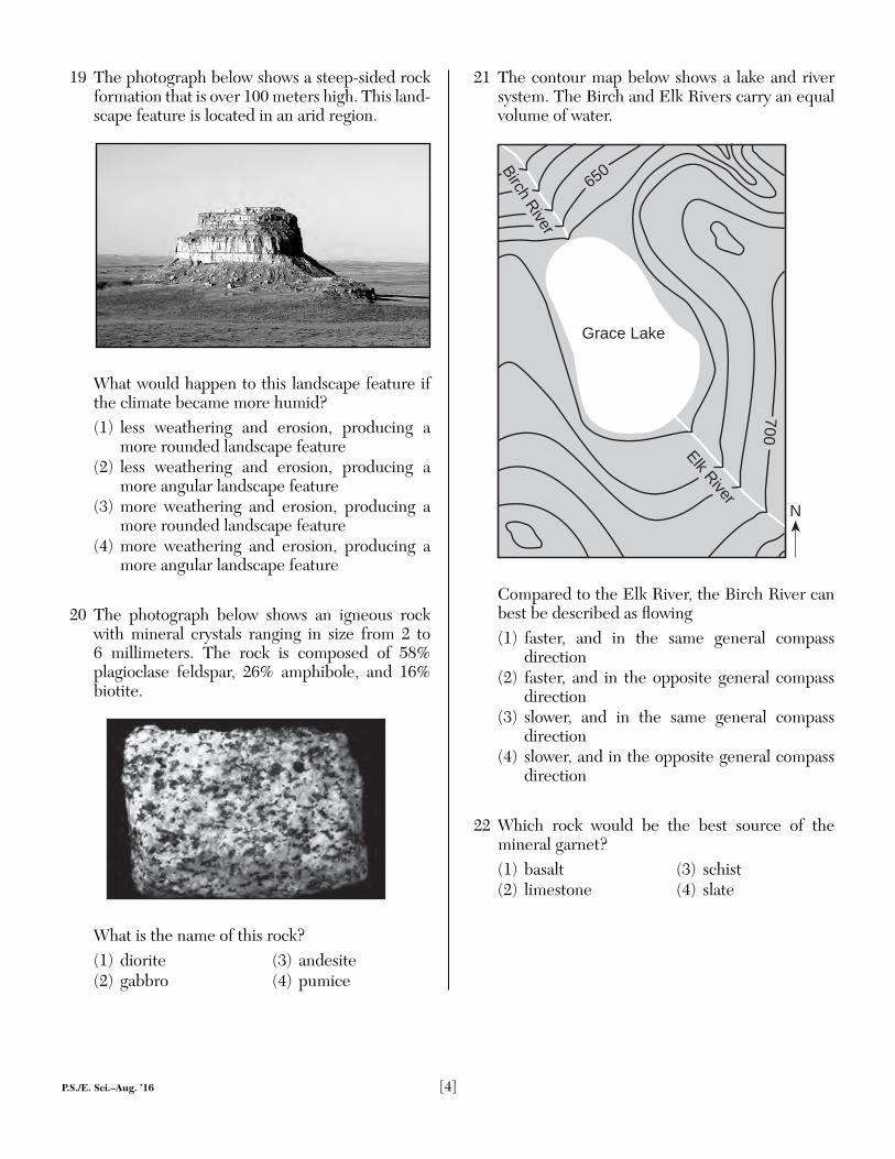
19 The photograph below shows a steep-sided rock formation that is over 100 meters high. This land-scape feature is located in an arid region.
What would happen to this landscape feature if the climate became more humid?(1) less weathering and erosion, producing a
more rounded landscape feature(2) less weathering and erosion, producing a
more angular landscape feature(3) more weathering and erosion, producing a
more rounded landscape feature(4) more weathering and erosion, producing a
more angular landscape feature
20 The photograph below shows an igneous rock with mineral crystals ranging in size from 2 to 6 millimeters. The rock is composed of 58% plagioclase feldspar, 26% amphibole, and 16% biotite.
What is the name of this rock?(1) diorite (3) andesite(2) gabbro (4) pumice
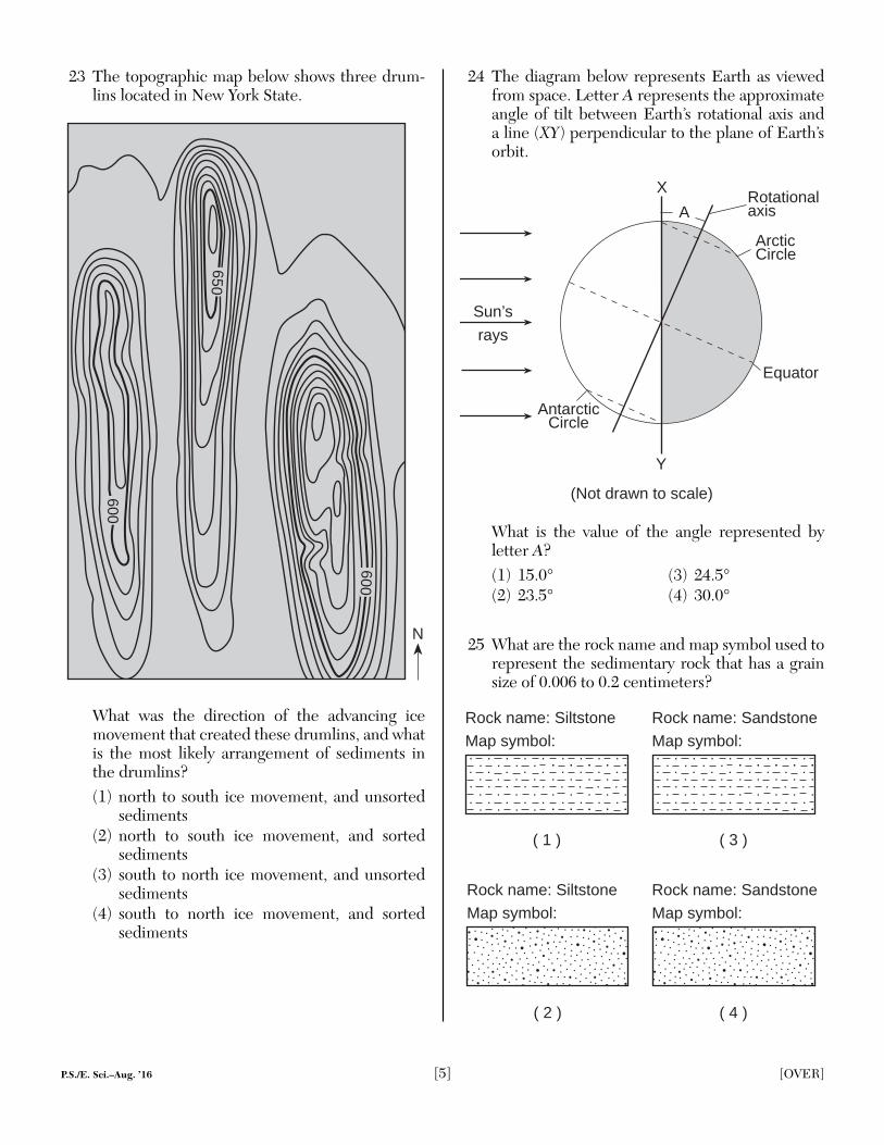
21 The contour map below shows a lake and river system. The Birch and Elk Rivers carry an equal volume of water.
N
Grace Lake
Elk River
Birch River
650
700
Compared to the Elk River, the Birch River can best be described as fl owing(1) faster, and in the same general compass
direction(2) faster, and in the opposite general compass
direction(3) slower, and in the same general compass
direction(4) slower, and in the opposite general compass
direction
22 Which rock would be the best source of the mineral garnet?(1) basalt (3) schist(2) limestone (4) slate
P.S./E. Sci.–Aug. ’16 [5] [OVER]
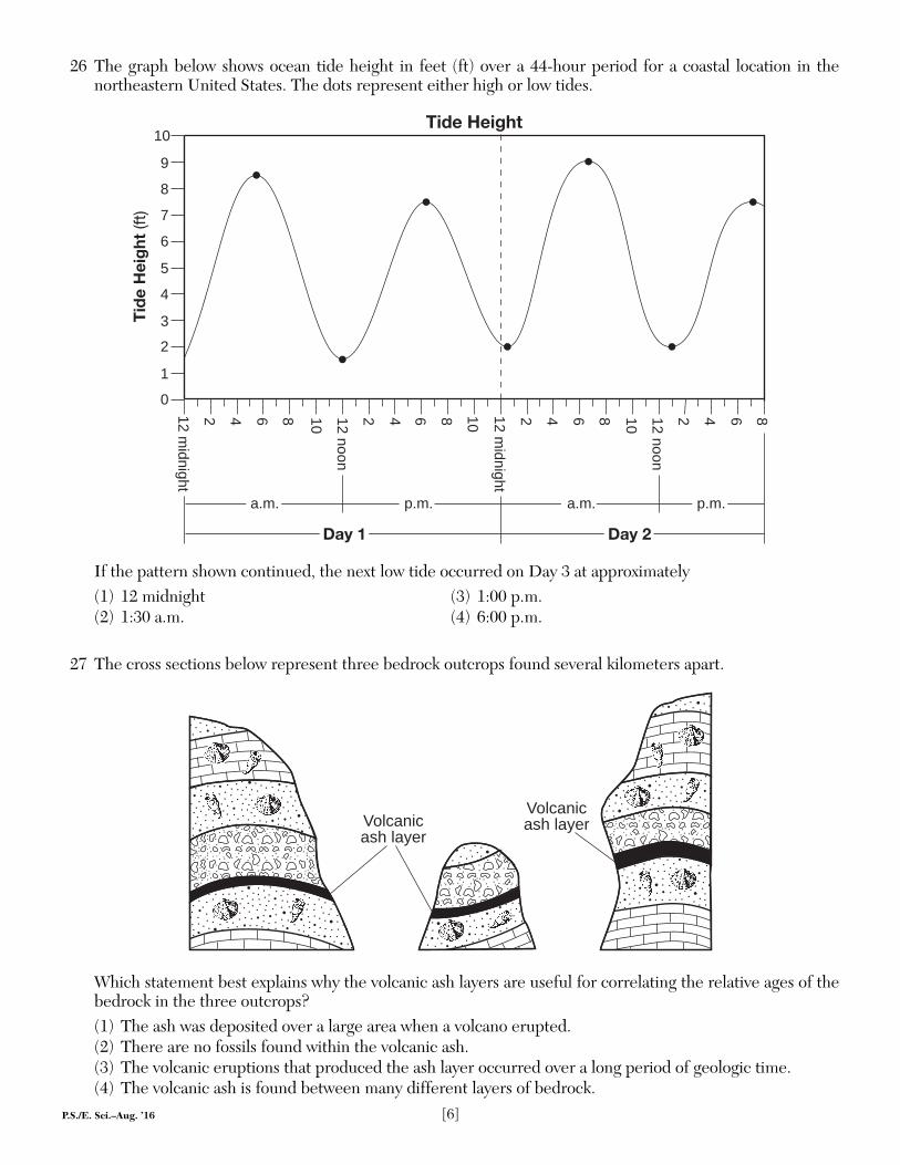
23 The topographic map below shows three drum-lins located in New York State.
N
600
600
650
What was the direction of the advancing ice movement that created these drumlins, and what is the most likely arrangement of sediments in the drumlins?(1) north to south ice movement, and unsorted
sediments(2) north to south ice movement, and sorted
sediments(3) south to north ice movement, and unsorted
sediments(4) south to north ice movement, and sorted
sediments
24 The diagram below represents Earth as viewed from space. Letter A represents the approximate angle of tilt between Earth’s rotational axis and a line (XY) perpendicular to the plane of Earth’s orbit.
Rotationalaxis
Arctic Circle
Equator
AntarcticCircle
Sun’s
rays
A
X
Y
(Not drawn to scale)
What is the value of the angle represented by letter A?(1) 15.0° (3) 24.5°(2) 23.5° (4) 30.0°
25 What are the rock name and map symbol used to represent the sedimentary rock that has a grain size of 0.006 to 0.2 centimeters?
( 1 ) ( 3 )
( 2 ) ( 4 )
Rock name: Siltstone Rock name: Sandstone
Rock name: Siltstone Rock name: Sandstone
Map symbol: Map symbol:
Map symbol: Map symbol:
P.S./E. Sci.–Aug. ’16 [6]
26 The graph below shows ocean tide height in feet (ft) over a 44-hour period for a coastal location in the northeastern United States. The dots represent either high or low tides.
12 midnight
2 4 6 8 10 12 noon
2 4 6 8 10 12 midnight
2 4 6 8 10 12 noon
2 4 6 8
a.m. p.m. a.m. p.m.
Day 1 Day 2
0
1
2
3
4
5
6
7
8
9
10Tide Height
Tid
e H
eig
ht (f
t)
If the pattern shown continued, the next low tide occurred on Day 3 at approximately(1) 12 midnight (3) 1:00 p.m.(2) 1:30 a.m. (4) 6:00 p.m.
27 The cross sections below represent three bedrock outcrops found several kilometers apart.
Volcanicash layer
Volcanicash layer
Which statement best explains why the volcanic ash layers are useful for correlating the relative ages of the bedrock in the three outcrops?(1) The ash was deposited over a large area when a volcano erupted.(2) There are no fossils found within the volcanic ash.(3) The volcanic eruptions that produced the ash layer occurred over a long period of geologic time.(4) The volcanic ash is found between many different layers of bedrock.
P.S./E. Sci.–Aug. ’16 [7] [OVER]
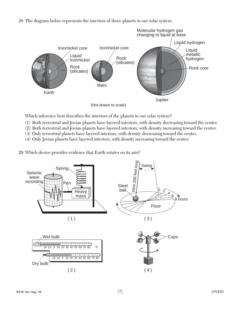
28 The diagram below represents the interiors of three planets in our solar system.
Earth
Mars
Jupiter
Iron/nickel core
Rock(silicates)
Iron/nickel core
Rock(silicates)
(Not drawn to scale)
Rock core
Liquidmetallichydrogen
Liquid hydrogen
Molecular hydrogen gaschanging to liquid at base
LiquidIron/nickel
Which inference best describes the interiors of the planets in our solar system?(1) Both terrestrial and Jovian planets have layered interiors, with density decreasing toward the center.(2) Both terrestrial and Jovian planets have layered interiors, with density increasing toward the center.(3) Only terrestrial planets have layered interiors, with density decreasing toward the center.(4) Only Jovian planets have layered interiors, with density increasing toward the center.
29 Which device provides evidence that Earth rotates on its axis?
Heavymass
Pen
SpringSeismic
waverecording
( 2 )
20 10 0 10 20 30 40 50 60 70 80
20 10 0 10 20 30 40 50 60 70 80
°C
( 4 )
( 1 ) ( 3 )
Wet bulb
Dry bulb
Swing
Floor
8 hours6
420Steelball W
ire 2
00 fe
et lo
ng
Cups
P.S./E. Sci.–Aug. ’16 [8]
30 Which weather map symbol is used to represent violently rotating winds that have the appearance of a funnel-shaped cloud?
( 2 ) ( 4 )( 3 )( 1 )
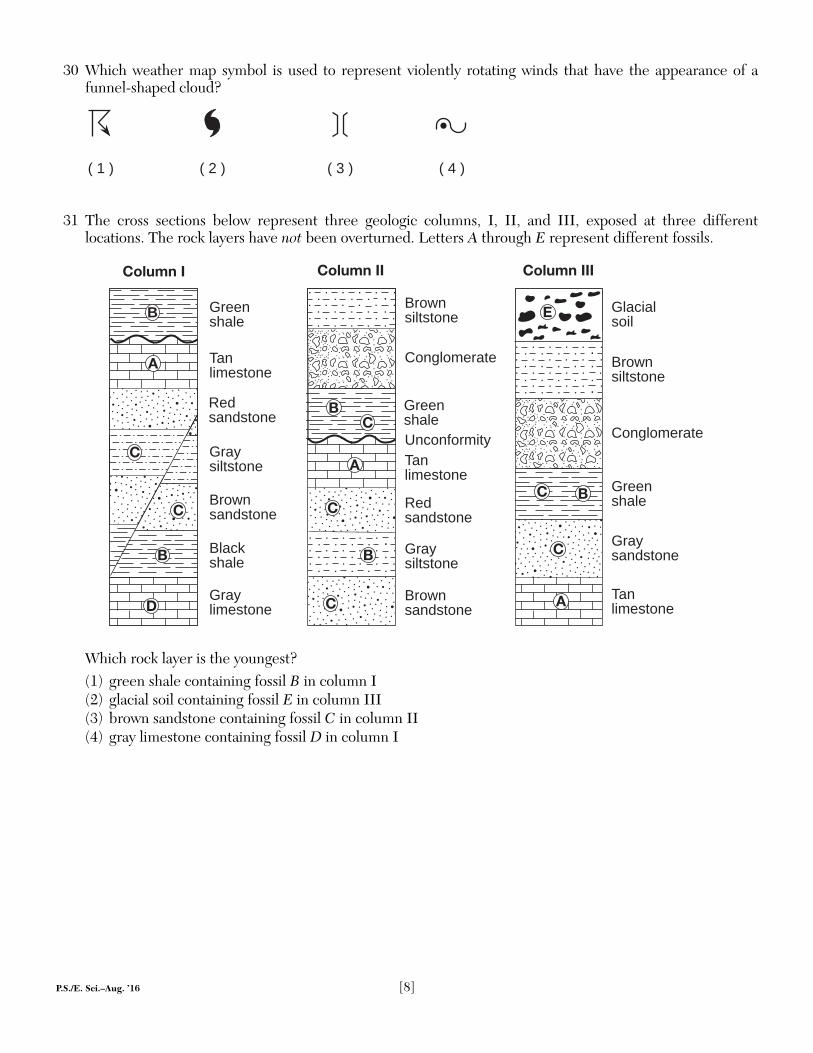
31 The cross sections below represent three geologic columns, I, II, and III, exposed at three different locations. The rock layers have not been overturned. Letters A through E represent different fossils.
Green shale
Tanlimestone
Graysiltstone
Redsandstone
Brownsandstone
Blackshale
Graylimestone
Conglomerate
Brownsiltstone
Redsandstone
Brownsandstone
Tanlimestone
Green shale
Graysiltstone
Brownsiltstone
Glacialsoil
Graysandstone
Tanlimestone
Conglomerate
Green shale
Column II Column IIIColumn I
Unconformity
C
B
C
A
CB
A
C
C B
E
D
C
C
A
B
B
Which rock layer is the youngest?(1) green shale containing fossil B in column I(2) glacial soil containing fossil E in column III(3) brown sandstone containing fossil C in column II(4) gray limestone containing fossil D in column I
P.S./E. Sci.–Aug. ’16 [9] [OVER]
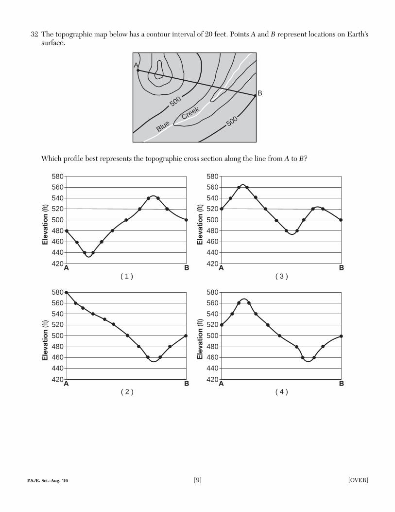
32 The topographic map below has a contour interval of 20 feet. Points A and B represent locations on Earth’s surface.
A
B
500
500
Blue
Creek
Which profi le best represents the topographic cross section along the line from A to B?
Ele
vati
on
(ft)
BA420
440
500
520
560
460
480
540
580
Ele
vati
on
(ft)
BA420
440
500
520
560
460
480
540
580
Ele
vati
on
(ft)
BA420
440
500
520
560
460
480
540
580
Ele
vati
on
(ft)
BA420
440
500
520
560
460
480
540
580
( 1 ) ( 3 )
( 2 ) ( 4 )
P.S./E. Sci.–Aug. ’16 [10]
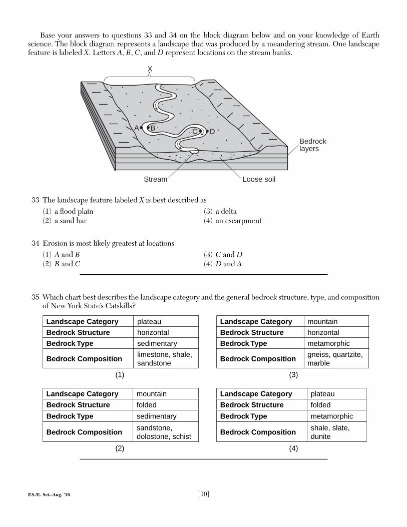
Base your answers to questions 33 and 34 on the block diagram below and on your knowledge of Earth science. The block diagram represents a landscape that was produced by a meandering stream. One landscape feature is labeled X. Letters A, B, C, and D represent locations on the stream banks.
Bedrocklayers
CBA
X
Loose soilStream
D
33 The landscape feature labeled X is best described as(1) a fl ood plain (3) a delta(2) a sand bar (4) an escarpment
34 Erosion is most likely greatest at locations(1) A and B (3) C and D(2) B and C (4) D and A
35 Which chart best describes the landscape category and the general bedrock structure, type, and composition of New York State’s Catskills?
Landscape Category plateau Landscape Category mountain
Bedrock Structure horizontal Bedrock Structure horizontal
Bedrock Type sedimentary Bedrock Type metamorphic
Bedrock Composition limestone, shale, sandstone
Bedrock Composition gneiss, quartzite, marble
(1) (3)
Landscape Category mountain Landscape Category plateau
Bedrock Structure folded Bedrock Structure folded
Bedrock Type sedimentary Bedrock Type metamorphic
Bedrock Composition sandstone, dolostone, schist
Bedrock Composition shale, slate, dunite
(2) (4)
P.S./E. Sci.–Aug. ’16 [11] [OVER]
Part B–1
Answer all questions in this part.
Directions (36–50): For each statement or question, choose the word or expression that, of those given, best completes the statement or answers the question. Some questions may require the use of the 2011 Edition Reference Tables for Physical Setting/Earth Science. Record your answers on your separate answer sheet.
Base your answers to questions 36 through 38 on the passage below and on your knowledge of Earth science.
Comets and AsteroidsSince comets and asteroids orbit the Sun, both are part of our solar system. Asteroids
are rocky objects that vary greatly in size. Most asteroids follow orbits between 300 and 600 million kilometers from the Sun, but several have been pulled from this region by the gravitational attraction of nearby planets. Many of these dislodged asteroids have struck both Earth and the Moon, causing the large impact craters that are visible on the surfaces of both bodies.
Comets have often been described as “dirty snowballs” and occupy highly eccentric orbits, traveling from near the Sun to far beyond the orbits of the outer planets. As they move through space, comets leave a debris trail of mostly dust-sized particles. When Earth passes through this debris, a meteor shower occurs, often fi lling the night sky with “shooting star” trails as they burn up in the atmosphere 50 to 80 kilometers above Earth’s surface.
36 Between which two planets are most asteroids located?(1) Earth and Mars (3) Jupiter and Saturn(2) Mars and Jupiter (4) Saturn and Uranus
37 In which temperature zone of Earth’s atmosphere will most meteors burn up?(1) troposphere (3) mesosphere(2) stratosphere (4) thermosphere
38 The extinction of which group of animals 65.5 million years ago is thought to have been due to an impact event and global climate change?(1) ammonoids (3) trilobites(2) brachiopods (4) placoderm fi sh
P.S./E. Sci.–Aug. ’16 [12]
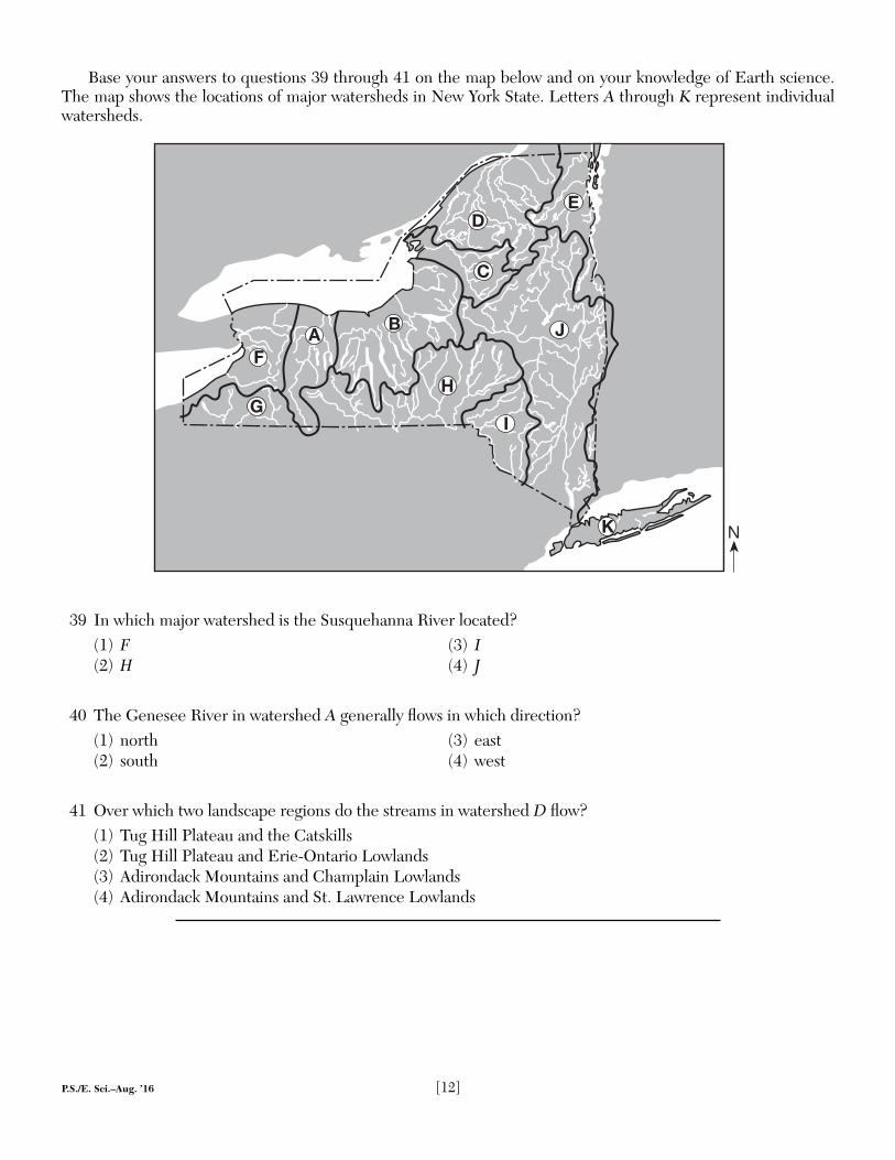
Base your answers to questions 39 through 41 on the map below and on your knowledge of Earth science. The map shows the locations of major watersheds in New York State. Letters A through K represent individual watersheds.
N
D
C
J
H
B
I
K
AF
G
E
39 In which major watershed is the Susquehanna River located?(1) F (3) I(2) H (4) J
40 The Genesee River in watershed A generally fl ows in which direction?(1) north (3) east(2) south (4) west
41 Over which two landscape regions do the streams in watershed D fl ow?(1) Tug Hill Plateau and the Catskills(2) Tug Hill Plateau and Erie-Ontario Lowlands(3) Adirondack Mountains and Champlain Lowlands(4) Adirondack Mountains and St. Lawrence Lowlands
P.S./E. Sci.–Aug. ’16 [13] [OVER]
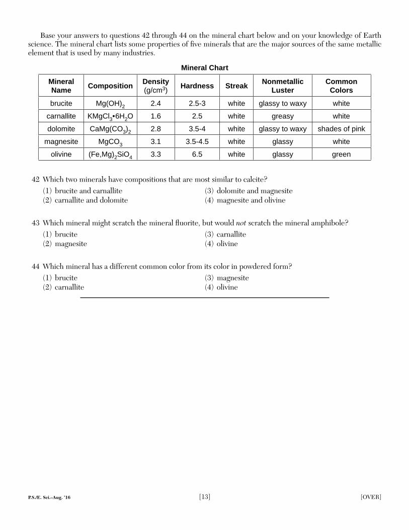
Base your answers to questions 42 through 44 on the mineral chart below and on your knowledge of Earth science. The mineral chart lists some properties of fi ve minerals that are the major sources of the same metallic element that is used by many industries.
Mineral Chart
Mineral Name Composition Density
(g/cm3)Hardness Streak Nonmetallic
LusterCommon
Colors
brucite Mg(OH)2 2.4 2.5-3 white glassy to waxy white
carnallite KMgCl3• 6H2O 1.6 2.5 white greasy white
dolomite CaMg(CO3)2 2.8 3.5-4 white glassy to waxy shades of pink
magnesite MgCO3 3.1 3.5-4.5 white glassy white
olivine (Fe,Mg)2SiO4 3.3 6.5 white glassy green
42 Which two minerals have compositions that are most similar to calcite?(1) brucite and carnallite (3) dolomite and magnesite(2) carnallite and dolomite (4) magnesite and olivine
43 Which mineral might scratch the mineral fl uorite, but would not scratch the mineral amphibole?(1) brucite (3) carnallite(2) magnesite (4) olivine
44 Which mineral has a different common color from its color in powdered form?(1) brucite (3) magnesite(2) carnallite (4) olivine
P.S./E. Sci.–Aug. ’16 [14]
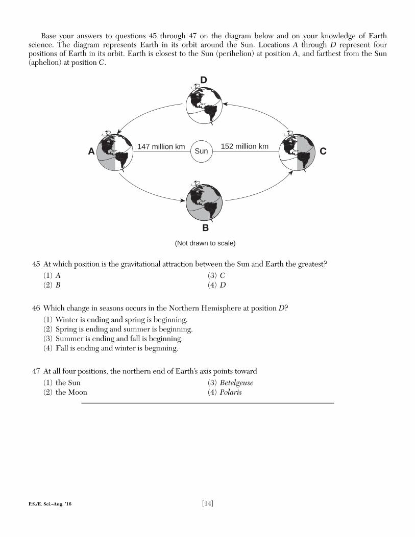
Base your answers to questions 45 through 47 on the diagram below and on your knowledge of Earth science. The diagram represents Earth in its orbit around the Sun. Locations A through D represent four positions of Earth in its orbit. Earth is closest to the Sun (perihelion) at position A, and farthest from the Sun (aphelion) at position C.
Sun147 million km 152 million km
A
B
C
D
(Not drawn to scale)
45 At which position is the gravitational attraction between the Sun and Earth the greatest?(1) A (3) C(2) B (4) D
46 Which change in seasons occurs in the Northern Hemisphere at position D?(1) Winter is ending and spring is beginning.(2) Spring is ending and summer is beginning.(3) Summer is ending and fall is beginning.(4) Fall is ending and winter is beginning.
47 At all four positions, the northern end of Earth’s axis points toward(1) the Sun (3) Betelgeuse(2) the Moon (4) Polaris
P.S./E. Sci.–Aug. ’16 [15] [OVER]
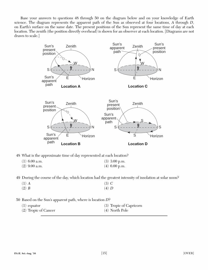
Base your answers to questions 48 through 50 on the diagram below and on your knowledge of Earth science. The diagram represents the apparent path of the Sun as observed at four locations, A through D, on Earth’s surface on the same date. The present positions of the Sun represent the same time of day at each location. The zenith (the position directly overhead) is shown for an observer at each location. [Diagrams are not drawn to scale.]
S N
E
Location B
Sun’spresentposition
W
S S
S
S
Location D
S N
E
Location A
Sun’spresentposition
W
S N
E
W
Location C
Horizon
ZenithSun’s
presentposition
Sun’sapparent
path
Zenith
HorizonSun’sapparent
path
ZenithZenithSun’s
presentposition
Sun’sapparent
path
Sun’sapparent
path
HorizonHorizon
48 What is the approximate time of day represented at each location?(1) 6:00 a.m. (3) 3:00 p.m.(2) 9:00 a.m. (4) 6:00 p.m.
49 During the course of the day, which location had the greatest intensity of insolation at solar noon?(1) A (3) C(2) B (4) D
50 Based on the Sun’s apparent path, where is location D?(1) equator (3) Tropic of Capricorn(2) Tropic of Cancer (4) North Pole
P.S./E. Sci.–Aug. ’16 [16]
Part B–2
Answer all questions in this part.
Directions (51–65): Record your answers in the spaces provided in your answer booklet. Some questions may require the use of the 2011 Edition Reference Tables for Physical Setting/Earth Science.
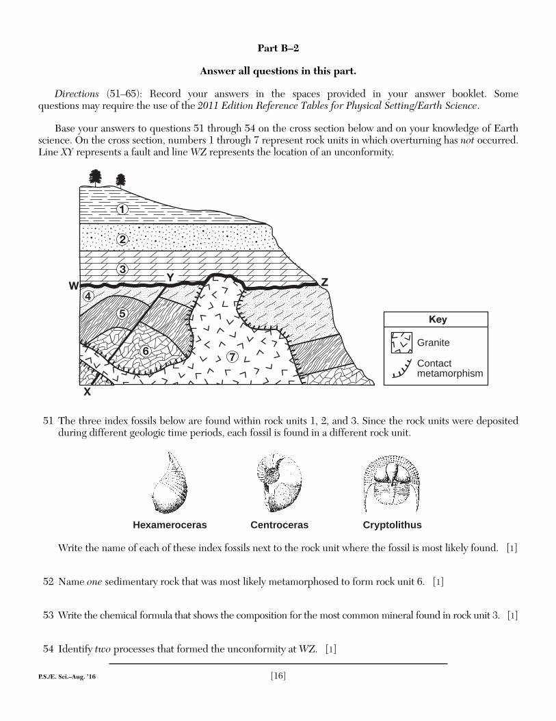
Base your answers to questions 51 through 54 on the cross section below and on your knowledge of Earth science. On the cross section, numbers 1 through 7 represent rock units in which overturning has not occurred. Line XY represents a fault and line WZ represents the location of an unconformity.
X
4
5
76
1
2
3ZW
Y
Key
Granite
Contactmetamorphism
51 The three index fossils below are found within rock units 1, 2, and 3. Since the rock units were deposited during different geologic time periods, each fossil is found in a different rock unit.
Hexameroceras CryptolithusCentroceras
Write the name of each of these index fossils next to the rock unit where the fossil is most likely found. [1]
52 Name one sedimentary rock that was most likely metamorphosed to form rock unit 6. [1]
53 Write the chemical formula that shows the composition for the most common mineral found in rock unit 3. [1]
54 Identify two processes that formed the unconformity at WZ. [1]
P.S./E. Sci.–Aug. ’16 [17] [OVER]
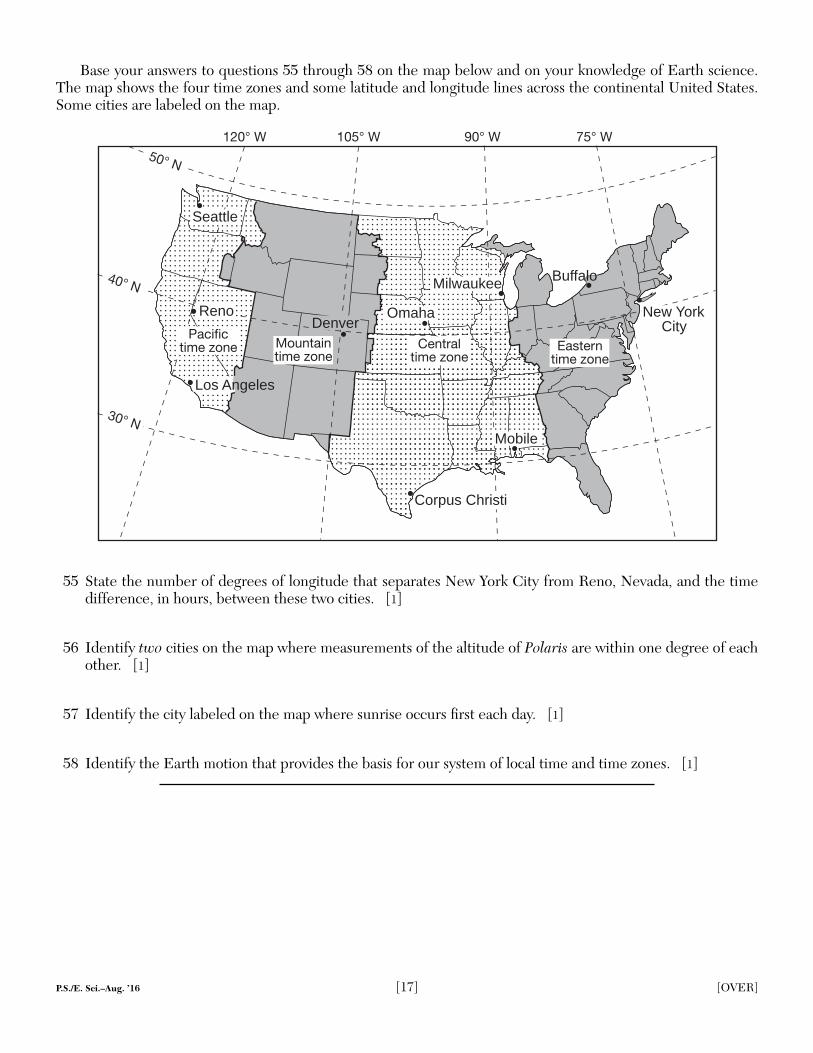
Base your answers to questions 55 through 58 on the map below and on your knowledge of Earth science. The map shows the four time zones and some latitude and longitude lines across the continental United States. Some cities are labeled on the map.
120° W 105° W 90° W 75° W
Mountaintime zone
Centraltime zone
Easterntime zone
Buffalo
New YorkCity
OmahaReno
Seattle
Milwaukee
Mobile
Denver
Los Angeles
Pacifictime zone
50° N
40° N
30° N
Corpus Christi
55 State the number of degrees of longitude that separates New York City from Reno, Nevada, and the time difference, in hours, between these two cities. [1]
56 Identify two cities on the map where measurements of the altitude of Polaris are within one degree of each other. [1]
57 Identify the city labeled on the map where sunrise occurs fi rst each day. [1]
58 Identify the Earth motion that provides the basis for our system of local time and time zones. [1]
P.S./E. Sci.–Aug. ’16 [18]
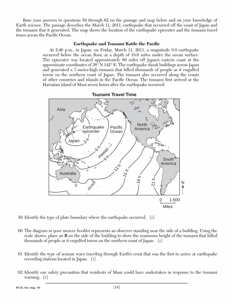
Base your answers to questions 59 through 62 on the passage and map below and on your knowledge of Earth science. The passage describes the March 11, 2011, earthquake that occurred off the coast of Japan and the tsunami that it generated. The map shows the location of the earthquake epicenter and the tsunami travel times across the Pacifi c Ocean.
Earthquake and Tsunami Rattle the Pacifi cAt 2:46 p.m., in Japan, on Friday, March 11, 2011, a magnitude 9.0 earthquake
occurred below the ocean fl oor, at a depth of 18.6 miles under the ocean surface. The epicenter was located approximately 80 miles off Japan’s eastern coast at the approximate coordinates of 38° N 142° E. The earthquake shook buildings across Japan and generated a 7-meter-high tsunami that killed thousands of people as it engulfed towns on the northern coast of Japan. The tsunami also occurred along the coasts of other countries and islands in the Pacifi c Ocean. The tsunami fi rst arrived at the Hawaiian island of Maui seven hours after the earthquake occurred.
N
6 h
9 h
12 h
15 h
18 h
21 h
3 h
PacificOcean
Hawaii
0 1,500
Miles
SouthAmerica
NorthAmerica
Asia
Japan
Australia
Tsunami Travel Time
Earthquakeepicenter*
59 Identify the type of plate boundary where the earthquake occurred. [1]
60 The diagram in your answer booklet represents an observer standing near the side of a building. Using the scale shown, place an X on the side of the building to show the maximum height of the tsunami that killed thousands of people as it engulfed towns on the northern coast of Japan. [1]
61 Identify the type of seismic wave traveling through Earth’s crust that was the fi rst to arrive at earthquake recording stations located in Japan. [1]
62 Identify one safety precaution that residents of Maui could have undertaken in response to the tsunami warning. [1]
P.S./E. Sci.–Aug. ’16 [19] [OVER]
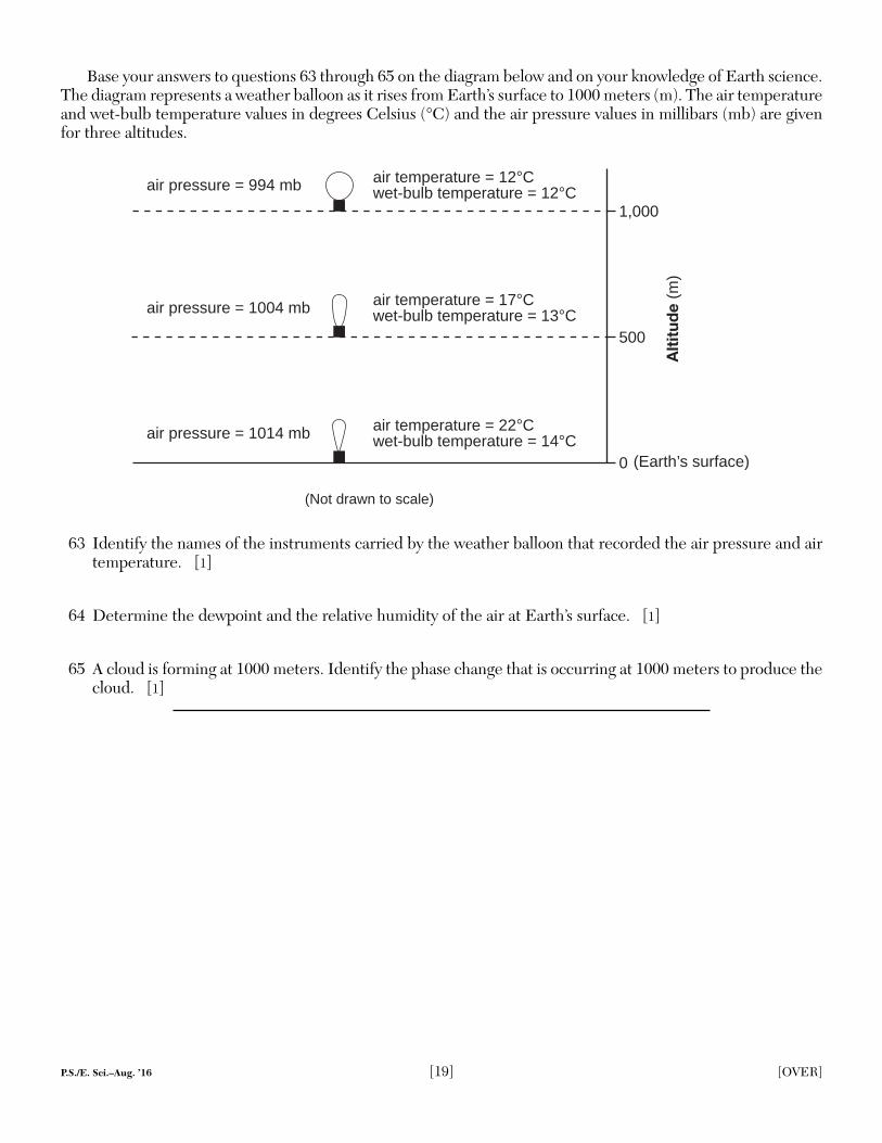
Base your answers to questions 63 through 65 on the diagram below and on your knowledge of Earth science. The diagram represents a weather balloon as it rises from Earth’s surface to 1000 meters (m). The air temperature and wet-bulb temperature values in degrees Celsius (°C) and the air pressure values in millibars (mb) are given for three altitudes.
0
500
1,000
Alt
itud
e (m
)
(Earth’s surface)
air pressure = 1014 mb
air pressure = 1004 mb
air pressure = 994 mb
air temperature = 22°Cwet-bulb temperature = 14°C
air temperature = 17°Cwet-bulb temperature = 13°C
air temperature = 12°Cwet-bulb temperature = 12°C
(Not drawn to scale)
63 Identify the names of the instruments carried by the weather balloon that recorded the air pressure and air temperature. [1]
64 Determine the dewpoint and the relative humidity of the air at Earth’s surface. [1]
65 A cloud is forming at 1000 meters. Identify the phase change that is occurring at 1000 meters to produce the cloud. [1]
P.S./E. Sci.–Aug. ’16 [20]
Part C
Answer all questions in this part.
Directions (66–85): Record your answers in the spaces provided in your answer booklet. Some questions may require the use of the 2011 Edition Reference Tables for Physical Setting/Earth Science.
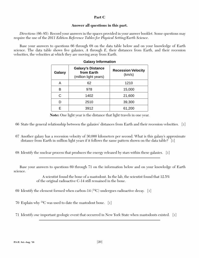
Base your answers to questions 66 through 68 on the data table below and on your knowledge of Earth science. The data table shows fi ve galaxies, A through E, their distances from Earth, and their recession velocities, the velocities at which they are moving away from Earth.
Galaxy Information
GalaxyGalaxy’s Distance
from Earth (million light years)
Recession Velocity (km/s)
A 62 1210
B 978 15,000
C 1402 21,600
D 2510 39,300
E 3912 61,200
Note: One light year is the distance that light travels in one year.
66 State the general relationship between the galaxies’ distances from Earth and their recession velocities. [1]
67 Another galaxy has a recession velocity of 30,000 kilometers per second. What is this galaxy’s approximate distance from Earth in million light years if it follows the same pattern shown on the data table? [1]
68 Identify the nuclear process that produces the energy released by stars within these galaxies. [1]
Base your answers to questions 69 through 71 on the information below and on your knowledge of Earth science.
A scientist found the bone of a mastodont. In the lab, the scientist found that 12.5% of the original radioactive C-14 still remained in the bone.
69 Identify the element formed when carbon-14 (14C) undergoes radioactive decay. [1]
70 Explain why 14C was used to date the mastodont bone. [1]
71 Identify one important geologic event that occurred in New York State when mastodonts existed. [1]
P.S./E. Sci.–Aug. ’16 [21] [OVER]
Base your answers to questions 72 through 75 on the diagram in your answer booklet and on your knowledge of Earth science. The diagram represents the Moon at four positions, A through D, in its orbit around Earth as viewed from above the North Pole (NP). The shaded parts of the Moon and Earth represent darkness.
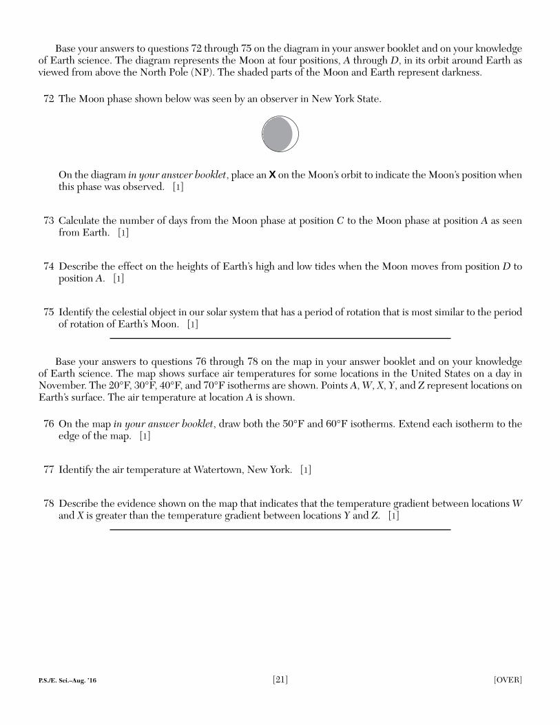
72 The Moon phase shown below was seen by an observer in New York State.
On the diagram in your answer booklet, place an X on the Moon’s orbit to indicate the Moon’s position when this phase was observed. [1]
73 Calculate the number of days from the Moon phase at position C to the Moon phase at position A as seen from Earth. [1]
74 Describe the effect on the heights of Earth’s high and low tides when the Moon moves from position D to position A. [1]
75 Identify the celestial object in our solar system that has a period of rotation that is most similar to the period of rotation of Earth’s Moon. [1]
Base your answers to questions 76 through 78 on the map in your answer booklet and on your knowledge of Earth science. The map shows surface air temperatures for some locations in the United States on a day in November. The 20°F, 30°F, 40°F, and 70°F isotherms are shown. Points A, W, X, Y, and Z represent locations on Earth’s surface. The air temperature at location A is shown.
76 On the map in your answer booklet, draw both the 50°F and 60°F isotherms. Extend each isotherm to the edge of the map. [1]
77 Identify the air temperature at Watertown, New York. [1]
78 Describe the evidence shown on the map that indicates that the temperature gradient between locations W and X is greater than the temperature gradient between locations Y and Z. [1]
P.S./E. Sci.–Aug. ’16 [22]
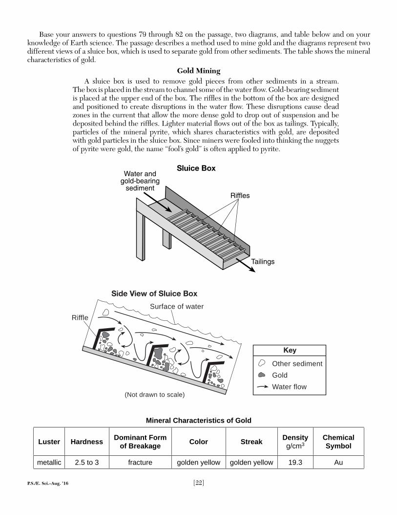
Base your answers to questions 79 through 82 on the passage, two diagrams, and table below and on your knowledge of Earth science. The passage describes a method used to mine gold and the diagrams represent two different views of a sluice box, which is used to separate gold from other sediments. The table shows the mineral characteristics of gold.
Gold MiningA sluice box is used to remove gold pieces from other sediments in a stream.
The box is placed in the stream to channel some of the water fl ow. Gold-bearing sediment is placed at the upper end of the box. The riffl es in the bottom of the box are designed and positioned to create disruptions in the water fl ow. These disruptions cause dead zones in the current that allow the more dense gold to drop out of suspension and be deposited behind the riffl es. Lighter material fl ows out of the box as tailings. Typically, particles of the mineral pyrite, which shares characteristics with gold, are deposited with gold particles in the sluice box. Since miners were fooled into thinking the nuggets of pyrite were gold, the name “fool’s gold” is often applied to pyrite.
Sluice Box
Tailings
Water and gold-bearing
sedimentRiffles
Side View of Sluice Box
Key
Gold
Other sediment
Water flow(Not drawn to scale)
Riffle
Surface of water
Mineral Characteristics of Gold
Luster Hardness Dominant Form of Breakage Color Streak Density
g/cm3Chemical Symbol
metallic 2.5 to 3 fracture golden yellow golden yellow 19.3 Au
P.S./E. Sci.–Aug. ’16 [23]
79 Identify the characteristic of gold shown in the table that allows gold to be deposited behind the riffl es, while other material fl ows out of the sluice box as tailings. [1]
80 The velocity of the water leaving the sluice box was 90 centimeters per second (cm/s). State the diameter of the largest particle that could be found in the tailings. [1]
81 The angle of the sluice box is changed so that the box has a steeper slope. Describe the most likely change in water velocity and the amount of sediment passing through the sluice box as tailings. [1]
82 A gold nugget with a volume of 0.8 cubic centimeter (cm3) was found in the sluice box. Calculate the mass of this gold nugget. [1]
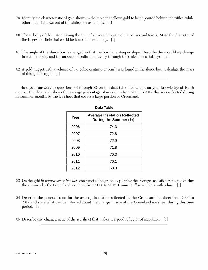
Base your answers to questions 83 through 85 on the data table below and on your knowledge of Earth science. The data table shows the average percentage of insolation from 2006 to 2012 that was refl ected during the summer months by the ice sheet that covers a large portion of Greenland.
Data Table
Year Average Insolation Refl ected During the Summer (%)
2006 74.3
2007 72.8
2008 72.9
2009 71.8
2010 70.3
2011 70.1
2012 68.3
83 On the grid in your answer booklet, construct a line graph by plotting the average insolation refl ected during the summer by the Greenland ice sheet from 2006 to 2012. Connect all seven plots with a line. [1]
84 Describe the general trend for the average insolation refl ected by the Greenland ice sheet from 2006 to 2012 and state what can be inferred about the change in size of the Greenland ice sheet during this time period. [1]
85 Describe one characteristic of the ice sheet that makes it a good refl ector of insolation. [1]
P.S./EARTH SCIENCE P.S./EARTH SCIENCE
Printed on Recycled Paper