Embed Size (px)
Citation preview

Le Baron Prospecting Port Renfrew, BC
P h y s i c a l , G e o c h e m i c a l a n d T e c h n i c a l A s s e s s m e n t R e p o r t
T h e R N R / T r a c e y P r o j e c t
Tenures 401285, 508826, 535952
Victoria Mining Division NTS: M092C069 48 degrees, 41' 16"N x 124 degrees, 20' 32"W
1 I O0QS4C
I O0QS4C
1012197
G E O L O G I C A L S U R V E Y B R A N C H A S S E S S M E N T R E P O R T
Report By; Le Baron Prospecting Po Box 92 16977 Tsonaquay Dr Port Renfrew B C V0S-1K0 Author: Scott Phillips
r— * :.-i
••••
2 0 1 3 / 2 0 1 4
I
B R I T I S H C O L U M B I A The Ben Mace an Einh
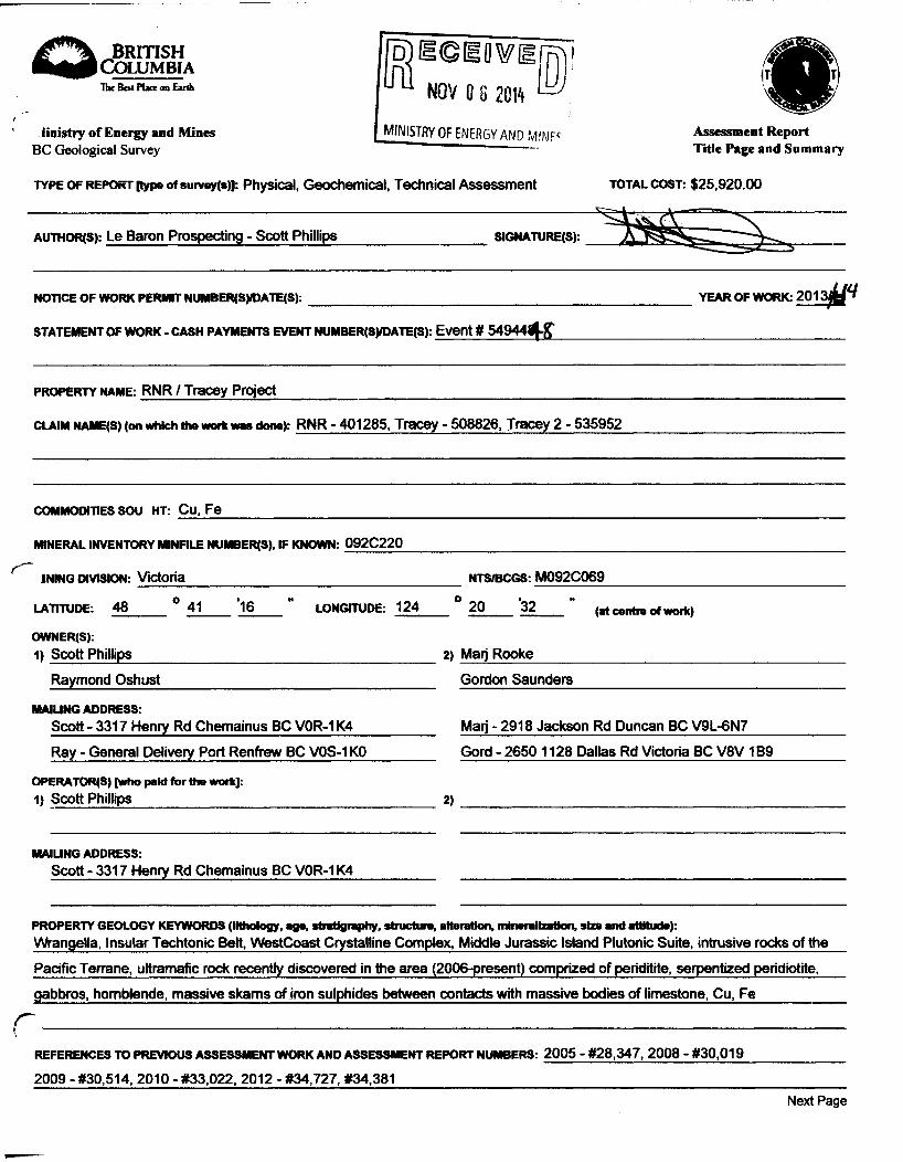
l i n i s t r y o f E n e r g y a n d M i n e s
BC Geological Survey
fpjECEOWO ^ NOV 0 8 2<M
MINISTRY OF ENERGY AND MINF
T Y P E O F R E P O R T [type of survoy(s)]: Physical, Geochemical, Technical Assessment
A s s e s s m e n t R e p o r t
T i t l e P a g e a n d S u m m a r y
T O T A L C O S T : $25,920.00
AUTHOR<S): Le Baron Prospecting - Scott Phillips SIGNATURE(S):
NOTICE O F W O R K PERMIT NUMBER(S)/DATE(S):
S T A T E M E N T O F W O R K - C A S H P A Y M E N T S E V E N T NUMBER(S)/DATE(S): Event # 54944^-fr
Y E A R O F W O R K : 2013^ffi
P R O P E R T Y NAME: RNR / Tracey Project
CLAIM NAME(S) (on which the work was done): RNR - 401285, Tracey - 508826, Tracey 2 - 535952
COMMODITIES S O U HT: Cu, Fe
MINERAL INVENTORY M N F I L E NUMBER(S), IF KNOWN: 092C220
INING DIVISION: victoria N T S / B C G S : M092C069
LATITUDE: 48 ° 41 *16 " LONGITUDE: 124 o "
20 3 2 (at contra of work)
OWNER(S).
1) Scott Phillips 2) Man Rooke
Raymond Oshust Gordon Saunders
M A I U N G A D D R E S S :
Scott - 3317 Henry Rd Chemainus BC V0R-1K4 Marj - 2918 Jackson Rd Duncan BC V9L-6N7
Ray - General Delivery Port Renfrew BC V0S-1K0 Gord - 2650 1128 Dallas Rd Victoria BC V8V1B9
O P E R A T O R S ) [who paid for the work]: 1) Scott Phillips 2)
M A I U N G A D D R E S S :
Scott - 3317 Henry Rd Chemainus BC V0R-1K4
P R O P E R T Y G E O L O G Y K E Y W O R D S (lithology, age, stratigraphy, structure, alteration, mineralization, size and attitude):
Wrangella, Insular Techtonic Belt, WestCoast Crystalline Complex, Middle Jurassic Island Plutonic Suite, intrusive rocks of the
Pacific Terrane, ultramafic rock recently discovered in the area (2006-present) comprized of periditite, serpentized peridiotite,
gabbros, hornblende, massive skams of iron sulphides between contacts with massive bodies of limestone, Cu, Fe
R E F E R E N C E S T O PREVIOUS A S S E S S M E N T W O R K A N D A S S E S S M E N T R E P O R T N U M B E R S : 2005 - #28,347, 2008 - #30,019
2009 - #30,514, 2010 - #33,022, 2012 - #34,727, #34,381 Next P a g e

TYPE OF WORK IN THIS REPORT
EXTENT OF WORK (IN METRIC UNITS)
ON WHICH CLAIMS PROJECT COSTS APPORTIONED
(Incl. support)
GEOLOGICAL (scale, area)
Ground, mapping 401285, 508826, 535952 $25,920.00
Photo interpretation
GEOPHYSICAL (line-kilometres) Ground
Magnetic
Electromagnetic
Induced Polarization
Radiometric
Seismic
Other
Airborne
GEOCHEMICAL
(number of samples analysed for...)
Soil Silt
Rock 16 rock chip samples analyized 75 rock chip samples taken in field
Other ALS - COA - VA14142172
-DRILLING rial metres; number of holes, size)
Core
Non-core
RELATED TECHNICAL
Sampling/assaying 25-5 gallon buckets of material classified into concentrate
Petrographic 879 grams of concentrate obtained
Mineralographic
Metallurgy
PROSPECTING (scale, area)
PREPARATORY / PHYSICAL
Line/grid (kilometres) 2514 m - GPS - stream sediment 2650 m - GPS - roadside chip sampling
Topographic/Photogrammetric (scale, area) 5140 m, GPS sample lines(3)establisfcj i
Legal surveys (scale, area) in field
Road, local access (kilometresyt
Trench (metres)
rail Road, local access (kilometresyt
Trench (metres)
Underground dev. (metres)
other sluicebox, hand panning of sediment samples GPS field survey sample lines plotted
TOTAL COST: $25,920.00

Le Baron Prospecting Port Renfrew, BC
T a b l e o f C o n t e n t s
Cover Page 1 Table of contents 2 Executive Summary, note to reader 3 Exploration in Port Renfrew 4 Tenure ownership 5 Area history 6 Geology 7 to 8 Minfile occurrences 9 Tenure accessibility, area resources 10 to 11 Assessment report summary 12 Author, disclaimer 13 Reference information 14 Area authors / references 15 Costs 16 Overview of the program 17
Appendix A Rock chip sampling and GPS survey lines / physical / geochemical / technical RNR + Tracey- 18 to 21 Reference working maps Figure maps D to D-4
Appendix B Roadside rock chip GPS sampling survey lines / physical / geochemical / technical RNR + Tracey 22 to 24 Reference working maps Figure maps E to E-2-1
Appendix C Steam sediment sampling program RNR + Tracey 25 to 27 Reference working maps Figure maps F to F-1
Appendix D Aero Magnetic survey (2006) Emerald Field Resources - (Pacific Iron Ore) Reference information (P-12 Target only) 28 to 30
Appendix E ALS Certificate of analysis VA114142172 31 to 32
Email Conformation of Event 33 to 35
2

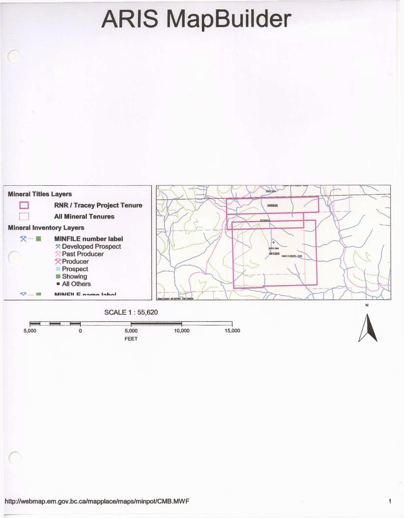
ARIS MapBuilder
R
http://webmap.em.gov.bc.ca/mapplace/maps/minpot/CMB.MWF
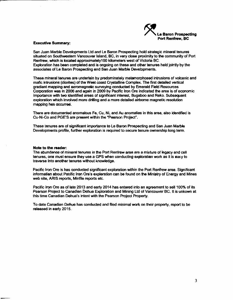
Le Baron Prospecting Port Renfrew, BC
Executive Summary:
San Juan Marble Developments Ltd and Le Baron Prospecting hold strategic mineral tenures situated on Southwestern Vancouver Island, BC, in very close proximity to the community of Port Renfrew, which is located approximately 100 kilometers west of Victoria BC. Exploration has been completed and is ongoing on these and other tenures held jointly by the associates of Le Baron Prospecting and San Juan Marble Developments.
These mineral tenures are underlain by predominately metamorphosed intrusions of volcanic and mafic intrusions (diorites) of the West coast Crystalline Complex. The first detailed vertical gradient mapping and aeromagnetic surveying conducted by Emerald Field Resources Corporation was in 2006 and again in 2009 by Pacific Iron Ore indicated the area is of economic importance with two identified areas of significant interest, Bugaboo and Reko. Subsequent exploration which involved more drilling and a more detailed airborne magnetic resolution mapping has occurred.
There are documented anomalous Fe, Cu, Ni, and Au anomalies in this area, also identified is Cu-Ni-Co and PGE'S are present within the "Pearson Project".
These tenures are of significant importance to Le Baron Prospecting and San Juan Marble Developments profile, further exploration is required to secure tenure ownership long term.
Note to the reader: The abundance of mineral tenures in the Port Renfrew area are a mixture of legacy and cell tenures, one must ensure they use a GPS when conducting exploration work as it is easy to traverse into another tenures without knowledge.
Pacific Iron Ore is has conducted significant exploration within the Port Renfrew area. Significant information about Pacific Iron Ore's exploration can be found on the Ministry of Energy and Mines web site, ARIS reports, Minfile reports etc.
Pacific Iron Ore as of late 2013 and early 2014 has entered into an agreement to sell 100% of its Pearson Project to Canadian Dehua Exploration and Mining Ltd of Vancouver BC. It is unkown at this time Canadian Dehua's intent with the Pearson Project Property.
To date Canadian Dehua has conducted and filed minimal work on their property, report to be released in early 2015.
3
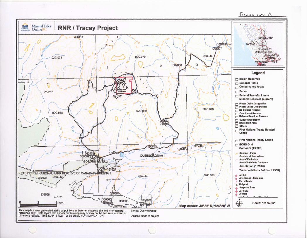

* • * MineraJTitles Online RNR / Tracey Project
This map reference otherwise
is a user generated static output from an Internet mapping site and is for general only. Data layers that appear on this map may or may not be accurate, current, or reliable. THIS MAP IS NOT TO BE USED FOR NAVIGATION.
Notes: RNR / Tracey tenures overview map
RNR - 401285, Tracey - 535952, Tracey 2 - 50S826
Legend p Indian Reserves
P National Parks |—I Conservancy Areas
• Parks • Federal Transfer Lands
MTO Grid (MTO) Mineral Tenure {current)
Q Mineral Claim I—| Mineral Lease
Mineral Reserves (current)
r-i Placer Claim Designation [—l Placer Lease Designation p No Slaking Reserve I—| Conditional Reserve Q Release Required Reserve Q Surface Reel rid ion p Recreation Area • Others ~2 First Nations Treaty Related
Lands
P First Nations Treaty Lands
p Integrated Cadastral Fabric
p BCGS Grid Contours (1:250K)
Contour • Index Contour - Inlermedlile Areaot Exclusion Aroaof Indefinite Contours Annotation (1:20K) Tranoportatlon - Points (TRIM)
# Helipad
N 4> Scale: 1:33,816
c

Le Baron Prospecting Port Renfrew, BC
Present Exploration in Port Renfrew:
In 1997, a local prospector first staked tenures on this West Coast Crystalline Complex of ultramafic intrusions. The mineral exploration company Emerald Field Resources Corporation of Kenora, Ontario started staking in Port Renfrew in 2002. San Juan Marble Developments and Le Baron Prospecting have held tenures on this intrusion since 2000. Since this time, EFR has explored the area and named their project "The Pearson Project". This original block of tenures consists of 147 mineral tenures on this intrusion.
San Juan Marble Developments and Le Baron Prospecting hold strategic mineral tenures inside the "Pearson Project" fence, with a combined 118 mineral tenures or 17,067 ha of strategic mineral tenures in the Port Renfrew area.
In 2006, Emerald Field Resources, completed an airborne aeromagnetic survey conducted by Furgo Airborne Services over the Pearson Block of mineral tenures, [ARIS report #28751], this report covered the Pearson Block of 147 tenures of 36,345 ha of large tenures. The resulting study was summarized by Monika Sumara, a consulting geophysics, and Dr. Canil of the University of Victoria, and Dr. Richard Ernst of Ernst Geosciences BC, a copy of this report is included.
Several targets of interest, referred to as "P-targets" require follow up exploration based upon the aeromagnetic survey. San Juan Developments and Le Baron Prospecting hold the mineral rights to several "P- Targets" of interest.
As a result of the merger of Klondike Capital in 2006/ 07 and the formation of Pacific Iron Ore vast amounts of mineral tenures were staked prior to this formation, this vast staking resulted in the Golden tenures and other subsequent tenures jointly owned by the owners of Le Baron Prospecting and San Juan Marble Developments to becoming completely encompassed in the Pearson Project. The Pearson Iron Ore Project is of historic proportions, it is over 27 kilometers in length, and over 4 kilometers in width, and is of vast depth.
This deposit is proving to be of potential economic importance to the Province of British Columbia.
The RNR / Tracey Tenure project are legacy tenures and new tenures encompassed in an extensive block of mineral tenures owned by Pacific Iron Ore. These tenures are five strategically placed tenures over previously identified PGE'S and a high grade iron skam deposit. Many work reports (SOW 3191808 - 2003, 3206308 - 2004,4024122 - 2004, 4073434 - 2006,4136570 -2007,4199939 -2008,4191232 - 2010, ARIS 34,3821, 34,727 - 2012) have been filed against these tenures.
This means a vast amount of exploration utilizing all hand sampling has occurred while keeping our tenures current while observing the exploration of the surrounding tenures of Pacific Iron Ore.
4
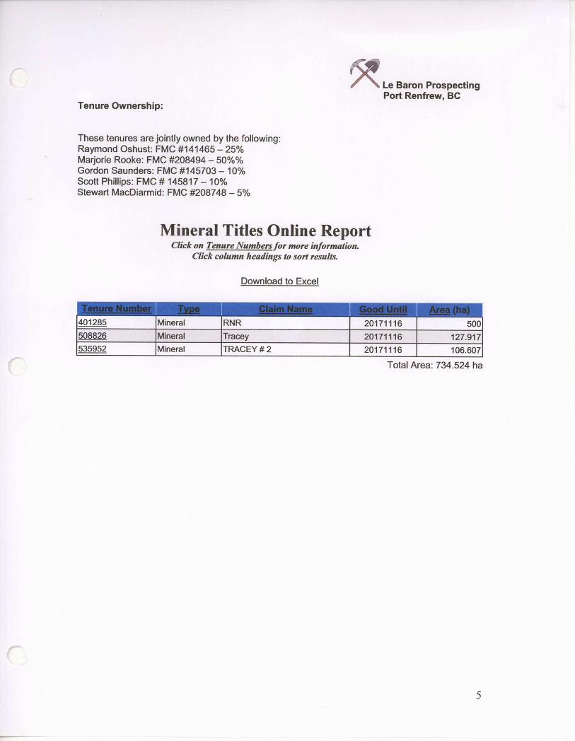
Tenure Ownership:
Le Baron Prospecting Port Renfrew, BC
These tenures are jointly owned by the following: Raymond Oshust: F M C #141465 - 25% Marjorie Rooke: F M C #208494 - 5 0 % % Gordon Saunders: F M C #145703 - 10% Scott Phillips: F M C # 145817 - 10% Stewart MacDiarmid: F M C #208748 - 5%
Mineral Titles Online Report Click on Tenure Numbers for more information.
Click column headings to sort results.
Download to Excel
401285 Mineral RNR 20171116 500 508826 Mineral Tracey 20171116 127.917 535952 Mineral TRACEY # 2 20171116 106.607
Total Area: 734.524 ha
5

Le Baron Prospecting Port Renfrew, BC
History:
The Port Renfrew area contains close to 50 mineral occurrences as documented in the British Columbia provincial mineral inventory database; reference MINFILE: (See Table 1) for MINFILE locations in the area that is subject of this report.
The most significant occurrences in the area are the historic Bugaboo iron (magnetite) skam deposits which are located in the headwaters of Bugaboo Creek, and the Reko iron (magnetite) skam deposits located within the headwaters of Granite / Renfrew Creek area. (The Golden # 5 -tenure #392325 is located here.)
Both the Bugaboo and Reko deposits contain historic reserves, and currently Pacific Iron Ore is completing further drilling upon the Bugaboo deposit (which it owns) to prove its reserves farther. More information on Pacific Iron's resource estimate can be found on their web site: www.Dacifcironorecoro.com
REKO Showing: - history
In the Granite Creek / Renfrew Creek area bulldozing and blasting by B.C. Forest Products road-building crews during the summer of 1970 uncovered showings of magnetite and sulphides near the upper reaches of Renfrew Creek (Reko showings). The Reko 1-6 claims were staked on these showings in July 1970 by Mr. M. Levasseur. Sampling of the exposed mineralization was subsequently carried out. Levasseur and associates incorporated Reako Explorations Ltd. in July 1971. Further staking in 1971-72 expanded the property to 66 claims. The exploration work conducted during 1971 included x-ray diamond drilling totaling 37 meters in 6 holes and a limited magnetometer survey. During 1972-73, work included geological mapping, magnetometer surveys over 120 line-kilometers, an electromagnetic survey over 80 line-kilometers, an induced potential survey over 19 line kilometers, trenching, and 5300 meters of diamond drilling in 100 holes on Reko 3,4, 9,10 and 42. The adjoining Kestrel 1-15 claims were purchased from M. Dickens of Savona in January 1974. Work during the year included 89 meters of diamond drilling in 6 holes on Reko 37. Drilling in 1972 on the South Pit B zone indicated a magnetite bearing zone 94 meters long, over 30 meters wide and up to 50 meters deep. The average grade indicated by the core assay was 22.28% iron. In 1973-74, R.L. Roscoe estimated 1,111,242 tones in five combined zones (Zone 1, 2, 3, 5, and 8) without specifying grades. South Pit B zone (or Zone 2) contains 970,597 tones. See MINFILE occurrences for detailed descriptions
The tenures which were staked by REKO explorations were allowed to lapse for several years until a local prospector began staking tenures on what was thought as ultramafic intrusions and this began a subsequence staking rush of the area of the Golden and RNR and adjoining tenures staked in the area.
This resulted in Emerald Field Resources now referred to as Pacific Iron Ore staking and optioning other remaining tenures within the Port Renfrew area in 2004 to present. This has resulted in a continuous tenure block in which the tenures owned jointly by Le Baron Prospecting and San Juan Marble Developments being completely encompassed in is what is now known as the Pearson Project. Pacific Iron has completed several airborne aeromagnetic surveys over the entire area and resulting data reveals a great deal of structural variety compared to the widespread high level magnetic response visible on a regional scale. A detailed compilation of at least 19 anomalies throughout the surveyed area (see table 2)
6
Le Baron Prospecting Port Renfrew, BC
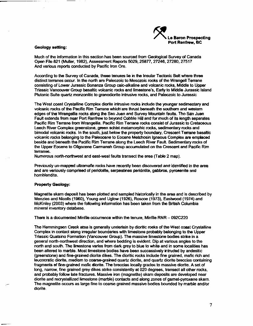
Geology setting:
Much of the information in this section has been sourced from Geological Survey of Canada Open File 821 (Muller, 1982), Assessment Reports 5029, 25877, 27246, 27280, 27517 And various reports conducted by Pacific Iron Ore.
According to the Survey of Canada, these tenures lie in the Insular Tectonic Belt where three distinct terranes occur. In the north are Paleozoic to Mesozoic rocks of the Wrangell Terrane consisting of Lower Jurassic Bonanza Group calc-alkaline and volcanic rocks, Middle to Upper Triassic Vancouver Group basaltic volcanic rocks and limestone's, Early to Middle Jurassic Island Plutonic Suite quartz monzonitic to granodiorite intrusive rocks, and Paleozoic to Jurassic
The West coast Crystalline Complex diorite intrusive rocks include the younger sedimentary and volcanic rocks of the Pacific Rim Terrane which are thrust beneath the southern and western edges of the Wrangellia rocks along the San Juan and Survey Mountain faults. The San Juan Fault extends from near Port Renfrew to beyond Cobble Hill and for much of its length separates Pacific Rim Terrane from Wrangellia. Pacific Rim Terrane rocks consist of Jurassic to Cretaceous Leech River Complex greenstone, green schist metamorphic rocks, sedimentary rocks and bimodal volcanic rocks. In the south, just below the property boundary, Crescent Terrane basaltic volcanic rocks belonging to the Paleocene to Eocene Metchosin Igneous Complex are emplaced beside and beneath the Pacific Rim Terrane along the Leech River Fault. Sedimentary rocks of the Upper Eocene to Oligocene Carmanah Group accumulated on the Crescent and Pacific Rim terranes. Numerous north-northwest and east-west faults transect the area (Table 2 map).
Previously un-mapped ultramafic rocks have recently been discovered and identified in the area and are variously comprised of peridotite, serpentines peridotite, gabbros, pyroxenite and homblendite.
Property Geology:
Magnetite skam deposit has been plotted and sampled historically in the area and is described by Menzies and Nicolls (1960), Young and Uglow (1926), Roscoe (1973), Eastwood (1974) and McKinley (2003) where the following information has been taken from the British Columbia mineral inventory database.
There is a documented Minfile occurrence within the tenure, Minfile RNR - 092C220
The Hemmingsen Creek area is generally underlain by dioritic rocks of the West coast Crystalline Complex in contact along irregular boundaries with limestone probably belonging to the Upper Triassic Quatsino Formation (Vancouver Group). The massive limestone bodies strike in a general north-northwest direction, and where bedding is evident. Dip at various angles to the north and south. The limestone varies from dark grey to blue to white and in some localities has been altered to marble. Most limestone bodies have been successively intruded by andesitic (greenstone) and fine-grained diorite dikes. The dioritic rocks include fine grained, mafic rich and leucocratic diorite, medium to coarse-grained quartz diorite, and quartz diorite breccias containing fragments of fine-grained mafic diorite. The breccias locally grades to massive diorite. A set of long, narrow, fine grained grey dikes strike consistently at 020 degrees, transect all other rocks, and probably follow late fractures. Massive iron (magnetite) skam deposits are developed near diorite and recrystallized limestone (marble) contacts and along zones of garnet-pyroxene skam. The magnetite occurs as large fine to coarse grained massive bodies bounded by marble and/or diorite.
7

GEOLOGICAL LEGEND
TERTIARY
L-'pper Eoc*--= ;o C goes-'*
| EOtc | C A R MAN AH GROUP: urdvded S M Teisr. rocks
Paleocene to Eocene METCHOSIN IGNEOUS COMPLEX METCMOSlN FORMATION: Easa tc volcano TICKS
JURASSIC TO CRETACEOUS
LEECH ftn/LR COMPLEX: Srss-£to-e, gr?=rscrist re-jri: rpnc roctE
| JKLE | LEECH RIVER COMPLEX • SURVEY MOUNTAIN VOLCANlCS: E ncda voeanc "octs
L O W E R J U R A S S I C
Lata aoNANZAGROUP:Ca?>au is volar crocus
M I D D L E T R I A S S I C T O U P P E R T R I A S S I C
V A N C O U V E R G R O U P
j urn-* | K A R M U T S E N FORMATION: sasarjc volcanic rocts
I TUTT.; I j-avasfl sea:T*rtary rocks
INTRUSIVE R O C K S
TERTIARY Eocene ha Oligocene
| ='-'•• | MOUNT WASHINGTON PLUTONIC SUITE: Gi.an aortc rtrjshs *oc*s
EARLY JURASSIC TO MIDDLE JURASSIC
| EMcc I ISLAND PLUTONIC SUITE: sraroaortc nnsve -cos
PALEOZOIC TO JURASSIC
| PZJVUB | Wt ST COAST CRYSTALLINE COMPLEX: irrjsr.* reds, mavises
^ Fault
Thrust Faun
MacPate iOCS1: Wets*: S C .WKay, U A K M I . O M ^ T
U N r , J E . | 1 N 2 ) : O M M S B L M T M laae. Brash C c i r m a ?.HB are NCSSS:
8

M I N F I L E O C C U R R E N C E S
092C 012 Red Dog 092C 099 Dore 52 092C 022 Bugaboo 092C 100 Dore 99 092C 023 David 092C 101 Dore 97 092C 024 Elijah 092C 102 TL5798 092C 025 Sirdar 092C 103 Polly 092C 027 Baden Powell 092C 104 DL 092C 029 Tide 092C 106 Dore 162 092C 030 Rose 092C 107 Harris 092C 031 Tally 092C n o Reko 38 092C 044 Sombrio Placers 092C 111 Fitinat 092C 058 Kinsley 092C 124 Gad 092C 059 Ox 092C 125 Lori 092C 063 Mai 092C 131 3 x 3 092C 068 Alfreda 092C 137 Ren 092C 071 Spanish 092C 140 Murton 092C 077 Ebb 1-12 092C 141 Ebb 092C 079 Nan 092C 142 Lizard 092C 085 Harris Creek D92C 143 Rat 092C 086 Gordon River 092C 146 Reko North 092C 089 vbl 092C 152 New World Slate 092C 090 Reko 3 092C 157 Baird Creek Marble 092C 091 Reko10 092C 158 Hemm 092C 093 Dore 30
9
ARIS MapBuilder
Mineral Titles Layers
RNR / Tracey Project Tenure
All Mineral Tenures
Mineral Inventory Layers
X • MINFILE number label X Developed Prospect
Past Producer X Producer
Prospect • Showing • All Others
• v ... m U I M O I c A A I M A U K A I
S C A L E 1 : 55, ^ |
5.000 0 5.000 F E E T
http://webmap.em.gov.bc.ca/mapplace/maps/minpot/CMB.MWF t

M I N F I L E M i n e r a l Inventory Page 1 o f 1
B R I T I S H I C O L U M B I A
Ministry of E n e r g y
News ! The Premier Online I Ministries & Organizations I Job Opportunities ] Main Index
tea D B M M M mtUMmomm rrmmmawsh.
MINFILE Record Summary MINFILE No 092C 220
XML Extract/Inventory Report
Print Preview File Created: Last Edit:
20 Ml < < 25-JUI-13
MIHFILE Detail @NeW by Karl A. Flower(KAF) by Karl A. Ftewer(KAF)
SUMMARY Summary Help
Name
Status Latitude Longitude
Commodities Tectonic Belt
Capsule Geology
Bibliography
RNR, TRACEY
Showing 48° 41' 02° ti 124- 19' 59" VY
Iron, Magnetite Insular
NMI Mining Division BCGS Map NTS Map UTM Northing Easting Deposit Types Terrane
Victoria 09ZC069 092C09W 10 (NAD 83) 5393174 401883 K03 I Fe skam W ranged
The RNR (Tracey) occurrence Is located on a ridge east of Hemmlngsen Creek, approximately 10.5 kilometres north of Fairy Lake.
The area is mapped by Huller (Geological Survey of Canada Open File 821) as primarily diorite of the Mesozoic and/or Paleozoic Westcoast Complex. An east trending band of limestone is also mapped. Volcantcs of the Lower Jurassic Bonanza Group occur to the north.
Locally, several outcrops of skarned diorite host massive magnetite with chalcopyrite mineralization.
In 2008 through 2010, Le Baron Prospecting completed programs of prospecting and geochemical sampling on the area as the RNR and Tracey claims. In 2010, samples E687447 through E6B7449, containing massive magnetite with chalcopyrite, assayed from 23.2 per cent to greater than 50.0 percent iron (Assessment Report 33022).
EM PR ASS RPT 300^9. *33022 EMPR FIELDWORK 1989, pp. 503-510 EM PR GEM 1972-242: 1973-226: '1974-166-170 EMPR GEOLOGY *1975, pp. 39-42 GSC MAP 1386A GSC MEM 13 GSC OF 463; 821 GSC P 72-44; 76-1A; 79 30 GCNL#147,#I57,#196,#235, 1972; #20,#21,#26,#43,#69,#117,#143,#212, 1973; #9, 1974; #207,#223, 1975
COPYRIGHT j DISCLAIMER | PRIVACY | ACCESSIBILITY
http : / /mi i i fye .gov

Le Baron Prospecting Port Renfrew, BC
Accessibility, climate and infrastructure:
The RNR / Tracey Project group of tenures are situated in the Victoria Mining Division on Vancouver Island, these tenures are located northwest of Victoria, British Columbia (Figure 1). The main service community is presently Port Renfrew, about 100 km west-northwest of Victoria. The claim tenures that are the subject of this report are located entirely on NTS map sheet 092C069 and have a rough center of 48.7105 north latitude and 124.5901 west longitude. Access to the claims, where the present work focus is, is via Highway 14 to west Port Renfrew and thence by a considerable network of active and non-active logging roads located north of the Harris Creek Mainline.
The overall the RNR / Tracey Project is underlain by moderately rugged and steep terrain Topography consists of regions of protruding and steeply sloped bluffs incised by numerous, north and northwest trending creeks and rivers (e.g. Gordon River, Renfrew Creek, and Hemmingsen Creek). Elevations range from 200 to 1200 meters above sea level.
The property is located within an exceptionally wet and mild rainforest climate region with cool summers and mild winters. In Port Renfrew, the main access community, there is an average of approximately 12 days of snowfall and only 15 days of snow cover over the year but at higher elevations regular winter snow conditions exist. Mean average daily temperatures range from a low of 3.2°C in January to 14.9°C in August. The area receives an impressive amount of rain, with a mean total rainfall of 64.1 mm in July, and 561.8 mm in November. The annual average total for rainfall is 3.6 meters.
Fieldwork in this area can be performed year round except at higher elevations where winter conditions prevail. Access to and on the property is excellent using an expansive and well developed network of logging roads. Other than road access, there is no significant infrastructure on the property. The community of Port Renfrew, population 180, is 10 kilometers south of the properties and is a source for fuel, groceries, accommodation, etc.
Port Renfrew is accessed by a 1% hour drive via Highway 14 from Victoria in the southeast or by all-weather logging roads from Lake Cowichan and Duncan in the northeast.
All of these tenures described in this assessment report are located upon crown land, in some areas the logging roads are gated however we retain the keys form the logging companies.
These claims also lie within the traditional territory of the Pacheedaht First Nations of Port Renfrew.
10

Technical Information - Google Earth, area spur roads
Le Baron Prospecting Port Renfrew, BC
11

MineralTitles Online RNR / Tracey Project
This map Is a user generated static output from an Internet mapping site and is for general reference oniy, Data layers that appear on this map may or may not be accurate, current, or otherwse reliable. THIS MAP IS NOT TO BE USED FOR NAVIGATION.
M a p c e n t e r : 4 8 ° 4 1 ' 13' 1 2 4 ° 20 ' 26" W
Notes: Overview map
Area access roads though tenure / project
Legend —] Indian Reserves
• National Parks QJ Conservancy Areas
• Parks • Federal Transfer Lands
MTO Grid (MTO) Mineral Reserves (current)
[—] Placer Claim Designation I—| Placer Lease Designation j—j No Slaking Reserve I—| Conditional Reserve |—| Release Required Roaorvo • Surface Restriction P Recreation Area • Others r—j First Nations Treaty Related
Lands
j—j First Nations Treaty Lands
j—I Integrated Cadastral Fabric
p BCGS Grid Contours (1:250K)
Contour - Index Contour - Intermediate Arrjaof Exclusion Araaof Indefinite Contours Annotation (1:20K) Transportation - Points (TRIM)
g, Helipad
Transportation - Lines (TRIM)
, > Airfield ., Airport
Scale: 1:33,816

Le Baron Prospecting Port Renfrew, BC
Assessment Report Summary:
This assessment report contains separate appendixes. Each appendix will report on the exploration work conducted and will deal briefly with the issue of exploration conducted within the tenures boundaries and related information as reported in Pacific Iron Ore's assessment reports.
Exploration Program
This exploration program was commenced over the six tenures as reported commencing in 2013 over various dates and completing in 2014. This exploration involved hand sampling and geochemical analysis of rock chip samples taken in areas of interest which were previously identified in assessment reports on these tenures filed in 2012
Geochemical analysis:
All rock chip samples were sent to ALS Chemex of Vancouver for analysis. Samples were pulverized and sieved to -80 meshes with a fraction of each being digested in hot aqua regia with ME-MS41 a 35 element aqua region digestion, with Fe-OG62.
Partial samples are kept for future reference and the returned samples are in storage in our holding facility in Port Renfrew and Chemainus.
Sampling methods:
All exploration has been conducted infield utilizing hand tools such as hammers, chisels, several GPS's, cameras, sluice box, 5 gallon bucket, classifier, gold pan and surveyor tape. Field maps utilized by various employees have been stored and referenced for this assessment report. Pacific Iron Ore's assessment reports have been utilized as part of the trespass on our tenures the information was resourced and then transferred to field maps for field inspection and re-plotting to verify the trespass.
Further information / Pacific Iron Ore Pacific Iron Ore's assessment reports for review ARIS #28,751 #30,394 #30,337A + #30,337B #30,640 #31,260 #31,531A + #31,531 B
12
Le Baron Prospecting Port Renfrew, BC
Author and Terms of Reference:
I, Scott Phillips of Le Baron Prospecting and San Juan Marble Development Ltd am the author of this report. I hold key interests in all of the tenures referred to in this technical report. This report of the tenures (properties) follows all guidelines in reference to technical report writing, also I am a "grass roots" local prospector who was bom and raised in Port Renfrew and who has a vast knowledge of geological structure of the area.
Author Disclaimer: • I, Scott Phillips have a valued interest in the tenures that is mentioned in this report. • I have verified some of the field work to date, since becoming co-owner in February 2008. • I consent to the use of the material within this prospecting report to further enhance the
exploration and development of the subject tenure(s). This report is correct in the information within and any use of this information to a second or third party is the responsibilities of those parties.
Author: • Scott Phillips [FMC # 145817] • Many years experience prospecting the Port Renfrew area. • Member in good standing with VIPMA. [Vancouver Island Miners Assn]. • Owns several mineral and placer tenures within the Port Renfrew Area. • Author of many prospecting reports accepted within the Ministry standards. • Is presently studying the formation of Wrangell, West Coast Crystalline Complex and the
Leech River Complex.
Author , Date Id I S o l *M
, Date 0<r\-Z<r\ fS' Revised
13

Reference information:
Le Baron Prospecting Port Renfrew, BC
Le Baron Prospecting Reports: 28756, 28759, 27971, 27973, 29512, 28061, 28108, 28347, 28348, 28426, 28427, 28478, 28488, 28505, 28572, 28668, 28952, 28953, 29217, 29228, 29291, 29292, 29293, 29317, 33022, 34727,34381.
Emerald Field Resources Corporation #28715, #28059, #27517, #27246,
Pacific Iron Ore # 28,751, #30,394, #30,337A + #30,337B, #30,640 , #31,260, #31,531A + #31,531B
Galleon Gold Tenures: 25697, 25877,
Other tenures: Hemm - 26093, 26464, 27081, Ren / Lizard, 14968,14686, Lizard, 12184 Beau pre ex, 14565,16184, Doc, 28075 Spanish, 11322 Reko, 05029 San Juan, 04359, 04940, 04941, 03672, 01656, Ren, 00549 Stella, 00169
Minfile Reports: 092C012, 022, 023, 024, 025, 027, 030, 031, 068, 079, 085, 090, 091, 093, 099,100,101, 102, 103, 104,106, 107, 110,141,142, 146, 147, 157,158, 220
14

Le Baron Prospecting Port Renfrew, BC
Area Authors:
Eastwood, GE.P. (1974): Reko Property Description; British Columbia Ministry of Energy, Mines and Petroleum Resources, Geology, Exploration and Mining in British Columbia, pp. 166-170.
Eastwood, G.EJP. (1977): Notes, maps and sketches; British Columbia Ministry of Energy, Mines and Petroleum Resources Library, ftoperty F ik -092C 090.
George Cross News Letter (1972-73, 1975): No. 147,235, 1972, No. 20,21,26,43,69,117,143,148,212, 1973, No. 207, 1975; British Columbia Ministry of Energy, Mines and Petroleum Resources Library, ftoperty Fik-092C090.
McKinley, S. and Gilmour W.K. (2003): Geological, Geochemical and Geophysical Assessment Report on die Pearson Property; British Columbia Ministry of Energy, Mines and Petroleum Resources, Assessment Report 27246,136 pp.
McKinley, S. (2003): Geological Description of Port Renfrew, B.C. >fi-PGE Property; British Columbia Ministry of Energy, Mines and Petroleum Resources library, Property File - 092C 025.
McKinley, S. and Gilmour, WJL (2003): Geochemical Report on the Karen Property; British Columbia Ministry of Energy, Mines and Petroleum Resources, Assessment Report 27280,136 pp.
Menzies, M M and NicoHs, O.W. (1960): Final Report for 1960 on the Port Renfrew Iron Property, Noranda Exploration Company, limited and International Iron Mines Ltd.; British Columbia Ministry of Energy, Mines and Petroleum Resources Library, Property File - 092C 022.
Mailer, IE . (1982): Geology, Nibnat Lake, British Cohimbia, Map and Notes; Geological Survey of Canada, Open File 821, scale 1:250 000.
Roscoe, RJL (1972): Report on the Renfrew Creek Claim Group, Port San Juan Area, January 21,1972 in Prospectus, Reako Explorations Ltd, April 12 1972; British Columbia Ministry of Energy, Mnes and Petroleum Resources Library, Property File - 092C 091.
Roscoe, R.L. (1973): Diamond Drilling Report on me Reko 38, Granite Creek, Port Renfrew Area; British Columbia Ministry of Energy, Mines and Petroleum Resources, Assessment Report 5029,32 pp.
Tavela, M. (1980): Report on Exploration Ebb Claims; British Columbia Ministry of Energy, Mines and Petroleum Resources. Assessment Report 8278,39 pp.
15

Le Baron Prospecting Port Renfrew, BC
Statement of costs: Dates: May 1st to 8 t h 2013, August 1st to 7 t h 2013, October 6 t h to 10 th 2013,
November 7 t h, 12 th to 13 th, 19 th to 20 th, 22 n d to 24 t h 2013 February 20 t h to 21s t 2014, March 7 t h 2014
Start - May 1 s t 2013 - Stop - March 7 t h 2014
Raymond Oshust (FMC #141465) Field supervisor / labor / owner 2 days @ $350.00 / day =$700.00
Scott Phillips (FMC #145817) Field assistant / labor / owner 18 days @ $350.00 / day =$6300.00
Robert Morris (FMC 118959) Field assistant / labor 15 days @ $350.00 / day =2450.00
M. Phillips Field labour 15 days @ $200.00 / day =$3000.00
B. Bradshaw Field labour 8 days @ $200.00 / day =$1600.00
Thompson and sons - (2011 - June 15 th to 16th) Survey sampling crew 2 crew @ $200.00 / day x 2 workers x 13 days = $6500.00 Total labour = $20550.00 =$20,550.00
Accommodations + meals -16977 Tsonaquay Dr Port Renfrew BC 2 survey crew @ $70.00 / day / worker x 13 days = $1820.00 Scott - @ $70.00 / day x 5 days = $350.00 Bob - @ $70.00 / day x 5 days = $350.00 Total =$2520.00 =$2,520.00
Transportation 1 crew truck @ $50.00 / day x 13 days = $650.00 Ray - Truck @ $50.00 / day x 2 days = $100.00 Scott - Truck @ $50.00 / day x 18 days = $900.00 Quad - @ $50.00 / day x 18 days =$900.00 Total =$1800.00 = $1,800.00
ALS laboratory services Vancouver BC not included at time of filing....= $0.00
Report Le Baron Prospecting, data compilation, edit, etc $350.00 / day x 3 days =$1050.00 =$1,050.00
Total exploration on RNR and Tracey (2013 / 2014) =$25,920.00
16

Le Baron Prospecting Port Renfrew, BC
Introduction:
The RNR and Tracy Tenures Project are located north / east of Port Renfrew BC. (See figure map A to B for tenure locations). The legacy tenure; RNR is 500 ha and the adjoining cell tenure of Tracey is 101 ha respectively. Tracey 2 is adjoined to this group of tenures also, that tenure is 127 ha. These tenures have been explored by this group over the years utilizing hand tools, several areas of interest have been identified in years past and are the continuation of exploration for this program.
Several exploration programs have occurred, those were stream sediment and rock chip sampling program and also a roadside rock chip sampling program on the main road through the tenure.
Thompson and Sons contractors have once again been contracted to conduct the required field sampling program was overseen by Raymond Oshust, under the supervision of Scott Phillips who laid out the required field programs and analyzed and prepared all samples collected infield.
Geochemical analysis was conducted of several rock chip samples submitted for analysis. (See related certificate of analysis)
Geochemical analysis is highlighted in bold print to identify and reference sample locations within the technical description of the sample as referred to on working reference maps.
It is still undetermined the relationship of the airborne magnetic survey report (Monika Sumara -ARIS 28,715 - 2006, over the P-13 target (RNR / Tracey tenures, as described in that report as the largest magnetic anomaly with a gradient high of 1400kt and with the largest size of 3000 x 830 meters. There are identified sulphide exposures in the mid southern portions of the tenure, however due to the geological features and the topographic conditions (gradient) and the vast amount of logging debris and overburden, little bed rock is exposed over a majority of the mid to northern portion of the tenures.
Further exploration is required within these tenures; the basis is to further understand the magnetic anomaly as described and its relationship to the property.
17

Le Baron Prospecting Port Renfrew, BC
Appendix A
RNR and Tracey Tenures Project
401285, 508826, 535952
Technical information
Rock chip, and GPS survey line sampling
Sampling survey lines A to B, C to D, E to F
Figure maps D-1-30,000 - overview
GPS lines - south map - working reference - 8,000 - north map - working reference 1 - 8,000 - south map ALS reference • 1- 8,000 - north map ALS reference
1 -8,000-D - 2 - 1 -
D - 3 -D - 4 -
18

This map is a user generated static output from an Internet mapping site and is for general reference only. Data layers that appear on this map may or may not be accurate, current, or otherwise reliable. THIS MAP IS NOT TO BE USED FOR NAVIGATION.
Notes: overview reference map GPS rock chip sampling survey lines Lines AtoB, CloD, EtoF

Le Baron Prospecting Port Renfrew, BC
Technical Information: (See Figure maps D to D4 Overview of exploration A GPS rock chip sampling survey was established with three parallel survey lines running 0 degrees north to south over the western portion of the tenure, as active logging in the eastern part of the tenure prevented accessibility. Rock chip samples were collected every 100 meters utilizing hand tools, each sample was field plotted and placed in a plastic bag, where bed rock was exposed; rock chip samples were collected utilizing a hammer and chisel. Several samples were sent away to ALS Laboratory Group for geochemical analysis (see certificate of analysis)
Note to reader: Individual GPS sampling survey lines are listed as per below and referenced on Figure Map D -1, D-2 (ALS samples), Survey Lines (SL) A to B, C to D, E to F. and applicable Figure maps for references # GPS Location Description of sample - RNR / Tracey rock chip sampling lines
1 409995x5392910 RC - roadside RC - BD 7040 - sulphide, magneitie, major 2 400993 x 5393000 RC-magnetite - ALS Q029717, Cu 552ppm, Fe19.90 3 400997x5393100 RC - minor magnetite 4 400997 x 5393260 RC - magneiite - ALS Q029718-Cu 16ppm, Fe19.30% 5 400100x5393300 RC - minor magnetite 6 400998 x 5393400 RC - minor magnetite, pyrite 7 400100x5393500 RC - magnetite, minor chalcopyrite 8 401000 x 5393600 RC- minor chalcopyrite, ALS Q029719,Cu2940ppm, Fe3.47 9 401003x5393700 RC - chalcopyrite, pyrite 10 401005x5393800 RC - pyrite, minor chalcopyrite
18 400530 x 5392945 RC - roadside, minor magnetite, pyrite 19 400532 x 5393000 RC - minor chalcopyrite 20 400535x5393100 RC- magenite - ALS Q029720, Cu148ppm, Fe15.45% 21 400535 x 5393200 RC - minor magnetite, chlchopyrite 22 400537 x 5393300 RC - roadside, alluvial till, small exposure minor magnetite, sill 23 400539 x 5393400 RC - granite diorite 24 400542 x 5393500 RC - granite diorite, overburden 25 400542 x 5393600 RC - granite diorite, overburden 26 400544 x 5393700 RC - granite, diorite 27 400548 x 5393800 RC - glacial till,
36 401425 x 5392900 RC - roadside, minor magnetite, pyrite 37 401460 x 5393000 RC - minor chalcopyrite 38 401456 x 5393100 RC - minor chalcopyrite - ALS Q029724 Cu 218ppm, Fe 4.12% 39 401457 x 5393200 RC - magnetite, minor pyrite 40 400457 x 5393300 RC - magnetite, minor, pyrite 41 401462 x 5393400 RC - minor chalcopyrite- ALS Q029725 Cu 25ppm, Fe 0.68% 42 401460 x 5393500 RC - roadside, glacial till, 43 401468 x 5393600 RC - granite, diorite, glacial overburden 44 401463 x 5393700 RC - minor magnetite, in creek, 45 401466x5393800 RC - granite, diorite, glacial clays, overburden
19

This map is a user generated static output from an Internet mapping site and is (or general reference only. Data layers that appear on this map may or may not be accurate, current, or otherwise reliable. THIS MAP IS NOT TO BE USED FOR NAVIGATION.
Notes: Working reference map GPS survey line rock chip sample point locations Survey lines AloB, CtoD, EtoF

Le Baron Prospecting Port Renfrew, BC
Technical Information: (See Figure maps D to D4 Overview of exploration A GPS rock chip sampling survey was established with three parallel survey lines running 0 degrees north to south over the western portion of the tenure, as active logging in the eastern part of the tenure prevented accessibility. Rock chip samples were collected every 100 meters utilizing hand tools, each sample was field plotted and placed in a plastic bag, where bed rock was exposed; rock chip samples were collected utilizing a hammer and chisel. Several samples were sent away to ALS Laboratory Group for geochemical analysis (see certificate of analysis)
Note to reader: Individual GPS sampling survey lines are listed as per below and referenced on Figure Map D -3, D-4 (ALS samples), Survey Lines (SL) A to B, C to D, E to F. and applicable Figure maps for references # GPS Location Description of sample - RNR / Tracey rock chip sampling lines
10 401005x5393800 RC - magnetite, minor pyrite, minor chalcopyrite 11 401007x5393900 RC - magnetite, minor pyrite 12 401010 x 5394000 RC - granite diorite, overburden 13 401012 x 5394100 RC - glacial till, alluvial 14 401011 x5394200 RC - minor pyrite, ALS Q029723 - Cu 8ppm, Cu 0.68% 15 401015 x 5394300 RC - glacial till, 16 401017x5394400 RC - granite diorite 17 401018x5394500 RC - overburden, glacial till, roadside
27 400548 x 5393800 RC - minor magntite, pyrite, minor chalcopyrite 28 400550 x 5393900 RC - roadside, granite, diorite, sill, intrusion 29 400551 x 5394000 RC - granite diorite, gabbro, overburden 30 400550 x 5394100 RC - granite diorite, gabbro, overburden 31 400552 x 5394200 RC - roadside, granite diorite, minor pyrite, sill 32 400554 x 5394300 RC - glacial till, 33 400557 x 5394400 RC - granite diorite 34 400559 x 5394500 RC - granite diorite, overburden 35 400560 x 5394600 RC - roadside, granite, diorite, disseminated pyrite, glacial clays
45 401466 x 5393800 RC - magnetite, pyrite, minor chalcopyrite 46 401468 x 5393900 RC - granite diorite 47 401468 x 5394000 RC • roadside, minor magnetite, Q092726-Cu 31ppm, Fe 2.67% 48 401469 x 5394100 RC - granite diorite, overburden 49 401474 x 5394200 RC - granite, diorite 50 401476 x 5394300 RC - glacial till, 51 401473 x 5394400 RC - glacial till, overburden 52 401477 x 5394500 RC - glacial till, overburden 53 401481 x 5394600 RC - glacial till, overburden 54 401480 x 5394655 RC - roadside, glacial till, overburden
20


* • * Mincraintles l-.V^"L Online RNR / Tracey Project
300 m . • A L S - QD29721 - Cu 1760 ppm Fe 38.6 S - ALS - QQ29719 - Cu 2940 ppm •-MflftlCQntyf": 48" 41 ' 37 .2" N, 1 2 4 ° 20' 36.8" W
This map is a user generated static output from an internet mapping site and is for general reference only. Data layers that appear on this map may or may not be accurate, currant, or otherwise reliable. THIS MAP IS NOT TO BE USED FOR NAVIGATION.
Notes: Working reference map
GPS sample locations / ALS sample reference point locations with assay results
Legend —, Indian Reserves
• National Parks P Conservancy Areas
• Parks
• Federal Transfer Lands - MTO Grid (MTO)
Mineral Reserves (current)
j—I Placer Claim Designation Q Placer LoaBo Designation —j No Staking Reserve • Conditional Reserve I—| Releaae Required Reserve • Surface Restriction I—| Recreation Area • Others p First Nations Treaty Related
Lands
.—j First Nations Treaty Lands
—j Integrated Cadastral Fabric
• 8CGS Grid Contours (TRIM)
Contour • Index Contour > Index.lndefinlte Contour • Index. Depression Contour • index.Depression Indefinite Contour - Intermediate Contour - intermedlalo.lndefinite Contour - Intermediate .Depress ion Contour • Intermedlate.Deprssslon Indefinite Aroaof Exclusion Areaot Indefinite Contours Annotation (1:20KI
Scale: 1:8,454
Le Baron Prospecting Port Renfrew, BC
Technical Information:
Summary of GPS Grid rock chip sampling survey lines
The GPS rock chip grid survey sampling lines established was the largest GPS sampling program to date within the RNR / Tracey tenures. Geographical and topographical conditions and the logging overburden and steep gradient conditions encountered made this the toughest program conducted to date.
Bedrock is exposed in most areas in the mid southern portion of the tenures where the GPS grid sampling lines were started (B6000 ML, B6040, B6080 spur roads).
As the survey crews conducting the sampling explained that the traverse lines were slow to establish because of debris, and loose overburden encountered along with logging debris.
Sulphide exposures were discovered and plotted (see Figure maps) and several geochemical analyses were conducted of several samples of interest within the GPS sampling survey lines.
In the future, several small grid sampling areas are required to establish a smaller footprint of the areas of significant mineralization. The northern portions of the GPS sampling survey line uncovered minimal mineralization due to the fact of significant overburden and logging debris.
No further GPS sampling is required along and of the GPS sampling survey lines in the northern portion of the tenures.
• GPS survey line A north @ 0 degrees to B • 1740 meters GPS sampling survey line established • 17 sample locations sampled and plotted in field
• GPS survey line C north @ 0 degrees to D • 1655 meters GPS sampling survey line established • 18 sample locations sampled and plotted in field
• GPS survey line E north @ 0 degrees to F • 1755 meters GPS sampling survey line established • 19 sample locations sampled and plotted in field
• Total • 5150 GPS meters of survey sampling established • 54 rock chip samples obtained and plotted infield
21
Le Baron Prospecting Port Renfrew, BC
Appendix B
RNR and Tracey Tenures Project
401285, 508826, 535952
Technical information
GPS roadside rock chip sampling program
Roadside rock chip sampling
Figure maps E -1-20,000 - overview
1 - 8,000 - GPS roadside rock chip sampling - east tenure - working reference 2 -1 - 8,000 - roadside rock chip sampling - west tenure- working reference -1 - 8,000 - GPS roadside rock chip sampling - east tenure - ALS reference - 2 - 1 - 8,000 - roadside rock chip sampling - west tenure- ALS reference

• MineralTides "L Online RNR / Tracey Project
1 — i — i
\
^ L R C 7 - 402159 x 5393625
• RC 8- MT0^2Majj^539355Q TO 402170 x 5393550
/
;C 9-401928x5393;
33x5393112^93^0 _ SEp.069
400740 x 5393060 , „ • — j R
400281^5393020 _ . . ^ ^ ^ ^ 7 ^ ^ 9 2 9 7 8 ' '
Ijjjp0 4 • 4 0 1 9 8 2 * 5393132
€ 3 - 401843 x 5393050 RC A - MTO • un/jp
" 50tm S f t C J -,26 x 5393020 ' * » - „
RC C - 40LJ84 X R £ i L : M T ° 4 0 0 5 ; " ' U - 401019 X 5392935 .KC 2 - 401705 x 5392920 F - 400867 x 5392869 —
This map is a user generated static output from an Internet mapping site and is for general reference only. Data layers that appear on this map may or may not be accurate, current, or otherwise reliable. THIS MAP IS NOT TO BE USED FOR NAVIGATION.
Notes: Overview reference map GPS rock chip locations Roadside and survey trails
Legend • Indian Reserves
Q National Parks r-j Conservancy Areas
• Parks
• Federal Transfer Lands MTO Grid (MTO) Mineral Reserves (current)
j—j Placor Claim Designation j—I Placer Lease Designation j—I No Staking Reserve I—| Condition el Reserve I—j Reieaae Required Reserve • Surface Restriction i—] Recreation Area • Others l_j First Nations Treaty Related
Lands
Q First Nations Treaty Lands
p-i Integrated Cadastral Fabric
• BCGS Grid Contours (TRIM)
Contour - Index Contour • Index. Indefinite Contour • Index. Depression Contour - index.Depression indoflnilo Contour - Intermediate Contour - Intermedlato.lndeflnllo Contour - Intermediate.Depression Contour • Intermediate.Depression Indefinite Area of Exclusion Aroaof Indefinite Contours Annotation (1:2QK)
Scale: 1:16,906

Le Baron Prospecting Port Renfrew, BC
Technical Information: (See Figure maps E to E-4 Overview of exploration A GPS roadside rock chip sampling survey was established on the B7000 ML, B7040, B7080 logging spur roads. This has been identified in the past (2010, 2013) as areas of interest because of the iron magnetite and sulphide exposures within the rock cuts and bedrock exposures within the area roads. Rock chip samples were collected every 100 meters utilizing hand tools, each sample was field plotted and placed in a plastic bag, where bed rock was exposed; rock chip samples were collected utilizing a hammer and chisel. Several samples were sent away to ALS Laboratory Group for geochemical analysis (see certificate of analysis)
Note to reader: Individual GPS rock chip samples and sampling survey lines are listed as per below and referenced on Figure Map E to E-4 maps Roadside rock chip samples (RC) # GPS Location I Description of sample - RNR / Tracey roadside RC sampling
RC-A 400259 x 5393118 RC - chalcopyrite, minor magnetite RC-B 400267 x 5393020 RC - chalcopyrite, minor pyrite RC-C 400384 x 5392965 RC - chalcopyrite, minor pyrite RC-D- 400532 x 5392950 RC - chalcopyrite, magnetite, sulfur RC-E 400750 x 5392857 RC - chalcopyrite RC-F 400867 x 5392869 RC - chalcopyrite RC-G 401019x5392935 RC - massive magnetite, ALS Q029733-Cu5430ppm, Fe47.7% RC-H 400919x5392978 RC - chalcopyrite, minor magnetite RC-I 400806 x 5393010 RC - massive magnetite, ALS Q029734-Cu3810ppm, Fe53.1% RC-J 400740 x 5393060 RC - chalcopyrite, minor magnetite RC-K 400760x5393110 RC - magnetite, pyrite RC-L 400533x5393112 RC - magnetite, minor pyrite RC-A 400259x5393118 RC - minor magnetite
RC-1 401435 x 5392905 RC - massive magnetite, ALS Q029729 Cu31ppm, Fe 48.0% RC-2 401705 x 5392920 RC - pyrite, chalcopyrite RC-3 401843x5393050 RC - magnetite, sulfur RC-4 401982 x 5393132 RC - massive magnetite ALS Q029730-Cu12ppm, Fe 55.0%, RC-5 402029 x 5393240 RC - minor magnetite, RC-6 402170x5393550 RC - chalcopyrite, magnetite, sulfur RC-7 402159x5393625 RC - massive magnetite, ALS Q029731-Cu612ppm, Fe 45.5% RC-8 402008 x 5393550 RC - massive magnetite, ALS Q029732-Cu8240, Fe 45.2% RC-9 401928x5393235 RC - minor magnetite
23

This map is a user generated static output from an Internet mapping site and is for general reference only. Data layers that appear on this map may or may not be accurate, current, or otherwise reliable, THIS MAP IS NOT TO BE USED FOR NAVIGATION.
Notes: Working reference map GPS rack chip, roadside and survey sampling trail, sample locations

Legend
Q Indian Roaervoa
Q National Parks QJ Conservancy Areas
• Parks Q Federal Transfer Lands
MTO Grid (MTO) Mineral Reserves (current)
r—j Placer Claim Designation I—I Placer Leaae Designation Q No Staking Reserve • Conditional Reserve r-i Roloaso Raqulrod Reserve • Surface Reatriclion p Recreation Area • Others r—j First Nations Treaty Related
Lands
rj First Nations Treaty Lands
r—j Integrated Cadastral Fabric
• BCGS Grid Contours (TRIM)
Conlour - Index Contour - Index. In definite Contour • Index. Depression Contour - Index.Depression Indefinite Conlour • Intermediate Conlour -Intermadlate.lndeffnlle Conlour • Intermediate.Depression Conlour - Intermediate.Depression Indefinite
Areaof Exclusion Area of Indefinite Contours Annotation M:20K)
N Scale: 1:8,454
This map reference otherwise
is a user generated static output from an Internet mapping site and is for general only. Data layers that appear on this map may or may not be accurate, current, or reliable, THIS MAP IS NOT TO BE USED FOR NAVIGATION.
Notes: Working reference map
GPS sample point locations / ALS sample point locations and assay results

/ Tracey Project
This map is a user generated static output from an Internet mapping site and is for general reference only. Data layers that appear on this map may or may not be accurate, current, or otherwise reliable. THIS MAP IS NOT TO BE USED FOR NAVIGATION,
Legend
Q Indian Reserves
Q National Parks |—I Conservancy Areas
• Parks
• Federal Transfer Lands MTO Grid {MTO) Mineral Reserves (current)
:—| Placer Claim Designation I—| Placer Lease Designation f—] No Sinking Reserve I—| Conditional Reserve |—I Release Required Resorve Q Surface Restriction • Recreation Area
Others r-j First Nations Treaty Related
Lands
j—| First Nations Treaty Lands
Q Integrated Cadastral Fabric
• BCGS Grid Contours (TRIM)
Contour - Index Conlour - Index. In definite Conlour • Index. Depression Contour - Index .Depression Indefinite Contour - Intermediate Contour - Iniermediate.Indefinite Contour • In termed! ate. Depress ion Contour - intermediate.Depression Indefinite
Areaof Exclusion Areaof 1 n deft n It a Co n tou re Annotation M:20K)
•
Scale: 1:8,454
Notes: Working reference map GPS rock chip and roadside and survey samplng trail RC 1 to RC 9
This map is a user generated static output from an internet mapping site and is for general reference only. Data layers that appear on this map may or may not be accurate, current or otherwise reliable. THIS MAP IS NOT TO BE USED FOR NAVIGATION.
Legend
• Indian Reserves r j National Parks |—I Conservancy Areas
• Parks •_j Federal Transfer Lands
MTO Grid (MTO) Mineral Reserves (current)
f—I Placor Claim Designation - j PI a car Loaie Designation —j No Slaking Raaarva • Conditional Reserve I—| Roloase Required Reserve I—| Surface Restriction • Recreation Area I—| Othors r~j First Nations Treaty Related
Lands
r-j First Nations Treaty Lands
r-j Integrated Cadastral Fabric
Q BCG8 Grid Contours (TRIM)
Contour • Index Contour • Index.Indefinite Contour • Index. Depression Contour • Index.Depression Indefinite Conlour - Intermediate Contour - Intermedia to. Indefinite Contour - Intermediate .Depress ion Conlour - Intermedlato.Depresaion Indefinite Arc-oof Exclusion Aroaof Indefinite Contours Annotation I1:20KI
•
Scale: 1:8,454
Notes: Working reference map
GPS sample point locations / ALS sample reference point locations/1"<) fl^i

Technical Information:
Le Baron Prospecting Port Renfrew, BC
Summary: GPS roadside rock chip sampling and survey lines
The roadside rock chip sampling with geochemical analysis was a continuation of previous identified areas of mineralization. Roadside exposures within the area are good indications of a possible deposit. Reference to airborne magnetic survey (Pacific Iron Ore - 2006 - ARIS 28,715)
The RNR / Tracey tenure is referred in that report as P-13.
P-13 is described by the author as a very large magnetic high of 1400 kt, it is a very strong magnetic anomaly which requires further geological recon.
Roadside exposures of sulphide are only found within the mid southern portion of the tenure along B6000 ML, B6040 and B6080 spur roads. Glacial till and overburden on most other roadside sample locations prevent bedrock exposure. Some bedrock exposures were uncovered on the survey trail lines established by use of shovel to remove this overburden.
Future geological recon and geochemical assaying is required within this area.
• 1110 GPS meters of roadside and survey trail sampling established - (RC 1 to RC 9) -east portion of tenure
• 9 sample stop locations plotted and sampled - see rock chip descriptions for details
• 1520 GPS meters of roadside and survey trail sampling established - (RC A to RC L) -western portion of tenure
• 12 sample stop locations plotted and sampled - see rock chip descriptions for details
24

Le Baron Prospecting Port Renfrew, BC
Appendix C
RNR and Tracey Tenures Project
401285, 508826, 535952
Technical information
GPS sediment sampling survey Hemmingsen Creek and related tributaries
Figure maps F -1-20,000 - overview
F -1 - 8,000 - GPS sediment sampling survey - working reference
25

*** MineraJTitles S S L Online RNR / Tracey Project
This map is a user generated static output from an Internet mapping site and is for general reference only. Data layers that appear on this map may or may not be accurate, current, or otherwise reliable. THIS MAP IS NOT TO BE USED FOR NAVIGATION.
Notes: Overview map GPS sediment sampling locations Hemmingsen Creek area
Legend • Indian Reserves
Q National Parks
-j Conservancy Areas
• Parks
• Federal Transfer Lands MTO Grid (MTO) Mineral Reserves (current)
r-j Placer Claim Designation Q Placer Lease Designation --j No Staking Reserve Q Conditional Reserve
—j Release Required Reserve [3 Surface Restriction • Recreation Area [—1 Others j—j First Nations Treaty Related
Lands
r j First Nations Treaty Lands
Q Integrated Cadastral Fabric
• BCGS Grid Contours (TRIM)
Contour - Index Contour -Index.Indefinite Conlour - Index.Depression Conlour - Index.Depression Indsfinite Contour - In term adl ate Contour - Intermediate.Indefinite Contour • In tsrmsdiate.Depression Contour - Intermediate.Depression Indefinite Aroaof Exclusion Aroaof indefinite Contours Annotation M:20K1
Scale: 1:16,908

Le Baron Prospecting Port Renfrew, BC
Technical Information:
(See Figure maps F to F-1 Overview of exploration A GPS stream sediment sampling survey was conducted within the Hemmingsen Creek and related small tributaries. Sediment samples were collected every 100 meters utilizing hand tools, (shovel, %" classifier, five gallon bucket, sluice box to concentrate, hand pan concentrate. Each sample was field plotted and placed in a plastic bag, where bed rock was exposed, rock chip samples were collected utilizing a hammer and chisel. All samples were retained for future reference.
Note to reader: Individual GPS sediment sample locations are listed as per below and referenced on Figure Map F-1 # GPS Location Description of sample - RNR / Tracey - sedimenl
SS-A 400040x 5393967 S S - MM - hand pan - outside of tenure SS-B 400030x 5394050 S S - MM - hand pan - outside of tenure SS-C 400088 x 5394225 S S - 1 - 5 gallon bucket, sluice, hand pan - 5 2 grms SS-D 400128x 5394300 S S - 1 - 5 gallon bucket, sluice, hand pan - 4 0 grms SS-E 400292 x 5394400 S S - 1 - 5 gallon bucket, sluice, hand pan - 6 3 grms SS-F 400394 x 5394480 S S - 1 - 5 gallon bucket, sluice, hand pan -51 grms SS-G 400556x 5394377 S S - 1 - 5 gallon bucket, sluice, hand pan - 2 2 grms SS-H 400658 x 5394300 S S - 1 - 5 gallon bucket, sluice, hand pan - 1 0 grms
SS-I 400402 x 5394500 S S - 1 - 5 gallon bucket, sluice, hand pan - 7 0 grms
SS-J 400400x 5394600 S S - 1 - 5 gallon bucket, sluice, hand pan - 7 3 grms SS-J1 400300 x 5394648 S S - 1 - 5 gallon bucket, sluice, hand pan - 5 6 grms SS-J2 400200 x 5394682 S S - 1 - 5 gallon bucket, sluice, hand pan - 3 5 grms SS-J3 400100x 5394735 S S - 1 - 5 gallon bucket, sluice, hand pan - 4 8 grms
SS-K 400417x 5394700 s s - 1 - 5 gallon bucket, sluice, hand pan - 3 9 grms
SS-L 400560x 5394712 S S - 1 - 5 gallon bucket, sluice, hand pan -41 grms SS-L1 400460 x 5394847 s s - 1 - 5 gallon bucket, sluice, hand pan -21 grms SS-L2 400400x 5394980 s s - 1 - 5 gallon bucket, hand pan - 8 grms SS-L3 400343x 5394935 s s - 1 - 5 gallon bucket, hand pan -11 grms
SS-M 400600 x 5394756 s s - 1 - 5 gallon bucket, sluice, hand pan - 3 6 grms SS-N 400700 x 5394770 s s - 1 - 5 gallon bucket, sluice, hand pan - 5 8 grms SS-O 400800x 5394820 s s - 1 - 5 gallon bucket, sluice, hand pan - 4 7 grms
SS-P 400900 x 5394912 s s - 1 - 5 gallon bucket, sluice, hand pan - 6 0 grms SS-P1 400849 x 5394970 S S - 1 - 5 gallon bucket, hand pan - 1 8 grms
SS-Q 401025x 5394925 s s - 1 - 5 gallon bucket, sluice, hand pan - 4 2 grms SS-R 401733x 5394960 s s - 1 - 5 gallon bucket, sluice, hand pan -51 grms
26

• * * M inera lT ides £S52l O n l i n e RNR / Tracey Project
This map is a user generated static output from an Internet mapping site and is for general reference only. Data layers that appear on this map may or may not be accurate, current, or otherwise reliable. THIS MAP IS NOT TO BE USED FOR NAVIGATION.
Notes: Working refrence map GPS sediment sample locations Hemmingsen Creek + tributaries
Legend
• Indian Reserves
• National Parks r-j Conservancy Areas
• Parks • Federal Transfer Lands
MTO Grid (MTO) Mineral Reserves (current)
j—I Placer Claim Designation r-j Placer Lease Designation r—I No Staking Reserve • Conditional Reserve I—| Release Required Reserve • Surface Restrict ion Q Recreation Areo I—| Others
r-j First Nations Treaty Related Lands
r—| First Nations Treaty Lands
r-j Integrated Cadastral Fabric
• ECGS Grid Contours (TRIM)
Contour • Index Contour -Index.lndefinlte Contour • index. Depression Contour • Index .Depression Indefinite Conlour • Intermedials Contour - Intermodlato.lndoflnlte Conlour - In termed I ate. Depress! on Contour - in formed late. Depression Indefinite
Aroaof Exclusion Aroaof Indefinite Contours Annotation (1:20K)
Scale: 1:8,454

Le Baron Prospecting Port Renfrew, BC
Technical Information:
Summary of GPS stream sediment sampling
The Stream sediment sampling program was one of the recommendations in a prior assessment report. This sampling program has concluded that with the abundance of samples collected and processed into concentrate (hand panned) that no major mineralization was reported during the sediment sampling program.
This information has given the tenure owners an understanding of the alluvial gravels within the Hemmingsen River and area tributaries, the geological topographic (steep gradient) sampling has shown that the material recovered had very minor magnetite in all samples collected within the main Hemmingsen Creek. All other tributaries which were sampled and had logging roads crossing those samples returned little to no magnetite.
Also of note, very little bedrock is exposed in the Hemmingsen River, as large amounts of glacial till are abundant along with extremely large boulders in mid river.
It is the conclusion of the tenure owners to point out to the reader is that there is very little mineralization of importance in the recovered samples and that no further sampling is required within any of the sampled tributaries of tenures,
• 25 sample locations sampled • 2 3 - 5 gallon buckets of material were classified =115 gallons of material • 879 grams of concentrate recovered • 1693 GPS meters of sampling survey line established - Hemmingsen Creek • 821 GPS meters of sampling survey line established - area tributaries
27
Le Baron Prospecting Port Renfrew, BC
Appendix D
RNR and Tracey Project
401285, 508826, 535952
Technical information
Airborne magnetic assessment On the Pearson Project
Emerald Field Resources - 2006 (P-Target reference)
28

Technical Information: The RNR P-Target Reference information
Le Baron Prospecting Port Renfrew, BC
ARIS # 28751
Special Information to the reader: This is only a part of the magnetic survey completed over the Pearson Property - 2006
REVIEW OF
AEROMAGNETIC DATA OVER THE
PEARSON PROPERTY O N B E H A L F O F
EMERALD FIELDS RESOURCE CORPORATION
REPORT BY MONIKA S U M A R A August 25th, 2006

r X Le Baron Prospecting Port Renfrew, BC
Technical Information: The RNR P-Target
Anomaly P13
The P13 anomaly is located at the NE end of the survey block and has a very strong response at 1400nT.
It's approximately 3000m by 830m in dimension and trends NW though not as strongly as the previous anomalies. Based on the large size and strength of the magnetic response, this anomaly merits further exploration. EM and geological recon are recommended.
Based upon the information provided on the referenced P-13 target this is the largest magnetic anomaly in the entire area. Based upon GPS coordinates and field maps and when cross referencing the airborne magnetic maps and all applicable information The P-13 target is 100% our RNR tenure # 401285.
Figure 6: Anomaly P-13 Image
3 0

Le Baron Prospecting Port Renfrew, BC
Appendix E
RNR and Tracey Tenures Project
401285, 508826, 535952
Technical information
ALS Laboratory Certificate of Analysis
VA14142172
Rock chip sampling
31

Le Baron Prospecting Port Renfrew, BC
Technical information
Ores & High Grade Materials
Procedures lor Ihe evaluation al ores and high grade materials are optimized for accuracy, precisian and recovery al the target element. No single dissolution ar analytical method is suitable lar all cases, and ALS. Geochemistry provides a wide variely ol procedures so the preferred method u n be selected Choices include acid digestions with eithef tl'-ALSor A M finish: XRf determination tor resistive elements and minerals that are difficult to decompose or lelam ai stable solutions al high content rations; and classical volumetiic methods lot very high grade commodites.
these methods may be triggered automatically as over-range analyses added to multielement geochemistry packages on request. Many other procedures are available; please contact ALS Geochemistry stall for inlormalion.
Aqua Regia Digestion with ICP-ACSor A AS Finish
Aqua regia is a pawerlul solvent lot sulfides, which dissolves Ag and base metals but may not completely dissolve more resistive elemenis. Minimum sample weight O.sg
ANAIYTE5 & RANGES COOF PRICFPEB SAMPIE{$)
A3
As 3.31-50 Cu 3 o o i - M 3.00 M 3 t 0.0 > w ;•;•;!£.)!. s.ra pks I^Velemeni
a 3.331-13 ta 3.01 -13 J Ni 3. 3 31.13 la a o o i - i d
•vj M S M p p m H o . o o i - w ft 3.01-100 Pa a » n a {•VAA46
As O J B I - J O e - j o . o o i * o Wo a o o v i a n •:i 03 i - M {•VAA46
ANA I TIES h RANGES t »
• Ada* de-neril symbol as pteli* B rnelhod cade.
Four Ac id Digestion wi th ICP-AESoi A A S Finish
lour acid digestion breaks down most silicates and all bul Ihe mosl resistive minerals. Minimum sample weight 0.5g
PftKE PER SAMPIF (S)
Ag As
MM0?JTi o.aowa
Ca
D
0.001-JO
O.CHJJ'30
Mg
Ma
aoi-so
aoi-M Pb
1
a.ocn-n 0.01-10
at O-Oawo Ca 0.001-10 ','0 13J1-1J i a 3.3 01-j 3
CM f« 3.31-133 Ni 3.301-j3
Ag l-isoomm Cu 0.001-50 Ma 3.331-1; P3 Q-OOMO
Ca re 0.01-WO Ni 0.001-M Ja 0.00 1- so
(•>-OtiU
O-AASJ •! ..: plus .. J . . c k n - : n
Add !•).;••!>;--ii sy-nbolas j - i ii> u -neiMad code.
Trace Level Methods by Aqua Regia
these melhods a r e economical tools lar tirsi pass exploration geochemistiy. 11 ii i reported Iranian aqua regia digestion should he considered as represeniing only ihe teachable portion ot the particular analyte.
Minimum sample size is Ig.
35 Element Package by A q u a Regia and ICP-AES
CODE PRICE PER SAMPIE (S)
3 -̂13 3 CO I I. ,004 Ma s - s o . o o a SI 1-14000 Al :; ;iv...-,v, o v n . o o o Vo l i ' ; : : lb JDB.OOO
AS JMOjOOO Ca l-U.OOO Ma M M h ' B W n 0.0T«i-H«. M1-KM1 111% compkle sjctjge oi S./0pljs a.6i/eteTienl B lo-iaooo r e : :;iv, v. Si i i a o a a M l a - i o j i o o
111% compkle sjctjge oi S./0pljs a.6i/eteTienl
Be Nl.10,000 t u 1 0 • 1 4 0 0 0 P 10-10,000 u 10 '10 ,000 Be o .s - i . aoe «« i - H . o o a Pfe . • • 1 : : ¥ 1 1 4 0 0 0
Bt J -1U.0OO K S ::>-.,•!.. •, W lOOOjOOO • . ' ! • • : I'll II 17.1S
Ca 0.01*Wi*> U 1 0 - 1 0 , 0 0 0 sb ; - - a . a o a ta ;-i:i,;i3 3
t<J Ma J.3 1>V. s< 1-10,003
la le . in;li3> Hj I a -< la.-.f • dMclKtn b r i l l ala.OaSppmnlhu suae al • laminl i . p b M w - mcDiad •.•: • 1: • :i - , , , , ' ,! i -KM1.
32

A m i n e r a l s
ALS Canada Ltd.
2103 Dollarton Hwy North Vancouver BC V7H 0A7 Phone: 604 984 0221 Fax: 604 984 0218 vvvvvv.alsglobal.com
To: LE BARON PROSPECTING 3317 HENRY ROAD CHEMAINUS BCV0R1K4
CERTIFICATE VA14142172
Project: RNR PROJECT
This report is for 16 Rock samples submitted to our lab in Vancouver, BC, Canada on 10- OCT-2014.
The following have access to data associated with this certificate: RAYMOND OSHUST I SCOTT PHILLIPS I
Page: 1 Total # Pages: 2 (A - C)
Plus Appendix Pages Finalized Date: 22- OCT- 2014
This copy reported on 24- OCT- 2014
Account: LEBPRO
SAMPLE PREPARATION ALS CODE DESCRIPTION WEI-21 Received Sample Weight LOG-21 Sample logging • CllentBarCode CRU-QC Crushing QC Test PUL-QC Pulverizing QC Test CRU-31 Fine crushing • 70X < 2mm SPL-21 Split sample • riffle splitter PUL- 31 Pulverize split to 85% < 75 um
ANALYTICAL PROCEDURES ALS CODE DESCRIPTION INSTRUMENT
Fe- OC62 Ore Grade Fe • Four Acid VARIABLE ME-OC62 Ore Grade Elements - Four Acid ICP-AES ME- ICP41 35 Element Aqua Regla ICP- AES ICP-AES
To: LE BARON PROSPECTING ATTN: SCOTT PHILUPS 3317 HENRY ROAD CHEMAINUS BCV0R1K4
This is the Final Report and supersedes any preliminary report with this certificate number. Results apply to samples as submitted. All pages of this report have been checked and approved for release. ***** See Appendix Page for comments regarding this certificate *****
Signature: Colin Ramshaw, Vancouver Laboratory Manager

m i n e r a l s
ALS Canada Ltd.
2103 Dollarton Hwy North Vancouver BC V7H 0A7 Phone: 604 984 0221 Fax: 604 984 0218 www.alsglobal.com
To: LE BARON PROSPECTING 3317 HENRY ROAD CHEMAINUS BC V0R 1K4
Project: RNR PROJECT
Page: 2 • A Total #Pages:2 (A- C)
Plus Appendix Pages Finalized Date: 22- OCT- 2014
Account: LEBPRO
CERTIFICATE OF ANALYSIS VA14142172
Sample Description
Method Analyte
Unit* LOR
WEt-21 RtcvdWt
0.02
ME-ICP41 Afl
ppm 0.2
ME-041 Al X
0.01
ME-KP41 Al
ppm 2
ME-ICP41 B
pom 10
ME-ICP41 Ba
ppm 10
ME-ICP41 BC
ppm 0.5
ME-ICP41 Bl
ppm 2
ME- ICP41 Ca X
0.01
ME-ICP41 Cd
ppm 0.5
ME-ICP4I Co
ppm 1
ME-ICP41 Cr
ppm 1
ME-ICP4I Cu
ppm 1
ME-ICP41 Fe X
0.01
ME-ICP41 Ca
ppm 10
Q029717 0.76 <0.2 1.16 17 <10 10 <0.5 6 11.8 0.6 30 1 552 15.90 10 Q029718 0.66 <0.2 043 28 <10 10 <0.5 8 14.0 0.5 61 2 16 19.30 10 Q029719 0.80 0.6 0.08 5 <10 10 0.6 <2 5.13 8.2 11 1 2940 3.47 <10 Q029720 0.80 <0.2 0.21 7 <10 10 0.6 4 15.6 0.8 5 1 148 1546 10 Q029721 0.60 0.6 0.88 146 <10 20 <0.5 9 1.76 <0.5 21 1 1760 38.6 10 0029722 0.86 <0.2 0.02 3 10 40 <0.5 2 >25.0 <0.5 <1 <1 26 0.24 <10 Q029723 0.64 <0.2 0.78 3 <10 130 <0.5 <2 0.83 <0.6 3 5 8 0.66 <10 Q029724 0.94 <0.2 4.51 4 30 10 <0.5 3 6.69 <0.5 28 161 218 4.12 20 Q029725 1.12 <0.2 0.22 2 <10 160 <0.5 <2 0.05 <0.5 2 14 25 0.66 <10 Q029726 0.78 <0.2 2.13 4 <10 10 <0.6 3 1.61 <0.5 20 9 31 2.67 10 0029729 0.94 <0.2 0.53 24 <10 10 <0.6 10 5.42 <0.6 56 <1 31 48.0 10 Q029730 0.94 <0.2 0.28 8 <10 10 <0.5 8 1.43 <0.5 41 3 12 >50 10 Q029731 1.04 0.4 0.64 30 <10 10 <0.5 11 2.37 <0.5 220 6 612 45.5 20 Q029732 0.80 1.5 0.50 24 <10 10 <0.5 8 5.08 <0.5 302 <1 8240 45.2 10 0029733 0.86 1.7 0.42 17 <10 10 <0.5 16 3.55 <0.5 647 <1 5430 47.7 10 Q029734 0.98 0.5 048 9 10 10 <0.5 12 1.05 <0.5 419 <1 3810 >50 10
***** S e e Appendix Page for comments regarding this certificate

m i n a i
ALS Canada Ltd.
2103 Dollarton Hwy North Vancouver BC V7H 0A7 Phone: 604 984 0221 Fax: 604 984 0218 wvvw.alsglobal.com
I:
To: LE BARON PROSPECTING 331 7 HENRY ROAD CHEMAINUS BC VOR 1K4
Project: RNR PROJECT
Page: 2 - C Total # Pages: 2 (A - C)
Plus Appendix Pages Finalized Date: 22- OCT- 2014
Account: LEBPRO
CERTIFICATE OF ANALYSIS VA14142172
Sample Description
Method Analyte Units LOR
ME-ICP41 n *
0.01
ME- ICP41 Tl
ppm 10
ME-ICP41 U
ppm 10
ME-ICP41 V
ppm 1
ME-ICP41 W
ppm 10
ME-ICP41 Zn
ppm 2
F«-0G62 Ft X
0.01
Q029717 0.04 <10 10 16 <10 80 19.95 Q029718 0.01 <10 10 13 <10 41 23.0 0029719 <0.01 <10 <10 1 <10 1430 11.90 Q029720 <0.01 <10 10 6 20 53 19.36 Q029721 0.06 <10 10 37 10 29 41.3 Q029722 <0.01 <10 <10 2 <10 53 0.25 Q029723 0.05 <10 <10 5 <10 25 1.08 0029724 0.47 <10 <10 145 <10 49 7.50 Q02972S <0.01 <10 <10 11 <10 11 0.70 Q029726 0.29 <10 <10 62 <10 39 8.52 0029729 0.01 <10 20 53 30 41 45.9 Q029730 0.02 <10 10 34 <10 25 55.0 Q029731 0.04 10 10 70 <10 46 52.7 0029732 0.01 10 20 24 <10 223 48.8 0029733 0.01 <10 20 24 <10 141 51.6 0029734 0.02 <10 10 92 <10 259 53.1
See Apnendlx Page for comments regarding this certificate *****

m i n e r a l s
ALS Canada Ltd.
2103 Dollarton Hwy North Vancouver BC V7H 0A7 Phone: 604 984 0221 Fax: 604 984 0218 vvww.alsglobal.com
To:LE BARON PROSPECTING 3317 HENRY ROAD CHEMAINUS BC V0R 1K4
Project: RNR PROJECT
Page: Appendix 1 Total # Appendix Pages: 1
Finalized Date: 22- OCT- 2014 Account: LEBPRO
CERTIFICATE OF ANALYSIS VA14142172
CERTIFICATE COMMENTS
Applies to Method:
LABORATORY ADDRESSES Processed at ALS Vancouver located at 2103 Dollarton Hwy, North Vancouver, BC, Canada. CRU-31 CRU-QC Fe-OG62 ME-ICP41 ME-OG62 PUL-31 SPL-21 WEI- 21
LOG-21 PUL-QC

Le Baron Prospecting Port Renfrew, BC
Appendix F
Email Conformation of event
Mineral Titles Online
33
Le Baron Prospecting Port Renfrew, BC
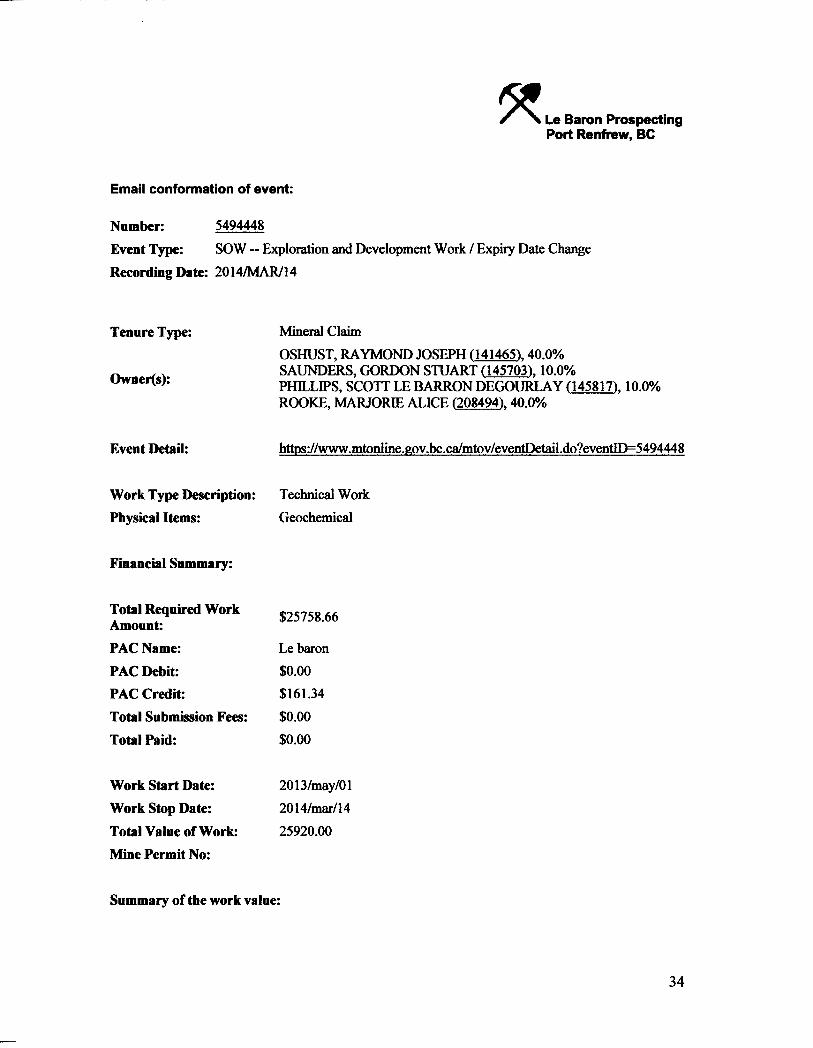
Email conformation of event:
Number: 5494448
Event Type: SOW — Exploration and Development Work / Expiry Date Change Recording Date: 2014/MAR/14
Tenure Type:
Owner(s):
Mineral Claim OSHUST, RAYMOND JOSEPH (141465). 40.0% SAUNDERS, GORDON STUART (145703). 10.0% PHILLIPS, SCOTT LE BARRON DEGOURLAY (145817). 10.0% ROOKE, MARJORIE ALICE (208494). 40.0%
Event Detail: https://www.mtonlme.gov.bc.ca/m^
Work Type Description: Physical Items:
Technical Work Geochemical
Financial Summary:
Total Required Work Amount: PAC Name: PAC Debit: PAC Credit: Total Submission Fees: Total Paid:
$25758.66
Le baron $0.00 $161.34 $0.00 $0.00
Work Start Date: Work Stop Date: Total Value of Work: Mine Permit No:
2013/may/01 2014/mar/14 25920.00
Summary of the work value:
34

Tenure Number: 401285 Tenure Type: Mineral Claim Claim Name/Property: RNR Issue Date: 2003/mar/16 Old Good To Date: 2014/mar/16 New Good To Date: 2017/nov/16 Number of Days Forward: 1341 Area in Ha: 500.0 Tenure Required Work Amount: $17534.25 Tenure Submission Fee: $0.00
Tenure Number: 508826 Tenure Type: Mineral Claim Claim Name/Property: Tracey Issue Date: 2005/mar/ll Old Good To Date: 2014/mar/16 New Good To Date: 2017/nov/16 Number of Days Forward: 1341 Area in Ha: 127.917 Tenure Required Work Amount: $4485.86 Tenure Submission Fee: $0.00
Tenure Number: 535952 Tenure Type: Mineral Claim Claim Name/Property: TRACEY # 2 Issue Date: 2006/jun/19 Old Good To Date: 2014/mar/16 New Good To Date: 2017/nov/16 Number of Days Forward: 1341 Area in Ha: 106.607 Tenure Required Work Amount: $3738.55 Tenure Submission Fee: $0.00