Embed Size (px)
Citation preview

Quail Brush Generation Project Application for Certification
APPENDIX G
PHASE I ENVIRONMENTAL SITE ASSESSMENT
DRAFT REPORT
PHASE I ENVIRONMENTAL SITE ASSESSMENT Quail Brush Project Site APN 366-081-42 San Diego, California San Diego County
Prepared for
Quail Brush Genco, LLC 9405 Arrowpoint Boulevard Charlotte, North Carolina 28273
Prepared by
143 Union Boulevard, Suite 1010 Lakewood, CO 80228
August 2011

Quail Brush Project Site Phase I Environmental Site Assessment
CONTENTS
i August 2011
EXECUTIVE SUMMARY........................................................................................................ES-1
1. INTRODUCTION ................................................................................................................ 1-1 1.1 PURPOSE ................................................................................................................... 1-1 1.2 LIMITING CONDITIONS AND METHODOLOGY USED ..................................... 1-2 1.3 SIGNIFICANT ASSUMPTIONS ............................................................................... 1-3 1.4 LIMITATIONS AND EXCEPTIONS ......................................................................... 1-3 1.5 SPECIAL TERMS AND CONDITIONS .................................................................... 1-3 1.6 USER RELIANCE ...................................................................................................... 1-4
2. PROJECT DESCRIPTION .................................................................................................. 2-1 2.1 LOCATION AND LEGAL DESCRIPTION OF PROPERTY ................................... 2-1 2.2 SITE AND VICINITY GENERAL CHARACTERISTICS ........................................ 2-1
2.2.1 Regional Setting ............................................................................................. 2-1 2.2.2 Geology and Groundwater ............................................................................. 2-2 2.2.3 Soils ............................................................................................................... 2-2
2.3 CURRENT USES OF THE PROPERTY ................................................................... 2-3 2.4 DESCRIPTIONS OF STRUCTURES, ROADS, AND OTHER
IMPROVEMENTS...................................................................................................... 2-3 2.5 CURRENT USE OF ADJOINING PROPERTIES ..................................................... 2-3 2.6 USER PROVIDED INFORMATION ......................................................................... 2-3
2.6.1 Title Records .................................................................................................. 2-3 2.6.2 Environmental Liens and Activity Use Limitations ....................................... 2-4 2.6.3 Specialized Knowledge .................................................................................. 2-4 2.6.4 Commonly Known or Reasonably Ascertainable Information ...................... 2-4 2.6.5 Value Reduction for Environmental Issues ................................................... 2-4 2.6.6 Owner, Property Manager, and Occupant Information .................................. 2-4 2.6.7 Reason for Performing Phase I ...................................................................... 2-4
3. RECORDS REVIEW ........................................................................................................... 3-1 3.1 REGULATORY AGENCY DATABASE SEARCH ................................................. 3-1
3.1.1 National Priorities List (Superfund) ............................................................... 3-2 3.1.2 Comprehensive Environmental Response, Compensation, and Liability
Information System ........................................................................................ 3-2 3.1.3 Resource Conservation and Recovery Act Corrective Action Reports
Treatment, Storage, and Disposal Facilities ................................................... 3-2 3.1.4 Resource Conservation and Recovery Act Non-Corrective Action
Reports Treatment, Storage, and Disposal Facilities ..................................... 3-2 3.1.5 Resource Conservation and Recovery Information System ........................... 3-2 3.1.6 Emergency Response Notification System List ............................................. 3-3 3.1.7 State Hazardous Waste List (State-Equivalent NPL and CERCLIS) ............ 3-3 3.1.8 State Landfills and/or Solid Waste Disposal Sites ......................................... 3-3 3.1.9 State Leaking Underground Storage Tank Sites ............................................ 3-5 3.1.10 State Underground Storage Tank and Aboveground Storage Tank Sites ...... 3-6

Quail Brush Project Site Phase I Environmental Site Assessment
CONTENTS (Continued)
ii August 2011
3.1.11 State Voluntary Cleanup Program Sites ......................................................... 3-6 3.1.12 State Brownfield Sites .................................................................................... 3-6 3.1.13 Orphan Sites ................................................................................................... 3-6
3.2 REVIEW OF USER PROVIDED TITLE COMMITMENT RECORDS ................... 3-7 3.3 PHYSICAL SETTING DESCRIPTION AND SOURCES......................................... 3-7 3.4 HISTORICAL USE OF THE PROPERTY ................................................................. 3-7 3.5 HISTORICAL USE OF ADJOINING PROPERTIES .............................................. 3-10
4. INTERVIEWS ...................................................................................................................... 4-1 4.1 LANDOWNER QUESTIONNAIRES ........................................................................ 4-1 4.2 SITE RECONNAISSANCE INTERVIEW ................................................................. 4-1 4.3 INTERVIEW WITH LOCAL GOVERNMENT OFFICIALS .................................... 4-2
5. SITE RECONNAISSANCE ................................................................................................. 5-1 5.1 METHODOLOGY AND LIMITATIONS .................................................................. 5-1 5.2 SUMMARY OF OBSERVATIONS ........................................................................... 5-1
5.2.1 Site Reconnaissance Findings ........................................................................ 5-2 5.3 ADJACENT PROPERTY AND VICINITY FINDINGS ........................................... 5-2
6. FINDINGS AND CONCLUSIONS ..................................................................................... 6-1
7. LIMITATIONS AND EXCEPTIONS OF ASSESSMENTS ............................................... 7-1
8. SIGNATURE OF ENVIRONMENTAL PROFESSIONALS.............................................. 8-1
9. REFERENCES ..................................................................................................................... 9-1

Quail Brush Project Site Phase I Environmental Site Assessment
iii August 2011
FIGURES
Figure 1 Site Location Map for Quail Brush Project Site, San Diego, San Diego County, California
Figure 2 Site Reconnaissance Map for Quail Brush Project Site, San Diego, San Diego County, California
APPENDICES
Appendix A Regulatory Database Report
Appendix B Topographic Maps and Aerial Photographs
Appendix C Site Reconnaissance Photograph Log
Appendix D Summary of Interviews
Appendix E Supporting Documentation
Appendix F Credentials of Environmental Professionals
Quail Brush Project Site Phase I Environmental Site Assessment
iv August 2011
ACRONYMS AND ABBREVIATIONS
AST Aboveground storage tank
ASTM American Society for Testing and Materials
CERCLIS Comprehensive Environmental Response, Compensation and Liability Information System
CORRACTS Corrective Action Reports
EPA U.S. Environmental Protection Agency
ERNS Emergency Response Notification System
ESA Environmental Site Assessment
LUST Leaking underground storage tank
NFRAP No Further Remedial Action Plan
NPL National Priority List
NE Northeast
NW Northwest
NW/NE Signifies the northwest quarter of the northeast quarter
REC Recognized environment condition
RCRA Resource Conservation and Recovery Act
RCRIS Resource Conservation and Recovery Information System
SE Southeast
SW Southwest
TSD Treatment, storage, and disposal
TtEC Tetra Tech EC, Inc.
TRIS Toxic Chemical Release Inventory System
USGS U.S. Geological Survey
UST Underground storage tank

Quail Brush Project Site Phase I Environmental Site Assessment
ES-1 August 2011
EXECUTIVE SUMMARY
In accordance with our proposal dated June 17, 2011, Tetra Tech EC, Inc. (TtEC) conducted a Phase I Environmental Site Assessment (ESA) for Quail Brush Genco, LLC, a wholly owned subsidiary of Cogentrix Energy, LLC for the Quail Brush Project Site, a proposed natural gas fired electrical generation plant (also referred to herein as the Property or Subject Property). The purpose of the Phase I ESA was to collect and interpret readily available data to identify recognized environmental conditions (RECs), if any, associated with the Property in accordance with American Society for Testing and Materials (ASTM) Standard E1527-05, Standard Practice for Environmental Site Assessments: Phase I Environmental Site Assessment Process, including the U.S. Environmental Protection Agency (EPA) All Appropriate Inquiry (AAI) standard. A REC is defined as “the presence or likely presence of any hazardous substances or petroleum products on a property under conditions that indicate an existing release, a past release, or a material threat of a release of any hazardous substances or petroleum products into structures on the Property or into the ground, groundwater, or surface water of the Property.” Through completion of the Phase I ESA process, no RECs were identified.
The Property is identified as Assessor’s Parcel Number (APN) 366-081-42, according to information obtained from the San Diego County Assessor and from an American Land Title Association/American Congress on Surveying and Mapping (ALTA/ACSM) land title survey for the Property. The Property encompasses 21.57 gross acres in San Diego, San Diego County, California. The location, boundaries, and vicinity are shown relative to surrounding topographic features in Figure 1. The Property is located approximately 0.35 miles northwest of the entrance (offices and scales) to the Sycamore Landfill off of Mast Boulevard, and approximately 0.35 miles south of the southern boundary of the landfill footprint. At the time of this assessment, Sycamore Landfill, Inc. had authorized access to the Property.
The site reconnaissance for this Phase I ESA was conducted on July 19, 2011. A questionnaire was mailed to the Property owner prior to the start of the site reconnaissance. In addition, Environmental Data Resources, Inc. (EDR) generated an environmental regulatory database report for the Property on July 12, 2011. At the time of the inspection, the Property was vacant land, with Sycamore Landfill Road crossing the Property along the western boundary at the northwest part of the Property.
The following findings were identified as a result of this Phase I ESA.
• Historical Maps and Aerial Photographs: The Property has been vacant land since at least 1903 based on review of historical topographic maps and aerial photographs; however, the Property is located within a larger area (Camp Elliott; Area B of the East Elliot subarea)

Quail Brush Project Site Phase I Environmental Site Assessment
ES-2 August 2011
historically used from 1941 to 1944 by the United States Marine Corps as a weapons training center. The Property is potentially located within the limits of former mortar and artillery ranges that used ordnance and explosives.
• Regulatory Agency Database Search: The Property was not listed in the regulatory agency database search. Nearby Sycamore Landfill was listed in the regulatory agency database search. Based on review of the database report and regulatory agency records, the Sycamore Landfill is not considered to be a REC of the Property.
• Landowner Questionnaire: According to the responses on the Landowner Questionnaire, the Property is located within a Multi-Habitat Planning Area (MHPA) and Multiple Species Conservation Program (MSCA) area, and the Department of the Army has conducted ordnance sweeps on or near the Property.
• RECs: Based on the environmental data review and field reconnaissance, no RECs were found associated with the Property.
• Potential safety issue (non-scope consideration): The potential location of the Property within the limits of former mortar and artillery ranges that used ordnance and explosives (OE), and the possibility for there to be unexploded ordnance (UXO) on the Property, is considered to be a potential safety issue at the Property. During the conduct of this assessment, TtEC found no Property-specific records documenting that ordnance sweeps had actually been conducted on the Property (e.g., maps showing a sweep area grid, a list of ordnance found [or documentation of none found] during a sweep, documentation of detonation of UXO [if found], etc.).
• Environmental Liens and Activity Use Limitations (AULs): No environmental liens or AULs were found for the Property.
TtEC presents the following recommendation for consideration:
• Prior to development of the Property, a Property-specific survey for OE and UXO should be conducted. Any OE or UXO found should be disposed in accordance with all applicable regulations.

Quail Brush Project Site Phase I Environmental Site Assessment
1-1 August 2011
1. INTRODUCTION
This report presents the results of a Phase I Environmental Site Assessment (ESA) prepared for Quail Brush Genco, LLC, for the Quail Brush Project Site, a proposed natural gas fired electrical generation plant (also referred to herein as the Property or Subject Property). Figure 1 shows the general location of the Property.
Tetra Tech EC, Inc. (TtEC) prepared this report for the sole use of Quail Brush Genco, LLC within the express limitations detailed in Sections 1.2 through 1.6 and Section 7.1. The format of this report is consistent with the recommended format in “Standard Practice for Environmental Site Assessment: Phase I Environmental Site Assessment Process” issued by American Society for Testing and Materials (ASTM) Standard E1527-05, including the U.S. Environmental Protection Agency (EPA) All Appropriate Inquiry (AAI) standard.
1.1 PURPOSE
Pursuant to the scope of work and the applicable ASTM standard, the purpose of this Phase I ESA is to identify recognized environmental conditions (RECs) in connection with the Subject Property. As defined in Section 1.1.1 of ASTM Standard E1527-05, “a recognized environmental condition” is “the presence or likely presence of any hazardous substances or petroleum products on a property under conditions that indicate an existing release, a past release, or a material threat of a release of any hazardous substances or petroleum products into structures on the Property or into the ground, groundwater, or surface water of the Property.” The term is not intended to include de minimis conditions that generally do not present a threat to human health or the environment and that generally would not be the subject of an enforcement action if brought to the attention of appropriate governmental agencies.
ASTM Standard E1527-05 is intended to permit a user to satisfy one of the requirements to qualify for the innocent landowner, contiguous property owner, or bona fide prospective purchaser limitations on CERCLA liability (hereinafter, the “landowner liability protections,” or “LLPs”): that is, the practice that constitutes “all appropriate inquiry into the previous ownership and uses of the property consistent with good commercial or customary practice” as defined at 42 U.S.C. §9601(35).

Quail Brush Project Site Phase I Environmental Site Assessment
1-2 August 2011
1.2 LIMITING CONDITIONS AND METHODOLOGY USED
TtEC representative Steven Grod performed the Phase I ESA in general accordance with ASTM Standard E1527-05. The scope of services for this project was limited to the following tasks:
• Task 1 - Site Reconnaissance • Task 2 - Interview of Knowledgeable Individual(s) • Task 3 - Regulatory Agency Database Search • Task 4 - Data Analysis and Report Preparation
TtEC’s assessment is limited strictly to identifying RECs associated with the Subject Property. TtEC’s assessment did not evaluate structural conditions of any buildings on the Subject Property, and sampling of soils, groundwater, and surface water was not within the scope of work. In addition, this assessment did not attempt to identify the presence of environmental contamination that exists in areas that were not able to be visually inspected. This includes: surface soils located under pavement, interiors of structures, vehicles, or other media interference; subsurface soils; groundwater; areas of the Property or buildings on the Property which were otherwise inaccessible due to locked or blocked accesses; geographic or vegetation impediments; weather interferences; or size of the Property.
The site reconnaissance was conducted from a vehicle along the adjacent public road, with ground inspection completed along readily accessible Property boundaries and interior portions of the Property as warranted based on vehicle observations and accessibility. A complete description of the site reconnaissance is provided in Section 5.1. TtEC did not inspect subsurface features, such as underground utilities or utility corridors, if present.
A data gap is a lack of or inability to obtain information required by this practice despite good faith efforts by the environmental professional to gather such information. Data gaps may result from incompleteness in any of the activities required by this practice, including, but not limited to site reconnaissance (e.g., an inability to conduct the site visit), interviews (e.g., an inability to interview the key site manager, regulatory officials, etc.), and intervals of standard historical sources reviewed (e.g., intervals of more than five years with no reasonably ascertainable historical sources). For the current assessment, historical sources interval data gaps were encountered; however, considering the historical sources reviewed indicate the Property has been vacant land since at least 1903, this data gap is not considered to be significant.
There may be environmental issues or conditions at the Property that parties may wish to assess in connection with commercial real estate that are outside the scope of this standard. TtEC did not assess the Subject Property for the potential for liabilities associated with the following:

Quail Brush Project Site Phase I Environmental Site Assessment
1-3 August 2011
• Asbestos-containing building materials • Radon • Lead-based paint • Lead in drinking water • Wetlands • Regulatory compliance • Cultural and historic resources • Industrial hygiene • Health and safety • Ecological resources • Endangered species • Indoor air quality • Biological agents • Mold
This list is not all-inclusive and no implication is intended as to the relative importance of inquiry. These can present environmental liabilities to a property owner, but they are not included in the ASTM Standard E1527-05 scope of work for Phase I ESAs.
1.3 SIGNIFICANT ASSUMPTIONS
In the completion of this report, it was assumed that the information provided by knowledgeable individuals during interviews and the landowner questionnaire was truthful. Otherwise, there were no significant assumptions associated with this Phase I ESA.
1.4 LIMITATIONS AND EXCEPTIONS
Results of this assessment are based upon the visual site inspection of readily accessible areas of the Subject Property conducted by TtEC personnel, information from interviews with knowledgeable persons regarding the Subject Property, information reviewed regarding historical uses, information provided by contacted regulatory agencies, and review of publicly available and practically reviewable information identifying current and historical uses of the property and surrounding properties. A title search was not performed by TtEC. No environmental samples were collected from the Subject Property.
1.5 SPECIAL TERMS AND CONDITIONS
There are no special terms and conditions.
Quail Brush Project Site Phase I Environmental Site Assessment
1-4 August 2011
1.6 USER RELIANCE
This report was prepared for the sole use of Quail Brush Genco, LLC. This report was prepared based on review of limited data, as described herein, in accordance with generally accepted professional practices, applicable to work of similar nature and complexity of similar localities, at the time the services were performed. No warranty, express or implied, is made. TtEC’s services, and the resulting scope and conclusions of this report are in accordance with the criteria of ASTM practice E1527-05 governing Phase I ESAs, as specifically defined in TtEC’s proposal dated June 17, 2011. TtEC assumes no responsibility for conditions of which it is unaware and/or as to which there was no opportunity or request for review.

Quail Brush Project Site Phase I Environmental Site Assessment
2-1 August 2011
2. PROJECT DESCRIPTION
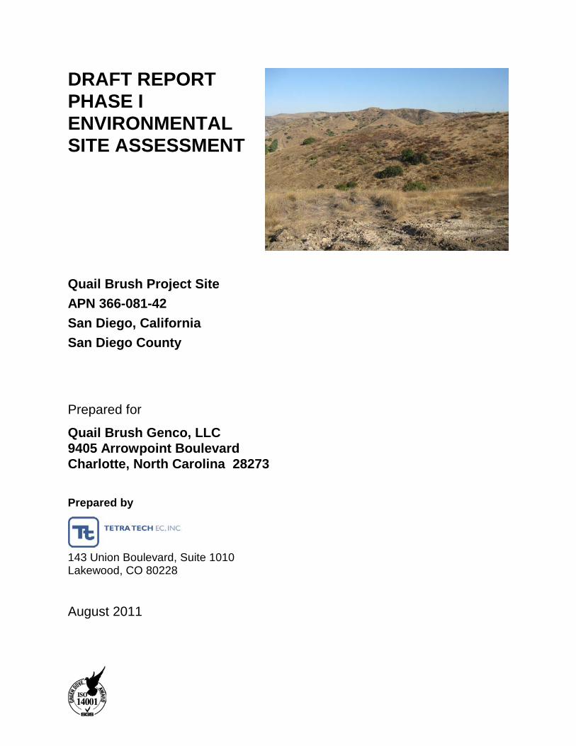
The proposed area for the Quail Brush Project Site described in this report is located in San Diego, San Diego County, California. The Property is currently, and has historically been, vacant land. The following sections describe the location, legal description, Property and vicinity general characteristics, and uses of the Property and adjacent properties.
2.1 LOCATION AND LEGAL DESCRIPTION OF PROPERTY
The Property is located in western San Diego County, within the San Diego city limits, and north and west of the City of Santee. The Property is identified as Assessor’s Parcel Number (APN) 366-081-42 and encompasses 21.57 gross acres, according to information obtained from the San Diego County Assessor and from an American Land Title Association/American Congress on Surveying and Mapping (ALTA/ACSM) land title survey for the Property. The location, boundaries, and vicinity are shown relative to surrounding topographic features in Figure 1. The ALTA/ACSM and title survey contained a legal description of the Property. Aerial photographs and topographic maps of the Property used in this assessment are provided in Appendix B.
2.2 SITE AND VICINITY GENERAL CHARACTERISTICS
The Property and surrounding properties are primarily vacant land. The Property is located approximately 0.35 miles northwest of the entrance (offices and scales) to the Sycamore Landfill off of Mast Boulevard and approximately 0.35 miles south of the southern boundary of the landfill footprint. A cell tower site is located approximately 600 feet southeast of the Property. Mission Trails Equestrian Staging Area is located approximately 600 feet southwest of the Property, beyond State Highway 52.
2.2.1 Regional Setting The Property is located in the Peninsular Ranges section of the Lower California Physiographic Province (U.S. Geological Survey [USGS], 2003). This province is characterized by a dissected westward-sloping granite upland.
According to information contained on an ALTA/ACSM land title survey for the Property, the elevations at the Property range from approximately 400 to 560 feet above mean sea level (msl) with a topography that generally slopes down to the west-southwest overall.
Quail Brush Project Site Phase I Environmental Site Assessment
2-2 August 2011
2.2.2 Geology and Groundwater The Property is located within the San Diego River Valley Groundwater Basin, which consists of alluvium deposited by the San Diego River and its tributaries (California Department of Water Resources [CADWR], 2004). The basin is surrounded by contacts with semi-permeable rocks of the Eocene Poway Group, impermeable Cretaceous crystalline rock, and impermeable Jurassic to Cretaceous Santiago Peak volcanic rocks. Quaternary alluvial deposits form the principal water-bearing unit within the basin. The most productive portions of the alluvium are the well-sorted sands located in buried river channels, along with a layer of coarse gravel near the base of the aquifer.
TtEC reviewed groundwater monitoring report information on the State Water Resources Control Board’s (SWRCB’s) GeoTracker website for groundwater depth and flow direction in the vicinity of the Property. According to June 2010 groundwater monitoring information for the Sycamore Landfill, located approximately 0.35 miles north of the Site, groundwater depth ranged from approximately 10 to 335 feet below ground surface (bgs) with a reported groundwater flow direction to the south-southwest. No other specific information was found for site locations within 0.5 mile of the Site.
Based on general surface topography at the Property and surrounding areas, groundwater flow direction is expected to flow in a west-southwesterly direction. There are, however, limitations to the use of topography as an indicator of groundwater flow direction. Topography is used here because no site-specific information was found for the Property during the conduct of this assessment.
2.2.3 Soils According to the United States Department of Agriculture, Natural Resources Conservation Service (USDA NRCS), web soil survey website, soils at the Property and are generally classified as follows:
• Diablo clay, 15 to 30 percent slopes: the Diablo series consists of moderately deep to deep, well-drained clays derived from soft, calcareous sandstone and shale. The typical profile for Diablo clay, 15 to 30 percent slopes, is clay from 0 to 27 inches bgs, heavy sandy loam from 27 to 32 inches bgs, and decomposed sandstone from 32 to 36 inches.
• Redding cobbly loam, dissected, 15 to 50 percent slopes: the Redding series consists of well-drained, undulating to steep gravelly loams that have a gravelly clay subsoil and a hardpan. The typical profile for Redding cobbly loam, dissected, 15 to 50 percent slopes, is 10 to 18 inches cobbly loam over hardpan.
Quail Brush Project Site Phase I Environmental Site Assessment
2-3 August 2011
2.3 CURRENT USES OF THE PROPERTY
The Property is currently vacant land primarily covered with non-native grasslands and some small areas with scrub and trees.
2.4 DESCRIPTIONS OF STRUCTURES, ROADS, AND OTHER IMPROVEMENTS
No structures were observed on the Property. Approximately 400 feet of Sycamore Landfill Road (approximately 25 feet wide) crosses the Property along the western boundary at the northwest part of the Property. Some dirt trails and tamped down grassland trails were observed at a few locations on the Property. A small concrete v-shaped ditch, barbed-wire fence, two storm water catch basins, and a pipe labeled “reclaimed water” were observed along the western side of the Property, adjacent and east of Sycamore Landfill Road.
2.5 CURRENT USE OF ADJOINING PROPERTIES
Land use in the area surrounding the Subject Property is primarily vacant/undeveloped. Metal beams were observed to be stored at a small area west of the central western Property boundary, on the west side of Sycamore Landfill Road. A cell tower is located approximately 600 feet southeast of the Property, on the parcel of land adjacent and southeast of the Property. As noted previously, the entrance (offices and scales) to the Sycamore Landfill off of Mast Boulevard is located approximately 0.35 miles southeast of the Property, the southern boundary of the landfill footprint is located approximately 0.35 miles north of the Property, and the Mission Trails Equestrian Staging Area is located approximately 600 feet southwest of the Property beyond State Highway 52.
2.6 USER PROVIDED INFORMATION
Quail Brush Genco, LLC provided TtEC the following items:
• APN, owner name, and map of the Property location.
• Completed AAI questionnaire filled out by the current landowner (Appendix D).
2.6.1 Title Records Quail Brush Genco, LLC provided no title records to TtEC. Readily available information reviewed by TtEC at the San Diego County Assessor’s office showed the Property has been owned since at least 1992 by private individuals, families, or trusts of private individuals or families.

Quail Brush Project Site Phase I Environmental Site Assessment
2-4 August 2011
2.6.2 Environmental Liens and Activity Use Limitations Quail Brush Genco, LLC provided TtEC no information regarding environmental lien or activity use limitations (AULs), if any exists, associated with the Property.
According to the responses on the AAI questionnaire filled out by the current landowner, the Property is located within a Multi-Habitat Planning Area (MHPA) and Multiple Species Conservation Program (MSCA) area, and the Department of the Army has conducted ordnance sweeps at or near the Property (note: the Department of the Army documentation included with the completed questionnaire refers to the Site parcel by its former Assessor’s Parcel Number of 366-081-25).
TtEC requested a search for environmental liens and AULs from Texas Environmental Research for the Property parcel (APN 366-081-42). No environmental liens or AULs were found for the Property parcel. A copy of the search results from Texas Environmental Research is provided in Appendix E.
2.6.3 Specialized Knowledge Quail Brush Genco, LLC provided TtEC with no specialized knowledge regarding the Property, except as discussed above.
2.6.4 Commonly Known or Reasonably Ascertainable Information Quail Brush Genco, LLC provided TtEC with no commonly known or reasonably ascertainable information associated with the Property, except as discussed above.
2.6.5 Value Reduction for Environmental Issues Quail Brush Genco, LLC provided TtEC with no information regarding value reduction for environmental issues associated with the Property. According to information on the AAI questionnaire filled out by the current landowner, there is none.
2.6.6 Owner, Property Manager, and Occupant Information Quail Brush Genco, LLC provided TtEC information regarding the current landowner (Rosemarie A. Burris Living Trust). The Property is vacant and there is no property manager or occupant.
2.6.7 Reason for Performing Phase I It is TtEC’s understanding that this Phase I ESA has been requested as a part of the due diligence activities by Quail Brush Genco, LLC for the Property, of which they propose to develop a portion with a natural gas fired electrical generation plant.
Quail Brush Project Site Phase I Environmental Site Assessment
3-1 August 2011
3. RECORDS REVIEW
The records review section of the Phase I ESA included performing database searches and reviewing physical setting information and the historical uses of the Property and adjoining/nearby properties.
3.1 REGULATORY AGENCY DATABASE SEARCH
A search of readily available federal, state, regional, and local agency database listings was conducted by Environmental Data Resources, Inc. (EDR). The EDR database report is provided in Appendix A. EDR searched numerous government databases, as described in detail in their report, including, but not limited to, the following databases and associated search distances specified in Section 8.2.1 of ASTM E1527-05:
• Federal National Priorities List (NPL) within one mile
• Federal Delisted National Priorities List (NPL) within one-half mile
• Federal Comprehensive Environmental Response, Compensation and Liability Information System (CERCLIS) within one-half mile
• Federal CERCLIS No Further Remedial Action Plan (NFRAP) within one-half mile
• Federal Resource Conservation and Recovery Act (RCRA) Corrective Action Reports (CORRACTS) Treatment, Storage, and Disposal (TSD) facilities within one mile
• Federal RCRA Non-CORRACTS TSD facilities within one-half mile
• Federal RCRA generators list (Resource Conservation and Recovery Information System [RCRIS]) for the Property and adjoining properties
• Federal Emergency Response Notification System (ERNS) list for the Property
• State-equivalent NPL sites within one mile
• State-equivalent CERCLIS sites within one-half mile
• State solid waste landfills and/or solid waste disposal sites within one-half mile
• State leaking underground storage tank (LUST) sites within one-half mile
• State-registered underground storage tanks (USTs) listed for the Properties and adjoining properties
• State-equivalent voluntary cleanup program (VCP) sites within one-half mile
• State-equivalent Brownfield sites within one-half mile
Descriptions of the various databases that were searched are provided below.

Quail Brush Project Site Phase I Environmental Site Assessment
3-2 August 2011
3.1.1 National Priorities List (Superfund) The NPL identifies federal Superfund sites with the highest priority for cleanup. ASTM Standard E1527-05 requires the identification of NPL sites within one mile of the Property. There were no NPL sites identified within one mile of the boundaries of the Property, nor are any NPL sites located on the Property.
3.1.2 Comprehensive Environmental Response, Compensation, and Liability Information System
The CERCLIS list identifies sites that the U.S. Environmental Protection Agency (EPA) has investigated or is in the process of investigating for potential hazardous substance contamination. A CERCLIS site may or may not become a NPL site. ASTM Standard E1527-05 requires the identification of CERCLIS and CERCLIS NFRAP sites within one-half mile of the Property. There were no CERCLIS or CERCLIS NFRAP sites identified within one-half mile of the boundaries of the Property, nor are any CERCLIS or CERCLIS NFRAP sites located on the Property.
3.1.3 Resource Conservation and Recovery Act Corrective Action Reports Treatment, Storage, and Disposal Facilities
The RCRA CORRACTS TSD is used to track the status and filing of any corrective actions that have taken place at a facility. ASTM Standard E1527-05 requires the identification of RCRA CORRACTS TSD sites within one mile of the Property. There were no RCRA CORRACTS TSD sites were identified within one mile of the boundaries of the Property, nor are any RCRA CORRACTS TSD sites located on the Property.
3.1.4 Resource Conservation and Recovery Act Non-Corrective Action Reports Treatment, Storage, and Disposal Facilities
The RCRA non-CORRACTS TSD facilities lists those facilities where treatment, storage, and/or disposal of hazardous wastes takes place and where corrective remedial action has not been required by EPA, as defined and regulated by RCRA. ASTM Standard E1527-05 requires the identification of RCRA non-CORRACTS TSD facilities within one-half mile of the Property. There were no RCRA non-CORRACTS TSD facilities within one-half mile of the boundaries of the Property, nor are any RCRA non-CORRACTS TSD sites located on the Property.
3.1.5 Resource Conservation and Recovery Information System RCRIS includes information on facilities that generate, transport, store, treat, and/or dispose of hazardous wastes as defined and regulated by RCRA. ASTM Standard E1527-05 requires the identification of RCRIS facilities on or adjacent to the Property. This information is found in the

Quail Brush Project Site Phase I Environmental Site Assessment
3-3 August 2011
RCRIS database for large- and small-quantity RCRIS-TSD generators. There were no RCRIS-TSD sites identified on or adjacent to the Property. There were no RCRA large-quantity generators or small-quantity generators identified adjacent to the Property, nor are any RCRA large-quantity generators or small-quantity generators located on the Property.
3.1.6 Emergency Response Notification System List The federal ERNS list records and stores information on reported releases of oil and hazardous substances. ASTM Standard E1527-05 requires the identification of ERNS sites on the Property. The Property was not identified on the ERNS list, nor are any ERNS sites identified on the adjacent properties.
3.1.7 State Hazardous Waste List (State-Equivalent NPL and CERCLIS) ASTM Standard E1527-05 requires that state-equivalent NPL and CERCLIS sites be identified within one mile and one-half mile of the Property, respectively. There were no state-equivalent NPL and CERCLIS facilities within one mile and one-half mile of the boundaries of the Property, respectively. No state-equivalent NPL and CERCLIS sites are located on the Property.
3.1.8 State Landfills and/or Solid Waste Disposal Sites Landfills and/or solid waste disposal sites are those sites that used to accept or currently accept waste of any kind for disposal onsite. ASTM Standard E1572-05 requires the identification of these sites within one-half mile of the Property. The Property was not listed on the landfills and/or solid waste disposal sites lists. One landfill and/or solid waste disposal site was identified within one-half mile of the Property: Sycamore Landfill, located approximately 0.35 miles north of the Site at the closest point.
It should be noted that the EDR database report referenced this landfill site as Sycamore Landfill, Sycamore Canyon Landfill, and Sycamore Sanitary Landfill. The EDR database report also listed addresses as 8514 Mast Boulevard, 14494 Mast Boulevard, and Mast Boulevard. Based on the information presented in the EDR database report, it appears all these listings are for the same site: the existing Sycamore Landfill with a current address of 8514 Mast Boulevard. Pertinent information from the EDR database report, as well as information obtained from local regulatory agency websites and information provided to TtEC from Mr. Gabe Gonzales (Operations Manager for Sycamore Landfill), is summarized below.
According to the information reviewed, the Sycamore Landfill began operations in the mid-1970s and currently comprises approximately 390 acres of land. The facility is a permitted Class III sanitary landfill.
Quail Brush Project Site Phase I Environmental Site Assessment
3-4 August 2011
Groundwater
Routine groundwater sampling and analysis is conducted on a semi-annual basis in accordance with the requirements of the California Regional Water Quality Control Board – San Diego Region (SDRWQCB). Groundwater samples are analyzed for indicator parameters, including chloride, nitrate as nitrogen, sulfate, and total dissolved solids (TDS), and volatile organic compounds (VOCs).
VOCs were first identified in samples from groundwater monitoring wells during the 1992 Solid Waste Assessment Test, when the County of San Diego operated the site. In response to the identification of VOCs in groundwater monitoring wells near the southwest “toe” of the Sycamore Landfill (crossgradient of the Property), an Evaluation Monitoring Program (EMP) was conducted and interim corrective action measures were initiated in April 1996. The results of the EMP investigation suggest that organic impacts observed in well ITSY-6 (near the southwest “toe”) appeared to be associated with landfill gas. Based on the data from the EMP, it was concluded that construction of a landfill gas extraction system, in tandem with well ITSY-6 used as an extraction well would be the most effective means of corrective action for mitigating impacted groundwater conditions at the point-of-compliance. Corrective action plan (CAP) monitoring points include wells ITSY-6 and ITSY-10 and they are sampled concurrently with other groundwater monitoring wells. Impacted groundwater is pumped from well ITSY-6 to an aboveground storage tank (AST) equipped with an automated float sensor to prevent overflows. Extracted groundwater is then transferred from the storage tank to water trucks, and used for dust control at the site. Due to well deterioration and subsequent pump failure, extraction well ITSY-6 was abandoned and replaced with extraction well ITSY-6R in August 2008.
During the monitoring period of April to September 2010, 48,747 gallons of groundwater were extracted. The analytical results of the sample from well ITSY-6R indicate a total VOC load of approximately 1.03 grams was removed from the aquifer during the monitoring period.
Groundwater quality conditions beneath the Sycamore Landfill during the monitoring period of April to September 2010 were generally similar to those observed historically. No new historical intra-well maximum concentrations were measured in groundwater samples collected during the current monitoring period. However, VOCs were measured in groundwater samples collected from CAP wells ITSY-6R (acetone at 4.5 micrograms per liter [µg/L] and 1,4-dichlorobenzene at 1.1 µg/L) and ITSY-10 (tetrachloroethene [PCE] at 0.51 µg/L and trichloroethene [TCE] at 0.31 µg/L). Review of the VOC results from these wells indicate that current concentrations were measured at or near respective historical intra-well minimum concentrations and, of the four VOCs detected, three were measured at estimated-trace concentrations.

Quail Brush Project Site Phase I Environmental Site Assessment
3-5 August 2011
Leachate
Pursuant to Waste Discharge Requirements (WDR) Order No. 99-74, leachate is sampled and tested annually. Leachate samples were recently (May 9, 2011) collected and analyzed for six metals (cadmium, chromium, copper, lead, nickel, and zinc), oil and grease, and other parameters (chemical oxygen demand, pH, total suspended solids [TSS]). Laboratory results reported no metals or oil and grease were detected.
Landfill Gas
Sycamore Landfill operates a landfill gas collection system comprised of 14 vertical gas collection wells and associated piping along the perimeter of the landfill. The landfill gas collection system is monitored on a monthly basis and perimeter probe monitoring is conducted on a quarterly basis. Instantaneous surface emissions monitoring and surface structure monitoring are also conducted on a quarterly basis. Results from the recent (June 22 and 30, 2011) perimeter probe monitoring found four casings at two perimeter probe locations to have concentrations of methane above the lower explosive limit (LEL) standard. The exceedances were reported to the City of San Diego Development Services Department, Solid Waste Local Enforcement Agency [LEA]. Adjustments were made to the landfill gas collection system and subsequent follow-up testing results reported concentrations of methane below the LEL standard.
Stormwater
Sycamore Landfill operates under a Storm Water Pollution Prevention Plan (SWPPP). Run-on/run-off control facilities have been designed to accommodate a 100-year, 24-hour storm event, as required by CCR Title 27. During the recent monitoring period, all of the facilities were functioning properly and no changes have been made to the current run-on/run-off control facilities. A storm water monitoring program is implemented at the site under the National Pollutant Discharge Elimination System (NPDES) General Permit for Industrial Activities.
Based on the information summarized above and the distance from the Property (approximately 0.35 miles), Sycamore Landfill is not considered to be of environmental concern to the Property at this time.
3.1.9 State Leaking Underground Storage Tank Sites The state LUST database provides information on reported LUST incidents. These data show those sites containing one or more USTs that have been identified as having leaked or are potentially leaking their contents to soil or groundwater. ASTM Standard E1527-05 requires the identification of LUST sites within one-half mile of the Property. There were no LUST sites

Quail Brush Project Site Phase I Environmental Site Assessment
3-6 August 2011
identified within one-half mile of the boundaries of the Property, nor are any LUST sites located on the Property.
3.1.10 State Underground Storage Tank and Aboveground Storage Tank Sites
The state UST and AST databases identify sites containing one or more registered USTs or ASTs. ASTM Standard E1527-05 requires the identification of USTs and ASTs on the Property or adjoining properties. There were no UST or AST sites identified adjacent to the Property, nor are any UST or AST sites located on the Property.
3.1.11 State Voluntary Cleanup Program Sites The state VCP Sites database contains information regarding low threat level properties with either confirmed or unconfirmed releases and for which the project proponents have requested that California Department of Toxic Substances Control (DTSC) oversee investigation and/or cleanup activities. ASTM Standard E1527-05 requires the identification of VCP sites within one-half mile of the Property. There were no VCP sites identified within one-half mile of the boundaries of the Property, nor are any VCP sites located on the Property.
3.1.12 State Brownfield Sites The state Brownfields sites database contains information regarding sites that have known contamination or sites for which there may be reasons to investigate further. ASTM Standard E1527-05 requires the identification of state-equivalent Brownfields sites within one-half mile of the Property. There were no state-equivalent Brownfields sites identified within one-half mile of the boundaries of the Property, nor are any state-equivalent Brownfields sites located on the Property.
3.1.13 Orphan Sites Certain sites are listed in the record search as orphan sites and are not mapped in the database search because of inadequate information. “Orphan” or “unmappable” are terms used in the industry referring to sites with insufficient address information to plot on the radius map from EDR. These types of sites can show up in any of the databases searched for Phase I ESAs. Their appearance on a database means that the site or facility has been identified, but the exact location from a mapping standpoint has not been verified. The EDR database report listed 43 orphan sites. Based on observations during TtEC’s reconnaissance of the Property vicinity, and review of Internet mapping databases, none of the listed orphan sites are located within search distances listed in ASTM Standard E1527-05.

Quail Brush Project Site Phase I Environmental Site Assessment
3-7 August 2011
3.2 REVIEW OF USER PROVIDED TITLE COMMITMENT RECORDS
Quail Brush Genco, LLC provided no title records to TtEC. Readily available information reviewed by TtEC at the San Diego County Assessor’s office showed the Property has been owned since at least 1992 by private individuals, families, or trusts of private individuals or families.
Quail Brush Genco, LLC provided TtEC no information regarding environmental lien or AULs, if any exists, associated with the Property.
According to the responses on the AAI questionnaire filled out by the current landowner, the Property is located within a Multi-Habitat Planning Area (MHPA) and Multiple Species Conservation Program (MSCA) area, and the Department of Army has conducted ordnance sweeps at or near the Property.
TtEC requested a search for environmental liens and AULs from Texas Environmental Research for the Property parcel (APN 366-081-42). No environmental liens or AULs were found for the Property parcel. A copy of the search results from Texas Environmental Research is provided in Appendix E.
3.3 PHYSICAL SETTING DESCRIPTION AND SOURCES
In Section 8.2.3 of the ASTM Standard E1527-05, physical setting sources are defined as, “information about the geologic, hydrogeologic, hydrologic, or topographic characteristics of a site.” Section 8.2.3 of the same standard requires the current U.S. Geological Survey (USGS) 7.5-Minute Topographic Map (or equivalent) be reviewed, provided it is reasonably ascertainable. The Property is within the La Mesa, California, quadrangle, which is provided in Appendix B. As discussed previously, surface soils at the Property are described as Diablo clay and Redding cobbly loam.
3.4 HISTORICAL USE OF THE PROPERTY
The historical uses of the Property were investigated through: interviews; review of historic topographic maps (1903, 1904, 1953, 1967, 1975, and 1994), aerial photographs (1953, 1963, 1974, 1989, 1995, 2002, and 2005), and city street directories (1981, 1988, 1995, 2002, and 2008); and review of readily available and reasonable ascertainable regulatory agency records. Other historical sources, such as Sanborn® maps showing the Property and surrounding area, were not available. While ASTM Standard E1527-05 does not provide specific interview questions, Section X.3 of ASTM Standard E1527-05, User Questionnaire, does. These questions were included in the Landowner Questionnaire, as appropriate, to assess the Property’s condition
Quail Brush Project Site Phase I Environmental Site Assessment
3-8 August 2011
and history; the returned questionnaire is included in Appendix D. Information from the questionnaire was previously discussed.
Based on the historical sources reviewed, the Property has been vacant land since at least 1903. A review of the topographic maps and aerial photographs showed no evidence of onsite structures or previous agricultural use. The Property has no historical or current address; therefore, it was not listed in the city directory abstract obtained from EDR. No Sanborn® maps were available for the Property.
A data gap is a lack of or inability to obtain information required by this practice despite good faith efforts by the environmental professional to gather such information. Data gaps may result from incompleteness in any of the activities required by this practice, including, but not limited to site reconnaissance (e.g., an inability to conduct the site visit), interviews (e.g., an inability to interview the key site manager, regulatory officials, etc.), and intervals of standard historical sources reviewed (e.g., intervals of more than five years with no reasonably ascertainable historical sources). For the current assessment, historical sources interval data gaps were encountered; however, considering the historical sources reviewed indicate the Property has been vacant land since at least 1903, this data gap is not considered to be significant.
According to publicly accessible documents and reports reviewed on websites maintained by the DTSC (referenced in Section 9), the Property is located within a larger area formerly known as Camp Elliott. Camp Elliott encompassed approximately 30,000 acres and was used as a Marine Corps training facility that was active in the 1940s and 1950s. More specifically, the Property is located within the area known as East Elliott, an approximately 3,200-acre, roughly rectangular area that comprises the southeast corner of the former Camp Elliott. After Camp Elliott closed in 1960, approximately 15,000 acres, including East Elliott, were declared surplus land by the Department of Defense (DOD) in 1961 and were transferred to the General Services Administration (GSA) for disposition. In 1962, the GSA solicited bids for sale of this land, and by 1974, sold most of the surplus land, including East Elliott, to real estate developers, private parties, and municipalities.
Ordnance and explosives (OE), including unexploded ordnance (UXO), have been found in East Elliott. Most of these items are reported to be 37- and 75-mm shells, and ordnance fragments that were most likely used during tank firing practice.
A comprehensive feasibility study for ordnance remediation in the Tierrasanta area was conducted for U.S. Army Corps of Engineers, Huntsville Center (CEHNC), in 1988. This study evaluated a 1,897-acre study area within Tierrasanta and sought to determine the magnitude and extent of ordnance contamination there and to evaluate appropriate remedial alternatives in order
Quail Brush Project Site Phase I Environmental Site Assessment
3-9 August 2011
to remedy the imminent public safety hazards posed by UXO. Following the preparation of this feasibility study in 1988, extensive ordnance clearance was undertaken within several of the study subareas. The investigation approach consisted of dividing East Elliott into four sectors (Sectors 1 through 4).
The Property is located within Sector 4. Sector 4 is approximately 1,050 acres in the eastern portion of East Elliott. It includes the area that is most frequently used for recreational activities. The sector is bounded by Sycamore Canyon to the east, Sycamore Landfill and Little Sycamore Canyon to the west, and the City of Santee to the south. Mast Boulevard and West Hills High School are in the southeast corner of the sector.
Eighty-nine survey grids, each measuring 100 by 200 feet, were established within the four sectors. The grids were further divided into subsections of 25 feet by 25 feet. Brush was thinned and OE was cleared from the surface within the entire area of each survey grid. Each survey grid was then swept using a magnetometer, and all anomalies to a depth of 4 feet bgs were mapped and flagged. All but six survey grids contained anomalies detected by the subsurface sweep. The six grids without anomalies were located in Sector 1 of East Elliott.
OE was detected and removed from all four sectors of East Elliott; however, the majority of the survey areas had no OE. In addition, most anomalies detected consisted of “false positives” or metal debris such as nails and wire. OE from a variety of ordnance was found during the investigation. The majority of identifiable OE was from 37-mm and 75-mm projectiles. The maximum depth at which any OE was found at East Elliott was 18 inches, and most OE was found on the surface. UXO was detected in all of the East Elliott sectors, except Sector 3. No UXO was found deeper than 8 inches bgs. In Sector 4, one live 75-mm high explosive (HE) projectile was found.
The largest concentration of OE was found in Sector 4. In addition, a large number of inert OE fragments and expended fuses were found in Sector 4. All live UXO and suspect fuses were detonated at the site. Twenty-seven identifiable OE items (consisting of both inert OE and UXO) were encountered during sampling at East Elliott. Most of the anomalies excavated during the sampling program consisted of scrap, including OE fragments, nails, wire, and miscellaneous metallic debris. A total of 758 pounds of OE and scrap was detected and removed during the investigation and was disposed of at the Sycamore Sanitary Landfill Recycling Center.
Maps and an aerial photograph contained in an Ordnance and Explosives Removal Actions report for Sector 2 showed the Property to be located within the limits of a former artillery range and potentially within the limit of a former mortar range. During the conduct of this assessment, TtEC found no Property-specific records documenting that ordnance sweeps had actually been

Quail Brush Project Site Phase I Environmental Site Assessment
3-10 August 2011
conducted on the Property (e.g., maps showing a sweep area grid, a list of ordnance found [or documentation of none found] during a sweep, documentation of detonation of UXO [if found], etc.).
The location of the Property within the limits of the East Elliott area of the former Camp Elliott, including location within the limits of a former artillery range and potentially within the limit of a former mortar range, is considered to be a potential safety issue (non-scope consideration) at the Property.
3.5 HISTORICAL USE OF ADJOINING PROPERTIES
Based on the historical sources reviewed, the immediately adjoining properties have been vacant land since at least 1903. As discussed previously, the Sycamore Landfill began operations in the mid-1970s and is located approximately 0.35 miles north of the Property.
Quail Brush Project Site Phase I Environmental Site Assessment
4-1 August 2011
4. INTERVIEWS
Interviews were conducted with individuals having relevant knowledge of property use and environmental conditions. Interviews were conducted with the following individuals:
• Property Owner (via written and mailed Landowner Questionnaire)
• Mr. Gabe Gonzales (Operations Manager for Sycamore Landfill)
• Representatives from selected local regulatory agencies
Summaries of these interviews and the returned Landowner Questionnaire are provided in Section 4.3 and Appendix D.
Past owners, operators, and occupants were not able to be contacted by Tetra Tech; therefore, no interviews were conducted with any past owners, operators and occupants. This is not considered to be a data gap as past uses of the Site were obtained from other sources and previously discussed.
4.1 LANDOWNER QUESTIONNAIRES
As discussed previously, the current landowner of the Property completed an AAI questionnaire. According to the responses on the AAI questionnaire filled out by the current landowner, the Property is located within a Multi-Habitat Planning Area (MHPA) and Multiple Species Conservation Program (MSCA) area, and the Department of Army has conducted ordnance sweeps on or near the Property.
Included with the completed questionnaire was an executed copy of a Right of Entry for Environmental Assessment Response for the Property’s former APN of 366-081-25. The right of entry was for a period of 18 months “for the purpose of surface sweep and detonating any live ordnance.” However, as discussed previously in Section 3.4, during the conduct of this assessment, TtEC found no Property-specific records documenting that ordnance sweeps had actually been conducted on the Property (e.g., maps showing a sweep area grid, a list of ordnance found [or documentation of none found] during a sweep, documentation of detonation of UXO [if found], etc.).
4.2 SITE RECONNAISSANCE INTERVIEW
Prior to accessing the Property, TtEC briefly interviewed Mr. Gonzales, who told TtEC where the Property was located along Sycamore Landfill Road and indicated the Property is vacant and

Quail Brush Project Site Phase I Environmental Site Assessment
4-2 August 2011
has been vacant land historically. Mr. Gonzales did not accompany TtEC during the inspection of the Property.
4.3 INTERVIEW WITH LOCAL GOVERNMENT OFFICIALS
After receiving responses to records requests, TtEC briefly interviewed local regulatory agency representatives (as deemed applicable) to see whether they had specific knowledge regarding the Property that was not found by TtEC in the records reviewed. None of the local regulatory agency representatives had any additional information. The representatives included Ms. Carol Tamaki (California Regional Water Quality Control Board – San Diego Region [SDRWQCB]) and Ms. Christina Buchanan (City of San Diego Development Services Department, Solid Waste Local Enforcement Agency [LEA]).

Quail Brush Project Site Phase I Environmental Site Assessment
5-1 August 2011
5. SITE RECONNAISSANCE
The objective of the site reconnaissance was to obtain information indicating the likelihood of identifying RECs in connection with the Property and to provide a description of the general site setting. Photographs taken during the site reconnaissance are included in Appendix C.
5.1 METHODOLOGY AND LIMITATIONS
TtEC representative Mr. Steven Grod performed the site reconnaissance on July 19, 2011. Mr. Grod’s resume is included in Appendix F. The reconnaissance was limited to features visible on the day the visit was conducted. Prior to the site visit, aerial photographs and topographic maps (Appendix B) were obtained and studied to evaluate if areas of land disturbance and other anthropogenic features were located on the Property (to be viewed during the site reconnaissance). Any changes to the Property after the reconnaissance date are not included in this report.
Section 9.2.3 of ASTM Standard E1527-05 describes choosing a methodology to observe the property. The site reconnaissance was conducted from a vehicle along the adjacent public road, with on the ground inspection completed along readily accessible Property boundaries and interior portions of the Property as warranted based on vehicle observations and accessibility.
5.2 SUMMARY OF OBSERVATIONS
At the time of the inspection, the Property was vacant land. No structures were observed on the Property. Approximately 400 feet of Sycamore Landfill Road (approximately 25 feet wide) crosses the Property along the western boundary at the northwest part of the Property. Some dirt trails and tamped down grassland trails were observed at a few locations on the Property. A small concrete v-shaped ditch, barbed-wire fence, two storm water catch basins, and a pipe labeled “reclaimed water” were observed along the western side of the Property, adjacent and east of Sycamore Landfill Road.
Access across the entire Property was not available due to thick vegetation and steep hillside; however, most of the Property was able to be viewed from onsite vantage points and Sycamore Landfill Road.
Through the interview process and observations made during the site reconnaissance, there was no evidence found that petroleum products have been used on the Property.
No other identified containers were observed on the Property during the site reconnaissance.
Quail Brush Project Site Phase I Environmental Site Assessment
5-2 August 2011
Through the interview process, observations made during the site reconnaissance, and records review, there was no evidence found of historical or existing ASTs or USTs at the Property.
No indications of significant solid waste accumulations were observed on the Property during the site reconnaissance. Minimal quantities of non-hazardous debris (plastic, paper, wood) were observed at the Property during the site reconnaissance.
Section 3.2.39 of ASTM Standard E1527-05 defines a historical recognized environmental condition as an “environmental condition which in the past would have been considered a recognized environmental condition, but which may or may not be considered a recognized environmental condition currently.” An example of this is a UST site that has received a notice of “no further action” from the regulating body. No historical recognized environmental conditions were identified as being associated with the Property.
Section 3.2.52 of ASTM Standard E1527-05 defines a material threat as a “physically observable or obvious threat, which is reasonably likely to lead to a release that, in the opinion of the environmental professional, is threatening and might result in impact to public health or the environment.” At the time of the site reconnaissance, no material threats were observed at the Property.
5.2.1 Site Reconnaissance Findings Based on the site reconnaissance performed on July 19, 2011, no RECs were found associated with the Property.
5.3 ADJACENT PROPERTY AND VICINITY FINDINGS
Adjacent properties and the vicinity surrounding the Property were also observed during the site reconnaissance on July 19, 2011. TtEC viewed surrounding properties from publicly accessible vantage points and roadways. The surrounding properties and vicinity are primarily vacant land. The Property is located approximately 0.35 miles northwest of the entrance (offices and scales) to the Sycamore Landfill off of Mast Boulevard, and approximately 0.35 miles south of the southern boundary of the landfill footprint. A cell tower site is located approximately 600 feet southeast of the Property. Mission Trails Equestrian Staging Area is located approximately 600 feet southwest of the Property, beyond State Highway 52. At the time of the visual site reconnaissance, there were no RECs identified on the adjacent properties.

Quail Brush Project Site Phase I Environmental Site Assessment
6-1 August 2011
6. FINDINGS AND CONCLUSIONS
We have performed a Phase I Environmental Site Assessment in conformance with the scope and limitations of ASTM Practice E 1527 of the Quail Brush Project Site, APN 366-081-42, San Diego, San Diego County, California (the Property). Any exceptions to, or deletions from, this practice are described in Sections 1 and 7 of this report. This assessment has revealed no evidence of recognized environmental conditions in connection with the Property.
In addition to the conclusion above, the findings and conclusions listed below have been drawn are based on site reconnaissance, database searches, the review of current and past records, and interviews of the Property landowner (via a completed questionnaire) and local regulatory agency representatives.
• Historical Maps and Aerial Photographs: The Property has been vacant land since at least 1903 based on review of historical topographic maps and aerial photographs; however, the Property is located within a larger area (Camp Elliott; Area B of the East Elliot subarea) historically used from 1941 to 1944 by the United States Marine Corps as a weapons training center. The Property is potentially located within the limits of former mortar and artillery ranges that used ordnance and explosives.
• Regulatory Agency Database Search: The Property was not listed in the regulatory agency database search. Nearby Sycamore Landfill was listed in the regulatory agency database search. Based on review of the database report and regulatory agency records, the Sycamore Landfill is not considered to be a REC for the Property.
• Landowner Questionnaire: According to the responses on the Landowner Questionnaire, the Property is located within a Multi-Habitat Planning Area (MHPA) and Multiple Species Conservation Program (MSCA) area, and the Department of the Army has conducted ordnance sweeps on or near the Property.
• RECs: Based on the environmental data review and field reconnaissance, no RECs were found associated with the Property.
• Potential safety issue (non-scope consideration): The potential location of the Property within the limits of former mortar and artillery ranges that used OE, and the possibility for there to be UXO on the Property, is considered to be a potential safety issue at the Property. During the conduct of this assessment, TtEC found no Property-specific records documenting that ordnance sweeps had actually been conducted on the Property (e.g., maps showing a sweep area grid, a list of ordnance found [or documentation of none found] during a sweep, documentation of detonation of UXO [if found], etc.).
• Environmental Liens and Activity Use Limitations (AULs): No environmental liens or AULs were found for the Property.
Quail Brush Project Site Phase I Environmental Site Assessment
6-2 August 2011
TtEC presents the following recommendation for consideration:
• Prior to development of the Property, a Property-specific survey for OE and UXO should be conducted. Any OE or UXO found should be disposed of in accordance with all applicable regulations.

Quail Brush Project Site Phase I Environmental Site Assessment
7-1 August 2011
7. LIMITATIONS AND EXCEPTIONS OF ASSESSMENTS
This report was prepared for the sole use of Quail Brush Genco, LLC. This report was prepared based on review of limited data, as described herein, in accordance with generally accepted professional practices, applicable to work of similar nature and complexity of similar localities, at the time the services were performed. No warranty, express or implied, is made. TtEC’s services, and the resulting scope and conclusions of this report are in accordance with the criteria of the ASTM Standard E1527-05, Standard Practice for Environmental Site Assessments: Phase I Environmental Site Assessment Process including the U.S. Environmental Protection Agency AAI standard governing Phase I Environmental Assessments. TtEC assumes no responsibility for conditions of which it is unaware and/or as to which there was no opportunity or request for review.
It is important to recognize that even the most comprehensive scope of services may not detect all the environmental liabilities at a particular site. Therefore, nothing herein shall be construed as a representation or certification that the site is either fully characterized or is free of environmental impairments and/or contamination.
In order to conduct the investigation for this report, TtEC relied upon the readily available information, as discussed in the report, and, unless explicitly included in our scope of work, included no verification of the accuracy or completeness of documentation or data or possible withholding of information by the interviewees, agencies, or other parties.

Quail Brush Project Site Phase I Environmental Site Assessment
8-1 August 2011
8. SIGNATURE OF ENVIRONMENTAL PROFESSIONALS
Preparation of this report was conducted by the following TtEC personnel:
Steven Grod, REA 07806 Project Manager
This Phase I ESA was reviewed by the following TtEC personnel:
Carol L. Rieger, PMP Senior Project Manager
We declare that, to the best of our professional knowledge and belief, we meet the definition of Environmental Professional as defined in §312.10 of 40 CFR 312. We have the specific qualifications based on education, training, and experience to assess a property of the nature, history, and setting of the subject property. We have developed and performed the all appropriate inquiries in conformance with the standards and practices set forth in 40 CFR Part 12.

Quail Brush Project Site Phase I Environmental Site Assessment
9-1 August 2011
9. REFERENCES
American Society of Testing and Materials (ASTM), “Standard Practice for Environmental Site Assessments: Phase I Environmental Site Assessment Process,” ASTM Standard Practice E1527-05.
California Department of Toxic Substances Control (DTSC), undated (circa 2001), California Environmental Quality Act (CEQA), Initial Study, 12-acre Equestrian Staging Area at East Elliott, Camp Elliott, San Diego, California.
California Department of Water Resources (CADWR), California’s Groundwater Bulletin 118: dated 2004.
Environmental Data Resources, Inc. (EDR), The EDR Radius Map™ Report with GeoCheck®, Sycamore Landfill Rd / Mast Blvd, San Diego, CA 92071, Inquiry Number 3121136.2s: dated July 12, 2011.
EDR, The EDR-City Directory Abstract, Sycamore Landfill Rd / Mast Blvd, San Diego, CA 92071, Inquiry Number 3121136.6: dated July 15, 2011.
EDR, Certified Sanborn® Map Report, Sycamore Landfill Rd / Mast Blvd, San Diego, CA 92071, Inquiry Number 3121136.3: dated July 12, 2011.
EDR, EDR Historical Topographic Map Report, Sycamore Landfill Rd / Mast Blvd, San Diego, CA 92071, Inquiry Number 3121136.4: dated July 12, 2011.
EDR, The EDR Aerial Photo Decade Package, Sycamore Landfill Rd / Mast Blvd, San Diego, CA 92071, Inquiry Number 3121136.5: dated July 15, 2011.
Geo-Logic Associates, 2010, Water Quality Monitoring Report, Semiannual (April Through September 2010) Report, Sycamore Landfill: dated October 2010.
Natural Resources Conservation Service (NRCS), 2011, Web Soil Survey, http://websoilsurvey.nrcs.usda.gov/app/WebSoilSurvey.aspx, U.S. Department of Agriculture.
Republic Services, 2011, Self Monitoring Report Certification for Leachate Sampling and Analysis, Sycamore Landfill, San Diego County, California: dated June 10, 2011.
SCS Field Services, 2011, Second Quarter 2011 Surface Emissions and Perimeter Probe Monitoring Results for the Sycamore Landfill, San Diego, California: dated July 12, 2011.
SCI UXO/OE Services, 2006, Site Specific Final Report, Ordnance and Explosives Removal Actions, Former Camp Elliott, East Elliott - Sector 2, San Diego, California: dated July 22, 2006.
Quail Brush Project Site Phase I Environmental Site Assessment
9-2 August 2011
California Regional Water Quality Control Board – San Diego Region (SDRWQCB), 1999, Order No. 99-74, Waste Discharge Requirements for the Sycamore Landfill, San Diego County, California: dated October 13, 1999.
SDRWQCB, 1999, Monitoring and Reporting Program No. 99-74 for the Sycamore Landfill, San Diego County, California: dated October 13, 1999.
Texas Environmental Research, Environmental Lien and Other Activity Use Limitations Report, Parcel 366-081-42-00, San Diego County, California: dated July 14, 2011.
U.S. Geological Survey (USGS), 2003, Map, Physiographic Regions of the Lower 48 United States.

Quail Brush Project Site Phase I Environmental Site Assessment
August 2011
FIGURES