Embed Size (px)
Citation preview

1
PG&E DCPP SSHAC Study
Workshop 1 PG&E Geologic and Geomorphic Mapping, San Luis Range Region LTSP Update program
William Page (PG&E), Alexis Lavine (AMEC), Serkan Bozkurt (Fugro [LCI]) John Baldwin (Fugro [LCI])
December, 2011

PG&E DCPP SSHAC Study 2
Geologic Map Compilation Areas

PG&E DCPP SSHAC Study 3
Regional Geologic Map Sources • Rosenberg (2011): Compilation of previous mapping for San Luis Obispo County (in progress) CGS (2010 and 2011): Morro Bay and San Luis Obispo quadrangles (preliminary maps provided by Mark Wiegers) • PG&E (1988, 1990, and 2011): LTSP, GSG-16, Shoreline Fault Study • Lettis and Hall (1994) Geology of Los Osos fault •Hanson et al. (1994) Paleoshorelines in San Luis Range • Fugro-WLA (2011) Landslides along DCPP Access roads

PG&E DCPP SSHAC Study 4
Structural Data Sources • Rosenberg (2011): Compilation of previous mapping for San Luis Obispo County (in progress) •CGS (2010 and 2011): Morro Bay and San Luis Obispo quadrangles (preliminary maps provided by Mark Wiegers) • Graymer (2008) USGS Central Coast compilation (in progress) • USGS Quaternary Fault and Fold Database • Lettis and Hall (1994) Geology of Los Osos fault •Hanson et al. (1994) Paleoshorelines in San Luis Range • PG&E (1988, 1990, and 2011): LTSP, GSG-16, Shoreline Fault Study
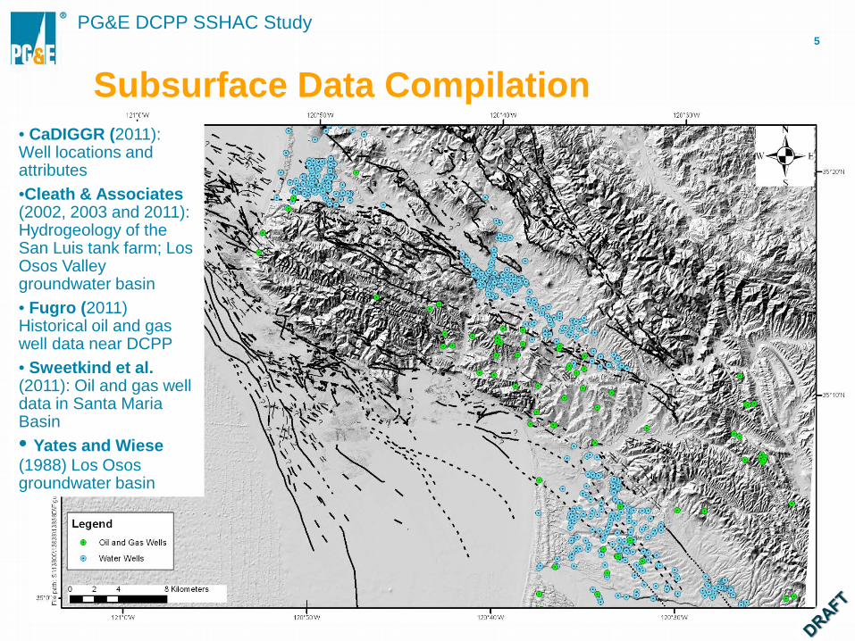
PG&E DCPP SSHAC Study 5
Subsurface Data Compilation • CaDIGGR (2011): Well locations and attributes •Cleath & Associates (2002, 2003 and 2011): Hydrogeology of the San Luis tank farm; Los Osos Valley groundwater basin • Fugro (2011) Historical oil and gas well data near DCPP • Sweetkind et al. (2011): Oil and gas well data in Santa Maria Basin • Yates and Wiese (1988) Los Osos groundwater basin

PG&E DCPP SSHAC Study 6
Air Photo Coverage
1:6000 1987 1:24,000 1986 1:36,000 1986 1:12,000 2010
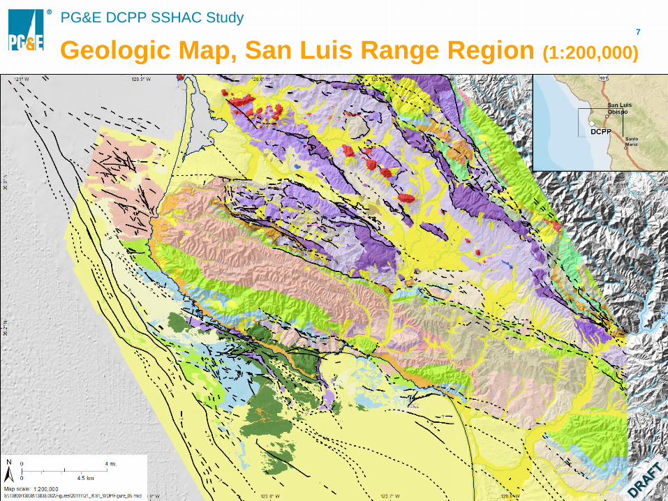
PG&E DCPP SSHAC Study 7
Geologic Map, San Luis Range Region (1:200,000)

PG&E DCPP SSHAC Study 8
Geologic Map in Irish Hills (1:50,000)

PG&E DCPP SSHAC Study 9
Geologic Map, Irish Hills (1:12,000)

PG&E DCPP SSHAC Study 10
Example of Combined Stratigraphic Units Combined Stratigraphic Units
(1:35,000 Scale Map) Detailed Stratigraphic Units
(1:12,000 Scale Map)
Combined Units: Subunits of Tmo, Tmm, Qal, Qe, Qf, and Qm
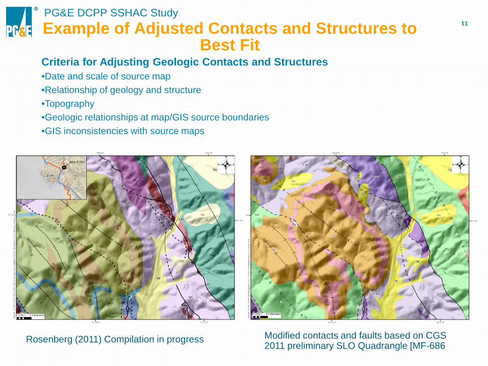
PG&E DCPP SSHAC Study 11 Example of Adjusted Contacts and Structures to
Best Fit
Rosenberg (2011) Compilation in progress Modified contacts and faults based on CGS 2011 preliminary SLO Quadrangle [MF-686
Criteria for Adjusting Geologic Contacts and Structures •Date and scale of source map •Relationship of geology and structure •Topography •Geologic relationships at map/GIS source boundaries •GIS inconsistencies with source maps

PG&E DCPP SSHAC Study 12 Relocated Onshore Paleoshorelines
based on LiDAR data (1:12,000)
PG&E DCPP SSHAC Study 13
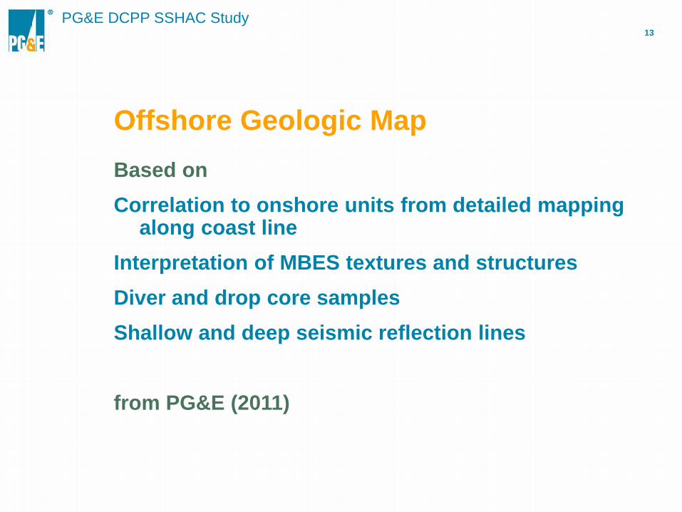
Offshore Geologic Map Based on Correlation to onshore units from detailed mapping
along coast line Interpretation of MBES textures and structures Diver and drop core samples Shallow and deep seismic reflection lines from PG&E (2011)

PG&E DCPP SSHAC Study 14
Coastal LiDAR and Air Photos
PG&E DCPP SSHAC Study 15
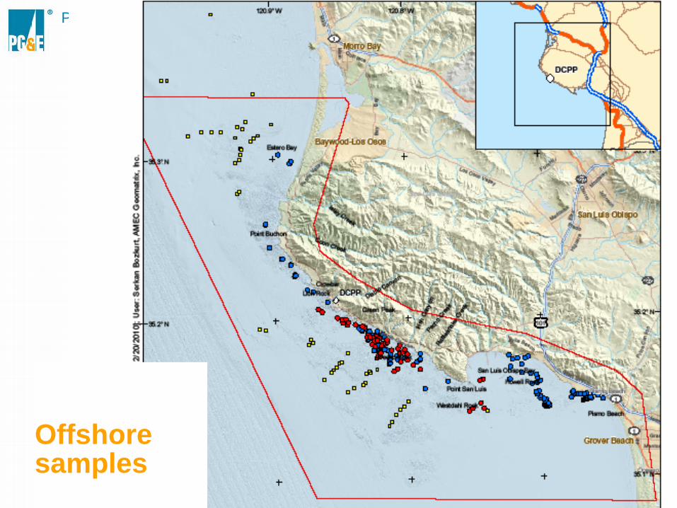
Offshore samples

PG&E DCPP SSHAC Study 16
Offshore geologic map

PG&E DCPP SSHAC Study 17
Geologic Map, San Luis Range Region (1:200,000)
A
A
A’

PG&E DCPP SSHAC Study 18
Irish Hills Cross Section

PG&E DCPP SSHAC Study 19
PG&E DCPP SSHAC Study 20

PG&E DCPP SSHAC Study 21
PG&E DCPP SSHAC Study 22
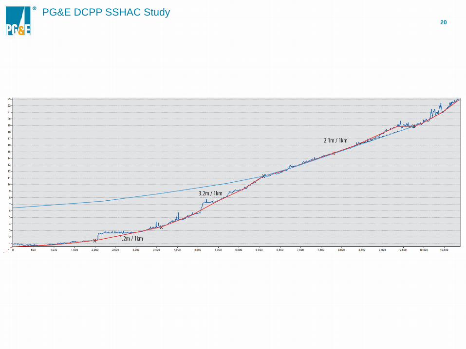
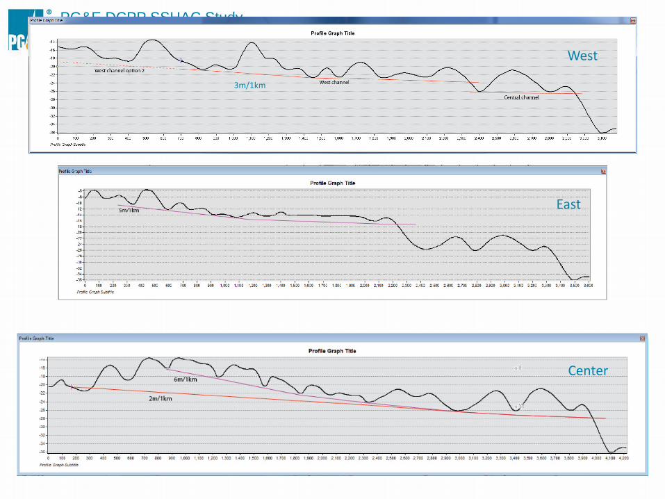
West
Center
East
3m/1km

PG&E DCPP SSHAC Study 23

PG&E DCPP SSHAC Study 24
Conclusions
Compilation map complete with data through September 2011 Geologic details displayed adjusted for desired map scale Combines onshore with offshore data Geo-referenced data easily accessed, e.g.: Source maps Oil and water well data Trench logs (being added) Magnetic field Offshore rock samples Provides base geologic map for context of many other investigations,
e.g.: Interpretation of the geophysics Geologic cross sections Tectonic models
PG&E DCPP SSHAC Study 25
‘Data’ Needs
As new data available it will be periodically updated, e.g.: Mapping of Los Osos fault Modify stratigraphic units as needed Create Quaternary geologic and geomorphic maps Revised and extended onshore Marine terraces using LiDAR
topography Continue analysis of offshore marine terraces Differentiate other important units such as Squire deposits,
different ages of dunes Dates on Quaternary deposits Continue analysis of recent tectonics using geomorphic surfaces
26
PG&E DCPP SSHAC Study
Thank You