Embed Size (px)
Citation preview

Petroleum Exploration Opportunities in Petroleum Exploration Opportunities in Jeanne dJeanne d’’Arc BasinArc Basin, , Call for Bids NL09Call for Bids NL09--11
Dr. Michael E. Enachescu,Dr. Michael E. Enachescu,P Geoph, P GeoP Geoph, P Geo
Euxinic ExplorationEuxinic Exploration
Euxinic Exploration On Behalf of NL DNROn Behalf of NL DNR
October 2009October 2009
AAcknowledgementscknowledgements•• Wes Foote, David McCallum and Larry Wes Foote, David McCallum and Larry
Hicks, for edits and suggestionsHicks, for edits and suggestions•• Darrell Spurrell, Brad Kendell, Jillian Darrell Spurrell, Brad Kendell, Jillian
Owens, Anne Lake of the NL Owens, Anne Lake of the NL Department of Natural Resources Department of Natural Resources
•• David Hawkins and Craig Rowe of CDavid Hawkins and Craig Rowe of C--NLOPBNLOPB
•• G. Smee, I. Sinclair and P. Meehan for G. Smee, I. Sinclair and P. Meehan for past collaborationspast collaborations
•• MUN, PanMUN, Pan--Atlantic Petroleum Systems Atlantic Petroleum Systems Consortium (PPSC) , PRConsortium (PPSC) , PR--ACAC
•• GSC Atlantic GSC Atlantic •• Husky Energy, LandmarkHusky Energy, Landmark--Halliburton, Halliburton,
Canstrat and IHSCanstrat and IHS•• This work could not have been This work could not have been
performed without information kindly performed without information kindly provided by GSC Atlantic, provided by GSC Atlantic, Government of Newfoundland and Government of Newfoundland and Labrador Department of Natural Labrador Department of Natural Resources and CResources and C--NLOPBNLOPB
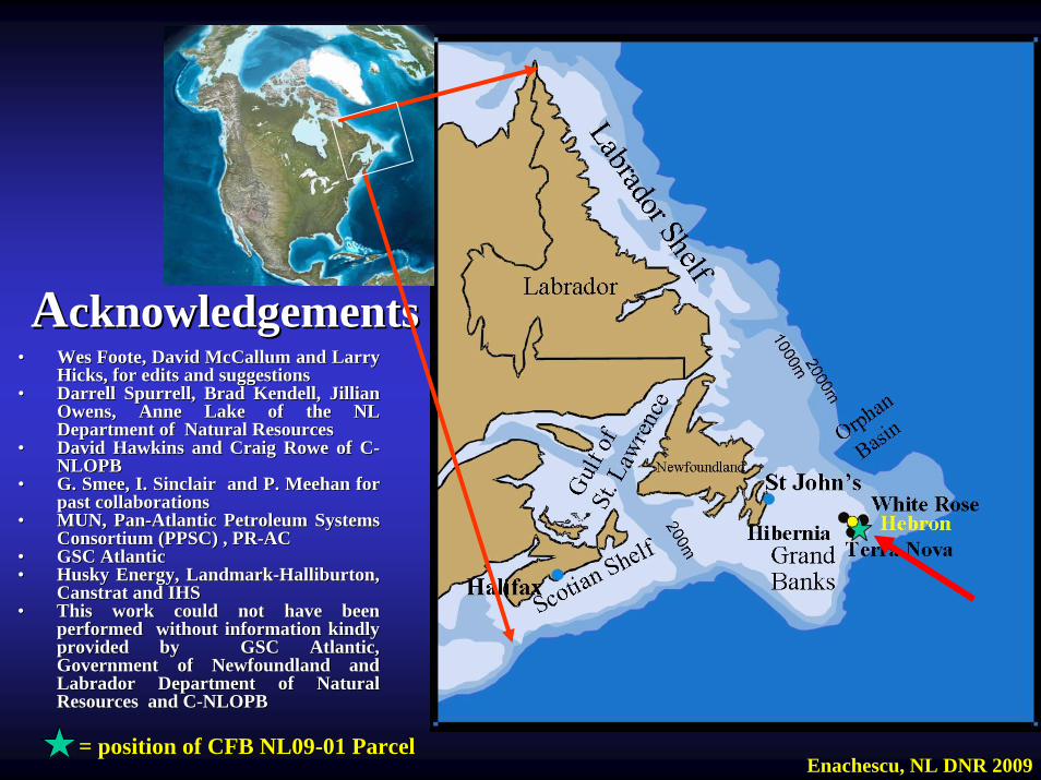
Enachescu, NL DNR 2009= position of CFB NL09= position of CFB NL09--01 Parcel01 Parcel
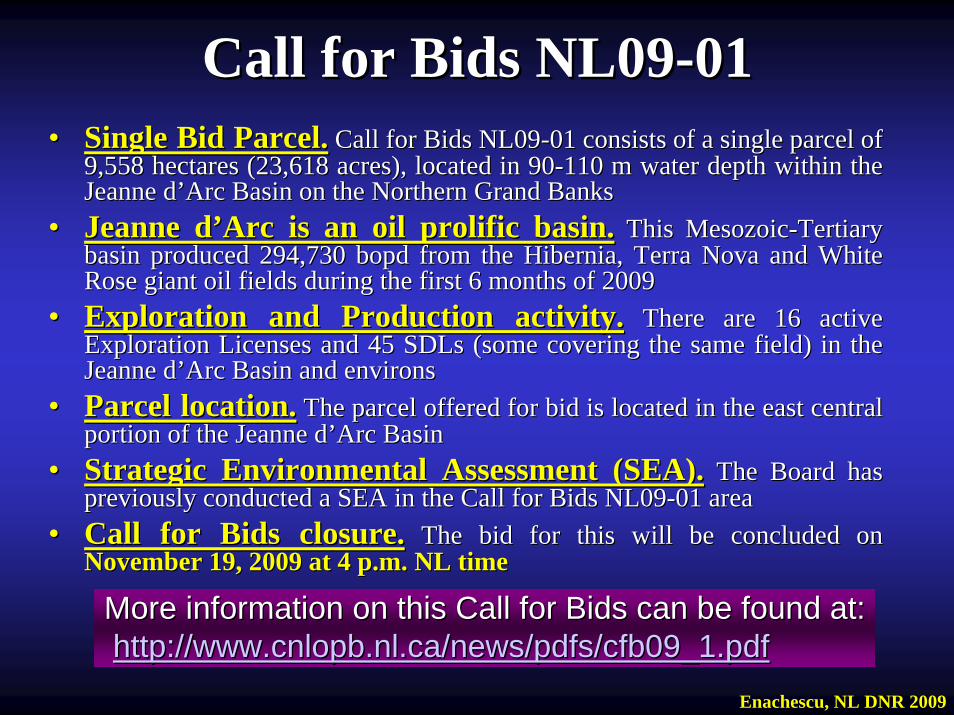
Call for Bids NL09Call for Bids NL09--0101•• Single Bid Parcel.Single Bid Parcel. Call for Bids NL09Call for Bids NL09--01 consists of a single parcel of 01 consists of a single parcel of
9,558 hectares (23,618 acres), located in 909,558 hectares (23,618 acres), located in 90--110 m water depth within the 110 m water depth within the Jeanne dJeanne d’’Arc Basin on the Northern Grand BanksArc Basin on the Northern Grand Banks
•• Jeanne dJeanne d’’Arc is an oil prolific basin.Arc is an oil prolific basin. This MesozoicThis Mesozoic--Tertiary Tertiary basin produced 294,730 bopd from the Hibernia, Terra Nova and Whbasin produced 294,730 bopd from the Hibernia, Terra Nova and White ite Rose giant oil fields during the first 6 months of 2009Rose giant oil fields during the first 6 months of 2009
•• Exploration and Production activity.Exploration and Production activity. There are 16 active There are 16 active Exploration Licenses and 45 SDLs (some covering the same field) Exploration Licenses and 45 SDLs (some covering the same field) in the in the Jeanne dJeanne d’’Arc Basin and environsArc Basin and environs
•• Parcel location.Parcel location. The parcel offered for bid is located in the east central The parcel offered for bid is located in the east central portion of the Jeanne dportion of the Jeanne d’’Arc BasinArc Basin
•• Strategic Environmental Assessment (SEA).Strategic Environmental Assessment (SEA). The Board has The Board has previously conducted a SEA in the Call for Bids NL09previously conducted a SEA in the Call for Bids NL09--01 area01 area
•• Call for Bids closure.Call for Bids closure. The bid for this will be concluded on The bid for this will be concluded on November 19, 2009 at 4 p.m. NL time November 19, 2009 at 4 p.m. NL time
Enachescu, NL DNR 2009
More information on this Call for Bids can be found at:More information on this Call for Bids can be found at:http://www.cnlopb.nl.ca/news/pdfs/cfb09_1.pdfhttp://www.cnlopb.nl.ca/news/pdfs/cfb09_1.pdf
Presentation ContentPresentation Content1.1. IntroductionIntroduction2.2. Exploration and Development BackgroundExploration and Development Background3.3. Geology Overview of the Mesozoic Grand Geology Overview of the Mesozoic Grand
Banks and EnvironsBanks and Environs4.4. Geology Summary of the Jeanne dGeology Summary of the Jeanne d’’Arc BasinArc Basin5.5. Petroleum Geology of the Petroleum Geology of the JDA BasinJDA Basin6.6. Petroleum Potential Petroleum Potential Call for Bids Call for Bids
NL09NL09--01 01 Parcel 1Parcel 16. Discussion6. Discussion7. Conclusions7. Conclusions
Enachescu, NL DNR 2009
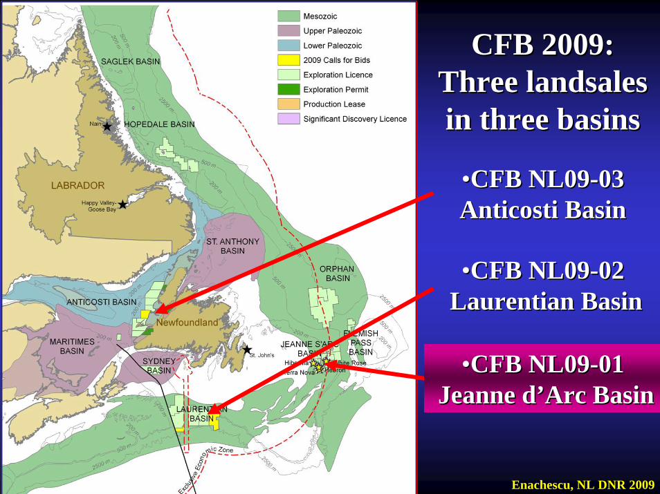
••CFB NL09CFB NL09--0303Anticosti BasinAnticosti Basin
••CFB NL09CFB NL09--0202Laurentian BasinLaurentian Basin
••CFB NL09CFB NL09--0101Jeanne dJeanne d’’Arc BasinArc Basin
CFB 2009: CFB 2009: Three landsales Three landsales in three basinsin three basins
Enachescu, NL DNR 2009
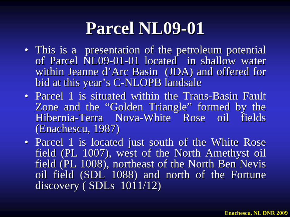
Parcel NL09Parcel NL09--0101•• This is a presentation of the petroleum potential This is a presentation of the petroleum potential
of Parcel NL09of Parcel NL09--0101--01 located in shallow water 01 located in shallow water within Jeanne dwithin Jeanne d’’Arc Basin (JDA) and offered for Arc Basin (JDA) and offered for bid at this yearbid at this year’’s Cs C--NLOPB landsaleNLOPB landsale
•• Parcel 1 is situated within the TransParcel 1 is situated within the Trans--Basin Fault Basin Fault Zone and the Zone and the ““Golden TriangleGolden Triangle”” formed by the formed by the HiberniaHibernia--Terra NovaTerra Nova--White Rose oil fields White Rose oil fields (Enachescu, 1987) (Enachescu, 1987)
•• Parcel 1 is located just south of the White Rose Parcel 1 is located just south of the White Rose field (PL 1007), west of the North Amethyst oil field (PL 1007), west of the North Amethyst oil field (PL 1008), northeast of the North Ben Nevis field (PL 1008), northeast of the North Ben Nevis oil field (SDL 1088) and north of the Fortune oil field (SDL 1088) and north of the Fortune discovery ( SDLs 1011/12)discovery ( SDLs 1011/12)
Enachescu, NL DNR 2009
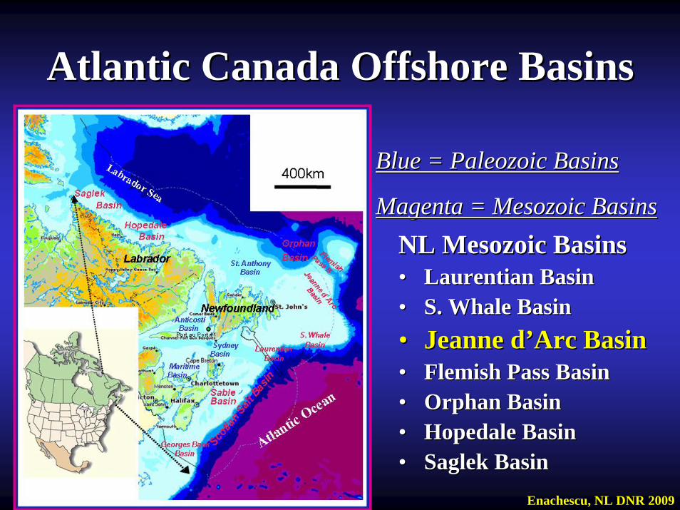
Atlantic Canada Offshore BasinsAtlantic Canada Offshore Basins
Blue = Paleozoic BasinsBlue = Paleozoic Basins
Magenta = Mesozoic BasinsMagenta = Mesozoic BasinsNL Mesozoic BasinsNL Mesozoic Basins•• Laurentian BasinLaurentian Basin•• S. Whale BasinS. Whale Basin•• Jeanne dJeanne d’’Arc BasinArc Basin•• Flemish Pass BasinFlemish Pass Basin•• Orphan BasinOrphan Basin•• Hopedale BasinHopedale Basin•• Saglek BasinSaglek Basin
Enachescu, NL DNR 2009

1. Introduction1. Introduction•• CFB NL09CFB NL09--0101--01 offered parcel is one of the few 01 offered parcel is one of the few
remaining unlicensed offshore blocks located in the remaining unlicensed offshore blocks located in the central part of the Jeanne dcentral part of the Jeanne d’’Arc BasinArc Basin
•• The parcel is located immediately southwest of the White The parcel is located immediately southwest of the White Rose field Production Licence (PL 1007) and just west of Rose field Production Licence (PL 1007) and just west of the recent North Amethyst Kthe recent North Amethyst K--15 discovery and Production 15 discovery and Production License (PL 1008) License (PL 1008)
•• The parcel also lies adjacent to several active Exploration The parcel also lies adjacent to several active Exploration Licenses were there is ongoing exploration activity Licenses were there is ongoing exploration activity consisting of acquisition of 3D seismic reflection data and consisting of acquisition of 3D seismic reflection data and exploration drillingexploration drilling
Enachescu, NL DNR 2009
Observation.Observation. References introduced in this power point are listed in part 2 References introduced in this power point are listed in part 2 of this presentation and are also contained in the earlier Jeannof this presentation and are also contained in the earlier Jeanne De D’’Arc Arc landsale reports posted on the website:landsale reports posted on the website:
http://http://www.nr.gov.nl.ca/mines&en/oilwww.nr.gov.nl.ca/mines&en/oil//
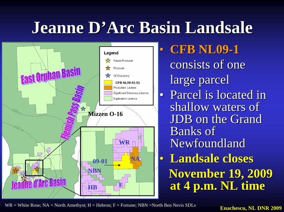
•• CFB NL09CFB NL09--11consists of one consists of one large parcellarge parcel
•• Parcel is located in Parcel is located in shallow waters of shallow waters of JDB on the Grand JDB on the Grand Banks of Banks of NewfoundlandNewfoundland
•• Landsale closes Landsale closes November 19, 2009 November 19, 2009 at 4 p.m. NL timeat 4 p.m. NL time
Jeanne DJeanne D’’Arc Basin LandsaleArc Basin Landsale
WR = White Rose; NA = North Amethyst; H = Hebron; F = Fortune; NBN =North Ben Nevis SDLs
WR
NA09-01
CFB NL09-01-01
HB
Mizzen O-16
F
NBN
Enachescu, NL DNR 2009
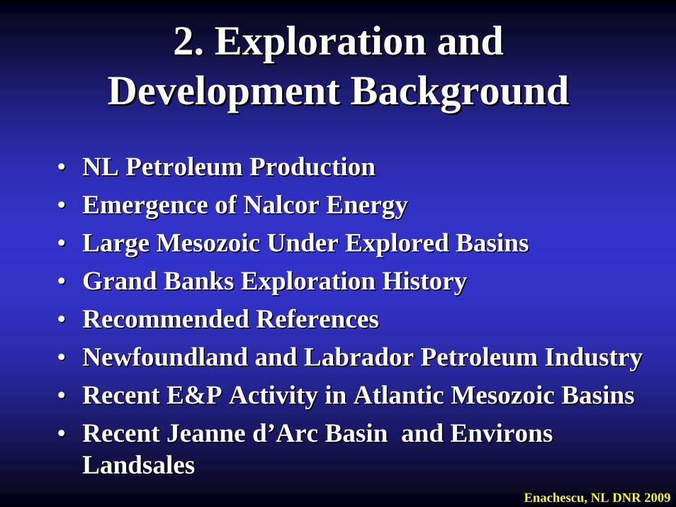
2. Exploration and 2. Exploration and Development BackgroundDevelopment Background
•• NL Petroleum ProductionNL Petroleum Production•• Emergence of Nalcor EnergyEmergence of Nalcor Energy•• Large Mesozoic Under Explored BasinsLarge Mesozoic Under Explored Basins•• Grand Banks Exploration HistoryGrand Banks Exploration History•• Recommended ReferencesRecommended References•• Newfoundland and Labrador Petroleum IndustryNewfoundland and Labrador Petroleum Industry•• Recent E&P Activity in Atlantic Mesozoic BasinsRecent E&P Activity in Atlantic Mesozoic Basins•• Recent Jeanne dRecent Jeanne d’’Arc Basin and Environs Arc Basin and Environs
LandsalesLandsalesEnachescu, NL DNR 2009
NL Petroleum ProductionNL Petroleum Production•• Jeanne dJeanne d’’Arc Basin fields Arc Basin fields -- Hibernia, Terra Nova and White Rose Hibernia, Terra Nova and White Rose --
developed in 80developed in 80--110 m water are some of the largest offshore 110 m water are some of the largest offshore producing fields in North Americaproducing fields in North America
•• These fields have produced in each of the past 5 years in the raThese fields have produced in each of the past 5 years in the range of nge of 300,000 to 360,000 barrels per day of light crude (30 to 35300,000 to 360,000 barrels per day of light crude (30 to 35ºº API) from API) from Late JurassicLate Jurassic--Early Cretaceous sandstonesEarly Cretaceous sandstones
•• NL delivers about 37% of the light oil produced in Canada from tNL delivers about 37% of the light oil produced in Canada from these hese fields representing more than 80% of the Atlantic Canadafields representing more than 80% of the Atlantic Canada’’s s hydrocarbon production. With this output NL is now the second lahydrocarbon production. With this output NL is now the second largest rgest hydrocarbon producing province in Canadahydrocarbon producing province in Canada
•• Over 1 bbls were produced to date from the JDA; more than 1.8 biOver 1 bbls were produced to date from the JDA; more than 1.8 billion llion barrels proven remaining recoverable reserves/resources exists; barrels proven remaining recoverable reserves/resources exists; approximately 6 tcf of gas was discovered but there is no producapproximately 6 tcf of gas was discovered but there is no productiontion
•• Jeanne dJeanne d’’Arc Basin developments are the only producing offshore Arc Basin developments are the only producing offshore oilfields on the Atlantic coast of North America oilfields on the Atlantic coast of North America
•• A fourth large field A fourth large field –– Hebron Hebron -- estimated to contain 731 million barrels estimated to contain 731 million barrels recoverable reserves/resources will be developed starting in 201recoverable reserves/resources will be developed starting in 2012 with 2 with first expected oil in 2017first expected oil in 2017
•• Satellites of larger fields are presently brought on stream addSatellites of larger fields are presently brought on stream adding to ing to productionproduction
Enachescu, NL DNR 2009
Emergence of Nalcor EnergyEmergence of Nalcor Energy•• Legislation to create the provinceLegislation to create the province’’s energy corporation, s energy corporation,
Nalcor Energy, wholly owned by the Province Nalcor Energy, wholly owned by the Province http://www.nalcorenergy.comhttp://www.nalcorenergy.com
•• Through Nalcor, Province negotiated equity positions in Through Nalcor, Province negotiated equity positions in the Hebron Project (4.9%) and White Rose Growth the Hebron Project (4.9%) and White Rose Growth Projects (5%) Projects (5%)
•• Fall 2007, the NL Government released the provincial Fall 2007, the NL Government released the provincial Energy Plan Energy Plan ““Focusing our EnergyFocusing our Energy”” that established new that established new policies for oil and gas exploration and production in the policies for oil and gas exploration and production in the ProvinceProvince’’s large onshore and offshore regions s large onshore and offshore regions http://www.nr.gov.nl.ca/energyplan/EnergyReport.pdfhttp://www.nr.gov.nl.ca/energyplan/EnergyReport.pdf
•• Energy Plan brought Energy Plan brought implementation of an Offshore implementation of an Offshore Natural Gas Royalty Regime and introduced the concept Natural Gas Royalty Regime and introduced the concept of a of a ““pioneer projectpioneer project””
Enachescu, NL DNR 2009
Emergence of Nalcor EnergyEmergence of Nalcor Energy•• Formation in 2007 of Nalcor Oil and Gas Inc. subsidiary Formation in 2007 of Nalcor Oil and Gas Inc. subsidiary
that acquired interest in several offshore fields: North that acquired interest in several offshore fields: North Amethyst, West White Rose and South White Rose Amethyst, West White Rose and South White Rose Extension (6.5%), Hebron (4.9%) Hibernia South (10%)Extension (6.5%), Hebron (4.9%) Hibernia South (10%)
•• Summer 2009, Nalcor farms into the Summer 2009, Nalcor farms into the ““Parson PondParson Pond””Exploration Permits located onshore in the Appalachian Exploration Permits located onshore in the Appalachian Paleozoic trend; may be followed by other Nalcor direct Paleozoic trend; may be followed by other Nalcor direct involvement with exploration projectsinvolvement with exploration projects
•• Petroleum Exploration Enhancement Program (PEEP) Petroleum Exploration Enhancement Program (PEEP) financed in 2008financed in 2008--9 a Western Newfoundland onshore 9 a Western Newfoundland onshore aeromagnetic regional survey ; aeromagnetic regional survey ; PEEP is a initiative of the PEEP is a initiative of the Energy Plan and is focused on improving geoscience Energy Plan and is focused on improving geoscience knowledge of knowledge of Western Newfoundland onshoreWestern Newfoundland onshore
•• A further $20 million was provided to fund the ongoing A further $20 million was provided to fund the ongoing Offshore Geoscience Data ProjectOffshore Geoscience Data Project
Enachescu, NL DNR 2009
Large Mesozoic Large Mesozoic Under Explored BasinsUnder Explored Basins
•• Atlantic Newfoundland and Labrador were affected by the Atlantic Newfoundland and Labrador were affected by the Wilson cycle initiated during Late Triassic which culminated Wilson cycle initiated during Late Triassic which culminated with the break up of Pangea and opening of the Atlantic Ocean with the break up of Pangea and opening of the Atlantic Ocean that continues todaythat continues today
•• During the initial intercontinental rifting stage and later duriDuring the initial intercontinental rifting stage and later during ng the breakthe break--up, numerous sedimentary basins were formed on up, numerous sedimentary basins were formed on both margins of the Atlantic Oceanboth margins of the Atlantic Ocean
•• Some of these basins such as Santos, Gulf of Mexico, Orinoco, Some of these basins such as Santos, Gulf of Mexico, Orinoco, Niger Delta, North Sea, etc. are prolific petroleum basinsNiger Delta, North Sea, etc. are prolific petroleum basins
•• Newfoundland and Labrador offshore area contains many Newfoundland and Labrador offshore area contains many underexplored Mesozoic basins including the Laurentian (1 well underexplored Mesozoic basins including the Laurentian (1 well in French territory), Carsonin French territory), Carson--BonnitionBonnition (4 wells), Flemish Pass (4 wells), Flemish Pass (6 wells), East Orphan (1 well), Hopedale (16 significant wells)(6 wells), East Orphan (1 well), Hopedale (16 significant wells)and Saglek (3 wells) basinsand Saglek (3 wells) basins
Enachescu, NL DNR 2009
•• 1966 1966 -- Mobil Oil conducts first seismic reflection program in Grand BaMobil Oil conducts first seismic reflection program in Grand Banksnks•• 1966 1966 -- The first Grand Banks well The first Grand Banks well Pan Am Pan Am TorsTors Cove DCove D--5252•• 1967 1967 -- First well spudded in the Jeanne d'Arc Basin First well spudded in the Jeanne d'Arc Basin Amoco Imperial Murre Amoco Imperial Murre
GG--6767•• 1971 1971 -- First free flow of oil to surface in the Jeanne d'Arc Basin: 26First free flow of oil to surface in the Jeanne d'Arc Basin: 268 bopd, 8 bopd,
313100 API gravity, 0.2 API gravity, 0.2 MMcfdMMcfd gas from gas from Mobil Gulf Mobil Gulf AdolphusAdolphus 2K2K--4141, the 4th , the 4th well in Jeanne d'Arc Basinwell in Jeanne d'Arc Basin
•• 1973 1973 -- First penetration of prolific Upper Jurassic source rock: EgretFirst penetration of prolific Upper Jurassic source rock: Egret Member Member of the Rankin Formation drilled at of the Rankin Formation drilled at Amoco Imperial Amoco Imperial SkellySkelly Egret KEgret K--3636, the , the 5th well in Jeanne d'Arc Basin5th well in Jeanne d'Arc Basin
•• 1979 1979 -- First major discovery well: First major discovery well: ChevronChevron etet al. Hibernia Pal. Hibernia P--15; 15; the 45th the 45th well drilled in Grand Banks region and 10th well drilled in the well drilled in Grand Banks region and 10th well drilled in the Jeanne d'Arc Jeanne d'Arc Basin; tested 800 bopd, 32Basin; tested 800 bopd, 3200 API and 0.2 API and 0.2 MMcfdMMcfd gas on first gas on first openholeopenhole test of test of Upper Jurassic sandstonesUpper Jurassic sandstones
•• 1980 1980 -- First oil discovery outside Jeanne dFirst oil discovery outside Jeanne d’’Arc Basin: Arc Basin: Mobil et al. South Mobil et al. South Tempest GTempest G--8888 well on the Central Ridgewell on the Central Ridge
•• 1981 1981 -- First Hibernia 3D seismic survey completed (also first 3D surveFirst Hibernia 3D seismic survey completed (also first 3D survey y offshore Canada)offshore Canada)
Grand Banks Exploration HistoryGrand Banks Exploration History
Enachescu, NL DNR 2009
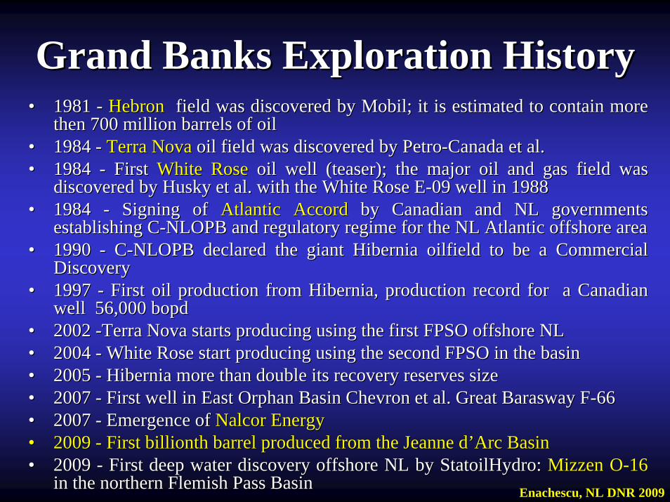
•• 1981 1981 -- HebronHebron field was field was discovered by Mobil; it is estimated to contain more discovered by Mobil; it is estimated to contain more then 700 million barrels of oilthen 700 million barrels of oil
•• 1984 1984 -- Terra NovaTerra Nova oil field was discovered by Petrooil field was discovered by Petro--Canada et al.Canada et al.•• 1984 1984 -- First First White RoseWhite Rose oil well (teaser); the major oil and gas field was oil well (teaser); the major oil and gas field was
discovered by Husky et al. with the White Rose Ediscovered by Husky et al. with the White Rose E--09 well in 198809 well in 1988•• 1984 1984 -- Signing of Signing of Atlantic AccordAtlantic Accord by Canadian and NL governments by Canadian and NL governments
establishing Cestablishing C--NLOPB and regulatory regime for the NL Atlantic offshore area NLOPB and regulatory regime for the NL Atlantic offshore area •• 1990 1990 -- CC--NLOPB declared the giant Hibernia oilfield to be a Commercial NLOPB declared the giant Hibernia oilfield to be a Commercial
Discovery Discovery •• 1997 1997 -- First oil production from Hibernia, production record for a CaFirst oil production from Hibernia, production record for a Canadian nadian
wellwell 56,000 bopd56,000 bopd•• 2002 2002 --Terra Nova starts producing using the first FPSO offshore NL Terra Nova starts producing using the first FPSO offshore NL •• 2004 2004 -- White Rose start producing using the second FPSO in the basin White Rose start producing using the second FPSO in the basin •• 2005 2005 -- Hibernia more than double its recovery reserves sizeHibernia more than double its recovery reserves size•• 2007 2007 -- First well in East Orphan Basin Chevron et al. Great First well in East Orphan Basin Chevron et al. Great BaraswayBarasway FF--6666•• 2007 2007 -- Emergence ofEmergence of Nalcor EnergyNalcor Energy•• 2009 2009 -- First billionth barrel produced from the Jeanne dFirst billionth barrel produced from the Jeanne d’’Arc BasinArc Basin•• 2009 2009 -- First deep water discovery offshore NL by StatoilHydro: First deep water discovery offshore NL by StatoilHydro: Mizzen OMizzen O--1616
in the northern Flemish Pass Basinin the northern Flemish Pass Basin
Grand Banks Exploration HistoryGrand Banks Exploration History
Enachescu, NL DNR 2009

Recommended Literature on Grand BanksRecommended Literature on Grand Banks
JansaJansa and Wade 1975; Hubbard et al., 1985; Parson et al., 1985; Masonand Wade 1975; Hubbard et al., 1985; Parson et al., 1985; Masonand Miles, 1986; Grant and and Miles, 1986; Grant and McAlpineMcAlpine, 1986; Srivastava and , 1986; Srivastava and TapscottTapscott, , 1986;1986; King et al., 1986; King et al., 1986; Grant and Grant and McAlpineMcAlpine, 1986;, 1986; Ziegler, 1987; Ziegler, 1987; Enachescu 1987, 1988, 1992, 1993 ; Enachescu et al., 1993; 2005;Enachescu 1987, 1988, 1992, 1993 ; Enachescu et al., 1993; 2005; 2006; 2006; Tankard and Tankard and WelsinkWelsink, 1987; Keen et al., 1987; Fowler and Snowden, , 1987; Keen et al., 1987; Fowler and Snowden, 1988; Grant et al., 1988; Sinclair, 1988; 1988; Grant et al., 1988; Sinclair, 1988; KoningKoning et al., 1988; Ziegler, et al., 1988; Ziegler, 1989; 1989; Balkwill and Balkwill and LegallLegall, 1989;, 1989; Tankard et al., 1989; Brown et al., Tankard et al., 1989; Brown et al., 1989; Bell and 1989; Bell and HowieHowie, 1989; , 1989; TucholkeTucholke et al., 1989; et al., 1989; Hiscott et al., 1990; Hiscott et al., 1990; Srivastava et al., 1990; Wade and MacLean, 1990;Srivastava et al., 1990; Wade and MacLean, 1990; Grant and Grant and McAlpineMcAlpine, , 1990;1990; McAlpineMcAlpine, 1989, 1991; Keen and Williams, 1990; Sinclair et al., , 1989, 1991; Keen and Williams, 1990; Sinclair et al., 1992; Srivastava and 1992; Srivastava and VerhoefVerhoef, 1992; , 1992; Foster and Robinson, 1993; Foster and Robinson, 1993; DeSilvaDeSilva, 1993, 1994 and 1999; Enachescu and Dunning, 1994, 1993, 1994 and 1999; Enachescu and Dunning, 1994; ; Fowler Fowler and and McAlpineMcAlpine, 1995; Driscoll and Hogg, 1995; Driscoll et al., 1995; , 1995; Driscoll and Hogg, 1995; Driscoll et al., 1995; Bateman, 1995;Bateman, 1995; Drummond, 1998; Hubbard, 1998;Drummond, 1998; Hubbard, 1998; Williams et al., 1999; Williams et al., 1999; Srivastava et al., 2000; Hogg and Enachescu, 2001;Srivastava et al., 2000; Hogg and Enachescu, 2001; LoudenLouden, 2002; , 2002; DeptuckDeptuck et al., 2003; Smee et al., 2003; Enachescu and Hogg, 2005; et al., 2003; Smee et al., 2003; Enachescu and Hogg, 2005; Sibuet et al., 2007; Sibuet et al., 2007; TucholkeTucholke et al., 2007; Hardy, 2007 (M Sc Thesis); et al., 2007; Hardy, 2007 (M Sc Thesis); Fagan and Enachescu, 2008; Fagan, 2009 (M Sc Thesis) Fagan and Enachescu, 2008; Fagan, 2009 (M Sc Thesis)
ObservationObservation:: This list is not exclusiveThis list is not exclusiveEnachescu, NL DNR 2009
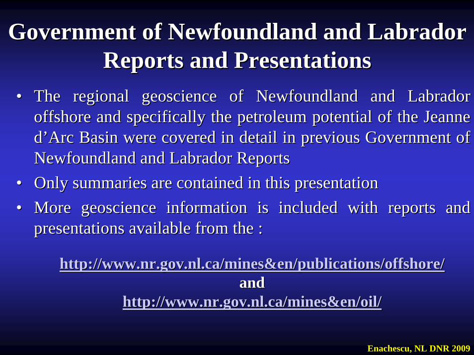
•• The regional geoscience of Newfoundland and Labrador The regional geoscience of Newfoundland and Labrador offshore and specifically the petroleum potential of the Jeanne offshore and specifically the petroleum potential of the Jeanne dd’’Arc Basin were covered in detail in previous Government of Arc Basin were covered in detail in previous Government of Newfoundland and Labrador ReportsNewfoundland and Labrador Reports
•• Only summaries are contained in this presentation Only summaries are contained in this presentation •• More geoscience information is included with reports and More geoscience information is included with reports and
presentationspresentations available from the :available from the :
http://www.nr.gov.nl.ca/mines&en/publications/offshore/http://www.nr.gov.nl.ca/mines&en/publications/offshore/and and
http://www.nr.gov.nl.ca/mines&en/oil/http://www.nr.gov.nl.ca/mines&en/oil/
Government of Newfoundland and Labrador Government of Newfoundland and Labrador Reports and PresentationsReports and Presentations
Enachescu, NL DNR 2009
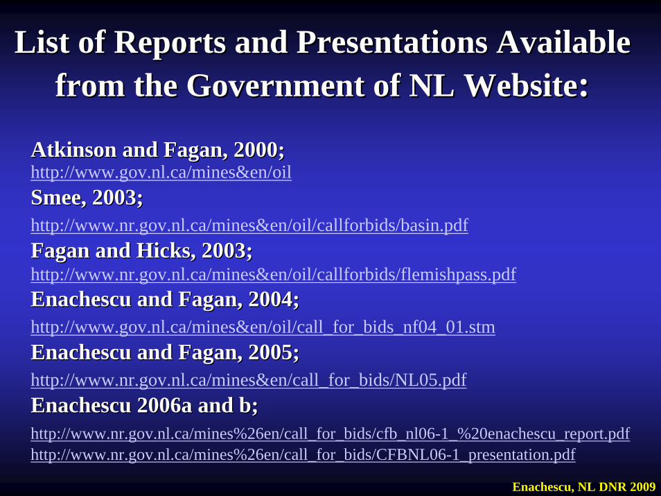
List of Reports and Presentations Available List of Reports and Presentations Available from the Government of NL Websitefrom the Government of NL Website::
Atkinson and Fagan, 2000;Atkinson and Fagan, 2000;http://www.gov.nl.ca/mines&en/oilSmee, 2003;Smee, 2003;http://www.nr.gov.nl.ca/mines&en/oil/callforbids/basin.pdfFagan and Hicks, 2003;Fagan and Hicks, 2003;http://www.nr.gov.nl.ca/mines&en/oil/callforbids/flemishpass.pdfEnachescu and Fagan, 2004;Enachescu and Fagan, 2004;http://www.gov.nl.ca/mines&en/oil/call_for_bids_nf04_01.stmEnachescu and Fagan, 2005;Enachescu and Fagan, 2005;http://www.nr.gov.nl.ca/mines&en/call_for_bids/NL05.pdfEnachescu 2006a and b;Enachescu 2006a and b;http://www.nr.gov.nl.ca/mines%26en/call_for_bids/cfb_nl06-1_%20enachescu_report.pdfhttp://www.nr.gov.nl.ca/mines%26en/call_for_bids/CFBNL06-1_presentation.pdf
Enachescu, NL DNR 2009
Newfoundland and Labrador Newfoundland and Labrador Petroleum IndustryPetroleum Industry
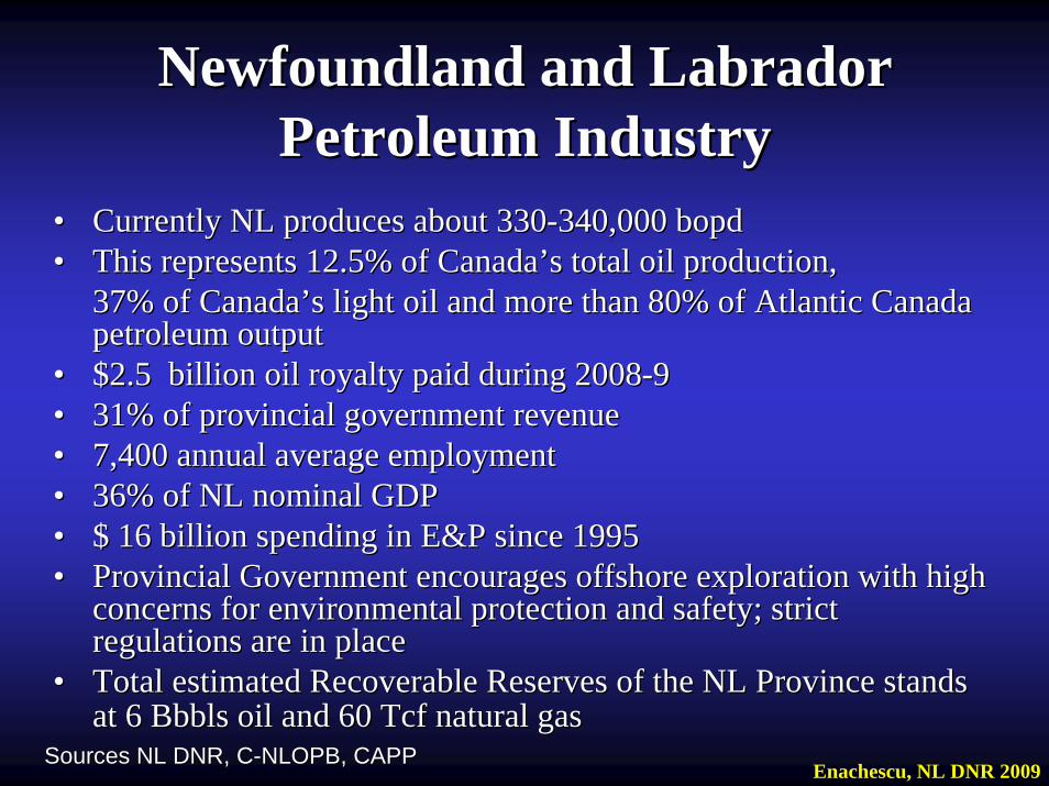
•• Currently NL produces about 330Currently NL produces about 330--340,000 bopd340,000 bopd•• This represents 12.5% of CanadaThis represents 12.5% of Canada’’s total oil production,s total oil production,
37% of Canada37% of Canada’’s light oil and more than 80% of Atlantic Canada s light oil and more than 80% of Atlantic Canada petroleum outputpetroleum output
•• $2.5 billion oil royalty paid during 2008$2.5 billion oil royalty paid during 2008--99•• 31% of provincial government revenue31% of provincial government revenue•• 7,400 annual average employment7,400 annual average employment•• 36% of NL nominal GDP36% of NL nominal GDP•• $ 16 billion spending in E&P since 1995$ 16 billion spending in E&P since 1995•• Provincial Government encourages offshore exploration with high Provincial Government encourages offshore exploration with high
concerns for environmental protection and safety; strict concerns for environmental protection and safety; strict regulations are in placeregulations are in place
•• Total estimated Recoverable Reserves of the NL Province stands Total estimated Recoverable Reserves of the NL Province stands at 6 Bbbls oil and 60 Tcf natural gasat 6 Bbbls oil and 60 Tcf natural gas
Sources NL DNR, CSources NL DNR, C--NLOPB, CAPPNLOPB, CAPPEnachescu, NL DNR 2009
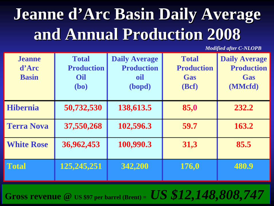
Jeanne dJeanne d’’Arc Basin Daily Average Arc Basin Daily Average and Annual Production 2008and Annual Production 2008
Jeanned’ArcBasin
Total Production
Oil(bo)
Daily Average Production
oil (bopd)
Total Production
Gas(Bcf)
Daily Average Production
Gas(MMcfd)
Hibernia 50,732,530 138,613.5 85,0 232.2
Terra Nova 37,550,268 102,596.3 59.7 163.2
White Rose 36,962,453 100,990.3 31,3 85.5
Total 125,245,251 342,200 176,0 480.9
Gross revenue @ US $97 per barrel (Brent) = US $12,148,808,747
Modified after C-NLOPB
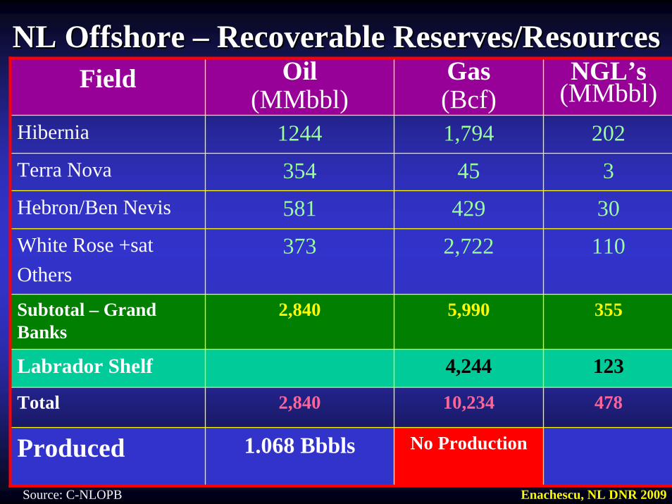
NL Offshore NL Offshore –– Recoverable Reserves/ResourcesRecoverable Reserves/ResourcesField Oil
(MMbbl)Gas(Bcf)
NGL’s(MMbbl)
Hibernia 1244 1,794 202Terra Nova 354 45 3Hebron/Ben Nevis 581 429 30White Rose +sat Others
373 2,722 110
Subtotal – Grand Banks
2,840 5,990 355
Labrador Shelf 4,244 123
Total 2,840 10,234 478
Produced 1.068 Bbbls No Production
Enachescu, NL DNR 2009Source: C-NLOPB
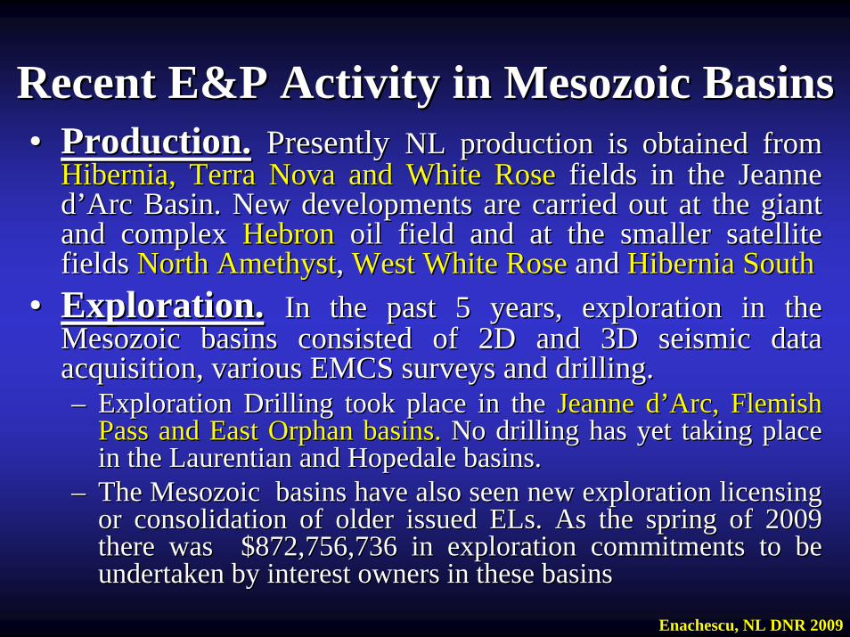
Recent E&P Activity in Mesozoic BasinsRecent E&P Activity in Mesozoic Basins•• Production.Production. Presently Presently NL production is obtained from NL production is obtained from
Hibernia, Terra Nova and White RoseHibernia, Terra Nova and White Rose fields in the Jeanne fields in the Jeanne dd’’Arc Basin. New developments are carried out at the giant Arc Basin. New developments are carried out at the giant and complex and complex HebronHebron oil field and at the smaller satellite oil field and at the smaller satellite fields fields North AmethystNorth Amethyst, , West White RoseWest White Rose and and Hibernia SouthHibernia South
•• Exploration.Exploration. In the past 5 years, exploration in the In the past 5 years, exploration in the Mesozoic basins consisted of 2D and 3D seismic data Mesozoic basins consisted of 2D and 3D seismic data acquisition, various EMCS surveys and drilling. acquisition, various EMCS surveys and drilling. –– Exploration Drilling took place in the Exploration Drilling took place in the Jeanne dJeanne d’’Arc,Arc, Flemish Flemish
Pass and East Orphan basins. Pass and East Orphan basins. No drilling has yet taking place No drilling has yet taking place in the Laurentian and Hopedale basins. in the Laurentian and Hopedale basins.
–– The Mesozoic basins have also seen new exploration licensing The Mesozoic basins have also seen new exploration licensing or consolidation of older issued ELs. As the spring of 2009 or consolidation of older issued ELs. As the spring of 2009 there was $872,756,736 in exploration commitments to be there was $872,756,736 in exploration commitments to be undertaken by interest owners in these basinsundertaken by interest owners in these basins
Enachescu, NL DNR 2009
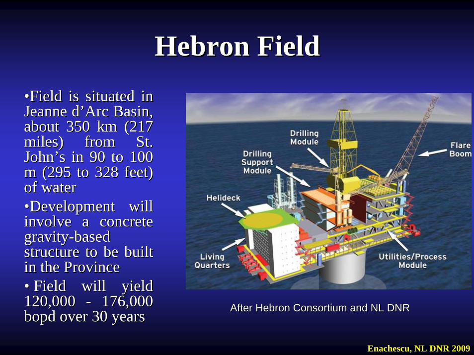
Hebron FieldHebron Field••Field is situated in Field is situated in Jeanne dJeanne d’’Arc Basin, Arc Basin, about 350 km (217 about 350 km (217 miles) from St. miles) from St. JohnJohn’’s in 90 to 100 s in 90 to 100 m (295 to 328 feet) m (295 to 328 feet) of waterof water••Development will Development will involve a concrete involve a concrete gravitygravity--based based structure to be built structure to be built in the Provincein the Province•• Field will yield Field will yield 120,000 120,000 -- 176,000 176,000 bopd over 30 yearsbopd over 30 years After Hebron Consortium and NL DNRAfter Hebron Consortium and NL DNR
Enachescu, NL DNR 2009
Hebron FieldHebron Field•• Hebron is the largest stand alone new field development in Hebron is the largest stand alone new field development in
CanadaCanada•• The Hebron compartmentalized field, consists of the Hebron, The Hebron compartmentalized field, consists of the Hebron,
Ben Nevis and West Ben Nevis oil accumulations located in Ben Nevis and West Ben Nevis oil accumulations located in several independent fault blocks several independent fault blocks
•• ExxonMobil is operator with a 36% interest, Chevron Canada ExxonMobil is operator with a 36% interest, Chevron Canada has 26.7 %, Suncor 22.7%, StatoilHydro Canada 9.7%has 26.7 %, Suncor 22.7%, StatoilHydro Canada 9.7%
•• The remaining 4.9% is held by Nalcor Energy. The The remaining 4.9% is held by Nalcor Energy. The government paid C$ 110 million for its stake in the fieldgovernment paid C$ 110 million for its stake in the field
•• Oil and gas are contained in Ben Nevis, Hibernia and Jeanne Oil and gas are contained in Ben Nevis, Hibernia and Jeanne dd’’Arc reservoirsArc reservoirs
•• Hebron field faces challenges associated with the recovery of Hebron field faces challenges associated with the recovery of heavier oil (heavier oil (~~2020ºº API) in the Hebron main poolAPI) in the Hebron main pool
•• Field is estimated to contain 731 Field is estimated to contain 731 MMbblsMMbbls recoverable recoverable reserves/resources to be developed starting in 2012 with reserves/resources to be developed starting in 2012 with ““first first oiloil”” production scheduled for 2017production scheduled for 2017
Enachescu, NL DNR 2009

Laurentian BasinLaurentian Basin• The basin is a hybrid Mesozoic basin developed between the
Scotian shelf and slope and the Newfoundland Transfer Zone (NTZ); during Late Triassic - Middle Jurassic the Laurentian Basin had affinity with the Scotian Basin
• Large Paleozoic extensional and transtensional structures are mapped in the northern part of the basin. In the south large Mesozoic structural and stratigraphic features are observed
• In the early eighties, several Exploration Permits were held which stretched the unsettled international boundaries of Canada and France and provincial boundaries of Newfoundland and Labrador and Nova Scotia, by Gulf, Mobil, Texaco and Imperial Oil
• The Bandol #1 well was drilled in 2001 on a shelf location and in French territory by Murphy et al.; while it was rumoured to havefound good Mesozoic reservoir, the well remains confidential until 2011. This is the only existing well in a 60,000 km2 area
Enachescu, NL DNR 2009
Laurentian BasinLaurentian Basin• After the jurisdictional boundaries were resolved in 1992 with
France and in 2002 between provinces, permits were converted into 7 ELs (1081-1087) awarded in 2004, by C-NLOPB to ConocoPhillips (CP) and EL 1088 awarded to Imperial Oil
• Basin-wide 2D surveys were conducted in late 1990s and early 2000s, followed by 2 large CP et al. 3D surveys conducted in deep water during 2005
• With these surveys several large structural and stratigraphic traps were seismically identified on the slope and in deep water
• A consolidation of the 7 CP operated lands into four ELs (EL1081R, EL1082R, EL1086R, EL1087R) took place in 2008; Imperial’s EL 1088 expired in April 2009
• A deep water exploration well is planned by CP et al. for the winter of 2009/10
• Two new deep water exploration parcels are offered by C-NLOPB at the current Call for Bids NL09-02
Enachescu, NL DNR 2009
East Orphan BasinEast Orphan Basin• Orphan Basin is a widely stretched Mesozoic rifted area located
north of Grand Banks of Newfoundland. The shallow part of the basin was unsuccessfully explored in the late seventies-early eighties when 5 wells were drilled on basement highs
• A deep water well, Blue H-28, drilled a rotated block bald of Late Jurassic-Early Cretaceous, without encountering hydrocarbons
• Based on new 2D seismic data interpretation, the drilled easternpart of the basin is considered more prospective for gas while the East Orphan Basin situated mostly in deep and super deep water has great oil potential as it was an earlier Tethyan rift (Enachescu et al., 2004 and 2005)
• The basin was connected in Late Jurassic to Jeanne d’Arc and Flemish Pass and W. Ireland basins during its Mesozoic evolution
• Eight large ELs (1073 to 1081) covering 21,250 km were awarded to Chevron Canada (50%)/ExxonMobil Canada (EMC) (25%)/Imperial Oil (IO) (25%) in 2003. The partnership later included Shell Canada that took a 20% interest from EMC and IO
• The partnership conducted two large 3D surveys in their licensesEnachescu, NL DNR 2009
East Orphan BasinEast Orphan Basin• Great Barasway F-66 well operated by Chevron was drilled in
2006/7 in EL 1076. This well set a Canadian record for deep water drilling in a water depth of 2338 m; the well TD’d and was abandoned at 6749.9 m
• F-66 well found good Late Jurassic-Early Cretaceous reservoirs and Late Jurassic source rocks. However the reservoirs were wet and only several shows were encountered
• At least a dozen of other large structural and stratigraphic traps were identified in the basin with the two large proprietary 3D surveys and several dense 2D grids existing in the basin. These prospects remain to be drilled
• A consolidation of the Chevron and ExxonMobil operated lands into two ELs (EL1073R and EL1074R) took place in 2008; at the time the EL 1075 and the north-eastern part of EL 1080 were relinquished to the Crown
• An exploration well is planned for the spring/summer of 2010• A large part of the petroleum prospective East Orphan Basin
remain un-licensed and opened for company land postingEnachescu, NL DNR 2009
Recent Newfoundland and Labrador Recent Newfoundland and Labrador LandsalesLandsales
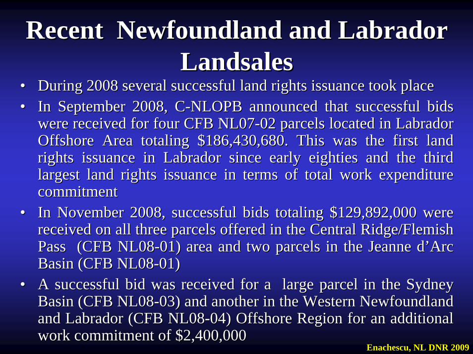
•• During 2008 several successful land rights issuance took place During 2008 several successful land rights issuance took place •• In September 2008, CIn September 2008, C--NLOPB announced that successful bids NLOPB announced that successful bids
were received for four CFB NL07were received for four CFB NL07--02 parcels located in Labrador 02 parcels located in Labrador Offshore Area totaling $186,430,680. This was the first land Offshore Area totaling $186,430,680. This was the first land rights issuance in Labrador since early eighties and the third rights issuance in Labrador since early eighties and the third largest land rights issuance in terms of total work expenditure largest land rights issuance in terms of total work expenditure commitmentcommitment
•• In November 2008, successful bids totalingIn November 2008, successful bids totaling $129,892,000$129,892,000 were were received on all three parcels offered in the Central Ridge/Flemireceived on all three parcels offered in the Central Ridge/Flemish sh Pass (CFB NL08Pass (CFB NL08--01) area and two parcels in the Jeanne d01) area and two parcels in the Jeanne d’’Arc Arc Basin (CFB NL08Basin (CFB NL08--01) 01)
•• A successful bid was received for a large parcel in the Sydney A successful bid was received for a large parcel in the Sydney Basin (CFB NL08Basin (CFB NL08--03) and another in the Western Newfoundland 03) and another in the Western Newfoundland and Labrador (CFB NL08and Labrador (CFB NL08--04) Offshore Region for an additional 04) Offshore Region for an additional work commitment of $2,400,000work commitment of $2,400,000
Enachescu, NL DNR 2009
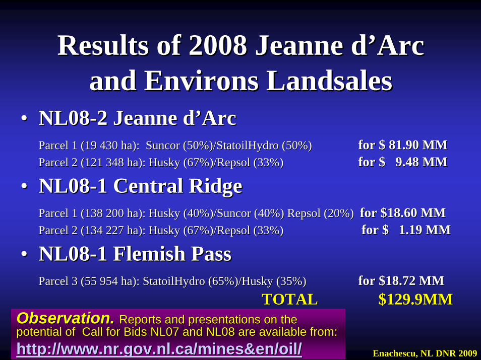
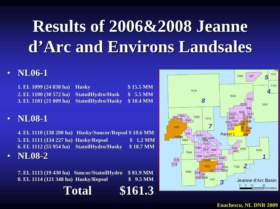
•• NL08NL08--2 Jeanne 2 Jeanne dd’’ArcArcParcelParcel 1 (19 430 ha): 1 (19 430 ha): SuncorSuncor (50%)/(50%)/StatoilHydroStatoilHydro (50%) (50%) forfor $ 81.90 MM$ 81.90 MMParcelParcel 2 (2 (121 348 ha): Husky (67%)/Repsol (33%)121 348 ha): Husky (67%)/Repsol (33%) for $ 9.48 MMfor $ 9.48 MM
•• NL08NL08--1 Central 1 Central RidgeRidgeParcelParcel 1 (138 200 ha): Husky (40%)/1 (138 200 ha): Husky (40%)/SuncorSuncor (40%) Repsol (20%) (40%) Repsol (20%) forfor $18.60 MM$18.60 MMParcelParcel 2 (134 227 ha): 2 (134 227 ha): Husky (67%)/Repsol (33%)Husky (67%)/Repsol (33%) for $ 1.19 MMfor $ 1.19 MM
•• NL08NL08--1 1 FlemishFlemish PassPassParcel 3 (55 954 ha): StatoilHydro (65%)/Husky (35%)Parcel 3 (55 954 ha): StatoilHydro (65%)/Husky (35%) for $18.72 MMfor $18.72 MM
TOTAL $129.9MMTOTAL $129.9MM
Results of 2008 Jeanne dResults of 2008 Jeanne d’’Arc Arc and Environs Landsalesand Environs Landsales
Observation.Observation. Reports and presentations on the Reports and presentations on the potential of Call for Bids NL07 and NL08 are available from:potential of Call for Bids NL07 and NL08 are available from:http://http://www.nr.gov.nl.ca/mines&en/oilwww.nr.gov.nl.ca/mines&en/oil// Enachescu, NL DNR 2009

Recent Jeanne dRecent Jeanne d’’Arc Basin LandsalesArc Basin Landsales
Enachescu, NL DNR 2009
Observation.Observation.In the 2008 landsale, In the 2008 landsale, RepsolRepsol participated for participated for the first time ever and the first time ever and succeeded in an offshore succeeded in an offshore Atlantic Canada landsale. Atlantic Canada landsale. RepsolRepsol is a large is a large integrated oil company integrated oil company with assets in many with assets in many countries.countries.It was also the first time It was also the first time in which NL has attracted in which NL has attracted a new a new ““namename”” -- a large a large reputable multinational reputable multinational integrated petroleum integrated petroleum company to explore the company to explore the Grand BanksGrand Banks
Presently there are: 16 Exploration Licences Presently there are: 16 Exploration Licences (EL), 43 Significant Discovery Licences (SDL) (EL), 43 Significant Discovery Licences (SDL) and 8 Production Licences (PL) in the basinand 8 Production Licences (PL) in the basin
Land Situation Land Situation Spring 2009Spring 2009
3. Geology Overview of the Mesozoic 3. Geology Overview of the Mesozoic Grand Banks and EnvironsGrand Banks and Environs
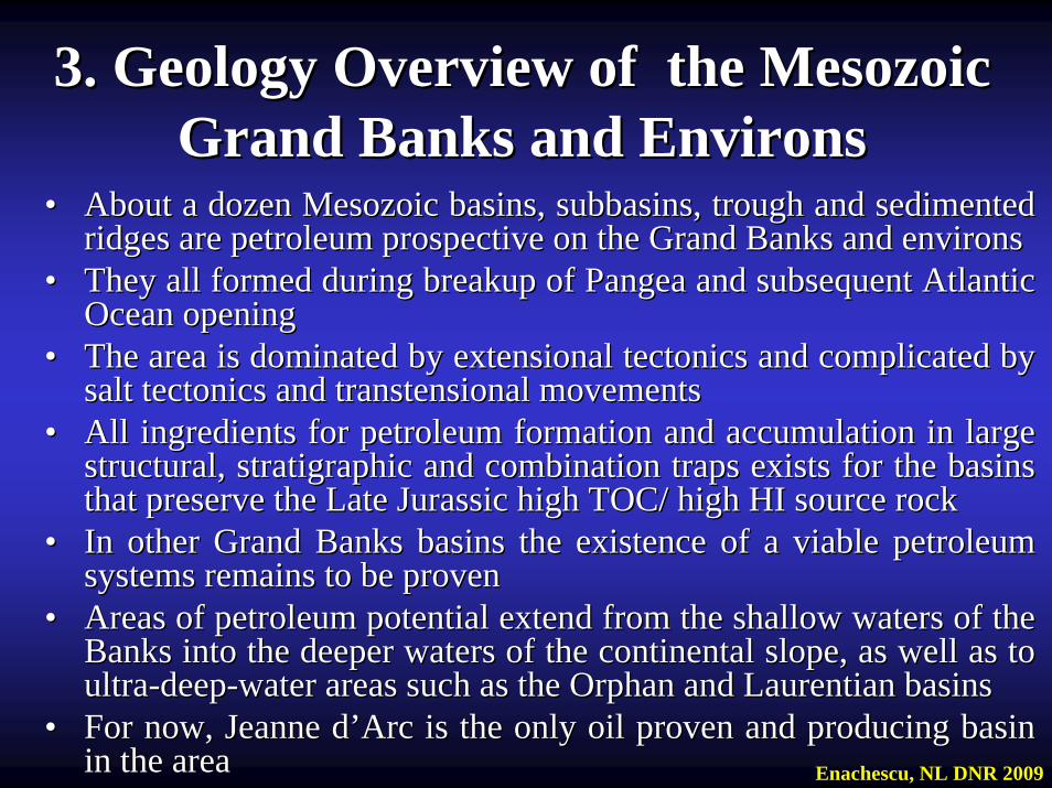
•• About a dozen Mesozoic basins, About a dozen Mesozoic basins, subbasinssubbasins, trough and , trough and sedimentedsedimentedridges are petroleum prospective on the Grand Banks and environsridges are petroleum prospective on the Grand Banks and environs
•• They all formed during breakup of Pangea and subsequent AtlanticThey all formed during breakup of Pangea and subsequent AtlanticOcean openingOcean opening
•• The area is dominated by extensional tectonics and complicated bThe area is dominated by extensional tectonics and complicated by y salt tectonics and transtensional movementssalt tectonics and transtensional movements
•• All ingredients for petroleum formation and accumulation in largAll ingredients for petroleum formation and accumulation in large e structural, stratigraphic and combination traps exists for the bstructural, stratigraphic and combination traps exists for the basins asins that preserve the Late Jurassic high TOC/ high HI source rockthat preserve the Late Jurassic high TOC/ high HI source rock
•• In other Grand Banks basins the existence of a viable petroleum In other Grand Banks basins the existence of a viable petroleum systems remains to be provensystems remains to be proven
•• Areas of petroleum potential extend from the shallow waters of tAreas of petroleum potential extend from the shallow waters of the he Banks into the deeper waters of the continental slope, as well aBanks into the deeper waters of the continental slope, as well as to s to ultraultra--deepdeep--water areas such as the Orphan and Laurentian basins water areas such as the Orphan and Laurentian basins
•• For now, Jeanne dFor now, Jeanne d’’Arc is the only oil proven and producing basin Arc is the only oil proven and producing basin in the areain the area Enachescu, NL DNR 2009
Regional Geology of the Grand Regional Geology of the Grand Banks of NewfoundlandBanks of Newfoundland
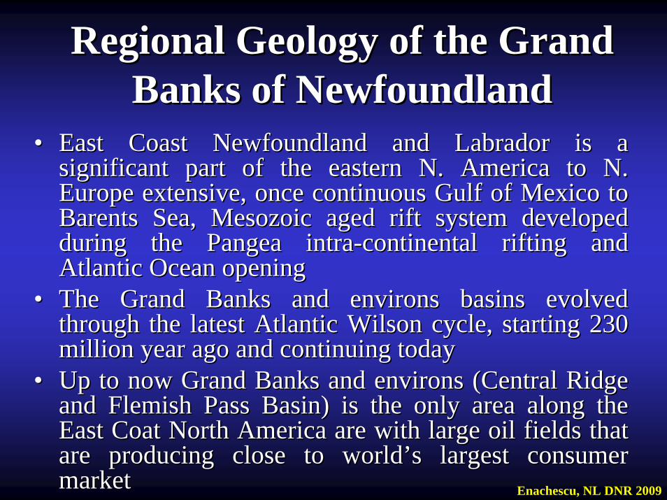
•• East Coast Newfoundland and Labrador is a East Coast Newfoundland and Labrador is a significant part of the eastern N. America to N. significant part of the eastern N. America to N. Europe extensive, once continuous Gulf of Mexico to Europe extensive, once continuous Gulf of Mexico to Barents Sea, Mesozoic aged rift system developed Barents Sea, Mesozoic aged rift system developed during the Pangea intraduring the Pangea intra--continental rifting and continental rifting and Atlantic Ocean openingAtlantic Ocean opening
•• The Grand Banks and environs basins evolved The Grand Banks and environs basins evolved through the latest Atlantic Wilson cycle, starting 230 through the latest Atlantic Wilson cycle, starting 230 million year ago and continuing todaymillion year ago and continuing today
•• Up to now Grand Banks and environs (Central Ridge Up to now Grand Banks and environs (Central Ridge and Flemish Pass Basin) is the only area along the and Flemish Pass Basin) is the only area along the East Coat North America are with large oil fields that East Coat North America are with large oil fields that are producing close to worldare producing close to world’’s largest consumer s largest consumer marketmarket Enachescu, NL DNR 2009
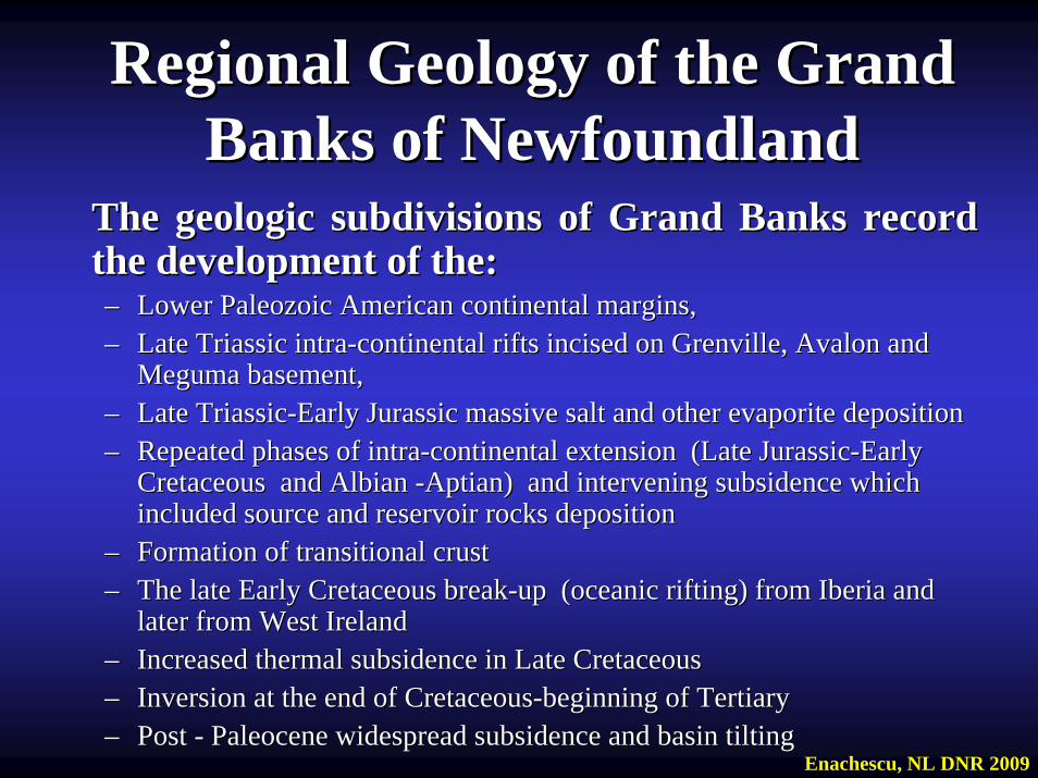
Regional Geology of the Grand Regional Geology of the Grand Banks of NewfoundlandBanks of Newfoundland
The geologic subdivisions of Grand Banks record The geologic subdivisions of Grand Banks record the development of the:the development of the:–– Lower Paleozoic American continental margins, Lower Paleozoic American continental margins, –– Late Triassic intraLate Triassic intra--continental rifts incised on Grenville, Avalon and continental rifts incised on Grenville, Avalon and
MegumaMeguma basement, basement, –– Late TriassicLate Triassic--Early Jurassic massive salt and other evaporite deposition Early Jurassic massive salt and other evaporite deposition –– Repeated phases of intraRepeated phases of intra--continental extension (Late Jurassiccontinental extension (Late Jurassic--Early Early
Cretaceous and Cretaceous and AlbianAlbian --AptianAptian) and intervening subsidence which ) and intervening subsidence which included source and reservoir rocks depositionincluded source and reservoir rocks deposition
–– Formation of transitional crustFormation of transitional crust–– The late Early Cretaceous breakThe late Early Cretaceous break--up (oceanic rifting) from Iberia and up (oceanic rifting) from Iberia and
later from West Irelandlater from West Ireland–– Increased thermal subsidence in Late Cretaceous Increased thermal subsidence in Late Cretaceous –– Inversion at the end of CretaceousInversion at the end of Cretaceous--beginning of Tertiary beginning of Tertiary –– Post Post -- Paleocene widespread subsidence and basin tiltingPaleocene widespread subsidence and basin tilting
Enachescu, NL DNR 2009
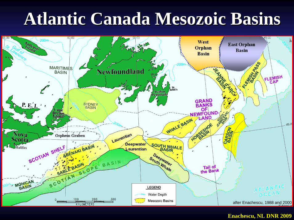
Atlantic Canada Mesozoic BasinsAtlantic Canada Mesozoic Basins
after Enachescu, 1988 and 2000
Enachescu, NL DNR 2009
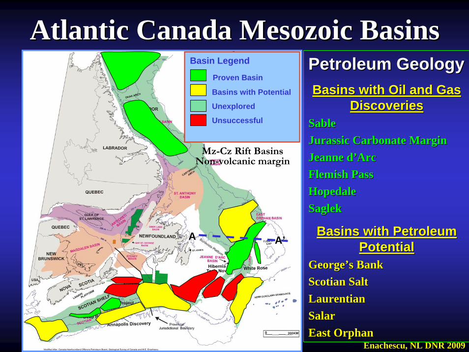
Atlantic Canada Mesozoic BasinsAtlantic Canada Mesozoic BasinsPetroleum GeologyPetroleum GeologyBasins with Oil and Gas Basins with Oil and Gas
DiscoveriesDiscoveriesSableSableJurassic Carbonate MarginJurassic Carbonate MarginJeanne dJeanne d’’ArcArcFlemish PassFlemish PassHopedaleHopedaleSaglekSaglek
Basins with Petroleum Basins with Petroleum PotentialPotential
GeorgeGeorge’’s Banks BankScotian SaltScotian SaltLaurentianLaurentianSalarSalarEast OrphanEast Orphan
Mz-Cz Rift BasinsNon-volcanic margin
Basin Legend
Proven Basin
Basins with Potential
Unexplored
Unsuccessful
AA AA’’
Enachescu, NL DNR 2009
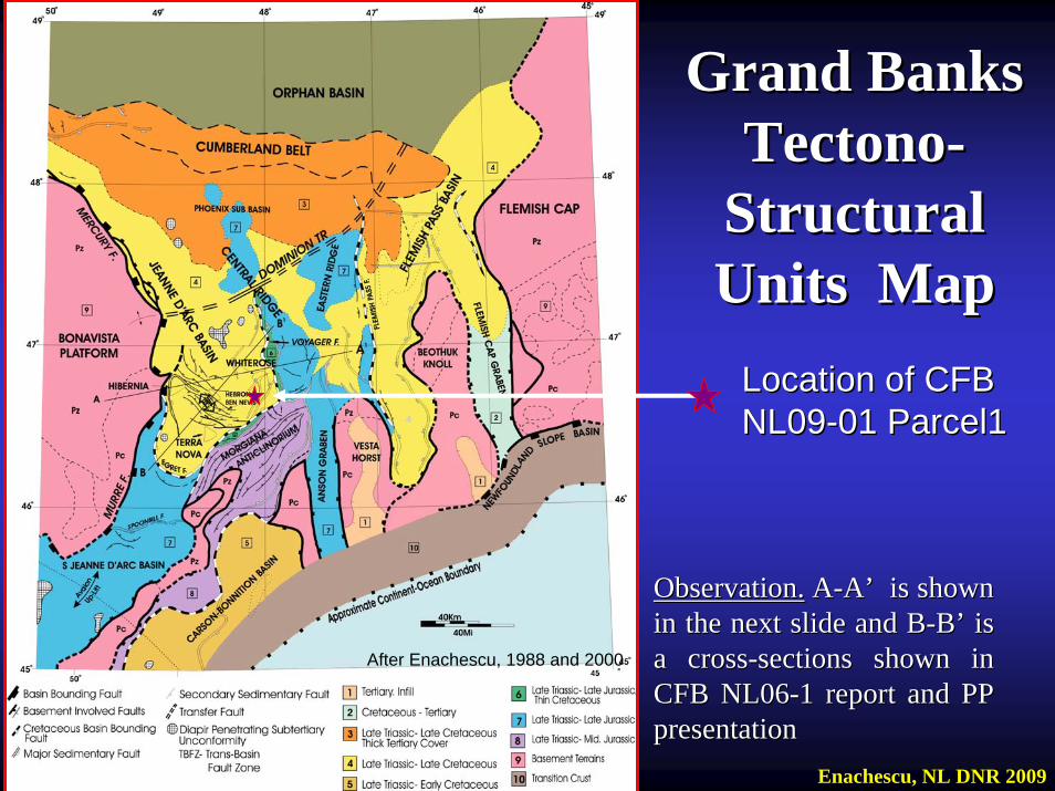
Grand Banks Grand Banks TectonoTectono--
Structural Structural Units MapUnits Map
Enachescu, NL DNR 2009
After Enachescu, 1988 and 2000
Location of CFB Location of CFB NL09NL09--01 Parcel101 Parcel1
Observation.Observation. AA--AA’’ is shown is shown in the next slide and Bin the next slide and B--BB’’ is is a crossa cross--sections shown in sections shown in CFB NL06CFB NL06--1 report and PP 1 report and PP presentationpresentation
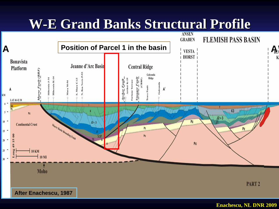
WW--E Grand Banks Structural ProfileE Grand Banks Structural Profile
After Enachescu, 1987
AA AA’’Position of Parcel 1 in the basin
Enachescu, NL DNR 2009
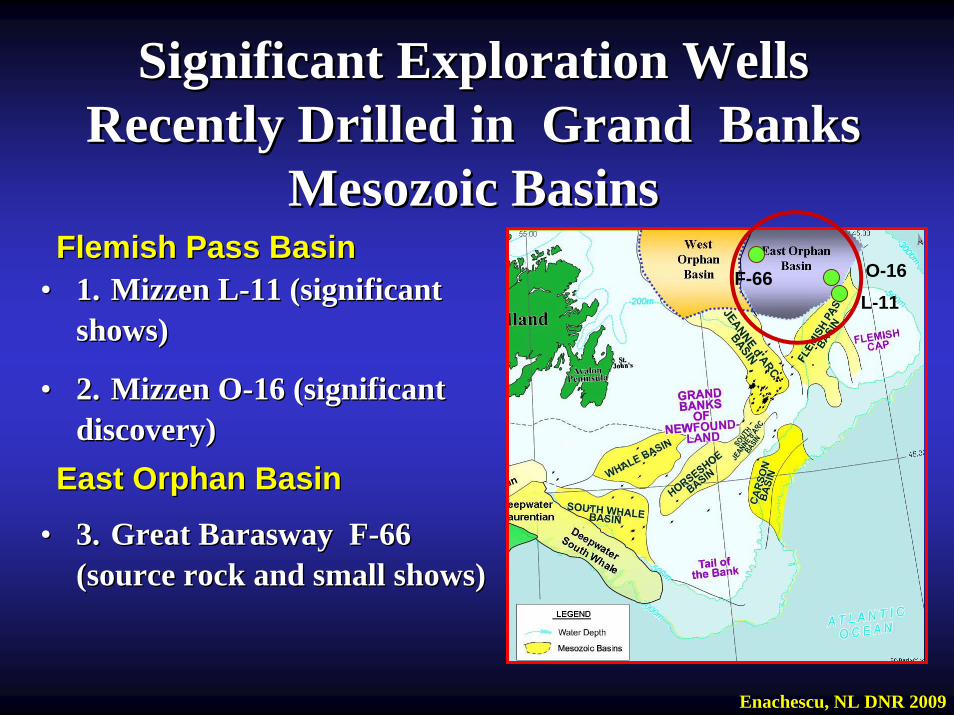
•• 1.1. Mizzen LMizzen L--11 (significant 11 (significant shows)shows)
•• 2.2. Mizzen OMizzen O--16 (significant 16 (significant discovery)discovery)
•• 3.3. Great Great BaraswayBarasway FF--66 66 (source rock and small shows) (source rock and small shows)
Significant Exploration Wells Significant Exploration Wells Recently Drilled in Grand Banks Recently Drilled in Grand Banks
Mesozoic BasinsMesozoic BasinsFlemish Pass BasinFlemish Pass Basin
East Orphan BasinEast Orphan Basin
Enachescu, NL DNR 2009
L-11O-16F-66
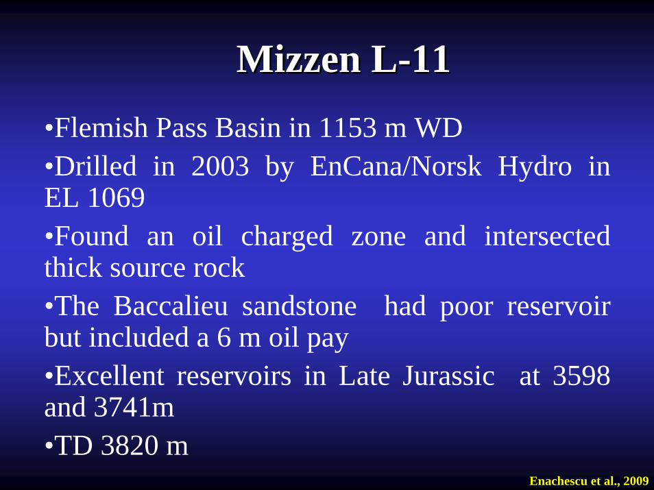
Mizzen LMizzen L--1111•Flemish Pass Basin in 1153 m WD•Drilled in 2003 by EnCana/Norsk Hydro in EL 1069 •Found an oil charged zone and intersected thick source rock•The Baccalieu sandstone had poor reservoir but included a 6 m oil pay•Excellent reservoirs in Late Jurassic at 3598 and 3741m•TD 3820 m
Enachescu et al., 2009
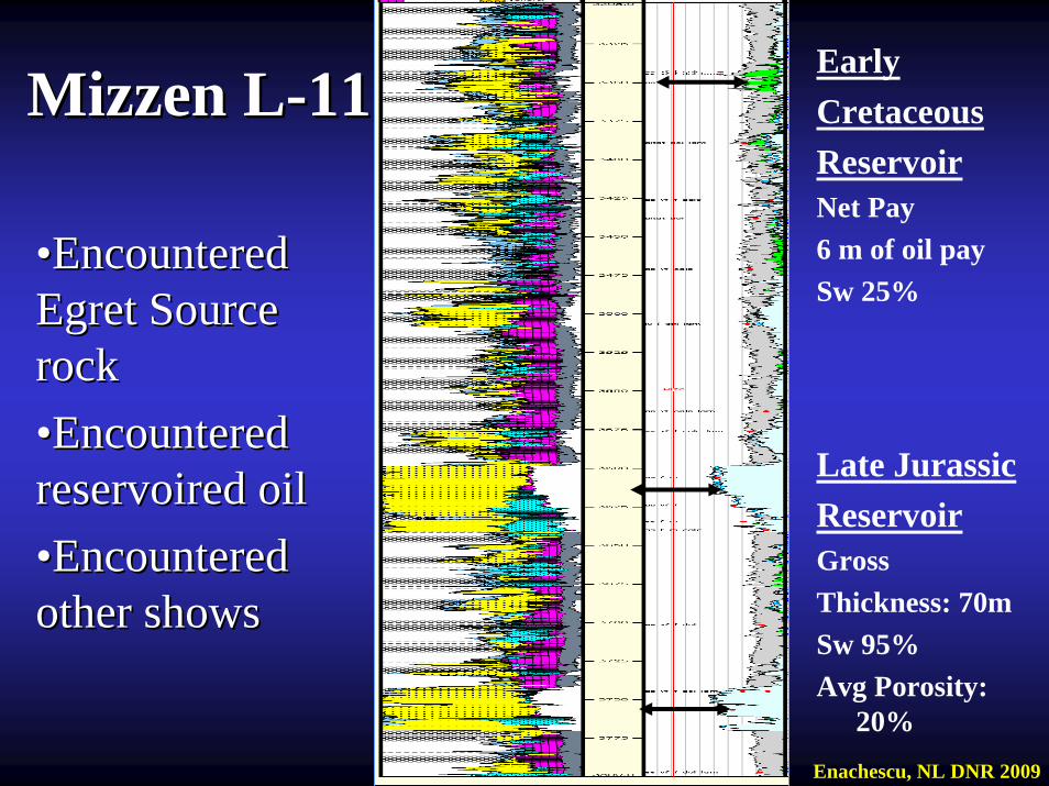
Mizzen LMizzen L--1111
••Encountered Encountered Egret Source Egret Source rockrock••Encountered Encountered reservoired oilreservoired oil••Encountered Encountered other showsother shows
Early Cretaceous ReservoirNet Pay6 m of oil paySw 25%
Late Jurassic ReservoirGross Thickness: 70mSw 95%Avg Porosity:
20%Enachescu, NL DNR 2009
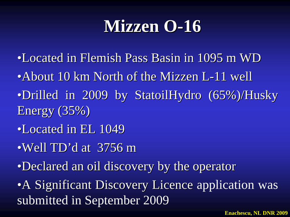
Mizzen OMizzen O--1616
••Located in Flemish Pass Basin in 1095 mLocated in Flemish Pass Basin in 1095 m WDWD••About 10 km North of the Mizzen LAbout 10 km North of the Mizzen L--11 well11 well••Drilled in 2009 by StatoilHydro (65%)/Husky Drilled in 2009 by StatoilHydro (65%)/Husky Energy (35%)Energy (35%)••Located in EL 1049 Located in EL 1049 ••Well Well TDTD’’dd at 3756 mat 3756 m••Declared an oil discovery by the operator Declared an oil discovery by the operator ••A Significant Discovery LicenceA Significant Discovery Licence application was submitted in September 2009
Enachescu, NL DNR 2009
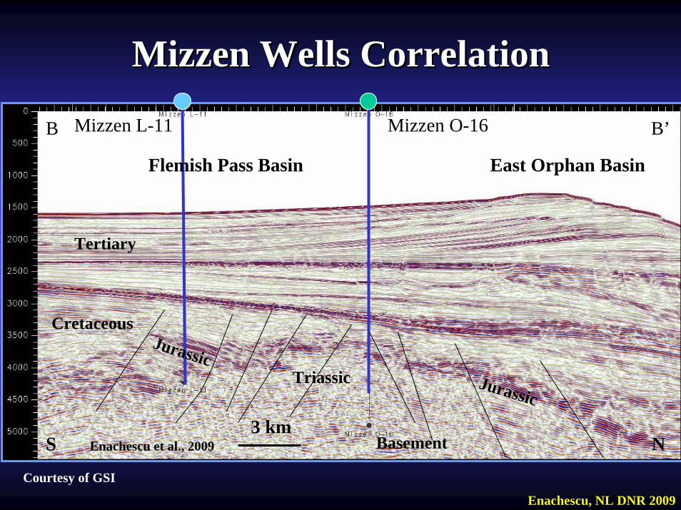
Mizzen Wells CorrelationMizzen Wells Correlation
Enachescu, NL DNR 2009
Courtesy of GSI
S N
Tertiary
Jurassic
Cretaceous
Triassic
Basement3 km
Mizzen LMizzen L--1111 Mizzen OMizzen O--1616
Jurassic
Flemish Pass Basin East Orphan Basin
Enachescu et al., 2009
B B’
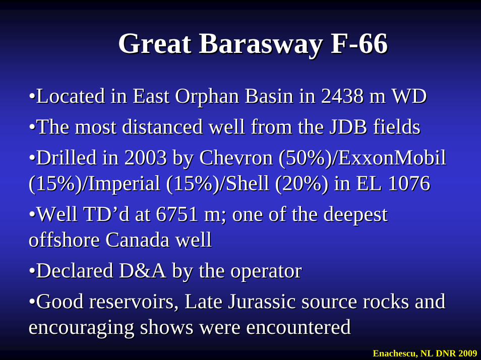
Great Great BaraswayBarasway FF--6666
••Located in East Orphan Basin inLocated in East Orphan Basin in 2438 m WD2438 m WD••The most distanced well from the JDB fieldsThe most distanced well from the JDB fields••Drilled in 2003 by Chevron (50%)/ExxonMobil Drilled in 2003 by Chevron (50%)/ExxonMobil (15%)/Imperial (15%)/Shell (20%) in EL 1076 (15%)/Imperial (15%)/Shell (20%) in EL 1076 ••Well Well TDTD’’dd at 6751 m; one of the deepest at 6751 m; one of the deepest offshore Canada well offshore Canada well ••Declared D&A by the operatorDeclared D&A by the operator••Good reservoirs, Late Jurassic source rocks and Good reservoirs, Late Jurassic source rocks and encouraging shows were encountered encouraging shows were encountered
Enachescu, NL DNR 2009

TertiaryTertiary
2338 m WB2338 m WB
JurassicJurassicCretaceousCretaceous
Avalon BasementAvalon Basement
TriassicTriassic
Great Great BaraswayBarasway FF--6666
U. CretaceousU. Cretaceous
Avalon BasementAvalon Basement
TriassicTriassic
NW SE3 km
Enachescu et al., 2009Courtesy of GSI
4. Geology Summary of the Jeanne 4. Geology Summary of the Jeanne dd’’Arc BasinArc Basin
•• Jeanne dJeanne d’’Arc Basin and adjacent Central Ridge area host most of the Arc Basin and adjacent Central Ridge area host most of the significant oil discoveries in the Newfoundland and Labrador significant oil discoveries in the Newfoundland and Labrador offshore area (there are also major gas discoveries off Labradoroffshore area (there are also major gas discoveries off Labrador and and an oil discovery in Flemish Pass Basin), including the three curan oil discovery in Flemish Pass Basin), including the three currently rently producing fields; also Hebron and a series of satellites and fieproducing fields; also Hebron and a series of satellites and field ld extensions which are now developed or planned for development extensions which are now developed or planned for development
•• The basin forms an elongate, roughly NE trending, large halfThe basin forms an elongate, roughly NE trending, large half--graben, graben, encompassing an area of about 14,000 kmencompassing an area of about 14,000 km22. It is bounded to the west . It is bounded to the west by the by the MurreMurre Fault, to the north by the Cumberland Belt Transfer Fault, to the north by the Cumberland Belt Transfer Zone (CBTZ) lineament, to the east by the Voyager Fault and to tZone (CBTZ) lineament, to the east by the Voyager Fault and to the he south by the Egret Fault. The basin deepens to the north and shasouth by the Egret Fault. The basin deepens to the north and shallows llows to the south, and contains over 20 km of Upper Triassic to Cenozto the south, and contains over 20 km of Upper Triassic to Cenozoic oic sedimentary infill in its sedimentary infill in its depocentredepocentre, situated to the north of the Trans, situated to the north of the Trans--Basin Fault Zone (TBFZ) and east of Hibernia Basin Fault Zone (TBFZ) and east of Hibernia
•• The sedimentary fill of this area was deposited, structured and The sedimentary fill of this area was deposited, structured and fragmented during repeated extensional episodes. Infill includesfragmented during repeated extensional episodes. Infill includesclastics, salt and carbonates. Minor transclastics, salt and carbonates. Minor trans--tensional tectonic tensional tectonic movements and several strong erosional interludes have also reshmovements and several strong erosional interludes have also reshaped aped the basin and its associated ridges the basin and its associated ridges
Enachescu, NL DNR 2009
Geology Summary of the Jeanne Geology Summary of the Jeanne dd’’Arc BasinArc Basin
The basin fill can be divided into two major stratigraphic The basin fill can be divided into two major stratigraphic sequences that are clearly recognizable on seismic datasequences that are clearly recognizable on seismic data: : 1. An extensional stage sedimentary sequence1. An extensional stage sedimentary sequence (Late Triassic to (Late Triassic to late Early Cretaceous) that is strongly late Early Cretaceous) that is strongly compartmentalisedcompartmentalised by normal by normal fault systems and contains numerous structuresfault systems and contains numerous structures2. A thermal subsidence stage sedimentary sequence2. A thermal subsidence stage sedimentary sequence (Late (Late AlbianAlbian to Present) that is tectonically undisturbed (i.e. no extensionto Present) that is tectonically undisturbed (i.e. no extension), ), but contains remarkable depositional and erosional features, incbut contains remarkable depositional and erosional features, including luding basin margin and floor fansbasin margin and floor fansAlongside extensional tectonics, prolonged Alongside extensional tectonics, prolonged halokinesishalokinesis and and halotectonicshalotectonics played an important role in basin evolution and played an important role in basin evolution and architecture. Prominent saltarchitecture. Prominent salt--cored structures are presently found cored structures are presently found throughout the Grand Banks. Salt pillows underlay the Hibernia, throughout the Grand Banks. Salt pillows underlay the Hibernia, Terra Terra Nova and White Rose oil fields and most of the other structural Nova and White Rose oil fields and most of the other structural features in the basin and on the Central Ridgefeatures in the basin and on the Central Ridge
Enachescu, NL DNR 2009
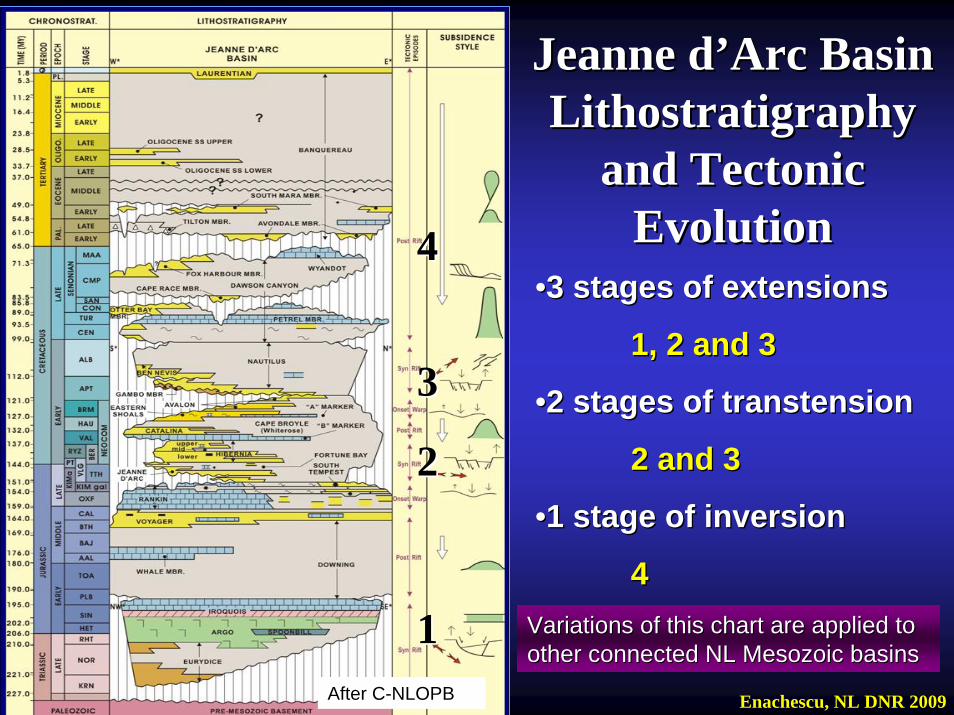
Jeanne dJeanne d’’Arc Basin Arc Basin LithostratigraphyLithostratigraphy
and Tectonic and Tectonic EvolutionEvolution
11
22
33
44••3 stages of extensions3 stages of extensions
1, 2 and 31, 2 and 3
••2 stages of transtension2 stages of transtension
2 and 32 and 3
••1 stage of inversion1 stage of inversion
44
After C-NLOPB Enachescu, NL DNR 2009
Variations of this chart are applied to Variations of this chart are applied to other connected NL Mesozoic basinsother connected NL Mesozoic basins
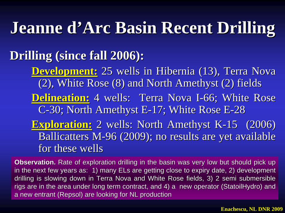
Jeanne dJeanne d’’Arc Basin Recent DrillingArc Basin Recent DrillingDrilling (since fall 2006):Drilling (since fall 2006):
Development:Development: 25 wells in Hibernia (13), Terra Nova 25 wells in Hibernia (13), Terra Nova (2), White Rose (8) and North Amethyst (2) fields(2), White Rose (8) and North Amethyst (2) fields
Delineation:Delineation: 4 wells: Terra Nova I4 wells: Terra Nova I--66; White Rose 66; White Rose CC--30; North Amethyst E30; North Amethyst E--17; White Rose E17; White Rose E--2828
Exploration:Exploration: 2 wells: North Amethyst K2 wells: North Amethyst K--1515 (2006)(2006)BallicattersBallicatters MM--96 (2009); no results are yet available 96 (2009); no results are yet available for these wellsfor these wells
Observation. Observation. Rate of exploration drilling in the basin was very low but shoulRate of exploration drilling in the basin was very low but should pick up d pick up in the next few years as: 1) many ELs are getting close to expiin the next few years as: 1) many ELs are getting close to expiry date, 2) development ry date, 2) development drilling is slowing down in Terra Nova and White Rose fields, 3)drilling is slowing down in Terra Nova and White Rose fields, 3) 2 semi submersible 2 semi submersible rigs are in the area under long term contract, and 4) a new operigs are in the area under long term contract, and 4) a new operator (StatoilHydro) and rator (StatoilHydro) and a new entrant (a new entrant (RepsolRepsol) are looking for NL production) are looking for NL production
Enachescu, NL DNR 2009
Wells Drilled in 2008/9 within Jeanne Wells Drilled in 2008/9 within Jeanne dd’’Arc BasinArc Basin
•• 1. North Amethyst E1. North Amethyst E--17 (Delineation) 17 (Delineation) TD 2591 mNorth Amethyst oil field is currently being developed as a WhiteNorth Amethyst oil field is currently being developed as a White Rose Rose satellite and first oil is expected in 2010 with an estimated prsatellite and first oil is expected in 2010 with an estimated production at oduction at peak of 37,000 bopdpeak of 37,000 bopd
•• 2. West White Rose E2. West White Rose E--28 ( Delineation) 28 ( Delineation) TDTD 3435 m3435 mW. White Rose pool will be also developed as a satellite tieW. White Rose pool will be also developed as a satellite tie--back to Sea back to Sea Rose FPSO with first oil expected in 2010/11Rose FPSO with first oil expected in 2010/11
•• 3. 3. BallicatersBallicaters MM--96 96 ((Exploration) Exploration) Spudded end of July 2009 and targeting both EL 1113 and EL 109Spudded end of July 2009 and targeting both EL 1113 and EL 1092; 2; currently being completed at 5655 m. This is a multi reservoir tcurrently being completed at 5655 m. This is a multi reservoir test for a est for a faultfault--bounded rotated block within the Transbounded rotated block within the Trans--Basin Fault Zone northeast of Basin Fault Zone northeast of Hibernia fieldHibernia field
Enachescu, NL DNR 2009
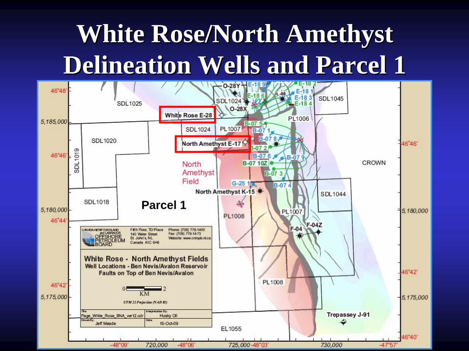
White Rose/North Amethyst White Rose/North Amethyst Delineation Wells and Parcel 1Delineation Wells and Parcel 1
Parcel 1
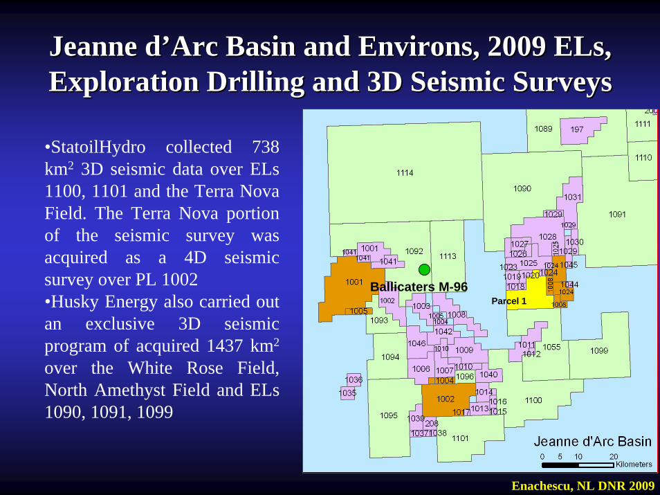
Jeanne dJeanne d’’Arc Basin and Environs, 2009 ELs, Arc Basin and Environs, 2009 ELs, Exploration Drilling and 3D Seismic SurveysExploration Drilling and 3D Seismic Surveys
•StatoilHydro collected 738 km2 3D seismic data over ELs 1100, 1101 and the Terra Nova Field. The Terra Nova portion of the seismic survey was acquired as a 4D seismic survey over PL 1002•Husky Energy also carried out an exclusive 3D seismic program of acquired 1437 km2
over the White Rose Field, North Amethyst Field and ELs 1090, 1091, 1099
Enachescu, NL DNR 2009
Parcel 1Ballicaters M-96
•• NL06NL06--111. EL 1099 (24 838 ha) Husky1. EL 1099 (24 838 ha) Husky $ 15.5 MM$ 15.5 MM2. EL 1100 (2. EL 1100 (30 572 ha) StatoilHydro/Husk $ 5.5 MM30 572 ha) StatoilHydro/Husk $ 5.5 MM3. EL 1101 (3. EL 1101 (21 009 ha) StatoilHydro/Husky $ 10.4 MM21 009 ha) StatoilHydro/Husky $ 10.4 MM
•• NL08NL08--114. EL 1110 (138 200 ha) 4. EL 1110 (138 200 ha) Husky/Suncor/Husky/Suncor/RepsolRepsol $ 18.6 MM$ 18.6 MM5. 5. EL 1111 (EL 1111 (134 227 ha) Husky/134 227 ha) Husky/RepsolRepsol $ 1.2 MM$ 1.2 MM6. EL 1112 (6. EL 1112 (55 954 ha) StatoilHydro/Husky 55 954 ha) StatoilHydro/Husky $ 18.7 MM$ 18.7 MM
•• NL08NL08--22
7. EL 1113 (19 430 ha) 7. EL 1113 (19 430 ha) SuncorSuncor/S/StatoilHydrotatoilHydro $ 81.9 MM$ 81.9 MM8. EL 1114 (8. EL 1114 (121 348 ha) Husky/121 348 ha) Husky/RepsolRepsol $ 9.5 MM$ 9.5 MM
TotalTotal $161.3$161.3
Results of 2006&2008 Jeanne Results of 2006&2008 Jeanne dd’’Arc and Environs LandsalesArc and Environs Landsales
Enachescu, NL DNR 2009
Parcel 1
12
3
4
5
7
8
5. Petroleum Geology of the 5. Petroleum Geology of the Jeanne dJeanne d’’Arc BasinArc Basin
Source RocksSource Rocks
Reservoir RocksReservoir Rocks
SealsSeals
Hydrocarbon TrapsHydrocarbon Traps
Maturation and MigrationMaturation and Migration
Hydrocarbon Plays and RisksHydrocarbon Plays and Risks
Egret Egret Petroleum SystemPetroleum System
Enachescu, NL DNR 2009
•• Jeanne dJeanne d’’Arc Basin is a hydrocarbon prolific basin that contains Arc Basin is a hydrocarbon prolific basin that contains almost exclusively all the oil volumes discovered offshore almost exclusively all the oil volumes discovered offshore NewfoundlandNewfoundland
•• The basinThe basin’’s infill contains structured synrift rock successions s infill contains structured synrift rock successions (includes evaporites, carbonates and coarse and fine clastics) (includes evaporites, carbonates and coarse and fine clastics) ranging in age from Late Triassic to late Early ranging in age from Late Triassic to late Early -- Cretaceous Cretaceous (Extensional Stage sedimentary sequence)(Extensional Stage sedimentary sequence)
•• Oil prone source rocks are present in Late Jurassic (Oil prone source rocks are present in Late Jurassic (CallovianCallovian, , OxfordianOxfordian and especially and especially KimmeridgianKimmeridgian); the potential for other ); the potential for other source rocks is recognized within the Early and Late Cretaceous source rocks is recognized within the Early and Late Cretaceous and Early Tertiaryand Early Tertiary
•• The early sedimentary fill contains the Argo Salt that later The early sedimentary fill contains the Argo Salt that later became mobile and created salt induced structures in the became mobile and created salt induced structures in the overlying sediments (e.g. White Rose overlying sediments (e.g. White Rose DiapirDiapir, Amethyst Ridge) , Amethyst Ridge) (Enachescu et al., 2000)(Enachescu et al., 2000)
•• Post rift sedimentary sequence is represented by parallel, slighPost rift sedimentary sequence is represented by parallel, slightly tly deformed sedimentary layers (mainly fine clastics and thin chalkdeformed sedimentary layers (mainly fine clastics and thin chalkand carbonates)and carbonates)
Petroleum GeologyPetroleum Geology
Enachescu&Foote/NLDNR 2009
••Over 25 exploration wells have penetrated the Egret Over 25 exploration wells have penetrated the Egret MbrMbr. source rock . source rock ••Four lithological components have been identified within the EgrFour lithological components have been identified within the Egret et Member of Rankin Fm. source interval: 1) Member of Rankin Fm. source interval: 1) a darka dark--brown laminated shale brown laminated shale (most abundant and highest oil generation potential)(most abundant and highest oil generation potential); 2) a grey to grey; 2) a grey to grey--brown shale; 3) a light brown marlstone/limestone; and 4) a finebrown shale; 3) a light brown marlstone/limestone; and 4) a fine--grained grained sandstone and siltstonesandstone and siltstone ((Bateman, 1995)••Thickness ranging from 50 m to well over 500 m at Thickness ranging from 50 m to well over 500 m at Panther PPanther P--5252••Best marine source rock within the North Atlantic rift systemBest marine source rock within the North Atlantic rift system••Proven Distribution in Jeanne dProven Distribution in Jeanne d’’Arc Basin to the South (Arc Basin to the South (Hibernia, Terra Hibernia, Terra Nova, White RoseNova, White Rose etc.) and to the East (etc.) and to the East (PantherPanther, , S. Tempest, BonanzaS. Tempest, Bonanza))••Proven distribution in northern Flemish Pass Basin (Proven distribution in northern Flemish Pass Basin (BaccalieuBaccalieu and and recentlyrecently both Mizzen wellsboth Mizzen wells))••Occurs within northOccurs within north--south and/or northeastsouth and/or northeast--southwest trending deep southwest trending deep basinsbasins
KimmeridgianKimmeridgian Aged Egret Source RockAged Egret Source RockAbundant Type II, oil prone source rock with up to 9% TOCAbundant Type II, oil prone source rock with up to 9% TOC
Enachescu, NL DNR 2009

ReservoirsReservoirsReservoirs rocks in the Jeanne dReservoirs rocks in the Jeanne d’’Arc Basin are predominantly Arc Basin are predominantly high porosityhigh porosity--high permeability sandstone of Late Jurassic to latehigh permeability sandstone of Late Jurassic to late--Early Cretaceous age. More than Early Cretaceous age. More than 98% of the discovered 98% of the discovered petroleum resides in these reservoir rock unitspetroleum resides in these reservoir rock units..
Enachescu, NL DNR 2009
••Stacked sandstones intervals within the Jeanne dStacked sandstones intervals within the Jeanne d’’Arc, Hibernia, Catalina Arc, Hibernia, Catalina and Avalon/Ben Nevis formations are proven quality reservoirs. Mand Avalon/Ben Nevis formations are proven quality reservoirs. Most of ost of these reservoirs are alluvial or deltaicthese reservoirs are alluvial or deltaic••Individual wells have tested in excess of 50,000 bopd from the HIndividual wells have tested in excess of 50,000 bopd from the Hibernia ibernia Sandstone at Hibernia, and in excess of 40,000 bopd from the JeaSandstone at Hibernia, and in excess of 40,000 bopd from the Jeanne dnne d’’Arc Arc Sandstone at Terra NovaSandstone at Terra Nova••Excellent reservoirs are found in Late Jurassic Voyager and LateExcellent reservoirs are found in Late Jurassic Voyager and Late Cretaceous Cretaceous Dawson Canyon formations (Otter Bay and Fox Harbour members) andDawson Canyon formations (Otter Bay and Fox Harbour members) and the the Paleocene Avondale and South Mara members of the Paleocene Avondale and South Mara members of the BanquereauBanquereauFormation, but to date only a couple of smaller pools have been Formation, but to date only a couple of smaller pools have been encountered encountered at these levelsat these levels••Early Tertiary sequence has a real and effectively untested poteEarly Tertiary sequence has a real and effectively untested potential for ntial for large oil and gas pools (especially in deep water)large oil and gas pools (especially in deep water)
••Oil and gas accumulations are sealed by thick overlying shales Oil and gas accumulations are sealed by thick overlying shales abundant during the Late Jurassic to Late Cretaceous (e.g. abundant during the Late Jurassic to Late Cretaceous (e.g. Fortune Bay, Cape Fortune Bay, Cape BroyleBroyle (White Rose), and(White Rose), and Nautilus shales) Nautilus shales) ••Also intraAlso intra--formational shales are widespread within the rift formational shales are widespread within the rift stage clastic sequences stage clastic sequences ••Excellent regional seals are provided by fine grained Late Excellent regional seals are provided by fine grained Late Cretaceous Dawson Canyon Fm. and the Tertiary fine clastics Cretaceous Dawson Canyon Fm. and the Tertiary fine clastics BanquereauBanquereau Fm.Fm.
SealsSealsFinding good seals should not be a problem in the Jeanne Finding good seals should not be a problem in the Jeanne dd’’Arc Basin as the extensional and thermal subsidence Arc Basin as the extensional and thermal subsidence stages contains a succession of very fine clastics, tight stages contains a succession of very fine clastics, tight sandstones and carbonatessandstones and carbonates
Enachescu, NL DNR 2009
••The main structural traps are extensional anticlines, rollThe main structural traps are extensional anticlines, roll--overs, faulted overs, faulted anticlines, faulted and tilted blocks and elongated horstsanticlines, faulted and tilted blocks and elongated horsts•• Numerous salt induced structures such as pillows, domes, diapirNumerous salt induced structures such as pillows, domes, diapirs, s, ridges, allochthonous teardrops and turtle anticlines are commonridges, allochthonous teardrops and turtle anticlines are common••The great majority of faults are listric normal faults, but someThe great majority of faults are listric normal faults, but some transfer transfer faults, accommodation zones and local inversions due to transtenfaults, accommodation zones and local inversions due to transtension sion and and halokinesishalokinesis are also forming trapsare also forming traps••Most of the discovered fields have a stratigraphic trapping compMost of the discovered fields have a stratigraphic trapping componentonent•• Stratigraphic traps are widespread. Stratigraphic traps are widespread. PaleoPaleo--valleys, basin margin and valleys, basin margin and basin floor fans are abundant in the basin and contain some discbasin floor fans are abundant in the basin and contain some discovered overed resourcesresources
Hydrocarbon Traps
Structural traps in the Jeanne dStructural traps in the Jeanne d’’Arc Basin are associated with Arc Basin are associated with rifting of the Newfoundland Margin, subsidence and formation rifting of the Newfoundland Margin, subsidence and formation of the deep extensional basin and movement of the Argo saltof the deep extensional basin and movement of the Argo salt
Enachescu, NL DNR 2009
••All major traps were found to have a stratigraphic component as All major traps were found to have a stratigraphic component as the accumulations are contained in continental, deltaic and shalthe accumulations are contained in continental, deltaic and shallow low marine sandstones marine sandstones onlappingonlapping or wrapped over the main structural or wrapped over the main structural trapstraps•• Many complex or solely stratigraphic traps remain to be drilledMany complex or solely stratigraphic traps remain to be drilled, as , as well as deeper faulted blocks and rollover structures in the cenwell as deeper faulted blocks and rollover structures in the central tral and northern part of the basin and northern part of the basin ••The basin margin plays were found to be most successfulThe basin margin plays were found to be most successful••On the eastOn the east--central part of the basin, where Parcel 1 is located, the central part of the basin, where Parcel 1 is located, the deformation of infill is due mainly to the Voyager Fault and itsdeformation of infill is due mainly to the Voyager Fault and itsimbricates, and the Amethyst salt cored ridgeimbricates, and the Amethyst salt cored ridge
Hydrocarbon Traps
Structural traps in the Jeanne dStructural traps in the Jeanne d’’Arc Basin are associated with Arc Basin are associated with rifting of the Newfoundland Margin, subsidence and formation rifting of the Newfoundland Margin, subsidence and formation of the deep extensional basins and movement of the Argo salt of the deep extensional basins and movement of the Argo salt
Enachescu, NL DNR 2009
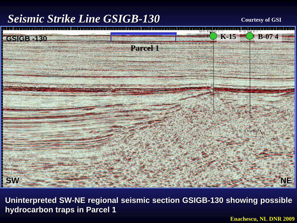
NENESWSW
K-15 B-07 4GSIGB -130Parcel 1
Uninterpreted SWUninterpreted SW--NE regional seismic section GSIGBNE regional seismic section GSIGB--130 showing possible 130 showing possible hydrocarbon traps in Parcel 1hydrocarbon traps in Parcel 1
Enachescu, NL DNR 2009
Seismic Strike Line GSIGBSeismic Strike Line GSIGB--130130 Courtesy of GSI
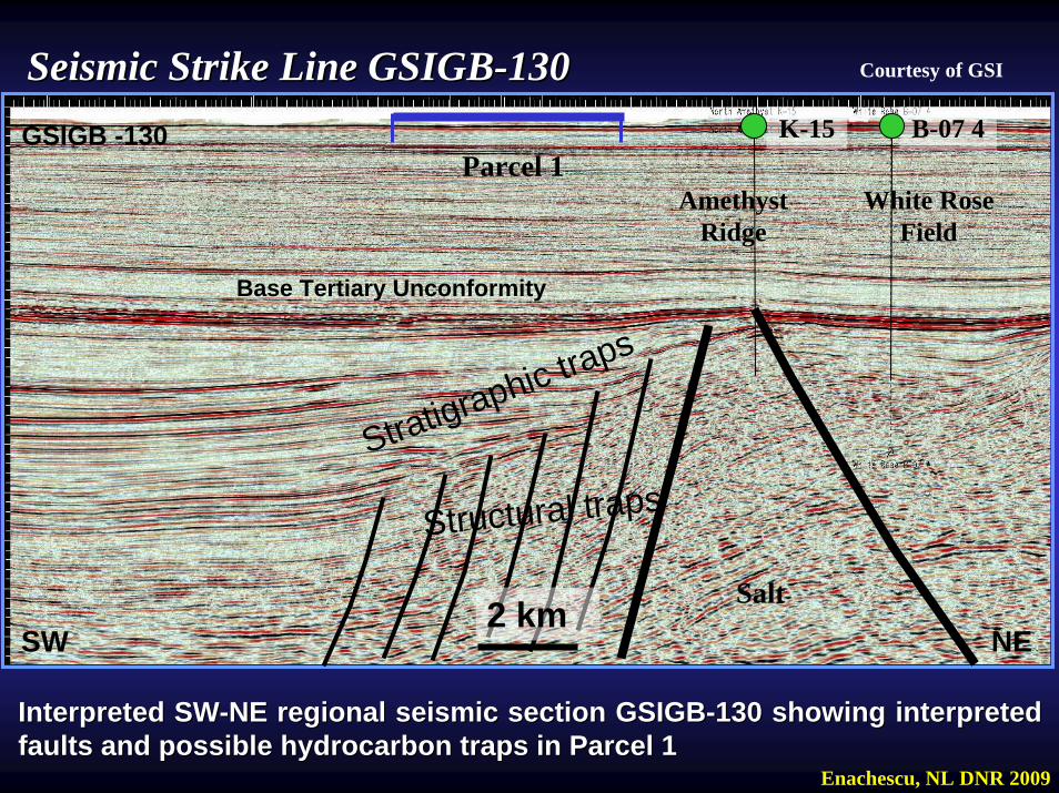
Seismic Strike Line GSIGBSeismic Strike Line GSIGB--130130 Courtesy of GSI
NE
Amethyst Ridge
Salt
SW
White Rose Field
Base Tertiary Unconformity
K-15 B-07 4GSIGB -130Parcel 1
2 km
Structural trapsStratigraphic traps
Interpreted SWInterpreted SW--NE regional seismic section GSIGBNE regional seismic section GSIGB--130 showing interpreted 130 showing interpreted faults and possible hydrocarbon traps in Parcel 1faults and possible hydrocarbon traps in Parcel 1
Enachescu, NL DNR 2009
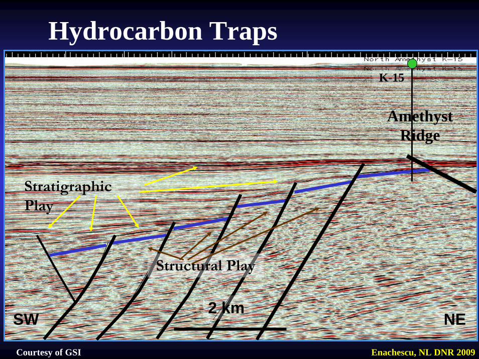
NE2 km
SW
Stratigraphic Play
Structural Play
Amethyst Ridge
Hydrocarbon Traps
Enachescu, NL DNR 2009Courtesy of GSI
K-15

Maturation and MigrationMaturation and Migration
•• Maturation starts in midMaturation starts in mid--Early Cretaceous and Early Cretaceous and continue into Tertiary continue into Tertiary
•• Petroleum expulsion starts at 3800 m and ends at Petroleum expulsion starts at 3800 m and ends at 5800 m5800 m
•• Expulsed hydrocarbons have migrated mainly Expulsed hydrocarbons have migrated mainly vertically, predominantly along the numerous vertically, predominantly along the numerous extensional faults extensional faults
•• Some lateral migration occurred locally along basin Some lateral migration occurred locally along basin flanks flanks
•• Late migration of hydrocarbons occurred within the Late migration of hydrocarbons occurred within the basin marginal fans and sand filled canyonsbasin marginal fans and sand filled canyons
Enachescu, NL DNR 2009
Hydrocarbon Plays and RisksHydrocarbon Plays and RisksThree main conventional plays are recognized in Three main conventional plays are recognized in Jeanne dJeanne d’’Arc Basin (Enachescu 2007, Grant and Arc Basin (Enachescu 2007, Grant and McAlpineMcAlpine, 1987): , 1987):
1) Late Jurassic Jeanne d1) Late Jurassic Jeanne d’’Arc SS, Arc SS, 2) Early Cretaceous Hibernia SS2) Early Cretaceous Hibernia SS3) late Early Cretaceous Avalon/Ben Nevis SS3) late Early Cretaceous Avalon/Ben Nevis SS
trapped in faulted blocks, parts of large, salt cored trapped in faulted blocks, parts of large, salt cored anticlines or ridges.anticlines or ridges.
Other Jurassic, Cretaceous and Early Tertiary SS make Other Jurassic, Cretaceous and Early Tertiary SS make secondary playsecondary play
Risks may exists re quality of reservoir and Risks may exists re quality of reservoir and sealing across faultssealing across faults
Enachescu, NL DNR 2009
•• All prerequisites for the formation of large oil and All prerequisites for the formation of large oil and gas accumulations have been identified and gas accumulations have been identified and confirmed in the Jeanne dconfirmed in the Jeanne d’’Arc BasinArc Basin
•• The most thought after drilling targets are structural The most thought after drilling targets are structural or combination traps, with plays in the Jeanne or combination traps, with plays in the Jeanne dd’’Arc, Hibernia, Avalon and Ben Nevis formations Arc, Hibernia, Avalon and Ben Nevis formations
•• Faulted blocks were Faulted blocks were particularly particularly successful on the successful on the eastern flank of Jeanne deastern flank of Jeanne d’’Arc Basin and in the Arc Basin and in the TransTrans--Basin Fault Zone Basin Fault Zone
Egret Petroleum System
Enachescu, NL DNR 2009
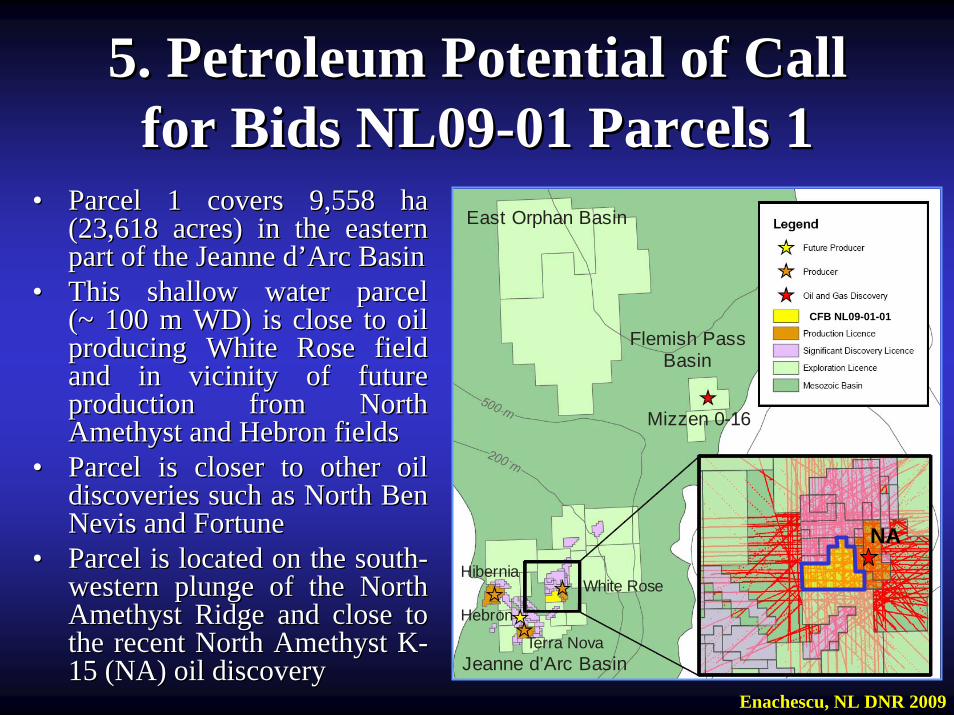
•• Parcel 1 covers 9,558 ha Parcel 1 covers 9,558 ha (23,618 acres) in the eastern (23,618 acres) in the eastern part of the Jeanne dpart of the Jeanne d’’Arc BasinArc Basin
•• This shallow water parcel This shallow water parcel ((~ ~ 100 m WD) is close to oil 100 m WD) is close to oil producing White Rose field producing White Rose field and in vicinity of future and in vicinity of future production from North production from North Amethyst and Hebron fields Amethyst and Hebron fields
•• Parcel is closer to other oil Parcel is closer to other oil discoveries such as North Ben discoveries such as North Ben Nevis and Fortune Nevis and Fortune
•• Parcel is located on the southParcel is located on the south--western plunge of the North western plunge of the North Amethyst Ridge and close to Amethyst Ridge and close to the recent North Amethyst Kthe recent North Amethyst K--15 (NA) oil discovery15 (NA) oil discovery
5. Petroleum Potential of Call 5. Petroleum Potential of Call for Bids NL09for Bids NL09--01 Parcels 101 Parcels 1
East Orphan Basin
Mizzen 0-16
Jeanne d’Arc Basin
Flemish PassBasin
Hibernia
Terra Nova
White Rose
Hebron
CFB NL09-01-01
NA
Enachescu, NL DNR 2009
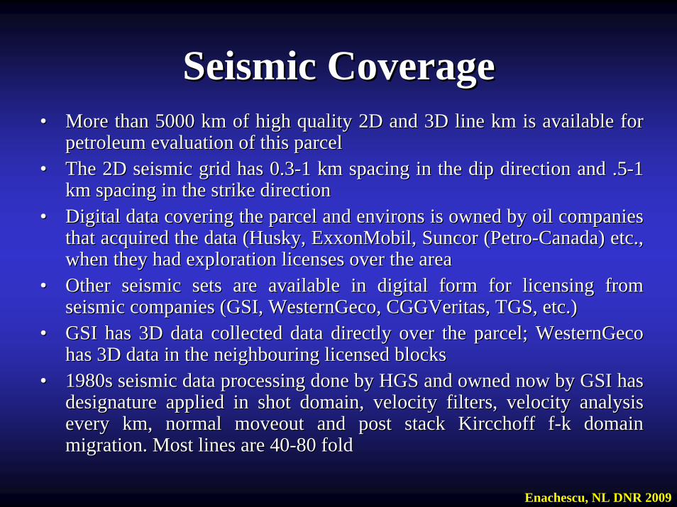
•• More than 5000 km of high quality 2D and 3D line km is availableMore than 5000 km of high quality 2D and 3D line km is available for for petroleum evaluation of this parcel petroleum evaluation of this parcel
•• The 2D seismic grid has 0.3The 2D seismic grid has 0.3--1 km spacing in the dip direction and .51 km spacing in the dip direction and .5--1 1 km spacing in the strike directionkm spacing in the strike direction
•• Digital data covering the parcel and environs is owned by oil coDigital data covering the parcel and environs is owned by oil companies mpanies that acquired the data (Husky, ExxonMobil, Suncor (Petrothat acquired the data (Husky, ExxonMobil, Suncor (Petro--Canada) etc., Canada) etc., when they had exploration licenses over the areawhen they had exploration licenses over the area
•• Other seismic sets are available in digital form for licensing fOther seismic sets are available in digital form for licensing from rom seismic companies (GSI, WesternGeco, seismic companies (GSI, WesternGeco, CGGVeritasCGGVeritas, TGS, etc.), TGS, etc.)
•• GSI has 3D data collected data directly over the parcel; WesternGSI has 3D data collected data directly over the parcel; WesternGeco Geco has 3D data in the neighbouring licensed blockshas 3D data in the neighbouring licensed blocks
•• 1980s seismic data processing done by HGS and owned now by GSI h1980s seismic data processing done by HGS and owned now by GSI has as designature applied in shot domain, velocity filters, velocity adesignature applied in shot domain, velocity filters, velocity analysis nalysis every km, normal moveout and post stack every km, normal moveout and post stack KircchoffKircchoff ff--kk domain domain migration. Most lines are 40migration. Most lines are 40--80 fold80 fold
Seismic CoverageSeismic Coverage
Enachescu, NL DNR 2009
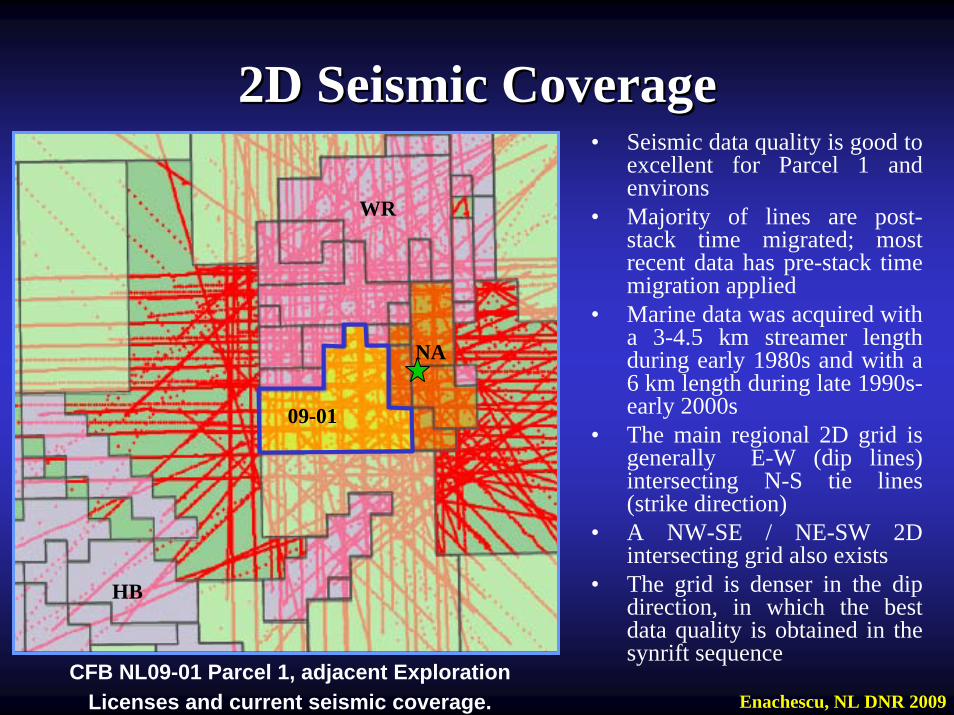
• Seismic data quality is good to excellent for Parcel 1 and environs
• Majority of lines are post-stack time migrated; most recent data has pre-stack time migration applied
• Marine data was acquired with a 3-4.5 km streamer length during early 1980s and with a 6 km length during late 1990s-early 2000s
• The main regional 2D grid is generally E-W (dip lines) intersecting N-S tie lines (strike direction)
• A NW-SE / NE-SW 2D intersecting grid also exists
• The grid is denser in the dip direction, in which the best data quality is obtained in the synrift sequence
2D Seismic Coverage2D Seismic Coverage
CFB NL09-01 Parcel 1, adjacent ExplorationLicenses and current seismic coverage.
NA
09-01
HB
WR
Enachescu, NL DNR 2009
NA
09-01
HB
WR
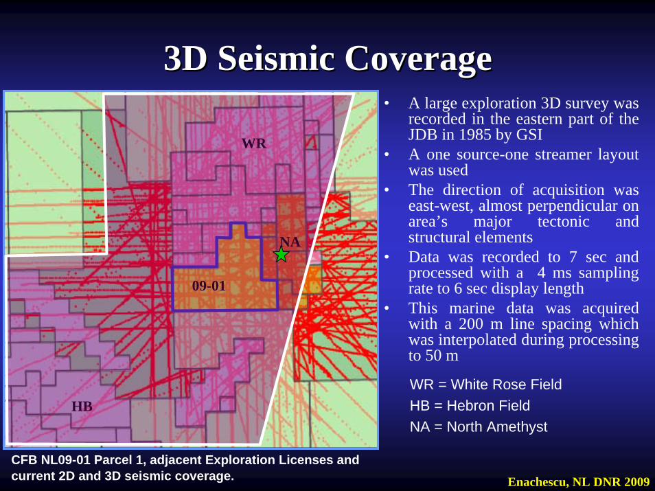
• A large exploration 3D survey was recorded in the eastern part of the JDB in 1985 by GSI
• A one source-one streamer layout was used
• The direction of acquisition was east-west, almost perpendicular on area’s major tectonic and structural elements
• Data was recorded to 7 sec and processed with a 4 ms sampling rate to 6 sec display length
• This marine data was acquired with a 200 m line spacing which was interpolated during processing to 50 m
3D Seismic Coverage3D Seismic Coverage
CFB NL09-01 Parcel 1, adjacent Exploration Licenses and current 2D and 3D seismic coverage.
WR = White Rose FieldHB = Hebron FieldNA = North Amethyst
Enachescu, NL DNR 2009
Exploration 3D Seismic DataExploration 3D Seismic Data• Data quality is excellent in the Late Jurassic-
Tertiary sequence but deteriorates in the Late Triassic-Late Jurassic interval
• Best markers are the Base Tertiary Unconformity, A Marker, B Marker and Egret or KimmeridgianUnconformity Marker
• Main and secondary faults are easy traceable• Deep penetration is poor due to the smaller streamer
length; reprocessing might be needed to improve data quality at depth
Enachescu, NL DNR 2009
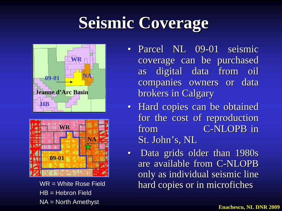
•• Parcel NL 09Parcel NL 09--01 seismic 01 seismic coverage can be purchased coverage can be purchased as digital data from oil as digital data from oil companies owners or data companies owners or data brokers in Calgary brokers in Calgary
•• Hard copies can be obtained Hard copies can be obtained for the cost of reproduction for the cost of reproduction from Cfrom C--NLOPB in NLOPB in St. JohnSt. John’’s, NLs, NL
•• Data grids older than 1980s Data grids older than 1980s are available from Care available from C--NLOPB NLOPB only as individual seismic line only as individual seismic line hard copies or in microficheshard copies or in microfiches
Seismic CoverageSeismic Coverage
WR
NA09-01
HB
Jeanne d’Arc Basin
NA
09-01
WR
WR = White Rose FieldHB = Hebron FieldNA = North Amethyst
Enachescu, NL DNR 2009
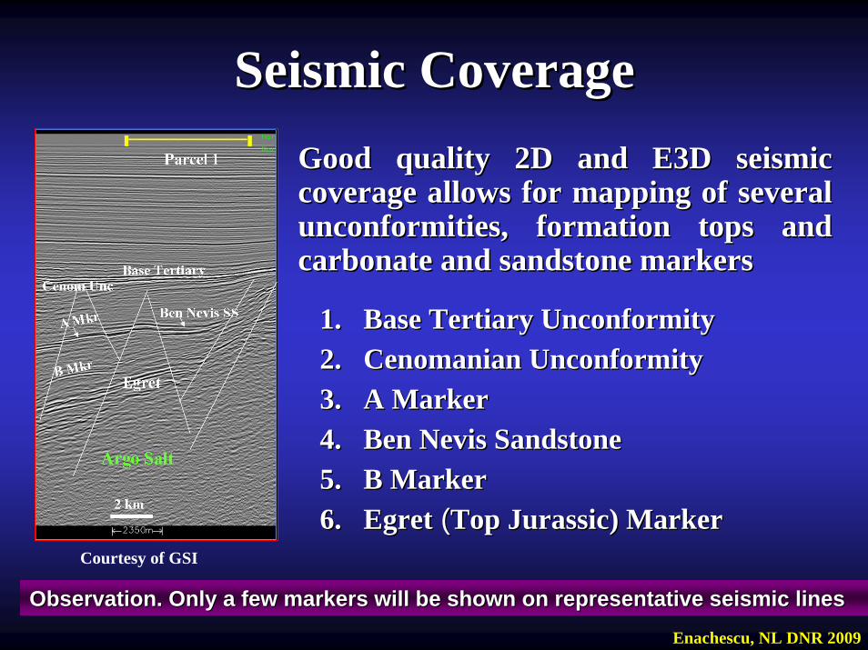
Seismic CoverageSeismic CoverageGood quality 2D and E3D seismic Good quality 2D and E3D seismic coverage allows for mapping of several coverage allows for mapping of several unconformities, formation tops and unconformities, formation tops and carbonate and sandstone markerscarbonate and sandstone markers
1.1. Base Tertiary UnconformityBase Tertiary Unconformity2.2. Cenomanian UnconformityCenomanian Unconformity3.3. A MarkerA Marker4.4. Ben Nevis SandstoneBen Nevis Sandstone5.5. B MarkerB Marker6.6. EgretEgret ((Top Jurassic) MarkerTop Jurassic) Marker
Observation. Only a few markers will be shown on representative Observation. Only a few markers will be shown on representative seismic linesseismic lines
Courtesy of GSI
Enachescu, NL DNR 2009
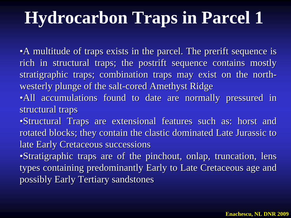
••A multitude of traps exists in the parcel. The prerift sequence A multitude of traps exists in the parcel. The prerift sequence is is rich in structural traps; the postrift sequence contains mostly rich in structural traps; the postrift sequence contains mostly stratigraphic traps; combination traps may exist on the northstratigraphic traps; combination traps may exist on the north--westerly plunge of the saltwesterly plunge of the salt--cored Amethyst Ridgecored Amethyst Ridge••All accumulations found to date are normally pressured in All accumulations found to date are normally pressured in structural trapsstructural traps••Structural Traps are extensional features such as: horst and Structural Traps are extensional features such as: horst and rotated blocks; they contain the clastic dominated Late Jurassicrotated blocks; they contain the clastic dominated Late Jurassic to to late Early Cretaceous successionslate Early Cretaceous successions••Stratigraphic traps are of the Stratigraphic traps are of the pinchoutpinchout, onlap, truncation, lens , onlap, truncation, lens types containing predominantly Early to Late Cretaceous age and types containing predominantly Early to Late Cretaceous age and possibly Early Tertiary sandstonespossibly Early Tertiary sandstones
Hydrocarbon Traps in Parcel 1
Enachescu, NL DNR 2009
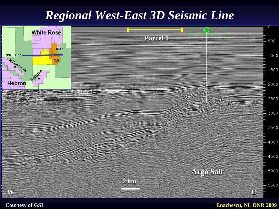
Parcel 1Parcel 1
Argo SaltArgo Salt
WW EE2 km2 km
Regional West-East 3D Seismic Line
Courtesy of GSI Enachescu, NL DNR 2009
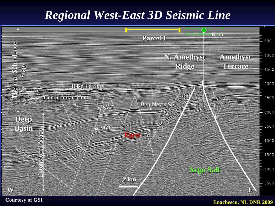
Parcel 1Parcel 1
Base TertiaryBase Tertiary
Cenomanian Cenomanian UncUnc
Argo SaltArgo Salt
A A MkrMkr Ben Nevis SSBen Nevis SS
EgretEgretB B MkrMkr
WW EE2 km2 km
Amethyst Amethyst TerraceTerrace
N. Amethyst N. Amethyst RidgeRidge
Ther
mal
Sub
side
nce
Ther
mal
Sub
side
nce
Stag
eSt
age
Exte
nsio
nal S
tage
Exte
nsio
nal S
tage
Deep Deep BasinBasin
Courtesy of GSI
K-15
Enachescu, NL DNR 2009
Regional West-East 3D Seismic Line
••On the southOn the south--western flank of the White Rose western flank of the White Rose DiapirDiapirand Amethyst Ridge the Late Jurassic Egret source and Amethyst Ridge the Late Jurassic Egret source rocks should be mostly in the mature rangerocks should be mostly in the mature range••The earlier and most recent wells drilled closed to The earlier and most recent wells drilled closed to Parcel 1 prove that mature source rock and migration Parcel 1 prove that mature source rock and migration of hydrocarbons into fault traps took placeof hydrocarbons into fault traps took place••After trap formation there were direct migration After trap formation there were direct migration routes through porous sandstone beds and numerous routes through porous sandstone beds and numerous normal faults from the Egret normal faults from the Egret MbrMbr. shale into younger . shale into younger sandstone reservoirssandstone reservoirs••Older than Egret source rocks are also mature in the Older than Egret source rocks are also mature in the parcelparcel
Enachescu, NL DNR 2009
Maturation and Migration in the Parcel 1
Hydrocarbon Plays in Parcel 1Hydrocarbon Plays in Parcel 1
The White Rose and North Amethyst discovery and The White Rose and North Amethyst discovery and delineation wells proved that a working petroleum system delineation wells proved that a working petroleum system represented by represented by the Egret source rock and the Ben Nevis the Egret source rock and the Ben Nevis Sandstone extends on the western and southSandstone extends on the western and south--western western sides of the White Rose main poolsides of the White Rose main poolThe late rift Ben Nevis sequence deepens south-westward into the basin through numerous steps, creating local horsts and rotated blocks bounded by deep penetrating faultsOlder Late Jurassic and Early Cretaceous sandstones are Older Late Jurassic and Early Cretaceous sandstones are also trapped on the parcelalso trapped on the parcel
Enachescu, NL DNR 2009
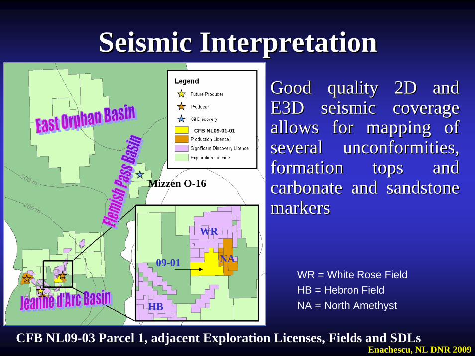
Seismic InterpretationSeismic Interpretation
CFB NL09-03 Parcel 1, adjacent Exploration Licenses, Fields and SDLs
WR
NA09-01
CFB NL09-01-01
HB
Mizzen O-16
Good quality 2D and Good quality 2D and E3D seismic coverage E3D seismic coverage allows for mapping of allows for mapping of several unconformities, several unconformities, formation tops and formation tops and carbonate and sandstone carbonate and sandstone markersmarkers
WR = White Rose FieldHB = Hebron FieldNA = North Amethyst
Enachescu, NL DNR 2009
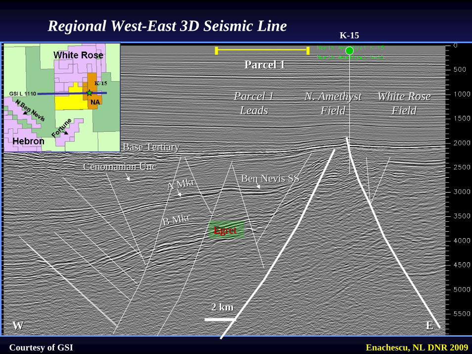
Parcel 1Parcel 1
Base TertiaryBase Tertiary
Cenomanian Cenomanian UncUnc
A A MkrMkr Ben Nevis SSBen Nevis SS
EgretEgretB B MkrMkr
WW EE2 km2 km
White Rose White Rose FieldField
N. Amethyst N. Amethyst FieldField
Parcel 1 Parcel 1 LeadsLeads
Regional West-East 3D Seismic Line
Courtesy of GSI
K-15
Enachescu, NL DNR 2009
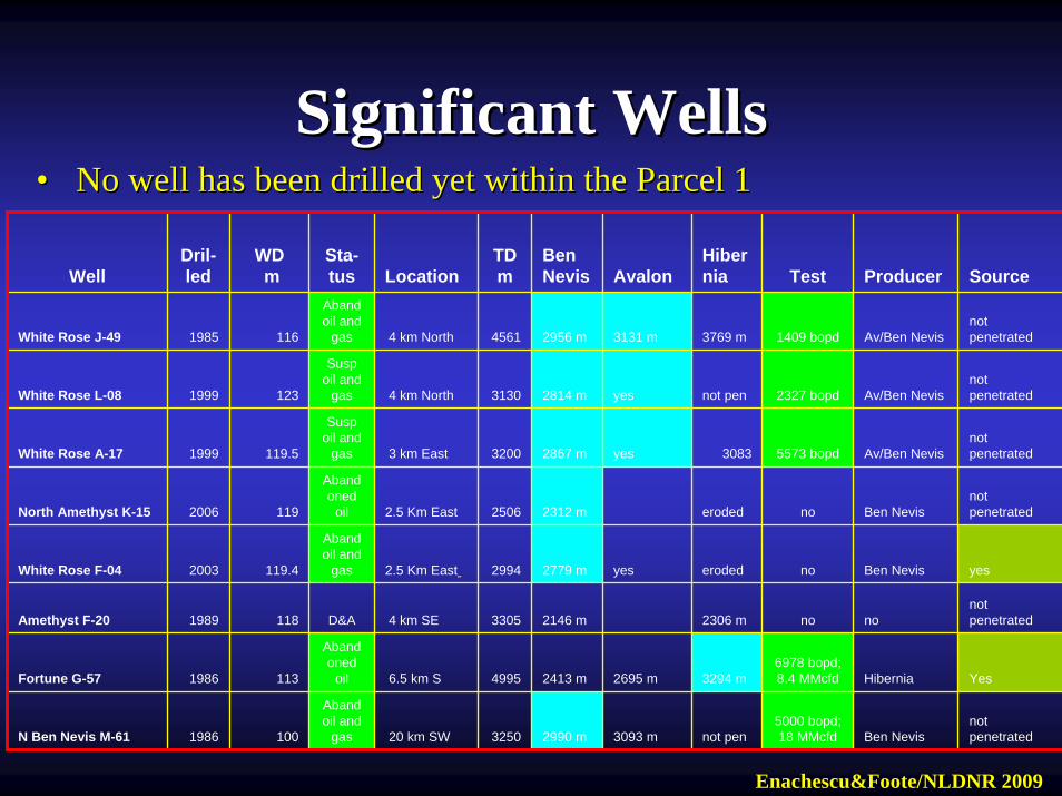
Significant WellsSignificant Wells•• No well has been drilled yet within the Parcel 1No well has been drilled yet within the Parcel 1
Enachescu&Foote/NLDNR 2009
WellDril-led
WDm
Sta-tus Location
TD m
Ben Nevis Avalon
Hibernia Test Producer Source
White Rose J-49 1985 116
Abandoil and
gas 4 km North 4561 2956 m 3131 m 3769 m 1409 bopd Av/Ben Nevisnot penetrated
White Rose L-08 1999 123
Suspoil and
gas 4 km North 3130 2814 m yes not pen 2327 bopd Av/Ben Nevisnot penetrated
White Rose A-17 1999 119.5
Suspoil and
gas 3 km East 3200 2867 m yes 3083 5573 bopd Av/Ben Nevisnot penetrated
North Amethyst K-15 2006 119
Abandoned
oil 2.5 Km East 2506 2312 m eroded no Ben Nevisnot penetrated
White Rose F-04 2003 119.4
Abandoil and
gas 2.5 Km East 2994 2779 m yes eroded no Ben Nevis yes
Amethyst F-20 1989 118 D&A 4 km SE 3305 2146 m 2306 m no nonot penetrated
Fortune G-57 1986 113
Abandoned
oil 6.5 km S 4995 2413 m 2695 m 3294 m6978 bopd; 8.4 MMcfd Hibernia Yes
N Ben Nevis M-61 1986 100
Abandoil and
gas 20 km SW 3250 2990 m 3093 m not pen5000 bopd; 18 MMcfd Ben Nevis
not penetrated
Significant WellsSignificant Wells•• 8 wells drilled in vicinity of Parcel 1 8 wells drilled in vicinity of Parcel 1 •• Fist well JFist well J--49 drilled 1985 last K49 drilled 1985 last K--15 in 200615 in 2006•• 7 out of 8 wells encountered oil and gas7 out of 8 wells encountered oil and gas•• Several well flow tested between 1400 and 7000 bopd with Several well flow tested between 1400 and 7000 bopd with
restrictive equipments; wells in the neighbouring South White restrictive equipments; wells in the neighbouring South White Rose pool are capable of producing 25Rose pool are capable of producing 25--35,000 bopd35,000 bopd
•• Oil wells group in the West White Rose, South White Rose, Oil wells group in the West White Rose, South White Rose, North Amethyst, Fortune and North Ben Nevis poolsNorth Amethyst, Fortune and North Ben Nevis pools
•• Only Amethyst FOnly Amethyst F--20 drilled down dip on a large anticline to test 20 drilled down dip on a large anticline to test its upside was dry missing the crestal oil leg on the Amethyst its upside was dry missing the crestal oil leg on the Amethyst RidgeRidge
•• The North Amethyst KThe North Amethyst K--15 and later E15 and later E--17 intersected the Ben 17 intersected the Ben Nevis sandstone that has better reservoir properties than in Nevis sandstone that has better reservoir properties than in adjacent area to the north and eastadjacent area to the north and east
•• At least half billion barrels discovered around the Parcel 1 At least half billion barrels discovered around the Parcel 1
Seismic InterpretationSeismic Interpretation•• Regional seismic data was tied with synthetic seismograms to Regional seismic data was tied with synthetic seismograms to
several exploration wells situated outside of the Parcel 1 areaseveral exploration wells situated outside of the Parcel 1 area•• Full synrift sequence including reservoir sandstone of Late Full synrift sequence including reservoir sandstone of Late
Jurassic to late Early Cretaceous exist within the Parcel NL09Jurassic to late Early Cretaceous exist within the Parcel NL09--01 01 •• On the illustrative seismic sections only a few markers and On the illustrative seismic sections only a few markers and
formations are displayedformations are displayed•• Potential reservoirs in synrift sequence include the proven Potential reservoirs in synrift sequence include the proven
Hibernia, AvalonHibernia, Avalon--Ben Nevis Sandstones. These are high Ben Nevis Sandstones. These are high producing reservoirs in adjacent fields or contain pay zone in producing reservoirs in adjacent fields or contain pay zone in undeveloped discoveriesundeveloped discoveries
•• Ben Nevis sandstone is the producing reservoir in White Rose, Ben Nevis sandstone is the producing reservoir in White Rose, North Ben Nevis and North Amethyst fieldsNorth Ben Nevis and North Amethyst fields
•• Ben Nevis can be drilled with relatively shallow wells in this Ben Nevis can be drilled with relatively shallow wells in this Parcel (2500Parcel (2500--4000 m)4000 m)
•• Only major faults are affecting the thermal subsidence sequenceOnly major faults are affecting the thermal subsidence sequence
Enachescu, NL DNR 2009
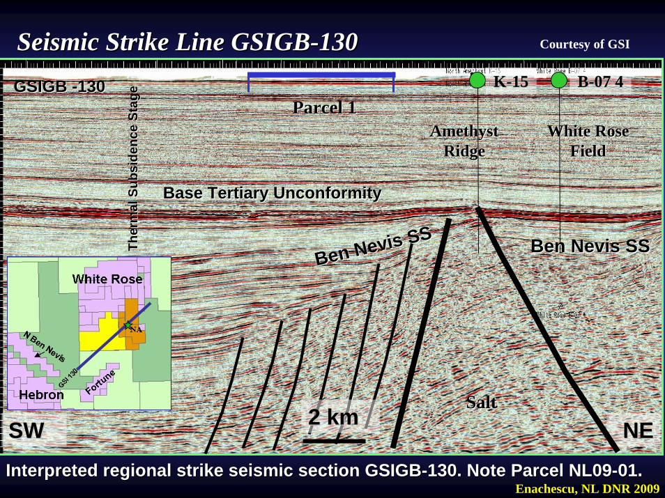
NENE
Amethyst Amethyst RidgeRidge
SaltSalt
SWSW
White Rose White Rose FieldField
Base Tertiary UnconformityBase Tertiary Unconformity
KK--1515 BB--07 407 4
Ben Nevis SSBen Nevis SS Ben Nevis SSBen Nevis SS
GSIGB GSIGB --130130Parcel 1Parcel 1
Interpreted regional strike seismic section GSIGBInterpreted regional strike seismic section GSIGB--130. Note Parcel NL09130. Note Parcel NL09--0101. .
Seismic Strike Line GSIGBSeismic Strike Line GSIGB--130130
2 km2 km
Courtesy of GSI
Enachescu, NL DNR 2009
Ther
mal
Sub
side
nce
Stag
eTh
erm
al S
ubsi
denc
e St
age
Seismic Line GSIGBSeismic Line GSIGB--130130•• This regional strike line (NEThis regional strike line (NE--SW) starts in Crown SW) starts in Crown
Land, crosses the northwestern tip of the EL 1055 , Land, crosses the northwestern tip of the EL 1055 , stretches over the offered stretches over the offered Parcel 1Parcel 1, the N. Amethyst , the N. Amethyst field field -- close to the Kclose to the K--15 discovery well, and then 15 discovery well, and then intersects the southern part of the White Rose oil field intersects the southern part of the White Rose oil field and ends on Crown Landand ends on Crown Land
•• Structurally, the line starts in the deep basin, crosses Structurally, the line starts in the deep basin, crosses the faulted plunge of the Amethyst Ridge, intersects the the faulted plunge of the Amethyst Ridge, intersects the RidgeRidge’’s crestal zone and then the White Rose southern s crestal zone and then the White Rose southern terrace, formed in front of the Voyager Fault Zone terrace, formed in front of the Voyager Fault Zone (outside of this seismic line)(outside of this seismic line)
Enachescu, NL DNR 2009
•• Note the position of Parcel 1 on the Note the position of Parcel 1 on the southwesterly plunge of the Amethyst southwesterly plunge of the Amethyst Ridge with synrift formations affected by Ridge with synrift formations affected by several downseveral down--to the basin normal faultsto the basin normal faults
•• Potential reservoirs in synrift sequence Potential reservoirs in synrift sequence include the proven Jeanne dinclude the proven Jeanne d’’Arc, Hibernia Arc, Hibernia and Avalonand Avalon--Ben Nevis Sandstones. These Ben Nevis Sandstones. These are high producing reservoirs in adjacent are high producing reservoirs in adjacent fields or contain pay zone in undeveloped fields or contain pay zone in undeveloped discoveriesdiscoveries
Seismic Line GSIGBSeismic Line GSIGB--130130
Enachescu, NL DNR 2009
Interpreted N-S E-3D seismic cross-line within parcel NL09-01 and environs (courtesy of GSI). Several rotated blocks bound by normal faults are trapping reservoir beds.
NN--S Seismic E 3D CrosslineS Seismic E 3D CrosslineJJ--4949
Parcel 1Parcel 1
SS2 km2 km
SaltSalt
NN
White Rose FieldWhite Rose Field
West PoolWest Pool
Ben Nevis SSBen Nevis SS
GSI E 3DGSI E 3D
Hibernia SSHibernia SS
EgretEgret
Base Tertiary Base Tertiary UncUnc
Fortune Fortune BlockBlock
Amethyst Ridge Amethyst Ridge PlungePlunge
Cenomanian Cenomanian UncUnc
SaltSalt
Courtesy of GSI
Enachescu, NL DNR 2009
NN--S Seismic E 3D CrosslineS Seismic E 3D Crossline•• This is a E 3D seismic Crossline starting over the White Rose StThis is a E 3D seismic Crossline starting over the White Rose Structure ructure
just north of the Jjust north of the J--49 well that discovered the West White Rose Pool 49 well that discovered the West White Rose Pool •• The Crossline continues over the salt withdrawal miniThe Crossline continues over the salt withdrawal mini--basin between the basin between the
White Rose Structure and the Amethyst Ridge; this miniWhite Rose Structure and the Amethyst Ridge; this mini--basin makes a basin makes a perfect kitchen area for the Egret perfect kitchen area for the Egret MbrMbr source rocksource rock
•• The line then intersects the fault segmented northwestern plungeThe line then intersects the fault segmented northwestern plunge of the of the Amethyst Ridge over Parcel 1, where several rotated blocks trapsAmethyst Ridge over Parcel 1, where several rotated blocks traps are are identified identified
•• The section then terminate within the fault blocks associated toThe section then terminate within the fault blocks associated to the the Fortune Significant Discovery Licence that has hydrocarbons trapFortune Significant Discovery Licence that has hydrocarbons trapped into ped into a two way fault closure at the level of Hibernia. Fortune Ga two way fault closure at the level of Hibernia. Fortune G--57 tested 57 tested 6978 bopd and 8.4 6978 bopd and 8.4 MMcfdMMcfd
•• Within this section, the Egret Source Rock is present as are theWithin this section, the Egret Source Rock is present as are the traditional traditional reservoirs of the JDB; the Jeanne dreservoirs of the JDB; the Jeanne d’’Arc, Hibernia and AvalonArc, Hibernia and Avalon--Ben Nevis Ben Nevis sandstones that may be trapped in onesandstones that may be trapped in one--way, twoway, two--ways and three ways ways and three ways fault closures; some independent closure may also existsfault closures; some independent closure may also exists
•• Stratigraphic trapping of Paleocene sandstones deposited as chanStratigraphic trapping of Paleocene sandstones deposited as channel or nel or basin floor fans may also be presentbasin floor fans may also be present
Enachescu, NL DNR 2009

Interpreted W-E E-3D seismic line within parcel NL09-01 and environs (courtesy of GSI). Several rotated blocks bound by normal faults are trapping reservoir beds.
NN--S Seismic E 3D LineS Seismic E 3D LineFF--0404
Parcel 1Parcel 1
EE2 km2 kmSaltSalt
WW
White Rose FieldWhite Rose Field
South PoolSouth Pool
Ben Nevis SSBen Nevis SS
GSI E 3DGSI E 3D
Hibernia SSHibernia SS
EgretEgret
ChannelChannel
Amethyst Amethyst RidgeRidge
Amethyst Ridge PlungeAmethyst Ridge Plunge
Cenomanian Cenomanian UncUnc
Base Tertiary Base Tertiary UncUnc
FanFan
AA
Deep BasinDeep Basin SaltSalt
EgretEgret
Courtesy of GSI
Enachescu, NL DNR 2009
WW--E Seismic E 3D LineE Seismic E 3D Line•• This is a E 3D seismic Line starting over the Deep Basin, withinThis is a E 3D seismic Line starting over the Deep Basin, within unlicensed land unlicensed land
just north of the North Ben Nevis Oil fieldjust north of the North Ben Nevis Oil field•• The line crosses over into Parcel 1, intersecting a series of roThe line crosses over into Parcel 1, intersecting a series of rotated fault blocks tated fault blocks
bounded by downbounded by down--toto--basin normal faults on the northwesterly plunge of the basin normal faults on the northwesterly plunge of the Amethyst RidgeAmethyst Ridge
•• The line then intersects the North Amethyst field located direcThe line then intersects the North Amethyst field located directly on the crestal tly on the crestal zone of the zone of the Amethyst Ridge. North Amethyst KAmethyst Ridge. North Amethyst K--15 well has a 51 m oil column 15 well has a 51 m oil column and 69 m gas columnand 69 m gas column
•• The section then crosses into the southernmost part of the WhiteThe section then crosses into the southernmost part of the White Rose South Pool Rose South Pool intersecting the Fintersecting the F--04 well location. 04 well location. Both White Rose FBoth White Rose F--04 and F04 and F--04Z encountered 04Z encountered oil and gas in Ben Nevis sandstone extending the South White Rosoil and gas in Ben Nevis sandstone extending the South White Rose poole pool
•• To the east, line terminates into Crown landTo the east, line terminates into Crown land•• Within this section, the Egret Source Rock is present as are theWithin this section, the Egret Source Rock is present as are the traditional traditional
reservoirs of the JDB; the Jeanne dreservoirs of the JDB; the Jeanne d’’Arc, Hibernia and AvalonArc, Hibernia and Avalon--Ben Nevis Ben Nevis sandstones that may be trapped in onesandstones that may be trapped in one--way, twoway, two--ways and three ways fault ways and three ways fault closures; some independent closure may also existsclosures; some independent closure may also exists
•• Stratigraphic trapping of Paleocene sandstones deposited as chanStratigraphic trapping of Paleocene sandstones deposited as channel or basin floor nel or basin floor fans may also be presentfans may also be present
Enachescu, NL DNR 2009
•• AreaArea’’s main hydrocarbon play is structural; it involves porous Ben s main hydrocarbon play is structural; it involves porous Ben Nevis/Avalon sandstones trapped within multiNevis/Avalon sandstones trapped within multi--sided fault bounded sided fault bounded blocksblocks
•• Several fault dependent closures can be mapped within the ParcelSeveral fault dependent closures can be mapped within the Parcel; ; closures are capable of each holding 25 to 50 closures are capable of each holding 25 to 50 mmbblsmmbbls oil oil recoverable depending on trap size and thickness of pay zonerecoverable depending on trap size and thickness of pay zone
•• MultiMulti--pay play is also possible in the areapay play is also possible in the area•• Stratigraphic trapping of Ben Nevis sands may also occur within Stratigraphic trapping of Ben Nevis sands may also occur within the the
parcelparcel•• Source rocks are found at expulsion depths of 3800Source rocks are found at expulsion depths of 3800--5800 beneath 5800 beneath
the individual rotated blocks and within the downdip SW depressithe individual rotated blocks and within the downdip SW depressionon•• Seismic amplitude variations are seen in the late Early CretaceoSeismic amplitude variations are seen in the late Early Cretaceous, us,
Late Cretaceous and Early Tertiary sequences. The variation of Late Cretaceous and Early Tertiary sequences. The variation of seismic amplitude within some of the markers, amplitude anomalieseismic amplitude within some of the markers, amplitude anomalies s around faults and gas chimneys and curtains may indicate flow ofaround faults and gas chimneys and curtains may indicate flow ofhydrothermal solutionshydrothermal solutions
ProspectsProspects and and LeadsLeads
Enachescu, NL DNR 2009
••Production infrastructure exists on this side of the Jeanne dProduction infrastructure exists on this side of the Jeanne d’’Arc Basin Arc Basin where three White Rose glory holes exist, sub bottom well complewhere three White Rose glory holes exist, sub bottom well completion tion was executed since 2003 and where tie back to Sea Rose FPSO can was executed since 2003 and where tie back to Sea Rose FPSO can easily be doneeasily be done••A field larger than 100 million barrels recoverable can also be A field larger than 100 million barrels recoverable can also be a a candidate for a stand alone developmentcandidate for a stand alone development•• While exploration in this part of the Jeanne dWhile exploration in this part of the Jeanne d’’Arc Basin approaches Arc Basin approaches the mature stage, there are many medium side blocks with petrolethe mature stage, there are many medium side blocks with petroleum um potential that remain undrilledpotential that remain undrilled•• Several oil prospects and leads identified in the parcel with pSeveral oil prospects and leads identified in the parcel with postost--1985 1985 seismic data are still waiting to be explored and drilledseismic data are still waiting to be explored and drilled•• Parcel NL09Parcel NL09--01 is well covered by good quality 2D and E 3D 01 is well covered by good quality 2D and E 3D seismic dataseismic data••These data can be easily reprocessed for better structural and These data can be easily reprocessed for better structural and stratigraphic imaging; moreover, prestack and stratigraphic imaging; moreover, prestack and postackpostack analysis of the analysis of the data may help reduce drilling riskdata may help reduce drilling risk••
6. Discussions6. Discussions
Enachescu, NL DNR 2009
•• The presence in vicinity of Fortune, West White Rose and North AThe presence in vicinity of Fortune, West White Rose and North Amethyst methyst fields provides encouragement for the potential of this parcelfields provides encouragement for the potential of this parcel•• These discovery have flown at rates of 1,400These discovery have flown at rates of 1,400--7,000 bopd in discovery tests 7,000 bopd in discovery tests neighbouring White Rose producers are capable of up to 35,000 inneighbouring White Rose producers are capable of up to 35,000 in production production teststests•• CFB NL09CFB NL09--01 Parcel is larger when compared with a Gulf of Mexico 01 Parcel is larger when compared with a Gulf of Mexico standard block (4.1 times larger) or North Sea offeringsstandard block (4.1 times larger) or North Sea offerings•• Parcel is in a region with large extensional traps, known reserParcel is in a region with large extensional traps, known reservoirs, mature voirs, mature source rocks and proven migration pathssource rocks and proven migration paths•• Risks are recognized in regard to reservoir quality and fault sRisks are recognized in regard to reservoir quality and fault sealingealing•• Parcel contains multiple reservoir targets within synrift sandsParcel contains multiple reservoir targets within synrift sandstones reservoirs tones reservoirs at 2500at 2500--4500 m depth that can be drilled year round and tested using jac4500 m depth that can be drilled year round and tested using jackk--ups ups or semior semi--submersible rigssubmersible rigs••Location of prospects in a shallow water environment certainly lLocation of prospects in a shallow water environment certainly lowers the owers the economic riskeconomic risk•• Cost of an offshore well in this Parcel would likely be in the Cost of an offshore well in this Parcel would likely be in the range of Can $25 range of Can $25 -- $45 million depending on the depth to the target$45 million depending on the depth to the target
DiscussionsDiscussions
Enachescu, NL DNR 2009
ConclusionsConclusions•• One large parcel, within the oil prolific Jeanne dOne large parcel, within the oil prolific Jeanne d’’Arc Basin is available for licensing in Arc Basin is available for licensing in the Cthe C--NLOPBNLOPB’’s s Call for Bids NL09Call for Bids NL09--0101 which closes on which closes on November 19, 2009, 4 p.m. November 19, 2009, 4 p.m. NL timeNL time••Parcel is surrounded by 4 oil fields, some in development some aParcel is surrounded by 4 oil fields, some in development some awaiting development waiting development or further drilling; or further drilling; over half billion barrels were discovered around the parcelover half billion barrels were discovered around the parcel•• Parcel contains synrift clastics and carbonates including proveParcel contains synrift clastics and carbonates including proven source and reservoir n source and reservoir rocksrocks•• Close to the landsale area, Ben Nevis sandstones flowClose to the landsale area, Ben Nevis sandstones flow--tested oil and gas at several tested oil and gas at several White Rose wells and also contains oil and gas in the North AmetWhite Rose wells and also contains oil and gas in the North Amethyst and North Ben hyst and North Ben Nevis fieldsNevis fields•• Similar fault bounded, rotated block trapSimilar fault bounded, rotated block trap--type is viable in parcel NL09type is viable in parcel NL09--01 together 01 together with other favourable stratigraphic trapping possibilities for swith other favourable stratigraphic trapping possibilities for sandstone reservoirsandstone reservoirs•• Several contiguous hydrocarbon filled tilted blocks, at the BenSeveral contiguous hydrocarbon filled tilted blocks, at the Ben Nevis or/and Hibernia Nevis or/and Hibernia levels may form a stand alone field development levels may form a stand alone field development ••Additional potential may exist in Late Cretaceous and Early TertAdditional potential may exist in Late Cretaceous and Early Tertiary stratigraphic trapsiary stratigraphic traps••Main source rock for the area Main source rock for the area -- the Egret Member the Egret Member -- exists in the mature range within exists in the mature range within the identified tilted blocks or in adjacent depressionsthe identified tilted blocks or in adjacent depressions••Good quality and dense 2D and E 3D seismic coverage is availableGood quality and dense 2D and E 3D seismic coverage is available in the parcel to in the parcel to image and adequately map hydrocarbon trapsimage and adequately map hydrocarbon traps
Enachescu, NL DNR 2009
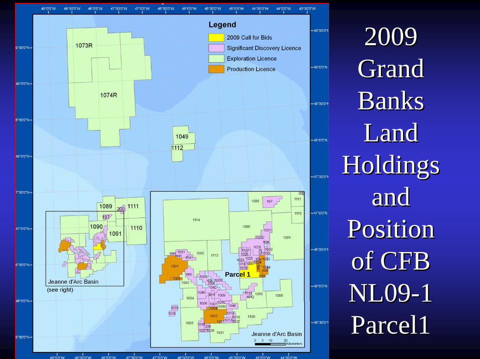
2009 2009 Grand Grand Banks Banks Land Land
Holdings Holdings and and
Position Position of CFB of CFB NL09NL09--1 1 Parcel1Parcel1
Parcel 1

ConclusionsConclusions•• Recognized risks in regard to reservoir quality and fault seal Recognized risks in regard to reservoir quality and fault seal are mitigated by the are mitigated by the presence of relatively large undrilled features and the presencepresence of relatively large undrilled features and the presence of adjacent oil and gas of adjacent oil and gas accumulationsaccumulations••Geological risk can also be reduce by using preGeological risk can also be reduce by using pre--stack and poststack and post--stack seismic analysis stack seismic analysis and CSEM methodsand CSEM methods••All the prospects and leads in the parcel are located in water dAll the prospects and leads in the parcel are located in water depth varying between epth varying between 90 90 --110 m and close to existing infrastructure and can be drilled wi110 m and close to existing infrastructure and can be drilled with relatively th relatively shallow wells (2500shallow wells (2500--4000 m)4000 m)•• The half dozen prospective tilted blocks located in Parcel NL09The half dozen prospective tilted blocks located in Parcel NL09--01 are undrilled. 01 are undrilled. They can significantly add to the Jeanne dThey can significantly add to the Jeanne d’’Arc Basin recoverable reserves in the range Arc Basin recoverable reserves in the range of several hundred million barrelsof several hundred million barrels••This parcel constitutes a large exploration block situated in shThis parcel constitutes a large exploration block situated in shallow water suitable for allow water suitable for jack up rigs in an area with proven oil accumulationsjack up rigs in an area with proven oil accumulations••The parcel will give a new entrant operator in the area an excelThe parcel will give a new entrant operator in the area an excellent opportunity of lent opportunity of participating in a proven oil play located in the most rewardingparticipating in a proven oil play located in the most rewarding basin of Canadabasin of Canada’’s East s East Coast;Coast;•• For an existing operator the parcel provides a great occasion tFor an existing operator the parcel provides a great occasion to increase its o increase its prospective portfolio and add significant oil reservesprospective portfolio and add significant oil reserves
Enachescu, NL DNR 2009
Thank You for your Attention!Thank You for your Attention!
Euxinic Exploration
Enachescu, NL DNR 2009