Embed Size (px)
Citation preview
____________________DOI: 10.2112/SI75-XXX.1 received Day Month Year; accepted in revision Day Month Year.*Corresponding author: [email protected]©Coastal Education and Research Foundation, Inc. 2016
Journal of Coastal Research SI 75 XX-XX Coconut Creek, Florida 2016
Perspectives on the Long-Term Equilibrium of a Wave Dominated Coastal Zone Affected by Tsunamis
Patricio L. Tavares †§*, Rodrigo Garcia‡§, Ana P. Lopez‡, and Mauricio C. Saval††‡
†Departamento de Obras CivilesUniversidad Técnica Federico Santa MaríaValparaíso, Chile
‡Departamento de Ingeniería Hidráulica y AmbientalPontificia Universidad Católica de ChileSantiago, Chile
††Departamento de Ingeniería CivilUniversidad Católica de la Santísima ConcepciónConcepción, Chile
§Centro Nacional para la Investigación en Gestión Integrada de Desastres Naturales, CIGIDEN
Santiago, Chile
ABSTRACT
Tavares, P.L.; Garcia, R.; Lopez, A.P., and Saval, M.C., 2016. Perspectives on the long-term equilibrium of a wave dominated coastal zone affected by tsunamis. In: Vila-Concejo, A.; Bruce, E.; Kennedy, D.M., and McCarroll, R.J. (eds.), Proceedings of the 14th International Coastal Symposium (Sydney, Australia). Journal of Coastal Research, Special Issue, No. 75, pp. XX-XX. Coconut Creek (Florida), ISSN 0749-0208.
The capability to predict the long term evolution of coastal state parameters can be severely affected by neglecting major geomorphic forcings. Among these, the effect of tsunamis as been largely neglected along the Chilean coast. In this contribution, we present a qualitative and descriptive assessment of the sudden change induced by the tsunami on a coastal location in Central Chile, and the consequent recovery process. The latter is driven mostly by strong wave forcing, with a very fast recovery capacity. The necessity and consequences of including tsunamis in long term evaluations for coastal morphology are briefly discussed.
ADDITIONAL INDEX WORDS: Morphological change, morphological recovery, tsunamis.
INTRODUCTIONOne of the main objectives of coastal and nearshore science is
to have the capacity to predict coastal state parameters. Having such capacity is relevant not only for basic science purposes, but also because it would allow improved development and assessment of coastal infrastructure; and enhanced policies for coastal management and planning, among others. However, this is not an easy task, because a wide range of spatial and temporal timescales concur and interact in the nearshore, regardless of whether fluid, morphological or fully coupled approaches are considered.
Typically, an a priori discrimination on the approach to be used is taken, based on the timescales and length scales to be resolved. In this way, a purely fluid based approach is used when the timescales are relatively short, of the order of a few wave periods, when it is assumed that morphological changes are minimal and would have little effect on the hydrodynamics. However, even at this short scales, some significant changes can take place that would have cumulative consequences on the overall behavior of the system. As a response to this, models with partial feedback or fully coupled can be used instead, but typically this approach is somewhat costly in terms of computational time and resources. For long-term evolution, one of the key aspects is to follow the evolution of shorelines, which
are related to changes in the large scale conditions of the
systems. One of the most typical examples are many current assessments of the impact of climate change on the coastal zone, where modeled trends and changes in wave forcing and mean water levels are estimated as bulk quantities over relatively large domains and timespans. These estimations in turn, can be used to assess the impact of the phenomenon on the coastal environment through several methodologies. As an example, model estimates of mean water level change along the Chilean coast typically do not exceed 30 cm level increase (Church et al., 2013), but even these moderate changes could induce erosive adjustments along the coast, and could trigger a cascade of affectations to coastal morphology and infrastructure.
What is being relevant in this assessment is that a very long time scale of evaluation is being considered (in this case, ~100 years), with a process, which can be considered very gradual in terms of its impact. But within the same time frame, large earthquakes and destructive tsunamis affect several coasts around the world, including the Chilean coast. These episodic events can induce significant effects at the local morphological level at very short time scales (over a few minutes) but over relatively large spatial scales (~100 kilometers). Earthquakes can also induce coseismic deformation over large areas and longitudinal extent of the coastal zone, even without triggering a tsunami. If a tsunami occurs, the strong hydrodynamic forcing associated can have large sediment transport capacity, also affecting the coast at more local scales. In this regard, some researchers have proposed that long lasting coastal tsunamigenic imprints could be used to reconstruct incomplete tsunami records (e.g., Bryant et al., 1996; Gianfreda et al., 2001; Scheffers and Kelletat, 2003). The underlying assumption is that tsunamis do have the capability to alter permanently coastal
www.JCRonline.org
www.cerf-jcr.org
XX Tavares et al._________________________________________________________________________________________________
morphology. In contrast, Kench et al. (2008) argue that tsunamis can affect short- and mid-term seasonal dynamics of beaches, but that the effect decays in time leaving no long-term imprints. Liew et al. (2010) supports this idea and suggest that no intervention is needed to recover coastal environments, as they would do in short times. Clearly, a consensus has not been reached yet.
When a tsunami strikes, the coastal environment can be affected by a sudden departure of its quasi-equilibrium state and a new equilibrium state needs to be reached. The relaxation time of those systems is uncertain and can be affected by a wide range of conditions, such as sediment supply, forcing strength, and the coastal configuration, among others (Liew et al., 2010). Consequently, incorporating these events in long-term assessments of coastal evolution is of paramount importance for coastlines subject to recurrent earthquakes.
Although this fact has been long recognized in several areas of the world, the most prominent data to date are related to the two large tsunamis of 2004 Indian Ocean tsunami; and 2011 Great Eastern Japan tsunami. Observations suggest that the effect and rate of change of the response could vary among different locations and coastal configurations. Liew et al. (2010) monitored the recovery process of Banda Aceh area after 2004 Indian Ocean tsunami, identifying six different morphological configurations. They found very short relaxation times (fast recovery) of the coastline and beaches, whereas river mouths and coastal lagoons were the slowest. Choowong et al. (2009) and Paris et al. (2009) also observed variability in the response, with beaches recovering very vast, and some sand barriers being restored to a significant degree less than a year later. More recently, Adityaman and Tanaka (2013), Liu (2013), and Tanaka et al. (2012) observed changes at local scale post the Tohoku 2011 event in Japan, and followed the recovery process, although they focused on the shoreline evolution of beaches and river mouths. One relevant aspect is that in some cases, a new equilibrium state was reached, typically under the influence of coastal structures.
In the present work, we present a qualitative assessment of the rate of change observed in the coastal zone of Mataquito, after the February 27, 2010 Maule Earthquake and Tsunami. This area can be described as a wave dominated coast (Davis and Hayes, 1984). While mostly descriptive in its scope, the evolution of the system highlights a highly resilient system, capable of recovering over very short time periods (hence short relaxation time), reaching a similar configuration to that of before the event.
METHODSOn February 27, 2010, a Mw 8.8 earthquake hit central Chile
causing widespread damage but relatively few casualties despite its magnitude (Madariaga et al., 2010). The epicenter was located offshore Maule but the rupture area, at the interface between the Nazca and South America plates, extended over several hundreds of kilometers (e.g., Vigny et al., 2011). The massive rupture generated devastating tsunami waves that affected more than 600 km of the Chilean coastline and the Archipelago Juan Fernández, located 660 km offshore Valparaíso. Coastal communities were severely hit during
several hours after the shock (Fritz et al., 2011; Yamazaki and Cheung, 2011).
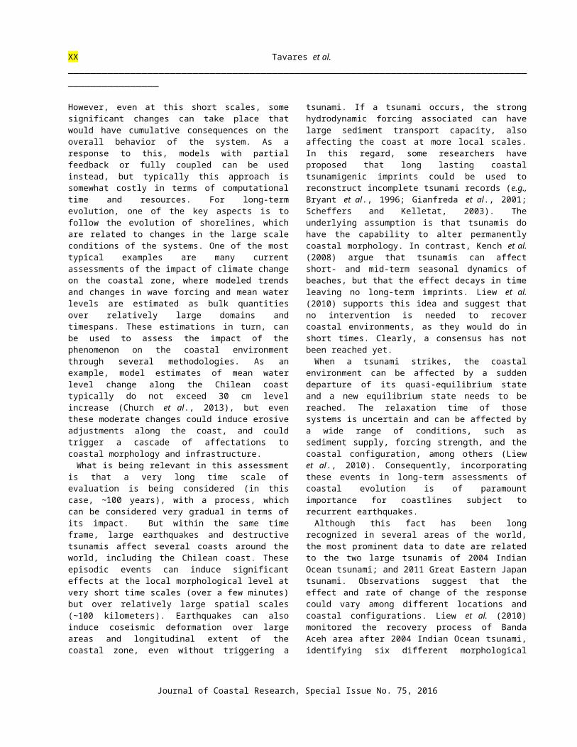
Figure 1. Study area and estimated location of the epicenter of the Feb. 27, 2010 Maule earthquake. Right images correspond to estuaries characteristic of the central Chile coast.
The event had complex slip pattern along the interplate fault, which was highly inhomogeneous along the 500 km long and 200 km wide rupture zone as estimated by different inversion methods and sources (e.g., Farías et al., 2010; Vigny et al., 2011), with at least two uplift spots: one offshore Bucalemu (34º39'S, 72º03'W) and the other inland Cobquecura (36º08'S, 72º47'W). Numerical modeling of the event suggests that tsunami waves could have had multiple focal origins. As tsunami waves propagated towards the coast, additional complexities arose because of the steep continental shelf and the numerous submarine canyons, embayments and headlands present in the Chilean central-south coast (e.g., Aránguiz, 2012; Yamazaki and Cheung, 2011). Despite the large earthquake magnitude, the tsunami was relatively moderate, with average runup of about 10 m, much less than those generally observed in the 2004 Indian Ocean Tsunami and 2011 Great Eastern Tsunami. In contrast to Maule tsunami, morphologic studies following those events were carried out in locations with inundation levels typically in excess of 10 m, and runups above 30m where not unusual.
On the other hand, river mouths in central Chile are characterized by strong interactions between sporadic but large flooding events from Andean rivers, resulting in significant sediment discharges to the Pacific Ocean. Under normal conditions, these sediments are redistributed by longshore currents generated by south-west dominant waves. This typically results in the formation of sand spits or coastal barriers, giving origin to estuaries, lagoons or wetlands when river discharge is low. Examples of these typical configurations can be found in the estuaries of the rivers Mataquito, Llico, Boyeruca and Bucalemu, near the area of interest of this work, (as seen in Figure 1) but they are ubiquitous between latitudes 33-40ºS.
Journal of Coastal Research, Special Issue No. 75, 2016
Perspectives on the Long-Term Equilibrium of a Coast Affected by Tsunamis XX_________________________________________________________________________________________________
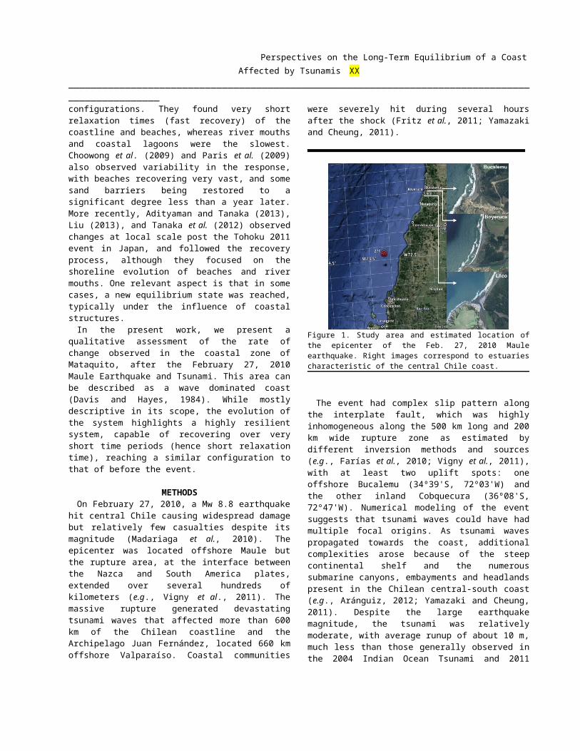
Figure 2. (a) Aerial view of the Mataquito River Mouth after the 2010 earthquake and tsunami. (b) Morphological changes in the Mataquito River Mouth. (c) Gauge level at the DGA Licantén River Station. (d) Tsunumi runup measurements along the Mataquito east river bank.
Tidal currents influence coastal morphology in such systems, but in a much lesser extent since tidal amplitudes in central Chile ranges between 1-2 m, hence microtidal.
The Mataquito River Mouth (34º58'S, 72º2'W) is a narrow and shallow bar-built estuary located almost halfway between the uplift spots of Cobquecura and Bucalemu (Figure 2a). Before the earthquake, the morphologic configuration was characterized as a long sand spit pointing to the north, forcing the river to run parallel to the shoreline over ca. 9 km, enclosed by the barrier and a range of coastal hills (Figure 2b). The area had been largely unaffected by human endeavors, and it has an ample supply of sediment both from alongshore transport from the Mataquito and Maule rivers, as from the nearby Dunas de Putú, a large dune field located just south of the estuary. According to satellite images, aerial photographs and field surveys, the spit geometry was estimated to be 2-3 m in height, with a mean width of 130-150 m and an emerging sand volume of ca. 2 x10⁶ m3, yielding an average volume of 220 m3/m. An overview of the pre-2010 sand spit evolution based on sporadic photographs of the site, showed that it remained essentially stable since the previous large earthquake, the Mw 9.5 1960 Valdivia event, with a slow migration of the sand spit tip towards the north. This prompted coastal intervention with a small groin during the early 2000s. In Figure 2c can also be seen the tsunami signature on a river gauge located a few kilometers upstream of the estuary (DGA, 2010). There was no hard nor anecdotal evidence of the sand barrier being subject to large erosional processes due to wave action.
We conducted surveys in the area of the Mataquito estuary early on 2010, where we measured water marks, runup levels and inundation lines as part of the Tsunami Survey Team (Fritz et al., 2011). Measured run up were in the 6-8 m range
and water level in the 4-7 m range. These values were significantly less than the 36 m runup that affected the study area of Lhok Nga (Paris et al., 2009), the 10-12 m water levels estimated in Banda Aceh (Liew et al., 2010) but compare well with those the Vellar estuary (Pari et al., 2008). It is of note, however, that the latter is considered far field.
Anecdotal eyewitness reports indicate that around 20 minutes after the shock, a south-to-north large amplitude but slow surge, was observed without causing significant damage. Two additional bore-like waves arrived within the following 20 to 30 min running parallel to the coast from opposite directions.
Despite these moderate water levels and runup, it was readily observable (as seen in Figure 2b and 2c, taken in April 2010) that the estuary was affected by a complete system reset, on which the sand spit was completely washed away. It is considered that most of this change is due to the tsunami action, as the estimated coseismic subsidence in nearby Duao (ca. 10 Km to the north) is about 1 m (Farías et al., 2010), therefore less than the estimated sand spit height. The effect of subsidence of about 0.8 m can also be seen in the river gauge record seen in Figure 2c. Despite the large amount of sand removed, no clear indication of sand deposition in the lowlands east of the original river was found, either at this location or further south. It is assumed then that most of the sediment was thus carried offshore.
As a result of the change, waves were breaking over the prior location of the sand spit but continued to propagate towards the former east bank of the river. A series of complementary environmental surveys carried out between 12 March and 10 May (2010) showed changes in water density, temperature and salinity, emphasizing the tsunami impact on the estuary dynamics.
XX Tavares et al._________________________________________________________________________________________________
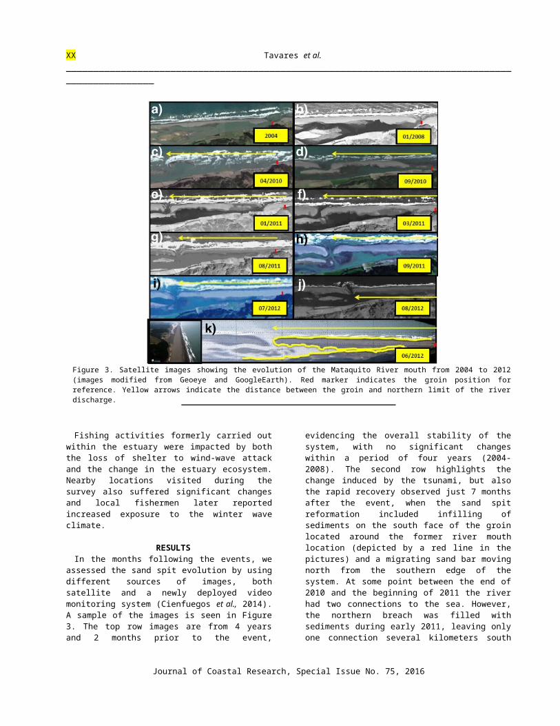
Figure 3. Satellite images showing the evolution of the Mataquito River mouth from 2004 to 2012 (images modified from Geoeye and GoogleEarth). Red marker indicates the groin position for reference. Yellow arrows indicate the distance between the groin and northern limit of the river discharge.
Fishing activities formerly carried out within the estuary were impacted by both the loss of shelter to wind-wave attack and the change in the estuary ecosystem. Nearby locations visited during the survey also suffered significant changes and local fishermen later reported increased exposure to the winter wave climate.
RESULTSIn the months following the events, we assessed the sand
spit evolution by using different sources of images, both satellite and a newly deployed video monitoring system (Cienfuegos et al., 2014). A sample of the images is seen in Figure 3. The top row images are from 4 years and 2 months prior to the event, evidencing the overall stability of the system, with no significant changes within a period of four years (2004-2008). The second row highlights the change induced by the tsunami, but also the rapid recovery observed just 7 months after the event, when the sand spit reformation included infilling of sediments on the south face of the groin located around the former river mouth location (depicted by a red line in the pictures) and a migrating sand bar moving north from the southern edge of the system. At some point between the end of 2010 and the beginning of 2011 the river had two connections to the sea. However, the northern breach was filled with sediments during early 2011, leaving only one
connection several kilometers south of its former exit, next to the groin. Aside from this difference in the placement of the river outlet, the overall configuration of the system was similar to prior the event (compare the configuration of January 2008 with that of January 2011), indicating an extremely fast recovery in less than one year. Subsequent images show again a rather stable system, where the sand spit grows at a lower rate and also a slow migration of the river outlet to the north is apparent.
After three years, the sand spit is completely reformed, encircling the river and leaving only a narrow outlet to ensure the river discharge to the sea. It is important to note, that the location of the outlet is still several kilometers south from the location it had prior to the tsunami event, and the groin that was erected to stabilize the inlet is now buried under sand. The once eroding beach at the groin site has now grown and is nearly 100 m. wide.
A quick quantitative estimation of the recovery process can be performed based on the area coverage of the sand spit when observed in plan view. Although this methodology neglects the actual height of the dunes (hence volume), it can be used as a proxy for the recovery. To do this, we selected a rectangular control area spanning most of the northern section of the sand spit. The evolution of the areal coverage is shown in Figure 4, where it can be seen that the tsunami induced a
Journal of Coastal Research, Special Issue No. 75, 2016
Perspectives on the Long-Term Equilibrium of a Coast Affected by Tsunamis XX_________________________________________________________________________________________________sudden loss of coverage, but the system quickly replenished the surface, to levels similar to those prior the event. An overall asymptotic trend can be observed, with a rapid change during the first few months, and then a gradual increase more recently, suggesting the near equilibrium state.
During these years, the area has been characterized by a persistent drought (Villagrán et al., 2011). Because of the lesser relative influence of the river discharge, the system reformed to a configuration that is now more close to a costal lagoon than it was before the tsunami. Once the sand spit encircled the river, it started to evolve much slower, probably because a new quasi-equilibrium state was reached.
DISCUSSIONWhile morphological changes along the central-south
Chilean coastline produced by the February 2010 earthquake and tsunami are certainly eye-catching, they seem to be a rule more than an exception since similar patterns have been reported by Darwin after the 1835 earthquake (Darwin, 1846) and after the 1960 Valdivia earthquake and tsunami (Weischet, 1963a,b), although these works focus more on the coseismic deformation rather than local scale morphological changes. Similarly, significant erosion has been reported for the large tsunamis in the Indian Ocean and in Japan. However, despite the Maule tsunami being more moderate than those events, no other event has recorded such level of volumetric erosion. Paris et al. (2009) report cross-sectional volumes eroded reaching up to 80 m3/m, whereas here the mean volume eroded was about 220 m3/m. Even if a 1 m subsidence is taken into account, the eroded volume still exceeds 100 m3/m.
Figure 4. Estimates of areal coverage by the sand dune as a function of time. Dates are given relative to the time of the event. Shaded areas indicate different calendar years, and keys at the bottom correspond to images in Figure 3.
The area affected can be described as an open coast with a barrier beach with a coastal lagoon, according to the six types of coast defined by Liew et al. (2010); identified by areas where beaches were completely eroded and the coast pushed back to the location of the inland bank of the river. Sand barriers as this were eroded also in India (away from the
coseismic deformation, Pari et al., 2008) and Japan (Nanakita River, Tanaka et al., 2012). They have been described to be eroded also in the 1755 tsunami in Portugal (Andrade, 1992).
However, the evolution of these other sites has been variable. The recovery of the Vellar estuary was considered a slow process by Pari et al., (2008), whereas Liu (2013) obtains a large recovery rate of about 70% within 4 months at Nanakita River. For the case of Mataquito, the recovery rate presented here is also fast, although slightly less than that of Liu (2013). However, care must be taken when comparing these rates since it is necessary to take into account that the surface eroded was twice that of Nanakita. If area coverage is considered, the recovery rate here was of 90,000 m2/month, whereas in Nanakita it was roughly 13,000 m2/month (Li, 2013)
It must be noted as well, that the behavior of sand barriers such as Mataquito have been considered to behave different to that of beaches (e.g., Liew et al., 2010). Beaches in turn have shown very fast recovery rates both in Indian Ocean and in Japan tsunamis, including bayhead, parabolic and straight coast beaches. In addition, beaches have been reported to have very fast recovery rates under other events such as hurricanes (e.g., Wang et al., 2006) or during normal cycles of erosion under storms (e.g., Thom and Hall, 1991). In particular, Thom and Hall (1991) report cross-sectional beach volumes of the same order as the original configuration of the sand barrier. They observed an accretion phase composed of a very fast recovery that gradually slowed down in time, similar to the trends observed here. However, the main difference is the degree of erosion induced by the tsunami, which nearly doubles the one observed by Thom and Hall (1991).
In summary, the large magnitude of the erosive process and its fast recovery makes this case a unique scenario that should be studied in more detail, addressing for instance, the conditions that favored such recovery rates. On one hand, open coasts like this offer ample accommodation space for the sediment to be deposited, even if no inland deposition is considered. Goto et al. (2011) suggest that the surfzone is one of the main areas of sediment supply, and also a receptor of sediments transported during the tsunami. Therefore, the sediment deposited can be transported by wave driven processes which can be enhanced in a wave dominated coast such as the Chilean, providing conditions for these geomorphologic crises to be reversed in relatively short times.
Whether the end state of the system will be similar to that prior is still needs to be determined. However, a brief analysis can be made on this regard with a few assumptions. First, it is possible to assume the forcing to remain constant. In the present case, the wave climate energy levels should not be affected by the tsunami, although the coseismic deformation could eventually induce changes in the coastal morphology affecting the latter stages of wave propagation. Secondly, the assumption that the tsunami does not affect sediment supply and it only represented a sudden redistribution of sediment, which was then available to be relocated by currents and wave action. If these were true, it could be expected that in within a certain period of time, the system will approach a configuration similar to the prior quasi-equilibrium state. Indeed, this appears to have been the situation observed here. Anecdotal accounts in other areas north of Mataquito, such as
XX Tavares et al._________________________________________________________________________________________________
Boyeruca (cf., Figure 1) also suggested recovery to pre-tsunami conditions with short relaxation times. The high energy wave climate of the study area and the lack of evidence of sediment deposition inland suggest that the conditions were best suited for a short relaxation time.
However, care must be taken when these processes are considered in unison with other processes over longer time periods. For instance, the recurrence of these large tsunamis in the southern coast of Chile is about 50 years or more. On the other hand, varying sea level and wave climate owing to climate change is analyzed within a 100-year window. It is possible to speculate that system resets separated over a century could be restored by different wave conditions. Moreover, the case study presented herein suggests that even moderate tsunamis can have a significant impact on coastal morphology. Hence, it is possible that a change in forcing between resets could lead to different quasi-equilibrium configurations or different recovery period of coastlines.
CONCLUSIONSIn this work we present a case study of severe coastal
erosion under the action of a moderate tsunami following the 2010 Maule Earthquake in Central Chile. A qualitative assessment of the recovery process of a sand barrier shows a recovery to nearly initial conditions within two years, with the most accelerated recovery phase during the first few months.
Comparison of these results with those observed in two other events show that a degree of variability in the expected recovery rates is present. Despite the differences in recovery time, our results point in the direction that coastal morphology is generally resilient to these sudden changes, an aspect that is considered relevant for the long term analysis and the ability to predict medium to long term coastal morphology. It is speculated that this is due to the high energy levels of the wave climate in the region.
It is noted that care must be taken when these events are considered in unison with other sources of coastal change with different time scales such as varying sea level or coseismic land level changes. While trends can be estimated for sea level change, the random nature of earthquakes and their land deformation signatures and the effects of their associated tsunamis, makes it difficult to assess its effects. More research and monitoring activities are needed on this regard.
ACKNOWLEDGMENTSThis publication is one of the results of the Latin American
Regional Network global collaborative project ‘‘EXCEED – Excellence Center for Development Cooperation – Sustainable Water Management in Developing Countries’’ consisting of 35 universities and research centres from 18 countries on 4 continents. The authors would like to acknowledge the support of the German Academic Exchange Service DAAD, the Centro de Tecnologia e Geociências da Universidade Federal de Pernambuco, the Fundação de Amparo a Ciência e Tecnologia do Estado de Pernambuco-FACEPE and the Instituto de Ingeniería of the Universidad Nacional Autónoma de México for their participation in this EXCEED project.
This work has been funded by the Chilean National Science and technology Committee CONICYT through the Fondecyt project N°1120878. Mauricio Villagran has been supported by CONICYT through a PhD scholarship. The CONICYT/FONDAP/15110017 program is also acknowledged.
LITERATURE CITEDAdityawan, M.B. and Tanaka, H., 2013. Shoreline changes at
Sendai port due to the great northeast Japan tsunami of 2011. Coastal Dynamics, 45(1), 63-72.
Andrade, C., 1992. Tsunami generated forms in the Algarve barrier islands. Science of Tsunami Hazards, 10(1), 21-34.
Aranguiz, R., 2012. The effect of a submarine canyon on tsunami propagation in the Gulf of Arauco, Chile. Proceedings of the 33th International Conference on Coastal Engineering (Santander, Spain), pp. 5-10.
Bryant, E.A.; Young, R.W., and Price, D.M., 1996. Tsunami as a major control on coastal evolution, southeastern Australia. Journal of Coastal Research, 14(4), 831-840.
Choowong, M.; Phantuwongraj, S.; Charoentitirat, T.; Chutakositkanon, V.; Yumuang, S., and Charusiri, P., 2009. Beach recovery after 2004 Indian Ocean tsunami from Phang-nga, Thailand. Geomorphology, 104(3-4), 134 -142.
Church, J.A.; Clark P.U.; Cazenave, A.; Gregory, J.M.; Jevrejeva, S.; Levermann, A.; Merrifield, M.A.; Milne, G.A.; Nerem, R.S.; Nunn, P.D.; Payne, A.J.; Pfeffer, W.T.; Stammer, D., and Unnikrishnan, A.S., 2013. Sea-level change. In: Stocker, T.F.; Qin, D., Plattner, G.-K.; Tignor, M.; Allen, S.K.; Boschung, J.; Nauels, A.; Xia, Y.; Bex, V., and Midgley, P.M. (eds.), Climate Change 2013: The Physical Science Basis. Contribution of Working Group I to the Fifth Assessment Report of the Intergovernmental Panel on Climate Change. Cambridge, United Kingdom: Cambridge University Press, 369p.
Cienfuegos, R.; Villagran, M.; Aguilera, J.C.; Catalán, P.; Castelle, B., and Almar, R., 2014. Video monitoring and field measurements of a rapidly evolving coastal system: the river mouth and sand spit of the Mataquito River in Chile. In: Green, A.N. and Cooper, J.A.G. (eds.), Proceedings of the 13th International Coastal Symposium (Durban, South Africa). Journal of Coastal Research, Special Issue No. 70, 455-460.
Darwin, C., 1846. Geological observations on South America. London: United Kingdom: Smith, Elder, and Co., 280p.
Davis Jr., R.A. and Hayes, M.O., 1984. What is a wave-dominated coast? Marine Geology, 60(4), 313-329.
DGA, 2010. Licantén Station at Mataquito River. Dirección General de Aguas (DGA), Ministerio de Obras Públicas (General Water Directorate of the Ministry of Public Works), Chile, 34p.
Farías, M.; Vargas, G.; Tassara, A.; Carretier, S.; Baize, S.; Melnick, D., and Bataille, K., 2010. Land-level changes produced by the Mw 8.8 2010 Chilean Earthquake. Science, 329(599), 916-925.
Fritz, H.; Petroff, C.; Catalán, P.A.; Cienfuegos, R.; Winckler, P.; Kalligeris, N.; Weiss, R.; Barrientos, S.; Meneses, G.; Valderas-Bermejo, C.; Ebeling, C.; Papadopoulos, A.;
Journal of Coastal Research, Special Issue No. 75, 2016
Perspectives on the Long-Term Equilibrium of a Coast Affected by Tsunamis XX_________________________________________________________________________________________________
Contreras, M.; Almar, R.; Dominguez, J., and Synolakis, C., 2011. Field survey of the 27 February 2010 Chile Tsunami. Pure and Applied Geophysics, 168, 1989-2010.
Gianfreda, F.; Mastronuzzi, G., and Sanso, P., 2001. Impact of historical tsunamis on a sandy coastal barrier: An example from the northern Gargano coast, southern Italy. Natural Hazards and Earth System Sciences, 1(4), 213-219.
Goto, K.; Takahashi, J.; Oie, T., and Imamura, F., 2011. Remarkable bathymetric change in the nearshore zone by the 2004 Indian Ocean tsunami: Kirinda Harbor, Sri Lanka. Geomorphology, 97(1-2), 107-116.
Kench, P.; Nichol, S.; Smithers, S.; McLean, R., and Brander, R., 2008. Tsunami as agents of geomorphic change in mid-ocean reef islands. Geomorphology, 95(3-4), 361-383.
Liu, H., 2013. Dynamic changes of coastal morphology following the 2011 Tohoku Tsunami. Geomorphology, 99(3-4), 371-393.
Liew S.; Gupta A.; Wong P., and Kwoh L., 2010. Recovery from a large tsunami mapped over time: The Aceh coast, Sumatra. Geomorphology, 96(5), 520-529.
Madariaga, R.; Métois, M.; Vigny, C., and Campos, J., 2010. Central Chile finally breaks. Science, 328(5975), 181-182.
Pari, Y.; Murthy, M.R.; Kumar, S.J.; Subramanian, B., and Ramachandran, S., 2008. Morphological changes at Vellar estuary, India: Impact of the December 2004 tsunami. Journal of Environmental Management, 89(1), 45-57.
Paris, R.; Wassmer, P.; Sartohadi, J.; Lavigne, F.; Barthomeuf, B.; Desgages, E.; Grancher, D.; Baumert, P.; Vautier, F., and Brunstein, D., 2009. Tsunamis as geomorphic crises: Lessons from the December 26, 2004 tsunami in Lhok Nga, West Banda Aceh (Sumatra, Indonesia). Geomorphology, 96(1-2), 59-72.
Scheffers, A. and Kelletat, D., 2003. Sedimentologic and geomorphologic tsunami imprints worldwide—a review. Earth-Science Reviews, 63(1-2), 83-92.
Tanaka, H.; Tinh, N.X.; Umeda, M.; Hirao, R.; Pradjoko, E.; Mano, A., and Udo, K., 2012. Coastal and estuarine morphology changes induced by the 2011 Great East Japan earthquake tsunami. Coastal Engineering Journal, 54(1), 12-17.
Thom, B.G. and Hall, W., 1991. Behaviour of beach profiles during accretion and erosion dominated periods. Earth Surface Processes and Landforms, 16(2), 113-127.
Vigny, C.; Socquet, A.; Peyrat, S.; Ruegg, J.-C.; Metois, M.; Madariaga, R.; Morvan, S.; Lancieri, M.; Lacassin, R., and Campos, J., 2011. The 2010 Mw 8.8 Maule megathrust earthquake of central Chile, monitored by GPS. Science, 332(6036), 1417-1421.
Villagrán, M.; Cienfuegos, R.; Almar, R.; Gironás, J.; Catalán, P.; Camaño A., and Dominguez J.C., 2011. Natural post tsunami recovery of Mataquito river mouth after 2010 Chilean Tsunami. Proceedings of the 2011 AGU Fall Meeting Conference (San Francisco, California), pp. 21-32.
Wang, P.; Kirby, J.H.; Haber, J.D.; Horwitz, M.H.; Knorr, P.O., and Krock, J.R., 2006. Morphological and sedimentological impacts of Hurricane Ivan and immediate poststorm beach recovery along the northwestern Florida barrier-island coasts. Journal of Coastal Research, 22(6), 1382-1402.
Weischet, W., 1963. The distribution of the damage caused by the earthquake in Valdivia in relation to the form of the terrane. Bulletin of the Seismological Society of America 53(6), 1259-1264.
Weischet, W., 1963. Further observations of geologic and geomorphic changes resulting from the catastrophic earthquake of May 1960, in Chile. Bulletin of the Seismological Society of America, 53(6), 1237-1257.
Yamazaki, Y. and Cheung, K.F., 2011. Shelf resonance and impact of near-field tsunami generated by the 2010 Chile earthquake. Geophysical Research Letters, 38(1), 65-74.

![AN EQUILIBRIUM CHARACTERIZATION OF THE TERM … · AN EQUILIBRIUM CHARACTERIZATION OF THE TERM ... (1969)] by a stochastic differential equation ... Solutions of partial differential](https://img.pdfslide.us/doc/110x75/5b580bee7f8b9aec628bd80b/an-equilibrium-characterization-of-the-term-an-equilibrium-characterization.jpg)