Embed Size (px)
Citation preview

PERIODIC REVIEW
JH Baxter & Co Inc. Site Facility Site ID#: 2068
5015 Lake Washington Boulevard North
Renton, Washington 98056
Northwest Region Office
TOXICS CLEANUP PROGRAM
April, 2017

Washington Department of Ecology
1.0 INTRODUCTION ..................................................................................................... 1 2.0 SUMMARY OF SITE CONDITIONS........................................................................ 2
2.1 Site Description and History .............................................................................................2 2.2 Site Investigations and Sample Results ........................................................................... 4 2.3 Cleanup Actions ............................................................................................................... 5 2.4 Cleanup Levels................................................................................................................. 6 2.5 Environmental Covenants .................................................................................................7
3.0 PERIODIC REVIEW .............................................................................................. 10 3.1 Effectiveness of Completed Cleanup Actions.................................................................10 3.2 New Scientific Information for Site Hazardous Substances ...........................................10 3.3 New Applicable Laws for Site Hazardous Substances ...................................................10 3.4 Current and Projected Site Use ...................................................................................... 13 3.5 Availability and Practicability of Higher Preference Technologies .............................. 13 3.6 Availability of Improved Analytical Methods ............................................................... 13
4.0 CONCLUSIONS .................................................................................................... 16 4.1 Next Review ................................................................................................................... 16
5.0 REFERENCES ...................................................................................................... 16 6.0 APPENDICES ....................................................................................................... 17
6.1 Site Vicinity Map ........................................................................................................... 18 6.2 Site Plan and Parcel Locations ....................................................................................... 19 6.3 Former Impacted Soil Areas and Remedies ....................................................................20 6.4 Former Groundwater Monitoring Wells .........................................................................21 6.5 Existing Groundwater Compliance Monitoring Wells ...................................................22 6.6 Former Remediation Areas, I&M Plan Areas, and Cap Types .......................................23 6.7 Environmental Covenants ...............................................................................................24 6.8 Photo Log ....................................................................................................................... 34

Washington Department of Ecology
1.1 INTRODUCTION
This document summarizes a review by the Washington State Department of Ecology (Ecology) of post-cleanup site conditions and monitoring data to ensure that human health and the environment are being protected at the JH Baxter & Co Inc. Site (Site). Cleanup at this Site was implemented under the Model Toxics Control Act (MTCA) regulations, Chapter 173-340 Washington Administrative Code (WAC).
Cleanup activities at this Site were completed under Prospective Purchaser Consent Decrees (Consent Decrees No. 00-2-11779-5 KNT and 00-2-11778-7). The cleanup actions resulted in concentrations of polycyclic aromatic hydrocarbons (PAHs) remaining at the Site which exceed MTCA cleanup levels. The MTCA cleanup levels for soil are established under WAC 173-340- 740. The MTCA cleanup levels for groundwater are established under WAC 173-340-720. WAC 173-340-420 (2) requires that Ecology conduct a periodic review of a Site every five years under the following conditions:
(a) Whenever the department conducts a cleanup action (b) Whenever the department approves a cleanup action under an order, agreed order or
consent decree (c) Or, as resources permit, whenever the department issues a no further action opinion,
and one of the following conditions exists:
1. Institutional controls or financial assurance are required as part of the cleanup; 2. Where the cleanup level is based on a practical quantitation limit; or 3. Where, in the department’s judgment, modifications to the default equations or
assumptions using Site-specific information would significantly increase the concentration of hazardous substances remaining at the Site after cleanup or the uncertainty in the ecological evaluation or the reliability of the cleanup action is such that additional review is necessary to assure long-term protection of human health and the environment.
When evaluating whether human health and the environment are being protected, the factors the department shall consider include [WAC 173-340-420(4)]:
(a) The effectiveness of ongoing or completed cleanup actions, including the effectiveness
of engineered controls and institutional controls in limiting exposure to hazardous substances remaining at the Site;
(b) New scientific information for individual hazardous substances of mixtures present at the Site;
(c) New applicable state and federal laws for hazardous substances present at the Site; (d) Current and projected Site use; (e) Availability and practicability of higher preference technologies; and (f) The availability of improved analytical techniques to evaluate compliance with cleanup
levels. The Department shall publish a notice of all periodic reviews in the Site Register and provide an opportunity for public comment.

Washington Department of Ecology
JH Baxter & Co Inc Periodic Review
April 2017 Page 2
2.0 SUMMARY OF SITE CONDITIONS
2.1 Site Description and History
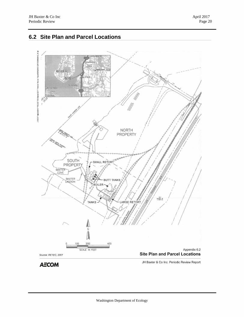
The JH Baxter & Co Inc. Site (Site) is located on the southeastern shore of Lake Washington at 5015 Lake Washington Boulevard Northeast in Renton, Washington. A site vicinity map is provided as Appendix 6.1. A wood treatment plant formerly operated at this 20-acre site from 1955 until it was closed in 1982. Plant operations included use of chemicals commonly associated with industrial treatment of wood, including creosote for railroad ties and pilings and pentachlorophenol (PCP) for poles. The northern portion of the Site (referred to as the North Baxter Property/North Parcel) was primarily used for storage of untreated poles and pilings. The southern portion of the Site (referred to as the South Baxter Property/South Parcel) produced treated wood upon demand and temporarily stored treated wood prior to shipment by rail or truck. A site plan showing the parcel locations is provided as Appendix 6.2.
A site assessment was conducted in 1983 in preparation for potential site development. The site assessment identified compounds of concern as PAHs and PCP in site soils and groundwater. In 1988, Ecology and J.H. Baxter entered into a legal agreement to perform a remedial investigation. The purpose of the investigation was to determine the nature and extent of contamination at the Site. In 1990, Ecology found PAHs and PCP contamination in sediments of Lake Washington adjacent to the property. This sediment contamination was concentrated in the southern third of the property.
The North Baxter Property and South Baxter Property were separated by a “Line of Demarcation” in a Renton-Baxter Remediation Security Interest Agreement in 1992 due to having separate facilities and different functions of operation. The North Baxter Property occupies approximately 12 acres, three miles south of the junction of Interstate Highways 405 and 90. The North Baxter Property has relatively flat topography and is situated within the northern portion of a roughly 70-acre alluvial plain at the former delta of May Creek bordering the Lake Washington shoreline. The Misty Cove Condominiums are located directly to the north of the North Baxter Property. Ecology found that no further action was required for the North Baxter Property predicated on adequate ground cover being provided prior to redevelopment. The South Baxter Property is located directly to the south of the North Baxter Property. The South Baxter Property occupies approximately 7 acres. The South Baxter Property also has relatively flat topography and is bounded by a mitigation wetland and Lake Washington to the west. The site layout and location of the north and south parcels is illustrated on a figure provided as (Appendix 6.2).
On May 18, 2000, Ecology entered into prospective purchaser consent decrees with the Port Quendall Company (PQC), an entity associated with Vulcan Inc., for both the North and South Baxter properties (Consent Decrees No. 00-2-11778-7 and 00-2-11779-5 KNT, respectively), and PQC subsequently purchased the Site from J.H. Baxter. The consent decrees resolve the potential liability of PQC for contamination associated with the former activities at the facility and allow it to prepare the Site for eventual development. In May 2002, Ecology reviewed and

Washington Department of Ecology
JH Baxter & Co Inc Periodic Review
April 2017 Page 3
approved the Engineering Design Report (EDR) for both the upland and underwater portions of the South Baxter Property consistent with the Cleanup Action Plan (CAP). In February 2004, Ecology approved the contractor plans and specifications for the upland portion of the South Baxter Property. In 2006, Ecology issued a Partial Certificate of Completion for the South Baxter Site.
The Quendall Terminals Property, which became an EPA-lead CERCLA site in 2006, is located directly to the south of the South Baxter Property. Further to the south is the property formerly occupied by Barbee Mill, which is being redeveloped for residential use by Conner Homes. In 2007 and 2008, Football Northwest (FNW) constructed the Virginia Mason Athletic Center (VMAC) on the North and South Baxter properties. The VMAC serves as the headquarters and practice facility for the Seattle Seahawks football program, and the address of that facility is now referred to as 12 Seahawks Way.
The Site is located within the Puget Sound Basin, which is situated between the Olympic Mountains to the west and the northern Cascade Range to the east. The regional topography and subsurface geology have been extensively shaped by Pleistocene glaciation (Galster & Laprade, 1991) which has produced a very complex mixture of drift, till and outwash sediments combined with fluvial, lacustrine and mud flow deposits.
The Site is located on the eastern shore of Lake Washington on the former delta of May Creek, which is an underfit stream remaining within the glacial Kennydale Channel. Subsurface soils have been segregated into three zones: the upper fill zone, the intermediate silty peat zone, and the lower sand zone. These three zones comprise the subsurface interval, parts of which have been impacted by past site activities that could influence groundwater movement through an impacted area.
The fill zone includes dredged material consisting primarily of silty to medium-grained sand, as well as imported material including clay, silt, sand, gravel, construction rubble, wood and other debris. The intermediate silty peat zone is comprised of soft to stiff, dark brown to gray silty peat, organic woody silt and silty fine-grained sand with interbedded gray and brown clay, silt, sand and occasional ash lenses. This layer shows a high degree of heterogeneity both vertically and horizontally and is saturated over most of its depth. The lower sand zone consists of gray, dense to medium dense, fine- to coarse-grained sand and gravel with cobbles and interbedded gray and brown silty fine-grained sand and silty lenses. The lower sand zone is underlain by soft gray clay to the south and bedrock to the north.
The shallow groundwater that intercepts the upper fill and silty peat zones is relatively stable and generally occurs at depths of less than 10 feet with seasonal variations of less than 3 feet. The average hydraulic gradient across the site is approximately 0.006 ft/ft toward the west. The gradient is notably steeper in the northeastern corner of the North Baxter property, likely due to the presence of shallow bedrock there. The hydraulic conductivity estimates for the silty peat zone ranged from 0.4 to 31.2 feet per day (ft/day) with an estimated average of 8.2 ft/day. The heterogeneity of the silty peat zone is reflected in the large range of the estimated values. The lower estimates are associated with silt and clay lenses, whereas the higher values are associated
Washington Department of Ecology
JH Baxter & Co Inc Periodic Review
April 2017 Page 4
with sand lenses. The estimated hydraulic conductivity in the lower sand zoned range from approximately 5.7 ft/day and 56.7 ft/day.
2.2 Site Investigations and Sample Results
Several investigations have been performed at the Site, generating a large volume of chemical data and visual observations of soil quality. Comprehensive summaries of project area historical information, regulatory records and environmental data have been provided in the Draft Remedial Investigation Report (Woodward Clyde, 1990). In the FS (ThermoRetec, 2000), this existing data was incorporated with data collected by ThermoRetec during the previous due diligence process and by ThermoRetec during the fourth quarter of 1998 to develop an interpretation of current site conditions. A summary of the FS findings is provided below.
Constituents of Concern The compounds of concern at the South Baxter Property were determined to be PCP and PAHs. These compounds are known to exist in both soil and groundwater at the Site as well as in the sediment of Baxter Cove. In addition, dioxins are known to exist at PCP-impacted sites. While dioxin/furan isomers were detected, in general, only more chlorinated, less toxic compounds were encountered at this Site (Woodward Clyde, 1990). Because dioxins and furans are known to be co-located with PCP, addressing source area PCP, and capping residual soil impacts, are expected to sufficiently address any concerns related to dioxins.
Soil Impacts The highest concentrations of PAHs and PCP in soil coincided with the approximate locations of former site operations. The concentrations of PAHs and PCP tended to decrease with depth in these areas. Downgradient of the former operation areas (e.g., BAX-6), soil impacts generally occurred near the groundwater interface. This suggested that soil contamination in these areas may be a result of groundwater transport. Former operational structures are shown in the site plan provided as Appendix 6.2. Former impacted soil areas and associated remedies are shown on the figure provided as Appendix 6.3.
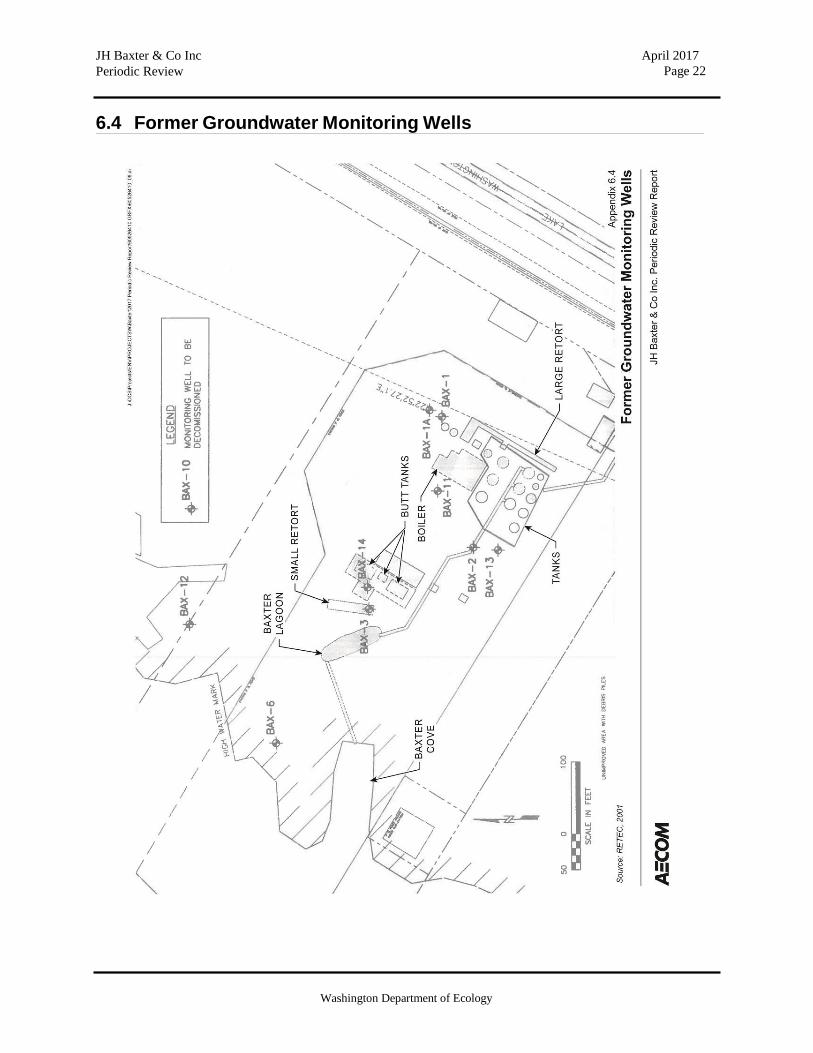
Groundwater Quality Past activities at the South Baxter Property resulted in impacts to groundwater quality. Chemical compounds detected in groundwater include PAHs and PCP and dense non-aqueous phase liquid (DNAPL) was also evident within the saturated zone. DNAPL was observed in monitoring well BAX-14 during the October 1998 sampling event, prior to well decommissioning and remediation of the Site. NAPL has not been observed at the Site during groundwater compliance monitoring events.
Areas with detected PAHs were observed to be associated with former operation areas. Because naphthalene is more mobile than chrysene, naphthalene was also found further downgradient. The only detection of PCP occurred at BAX-14, in the vicinity of the butt tanks, on the upland portion of the Site. Carcinogenic PAHs (cPAHs) were detected in several monitoring wells prior to 1990, but were only detected in wells BAX-1 and BAX-14 in 1990. Detected cPAH compounds included benzo(a)anthracene, benzo(a)pyrene, chrysene and combined benzo(b)- and

Washington Department of Ecology
JH Baxter & Co Inc Periodic Review
April 2017 Page 5
benzo(k)fluoranthene. Former groundwater monitoring wells are shown on a figure provided as Appendix 6.4.
Sediment Quality Sediment data from multiple investigations (Ecology 1986; EPA1983; (Ecology and Environment, 1986; Woodward Clyde, 1990; Norton, 1992) was incorporated with data collected by ThermoRetec ( 1997) near the North Baxter Property demarcation line and near the de-barker along the shoreline of North Baxter Property. These samples confirmed that PAH and PCP contamination was restricted to the interior of Baxter Cove.
2.3 Cleanup Actions
Cleanup on the South Baxter Property included excavation and treatment/disposal of soils and sediments, in-place soil solidification in former process areas, capping of residual soil impacts, and creation of a 0.46-acres forested wetland to enhance shoreline habitat with a 50-foot wide wetland butter. In March 2009, AECOM certified in a Construction Completion Report that PQC was in substantial compliance with North and South Baxter Property consent decrees, CAP, and the EDR. The remedy selected for the South Baxter Property, as described in the CAP, consisted of the following actions:
• DNAPL removal from source areas prior to soil stabilization (BAX- 14); • Excavation of LNAPL-impacted soil to a depth of 6 to 7 feet below ground surface (bgs)
near the former tank farm based on an action level of 1,000 mg/kg total PAH (TPAH) followed by thermal treatment or off-site disposal of soil to provide a reduction in contaminant volume and to remove a long-term source of groundwater impacts;
• Removal and incineration of Listed Hazardous Waste from Baxter Lagoon; • Removal and thermal treatment or off-site disposal of impacted sediment exceeding the
action level of 100 mg/kg TPAH from Baxter Cove to prevent exposure to aquatic organisms;
• In-situ soil stabilization of NAPL-impacted soil near the butt tanks and Baxter Lagoon based on an action level of 1,000 mg/kg TPAH to remove a long-term source of groundwater impacts;
• Re-creation of wetlands adjacent to Lake Washington and buffer restoration and enhancement; impact avoidance to species listed as threatened under the Endangered Species Act through hydraulic isolation of the project work and the timing of in-water work;
• Capping of residual soil impacts during development to prevent direct contact by humans and institutional controls to ensure cap integrity into the future;
• Monitoring of groundwater and implementation of a compliance monitoring program to ensure that groundwater discharging to Lake Washington is protective; and
• Implementation of institutional controls to prevent future groundwater extraction and to ensure that any future breaching of the environmental cap is performed in accordance with the Environmental Covenant and the· Soil Management Plan.

Washington Department of Ecology
JH Baxter & Co Inc Periodic Review
April 2017 Page 6
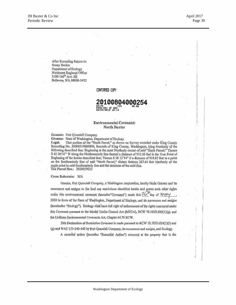
Environmental covenants were recorded for both the South and North Baxter Properties on August 4, 2010. Ecology issued a No Further Action determination for the JH Baxter & Co Inc Site on December 1, 2010, and the Site was subsequently removed from Ecology’s Hazardous Sites List on December 13, 2010.
As required by the CAP, ongoing work has included periodic groundwater monitoring and wetland and shoreline monitoring and maintenance. Existing groundwater compliance monitoring wells are shown on the figure provided as Appendix 6.5. Periodic cap inspection of the different environmental cap types is performed. A Soil Management Plan (SMP) associated with these covenants addresses protocols for Site post development penetration of the environmental caps and excavation of contaminated soil located below the environmental caps and indicator layer. The SMP addresses health and safety standards, soil stockpiling, analytical testing, soil reuse or disposal options, and structure and cap maintenance.
A cap inspection and maintenance (I&M) plan (attached as Appendix Q to the CAP) details the I&M requirements for the environmental caps at the North and South Baxter properties. The final cap types constructed include:
• Field Cap: This cap consists of the three outdoor natural turf practice fields and one
indoor artificial turf practice field • Concrete Slab Cap: This cap consists of the concrete structural slab of the office building,
concrete slab of the maintenance building and concrete sidewalk • Asphalt Pavement Cap: This cap consists of areas that include pedestrian access, surface
parking and roadways • Landscape Cap: This cap consists of areas used for planting beds, public viewing, sand
filters, bioretention swales and hardscape areas • Membrane Cap: This cap consists of utility easement area and other areas along the
eastern edge of the property boundary
The purpose of the I&M plan is to ensure future maintenance of the cap in a manner that complies with all of the objectives of the cap. The I&M plan area and the location of the five cap types are shown in relation to former remediation areas on the figure provided as Appendix 6.6.
2.4 Cleanup Levels
MTCA Method B cleanup levels were established as appropriate for the Site in the FS and CAP. Method B criteria are defined as “applicable to all sites” to protect public exposure to impacted areas of the Site. Soil cleanup levels are based on human exposure via direct contact, and are identified in Table 3-1.
Groundwater cleanup levels are based on protection of surface water. Cleanup standards for Site groundwater are generally MTCA Method B surface water cleanup levels with the point of compliance located at the shoreline. Groundwater cleanup levels selected in the CAP are identified in Table 3-2.

Washington Department of Ecology
JH Baxter & Co Inc Periodic Review
April 2017 Page 7
The chemical cleanup level for sediment at the South Baxter Property was established using site- specific bioassay data developed by Ecology in accordance with the Sediment Management Standards (SMS).
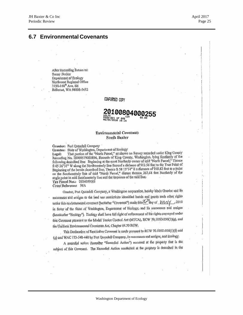
2.5 Environmental Covenants
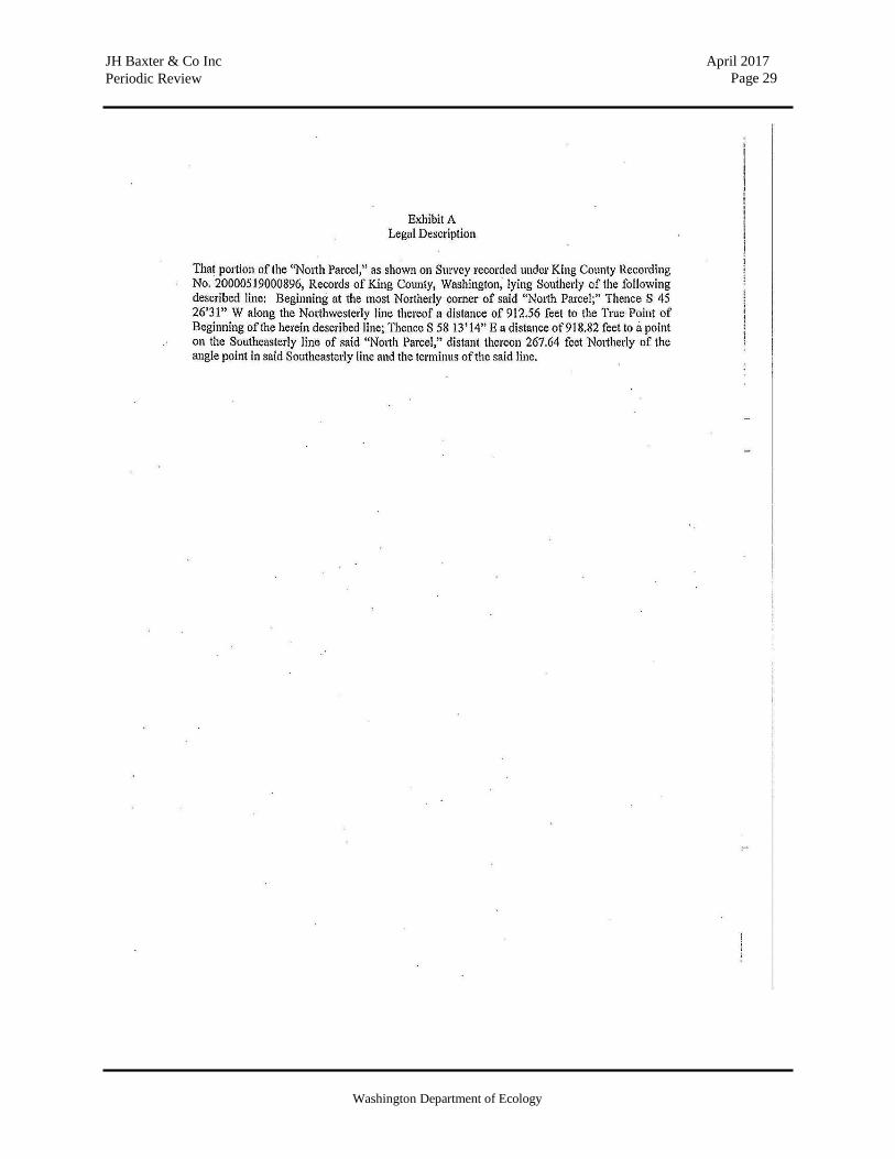
Based on the Site use, surface cover and cleanup levels, it was determined that the Site was eligible for a ‘No Further Action’ determination if Environmental Covenants were recorded. Environmental Covenants were recorded for both the North and the South Baxter Properties in 2010. The Environmental Covenant for the North Baxter Property imposed the following limitations:
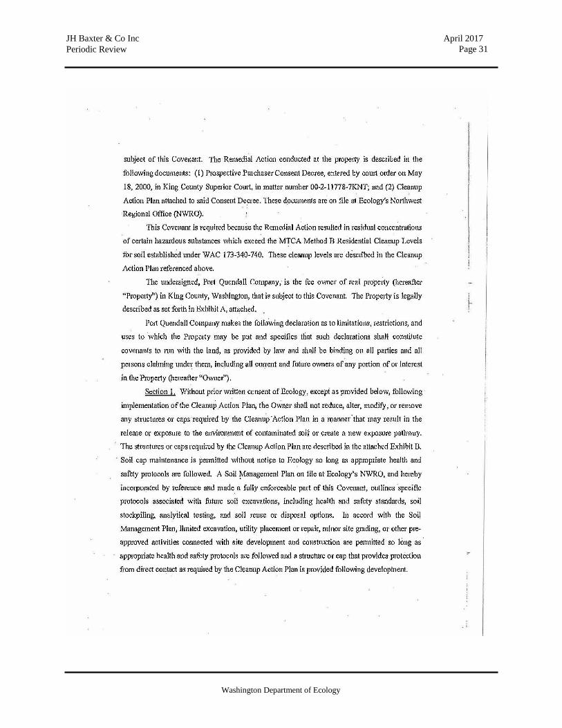
1. Without prior written consent of Ecology, except as provided below, following ·
implementation of the CAP, the Owner shall not reduce, alter, modify, or remove any structures or caps required by the CAP in a manner that may result in the release or exposure to the environment of contaminated soil or create a new exposure pathway. Soil cap maintenance is permitted without notice to Ecology so long as appropriate health and safety protocols are followed. The SMP on file at Ecology's NWRO is a fully enforceable part of the Covenant and outlines specific protocols associated with future soil excavations, including health and safety standards, soil stockpiling, analytical testing, and soil reuse or disposal options. Limited excavation, utility placement or repair, minor site grading, or other pre-approved activities connected with site development and construction are permitted so long as appropriate health and safety protocols are followed and a structure or cap that provides protection from direct contact as required by the CAP.
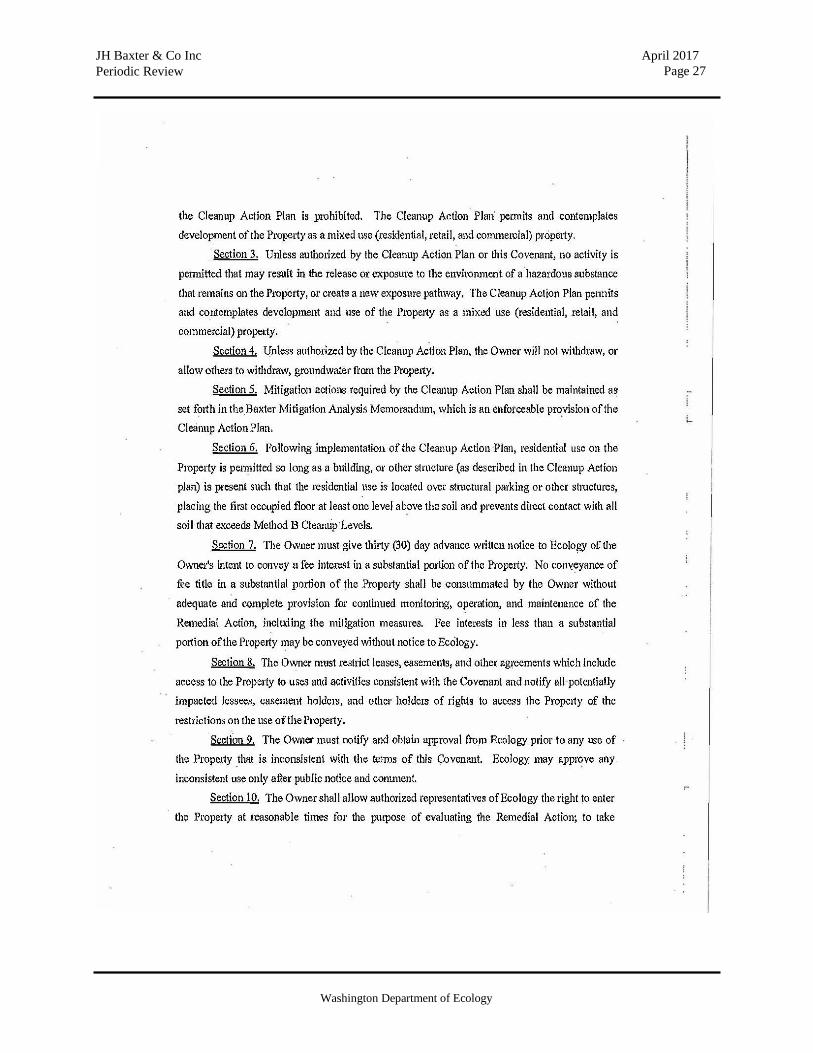
2. Any activity on the Property that may interfere with the integrity of the Remedial Action and continued protection of human health and the environment is prohibited. The CAP permits and contemplates development of the Property as a mixed use (residential, retail, and commercial) property.
3. Unless authorized by the CAP or the Covenant, no activity is permitted that may result in the release or exposure to the environment of a hazardous substance that remains on the Property, or create a new exposure pathway.
4. Unless authorized by the CAP, the Owner will not withdraw, or allow others to withdraw, groundwater from the Property.
5. Following implementation of the CAP, residential use on the Property is permitted so long as a building or other structure is present such that the residential use is located over structural parking or other structures, placing the first occupied floor at least one level above the soil and prevents direct contact with all soil that exceeds Method B Cleanup Levels.
6. The Owner must give thirty (30) day advance written notice to Ecology of the Owner's intent to convey a fee interest in a substantial portion of the Property. No conveyance of fee title in the Property shall be consummated by the Owner without adequate and complete provision for continued monitoring and maintenance of the Remedial Action. Fee interests in less than a substantial portion of the Property may be conveyed without notice to Ecology.

Washington Department of Ecology
JH Baxter & Co Inc Periodic Review
April 2017 Page 8
7. The Owner must restrict leases, easements, and other agreements which include access to the Property to uses and activities consistent with the Covenant and notify all potentially impacted lessees, easement holders, and other holders of rights to access the Property of the restrictions on the use of the Property.
8. The Owner must notify and obtain approval from Ecology prior to any use of the Property that is inconsistent with the terms of the Covenant. Ecology may approve any inconsistent use only after public notice and comment.
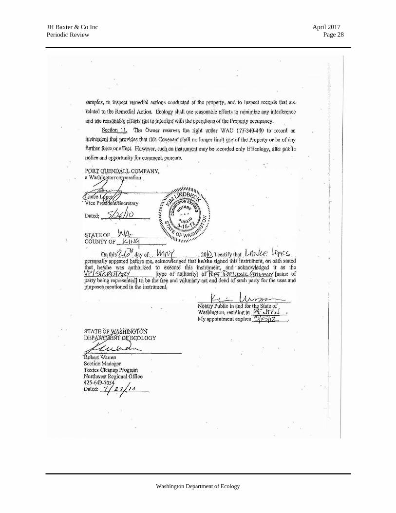
9. The Owner shall allow authorized representatives of Ecology the right to enter the Property at reasonable times for the purpose of evaluating the Remedial Action; to take samples, to inspect remedial actions conducted at the property, and to inspect records that are related to the Remedial Action. Ecology shall use reasonable efforts to minimize any interference and use reasonable efforts not to interfere with the operations of the Property occupancy.
10. The Owner reserves the right under WAC 173-340-440 to record an instrument that provides that the Covenant shall no longer limit use of the Property or be of any further force or effect. However, such an instrument may be recorded only if Ecology, after public notice and opportunity for comment, concurs.
The Environmental Covenant for the South Baxter Property imposed the following limitations:
1. Without prior written consent of Ecology, except as provided below, following
implementation of the CAP, the Owner shall not alter, modify, or remove any structures or caps required by the CAP in a manner that may result in the release or exposure to the environment of contaminated soil or create a new exposure pathway. Structure or cap maintenance is permitted without notice to Ecology so long as appropriate health and safety protocols are followed. The SMP on file at Ecology's NWRO is a fully enforceable part of the Covenant, and outlines specific protocols associated with, future soil excavations, including health and safety standards, soil stockpiling, analytical testing, and soil reuse or disposal options. Limited excavation, utility placement or repair, minor site grading, or other pre-approved activities connected with site development and construction are permitted so long as appropriate health and safety protocols are followed and a structure or cap that provides protection from direct contact as required by the CAP.
2. Any activity on the Property that may interfere with the integrity of the Remedial Action and continued protection of human health and the environment is prohibited. The CAP permits and contemplates development of the Property as a mixed use (residential, retail, and commercial) property.
3. Unless authorized by the CAP or the Covenant, no activity is permitted that may result in the release or exposure to the environment of a hazardous substance that remains on the Property, or create a new exposure pathway.
4. Unless authorized by the CAP, the Owner will not withdraw, or allow others to withdraw, groundwater from the Property.
5. Mitigation actions required by the CAP shall be maintained as set forth in the Baxter Mitigation Analysis Memorandum, which is an enforceable provision of the CAP.
Washington Department of Ecology
JH Baxter & Co Inc Periodic Review
April 2017 Page 9
6. Residential use on the Property is permitted so long as a building, or other structure is present such that the residential use is located over structural parking or other structures, placing the first occupied floor at least one level above the soil and prevents direct contact with all soil that exceeds Method B Cleanup Levels.
7. The Owner must give thirty (30) day advance written notice to Ecology of the Owner's intent to convey a fee interest in a substantial portion of the Property. No conveyance of fee title in a substantial portion of the Property shall be consummated by the Owner without adequate and complete provision for continued monitoring, operation, and maintenance of the Remedial Action, including the mitigation measures. Fee interests in less than a substantial portion of the Property may be conveyed without notice to Ecology.
8. The Owner must restrict leases, easements, and other agreements which include access to the Property to uses and activities consistent with the Covenant and notify all potentially impacted lessees, easement holders, and other holders of rights to access the Property of the restrictions on the use of the Property.
9. The Owner must notify and obtain approval from Ecology prior to any use of the Property that is inconsistent with the terms of the Covenant. Ecology may approve any inconsistent use only after public notice and comment.
10. The Owner shall allow authorized representatives of Ecology the right to enter the Property at reasonable times for the purpose of evaluating the Remedial Action; to take samples, to inspect remedial actions conducted at the property, and to inspect records that are related to the Remedial Action. Ecology shall use reasonable efforts to minimize any interference and use reasonable efforts not to interfere with the operations of the Property occupancy.
11. The Owner reserves the right under WAC 173-340-440 to record an instrument that provides that the Covenant shall no longer limit the use of the Property or be of any further force or effect. However, such an instrument may be recorded only if Ecology, after public notice and opportunity for comment, concurs.
Both Environmental Covenants are provided as Appendix 6.7.

Washington Department of Ecology
JH Baxter & Co Inc Periodic Review
April 2017 Page 10
3.0 PERIODIC REVIEW
3.1 Effectiveness of Completed Cleanup Actions
The Environmental Covenants for the Site were recorded and are in place. This Environmental Covenants prohibit activities that will result in the release of contaminants at the Site without Ecology’s approval, and prohibits any use of the property that is inconsistent with the Covenants. The Environmental Covenants serve to ensure the long term integrity of the remedy.
Based upon the Site visit conducted on November 15, 2016, the environmental caps at the Site continue to provide an effective barrier to exposure to contaminated soils. The concrete and asphalt appears in satisfactory condition and no repair, maintenance, or contingency actions have been required. The Site is still operating as the headquarters and practice facility for the Seattle Seahawks football program. A photograph log is provided as Appendix 6.8.
Soils with PAH concentrations exceeding MTCA cleanup levels are still present at the Site. However, the remedy prevents human exposure to this contamination by ingestion and direct contact with soils. The Environmental Covenants for the property will ensure that the contamination remaining is contained and controlled.
3.2 New Scientific Information for Site Hazardous Substances
No new scientific information related to the contaminants present at the Site have been identified.
3.3 New Applicable Laws for Site Hazardous Substances
The cleanup at the Site was governed by Chapter 173-340 WAC and provides that,
“A release cleaned up under the cleanup levels determined in (a) or (b) of this subsection shall not be subject to further cleanup action due solely to subsequent amendments to the provision in this chapter on cleanup levels, unless the department determines, on a case-by-case basis, that the previous cleanup action is no longer sufficiently protective of human health and the environment.”
Contamination remains at the Site above MTCA Method B cleanup levels, and cleanup action elements and institutional controls continue to be protective of human health and the environment. The original cleanup levels referenced in the CAP were obtained from Ecology’s Cleanup Levels and Risk Calculation (CLARC) database in 1996. Table 3-1 compares current CLARC soil cleanup levels (2016) to the original 1996 soil cleanup levels identified in the CAP to illustrate that 2016 cleanup levels are generally the same or higher, except for the two analytes naphthalene and pentachlorophenol.

Washington Department of Ecology
JH Baxter & Co Inc Periodic Review
April 2017 Page 11
The current (2016) MTCA soil cleanup levels summarized below also include reference to a total toxic equivalent concentration (TTEC) which is calculated by adding the products of each of seven cPAH concentrations with their respective toxicity equivalency factor (TEF). The resulting calculated TTEC value is compared to the soil cleanup level for benzo(a)pyrene.
TABLE 3-1
SOIL CLEANUP LEVELS – CAP (1996 CLARC) AND CURRENT (2016 CLARC)
Analyte 1996 MTCA Method B Direct Contact
(mg/kg)
2016 MTCA Method B Direct Contact
(mg/kg)
1996 MTCA Method B 100x Protection of Groundwater (mg/kg)
2016 MTCA Method B 100x Protection of Groundwater (mg/kg)
Acenaphthene 4,800 4,800 96 97.9 Acenaphthylene NE NE NE NE Anthracene 24,000 24,000 480 2,270 Benzo(a)anthracene 0.137 1.37 0.0012 85.8 Benzo(a)pyrene 0.137 0.137 0.02 2.33 Benzo(b)fluoranthene 0.137 1.37 0.0012 2.95 Benzo(g,h,i )perylene NE NE NE NE Benzo(k)fluoranthene 0.137 13.7 0.0012 29.5 Chrysene 0.137 137 0.0012 95.5 Dibenzo(a,h)anthracene 0.137 0.137 0.0012 0.429 Fluoranthene 3,200 3,200 64 631 Fluorene 3,200 3,200 64 101 lndeno(I ,2,3,cd)pyrene 0.137 1.37 0.0012 8.32 Naphthalene 3,200 1,600 32 4.46 Pentachlorophenol 8.33 2.5 0.1 0.0158 Phenanthrene NE NE NE NE Pyrene 2,400 2,400 48 655 TTEC NE 0.137 NE 2.33
CLARC = Cleanup Levels and Risk Calculations NE = None Established TTEC = Total Toxic Equivalent Concentration (sum of cPAH concentrations multiplied by their respective toxicity equivalency factors [TEFs] per WAC 173-340-708(8)(e))
Since the primary goals of the remedy implemented at this site were to prevent human direct contact and groundwater impacts to surface water, the assessment of the adequacy of the remedy for addressing these two pathways is best conducted via monitoring of the site surface capping systems and the monitoring of groundwater in the vicinity of the shoreline, respectively.
Washington Department of Ecology
JH Baxter & Co Inc Periodic Review
April 2017 Page 12
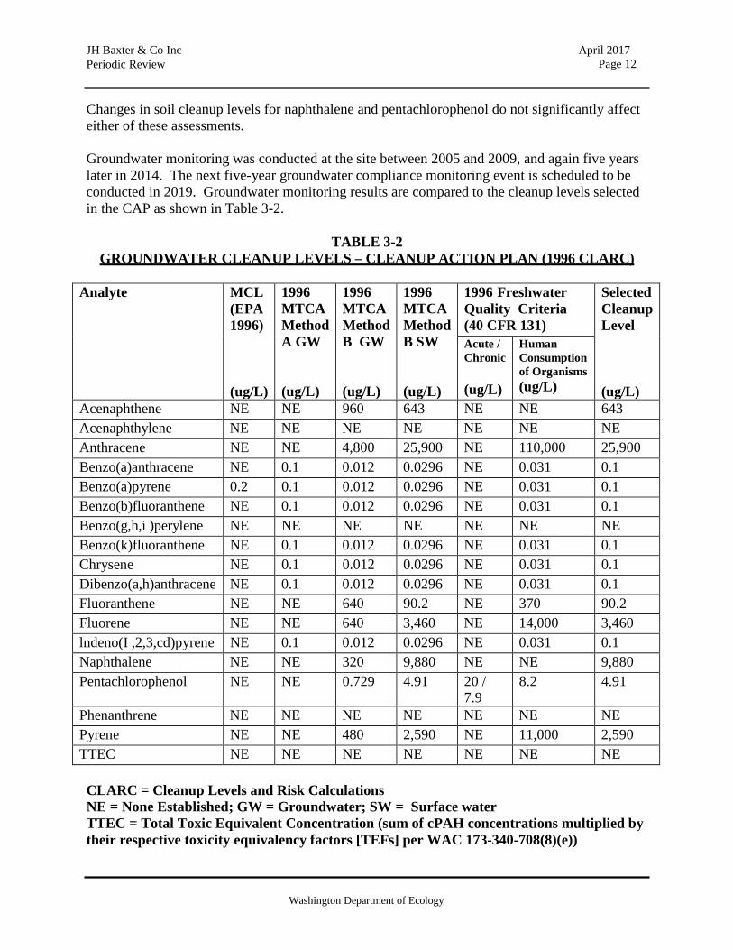
Changes in soil cleanup levels for naphthalene and pentachlorophenol do not significantly affect either of these assessments.
Groundwater monitoring was conducted at the site between 2005 and 2009, and again five years later in 2014. The next five-year groundwater compliance monitoring event is scheduled to be conducted in 2019. Groundwater monitoring results are compared to the cleanup levels selected in the CAP as shown in Table 3-2.
TABLE 3-2
GROUNDWATER CLEANUP LEVELS – CLEANUP ACTION PLAN (1996 CLARC)
Analyte MCL (EPA 1996)
(ug/L)
1996 MTCA Method A GW
(ug/L)
1996 MTCA Method B GW
(ug/L)
1996 MTCA Method B SW
(ug/L)
1996 Freshwater Quality Criteria (40 CFR 131)
Selected Cleanup Level
(ug/L)
Acute / Chronic
(ug/L)
Human Consumption of Organisms (ug/L)
Acenaphthene NE NE 960 643 NE NE 643 Acenaphthylene NE NE NE NE NE NE NE Anthracene NE NE 4,800 25,900 NE 110,000 25,900 Benzo(a)anthracene NE 0.1 0.012 0.0296 NE 0.031 0.1 Benzo(a)pyrene 0.2 0.1 0.012 0.0296 NE 0.031 0.1 Benzo(b)fluoranthene NE 0.1 0.012 0.0296 NE 0.031 0.1 Benzo(g,h,i )perylene NE NE NE NE NE NE NE Benzo(k)fluoranthene NE 0.1 0.012 0.0296 NE 0.031 0.1 Chrysene NE 0.1 0.012 0.0296 NE 0.031 0.1 Dibenzo(a,h)anthracene NE 0.1 0.012 0.0296 NE 0.031 0.1 Fluoranthene NE NE 640 90.2 NE 370 90.2 Fluorene NE NE 640 3,460 NE 14,000 3,460 lndeno(I ,2,3,cd)pyrene NE 0.1 0.012 0.0296 NE 0.031 0.1 Naphthalene NE NE 320 9,880 NE NE 9,880 Pentachlorophenol NE NE 0.729 4.91 20 /
7.9 8.2 4.91
Phenanthrene NE NE NE NE NE NE NE Pyrene NE NE 480 2,590 NE 11,000 2,590 TTEC NE NE NE NE NE NE NE
CLARC = Cleanup Levels and Risk Calculations NE = None Established; GW = Groundwater; SW = Surface water TTEC = Total Toxic Equivalent Concentration (sum of cPAH concentrations multiplied by their respective toxicity equivalency factors [TEFs] per WAC 173-340-708(8)(e))

Washington Department of Ecology
JH Baxter & Co Inc Periodic Review
April 2017 Page 13
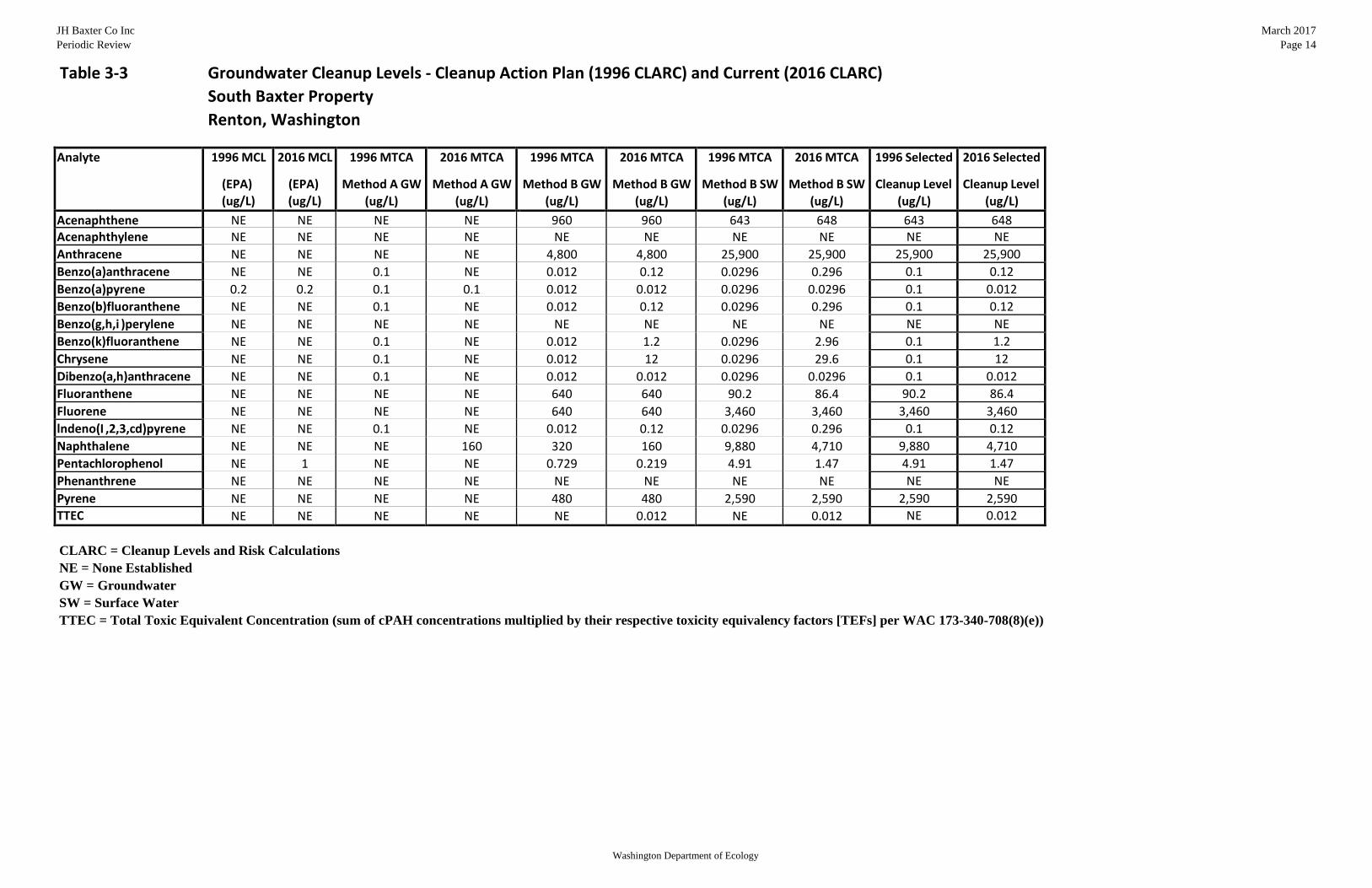
Table 3-3 compares current MTCA groundwater cleanup levels (2016) to the original 1996 groundwater cleanup levels identified in the CAP to illustrate that 2016 cleanup levels are generally the same or higher, except for naphthalene, pentachlorophenol, and fluoranthene, as well as the cPAHs benzo(a)pyrene and dibenzo(a,h)anthracene. Current (2016) MTCA groundwater cleanup levels also now reference a TTEC value for cPAHs that is compared to the groundwater cleanup level for benzo(a)pyrene.
Groundwater monitoring results for the years 2005 through 2009 and 2014 are presented in Table 3-4, and are compared to both original 1996 CAP groundwater cleanup levels and current (2016) CLARC groundwater cleanup levels. These data indicate that all groundwater sample concentrations have been below both the original and current groundwater cleanup levels, with the exception of dibenz(a,h)anthracene at two monitoring locations (location BAX-15 in July 2005, and location BAX-8A in April 2008). No exceedances have been observed since 2008. Groundwater compliance monitoring well locations are shown on the figure provided as Appendix 6.5.
3.4 Current and Projected Site Use
The Site is currently used for commercial purposes. There have been no changes in current or projected future Site or resource uses.
3.5 Availability and Practicability of Higher Preference Technologies
The remedy implemented included containment and capping of hazardous substances, and this remedy continues to be protective of human health and the environment. While higher preference cleanup technologies may be available, they are still not practicable at this Site.
3.6 Availability of Improved Analytical Methods
The analytical methods used at the time of the remedial action were capable of adequate detection and reporting levels related to selected Site cleanup levels. The presence of improved analytical techniques would not affect decisions or recommendations made for the Site.
JH Baxter Co Inc Periodic Review
Table 3‐3 Groundwater Cleanup Levels ‐ Cleanup Action Plan (1996 CLARC) and Current (2016 CLARC) South Baxter Property Renton, Washington
March 2017 Page 14
Analyte 1996 MCL
(EPA) (ug/L)
2016 MCL
(EPA) (ug/L)
1996 MTCA
Method A GW (ug/L)
2016 MTCA
Method A GW (ug/L)
1996 MTCA
Method B GW (ug/L)
2016 MTCA
Method B GW (ug/L)
1996 MTCA
Method B SW (ug/L)
2016 MTCA
Method B SW (ug/L)
1996 Selected
Cleanup Level (ug/L)
2016 Selected
Cleanup Level (ug/L)
Acenaphthene NE NE NE NE 960 960 643 648 643 648 Acenaphthylene NE NE NE NE NE NE NE NE NE NE Anthracene NE NE NE NE 4,800 4,800 25,900 25,900 25,900 25,900 Benzo(a)anthracene NE NE 0.1 NE 0.012 0.12 0.0296 0.296 0.1 0.12 Benzo(a)pyrene 0.2 0.2 0.1 0.1 0.012 0.012 0.0296 0.0296 0.1 0.012 Benzo(b)fluoranthene NE NE 0.1 NE 0.012 0.12 0.0296 0.296 0.1 0.12 Benzo(g,h,i )perylene NE NE NE NE NE NE NE NE NE NE Benzo(k)fluoranthene NE NE 0.1 NE 0.012 1.2 0.0296 2.96 0.1 1.2 Chrysene NE NE 0.1 NE 0.012 12 0.0296 29.6 0.1 12 Dibenzo(a,h)anthracene NE NE 0.1 NE 0.012 0.012 0.0296 0.0296 0.1 0.012 Fluoranthene NE NE NE NE 640 640 90.2 86.4 90.2 86.4 Fluorene NE NE NE NE 640 640 3,460 3,460 3,460 3,460 lndeno(I ,2,3,cd)pyrene NE NE 0.1 NE 0.012 0.12 0.0296 0.296 0.1 0.12 Naphthalene NE NE NE 160 320 160 9,880 4,710 9,880 4,710 Pentachlorophenol NE 1 NE NE 0.729 0.219 4.91 1.47 4.91 1.47 Phenanthrene NE NE NE NE NE NE NE NE NE NE Pyrene NE NE NE NE 480 480 2,590 2,590 2,590 2,590 TTEC NE NE NE NE NE 0.012 NE 0.012 NE 0.012
CLARC = Cleanup Levels and Risk Calculations NE = None Established GW = Groundwater SW = Surface Water TTEC = Total Toxic Equivalent Concentration (sum of cPAH concentrations multiplied by their respective toxicity equivalency factors [TEFs] per WAC 173-340-708(8)(e))
Washington Department of Ecology

JH Baxter Co Inc Periodic Review
March 2017 Page 15
Table 3‐4 Groundwater Analytical Results
South Baxter Property Renton, Washington
Chemical Name:
Pentachloro phenol
1‐Methyl
naphthalene
2‐Methyl
naphthalene
Acenapthene
Acenapthylene
Anthracene
Benzo(a)
anthracene
Benzo(a) pyrene
Benzo(b)
fluoranthene
Benzo(ghi) perylene
Benzo(k)
fluoranthene
Chrysene
Dibenz(a,h) anthracene
Fluoranthene
Fluorene
Indeno(1,2,3‐cd)
pyrene
Naphthalene
Phenanthrene
Pyrene
1996 CAP Cleanup Level: 4.91 NS NS 643 NS 25,900 0.1 0.1 0.1 NS 0.1 0.1 0.1 90.2 3,460 0.1 9,880 NS 2,590 2016 Current Cleanup Level: 1.47 1.51 32 648 NS 25,900 0.12 0.012 0.12 NS 1.2 12 0.012 86.4 3,460 0.12 4,710 NS 2,590
Well Name Event Date
BAX‐6S July 2005
< 0.5
< 0.1
< 0.1
< 0.1
< 0.1
< 0.1
< 0.1
< 0.1
< 0.1
< 0.1
< 0.1
< 0.1
< 0.1
< 0.1
< 0.1
< 0.1
< 0.1
< 0.1
< 0.1 July 2005 (Dup) < 0.5 < 0.1 < 0.1 < 0.1 < 0.1 < 0.1 < 0.1 < 0.1 < 0.1 < 0.1 < 0.1 < 0.1 < 0.1 < 0.1 < 0.1 < 0.1 < 0.1 < 0.1 < 0.1 October 2005 < 0.5 < 0.1 < 0.1 < 0.1 < 0.1 < 0.1 < 0.1 < 0.1 < 0.1 < 0.1 < 0.1 < 0.1 < 0.1 < 0.1 < 0.1 < 0.1 < 0.1 < 0.1 < 0.1 February 2006 < 0.5 < 0.1 < 0.1 < 0.1 < 0.1 < 0.1 < 0.1 < 0.1 < 0.1 < 0.1 < 0.1 < 0.1 < 0.1 < 0.1 < 0.1 < 0.1 < 0.1 < 0.1 < 0.1 April 2006 < 0.5 < 0.1 < 0.1 < 0.1 < 0.1 < 0.1 < 0.1 < 0.1 < 0.1 < 0.1 < 0.1 < 0.1 < 0.1 < 0.1 < 0.1 < 0.1 < 0.1 < 0.1 < 0.1 April 2006 (Dup) < 0.5 < 0.1 < 0.1 < 0.1 < 0.1 < 0.1 < 0.1 < 0.1 < 0.1 < 0.1 < 0.1 < 0.1 < 0.1 < 0.1 < 0.1 < 0.1 < 0.1 < 0.1 < 0.1 October 2006 < 0.5 < 0.1 < 0.1 < 0.1 < 0.1 < 0.1 < 0.1 < 0.1 < 0.1 < 0.1 < 0.1 < 0.1 < 0.1 < 0.1 < 0.1 < 0.1 < 0.1 < 0.1 < 0.1 October 2006 (Dup) < 0.5 < 0.1 < 0.1 < 0.1 < 0.1 < 0.1 < 0.1 < 0.1 < 0.1 < 0.1 < 0.1 < 0.1 < 0.1 < 0.1 < 0.1 < 0.1 < 0.1 < 0.1 < 0.1 April 2007 < 0.5 < 0.1 < 0.1 < 0.1 < 0.1 < 0.1 < 0.1 < 0.1 < 0.1 < 0.1 < 0.1 < 0.1 < 0.1 < 0.1 < 0.1 < 0.1 < 0.1 < 0.1 < 0.1 April 2008 < 0.5 < 0.1 < 0.1 < 0.1 < 0.1 0.16 < 0.1 < 0.1 < 0.1 < 0.1 < 0.1 < 0.1 < 0.1 < 0.1 < 0.1 < 0.1 < 0.1 < 0.1 < 0.1 April 2009 < 0.5 < 0.1 < 0.1 < 0.1 < 0.1 < 0.1 < 0.1 < 0.1 < 0.1 < 0.1 < 0.1 < 0.1 < 0.1 < 0.1 < 0.1 < 0.1 < 0.1 < 0.1 < 0.1 April 2014 0.022 JB 0.0064 J 0.012 J 0.069 0.02 0.052 < 0.019 < 0.019 < 0.019 < 0.019 < 0.019 < 0.019 < 0.019 < 0.019 0.0078 J < 0.019 0.044 < 0.019 < 0.019
BAX‐6D July 2005
< 0.5
< 0.1
< 0.1
< 0.1
< 0.1
< 0.1
< 0.1
< 0.1
< 0.1
< 0.1
< 0.1
< 0.1
< 0.1
< 0.1
< 0.1
< 0.1
< 0.1
< 0.1
< 0.1 October 2005 < 0.5 < 0.1 < 0.1 < 0.1 < 0.1 < 0.1 < 0.1 < 0.1 < 0.1 < 0.1 < 0.1 < 0.1 < 0.1 < 0.1 < 0.1 < 0.1 < 0.1 < 0.1 < 0.1 February 2006 < 0.5 < 0.1 < 0.1 < 0.1 < 0.1 < 0.1 < 0.1 < 0.1 < 0.1 < 0.1 < 0.1 < 0.1 < 0.1 < 0.1 < 0.1 < 0.1 < 0.1 < 0.1 < 0.1 April 2006 < 0.5 < 0.1 < 0.1 < 0.1 < 0.1 < 0.1 < 0.1 < 0.1 < 0.1 < 0.1 < 0.1 < 0.1 < 0.1 < 0.1 < 0.1 < 0.1 < 0.1 < 0.1 < 0.1 October 2006 < 0.5 < 0.1 < 0.1 < 0.1 < 0.1 < 0.1 < 0.1 < 0.1 < 0.1 < 0.1 < 0.1 < 0.1 < 0.1 < 0.1 < 0.1 < 0.1 < 0.1 < 0.1 < 0.1 April 2007 < 0.5 < 0.1 < 0.1 < 0.1 < 0.1 < 0.1 < 0.1 < 0.1 < 0.1 < 0.1 < 0.1 < 0.1 < 0.1 < 0.1 < 0.1 < 0.1 < 0.1 < 0.1 < 0.1 April 2008 < 0.5 < 0.1 < 0.1 < 0.1 < 0.1 < 0.1 < 0.1 < 0.1 < 0.1 < 0.1 < 0.1 < 0.1 < 0.1 < 0.1 < 0.1 < 0.1 < 0.1 < 0.1 < 0.1 April 2009 < 0.5 < 0.1 < 0.1 < 0.1 < 0.1 < 0.1 < 0.1 < 0.1 < 0.1 < 0.1 < 0.1 < 0.1 < 0.1 < 0.1 < 0.1 < 0.1 0.11 < 0.1 < 0.1 April 2014 0.022 JB 0.006 J 0.013 J 0.026 < 0.019 < 0.019 < 0.019 < 0.019 < 0.019 < 0.019 < 0.019 < 0.019 < 0.019 < 0.019 < 0.019 < 0.019 0.055 < 0.019 < 0.019
BAX‐8A July 2005
< 0.5
< 0.1
< 0.1
< 0.1
< 0.1
< 0.1
< 0.1
< 0.1
< 0.1
< 0.1
< 0.1
< 0.1
< 0.1
< 0.1
< 0.1
< 0.1
< 0.1
< 0.1
< 0.1 October 2005 < 0.5 < 0.1 < 0.1 < 0.1 < 0.1 < 0.1 < 0.1 < 0.1 < 0.1 < 0.1 < 0.1 < 0.1 < 0.1 < 0.1 < 0.1 < 0.1 < 0.1 < 0.1 < 0.1 February 2006 < 0.5 < 0.1 < 0.1 < 0.1 < 0.1 < 0.1 < 0.1 < 0.1 < 0.1 < 0.1 < 0.1 < 0.1 < 0.1 < 0.1 < 0.1 < 0.1 < 0.1 < 0.1 < 0.1 February 2006 (Dup) < 0.5 < 0.1 < 0.1 < 0.1 < 0.1 < 0.1 < 0.1 < 0.1 < 0.1 < 0.1 < 0.1 < 0.1 < 0.1 < 0.1 < 0.1 < 0.1 < 0.1 < 0.1 < 0.1 April 2006 < 0.5 < 0.1 < 0.1 < 0.1 < 0.1 < 0.1 < 0.1 < 0.1 < 0.1 < 0.1 < 0.1 < 0.1 < 0.1 < 0.1 < 0.1 < 0.1 < 0.1 < 0.1 < 0.1 October 2006 < 0.5 < 0.1 < 0.1 < 0.1 < 0.1 < 0.1 < 0.1 < 0.1 < 0.1 < 0.1 < 0.1 < 0.1 < 0.1 < 0.1 < 0.1 < 0.1 < 0.1 < 0.1 < 0.1 April 2007 1.11 < 0.1 < 0.1 < 0.1 < 0.1 < 0.1 < 0.1 < 0.1 < 0.1 < 0.1 < 0.1 < 0.1 < 0.1 < 0.1 < 0.1 < 0.1 < 0.1 < 0.1 < 0.1 April 2007 (Dup) < 0.5 < 0.1 < 0.1 < 0.1 < 0.1 0.10 < 0.1 0.01 < 0.1 < 0.1 0.02 < 0.1 < 0.1 < 0.1 < 0.1 < 0.1 < 0.1 < 0.1 < 0.1 April 2008 1.18 < 0.1 < 0.1 < 0.1 < 0.1 0.18 < 0.1 < 0.1 < 0.1 < 0.1 < 0.1 < 0.1 0.02 < 0.1 < 0.1 0.02 < 0.1 < 0.1 < 0.1 April 2008 (Dup) < 0.5 < 0.1 < 0.1 < 0.1 < 0.1 0.17 < 0.1 < 0.1 < 0.1 < 0.1 < 0.1 < 0.1 < 0.1 < 0.1 < 0.1 < 0.1 < 0.1 < 0.1 < 0.1 April 2009 < 0.5 < 0.1 < 0.1 < 0.1 < 0.1 < 0.1 < 0.1 < 0.1 < 0.1 < 0.1 < 0.1 < 0.1 < 0.1 < 0.1 < 0.1 < 0.1 < 0.1 < 0.1 < 0.1 April 2014 0.031 JB 0.0062 J 0.018 J 0.048 0.0093 J 0.0066 < 0.019 < 0.019 < 0.019 < 0.019 < 0.019 < 0.019 < 0.019 0.0057 J < 0.019 < 0.019 0.045 0.019 0.010 J
BAX‐8B July 2005
< 0.5
< 0.1
< 0.1
< 0.1
< 0.1
< 0.1
< 0.1
< 0.1
< 0.1
< 0.1
< 0.1
< 0.1
< 0.1
< 0.1
< 0.1
< 0.1
< 0.1
< 0.1
< 0.1 October 2005 < 0.5 < 0.1 < 0.1 < 0.1 < 0.1 < 0.1 < 0.1 < 0.1 < 0.1 < 0.1 < 0.1 < 0.1 < 0.1 < 0.1 < 0.1 < 0.1 < 0.1 < 0.1 < 0.1 February 2006 < 0.5 < 0.1 < 0.1 < 0.1 < 0.1 < 0.1 < 0.1 < 0.1 < 0.1 < 0.1 < 0.1 < 0.1 < 0.1 < 0.1 < 0.1 < 0.1 < 0.1 < 0.1 < 0.1 April 2006 < 0.5 < 0.1 < 0.1 < 0.1 < 0.1 < 0.1 < 0.1 < 0.1 < 0.1 < 0.1 < 0.1 < 0.1 < 0.1 < 0.1 < 0.1 < 0.1 < 0.1 < 0.1 < 0.1 October 2006 < 0.5 < 0.1 < 0.1 < 0.1 < 0.1 < 0.1 < 0.1 < 0.1 < 0.1 < 0.1 < 0.1 < 0.1 < 0.1 < 0.1 < 0.1 < 0.1 < 0.1 < 0.1 < 0.1 April 2007 < 0.5 < 0.1 < 0.1 < 0.1 < 0.1 < 0.1 < 0.1 < 0.1 < 0.1 < 0.1 < 0.1 < 0.1 < 0.1 < 0.1 < 0.1 < 0.1 < 0.1 < 0.1 < 0.1 April 2008 < 0.5 < 0.1 < 0.1 < 0.1 < 0.1 < 0.1 < 0.1 < 0.1 < 0.1 < 0.1 < 0.1 < 0.1 < 0.1 < 0.1 < 0.1 < 0.1 < 0.1 < 0.1 < 0.1 April 2009 < 0.5 < 0.1 < 0.1 < 0.1 < 0.1 < 0.1 < 0.1 < 0.1 < 0.1 < 0.1 < 0.1 < 0.1 < 0.1 < 0.1 < 0.1 < 0.1 < 0.1 < 0.1 < 0.1 April 2014 0.049 JB 0.0069 J 0.013 J 0.026 < 0.019 < 0.019 < 0.019 < 0.019 < 0.019 < 0.019 < 0.019 < 0.019 < 0.019 < 0.019 < 0.019 < 0.019 0.051 < 0.019 < 0.019
BAX‐15 July 2005 < 0.5 < 0.1 < 0.1 0.38 < 0.1 < 0.1 < 0.1 < 0.1 < 0.1 0.12 < 0.1 < 0.1 0.10 < 0.1 < 0.1 < 0.1 < 0.1 < 0.1 < 0.1 August 2005 < 0.5 < 0.1 < 0.1 0.65 < 0.1 0.11 < 0.1 < 0.1 < 0.1 < 0.1 < 0.1 < 0.1 < 0.1 < 0.1 < 0.1 < 0.1 < 0.1 < 0.1 < 0.1 October 2005 < 0.5 < 0.1 < 0.1 < 0.1 < 0.1 < 0.1 < 0.1 < 0.1 < 0.1 < 0.1 < 0.1 < 0.1 < 0.1 < 0.1 < 0.1 < 0.1 < 0.1 < 0.1 < 0.1 October 2005 (Dup) < 0.5 < 0.1 < 0.1 < 0.1 < 0.1 < 0.1 < 0.1 < 0.1 < 0.1 < 0.1 < 0.1 < 0.1 < 0.1 < 0.1 < 0.1 < 0.1 < 0.1 < 0.1 < 0.1 February 2006 1.55 < 0.1 < 0.1 0.09 < 0.1 < 0.1 < 0.1 < 0.1 < 0.1 < 0.1 < 0.1 < 0.1 < 0.1 < 0.1 < 0.1 < 0.1 0.26 < 0.1 < 0.1 April 2006 < 0.5 < 0.1 < 0.1 0.27 < 0.1 < 0.1 < 0.1 < 0.1 < 0.1 < 0.1 < 0.1 < 0.1 < 0.1 < 0.1 < 0.1 < 0.1 < 0.1 < 0.1 < 0.1 October 2006 < 0.5 < 0.1 < 0.1 0.34 < 0.1 < 0.1 < 0.1 < 0.1 < 0.1 < 0.1 < 0.1 < 0.1 < 0.1 < 0.1 < 0.1 < 0.1 < 0.1 < 0.1 < 0.1 April 2007 < 0.5 < 0.1 < 0.1 0.22 < 0.1 0.14 < 0.1 < 0.1 < 0.1 < 0.1 < 0.1 < 0.1 < 0.1 < 0.1 < 0.1 < 0.1 < 0.1 < 0.1 < 0.1 April 2008 < 0.5 < 0.1 < 0.1 0.52 < 0.1 0.30 < 0.1 < 0.1 < 0.1 < 0.1 < 0.1 < 0.1 < 0.1 < 0.1 < 0.1 < 0.1 < 0.1 < 0.1 < 0.1 April 2009 < 0.5 < 0.1 < 0.1 0.35 < 0.1 < 0.1 < 0.1 < 0.1 < 0.1 < 0.1 < 0.1 < 0.1 < 0.1 < 0.1 < 0.1 < 0.1 < 0.1 < 0.1 < 0.1 April 2009 (Dup) < 0.5 < 0.1 < 0.1 0.37 < 0.1 < 0.1 < 0.1 < 0.1 < 0.1 < 0.1 < 0.1 < 0.1 < 0.1 < 0.1 < 0.1 < 0.1 < 0.1 < 0.1 < 0.1 April 2014 0.021 JB < 0.019 0.0079 J 0.19 0.0065 J 0.062 < 0.019 < 0.019 < 0.019 < 0.019 < 0.019 < 0.019 < 0.019 0.0085 J < 0.019 < 0.019 0.032 < 0.019 < 0.019 April 2014 (Dup) 0.021 JB 0.0067 J 0.0085 J 0.25 < 0.019 0.075 < 0.019 < 0.019 < 0.019 < 0.019 < 0.019 < 0.019 < 0.019 < 0.019 0.011 J < 0.019 0.026 < 0.019 < 0.019
Notes: All results are in ug/L. Dup ‐ Duplicate sample collected. < Analyte not detected at given detection limit. J ‐ Estimated quantity, value is less than the reporting limit. B ‐ Compound was detected in laboratory blank. NS ‐ Not specified in cleanup program Bolded results indicate exceedance of current (2016) cleanup level
Washington Department of Ecology
JH Baxter & Co Inc Periodic Review
April 2017 Page 16
Washington Department of Ecology
4.1 CONCLUSIONS
The following conclusions have been made as a result of this periodic review:
• The cleanup actions completed at the Site appear to be protective of human health and the environment.
• Soils cleanup levels have not been met at the standard point of compliance for the Site;
however, the cleanup action has been determined to comply with cleanup standards since the long-term integrity of the environmental caps is ensured, and the requirements for containment and capping technologies are being met.
• The Environmental Covenants for the property is in place and continues to be effective in
protecting public health and the environment from exposure to hazardous substances and protecting the integrity of the cleanup action.
Based on this periodic review, the Department of Ecology has determined that the requirements of the Environmental Covenants continue to be met. No additional cleanup actions are required by the property owner. It is the property owner’s responsibility to continue to inspect the Site to assure that the integrity of the remedy is maintained.
4.1 Next Review
The next review for the Site will be scheduled five years from the date of receipt of the groundwater monitoring report submitted in 2014. In the event that additional cleanup actions or institutional controls are required, the next periodic review will be scheduled five years from the completion of those activities.
5.0 REFERENCES
AECOM, 2007, Groundwater Monitoring Report. AECOM, 2008, Groundwater Monitoring Report. AECOM, 2009, Construction Completion Report. AECOM, 2009, Groundwater Monitoring Report. AECOM, 2010, Groundwater Monitoring Report. AECOM, 2014, Groundwater Monitoring Report. Ecology, August 4, 2010, Environmental Covenants.

JH Baxter & Co Inc Periodic Review
April 2017 Page 17
Washington Department of Ecology
Ecology, August 4, 2010, Environmental Covenants.
Ecology, November 15, 2016, Site Visit.
Galster & Laprade, 1991, Geology of Seattle, Washington, United States of America.
Retec, 2002, Engineering Design Report.
ThermoRetec, 2000, Feasibility Study.
ThermoRetec, 2000, Cleanup Action Plan.
Woodward-Clyde Consultants, 1990, Draft Remedial Investigation Report.

JH Baxter & Co Inc Periodic Review
April 2017 Page 18
Washington Department of Ecology
6.0 APPENDICES

JH Baxter & Co Inc Periodic Review
April 2017 Page 19
Washington Department of Ecology
6.1 Site Vicinity Map
JH Baxter & Co Inc Periodic Review
April 2017 Page 20
Washington Department of Ecology
6.2 Site Plan and Parcel Locations

JH Baxter & Co Inc Periodic Review
April 2017 Page 21
Washington Department of Ecology
6.3 Former Impacted Soil Areas and Remedies
JH Baxter & Co Inc Periodic Review
April 2017 Page 22
Washington Department of Ecology
6.4 Former Groundwater Monitoring Wells

JH Baxter & Co Inc Periodic Review
April 2017 Page 23
Washington Department of Ecology
6.5 Existing Groundwater Compliance Monitoring Wells

JH Baxter & Co Inc Periodic Review
April 2017 Page 24
Washington Department of Ecology
6.6 Former Remediation Areas, I&M Plan Areas, and Cap Types
JH Baxter & Co Inc Periodic Review
April 2017 Page 25
Washington Department of Ecology
6.7 Environmental Covenants

JH Baxter & Co Inc Periodic Review
April 2017 Page 26
Washington Department of Ecology
JH Baxter & Co Inc Periodic Review
April 2017 Page 27
Washington Department of Ecology
JH Baxter & Co Inc Periodic Review
April 2017 Page 28
Washington Department of Ecology
JH Baxter & Co Inc Periodic Review
April 2017 Page 29
Washington Department of Ecology
JH Baxter & Co Inc Periodic Review
April 2017 Page 30
Washington Department of Ecology
JH Baxter & Co Inc Periodic Review
April 2017 Page 31
Washington Department of Ecology

JH Baxter & Co Inc Periodic Review
April 2017 Page 32
Washington Department of Ecology

JH Baxter & Co Inc Periodic Review
April 2017 Page 33
Washington Department of Ecology

JH Baxter & Co Inc Periodic Review
April 2017 Page 34
Washington Department of Ecology

JH Baxter & Co Inc Periodic Review
April 2017 Page 35
Washington Department of Ecology
6.8 Photo Log Photo 1: East boundary of site and practice facility – looking south
Photo 2: East boundary of site and north parking area – looking north

JH Baxter & Co Inc Periodic Review
April 2017 Page 36
Washington Department of Ecology
Photo 3: North boundary of site and parking area – looking west
Photo 4: West side of practice facility – looking south

JH Baxter & Co Inc Periodic Review
April 2017 Page 37
Washington Department of Ecology
Photo 5: West boundary of site and restored Lake Washington shoreline – looking south
Photo 6: South side of practice facility and natural grass practice field – looking east

JH Baxter & Co Inc Periodic Review
April 2017 Page 38
Washington Department of Ecology
Photo 7: South boundary of site and natural grass practice field – looking east
Photo 8: South side of practice facility and natural grass practice field – looking north

JH Baxter & Co Inc Periodic Review
April 2017 Page 39
Washington Department of Ecology
Photo 9: PSE electric substation at southwest corner of site – looking west
Photo 10: Groundwater monitoring wells near compliance shoreline – looking west