Embed Size (px)
Citation preview

PERFORMANCE OF FLOOD-TESTED SOIL-CEMENT PROTECTED LEVEES
Kenneth D. Hansen, P.E.1 Dennis L. Richards, P.E.2
Mark E. Krebs, P.E.3
ABSTRACT
Although there were some early projects using soil-cement to protect levees or banks dating back to 1965, large scale use of soil-cement bank protection did not occur until the late 1970’s and early 1980’s in the Tucson area. Following its excellent performance during the October 1983 flood of record in Tucson, the use of soil-cement to protect mainly sandy riverbanks soon spread to other urban areas of Arizona, New Mexico, Colorado and California. This paper will present the results of the performance of soil-cement protected levees during the following five major floods:
- The October 1983 flood on the Santa Cruz and Rillito Rivers in Tucson, AZ - The January 1993 flood on the same rivers in Tucson, AZ - The January 1993 flood on the Salt River in the Phoenix, AZ area - The January 2005 flood on the Santa Clara River at Santa Clarita and Fillmore, CA - The July 2006 flood on the Rillito River in Tucson, AZ
Soil-cement protected banks are typically built to contain the 1 in 100-year event. In two of these cases, the measured flow exceeded the 100-year flood. Thus the soil-cement protection was overtopped and the levee material behind the soil-cement exposed to erosion. In addition, in several of the events, high flows caused erosion beneath the scour depth to which the soil-cement was placed. The performance of the protection in each case will be presented. The case history at Phoenix will focus on the resistance of cement-stabilized alluvium (as soil-cement along the Salt River in Maricopa County is called) to very abrasive flow while the performance of a buried soil-cement design in California will be presented. Lessons learned from the performance of soil-cement protected levees as well as unprotected banks when subjected to the floods of record in two cases will be included in the conclusions for this paper.
1 Individual Consultant, 6050 Greenwood Plaza Blvd. – Suite 100, Greenwood Village, CO 80111; [email protected] 2 Senior Project Manager, Ayres Associates, 1500 North Priest Drive – Suite 107, Tempe, AZ 85281; [email protected] 3 President, Pacific Advanced Civil Engineering, Inc. (PACE), 17520 Newhope Street – Suite 200, Fountain Valley, CA 92708; [email protected]
INTRODUCTION
For nearly 50-years, soil-cement has been used to armor the upstream face of major dams and other embankments in lieu of rock rip rap and other slope protection methods. Soil-cement has also been used to protect river banks or levees in mostly urban areas in the Southwestern United States. Soil-cement slope protection for dams and river banks are somewhat different in design concept. However in most cases, the soil-cement is placed in successive horizontal layers 6 – 9 inches in compacted thickness. For dams, the stair-shaped soil-cement protection is placed on an embankment slope that is typically 1 vertical to 3 horizontal and the waves from the reservoir directly impinge on the protected embankment at close to a 90 degree angle. For bank protection, the soil-cement is also placed stair-stepped but on a steeper slope (usually 1 to 1) and the water from the river runs parallel to the bank. Bank protection is basically for flood protection and the river water acts upon the soil-cement only during high flow events. For levees, the slope may need to be flatter for embankment stability. Figure 1 shows a typical soil-cement bank protection section with soil-cement protection on both sides of the waterway, thus channelizing the flow while leaving the waterway bottom in a natural condition.
Figure 1. Typical Section – Soil-Cement Bank Protection
Because soil-cement bank protection is most economically built using conventional highway construction equipment, the horizontal width of the soil-cement layers is typically a minimum of 8-feet. The height of the soil-cement (H) section is usually built to contain the 1 in 100 year design flow while the toe down or scour depth (D) below channel bottom or thalweg, as been typically 6 to 8 ft. However, for soil-cement levees recently constructed at Santa Maria, CA, this toe down distance was 15 feet. Determination of required toe-down requires an in-depth analysis of scour potential and fluvial geomorphology. The initial use of soil-cement for bank protection was in 1965 to protect the Roger Road Wastewater Treatment Plant in Tucson, Arizona from the Santa Cruz River. Subsequently, in 1970, soil-cement was used to protect a portion of the Riverside Freeway from the Santa Ana River near Corona in southern California. However, large scale use of soil-

cement bank protection did not occur until the late 1970’s and early 1980’s when, in the Tucson area, significant reaches of the Santa Cruz River, Rillito River, Canada del Oro Wash, and the Pantano Wash were protected with mass soil-cement sections. It was during this period that the first use of soil-cement for the construction of grade control structures to mitigate channel bed degradation took place on the Santa Cruz River through downtown Tucson. Major soil-cement levee bank protection projects have since been built at the locations shown in Figure 2. Much of this growth in the use of soil-cement levee protection is due to its excellent performance when subjected to the floods described in this paper. The designs were mostly prepared by consultants retained by flood control districts, municipalities, or private land developers in the Tucson, Phoenix, Albuquerque, Las Vegas and Los Angeles areas as well as the Los Angeles and Albuquerque Districts of the U.S. Army Corps of Engineers (USACE).
Figure 2. Location of Major Soil-Cement Levee Bank Protection Projects
One of the main reasons for the development of soil-cement for levee protection in semi-arid regions of the southwestern United States is the abundance of sandy soils in these areas. These sandy soils are prone to erosion when subjected to flood flows. Sandy soils also become part of the solution. When cement is added along with water at optimum moisture content and compacted it produces a durable erosion resistant material called soil-cement. In addition, the usually low elevation of the water table in these areas allows toe-down construction to the designed scour depth to proceed without any consideration or cost for dewatering. The sand to be stabilized is also on-site, which also reduces cost.

It should be noted that for the purposes of this paper, the words bank or levee protection are interchangeable although there is a slight difference. Levees are invariably an embankment with slopes on both sides, while a bank may be sloped only on one side as the river is incised into the landscape. Similarly, flood and flow events are used interchangeably. Flow refers to events retained within the river channel while floods usually involve water flowing out of the streambed and thus causing flooding of a larger area. While the word flood is used mostly in this paper as well as in the literature, the actual events may be more accurately defined as high flow events.
CASE STUDIES
The flows for the five floods studied in this paper are summarized in Table 1 below. Table 1. High Flows in Soil-Cement Protected Levees
Date River Flood Flow (cfs)
100-year (cfs)
Comments
October 2, 1983
Santa Cruz - Tucson, AZ 52,700 30,000* flood of record
Rillito - Tucson, AZ 29,700 32,500
January 8-19, 1993
Santa Cruz - Tucson, AZ 35,800 45,000*
Rillito - Tucson, AZ 28,000 32,500 greater than 50 year event
January 8, 1993
Salt - Phoenix, AZ 124,000 210,000
Second highest flow recorded in past 100 years
January 9 & 10, 2005
Santa Clara - Santa Clarita, CA 20,900 35,000
second highest recorded flow
July 31, 2006 Rillito - Tucson, AZ 38,700 32,500
flood of record - greater than 500 year event
* 30,000 cfs prior to 1983 event, then raised to 45,000 cfs.
The October 1983 Flood in the Tucson Area Most of the Tucson, Arizona area received between 6.5 to 7.7 inches of rain over a six day period in October 1983. The heavy rains caused a measured flow record of up to 52,700 cfs on the Santa Cruz River through downtown Tucson. See Figure 3.

Figure 3. Flow in Santa Cruz River on October 2, 1983 looking south from St. Mary’s
Bridge, near downtown Tucson
At that time, the 1 in 100 year event was 30,000 cfs. This 100 year regulatory flow has since been raised to 45,000 cfs. In any case, the maximum flow in 1983 was greater than the 100 year event. Damage caused by the flood was estimated at $105.7 million. Four deaths were also attributed to the flood. All but one of the bridges spanning the Santa Cruz River were put out of service due to erosion at the abutments. See Figure 4.
Figure 4. Washed out Bridge Abutment on Santa Cruz River
A total of 154 residential units were destroyed and 382 more received either major or minor damage according to FEMA. Most of these residences were located adjacent to the Rillito River (also called Rillito Creek in some later reports). See Figure 5.

Figure 5. Damaged Office Building on the Rillito River
Peak flow on the Rillito River in northeast Tucson was measured at 29,700 cfs or greater than the one in 50 year event. Soil-cement bank protection on the Santa Cruz River through downtown Tucson performed exceptionally well during this flood referred to as the “Big One”. Because the top elevation at the soil-cement was built to contain the then 1 in 100 year event (or 1 in 25 years in one case) it was overtopped. Embankment soil behind the soil-cement washed out, but the protection remained in place. Unprotected banks suffered extensive erosion in the form of progressive block collapse. That is, water flow erodes the lower portions of the sand bank, eliminating support for the soil above it; this causes the unsupported soil to drop vertically as a “block” into the river channel. Following this flood of the century, Pima County officials declared all but soil-cement bank protection as inadequate. Future soil-cement bank protection on the Santa Cruz or Rillito River had to be on both banks or a 500 ft setback provided. News descriptions following the event detailed soil-cement as a “proven flood fighter”. The January 1993 Flood in the Tucson Area Ten years after the 1983 flood at Tucson, another major flood hit Tucson between January 5 and 19, 1993. During this two week period, four to seven inches of rain fell across the Tucson metropolitan area and surrounding mountains where snow melt added to the flood flows. The rainfall produced two distinct flood flows. On January 8, flow in the normally dry Rillito River reached 28,000 cfs. Then, on January 18, the flow in the Santa Cruz River upstream of its confluence with the Rillito reached 35,800 cfs. Even thought the peak discharges for the 1993 flood were generally less than the 1983 flood, the soil-cement banks were subjected to flowing water for a longer period of time. Figure 6 shows flow in the Santa Cruz River near downtown Tucson on January 19, 1993.

Figure 7. Salt River at Mill Road Bridge
Figure 6. Flow in Santa Cruz River north of Congress St. Bridge, in 1993
Damage to local infrastructure due to this flood was considerable less than the October 1983 event. This was due to (a) smaller peak discharges, (b) considerably more soil-cement bank protection built on these two major waterways since 1983, and (c) some properties were acquired in flood vulnerable areas. The total estimated damages attributed to the 1993 event was $13.9 million or about 13% of that for the “Big One” in 1983. The Salt River Flood of January 1993 in the Phoenix Area Heavy rains hit many parts of Arizona in January 1993. In addition to the rainfall reported in the Tucson area, areas upstream on the Salt River that flows through Phoenix also were hit with heavy rains for a two week period. This produced an estimated peak flow of 124,000 cfs within a reach of the Salt River in the Phoenix Metropolitan Area where what they call cement treated alluvium (CSA) levee protection was in place. At that time, the 1 in 100 year discharge in this 900 ft wide stretch of the Salt River was 210,000 cfs. Following completion of raising Roosevelt Dam upstream, the 100-year discharge has been reduced to 167,000 cfs. Cement stabilized alluvium is unique to the Salt River and differs from soil-cement with respect to the gradation of the material to be stabilized. CSA consists of cement stabilization of well graded cobbles, gravels and sand where material greater than 3 inches in diameter is removed. Soil-cement traditionally consists of stabilization of sands where not a great fraction of the material exceeds ¼ inch in size.
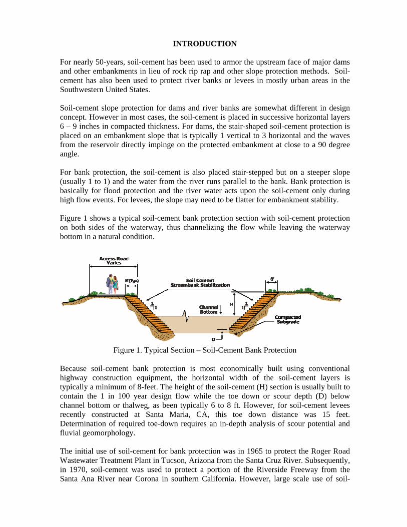
During this flood, portions of the construction formwork for the new Mill Road Bridge under construction across the Salt River located upstream of Phoenix was washed away. See Figure 7. The unprotected banks of the Tri City Landfill north of Mesa was breached during the January 1993 flood. This caused garbage to enter the flood flow. See Figure 8.
Figure 8. Unprotected Tri City Landfill
Once again CSA protected banks performed well when subjected to high velocity, turbulent flow containing a significant amount of cobbles, gravel, and sand. Figure 9 shows some scouring of the CSA levee along the Salt River at Tempe. Please note the size of the “boulders” that acted upon the CSA levee protection at a relatively high velocity.

Figure 9. Scour of Cement Stabilized Alluvium along Salt River at Tempe, Arizona
The July 2006 Flood on the Rillito River and Tributaries at Tucson The culmination of five days of heavy rains generated by tropical storm Emilia across southeast Arizona occurred on July 31, 2006. This produced record flows on the Rillito River as well as its tributaries Tanque Verde Creek, Sabino Wash, Pantano Wash, Rincon Creek and Bear Creek in northeast Tucson. The U.S. Geological Survey’s (USGS) estimate of the flood peak in the Rillito was 38,700 cfs. See Figure 10.
Figure 10. Rillito Flood from Dodge Bridge
This compares to FEMA’s estimate for the 100-year flood event of 32,000 cfs and the average flow in the Rillito over a 10-year period of less than 14 cfs. The USGS estimated that this flow was well as the 26,600 cfs peak on Tanque Verde Creek exceeded the 500 year event.

Because most of the Rillito had Corps of Engineers designed soil-cement levee protection on both banks since 1993, the estimated damage due to the event was held to about $4 million. The high flow overtopped the soil-cement banks near Dodge Blvd. without incident. At no location did the bank protection erode due to high velocities. It is estimated velocities were as high as 19 ft/sec. Approximately 225 feet out of a total 10.8 miles (less than 0.7 percent) of the Corps designed soil-cement levee protection was undercut due to inadequate toe-down depths. Repair of this stretch was estimated to cost $310,000. See Figure 11.
Figure 11. Under cutting of Soil-Cement along Rillito River (2006)
2005 Flooding on the Santa Clara River at Santa Clarita, California The Santa Clara River is one of the few remaining “natural” dry rivers in Los Angeles County. Because local community and environmental agencies desired to keep it as “natural” as possible while still providing appropriate flood protection, a different approach to soil-cement levee protection was developed at Santa Clarita, California. It involved the use of buried soil-cement. The buried soil-cement designed by Pacific Advanced Civil Engineering (PACE) shown in Figure 12 offers two levels of flood and scour protection. The lower level is built to contain the 100-year storm event, while the upper level offers protection against the Los Angeles County Department of Public Works (LADPW) Flood Control Division Capital Flow. The lower lever offers protection for flows up to about 35,000 cfs while the upper level provides protection from flows up to 118,000 cfs.

Figure 12. Section of Santa Clara River Levee of Santa Clarita, CA
All soil-cement levees in Los Angeles County were built since 1999. During the winter of 2004 – 2005 nearly 51 inches of rain fell in the City of Santa Clarita’s Newhall area. This caused a measured peak flow of 20,900 cfs in the Santa Clara River at the Old Road Bridge just upstream of Interstate Highway 5. This flow in a normally dry river was estimated to be greater than the 1 in 25 year event and the second highest flow on the Santa Clara in 69 years of record. While many unstabilized areas, as well as areas protected by other bank protection methods suffered damage during 2005 flooding soil-cement has functioned faultlessly. A major test of the buried soil-cement protection occurred at the 33-acre site of the William S. Hart Baseball and Softball League fields in Santa Clarita. In the past, this area had been subject to flooding even during minor rainfall events. Because of this problem, the areas developer approved construction of 3,500 linear feet of soil-cement levee protection along the Santa Clara River and its South Fork tributary. Construction was completed in the fall of 2004, just in time for the usual rainy season. In January 2005, when the Santa Clara River rose to record levels, baseball tryouts went on as scheduled since no areas on the site were flooded. See Figure 13 for an aerial view of the Hart Baseball fields during the January 2005 storm event.
Figure 13. Aerial view of Hart Baseball Fields, Santa Clarita, CA during January 2005
storms

Downstream from Santa Clarita, buried soil-cement was used to protect a housing development at Fillmore, California. Flow in the Santa Clara River caused by January 2005 storms eroded the sand banks and exposed some buried soil-cement, as intended by design. There was no damage to the nearby houses. See Figure 14.
Figure 14. Erosion of bank at Fillmore, CA exposed some buried soil-cement
LESSONS LEARNED
In the five case studies where soil-cement levees were exposed to extreme flood events, the soil-cement has performed extremely well. In no case was the soil-cement protection breached. This was despite the protection being subjected to the flood of record on two rivers and on two occasions, the flow exceeded the 1 in 100 year event. Some minor damage occurred in several cases. This damage and some lessons learned when the soil-cement levees were subjected to these floods is presented herein. As more soil-cement was used to protect the Santa Cruz, Rillito River and lesser streams in the Tucson area, a drastic reduction in flood related damage occurred. The record flow on the Santa Cruz in 1983 caused damage totaling $103.9 million, while high flows on both noted rivers in 1993 caused $13.9 million in flood related damage. Finally the damage from the flood of record on the Rillito in 2006 was estimated at $4 million. While all of this reduction in flood related damage cannot be attributed to channelization using soil-cement protected banks, it has worked well during major floods. Weathering Durability of Soil-Cement While high flows in rivers only occur infrequently, soil-cement protected embankments are exposed to weathering on a daily basis. As noted previously nearly all soil-cement protected levees have been built in the southeast portion of the United States. Therefore, they have not been exposed to much potential deterioration due to freeze-thaw cycles.
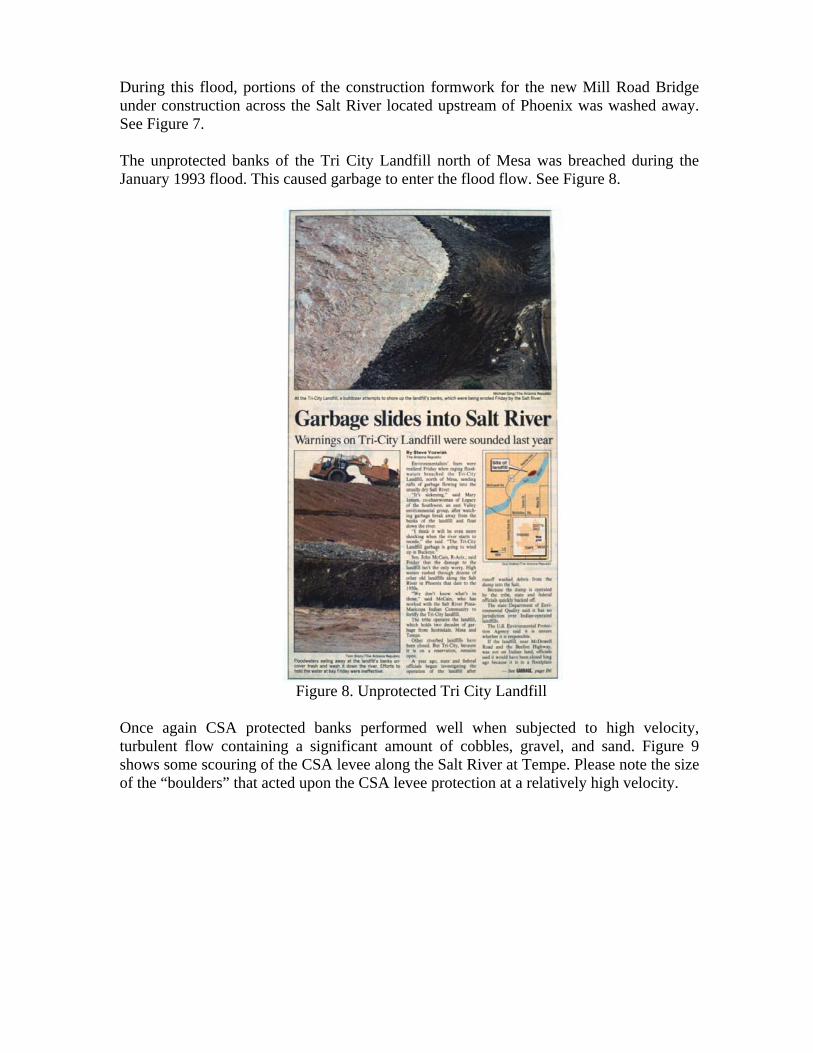
However, the performance of the US Bureau of Reclamation (USBR) soil-cement test section in the Bonny Reservoir built in 1951 provides a positive example of the long term durability of exposed soil-cement. Even though it is located in an area, which receives an average of 140 freeze-thaw cycles per year in addition to being exposed to wave action for the most of its 60-year life, the basic soil-cement remains intact. This was despite construction methods which might be describes as crude nowadays. They included in-place mixing methods and compaction first by sheepsfoot roller and then by rubber-tired wheels of a flatbed truck loaded with cement sacks. As shown in Figure 15, taken in 2008, there has been some breakage of soil-cement layers due to poor bond between the individual 6-inch thick soil-cement layers. The lower portion of the lifts were thus subject to wave erosion due to lower cement content at the bottom of the layers that is typical of the in-place mixing method together with lower density in this area due to the compaction method.
Figure 15. Bonny Reservoir Test Section after 57 years of exposure
Based on the long-term performance of exposed soil-cement constructed with adequate cement content at Bonny Reservoir and other projects subjected to freeze-thaw cycles, a small amount of deterioration may be expected. This is usually at the outer edges of layers where lower density occurs due to lack of restraint of the edge when compacted. Once this minor loose material is washed away, the soil-cement is sound and has shown very fine weathering durability. Durability Due to Water and Waterborne Particle Flow The longest exposure of soil-cement to flood waters for any of the floods studies was two weeks. In most cases the floods rarely produced a velocity in excess of 20 ft/sec with little in the way of waterborne particles. Because most of the soil-cement levees are located in

the semi-arid southwest US, very few trees are included with the flood waters that impinge on the soil-cement protection. No durability problems with the soil-cement levees were observed following these flow events. The unusual case of an extreme flow carrying large cobbles and boulders greater than 9-inch size was the 1993 flood on the Salt River through the Phoenix area. The banks were protected with what is called cement-stabilized alluvium (CSA) using the same material, but with the rocks greater than 3-inch size scalped off. CSA is a term only applied to protection of the Salt River in Maricopa County, Arizona. It is probably closer to roller-compacted concrete (RCC) than soil-cement due to the large maximum size aggregate used. Figure 9 shows some scouring of soil-cement levee along the Salt River through Tempe, Arizona, east of Phoenix. The scouring is likely due to a combination of (1) the inability to provide adequate compaction at the outer edge of the soil–cement lifts and (2) the large material transported by the river system during large volume flow events tending to abrade the cement stabilized alluvium. Loss of Support Below Soil-Cement Bank Protection If the soil-cement is not carried deep enough below scour depth or the material below the protection is not well or uniformly compacted, two conditions have been observed. As shown in Fig. 16, the soil-cement has apparently lost support of its foundation. This has caused the soil-cement to separate at a weak lift line, break up somewhat and settle. This occurred on the Rillito River west of Oracle Road at Tucson, Arizona following the 1993 flood.
Figure 16. Soil-Cement Bank Protection on Rillito River, Tucson, Arizona
An even more dramatic result of scour below soil-cement bank protection is shown in Fig. 17. On the Santa Cruz River downstream from the Cortaro Road north of Tucson, a loss of support has caused the soil-cement to drop into what is assumed to be a scour hole. This caused the 24 inch soil-cement section above the gap to span 107 ft. at the time of this photo. Note the imprints from what appears to be a pad foot roller on the underside of the soil-cement “bridge”.

Figure 17. Settlement of Soil-Cement Bank Protection on Santa Cruz River, north of
Tucson, Arizona The second condition concerns a vertical displacement of soil-cement bank protection on the Santa Cruz River downstream of the Ina Road Bridge, north of Tucson. It is unclear as to the cause of this occurrence, except one section of soil-cement separated and moved downward and slightly back from the adjacent soil-cement. See Figure 18.
Figure 18. Displacement of Soil-Cement Bank Protection, north of Tucson, Arizona
In each of these incidents, there remains sufficient soil-cement to protect against the next flood event or until it is repaired. Performance of Unprotected Banks During the October 1983 flood at Tucson, unstabilized sand banks eroded back as far as 460 ft. from their original position caused by scour of the bank and subsequent caving in. Other examples of the erosion effect at a river during a flood on unprotected sand banks can best be illustrated by the following Figures. Figure 19 shows a span of the I-19 Bridge across the Santa Cruz River south of Tucson collapsing due to lack of support from an eroded abutment. It also shows the river eroded away the left bank and abutment for the local bridge in the background.

Figure 19. Collapse of I-19 Bridge south of Tucson, Arizona
In Figure 20, on the Rillito River in Tucson near Country Club Road a comparison of soil-cement protected bank in the foreground with an unprotected bank is graphically shown.
Figure 20. Comparison Soil-Cement and Unprotected Banks on Rillito River, Tucson,
Arizona
Overtopping of Soil-Cement Levees In the case of 1983 flood on the Santa Cruz as well as the 2006 flood on the Rillito, both in Tucson, the high flows overtopped the soil-cement bank protection. Similarly, the Bonny Reservoir soil-cement test section was also overtopped due to wave action. The protection of the Rio Nuevo development adjacent to Santa Cruz near downtown Tucson was only built to the 25-year flood level prior to the 1983 flood which exceeded the 100-year event. Obviously, under these conditions, the soil-cement was overtopped. Some of the embankment behind the soil-cement line washed out. However, the soil-cement was undamaged and was not displaced as shown in Figure 21 and 22.
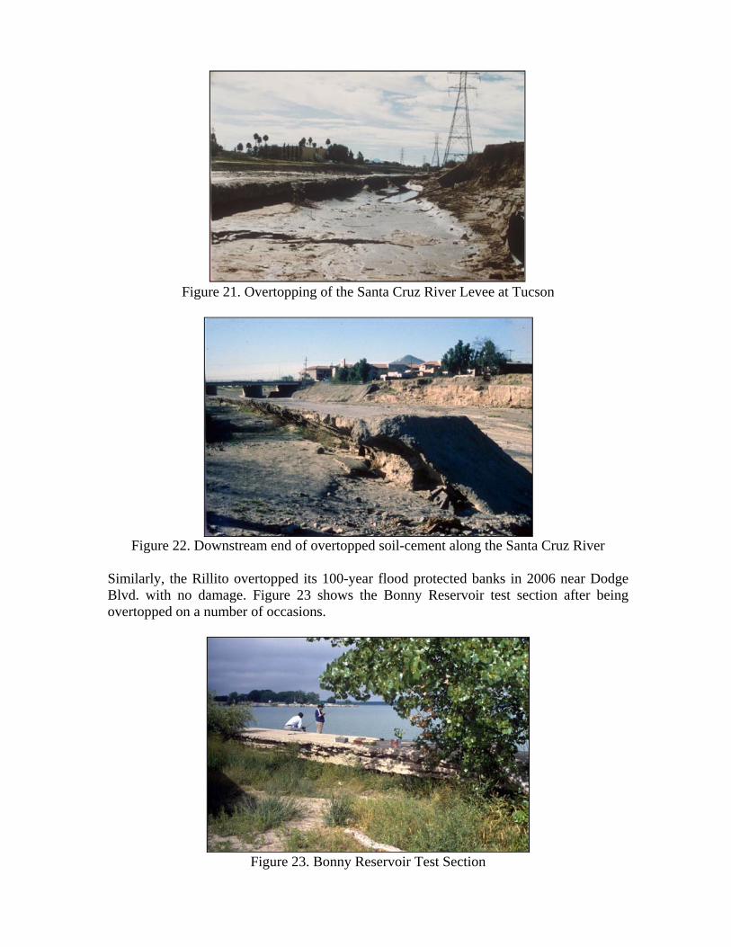
Figure 21. Overtopping of the Santa Cruz River Levee at Tucson
Figure 22. Downstream end of overtopped soil-cement along the Santa Cruz River
Similarly, the Rillito overtopped its 100-year flood protected banks in 2006 near Dodge Blvd. with no damage. Figure 23 shows the Bonny Reservoir test section after being overtopped on a number of occasions.
Figure 23. Bonny Reservoir Test Section

SUMMARY AND CONCLUSIONS
Soil-cement protected levees or banks, whether exposed or buried, have performed exceptionally well when subjected to either infrequent high flood flows or long-term weathering. In two case studies the soil-cement protected embankments were subjected to the flow of record on the river and the second highest flow recorded in the other two cases. The main lessons learned involved performance when subjected to conditions in excess of that for which they were designed. The lessons include:
1. When the protected banks were overtopped the embankment soil behind the soil-cement washed away, thus providing less support for the soil-cement. Still, the soil-cement did not break and cave into the washed out embankment area. It remained in place to withstand the next flood.
2. When flood flows caused scour below the toe down depth, some embankment erosion took place below the soil-cement section. In several cases, the soil-cement above separated at a weak lift line and dropped into the eroded area. This was observed rather high up in the section as the weight of soil-cement below caused more tension at the lift line that separated. This created a void that could be easily repaired. In addition the soil-cement near the river bottom remained in place to protect against the next flood event.
3. Very abrasive flow consisting of boulders, cobbles, gravel and sand was not anticipated during the 1993 flood on the Salt River in the Phoenix area. A fair amount of erosion occurred where this heavy bed load traveling at a relatively high velocity impinged on the cement stabilized alluvium (CSA) protected banks. Still no breach occurred and the affected areas could be repaired.
4. When the US Bureau of Reclamation built its soil-cement slope protection test section in 1951, it was intended to last for ten years. Now, sixty years after being subjected to more than 8,000 freeze-thaw cycles and wave action, the long-term durability due to weathering has been proven.
5. Unprotected banks or those protected with other protection methods did not fare well during the floods studied.
REFERENCES
1. Hansen, K.D. and Lynch, J.P. “Controlling Floods in the Desert with Soil-Cement,” Proceedings of Second CANMET/ACI International Symposium on Advances in Concrete Technology, Las Vegas, Nevada, June 1995.
2. Hansen, K.D. “Erosion and Abrasion Resistance of Soil-Cement and Roller Compacted Concrete,” Portland Cement Association, Skokie, Illinois, R&D Bulletin 126, 2002.
3. Hansen, K.D. “Soil-Cement for Embankment Dams,” Bulletin 54, International Commission on Large Dams (ICOLD), Paris, 1986.
4. Krebs, M.E. “Soil-Cement Stands the Test of Near Record Breaking Rainfall in Southern California,” Soil-Cement Solutions, Portland Cement Association, Skokie, Illinois, 2006.

5. Richards, D.L. and Hansen, K.D. “Soil-Cement for Channel Bank Stabilization,” Proceedings of 1998 International Water Resources Engineering Conference, Memphis, Tennessee, August 1998.
6. Richards, D. L. and Hadley, H.R., “Soil-Cement Guide for Water Resources Applications,” Portland Cement Association, Skokie, Illinois, 2006.