Embed Size (px)
DESCRIPTION
PENANAMAN POHON MELESTARIKAN SUMBER MATA AIR. BAHAN KAJIAN MANAJEMEN EKOSISTEM. Soemarno - pslp ppsub 2010. www.thecottagekey.com/watershed.htm . Peran pohon dalam siklus air . Trees: The Original Multi-taskers. Provide social, ecological, and economic benefits - PowerPoint PPT Presentation
Citation preview
1
PENANAMAN POHON MELESTARIKAN
SUMBER MATA AIRSoemarno - pslp ppsub 2010
BAHAN KAJIAN MANAJEMEN EKOSISTEM
2
www.thecottagekey.com/watershed.htm
3
Peran pohon dalam siklus
air
4
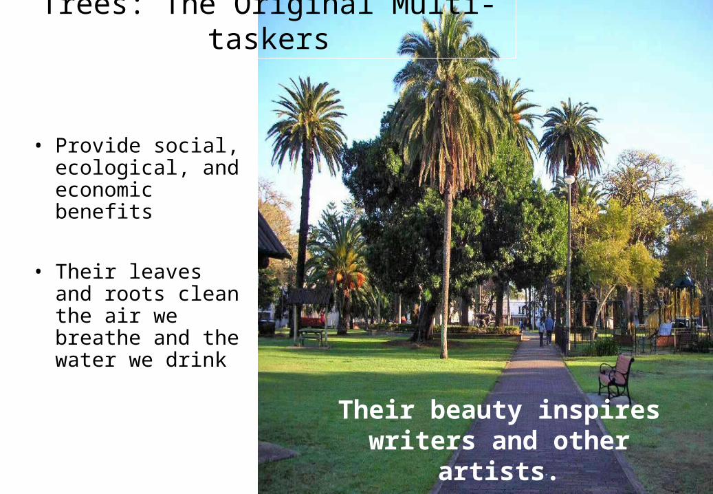
• Provide social, ecological, and economic benefits
• Their leaves and roots clean the air we breathe and the water we drink
Trees: The Original Multi-taskers
Their beauty inspires writers and other artists.

5
• Save Energy
• Improve air quality
• Extend life of paved surfaces
• Increase traffic safety
• Increase real estate values
• Increase sociological benefits
• Protect our water resources
Benefits of Trees in Urban Areas
6
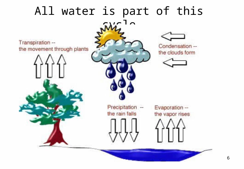
All water is part of this cycle
7
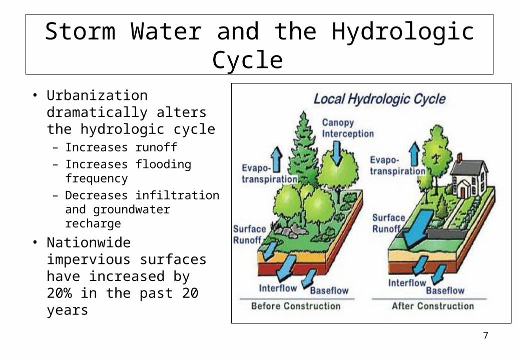
Storm Water and the Hydrologic Cycle
• Urbanization dramatically alters the hydrologic cycle– Increases runoff– Increases flooding
frequency– Decreases infiltration and
groundwater recharge
• Nationwide impervious surfaces have increased by 20% in the past 20 years
8
9
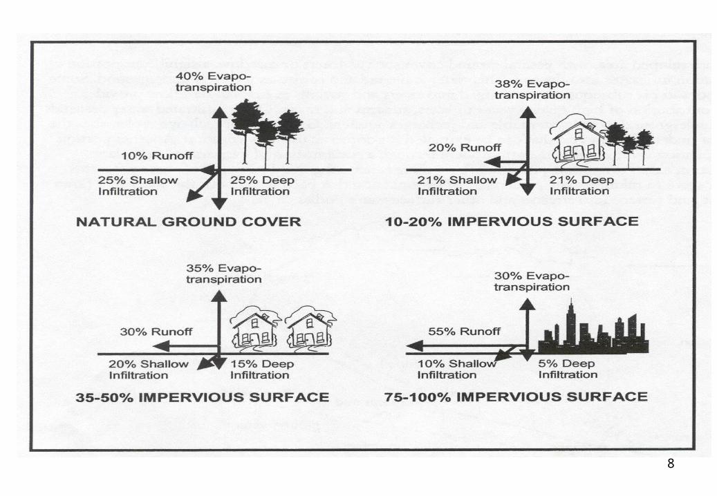
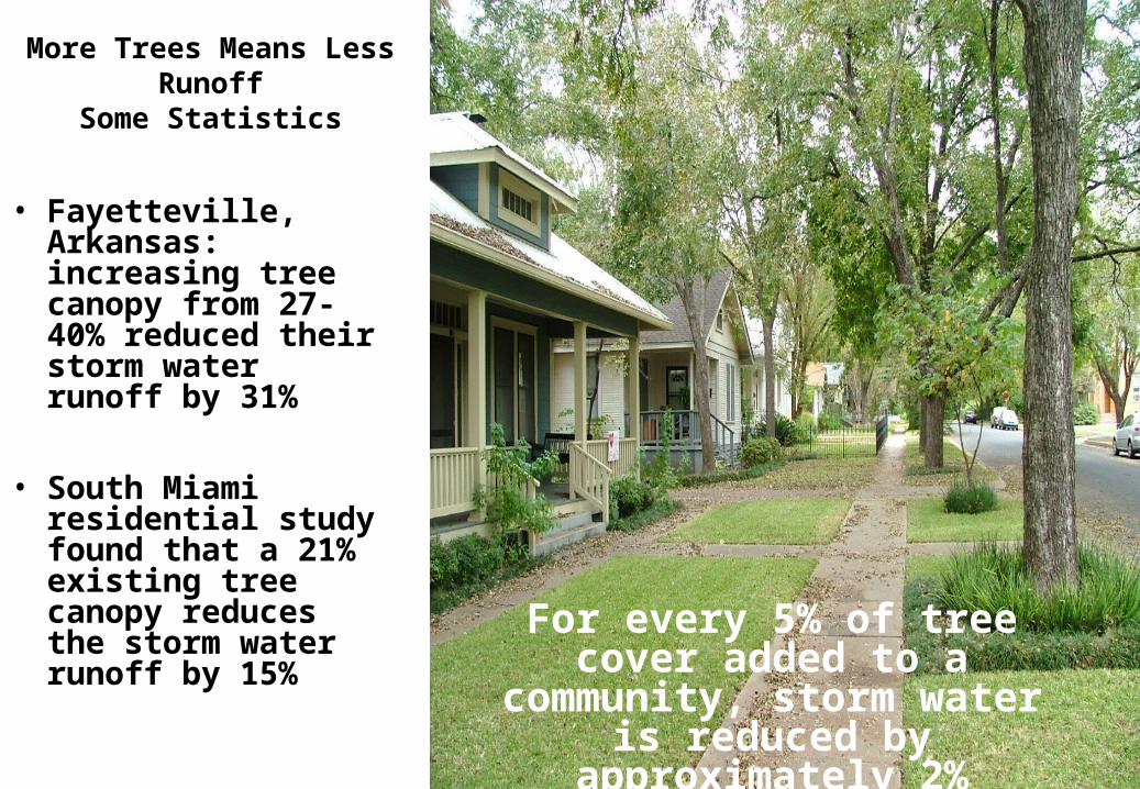
More Trees Means Less Runoff
Some Statistics
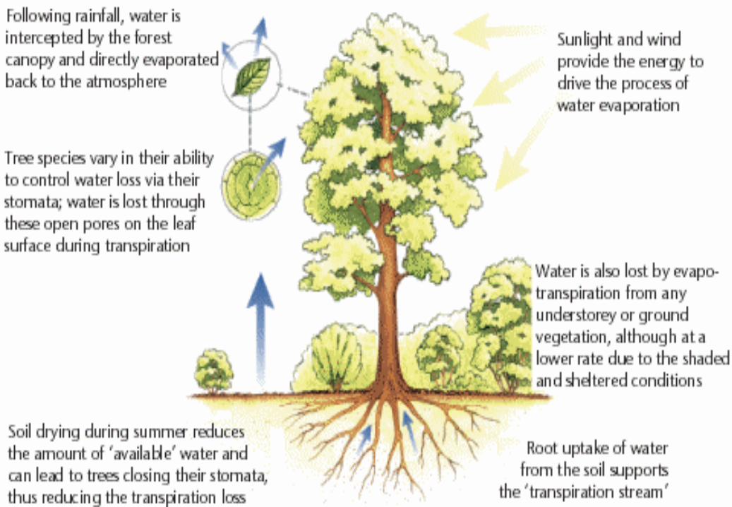
• Fayetteville, Arkansas: increasing tree canopy from 27-40% reduced their storm water runoff by 31%
• South Miami residential study found that a 21% existing tree canopy reduces the storm water runoff by 15% For every 5% of tree cover added
to a community, storm water is reduced by approximately 2%
10
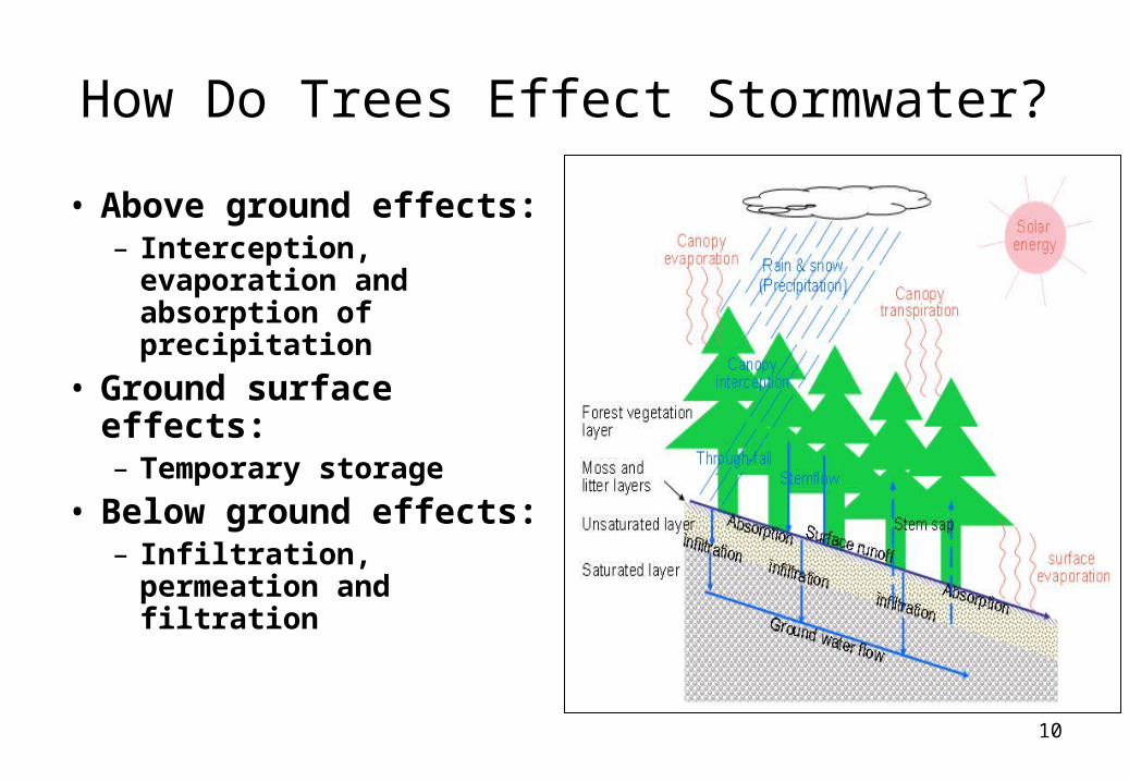
How Do Trees Effect Stormwater?
• Above ground effects:– Interception,
evaporation and absorption of precipitation
• Ground surface effects:– Temporary storage
• Below ground effects:– Infiltration, permeation
and filtration
11
12
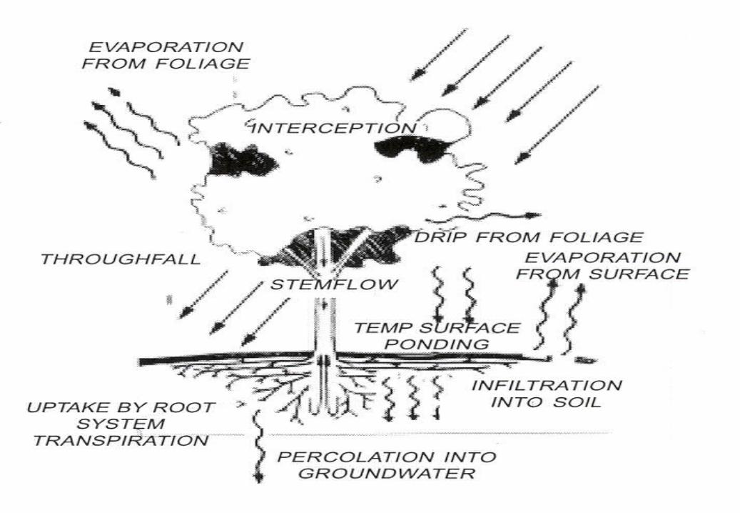
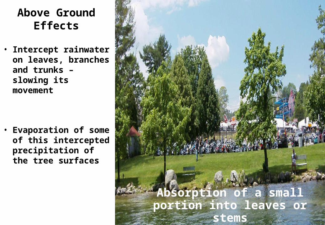
Above Ground Effects
• Intercept rainwater on leaves, branches and trunks – slowing its movement
• Evaporation of some of this intercepted precipitation of the tree surfaces
Absorption of a small portion into leaves or stems
13
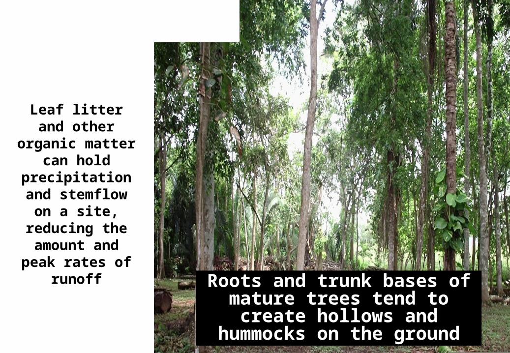
Leaf litter and other organic
matter can hold precipitation and
stemflow on a site, reducing the amount and peak
rates of runoff
Ground Surface Effects
Roots and trunk bases of mature trees tend to create hollows and
hummocks on the ground
14
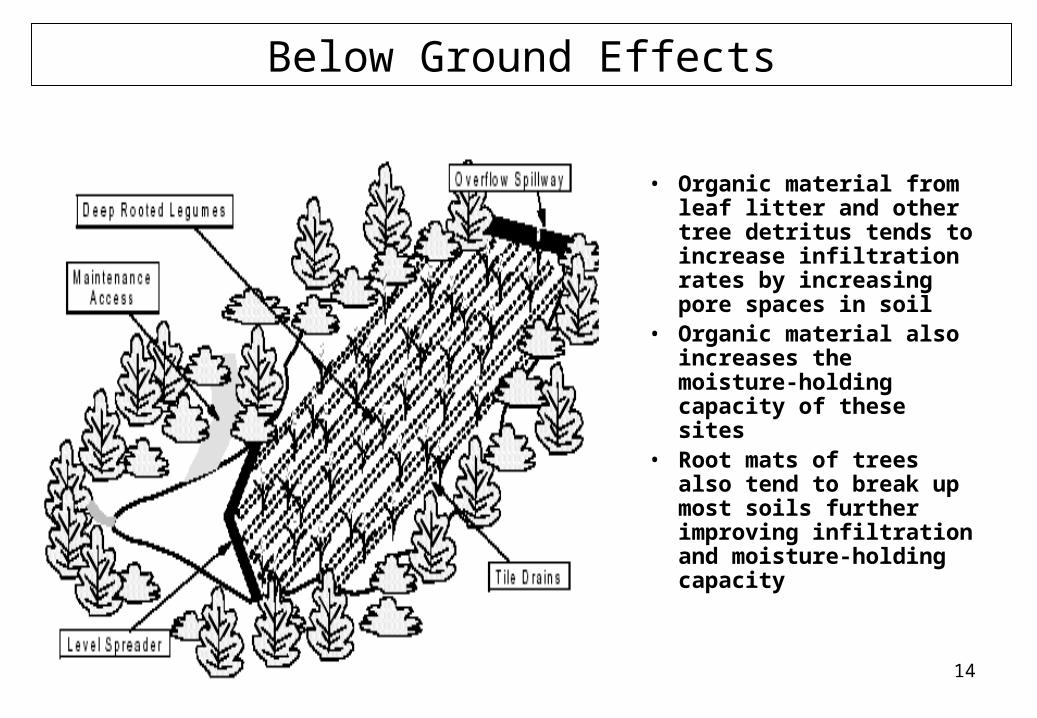
Below Ground Effects
• Organic material from leaf litter and other tree detritus tends to increase infiltration rates by increasing pore spaces in soil
• Organic material also increases the moisture-holding capacity of these sites
• Root mats of trees also tend to break up most soils further improving infiltration and moisture-holding capacity
15
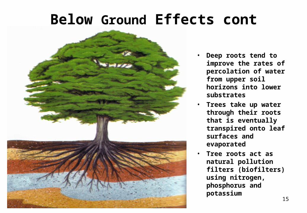
Below Ground Effects cont
• Deep roots tend to improve the rates of percolation of water from upper soil horizons into lower substrates
• Trees take up water through their roots that is eventually transpired onto leaf surfaces and evaporated
• Tree roots act as natural pollution filters (biofilters) using nitrogen, phosphorus and potassium
16
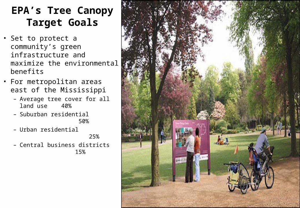
EPA’s Tree Canopy Target Goals
• Set to protect a community’s green infrastructure and maximize the environmental benefits
• For metropolitan areas east of the Mississippi– Average tree cover for all land use
40%– Suburban residential
50%– Urban residential
25%– Central business districts
15%
17
Complications?
18
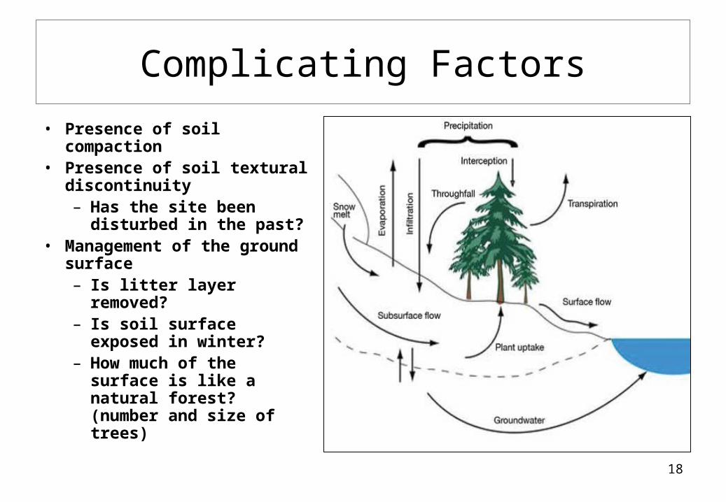
Complicating Factors• Presence of soil
compaction• Presence of soil textural
discontinuity– Has the site been
disturbed in the past?• Management of the ground
surface– Is litter layer removed?– Is soil surface exposed
in winter?– How much of the
surface is like a natural forest? (number and size of trees)
19
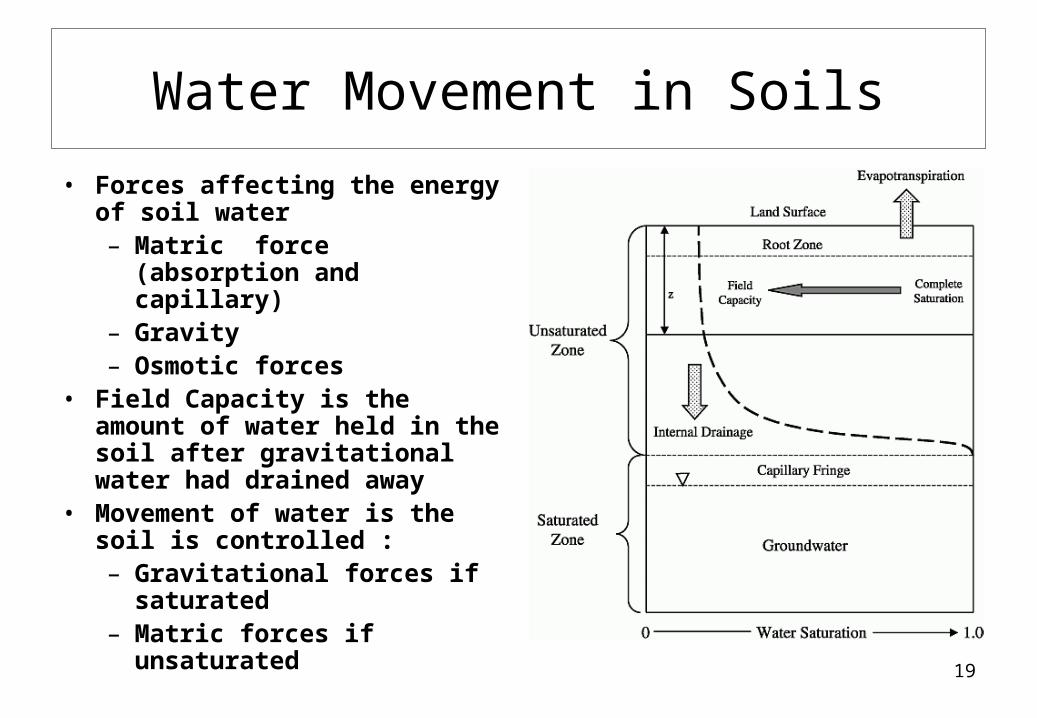
Water Movement in Soils• Forces affecting the energy of
soil water– Matric force (absorption
and capillary)– Gravity– Osmotic forces
• Field Capacity is the amount of water held in the soil after gravitational water had drained away
• Movement of water is the soil is controlled :– Gravitational forces if
saturated– Matric forces if unsaturated
20
Soil Factors Influencing Infiltration
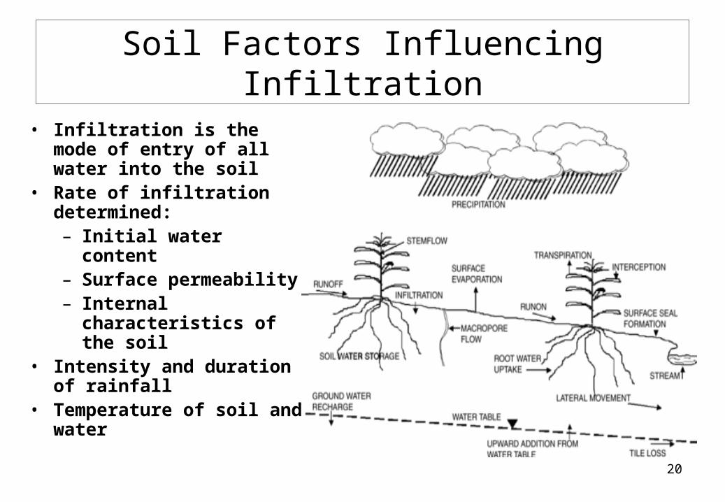
• Infiltration is the mode of entry of all water into the soil
• Rate of infiltration determined:– Initial water content– Surface permeability– Internal characteristics
of the soil• Intensity and duration of
rainfall• Temperature of soil and
water
21
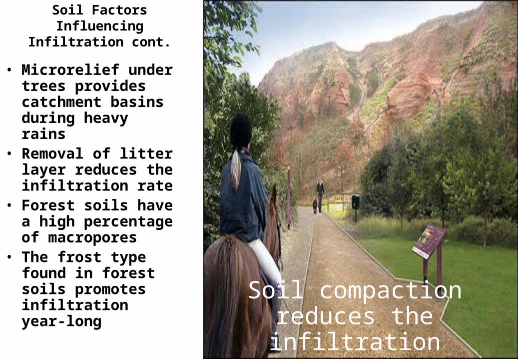
Soil Factors Influencing Infiltration cont.
• Microrelief under trees provides catchment basins during heavy rains
• Removal of litter layer reduces the infiltration rate
• Forest soils have a high percentage of macropores
• The frost type found in forest soils promotes infiltration year-long
Soil compaction reduces the infiltration rate
22
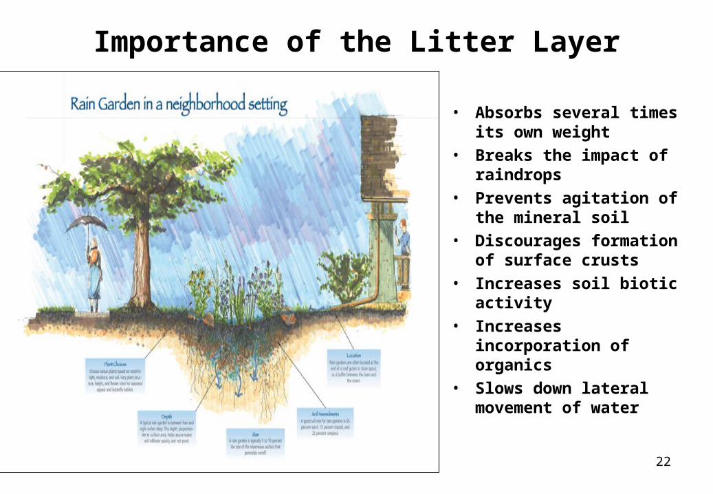
Importance of the Litter Layer
• Absorbs several times its own weight
• Breaks the impact of raindrops
• Prevents agitation of the mineral soil
• Discourages formation of surface crusts
• Increases soil biotic activity
• Increases incorporation of organics
• Slows down lateral movement of water
23
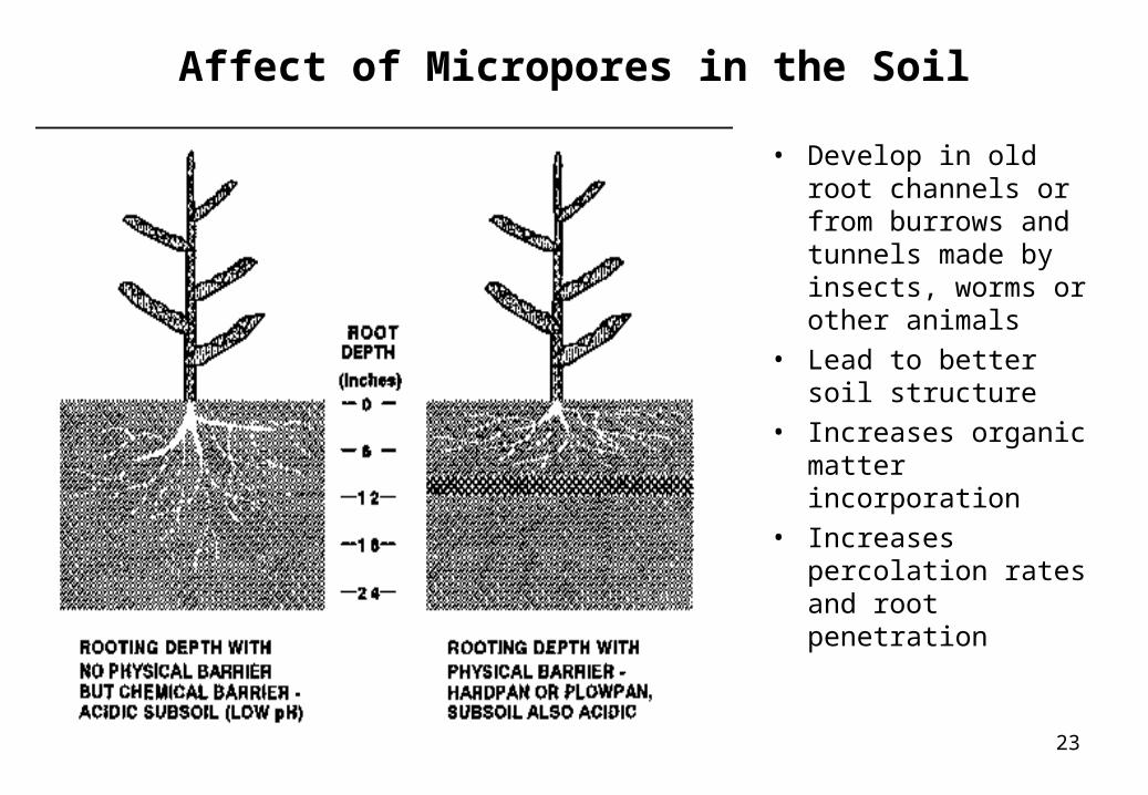
Affect of Micropores in the Soil
• Develop in old root channels or from burrows and tunnels made by insects, worms or other animals
• Lead to better soil structure
• Increases organic matter incorporation
• Increases percolation rates and root penetration
24
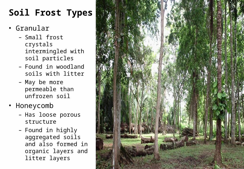
Soil Frost Types• Granular
– Small frost crystals intermingled with soil particles
– Found in woodland soils with litter
– May be more permeable than unfrozen soil
• Honeycomb– Has loose porous
structure– Found in highly
aggregated soils and also formed in organic layers and litter layers
25
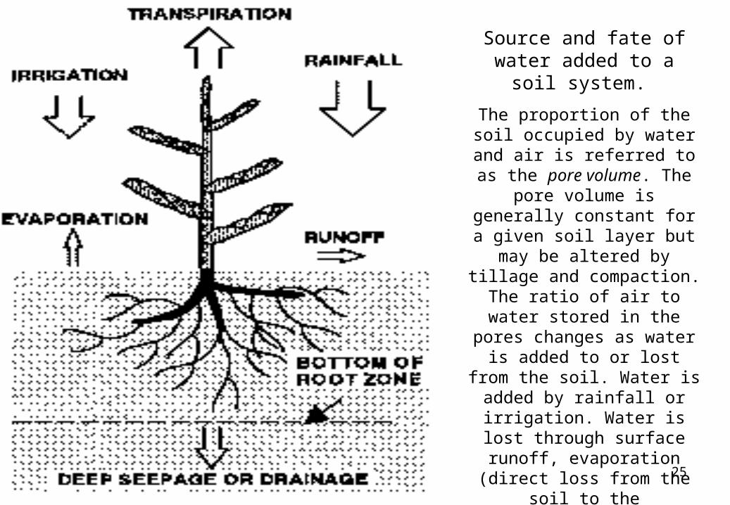
Source and fate of water added to a soil system.
The proportion of the soil occupied by water and air is
referred to as the pore volume. The pore volume is generally constant for a given soil layer but may be altered by tillage and compaction. The ratio of
air to water stored in the pores changes as water is added to or lost from the soil. Water is added by rainfall or irrigation. Water is lost through surface
runoff, evaporation (direct loss from the soil to the
atmosphere), transpiration (losses from plant tissue), and
either percolation (seepage into lower layers) or drainage.
26
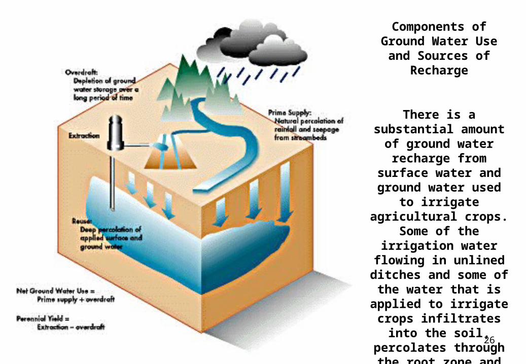
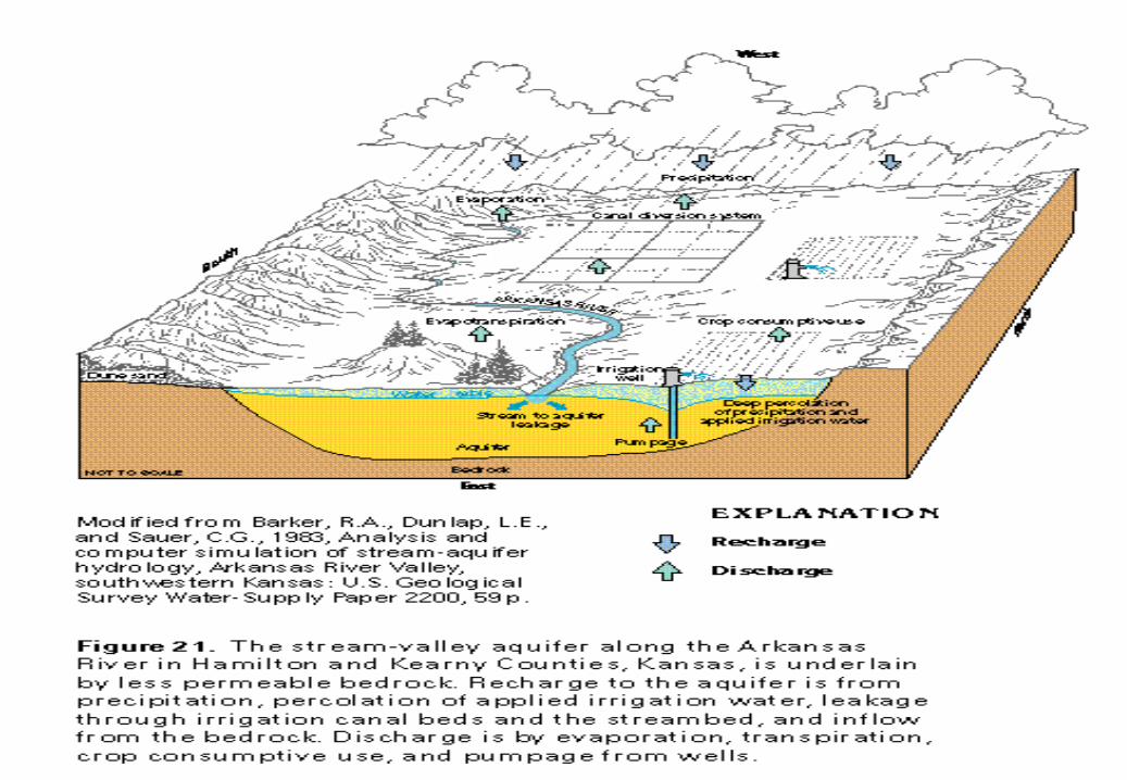
Components of Ground Water Use and Sources
of Recharge
There is a substantial amount of ground water recharge from surface
water and ground water used to irrigate
agricultural crops. Some of the irrigation
water flowing in unlined ditches and some of the water that is applied to irrigate crops infiltrates into the soil, percolates through the root zone
and recharges the ground water basins
27
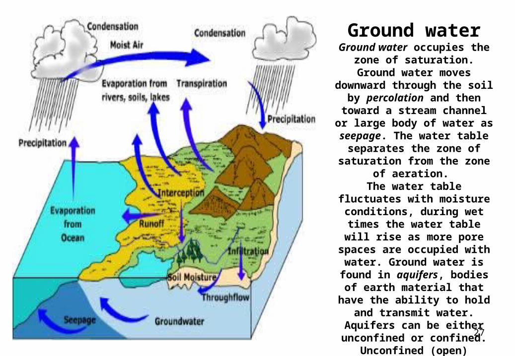
Ground waterGround water occupies the zone of saturation. Ground
water moves downward through the soil by percolation
and then toward a stream channel or large body of water
as seepage. The water table separates the zone of
saturation from the zone of aeration.
The water table fluctuates with moisture conditions, during wet times the water table will rise as more pore spaces are occupied
with water. Ground water is found in aquifers, bodies of earth material that have the ability to hold and transmit
water. Aquifers can be either unconfined or confined.
Unconfined (open) aquifers are "connected" to the surface
above.
28
Aquifers replenish their supply of water very slowly.
The rate of ground water flow depends on the permeability of the aquifer and the hydraulic gradient. Permeability is affected by the size and
connectivity of pore spaces. Larger, better connected pore spaces creates highly permeable earth material. The hydraulic gradient is the difference in elevation between two points on the water table divided by the horizontal
distance between them.
The rate of ground water flow is expressed by the equation:
Ground water flow rate = permeability X hydraulic gradient
Groundwater flow rates are usually quite slow. Average ground water flow rate of 15 m per day is common. Highly
permeable materials like gravels can have flow velocities of 125 m per day.
29
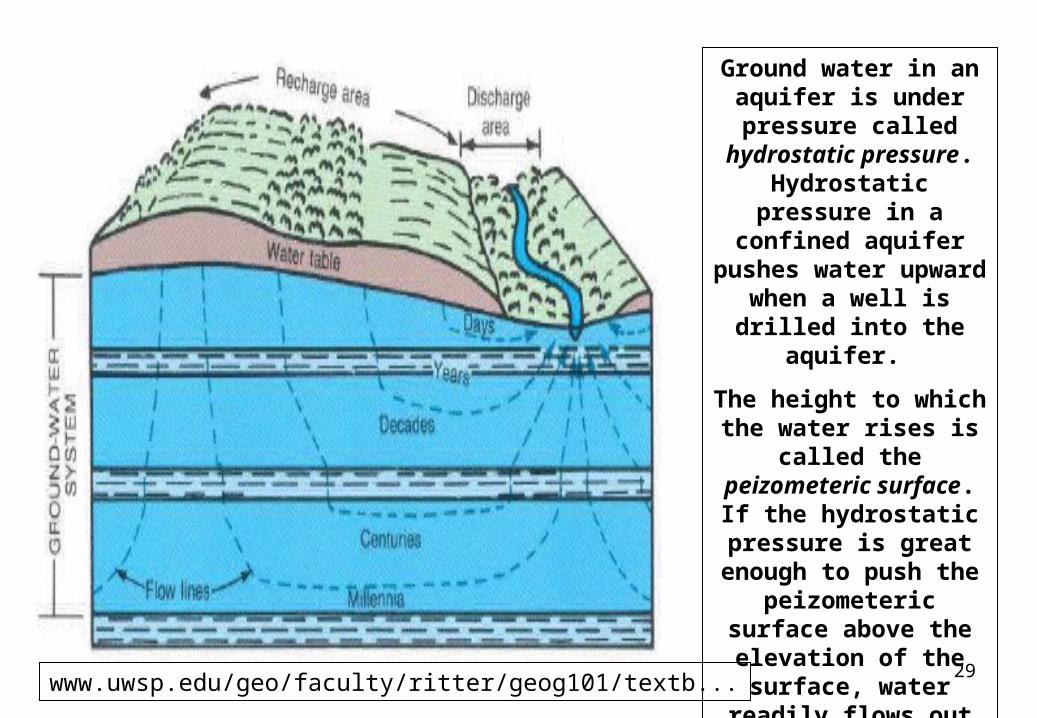
Ground water in an aquifer is under pressure called
hydrostatic pressure. Hydrostatic pressure in
a confined aquifer pushes water upward when a well is drilled
into the aquifer.
The height to which the water rises is called the peizometeric surface. If
the hydrostatic pressure is great
enough to push the peizometeric surface
above the elevation of the surface, water
readily flows out as an artesian well.
www.uwsp.edu/geo/faculty/ritter/geog101/textb...
30
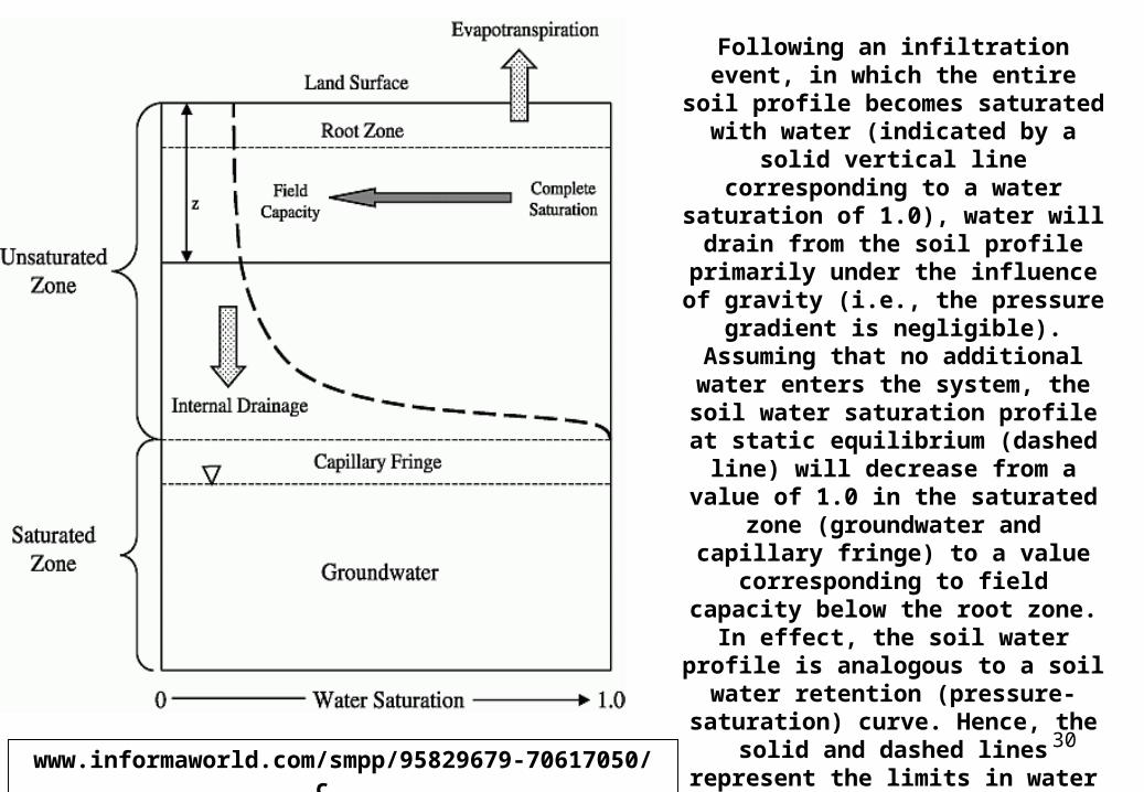
Following an infiltration event, in which the entire soil profile becomes saturated with water (indicated by a solid vertical line corresponding to a
water saturation of 1.0), water will drain from the soil profile primarily
under the influence of gravity (i.e., the pressure gradient is negligible).
Assuming that no additional water enters the system, the soil water
saturation profile at static equilibrium (dashed line) will decrease from a value of 1.0 in the saturated zone
(groundwater and capillary fringe) to a value corresponding to field capacity below the root zone. In effect, the soil
water profile is analogous to a soil water retention (pressure-saturation) curve. Hence, the solid and dashed lines represent the limits in water
content (saturation) between which soil water percolation occurs in soils
overlying an unconfined aquifer.
www.informaworld.com/smpp/95829679-70617050/c...

31
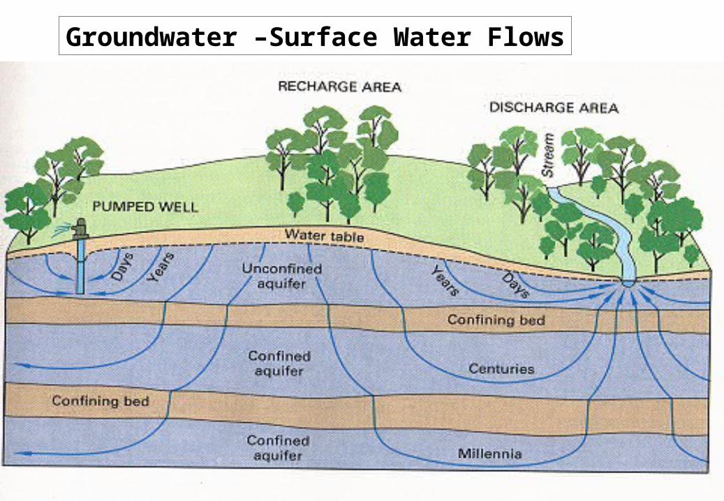
Water is recharged to the ground-
water system by percolation of water from precipitation
and then flows to the stream through the
ground-water system.
ga.water.usgs.gov/edu/earthgwdecline.html
32
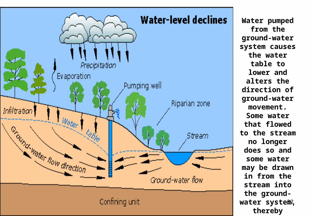
Water pumped from the ground-
water system causes the water
table to lower and alters the direction of
ground-water movement.
Some water that flowed to the
stream no longer does so and
some water may be drawn in from the stream into
the ground-water system, thereby
reducing the amount of
streamflow.
.
33
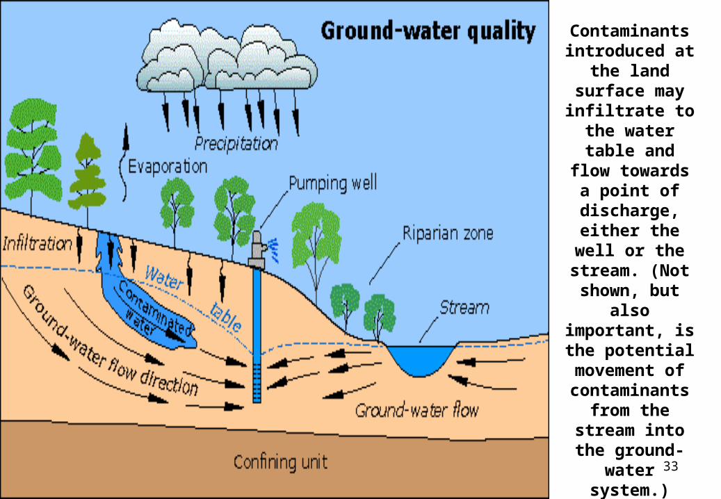
Contaminants introduced at the land surface may
infiltrate to the water table and flow towards a
point of discharge, either
the well or the stream. (Not
shown, but also important, is the
potential movement of contaminants
from the stream into the ground-water system.)
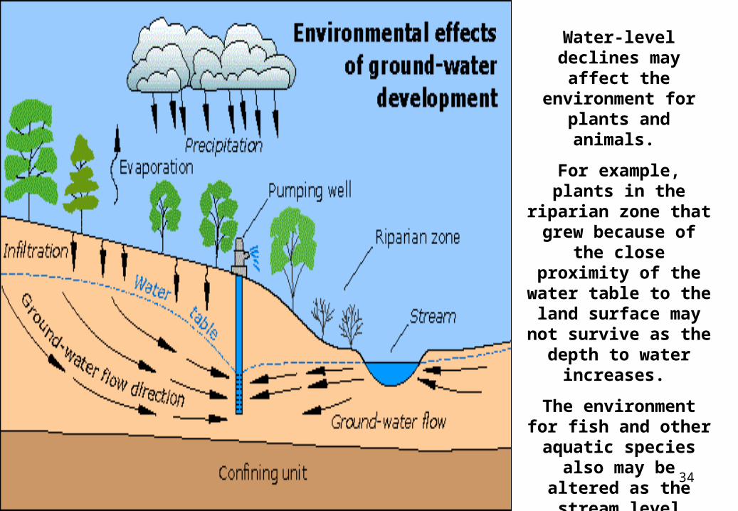
34
Water-level declines may affect the
environment for plants and animals.
For example, plants in the riparian zone that grew because of the
close proximity of the water table to the land
surface may not survive as the depth to
water increases.
The environment for fish and other aquatic species also may be altered as the stream
level drops.
35
36
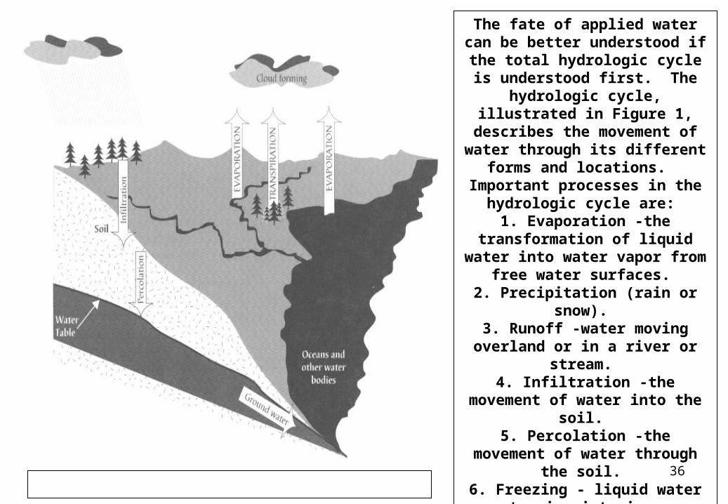
The fate of applied water can be better understood if the total
hydrologic cycle is understood first. The hydrologic cycle,
illustrated in Figure 1, describes the movement of water through its
different forms and locations. Important processes in the
hydrologic cycle are: 1. Evaporation -the transformation
of liquid water into water vapor from free water surfaces.
2. Precipitation (rain or snow). 3. Runoff -water moving overland
or in a river or stream. 4. Infiltration -the movement of
water into the soil. 5. Percolation -the movement of
water through the soil. 6. Freezing - liquid water turning
into ice 7. Thawing - melting of ice
8. Transpiration - the movement of water vapor out through
plant/animal tissue surfaces into the atmosphere.
37
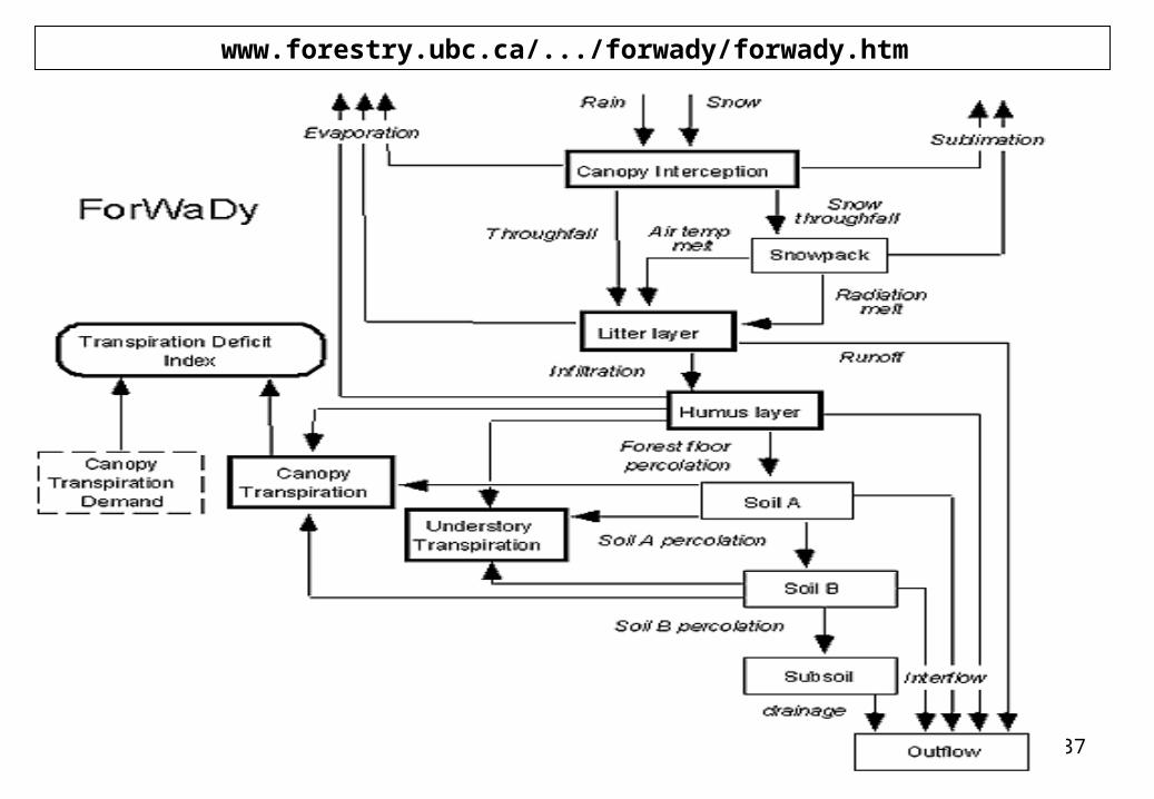
www.forestry.ubc.ca/.../forwady/forwady.htm
38
Forests and the Hydrologic Cycle
The surface water in a stream, lake, or wetland is most commonly precipitation that has run off the land or flowed through topsoils to subsequently enter the
waterbody. If a surficial aquifer is present and hydraulically connected to a surface-water body, the aquifer can sustain surface flow by releasing water to it.
In general, a heavy rainfall causes a temporary and relatively rapid increase in streamflow due to surface runoff. This increased flow is followed by a relatively
slow decline back to baseflow, which is the amount of streamflow derived largely or entirely from groundwater. During long dry spells, streams with a baseflow
component will keep flowing, whereas streams relying totally on precipitation will cease flowing.
Generally speaking, a natural, expansive forest environment can enhance and sustain relationships in the water cycle because there are less human
modifications to interfere with its components. A forested watershed helps moderate storm flows by increasing infiltration and reducing overland runoff.
Further, a forest helps sustain streamflow by reducing evaporation (e.g., owing to slightly lower temperatures in shaded areas). Forests can help increase recharge
to aquifers by allowing more precipitation to infiltrate the soil, as opposed to rapidly running off the land to a downslope area.
39
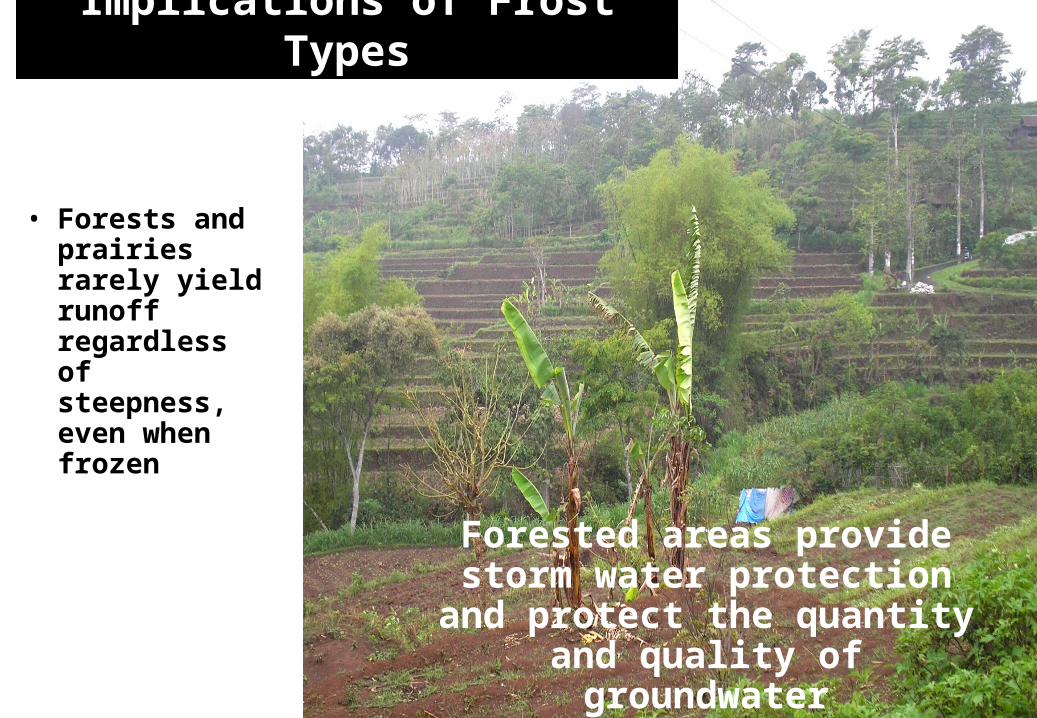
• Forests and prairies rarely yield runoff regardless of steepness, even when frozen
Forested areas provide storm water protection and protect the
quantity and quality of groundwater
Implications of Frost Types
40
Groundwater –Surface Water Flows
41
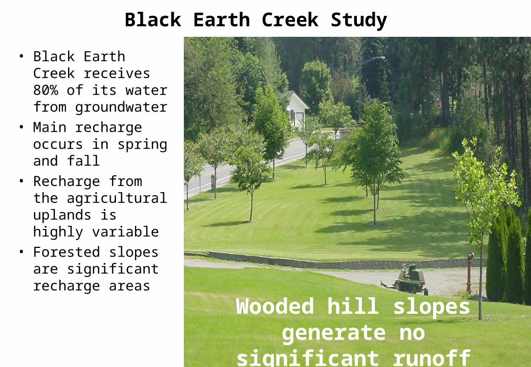
Black Earth Creek Study
• Black Earth Creek receives 80% of its water from groundwater
• Main recharge occurs in spring and fall
• Recharge from the agricultural uplands is highly variable
• Forested slopes are significant recharge areas Wooded hill slopes generate
no significant runoff
42
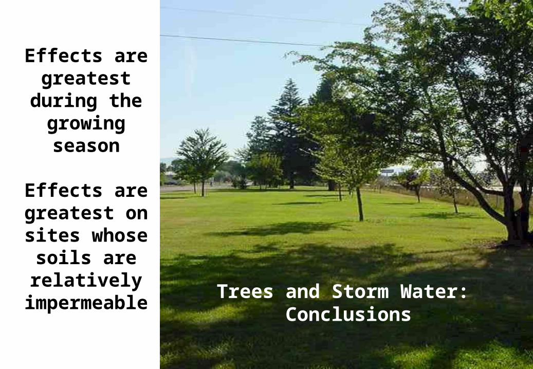
Effects are greatest during
the growing season
Effects are greatest on sites whose soils are
relatively impermeable
Trees and Storm Water: Conclusions
43
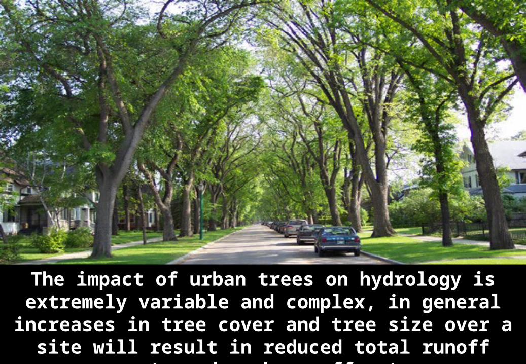
The impact of urban trees on hydrology is extremely variable and complex, in general increases in tree cover and tree size
over a site will result in reduced total runoff amounts and peak runoff rates.
44
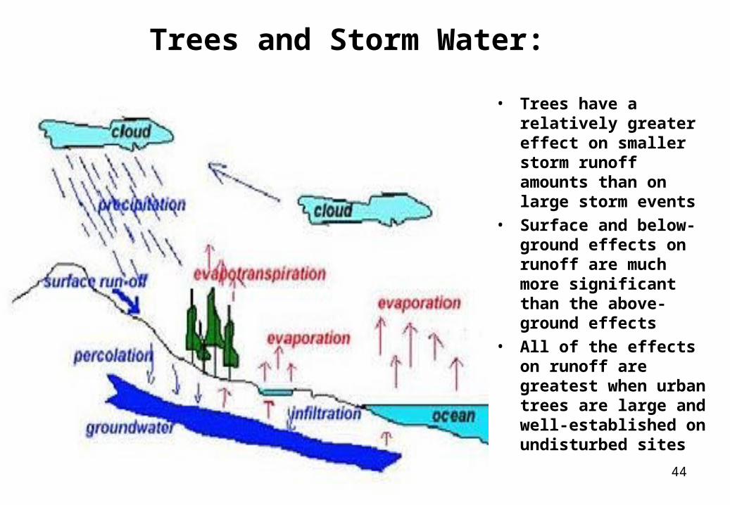
Trees and Storm Water:
• Trees have a relatively greater effect on smaller storm runoff amounts than on large storm events
• Surface and below-ground effects on runoff are much more significant than the above-ground effects
• All of the effects on runoff are greatest when urban trees are large and well-established on undisturbed sites
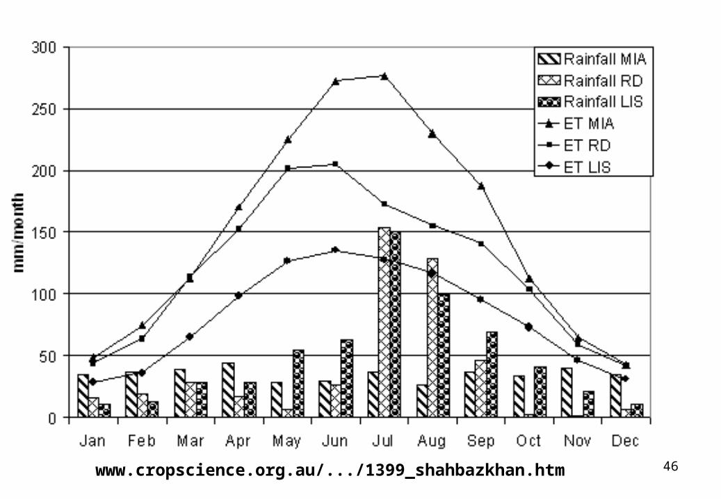
46www.cropscience.org.au/.../1399_shahbazkhan.htm
47
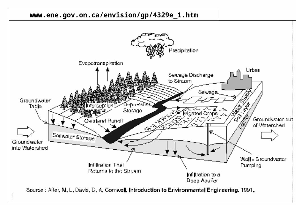
www.ene.gov.on.ca/envision/gp/4329e_1.htm
48
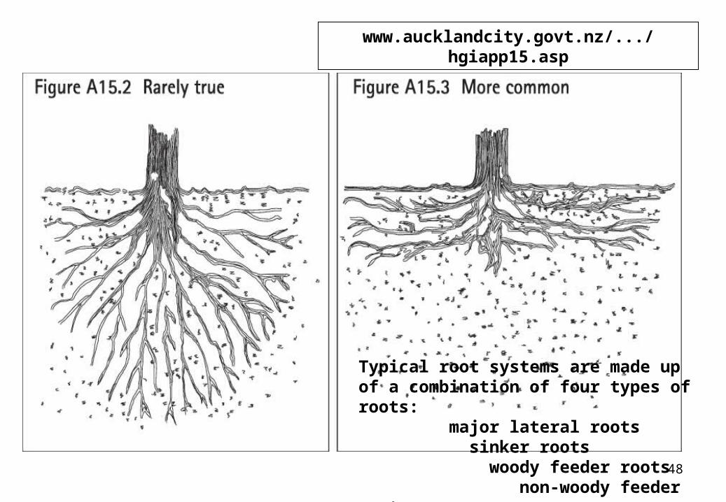
www.aucklandcity.govt.nz/.../hgiapp15.asp
Typical root systems are made up of a combination of four types of roots: major lateral roots sinker roots woody feeder roots non-woody feeder roots.
49
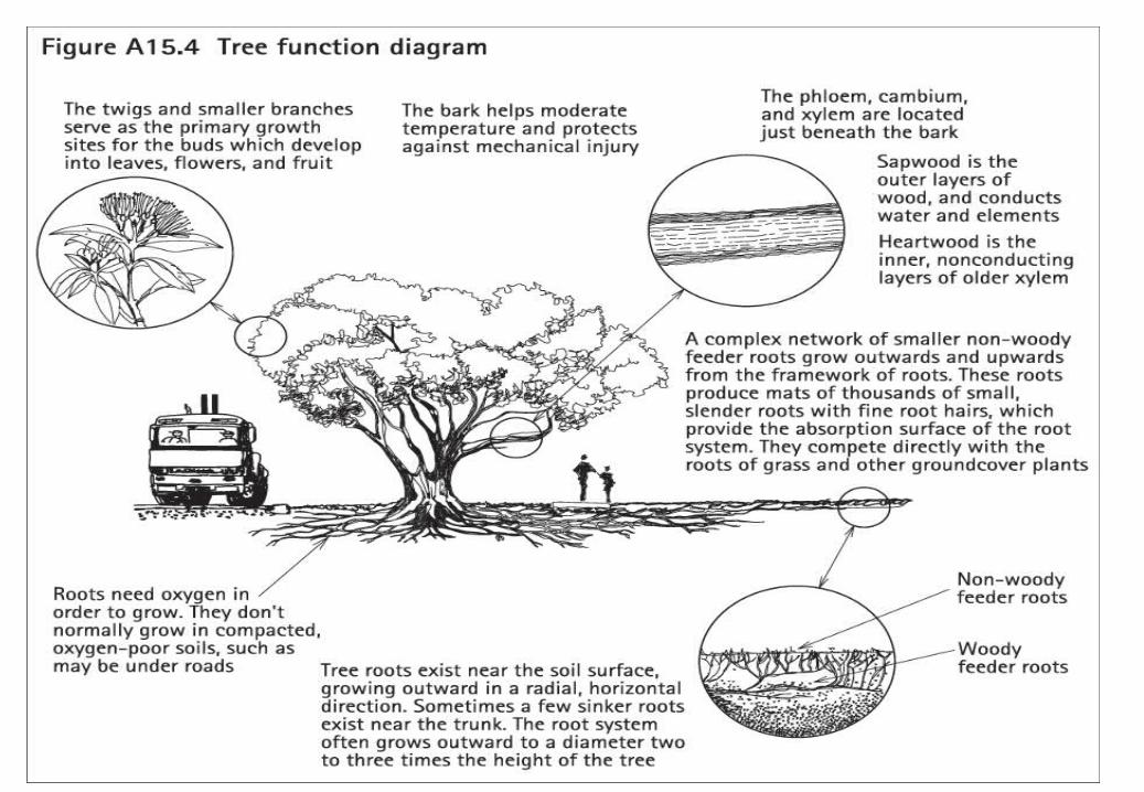
50
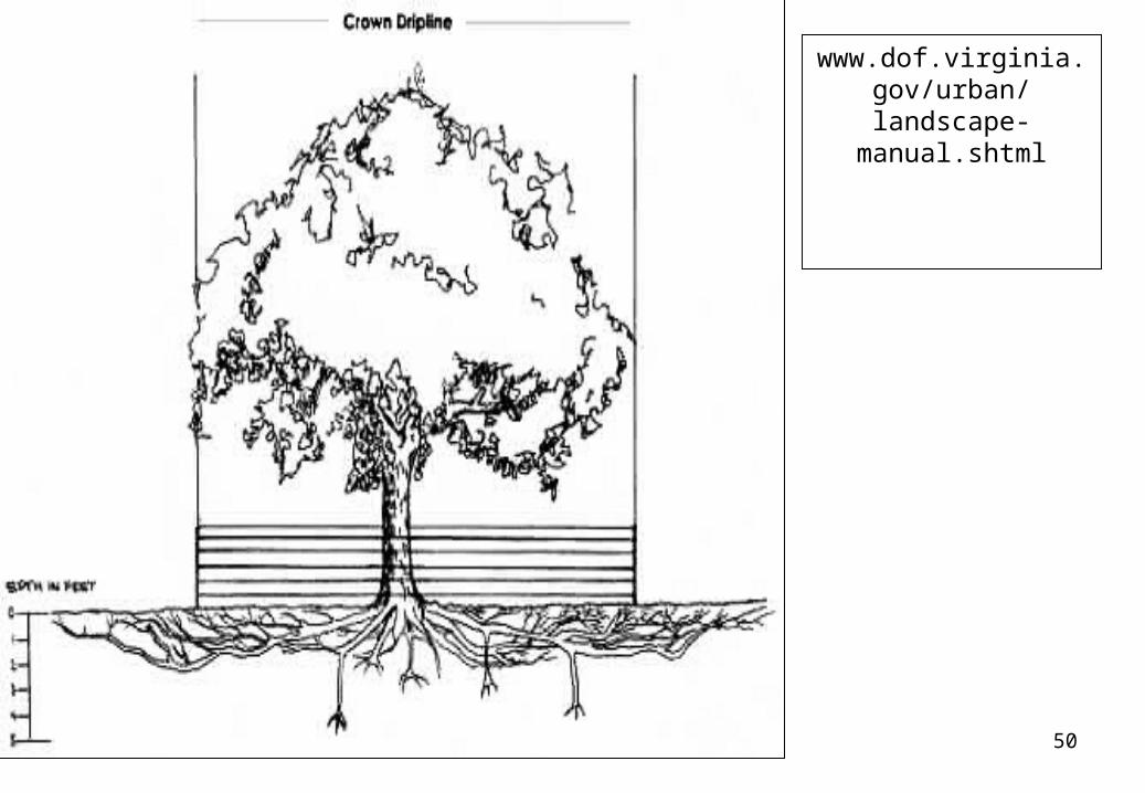
www.dof.virginia.gov/urban/landscape-
manual.shtml
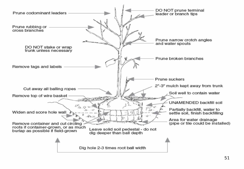
51
52
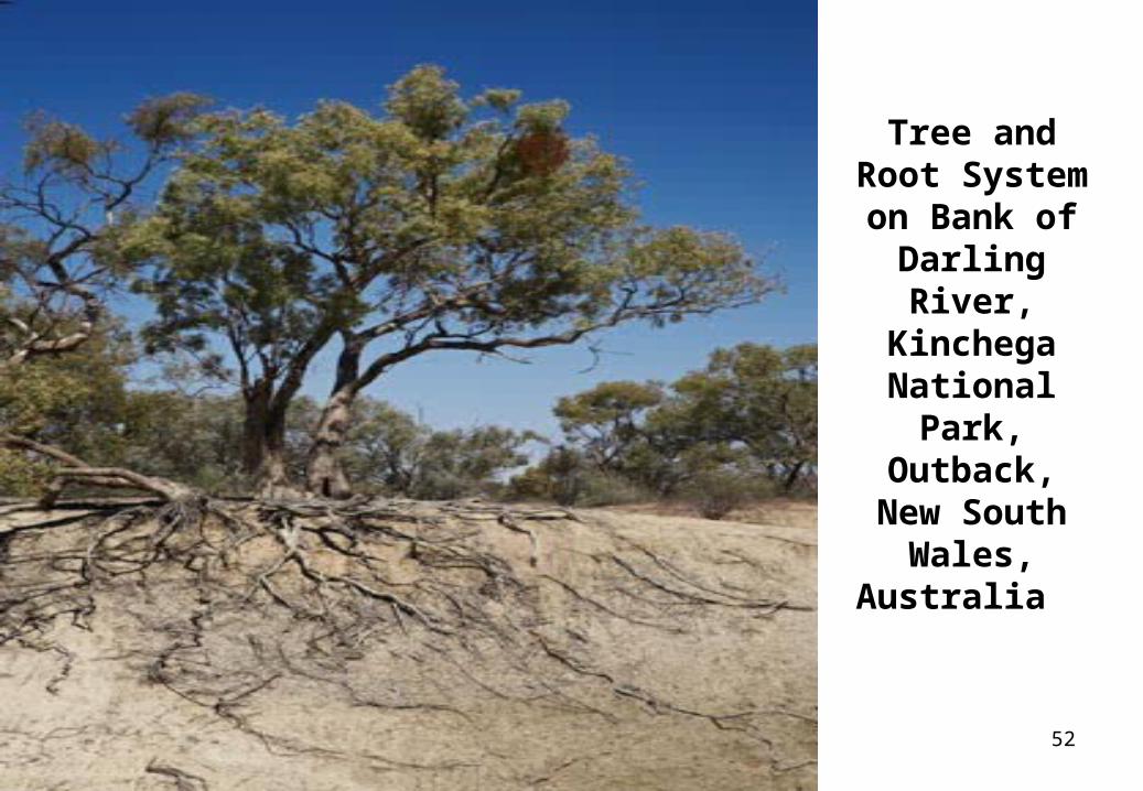
Tree and Root System on Bank of
Darling River, Kinchega National
Park, Outback, New South Wales,
Australia
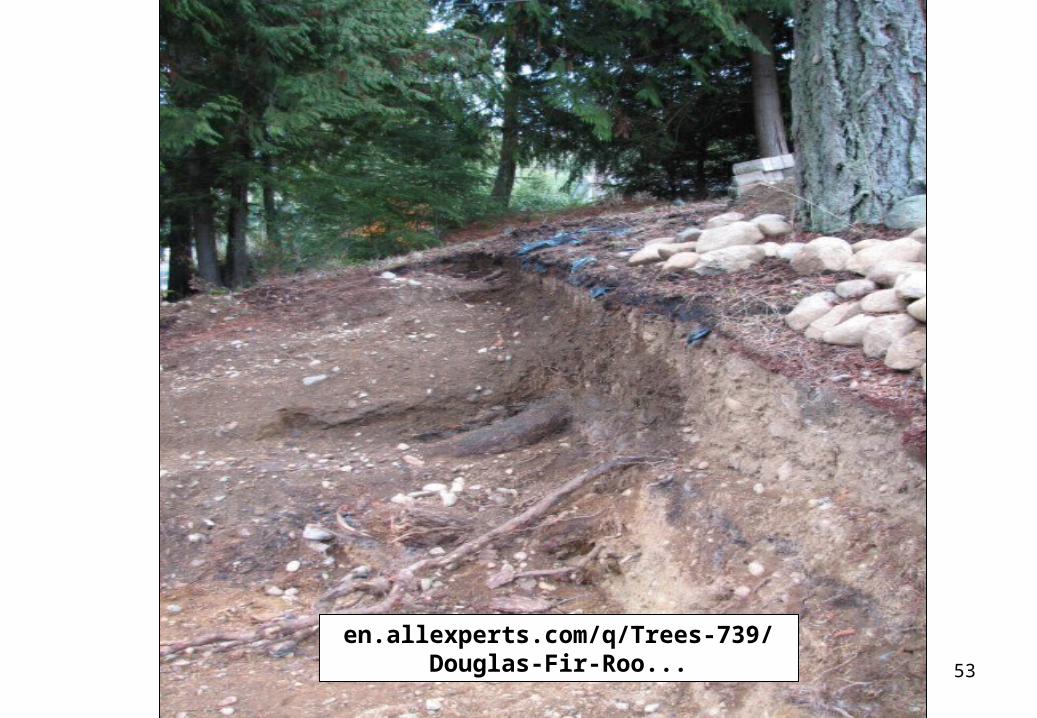
53
en.allexperts.com/q/Trees-739/Douglas-Fir-Roo...
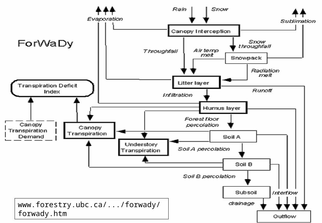
54www.forestry.ubc.ca/.../forwady/forwady.htm
55
56
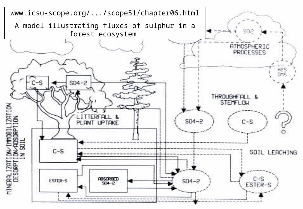
www.icsu-scope.org/.../scope51/chapter06.html
A model illustrating fluxes of sulphur in a forest ecosystem
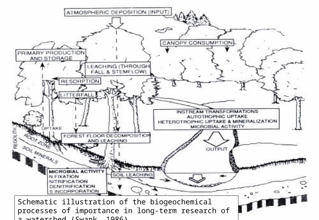
57Schematic illustration of the biogeochemical processes of importance in long-term research of a watershed (Swank, 1986).
58
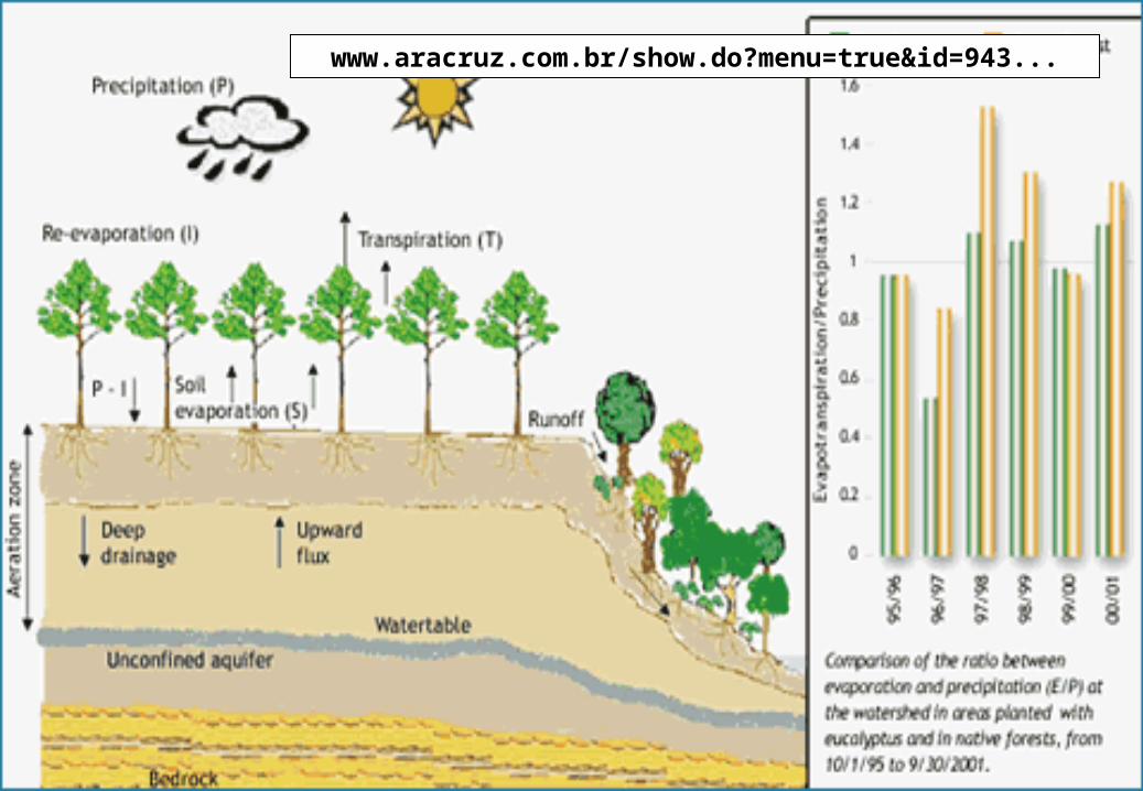
www.aracruz.com.br/show.do?menu=true&id=943...
59
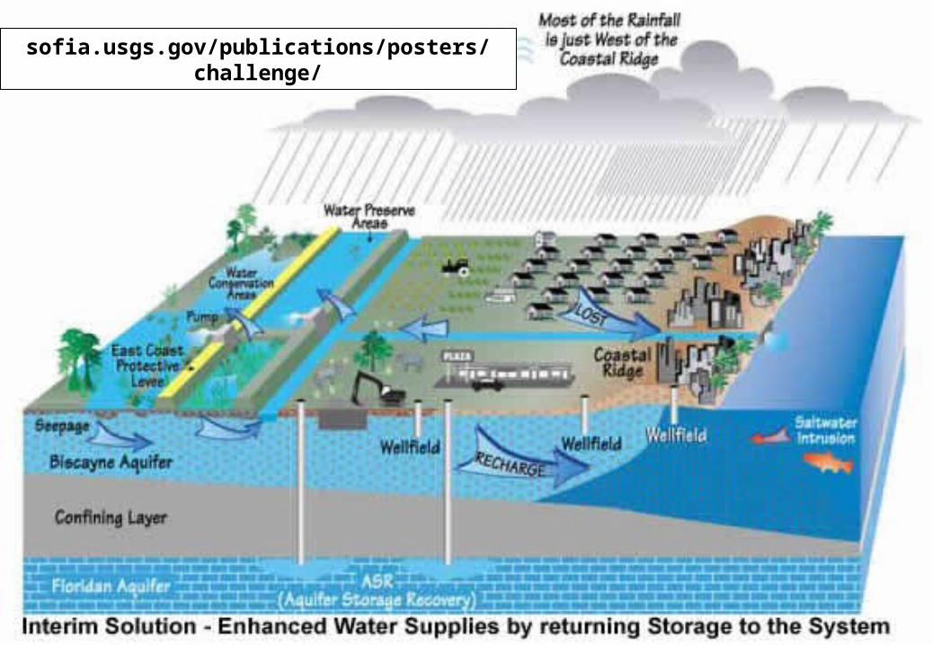
sofia.usgs.gov/publications/posters/challenge/
60
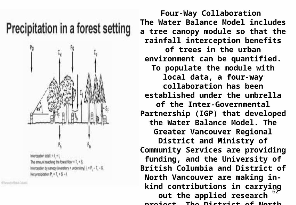
61www.waterbucket.ca/rm/?sid=33&id=271&type=single
62
Four-Way Collaboration The Water Balance Model includes a
tree canopy module so that the rainfall interception benefits of trees in the
urban environment can be quantified. To populate the module with local data, a
four-way collaboration has been established under the umbrella of the Inter-Governmental Partnership (IGP)
that developed the Water Balance Model. The Greater Vancouver Regional
District and Ministry of Community Services are providing funding, and the
University of British Columbia and District of North Vancouver are making in-kind contributions in carrying out the applied research project. The District of North Vancouver is acting on behalf of the IGP in leading this on-the-ground
initiative.
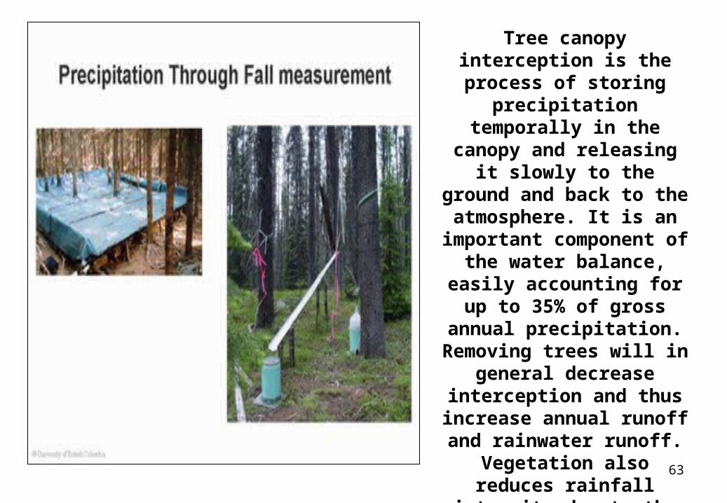
63
Tree canopy interception is the process of storing
precipitation temporally in the canopy and releasing it slowly to the ground and
back to the atmosphere. It is an important component of
the water balance, easily accounting for up to 35% of gross annual precipitation.
Removing trees will in general decrease
interception and thus increase annual runoff and rainwater runoff. Vegetation
also reduces rainfall intensity due to the temporal
storage effect.
64
wwa.colorado.edu/treeflow/lees/treering.html
65
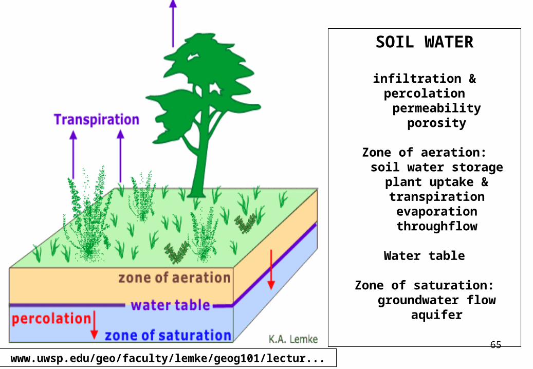
SOIL WATER
infiltration & percolationpermeability
porosity
Zone of aeration:soil water storage
plant uptake & transpirationevaporationthroughflow
Water table
Zone of saturation:groundwater flow
aquifer
www.uwsp.edu/geo/faculty/lemke/geog101/lectur...
66
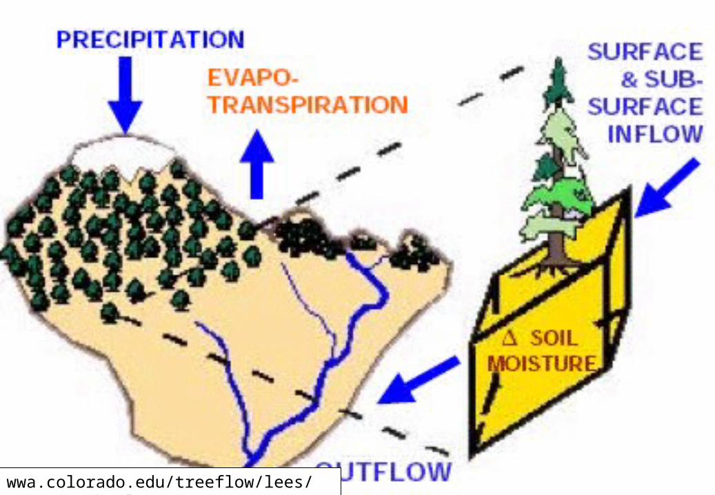
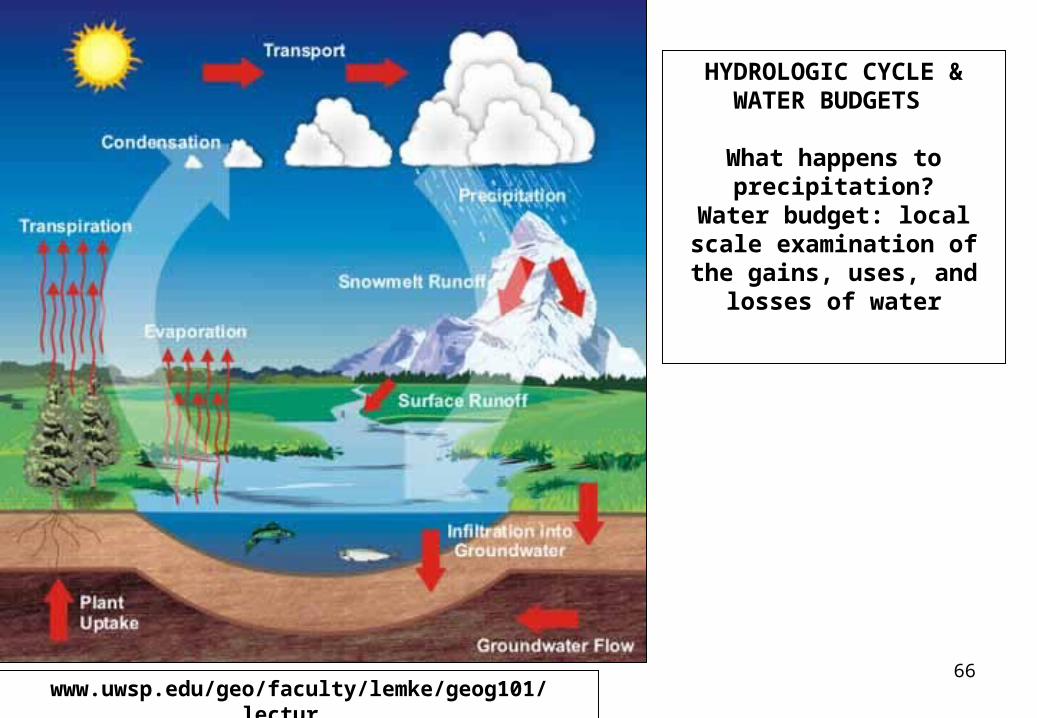
HYDROLOGIC CYCLE & WATER BUDGETS
What happens to precipitation?
Water budget: local scale examination of the gains, uses, and losses of water
www.uwsp.edu/geo/faculty/lemke/geog101/lectur...
67
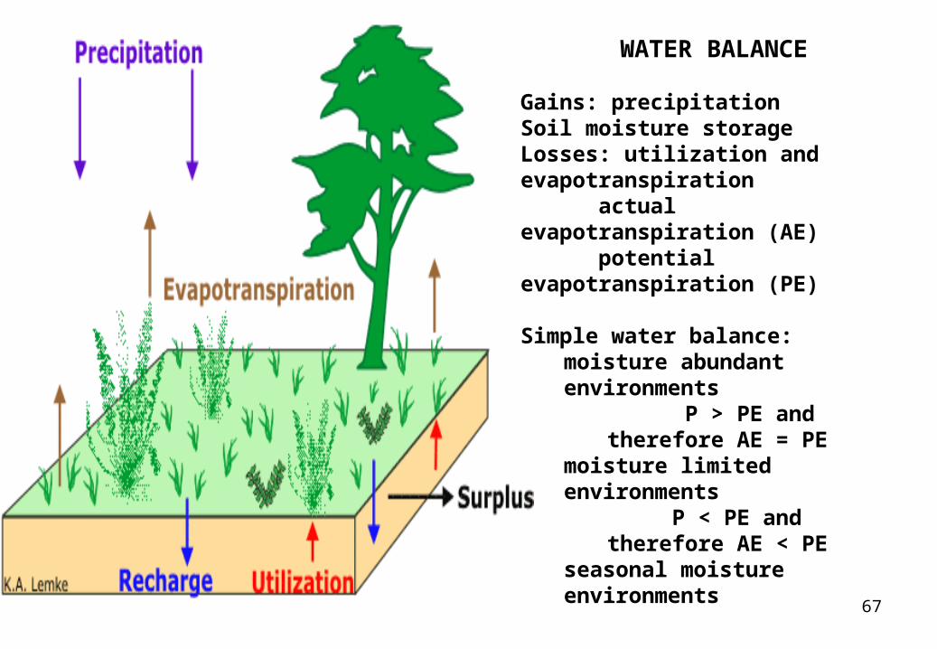
WATER BALANCE
Gains: precipitation Soil moisture storage Losses: utilization and evapotranspiration actual evapotranspiration (AE) potential evapotranspiration (PE)
Simple water balance: moisture abundant environments
P > PE and therefore AE = PE
moisture limited environments P < PE and therefore AE < PE
seasonal moisture environments
68
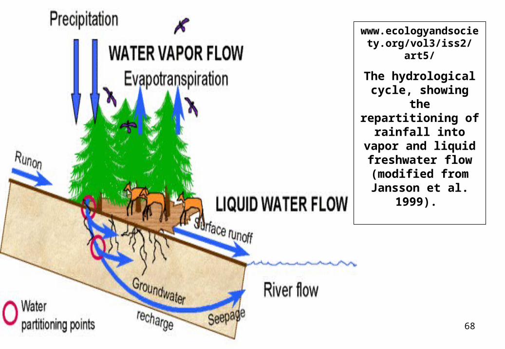
www.ecologyandsociety.org/vol3/iss2/art5/
The hydrological cycle, showing the
repartitioning of rainfall into vapor and liquid freshwater flow
(modified from Jansson et al. 1999).
69
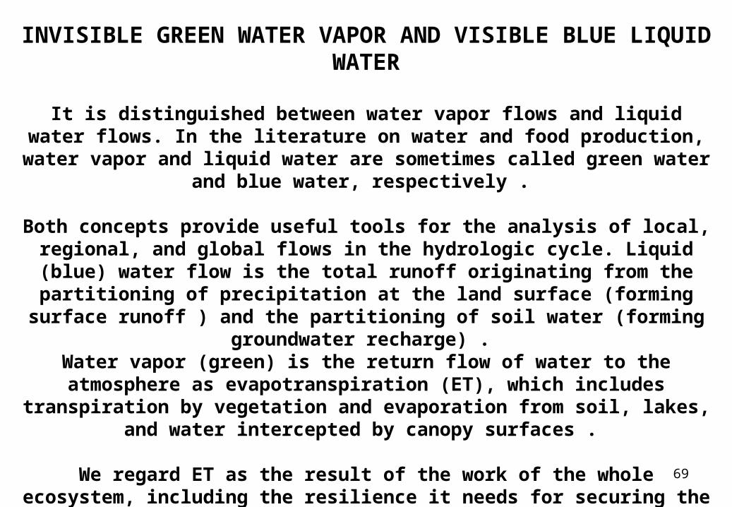
INVISIBLE GREEN WATER VAPOR AND VISIBLE BLUE LIQUID WATER
It is distinguished between water vapor flows and liquid water flows. In the literature on water and food production, water vapor and liquid water are
sometimes called green water and blue water, respectively .
Both concepts provide useful tools for the analysis of local, regional, and global flows in the hydrologic cycle. Liquid (blue) water flow is the total
runoff originating from the partitioning of precipitation at the land surface (forming surface runoff ) and the partitioning of soil water (forming
groundwater recharge) . Water vapor (green) is the return flow of water to the atmosphere as
evapotranspiration (ET), which includes transpiration by vegetation and evaporation from soil, lakes, and water intercepted by canopy surfaces .
We regard ET as the result of the work of the whole ecosystem, including the resilience it needs for securing the generation of ecosystem services in the
long run.
70
https://www.uwsp.edu/natres/nres743/T1Eco2.htm
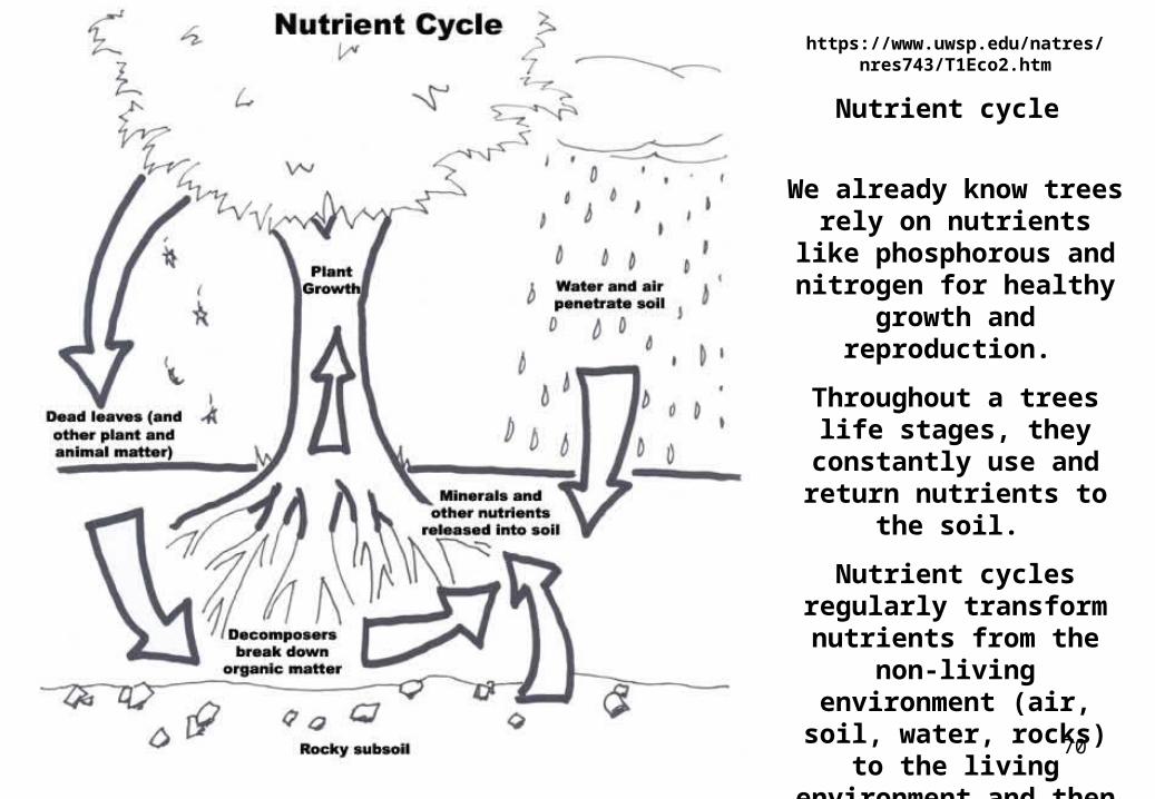
Nutrient cycle
We already know trees rely on nutrients like
phosphorous and nitrogen for healthy growth and
reproduction.
Throughout a trees life stages, they constantly
use and return nutrients to the soil.
Nutrient cycles regularly transform nutrients from
the non-living environment (air, soil, water, rocks) to
the living environment and then back again
71
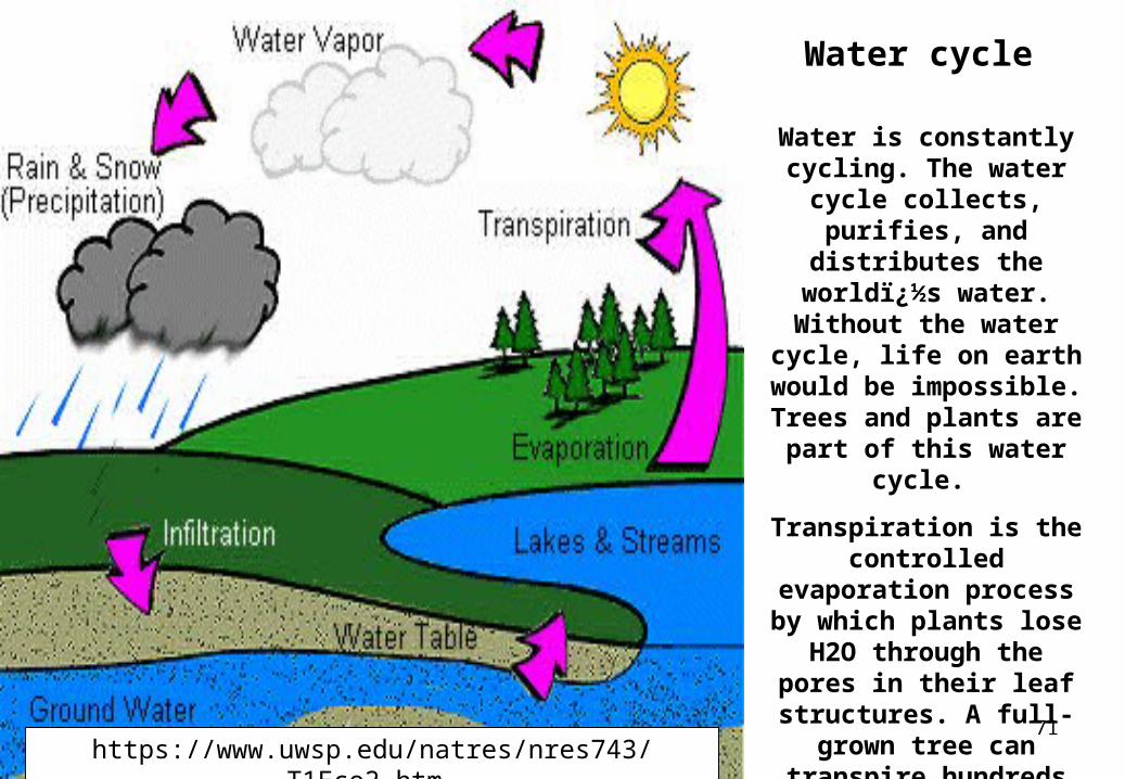
Water cycle
Water is constantly cycling. The water cycle
collects, purifies, and distributes the world�s water. Without the water cycle, life on earth would be impossible. Trees and
plants are part of this water cycle.
Transpiration is the controlled evaporation
process by which plants lose H2O through the
pores in their leaf structures. A full-grown
tree can transpire hundreds of gallons of
water a day during growing season.
https://www.uwsp.edu/natres/nres743/T1Eco2.htm
72www.bgky.org/tree/care.php
73
www.fastest-growing-trees.com/articles/10058-...
74
phytosphere.com/vtf/treewater.htm
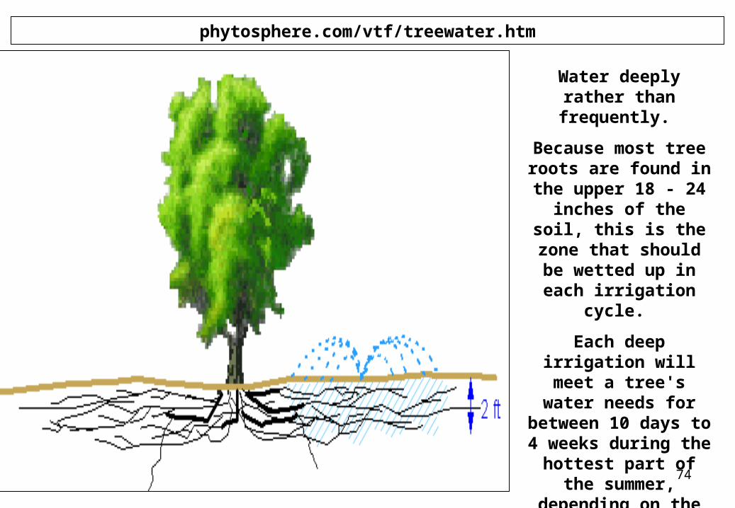
Water deeply rather than frequently.
Because most tree roots are found in the upper 18 - 24 inches of
the soil, this is the zone that should be wetted up in each irrigation cycle.
Each deep irrigation will meet a tree's water needs for between 10
days to 4 weeks during the hottest part
of the summer, depending on the tree species and soil type.
75
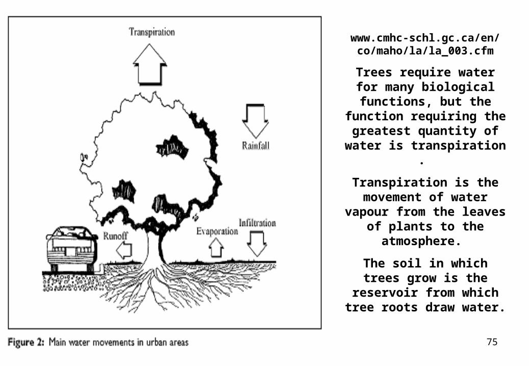
www.cmhc-schl.gc.ca/en/co/maho/la/la_003.cfm
Trees require water for many biological functions, but the function requiring
the greatest quantity of water is transpiration .
Transpiration is the movement of water vapour from the leaves of plants to
the atmosphere.
The soil in which trees grow is the reservoir from which
tree roots draw water.
76
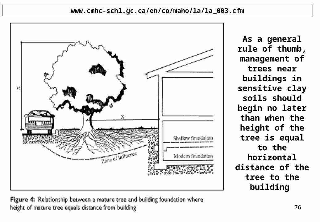
www.cmhc-schl.gc.ca/en/co/maho/la/la_003.cfm
As a general rule of thumb,
management of trees near
buildings in sensitive clay soils
should begin no later than when the height of the tree
is equal to the horizontal distance
of the tree to the building
77
www.flemings.com.au/treefacts_environmental.asp
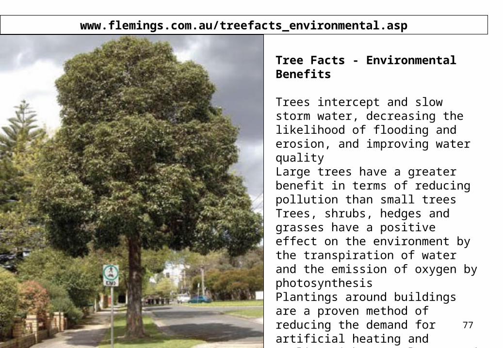
Tree Facts - Environmental Benefits Trees intercept and slow storm water, decreasing the likelihood of flooding and erosion, and improving water quality Large trees have a greater benefit in terms of reducing pollution than small trees Trees, shrubs, hedges and grasses have a positive effect on the environment by the transpiration of water and the emission of oxygen by photosynthesis Plantings around buildings are a proven method of reducing the demand for artificial heating and cooling with a resultant, and important, lower use of fossil fuels. Greenery provides ‘white noise’ reducing the effects of man-made sounds
78
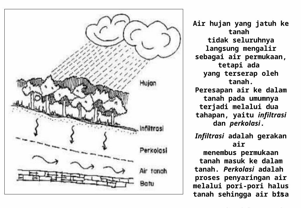
Air hujan yang jatuh ke tanah
tidak seluruhnya langsung mengalir sebagai air
permukaan, tetapi ada yang terserap oleh tanah.Peresapan air ke dalam
tanah pada umumnya terjadi melalui dua
tahapan, yaitu infiltrasi dan perkolasi.
Infiltrasi adalah gerakan air menembus permukaan tanah
masuk ke dalam tanah. Perkolasi adalah
proses penyaringan air melalui pori-pori halus tanah
sehingga air bisa meresap ke dalam tanah.
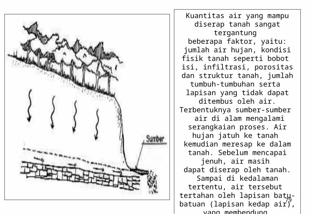
79
Kuantitas air yang mampu diserap tanah sangat tergantung
beberapa faktor, yaitu: jumlah air hujan, kondisi fisik tanah seperti
bobot isi, infiltrasi, porositas dan struktur
tanah, jumlah tumbuh-tumbuhan serta
lapisan yang tidak dapat ditembus oleh air. Terbentuknya sumber-
sumber air di alam mengalami serangkaian
proses. Air hujan jatuh ke tanah kemudian meresap ke dalam tanah. Sebelum mencapai jenuh, air masih dapat diserap oleh tanah. Sampai di
kedalaman tertentu, air tersebut tertahan oleh lapisan batu-batuan
(lapisan kedap air), yang membendung
air sehingga tidak terus meresap ke bawah sehingga membentuk air
tanah. Jika telah mengalami jenuh, air yang
jatuh ke permukaan tanah akan dialirkan sebagai air permukaan.
80
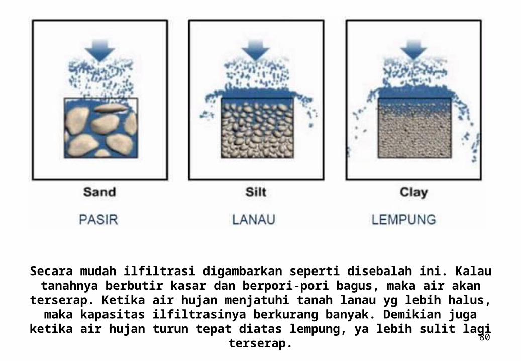
Secara mudah ilfiltrasi digambarkan seperti disebalah ini. Kalau tanahnya berbutir kasar dan berpori-pori bagus, maka air akan terserap. Ketika air hujan menjatuhi
tanah lanau yg lebih halus, maka kapasitas ilfiltrasinya berkurang banyak. Demikian juga ketika air hujan turun tepat diatas lempung, ya lebih sulit lagi
terserap.
81
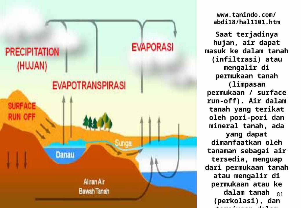
www.tanindo.com/abdi18/hal1101.htm
Saat terjadinya hujan, air dapat masuk ke dalam tanah (infiltrasi) atau
mengalir di permukaan tanah (limpasan
permukaan / surface run-off). Air dalam tanah
yang terikat oleh pori-pori dan mineral tanah,
ada yang dapat dimanfaatkan oleh
tanaman sebagai air tersedia, menguap dari permukaan tanah atau mengalir di permukaan
atau ke dalam tanah (perkolasi), dan
tersimpan dalam tanah sebagai air tanah.
82
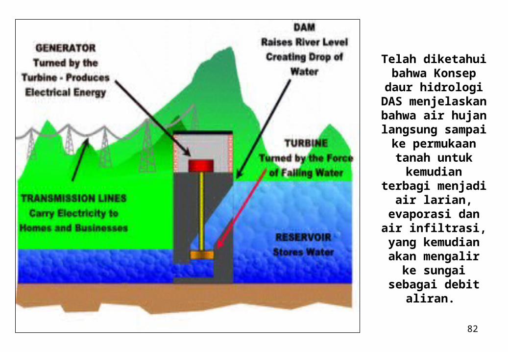
Telah diketahui bahwa Konsep
daur hidrologi DAS menjelaskan
bahwa air hujan langsung sampai
ke permukaan tanah untuk
kemudian terbagi menjadi air larian, evaporasi dan air
infiltrasi, yang kemudian akan
mengalir ke sungai sebagai debit
aliran.
83
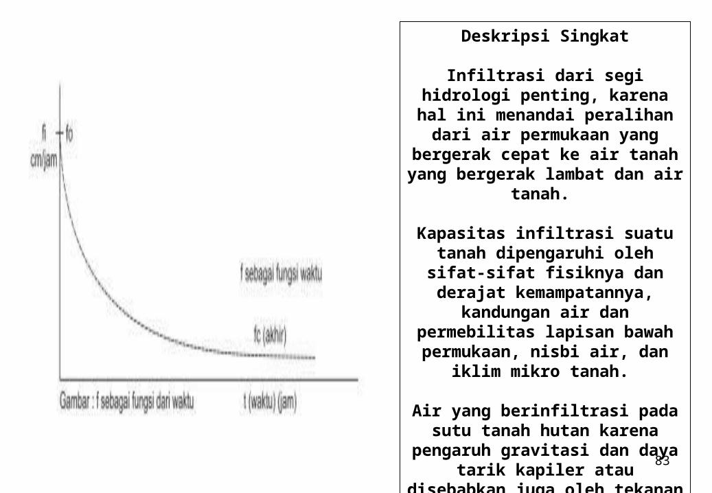
Deskripsi Singkat
Infiltrasi dari segi hidrologi penting, karena hal ini menandai
peralihan dari air permukaan yang bergerak cepat ke air tanah yang bergerak lambat dan air tanah.
Kapasitas infiltrasi suatu tanah dipengaruhi oleh sifat-sifat fisiknya
dan derajat kemampatannya, kandungan air dan permebilitas lapisan bawah permukaan, nisbi
air, dan iklim mikro tanah.
Air yang berinfiltrasi pada sutu tanah hutan karena pengaruh
gravitasi dan daya tarik kapiler atau disebabkan juga oleh tekanan
dari pukulan air hujan pada permukaan tanah.
84
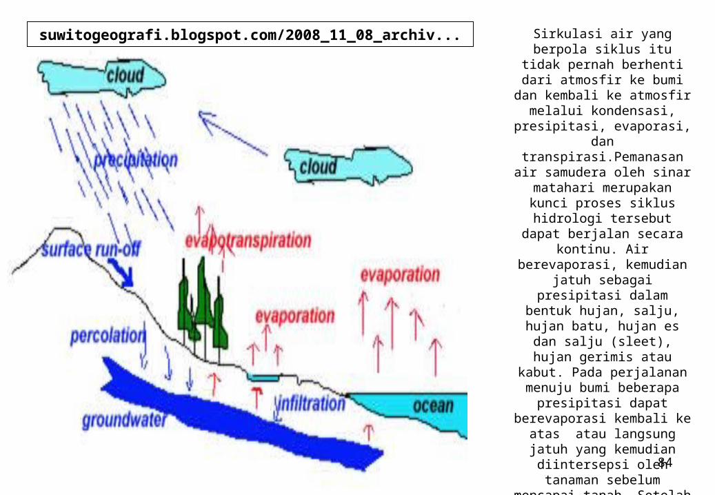
Sirkulasi air yang berpola siklus itu tidak pernah berhenti
dari atmosfir ke bumi dan kembali ke atmosfir melalui
kondensasi, presipitasi, evaporasi, dan
transpirasi.Pemanasan air samudera oleh sinar matahari merupakan kunci proses siklus
hidrologi tersebut dapat berjalan secara kontinu. Air
berevaporasi, kemudian jatuh sebagai presipitasi dalam
bentuk hujan, salju, hujan batu, hujan es dan salju (sleet),
hujan gerimis atau kabut. Pada perjalanan menuju bumi
beberapa presipitasi dapat berevaporasi kembali ke atas
atau langsung jatuh yang kemudian diintersepsi oleh
tanaman sebelum mencapai tanah. Setelah mencapai
tanah, siklus hidrologi terus bergerak secara kontinu dalam
tiga cara diantaranya melaui kondensasi, presipitasi,
evaporasi dan transpirasi.
suwitogeografi.blogspot.com/2008_11_08_archiv...
85
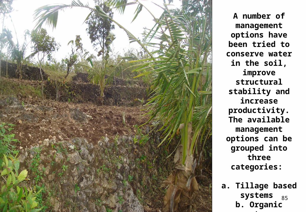
A number of management options
have been tried to conserve water in the soil, improve
structural stability and increase
productivity. The available
management options can be grouped into
three categories:
a. Tillage based systems
b. Organic systems c. Biological
systems
86
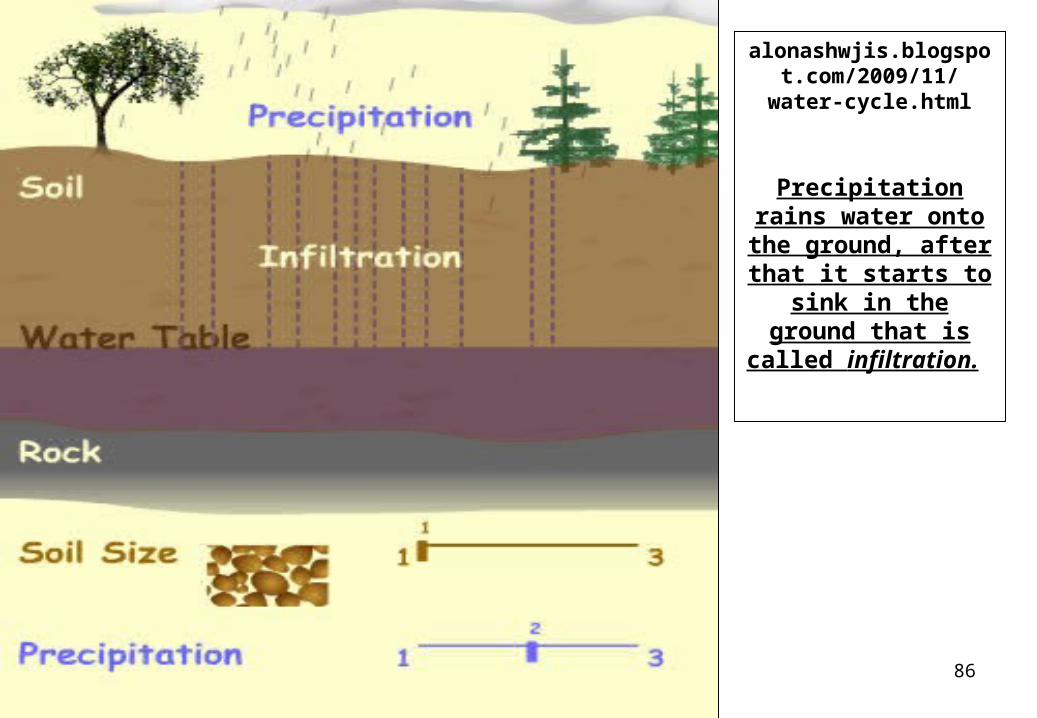
alonashwjis.blogspot.com/2009/11/water-
cycle.html
Precipitation rains water onto the
ground, after that it starts to sink in the
ground that is called infiltration.
87
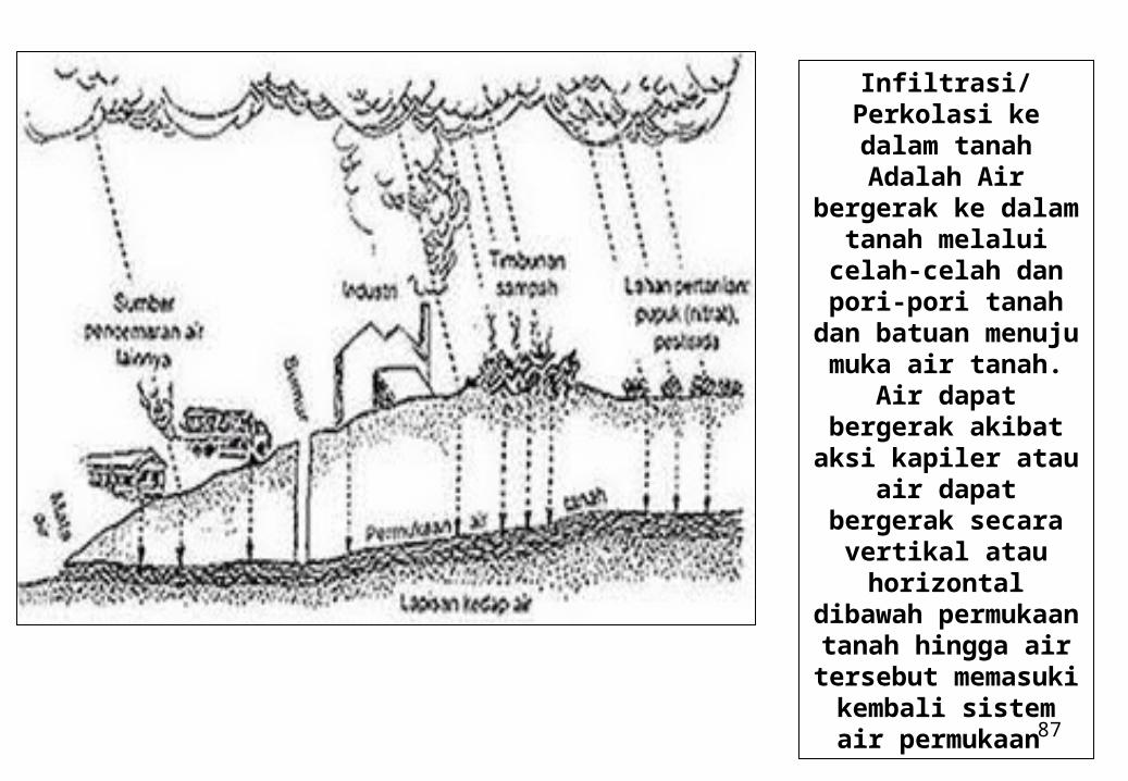
Infiltrasi/Perkolasi ke dalam tanah Adalah
Air bergerak ke dalam tanah melalui celah-celah dan pori-pori tanah dan batuan menuju muka air tanah. Air dapat
bergerak akibat aksi kapiler atau air dapat
bergerak secara vertikal atau
horizontal dibawah permukaan tanah
hingga air tersebut memasuki kembali
sistem air permukaan
88
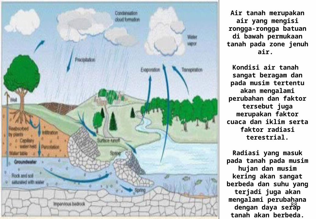
Air tanah merupakan air yang mengisi rongga-
rongga batuan di bawah permukaan tanah pada
zone jenuh air.
Kondisi air tanah sangat beragam dan pada musim tertentu akan mengalami
perubahan dan faktor tersebut juga merupakan
faktor cuaca dan iklim serta faktor radiasi
terestrial.
Radiasi yang masuk pada tanah pada musim hujan dan musim kering akan
sangat berbeda dan suhu yang terjadi juga akan
mengalami perubahana dengan daya serap tanah
akan berbeda.
89
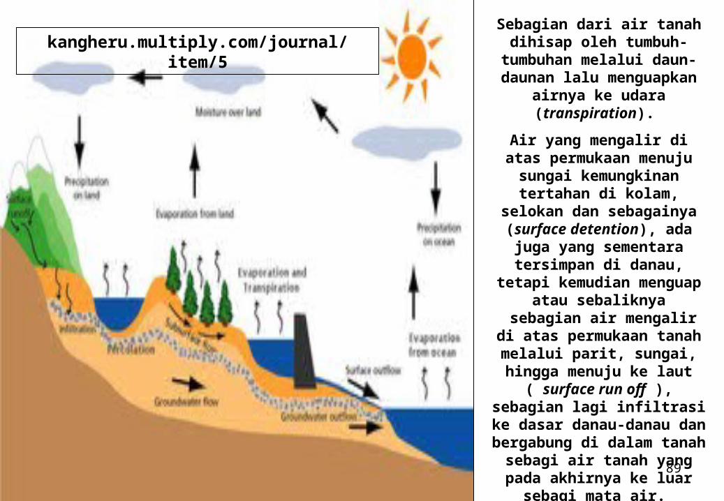
Sebagian dari air tanah dihisap oleh tumbuh-
tumbuhan melalui daun-daunan lalu menguapkan
airnya ke udara (transpiration).
Air yang mengalir di atas permukaan menuju sungai kemungkinan tertahan di
kolam, selokan dan sebagainya (surface
detention), ada juga yang sementara tersimpan di danau, tetapi kemudian
menguap atau sebaliknya sebagian air mengalir di atas
permukaan tanah melalui parit, sungai, hingga menuju
ke laut ( surface run off ), sebagian lagi infiltrasi ke dasar danau-danau dan
bergabung di dalam tanah sebagi air tanah yang pada
akhirnya ke luar sebagi mata air.
kangheru.multiply.com/journal/item/5
90
AIR TANAH
Air tanah adalah air yang terdapat dalam pori-pori tanah atau pada celah-celah batuan. Air tanah terbentuk dari air hujan.
Pada saat turun hujan, sebagian titik-titik air meresap ke dalam tanah (infiltrasi). Air hujan yang masuk itu yang menjadi adangan air tanah. Volume air yang meresap ke dalam tanah tergantung pada jenis lapisan batuannya.
Berdasarkan kenyataan tersebut terdapat pula dua jenis batuan utama, yaitu lapisan kedap (impermiable) dan lapisan tanah tidak kedap air (permeable)
Kadar pori lapisan kedap atau tak tembus air sangat kecil, sehingga kemampuan untuk meneruskan air juga kecil.
Contoh lapisan kedap, yaitu geluh, napal, dan lempung. Sedangkan kadar pori lapisan tak kedap air atau tembus air cukup besar. Oleh karena itu,
kemampuan untuk meneruskan air juga besar. Contoh lapisan tembus air, yaitu pasir, padas, krikil dan kapur. Kita akan lihat
bersama gambar lapisan kedap dan lapisan tak kedap pada air tanah di halaman berikutnya
91
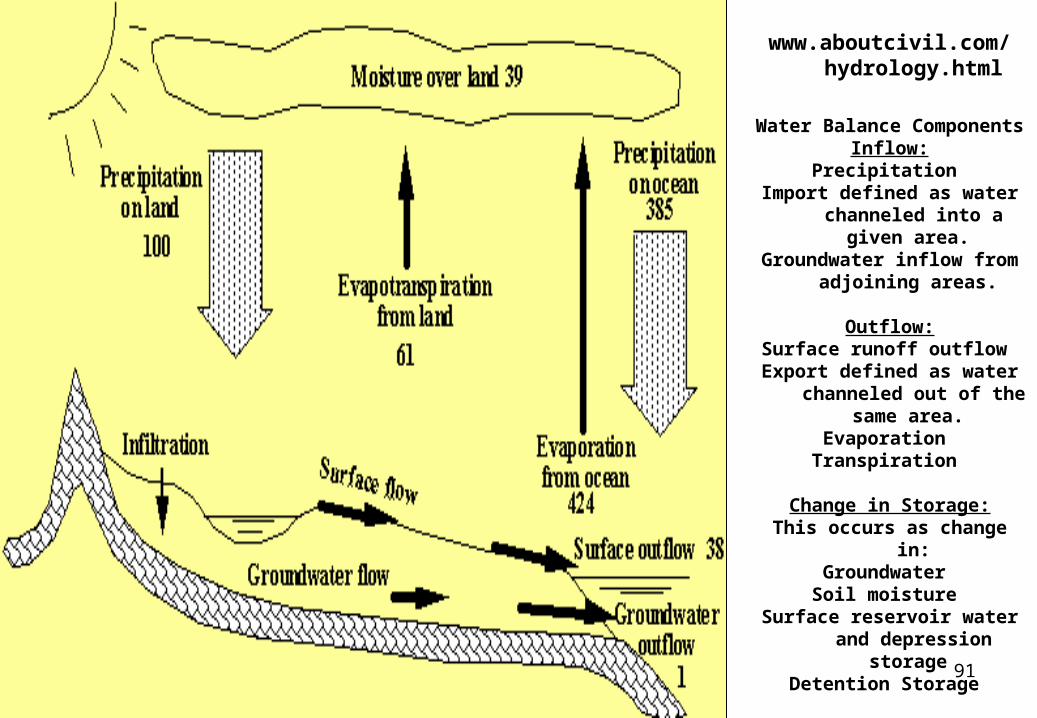
www.aboutcivil.com/hydrology.html
Water Balance ComponentsInflow:
Precipitation Import defined as water
channeled into a given area.
Groundwater inflow from adjoining areas.
Outflow:Surface runoff outflow Export defined as water
channeled out of the same area.
Evaporation Transpiration
Change in Storage:This occurs as change in:
Groundwater Soil moisture
Surface reservoir water and depression storage
Detention Storage
92
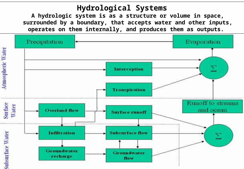
Hydrological SystemsA hydrologic system is as a structure or volume in space, surrounded by a
boundary, that accepts water and other inputs, operates on them internally, and produces them as outputs.
93
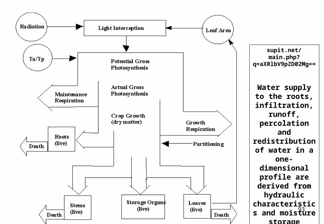
supit.net/main.php?q=aXRlbV9pZD02Mg==
Water supply to the roots,
infiltration, runoff,
percolation and redistribution of water in a one-
dimensional profile are
derived from hydraulic
characteristics and moisture
storage capacity of the soil.
94
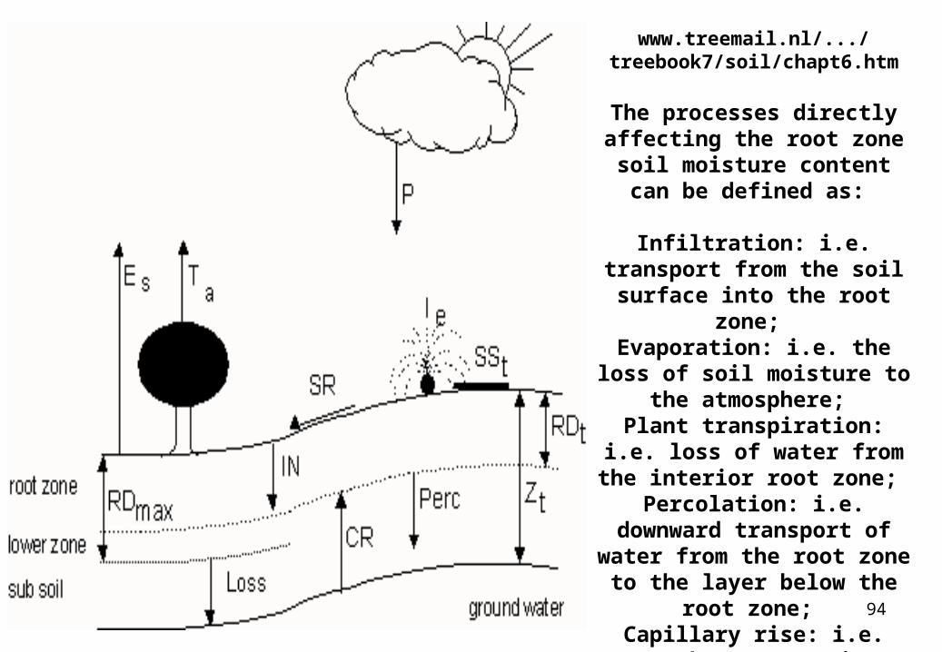
www.treemail.nl/.../treebook7/soil/chapt6.htm
The processes directly affecting the root zone soil
moisture content can be defined as:
Infiltration: i.e. transport from the soil surface into the root
zone; Evaporation: i.e. the loss of
soil moisture to the atmosphere;
Plant transpiration: i.e. loss of water from the interior root
zone; Percolation: i.e. downward transport of water from the root zone to the layer below
the root zone; Capillary rise: i.e. upward
transport into the rooted zone.
95
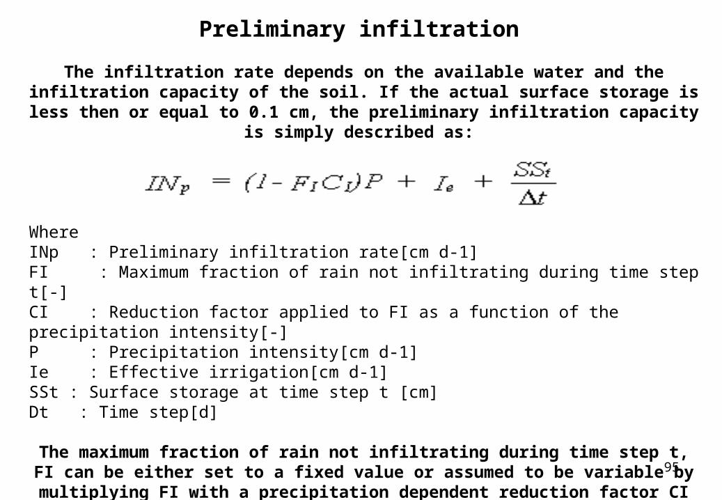
Preliminary infiltration
The infiltration rate depends on the available water and the infiltration capacity of the soil. If the actual surface storage is less then or equal to 0.1 cm, the preliminary
infiltration capacity is simply described as:
WhereINp : Preliminary infiltration rate[cm d-1]FI : Maximum fraction of rain not infiltrating during time step t[-]CI : Reduction factor applied to FI as a function of the precipitation intensity[-]P : Precipitation intensity[cm d-1]Ie : Effective irrigation[cm d-1]SSt : Surface storage at time step t [cm]Dt : Time step[d]
The maximum fraction of rain not infiltrating during time step t, FI can be either set to a fixed value or assumed to be variable by multiplying FI with a precipitation dependent reduction factor CI which is maximum for high rainfall and will be
reduced for low rainfall. The user should provide FI. The CI table is included in the model and is assumed to be fixed.
96
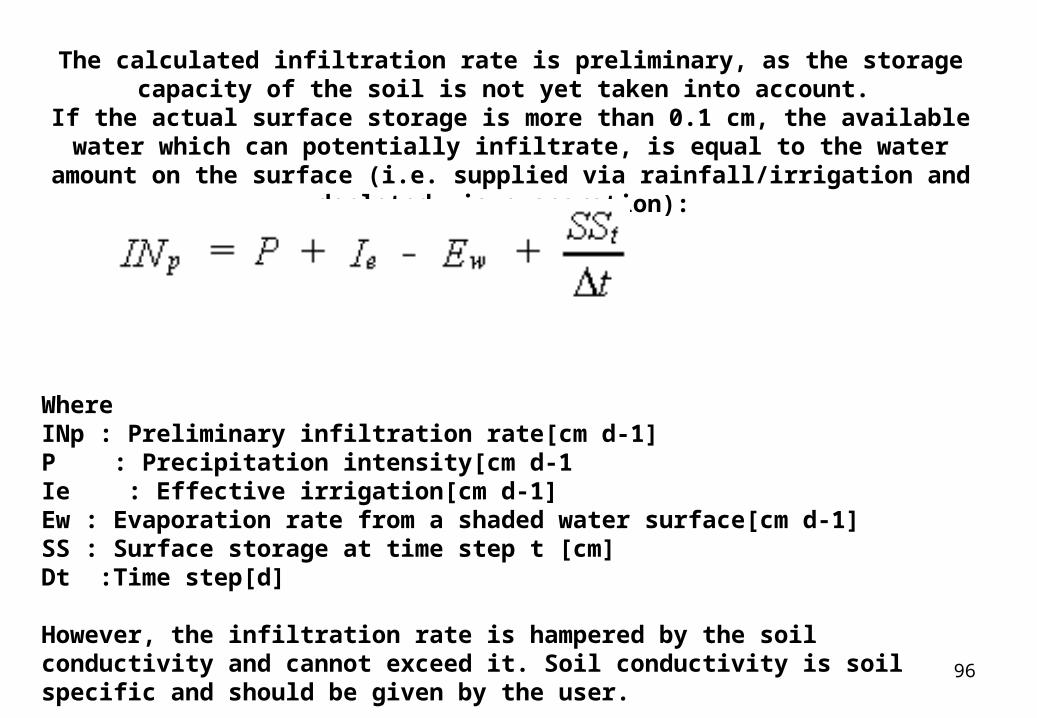
The calculated infiltration rate is preliminary, as the storage capacity of the soil is not yet taken into account.
If the actual surface storage is more than 0.1 cm, the available water which can potentially infiltrate, is equal to the water amount on the surface (i.e. supplied via
rainfall/irrigation and depleted via evaporation):
WhereINp : Preliminary infiltration rate[cm d-1]P : Precipitation intensity[cm d-1Ie : Effective irrigation[cm d-1]Ew : Evaporation rate from a shaded water surface[cm d-1]SS : Surface storage at time step t [cm]Dt :Time step[d]
However, the infiltration rate is hampered by the soil conductivity and cannot exceed it. Soil conductivity is soil specific and should be given by the user.
97
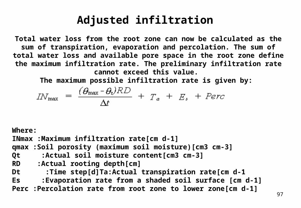
Adjusted infiltration Total water loss from the root zone can now be calculated as the sum of
transpiration, evaporation and percolation. The sum of total water loss and available pore space in the root zone define the maximum infiltration rate. The
preliminary infiltration rate cannot exceed this value. The maximum possible infiltration rate is given by:
Where:INmax :Maximum infiltration rate[cm d-1]qmax :Soil porosity (maximum soil moisture)[cm3 cm-3]Qt :Actual soil moisture content[cm3 cm-3]RD :Actual rooting depth[cm]Dt :Time step[d]Ta:Actual transpiration rate[cm d-1Es :Evaporation rate from a shaded soil surface [cm d-1]Perc :Percolation rate from root zone to lower zone[cm d-1]
98
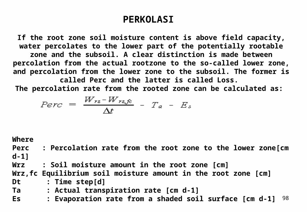
PERKOLASI If the root zone soil moisture content is above field capacity, water percolates to the lower part of the potentially rootable zone and the subsoil. A clear distinction is made between percolation from the actual rootzone to the so-called lower zone, and percolation from the lower zone to the subsoil. The former is called Perc and
the latter is called Loss. The percolation rate from the rooted zone can be calculated as:
WherePerc : Percolation rate from the root zone to the lower zone[cm d-1]Wrz : Soil moisture amount in the root zone [cm]Wrz,fc Equilibrium soil moisture amount in the root zone [cm]Dt : Time step[d]Ta : Actual transpiration rate [cm d-1]Es : Evaporation rate from a shaded soil surface [cm d-1]
99
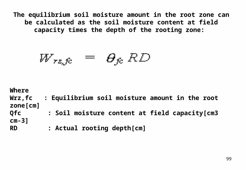
The equilibrium soil moisture amount in the root zone can be calculated as the soil moisture content at field capacity times the depth of the
rooting zone:
WhereWrz,fc : Equilibrium soil moisture amount in the root zone[cm]Qfc : Soil moisture content at field capacity[cm3 cm-3]RD : Actual rooting depth[cm]
100
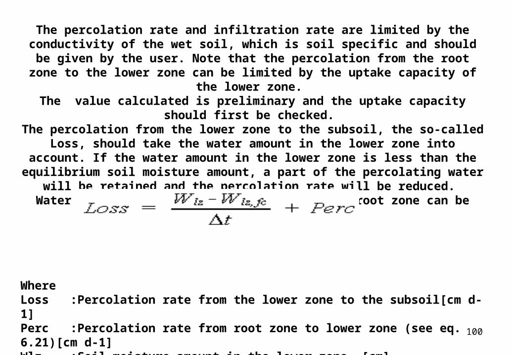
The percolation rate and infiltration rate are limited by the conductivity of the wet soil, which is soil specific and should be given by the user. Note that the
percolation from the root zone to the lower zone can be limited by the uptake capacity of the lower zone.
The value calculated is preliminary and the uptake capacity should first be checked.
The percolation from the lower zone to the subsoil, the so-called Loss, should take the water amount in the lower zone into account. If the water amount in the
lower zone is less than the equilibrium soil moisture amount, a part of the percolating water will be retained and the percolation rate will be reduced.
Water loss from the lower end of the maximum root zone can be calculated as:
WhereLoss :Percolation rate from the lower zone to the subsoil[cm d-1]Perc :Percolation rate from root zone to lower zone (see eq. 6.21)[cm d-1]Wlz :Soil moisture amount in the lower zone [cm]Wlz,fc :Equilibrium soil moisture amount in the lower zone [cm]Dt :Time step
101
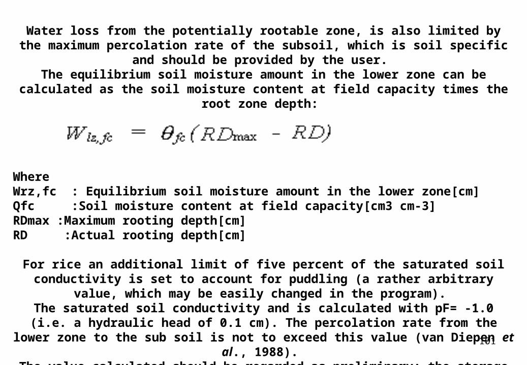
Water loss from the potentially rootable zone, is also limited by the maximum percolation rate of the subsoil, which is soil specific and should be provided by the
user. The equilibrium soil moisture amount in the lower zone can be calculated as the soil
moisture content at field capacity times the root zone depth:
WhereWrz,fc : Equilibrium soil moisture amount in the lower zone[cm]Qfc :Soil moisture content at field capacity[cm3 cm-3]RDmax :Maximum rooting depth[cm]RD :Actual rooting depth[cm]
For rice an additional limit of five percent of the saturated soil conductivity is set to account for puddling (a rather arbitrary value, which may be easily changed in the
program). The saturated soil conductivity and is calculated with pF= -1.0 (i.e. a hydraulic head of 0.1 cm). The percolation rate from the lower zone to the sub soil is not to exceed this
value (van Diepen et al., 1988). The value calculated should be regarded as preliminary; the storage capacity of the
receiving layer may become limiting.
102
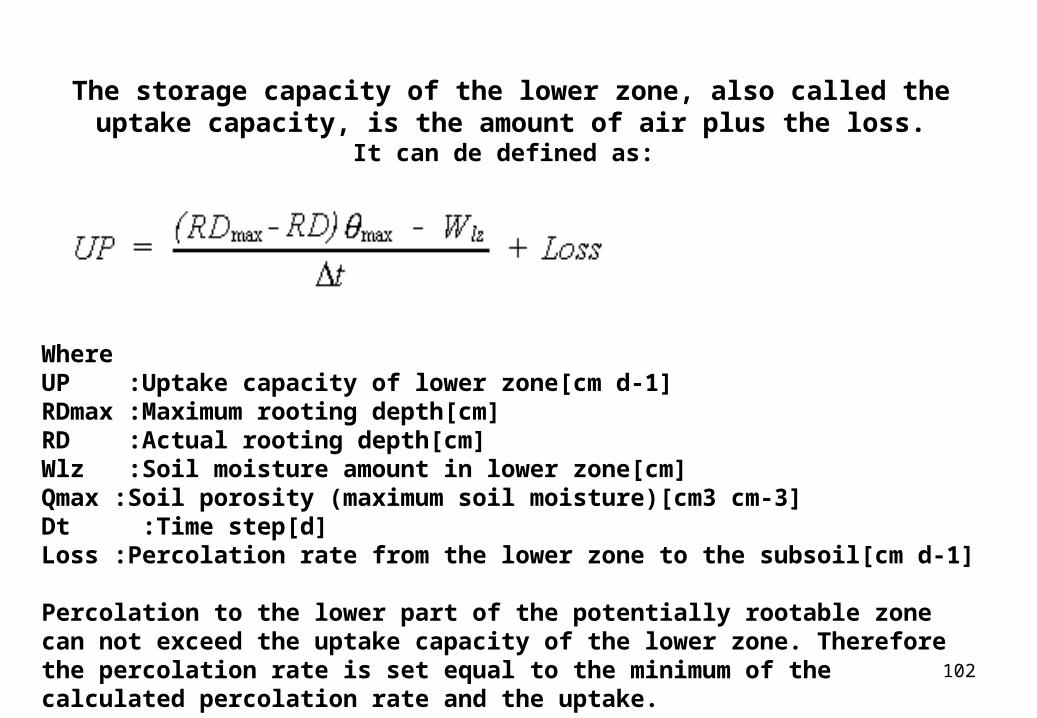
The storage capacity of the lower zone, also called the uptake capacity, is the amount of air plus the loss.
It can de defined as:
WhereUP :Uptake capacity of lower zone[cm d-1]RDmax :Maximum rooting depth[cm]RD :Actual rooting depth[cm]Wlz :Soil moisture amount in lower zone[cm]Qmax :Soil porosity (maximum soil moisture)[cm3 cm-3]Dt :Time step[d]Loss :Percolation rate from the lower zone to the subsoil[cm d-1]
Percolation to the lower part of the potentially rootable zone can not exceed the uptake capacity of the lower zone. Therefore the percolation rate is set equal to the minimum of the calculated percolation rate and the uptake.
103
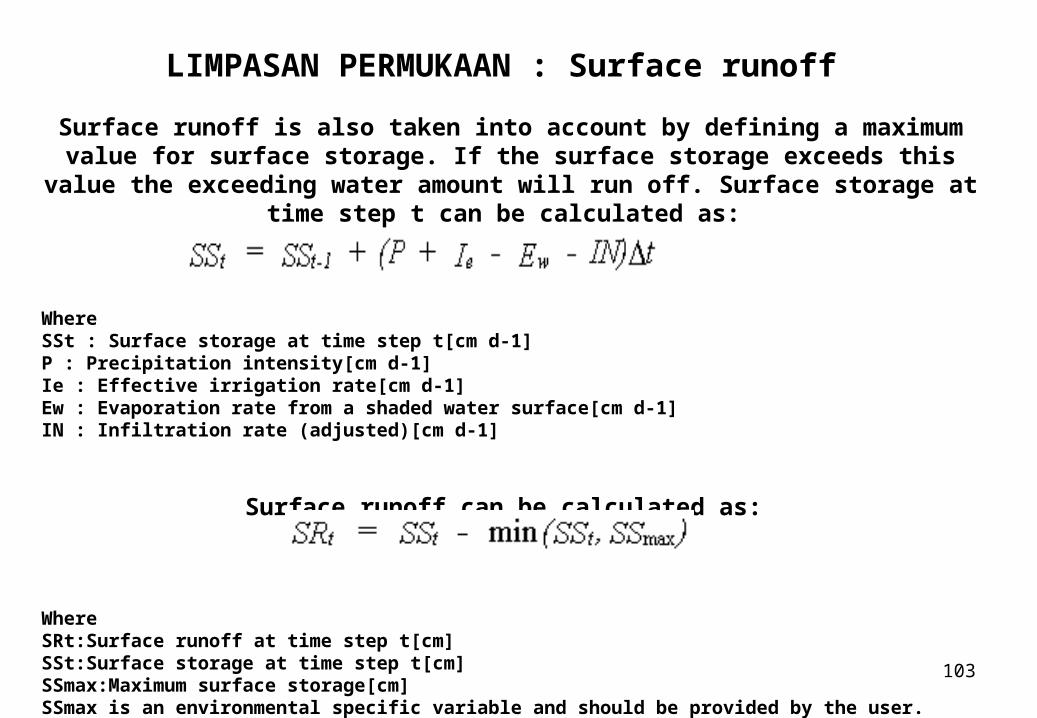
LIMPASAN PERMUKAAN : Surface runoff Surface runoff is also taken into account by defining a maximum value for surface storage. If the surface storage exceeds this value the exceeding water amount will
run off. Surface storage at time step t can be calculated as:
WhereSSt : Surface storage at time step t[cm d-1]P : Precipitation intensity[cm d-1]Ie : Effective irrigation rate[cm d-1]Ew : Evaporation rate from a shaded water surface[cm d-1]IN : Infiltration rate (adjusted)[cm d-1]
Surface runoff can be calculated as:
WhereSRt:Surface runoff at time step t[cm]SSt:Surface storage at time step t[cm]SSmax:Maximum surface storage[cm]SSmax is an environmental specific variable and should be provided by the user.
104
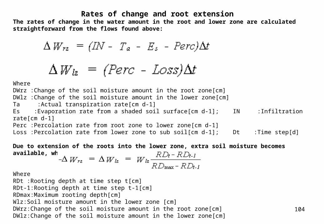
Rates of change and root extension The rates of change in the water amount in the root and lower zone are calculated straightforward from the flows found above:
WhereDWrz :Change of the soil moisture amount in the root zone[cm]DWlz :Change of the soil moisture amount in the lower zone[cm]Ta :Actual transpiration rate[cm d-1]Es :Evaporation rate from a shaded soil surface[cm d-1]; IN :Infiltration rate[cm d-1]Perc :Percolation rate from root zone to lower zone[cm d-1]Loss :Percolation rate from lower zone to sub soil[cm d-1]; Dt :Time step[d]
Due to extension of the roots into the lower zone, extra soil moisture becomes available, which can be calculated as:
WhereRDt :Rooting depth at time step t[cm]RDt-1:Rooting depth at time step t-1[cm]RDmax:Maximum rooting depth[cm]Wlz:Soil moisture amount in the lower zone [cm]DWrz:Change of the soil moisture amount in the root zone[cm]DWlz:Change of the soil moisture amount in the lower zone[cm]
105
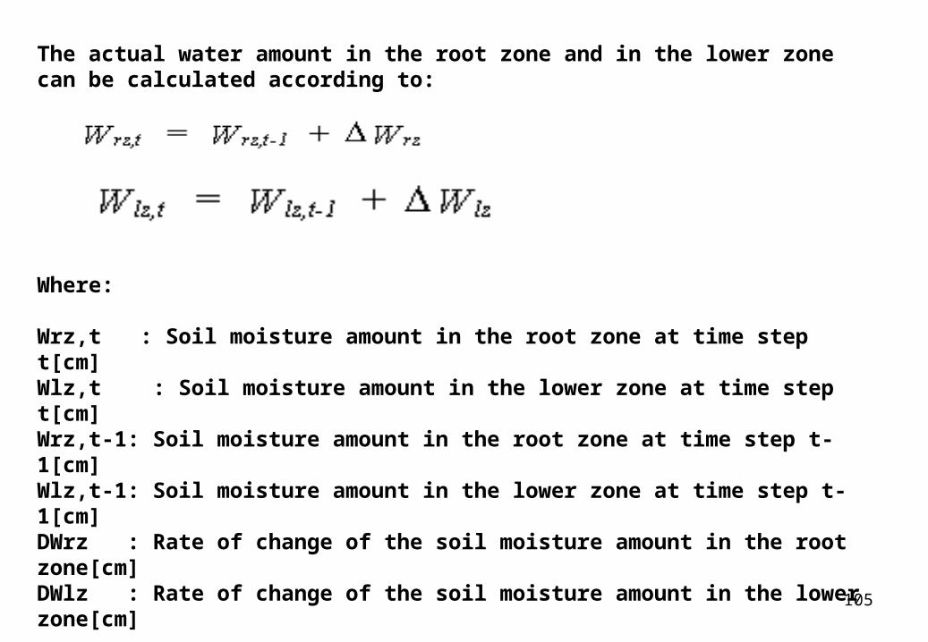
The actual water amount in the root zone and in the lower zone can be calculated according to:
Where:
Wrz,t : Soil moisture amount in the root zone at time step t[cm]Wlz,t : Soil moisture amount in the lower zone at time step t[cm]Wrz,t-1: Soil moisture amount in the root zone at time step t-1[cm]Wlz,t-1: Soil moisture amount in the lower zone at time step t-1[cm]DWrz : Rate of change of the soil moisture amount in the root zone[cm]DWlz : Rate of change of the soil moisture amount in the lower zone[cm]
106
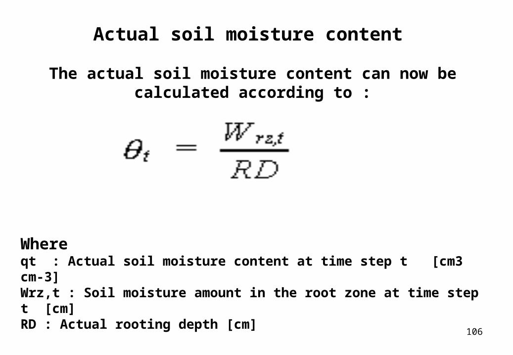
Actual soil moisture content
The actual soil moisture content can now be calculated according to :
Whereqt : Actual soil moisture content at time step t [cm3 cm-3]Wrz,t : Soil moisture amount in the root zone at time step t [cm]RD : Actual rooting depth [cm]
107
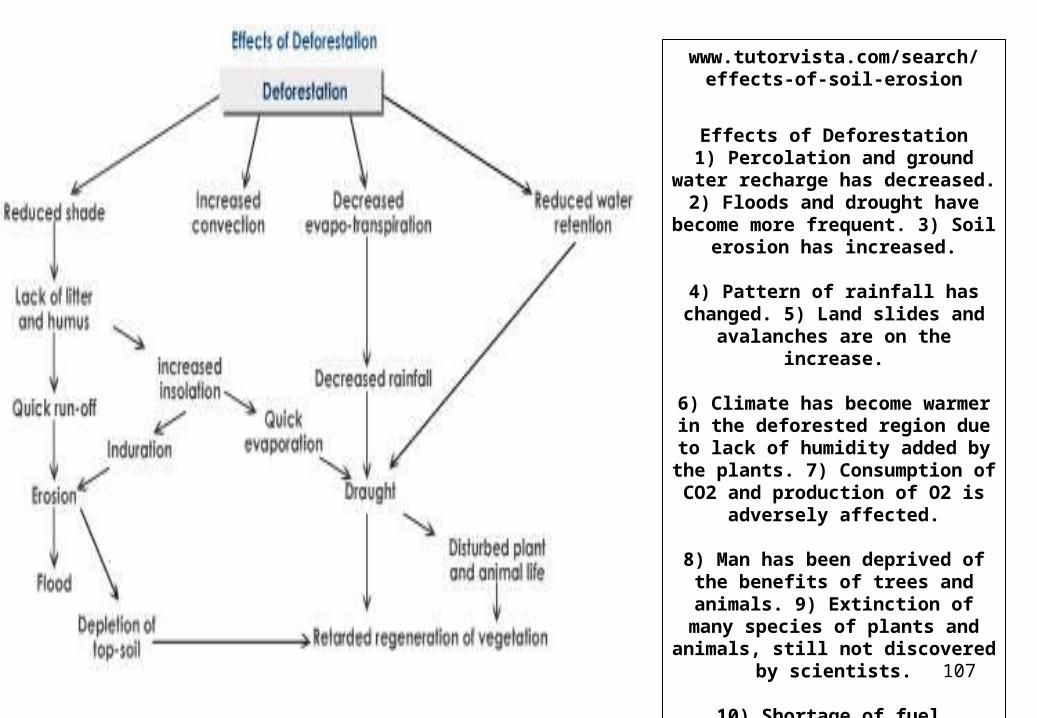
www.tutorvista.com/search/effects-of-soil-erosion
Effects of Deforestation1) Percolation and ground water
recharge has decreased.2) Floods and drought have become more frequent. 3) Soil erosion has
increased.
4) Pattern of rainfall has changed. 5) Land slides and avalanches are on
the increase.
6) Climate has become warmer in the deforested region due to lack of
humidity added by the plants. 7) Consumption of CO2 and
production of O2 is adversely affected.
8) Man has been deprived of the benefits of trees and animals. 9)
Extinction of many species of plants and animals, still not discovered by
scientists.
10) Shortage of fuel
108
www.cluin.org/studio/2003phyto/abstracts.htm

109
www.worldagroforestry.org/af2/?q=node/122
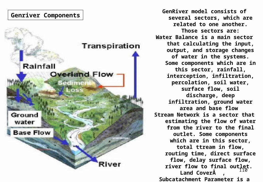
GenRiver: Generic River model on river flow
Overview of the GenRiver model; the multiple
subcatchments that make up the catchment as a whole
can differ in basic soil properties, land cover
fractions that affect interception, soil structure
(infiltration rate) and seasonal pattern of water
use by the vegetation.
The subcatchment will also typically differ in ‘routing time' or in the time it takes
the streams and river to reach the observation point
of main interest
110
Genriver Components GenRiver model consists of several sectors, which are related to one
another. Those sectors are:Water Balance is a main sector that
calculating the input, output, and storage changes of water in the
systems. Some components which are in this sector, rainfall, interception, infiltration,
percolation, soil water, surface flow, soil discharge, deep
infiltration, ground water area and base flow
Stream Network is a sector that estimating the flow of water from the river to the final outlet. Some
components which are in this sector, total ttream in flow, routing
time, direct surface flow, delay surface flow, river flow to final
outlet. Land Cover ,
Subcatachment Parameter is a sector stired constant parameters that control to the changes of water balance, landcover and stream
network.
111
www.ecy.wa.gov/programs/sea/pubs/93-31/chap1.html
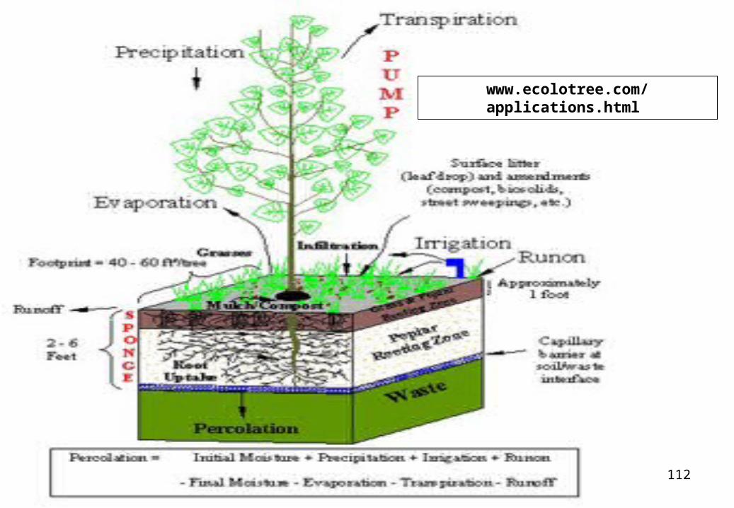
112
www.ecolotree.com/applications.html