Embed Size (px)
DESCRIPTION
Guidebook for a mock brand name
Citation preview

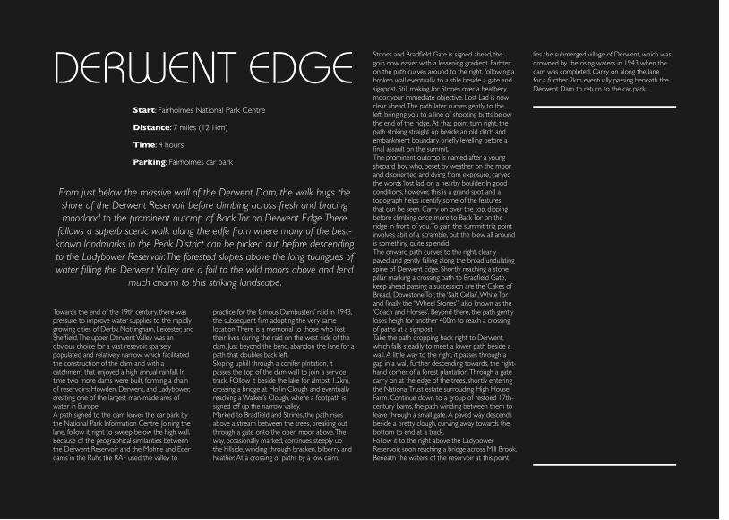
DERWENT EDGEStart: Fairholmes National Park Centre
From just below the massive wall of the Derwent Dam, the walk hugs the shore of the Derwent Reservoir before climbing across fresh and bracing moorland to the prominent outcrop of Back Tor on Derwent Edge. There
follows a superb scenic walk along the edfe from where many of the best-known landmarks in the Peak District can be picked out, before descending to the Ladybower Reservoir. The forested slopes above the long toungues of water filling the Derwent Valley are a foil to the wild moors above and lend
much charm to this striking landscape.
Distance: 7 miles (12.1km)
Time: 4 hours
Parking: Fairholmes car park
Towards the end of the 19th century, there was pressure to improve water supplies to the rapidly growing cities of Derby, Nottingham, Leicester, and Sheffield. The upper Derwent Valley was an obvious choice for a vast resevoir, sparsely populated and relatively narrow, which facilitated the construction of the dam, and with a catchment that enjoyed a high annual rainfall. In time two more dams were built, forming a chain of reservoirs: Howden, Derwent, and Ladybower, creating one of the largest man-made ares of water in Europe.A path signed to the dam leaves the car park by the National Park Information Centre. Joining the lane, follow it right to sweep below the high wall. Because of the geographical similarities between the Derwent Reservoir and the Mohne and Eder dams in the Ruhr, the RAF used the valley to
practice for the famous Dambusters’ raid in 1943, the subsequent film adopting the very same location. There is a memorial to those who lost their lives during the raid on the west side of the dam. Just beyond the bend, abandon the lane for a path that doubles back left. Sloping uphill through a conifer plntation, it passes the top of the dam wall to join a service track. FOllow it beside the lake for almost 1.2km, crossing a bridge at Hollin Clough and eventually reaching a Walker’s Clough, where a footpath is signed off up the narrow valley.Marked to Bradfield and Strines, the path rises above a stream between the trees, breaking out through a gate onto the open moor above. The way, occasionally marked, continues steeply up the hillside, winding through bracken, bilberry and heather. At a crossing of paths by a low cairn,
Strines and Bradfield Gate is signed ahead, the goin now easier with a lessening gradient. Farhter on the path curves around to the right, following a broken wall eventually to a stile beside a gate and signpost. Still making for Strines over a heathery moor, your immediate objective, Lost Lad is now clear ahead. The path later curves gently to the left, bringing you to a line of shooting butts below the end of the ridge. At that point turn right, the path striking straight up beside an old ditch and embankment boundary, briefly levelling before a final assault on the summit.The prominent outcrop is named after a young shepard boy who, beset by weather on the moor and disoriented and dying from exposure, carved the words ‘lost lad’ on a nearby boulder. In good conditions, however, this is a grand spot and a topograph helps identify some of the features that can be seen. Carry on over the top, dipping before climbing once more to Back Tor on the ridge in front of you. To gain the summit trig point involves abit of a scramble, but the biew all around is something quite splendid.The onward path curves to the right, clearly paved and gently falling along the broad undulating spine of Derwent Edge. Shortly reaching a stone pillar marking a crossing path to Bradfield Gate, keep ahead passing a succession are the ‘Cakes of Bread’, Dovestone Tor, the ‘Salt Cellar’, White Tor and finally the “Wheel Stones”, also known as the ‘Coach and Horses’. Beyond there, the path gently loses heigh for another 400m to reach a crossing of paths at a signpost.Take the path dropping back right to Derwent, which falls steadily to meet a lower path beside a wall. A little way to the right, it passes through a gap in a wall, further descending towards, the right-hand corner of a forest plantation. Through a gate carry on at the edge of the trees, shortly entering the National Trust estate surrouding High House Farm. Continue down to a group of restoed 17th-century barns, the path winding between them to leave through a small gate. A paved way descends beside a pretty clough, curving away towards the bottom to end at a track.Follow it to the right above the Ladybower Reservoir, soon reaching a bridge across Mill Brook. Beneath the waters of the reservoir at this point
lies the submerged village of Derwent, which was drowned by the rising waters in 1943 when the dam was completed. Carry on along the lane for a further 2km eventually passing beneath the Derwent Dam to return to the car park.
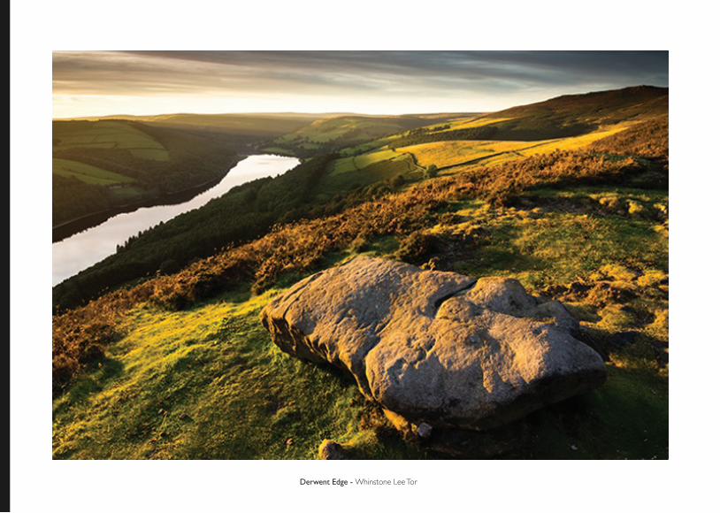
Derwent Edge - Whinstone Lee Tor
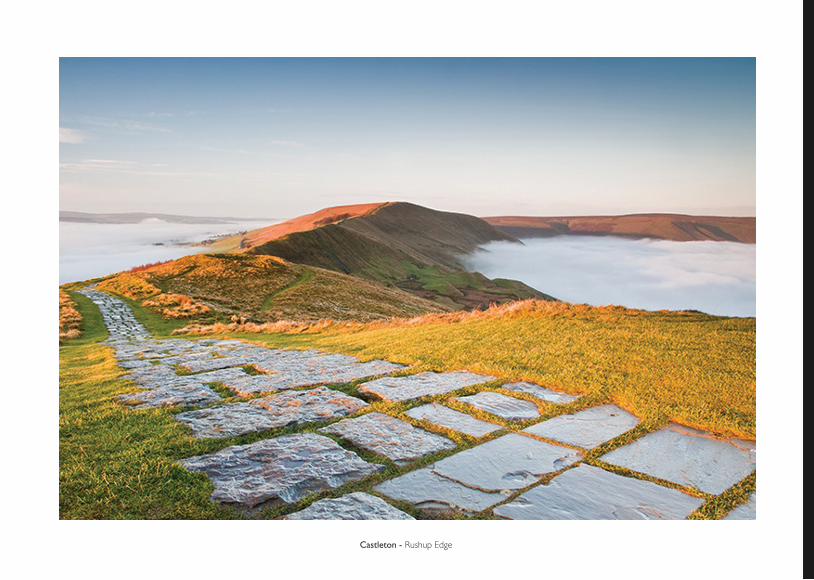
Castleton - Rushup Edge
CASTLETONStart: Castleton
Distance: 6 miles (10km)
Time: 3 and a half hours
Parking: Car park in Castleton
Castleton occupies an eviable position near the the head of the Hoe Valley, dominated by the ruins of Peveril Castle and surrounded by bold hills and
rolling moors. The walk begins with a long, steady ascent of Cave Dale to the gently undulating stone-walled fields above. There is then a steep but short
pull onto the 1695ft summit of Mam Tor, which begins one of the finest scenic ridge walks in the Peak District. Linger to enjoy the views into the Vale of Edale and the Hope Valley, but save enough time to visit one of
the nearby caves or perhaps explore the castle ruins.
Surrounded by fantastic scenery and a multitude of attractions, it is little wonder that Castelton has become one of the principal tourites retnres of the Peak Dstrict. The town grew up around the base of Peveril Castle, which was founded in the late 11th centuruy by William Peverl, an illigitimate son of William the Conqueror. The stronghold occupies a virtually impregnable position, with steep cliffs on three sides. Initially, i seems likely that a curtain wall was constructed only on the north side overlooking the town and that the other flanks relied on the natural defence afforded by the cliffs on three sides. Initially, it seems likely that a curtain wall was consstructed only on the north side overlooking the town and that the other flanks relied on the natura defence afforded by the cliffs. The castle’s most outsanding feature is the great keep, built by Henry II in 1176 after it had
been forteited to the Crown. But it was not solely a defensive fortress, as it also served as a hunting lodge for the Royal Forest of the Peak before falling into disuse as subsequent ruin in the 15th century.The predominant building in the village itself is the church which, though mainly a 19th-century restoration, retains its fine Norman chancel arch. However the sites drawing the greatest number of visitors to Castleton are the caried and spectacular caverns that honeycomb the surrounding hills. They are, in fact a mixture of natural caves and man-made tunnels, created as a result of mining for lead and other minerals. There are four show caves to choose from: the Peak, BLue John, Treak Cliff and Speedwell Caverns, the latter being particularly exciting as it involves a subterranean boat trip.
Turn left out of the car park and follow the main street through the town as far as a sharp left-hand bend. Peak Cavern and Peveril Castle are signed off to the right, the road taking you past the church to a green in the middle of the old market place. Go left at the top, but almost immediately, look for a bridleway to Cave Dale leaving between cottages on the right.Entering between abrupt rocky portals the path winds up the narrow gorge, passing below the ruins of Peveril Castle perched high on the lip above. Beyond a gate at the head of the gorge, the way continues more easily through the upper part of the dale, eventually turning through a gate in the right-hand wall. Head across to another gate and then bear left over the crest of the field, where the view to the right is Mam Tor, the ramparts and ditches of its Iron Age summit fort stunningly revealed. Closer to hand, the landscape is pockmarked with the tips of old lead mines, which often broke through to the natural caves below. Pass through a gated sheep pen in the far corner to emerge at a junction of tracks.Go right and, when you shortly reach a fork, take the track ahead. Carry on for almost another half a mile (800m) to the far side of the second large field. Ignore the gate ahead and instead mount a stile on the right.Follow the left-hand wall away past grass-covered mounds that betrat more abandoned workings. Mam Tor, now seen in front of you, is known as the ‘Shivering Mountain’ on account of instability in its lower layers of loose, soft shales, which are constantly crumbling and falling, giving the impression that the hull is moving or shivering. A landslide some years ago led to the closure of the A625 Sheffield to Chapel-en-le-Frith road and light traffic is now diverted through Winnat’s Pass, a steep and narrow route between towering limestone cliffs. Over a couple of stiles the onward way then falls gently downhill, leading to a gate onto a lane near the head of Winnat’s Pass. Cross diagonally right to a gate (not the one directly opposite) and follow a field track that shortly descends to another road. Through a small gate opposite, apath rises steeply ahead up the grassy hill, culminating in steps onto the Edale road.
Instead of joining the road, go through a gate on the right from which a stepped path takes you to the summit of Mam Tor. The views from the top are magnificent: to the north is the Vale of Edale from which the Pennine Way can be clearly seen snaking up onto Kinder Scout, and the east you can just spot Peveril Castle above Castleton, with the Hope Valley winding between the hills beyond. The onward route lies ahead, an exhilarating ridge walk along the spine of the hill, overlooking a patchwork of hedged green fields speckled with trees, whilst scattered across the hillside are lonely farmsteads and cottages. The path gently loses height for quarter of a mile (1.2km) before reaching Hollins Cross, a junction of paths marked by a stone cairn.Although the ride path continues on to Lose Hill (alternatively known as Ward’s Piece after a Sheffield man, G.H.B Ward, who made a major contribution to the cause of rambling in the area), we now leave it, forking off right to drop across the steep hillside in the direction of Castelton. Initially paved, it descends over stiles, eventually joining a sunken path that ends at a farm track. Follow it ahead, keeping right where it later forks to pass a training centre. Beyond there is a lane which leads to the town. Go forward when you meet the main road, bending right with it through the centre to return to the car park.
CURBAR EDGEStart: Baslow
A magnificent gritstone escarpment stretches along the eastern rim of the Derwent Valley from Birchen Edge northwards to Derwent Edge, providing both exhilarating walking and glorious views. This ramble traverses Baslow Edge and Curbar Edge, two of the finest sections of this long cliff, before plunging through thick woods to the banks of the Derwent and returning
along the riverbank and across fields to Baslow. There are two ascents, the longer one being at the beginning to take you onto the edges.
Distance: 7 miles (11.3km)
Time: 3 and a half hours
Parking: Car park in Baslow
The rather suburbanised and strung-out village of Baslow lies at the northern end of Chatsworth Park and near the southern limit of the long line of gritstone edges, which occupy a frontier position above the River Derwent between the limestone of the White Peak and the gritstone of the Dark Peak.Out of the car park, go left to the main road and take the uphill street opposite, Eaton Hill. Where it later bends past a small triangular green, turn right to head up Bar Road.Past the last of the houses, the road degrades to a rough track and continues winding up the hill. Through a gate at its end, keep climing onto the moor, soon reachin a fork. Occupying a splendid vantage over to the right is the Wellington Monument, erected in 1866, whilst high above the opposite side of the valley stands a twin
monument to Nelson. The onward route, however, lies to the left, shortly passing a massive isolated rock, the Eagle Stone. The main track carries on for a further half a mile (800m) to a gate, but for the best views across the Derwent Vallet, take on of the lesser paths to the left that wander along the rim of Baslow Edge. Through the gate, cross a lane and continue along the track opposite onto Curbar Edge. The weathered outcrops of gritstone here are even more impressive, with massive boulders, buttresses and pillars lining the long escarpment. The cliffs are a haunt for rock climbers, but be careful for the drop is sheer. Follow the edge for a little over amile (1.6km) until you meet a walled enclosure.Just this side of it, a narrower path forks left, dropping to a shelf below the precipitous cliffs. About 100 yds (91m) along, and before reaching a
detached pillar, look for a not-so-obvious rocky path that doubles back steeply into the woods below.The gradient shortly eases the path winding between the trees to a gate. Continue down through the wood to a road by the Chequers Inn. Cross to a stile opposite and keep ahead, descending across a meadow and then through more open woodland. Emerging onto a lane at the bottom, follow it right to Frogatt Bridge. Turn over the bridge and then immediately leave by a stone stile on the left.A riverside path, signed to New Bridge and Calver, winds through a conifer plntation and on at the edge of successive tree-fringed meadows, eventually meeting a lane at New Bridge. Cross to a track opposite passing cottages above aweir and continue along a wooded path beside The Goit, which carried water to power the mill at Calver. Breaking from the trees, the path soon curves away from the leat to Stocking Farm. Walk past the farm and out along atrack to the road. Recross the river, from where there is a glimpse of the fine, early 19th century Calver Mill. Its forbidding ap-pearance made it a suitable substitute for Colditz Castle in the new television series. Carry on to a junction opposite the Bridge Inn.Take the second of the two lanes on the left, Curbar Lane, beside the church, and follow it steeply uphill for quarter of a mile (400m). At a crossroads by a telephone box, turn right into Cliff Lane. Walk along to a bend at the crest of the hill, where a path over a stile on the left is signed to Baslow via Gorse Bank Farm. Pass between house gardens and contuinue towards Lane Farm, crossing a stile below the buildings to follow an old hedged path down between the fields.Keep going beyond its end to a gate, through which curve left to join a wall on the right. Reaching adjacent gates, pass through one on the left and climb across a field to the top corner above another farm. Go right to a gate and then ahead beside a wall. Through a gap bear left across the next enclosure, passing through a second gap and on to a squeeze stile by a gate. The trak ahead leads to Gorse Bank Farm. There, continue through the yard and follow Gorsebank Lane gently downhill for half a mile (800m) to the edge of
Baslow. Reaching a junction, bear right into Bar Road and then go left, retracing your outward steps down Eaton Hill to the car park.
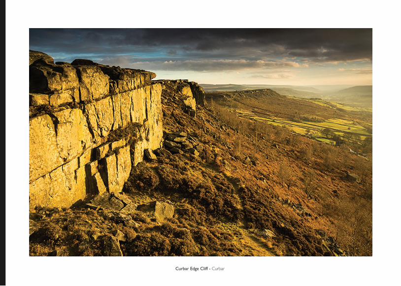
Curbar Edge Cliff - Curbar
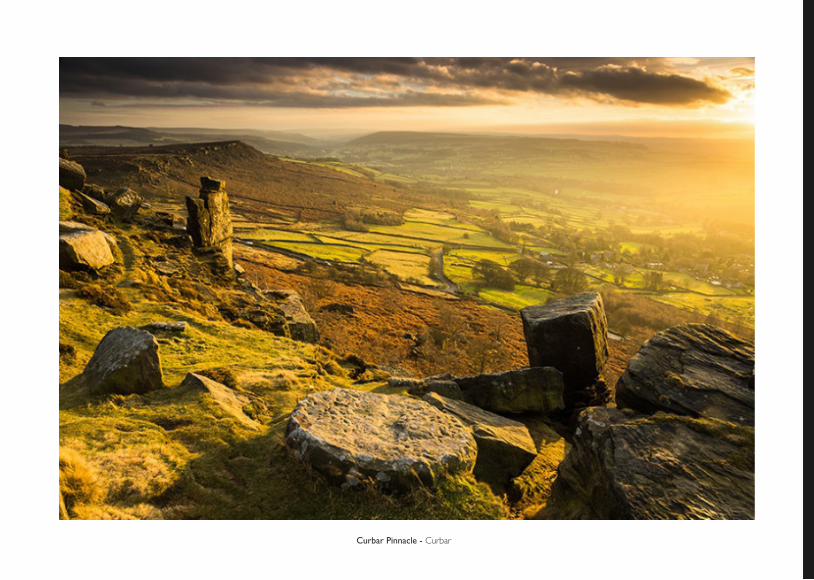
Curbar Pinnacle - Curbar
CURBAR EDGEStart: Baslow
A magnificent gritstone escarpment stretches along the eastern rim of the Derwent Valley from Birchen Edge northwards to Derwent Edge, providing both exhilarating walking and glorious views. This ramble traverses Baslow Edge and Curbar Edge, two of the finest sections of this long cliff, before plunging through thick woods to the banks of the Derwent and returning
along the riverbank and across fields to Baslow. There are two ascents, the longer one being at the beginning to take you onto the edges.
Distance: 7 miles (11.3km)
Time: 3 and a half hours
Parking: Car park in Baslow
The rather suburbanised and strung-out village of Baslow lies at the northern end of Chatsworth Park and near the southern limit of the long line of gritstone edges, which occupy a frontier position above the River Derwent between the limestone of the White Peak and the gritstone of the Dark Peak.Out of the car park, go left to the main road and take the uphill street opposite, Eaton Hill. Where it later bends past a small triangular green, turn right to head up Bar Road.Past the last of the houses, the road degrades to a rough track and continues winding up the hill. Through a gate at its end, keep climing onto the moor, soon reachin a fork. Occupying a splendid vantage over to the right is the Wellington Monument, erected in 1866, whilst high above the opposite side of the valley stands a twin
monument to Nelson. The onward route, however, lies to the left, shortly passing a massive isolated rock, the Eagle Stone. The main track carries on for a further half a mile (800m) to a gate, but for the best views across the Derwent Vallet, take on of the lesser paths to the left that wander along the rim of Baslow Edge. Through the gate, cross a lane and continue along the track opposite onto Curbar Edge. The weathered outcrops of gritstone here are even more impressive, with massive boulders, buttresses and pillars lining the long escarpment. The cliffs are a haunt for rock climbers, but be careful for the drop is sheer. Follow the edge for a little over amile (1.6km) until you meet a walled enclosure.Just this side of it, a narrower path forks left, dropping to a shelf below the precipitous cliffs. About 100 yds (91m) along, and before reaching a
detached pillar, look for a not-so-obvious rocky path that doubles back steeply into the woods below.The gradient shortly eases the path winding between the trees to a gate. Continue down through the wood to a road by the Chequers Inn. Cross to a stile opposite and keep ahead, descending across a meadow and then through more open woodland. Emerging onto a lane at the bottom, follow it right to Frogatt Bridge. Turn over the bridge and then immediately leave by a stone stile on the left.A riverside path, signed to New Bridge and Calver, winds through a conifer plntation and on at the edge of successive tree-fringed meadows, eventually meeting a lane at New Bridge. Cross to a track opposite passing cottages above aweir and continue along a wooded path beside The Goit, which carried water to power the mill at Calver. Breaking from the trees, the path soon curves away from the leat to Stocking Farm. Walk past the farm and out along atrack to the road. Recross the river, from where there is a glimpse of the fine, early 19th century Calver Mill. Its forbidding ap-pearance made it a suitable substitute for Colditz Castle in the new television series. Carry on to a junction opposite the Bridge Inn.Take the second of the two lanes on the left, Curbar Lane, beside the church, and follow it steeply uphill for quarter of a mile (400m). At a crossroads by a telephone box, turn right into Cliff Lane. Walk along to a bend at the crest of the hill, where a path over a stile on the left is signed to Baslow via Gorse Bank Farm. Pass between house gardens and contuinue towards Lane Farm, crossing a stile below the buildings to follow an old hedged path down between the fields.Keep going beyond its end to a gate, through which curve left to join a wall on the right. Reaching adjacent gates, pass through one on the left and climb across a field to the top corner above another farm. Go right to a gate and then ahead beside a wall. Through a gap bear left across the next enclosure, passing through a second gap and on to a squeeze stile by a gate. The trak ahead leads to Gorse Bank Farm. There, continue through the yard and follow Gorsebank Lane gently downhill for half a mile (800m) to the edge of
Baslow. Reaching a junction, bear right into Bar Road and then go left, retracing your outward steps down Eaton Hill to the car park.
BAMFORDStart: Bamford
Less popular than some parts of the Dark Peak, this area still has some good walking country. The walk described below is ideal for a half day
excursion and could easily be extended if required. You will be surprised by the spacious feel to the scenery above Bamford Edge. Open moorland and rolling hills, normally unseen from the valley roads, merge together backed
by the gritstone forming Stanage Edge.
Distance: 7 miles (11.4km)
Time: 3 hours
Parking: Bamford
Following the road east and then south-east you draw level with the Stanage Plantation on your left. Taking the footpath you can head up to the edge with the scenery improving rapidly as you gain height. Clambering on to the main edge you continue east to the Stanedge Pole where views across the City of Sheffield and down to Redmires Reservoirs are on offer. Returning in south-westerly direction to the Edge be aware and treat the extensive boggy ground with caution. Even so wet feet were unavoidable. Regaining the edge you will work your way over the High Neb (summit point of Stanage Edge) continuing past the Crow Chin and down to the disused quarry at Stanage End. The Edge provides easy walking with good views west - including all the high ground of Kinder Scout and Bleaklow.
Turning back on yourself, you leave the ridge for lower ground using the path running parallel to your outward route. Scatted below the edge are many discarded millstones. Once quarried and finished in this area, the finished and half-finished discards show how quickly the market collapsed. Returning to your car is a simple matter of navigation.
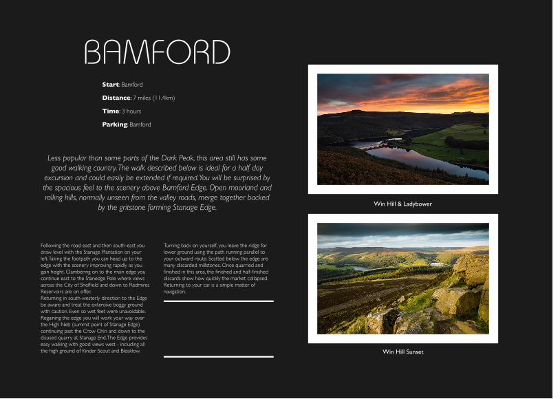
Win Hill Sunset
Win Hill & Ladybower
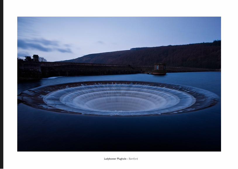
Ladybower Plughole - Bamford
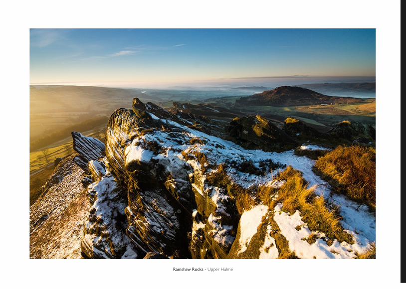
Ramshaw Rocks - Upper Hulme
UPPER HULMEStart: The Roaches
The gritstone edge of The Roaches forms the dramatic western boundary of the Peak District overlooking the lowlands of Staffordshire and Chesire. It is an area of weirdly contorted rocks, which, together with the continuing ridge to the north, provide a magnificent three-mile (4.8km) high-level walk. Dropping through Forest Wood, there is the fasicnating and perhaps even menacing deep and secluded chasm of Lud’s Church to explore, which has
links with medieval religious heresy. After winding through the seemingly remote valley of Black Brook, the return lies across the shoulder of The
Roaches past the equally intriguing outcrop Hen Cloud.
Distance: 8 and a quarter miles (13.3km)
Time: 4 and a half hours
Parking: Roadside parking at The Roaches
Leave the lane through a gate by the bus stop and bear right up a broad stony path making for the col between The Roaches and their near neighbour, Hen Cloud. The name ‘Roaches’ prob-ably comes from the French ‘roche’, meaning ‘rock’. Towards the top, take a path to the left that passes below Rockhall Cottage before swinging right through a gap in the stone wall. The way winds through trees amidst great boulders below the cliffs and then swings right on a stepped path that breaches the rocks to gain the ridge above.Go left, shortly passing the quiet, mysterious-look-ing Doxey Pool om the right to continue along the lofty ride, eventually reaching a trianglulation pillar marking its high point at 1658 ft (505m). Beyond, the way falls in a gradual descent, winding beside the weather worn formation of Bearstone Rock to meet a lane at Roach End.
Otherwise, cross the lane to a gap stile above the track. The onward path carries on over a second stile to follow a wall along the continuing ridge. After alittle less than half a mile (800m) at a fork, both ways being signed to Dane Bridge, keep on the higher path that later drops to a shallow col. Ignore the crossing path and walk on through a narrow gate, eventually losing heigh to meet a stony track. Signed to Gradbach, the way right falls across heather and bilberry heath, soon passing into Forest Wood. At a fork by a prominent outcrop of rock bear right to Lud’s Church. looking for a path off a little farther along on the right. It slips through a narrow cleft in the sandstone cliff to descend into the deep moss and fern encrusted chasm of Lud’s Church. Local tradition holds that this inaccessible spot was a meeting place for Lollards,
a group of religious heretics prominent in the 14th and 15th centuries who followed John Wycliff. Persecution and the constant threat of execution by burning forced them to meet in secret hideouts, for which this place, supposedly named after one of the Lollards, Walkter de Ludank would have been eminently suitable. Wind through and, as you begin to climb out at the far end, choose the right branch to find a stepped path to the top. Carry on through the trees, eventually passing a concessionary path off back into the ridge to reach a T-junction just beyond. Turn right and, at a second junction go right again, following signs to Roach End. The path breaks from the wood beside a wall at the edge of open heath, towards the top of which is a waymarked stile out onto a gravel track.Down the hill, after passing a farmhouse in nar-rows to a path and continues along the flank into a quiet dale, eventually crossing a bridge over Black Brook. Bear right to a stile and carry on along the shallowing valley, passing paths that lead off across Goldstitch Moss. Approaching Goldstitch House, negotiate a couple of stiles and keep forward across a track. Passing a barn, bear left towards a gate emerging onto a second track and follow it right to a stone bridge. Cross and go over a stile beside a gate, beyond which a second stile begins a contained path skirt-ing the rear of the Blackbank Farm. Returning to the edfe of the moor beyond, carry on above Black Brook once more, but after cross-ing a stile towards the end of the fence on your right, curve left to accompany a ditch rising away. Higher up, a wall corner forces you to cross the gully, the way continuing above its opposite bank to meet a lane.Turn up the hill to a junction opposite Corner House and go right, bearing right again when you reac a fork. Carry on for a further quarter of a mile (400m) then leave across a cattle-grid along a farm track on the left. When it splits, keep with the right branch, which leads to the entrance of a farm. Summerhill. Abandon the track there through a small gate on the right and follow a path beside a wall that climbs gently towards the top of the long ridge. Cresting the ride, the way then falls through the broad gap between The Roaches and
Hen Cloud, finally returning you to the lane where you began the walk.
MATLOCKStart: Cromford Wharf
An incredible variety of scenic and hstoric attractions are packed into this modestly distanced and throughly absorbing walk. The natural wonders
include the narrow gorge of the River Derwent and the impressive Black Rock above Cromford - an excellent vantage point. Equally striking i the
architecture of the Victorian spa of Matlock Bath, the fascinating village and mills of Cromford and the railway incline dropping to the Cromford Canal,
where an interesting museum in housed in the former workshops.
Distance: 7 miles (11.3km)
Time: 4 hours
Parking: Car park in Cromford Wharf
In 1771 Sir Richard Arkwright, a Lancashire cotton entrepreur, established the first successful water-powered cotton mill in the then sparsely scattered farming community of Cromford - an event which helped transform textile manufacturing from a cottage-based craft into a factory-based industry. Arkwright chose Cromford because of the power that could be drawn from the River Derwent, but it did have two disadvantages: a shortage of labour and poor communications. He solved his work-force problem by building a new village, attracting people from the surrounding countryside, but the second difficulty was never completely overcome. Although he build a canal, which was later linked by railway to the Peak Forest Canal at Whaley Bridge, Cromford was far from the main sea ports through which raw cotton and finished goods were traded. Unable to compete effectively with
the main centres of the cotton industry, the town thus never developed into another Manchester or Bolton. However, what remains is a rare example of an early Industrial Revolution textile settlement, which has retained many of the original buildings erected by Arkwright and his successors. Some of these can be found near the start of the walk, which begins at the head of the canal opposite Arkwright’s Mill. The complex dates from the late 18th century and is being painstakingly excavated and restored by the Arkwright Society.For the walk, turn right past the church, founded towards the end of the 18th century as a private chapel for the Arkwrights and where Sir Richard was buried. It was enlarged in the 19th century to accommodate the growing community. Across the brige is the entrance to Willersley Castle, also built in the 18th century for Sir Richard Arkwright.
Fork left just past there along a lane climbing steeply to Starkholmes. Where it later levels, a fine view opens across the valley of Matlock Bath. Reaching the village, look for a footpath leaving on the left just before the White Lion.The path doubles back to wind down the hillside, joining another path lower down to drop at the edge of a wood. Beyond the bottom station of the cable car onto the Heights of Abraham, pass beneath a railway bridge and then turn left along a riverside track to a bridge opposite Matlock Bath Station.Matlock Bath, an extension of Matlock itself, became a popular spa resort in the 19th century, developing o nthe back of the railway that was pushed through the Derwent gorge. Victorian visitors came to take the waters and socialise in the Pavillion and Pump Room, and of course to enjoy the riverside gardens and scenery. The same surroundings attract visitors today, as does the Peak District Mining Museum housed in the Pavil-lion, show caves and former lead mines as well as a wide range of pubs and eating places. A modern attraction that the Victorians would certainly have appreciated is the chairlift, which offers a spectacu-lar crossing of the gorge above the town to the Heights of Abraham where, in fine weather, there are superb views from the terrace of an imitation Alpine chalet. The Swiss theme is nothing new, for when Joseph Paxton built the railway station in the 19th century, he also chose to model it in the style of a Swiss chalet.Follow the main road left by the river through the town as far as the Pavillion and cross to a footpath beside the Fishpond pub. At the top go right, passing the entrance to the Gulliver’s World Theme Park, keaving just a few steps beyond where another footpath is signed off left to Up-perwood. Breifly joining the theme park drive, the path continues just a little higher up on the right, rising through the trees cloaking the valley. After 100 yds (93m), and before reaching a cottage, turn left, climbing more steeply up the hillside before emerging onto a lane.Go left through the hamlet of Upperwood, bearing left at a fork. Beyond the houses the way degrades to a track and then a footpath, a signpost to a track and then a footpath, a signpost directing you
ahead towards Scarthin. The ongoing path falls gradually across a wooded hillside, where in spring you will find celandine, wood anemone, wood sor-rel and ransom. Lower down, keep ahead and then bear right at consecutive junctions, passing the rear of a large hotel. Beside the road far below is Masson MIll, the orginial part of which was erected by Sir Richard Arkwright in 1783-4. The path shortly curves across the rib of the hill, zigzaggin down the opposite flank to emerge in Scarthin, a former lead-mining settlement. Walk left through the vilage to the main road. Turn right up the hill to Cromford, passing the three-storey terraces in North Street, which were built by Arkwright in 1776 to accommodate his workers. They are regarded as the earliest planned industrial housing in Britain and were greatly in advance of their time. Just beyond, turn off into a narrow alley. Beedhouse Lane, bearing right to climb behind the gardens of houses. Metting a street, cross to the ongoing track opposite signed to Black Rock. At the top of that, walk left on the narrow lane, bend-ing right with it to then go left at the next junction. Beyond a house, continue on a grass track into a wood. Through a gate, pass winds near the edge of the trees past a disused quarry before ending at a couple of stiles. Clamber over the one on the right to gain the old track-bed of the former Cromford and High Peak Railway. Black Rock lies half a mile (800m) to the right, the track passing beneath it to a car park,. A path on the left then provides a relatively easy climb to the top of his impressive outcrop of weatherworn gritstone boulders, from which there is a splendid panoramic view across the countryside. Retrace your steps along the railway, continuing beyond the point at which you joined it and shortly passing the old winding house at Sheep Pasture. It was built in 1830 to haul wagons up and down the 1 in 8 incline to High Peak Junction beside the Cromford Canal. Originally there was a second winding house part-way down and at the bottom just before the track passes beneath the main road, is a crash pit. If you have the time, a short walk to the right takes you to the Leawood Pump House. The way back however is to the left, a one mile stroll beside the canal returns you to the Cromford Wharf.
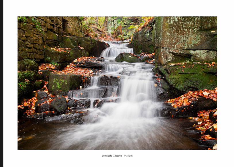
Lumsdale Cascade - Matlock

This guide book features some of the iconic walking spots of the Peak District. As well as a step by step guide provided on each of the walks,
various historical information can also be found amongst the guide. A key component to any current walker’s kit or a great way to begin your walking hobby by learning about some of the best walks available around the area.