Embed Size (px)
Citation preview
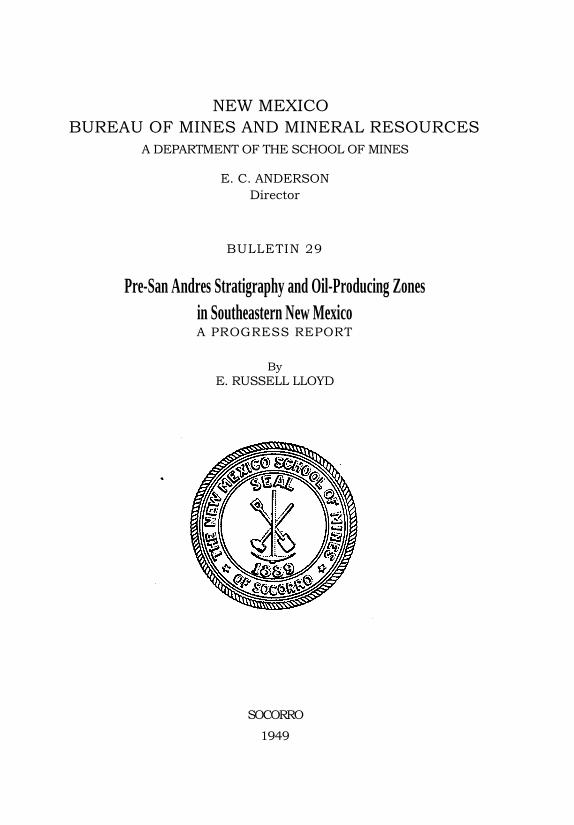
NEW MEXICO
BUREAU OF MINES AND MINERAL RESOURCES
A DEPARTMENT OF THE SCHOOL OF MINES
E. C. ANDERSON
Director
BULLETIN 29
Pre-San Andres Stratigraphy and Oil-Producing Zones
in Southeastern New Mexico A PROGRESS REPORT
By
E. RUSSELL LLOYD
SOCORRO
1949
CONTENTSP
Page
The New Mexico Bureau of Mines and Mineral Resources ------------------------ 6
Board of Regents ------------------------------------------------------------------ 6
Explanatory note ------------------------------------------------------------------------ 7
Introduction ----------------------------------------------------------------------------- 9
Acknowledgments --------------------------------------------------------------------- 10
Principal structural features --------------------------------------------------------- 11
General 11
Pedernal Mountains -------------------------------------------------------------- 13
Matador uplift -------------------------------------------------------------------- 15
Eunice uplift ---------------------------------------------------------------------- 15
Stratigraphy ---------------------------------------------------------------------------- 17
General outline 17
Permian system ------------------------------------------------------------------- 18
Classification 18
Guadalupe-Leonard contact ----------------------------------------------- 19
Guadalupe or Leonard series --------------------------------------------- 22
Glorieta sandstone ---------------------------------------------------- 22
Leonard series --------------------------------------------------------------- 23
Yeso formation --------------------------------------------------------- 23
Victorio Peak reef zone 27
Leonard and Wolfcamp ( ?) series ---------------------------------------- 28
Abo formation ---------------------------------------------------------- 28
Wolfcamp series ------------------------------------------------------------- 31
Hueco limestone 31
Bursum formation ---------------------------------------------------- 32
Hueco and Bursum formations in subsurface -------------------- 33
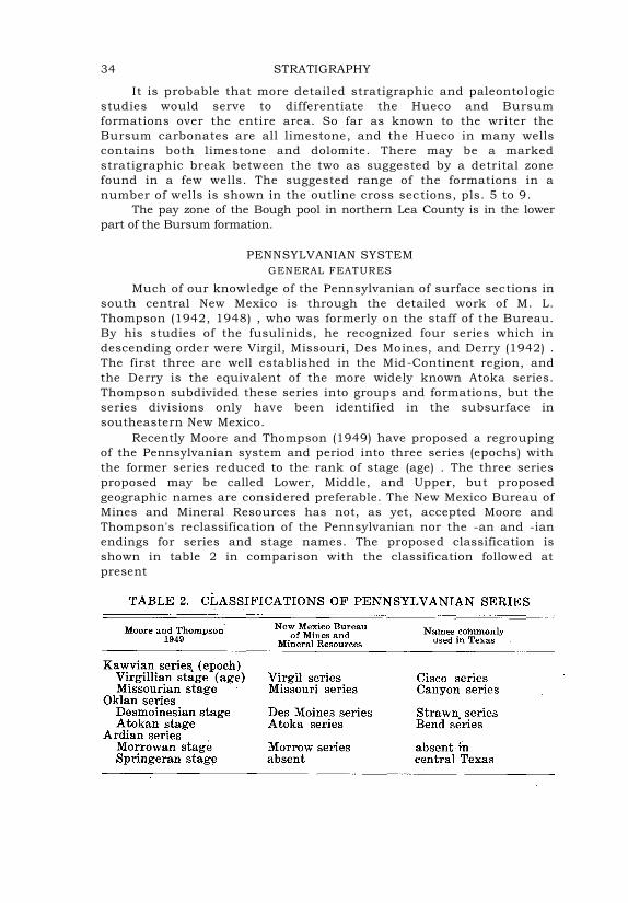
Pennsylvanian system ----------------------------------------------------------- 34
General features ------------------------------------------------------------ 34
Virgil series ------------------------------------------------------------------ 37
Missouri series 38
Des Moines series ----------------------------------------------------------- 39
Atoka series ----------------------------------------------------------------- 40
Mississippian system ------------------------------------------------------------ 40
General features 40
Chester series --------------------------------------------------------------- 42
Helms formation ------------------------------------------------------ 42
Meramec series -------------------------------------------------------------- 44
Rancheria formation -------------------------------------------------- 44
Osage series ----------------------------------------------------------------- 45
Lake Valley formation ------------------------------------------------- 45
Kinderhook series ----------------------------------------------------------- 45
Caballero formation -------------------------------------------------- 45
Devohian system ----------------------------------------------------------------- 46
General features 46
3
4 CONTENTS
Page
Upper Devonian 48
Woodford formation -------------------------------------------------- 48
Percha shale 48
Contadero and Sly Gap formations 49
Middle Devonian------------------------------------------------------------- 49
Oñate formation ------------------------------------------------------- 49
Canutillo formation --------------------------------------------------- 50
Lower Devonian ------------------------------------------------------------- 51
Silurian system ------------------------------------------------------------------- 52
Ordovician system --------------------------------------------------------------- 54
Upper Ordovician ----------------------------------------------------------- 54
Montoya formation ---------------------------------------------------- 54
Middle Ordovician ---------------------------------------------------------- 56
Simpson group -------------------------------------------------------- 56
Lower Ordovician 57
Ellenburger group and El Paso limestone ------------------------- 57
Cambrian system ---------------------------------------------------------------- 59
Geological history 59
Cambrian -------------------------------------------------------------------------- 59
Ordovician 59
Silurian ---------------------------------------------------------------------------- 60
Devonian 61
Mississippian --------------------------------------------------------------------- 61
Pennsylvanian 62
Permian ---------------------------------------------------------------------------- 63
Oil and gas pools 64
General ---------------------------------------------------------------------------- 64
Permian pools of the Leonard and Wolf camp series ------------------------ 67
Pennsylvanian pool 67
Mississippian pool --------------------------------------------------------------- 68
Devonian pool --------------------------------------------------------------------- 68
Silurian pools --------------------------------------------------------------------- 68
Ordovician pools ----------------------------------------------------------------- 69
Future possibilities for pre-San Andres production ------------------------------- 69
Selected bibliography ------------------------------------------------------------------ 73
Index -------------------------------------------------------------------------------------- 77
Publications of the New Mexico Bureau of Mines and Mineral Resources 81
PLATES
Facing • Page
1. Pre-San Andres oil and gas map of southeastern New Mexico In pocket
2. Comparative sections of Permian formations: Surface sections -------------------------------------------------------- In pocket
3. Comparative sections of Yeso formation in selected wells In pocket
4. Comparative sections of Pennsylvanian system: Surface and subsurface ----------------------------------------------- In pocket
5. Outline cross section: Guadalupe County to eastern Lea County ----------------------------------------------------------------------- 22
6. Outline cross section: Chaves County to eastern Lea County 30
7. Outline cross section: Southwestern Chaves County to northern Lea County ----------------------------------------------------------- 32
8. Outline cross section; south to north: eastern Lea County 42
9. Outline cross section ; west to east: Eunice area 56
10. Composite stratigraphic section, Lea County --------------------------- 64
FIGURES
Page
1. Index map ---------------------------------------------------------------------- 8
2. Pre-Cambrian elevations in southeastern New Mexico ----------------- 12
3. Correlation chart, Permian formations in New Mexico ----------------- 16
4. Pennsylvanian system in southeastern New Mexico ------------------- 36
5. Mississippian system in southeastern New Mexico -------------------- 43
6. Devonian and Silurian systems in southeastern New Mexico 47
7. Ordovician system in southeastern New Mexico ------------------------ 55
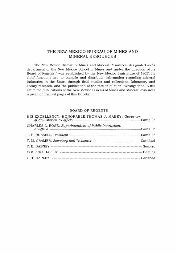
THE NEW MEXICO BUREAU OF MINES AND
MINERAL RESOURCES
The New Mexico Bureau of Mines and Mineral Resources, designated as "a
department of the New Mexico School of Mines and under the direction of its
Board of Regents," was established by the New Mexico Legislature of 1927. Its
chief functions are to compile and distribute information regarding mineral
industries in the State, through field studies and collections, laboratory and
library research, and the publication of the results of such investigations. A full
list of the publications of the New Mexico Bureau of Mines and Mineral Resources
is given on the last pages of this Bulletin.
BOARD OF REGENTS
HIS EXCELLENCY, HONORABLE THOMAS J. MABRY, Governor of New Mexico, ex-officio ----------------------------------------------------------------- Santa Fe
CHARLES L. ROSE, Superintendent of Public Instruction, ex-officio ---------------------------------------------------------------------------------------- Santa Fe
J. H. RUSSELL, President --------------------------------------------------------------------- Santa Fe
T. M. CRAMER, Secretary and Treasurer ---------------------------------------------- Carlsbad
T. E. DABNEY --------------------------------------------------------------------- Socorro
COOPER SHAPLEY -------------------------------------------------------------- Deming
G. T. HARLEY ------------------------------------------------------------------ Carlsbad

EXPLANATORY NOTE
By
E. C. ANDERSON
The four years since the release of Bulletin No. 23, a preliminary report compiled by Robert E. King, have seen much work done and great progress made in the search for oil at depth in southeastern New Mexico. Many wells have been drilled, many producers have been brought in, and several new fields developed. Much new information on the stratigraphy and producing zones of the pre-San Andres formations has been accumulated.
The Bureau deemed it desirable that a new report be compiled and published that would include all the information, new and old, available as of July 1, 1949—that a "Progress Report" be made to replace Mr. King's "Preliminary Report".
To do the job properly it was essential that a person familiar with what has been done in the area be persuaded to undertake the work. It was not only essential that this person be familiar with the progress made in the development of the deep fields, he must also enjoy the full confidence and respect of the operating personnel, as well as his professional associates.
In persuading Mr. Russell Lloyd to undertake the preparation of this report, we feel that this Bureau, as well as the petroleum fraternity, are indeed fortunate. It seems generally agreed that a better qualified person could not have been found for the job.
We hope that Bulletin 29, "Pre-San Andres stratigraphy and oil-producing zones in southeastern New Mexico—A Progress Report," will serve the industry well.
Pre-San Andres Stratigraphy and Oil-Producing Zones
in Southeastern New Mexico
A PROGRESS REPORT
By
E. RUSSELL LLOYD1
INTRODUCTION
The first discovery of commercial oil or gas in New Mexico in
rocks older than the San Andres actually took place late in 1943 with
the drilling of R. Olsen Oil Company's Langlie well in sec. 11, T. 25
S., R. 37 E., Lea County. Gas was discovered in what was later called
the Justis pool, but the well was not officially completed until April
18, 1944. Later in 1944 the Dublin (Ellen-burger) , Drinkard (lower
Yeso) and Cass (Pennsylvanian) pools were discovered, and the search
for "older" pays has been active since that time.
In 1945 the New Mexico Bureau of Mines and Mineral Resources
published Bulletin No. 23, a report by Robert E. King entitled
"Stratigraphy and oil-producing zones of the pre-San Andres
formations of southeastern New Mexico." This was a "Preliminary
report," and the present work is designed as a progress report to
supplement the work of King in the light of numerous wells that have
been drilled since 1945.
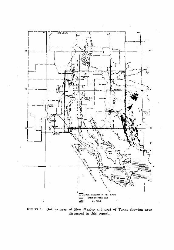
Southeastern New Mexico is an indefinite area. The accom-
panying base map (pl. 1) covers the part of the state south and east of
Albuquerque (fig. 1) . Present interest, however, is largely in the
southeastern counties, Lea, Eddy, Chaves, and Roosevelt, and actual
production of oil or gas from pre-San Andres formations is confined to
Lea County. Most of the producing formations are exposed in the
Sacramento, San Andres, and other mountains where they have been
studied and described in more or less detail. A comparison of these
described surface sections with the correlative sections in producing
areas and in numerous exploratory wells has been one of the primary
objects of the present studies. Much is yet to be learned, and future
studies and data to be revealed by future wells will undoubtedly
necessitate important revisions and additions to correlations and
interpretations herein presented.
The report is primarily an attempt at regional stratigraphic
interpretation. Some consideration of the major structural fea tures
is necessary in an interpretation of the s tratigraphy, but no
detailed structural studies have been undertaken. The strati -
¹Consulting geologist, Midland, Texas.
9
10 ACKNOWLEDGMENTS
graphic settings of the several oil and gas pools producing from
rocks of pre-San. Andres age are presented, and some general
structural features are shown by outline cross sections.
The purpose of King's report as expressed in his introduction
was "to attempt standardization of names and correlations of the
older subsurface units in southeastern New Mexico, and to compare
the names used with those established for the surface outcrop
sections in the state." The correlations and interpretations presented
by King are accepted in the present report with only a few exceptions.
The formation names used by King and in the present report are
largely those established by surface work in the mountains of
southern New Mexico. Some of them are not in general use, and in
other cases there is a diversity in usage among geologists working in
the area.
Many geologists use the names Clear Fork and Wichita cor-
related from groups of Permian formations. exposed in north central
Texas. In the writer's opinion, however, the common correlations of
these groups are not well established, and their use in New Mexico is
inadvisable. The name "Tubb sand" is firmly estab lished among
subsurface geologists in the Permian Basin, but unfortunately has
never been described in geological literature. The Drinkard sandy
member of the Yeso formation, adequately described by R. E. King, is
probably the same strati-graphic unit and, because it is well defined,
should be more widely recognized.
The standard series names for subdivisions of the Pennsylvanian
are preferred to the more local Texas units, although the latter are in
common use. Recently defined or re-defined Mississippian formations,
the Helms and Rancheria are used for subsurface units in preference to
"Barnett" and "Mississippian limestone."
ACKNOWLEDGMENTS
The present report is a compilation based on published reports,
logs from sample cuttings, electrical and radioactivity logs,
paleontological and insoluble residue studies, and detailed studies by
a number of geologists. Descriptions of sample cuttings from most of
the critical Wildcat wells have been kindly furnished for use in
preparing this report by W. W. West of the Permian Basin Sample
Laboratory. Electrical and radioactivity logs were obtained from the
West Texas Electrical Log Service. R. V. Hollingsworth and Harold
Williams of the Paleontological Laboratory have been particularly
helpful in furnishing fusulinid determinations without which the
subdivisions of the Pennsylvanian and lower Permian would be
impossible. Much valuable data have been furnished by E. W.
Vanderpool of the Residue Research Laboratory.
Detailed surface sections of the Yeso and Abo formations

PRINCIPAL STRUCTURAL FEATURES 11
were measured in the Sacramento Mountains for this report by Richard C.
Northup and Lloyd C. Pray. A similar section iri the Oscura Mountains was
kindly furnished by Walter C. Warren with permission from the Standard Oil
Company of Texas. A detailed measured section of the Pennsylvanian system
in the Sacramento Mountains with fusulinid determinations of the series
subdivisions was kindly furnished by M. L. Thompson. Some structural
interpretations, particularly the outline of the old Pedernal Mountains, were
guided in part by gravity surveys furnished by Hart Brown.
Many valuable suggestions and corrections were furnished by a number
of geologists who have read the manuscript either in whole or in part.
Particular thanks are due to John Emery Adams, Carl F. Barnhart, Carl C.
Branson, Ralph D. Chambers, Hugh N. Frenzel, John M. Hills, Theodore S.
Jones, Richard C. Northup, Dana M. Secor, R. C. Spivey, John W. Skinner,
Georges Vorbe, and W. A. Waldschmidt. The report was prepared under the
supervision of E. C. Anderson, Director of the Bureau of Mines and Mineral
Resources.
Many suggestions and corrections by these geologists have been
incorporated in the text, but there are still differences of opinion which
cannot be reconciled. The writer must accept full responsibility for all
statements, but his associates may claim full credit for much of the
material incorporated in the report and may properly disavow any
statements with which they do not agree.
PRINCIPAL STRUCTURAL FEATURES
GENERAL
Surf ace features east of the Pecos Valley in New Mexico furnish little
evidence of the subsurface structure. Farther west, however, many structural
features have been mapped on the surface and have determined the locations
of a number of test wells.
The Sacramento and Guadalupe mountains are cuestas with gently
sloping eastern flanks and faulted western scarps which separate them from
the Tularosa and Salt basins respectively. The Hueco Mountains lie east of the
southern part of the Tularosa Basin and form the western scarp of the Diablo
Plateau. The highest part, structurally, of the Hueco Mountains lies west of the
main west facing scarp and extends north along a line of low lying hills to the
Jarilla Mountains at Oro Grande. The main structural uplift of the Sacramento
Mountains dies out to the south in the Otero Mesa which is the northern
continuation of the Diablo Plateau.
North of the Sacramento Mountains late Tertiary intrusions of igneous
rocks form the Sierra Blanca, Capitan Mountains, Jicarilla Mountains,
Gallinas Mountains, and other smaller peaks
PEDERNAL MOUNTAINS 13
and ranges. Farther north along the same general trend, the
Pedernal Hills consist of comparatively low lying outcrops of pre -
Cambrian igneous rocks, gneisses and schists.
Farther west the Oscura, Los Piños, and Manzano mountains
consisting of pre-Cambrian, Pennsylvanian, and Permian rocks are
cuestas sloping to the east with abrupt, faulted western scarps.
South and a little west of the Oscura Mountains are the San Andres
Mountains, also a cuesta but sloping steeply to the west and with an
abrupt, faulted eastern scarp facing the Sacramento Mountains
across Tularosa Basin. The San Andres Mountains form a narrow
range extending over 70 miles from north to south and expose rocks
of all Paleozoic systems except the Cambrian. The same trend is
continued south through the Organ and Franklin mountains to El
Paso, Texas.
The common designations of structural units in the area east of
the mountains, such as the Central Basin Platform, the Delaware
Basin, and Northwestern Shelf area, are based primarily on
structural and stratigraphic features of the Permian rocks and in
general do not reflect the pre-Permian uplifts and basins. Some of the
older positive areas can be outlined, but for, the most part their
limits can be mapped in only a general way. The most prominent are
the Pedernal Mountains, the Matador uplift, and the Eunice uplift,
but there are others of lesser extent and prominence, and
undoubtedly still others will be found by future drilling. The area of
most nearly continuous deposition was probably in southern Eddy
County and southwestern Lea County, but this is, as yet, essentially
unexplored territory and may include some older positive areas of
which there is at present little indication.
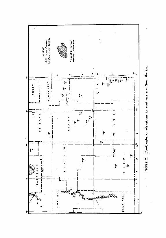
The top of the pre-Cambrian has been reached in a number of
wells in southeastern New Mexico. Elevations of this horizon, above
or below sea level, are shown on fig. 2 both in wildcat wells and in
some localities where it is exposed at the surface. No attempt is made
to interpret these points by structural contours because data are
lacking over wide areas, and in these areas a structural
interpretation would be largely guesswork. The present structural
position of the pre-Cambrian represents the algebraic sum of
structural movements since the beginning of the Cambrian except in
limited areas where part of the pre-Cambrian has been removed by
erosion.
PEDERNAL MOUNTAINS
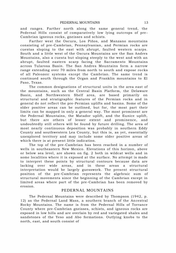
The Pedernal Mountains were described by Thompson (1942, p.
12) as the Pedernal Land Mass, a southern branch of the Ancestral
Rocky Mountains. The name is from the Pedernal Hills of Torrance
County where pre-Cambrian gneisses, schists, and igneous rocks are
exposed in low hills and are overlain by red and variegated shales and
sandstones of the Yeso and Abo formations. Outlying knobs to the
north, east, and south consist of

14 PRINCIPAL STRUCTURAL FEATURES
similar pre-Cambrian rocks and the pre-Cambrian has been found at
shallow depths in a number of wells. The principal outcrops of the
pre-Cambrian in this and other areas are shown on p1. 1.
Pajarita Peak in T. 12 S., R. 15 E., Otero County, on the eastern
slope of the Sacramento cuesta, is composed in part of igneous rock
which is reported to be pre-Cambrian,2 overlain by the Abo formation.
Similar conditions have been reported just west of Capitan Mountains,
Lincoln County (Thompson, 1942, p. 12) . A well drilled by Stanolind
Oil and Gas Company near Picacho, Lincoln County, (sec. 10, T. 12 S.,
R. 18 E.) found coarse arkosic sandstone at 2310 feet underlain at
2550 feet by "granite wash" which in turn grades downward into
igneous rock, the exact top of which is difficult to determine. Similar
conditions were found in Humble's State No. 1-N (Manning Dome) well
15 miles farther south in sec. 35, T. 14 S., R. 17 E. in Chaves
County. In both wells the arkosic sandstone and "granite wash"
correspond in stratigraphic position with the Abo formation. The
"granite" reported by Darton (1928, pp. 231-232) in a well near
Picacho is probably "granite wash" grading downward into pre -
Cambrian igneous rock.
The occurrence of thick beds of coarse elastics in areas sur-
rounding the old Pedernal Mountains furnish some measure of its
extent and prominence. Because of the probable elevation and extent
of the uplift the name mountains is preferred to "land mass." The
coarse sandstones and conglomerates are found in numerous beds
from lower Atoka to the top of the Pennsylvanian as well as in the
lower part of the Permian. They are conspicuous in the Sacramento,
Oscura, Los Piños, and mountains farther north and also in
numerous wells east of the mountains. The thickness and abundance
of these coarse elastics indicate contemporaneous mountains of
considerable magnitude. The first uplif t apparently took place about
the beginning of Atoka time, but probably the major uplift was early
in the Permian. No coarse elastics have been found in beds older than
the Pennsylvanian, but the present known northern occurrence of any
pre-Pennsylvanian sediments in southeastern New Mexico is south of
latitude 34° in the southern Oscura Mountains and in a well in
southern Roosevelt County. It is logical to assume that southeastern
New Mexico north of latitude 34° was a land area of low relief
throughout earlier Paleozoic time.
The probable extent of the Pedernal Mountains in Pennsylvanian
time is shown 'on fig. 4. The areal extent is predicated partly on the
known absence of Pennsylvanian rocks and partly on gravity surveys
furnished by Hart Brown. Three wells in southern Otero County
found the Pennsylvanian missing, so it is possible that during
Pennsylvanian time there was a continuous land area across Otero
County into Hudspeth County, Texas.
2Some geologists who have studied Pajarita Peak believe that the igneous rock may be a Tertiary intrusive.
EUNICE UPLIFT 15
The present map, however, shows only local areas of uplift in Otero County.
MATADOR UPLIFT
Beds of Permian age (Wolfcamp) rest on the pre-Cambrian in one
well in southern Roosevelt County, Shell's Harwood No. 1 in sec. 27,
T. 7 S., R. 35 E. This is commonly interpreted as the western
extension of the Matador uplift which is a prominent subsurface
feature extending westward from the Electra arch of north central
Texas across the South Plains area of Texas. In some wells the pre -
Cambrian is directly overlain by Permian rocks, but in other wells
beds of Virgil (upper Pennsylvanian) age rest on the pre -Cambrian
indicating a pre-Virgil uplift. This is the case in Shell's Saunders-
Federal test in sec. 5, T. 8 S., R. 37 E. where 100 feet of limestone
and shale of Virgil age is present over the pre-Cambrian.
Some geologists think that the Matador uplift is a continuous
ridge, while others think of it as a general alignment of isolated peaks.
Data available to the writer on this question are inconclusive. There
was probably some recurrence of structural uplift at various times
throughout the Pennsylvanian culminating about the beginning of the
Permian. No extensive coarse elastics have been reported in either
Pennsylvanian or Permian rocks on the flanks of the Matador uplift, so
we can assume. the absence of any high or extensive area of pre-
Cambrian rocks.
The alignment of the Matador uplift has suggested a possible
connection with the Capitan Mountains of central Lincoln County
and with the east-west trending dikes in Chaves County. These
mountains and dikes, however, are formed by late•Tertiary igneous
intrusions, and their connection with a pre -Permian structural uplift
is very doubtful. Another possible connection is with a structural
feature found by drilling east and a little north of Roswell. In this
area De Kalb's Lewis No. 1 well found only 200 feet of limestone and
shale of Virgil age with a basal "granite wash" overlying the pre-
Cambrian. Much thicker Pennsylvanian and older rocks were found
in wells a few miles to the southeast indicating a ridge similar in
character to the Matador uplift. Gravity data indicate that this ridge
had a northeast-southwest trend but does not indicate any direct
connection with the Matador uplift. Such a connection might have
been by a few isolated peaks.
EUNICE UPLIFT
The Eunice uplift in eastern Lea County is well known because of
its numerous oil pools and the large number of wells that have been
drilled on and around the flanks of the main uplift. Only some broad
outlines of the stratigraphy, structure and oil development are
presented in this report.
The higher part of the uplift covers 15 to 20 square miles
and in this area, the Abo formation of Leonard (Permian) age
EUNICE UPLIFT 17
rests directly on pre-Cambrian. On the western and southern flanks and
probably on the northern flank the truncated edges of beds of progressively
younger ages appear beneath the Abo formation. The eastern flank appears to
be faulted. The main period of uplift and erosion was at the close of the
Pennsylvanian or early in the Permian. Wolfcamp beds were probably not
deposited over the higher part of the area.
The general outline of the Eunice uplift coincides with the largest area of
pre-San Andres oil production as shown on p1. 1. Outline cross sections are
shown on pls. 8 and 9.
The Eunice uplift is one of the most prominent of a number of structural
highs underlying the Central Basin Platform. It appears to lie at the
intersection of two pre-Permian axes of folding, one trending nearly north-
south in at least the southern part of Lea County and the other a northwest-
southeast trend which can be traced into Lea County from Andrews County,
Texas. Pennsylvanian beds are generally absent over the higher part of this
fold, but older Paleozoic rocks are commonly present except over the high part
of the Eunice uplift. The Monument pools are probably on a similar but less
pronounced uplift separate from the Eunice uplift.
STRATIGRAPHY GENERAL OUTLINE
All the Paleozoic systems except the Cambrian are represented in the
sedimentary rocks of southeastern New Mexico, but a number of units of series
rank are missing. Surface sections have been studied and described in the
mountains of central New Mexico and western Texas, and the subsurface is
known from the records of numerous wells. The following tabulation shows the
principal rock units known in the area and the nomenclature used in this
report.

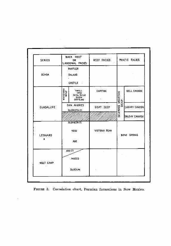
PERMIAN SYSTEM
CLASSIFICATION
In 1939 a group of geologists (Adams et al.) proposed a four fold
series subdivision of the Permian system. These subdivisions have
been generally accepted but were not used by R. L. Clifton (1945) and
John W. Skinner (1946) in their discussions of Permian stratigraphy
and correlations. The present classification of the Permian formations
of southeastern New Mexico is shown on an accompanying chart (fig.
3) .
In this classification three facies groups are distinguished
based on the relationship to extensively developed barrier reefs
PERMIAN SYSTEM 19
which are prominent in the Guadalupe series but less evident in the
other three series. One facies group is the reef itself with im-
mediately associated rocks ; a second is landward from the reef ;
and the third seaward from the reef.
Various names have been given to the areas shoreward from the
reefs such as shelf, platform, back-reef, and lagoon. Objections can
be raised to all these terms. The Castile formation belongs
lithologically in the back-reef or lagoonal group, but it was deposited
in a restricted basin and could hardly be called a shelf or platform
facies. Even the term shoreward might be misleading because the
actual shore lines were in places a hundred miles or more from the
reefs. Many of the back-reef or lagoonal areas were actually shallow
epicontinental seas differing from other shallow epicontinental seas
only by being in a drier climate so that evaporation exceeded the
supply of water from rainfall and runoff from surrounding land
areas.
The rock facies developed seaward from the barrier reefs has
likewise been called by different names : basin, basinal and pontic.
The name pontic was proposed by the writer in 1938, because the
rocks seaward from the Permian reefs of New Mexico and west Texas
appeared to need a more distinctive name than the very general term
basinal. The term is from the Greek word "pontos", one of the words
for open sea or large sea and was applied particularly to the Black
Sea, Pontos Euxeinos.
The Delaware Mountain group of rocks may be taken as typical
of the pontic facies group:. Characteristic features are the general
absence of dolomite and the dark to black color of the shales. Many of
the limestones are also dark to black. The sandstones are less
characteristic but are commonly fine-grained. These beds were
deposited in a bay in which the waters were considerably deeper than
in the adjacent reef area. The greatest depth of water in the bay was
probably about the close of Capitan reef building time and was
approximately 1800 feet.
The distinctive characteristics of the rocks of this facies are
probably due, in part at least, to the depth of water in which they
were deposited. The black limestone and shale of the Bone Spring
formation have much the same features as those of the Delaware
Mountain group and may be considered as equally typical of the facies
group.
GUADALUPE-LEONARD CONTACT
The type section of the Guadalupe series is at the south end of
the Guadalupe Mountains and is essentially the Delaware Mountain
group. The lowest formation of the Delaware Mountain group is the
Brushy Canyon, which according to P. B. King (1942, 1948) is
confined to the Delaware Basin and disappears by overlap against the
Bone Spring limestone to the north.3 It was this pronounced
unconformity that influenced the original pro-
³Subsurface data indicate that the Brushy Canyon is also present in the Midland
Basin.
20 STRATIGRAPHY
ponents of the Guadalupe series in placing the series boundary at the base of
the Delaware Mountain group.
Frank E. Lewis (1941) presented a strong argument for placing the San
Andres formation in the Guadalupe series, but other authors then and later
included the San Andres in the Leonard series. More recent papers by R. L. Clifton
(1945) and John W. Skinner (1946) present paleontological evidence confirming
Lewis' earlier correlation of the San Andres with a part of the °type Guadalupe
section in the Delaware Mountains.
The type section of the Leonard series is in the Glass Mountains where it
was defined as co-extensive with the Leonard formation. The top of the formation
as described by P. B. King (1930, 1942) is at the base of a limestone bed which
was defined as the lowest unit of the overlying Word formation. As thus defined
the Leonard series was supposed to be co-extensive with the zone of Perrinites
hilli but later Cooper (Miller, 1945) and Clifton (1945) found that supposedly
distinctive Leonard ammonoid genus in the lower limestone of the Word
formation.
A prominent chert and quartz pebble conglomerate 300 feet below the lower
limestone of the Word and overlying the Hess limestone facies of the Leonard is
regarded by Lewis as the logical base of the Word formation and of the Guadalupe
series. He correlates this conglomerate at least in part with the San Angelo
conglomerate and states that the two conglomerates are so similar as to suggest a
common source (1946, p. 20) .
The pronounced unconformity at the base of the Delaware Mountain group,
the presence of the Brushy Canyon formation in the Delaware and Midland
basins, and the probable absence of beds correlative with the Brushy Canyon on
the shelf or platform areas indicate a pronounced break in sedimentation on the
platform areas while the Brushy Canyon was being deposited in the basin areas.
The probable unconformity at the base of the San Angelo conglomerate on the east
side of the Permian Basin appears to be such a stratigraphic break, at least in
surface sections.
No such marked stratigraphic break is found in New Mexico but the Glorieta
sandstone appears to be correlative with the San Angelo conglomerate. The U. S.
Geological Survey classifies the Glorieta sandstone as a member of the San Andres
formation, but the New Mexico Bureau of Mines and Mineral Resources considers
it a separate formation. Some geologists, including the writer, have found evidence
that it grades laterally into the lower limestones and dolomites of the San Andres
formation, but in other localities, particularly in the Gran Quivira quadrangle,
some evidence has been found of lateral gradation into the underlying Yeso
formation (Bates et al., 1947, p. 33) .
In general it appears that the base of the Glorieta sandstone, the base of the
San Angelo conglomerate, and the base of the conglomerate above the Hess,
located in widely separated areas,
PERMIAN SYSTEM 21
each represents the initiation of a new cycle of deposition and that all are of
approximately the same age.4 From the standpoint of stratigraphy alone this
appears to be the logical base of the Guadalupe series. Paleontological data,
however, do not appear to confirm this interpretation.
The upper part of the Victorio Peak member of the Bone Spring formation
contains the fusulinid species Parafusulina fountaini and Schwagerina setum.
According to P. B. King (1942, 1948) the Victorio Peak member is below the
unconformity at the base of the Delaware Mountain group and therefore belongs
in the Leonard series. The fusulinid fauna of the upper Victorio Peak is commonly
considered as the uppermost fauna of the Leonard. However, it has been found in
a few wells where by subsurface correlation it is above the base of the San Angelo
and of the Glorieta. One such locality is in eastern Ector County, Texas, where
Parafusulina fountaini is found in limestones associated with the "Holt pay"
(Skinner, 1946, p. 1863). According to the writer's correlations, the "Holt pay" is
in the lower part of the San Andres formation rather than below it.
In Spearow's McClelland well in sec. 22, T. 22 S., R. 23 E., Skinner (1946
cross sections) found the uppermost Leonard fauna including Parafusulina
fountaini and Schwagerina setum in a limestone zone which is underlain at
2055 feet by a bed of sandstone which is logically correlated with either the
Glorieta or the uppermost sand of the Yeso. The limestone is correlative with a
limestone underlying the Cherry Canyon formation in Last Chance Canyon and
containing a "Bone Spring" fauna (Skinner, 1946, p. 1865) . Last Chance
Canyon does not cut deep enough to expose the underlying beds.
Adams (1949) reports the presence of Schwagerina setum in the Glass
Mountains in beds above the conglomerate which Lewis places at the base of
the Guadalupe series. Therefore paleontological as well as stratigraphic
evidence indicates that this conglomerate is correlative with the San Angelo
and with the Glorieta. The paleontological evidence also indicates that the
stratigraphic position of this conglomerate, the San Angelo, and the Glorieta is
below the upper part of the Victorio Peak member of the Bone Spring.
According to V. C. Peterson (1947, p. 11) , the upper sandstone of the
Brushy Canyon formation grades northward into a reef limestone which overlies
the Victorio Peak reef. This statement has not been confirmed by other
observers,5 and further detailed work in the area is desirable. If it can be shown
that the upper part of the Victorio Peak containing the Parafusulina fountaini
fauna is equivalent to some part of the Brushy Canyon
4Many geologists do not agree with the correlation of the base of the San Angelo with the base of the Glorieta. This difference in correlation will be discussed with the Yeso formation.
5 Walter C. Warren and Roy M. Huffington, personal communications.
22 STRATIGRAPHY
we can put the base of the Guadalupe series at. the base of this
zone and also at the base of the San Angelo and Glorieta. Skinner's
correlation (1946, fig. 8) , on the other hand, shows a marked
stratigraphic break between the Glorieta and San Andres formations
and between the San Angelo and the overlying Flower Pot formation.
Determination of the boundary between the Guadalupe and Leonard
series will depend on more detailed stratigraphic and paleontologic
work in the type areas.
GUADALUPE OR LEONARD SER IES
Glorieta sandstone.—The Glorieta sandstone is herein consid-
ered the lowest formation of the Guadalupe or the uppermost for -
mation of the Leonard series in central New Mexico. In surface
sections it is "a white and yellow clean sandstone composed of
angular to sub-round quartz grains of medium size" (Bates et al.,
1947, p. 32) . It is 520 feet thick in northeastern Torrance County
and is thinner both to the south and east. It is readily recognized in
wells in Guadalupe and De Baca counties where it is separated from
the underlying fine grained silty sandstones of the Yeso formation by
a bed of dolomite. It is recognized in surface sections as far south as
the northern Guadalupe Mountains and southern Sacramento
Mountains where it is only a few feet thick.
The individual sandstone beds in the Glorieta are lithologi cally
distinct from underlying beds and the formation as a whole is
markedly different from the underlying Yeso, but there is no marked
stratigraphic break and locally considerable difficulty is
encountered in defining both the upper and lower limits of the
formation.
Measured surface sections of the Glorieta in the Gran Quivira
quadrangle, the Oscura Mountains, and the southern Sacramento
Mountains are shown graphically on pl. 2. The locations of these
sections are shown on pl. 1. The sandstone is 230 feet thick where
measured in the Gran Quivira quadrangle (sec. 29, T. 1 N., R. 5 E.,
Bates et al., 1947, pl. 5) and in the Oscura Mountains is only 40 feet
thick. A corresponding thickening of the underlying Joyita member
of the Yeso formation from north to south as shown in the sections
supports the argument for inter-gradation between the Glorieta and
Joyita sands.
A section measured in the southern Sacramento Mountains (E,
pl. 2) contains one 8-foot bed of white calcareous fine- to medium-
grained sandstone which appears to be the Glorieta. Over 100 feet of
limestone and dolomite underlying this sandstone is considered as
upper Yeso but might be logically included in the Glorieta.
In Lea County the distinctive character of the Glorieta is not
recognizable, and most subsurface geologists call the top of the first
sandstone lens below the San Andres "top of Glorieta"

PERMIAN SYSTEM 23
and do not attempt to pick its base. "It is possible that the Glorieta
wedges out completely toward the southeast and that the top of the
so-called Glorieta sand of most of Lea County is the top of the Yeso"
(R. E. King, 1945, p. 10) . A probable correlation of the Glorieta in
one well in Lea County (Shell's Taylor-Glenn No. 1) is shown on p1.
3, but in the outline cross sections (p ls. 5 to 9) the Glorieta is
included with the upper Yeso.
LEONARD SERIES
Yeso formation.—The Yeso formation was deposited in a saline
epicontinental sea. Complete surface sections are exposed only on the
west side of the old Pedernal Mountains, and detailed sections
measured in the Gran Quivira quadrangle, the Oscura Mountains, and
northern and southern Sacramento Mountains are shown graphically
on pl. 2.
In these four sections the formation consists of alternating
beds of sandstone, shale, limestone, and gypsum. A prominent basal
sandstone is found in the Gran Quivira quadrangle and the Oscura
Mountains but not in the Sacramento Mountains. There is a general
decrease in the relative abundance of elastic sediments and of
gypsum from north to south with a corresponding increase in
carbonates.
The first section is a composite section measured in the Gran
Quivira quadrangle (Bates et al., 1947, pp. 29-30) . The.formation is
678 feet thick and is divided into four members. The uppermost Joyita
member, 62 feet thick, is composed of siltstone and fine sandstone.
The second member, the Cañas, 105 feet thick, is predominantly
gypsum. The third member is the Torres, 405 feet thick, and is
composed of alternating beds of sandstone, silt-stone, limestone, and
gypsum.-The lowest member, the Meseta Blanca, 106 feet thick, is
predominantly sandstone.
The second section was measured in the Oscura Mountains and
is reproduced with the permission of the Standard Oil Company of
Texas. The Yeso is 1205 feet thick as compared with 678 feet in the
Gran Quivira quadrangle with the most marked thickening in the
sandstone units, Joyita and Meseta Blanca members, at the top and
bottom of the section. Thickening of the Joyita member is
accompanied by a thinning of the overlying Glorieta and the two may
be intergradational. The lower Meseta Blanca sandstone member is
380 feet thick, more than three times its thickness in the Gran
Quivira area. This sandstone may be the basal sediments of the Yeso
marine sea advancing from the south or southwest over a land area.
The third section shown on pl. 2 was measured by Richard C.
Northup and Lloyd C. Pray in the northern Sacramento Mountains in
secs. 22 and 27, T. 13 S., R. 11 E. The section is poorly exposed with
neither the top nor bottom of the Yeso definitely identified. As
measured, the formation is 1343 feet thick. The
24 STRATIGRAPHY
Joyita and Cañas members can be recognized, but the basal sandstone is
not present unless in the 150-foot covered interval at the base.
Another section was measured by Northup and Pray near the
southern end of the Sacramento Mountains in secs. 30, 31 and 32,
T. 19 S., R. 12 E. One 8-foot bed of sandstone is correlated with the
Glorieta. The underlying 180 feet of limestone, dolomite, and silty
sandstone with a prominent sandstone bed at the base is tentatively
correlated with the Joyita member of the Yeso. Other members of the
Yeso are even less distinctive. The Cañas member is apparently
represented by limestone, and what appears to be the Torres
equivalent contains only one thin bed of gypsum. However, at the
base of the Yeso section over 100 feet of beds, predominantly
gypsum, was measured and is overlain by a covered interval which
may be gypsum in part. Farther north in the Sacramento Mountains
the lower part of the Yeso contains numerous beds of gypsum.
In the area east of the Pedernal Mountains in Guadalupe and De
Baca counties, the upper part of the Yeso is very similar to that in
the surface sections to the west with the addition of beds of salt
alternating with those of sandstone, shale, and dolomite. Correlation
with the Oscura Mountains section is more satisfactory than with the
Gran Quivira quadrangle section because of the more comparable
thickness. A similar section extends eastward across Curry County
and into Texas and southward across northern and southwestern
Chaves County and eastern Lincoln County. Farther southeast the
percentage of dolomite increases until in central and southeastern
Lea County, southeastern Chaves County and parts of Eddy County
the section is predominantly dolomite with persistent beds of fine-
grained sandstone.
Beds equivalent to the Yeso in the Delaware Basin and in at
least a part of the Carlsbad Shelf area (DeFord, 1942) are dark
limestones interbedded with black shale, the Bone Spring formation.
A barrier reef between the typically pontic Bone Spring beds and the
Yeso dolomites to the north can be reasonably in ferred, but the
exact position of this reef is still largely a matter of conjecture.
Within the area where the Yeso is predominantly dolomite two
persistent marker beds can be recognized. One is at the base of a
sandy zone overlying the Blinebry pay of eastern Lea County, and the
other is the top of the Drinkard sandy member named and described
by R. E. King (1945, pp. 13-15) . These two marker horizons divide
the Yeso into three units which are herein designated upper, middle,
and lower Yeso. The upper and middle Yeso as here used are the
same as R .E. King's upper Yeso (1945, p. 12) .
Detailed sections of the Yeso in four widely scattered wells are shown
graphically on pl. 3 to illustrate the differences in the section in different areas.

PERMIAN SYSTEM 25
The upper Yeso as here used is the part of the formation above
the Blinebry pay of, southeastern Lea County. In Shell Oil Company's
Taylor-Glenn test in sec. 3, T. 21 S., R. 37 E. it is 385 feet thick (pl.
3) . The top of the Yeso in this well is picked at 5295 feet, and the
overlying 50 feet, predominantly sandstone, is classed as Glorieta.
However, it is possible that the entire sand section is Yeso. The upper
Yeso is predominantly dolomite with a considerable amount of
interbedded sandstone and sandy dolomite in the lower part. The
base of the sandy section is the base of the member. Many geologists
correlate the upper Yeso and the Glorieta with the San Angelo
formation and correlate the top of the Clear Fork with the top of the
Blinebry pay. The writer, however, believes that the upper Yeso is
correlative with upper Clear Fork and the Glorieta with the San
Angelo.
The section in Shell's Taylor-Glenn well is typical of the
northern part of the Central Basin Platform in Lea County. The
formation thickens to the north and west. In southeastern Chaves
County, De Kalb Agricultural Association's White No. 1 (G, pl. 3) in
sec. 35, T. 10 S., R. 28 E. was chosen as illustrative. Here, however,
the middle as well as the upper Yeso contains sand beds, and there
is some uncertainty as to the position of the base of the upper
member. A comparison of this section with that in Sanders Bros.'
Hultman No. 1 (H, pl. 3) in sec. 32, T. 16 S., R. 26 E. in Eddy County
shows the marked decrease in the amount of anhydrite from north to
south.
Pure Oil Company's Federal Fee test (F, pl. 3) in sec. 31 , T. 3 N.,
R. 28 E. was chosen to illustrate the section in De Baca and
Guadalupe counties. Here no limestone or dolomite was found in the
upper Yeso which consists of alternating beds of sandstone, red
shale, anhydrite, and salt. The Joyita, Callas, and Torres members
can be recognized and are correlated as shown on pl. 3. The base of
the upper Yeso is correlated with the top of a dolomite zone at 2830
feet, and this dolomite zone is correlated with the lower limestone
zone of the Torres member in outcrop sections to the west. Thus the
upper Yeso of subsurface sections is interpreted as including the
Joyita, Cañas, and most of the Torres members.
In southeastern Lea County the Paddock oil pay lies in the
upper part of the upper Yeso as here interpreted.
The middle Yeso is almost entirely dolomite in the Eunice area of
eastern Lea County. In the Shell Oil Company's Taylor-Glenn well it is
550 feet thick, extending from 5680 to 6230 feet. In Eddy County the
member has much the same character but is thicker and includes
several thin beds of sandstone. In Sanders' Hultman well it is 665 feet
thick extending from 2810 to 3475 feet. Farther north in Chaves
County (G, pl. 3) it is still thicker, but the recognition of both the top
and bottom of the member is difficult because there is a marked
increase in the amount of sand. In the rotary cuttings a considerable
amount of shale, sandstone,

26 STRATIGRAPHY
and anhydrite is found in almost every sample indicating an
alternation of numerous thin beds. The same characteristics are
found in all wells in central and eastern Chaves County.
In De Baca and Guadalupe counties the middle Yeso (F, pl. 3)
contains only a few thin beds of dolomite. Most of the section
consists of alternating beds of red shale, sandstone, anhydrite, and
salt. As correlated with the surface section in the Oscura Mountains
it includes the lower limestone zone of the Torres member and
probably a considerable amount of section that is missing in the
surface sections.
In southeastern Lea County the Blinebry oil and gas pay lies at
the top of the middle Yeso section.
The lower Yeso extends from the top of the Drinkard sandy
member to the top of the underlying Abo formation. The Drinkard
sandy member was named and described by R. E. King (1945, pp. 13-
14) and its type section is the zone of interbedded dolomite and
sandstone from 6100 to 6210 feet in the Texas Company's Blinebry
No. 1 well in sec. 19, T. 22 S., R. 38 E. The Drinkard-Vivian pay zone
lies approximately 300 feet below the top of the Drinkard member in
the lower part of the lower Yeso (pl. 10) . The Drinkard-Andrews pay
is in the upper part of the Abo formation.
The Drinkard sandy member is commonly correlated with the
"Tubb sand" and "Fullerton sand", and both these names are applied
by geologists to the zone in New Mexico as well as in Texas. However,
the name Fullerton is preoccupied and the "Tubb sand" has not been
described as such in geological literature. The sandy zone is very
widespread in "shelf" areas of the Permian Basin, but has not as yet
been definitely correlated with the surface section either on the east
or west side of the basin.
Details of the Drinkard sandy member in the selected illustrative
wells in Lea, Eddy, Chaves, and De Baca counties are shown on pl. 3,
and suggested correlations are shown in outline cross sections, pls. 5
to 9 inclusive. In Chaves County and farther north the entire lower
Yeso contains numerous beds of sand so that only the top of the
Drinkard can be correlated satisfactorily. There is a suggested
correlation' of the Drinkard sandy member with the basal sandstone of
the Yeso in the Oscura Mountains section. If this is the correct
correlation we might logically infer that the lower part of the Yeso of
Lea County pinches out to the northwest. Another possible
explanation is that it grades into continental deposits with Abo-type
lithologv and its northern equivalent has been included in the Abo. A
third possible explanation is that the entire lower Yeso grades into
sandstone to the northwest and is the equivalent of the Meseta Blanca
member.
In Eddy County and in southwestern Chaves County several
beds of anhydrite are found in the lower Yeso as illustrated in the
section of Sanders' Hultman well shown on pl. 3. The lower zone of
anhydrite in this and other wells in the general area is
PERMIAN SYSTEM 27
probably correlative with the lower gypsum zone found by Northup
and Pray in the southern Sacramento Mountains (pl. 2) .
Victorio Peak reef zone.—The Victorio Peak limestone was
described by P. B. King as a member of the Bone Spring formation. As
exposed in the Sierra Diablo and Guadalupe mountains in west Texas
it "consists of gray, calcitic limestone in thick, fairly even beds, with
a thickness of 500 to more than 1,000 feet" (King, 1942, p. 569).
Observations by the writer in the Guadalupe Mountains lead to the
belief that the Victorio Peak is in part a reef limestone forming a
barrier between the upper part of the pontic Bone Spring limestone
and at least a part of the Yeso formation, which represents the shelf
or lagoonal facies. Whether the Victorio Peak reef facies is equivalent
to all or only a part of the Yeso is not known.
Wells drilled in the Guadalupe foothills west of the Pecos River
indicate that the Victorio Peak reef may extend across the Carlsbad
Shelf along a trend intermediate between that of the Capitan reef to
the south and the San Andres reef to the north. This is well
illustrated by the first four wells on Skinner's cross section (1946,
fig. 9, p. 1868) . The first well, Spearow's McClelland No. 1 in sec. 22,
T. 22 S., R. 23 E., dril led through the back-reef or lagoonal
equivalents of the lower part of the Capitan (Queen and Grayburg
formations) , and then passed through the San Andres very near the
reef front where it grades basinward into Cherry Canyon sands. Below
the San Andres it found mostly limestones of the Yeso formation.
The second well of Skinner's section, Standard of Texas' Smith
No. 1 in sec. 23, T. 22 S., R. 24 E., seven miles east of the
McClelland well, found nearly a thousand feet of Cherry Canyon
sands which have replaced the San Andres reef basinward. Below
this is a dolomite section which is here interpreted as a near -reef
facies of the Victorio Peak.
The third well, Standard of Texas' Wilson No. 1, did not go deep
enough to show the character of the pre-Cherry Canyon formations.
The fourth well, however, Ohio's Tracy Dome test, went through the
entire Capitan reef section and also both Cherry Canyon and Brushy
Canyon sand sections (middle and lower Delaware Mountain) before
reaching the black limestones and shales of the Bone Spring. It is
obvious that the Victorio Peak reef lies somewhere between the Tracy
and Smith wells, and probably between the Smith and Wilson wells.
East of the Pecos River, only three wells in the Carlsbad Shelf
area have been drilled through the Cherry Canyon section. One is
Getty's Dooley No. 7 in sec. 24, T. 20 S., R. 29 E., which has the same
section below the top of the Capitan as the Ohio's Tracy. The second
well is Richfield's Lake McMillan Unit No. 1, in sec. 36, T. 20 S., R. 26
E. This well had a Cherry Canyon and higher section very similar to
that in Standard of Texas' Smith well. The section below the Cherry
Canyon is partly dolomite but

28 STRATIGRAPHY
predominantly limestone with some interbedded black shale. This
may be interpreted as either a pontic or back-reef facies. The third
test to penetrate the Cherry Canyon was Amerada's Record No. 2 in
sec. 25, T. 19 S., R. 35 E. in Lea County. Although this well is over
fifty miles east of Richfield's Lake McMillan well it shows very nearly
the same sequence of formations and the same facies.
In the Amerada well, fusulinids identified as Leonard in age were
found through an interval of 3130 feet from depths o f 7240 to 10,370
feet. This section is tentatively correlated with the Yeso and Abo
formations. On lithologic evidence alone the upper part, above 7620
feet, appears to be correlative with the "Holt zone" of Ector County,
Texas, and therefore with the lower part of the San Andres. This
interpretation is shown on pl. 6 but the evidence is inconclusive.
LEONARD AND WOLFCAMP ( ?) SERIES
Abo formation.—A section in southern Lea County 1000 feet or
more thick and composed of limestone and dolomite with some
interbedded red and green shale is believed by the writer to represent
the Abo formation. This section in a few wells contains fusulinids of
Leonard age. On the other hand in the southern Sacramento
Mountains a limestone section, believed to be a part of the Abo
formation, appears to be a northern extension of the type Hueco
formation which is upper Wolfcamp in age. It is probable that one of
these sections does not represent the Abo formation, but the available
data on this question are inconclusive. The problem will be discussed
further after a brief description of the formation as now identified in
different areas.
Four detailed surface sections of the Abo formation west of the
Pedernal Mountains are shown on pl. 2. The northern section is the
type section of the formation as measured by Needham and Bates
(1943, p. 1656) in Abo Canyon. However, the upper 104 feet of
Needham and Bates' Abo section is now classed as the Meseta Blanca
member of the Yeso formation (Bates et al., 1947) .
The type Abo consists of dark red shale, sandstone, and arkose,
and is interpreted as continental in origin in contrast with the
overlying Yeso formation and the underlying Bursum formation which
are marine in origin. In the Gran Quivira quadrangle the Abo is 810
feet thick.
In the Oscura Mountains the Abo consists of arkosic sandstone
and shale both with the intense dark red color which is
characteristic of the formation in this part of the state. The detailed
section (B, pl. 2) was measured by Walter C. Warren at the southern
end of the mountains in T. 9 S., R. 6 E. The thickness of the
formation here is 830 feet.
The section measured by, Northup and Pray in sec. 4, T. 16 S.,
R. 11 E. (D, pl. 2) shows the general characteristics of the
PERMIAN SYSTEM 29
Abo formation in the central part of the Sacramento Mountains. It is a
dark red shale with a coarse conglomerate at the base and a total
thickness of only 400 feet. A section measured by W. Y. Penn (1932)
farther north in Tularosa Canyon has about the same thickness, but
the formation there is almost entirely coarse conglomerate.
Near the southern end of the Sacramento Mountains a lens of
limestone appears in the Abo and thickens to the south. In the
section measured by Northup and Pray in T. 19 S., Rs. 11 and 12 E.
(E, pl. 2) the limestone section is 360 feet thick and is underlain by
100 feet of red shale and siltstone and overlain by 90 feet of
interbedded red sandstone and shale, a total of 550 feet of Abo. The
limestone is shaly and has some interbedded dark shale and
sandstone. Thinning of the limestone section to the north is
accompanied by a thickening of the underlying elastic section.6
No fusulinids have been found in the Abo limestone in the
Sacramento Mountains but it has been traced a few miles to the south
where Hueco-type fusulinids were collected.? It also appears to be the
limestone from which Branson collected ammonoids in T. 22 S., R. 10
E. (Miller and Parizek, 1948) . Both the fusulinids arid ammonoids
show a definite correlation with the Hueco limestone in its type
locality in the Hueco Mountains.
In the surface sections from Abo Canyon south to the Sacra-
mento Mountains, the Abo rests with angular unconformity on rocks
ranging in age from lower Wolfcamp to Mississippian. Except in the
southern Sacramento Mountains, the rocks are all coarse elastics of
continental origin. These continental deposits either p inch out to the
south or grade into marine limestones. The lime-depositing sea
advanced from the south.
On the flanks of the Pedernal Hills in Torrance County, the Abo
formation is absent except locally, and the Yeso formation rests on pre -
Cambrian schists. Farther south, in the Gallinas Mountains, Abo beds
100 to 200 feet thick rest on pre-Cambrian rocks.
Farther south in eastern Lincoln County and southwestern
Chaves County, beds correlated with the Abo are coarse arkose or
"granite wash."
During Abo time a large amount of coarse elastic material was
eroded from the Pedernal Mountains, which locally must have risen
into mountains of considerable magnitude.
The top of the granite wash or Abo is probably not a time horizon
as the tops of some of the pre-Cambrian hills stayed above sea level
longer than others and continued to shed their detritus into the
neighboring waters long after marine sediments buried the lower
granite knobs.
In wells drilled in Guadalupe and De Baca counties the top of the
Abo is difficult to identify because of the abundance of red
6 Lloyd C. Pray, personal communication
7 Walter C. Warren, personal communication.
30 STRATIGRAPHY
shale and sandstone in the lower part of the Yeso formation.
However, the dark red color of both the sandstones and shales is
distinctive. The formation may be considered as continental in
origin near the old Pedernal Mountains, but farther east in east ern
De Baca County some thin beds of dolomite and anhydrite are
present in the Abo section, indicating a transition from continental
to marine conditions. In Guadalupe, De Baca, and northern
Roosevelt counties, the Abo ranges in thickness from less than 600
to over 1,100 feet. The thinner sections are nearer the mountains
and contain coarse sandstones and arkoses similar to those found
in the surface sections on the west side of the mountains.
In Chaves County and southern Roosevelt County there is a
sharp break between the dolomite and anhydrite of the lower Yeso
and the dark red shale of the top of the Abo formation. This is the
top of Abo of all subsurface studies in Chaves; Eddy, and Lea
counties and can be followed as a reasonably accurate strati -graphic
marker over wide areas. However, it may be 100 to 200 feet lower
stratigraphically than the lithologic break farther north.
The Abo of central and eastern Chaves County, southern
Roosevelt County, and northern Lea County consists of interbedded
red, green, and gray shale, dolomite and anhydrite. The percentage
of dolomite increases to the south, and in central Lea County there
are only remnants of the characteristic red and green shale in the
upper part of the formation. The top of the formation can be
identified with reasonable accuracy over the entire Central Basin
Platform. The range of the Abo formation in a number of wells is
shown in the outline cross sections, pls. 5 to 9.
In Amerada's Phillips No. 5 well in sec. 1, T. 20 S., R. 36 E. in
the Monument area, the top of Abo is placed tentatively at 6840 feet
(pl. 6) . The lower part of the Abo in this well from 7140 to 7840 feet
contains fusulinids of Leonard age. The Abo rests on beds of
Wolfcamp age, probably the Hueco formation.
In the Eunice area of eastern Lea County, and over most of the
Central Basin Platform the Abo section consists of dolomite
interbedded with limestone and with thin beds of red and green shale.
It rests unconformably on rocks ranging in age from pre-Cambrian to
Pennsylvanian. Elsewhere over a large part of southeastern New
Mexico east of the mountains, the Abo is underlain by beds of Wolf
camp age as determined by fusulinids from numerous wells. The
Drinkard-Andrews pay of the Drinkard pool, the Monument-Abo pool,
and the Elliott pool produce oil from a porous dolomite in the upper
part of the Abo formation.
The age of the Abo formation has been discussed at some
length by P. B. King (1942) and R. E. King (1945) who concluded
that the weight of evidence was indicative of Leonard age. P. B.
King reported plant remains collected and studied by

PERMIAN SYSTEM 31
C. B. Read as evidence of the Leonard age of at least a part of the formation
(1942, p. 690) .
The continental redbeds of the typical Abo can be traced into their marine equivalents by lithologic correlation only and such a
correlation is always subject to error. The assignment of a marine lower Leonard section in southern Lea County to the Abo is based on well to well correlations over a distance of more than 150 miles and further lithological correlations across a partly buried mountain
range which separated two areas of deposition during Abo time. Despite these difficulties the general correlation appears to be well established but the upper and lower limits of the formation as placed in the outline sections (pls. 5-9) probably do not represent uniform
time lines. The Abo of the Eunice area and the Central Basin Platform is shown by the fusulinids to be Leonard in age but farther northwest it may include beds of upper Wolfcamp age.
It has been shown that in all probability most of the Abo of the
southern Sacramento Mountains is equivalent to a part of the Hueco formation of Wolfcamp age. Possibly the uppermost 90 feet represents
the Leonard part of the formation.
The equivalent of the Abo formation under the Carlsbad Shelf area and in the Delaware Basin is probably the lower part of the Bone Spring formation. The thick section containing Leonard fusulinids in Amerada's Record No. 2 well (pl. 6) is placed in the Bone Spring and
correlated with the Yeso and Abo formations of the shelf area. Below the fossiliferous Leonard section in this well is a predominantly sandy section from 10,370 to 10,710 feet which might be basal Abo.
WOLFCAMP SERIES
Hueco limestone.—The Hueco limestone in its type section in
the Hueco Mountains in Hudspeth County, Texas, consists of the basal
Powwow conglomerate overlain by a predominantly limestone section nearly 1600 feet thick, in which three divisions were recognized (King and Knight, 1945) . The Deer Mountain red shale member, 180 feet thick, is the lower member of the upper division. The Hueco limestone
is assigned a Wolfcamp age but it is possible that some of the upper part may be of Leonard age. The Powwow conglomerate is mapped as the lowest member of the Hueco, but the limestones above the Powwow do not contain the lowermost Wolfcamp fusulinids so it appears that
the Hueco represents only the upper or possibly the middle and upper part of the Wolfcamp series.
The Hueco limestone is represented in wells drilled on the Otero Mesa in Otero County where it is about the same thickness as at the
outcrop. Farther north, however, in the Sacramento Mountains it becomes thinner and is represented by a limestone lens in the Abo. This lens thins and terminates in the mountains south of Alamogordo.
32 STRATIGRAPHY
The Hueco is found in a number of wells in the southeastern counties,
but in many wells the evidence available at present is
not sufficient to differentiate it from the lower Wolfcamp Bursum formation.
The subsurface distribution of the two formations will be discussed under
another heading.
Bursum f ormation.—In discussing the Pennsylvanian-Permian
contact, M. L. Thompson (1942, p. 20) mentioned the presence of
fusulinid-bearing marine sediments of lower Wolfcamp age
unconformably overlying Pennsylvanian rocks in a number of localities
in south central New Mexico.
In 1946 this lower Wolfcamp limestone received no less than
three names. Kelly and Wood (U. S. Geol. Survey, Prelim. map No. 47)
described what is apparently the same section on the west side of
Ladron Peak and called it the "Red Tanks member of Madera
Limestone." They classed it as Pennsylvanian in age. Wilpolt et al. (U.
S. Geol. Survey, Prelim. map No..61) introduced the name Bursum
formation for beds exposed in Los Pitios Mountains and the vicinity of
Abo Canyon. Stark and Dapples (1946, p. 1154) described the same
section and named it the Aqua Torres formation.
The descriptions by Kelly and Wood and by Wilpolt et al. of the
Red Tanks member and Bursum formation are inadequate by
present standards of nomenclature, but in the case of the Bursum
formation this was remedied in 1947 by Bates et al. (Bull. 26) who
published two detailed sections, one in Abo Canyon and the other
31/2 miles to the southwest in sec. 14, T. 2 N., R. 4 E. The name
Bursum formation is preferred by the Bureau of Mines and Mineral
Resources, but it is unfortunate that the only adequate descriptions
of the formation were from areas nearly forty miles north of the type
locality which is at Bursum triangulation station in sec. 1, T. 6 S.,
R. 4 E. The section in T. 2 N., R. 4 E., and also a section measured
by Walter C. Warren in the southern Oscura Mountains in T. 9 S.,
R. 6 E., are shown graphically on p1. 2.
The Bruton formation of Pennsylvanian Virgil age ( Thompson,
1942, pp. 79-82) is very similar in lithology to the Bursum and it is
probable that part or all of the Bruton has been included in
descriptions of the Bursum (Thompson, 1942, p. 81) . The two
formations are separated by an unconformity, but apparently they
can be distinguished only by careful stratigraphical and
paleontological study. The Bursum is overlain unconformably by the
continental Abo formation.
A similar section, now included in the Bursum, was found by
Thompson (1942, p. 82) in Fresnal Canyon in the northern Sacra-
mento Mountains where it is 250 feet thick and overlies beds of upper
Virgil age. It is overlain with angular unconformity by a coarse
quartzite conglomerate at the base of the Abo formation. The
formation thickens to about 350 feet a mile north of Fresnal

PERMIAN SYSTEM 33
Canyon, but thins and disappears within a few miles to the south, 8 and
is not found farther south in the Sacramento Mountains where it is cut
out by the unconformity at the base of the Abo.
Most of the limestone beds of the Bursum formation contain an
abundance of fusulinids of lower Wolfcamp age. The formation is older
than the Hueco limestone which is middle and upper Wolfcamp in age.
Hueco and Bursum formations in subsurface.—Rocks containing
Wolfcamp fusulinids are found in a large number of wells in
southeastern New Mexico. They are missing in the Eunice area and
generally over the higher parts of the Central Basin Plat form. Over
most of the area the rocks are limestone and dolomite with
interbedded gray, black and red shale. There is a gradual increase in
the amount of elastic, material to the north and west and near the old
Pedernal Mountains red shale and sandstone are the predominant
constituents.
The most complete Wolfcamp section so far encountered is in
Phillips' Lea-Mex No. 4 test in sec. 17, T. 17 S., R. 33 E. (p1. 6) .
Here the series is 2100 feet thick from 9700 to 11,800 feet in depth.
Upper Wolfcamp Hueco fusulinids have been found in the upper part
of the section and lower Wolfcamp pre-Hueco types in the lower part.
Both the Hueco and Bursum formations are represented, but there
does not appear to be any marked strati -graphic break between the
two formations. The upper part is predominantly limestone with
some interbedded. dolomite, chert, and gray shale, and the lower
part is interbedded limestone and gray shale.
Farther east in Amerada's Hamilton No. 1 well (pl. 8) , the two
formations can be distinguished with reasonable assurance. The
Hueco is 695 feet thick from 9835 to 10,530 feet and is pre -
dominantly dolomite and limestone with some chert and black shale.
The underlying Bursum formation is 310 feet thick and is mostly
limestone with interbedded gray and black shale and some chert. At
10,840 feet the Bursum lies unconformably on limestone of
Mississippian age.
In northern Lea County in the Crossroads area the known
Wolfcamp beds are predominantly limestone (pl: 7) . The lower part is
placed in the Bursum formation but the upper part may be Hueco. In
Barnsdall's State No. 1-A well in eastern Chaves County the
Wolfcamp is 740 feet thick from 8400 to 9140 feet in depth. A detrital
zone at about 8650 feet may mark the boundary
. between the Hueco and Bursum formations.
Wolfcamp beds found in wells in southeastern Lea County,
Eddy County and in southern and southwestern Chaves County are
apparently all Hueco. The fragmentary remains of fusulinids found
in wells in De Baca and Guadalupe counties are not suffi ciently
diagnostic to differentiate the two formations.
8 Lloyd C. Pray, personal communication .
34 STRATIGRAPHY
It is probable that more detailed stratigraphic and paleonto logic
studies would serve to differentiate the Hueco and Bursum
formations over the entire area. So far as known to the writer the
Bursum carbonates are all limestone, and the Hueco in many wells
contains both limestone and dolomite. There may be a marked
stratigraphic break between the two as suggested by a detrital zone
found in a few wells. The suggested range of the formations in a
number of wells is shown in the outline cross sections, pls. 5 to 9.
The pay zone of the Bough pool in northern Lea County is in the lower
part of the Bursum formation.
PENNSYLVANIAN SYSTEM
GENERAL FEATURES
Much of our knowledge of the Pennsylvanian of surface sections in
south central New Mexico is through the detailed work of M. L.
Thompson (1942, 1948) , who was formerly on the staff of the Bureau.
By his studies of the fusulinids, he recognized four series which in
descending order were Virgil, Missouri, Des Moines, and Derry (1942) .
The first three are well established in the Mid-Continent region, and
the Derry is the equivalent of the more widely known Atoka series.
Thompson subdivided these series into groups and formations, but the
series divisions only have been identified in the subsurface in
southeastern New Mexico.
Recently Moore and Thompson (1949) have proposed a regrouping
of the Pennsylvanian system and period into three series (epochs) with
the former series reduced to the rank of stage (age) . The three series
proposed may be called Lower, Middle, and Upper, but proposed
geographic names are considered preferable. The New Mexico Bureau of
Mines and Mineral Resources has not, as yet, accepted Moore and
Thompson's reclassification of the Pennsylvanian nor the -an and -ian
endings for series and stage names. The proposed classification is
shown in table 2 in comparison with the classification followed at
present

PENNSYLVANIAN SYSTEM 35
by the Bureau of Mines and Mineral Resources and with names
commonly used in central Texas. Although Moore and Thompson's
classification is here presented, it is in no way followed in the
subsequent discussion.
Pennsylvanian older than Atoka may not be represented in New
Mexico, but 110 feet of sandstone and shale with a few beds of
limestone at the base of the section in the Sacramento Mountains
might belong in the Morrow series.9 Similarly some unf ossiliferous
limestones and shales below known Atoka beds in Magnolia's Burro
Hills test in southwestern Eddy County might be of Morrow age.
Thompson identified several hundred feet of massive to massively
bedded limestone at the base of the Pennsylvanian section in the Hueco
Mountains as probably Morrow in age (1948) . In general, the
Pennsylvanian rocks of New Mexico belong to the middle and upper
parts of the system (Oklan and Kawvian series of Moore and
Thompson).
R. V. Hollingsworth and associates in the Paleontological
Laboratory in Midland, Texas, have studied the fusulinids from
Pennsylvanian rocks penetrated by numerous wells in southeastern
New Mexico. In most wells they have identified the different series that
are represented, and in many wells have recognized units of lesser
rank. In most cases, however, the exact limits of a series cannot be
determined because of the absence or nonrecognition of persistent
stratigraphic breaks and the scarcity of diagnostic fossils in parts of
the section.
Pennsylvanian rocks are absent in the area of the Pedernal
Mountains and its southern extensions, and coarse elastics found at
intervals throughout the system both east and west of the Pedernal
area show a prominent nearby mountain mass with recurrent uplifts
during Pennsylvanian time.
Pennsylvanian rocks are absent in the Eunice area in eastern
Lea County and over other parts of the Central Basin Platform. They
are also absent over the western extension of the Matador uplift in
southern Roosevelt County. In these areas, however, the absence of
coarse elastics on the flanks of the uplifts suggest that the principal
orogony was post-Pennsylvanian.
Detailed descriptions of two surface sections and two subsurface
sections of Pennsylvanian rocks are shown graphically on pl. 4. One
surf ace section is a composite of sections measured by Stark and
Dapples (1946) in the Los Piños Mountains, Socorro County, and the
other is a detailed section measured by M. L. 'Thompson in the
northern Sacramento Mountains. Two wells
. were selected to show the subsurface section, Magnolia's Burro Hills
No. 1 well in southern Eddy County and Richfield et al.'s Mullis No. 1
well in southeastern Chaves County.
The greatest thickness of Pennsylvanian so far found in
southeastern New Mexico is in Magnolia's Burro Hills well, where 3490
feet of rocks from 5750 to 9240 feet are assigned to that
9 M. L. Thompson, personal communication .
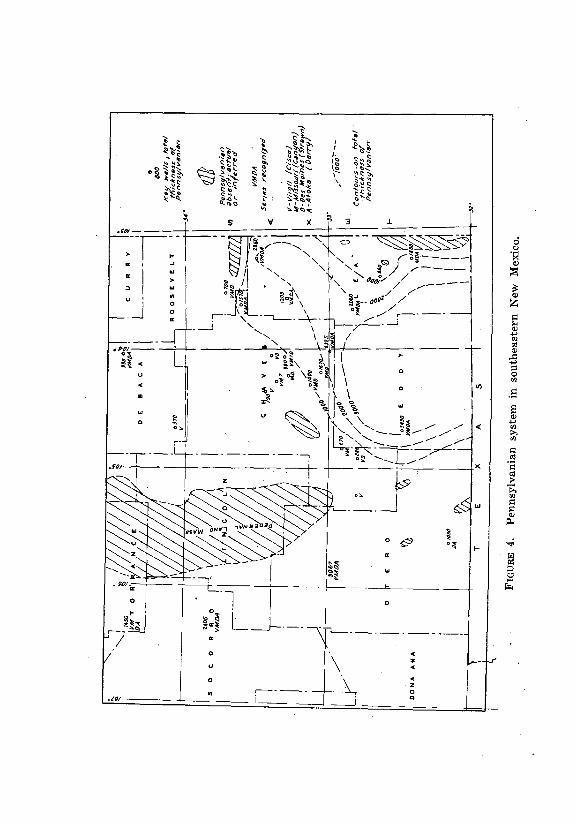
PENNSYLVANIAN SYSTEM 37
system. Thompson measured 3065 feet of Pennsylvanian rocks in the northern
Sacramento Mountains. By contrast the total of the composite section in the
Los Piños Mountains is approidmately 1450 feet, although all four series of the
Pennsylvanian above the Morrow are represented.
A regional map, fig. 4, shows variations in thickness of the Pennsylvanian
section in wells in southeastern New Mexico and in some surface sections with
suggested isopachs for the system in parts of the area.
VIRGIL SERIES
In the northern Sacramento Mountains, the Virgil series is represented by
the Fresnal and Keller groups. The Fresnal group in its type locality in Fresnal
Canyon (K, pl. 4) is 530 feet thick and consists of conglomerate, arkosic
sandstone, gray and black shale with numerous beds of fossiliferous limestone.
The upper part of the group is among the youngest portions of the Pennsylvanian
known in North America (Thompson, 1942, p. 74) .
The underlying Keller group, 350 feet or more thick, is predominantly
limestone with a few thin beds of conglomerate and gray shale in the upper
part. In its type locality in the Oscura Mountains this group is 132 feet thick
and is predominantly limestone with a few thin beds of sandstone in the lower
part (Thompson, 1942, p. 71) .
The entire Virgil series as measured by Stark and Dapples (1946,.p. 1169)
in the southern end of the Los Piños Mountains consists of 125 feet of
limestone. This is apparently the lower part of the Keller group, the Fresnal
group being absent. Probably only the uppermost 75 feet of the Madera arkosic
limestone measured by Bates et al. in Abo Canyon belongs in the Virgil series.
East and southeast of the Pedernal Mountains the Virgil is one of the most
widespread if not the most widespread division of the Pennsylvanian. Thompson
(1942, pl. 1) reports Virgil rocks resting on pre-Cambrian in Transcontinental's
McWhorter well in western De Baca County (pl. 5) , and the writer tentatively
places 370 feet of limestone with interbedded red shale and sandstone from 4010
to 4380 in that well in the Virgil. In Texas Company's Wilson No. 1 (Dunken Dome)
well (pl. 7) , in southwestern Chaves County, rocks of Virgil age probably extend
from 4155 to 4690 feet in depth, but fusulinids were found only in the upper 100
feet. The rocks are mostly sandstone and black and red shale with only a few beds
of limestone. They rest on a black shale which is now believed to be of
Mississippian age. In De Kalb's Lewis well east of Roswell in Chaves County (pl. 5)
only 190 feet of rocks of Virgil age are present from 5310 to 5500 feet and consist
of red and gray shale with beds of sandstone and limestone resting on the pre-
Cambrian.
Farther east the Virgil rocks are predominantly limestone with some
interbedded shale and sandstone. In Magnolia's Burro

38 STRATIGRAPHY
Hills test in southern Eddy County (L, pl. 4) , 800 feet of beds from
5750 to 6550 feet are classed as Virgil on the basis of fusuliriids.
Probably both the Fresnal and Keller groups are represented, but no
attempt is made to differentiate them. A similar section but with a
smaller percentage of elastic material is found from 7610 to 8410 feet
in depth in Richfield et al.'s well in southern Chaves County.
Rocks of Virgil age are notably absent in Texas & Pacific's State
No. 39-A, Acct. 2, in sec. 9, T. 22 S., R. 36 E., in eastern Lea County
where beds of Wolfcamp age rest on lowermost Missouri rocks. This
well is on the western flank of the Eunice uplift, and the rocks of
Virgil age were probably eroded after the pre -Permian uplift. The
Virgil, like the remainder of the Pennsylvanian, is absent, probably
because of pre-Permian erosion, over the greater part of the Eunice
uplift and over large areas on the Central Basin Platform.
MISSOURI SERIES
In the northern Sacramento Mountains, 900 feet or more of beds
represent the Missouri series (K, pl. 4) . The lower 90 feet is
conglomerate overlain by sandstone. This lower elastic section is
overlain by 110 feet of limestone with prominent cliff forming
members at the top and near the base. Next above is 320 feet of
sandstone and dark colored shale with a few thin beds of limestone.
The upper 380 feet of the section is predominantly limestone with
much dark shale especially in the middle part.
The Missouri section measured by Stark and Dapples in the
southern part of the Los Piños Mountains (J, pl. 4) is 343 feet thick
and consists of alternating beds of limestone, sandstone, and shale
with 55 feet of limestone at the top. A 22-foot bed of arkose was
found near the middle of the section. The Missouri series is
represented by the lower part of the arkosic limestone member of the
Madera formation as measured by Bates et al . in Abo Canyon.
The thickest reported section of Missouri rocks in southeastern
New Mexico is in Magnolia's Burro Hills test (L, pl. 4) where 1200 feet of
beds from 6550 to 7750 feet in depth are identified as belonging in this
series on the basis of fusulinids. The section is predominantly limestone
especially the lower 450 feet. The upper 750 feet contains numerous
beds of dark gray to black shale and several beds of sandstone. One bed
of sandstone, fifty feet or more thick, was found near the middle of the
series. In Richfield et al.'s Mullis well (M, pl. 4) the Missouri section is
much thinner and extends from 8410 to 9130 feet with a thickness of
720 feet. Here the section is almost entirely limestone with only thin
beds of gray shale.
Northwestward from the Mullis well in Chaves County the
Missouri section thins more or less abruptly, and is not readily
differentiated from the underlying Des Moines limestones.
PENNSYLVANIAN SYSTEM 39
Limestone beds of Missouri age are present over at least parts of
De Baca County. Thompson reports their presence in Matador's
Woods test in extreme northwestern De Baca County, but Missouri
fusulinids have not been recognized in wells farther east.
Intervals tentatively assigned to the Missouri series are shown on outline
sections, pls. 5 to 9.
DES MOINES SERIES
A section 755 feet or more thick in the northern Sacramento
Mountains is included by Thompson in the Des Moines series. The top
is at the base of a conglomerate which marks the base of the Missouri
series, and the base is in or at the top of a concealed section 145 feet
thick. The lower 200 feet is predominantly limestone, and the upper
550 feet predominantly sandstone but with about 60 feet of limestone
near the middle. Some of the sandstone beds are coarse grained to
conglomeratic.
By contrast the Des Moines section measured by Stark and
Dapples in Abo Pass railroad cut is 480 feet thick and is nearly all
limestone with the exception of 40 feet of dark shale in the upper
part. It includes all except the lower 130 feet of the marine limestone
member of the Madera formation.
The sections of the Des Moines found in wells in southeastern New
Mexico are predominantly limestone. In the Burro Hills test the interval
from 7750 to 8500 feet is provisionally identified as Des Moines, but
both the top and base are picked on indefinite lithologic data. The
section is similar to the overlying Missouri except for the presence of
considerable chert in some beds. In Richfield et al.'s Mullis well the
section is thinner (9130 to 9600 feet) and contains smaller percentages
of shale and chert.
Except for local areas east of the Pedernal Mountains where Virgil
beds rest on pre-Cambrian, the Des Moines is probably more
widespread than the Virgil. Fusulinids characteristic of the series have
been found in numerous wells as far north as northern Guadalupe
County. Correlations for a number of wells are shown on outline
sections, pls. 5 to 9.
Like other divisions of the Pennsylvanian the Des Moines is
absent over the Eunice uplift and many ,other parts of the Central
Basin Platform. In the Skaggs area in T. 20 S., R. 37 E., Lea County,
the Des Moines is the only division of the Pennsylvanian that is
present. In Continental's Skaggs No. 5-B-23 shown in outline on pl. 6
the base of the Abo formation is tentatively placed at 7670 feet, and
beds of Des Moines age extend to the top of Devonian dolomite at
8150 feet. The section is predominantly limestone with considerable
amounts of chert near the middle, and with interbedded dolomite in
the upper part. There is obviously an angular unconformity both
above and below the Des Moines section in this area.

40 STRATIGRAPHY
The pay section of the Cass pool is a porous dolomite in the upper part of
the Des Moines section.
ATOKA SERIES
The Atoka or Derry series in the area west of the Pedernal
Mountains and its southern extension is composed predominantly of
elastic sediments. At Turrett Mesa in southern Los Pifios Mountains
it is 498 feet thick (J, p1. 4) and is predominantly sandstone and
conglomerate with a few beds of limestone and dark gray to black
shale. Farther north in Tongue Ridge it is about 275 feet thick. This
series includes the upper Sandia formation and about 130 feet of
the marine limestone member of the Madera formation as measured
by Bates and others in Abo Canyon. In this area the rocks of the
Atoka series rest on the pre-Cambrian.
In the northern Sacramento Mountains Thompson measured a
possible 437 feet of beds of Atoka age consisting predominantly of
sandstone and shale with a few thin beds of limestone. However, the
lower 112 feet of this section might be of Morrow age and the upper
145 feet is concealed so that no definite top of the series could be
determined.
In Magnolia's Burro Hills test in southern Eddy County a possible
740 feet of beds from 8500 to 9240 feet may be Atoka in age, but here
again 150 feet of limestone at the base of the section might belong in
the Morrow. Fusulinids were found only in the upper part of the
section. Possible base of the Atoka is placed at 9110 feet at the base
of a prominent sandstone.
In Richfield et al.'s Mullis well in southern Chaves County (M, p1.
4) , 340 feet of beds from 9600 to 9940 feet are tentatively assigned to
the Atoka series. The section consists of limestone with interbedded
gray to black shale and a few thin beds of sandstone. Fusulinids were
found near the middle of the section only, and the limits selected are
very arbitrary.
No Atoka beds were found in wells farther northwest in Chaves
County, but they are apparently continuous throughout a deep basin
extending from southern Eddy County across eastern Chaves County
and northern and western Lea County extending as far north as
Barnsdall's State No. 1-A well in extreme eastern • Chaves County
where the section from 10,380 to 10,710 feet is provisionally correlated
as Atoka. This section consists of interbedded dark to black shale,
sandstone, and limestone with a much higher percentage of elastics
than in wells farther south.
MISSISSIPPIAN SYSTEM
GENERAL FEATURES
Laudon and Bowsher (1941, 1949) have studied the surface
exposures of Mississippian rocks in southern New Mexico and their
faunas in considerable detail. Data on subsurface features

MISSISSIPPIAN SYSTEM 41
are obtained from detailed sample descriptions supplemented by analyses from
the Paleontological Laboratory in Midland, Texas.
The type area of Mississippian rocks is in the Mississippi Valley where
four series are generally recognized which, from top to bottom, are named
Chester, Meramec, Osage, and Kinderhook. Laudon and Bowsher have found
representatives of all four series in the Sacramento and San Andres mountains
of southern New Mexico, but in the Hueco and Franklin Mountains of Texas,
Chester and Meramec rocks only are present. Classification of the named units
of the system in the Sacramento and Hueco Mountains are shown in table 3.
Mississippian rocks are recognized over wide areas in the subsurface in
southeastern New Mexico and western Texas. They are generally present in
Eddy County, southeastern Chaves County and in Lea County except in the
Eunice area and other structurally high parts of the Central Basin Platform.
They are absent over the western extension of the Matador uplift in southern
Roosevelt County but present in Magnolia's A. K. Smith test

42 STRATIGRAPHY
in the southwestern part of the county. They are generally absent in
wells drilled in De Baca and Guadalupe counties.
In most of the subsurface sections the Mississippian is rep -
resented by a limestone section overlain by dark shale. The lime -
stone section in most wells is correlated with the Rancheria
formation of Meramec age and the shale section with the Helms
formation as restricted by Laudon and Bowsher.
CHESTER SERIES
Helms formation.—The Helms formation of the Hueco Mountains
was first described by Beede (1918) , who included in it rocks of
Mississippian and Devonian age. Laudon and Bowsher have restricted
the Helms to the upper shaly part which contained the original
Chester fauna collected by Beede. The Helms as thus restricted
"overlies the Rancheria unconformably. The lower beds consist of
green, thin-bedded, 'chippy' shales with very thin, 'waferlike' brown
sand lenses. The middle part consists of gray to brown, sandy shales
with several brown slabby limestone beds. The limestone beds and
associated marls carry excellent faunas. The upper beds consist
mainly of brown, cherty, crinoidal limestones interbedded with gray
marls. The fauna contains typical Chester forms" (Laudon and
Bowsher, 1949, p. 34) .
A shale section overlying the "Mississippian limestone" in a
number of wells in southeastern New Mexico is tentatively identified
as the Helms formation. It is best developed in southern Lea County.
In Amerada's Record No. 2 test it is 265 feet thick extending from
12,260 to 12,525 feet (pl. 6) . This section is dark gray to black shale
with some thin beds of limestone. Farther west and north the -
formation is thinner and may be entirely absent in Chaves County,
northern Lea County, and counties farther north. In some wells a
dark shale with interbedded limestone is found between the top of the
Rancheria limestone and overlying beds carrying Atoka fusulinids and
there is a question whether these beds are Helms or Atoka. Such a
section is found in Richfield et al.'s Mullis well in southern Chaves
County from 9,940 to 10,050 feet (pls. 4 and 6) .
In Amerada's Hamilton No. 1 well in sec. 35, T. 16 S., R. 38 E.
(pl. 8) , the total Mississippian section is 1540 feet thick from 10,840
to 12,380 feet in depth. It is predominantly limestone with a
considerable amount of chert in two zones in the middle portion and
with some interbedded gray shale. The upper part of the section has
been identified as Chester in age and may be correlative with the
Helms formation.
The subsurface shale section, here designated as Helms, is also
called Barnett by many subsurface workers. Cloud and Barnes (1948,
pp. 52-59) , however, have shown that the Barnett is not younger
than Meramec in age and therefore not correlative with the Helms.
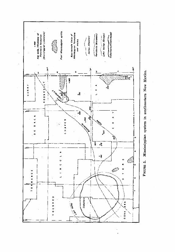
44 STRATIGRAPHY
The approximate northern limit of the Helms formation is shown on fig.
5.
MERAMEC SERIES
Rancheria formation.—The Rancheria formation, named by Laudon and
Bowsher for Rancheria Peak in the Huth) Mountains, has its maximum surface
development in the southern Sacramento Mountains where it reaches a thickness
of over 275 feet. It is described as a "monotonous evenly-bedded sequence of dove-
gray to brownish-gray slightly calcareous siltstone carrying considerable amounts
of brown, crinkly, secondary chert ( ?) rhythmically bedded with thin shale
partings. The beds are rarely more than a foot thick" (Laudon and Bowsher, 1949,
p. 31) .
The formation thins to the north probably by progressive overlap but
extends as far north as Mule Canyon in T. 17 S., R. 10 E. In canyons farther
south the formation thickens markedly to the east.1°
In the Hueco Mountains the Rancheria formation "consists of monotonously
thin-bedded, gray, silty limestones interstratified with thin gray shale. The beds
average 7 inches in thickness and are rarely over 18 inches thick. The shale
partings are generally under half an inch thick. The entire section is filled with
elongate, slender, 'crinkly,' and nodular chert masses that ordinarily make up as
much as 50 per cent of the rocks. Weathering of these cherts produces rich brown,
angular rock chips causing the outcrop to resemble a woodyard, hence the name
'Woodyard cherts' (Beede, 1920). The Rancheria is slightly over 215 feet thick at
Rancheria Peak. Fossils are rare but occur occasionally in the basal beds. A few
occur sporadically throughout the section. Leiorhynchus carbonif erum, Spirit er
arkansanus and Dictyoclostus inflatus var. coloradoensis are most common"
(Laudon and Bowsher, 1949, p. 34) .
The Las Cruces formation of Meramec age unconformably underlying the
Rancheria in the Franklin Mountains is not present in the Sacramento or
Hueco mountains and is not recognized in wells farther east.
The limestone of the subsurface, herein called the Rancheria, varies in
thickness up to 850 feet and is commonly siliceous and cherty. The color varies
from light gray to light brown, and the texture from crypto-crystalline to
paurograined. Some beds of limestone are shaly, and beds of gray shale and chert
are found interbedded with the limestone.
The Paleontological Laboratory (Midland) has identified Leiorhynchus carbonif
erum, a characteristic Meramec fossil, in a core from 13,090 to 13,100 feet from
Amerada's Record No. 2 well in sec. 25, T. 19 S., R. 35 E. in Lea County and has
also found Leiorhynchus in a core from 11,182 to 11,190 in Barnsdall's State No. 1-
A in extreme eastern Chaves County. On the basis of these
10 Lloyd C. Pray, personal communication.
MISSISSIPPIAN SYSTEM 45
identifications and the general character of the rocks, the Mississippian
limestone section is correlated with the Rancheria formation.
Lithologically it is more like the Rancheria in the Hueco Mountains than
that in the Sacramento Mountains where it is predominantly siltstone.
The lower part of the thick limestone section in Amerada's Hamilton No. 1
well in eastern Lea County is correlated with the Rancheria formation and the
upper part with the Helms.
OSAGE SERIES
Lake Valley formation.—The Lake Valley formation has its maximum
development in the northern part of the Sacramento Mountains in the
area immediately south of where the rocks plunge below the valley floor.
The maximum thickness is about 275 feet. The formation has been
studied in detail by Laudon and Bowsher (1941, 1949) who recognized
and described six distinctive members.
The remarkable bioherms developed in the Lake Valley formation
have their bases in the Alamogordo member and extend upward through
the overlying Nunn and Tierra Blanca members and locally through the
Arcente member. The crinoidal coquina beds of the Nunn and Tierra
Blanca members grade laterally into the massive limestones of the
bioherms.
All members of the Lake Valley formation thin to the south either by
progressive overlap or because of unconformities at the base and top of
the formation. The formation is not present in the Hueco Mountains and
has not been recognized in any wells drilled east of the mountains. The
approximate distribution of the Lake Valley formation as shown on fig. 5
is modified from Laudon and Bowsher (1949, fig. 6, p. 14) .
The Kelly formation of Osage age, overlying the Lake Valley in west
central New Mexico, is not present in the Sacramento Mountains.
KINDERHOOK SERIES
Caballero formation.—The Kinderhook series is represented in the
Sacramento Mountains by the Caballero formation which has a maximum
thickness of less than 50 feet and is composed of shale and nodular
limestone. The formation thins to the south and east and is absent in the
Hueco Mountains and in subsurface sections farther east.
In eastern Chaves County and southwestern Roosevelt County a section
of grayish-green shale and silt, sandy at the base, is found underlying the
Rancheria limestone. In Barnsdall's State No. 1-A in Chaves County these
beds extend from 11,290 to 11,475 feet in depth, and in Magnolia's A. K.
Smith well, ten miles northeast in Roosevelt County, the interval is from
9320 to 9510. According to Hollingsworth 11 these beds are lithologically
Kinder-
11R. V. Hollingsworth, personal communication .

46 STRATIGRAPHY
hook-like. These beds are tentatively correlated with the Caballero,
but this correlation is very questionable (fig. 5) .
DEVONIAN SYSTEM
GENERAL FEATURES
The most detailed studies of the Devonian rocks in the mountain
areas of southern New Mexico have been made by Frank V. Stevenson
whose work was summarized in a paper published in 1945. The
exposures in New Mexico are limited to five mountain ranges, the
Sacramento, San Andres, Caballos, Mud Springs, and Mimbres
mountains. All the formations present are predominantly shale and
siltstone with thin beds of limestone in some of the formations. The
overall thickness is in excess of 350 feet in the Mimbres region,
approximately 150 feet in the San Andres Mountains and 100 feet in
the Sacramento Mountains.
Stevenson's classification of the Devonian beds is summarized in table 4.
The Canutillo formation (Nelson, 1940,-p. 164) of the Franklin
Mountains is in part, at least, Middle Devonian. The upper black shale
member may be correlative with the Ready Pay member of the Percha.
The Woodford formation has been identified in a number of wells
and is herein classed as Upper Devonian in age and correlated with
the Ready Pay member of the Percha.
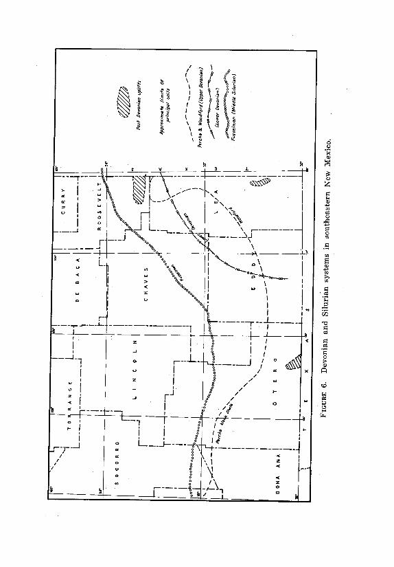
48 STRATIGRAPHY
A limestone and dolomite section found in numerous wells is
believed to be Lower Devonian in age. It is not present in surface
sections but might be correlative with the lower cherty member of the
Canutillo formation.
UPPER DEVONIAN
Woodford formation.—A shale section commonly correlated with
the Woodford chert of Oklahoma is found over a wide area in west
Texas and southeastern New Mexico. It is described as "Brownish-
black flaky shale with thin beds of finely crystalline, argillaceous
dolomite and brownish-black chert. It contains conodonts and
resinous spores" (Barton et al., 1946) .
On the Central Basin Platform the Woodford attains a maximum
thickness of approximately 600 feet and is best developed in Winkler
County, Texas, and Lea County, New Mexico . In El Paso Natural Gas
Company's Ginsberg well in sec. 7, T. 25 S., R. 38 E., Lea County, the
thickness is 500 feet from 8910 to 9410 feet in depth. The spores,
Tasmanites huronensis are numerous especially in the upper part. A
similar thickness of Woodford was found in the Dublin area in sec.
12, T. 26 S., R. 37 E. In Amerada's Record No. 2 in sec. 25, T. 19 S.,
R. 35 E. the Woodford is 155 feet thick from 13,220 to 13,375 feet
(pl. 6).
In the Eunice area of southern Lea County the Woodford is
absent but was probably deposited over the entire area and removed
by pre-Permian or pre-Pennsylvanian erosion. North of the Eunice
area two wells have found a Woodford section much thinner than that
in the southern part of the county. In Phillips' Shipp No. 1 in sec. 20,
T. 18 S., R. 37 E. the shale is 105 feet thick from 10,250 to 10,355
feet (fig. 5) , and in Amerada's Hamilton No. 1 in sec. 35, T. 16 S., R.
38 E. it is only 66 feet thick from 12,380 to 12,446 feet (fig. 8) . The
Woodford was .not recognized in the discovery well in the Crossroads
area, but a black spore bearing shale was found in Skelly's U. D.
Sawyer No. 1 well at 12,574 feet. In all wells where present in Lea
County and on the Central Basin Platform in Texas, the Woodford
rests on dolomite or siliceous limestone which is believed to be Lower
Devonian in age.
No Woodford shale has been found in wells in Chaves County
(except possibly in the southwest part) , Eddy County, or in counties
farther north, and the general thinning of the section from south to
north indicates that it was not deposited north of Lea County and
possibly not north of southernmost Eddy County. The probable limits
of the Woodford is shown on fig. 6.
The Woodford is regarded by many geologists as lowermost
Mississippian (lower Kinderhook) in age, but Ellison (1946) has
presented strong evidence based on conodont and fossil wood studies
that it is Upper Devonian.
Percha shale.—The Percha shale is exposed in surface sections
in the Mimbres Mountains where, according to Stevenson

DEVONIAN SYSTEM 49
(1945) , it reaches a thickness of over 400 feet and is divided into two
members. The upper member, which Stevenson named the Box
member, is a gray to green calcareous shale with lenses and nodules of
limestone. It is known only in the Mimbres region where it is highly
fossiliferous. The lower, Ready Pay member is a black fissile non-
fossiliferous shale which reaches a maximum thickness of 383 feet in
the Mimbres Mountains. Similar black shales are widespread in
southern New Mexico but are much thinner. In the Sacramento
Mountains they are only a few feet thick and are overlain by the lower
Mississippian Caballero formation and underlain by the Sly Gap
formation of the Upper Devonian.
Stainbrook (1947) has studied the fauna of the upper Percha
shale and concludes that it is lowermost Mississippian in age. "The
Percha fauna is more closely related to that of the overlying
Mississippian than to the underlying Devonian and the Mississippian
system in New Mexico seems to begin with a body of black shale, the
Silver member (Stevenson's Ready Pay member) , similar to the basal
black shale of the Mississippian system in many other parts of North
America" (1947, p. 302) .
The fauna studied by Stainbrook is from the Box member of the
Percha, and no faunal evidence is available regarding the underlying
black shale or Ready Pay member. This member is similar in
character to the Woodford and apparently occupies the same
stratigraphic position.
Some black shale found in wells in Otero County are probably
the Ready Pay member of the Percha. They are also recognized as
the upper member of the Canutillo formation.
Contadero and Sly Gap formations.—Stevenson named and
described the Contadero and Sly Gap formations from surface sections
in the San Andres Mountains. Both formations consist of shales with
interbedded limestones. The Sly Gap is fossiliferous, and the fauna is
Upper Devonian. In the southern part of the San Andres Mountains
and in the Sacramento Mountains it underlies the Ready Pay member
of the Percha. In the central part of the San Andres Mountains the
unfossiliferous Contadero formation lies between the Sly Gap and the
Ready Pay and may be a local correlative of one of these units. Neither
the Sly Gap nor Contadero is recognized in wells east of the
mountains.
MIDDLE DEVONIAN
Oñate formation.—The Oñate formation was described by
Stevenson (1945) from surface sections in the San Andres Mountains.
It is predominantly shale with interbedded siltstone, sandstone and
limestone. A meagre fauna suggests an uppermost Middle Devonian
age or possibly lowermost Upper Devonian: The formation is limited to
the San Andres and Sacramento mountains and has not been
recognized in the subsurface.
50 STRATIGRAPHY
Canutillo formation.—The Canutillo formation of the Franklin
Mountains as described by Nelson (1940, p. 164) has a basal section
of light brown cherty limestone and an upper unit 40 feet thick of
black fissile shale. Fossiliferous gray limestone with a Middle
Devonian fauna and a thin bed of dense almost black sandstone lie
between the upper and lower units. Laudon and Bowsher (1949, p.
36) by inference limit the Canutillo formation to the middle
fossiliferous part of Nelson's Canutillo and correlate it with the Ofiate
formation of the San Andres Mountains on the basis of lithology and
fossil content. They suggest that the upper black shale may be
correlative with the Percha.
A similar section was found in the Hueco Mountains except that
the upper "Percha" shale is absent. The basal beds are about 100 feet
thick and thin bedded and nodular chert commonly makes up as
much as 90 percent of the unit. Overlying the chert beds are beds of
soft, gray silty shale and silty limestone which appear to be correlative
with the fossiliferous part of the Canutillo (Laudon and Bowsher,
1949, p. 34) . The Canutillo is in turn overlain unconformably by the
Rancheria formation.
A l ittle farther east in California Oil Company's Thiessen well
in Sec. 19, Blk. E, University Survey, Hudspeth County, Texas, a
black pyritic shale underlies the Rancheria l imestone from 2100
to 2165 feet in depth and contains the plant spores,Tasmanites
huronensis which occur abundantly in the Woodford.
On the basis o f l i thology and the presence o f the spores this
shale should be corre lated with the Woodford and Percha rather
than the Canutil lo. However, i t rests direct ly on a very cherty
l imestone which seems to be the same as the Canutil lo chert in
the Hueco outcrops. The obvious inference is that the middle
part of the Canutil lo d isappears a short distance east of the
Hueco outcrops.
A similar black shale overlying chert is present from 2030 to
2075 feet in Fred Turner's Everett well in sec. 34, T. 22 S., R. 13 E.,
Otero County. Here, however, the black shale is overlain by a red
shale which may represent either the Powwow conglomerate or the
basal Abo.
Black shale, but without the underlying chert, was found in
Turner's Evans well in sec. 22, T. 24 S., R. 12 E. from 1890 to 1970
feet and also in Union Oil Company's McMillan well in sec. 9, T. 25
S., R. 13 E., from 3485 to 3540 feet. In both these wells the black
shale rests on dolomite which is correlated as Fusselman.
In the Texas Company's Wilson well (Dunken Dome) in
southwestern Chaves County in sec. 29, T. 17 S., R. 18 E. (pl. 7) , a
black shale from 4830 to 4870 feet in depth rests on a dolomite which
is now identified as Fusselman on the basis of insoluble residues. This
may be approaching the eastern limit of black shale deposition in the
"Percha" basin. As previously noted, the characteristic black shale has
not been found in wells farther east
DEVONIAN SYSTEM 51
in Chaves or Eddy counties but reappears in southern Lea County as the
Woodford shale.
The cherty lower Canutillo section might be Lower Devonian correlative
with the Lower Devonian dolomites of southern Lea County. There is no fossil
evidence as to its age.
LOWER DEVONIAN
A group of rocks, predominantly dolomites of Devonian and
Silurian age, is present over a large part of southeastern New Mexico
and west Texas. The Devonian part of this section is known from
subsurface data only. In 1945 and 1946 a study group of the West
Texas Geological Society (Barton et al., 1946) recommended that the
name Hunton group be used for the Devonian and Silurian dolomites,
limestones and associated rocks of the Central Basin Platform, but that
name is not in common use.
Numerous fossils found in a well in central Andrews County, Texas, were
studied by Stainbrook who reported that they most closely resembled the fauna
of the Helderberg group of Lower Devonian age (Jones, 1944) . Stromatoporoids
of early Devonian age are most common and have also been found in other
wells.
The study group divided the Hunton section into several units of
which the lower two are Silurian. The upper units believed to be Devonian
in age are variable in thickness and difficult to identify in Lea County.
Zones of chert or very cherty limestone and porous dolomite in the
Devonian are oil and gas reservoirs in several fields On the Central Basin
Platform in west Texas.
Limestones and dolomites of lower Devonian age are present over all
of southern Lea County except where they have been removed by pre-
Permian erosion. In general, the limestone is predominant in the southern
part of the county and dolomite farther north. Some chert and cherty
limestone beds are present, but the writer has not undertaken a
correlation between different cherty units, nor has he segregated the
Devonian from the underlying Silurian. Some suggested correlations are
shown in outline cross sections, pls. 5 to 9.
The oil pay in the Knowles pool is believed to be in the Devonian.
This pool was discovered in Amerada's Hamilton No. 1 Well in sec. 35, T.
16 S., R. 38 E. (pl. 8) and lies seven miles southwest of the Jones Ranch
pool in northwestern Gaines County, Texas, where the production is also
from the Devonian.
Reported Devonian rocks in northern Lea County are _questionable.
Production from the Crossroads pool in T. 9 S., R. 36 E. was reported as
Devonian (Henderson and Barr, 1949) , but in the writer's opinion it is
more probably Silurian, possibly Fusselman. The pay in the Crossroads
pool is probably the same as in the Bagley area 25 miles to the southwest
in T. 12 S., R. 33 E.
The Lower Devonian dolomite section thins and disappears to the west. In
Richfield et al.'s Mullis test in southeastern Chaves

52 STRATIGRAPHY
County (pl. 7) 135 feet of chert from 10,890 to 11,025 feet is believed to be Devonian. This may be the equivalent of the much thicker dolomite section in
southern Lea County. It may also be the same as the cherty section in the lower Canutillo in the Hueco Mountains. This chert section was not found in wells farther north or west in Chaves or Eddy counties. If it was continuous with the cherty section in the Hueco Mountains, it was probably removed by erosion over
wide areas prior to the deposition of the Mississippian. Probable limits of the Lower Devonian rocks are shown on fig. 6.
SILURIAN SYSTEM
The Fusselman limestone reaches its maximum thickness of about 1000 feet in its type locality in the Franklin Mountains, where it is "mostly a massive magnesian limestone" (Darton, 1917, p. 43). In the San Andres Mountains the
thickness ranges from 105 to 130 feet the maximum thickness being in Alamo Canyon. Here the formation consists of two members, an upper 50-foot member consisting of hard dark limestone carrying a distinctive fauna and a lower 85-foot member of compact, fine-grained gray limestone that weathers nearly white.
Darton found no fossils in the lower member and included it in the Fusselman arbitrarily (Darton, 1917, p. 43 and 1928, p. 201). The Fusselman is determined as Niagaran (Middle Silurian) in age on the basis of its fossil content. The most common characteristic form is a Pentamerus, but many corals occur at some
places.
A section of the Fusselman measured by a study group of the West Texas Geological Society in the Hueco Mountains is 630 feet thick and is predominantly
dolomite in the lower part and limestone in the upper part. The dolomite beds are commonly thick and in many places reef-like. The texture ranges from finely crystalline to very coarsely crystalline. Colors are white, gray, and pink. Chert is present in many beds.
The upper part of the section is not fossiliferous in the Hueco Mountains, and there is some question as to whether it should be included in the Fusselman. Laudon and Bowsher (1949) report 30 feet of massive, coarsely crystalline, pink to gray limestone with large calcareous algae overlying the
Fusselman in the Rancheria Peak area and lithologically quite unlike the underlying Fusselman. The reported similarity to the Chimney Hill formation of the Arbuckle Mountains is probably not significant because the latter is Lower Silurian in age.
The Silurian of the subsurface in southeastern New Mexico and west Texas is divided into two distinct units. The lower unit is the Fusselman, and is remarkably uniform over wide areas with much the same character as in the Hueco'Mountains. A section 650 feet thick from 9670 to 10,320 feet in Magnolia's.
Burro Hills test in southern Eddy County is tentatively correlated with the Fusselman. It is a continuous dolomite section with a bed of
SILURIAN SYSTEM 53
chert at the top and a thin bed of chert in the lower part. It is overlain by the Rancheria limestone unconformably. The upper part may be
younger than Fusselman and might even be Devonian. Contact with the underlying Montoya is picked at the top of a chert bed at 10,320 feet, but this contact is arbitrary inasmuch as the underlying section is very similar in character to that above.
Farther east the Fusselman is much thinner, 250 to 300 feet. Over most of southern Lea County its top is picked at the top of a persistent cherty zone. In Winkler County, Texas, the Fusselman is "predominantly medium to coarsely
crystalline limestone" Barton et al., 1946) .
In the southern part of the Central Basin Platform in Texas the
upper unit of the Silurian consists of approximately 220 feet of "green, gray, and red silty shale with shaly, finely crystalline limestone" (Barton et al., 1946) . A dense limestone is present at the base of this unit which
is intermediate in lithology between the shale and the underlying Fusselman. This limestone facies becomes more prominent to the north and in southern Lea County the unit is mostly limestone with only traces of the characteristic gray and green shale. Still farther north the unit is
predominantly dolomite.
In Ward County, Texas, graptolites from a core in the shale section have been identified as of Lockport, lower Niagaran age. Present evidence, therefore, indicates that the Fusselman and the overlying unnamed shale unit are both
Middle Silurian.
In Amerada's State No. 1 BTA (pl. 7) , the discovery well of the Bagley area, the base of the Mississippian limestone section and top of a dolomite was reached at 10,785 feet. The top of the Montoya formation was picked 560 feet lower at 11,345 feet. This dolomite
section is tentatively identified as Fusselman by the writer, but it may be that the upper part belongs in the upper unit of the Silurian or even in the Devonian. Similarly the pay in the Crossroads pool is tentatively called Fusselman. Top of the Fusselman ( ?) in the
discovery well was reached at 12,115 feet. Oil is produced from a porous dolomite identified as Silurian in the
McCormack pool on the west flank of the Eunice uplift. The formation is probably Fusselman.
In surface sections in the San Andres Mountains the Fusselman thins and disappears a short distance north of the latitude of Alamogordo and is not found in any mountain areas farther north. In Chaves County it extends as far north as Richfield's White No. 3-1 in sec. 6, T. 12 S., R.
29 E. (p1. 5) where it consists of 420 feet of very cherty dolomite from 8340 to 8760 feet. Here it is overlain unconformably by Mississippian (Rancheria) limestone and shale and lies unconformably on the Ellenburger. In wells farther north in Chaves County it was probably
present but removed by pre-Pennsylvanian erosion. It is absent in Guadalupe

54 STRATIGRAPHY
and De Baca counties where, in all tests so far drilled, Pennsylvanian or
Permian rocks rest directly on the pre-Cambrian. The probable northern
limits of the Fusselman formation are shown on fig. 6.
ORDOVICIAN SYSTEM
UPPER ORDOVICIAN
Montoya formation —Surface exposures of the Montoya limestone
have received little detailed study since the classic work of N. H. Darton
(1917, 1928) , and the following notes are taken from his publications.
The formation underlies most of southern New Mexico except where
removed by erosion. It ranges from 200 to 300 feet in thickness and in
most areas consists of two members, a lower dark-colored massive
limestone, locally sandy, and an upper member of slabby beds with many
thin layers of chert. The formation is a prominent feature in most of the
mountain ranges. It extends as far north as the southern end of the
Oscura Mountains but thins and disappears within a short distance to
the north.
In the Sacramento Mountains the lower member crops out as a
high cliff and is from 75 to 120 feet thick. In Alamo Canyon its base is a
gray sandstone. The upper member is 60 feet thick and consists largely
of alternating thin beds of chert and limestone.
The Montoya formation contains numerous fossils which serve to
determine its age as Richmond, Upper Ordovician. In all outcrop sections
in New Mexico and in the Franklin and Hueco mountains of west Texas,
the Montoya overlies the Lower Ordovician El Paso limestone
unconformably with the Middle Ordovician missing. Farther north in the
San Andres Mountains the Fusselman thins and disappears and the
Montoya is overlain by the Middle Devonian Oñate formation and in the
northern end of the range by the Upper Devonian Sly Gap formation. In'
the southern end of the Oscura Mountains the Montoya is overlain. by
Pennsylvanian rocks.
The Montoya of southern Lea County is similar to that of the surface
sections in the mountains to the west. It reaches a maximum thickness of
400 feet in the Dublin area in T. 26 S., R. 37 E. and decreases in thickness
to the north. The thinnest section so far found in southern Lea County is in
Continental Oil Company's Warren No. 1-B-29, in sec. 29, T. 20 S., R. 38 E.
where it is 215 feet thick from 8450 to 8665 feet. In southeastern Chaves
County the formation is much thinner. In Richfield's Trigg well in sec. 35,
T. 14 S., R. 27 E. it is 130 feet thick from 9440 to 9570 feet. Farther north
and west the formation is absent and the Fusselman or younger beds rest
directly on the Ellenburger.
In the Bagley area of northern Lea County (Amerada's State No. 1-BTA)
the Montoya is 240 feet thick from 11,345 to 11,605
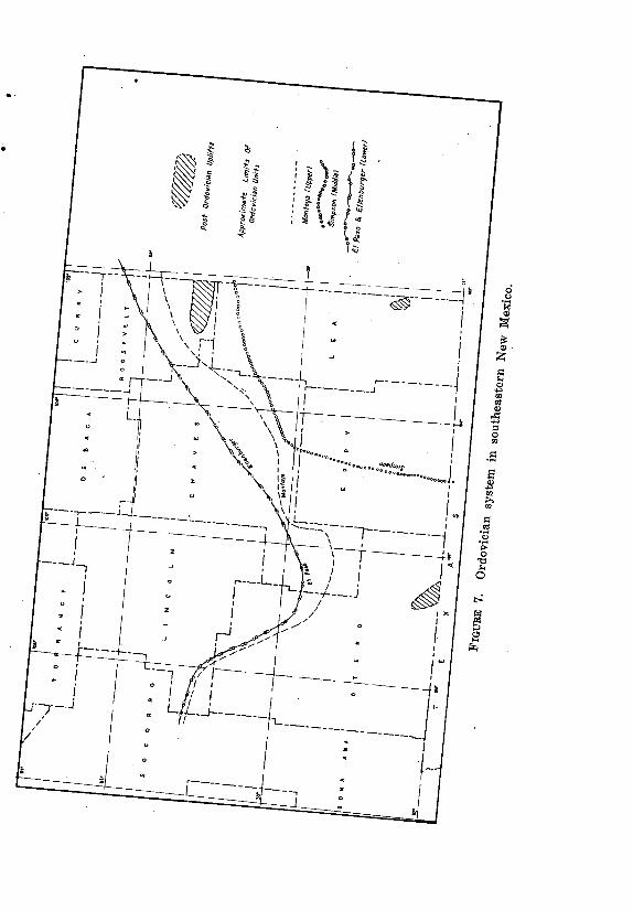
56 STRATIGRAPHY
feet in depth. It is present at least as far north as Magnolia's A. K. Smith well in
southwestern Roosevelt County.
The probable northern limit of the Montoya is indicated on fig. 7, and
its vertical limits in a number of wells are shown on outline cross sections,
pis. 5 to 9. For some of the wells the limits of the formation have been
determined by insoluble residue studies, but in most cases such
determinations are not available.
The Montoya formation produces oil in the Cary pool in sec. 22, T. 22 S.,
R. 37 E., Lea County.
MIDDLE ORDOVICIAN
Simpson group.—The Simpson group of Middle Ordovician age has
been described in detail from surface sections in southern Oklahoma
(Decker et al., 1931) where it is divided into five formations. These units
have been recognized generally in the subsurface of west Texas and
southeastern New Mexico, but there has been a reluctance in applying the
Oklahoma names because of the distance from the type localities. Local
names have been proposed for producing sandstone members in west
Texas, and these units can be generally recognized in Lea County, New
Mexico. The subdivisions of the Simpson group are shown in table 5 .
The writer has not undertaken to differentiate the individual units of the
Simpson group in Lea County, but most of them can be recognized particularly
by the use of electrical or radioactivity logs. The group as a whole reaches its
maximum thickness in New

ORDOVICIAN SYSTEM 57
Mexico in the Dublin area where in Humble's Federal-Leonard No. 1 in
sec. 12, T. 26 S., R. 37 E. (pl. 8) it is 1060 feet thick from 10,760 to
11,820 feet. The group thins to the north and northwest partly by
transgressive overlap of younger units of the group and partly by
thinning and disappearance of upper units.
In ,Amerada's State No. 1-BTA well in the Bagley area of northern
Lea County, 65 feet of Simpson beds have been recognized from
11,605 to 11,670. In Richfield's Trigg well in sec. 35, T. 14 S., R. 27 E.
in southern Chaves County the Simpson is represented by 50 feet of
sandstone and red and green shale from 9570 to 9620 feet. These
wells were probably near the northwestern limit of deposition of the
Simpson since it is missing in wells farther north in Chaves County
and also in wells in Eddy County. No rocks of Middle Ordovician age
have been found in any of the mountains of southern New Mexico.
As noted above, three sandstone members in the Simpson
group.have been found productive of oil in west Texas. Only one of
these, the McKee sandstone, has so far proved productive in New
Mexico, but this sand is producing oil in five fields in south central
Lea County. A brief summary of the producing fields will be
presented later.
LOWER ORDOVICIAN
Ellenburger group and El Paso limestone.—The dolomites and
limestones of the Lower Ordovician of Oklahoma, Texas, and New
Mexico have been studied in much detail, principally because of their
economic importance as oil and gas reservoirs. Surface studies have
been most detailed in the type area of the Ellenburger group in the
Llano uplift in Central Texas and in the Arbuckle Mountains of
Oklahoma where the group is known as the Arbuckle. Reference is
made to recent detailed studies by Cloud and Barnes (1948) for a
description *of the Ellenburger group of central Texas and also detailed
measured sections of the El Paso group in the Franklin and Beach
mountains of west Texas.
The subsurface section in west Texas and southeastern New
Mexico is commonly called the Ellenburger formation. It has been
subdivided into more or less distinctive units principally by insoluble
residue studies. Earlier published insoluble residue determinations
have not been confirmed by more detailed work so no reliable
subdivision of the Ellenburger subsurface of west Texas and New
Mexico is available for the present report.
The Ellenburger group of the Llano uplift is restricted to rocks of
Lower Ordovician age. Some Cambrian dolomites and limestones
formerly included in the Ellenburger are now members of the Wilberns
formation. The Ellenburger is divided into three formations, named
from top down, Honeycut, Gorman and Tan-yard, but these represent
only about the lower half of the Lower Ordovician of the Ozark uplift of
Missouri and Arkansas and of the Arbuckle Mountains (Cloud and
Barnes, 1948).

58 STRATIGRAPHY
Detailed sections of the El Paso limestone in the Beach and
Franklin mountains of west Texas have been studied and corre lated
with Lower Ordovician rocks in the Llano, Arbuckle, and Ozark areas
on the basis of their fossils (Cloud and Barnes, 1948, p. 66 et seq.,
also p. 352 et seq.) . The Bliss ( ?) sandstone of Beach Mountain, or
at least the upper part of it, is correlat ive with the Tanyard
formation, lower Ellenburger. The El Paso limestone of Beach
Mountain as measured is 1125 feet thick, but only the lower 400 feet
of this section is correlated with the middle and upper formations of
the Ellenburger. The upper 715 feet is correlated with the upper part
of the Arbuckle group and with post-Jefferson City formations of the
Ozark uplift, and correlative beds are missing in the Llano uplift.
The same faunal divisions of the El Paso except Tanyard were
found in the Franklin Mountains. The fossils in the Bliss sandstone are
not diagnostic, and it may be correlative with the sandstone in the
Beach Mountains or it may be Cambrian in age. The El Paso formation
is 1590 feet thick and consists of limestone, dolomite, a little shale ,
and less sand. The lower 855 feet of the formation is correlated with
the Honeycut and Gorman formations of the Ellenburger and the upper
735 feet with the upper part of the Arbuckle and Ozark sections.
Preliminary insoluble residue studies12 suggest that the lower
part of the El Paso limestone section may be older than any of the
Ellenburger as known in the subsurface of southeastern New Mexico
and west Texas. This leads to speculation as to the possibility that the
subsurface Ellenburger includes only the upper part of the
Ellenburger of Llano uplift and that most of it is equivalent to the
upper part of the Arbuckle group, and to post-Jefferson City rocks of
the Ozark uplift. It must be kept in mind, however, that this is merely
a suggestion, and much detailed work will be necessary before it can
be 'checked.
The name El Paso is commonly used for the Lower Ordovician
dolomites and limestones found in wells in Otero County and in
Hudspeth County, Texas, but farther east the corresponding section is
more commonly called Ellenburger. The maximum thickness of 845 feet
in Otero County is in Turner's Everett well from 3025 to 3870 feet.
The subsurface Ellenburger has its maximum development in
southern Crane County, Texas, where it is over 1300 feet thick
(Barton et al., 1946) . Some sand is found in the lower 90 feet and a
sandy bed is found near the middle, but most of the section is
dolomite, gray, buff, and light brown and ranging from finely to
coarsely crystalline.
The Ellenburger is 445 feet thick from 9110 to 9555 feet in
Olsen's Langlie well in sec. 11, T. 25 S., R. 37 E., southern Lea
County (p1. 8) . It is thinner to the north and on the west flank
12 E. W. Vanderpool, personal communication .
CAMBRIAN SYSTEM 59
of the Eunice uplift it is locally absent with Simpson beds resting on pre -
Cambrian. It is also absent in the Skaggs area in T. 20 S., R. 37 E. with
Simpson resting on pre-Cambrian. In other wells north of the Eunice area
the thickness is less than 100 feet. In Amerada's State No. 1-BTA, it is
only about 40 feet thick (p1. 7).
The Ellenburger is well developed in southeastern Chaves County
where, in Richfield's Trigg well, it is 350 feet thick from 9620 to 9970
feet in depth (pl. 6) . It is thinner to the northwest and in the vicinity of
Roswell is cut out by pre-Virgil possibly pre-Pennsylvanian truncation.
Probable northern limits of the Ellenburger and El Paso are shown on
fig. 7.
CAMBRIAN SYSTEM
No rocks of definitely known Cambrian age are found in southeastern New
Mexico.
McCloud and Barnes (1948) have shown that the Bliss ( ?)
sandstone of Beach Mountain near Van Horn, Texas, is lower Ellenburger
in age. The type Bliss sandstone of the Franklin Mountains and the Bliss
sandstone of the Sacramento Mountains are also probably lower
Ordovician in age. Thin beds of sandstone in the lower part and a
prominent bed at the base of the El Paso limestone are found in most
wells in Otero County and in southwestern Chaves County. These, like the
Bliss sandstone of outcrop sections, are presumably Ordovician.
A sandstone found in some wells in Lea County has been called
Wilberns by some geologists thereby correlating it with the upper
Cambrian of the Llano uplift in central Texas. It is more likely to be a
basal sandstone of the Ellenburger.
GEOLOGICAL HISTORY
CAMBRIAN
Southeastern New Mexico was probably a land area throughout
Cambrian time. Cambrian limestones, dolomites, and sandstones are well
developed in the Llano uplift and in the Marathon uplift in Texas, but we
do not know how far these rocks extended to the northwest. Critical
fossils are lacking in the surface and subsurface sections which might be
Cambrian in west Texas and New Mexico.
ORDOVICIAN
Lower Ordovician limestones and dolomites were deposited in an
epicontinental sea over a large part if not all of west Texas and
southeastern New Mexico. The lower Tanyard formation of the
Ellenburger group of the Llano uplift is represented by a sandstone in
Beach Mountain, near Van Horn, Texas, and probably in southern Otero
County, New Mexico. The Ellenburger of Lea County may be the upper
part of the type Ellenburger plus

60 GEOLOGICAL HISTORY
younger beds. A basal sandstone found in many wells was probably deposited
in a transgressive sea and represents the initial stage of Ordovician deposition.
Present limits of the Ellenburger-El Paso carbonates (fig. 7) show
no evidence of near shore conditions, so the limits of the depositional
basin to the north and northwest are unknown. Thinning of the
Ellenburger around the Eunice uplift probably represents both post-
Ellenburger erosion and non-deposition of the lower part.
Middle Ordovician limestones and elastics overlie the Lower Ordovician
carbonates unconformably indicating a stage of withdrawal of the sea and
erosion. The unconformity, however, is angular in local areas only. Around the
Eunice uplift the Simpson beds transgress the entire Ellenburger section in a
few places.
The Middle Ordovician Simpson group is widespread over western Texas
and southeastern New Mexico and consists of alternating elastics and
carbonates. The source of the elastics is unknown. Basal sands of the Oil
Creek, McLish, and Tulip Creek formations suggest the initiation of new cycles
of sedimentation in each case. Present northern and western limits of the
Simpson in Eddy, southeastern Chaves, and northern Lea counties (fig. 7) may
be near the original limits of deposition.
The unconformity, if any, between the Simpson and overlying Montoya is
not angular, but everywhere to the north and west the Montoya overlaps the
Simpson and rests unconformably on the Ellenburger; nowhere so far as is
known in New Mexico or west Texas does it rest on older rocks. The Montoya
basin of deposition was probably considerably more extensive than the present
areal extent of the formation.
SILURIAN
Lower Silurian rocks are missing in New Mexico, so there must have
been a long stage of sea withdrawal and erosion. Another carbonate-
depositing sea advanced over the area in Middle Silurian time with the
deposition of the Fusselman limestones and dolomites over a large area
(fig. 6) . Present limits of the Fusselman in Lea County will remain
indeterminate until we have a definite age determination of the dolomites
in northern Lea County and southern Roosevelt County. In surface
sections in south central New Mexico the formation does not extend as far
north as does the underlying Montoya or the overlying Devonian.
Limestones and dolomites overlying the typical Fusselman in Lea County
and grading southward into shale in Texas belong with the Fusselman in
the Middle Silurian. There is no evidence of an unconformity between
them and the Fusselman.
So far as known Upper Silurian rocks are missing in New Mexico so
we must assume a stage of sea withdrawal between the Silurian and
overlying Devonian dolomites .

MISSISSIPPIAN 61
DEVONIAN
If our correlations are correct a carbonate -depositing sea
invaded southeastern New Mexico from the south or southeast
during Lower Devonian time and covered southern Lea County at
least. Whether it extended as far north as the Crossroads area of
northern Lea County is, as yet, undetermined. A chert and cherty
limestone zone in the lower Canutillo formation of the Franklin and
Hueco mountains and also present in a number of wells in Otero
County might be correlative with the thicker dolomite section in Lea
County, but the evidence for such a correlation is meagre. The
probable extent of the carbonate-depositing sea is shown in fig. 6.
Middle Devonian rocks are not known in the subsurface and
another big break in the sedimentary record is evident. A thin
section of shale and limestone of upper Middle Devonian age has
been found at the surface in southern New Mexico and western Texas
(Canutillo and Oñate formations) , but this Middle Devonian sea
apparently extended only a short distance east of the Hueco and
Sacramento mountains.
The widespread Woodford formation is herein classified as Upper
Devonian and correlated with the Ready Pay member of the Percha
shale, and possibly with the upper black shale member of the
Canutillo. These formations represent a widespread stage of black
shale deposition probably in fairly deep quiet waters, which probably
covered only the southern part of southeastern New Mexico (fig. 6) .
The Contadero formation and the highly fossiliferous Sly Gap
formation underlying the Percha in the San Andres and Sacramento
mountains might be sediments deposited in a locally shallower sea or
might be deposits of an entirely different and earlier marine invasion.
MISSISSIPPIAN
The lower Mississippian Kinderhook series is represented by the
thin (up to 60 feet) Caballero formation, which is exposed in the
Sacramento and San Andres mountains. Laudon and Bowsher (1949,
fig. 5) show the distribution of the formation with an indefinite
eastern boundary. The formation, however, is not recognized in the
subsurface to the east of the Sacramento Mountains, and its limited
areal extent is shown in fig. 5. Kinder-hook beds, consisting
predominantly of shale, may be present in southern Roosevelt County
and easternmost Chaves County. These beds may or may not be
correlative with the Caballero. Their, areal extent is unknown as they
have been recognized in only two wells, Magnolia's A. K. Smith No. 1
and Barnsdall's State No. 1-A.
The bioherms of the Lake Valley formation form a conspicuous
feature of the Osage series in the Sacramento Mountains, but
apparently this formation like the Caballero does not extend far
62 GEOLOGICAL HISTORY
east of its present outcrops (fig. 5) . Present information indi cates
that a large part of southeastern New Mexico was a land area during
Kinderhook and Osage times.
In Meramec time a limestone depositing sea covered a large area
in southeastern New Mexico and west Texas. This "Mississippian
limestone" is correlated with the Rancheria formation (Laudon and
Bowsher, 1949) , and the overlying dark gray to black shale is
correlated with the Helms formation (restricted) of Chester age. The
probable northern limits of the two formations are shown on fig. 5.
PENNSYLVANIAN
Although there were long breaks in the sedimentary record in
the earlier Paleozoic and numerous advances and retreats of the sea,
there is no evidence of mountain making movements in southeastern
New Mexico until some time in the Pennsylvanian. The lower
Pennsylvanian Springer series is not represented. . The upper
Morrow sea advanced over the Hueco mountain area and possibly as
far north as the Sacramento Mountains and southern Eddy County.
Coarse e lastic rocks in the lower Atoka of central New Mexico
indicate a nearby mountainous area, the Pedernal Mountains. There
may have been similar but less pronounced uplifts along the Matador
uplift and in the Central Basin Platform area but they are less
apparent.
Atoka (Derry) seas spread over a large part of central and
southern New Mexico as shown by Thompson (1948, fig. 6, p. 70) and
also covered most of Eddy and Lea counties. At least a part of the
area north of the Matador uplift was invaded by the Atoka sea. The
Des Moines sea was much more extensive and covered most, if not all
southeastern New Mexico with the exception of the uplift of the
Pedernal Mountains. A coarse conglomerate and thick sand body in
the upper part of the series in the Sacramento Mountains is evidence
of renewed uplift of the Pedernal Mountains.
The Missouri seas may have been somewhat more restricted than
those of the Des Moines epoch, but the marked thinning of the series
in the vicinity of the Matador uplift and farther north may be in part
the result of pre-Virgil erosion rather than non-deposition. Further
evidence of pre-Virgil uplift and erosion is found on the Matador
uplift and in the vicinity of Roswell where rocks of that series rest
directly on the pre-Cambrian.
The Virgil epoch marked another widespread advance of the sea
which during that time probably advanced farther up on the flanks of
the Pedernal Mountains than at any earlier stage. The Virgil sea
persisted in some areas, particularly in the Sacramento Mountains,
until the close of the epoch as shown by fusulinids, which are
recognized as among the youngest Pennsylvanian types known in
North America.
PERMIAN 63
All the Pennsylvanian seas deposited limestones except where the
limestone deposition was interrupted by encroachment of elastic sediments.
There were probably large areas of shallow epicontinental seas with numerous
transgressive and regressive stages.
Available evidence regarding the present distribution of the
Pennsylvanian series is shown by letter symbols on fig. 4. Pennsylvanian rocks
are missing in several areas as shown on the map, but all of these areas except
the Pedernal Mountains were probably areas of marine deposition during parts
of the Pennsylvanian.
PERMIAN
Mountain-making movement with faulting and locally intense folding
marked the early stages of the Permian in southeastern New Mexico and
adjoining parts of Texas. As a result the lowermost Permian beds commonly
rest with angular unconformity on truncated edges of older rocks ranging in
age from pre-Cambrian to late Pennsylvanian. Extensive solution and erosion
removed large quantities of rocks from the crests of the Eunice uplift and
other highs on the Central Basin Platform, but this material was largely older
Paleozoic carbonate rocks, and only a limited amount of sandstone and shale
is found in the basal Permian rocks surrounding and overlying these and
similar pre-Permian folds. In the Pedernal Mountains, however, the erosion
was mostly of pre-Cambrian rocks and the resultant sediments were
predominantly arkose, conglomerate, sandstone, and red
hale.
The earliest Permian seas of lower Wolfcamp age covered parts of
central New Mexico where they are represented by thin beds of limestone
interbedded with coarse conglomerates and sandstones, the Bursum
formation. This early Wolfcamp sea also covered parts of Eddy and Lea
counties and extended as far north as southern Roosevelt County. In this
area its deposits were predominantly limestone. The Upper Wolfcamp Hueco
sea was much more widespread east of the mountains and extended as far
north as De Baca County. West of the mountains the Hueco limestones
appear to grade into a elastic section which is correlated with the Abo. No
Wolfcamp beds are present over the Eunice uplift, which was probably a land
area during all of Wolfcamp time.
The Abo formation in its type area at Abo Pass and also in the Oscura
Mountains and the northern part of the Sacramento Mountains consists of
continental red beds and conglomerates, the only beds of continental origin in
the Paleozoic sequence of southeastern New Mexico. At least a part of these
continental Abo rocks appear to grade laterally southward into the marine
upper Wolfcamp Hueco formation.
64 OIL AND GAS POOLS
The dolomites and interbedded shales of an early Leonard sea in Lea County grade laterally northwestward into red beds similar to the typical Abo
and make up the Abo formation of the area east of the mountains. This is the earliest Permian sea which covered the entire Eunice uplift and the Central Basin Platform. It extended over only a part of the Pedernal Mountain area.
Upper Leonard, Yeso seas extended over all of southeastern New
Mexico with the possible exception of some of the higher peaks of the Pedernal Mountains. There are marked facies changes in the formation from
southeast to northwest. The gradation is from a pontic facies to the south in the Delaware Basin area through a reef facies into bedded dolomites of a back-reef or lagoonal facies. These in turn grade into interbedded evaporites, sands, and shales and eventually into continental deposits north of the area
discussed in this report. The encroachment of sandstone (Joyita member) caused a partial regression of the Yeso seas and probably marked the closing stage of the Leonard series.
Another marine transgression marked by the Glorieta sandstone probably
initiated the Guadalupe epoch during which the barrier reefs of the Permian seas attained their most spectacular development. The history of the Guadalupe
and Ochoa series of the Permian are not a part of the present report.
OIL AND GAS POOLS
GENERAL
Pre-San Andres production of oil and gas is confined to Lea County, and all discoveries prior to 1948 were on the Central Basin Platform in southeastern Lea County. The stratigraphic setting of the different pays is shown on pl. 10. This section illustrates in a general way the lithology of pre-San Andres formations in Lea County by means of actual sections from
selected wells.
The first discovery of oil or gas in pre-San Andres rocks is credited to the
year 1944 although gas was actually found in the Justis pool late in 1943. A total of 22 pre-San Andres pools were discovered prior to January 1, 1949, equally divided between the Permian and pre-Permian. Six new pools were
discovered in 1949 prior to August first. Statistical and engineering data on the oil pools of New Mexico are
compiled by the Lea County Operators Committee and the New Mexico Bureau of Mines and Mineral Resources. These data are published annually by the
Bureau and the New Mexico Oil Conservation Commission as circulars and bulletins of the Bureau. Tables 6 and 7 show a few pertinent data regarding the pre-San Andres pools. These data are taken from Circulars 19-A and 20 to which reference is made for more complete details.

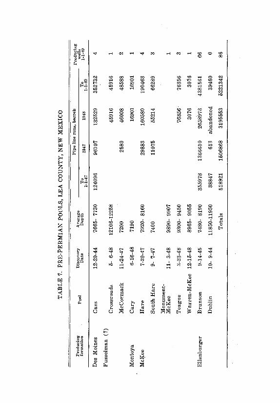

PENNSYLVANIAN POOL 67
PERMIAN POOLS OF THE LEONARD AND WOLFCAMP SERIES
Four pay zones have been found in rocks of Leonard age, of which
three are in the Yeso formation and one in the Abo. The uppermost pay
is at the top of the Yeso formation and is commonly designated the
Paddock pay. The principal pool is the Paddock in Ts. 21 and 22 S., R.
37 E. Other pools producing from this zone are the Monument-
Paddock, Harrison, and Justis (gas). The second pay lies approximately
350 feet below the Paddock pay in the upper part of the middle Yeso. It
is known as the Blinebry pay and is productive in the Blinebry and
Monument-Blinebry pools.
The lower pay of the Yeso formation is so far the most pro lific of
any in the Leonard series and is known as the Drinkard pay or more
properly the Drinkard-Vivian pay. It is the main pay of the Drinkard
pool and is also productive in the North Drinkard, South Drinkard,
Weir, and House pools. The upper part of the Abo formation is
productive in the Drinkard pool (Drinkard-Andrews pay) and also in
the Monument-Abo and Elliott pools.
All the pays in the Leonard series listed above are zones of
porous dolomite and accumulation is controlled in part by structure
and in part by variations in porosity within the zones. All of the
fields are within the map areas of pls. 21 and 23 in Bulle tin 18 of
the New Mexico Bureau of Mines and Mineral Resources. These maps
show structure contours on the top of the Yates fo rmation. The
structure of underlying formations down to the base of the Permian
is very similar to that of the Yates.
Oil is found in the lower part of the Wolfcamp series in the Bough
pool in northern Lea County. The discovery well is Magnolia Petroleum
Company's Betenbaugh No. 1 in sec. 12, T. 9 S., R. 35 E. which was
completed May 10, 1949, with an initial production of 510 barrels of
oil per day. The pay is a porohs limestone from 9617 to 9635 feet.
Fusulinids from a core from this well from 9630 to 9641 show the
lower Wolfcamp age of the pay.
A similar zone in what appears to be the same stratigraphic
position showed oil in commercial quantities in a drill stem test in
Amerada Oil Company's State No. 1-BTA test in sec. 2, T. 12 S., R. 33
E. which is 22 miles southwest of the Betenbaugh well. The drill stem
test was from 8992 to 9172 feet.
PENNSYLVANIAN POOL
The only pool producing from rocks of Pennsylvanian age in
southeastern New Mexico is the Cass pool in sec. 23, T. 20 S., R.
37 E. The pay is a porous dolomite in the lower Des Moines
(Strawn) series. In this area the lower Des Moines is approximately
450 feet thick and is the only part of the Pennsylvanian present. A
more complete section of the Pennsylvanian is found in northern
Lea County in the Crossroads area where all four of the middle and
upper Pennsylvanian series are present (pl.. 10).
68 OIL AND GAS POOLS
The Landon-Strawn pool in southwestern Cochran County, Texas,
produces oil from a dolomite of Des Moines, probably lower Des Moines
age. Its location is nine miles east of the northeast corner of T. 11 S., R.
38 E.
MISSISSIPPIAN POOL
Oil was found in the "Mississippi Lime", Rancheria formation, in
the Crossroads pool in Mid-Continent Petroleum Company's U. D.
Sawyer No. 1-B in sec. 34, T. 9 S., R. 36 E. The well was completed
on March 22, 1949, at a total depth of 12,750 feet in the
"Mississippian Limestone". Top of "Mississippian" and top of pay were
found at 11,805 giving an abnormal thickness for the formation of
over 945 feet. This and steep dips found in a core suggest close
proximity to a fault.
DEVONIAN POOL
Oil is found in a lower Devonian dolomite in the Knowles pool
southeast of Lovington. The discovery well is Amerada's Hamilton No.
1 in sec. 35, T. 16 S., R. 38 E. which was completed May 4, 1949, at
a total depth of 12,646 feet. The top of the Devonian dolomite was
reached at 12,446 feet. This discovery is about seven miles southwest
of the Jones Ranch pool of northwestern Gaines County, Texas, where
production is found also in Devonian dolomite. Another Devonian pool
within a mile of the New Mexico state line is the Dollarhide -Devonian
pool in southwestern Andrews County, Texas. The pay in the
Crossroads pool of northern Lea County may be Devonian in age, but
the writer believes that it is more probably Silurian.
SILURIAN POOLS
The McCormack pool produces from the Fusselman formation on
the west flank of the Eunice uplift. The oil is in a porous dolomite
which makes a narrow hogback ridge dipping to the west and
unconformably overlain by the Abo formation thus forming a
stratigraphic trap. The structural relationship to other pools in the
area is shown on the outline cross section p1. 9.
The pay in the Crossroads pool of northern Lea County is
tentatively correlated as Silurian in age probably belonging in the
Fusselman formation. The pool was discovered by Mid-Continent Oil
Company's U. D. Sawyer No. 1-A in sec. 27, T. 9 S., R. 36 E.,
completed in May 1948 at a total depth of 12,258 fee t. The top of the
Fusselman ( ?) was reached at 12,106 feet.
The discovery well in the Bagley area in northern Lea County is
Amerada's State No. 1-BTA in sec. 2, T. 12 S., R. 33 E. The well was
completed July 16, 1949, with an initial production of 1744 barrels
per day. The oil is in a porous dolomite which is tentatively placed in
the Fusselman (pl. 7) . The top of the dolomite was reached at 10,785
feet.
ORDOVICIAN POOLS 69
The Dollarhide-Fusselman pool in southwestern Andrews
County, Texas, is less than a mile from New Mexico state line.
ORDOVICIAN POOLS
The Cary pool in sec. 22, T. 22 S., R. 37 E. produces from a porous dolomite in the Montoya formation of upper Ordovician . age. It is significant as the only pool producing from that formation in the
west Texas-southeast New Mexico area. It lies on the southwest flank of the Eunice uplift where the Montoya formation makes a hogback overlain unconformably by the Abo formation.
The McKee sandstone member of the Tulip Creek formation of the
Simpson group, Middle Ordovician, is the pay zone of the Hare and
South Hare pools on the west flank of the Eunice uplift. It is also the pay in the Teague pool, nine miles south of Eunice ; the Warren-McKee pool, eight miles north of Eunice ; and the Monument-McKee pool.
The Ellenburger formation furnishes one pool, the prolific Brunson
pool on the west flank of the Eunice uplift. The Dublin pool near the southeast corner of Lea County was abandoned in 1945.
The Fowler pool, ten miles south of the Brunson pool, was discovered in Stanolind's South Mattix Unit No. 1 well in sec. 15, T. 24 S., R. 37 E. The well was completed May 20, 1949, at a total depth of
9705 feet with an initial production of 383 barrels per day. The top of Ellenburger and top of pay was reported at 9505 feet.
The Nelson pool in western Andrews County, Texas, is on the
eastern flank of the Eunice uplift and the Dollarhide-Ellenburger pool in southwestern Andrews County is within a mile of the state line.
The Ordovician pools on the flanks of the Eunice uplift furnish excellent examples of stratigraphic traps with the pay zones unconformably overlain by younger beds. A detailed study of the oil
pools of the Eunice uplift would make a very desirable contribution to the geology of New Mexico.
FUTURE POSSIBILITIES FOR PRE-SAN ANDRES PRODUCTION
In Bulletin 23 the prospects for additional production in southeastern New Mexico were pointed out as they appear to the author, R. E. King. At that time four zones in the Leonard series and two in pre -Permian formations were producing oil or gas. Since that time five new
producing zones have been found in the pre-Permian and one in the Permian, while several new pools have been added to those producing from the Permian.
The producing zones in the Yeso and Abo formations of the Leonard series
are in a backreef or platform dolomite facies and

70 FUTURE POSSIBILITIES
all the pools so far discovered are on the Central Basin Platform. This
facies zone forms• a broad arch around the north flank of the
Delaware Basin grading northward into an anhy dritic facies and
southward through a reef zone into a pontic black shale facies in the
Delaware basin. Additional oil pools are probable both in the reef
zone and in the back-reef dolomite zone.
The finding of oil in lower Wolfcamp, Bursum limestone in two
wells over twenty miles apart in northern Lea County gives promise of
important future discoveries from that formation. The formation is
widespread over southeastern New Mexico and appears to be uniform
in composition over wide areas.
A thick Pennsylvanian section predominantly limestone un-
derlies a large part of southeastern New Mexico (fig. 4), and these
rocks are potentially oil bearing over a large area. At present the
most promising area appears to be the deep basin extending from
southern Eddy County northeastward to northern Lea County.
Possibly the flanks of this basin toward the uplifts of the Central
Basin Platform on the east and the Matador uplift and Pedernal
Mountains on the north and northwest will furnish stratigraphic
and structural traps.
Pennsylvanian rocks penetrated by wells in De Baca and
Guadalupe counties and northernmost Roosevelt County contain a
predominance of coarse elastics and black and red shales commonly
assumed to be unfavorable for petroleum accumulation, but this
assumption may be in error. Between these wells and wells drilled in
southern Chaves and Roosevelt counties is a wide belt of country
which is entirely unexplored. It is a zone 45 to 60 miles wide and
extends across northern Chaves County and central and northern
Roosevelt County into southern Curry County. This may be the site
of a deep basin of Pennsylvanian and older rocks.
The discovery of oil in the "Mississippian Limestone", Rancheria
formation, in the Crossroads area of northern Lea County, reveals
possibilities for future pools from that formation over a large part of
southeastern New Mexico.
The lower Devonian limestone is probably more limited in areal
extent in New Mexico than other producing units (fig. 6) . Only one
pool in New Mexico can definitely be assigned to this unit, but pools
in Andrews County, Texas, within a few miles of the state line
indicate the probability of additional important pools in New Mexico,
particularly in southern Lea County on and around the flanks of the
pre-Permian uplifts.
Although the interpretation suggested in this re port includes all
the dolomite in the lower part of the section in northern Lea County in
the Silurian and Ordovician, it may be that the upper part, including
the pay section in the Crossroads and Bagley pools, is Devonian in
which case the area of probable new pools from the Devonian is greatly
extended to the north an d northwest. The Fusselman is probably as
widespread as any of the
FUTURE POSSIBILITIES 71
lower Paleozoic dolomite formations and is very promising for
probable future pools as far north as northern Lea County and
possibly still farther north. If, as herein suggested, the Crossroads
and Bagley pools produce from the Fusselman, New Mexico's pools in
that formation are as much as 70 miles apart. Important pools farther
east in Andrews County, Texas, are further proof of the importance of
the formation as a source of oil.
The Montoya is a widespread dolomite formation which has been
penetrated in many wells but produces oil in only one pool. Its
importance as a probable reservoir must not be overlooked.
The Simpson group including the McKee sandstone is re -
stricted to the southeastern counties of New Mexico (fig. 7) and
thins to the north and west. However, if this thinning is an ap -
proach to an old shore line, the sandstone beds may become thicker
and coarser grained toward the shore line and afford excellent oil
and gas reservoirs anywhere within the area under lain by the
Simpson group.
The Ellenburger is probably the most widespread and pro lific of
the pre-Pennsylvanian formations in west Texas and New Mexico.
Present information indicates that it is comparatively thin in central
and northern Lea County, but the thin sections that have been
encountered in wells might be due in part to pre -Simpson erosion
over uplifts developed about the close of Lower Ordovician time.
Ellenburger dolomites underlie a large part of southern New Mexico
(fig. 7) and are potentially oil bearing anywhere within this area.
All data presented in this report point to one conclusion. Under
the greater part of southeastern New Mexico there is a thick section of
potential oil and gas bearing rocks so that wherever the structural
conditions are right, either anticlines or strati-graphic traps, we may
confidently expect to find petroleum reservoirs in one or more
formations. Naturally there is a wide range in attractive possibilities
from one part of the area to another. Certain mountainous areas can
be completely excluded particularly where pre-Cambrian rocks or large
masses of igneous intrusions appear at the surface. Much of the
Pedernal Mountains area and certain very limited areas which have
been explored to the pre-Cambrian with negative results may also be
excluded.
Stratigraphically the most attractive general area includes all
of Lea and Eddy counties and also southeastern Chaves County. A
possible structural basin north of the Matador uplift may prove
equally attractive.
Other areas that must not be overlooked are the Guadalupe
Mountains, the Sierra Diablo Plateau, the southern Sacramento
Mountains, the Tularosa Basin, Chupadera Mesa, and the Es tancia
Valley. All or parts of these areas are underlain by thick sections of
marine pre-Permian rocks and must therefore be considered as
potentially petroliferous.


SELECTED BIBLIOGRAPHY
ADAMS, JOHN E., and others, 1939, Standard Permian section of North America: Bull. Amer. Assoc. Petrol. Geol., vol. 23, no. 11, pp. 1673-1681.
ADAMS, JOHN E., 1949, Permian rocks of the trans-Pecos region: West Texas Geol. Soc. Guidebook, Field trip No. 4.
BARNES, V. E., CLOUD, P. E., JR., and WARREN, L. E., 1947, Devonian rocks of central Texas: Bull. Geol. Soc. Amer., vol. 58, no. 2, pp. 125-140.
BARTON, JACKSON M., and others, 1946, Columnar section of pre-Permian rocks of Central Basin Platform, west Texas and southeastern New Mexico : Compiled by Pre-Permian Study Group, West Texas Geol. Soc.
BATES, ROBERT L., and others, 1942, The oil and gas resources of New Mex-ico, 2nd ed.: N. Mex. School of Mines, State Bur. Mines and Min. Res. Bull. 18.
BATES, ROBERT L., and others, 1947, Geology of the Gran Quivira quadrangle, New Mexico: N. Mex. Bur. Mines and Min. Res. Bull. 26.
BEEDE, J. W., 1918, Notes on the geology and oil possibilities of the northern Diablo Plateau in Texas: Texas Univ. Bull. 1852.
CLIFTON, R. L., 1945, Permian Word formation; its faunal and stratigraphic correlatives, Texas: Bull. Amer. Assoc. Petrol. Geol., vol. 29, no. 12, pp. 1766-1776.
CLOUD, P. E., JR., and others, 1946, Stratigraphy of the Ellenburger group in central Texas—A progress report: Texas Univ. Pub. 4301, pp. 133-161.
CLOUD, P. E., JR., and BARNES, V. E., 1948, The Ellenburger group of cen- tral Texas: Texas Univ. Pub. 4621.
COOPER, G. ARTHUR, and others, 1942,, Correlation of the Devonian sedimen-tary formations of North America : Bull. Geol. Soc. Amer., vol. .53, no. 12, pp. 1729-1794.
DARTON, N. H., 1917, A comparison of Paleozoic sections in southern New Mexico : U. S. Geol. Survey Prof. Paper 108-c.
DARTON, N. H., 1928, "Red Beds" and associated formations in New Mex-ico; with an outline of the geology of the state : U. S. Geol. Survey Bull. 794.
DECKER, CHARLES E., and others, 1931, The stratigraphy and physical characteristics of the Simpson group : Oklahoma Geol. Survey, Bull. 55.
DEFORD, RONALD K., 1942, Major structural features, southeast area: The oil and gas resources of New Mexico, 2nd ed., pp. 160-163, N. Mex. School of Mines, State Bur. Mines and Min. Res. Bull. 18.
ELLISON, SAMUEL P. JR., 1946, Conodonts as Paleozoic guide fossils: Bull. Amer. Assoc. Petrol. Geol., vol. 30, no. 1, pp. 93-110.
FRITZ, MADELEINE A., 1944, Upper Devonian bryozoa from New Mexico : Jour. Paleontology, vol. 18, no. 1, pp. 31-41.
HENDERSON, CHARLES F., and BARR, CHARLES R., 1949, Developments in 1948 in west Texas and southeast New Mexico: Bull. Amer. Assoc. Petrol. Geol., vol. 33, no. 6, pp. 908-930.
JONES, T. S., 1944, Dolomite porosity in Devonian of west Texas Permian Basin: Bull. Amer. Assoc. Petrol. Geol., vol. 28, no. 7, pp. 1043-1044.
KELLEY, V. C., and Wow), G. H. 1946, Lucero uplift, Valencia, Socorro, and Bernalillo counties, New Mexico: U. S. Geol. Survey, Oil and Gas In-vestigations, Preliminary Map 47.
KING, PHILIP B., 1931, Geology of the Glass Mountains ; Pt. 1, Descriptive geology: Texas Univ. Bull. 3038.
KING, PHILIP B., 1934, Notes on upper Mississippian rocks in trans-Pecos Texas: Bull. Amer. Assoc. Petrol. Geol., vol. 18, no. 11, pp. 1537-1543.
73
74 BIBLIOGRAPHY
KING, PHILIP B. 1942, Permian of west Texas and southeaste rn New Mex- ico; Pt. 2, B., Texas-New Mexico symposium: Bull. Amer. Assoc. Petrol. Geol., vol. 26, no. 4, pp. 535-763.
KING, PHILIP B., and KNIGHT, J. B., 1945, Geology of the Hueco Mountains, El Paso and Hudspeth counties, Texas; Description and correlation of upper Paleozoic rocks of Hueco Mountains : U. S. Geol. Survey, Oil and Gas Investigations, Preliminary Map 36, sheet 2.
KING, PHILIP B., 1948, Geology of the southern Guadalupe Mountains: U. S. Geol. Survey Prof. Paper 215.
KING, ROBERT E., 1945, Stratigraphy and oil-producing zones of the pre-San Andres formations of southeastern New Mexico-A preliminary report: N. Mex. School of Mines, State Bur. Mines and Min. Res. Bull. 23.
LAUDON, L. R. and BOWSHER, A. L., 1941, Mississippian formations of Sac- ramento R., New Mexico: Bull. Amer. Assoc. Petrol. Geol., vol. 25, no. 12, pp. 2107-2160.
LAUDON, L. R., and BOWSHER, A. L., 1949, Mississippian formations of southwestern New Mexico: Bull. Geol. Soc. Amer., vol. 60, no. 1, pp. 1-88.
LEWIS, FRANK E., 1941, Position of San Andres group, west Texas and New Mexico: Bull. Amer. Assoc. Petrol. Geol., vol. 25, no. 1, pp: 73-103.
LEWIS, FRANK E., and BARTON, JACKSON M., 1946, Glass Mountains-Mara-thon Basin : Guidebook, West Texas Geological Society Fall Field Trip.
LLOYD, E. Russell., 1938, Theory of reef barriers (abstract) : Bull. Amer. Assoc. Petrol. Geol., vol. 22, no. 12, p. 1709.
MILLER, A. K., 1945, Some exceptional Permian ammonoids from west Texas: Jour. Paleontology, vol. 19, no. 1, pp. 14-21.
MILLER, A. K., and YOUNGQUIST, WALTER, 1947, The Discovery and signifi-cance or a cephalopod fauna in the Mississippian Caballero formation of New Mexico: Jour. Paleontology, vol. 21, no. 2, pp. 113-117.
MILLER, A. K., and PARIZEK, ELDON J., 1948, A lower Permian ammonoid fauna from New Mexico: Jour. Paleontology, vol. 22, no. 3, pp. 350-358.
MOORE, RAYMOND C., and THOMPSON, M. L., 1949, Main divisions of Pennsylvanian period and system: Bull. Amer. Assoc. Petrol. Geol., vol. 33, no. 3, pp. 275-302.
NEEDHAM, C. E., and BATES, ROBERT L., 1943, Permian type sections in cen-tral New Mexico: Bull. Geol. Soc. Amer., vol. 54, no. 21, pp. 1653-1668.
NELSON, L. A., 1940, Paleozoic stratigraphy of the Franklin Mountains of west Texas: Bull. Amer. Assoc. Petrol. Geol., vol. 24, no. 1, pp. 157-172.
PENN, WILLIAM Y., 1932, Upper Pennsylvanian fossils of the Sacramento Mountains, New Mexico: Unpublished thesis, Leland Stanford Junior University.
PETERSON, V. C., and SKINNER, JOHN W., 1947, Guadalupe Mountains of New Mexico-Texas : West Texas Geol. Soc. Guidebook, Spring field trip.
READ, C. B., and others, 1944, Geologic map and stratigraphic sections of Permian and Pennsylvanian rocks of parts of San Miguel, Santa Fe, Sandoval, Bernalillo, Torrance, and Valencia counties, north central New Mexico: U. S. Geol. Survey, Oil and Gas Investigations, Prelim-inary Map 21.
READ, C. B., and WOOD, G. H., Distribution and correlation of Pennsylvanian rocks in late Paleozoic sedimentary basins of northern New Mexico: Jour. Geology, vol. 55, no. 3, pp. 220-235.
SKINNER, JOHN M., 1946, Correlation of Permian of west Texas and southeast New Mexico : Bull. Amer. Assoc. Petrol. Geol., vol. 30, no. 11, pp. 1857-1874.
STAINBROOK, MERRILL A., 1935, A Devonian fauna from the Sacramento

BIBLIOGRAPHY 75
Mountains near Alamogordo, New Mexico: Jour. Paleontology, vol. 9, no. 8, pp. 709-714.
STAINBROOK, MERRILL A., 1947, Brachiopods of the Percha shale: Jour. Pale-ontology, vol. 21, no. 4, pp. 297-328.
STAINBROOK, MERRILL A., 1948, Age and correlation of the Devonian Sly Gap beds near Alamogordo, New Mexico: Am. Jour. Sci., vol. 246, no. 12, pp. 765-790.
STARK, J. T., and DAPPLES, E. C., 1946, Geology of the Los Piños Mountains, New Mexico: Bull. Geol. Soc. Amer., vol. 57, no. 12, Pt. 1, pp. 1121-1172.
STEVENSON, FRANK V., 1945, Devonian of New Mexico: Jour. Geology, vol. 53, no. 4, pp. 217-245.
STOYANOW, ALEXANDER, 1948. Some problems of Mississippian stratigraphy in southwestern United States: Jour. Geology, vol. 56, no. 4, pp. 313-326.
THOMPSON, M. L., 1942, Pennsylvanian system in New Mexico: N. Mex. School of Mines, State Bur. Mines and Min. Res. Bull. 17.
THOMPSON, M. L., 1948, Studies of American fusulinids: Kansas Univ. Pale-ontological Contr., Protozoa, Article 1, pp. 1-184.
WELLER, J. MARVIN, and others, 1948, Correlation of the Mississippian for-mations of North America : Bull. Geol. Soc. Amer., vol. 59, no. 2, pp. 91-196.
WILPOLT, R. H., and others, 1946, Geologic map and stratigraphic sections of Paleozoic rocks of Joyita Hills, Los Piños Mountains, and northern Chupadera Mesa, Valencia, Torrance, and Socorro counties, New Mexico: U. S. Geol. Survey,-Oil and Gas Investigations, Preliminary Map. 61.
WOOD, G. H., and NORTHROP, S. A., 1946, Geology of Nacimiento Mountains, San Pedro Mountain, and adjacent plateaus in parts of Sandoval and Rio Arriba counties, New Mexico: U. S. Geol. Survey, Oil and Gas Investigations, Preliminary Map. 57.

INDEX
Figures in ital ic indicate main references.
A Des Moines series, 34, 38, 39, 40, 62, 67, 68. Abo Canyon, 28, 29, 32, 37, 38, 39, 40, 63. Devonian pool, 68. Abo formation, 10, 13, 14, 15, 17, 26, 28, 29, Devonian system, 39, 42, 46, 49, 51, 52, 53, 60,
30, 31, 32, 33, 39, 50, 63, 64, 65, 67, 68, 69. 61, 68, 70. Acknowledgments, 10. Dictyoclostus inflatus var. coloradoensis, 44. Alamogordo member, 45. Dollarhide-Devonian pool, 68. Amerada's Hamilton No. 1, 33, 42, 45, 48, 51, Dollarhide-Ellenburger pool, 69.
68• Dollarhide-Fusselman pool, 69.
Amerada's Phillips No. 5, 30. Drinkard-Andrews pay zone, 26, 30 ,67. Amerada's Record No. 2, 28, 31, 42, 44, 48. Drinkard pool, 9, 30, 67. Amerada's State No. 1 BTA, 53, 54, 57, 59, Drinkard sandy member, 10, 24, 26.
67, 68. . Drinkard-Vivian pay zone, 26, 67. Ancestral Rocky Mountains, 13. Dublin (Ellenburger) pool, 9, 48, 54, 57, 69. Aqua Torres formation, 32. Arbuckle group, 57. E Arbuckle Mountains, 52, 57, 58. Electra arch, 15. Arcente member, 45. Ellenburger group, 9, 53, 54, 57, 58, 59, 60, Atoka series, 14, 34, 35, .40, 42, 62. 69,71.
Elliott pool, 30, 67. B El Paso limestone, 54, 57, 58, 59, 60.
Bagley pool (area), 51, 53, 54, 57, 68, 70, 71. El Paso Natural Gas Company's Ginsberg "Barnett" formation, see Helms formation. well, 48. Barnsdall's State No. 1-A, 33, 40, 44, 45, 61. Estancia Valley, 71. Beach Mountains, 57, 58, 59. Eunice uplift (area), 13, 14, 15, 17, 25, 30, Bibliography, 73. 31, 33, 35, 38, 39, 41, 48, 53, 59, 60, 63, 64, Blinebry pay zone, 24, 25 ,26, 67. 68, 69. Blinebry pool, 67. Explanatory note, 7. Bliss ( ?) sandstone, 58, 59. Board of Regents, 6. F Bone Spring formation, 19, 21, 24, 27, 31. Flower Pot formation, 22. Bough pool, 34, 67. Fowler pool, 69. Box member, 49. Franklin Mountains, 13, 41, 44, 46, 50, 52, Brunson pool, 69. 54, 57, 58, 59, 60, 61. Brushy Canyon formation, 19, 20, 21, 27. Fresnal Canyon, 32, 33, 37. Bruton formation, 32. Fresnal group, 37, 38. Bursum formation, 28, 32, 33, 34, 63, 70. "Fullerton sand," 26.
Fusselman formation, 50, 51, 52, 53, 54, 60, C I 68, 70, 71.
Caballero formation, .45, 46, 49, 61. Future possibilities, 69. Caballos Mountains, 46. California Oil Company's Thiessen well, 50. G Cambrian system, 13, 17, 57, 58, 59. Gallinas Mountains, 11, 29. Callas member (Yeso), 23, 24, 25. Geological history, 59. Canutillo formation, 46, 48, 49, 50, 51, 52, Getty's Dooley No. 7, 27.
60, 61. Glass Mountains, 20, 21. Capitan Mountains, 11, 14, 15. Glorieta sandstone. 20, 21, 22, 23, 24, 25, 64. Capitan reef formation, 19, 27. Gorman formation, 57, 58. Carlsbad Shelf area, 24, 27, 31. Gran Quivira quadrangle, 20, 22, 23, 24, 28. Cary pool, 56, 69. Grayburg formation, 27. Cass pool, 9, 40, 67. Guadalupe-Leonard contact, 19. Castile formation, 19. Guadalupe Mountains, 11, 19, 22, 27, 71. Central Basin Platform, 13, 17, 25, 30, 31, Guadalupe or Leonard series, 22.
33, 35, 38, 39, 41, 48, 51, 53, 62, 63, 64, 70. Guadalupe series, 19, 20, 21, 22, 64. Cherry Canyon formation, 21, 27, 28. Chester series, 41, 42, 62. H Chimney Hill formation, 52. Hare pool, 69. Chupadera Mesa, 71. Harrison pool, 67. Clear Fork formation, 10, 25. Helderberg group, 51. Contadero formation, 49, 61. Helms formation, 10, 42, 44, 45, 62. Continental Oil Company's Warren No. 1-B- Hess limestone facies (Leonard), 20.
29, 54. "Holt pay" zone, 21, 28. Continental's Skaggs No. 5-B-23, 39. Honeycut formation, 57, 58. Crossroads pool (area), 33, 48, 51, 53, 61, 67, House pool, 67.
68, 70, 71. Hueco formation, 28, 29, 30, 31, 32, 33, 34, 50, 63. .
D Hueco Mountains, 11, 29, 31, 35, 41, 42, 44, DeKalb Agricultural Association's White No. 45, 50, 52, 54, 60, 61, 62.
1, 25. Humble's Federal-Leonard No. 1, 57.
DeKalb's Lewis No. 1, 15, 37. Deer Mountain red shale member, 31. Humble's State No. 1-N, 14. Delaware Basin, 13, 19, 20, 24, 31, 64, 70. Hunton group, 51. Delaware Mountain group, 19, 20, 21, 27.
, Delaware Mountains, 20. I Derry series, see Atoka series. Introduction, 9.
77

73 INDEX
J Resources, 6, 9, 11, 20, 32, 34, 35, 64, 67. Jarilla Mountains, 11. Niagaran group (Middle Silurian), 52, 53. Jicarilla Mountains, 11. North Drinkard pool, 67. Jones Ranch pool, 51, 68. Northwestern Shelf area, 13. joyita member (Yeso), 22, 23, 24, 25, 64. Nunn member, 45. Justis pool (gas), 9, 67.
O K Ochoa series, 64.
Kawvian series, 35. Ohio's Tracy Dome test, 27. Keller group, 37, 38. Oil and gas pools, 64. Kelly formation, 45. Oil Creek formation, 60. Kinderhook series, 41, 45, 48, 61, 62. Oklan series, 35. Knowles pool, 51, 68. Olsen Oil Company's Langlie well, 9, 58.
(Mate formation, 49, 50, 54, 61. L Ordovician pools, 69.
Lake Valley formation, 45, 61. Ordovician system, 54, 59, 60, 69, 70. Las Cruces formation, 44. Organ Mountains, 13. Last Chance Canyon, 21. Osage series, 41, 45, 61, 62. Lea County Operators Committee, 64. Oscura Mountains, 11, 13, 14; 22, 23, 24, 26, Leiorhynchus carboniferum, 44. 28, 32, 37, 54, 63. Leonard and Wolfcamp ( ?) series, 28. Otero Mesa, 11, 31. Leonard series, 15, 20, 21, 22, 23, 28, 30, 31, Ozark uplift, 57, 58.
64, 67, 69. L'ano uplift, 57, 58, 59. P • Lockport formation, 53. Paddock pay zone, 25, 67. Los Piños Mountains, 13, 14, 32, 35, 37, 38, Paddock pool, 67.
40. Pajarita Peak, 14. Lower Devonian, 48, 51, 52, 61. Paleontological Laboratory, 10, 35, 41, 44. Lower Ordovician, 54, 57, 58, 59, 60, 71. Paleozoic era, 13, 14, 17, 62, 63, 71. Lower Silurian, 52, 60. Parafusulina fountain, 21. Lower Wolfcamp series, 29, 32, 33, 63, 67, 70. Pedernal Land Mass, 13. Lower Yeso, 9, 24, 26. Pedernal Mountains, 11, 13, 14, 23, 24, 28, 29,
30, 33, 35, 37, 39, 40, 62, 63, 64, 70, 71. M Pennsylvanian-Permian contact, 32.
McCormack pool, 53, 68. Pennsylvanian pool, 67, 68. McKee sandstone member (Simpson group ), Pennsylvanian system, 10, 11, 13, 14, 15, 17,
57, 69, 71. 30, 32, 34, 35, 37, 38, 39, 54, 62, 63, 64, 67, McLish formation, 60. 70. Madera formation, 38, 39, 40. Pentamterus, 52. Magnolia Petroleum Company's Betenbaugh Percha shale, 46, 48, 49, 50, 61.
No. 1, 67. Permian Basin, 10, 20, 26. Magnolia's A. K. Smith test, 41, 42, 45, 56, Permian Basin Sample Laboratory, 10.
61. Permian pools, 65. Magnolia's Burro Hills well, 35, 37, 38, 39, Permian system, 10, 13, 14, 15, 17, 18, 19, 54,
40, 52. 63, 64, 67, 69. Manning Dome, 14. Perrinites hilli, 20. Manzano Mountains, 13. Phillips' Lea-Mex No. 4, 33. Marathon uplift, 59. Phillips' Shipp No. 1, 48. Matador's Woods test, 39. Powwow conglomerate member ( Hueco), 31, Matador uplift, 13, 14, 15, 35, 41, 62, 70, 71. 50. Meramec series, 41, 42, 44, 62. Pre-Cambrian rocks, 13, 14, 15, 17, 29, 30, 37, Meseta Blanca member (Yeso), 23, 26, 28. 39, 40, 54, 59, 62, 63, 71. Mid-Continent Petroleum Company's U. D. Pre-Pennsylvanian erosion, 48, 53, 59.
Sawyer No. 1-A, 68. Pre-Permian pools, 66. ' Mid-Continent Petroleum Company's U. D. Pre-Permian uplifts and basins, 13, 15, 38, 70.
Sawyer No. 1-B, 68. Principal structural features, 11. Middle Devonian, 46, 49, 50, 61. Pure Oil Company's Federal Fee test, 25. Middle Ordovician, 54, 56, 57, 60, 69. Middle Silurian, 52, 53, 60. Middle Wolfcamp, 33. Queen formation, 27. Middle Yeso, 24, 25, 26. Midland Basin, 20. Mimbres Mountains, 46, 48, 49. Rancheria formation, 10, 42, 44, 45, 50, 53, Mississippian pool, 68. 62, 68, 70. Mississippian system, 10, 29, 33, 37, 40, 41, Ready pay member, 46, 49, 61.
42, 45, 48, 49, 52, 53, 61, 62, 68, 70. "Red Tanks member of Madera limestone," Mississippi Valley, 41. 32. Missouri series, 34, 38, 39, 62. Residue Research Laboratory, 10. Montoya formation, 53, 54, 56, 60, 69, 71. Richfield et al.'s Mullis No. 1, 35, 38, 39, 40, Monument-Abo pool, 30, 67. 42, 51. Monument area, 17, 30. Richfield's Lake McMillan Unit No. 1, 27, 28. Monument-Blinebry pool, 67. Richfield's Trigg well, 54, 57, 59. Monument-McKee pool, 69. Richfield's White No. 3-1, 53. Monument-Paddock pool, 67. Richmond group, 54. Morrow series, 35, 37, 40, 62. Mud Springs Mountains, 46.
Sacramento Mountains, 9, 11, 13, 14, 22, 23, N 24, 27, 28, 29, 31, 32, 38, 35, 37, 38, 39,
Nelson pool, 69. 40, 41, 44, 45, 46, 48, 49, 54, 59 61, 62, New Mexico Bureau of Mines and Mineral 63, 71.

INDEX 79
Salt Basin, 11. Texas Company's Wilson No. 1, 37, 50. San Andres formation, 9, 20, 21, 22, 27, 28, Tierra Blanca member, 45.
53, 54. Torres member (Yeso), 23, 24, 25, 26. San Andres Mountains, 9, 13, 41, 46, 49, 50, Transcontinental's McWhorter well, 37.
52, 53, 61. "Tubb sand," 10, 26. San Angelo formation, 20, 21, 22, 25. Tularosa Basin, 11, 13, 71. Sanders Bros.' Hultman No. 1, 25, 26. Tulip Creek formation, 60, 69. Sandia formation, 40. Turner's Evans well, 50. Schwagerina setum, 21. Turner's Everett well, 50, 58. Shell's Harwood No. 1, 15. Shell's Saunders-Federal test, 15.. Shell's Taylor-Glenn No. 1, 23, 24. Union Oil Company's McMillan well, 50. Sierra Blanca Mountains, 11. Upper Devonian, 46, 48, 49, 61. Sierra Diablo Mountains, 11, 27, 71. Upper Ordovician, 54, 69. Silurian pools, 68. Upper Silurian, 60. Silurian system, 51, 52, 53, 60, 68, 70. Upper Wolfcamp, 31, 33, 63.
See also Lower Silurian, Middle Silurian, Upper Yeso, 23, 24, 25. Upper Silurian. U. S. Geological Survey, 20.
Silver member, see Ready Pay member. Simpson group, 56, 59, 60, 69, 71. V Skaggs area, 39, 59. Vittorio Peak member (reef zone), 21, 27. Skelly's U. D. Sawyer No. 1, 48. Virgil series, 15, 32, 34, 37, 38, 39, 62. Sly Gap formation, 49, 54, 61. South Drinkard pool, 67. South Hare pool, 69. Warren-McKee pool, 69. Spearow's McClelland No. 1, 21, 27. Weir pool, 67. Spirifer arkansanus, 44. West Texas Electrical Log Service, 10. Springer series, 62. West Texas Geological Society, 51, 52. Standard of Texas' Smith No. 1, 27. Wichita group, 10. Standard of Texas' Wilson No. 1, 27. Wilberns formation, 57, 59. Standard Oil Company of Texas, 11, 23. Wolfcamp series, 15, 17, 28, 30, 31, 33, 38, 67. Stanolind Oil and Gas Company's No. 1 See also Lower Wolfcamp, Middle Wolf-
Pichacho, 14. camp, Upper Wolfcamp. Stanolind's South Mattix Unit No. 1, 69. Woodford formation, 46, 48, 49, 50, 51, 61. Stratigraphic section, 17, 18. Word formation, 20.
T Y Tanyard formation, 57, 58, 59. Yates formation, 67. Tasmanites huronensis, 48, 50. Yeso formation, 10, 13, 20, 21, 22, 23, 24, 25, Teague pool, 69. 26, 27, 28, 29, 30, 31, 64, 65, 67, 69. Tertiary (late) intrusions, 11, 15. See also Lower Yeso, Middle Yeso, Upper Texas & Pacific's State No. 39-A, Acct. 2, 38. Yeso. Texas Company's Blinebry No. 1, 26.

PUBLICATIONS
PUBLICATIONS OF THE MINERAL RESOURCES SURVEY
No. Title and Author Date Price 1 The Mineral Resources of New Mexico; Fay-
ette A. Jones ---------------------------------------------- 1915 Out of print 2 Manganese in New Mexico; E. H. Wells --------------- 1918 Out of print 3 Oil and Gas Possibilities of the Puertecito
District, Socorro and Valencia Counties, New Mexico; E. H. Wells ---------------------------------- 1919 Out of print
PUBLICATIONS OF THE NEW MEXICO BUREAU OF MINES AND MINERAL RESOURCES
BULLETINS
No. Title and Author Date Price 4 Fluorspar in New Mexico; W. D. Johnston,
Jr. (Superseded by Bulletin 21) -------------------- 1928 Out of print
5 Geologic Literature of New Mexico; T. P. Wootton (Superseded by Bulletin 22) -------------- 1930 Out of print
6 Mining and Mineral Laws of New Mexico; Charles H. Fowler (Superseded by Bulletin 16) ---------------------------------------------------- 1930 Out of print
7 The Metal Resources of New Mexico and their Economic Features; S. G. Lasky and T. P. Wootton ------------------------------------------ 1933 Out of print
8 The Ore Deposits of Socorro County, New Mexico; S. G. Lasky ------------------------------------ 1932 .60
9 The Oil and Gas Resources of New Mexico; Dean E. Winchester (First edition; superseded by Bulletin 18) ---------------------------------------- 1933 Out of print
10 The Geology and Ore Deposits of Sierra County, New Mexico; G. Townsend Harley --------- 1934 .60
11 The Geology of the Organ Mountains, with an Account of Dona Ana County, New Mexico; Kingsley Charles Dunham --------------------------- 1935 Out of print
12 The Non-Metallic Mineral Resources of New Mexico and their Economic Features (Exclu- sive of Fuels) ; S. B. Talmage and T. P. Wootton 1936 .50
13 Geology and Economic Features of the Peg- matites of Taos and Rio Arriba Counties, New Mexico; Evan Just ------------------------------- 1937 .50
14 Some New Mexico Fusulinidae; C. E. Needham 1937 .50
15 The Geology and Ore Deposits of Northeastern New Mexico (Exclusive of Colfax County) ; G. Townsend Harley --------------------------------------- 1940 .60
16 Mining, Oil, and Mineral Laws of New Mexico; C. H. Fowler and S. B. Talmage (Supersedes Bulletin 6) ----------------------------------------------- 1941 .75
17 Pennsylvanian System in New Mexico; M. L. Thompson ------------------------------------------------ 1942 .50
18 The Oil and Gas Resources of New Mexico; compiled by Robert L. Bates (Second edition; supersedes Bulletin 9) --------------------------------- 1942 2.50
81
82 PUBLICATIONS
No. Title and Author Date Price
19 Manganiferous Iron-ore Deposits near Silver City, New Mexico; Lawson P. Entwistle ------------ 1944 .50
20 Stratigraphy of the Colorado Group, Upper Cretaceous, in Northern New Mexico; Charles H. Rankin ---------------------------------------------- 1944 Out of print
21 Fluorspar Resources of New Mexico; H. E. Rothrock, C. H. Johnson, and A. D. Hahn (Supersedes Bulletin 4) ------------------------------- 1946 2.50
22 Geologic Literature of New Mexico Through 1944; Robert L. Bates and Marian R. Burks (Supersedes Bulletin 5) ------------------------------ 1945 Out of print
23 Stratigraphy and Oil-producing Zones of the Pre-San Andres Formations of Southeastern New Mexico—A Preliminary Report; Robert E. King ------------------------------------------------------ 1945 .50
24 Building Blocks from Natural Lightweight Materials of New Mexico; Donn M. Clippinger 1946 .50
25 Mica Deposits of the Petaca District, Rio Arriba County, New Mexico, with Brief De-scriptions of the Ojo Caliente District, Rio Arriba County, and the Elk Mountain District, San Miguel County; Richard H. Jahns -------------- 1946 2.00
26 Geology of the Gran Quivira Quadrangle, New Mexico; Robert L. Bates, Ralph H. Wilpolt, Archie J. MacAlpin, and Georges Vorbe ----------------------------------------------------- 1947 .60
27 Contribut ions o f New Mexico 's Mineral Industry to World War II; compiled by T. D. Benjovsky ------------------------------------------------ 1947 .50
28 Pumice Aggregate in New Mexico—Its Uses and Potentialities; Donn M. Clippinger and Walter E. Gay ------------------------------------------ 1947 Out of print
29 Pre-San Andres Stratigraphy and Oil-produc- ing zones in Southeastern New Mexico—A Progress Report; E. Russell Lloyd -------------------- 1949 2.00
GROUND-WATER REPORT
*1 Geology and Ground-Water Resources of the
Eastern Part of Colfax County, New Mexico; Roy L. Griggs ------------------------------------------- 1948 3.00
OIL AND GAS REPORTS
4-A New Mexico Oil and Gas Statistical Data for 1948; compiled by E. E. Kinney, Lea County Operators Committee, and New Mexico Oil Conservation Commission ---------------------------- 1949 2.25
4-B New Mexico Oil and Gas Engineering Data for 1948; compiled by E. E. Kinney, Lea County Operators Committee, and New Mexico Oil Conservation Commission ---------------------------- 1949 2.25
4-C San Juan Basin, New Mexico, Oil and Gas Data Summary Cumulative to January 1, 1949; com- piled by E. E. Kinney ---------------------------------- 1949 .50
Prepared in cooperation with the U. S. Geological Survey and the State Engineer of New Mexico.
PUBLICATIONS 83
No. Title and Author Date Price
CIRCULARS
1 An Outline of the Mineral Resources of New Mexico; E. H. Wells -------------------------------------- 1930 Out of print
2 Geology and Ore Deposits of the Ground Hog Mine, Central District, Grant County, New Mexico; S. G. Lasky ------------------------------------- 1930 Out of print
3 First, Second, and Third Annual Reports of the Director, and Preliminary Report for the Fourth Year; E. H. Wells ------------------------------- 1931 Out of print
4 The Hobbs Field and Other Oil and Gas Areas, Lea County, New Mexico; Dean E. Winchester 1931 Out of print
5 Gold Mining and Gold Deposits in New Mex- ico; E. H. Wells and T. P. Wootton, 1932; re- vised by T. P. Wootton ----------------------------------- 1940 No charge
6 Carbon Dioxide in New Mexico; E. H. Wells and A. Andreas (Superseded by Circular 9) --------- 1938 Out of print
7 Outlook for Further Ore Discoveries in the Little Hatchet Mountains, New Mexico; S. G. Lasky ------------------------------------------------------- 1940 Out of print
8 Selected Bibliography on Coal in New Mexico; Robert L. Bates ------------------------------------------ 1943 No charge
9 Carbon Dioxide in New Mexico; Sterling B. Talmage and A. Andreas (Reprinted from Bulletin 18) ----------------------------------------------- 1942 No charge
10 Natural Light-weight Building-block Materials of New Mexico; T. D. Benjovsky and D. M. Clippinger ------------------------------------------------- 1945 Out of print
11 Reconnaissance Survey of the Headstone Min- ing District, Rio Arriba County, New Mexico; T. D. Benjovsky ------------------------------------------- 1945 No charge
12 Future Oil Possibilities of New Mexico; Robert L. Bates ------------------------------------------ 1946 Out of print
13 Compilation of State Tax Law Relating to Mineral Properties in New Mexico; E. P. Ripley 1946 No charge
14 Oil and Gas Production Data, Eddy County, New Mexico, 1943-1945; compiled by N. Ray- mond Lamb and W. B. Macey -------------------------- 1947 Out of print
15 Tables of Fluorescent and Radioactive Min- erals; compiled by Robert L. Hershey ---------------- 1947 No charge
16 New Mexico Oil and Gas Production Data for 1946 (Exclusive of Lea County) ; compiled by N. Raymond Lamb and W. B. Macey ------------------ 1947 Out of print
17 Caprock Pool Statistical Report, Chaves and Lea Counties, New Mexico; compiled by N. Raymond Lamb and William B. Macey --------------- 1947 Out of print
18 Geology and Ore Deposits of Red River and Twining Districts, Taos County, New Mexico —A Preliminary Report; Charles F. Park, Jr. and Philip F. McKinlay --------------------------------- 1948 No charge
19-A New Mexico Oil and Gas Statistical Data for 1947; compiled by N. Raymond Lamb and Lea County Operators Committee ------------------------- 1948 No charge
19-B New Mexico Oil and Gas Engineering Data for
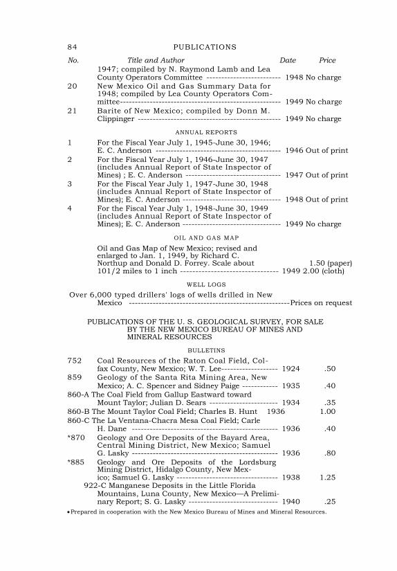
84 PUBLICATIONS
No. Title and Author Date Price
1947; compiled by N. Raymond Lamb and Lea County Operators Committee ------------------------- 1948 No charge
20 New Mexico Oil and Gas Summary Data for 1948; compiled by Lea County Operators Com- mittee ------------------------------------------------------ 1949 No charge
21 Barite of New Mexico; compiled by Donn M. Clippinger ------------------------------------------------ 1949 No charge
ANNUAL REPORTS
1 For the Fiscal Year July 1, 1945-June 30, 1946; E. C. Anderson ------------------------------------------ 1946 Out of print
2 For the Fiscal Year July 1, 1946-June 30, 1947 (includes Annual Report of State Inspector of Mines) ; E. C. Anderson -------------------------------- 1947 Out of print
3 For the Fiscal Year July 1, 1947-June 30, 1948 (includes Annual Report of State Inspector of Mines); E. C. Anderson --------------------------------- 1948 Out of print
4 For the Fiscal Year July 1, 1948-June 30, 1949 (includes Annual Report of State Inspector of Mines); E. C. Anderson --------------------------------- 1949 No charge
OIL AND GAS MAP
Oil and Gas Map of New Mexico; revised and enlarged to Jan. 1, 1949, by Richard C. Northup and Donald D. Forrey. Scale about 1.50 (paper) 101/2 miles to 1 inch -------------------------------- 1949 2.00 (cloth)
WELL LOGS
Over 6,000 typed drillers' logs of wells drilled in New Mexico ------------------------------------------------------ Prices on request
PUBLICATIONS OF THE U. S. GEOLOGICAL SURVEY, FOR SALE BY THE NEW MEXICO BUREAU OF MINES AND MINERAL RESOURCES
BULLETINS
752 Coal Resources of the Raton Coal Field, Col- fax County, New Mexico; W. T. Lee------------------- 1924 .50
859 Geology of the Santa Rita Mining Area, New Mexico; A. C. Spencer and Sidney Paige ------------ 1935 .40
860-A The Coal Field from Gallup Eastward toward Mount Taylor; Julian D. Sears ----------------------- 1934 .35
860-B The Mount Taylor Coal Field; Charles B. Hunt 1936 1.00
860-C The La Ventana-Chacra Mesa Coal Field; Carle H. Dane ------------------------------------------------- 1936 .40
*870 Geology and Ore Deposits of the Bayard Area, Central Mining District, New Mexico; Samuel G. Lasky ------------------------------------------------- 1936 .80
*885 Geology and Ore Deposits of the Lordsburg Mining District, Hidalgo County, New Mex- ico; Samuel G. Lasky ---------------------------------- 1938 1.25
922-C Manganese Deposits in the Little Florida Mountains, Luna County, New Mexico—A Prelimi- nary Report; S. G. Lasky ------------------------------ 1940 .25
Prepared in cooperation with the New Mexico Bureau of Mines and Mineral Resources.
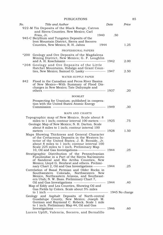
PUBLICATIONS 85
No. Title and Author Date Price
922-M Tin Deposits of the Black Range, Catron and Sierra Counties. New Mexico; Carl Fries, Jr. 1940 .50
945-C Beryllium and Tungsten Deposits of the Iron Mountain District, Sierra and Socorro Counties, New Mexico; R. H. Jahns 1944 1.25
PROFESSIONAL PAPERS
*200 Geology and Ore Deposits of the Magdalena Mining District, New Mexico; G. F. Loughlin and A. H. Koschmann -------------------------------- 1942 2.00
*208 Geology and Ore Deposits o f the Litt le Hatchet Mountains, Hidalgo and Grant Coun- ties, New Mexico; Samuel G. Lasky ----------------- 1947 2.50
WATER-SUPPLY PAPER
842 Flood in the Canadian and Pecos River Basins of New Mexico—With Summary of Flood Dis-charges in New Mexico; Tate Dalrymple and others --------------------------------------------------- 1937 .20
BOOKLET
Prospecting for Uranium; published in coopera-tion with the United States Atomic Energy Commission ------------------------------------------- 1949 .30
MAPS AND CHARTS
Topographic map of New Mexico. Scale about 8 miles to 1 inch; contour interval 100 meters ----- 1925 .75
Geologic Map of New Mexico; N. H. Darton. Scale about 8 miles to 1 inch; contour interval 100 meters -------------------------------------------------- 1928 1.50
Maps Showing Thickness and General Character of the Cretaceous Deposits in the Western In-terior of the United States; J. B. Reeside, Jr. about 8 miles to 1 inch; contour interval 100 Scale 225 miles to 1 inch. Preliminary Map 10, Oil and Gas Investigations ----------------------- 1944 .25
Stratigraphic Distribution of the Pennsylvanian Fusulinidae in a Part of the Sierra Nacimiento of Sandoval and Rio Arriba Counties, New Mexico; Lloyd G. Henbest and others. Prelimi- nary Chart 2, Oil and Gas Investigations ---------- 1944 .25
Correlation of Basal Permian and Older Rocks in Southwestern Colorado, Northwestern New Mexico, Northeastern Arizona, and Southeast-ern Utah; N. W. Bass. Preliminary Chart 7, Oil and Gas Investigations -------------------------- 1944 .40
Map of Eddy and Lea Counties, Showing Oil and Gas Fields by Colors. Scale about 5% miles to 1 inch -------------------------------------------------- 1945 No charge
Geology and Asphalt Deposits of North-central Guadalupe County, New Mexico; Joseph M. Gorman and Raymond C. Robeck. Scale 1 mile to 1 inch. Preliminary Map 44, Oil and Gas Investigations ------------------------------------------ 1946 .60
Lucero Uplift, Valencia, Socorro, and Bernalillo
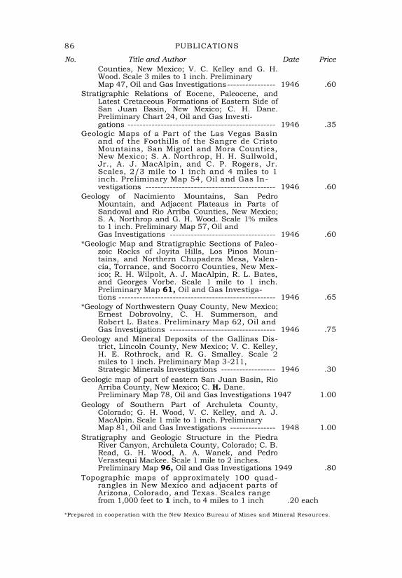
86 PUBLICATIONS
No. Title and Author Date Price
Counties, New Mexico; V. C. Kelley and G. H. Wood. Scale 3 miles to 1 inch. Preliminary Map 47, Oil and Gas Investigations ---------------- 1946 .60
Stratigraphic Relations of Eocene, Paleocene, and Latest Cretaceous Formations of Eastern Side of San Juan Basin, New Mexico; C. H. Dane. Preliminary Chart 24, Oil and Gas Investi- gations ------------------------------------------------- 1946 .35
Geologic Maps of a Part of the Las Vegas Basin and of the Foothills of the Sangre de Cristo Mountains, San Miguel and Mora Counties, New Mexico; S. A. Northrop, H. H. Sullwold, Jr., A. J. MacAlpin, and C. P. Rogers, Jr. Scales, 2/3 mile to 1 inch and 4 miles to 1 inch. Preliminary Map 54, Oil and Gas In- vestigations ------------------------------------------- 1946 .60
Geology of Nacimiento Mountains, San Pedro Mountain, and Adjacent Plateaus in Parts of Sandoval and Rio Arriba Counties, New Mexico; S. A. Northrop and G. H. Wood. Scale 1% miles to 1 inch. Preliminary Map 57, Oil and Gas Investigations ----------------------------------- 1946 .60
*Geologic Map and Stratigraphic Sections of Paleo-zoic Rocks of Joyita Hills, Los Pinos Moun-tains, and Northern Chupadera Mesa, Valen-cia, Torrance, and Socorro Counties, New Mex-ico; R. H. Wilpolt, A. J. MacAlpin, R. L. Bates, and Georges Vorbe. Scale 1 mile to 1 inch. Preliminary Map 61, Oil and Gas Investiga- tions ---------------------------------------------------- 1946 .65
*Geology of Northwestern Quay County, New Mexico; Ernest Dobrovolny, C. H. Summerson, and Robert L. Bates. Preliminary Map 62, Oil and Gas Investigations ----------------------------------- 1946 .75
Geology and Mineral Deposits of the Gallinas Dis-trict, Lincoln County, New Mexico; V. C. Kelley, H. E. Rothrock, and R. G. Smalley. Scale 2 miles to 1 inch. Preliminary Map 3-211, Strategic Minerals Investigations ------------------ 1946 .30
Geologic map of part of eastern San Juan Basin, Rio Arriba County, New Mexico; C. H. Dane. Preliminary Map 78, Oil and Gas Investigations 1947 1.00
Geology of Southern Part of Archuleta County, Colorado; G. H. Wood, V. C. Kelley, and A. J. MacAlpin. Scale 1 mile to 1 inch. Preliminary Map 81, Oil and Gas Investigations --------------- 1948 1.00
Stratigraphy and Geologic Structure in the Piedra River Canyon, Archuleta County, Colorado; C. B. Read, G. H. Wood, A. A. Wanek, and Pedro Verastequi Mackee. Scale 1 mile to 2 inches. Preliminary Map 96, Oil and Gas Investigations 1949 .80
Topographic maps of approximately 100 quad-rangles in New Mexico and adjacent parts of Arizona, Colorado, and Texas. Scales range from 1,000 feet to 1 inch, to 4 miles to 1 inch .20 each
*Prepared in cooperation with the New Mexico Bureau of Mines and Mineral Resources.
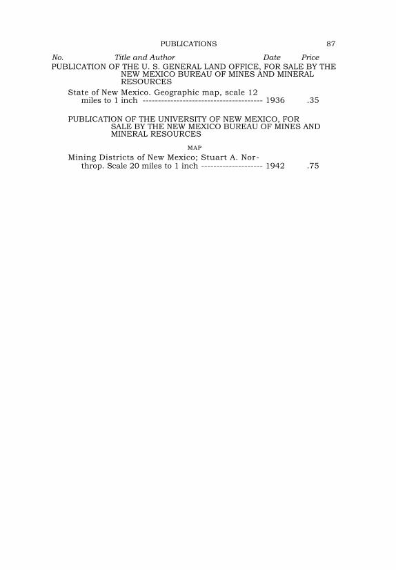
PUBLICATIONS 87
No. Title and Author Date Price
PUBLICATION OF THE U. S. GENERAL LAND OFFICE, FOR SALE BY THE NEW MEXICO BUREAU OF MINES AND MINERAL RESOURCES
State of New Mexico. Geographic map, scale 12 miles to 1 inch --------------------------------------- 1936 .35
PUBLICATION OF THE UNIVERSITY OF NEW MEXICO, FOR SALE BY THE NEW MEXICO BUREAU OF MINES AND MINERAL RESOURCES
MAP
Mining Districts of New Mexico; Stuart A. Nor- throp. Scale 20 miles to 1 inch -------------------- 1942 .75

1