Embed Size (px)
Citation preview
GEOGRAPHIC INFORMATION SYSTEMS (GIS) BUSINESS PLAN:Washington Enterprise GIS Program and Shared Access to Geospatial Services
FINAL: May 14, 2010
120 Lakeside Avenue Suite 200 Seattle, Washington 98122 P (206) 324-8760
www.berkandassociates.com
“Helping Communities and Organizations Create Their Best Futures”
Principals: Bonnie Berk and Michael Hodgins
Project Manager: Natasha Fedo
Project Team: Bonnie Berk, Natasha Fedo, Julia Warth
Washington State Geographic Information Council (WAGIC)Executive Members
Ian Von Essen, Spokane County
Kerry Brooks, Washington State University
Tom Carlson, US Geological Survey
Alan Smith, Department of Transportation
Tim Young, Department of Fish & Wildlife
Ron Holeman, Department of Natural Resources
Dan Miller, Washington Military Department
Matt Parsons, University of Washington
Matthieu Denuelle, ESRI
Dan Saul, Department of Ecology
George Alvarado, Department of Revenue
David Jennings, Department of Health
Steve Rush, Hanford
Mike Mohrman, Office of Financial Management
Teresa Mathiesen, City of Ellensburg
Plan Primary Author:Joy Paulus, GIS Coordinator
Staff to the ISB-GIT and WAGIC
GIS Program Office
Department of Information Services
For more information:[email protected] I 360.902.3447 I http://wagic.wa.gov
GEOGRAPHIC INFORMATION SYSTEMS (GIS) BUSINESS PLAN:
Washington Enterprise GIS Program and Shared Access to Geospatial Services
GEOGRAPHIC INFORMATION SYSTEMS (GIS) BUSINESS PLAN
Washington Enterprise GIS Program and Shared Access to Geospatial Services: Design and Implementation
EXECUTIVE SUMMARY
This plan is an extension of the Geographic Information Systems Strategic Plan: Mapping Washington’s Future, 2010‐2014 completed under the 50 States Initiative’s grant from the United States Geological Survey (USGS). This Business Plan addresses two of the goals identified in the Strategic Plan, and details their implementation. These goals were identified by Washington Geographic Information Council (WAGIC) as the primary steps to achieving the Vision of the Strategic Plan and the most feasible in the current economic and political climate.
Goal 1: Establish Access Mechanism for Washington Geospatial Data
There is a significant need for a data discovery and access mechanism that is easy to use, well‐organized, searchable, consistently updated and capable of supporting both centralized and distributed resources. Benefits of such a tool include the ability to easily find and share data, reduced data redundancy, and increased opportunities for inter‐governmental collaboration.
Goal 2: Staff GIS Program Office and Recruit a State Geospatial Information Officer
In order to implement the overarching strategic goals, it is necessary to fully staff the existing state GIS Program Office, and recruit a state Geospatial Information Officer (GIO). The GIO will coordinate interagency and intergovernmental efforts and will provide executive leadership for the state’s GIS user community.
Together, these goals best describe an enterprise GIS Program that will help agencies realize the Governor’s objectives for creating more shared services in state government and GIS consolidation across agencies. The GIS Business Plan lays the groundwork for the development of a federated organizational model to more effectively deploy GIS resources in the State of Washington.
Enterprise GIS Approach
The GIS enterprise approach advances customer services by providing external entities access to desired information, spatial data resources, standards, and web‐based services in an effort to support transparency in state government. The key enterprise program elements include:
Formalize GIS Data Stewardship: Designate data steward(s) for each of the enterprise level GIS data sets and any data services consuming these data.
Provide Shared GIS Infrastructure: Establish a single point of access for enterprise level data and shared services to reduce confusion and storage costs of hosting multiple copies of data. Provide access to services like address matching, visualization tools, and applications that public, private, and governmental entities can use and benefit from. Shared data will lead to better decisions as agencies work from official versions of data rather than multiple, unsynchronized, or inconsistent versions of data.
EXECUTIVE SUMMARY GEOGRPAHIC INFORMATION SYSTEMS (GIS) BUSINESS PLAN Washington Enterprise GIS Program and Shared Access to Geospatial Services
5/14/2010 FINAL DRAFT ES‐2
Expand Washington State GIS Program Office: Expand Washington State GIS Program Office and establish the state Geospatial Information Officer (GIO) to be responsible for running the shared infrastructure, coordinating GIS data and software purchases, managing business agreements between stakeholders, securing sustainable funding for the upkeep of the shared infrastructure, coordinating data acquisition, and serving as the GIS point‐of‐contact for external stakeholders. The GIO will interface and coordinate across all governmental entities and businesses at the executive level.
Implementation Plan
The Business Plan embraces changes the GIS community has envisioned for years and recommended in the Washington’s 2006 Enterprise Architecture effort. The implementation of this Plan is separated into four phases:
Phase I – Budget Development and Return on Investment Planning
Enterprise GIS Program: Create the budget decision packages needed to fund the phased development of the vision outlined in this Plan (staffing and infrastructure).
Return on Investment Funding/Grant: Submit grant proposal to fund the development of an ROI analysis for common infrastructure geospatial data and value of shared services.
Return on Investment (ROI): Plan for conducting a formal ROI analysis for Enterprise GIS implementation and need for geospatial data. Identify potential ROI funding opportunities; identify entity participation and commitments for involvement.
Phase II – Infrastructure and Technical Staff Implementation
Infrastructure: Implement the infrastructure needed to support the access, discovery, storage and potential maintenance of common geospatial data, once funding is identified and procured. Leverage and expand the existing orthoimagery portal infrastructure and add the hardware and software resources needed to support the enterprise environment for framework data and shared services.
Technical Staffing: Develop job descriptions and recruiting plan for technical support staff. Begin hiring process for required and approved staffing.
Shared Geospatial Services and Data: Position infrastructure and staff to provide shared geospatial services to a wide range of governmental entities and stakeholder clients.
Phase III – Enterprise GIS Office Expansion
Staff GIS Program Office: Develop job description for GIO position; develop recruiting plan and hiring process for GIO; develop job descriptions and recruiting plan for technical support staff. Begin hiring process for required and approved staff.
Phase IV – Agency GIS Program Data Implementation
Framework Data Sets: Provide the necessary support and funding needed to complete the active framework data efforts.
Shared Geospatial Services: Provide the necessary support and staffing needed to supply the shared geospatial services to the access and discovery portal.
GEOGRAPHIC INFORMATION SYSTEMS (GIS) BUSINESS PLAN
Washington Enterprise GIS Program and Shared Access to Geospatial Services: Design and Implementation
Contents
1.0 GOALS AND BUSINESS OBJECTIVES .......................................................................................... 1
1.1 Background ............................................................................................................................ 1
1.2 Selected Strategic Goals for Business Implementation ......................................................... 2
2.0 BENEFITS AND BUSINESS JUSTIFICATION ................................................................................. 5
2.1 Business Case for Enterprise GIS Approach for Washington ................................................. 6
2.2 Benefits .................................................................................................................................. 7
3.0 REQUIREMENTS AND COSTS .................................................................................................... 9
3.1 Enterprise GIS Program Elements .......................................................................................... 9
3.2 Governmental Entities GIS Program Requirements and Costs ............................................ 12
3.3 Risks to Successful Implementation ..................................................................................... 13
4.0 IMPLEMENTATION PLAN ....................................................................................................... 14
5.0 MEASURING SUCCESS ............................................................................................................ 18
APPENDIX A: List of Acronyms
APPENDIX B: Core GIS Spatial Data Layers

5/14/2010 FINAL DRAFT 1
GEOGRAPHIC INFORMATION SYSTEMS (GIS) BUSINESS PLAN
Washington Enterprise GIS Program and Shared Access to Geospatial Services: Design and Implementation
1.0 GOALS AND BUSINESS OBJECTIVES
1.1 Background
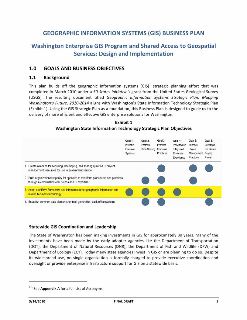
This plan builds off the geographic information systems (GIS)1 strategic planning effort that was completed in March 2010 under a 50 States Initiative’s grant from the United States Geological Survey (USGS). The resulting document titled Geographic Information Systems Strategic Plan: Mapping Washington’s Future, 2010‐2014 aligns with Washington’s State Information Technology Strategic Plan (Exhibit 1). Using the GIS Strategic Plan as a foundation, this Business Plan is designed to guide us to the delivery of more efficient and effective GIS enterprise solutions for Washington.
Exhibit 1 Washington State Information Technology Strategic Plan Objectives
Statewide GIS Coordination and Leadership
The State of Washington has been making investments in GIS for approximately 30 years. Many of the investments have been made by the early adopter agencies like the Department of Transportation (DOT), the Department of Natural Resources (DNR), the Department of Fish and Wildlife (DFW) and Department of Ecology (ECY). Today many state agencies invest in GIS or are planning to do so. Despite its widespread use, no single organization is formally charged to provide executive coordination and oversight or provide enterprise infrastructure support for GIS on a statewide basis.
1 1 See Appendix A for a full List of Acronyms
GEOGRPAHIC INFORMATION SYSTEMS (GIS) BUSINESS PLAN Washington Enterprise GIS Program and Shared Access to Geospatial Services
5/14/2010 FINAL DRAFT 2
Starting with the formation of the Washington GIS Working Group (1984‐85) and the subsequent establishment of the Washington Geographic Information Council (WAGIC, 1994), the GIS community has worked together to meet the needs of the user community in the state. Recently the Information Services Board’s Committee on Geographic Information Technology (ISB‐GIT) has served as the de facto coordinator within state government. However, as the use of GIS continues to grow, personal working relationships within the WAGIC and the more formal ISB‐GIT processes are no longer sufficient to provide the level of coordination needed to maximize the potential benefits and increased efficiencies of GIS.
The need for more effective coordination and executive leadership has become especially apparent as state and local governmental organizations discover they are unable to keep up with the growing demand for GIS within their agencies given staffing levels and current budgets. Much of the state’s GIS capacity exists within discrete agencies, and is managed and funded at the individual agency level. This has led to some investments in redundant infrastructure and an uneven spread of GIS capabilities between “haves” and “have not’s” across all levels of government. Increased interagency support and cross agency coordination are keys to increasing efficiencies and enabling the use of GIS across the various levels of government.
Governor’s Directives
Presently, Washington State is looking to have technology deliver services more efficiently and economically. This includes how state government information technology is planned, funded, developed, implemented, and maintained. Washington Governor Chris Gregoire has issued two directives that focus on information technology and specifically GIS technology:
Shared Services: On February 10, 2009, Governor Gregoire issued Governor’s Directive 09‐02, directing state agencies to provide full assistance and support in the development and implementation of a shared services model. The Governor stated that “sharing administrative functions between agencies will allow you to focus on your core missions of providing essential services to Washingtonians.”
GIS Consolidation: On December 2, 2009, Governor Gregoire issued Executive Order 09‐07, “Washington’s Natural Resource Reform Initiative.” Key goals of the initiative are to improve customer service, increase efficiencies, and advance the state’s commitment to protect and restore natural resources and the environment. Specifically, in order to “…streamline and reduce duplication...,” the executive order directs the natural resource agencies to “…identify cost‐effective opportunities for developing a single point of access for common geographic information system (GIS) data.”
This Plan describes a business solution for GIS that aligns with the intent of these directives as well as the selected GIS strategic goals that are outlined in the following section.
Shared services – the practice of having a single group provide back‐office administrative services or customer‐facing activities for multiple agencies or departments.
GEOGRPAHIC INFORMATION SYSTEMS (GIS) BUSINESS PLAN Washington Enterprise GIS Program and Shared Access to Geospatial Services
5/14/2010 FINAL DRAFT 3
1.2 Selected Strategic Goals for Business Implementation
The GIS Business Plan lays the groundwork for the development of a federated organizational model to more effectively deploy GIS resources in the State of Washington. The intent is to migrate from the existing model of informal sharing and cooperation toward a more formalized enterprise structure, characterized by a centralized geographic information office working collaboratively with all levels of government to:
• Take advantage of opportunities for co‐investment;
• Reduce duplication through the use of centralized and distributed shared services;
• Improve efficiencies involving data storage, retrieval and discovery;
• Improve integration through establishment of common standards; and
• Increase awareness and support for GIS through education and outreach.
The GIS Business Plan specifically focuses on two of the strategic goals that were laid out in the document titled Geographic Information Systems Strategic Plan: Mapping Washington’s Future, 2010‐2014:
Goal 1: Establish Access Mechanism for Washington Geospatial Data
There is a significant need for a data discovery and access mechanism that is easy to use, well‐organized, searchable, consistently updated and capable of supporting both centralized and distributed resources. Benefits of such a tool include the ability to easily find and share data, reduced data redundancy, and increased opportunities for inter‐governmental collaboration.
Goal 2: Staff GIS Program Office and Recruit a State Geospatial Information Officer
In order to implement the overarching strategic goals, it is necessary to fully staff the existing state GIS Program Office and recruit a state Geospatial Information Officer (GIO). The GIO will coordinate interagency and intergovernmental efforts and will provide executive leadership for the state’s GIS user community.
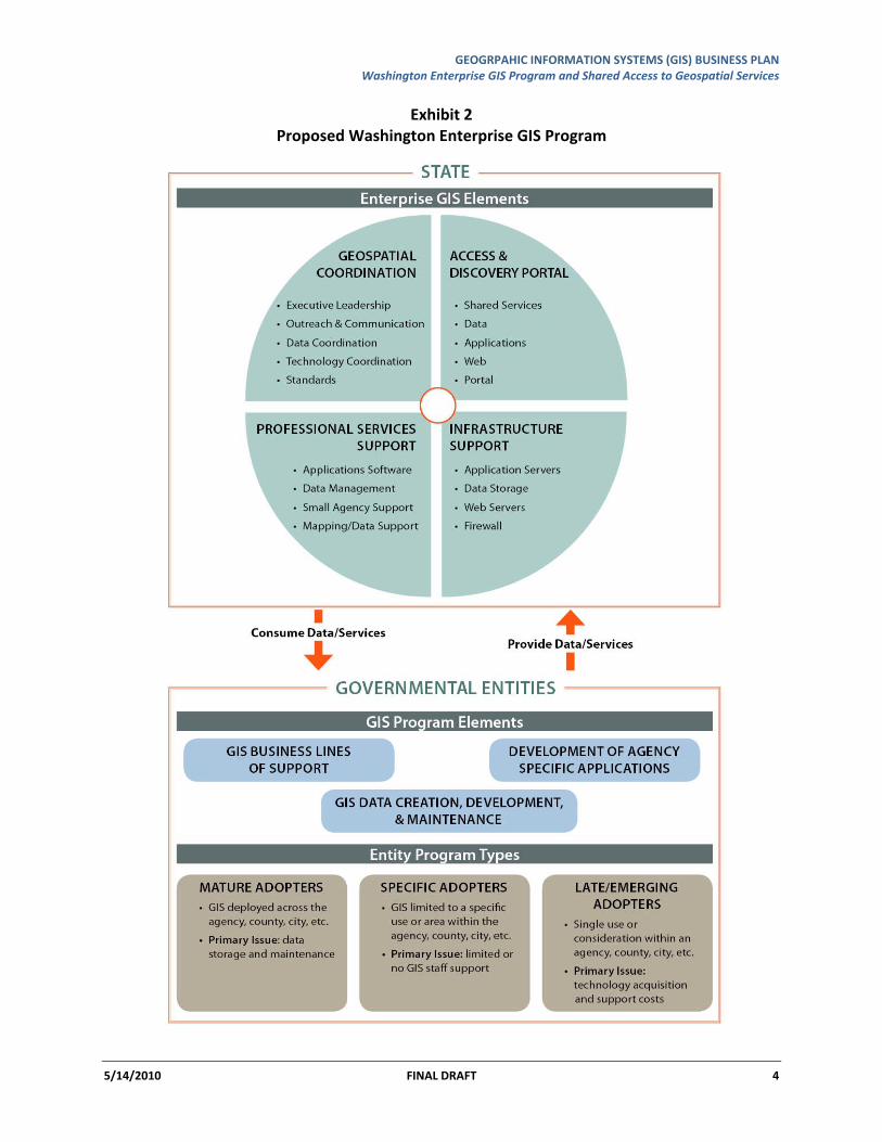
Together, these goals best describe an enterprise GIS Program that is outlined in Exhibit 2 below.
GEOGRPAHIC INFORMATION SYSTEMS (GIS) BUSINESS PLAN Washington Enterprise GIS Program and Shared Access to Geospatial Services
5/14/2010 FINAL DRAFT 4
Exhibit 2 Proposed Washington Enterprise GIS Program
GEOGRPAHIC INFORMATION SYSTEMS (GIS) BUSINESS PLAN Washington Enterprise GIS Program and Shared Access to Geospatial Services
5/14/2010 FINAL DRAFT 5
2.0 BENEFITS AND BUSINESS JUSTIFICATION
The Governor has identified the following list of strategic initiatives that are important to the citizens of this state.
• Community Safety
• Education
• Environmental Accountability
• Energy
• Social Services
• Transportation
• Health Care
• Transparency in Government
In order to work collaboratively on these initiatives, governmental entities need to streamline access to information, which supports consistent decision‐making. To help meet this challenge the state needs to work more effectively together, leverage our existing resources and knowledge base and develop an enterprise approach to manage geospatial data and services.
A starting place is the approved ISB‐GIT Conceptual Enterprise Architecture document and initiating the key enterprise program elements listed below.
Formalize GIS Data Stewardship: Data steward(s) shall be designated for each of the enterprise level GIS data sets listed to the right. The data steward(s) will be responsible for developing the necessary business processes to document the data, define data change management business rules, define data security policies, develop procedures for co‐incident registration, confirm policies for data retention and archiving, define required data currency, and define procedures for data correction and enhancement. In addition, any data services consuming these data shall similarly have a designated steward with responsibilities similar to those for data layer stewardship.
Provide Shared GIS Infrastructure: A single point of access for enterprise level data and shared services will reduce confusion and storage costs of hosting each other’s data and provide access to services like address matching, visualization tools, and applications that public, private, and governmental entities can use and benefit from. It will have sufficient capacity and redundancy to accommodate current and expected agency and public access requirements. External stakeholders will be better served by a single point of data discovery and data access. Shared data will lead to better decisions as agencies work from official versions of data rather than multiple, unsynchronized or inconsistent versions of data.
Expand Washington State GIS Program Office: In its expanded role this office will be responsible for running the shared infrastructure, coordinating GIS data and software purchases, managing business agreements between stakeholders, securing sustainable funding for the upkeep of the shared infrastructure, coordinating data acquisition, and serving as the GIS point‐of‐contact for external stakeholders. The state GIO will interface and coordinate across all governmental entities and businesses at the executive level. The GIO’s primary purpose is providing cohesive leadership for the state’s GIS user community.
Primary Framework Data Layers
• Orthoimagery • Hydrography • Transportation • Cadastral Information • Governmental Units • Geodetic Control • Elevation
Additional Data Layers
• Public Safety /Structures • Land Use/Land Cover • Reference • Utilities • Geo Sciences • Hazards
For more information see Appendix B.
GEOGRPAHIC INFORMATION SYSTEMS (GIS) BUSINESS PLAN Washington Enterprise GIS Program and Shared Access to Geospatial Services
5/14/2010 FINAL DRAFT 6
2.1 Business Case for Enterprise GIS Approach for Washington
The GIS enterprise approach advances customer services by providing external entities access to desired information, spatial data resources, standards, and web‐based services in an effort to support transparency in state government.
A common point of access for geospatial data and services increases efficiencies through the reduction of duplicate data maintained by multiple agencies, and its associated infrastructure and data storage. It also improves data quality through the use and maintenance of shared corporate level data sets and their associated information.
Assessments of environmental conditions, public health, medical service delivery, contaminant risk assessment, and issues of environmental justice all depend on the use of accurate, defendable, and authoritative geospatial data. The enterprise approach supports these types of assessments.
Enterprise GIS Program and Single Access Mechanism Improve Customer Service by:
• Providing a central point of contact for external entities desiring information about Washington State GIS resources, standards, and protocols;
• Improving GIS data quality by the shared use and maintenance of commonly used data;
• Providing a common presentation of geospatial information in the form of web services (e.g. maps, features, RSS feeds, geoXML, XML, etc.); and
• Deploying services across the enterprise independent of how and where they are created or maintained.
Enterprise GIS Program and Single Access Mechanism Increase Efficiencies by:
• Reducing stakeholder frustration with inconsistent data available from multiple sources;
• Reducing staff time needed to resolve conflicts caused by inconsistent geospatial data;
• Reducing staff time currently spent maintaining similar GIS data in multiple places;
• Freeing up staff to focus on specific business needs; and
• Streamlining infrastructure (e.g. reducing redundant storage of data, service hosting, and software licensing).
Tangible benefits of a shared infrastructure could include (alignment with Governor’s strategic initiatives in parentheses):
• Providing the infrastructure to stand up a common visualization tool for emergency responders to use in cases like the Howard Hanson Dam monitoring. State agencies could provide information from a single location to help responders, residents and businesses plan for potential evacuations (community safety).
• Enabling web‐accessible tools for health and safety officers across all levels of government so they can quickly find the location of an accident on a map (transportation, community safety).
• Providing the ability to notify county/city officials to close water intakes along a section of a stream in the event of an oil spill (environmental accountability, streamlining government).
GEOGRPAHIC INFORMATION SYSTEMS (GIS) BUSINESS PLAN Washington Enterprise GIS Program and Shared Access to Geospatial Services
5/14/2010 FINAL DRAFT 7
• Enabling the Department of Transportation to better work with regional and federal agencies on transportation planning efforts through a shared portal that support interagency planning (transportation).
• Making available historic aerial photography that allows research of past irrigation usage in order to make better decisions on allocating water rights (environment).
• Sharing demographic, economic, and cultural data that allows the study of environmental justice issues (environment/social services).
• Providing an opportunity for robust business development by having live feeds of information and data like maps, weather, traffic, stream flow, address matching and other web services from one place for government entities, businesses, and non‐governmental organizations (community development).
• Providing a publically accessible list of health and medical service locations and information linked with public transportation resources – all on one interactive map – will enhance the use of public transportation and access to health care (healthcare/social services).
• Advancing customer support by providing a presentation of complex information in a format that is easy to understand and that is specifically tied to a map of Washington. More than 65 services are available and ready to be launched and consumed by private businesses, developers, and the public (transparency).
2.2 Benefits
Where GIS has been implemented successfully, governmental entities have been able to provide services more efficiently, as seen in other states like Minnesota, Maryland, and Montana. At the state level, GIS Programs at DNR, ECY, DOT, DFW, Department of Revenue (DOR), and Department of Health (DOH) provide examples of agencies that have benefitted from their investments in GIS. But not all entities have been able to implement GIS to this level and some are struggling to maintain their existing investments and staff. Enabling a federated enterprise approach can provide enormous value to the state. The most tangible benefits involve maximizing the value of these large investments, including:
• Strategic data investments;
• Efficient data storage;
• Effective software licensing;
• Shared geospatial web services;
• Coordinated data acquisitions;
• Reduced duplication of staff time;
• Improved coordination; and
• Common data distribution portal.
A mechanism for a single point of access to spatial resources:
• Provides an adaptable framework for developing solutions that operate across agencies;
• Facilitates design of flexible, reliable, scalable, and secure systems that are more responsive to changing business needs;
• Allows agencies to add systems and manage the lifecycle of current systems while supporting enterprise investments;
• Increases data timeliness and accuracy;
GEOGRPAHIC INFORMATION SYSTEMS (GIS) BUSINESS PLAN Washington Enterprise GIS Program and Shared Access to Geospatial Services
5/14/2010 FINAL DRAFT 8
• Advances the notion of a holistic approach to decision making at the state level by consolidating and integrating GIS data, whether centralized or distributed, into a common, shared library. Due to the current fragmented access to spatial data, it is often difficult to assess conditions across the landscape.
• Reduces burden to consumers and advances sustainable commercial endeavors by reducing the burden on the regulated community. Access to regulatory information is fragmented across multiple agencies, forcing permit applicants to seek information from multiple sources.
A fully functional enterprise GIS Program Office and GIO provides the following benefits:
• Addresses multiple objectives of Washington State’s Strategic Information Technology Plan;
• Defines business processes that facilitate integration and reuse of GIS data and application components across the enterprise;
• Brings clarity to how stakeholder groups relate and how they jointly work together to achieve an enterprise approach to certain GIS issues;
• Makes use of existing information technology policy and governance structures to achieve the GIS enterprise architecture vision;
• Facilitates a single enterprise view of GIS framework data for policy makers, business partners and citizens;
• Increases state agencies' capacity to fully support informed public policy and decision‐making;
• Helps resolve spatially‐based natural resource, environmental, public safety, and other complex multi‐jurisdictional problems;
• Provides a central focus for state GIS enterprise activity for operational, budgeting, and planning activities, increasing effectiveness;
• Puts DIS GIS coordination closer to operational reality;
• Provides a gateway to a federated deployment model where governmental entities form a distributed collection of connected spatial nodes that share and use each other’s geographic information and services;
• Positions the state to take a stronger role in GIS coordination between state, local and tribal governments; and
• Provides additional resources to manage and deploy enterprise resources freeing up state agencies to focus on agency unique business needs.
GEOGRPAHIC INFORMATION SYSTEMS (GIS) BUSINESS PLAN Washington Enterprise GIS Program and Shared Access to Geospatial Services
5/14/2010 FINAL DRAFT 9
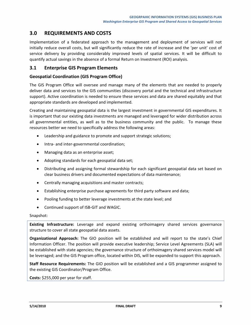
3.0 REQUIREMENTS AND COSTS
Implementation of a federated approach to the management and deployment of services will not initially reduce overall costs, but will significantly reduce the rate of increase and the ‘per unit’ cost of service delivery by providing considerably improved levels of spatial services. It will be difficult to quantify actual savings in the absence of a formal Return on Investment (ROI) analysis.
3.1 Enterprise GIS Program Elements
Geospatial Coordination (GIS Program Office)
The GIS Program Office will oversee and manage many of the elements that are needed to properly deliver data and services to the GIS communities (discovery portal and the technical and infrastructure support). Active coordination is needed to ensure these services and data are shared equitably and that appropriate standards are developed and implemented.
Creating and maintaining geospatial data is the largest investment in governmental GIS expenditures. It is important that our existing data investments are managed and leveraged for wider distribution across all governmental entities, as well as to the business community and the public. To manage these resources better we need to specifically address the following areas:
• Leadership and guidance to promote and support strategic solutions;
• Intra‐ and inter‐governmental coordination;
• Managing data as an enterprise asset;
• Adopting standards for each geospatial data set;
• Distributing and assigning formal stewardship for each significant geospatial data set based on clear business drivers and documented expectations of data maintenance;
• Centrally managing acquisitions and master contracts;
• Establishing enterprise purchase agreements for third party software and data;
• Pooling funding to better leverage investments at the state level; and
• Continued support of ISB‐GIT and WAGIC.
Snapshot:
Existing Infrastructure: Leverage and expand existing orthoimagery shared services governance structure to cover all state geospatial data assets.
Organizational Approach: The GIO position will be established and will report to the state’s Chief Information Officer. The position will provide executive leadership; Service Level Agreements (SLA) will be established with state agencies; the governance structure of orthoimagery shared services model will be leveraged; and the GIS Program office, located within DIS, will be expanded to support this approach.
Staff Resource Requirements: The GIO position will be established and a GIS programmer assigned to the existing GIS Coordinator/Program Office.
Costs: $255,000 per year for staff.
GEOGRPAHIC INFORMATION SYSTEMS (GIS) BUSINESS PLAN Washington Enterprise GIS Program and Shared Access to Geospatial Services
5/14/2010 FINAL DRAFT 10
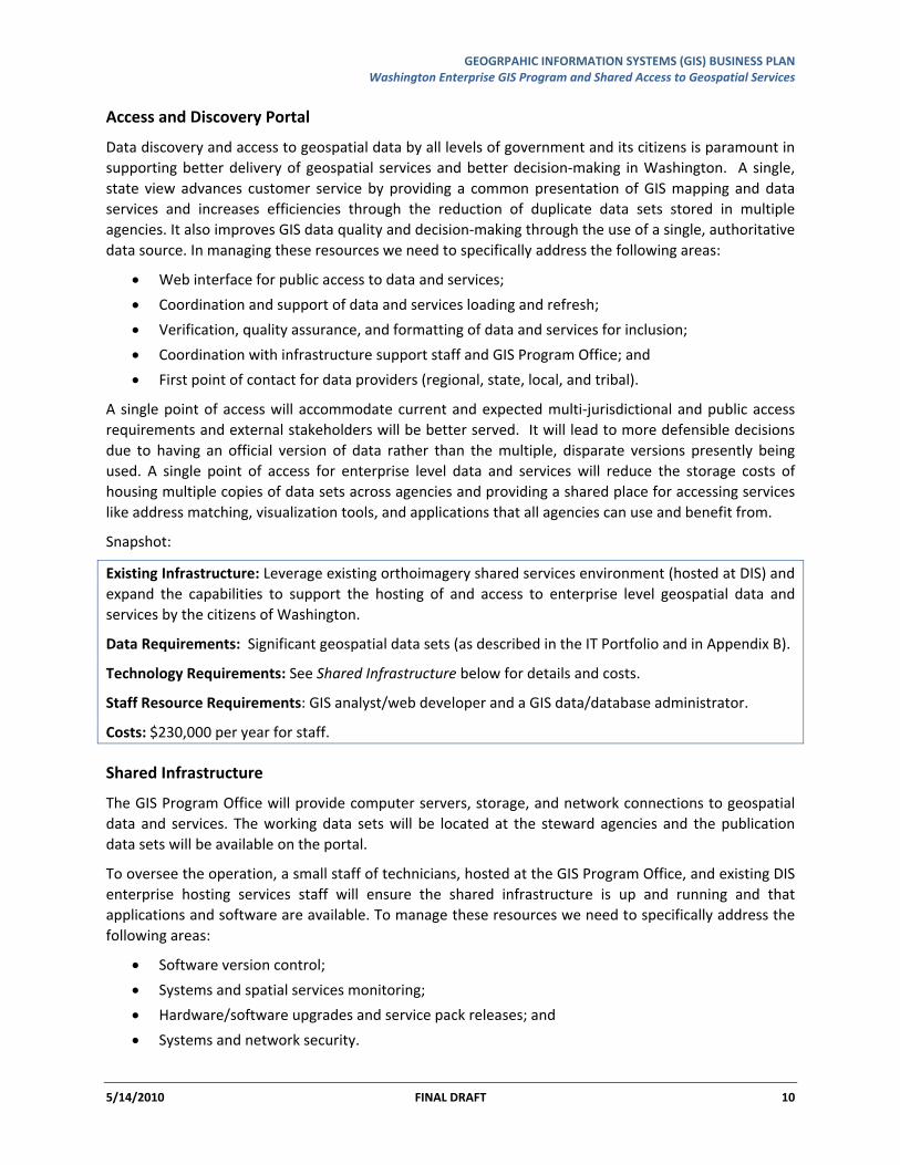
Access and Discovery Portal
Data discovery and access to geospatial data by all levels of government and its citizens is paramount in supporting better delivery of geospatial services and better decision‐making in Washington. A single, state view advances customer service by providing a common presentation of GIS mapping and data services and increases efficiencies through the reduction of duplicate data sets stored in multiple agencies. It also improves GIS data quality and decision‐making through the use of a single, authoritative data source. In managing these resources we need to specifically address the following areas:
• Web interface for public access to data and services;
• Coordination and support of data and services loading and refresh;
• Verification, quality assurance, and formatting of data and services for inclusion;
• Coordination with infrastructure support staff and GIS Program Office; and
• First point of contact for data providers (regional, state, local, and tribal).
A single point of access will accommodate current and expected multi‐jurisdictional and public access requirements and external stakeholders will be better served. It will lead to more defensible decisions due to having an official version of data rather than the multiple, disparate versions presently being used. A single point of access for enterprise level data and services will reduce the storage costs of housing multiple copies of data sets across agencies and providing a shared place for accessing services like address matching, visualization tools, and applications that all agencies can use and benefit from.
Snapshot:
Existing Infrastructure: Leverage existing orthoimagery shared services environment (hosted at DIS) and expand the capabilities to support the hosting of and access to enterprise level geospatial data and services by the citizens of Washington.
Data Requirements: Significant geospatial data sets (as described in the IT Portfolio and in Appendix B).
Technology Requirements: See Shared Infrastructure below for details and costs.
Staff Resource Requirements: GIS analyst/web developer and a GIS data/database administrator.
Costs: $230,000 per year for staff.
Shared Infrastructure
The GIS Program Office will provide computer servers, storage, and network connections to geospatial data and services. The working data sets will be located at the steward agencies and the publication data sets will be available on the portal.
To oversee the operation, a small staff of technicians, hosted at the GIS Program Office, and existing DIS enterprise hosting services staff will ensure the shared infrastructure is up and running and that applications and software are available. To manage these resources we need to specifically address the following areas:
• Software version control;
• Systems and spatial services monitoring;
• Hardware/software upgrades and service pack releases; and
• Systems and network security.
GEOGRPAHIC INFORMATION SYSTEMS (GIS) BUSINESS PLAN Washington Enterprise GIS Program and Shared Access to Geospatial Services
5/14/2010 FINAL DRAFT 11
Snapshot:
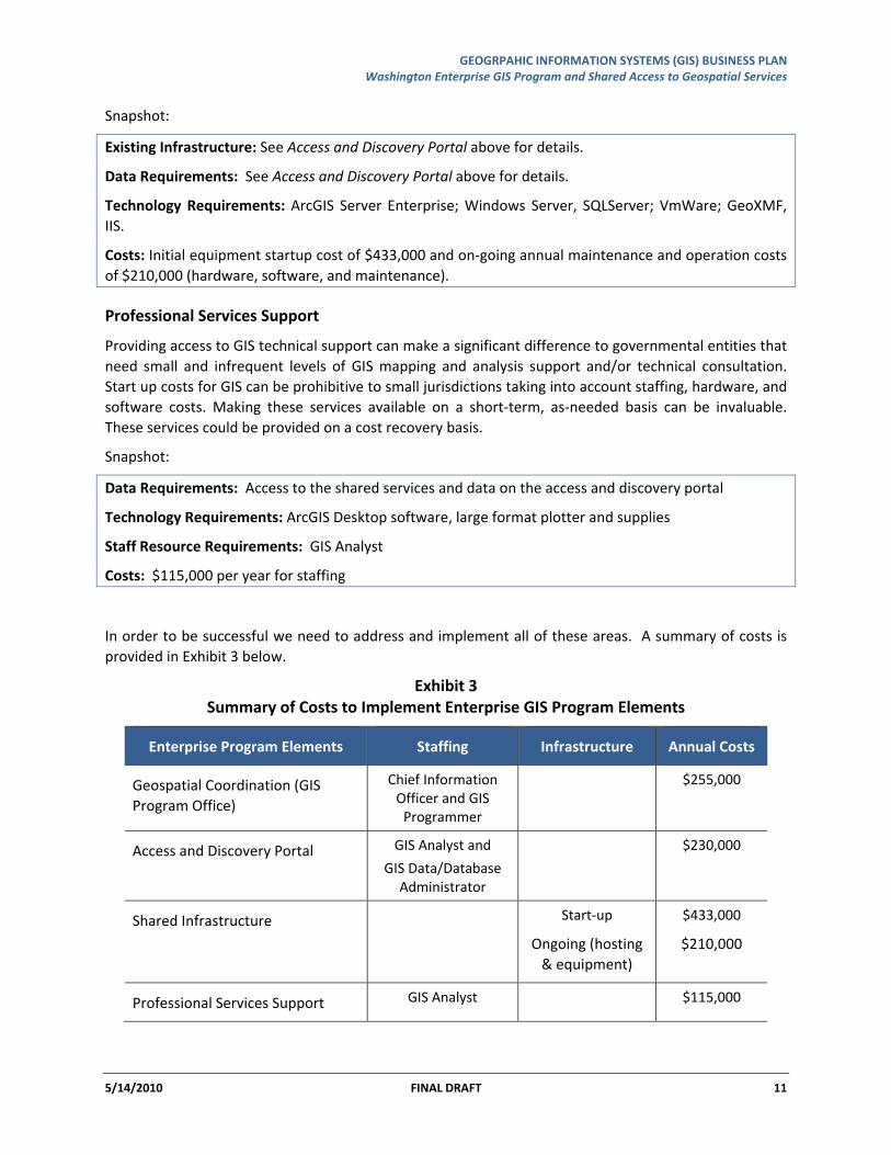
Existing Infrastructure: See Access and Discovery Portal above for details.
Data Requirements: See Access and Discovery Portal above for details.
Technology Requirements: ArcGIS Server Enterprise; Windows Server, SQLServer; VmWare; GeoXMF, IIS.
Costs: Initial equipment startup cost of $433,000 and on‐going annual maintenance and operation costs of $210,000 (hardware, software, and maintenance).
Professional Services Support
Providing access to GIS technical support can make a significant difference to governmental entities that need small and infrequent levels of GIS mapping and analysis support and/or technical consultation. Start up costs for GIS can be prohibitive to small jurisdictions taking into account staffing, hardware, and software costs. Making these services available on a short‐term, as‐needed basis can be invaluable. These services could be provided on a cost recovery basis.
Snapshot:
Data Requirements: Access to the shared services and data on the access and discovery portal
Technology Requirements: ArcGIS Desktop software, large format plotter and supplies
Staff Resource Requirements: GIS Analyst
Costs: $115,000 per year for staffing
In order to be successful we need to address and implement all of these areas. A summary of costs is provided in Exhibit 3 below.
Exhibit 3 Summary of Costs to Implement Enterprise GIS Program Elements
Enterprise Program Elements Staffing Infrastructure Annual Costs
Geospatial Coordination (GIS Program Office)
Chief Information Officer and GIS Programmer
$255,000
Access and Discovery Portal GIS Analyst and
GIS Data/Database Administrator
$230,000
Shared Infrastructure Start‐up
Ongoing (hosting & equipment)
$433,000
$210,000
Professional Services Support GIS Analyst $115,000
GEOGRPAHIC INFORMATION SYSTEMS (GIS) BUSINESS PLAN Washington Enterprise GIS Program and Shared Access to Geospatial Services
5/14/2010 FINAL DRAFT 12
3.2 Governmental Entities GIS Program Requirements and Costs
When it comes to providing data and services as a pooled resource, it is important that all levels of government participate and contribute to this portal. This concept depends on that participation in order to build, maintain, and serve geospatial data to all users.
Having spatial data that is collectively used by multiple organizations, but is managed and maintained by a single steward has the greatest savings potential. Rather than multiple organizations managing duplicate data sets, we need data shared from a single point to avoid unnecessary investments in infrastructure and staff. In order to get a firm understanding of the potential savings, a full return on investment analysis needs to be carried out at the state level. Phase 1 of this Plan (outlined in Section 5.0) identifies this task.
Initial financial investments need to be made at the state level to ensure we have consistent, common geospatial data for use by the public and governmental entities. The cost to consolidate this data under individual lead steward agencies and to develop the data to meet the common needs of multiple organizations needs to be properly identified. After the initial investment is made, all funding for the continued development and maintenance of the geometry and baseline attributes will occur within the steward agency. All business level information tied to this common geometry will be funded and carried out by the business entity requiring the associated attribute information.
Cost Avoidance
There is a potential to see cost savings over time if initial investments are made by governmental entities to stand up these resources and services.
Potential short‐term cost‐avoidance (2 years and less)
• Reduces GIS software and infrastructure costs for many state agencies by having a central entity capable of negotiating enterprise license agreements with GIS vendors (smaller agencies will likely realize the greatest savings on a per user basis as they gain the pricing advantage of the larger state enterprise); and
• Reduces GIS software/hardware costs by providing a shared infrastructure (data storage and backup, servers, software, network) for enterprise level geospatial resources.
There will be some short‐term increase in costs for agencies as they need to retool business processes, shift resources and adjust their GIS priorities to work in concert with the common data stewardship and shared infrastructure approach
Potential long‐term cost‐avoidance (beyond 2 years)
• Reduces or eliminates errors caused by inconsistent regulatory GIS data;
• Reduces growth in costs for GIS staff associated with administering hardware infrastructure; and
• Reduces growth in costs for GIS database administration staff.
GEOGRPAHIC INFORMATION SYSTEMS (GIS) BUSINESS PLAN Washington Enterprise GIS Program and Shared Access to Geospatial Services
5/14/2010 FINAL DRAFT 13
3.3 Risks to Successful Implementation
The Implementation Plan is based on the assumption that new or re‐directed state funding is available for the investments. Given the current economic climate it may be an unrealistic assumption in the near term. If funding is not available, then the following opportunities may be missed:
• Momentum generated within the GIS community during the strategic planning process;
• Current level of executive interest in this effort;
• Building on the success of the current orthoimagery portal; and
• Cooperation encouraged by the difficult financial times.
This Plan leverages the organizational impetus in the form of the Governor’s technology initiatives to make major changes in the way the state delivers services to its citizens.
GEOGRPAHIC INFORMATION SYSTEMS (GIS) BUSINESS PLAN Washington Enterprise GIS Program and Shared Access to Geospatial Services
5/14/2010 FINAL DRAFT 14
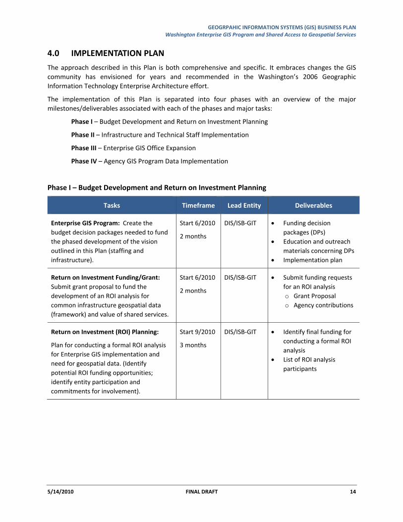
4.0 IMPLEMENTATION PLAN
The approach described in this Plan is both comprehensive and specific. It embraces changes the GIS community has envisioned for years and recommended in the Washington’s 2006 Geographic Information Technology Enterprise Architecture effort.
The implementation of this Plan is separated into four phases with an overview of the major milestones/deliverables associated with each of the phases and major tasks:
Phase I – Budget Development and Return on Investment Planning
Phase II – Infrastructure and Technical Staff Implementation
Phase III – Enterprise GIS Office Expansion
Phase IV – Agency GIS Program Data Implementation
Phase I – Budget Development and Return on Investment Planning
Tasks Timeframe Lead Entity Deliverables
Enterprise GIS Program: Create the budget decision packages needed to fund the phased development of the vision outlined in this Plan (staffing and infrastructure).
Start 6/2010
2 months
DIS/ISB‐GIT • Funding decision packages (DPs)
• Education and outreach materials concerning DPs
• Implementation plan
Return on Investment Funding/Grant: Submit grant proposal to fund the development of an ROI analysis for common infrastructure geospatial data (framework) and value of shared services.
Start 6/2010
2 months
DIS/ISB‐GIT • Submit funding requests for an ROI analysis o Grant Proposal o Agency contributions
Return on Investment (ROI) Planning:
Plan for conducting a formal ROI analysis for Enterprise GIS implementation and need for geospatial data. (Identify potential ROI funding opportunities; identify entity participation and commitments for involvement).
Start 9/2010
3 months
DIS/ISB‐GIT • Identify final funding for conducting a formal ROI analysis
• List of ROI analysis participants
GEOGRPAHIC INFORMATION SYSTEMS (GIS) BUSINESS PLAN Washington Enterprise GIS Program and Shared Access to Geospatial Services
5/14/2010 FINAL DRAFT 15
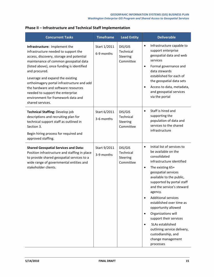
Phase II – Infrastructure and Technical Staff Implementation
Concurrent Tasks Timeframe Lead Entity Deliverable
Infrastructure: Implement the infrastructure needed to support the access, discovery, storage and potential maintenance of common geospatial data (listed above), once funding is identified and procured.
Leverage and expand the existing orthoimagery portal infrastructure and add the hardware and software resources needed to support the enterprise environment for framework data and shared services.
Start 1/2011
6‐9 months
DIS/GIS Technical Steering Committee
• Infrastructure capable to support enterprise geospatial data and web services
• Formal governance and data stewards established for each of the geospatial data sets
• Access to data, metadata, and geospatial services via the portal
Technical Staffing: Develop job descriptions and recruiting plan for technical support staff as outlined in Section 3.
Begin hiring process for required and approved staffing.
Start 6/2011
3‐6 months
DIS/GIS Technical Steering Committee
• Staff is hired and supporting the population of data and services to the shared infrastructure
Shared Geospatial Services and Data: Position infrastructure and staffing in place to provide shared geospatial services to a wide range of governmental entities and stakeholder clients.
Start 9/2011
3‐9 months
DIS/GIS Technical Steering Committee
• Initial list of services to be available on the consolidated infrastructure identified
• The existing 65+ geospatial services available to the public, supported by portal staff and the service’s steward agency.
• Additional services established over time as opportunity allowed
• Organizations will support their services
• SLAs established outlining service delivery, custodianship, and change management processes
GEOGRPAHIC INFORMATION SYSTEMS (GIS) BUSINESS PLAN Washington Enterprise GIS Program and Shared Access to Geospatial Services
5/14/2010 FINAL DRAFT 16
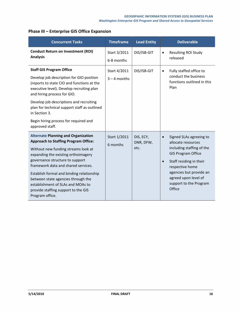
Phase III – Enterprise GIS Office Expansion
Concurrent Tasks Timeframe Lead Entity Deliverable
Conduct Return on Investment (ROI) Analysis
Start 3/2011
6‐8 months
DIS/ISB‐GIT • Resulting ROI Study released
Staff GIS Program Office
Develop job description for GIO position (reports to state CIO and functions at the executive level). Develop recruiting plan and hiring process for GIO.
Develop job descriptions and recruiting plan for technical support staff as outlined in Section 3.
Begin hiring process for required and approved staff.
Start 4/2011
3 – 4 months
DIS/ISB‐GIT • Fully staffed office to conduct the business functions outlined in this Plan
Alternate Planning and Organization Approach to Staffing Program Office:
Without new funding streams look at expanding the existing orthoimagery governance structure to support framework data and shared services.
Establish formal and binding relationship between state agencies through the establishment of SLAs and MOAs to provide staffing support to the GIS Program office.
Start 1/2011
6 months
DIS, ECY, DNR, DFW, etc.
• Signed SLAs agreeing to allocate resources including staffing of the GIS Program Office
• Staff residing in their respective home agencies but provide an agreed upon level of support to the Program Office
GEOGRPAHIC INFORMATION SYSTEMS (GIS) BUSINESS PLAN Washington Enterprise GIS Program and Shared Access to Geospatial Services
5/14/2010 FINAL DRAFT 17
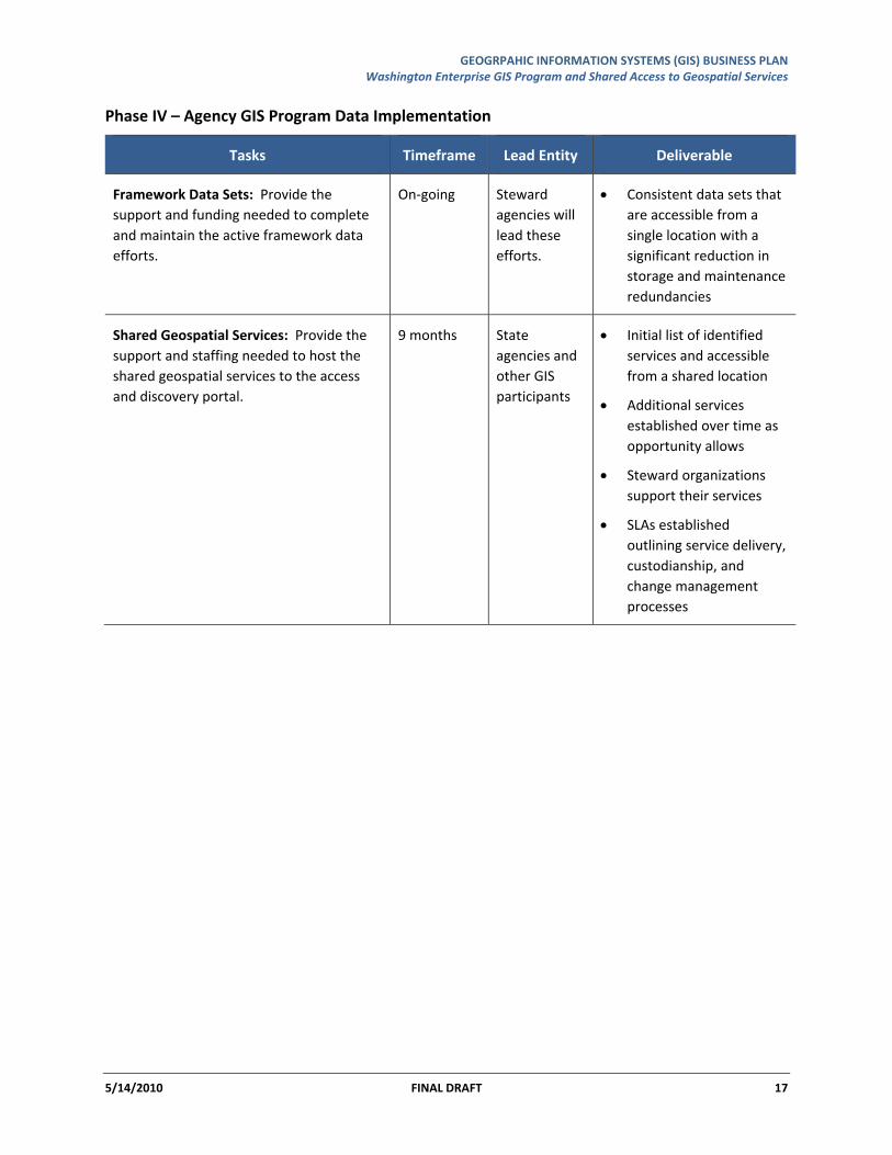
Phase IV – Agency GIS Program Data Implementation
Tasks Timeframe Lead Entity Deliverable
Framework Data Sets: Provide the support and funding needed to complete and maintain the active framework data efforts.
On‐going Steward agencies will lead these efforts.
• Consistent data sets that are accessible from a single location with a significant reduction in storage and maintenance redundancies
Shared Geospatial Services: Provide the support and staffing needed to host the shared geospatial services to the access and discovery portal.
9 months State agencies and other GIS participants
• Initial list of identified services and accessible from a shared location
• Additional services established over time as opportunity allows
• Steward organizations support their services
• SLAs established outlining service delivery, custodianship, and change management processes
GEOGRPAHIC INFORMATION SYSTEMS (GIS) BUSINESS PLAN Washington Enterprise GIS Program and Shared Access to Geospatial Services
5/14/2010 FINAL DRAFT 18
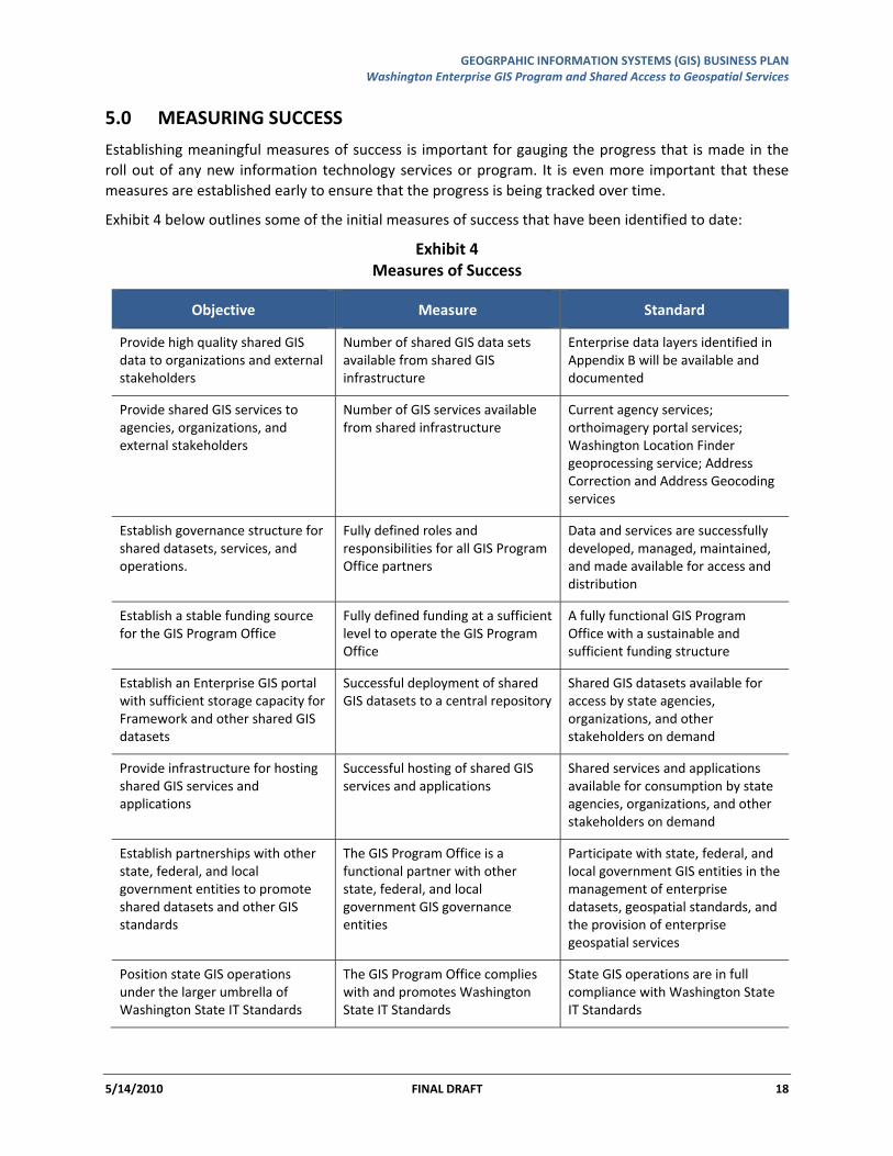
5.0 MEASURING SUCCESS
Establishing meaningful measures of success is important for gauging the progress that is made in the roll out of any new information technology services or program. It is even more important that these measures are established early to ensure that the progress is being tracked over time.
Exhibit 4 below outlines some of the initial measures of success that have been identified to date:
Exhibit 4 Measures of Success
Objective Measure Standard
Provide high quality shared GIS data to organizations and external stakeholders
Number of shared GIS data sets available from shared GIS infrastructure
Enterprise data layers identified in Appendix B will be available and documented
Provide shared GIS services to agencies, organizations, and external stakeholders
Number of GIS services available from shared infrastructure
Current agency services; orthoimagery portal services; Washington Location Finder geoprocessing service; Address Correction and Address Geocoding services
Establish governance structure for shared datasets, services, and operations.
Fully defined roles and responsibilities for all GIS Program Office partners
Data and services are successfully developed, managed, maintained, and made available for access and distribution
Establish a stable funding source for the GIS Program Office
Fully defined funding at a sufficient level to operate the GIS Program Office
A fully functional GIS Program Office with a sustainable and sufficient funding structure
Establish an Enterprise GIS portal with sufficient storage capacity for Framework and other shared GIS datasets
Successful deployment of shared GIS datasets to a central repository
Shared GIS datasets available for access by state agencies, organizations, and other stakeholders on demand
Provide infrastructure for hosting shared GIS services and applications
Successful hosting of shared GIS services and applications
Shared services and applications available for consumption by state agencies, organizations, and other stakeholders on demand
Establish partnerships with other state, federal, and local government entities to promote shared datasets and other GIS standards
The GIS Program Office is a functional partner with other state, federal, and local government GIS governance entities
Participate with state, federal, and local government GIS entities in the management of enterprise datasets, geospatial standards, and the provision of enterprise geospatial services
Position state GIS operations under the larger umbrella of Washington State IT Standards
The GIS Program Office complies with and promotes Washington State IT Standards
State GIS operations are in full compliance with Washington State IT Standards
GEOGRPAHIC INFORMATION SYSTEMS (GIS) BUSINESS PLAN Washington Enterprise GIS Program and Shared Access to Geospatial Services
5/14/2010 FINAL DRAFT 19
REFERENCE SOURCES
State of Washington 2008‐2014 State Strategic IT Plan
Geographic Information Systems Strategic Plan: Mapping Washington’s Future, 2010‐2014
Washington 2006 Geographic Information Technology Enterprise Architecture
Program for Transformed GIS in State of Minnesota
ACKNOWLEDGEMENTS
Principle Author:
Joy Paulus, Department of Information Services
Contributors:
David Jennings, Department of Health
Dan Saul, Department of Ecology
Tim Young, Department of Fish & Wildlife
Ian Von Essen, Spokane County
Dan Miller, Department of Military
George Alvarado, Department of Revenue
Kerry Brooks, Washington State University
Tom Carlson, US Geological Survey
Alan Smith, Department of Transportation
Matthieu Denuelle, ESRI
Teresa Mathiesen, City of Ellensburg
Deborah Naslund, Department of Natural Resources
Ron Holeman, Department of Natural Resources
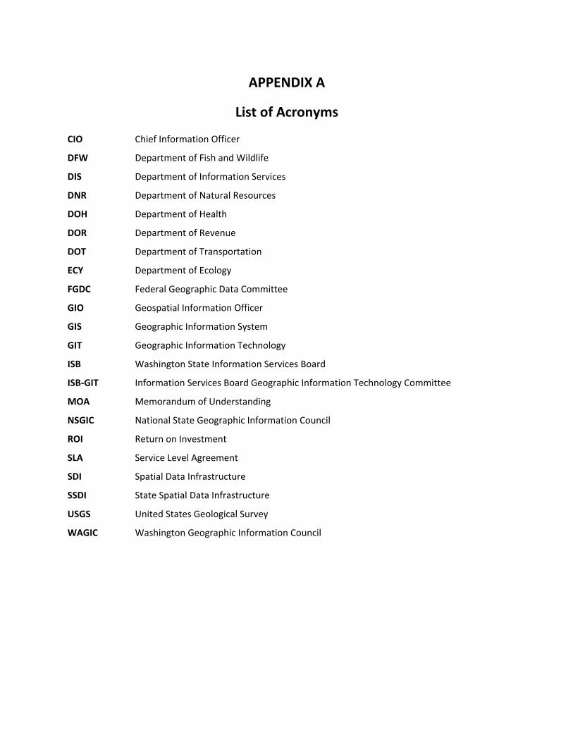
APPENDIX A
List of Acronyms
CIO Chief Information Officer
DFW Department of Fish and Wildlife
DIS Department of Information Services
DNR Department of Natural Resources
DOH Department of Health
DOR Department of Revenue
DOT Department of Transportation
ECY Department of Ecology
FGDC Federal Geographic Data Committee
GIO Geospatial Information Officer
GIS Geographic Information System
GIT Geographic Information Technology
ISB Washington State Information Services Board
ISB‐GIT Information Services Board Geographic Information Technology Committee
MOA Memorandum of Understanding
NSGIC National State Geographic Information Council
ROI Return on Investment
SLA Service Level Agreement
SDI Spatial Data Infrastructure
SSDI State Spatial Data Infrastructure
USGS United States Geological Survey
WAGIC Washington Geographic Information Council
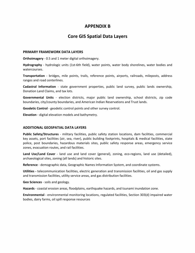
APPENDIX B
Core GIS Spatial Data Layers
PRIMARY FRAMEWORK DATA LAYERS
Orthoimagery ‐ 0.5 and 1 meter digital orthoimagery.
Hydrography ‐ hydrologic units (1st‐6th field), water points, water body shorelines, water bodies and watercourses.
Transportation ‐ bridges, mile points, trails, reference points, airports, railroads, mileposts, address ranges and road centerlines.
Cadastral Information ‐ state government properties, public land survey, public lands ownership, Donation Land Claims, and tax lots.
Governmental Units ‐ election districts, major public land ownership, school districts, zip code boundaries, city/county boundaries, and American Indian Reservations and Trust lands.
Geodetic Control ‐ geodetic control points and other survey control.
Elevation ‐ digital elevation models and bathymetry.
ADDITIONAL GEOSPATIAL DATA LAYERS
Public Safety/Structures ‐ military facilities, public safety station locations, dam facilities, commercial key assets, port facilities (air, sea, river), public building footprints, hospitals & medical facilities, state police, post boundaries, hazardous materials sites, public safety response areas, emergency service zones, evacuation routes, and rail facilities.
Land Use/Land Cover ‐ land use and land cover (general), zoning, eco‐regions, land use (detailed), archaeological sites, zoning (all lands) and historic sites.
Reference ‐ demographic data, Geographic Names Information System, and coordinate systems.
Utilities ‐ telecommunication facilities, electric generation and transmission facilities, oil and gas supply and transmission facilities, utility service areas, and gas distribution facilities.
Geo Sciences ‐ soils and geology.
Hazards ‐ coastal erosion areas, floodplains, earthquake hazards, and tsunami inundation zone.
Environmental ‐ environmental monitoring locations, regulated facilities, Section 303(d) impaired water bodies, dairy farms, oil spill response resources