Embed Size (px)
Citation preview

Hancock Wind Project MDEP NRPA/Site Location of Development Combined Application
SECTION 1: PROJECT DESCRIPTION
1-1
1.0 PROJECT DESCRIPTION
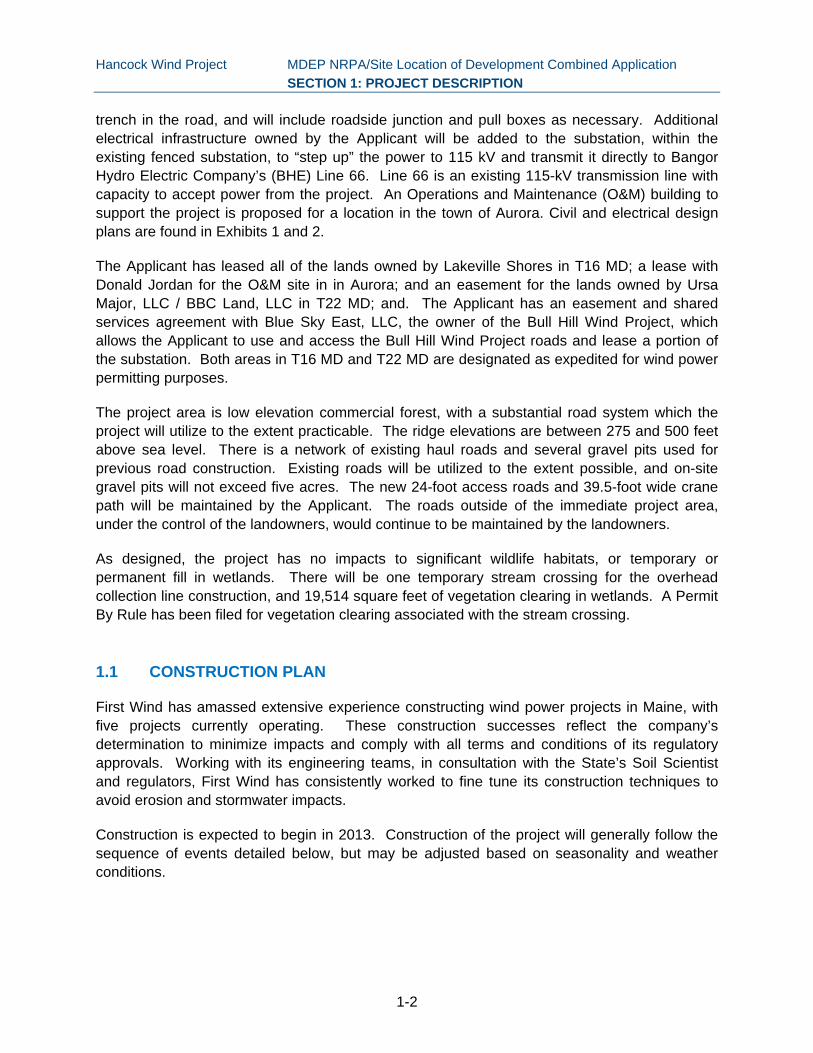
The Hancock Wind Project is an 18 turbine wind power project proposed by Hancock Wind, LLC, a wholly owned subsidiary of First Wind, (Applicant), for Schoppe Ridge in T22 MD and an unnamed ridge in T16 MD, both in Hancock County (see Figure 1). The proposed turbines will be one of two types: Vestas V112 or Siemens 3.0-113 machines, each with a 3.0-megawatt (MW) rated power. The Vestas turbines would be on a 94-meter tower and have 112-meter rotor diameter, for a total height with the blade fully extended of 150 meters (492 feet). The Siemens turbines would be on a 99.5-meter tower and have a 113-meter rotor diameter, for a total height of 156 meters (512 feet). The project is designed so that either turbine type can be accommodated.
The project also will include up to two permanent meteorological (met) towers that will not exceed 105 meters (344 feet). Three potential locations are shown on the project plans; only those locations where a permanent tower will be installed will be cleared. During construction, up to three new temporary met towers, up to 105 meters tall, will be placed in turbine pad locations before the turbines are erected. All temporary met towers in turbine pad locations will be removed prior to commercial operation.
The applicant has proposed to use a radar-assisted lighting system. This is the second project in Maine to propose this type of lighting system, and it is designed to essentially eliminate the effects of turbine nighttime lighting. These systems permit wind turbine obstruction lights to remain off at all times unless an aircraft is operating in the vicinity of the wind farm, thus greatly reducing the time that nighttime lighting would be visible.
Use of the systems described above for commercial wind projects has not yet been approved by the FAA. The FAA has drafted an Advisory Circular (“AC”) that details the standards that such a system must meet in order to be used. Following FAA approval, and assuming commercial availability, Hancock will install a radar-assisted lighting system that will allow the required nighttime lighting for turbines and permanent met towers to remain off except when aircraft are in the vicinity of the Project per the FAA standards. Hancock will install the technology as soon as it obtains the necessary approvals from FAA and is able to contract with vendors for installation of the technology.
Hancock will install traditional lighting if FAA approval is not complete at the time of project construction, and retrofit the Hancock project once FAA approval is obtained and the systems are commercially available. Consistent with FAA safety requirements, Hancock will retain the ability to keep the turbine lighting on at night if the radar-assisted system malfunctions or is being maintained or repaired.
The power from each turbine will be collected in approximately 10.2 miles of underground and 1.5 miles of above ground 34.5-kilovolt (kV) collection lines and will flow to the existing Bull Hill Wind Project substation location. The underground portion of the collector system will run in a
Hancock Wind Project MDEP NRPA/Site Location of Development Combined Application
SECTION 1: PROJECT DESCRIPTION
1-2
trench in the road, and will include roadside junction and pull boxes as necessary. Additional electrical infrastructure owned by the Applicant will be added to the substation, within the existing fenced substation, to “step up” the power to 115 kV and transmit it directly to Bangor Hydro Electric Company’s (BHE) Line 66. Line 66 is an existing 115-kV transmission line with capacity to accept power from the project. An Operations and Maintenance (O&M) building to support the project is proposed for a location in the town of Aurora. Civil and electrical design plans are found in Exhibits 1 and 2.
The Applicant has leased all of the lands owned by Lakeville Shores in T16 MD; a lease with Donald Jordan for the O&M site in in Aurora; and an easement for the lands owned by Ursa Major, LLC / BBC Land, LLC in T22 MD; and. The Applicant has an easement and shared services agreement with Blue Sky East, LLC, the owner of the Bull Hill Wind Project, which allows the Applicant to use and access the Bull Hill Wind Project roads and lease a portion of the substation. Both areas in T16 MD and T22 MD are designated as expedited for wind power permitting purposes.
The project area is low elevation commercial forest, with a substantial road system which the project will utilize to the extent practicable. The ridge elevations are between 275 and 500 feet above sea level. There is a network of existing haul roads and several gravel pits used for previous road construction. Existing roads will be utilized to the extent possible, and on-site gravel pits will not exceed five acres. The new 24-foot access roads and 39.5-foot wide crane path will be maintained by the Applicant. The roads outside of the immediate project area, under the control of the landowners, would continue to be maintained by the landowners.
As designed, the project has no impacts to significant wildlife habitats, or temporary or permanent fill in wetlands. There will be one temporary stream crossing for the overhead collection line construction, and 19,514 square feet of vegetation clearing in wetlands. A Permit By Rule has been filed for vegetation clearing associated with the stream crossing.
1.1 CONSTRUCTION PLAN
First Wind has amassed extensive experience constructing wind power projects in Maine, with five projects currently operating. These construction successes reflect the company’s determination to minimize impacts and comply with all terms and conditions of its regulatory approvals. Working with its engineering teams, in consultation with the State’s Soil Scientist and regulators, First Wind has consistently worked to fine tune its construction techniques to avoid erosion and stormwater impacts.
Construction is expected to begin in 2013. Construction of the project will generally follow the sequence of events detailed below, but may be adjusted based on seasonality and weather conditions.

Hancock Wind Project MDEP NRPA/Site Location of Development Combined Application
SECTION 1: PROJECT DESCRIPTION
1-3
Construction Schedule
Task Duration
Erection of temporary and permanent met towers Week 1 - Week 4
Preliminary layout and staking of new road segments, turbine clearings, and laydown areas
Week 4 - Week 8
Installation of erosion control measures in areas to be disturbed Week 9 - Week 13
Clearing for roads, collection system, turbines, and laydown areas Week 12 - Week 16
Grubbing and initial grading for roads, turbine and laydown areas Week 16 - Week 24
Underground trench/conduit work Week 22 - Week 36
Blasting as necessary and on-site stockpiling of reusable blasted bedrock Week 16 - Week 30
Hauling and stockpiling of aggregate from local borrow pits Week 24 - Week 36
Final grading for roads and turbine areas Week 30 - Week 38
Construction of turbine foundations and substation transformer pad Week 24 - Week 38
Removal of temporary met towers Week 20 –Week 45
Turbine delivery, assembly of rotors, tower erection, lifting of nacelles and rotor assemblies, construction of above ground and underground collection system, permanent met towers
Week 32 - Week 40
Installation of transformers, initial activation of turbines Week 32 - Week 36
Commissioning and testing of wind turbine generators and electrical interconnections
Week 40 - Week 46
Removal of temporary erosion and sedimentation control materials upon final site stabilization and reseeding.
Week 46 - Week 50
Start of commercial operations Week 50

"J
"J
"J
EASTBROOK
OSBORN
T22 MD BPP
T16 MD BPP
Sand Beach Rd
Hemlock Way
Birch Rd
Balsam Dr
Spruc
e Way
Landing Rd
Spec Pond Rd
Pine Dr
Loggin Dr
Kingman
Beach Rd
Smelt Dr
Loop
Rd
S Spe
ctacle
Pond
Rd
Spectacle Pond Rd
Grandview Dr
Bull Hill Rd
Rocky Pond Rd
Schoppe Ridge Rd
1
23
67
4
13
8
14
5
9
10
1112
17
18
16
15
Stantec Consulting Services Inc.30 Park DriveTopsham, ME USA04086Phone (207) 729-1199Fax: (207) 729-2715www.stantec.com
0 2,000
Feet
Figure No.
Client/Project
Title
Legend
Proposed Turbine Layout"J Proposed Permanent MET Tower
Town Boundary
Proposed Above Ground CollectorProposed Underground CollectorProposed Edge of Gravel
Hancock Wind Project
O&M Facility
OP9
ST179
Aurora
OsbornMariaville
Amherst
T22 MD BPP
T16 MD BPP
T28 MD BPPBeddington
195600763
00763_01_Location11x17.mxd
Hancock Wind, LLCHancock Wind ProjectT16 MD & T22 MD, Maine
1
Project Location Map1/10/2013