Embed Size (px)
Citation preview
§¦95
§¦95
«¬55
«¬55
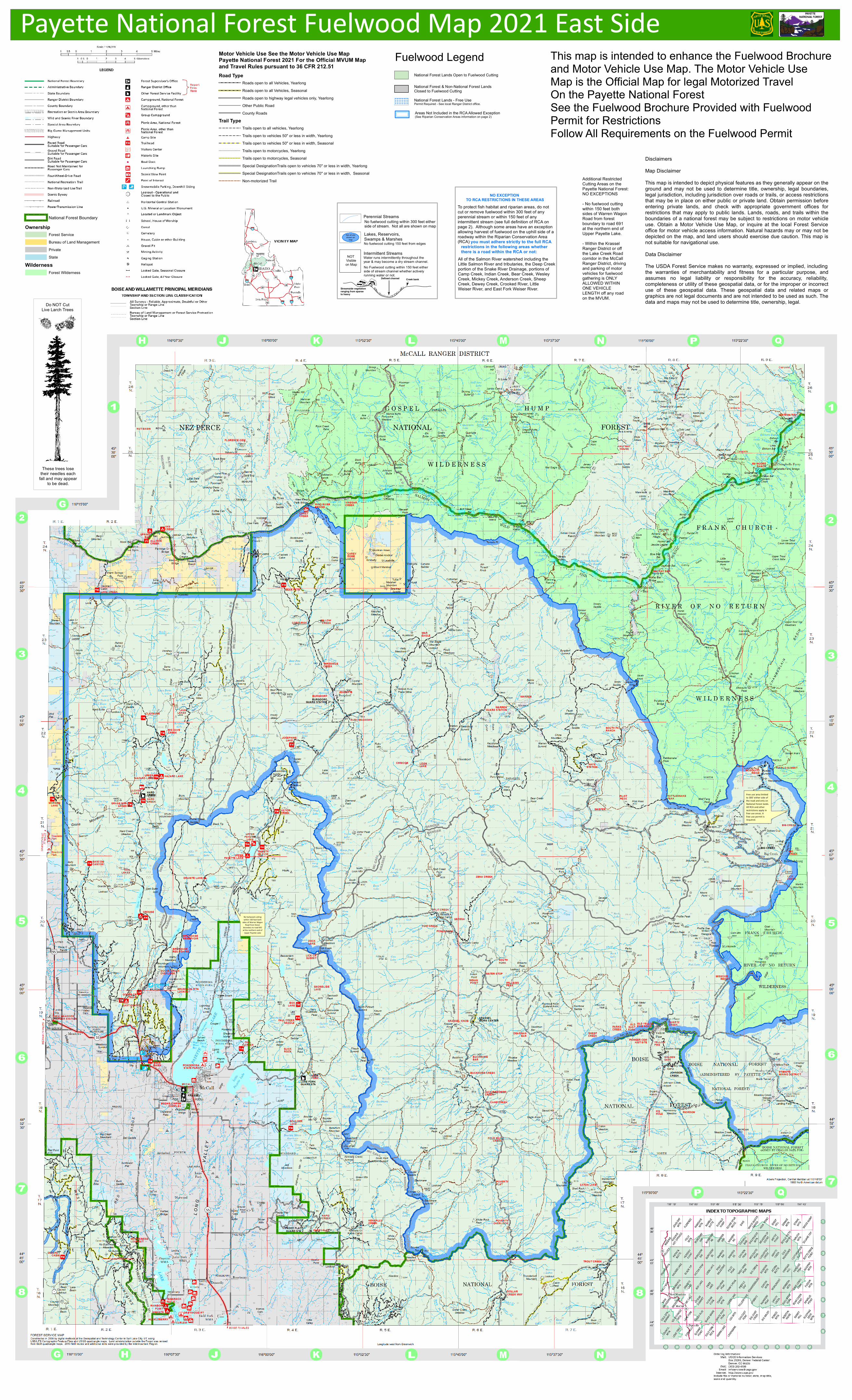
No fuelwood cuttingwithin 150 feet both
sides of Warren WagonRoad from forest
boundary to road 691at the northern end of
Upper Payette Lake
Free use area limitedto 300' either side ofthe road and only onNational Forest lands.All RCA and otherrestrictions apply infree use areas. Afree use permit isrequired.
Water runs intermittently throughout theyear & may become a dry stream channel.No Fuelwood cutting within 150 feet eitherside of stream channel whether activelyrunning water or not.
Perennial StreamsNo fuelwood cutting within 300 feet eitherside of stream. Not all are shown on map
Intermittent Streams
Lakes, Reservoirs, Swamps & MarshesNo fuelwood cutting 150 feet from edges
NOT Visibleon Map
Not all areshown on
map
All of the Salmon River watershed including theLittle Salmon River and tributaries, the Deep Creekportion of the Snake River Drainage, portions ofCamp Creek, Indian Creek, Bear Creek, WesleyCreek, Mickey Creek, Anderson Creek, SheepCreek, Dewey Creek, Crooked River, LittleWeiser River, and East Fork Weiser River.
To protect fish habitat and riparian areas, do notcut or remove fuelwood within 300 feet of anyperennial stream or within 150 feet of anyintermittent stream (see full definition of RCA onpage 2). Although some areas have an exceptionallowing harvest of fuelwood on the uphill side of a roadway within the Riparian Conservation Area(RCA)
NO EXCEPTION TO RCA RESTRICTIONS IN THESE AREAS
you must adhere strictly to the full RCArestrictions in the following areas whether there is a road within the RCA or not:
This map is intended to enhance the Fuelwood Brochureand Motor Vehicle Use Map. The Motor Vehicle UseMap is the Official Map for legal Motorized TravelOn the Payette National ForestSee the Fuelwood Brochure Provided with FuelwoodPermit for RestrictionsFollow All Requirements on the Fuelwood Permit
DisclaimersMap DisclaimerThis map is intended to depict physical features as they generally appear on theground and may not be used to determine title, ownership, legal boundaries,legal jurisdiction, including jurisdiction over roads or trails, or access restrictionsthat may be in place on either public or private land. Obtain permission beforeentering private lands, and check with appropriate government offices forrestrictions that may apply to public lands. Lands, roads, and trails within theboundaries of a national forest may be subject to restrictions on motor vehicleuse. Obtain a Motor Vehicle Use Map, or inquire at the local Forest Serviceoffice for motor vehicle access information. Natural hazards may or may not bedepicted on the map, and land users should exercise due caution. This map isnot suitable for navigational use.Data DisclaimerThe USDA Forest Service makes no warranty, expressed or implied, includingthe warranties of merchantability and fitness for a particular purpose, andassumes no legal liability or responsibility for the accuracy, reliability,completeness or utility of these geospatial data, or for the improper or incorrectuse of these geospatial data. These geospatial data and related maps orgraphics are not legal documents and are not intended to be used as such. Thedata and maps may not be used to determine title, ownership, legal.
Additional Restricted Cutting Areas on thePayette National Forest:NO EXCEPTIONS - No fuelwood cuttingwithin 150 feet bothsides of Warren WagonRoad from forestboundary to road 691at the northern end ofUpper Payette Lake.- Within the Krassel Ranger District or offthe Lake Creek Roadcorridor in the McCall Ranger District, drivingand parking of motorvehicles for fuelwood gathering is ONLY ALLOWED WITHINONE VEHICLELENGTH off any roadon the MVUM.
Payette National Forest Fuelwood Map 2021 East Side
OwnershipForest ServiceBureau of Land ManagementPrivateState
WildernessForest Wilderness
National Forest Boundary
National Forest Lands Open to Fuelwood Cutting
National Forest & Non-National Forest LandsClosed to Fuelwood CuttingNational Forest Lands - Free UsePermit Required - See local Ranger District office.
Areas Not Included in the RCA Allowed Exception(See Riparian Conservation Areas information on page 2)
! ! ! ! ! ! ! ! !
! ! ! ! ! ! ! ! !
! ! ! ! ! ! ! ! !
! ! ! ! ! ! ! ! !
! ! ! ! ! ! ! ! !
Fuelwood Legend
Do NOT CutLive Larch Trees
These trees losetheir needles each
fall and may appearto be dead.
Motor Vehicle Use See the Motor Vehicle Use MapPayette National Forest 2021 For the Official MVUM Map and Travel Rules pursuant to 36 CFR 212.51Road Type
Roads open to all Vehicles, YearlongRoads open to all Vehicles, SeasonalRoads open to highway legal vehicles only, YearlongOther Public RoadCounty Roads
Trail TypeTrails open to all vehicles, YearlongTrails open to vehicles 50" or less in width, YearlongTrails open to vehicles 50" or less in width, Seasonal
! ! ! ! ! ! ! ! ! ! ! ! ! ! ! ! ! ! ! ! ! ! ! ! ! Trails open to motorcycles, Yearlong! ! ! ! ! ! ! ! ! ! ! ! ! ! ! ! ! ! ! ! ! ! ! ! ! Trails open to motorcycles, Seasonal
Special DesignationTrails open to vehicles 70" or less in width, YearlongSpecial DesignationTrails open to vehicles 70" or less in width, SeasonalNon-motorized Trail