Embed Size (px)
Citation preview
Paul Eastwood, Stuart Rogers, Carla Houghton, Craig Mills, and John Aldridge
Centre for Environment, Fisheries and Aquaculture Science (Cefas)Lowestoft, UK
Assessment of Pressure from Human Activities on Marine Landscapes
UK Workshop on the project ‘Mapping European Seabed Habitats (MESH)’19 October 2006, City Conference Centre, London
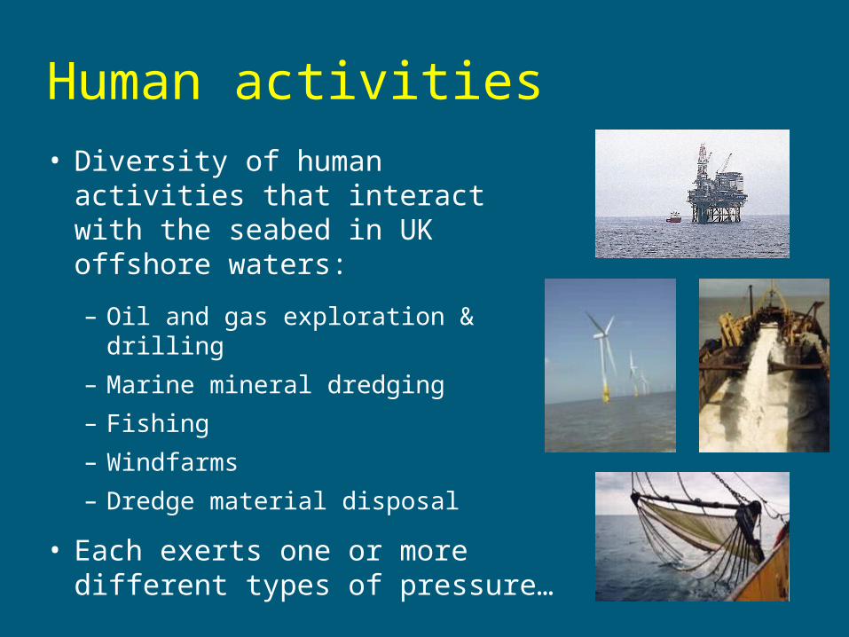
Human activities
• Diversity of human activities that interact with the seabed in UK offshore waters:
– Oil and gas exploration & drilling
– Marine mineral dredging
– Fishing
– Windfarms
– Dredge material disposal
• Each exerts one or more different types of pressure…
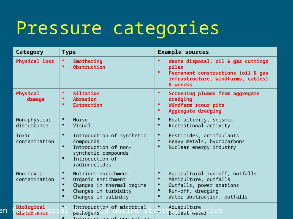
Pressure categoriesCategory Type Example sources
Physical loss Smothering Obstruction
Waste disposal, oil & gas cuttings piles Permanent constructions (oil & gas
infrastructure, windfarms, cables) & wrecks
Physical damage Siltation Abrasion Extraction
Screening plumes from aggregate dredging Windfarm scour pits Aggregate dredging
Non-physical disturbance
Noise Visual
Boat activity, seismic Recreational activity
Toxic contamination
Introduction of synthetic compounds Introduction of non-synthetic
compounds Introduction of radionuclides
Pesticides, antifoulants Heavy metals, hydrocarbons Nuclear energy industry
Non-toxic contamination
Nutrient enrichment Organic enrichment Changes in thermal regime Changes in turbidity Changes in salinity
Agricultural run-off, outfalls Mariculture, outfalls Outfalls, power stations Run-off, dredging Water abstraction, outfalls
Biological disturbance
Introduction of microbial pathogens Introduction of non-native species
and translocations Selective extraction of species
Aquaculture Ballast water
Commercial fishing
Taken from proposal for a EU marine strategy directive
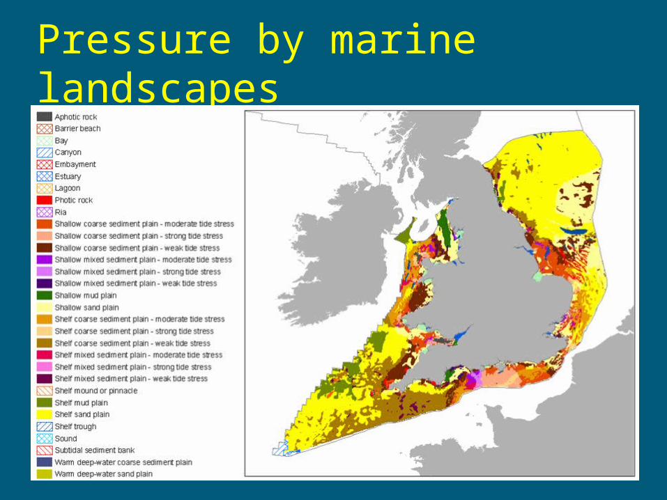
Pressure by marine landscapes
Pressure assessment
• Aim was to estimate direct pressure on the seabed from all major offshore human activities and the extent to which marine landscapes are affected
• Spatial extent = England and Wales waters
• Time period = 2004
• Measure of ‘pressure’ = spatial extent or ‘footprint’ of the activity
• Did not estimate intensity of pressure – presence/absence only
Methodology
1. Obtained spatial data for human activities
2. Where necessary, estimated location of activity
3. Where necessary, estimated spatial extent of associated pressure(s)
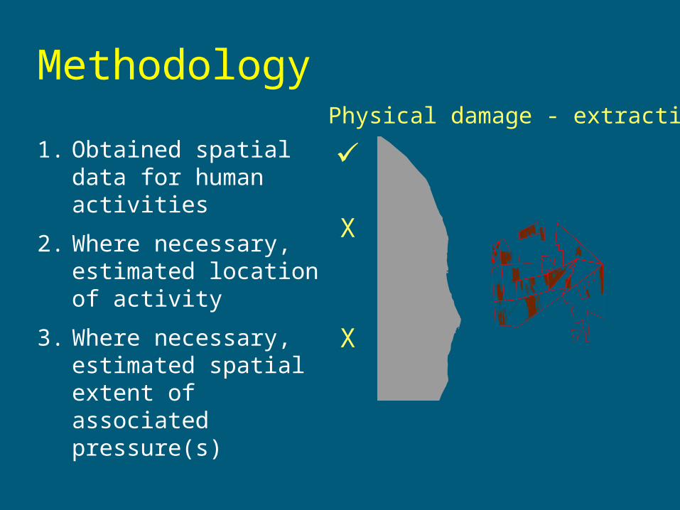
MethodologyPhysical damage - extraction
X
X
1. Obtained spatial data for human activities
2. Where necessary, estimated location of activity
3. Where necessary, estimated spatial extent of associated pressure(s)
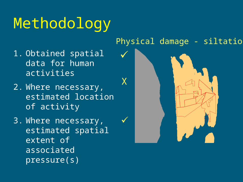
Methodology
1. Obtained spatial data for human activities
2. Where necessary, estimated location of activity
3. Where necessary, estimated spatial extent of associated pressure(s)
X
Physical damage - siltation

Confidence rating
• Degree to which pressure estimates derived from georeferenced observations or estimates of location and/or extent
1 = estimated location and extent
2 = known location, estimated extent
3 = known location and extent
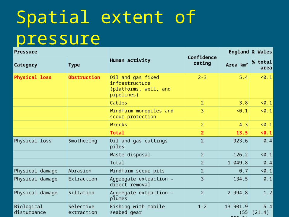
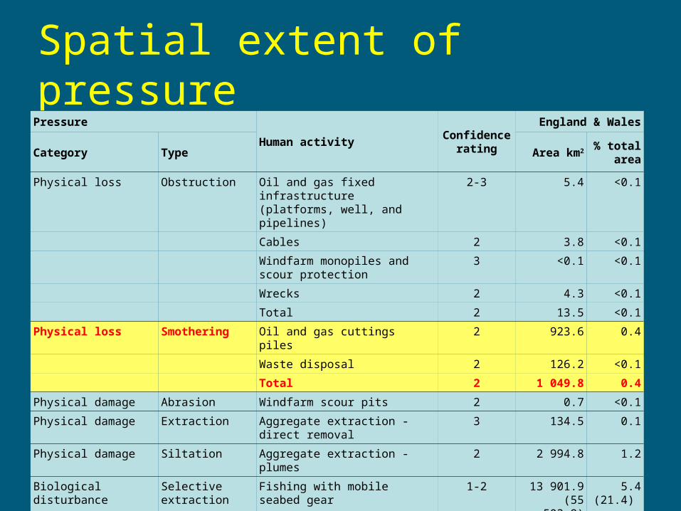
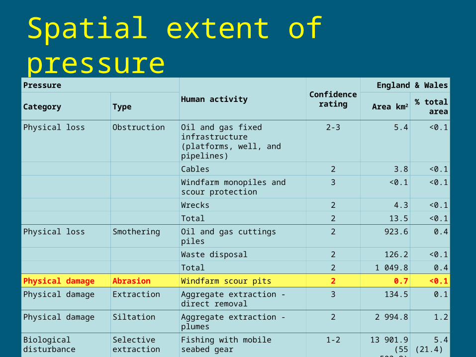
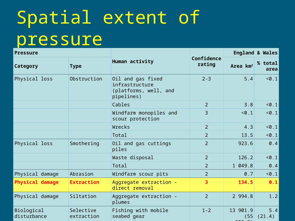
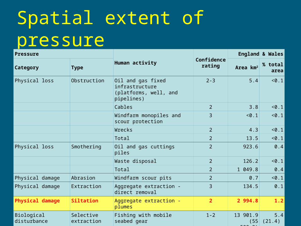
Spatial extent of pressurePressure
Human activityConfidence
rating
England & Wales
Category Type Area km2 % total area
Physical loss Obstruction Oil and gas fixed infrastructure (platforms, well, and pipelines)
2-3 5.4 <0.1
Cables 2 3.8 <0.1
Windfarm monopiles and scour protection
3 <0.1 <0.1
Wrecks 2 4.3 <0.1
Total 2 13.5 <0.1
Physical loss Smothering Oil and gas cuttings piles 2 923.6 0.4
Waste disposal 2 126.2 <0.1
Total 2 1 049.8 0.4
Physical damage Abrasion Windfarm scour pits 2 0.7 <0.1
Physical damage Extraction Aggregate extraction - direct removal
3 134.5 0.1
Physical damage Siltation Aggregate extraction - plumes 2 2 994.8 1.2
Biological disturbance Selective extraction
Fishing with mobile seabed gear 1-2 13 901.9(55 503.9)
5.4(21.4)
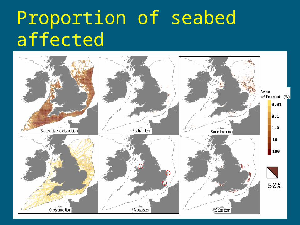
Proportion
0.0001
0.0005
0.001
0.005
0.01
0.05
0.1
0.5
1.0
Smothering
SiltationAbrasionObstruction
ExtractionSelective extraction
Proportion of seabed affected
Areaaffected (%)
0.01
0.1
1.0
10
100
50%
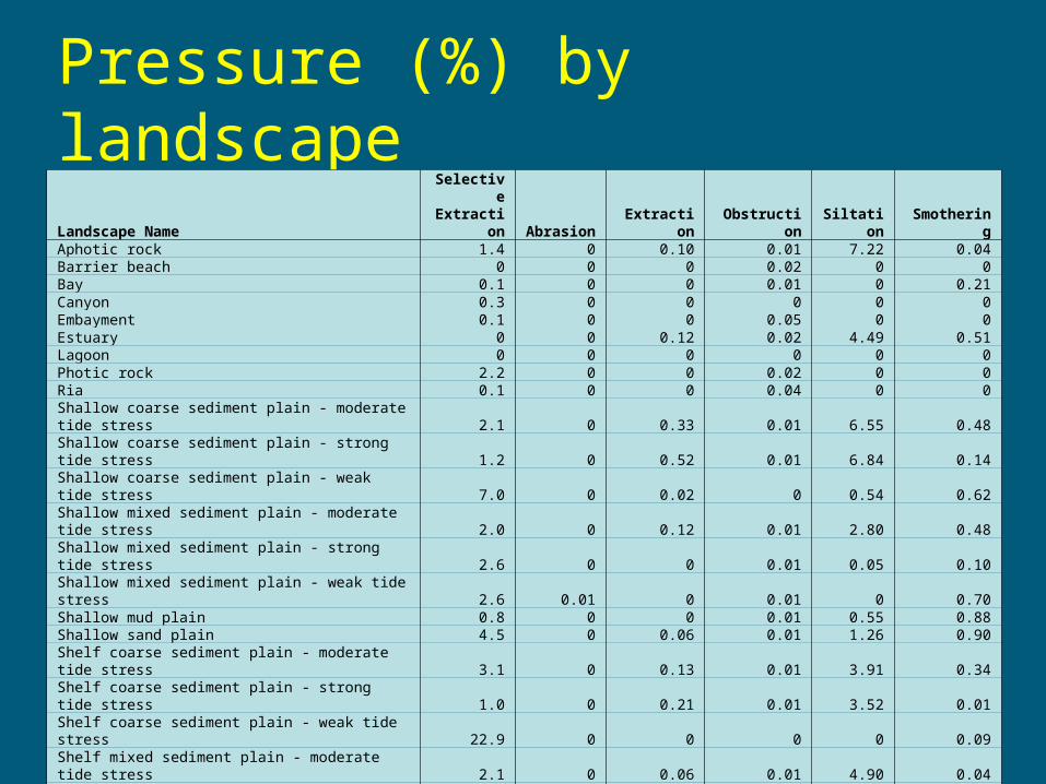
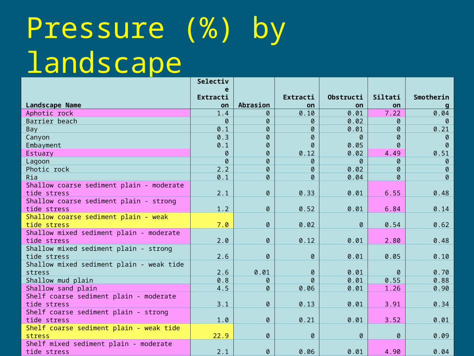
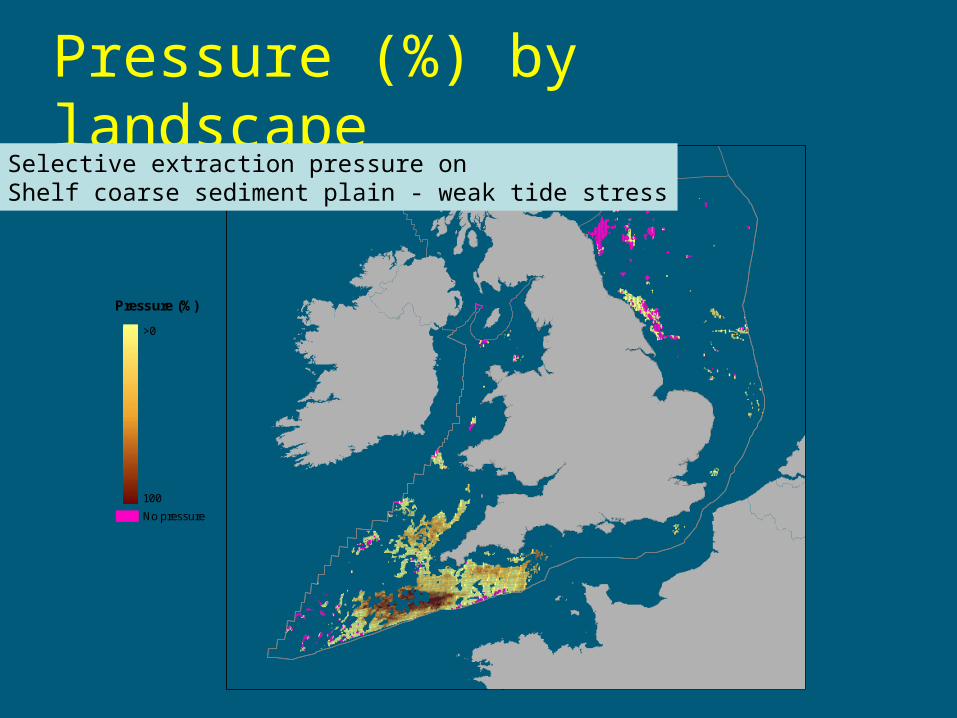
Pressure (%) by landscapeLandscape Name
Selective Extraction Abrasion Extraction Obstruction Siltation Smothering
Aphotic rock 1.4 0 0.10 0.01 7.22 0.04Barrier beach 0 0 0 0.02 0 0Bay 0.1 0 0 0.01 0 0.21Canyon 0.3 0 0 0 0 0Embayment 0.1 0 0 0.05 0 0Estuary 0 0 0.12 0.02 4.49 0.51Lagoon 0 0 0 0 0 0Photic rock 2.2 0 0 0.02 0 0Ria 0.1 0 0 0.04 0 0Shallow coarse sediment plain - moderate tide stress 2.1 0 0.33 0.01 6.55 0.48Shallow coarse sediment plain - strong tide stress 1.2 0 0.52 0.01 6.84 0.14Shallow coarse sediment plain - weak tide stress 7.0 0 0.02 0 0.54 0.62Shallow mixed sediment plain - moderate tide stress 2.0 0 0.12 0.01 2.80 0.48Shallow mixed sediment plain - strong tide stress 2.6 0 0 0.01 0.05 0.10Shallow mixed sediment plain - weak tide stress 2.6 0.01 0 0.01 0 0.70Shallow mud plain 0.8 0 0 0.01 0.55 0.88Shallow sand plain 4.5 0 0.06 0.01 1.26 0.90Shelf coarse sediment plain - moderate tide stress 3.1 0 0.13 0.01 3.91 0.34Shelf coarse sediment plain - strong tide stress 1.0 0 0.21 0.01 3.52 0.01Shelf coarse sediment plain - weak tide stress 22.9 0 0 0 0 0.09Shelf mixed sediment plain - moderate tide stress 2.1 0 0.06 0.01 4.90 0.04Shelf mixed sediment plain - strong tide stress 1.8 0 0 0 2.55 0.41Shelf mixed sediment plain - weak tide stress 8.0 0 0 0.01 0 0.27Shelf mound or pinnacle 0.7 0 0 0 0 0Shelf mud plain 2.6 0 0 0 0 0.09Shelf sand plain 5.3 0 0 0 0.19 0.34Shelf trough 2.8 0 0 0 0.30 1.11Sound 0 0 0 0.05 0 0Subtidal sediment bank 1.6 0 0 0 0.38 2.28Warm deep-water coarse sediment plain 1.2 0 0 0 0 0Warm deep-water sand plain 0.8 0 0 0 0 0
Total for E&W waters 5.4 <0.1 0.1 <0.1 1.2 0.4
Pressure (%) by landscape
Pressure (%)
>0
100
No pressure
Selective extraction pressure onShelf coarse sediment plain - weak tide stress
Summary
• Geospatial data for human activities can be used to estimate pressure on marine landscapes
• Understanding pressures by landscapes could help in:
– designing MPA networks
– setting management objectives
• Next steps:
– pressure intensity
– time series assessment