Embed Size (px)
Citation preview

PATIALA DISTRICT PUNJAB CENTRAL GROUND WATER BOARD
Ministry of Water Resources
Government of India
North Western Region
CHANDIGARH
2013

Contributors
G.P.Singh
Scientist - ‘B’
Prepared under supervision of
A.K. Bhatia
Regional Director
Our Vision
“Water Security through Ground water
Management”

GROUND WATER INFORMATION BOOKLET
PATIALA DISTRICT, PUNJAB
C O N T E N T S
DISTRICT AT A GLANCE
1.0 INTRODUCTION
2.0 RAINFALL & CLIMATE
3.0 GEOMORPHOLOGY AND SOILS
4.0 GROUND WATER SCENARIO
4.1 HYDROGEOLOGY
4.2 GROUND WATER RESOURCES
4.3 GROUND WATER QUALITY
4.4 STATUS OF GROUND WATER DEVELOPMENT
5.0 GROUND WATER MANAGEMENT
5.1 GROUND WATER DEVELOPMENT
5.2 WATER CONSERVATION AND ARTIFICIAL RECHARGE
6.0 GROUND WATER RELATED ISSUES AND PROBLEMS
7.0 AWARENESS & TRAINING ACTIVITY
8.0 AREAS NOTIFIED BY CGWB
9.0 RECOMMENDATIONS

PATIALA DISTRICT AT A GLANCE
Sl.No ITEMS Statistics
1. GENERAL INFORMATION
i. Geographical Area (sq. km.) 3218
ii. Administrative Divisions
Number of Tehsils 05- Patiala, Nabha,
Ghanaur, Rajpura and
Samana
Number of Blocks 08- Patiala, Nabha, Sanaur, Bhunerheri, Rajpura,
Ghanaur, Samana and
Patran Number of Panchayats -
Number of Villages 1084
iii. Population (As per 2011Census) 18,92,282
iv. Average Annual Rainfall (mm) 677
2. GEOMORPHOLOGY
Major physiographic Units Plain
Major Drainage Ghaggar River
3. LAND USE (Sq.km.)
a. Forest Area 120
b. Net area sown 2630
c. Cultivable area 2810
4. MAJOR SOIL TYPES Tropical arid brown and arid brown
5. AREA UNDER PRINCIPAL CROPS 5190 sq.km.
6. IRRIGATION BY DIFFERENT SOURCES
(Areas and Number Of Structures)
Dugwells -
Tubewells/Borewells 2570 sq.km (80607)
Tanks/ponds -
Canals 60 sq.km
Other sources -
Net Irrigated area 2630 sq.km.
Gross irrigated area 5177 sq.km.
7. NUMBERS OF GROUND WATER
MONITORING WELLS OF CGWB
No. of dug wells 09
No of Piezometers 04
8. PREDOMINANT GEOLOGICAL FORMATIONS Alluvium
9. HYDROGEOLOGY

*Major Water bearing formation Sand, Gravel
*(Pre-monsoon depth to water level ) 4.43- 20.62mbgl
*(Post-monsoon depth to water level ) 6.99 - 24.28mbgl
*Long term water level trend in 10 yrs 0.16m-1.07m ( Fall )
in m /yr 0.00 - 0.24 m. ( Rise )
10. GROUND WATER EXPLORATION BY CGWB
No. of wells drilled
EW 10
OW -
PZ 06
SH -
Depth range(m) 49-400
Discharge(liters per minutes) 2400-2680
Storativity (S) 1.95x10⁻³ -4.7x10⁻³
Transmissivity (m2/day) 154-9410
11. GROUND WATER QUALITY
Presence of Chemical constituents more than the
permissible limit
EC (micro mhos at 25oC) 667-4100
F (mg/l) 0.20-2.80
As (mg/l) 0.10 to 0.75
Fe (mg/l) 0.0002 to 0.0023
Type of water Na HCO3 & mixed type
12 DYNAMIC GROUND WATER RESOURCES(2009)-in MCM
Annual Replenishable Ground water Resources 1490.83
Net Annual Ground water Draft 2911.65
Projected Demand for Domestic and industrial 64.54
Uses upto 2025
Stage of Ground Water Development 195%
13 AWARENESS AND TRAINING ACTIVITY One Mass Awareness organized
at Patiala on 28th March 2003
14. EFFORTS OF ARTIFICIAL RECHARGE& RAIN Four pilot projects for artificial
WATER HARVESTING recharge to ground water and
one roof top rain water
harvesting.
15. GROUND WATER CONTROL AND REGULATION
Number of Over Exploited Blocks. 08
No. Critical Blocks -
No.of blocks notified 1
16 .MAJOR GROUND WATER PROBLEMS AND Ground water salinity, Water
ISSUES. level decline, High Fluoride

GROUND WATER INFORMATION BOOKLET PATIALA DISTRICT, PUNJAB.
1.0 INTRODUCTION
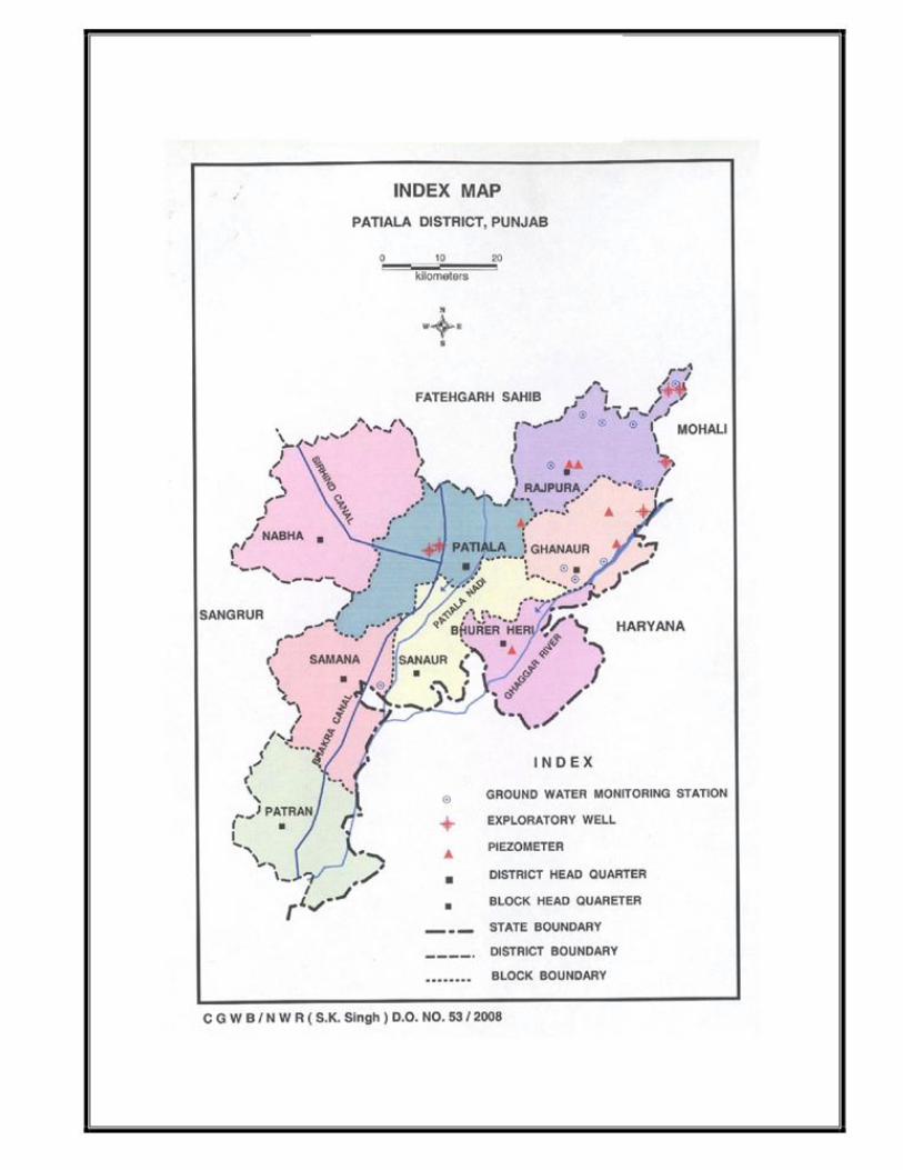
Patiala district of Punjab state lies between 29o 49’ 30o 40’ north
latitudes and 75o 58’ 76o 48’ east longitudes. Total geographical area of the
district is 3218 sq.km. The Patiala district is divided into five sub-divisions
(tehsils) namely Patiala, Nabha, Ghanaur, Rajpura and Samana comprising
eight-community development blocks viz. Patiala, nabha, Sanaur, Bhunerheri,
rajpura, ghanaur, samana and Patran for the purpose of administration .The
district headquarter, Patiala town falls in Patiala Tehsil.
2.0 RAINFALL &CLIMATE
The climate of Patiala district can be classified as tropical steppe, Semi-arid and
hot which is mainly dry with very hot summer and cold winter except during
monsoon. There are four seasons in a year. The hot weather season starts from
mid March to last week of the June followed by the south west monsoon which
lasts upto September. The transition period from September to October forms the
post monsoon season. The winter season starts late in November and remains
upto first week of March.
The normal monsoon and annual rainfall of the district is 547 mm and 677
mm , respectively which is unevenly distributed over the area 29 days.. The
south west monsoon, sets in from last week of June and withdraws in end of
September, contributing about 81% of annual rainfall. July and August are the
wettest months. Rest 19% rainfall is received during non-monsoon period in the
wake of western disturbances and thunderstorms. Generally rainfall in the district
increases from southwest to northeast. The mean minimum and maximum temperature in the area renges from
7.1o C to 40.4o C during January and May or June respectively.
3.0 GEOMORPHOLOGY AND SOIL TYPES
The district area is occupied by Indo-Gangetic alluvial plain and consists
of three types of region viz. the Upland plain, the Cho-infested Foothill Plain
and the Floodplain of the Ghaggar river. The elevation of land ranges from 240
to 278 m amsl. Due to arid climate, the soils are light coloured. Tropical arid
brown soils exist in the major parts of the district. Here soils are deficient in
nitrogen, phosphorus and potassium. In Patran and Samana blocks, soils are
arid brown soils occur. These are calcareous in nature and in most cases
kankar layers occur.
4.0 GROUND WATER SCENARIO
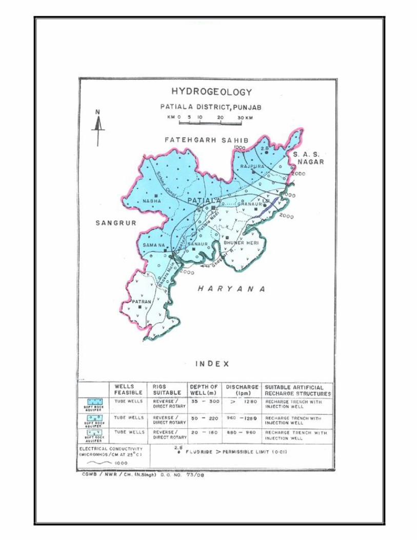
4.1 Hydrogeology
The district is occupied by Indo-Gangetic alluvial plain of Quaternary
age, and falls in Ghaggar basin. The ground water occurs in alluvium
formations comprising fine to coarse sand, which forms the potential aquifers.
In the shallow aquifer ( up to 50m) ground water occurs under unconfined/water
table conditions, where as in deeper aquifer, semi-confined/confined conditions
exist.
The traditional dugwells tapping the shallow aquifer are not in use and
most of them have been abandoned, however, this aquifer is being tapped by
thr hand pumps and shallow tube wells, which are widely used for domestic
purposes. The deep tube wells have been constructed by CGWB, which has
drilled 10 exploratory boreholes, 1 slim hole and 6 Piezometers to delineate and
determibne potential aquifer zones, evaluation of aquifer characteristics.The
deepest slim hole was drilled up to the depth of 308.30 at Dhappar ( 30o 31’00”
76o 48’24”). EW at Chamaru(Rajpura) Theri(Sanaur) Seel (Ghanaur)
Mallomajra(Patiala)Thuhi(Nabha) The permeable granular zones comprising fine to
mediumgrained
sand and occasionally coarse sand and gravel.Their lateral and vertical extent
is limited. The borehole data reveals that clay group of formations dominate
over the sand group in the district area.Ground water in the district occurs in the
alluvium under water table and semi confined to confined conditions.
The discharge of deep tube well in the area varies between 2400 and
2680 lpm. The transmissivity values ranges from 154 to 9410 m2/day and
storativity ranges from 1.95*10-3 to 4.7*10-3.
Water level behavior
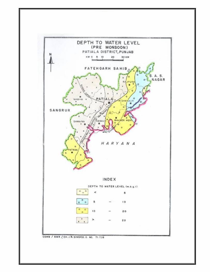
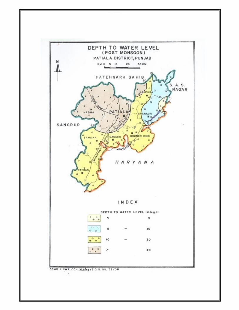
The depth to water level ranges from 4.43 to 20.62 m bgl during pre
monsoon period and 6.99 to 24.28 m bgl during post monsoon period. The
seasonal fluctuation varies from 0.03 to (-) 3.66 m in the area. The long-term
water levels trend indicates average fall of 0.50 m/year.The long term water level
trend is also showing little rise being 0.24 m/year around majauli, which
insignificant with respect to entire area. Ground water flow
The elevation of the water table in the district varies from 230 m to 300 m
above mean sea level.The highest elevation is in the northeastern part and the
lowest in the southwestern part and reflects the topographic gradients. The
hydraulic gradient in the northern eastern part is steep, whereas, in the
southwestern part, it is gentle. The The overall flow of ground water is from northeast to south-west direction.
4.2 Ground Water Resources
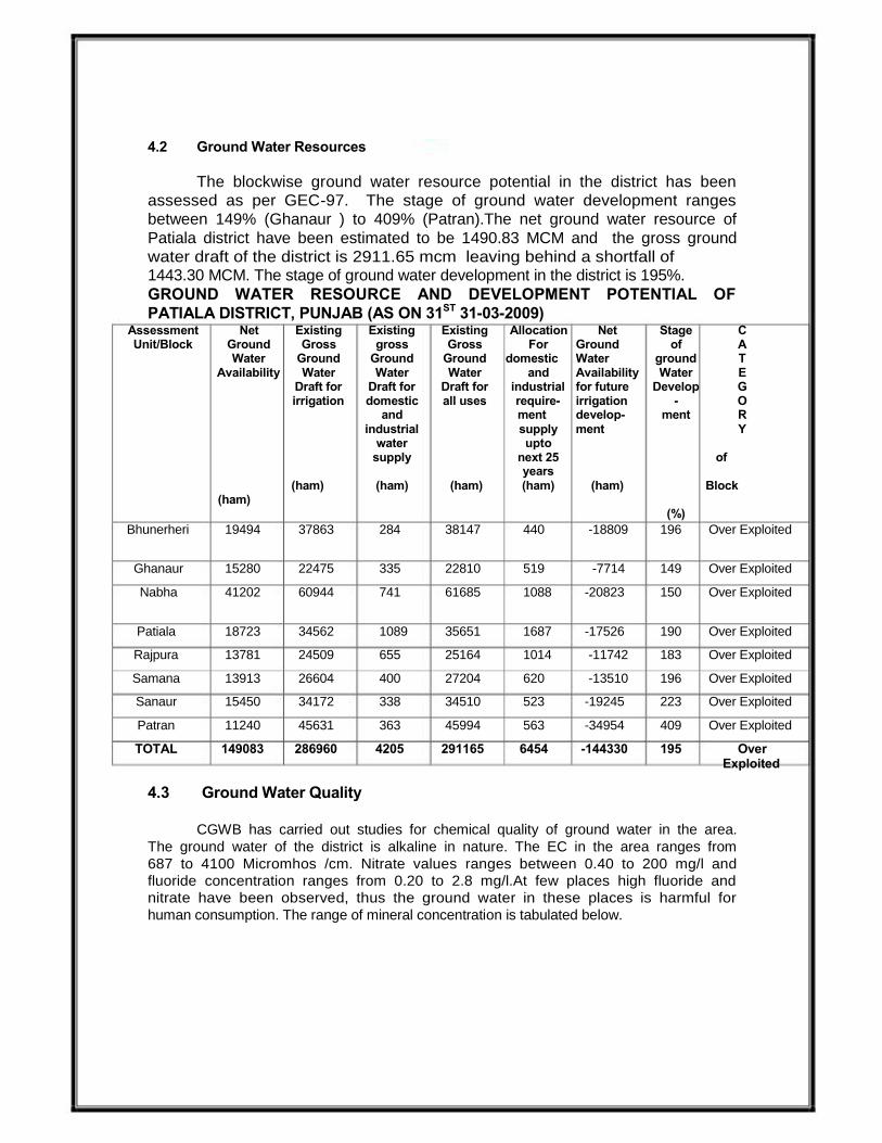
The blockwise ground water resource potential in the district has been
assessed as per GEC-97. The stage of ground water development ranges
between 149% (Ghanaur ) to 409% (Patran).The net ground water resource of
Patiala district have been estimated to be 1490.83 MCM and the gross ground
water draft of the district is 2911.65 mcm leaving behind a shortfall of 1443.30 MCM. The stage of ground water development in the district is 195%.
GROUND WATER RESOURCE AND DEVELOPMENT POTENTIAL OF
PATIALA DISTRICT, PUNJAB (AS ON 31ST 31-03-2009) Assessment Net Existing Existing Existing Allocation Net Stage C Unit/Block Ground Gross gross Gross For Ground of A
Water Ground Ground Ground domestic Water ground T Availability Water Water Water and Availability Water E
Draft for Draft for Draft for industrial for future Develop G irrigation domestic all uses require- irrigation - O
and ment develop- ment R industrial supply ment Y
water upto supply next 25 of
years (ham) (ham) (ham) (ham) (ham) Block
(ham) (%)
Bhunerheri 19494 37863 284 38147 440 -18809 196 Over Exploited
Ghanaur 15280 22475 335 22810 519 -7714 149 Over Exploited
Nabha 41202 60944 741 61685 1088 -20823 150 Over Exploited
Patiala 18723 34562 1089 35651 1687 -17526 190 Over Exploited
Rajpura 13781 24509 655 25164 1014 -11742 183 Over Exploited
Samana 13913 26604 400 27204 620 -13510 196 Over Exploited
Sanaur 15450 34172 338 34510 523 -19245 223 Over Exploited
Patran 11240 45631 363 45994 563 -34954 409 Over Exploited
TOTAL 149083 286960 4205 291165 6454 -144330 195 Over Exploited
4.3 Ground Water Quality
CGWB has carried out studies for chemical quality of ground water in the area.
The ground water of the district is alkaline in nature. The EC in the area ranges from
687 to 4100 Micromhos /cm. Nitrate values ranges between 0.40 to 200 mg/l and
fluoride concentration ranges from 0.20 to 2.8 mg/l.At few places high fluoride and
nitrate have been observed, thus the ground water in these places is harmful for
human consumption. The range of mineral concentration is tabulated below.


Constituents Minimum limit Maximum limit
pH 7.10 8.24
EC Micromhos /cm at 25 0C 687 4100
Alkalinity (mg/l) 195 810
CO3 “ Nil Nil
HCO3 “ 238 988
Cl “ 21 379
SO4 “ 37 1260
NO3 “ 0.40 200
F “ 0.44 2.8
Ca “ 12 130
Mg “ 1.2 81
Na “ 116 778
K “ 1.4 205
B “ 0.14 0.54
TH as CaCO3 “ 35 657
As “ 0.0002 0.0022
Fe “ 0.10 0.75
SAR 3.00 14.01
RSC -7.37 12.17
Type of water
The shallow ground water is of NaHCO3 type and mixed facies type of
water also occurs where EC increases in district.
Suitabilty of water
Ground water is potable and fit for drinking and domestic purposes, except at
few places, where high values of nitrates and fluoride is observed.
The suitability of ground water for irrigation purpose is calculated by SAR and
RSC values, which range between 3.00-14.01 and -7.37-12.17
respectively. The ground water in the area is C3 and C4 type from salinity point of
view and S1 and S2 type from solidity point of view; as such ground water is fit for
irrigation.
4.4 Status Of Ground Water Development
The drinking water supply is mainly through ground water in the district. The
short fall in water supply to towns, cities and villages is met with the installation
of hand pumps by public individually as spot and convenient source of water.
The shallow tube wells tap unconfined aquifer and depth varies from 20 to 70
m.The tube wells constructed by the municipal corporation and other agencies
have been constructed tapping deeper aquifer down to 100m. The shallow tube
wells irrigate about 2670 sq.km. area in the district. Most of these shallow tube
wells are cavity type and either run by diesel engines or electric motors. he
discharge of these shallow tube wells/cavity wells range 600 - 1000 lpm.

5.0 GROUND WATER MANAGEMENT STRATEGY
5.1 Ground Water Development
The present stage of ground water development varies from 149%
(Ghanaur ) to 409% (Patran). All the eight blocks of the area fall in Over
Exploited category. Hence, there is no scope of large-scale ground water
resource development in the area .However, the shallow ground water can be
exploited with caution through shallow tube wells ( Cavity Type). PVC pipes are
commonly used for constructing these tube wells. Drilling technique used for
boring the shallow wells is locally developed.
5.2 Water Conservation and Artificial Recharge
In Patiala district, 4 pilot projects for artificial recharge to ground water
were undertaken and same were completed successfully. These are namely (i). Pilot
project for Artificial Recharge from Choe No.1 of Bhakra Main line canal, near village
Dhanetha, Samana block ( 1999-2000), (ii) Pilot study for artificial recharge scheme
to ground water from Sirhind Choe, (2000 - 2001), Pilot study for artificial recharge to
ground water from Patiala Nadi (2001-2002) and Pilot study for artificial recharge to
ground water from Miranpur choe (2001-2002). One Scheme for artificial recharge to
roof top rain water harvesting for school buildings were undertaken in the area ( 2004-
2005).
6.0 GROUND WATER RELATED ISSUES & PROBLEMS
The major problem in respect of ground water in the district is the overall
decline in the water level.It is apprehended that the declining ground water
trend will further aggravate with installation of more tube wells. High fluoride
( F) content, more than the permissible limit of 1.5 mg/l, in shallow ground
water is observed at few places in the district, thus making the water harmful
(unfit) for human consumption. High values of nitrates, more than the
prescribed limit of 45 mg/l is also observed in shallow ground water at few
places in the area.
7.0 AWARENESS & TRAINING ACTIVITY
One Mass Awareness program on Rainwater Harvesting for artificial
recharge to ground water was organized at Patiala on 28th March 2003.

8.0 Areas Notified By CGWB/CGWA
Patran Block of Patiala District is notified
9.0 RECOMMENDATIONS
1. The dug wells traditionally used for the monitoring the water level in
the area are either dried or abandoned in major part of the area.So, it is
recommended to install shallow piezometers in Nabha, Patiala,
Sanaur, Samana, Bhuner heri and Patran blocks. 2. On the declining trend of ground water level a close watch be
maintained and water level should be measured at different places. For
this, 10 shallow ( 50 m) and 10 deep ( 200 m) piezometers 152 mm (6”)
dia. Should be constructed for regular monitoring of ground water
level.These piezometers should be uniformly distributed with the proper
provision of collection of water samples.
3. High fluoride areas can be mapped and the public be educated about
its harmful effect on human body. Small defluoridation plants can be
used and mixing of water can be practiced. 4. PVC pipe assembly may be used in case of shallow tube wells.
5. It is necessary to notify the entire district for registration of all ground
water abstraction structures and for the construction of any tube well,
prior permission should be sought from the Central Ground Water
Authority. 6. Mass awareness programme should be organized to educate the
people regarding consequences of mining of ground water and need for
its effective/economic use. Public awareness programme should be
arranged to make the people and industry aware about the
menace of ground water pollution and dwindling ground water
resources in the towns.
7. More canal should be laid for irrigation so that stress on ground water
can be reduced.
8. Cropping pattern in the area should be changed by growing low water consuming crops instead of paddy.
9. Improved irrigation practices should be followed in order to reduce
burden on irrigation water.