Embed Size (px)
Citation preview
क दरय भम जल बोडर
जल ससाधन नद वकास और गगा सरण मतरालय
भारत सरकार Central Ground Water Board
Ministry of Water Resources River Development and Ganga Rejuvenation
Government of India
Report on
AQUIFER MAPPING AND MANAGEMENT PLAN
Amritsar District Punjab
उर पिशचम तर चडीगढ़ North Western Region Chandigarh
AQ
MA
AM
CentralMinistry of Water Resou
AQUIFER MAPPING
amp
ANAGEMENT PLAN
AMRITSAR DISTRICT
PUNJAB
ntral Ground Water Board esources River Development and Ganga Rej
Government of India
2016
a Rejuvenation
CONTENTS
1 INTRODUCTION
2 DATA COLLECTION AND GENERATION
3 HYDROGEOLOGY
4 GROUND WATER RESOURCES
5 GROUND WATER ISSUES
6 AQUIFER MANAGEMENT PLAN
7 BLOCKWISE AQUIFER MAPS AND MANAGEMENT PLAN
i AJNALA BLOCK
ii CHOGAWAN BLOCK
iii HARSH CHINA BLOCK
iv JANDIALA BLOCK
v MAJITHA BLOCK
vi RAYYA BLOCK
vii TARSIKA BLOCK
viii VERKA BLOCK
8 CONCLUSION
LIST OF FIGURES
Fig 1 Base Map of Amritsar District
Fig 2 Location of CGWB PSTC WRED Private Wells
Fig 3 Validated Exploration Data of Amritsar District
Fig 4 Elevation Contour Map-Amritsar District
Fig 5 3Dimension Lithological Model-Amritsar District
Fig 6 3Dimension Lithological Fence of Amritsar District
Fig 7 3Dimension Aquifer model - Amritsar District
Fig 8 Cross sections of Aquifer Map of Amritsar District
Fig 9 Methodology for Resource Estimation in Unconfined and Confined Aquifer
System
Fig 10 Irrigation tube wells as per depth
Fig 11 Ground water trend versus rainfall
Fig 12 Long term ground water table variation
Fig 13 Irrigation tube wells as per depth
LIST OF TABLES
Table 1 Data availability of exploration wells in Amritsar district
Table 2 Summary of optimized exploration wells
Table 3 Aquifer Group depth and thickness ranges of Amritsar District
Table 4 Dynamic Ground Water Resource amp Development Potential (as on 31032013)
Table 5 Block wise in-storage groundwater resourcesndashunconfined(aquifer I)
Table 6 Block wise in-storage ground water resources - confined (aquifer II)
Table 7 Block wise in-storage ground water resources - confined (aquifer
IIIupto300m)
Table 8 Block wise total available ground water resources in aquifers up to 300m
depth
Table 9 Distribution of Tube wells according to ownerrsquos land holding size
Table 10 Distribution of Shallow Tube wells according to Depth
Table 11 Type of Ground Water Distribution Device
Table 12 Scope of quantitative impact on stage of development after applying various
management strategies
ANNEXURES
Annexure 1 Details of water quality analysis of the Amritsar District
AQUIFER MAPPING AND GROUND WATER MANAGEMENT IN
AMRITSAR DISTRICT PUNJAB (2403 SqKm UNDER NAQUIFERUIM XII PLAN)
10 INTRODUCTION
There has been a paradigm shift from ldquogroundwater developmentrdquo to ldquogroundwater
managementrdquo in the past two decades in the country An accurate and comprehensive micro-
level picture of ground water through aquifer mapping in different hydrogeological settings
would enable robust groundwater management plans in an appropriate scale Aquifer
mapping is a process wherein a combination of geologic geophysical hydrologic and
chemical field and laboratory analyses are applied to characterize the quantity quality and
sustainability of ground water in aquifers This would help achieving drinking water security
improved irrigation facility and sustainability in water resources development in large parts
of rural India and many parts of urban India
Central Ground Water Board (CGWB) implemented the Aquifer Mapping
Programme in Punjab in four phases (Fig 1) with the broad objective of preparing an
Aquifer-wise management plan for the region Various multindashdisciplinary geo-
scientific activities were undertaken in the study partly through in-house capacity of
CGWB DWRS PSCTC and Private agencies for generation of additional micro-level
hydrogeological data This report primarily deals with Amritsar district of Punjab State
(Fig 1) covered under Phase-I
The Upper Bari Doab area is enclosed between the perennial Beas and Ravi Rivers is
sub-basin of the main Indus Basin which is considered to encompass one of the most
productive aquifer systems The Upper Bari Doab area is thus a well defined tract delimited
by the Ravi and Beas Rivers Towards north and north east it is delineated by the Siwalik
foot hill zone and towards southwest the area is truncated by the international boundary with
Pakistan beyond which it continues as the lower Bari Doab area
Amritsar district is located in the northern part of Punjab state and lies between
310 28rsquo 30rdquo to 32
0 03rsquo 15rdquo north latitude amp 74
0 29rsquo 30rdquo to 75
0 24rsquo 15rdquo east longitude Total
area of the district is 2403 sq km Amritsar I Amritsar II Baba Bakala and Ajnala are four
tehsils of the district whereas Majitha Attari Tarsikka Lopoke and Ramdas are subtehsils in
the district There are eight development blocks namely Ajnala Chogawan Harsha Chhina
Jandiala Majitha Rayya Tarsika and Verka The total population of the district is
2490891 as per 2011 census which constitutes 899 of the total population of the
state Amritsar district falls between rivers Ravi and Beas Major canal in the district is
Upper Bari Doab canal which give rise to various branches as Lahore Branch Kasur
branch etc these canals further feed to their distributaries
Fig 1 Base Map of Amritsar District
2 DATA COLLECTION AND GENERATION
21 Tube well Logs
The Lithologs of Exploratory Well Observation well Peizometer productive wells of
CGWB and private wells have been collected and those supported electrical logs have been
validate for aquifer map preparation The details are shown below
AMRITSAR DISTRICT SlNo Source of data Depth Range (m)
lt 100 100-200 200-300 gt300
1 CGWB 4 0 0 6
2 WRampED 0 0 0 3
3 PRIVATE 1 24 4 2
Total 5 24 4 11
22 Ground Water Quality
Chemical quality of groundwater of shallow aquifer shows that all parameters
are within the permissible limits for drinking purpose set by the BIS 2012 Electrical
conductivity Chloride Nitrate and Fluoride are the important parameters that are
normally considered for evaluating the suitability of ground water for drinking uses
Ground water occurs within desirable levels with respect to EC (less than 1000
micromohoscm at 250C) Chloride (lt250 mgl) Nitrate (lt45mgl) and Fluoride (lt1mgl)
in all samples As per geo-chemical classification the shallow ground water is Ca-
Mg-HCO3 type with few exception where water is Na-HCO3 type
S No Location Block District Latitude Longitude
Type of
Well
As in
mgl
Fe in
mgl
1 Beas Raiya Amritsar 315136 752966 Dugwell BDL 0003
2 Jandiala Gurn Jandiala Amritsar 315669 750356 Tubewell 0001 00317
3 Amritsar Verka Amritsar 316358 748787 Dugwell 0006 00858
4 Chogawan Chogawan Amritsar 317041 746649 Handpump 0001 14836
5 Ajnala Ajnala Amritsar 318439 747608 Handpump BDL 21847
6 Goaggomahal Ajnala Amritsar 319089 748065 Tubewell 0055 03211
7 Ramdas Ajnala Amritsar 319667 749111 Dugwell 006 BDL
8 Tanel Tarike Amritsar 316701 751723 Handpump 0001 766
S No District Block Location Latitude Longitude pH EC in CO3 HCO3 Cl SO4 NO3 F PO4 Ca Mg Na K SiO2 TH
microScm as CaCO3
at 250C (-----------------------------mgl------------------------)
1 Amritsar Ajnala Ajnala 318439 747608 783 1094 nil 389 117 25 46 017 BDL 65 36 112 12 16 248
2 Amritsar Ajnala Goaggomahal 319089 748065 826 904 nil 554 28 BDL BDL 007 BDL 67 19 119 55 21 176
3 Amritsar Ajnala Ramdas 319667 749111 834 363 20 208 90 BDL BDL 016 013 30 56 56 28 18 145
4 Amritsar Chogawan Chogawan 317041 746649 815 1374 nil 456 106 100 76 049 BDL 35 46 188 24 22 219
5 Amritsar Jandiala Jandiala Gurn 315669 750356 84 648 20 222 60 10 26 079 BDL 27 39 44 92 19 227
6 Amritsar Raiya Beas 315136 752966 809 640 nil 235 53 10 52 044 BDL 33 26 62 67 22 189
7 Amritsar Tarike Tanel 316701 751723 817 521 nil 262 23 31 21 019 BDL 50 22 28 9 15 186
8 Amritsar Verka Amritsar 316358 748787 821 604 nil 302 37 BDL 27 026 BDL 41 24 56 84 22 133
23 SPATIAL DATA DISTRIBUTION
Data Distribution
The actual data of all the wells in the area are plotted on the map of 150000 scale with 5 min
x 5 min grid (9km x 9km) and is shown in Fig 2The exploration data shows that majority of
tube wells falls in the IInd
Aquifer After data validation only selected the deepest well in
each quadrant is plotted on the map of 150000 scale with 5 min x 5 min grid (9km x 9km)
and is shown in Fig II The grids formations devoid of SHPZEW are identified as data
gaps and these are to be filled by data generation
Fig-2 Location of Exploratory Bore Holes
24 DATA INTERPRETATION INTEGRATION AND AQUIFER MAPPING
All the available data have been validated for consideration to generate aquifer
map The deepest well in each quadrant is selected and plotted on the map of 150000
scale with 5rsquoX5rsquogrid (9 x 9km) and is shown in Fig -3
Fig 3 Validated Exploration Data of Amritsar District
The topographic elevation values have been plotted to prepare the elevation contour map and
is in fig 4
Fig 4 Elevation Contour Map-Amritsar District
The data is validated by selecting the deepest well in each quadrant with those supported
electrical logs for preparation of aquifer map and is shown below
Table-2 Summery of Optimized Exploration Wells
Data Validated The data is validated by selecting the deepest well in each quadrant with those supported electrical logs for preparation of aquifer map and is shown
below SlNo Block Toposheet and
Grid number
Depth Range (m) Elevation
(m amsl)
Source
of data
Location lt 100 Location 100-200 Location 200-300 Location gt300
1 Verka 44I14 2A Amritsar II 40250 22834 CGWB
2 Verka 44I14 2B Amritsar Tagore
Park
41900 23000 PRIVATE
3 Rayya 44M06 3A Beas 30600 23700 CGWB
4 Tariska 44M02 2B Chogawan 150 23900 PRIVATE
5 Verka 44I14 2C Fish Market Valloh 155 22900 PRIVATE
6 Rayya 44M06 2A Sathiala 30200 24100 PRIVATE
7 Attari 44I14 3B IBBIN Kalan 15243 22800 PRIVATE
8 Jandila guru 44M02 3A Jandila guru 30630 23450 CGWB
9 Chogawan 44I10 2C Kathania colonykhasa 189 25500 PRIVATE
10 Chogawan 44I10 1B Kohala 45006 22337 CGWB
11 Ajnala 44I13 1B Thoba 154 23200 PRIVATE
12 Verka 44I14 1B Pandori
Warriach
2027 23000 PRIVATE
13 Verka 44I14 1C PasumandiVerka 188 23300 PRIVATE
14 Chogawan 44I10 1A Sarangra 1524 22200 PRIVATE
15 Jandila guru 44M02 2A Wadala Johla 150 23300 PRIVATE
16 Ajnala 44I13 2A Gujjarpur 37500 22900 CGWB
17 Verka 44I13 3B Sohian Khurd 45122 23600 PSTC
18 Rayya 44M02 3C Rayya 30500 23700 PSTC
3 HYDROGEOLOGY
31 PREVIOUS WORK
The district forms part of Uppar Bari Doab and is underlain by formations of
Quaternary age comprising of alluvium deposits belonging to vast Indus alluvial plains
Sub surface geological formations comprise of fine to coarse grained sand silt clay and
kankar Gravel associated with sand beds occurs along left bank of Ravi The beds of thin
clay exists alternating with thick sand beds and pinches out at short distances against sand
beds
Central Ground Water Board has carried out ground water exploration up to a depth
of 450 meters at village Kohala (Lopoke) in Chogwan block Total thickness of alluvium is
expected to be more than 450 m as bedrock has not been encountered up to that depth
Depth to water level in the district ranges from 1161 to 2430 m bgl during
pre monsoon period and between 1226 to 2404 m bgl during post monsoon period
Water level in the northern and eastern part of the district comprising Ajnala Chogawan and
Harsha China blocks are less than 15 m while in Verka Majhitha Jandiala Raya and
Tarsikka blocks it is gt 20 m
Long term water level fluctuation (May 2002-May 2012) shows a decline of
027 m to 074 m in whole of the district The decline in water levels is more in the
central and eastern part of the district
Water level elevation in the district ranges from 200 m amsl to 230 m amsl
The ground water flow direction is from northeast to southwest The gradient of water table
elevation is steep in the north east part and gentle in the south west part of the district
The aquifer parameters were also determined during the ground water exploration
work The discharge of exploratory wells constructed varies from 2000 to 4510 lpm for a
draw-down of 3 to 6m The transmissivity value ranges from 1100 to 2424m2day The
storage coefficient values ranges from 264x10-3 to 58x10-4
32 Present NAQUIFERUIM study
To understand the sub surface lithology and its disposition the lithological data of the
optimized wells drilled by CGWB PHED and Private Agencies is plotted using the
RockWorks15 software and a lithological model has been prepared and is shown in fig The
2D lithology map and 3D lithological fence diagram has been prepared using the lithology
model and are shown in fig 5 amp 6 respectively
Fig 5 3-Dimension Lithological Model of Amritsar District
To present a three dimensional regional picture of the sub-surface conditions in the two
districts a fence diagram was prepared by synthesizing the various sub-surface sections The
fence diagram thus drawn reveals broad picture of disposition inter relationship of granular
zones nature geometry and extension of aquifers of the entire district The aquifer group
embodies a number of granular layers alternating with thick or thin clay lenses A few clay
layers intervening these aquifer groups pinch out against the sand zones at a few places In
the southern part 4 aquifers separated by clay layers exist down to 450m Sandy clay layer
occurs at the surface covering the unconfined aquifer which is in turn underlain by prominent
clay zone It is composed of mainly of medium sand with thin beds of fine sand The second
and third aquifers are separated by a 8-10 m clay bed Coarse sand beds occur as thin layers
within medium sand Fourth aquifer is again underlain by a clay zone of unknown thickness
Striplogs showing lithologs of exploration wells and various block diagrams based on
Lithology and Aquifer Group
Fig 6 3 Dimension Lithological Fence of Amritsar District
33 Aquifer Geometry
Amritsar District forms part of Uppar Bari Doab and is underlain by formations of
Quaternary age comprising of alluvium deposits belonging to vast Indus alluvial plains
therefore it belongs to a multiple aquifer system up to 300m depth with alternate bands of
medium to coarse sand and clay To know the broad picture of the aquifer disposition
inter-relationship of granular zones nature geometry and extension of aquifers in the
Amritsar district the aquifer grouping has been done using the sub-surface lithology and a
three-dimensional aquifer model has been prepared The 2D aquifer map was also
prepared using the aquifer model The aquifer grouping is done and given in Table The
first aquifer is water table aquifer and extends all over the area The aquifer is mainly
composed of medium to coarse grained sand
Table 3 Aquifer Group depth
SlNo Aquifer Group
1 Aquifer Group I
2 Aquifer Group II
3 Aquifer Group III
Fig 7 3-Dime
depth and thickness ranges of Amritsar Distric
Amritsar District
Depth Range
(m)
Thickness
Range (m)
Avera
Thickne
as pe
available
Min Max Min Max
10 138 88 138 111
100 216 32 107 63
p III 170 3245 69 120 89
imension Aquifer model - Amritsar Distric
istrict
Average
ickness (m)
as per
ailable data
111
63
89
istrict
Fig 8 Cross sections of Aquifer Map of Amritsar District
4 GROUND WATER RESOURCES
Ground water resource estimation of the area have been carried out by taking
Dynamic and In-storage resources of unconfined aquifer and confined aquifers present up to
300m depth The assessment of Dynamic and in storage Ground Water Resources of the
study area have been carried out jointly by CGWB Water Resources amp Environment
Directorate Department of Irrigation on the basis of GroundWater Estimation Committee
(GEC) (1997) methodology based on data available and as per the revised methodology for
the year 2013
The occurrence of potential aquifers (productive granular zones) upto 300 m depth
has been demarcated on basis of aquifer wise subsurface mapping The total saturated
thickness of granular zones was derived from the exploratory borehole data of a particular
block The granular zones occurring below the zone of water level fluctuation up to the first
confining layer has been considered as static unconfined zone The ground water resource of
this zone has been calculated considering 12 specific yield of the formation The specific
yield value for the unconfined aquifer has been taken as 60 of 012 which comes as 0072
whereas for the confined aquifer the Storativity value has been considered Since the specific
yield is likely to reduce with increase in depth due to compaction of overlying sediments
Hence the major data elements considered in this estimation are thickness of granular
zones specific yield Storativity and area of fresh water It has been observed that in some of
the blocks sufficient data on probable occurrence of granular zones was not available In
those cases the existing exploratory data of adjoining blockdistrict has been either
extrapolated or interpolated to derive such parameters required for estimation This
assessment of total groundwater resources has been computed based on the available data
with CGWB Water Resources amp Environment Directorate Department of Agriculture and
Punjab Water Resource Management amp Development Corporation Punjab
41 Unconfined aquifers
Dynamic Resources
As per Groundwater Resources Estimation 2013 the ground water development in 7
blocks has exceeded the available recharge thus 7 blocks have been categorized as over
exploited except Majitha which is Critical Stage of ground water development in the
Amritsar district has been assessed to be 126
Table 4 Dynamic Ground Water Resource amp Development Potential (as on 31032013)
Assessment
Unit Block
Net
Annual
Ground
Water
Availabi
lity
Existing
Gross
Ground
Water
Draft for
irrigation
Existing Gross
Ground Water
Draft for
domestic and
industrial
water supply
Existing
Gross
Ground
Water Draft
for All uses
Provision for
domestic
and
industrial
requirement
supply to
2025
Net Ground
Water
Availability
for future
irrigation
development
Stage of
Ground Water
Development
()
AJNALA 21675 36149 447 36597 618 -15092 169
CHOGAWAN 30343 33322 442 33764 613 -3591 111
HARSHA
CHINA 19338 21011 216 21227 300 -1972 110
JANDIALA 15898 24364 267 24631 364 -8830 155
MAJITHA 32481 28321 3003 31323 4165 -4 96
RAYYA 19154 26982 572 27555 788 -8616 144
TARSIKA 16039 23915 313 24228 434 -8309 151
VERKA 20424 20792 499 21291 607 -975 104
Total
(ham)
175354
214857 5758 220615 7888 -47391 126
Instorage Ground Water Resources
As per revised guidelines recommended by the Central Level Expert Group on
ground water resources assessment the resources are separately considered as
dynamic and in-storage unconfined In case of alluvial area the in-storage resources of
unconfined aquifer have been computed based on specific yield of the aquifer as
detailed below
In-storage
Ground Water
resources
(unconfined
Aquifer)
=
Thickness of the aquifer
(granularproductive zone)
below the zone of water level
fluctuation down to the bottom
layer of unconfined aquifer
x
Sp Yield of
the aquifer x
Areal extent
of the
aquifer
42 Confined Aquifer
The availability of ground water resources in confined aquifer have two
components Storage under pressure (using Storativity concept) and Storage under
desaturated (gravity drainage) condition (using Specific Yield concept) (source
Assessment of Ground Water Resources A Review of International Practices 2014) and
is shown in Fig 9 However since ground water withdrawals from confined aquifer are
known to have serious environmental degradation effects the preliminary assessment
of ground water resources in confined aquifer is restricted to the estimation of ground
water storage under pressure conditions only but here the storage under de-saturation
is also computed
Storativity Concept
ii)
In-storage
Ground
Water
resources
(within the
Peizometer)
=
Thickness of the water
column in Peizometer of
particular confined
aquifer up to the top layer
of same confined aquifer
times
Storativity
of the
confined
aquifer times
Areal extent
of the
confined
aquifer
group
Specific Yield Concept
ii)
In-storage
Ground Water
resources
(within the
aquifer
thickness)
=
Thickness of the
confined aquifer
(granular productive
zone) down to the
bottom layer of confined
aquifer or exploitable
depth of 300 m
times
Sp
Yield
of
the
aquifer
times
Areal
extent of
the
confined
aquifer
group
Preliminary assessment of the ground water resources in confined aquifer does
not imply that the assessed resource is available for exploitation The objective of this
exercise is to have an overview of the ground water regime in the particular confined
aquifer It should be kept in mind that any significant ground water withdrawal from
confined aquifer may invoke serious environmental degradation problem Therefore in
case the preliminary assessment reveals that ground water is being withdrawn in
significant quantity for any confined aquifer that particular aquifer should be identified
for detailed assessment using numerical modelling approach
Total Availability of Ground Water Resources = Dynamic Resources + In-storage
Resources
Fig 9 Concept for Resource Estimation in Unconfined and Confined Aquifer System
Table 5 BLOCK WISE INSTORAGE GROUND WATER RESOURCES IN UNCONFINED AQUIFER -I
S
N
Name of
Assessment
Unit
Type of
rock
formation
Areal extent (ha) Averag
e Pre-
monso
on
Water
Level
(m bgl)
Depth to
bottom
of
unconfin
ed
aquifer I
(m bgl)
Total
Thickne
ss of
formati
on
below
Pre-
monsoo
n Water
Level
(m)
(9-8)
Thicknes
s of the
Granular
Zone in
unconfin
ed
aquifer I
below
Pre-
monsoon
WL
(m)
Avera
ge
Specifi
c Yield
In-Storage
Ground
Water
Resources
[(6)(11)(1
2)] FRESH
(ham)
Total
Geogra
phical
Area
Assessment Area
Total Fresh
Water
Brackish
Saline
Water
1 2 3 4 5 6 7 8 9 10 11 12 13
1 AJNALA
Alluvium 37550 37550 37550 0 990 119 10910 97 0072 262249
2 CHOGAWAN
Alluvium 39600 39600 39600 0 1324 117 10377 96 0072 273715
3
HARSHA
CHINA Alluvium 25740 25740 25740 0
1140 104 9260 77 0072 142703
4 JANDIALA
Alluvium 20620 20620 20620 0 1687 114 9713 79 0072 117287
5 MAJITHA
Alluvium 27190 27190 27190 0 965 92 8235 70 0072 137038
6 RAYYA
Alluvium 32640 32640 32640 0 1469 101 8631 68 0072 159805
7 TARSIKA
Alluvium 23650 23650 23650 0 1227 98 8573 72 0072 122602
8 VERKA
Alluvium 33340 33340 33340 0 1953 107 8747 76 0072 182436
Dist Total (ham) 258340 258340 258340 0
1397835
Dist Total (mcm)
1397835
Table 6 BLOCK WISE INSTORAGE GROUND WATER RESOURCES - CONFINED (AQUIFER II) Type of Ground Water Assessment Unit (Block)
Sr
No
Name of
Assessment
Unit
Type of
rock
formatio
n
Areal extent (ha) Top
Aquifer
II
(m bgl)
Depth
to
bottom
of
Aquifer
II
(m bgl)
Total
Thickness
of
confined
aquifer
down to
explored
depth
(m)
(9-8)
Thickness
of the
Granular
Zone in
confined
aquifer
down to
explored
depth
(m)
Average
value of
Storat-
ivity
In-Storage
Ground Water
Resources
[(6)(11)(12)]
FRESH
(ham)
In-Storage
Ground Water
Resources
[(7)(11)(12)]
BRAKISH
SALINE
(ham)
Total
Geographica
l Area
Assessment Area
Total Fresh
Water
Bracki
shSali
ne
Water
1 2 3 4 5 6 7 8 9 10 11 12 13 14
Amritsar
1 Ajnala Alluvium 37550 37550 37550 0 141 212 71 54 000238 482593 0
2 Chowgwan Alluvium 39600 39600 39600 0 128 192 64 52 000238 490090 0
3 Harsa Chhina Alluvium 25740 25740 25740 0 119 204 85 56 000238 343063 0
4 Jandiala Alluvium 20620 20620 20620 0 125 179 54 29 000238 142319 0
5 Majitha Alluvium 27190 27190 27190 0 110 190 80 56 000238 362388 0
6 Rayya Alluvium 32640 32640 32640 0 112 218 106 86 000238 668076 0
7 Tarsika Alluvium 23650 23650 23650 0 114 181 67 41 000238 230777 0
8 Verka Alluvium 33340 33340 33340 0 126 201 75 59 000238 468160 0
DistTotal (ham) 258340 258340 258340 0
31875 0
DistTotal (mcm) 31875 000
Table 7 BLOCK WISE INSTORAGE GROUND WATER RESOURCES - CONFINED (AQUIFER III- upto 300m depth)
Type of Ground Water Assessment Unit (Block)
Sr
No
Name of
Assessment
Unit
Type of
rock
formatio
n
Areal extent (ha) Top
Aquifer
II
(m bgl)
Depth
to
bottom
of
Aquifer
II
(m bgl)
Total
Thickness
of
confined
aquifer
down to
explored
depth
(m)
(9-8)
Thickness
of the
Granular
Zone in
confined
aquifer
down to
explored
depth
(m)
Average
value of
Storat-
ivity
In-Storage
Ground Water
Resources
[(6)(11)(12)]
FRESH
(ham)
In-Storage
Ground Water
Resources
[(7)(11)(12)]
BRAKISH
SALINE
(ham)
Total
Geographica
l Area
Assessment Area
Total Fresh
Water
Brackish
Saline
Water
1 2 3 4 5 6 7 8 9 10 11 12 13 14
Amritsar
1 Ajnala Alluvium 37550 37550 37550 0 220 300 80 40 0072 108144 0
2 Chowgwan Alluvium 39600 39600 39600 0 206 300 94 40 0072 114048 0
3 Harsa Chhina Alluvium 25740 25740 25740 0 215 300 85 40 0072 741312 0
4 Jandiala Alluvium 20620 20620 20620 0 185 300 115 40 0072 593856 0
5 Majitha Alluvium 27190 27190 27190 0 203 300 97 40 0072 783072 0
6 Rayya Alluvium 32640 32640 32640 0 233 300 67 30 0072 705024 0
7 Tarsika Alluvium 23650 23650 23650 0 210 300 90 30 0072 51084 0
8 Verka Alluvium 33340 33340 33340 0 225 300 75 30 0072 720144 0
DistTotal (ham) 258340 258340 258340 0 39890 0
DistTotal (mcm) 3989 000
Table 8 BLOCK WISE TOTAL AVAILABLE GROUND WATER RESOURCES IN AQUIFERS UP TO 300m DEPTH
AVAILABILITY OF TOTAL FRESH GROUND WATER RESOURCES IN AMRITSAR DISTRICT UPTO 300 METRE
DEPTH
SlNo BLOCK Dynamic
Groundwater
Resources
(2013)
AQUIFER-I
In-storage
Groundwater
Resources
AQUIFER-I
Groundwater
Resources
AQUIFER-I
[(4)+(5)]
In-storage
Groundwater
Resources
AQUIFER-II
In-storage
Groundwater
Resources
AQUIFER-
III
Total Availabilty of
Groundwater
Resources
[(5)+(6)+(7)]
ham mcm
1 2 3 4 5 6 7 8 9
1 Ajnala 21675 262249 283924 4826 6435 295185 2952
2 Chowgwan 30343 273715 304058 4901 8011 316971 3170
3 Harsa Chhina 19338 142703 162041 3431 3798 169270 1693
4 Jandiala 15898 117287 133185 1423 4368 138976 1390
5 Majitha 32481 137038 169519 3624 4853 177996 1780
6 Rayya 19154 159805 178959 6681 3806 189447 1894
7 Tarsika 16039 122602 138641 2308 4334 145283 1453
8 Verka 20424 182436 202860 4682 4285 211826 2118
DistTotal (ham) 175354 1397835 1573189 31875 39890 1644953
DistTotal (mcm) 1754 13978 15732 319 399 16450
5 GROUND WATER RELA
Amritsar is famous for its pa
Punjab The quality of ground w
irrigation purposes therefore th
irrigation due to its easy access
irrigation
This will lead to its major g
level as the recharge of the grou
than the overall extraction
51 GROUND WATER IRRIGAT
As per the data available
shallow and deep tube wells li
are given in Table 1011 and 12
Fig 10
41
RELATED ISSUES
s for its paddy cultivation and is also known as lsquoRice
ground water in the district is potable for both the d
erefore the ground water is constantly being pumpe
sy access through tube wells and they are the main s
ts major ground water issue which is deepening of g
f the groundwater through rainfall and other source
RIGATION SCENARIO
ailable from minor irrigation census 2006-07 the n
ells lined unlined water distribution system land h
and 12
0 Irrigation tube wells as per depth
20
40
60
70
4143
13
3
n as lsquoRice Bowlrsquo of
both the drinking and
ing pumped for the
the main source of
ening of ground water
her sources are less
the number of
land holdings of wells
20-40
40-60
60-70
70-90
Table 9-Distribution of Tube wells According to Ownerrsquos holding Size
No of shallow tube wells by size class of individual owner
Srno district Marginal
(0-1 ha)
Small
(1-2 ha)
Semi-Medium
(2-4 ha)
Medium
(4-10ha)
Big
(gt=10 ha)
Total
1 Amritsar 1689 14508 39498 23553 3864 83112
Table10 -Distribution of Shallow Tube wells According to Depth of tube well
No by the depth of shallow Tube well
Srno district (0-20
mts)
(20-40
mts)
(40-60 mts) (60-70
mts)
(gt70 mts) Total
1 Amritsar 14 11137 37252 34709 2559 85671
Table11- Type of Ground water distribution device
Open Water Channel
Linedpucca Unlinedkutcha Total
309 84999 85308
6 AQUIFER MANAGEMENT PLAN
A summery outline of the artificial recharge plan for the entire district of each OE block
is given at the beginning in tabular forms This is followed by the salient features of each block
along with the detailed structure-wise recharge plan and cost estimates Details of the block
wise type of suitable recharge structures and volume of water assured for annual recharge for
each block in rural area urban area and artificial recharge in agricultural farm are given in table
and design of recharge structures are annexed at annexure I II More than 5 meter Mean
decadal water level with falling trend is considered for block wise artificial recharge calculation
Another focus has been given to minimize the gross draft by enhancing ground water
use efficiency in irrigation system after replacing the water distribution system from
unlinedkutcha channel to Under Ground Pipeline System in the whole district
61 SCOPE OF IMPLEMENTATION
This plan is focusing on the technical aspects of the ground water recharge through
various means so that various implementing agencies may get the appropriate technical
guidelines The existingongoing schemes of the Central or State Govt like MANERGA IWSP
PMKSY (Prime Minister Krishi Sinchai Yojna) NABARD funded schemes Urban
Development schemes departmentally funded projects etc may be benefitted from the recharge
plan by incorporating the input in the operational guidelines design and for locating the specific
sites
Agriculture University Engineering Collages Academic and Research Institution and
NGO may also take up the pilot or demonstrative projects in the blocks suitable to them to plan
at local level as per local conditions
62 POTENTIAL OF ENHANCING THE GROUND WATER USE EFFICIENCY
The micro level transformation in the ground water management have vast impact
potential to counter extensive ground water depletion faced by the state of Punjab
particularly in overexploited blocks There are around 85671 operated by farmers for
irrigation through unlinedKatcha (9921) open channel system in Amritsar district
where water from the tubewells is discharge to the agricultural field In this process huge
quantity of ground water is wasted in soil moisture and evaporation losses Dynamic
ground water resources (2013) indicate that Gross ground water draft for irrigation in
Amritsar district is estimated at 214857 MCM It is expected that around 4393 of over
draft can be brought down by switching over to undergroundsurface pipeline based
distribution from the prevailing unlined open channels Thereby gross draft will be
reduced to the tune of 54289 MCM assuming there is no crop diversification by the
farmers
The benefit will lead to saving of precious ground water resources in overexploited
blocks of Amritsar Districts The category of the blocks will also improve drastically
resulting in boosting of agriculture and industrial development otherwise not sustainable
in majority of the blocks in the state The tubewells also consume enormous electricity
which is subsidized and government incurs significant revenue on this account The
measures therefore will result in saving of energy and money Pollution impact will be
reduced whenever diesel engines are used by the farmers The environmental and
ecological condition in the irrigated land will improve Unwanted weed growth will also
be controlled inside the farm land This will also be useful in the waterlogged shallow
water table areas as the seepage losses in these areas also aggravate the water logging
Government should makelaunch a mission mode program for installing the
underground pipe lines instead of having katcha channel in the entire Punjab Heavy
ground water overdraft can be reduced by these efforts This will ensure more crop per
drop
63 Water Saving Potential from Crop Diversification-Change Paddy to MaizePulses
As the requirement of water for paddy is much high therefore by changing paddy to
maizePulses will help in saving of water For estimating the water saving by crop
diversification it is assumed that one mcm of water will be saved in case of maize or
pulses planted in one sq km of land In case of pulses even higher amount of ground water
can be saved
Table 12 Scope of Quantitative Impact on Stage of Development after applying various management strategies
Block
Net Ground
Water
ailability (mcm)
Total Draft
(mcm)
Present Stage of
draft (SOD) ()
As per 2013
Reduction in draft by different water saving method
SOD afterwards
()
hange of paddy cultivation
area ( of existing)
eplace water
courses by
UG Pipes
(mcm)
opt Artificial
recharge
(mcm)
ange Paddy to Maize
(mcm)
Total (mcm)
(2+3+4)
1 2 3 4 5
AJNALA 217 361 169 897 43 55622 149622 97 20
CHOGAWAN 303 333 111 826 78 0 904 80 0
HARSHA CHINA 193 210 110 521 21 0 542 81 0
JANDIALA 159 244 155 604 03 2652 8722 98 16
MAJITHA 325 283 96 702 31 0 733 64 0
RAYYA 192 270 144 669 36 13398 83898 97 7
TARSIKA 160 239 151 593 32 19488 81988 98 12
VERKA 204 208 104 516 20 0 536 76 0
Total 1753 2148 126 5329 263 0 5592 91
7 BLOCK WISE AQUIFER
MAPS
AND
MANAGEMENT PLAN
(I) AJNALA BLOCK (37550 SQ KM)
1 Salient Information
Population (2011) Rural-28963
Urban-0
Total-28963
Rainfall 2014 (Amritsar District) Average annual rainfall -6793 mm
Average Annual Rainfall (Ajnala block) 608 mm
Agriculture and Irrigation Major Crops- Rice Wheat
Other crops-Sugarcane Potatoes Pulses
Net Area Sown- 38163 sqkm
Total Irrigated Area-38163 sqkm
Water Bodies amp Canal Irrigation
Water bodies available in the villages for the storm water and untreated waste water of
villagers that can be used for irrigation after treatment The canal irrigation is
available in the Ajnala block
Ground Water Resource Availability Ground Water Resources available in the
different group of aquifers Aquifer I (97m) is very prominent in terms of thickness and
geographic extent Aquifer II (54 m) amp III (72 m) are less in thickness Block is
categorized as Over-Exploited as per Ground Water Assessment 2013
Ground water Extraction Information regarding the abstraction from Aquifer III is
not available but there are drinking water supply from tubewells tapping combined
aquifer and separate aquifer could not be assessed separately
Water level Behavior (2015) Pre Monsoon-~520mdash1280 (mbgl)bgl ampPost Monsoon-
~420mdash1290(mbgl)
Aquifer Disposition Multiple Aquifer System (3 Aquifer System)
Aquifer Geology Type of
Aquifer
Thickness of
Granular
Zones (m)
Transmis
sivity
(m2day)
Specific
Yield
Storativity
Aquifer-I
(10-119m)
Qu
ate
rna
ry
All
uv
ial
de
po
sits
Unconfined 97
1450-
7190 0072 20010
-2
Aquifer-II
(141-212m)
Unconfined
to Confined 54 - NA -
Aquifer-III
(220-300m)
Unconfined
to Confined 72 - NA -
Aquifer comprises of freshwater only and the main aquifer material is sand
The non-aquifer material comprise of clay
3D Lithology model
3D Lithology Fence
2 Ground Water Resource Extraction Contamination and Other Issues
Aquifer wise Water
Resource available
( mcm)
Dynamic Aquifer I 21675
In-storage Aquifer I 262249
Dynamic Aquifer II -
In-storage Aquifer II 4826
Dynamic Aquifer III -
In-storage Aquifer III 6435
Total 2952
Ground Water
Extraction (in
mcm)
Irrigation 36149
Domestic amp Industrial 447
Provision for domestic amp Industrial
requirement upto 2025 (in mcm)
618
Chemical Quality of ground water amp
contamination
Suitable for drinking and irrigation
purposes
Other issues Declining water level trend
3 Ground Water Resource Enhancement
Aquifer wise space available for
recharge and proposed interventions
Volume of unsaturated zone upto the average
depth to water level (10m)
Other interventions proposed Artificial Recharge Roof top Rainwater
Harvesting Farm recharge by constructing
pits will save 4296 mcm volume of water
4 Demand Side Interventions
Advanced Irrigation Practices Lining of underground pipelines (Kutcha channel)
will save 9134mcm volume of water wastage
Change in cropping pattern Proposed change in cropping pattern from Paddy
to maizesoyabean
40 of the total area needs to change the crop
from paddy to maizesoyabean
Anticipated volume of water to be saved by
maizesoyabean is 14 mcm
Alternate water sources Tanks ponds and canals
Regulation and Control -
Other interventions proposed if
any
-
(II) CHOWGWAN BLOCK (396 SQ KM)
1 Salient Information
Population (2011) Rural-147491
Urban-142075
Total-5416
Rainfall 2014 (Amritsar District) Average annual rainfall -6793 mm
Average Annual Rainfall (Chowgwan block) 627 mm
Agriculture and Irrigation Major Crops- Rice Wheat
Other crops-Sugarcane Potatoes Pulses
Net Area Sown- 35075 sqkm
Total Irrigated Area-35075 sqkm
Water Bodies amp Canal Irrigation
Water bodies available in the villages for storm water and untreated waste water of
villagers that can be used for irrigation after treatment The canal irrigation available in
the Chowgwan block
Ground Water Resource Availability Ground Water Resources available in the
different group of aquifers Aquifer I (96m) is very prominent in terms of thickness and
geographic extent Aquifer II (52m) amp III (85m) are less in thickness Block is
categorized as Over-Exploited as per Ground Water assessment 2013
Ground water Extraction Information regarding the abstraction from Aquifer III is
not available but there are drinking water supply tapping combined aquifer and
separate aquifer could not be assessed separately
Water level Behavior (2015) Pre Monsoon690mdash1580(mbgl) ampPost Monsoon-
~670mdash1510 (mbgl)
2 Aquifer Disposition Multiple Aquifer System (3 Aquifer System)
Aquifer Geology Type of
Aquifer
Thickness of
Granular
Zones (m)
Transmis
sivity
(m2day)
Specific
Yield
Storativity
Aquifer-I
(13-117m) Q
ua
tern
ary
All
uv
ial
de
po
sits
Unconfined 96
1450-
7190 0072 20010
-2
Aquifer-II
(128-192m)
Unconfined
to Confined 52 - NA -
Aquifer-III
(206-300m)
Unconfined
to Confined 85 - NA -
Aquifer comprises of freshwater only and the main aquifer material is sand
The non-aquifer material comprise of clay
3D Lithology model
3D Lithology Fence
3 Ground Water Resource Extraction Contamination and Other Issues
Aquifer wise Water
Resource available
( mcm)
Dynamic Aquifer I 30343
In-storage Aquifer I 273715
Dynamic Aquifer II -
In-storage Aquifer II 4901
Dynamic Aquifer III -
In-storage Aquifer III 8011
Total 3170
Ground Water
Extraction (in
mcm)
Irrigation 33322
Domestic amp Industrial 442
Provision for domestic amp Industrial
requirement in 2025 ( mcm)
613
Chemical Quality of ground water amp
contamination
Suitable for drinking and irrigation
purposes
Other issues declining water level trend
4 Ground Water Resource Enhancement
Aquifer wise space available for
recharge and proposed interventions
Volume of unsaturated zone upto the average
depth to water level (13 m)
Other interventions proposed Artificial Recharge Roof top Rainwater
Harvesting Farm recharge by constructing
pits will save 7657 mcm volume of water
5 Demand Side Interventions
Advanced Irrigation Practices Lining of underground pipelines (Kutcha channel)
will save 8421 mcm volume of water wastage
Change in cropping pattern Proposed change in cropping pattern from Paddy
to maizesoyabean
40 of the total area needs to change the crop
from paddy to maizesoyabean
Anticipated volume of water to be saved by
maizesoyabean is 16 mcm
Alternate water sources Tanks ponds and canals
Regulation and Control -
Other interventions proposed if
any
-
(III) HARSHA CHHINA BLOCK (25740 SQ KM)
1 Salient Information
Population (2011) Rural-95260
Urban- -
Total-95260
Rainfall 2014 (Amritsar District) Average annual rainfall -6793 mm
Average Annual Rainfall (Harsha Chhina block) 624 mm
Agriculture and Irrigation Major Crops- Rice Wheat
Other crops- Sugarcane Potatoes Pulses
Net Area Sown- 20259sqkm
Total Irrigated Area-20259 sqkm
Water Bodies amp Canal Irrigation
Water bodies available in the villages for storm water and untreated waste water of
villagers that can be used for irrigation after treatment The canal irrigation is also
available in the Harsha Chhina block
Ground Water Resource Availability Ground Water Resources available in the
different group of aquifers Aquifer I (77 m) is very prominent in terms of thickness and
geographic extent Aquifer II (56 m) amp III (62 m) are less in thickness Block is
categorized as Over-Exploited as per Ground Water assessment 2013
Ground water Extraction Information regarding the abstraction from Aquifer III is
not available but there are drinking water supply tapping combined aquifer and
separate aquifer could not be assessed separately
Water level Behavior (2015) Pre Monsoon 890mdash1470 (mbgl) ampPost Monsoon-
~880mdash1410 (mbgl)+6
3D Lithology model
3D Lithology Fence
2 Aquifer Disposition Multiple Aquifer System (3 Aquifer System)
Aquifer Geology Type of
Aquifer
Thickness of
Granular
Zones (m)
Transmis
sivity
(m2day)
Specific
Yield
Storativity
Aquifer-I
(11-93m) Q
ua
tern
ary
All
uv
ial
de
po
sits
Unconfined 77
1450-
7190 0072 20010
-2
Aquifer-II
(119-214m)
Unconfined
to Confined 56 - NA -
Aquifer-III
(215-300m)
Unconfined
to Confined 62 - NA -
Aquifer comprises of freshwater only and the main aquifer material is sand
The non-aquifer material comprise of clay
3 Ground Water Resource Extraction Contamination and Other Issues
Aquifer wise Water
Resource available
( mcm)
Dynamic Aquifer I 19338
In-storage Aquifer I 142703
Dynamic Aquifer II -
In-storage Aquifer II 3431
Dynamic Aquifer III -
In-storage Aquifer III 3798
Total 1693
Ground Water
Extraction (in
mcm)
Irrigation 21011
Domestic amp Industrial 216
Provision for domestic amp Industrial
requirement up to 2025 ( mcm)
300
Chemical Quality of ground water amp
contamination
Suitable for drinking and irrigation
purposes
Other issues declining water level trend
4 Ground Water Resource Enhancement
Aquifer wise space available for
recharge and proposed interventions
Volume of unsaturated zone upto the average
depth to water level (11 m)
Other interventions proposed Artificial Recharge Roof top Rainwater
Harvesting Farm recharge by constructing
pits will save 2142 mcm volume of water
5 Demand Side Interventions
Advanced Irrigation Practices Lining of underground pipelines (Kutcha channel)
will save 5310 mcm volume of water wastage
Change in cropping pattern Proposed change in cropping pattern from Paddy
to maizesoyabean
40 of the total area needs to change the crop
from paddy to maizesoyabean
Anticipated volume of water to be saved by
maizesoyabean is 12 mcm
Alternate water sources Tanks ponds and canals
Regulation and Control -
Other interventions proposed if
any
-
(IV) JANDIALA BLOCK (20620 SQ KM)
1 Salient Information
Population (2011) Rural-125742
Urban- 250
Total-125992
Rainfall 2014 (Amritsar District) Average annual rainfall -6793 mm
Average Annual Rainfall (Jandiala block) 671 mm
Agriculture and Irrigation Major Crops- Rice Wheat
Other crops- Sugarcane Potatoes Pulses
Net Area Sown- 16153 sqkm
Total Irrigated Area- 16153 sqkm
Water Bodies amp Canal Irrigation
Water bodies available in the villages for the storm water and untreated waste water of
villagers that can be used for irrigation after treatment The canal irrigation is also
available in the Jandiala block
Ground Water Resource Availability Ground Water Resources available in the
different group of aquifers Aquifer I (79 m) is very prominent in terms of thickness and
geographic extent Aquifer II (29 m) is less in thickness amp Aquifer III is (89 m) Block is
categorized as Over-Exploited as per Ground Water assessment 2013
Ground water Extraction Information regarding the abstraction from Aquifer III is
not available but there are drinking water supply tapping combined aquifer and
separate aquifer could not be assessed separately
Water level Behavior (2015) Pre Monsoon 690mdash1920 (mbgl) ampPost Monsoon-
~
640
mdash
188
2
(mb
gl)
2 Aquifer Disposition Multiple Aquifer System (3 Aquifer System)
Aquifer Geology Type of
Aquifer
Thickness of
Granular
Zones (m)
Transmis
sivity
(m2day)
Specific
Yield
Storativity
Aquifer-I
(17-114m)
Qu
ate
rna
ry
All
uv
ial
de
po
sits
Unconfined 79
1450-
7190 0072 20010
-2
Aquifer-II
(125-179m)
Unconfined
to Confined 29 - NA -
Aquifer-III
(185-300m)
Unconfined
to Confined 89 - NA -
Aquifer comprises of freshwater only and the main aquifer material is sand
The non-aquifer material comprise of clay
3D Lithology model
3D Lithology Fence
3 Ground Water Resource Extraction Contamination and Other Issues
Aquifer wise Water
Resource available
( mcm)
Dynamic Aquifer I 15898
In-storage Aquifer I 117287
Dynamic Aquifer II -
In-storage Aquifer II 1423
Dynamic Aquifer III -
In-storage Aquifer III 4368
Total 1390
Ground Water
Extraction (in
mcm)
Irrigation 24364
Domestic amp Industrial 267
Provision for domestic amp Industrial
requirement 2025 (in mcm)
364
Chemical Quality of ground water amp
contamination
Suitable for drinking and irrigation
purposes
Other issues Declining water level trend
4 Ground Water Resource Enhancement
Aquifer wise space available for
recharge and proposed interventions
Volume of unsaturated zone upto the average
depth to water level (17 m)
Other interventions proposed Artificial Recharge Roof top Rainwater
Harvesting Farm recharge by constructing
pits will save 252 mcm volume of water
5 Demand Side Interventions
Advanced Irrigation Practices Lining of underground pipelines (Kutcha channel)
will save 6117 mcm volume of water wastage
Change in cropping pattern Proposed change in cropping pattern from Paddy
to maizesoyabean
40 of the total area needs to change the crop
from paddy to maizesoyabean
Anticipated volume of water to be saved by
maizesoyabean is 9 mcm
Alternate water sources Tanks ponds and canals
Regulation and Control -
Other interventions proposed if
any
-
(V) MAJITHA BLOCK (27190 SQ KM)
1 Salient Information
Population (2011) Rural-150271
Urban- -
Total-150271
Rainfall 2014 (Amritsar District) Average annual rainfall -699 mm
Average Annual Rainfall (Majitha block) 671 mm
Agriculture and Irrigation Major Crops- Rice Wheat
Other crops- Sugarcane Potatoes Pulses
Net Area Sown- 22684 sqkm
Total Irrigated Area- 22684 sqkm
Water Bodies amp Canal Irrigation
Water bodies available in the villages for storm water and untreated waste water of
villagers that can be used for irrigation after treatment The canal irrigation is available
in the Majitha block
Ground Water Resource Availability Ground Water Resources available in the
different group of aquifers Aquifer I (70 m) is very prominent in terms of thickness and
geographic extent Aquifer II (56 m) is less in thickness amp Aquifer III is (75 m) Block is
categorized as Critical as per Ground Water assessment 2013
Ground water Extraction Information regarding the abstraction from Aquifer III is
not available but there are drinking water supply tapping combined aquifer and
separate aquifer could not be assessed separately
Water level Behavior (2015) Pre Monsoon 810-1460 (mbgl) ampPost Monsoon-
~ 680- 1510
(mbgl)
2 Aquifer Disposition Multiple Aquifer System (3 Aquifer System)
Aquifer Geology Type of
Aquifer
Thickness of
Granular
Zones (m)
Transmis
sivity
(m2day)
Specific
Yield
Storativity
Aquifer-I
(10-92m)
Qu
ate
rna
ry
All
uv
ial
de
po
sits
Unconfined 70
1450-
7190 0072 20010
-2
Aquifer-II
(110-190m)
Unconfined
to Confined 56 - NA -
Aquifer-III
(203-300m)
Unconfined
to Confined 75 - NA -
Aquifer comprises of freshwater only and the main aquifer material is sand
The non-aquifer material comprise of clay
3D Lithology model
3D Lithology Fence
3 Ground Water Resource Extraction Contamination and Other Issues
Aquifer wise Water
Resource available
(in mcm)
Dynamic Aquifer I 32481
In-storage Aquifer I 137038
Dynamic Aquifer II -
In-storage Aquifer II 3624
Dynamic Aquifer III -
In-storage Aquifer III 4853
Total 1780
Ground Water
Extraction (in
mcm)
Irrigation 28321
Domestic amp Industrial 3003
Provision for domestic amp Industrial
requirement up to 2025 (in mcm)
4165
Chemical Quality of ground water amp
contamination
Suitable for drinking and irrigation
purposes
Other issues Declining water level trend
4 Ground Water Resource Enhancement
Aquifer wise space available for
recharge and proposed interventions
Volume of unsaturated zone upto the average
depth to water level (10m)
Other interventions proposed Artificial Recharge Roof top Rainwater
Harvesting Farm recharge by constructing
pits will save 3697 mcm volume of water
5 Demand Side Interventions
Advanced Irrigation Practices Lining of underground pipelines (Kutcha channel)
will save 7155 mcm volume of water wastage
Change in cropping pattern Proposed change in cropping pattern from Paddy
to maizesoyabean
40 of the total area needs to change the crop
from paddy to maizesoyabean
Anticipated volume of water to be saved by
maizesoyabean is 10 mcm
Alternate water sources Tanks ponds and canals
Regulation and Control -
Other interventions proposed if
any
-
(VI) RAYYA BLOCK (32640 SQ KM)
1 Salient Information
Population (2011) Rural-160421
Urban- 24513
Total-184934
Rainfall 2014 (Amritsar District) Average annual rainfall -63260 mm
Average Annual Rainfall (Rayya block) 671 mm
Agriculture and Irrigation Major Crops- Rice Wheat
Other crops- Sugarcane Potatoes Pulses
Net Area Sown- 23236 sqkm
Total Irrigated Area- 23236 sqkm
Water Bodies amp Canal Irrigation
Water bodies available in the villages for storm water and untreated waste water of
villagers that can be used for irrigation after treatment The canal irrigation is also
available in the Rayya block
Ground Water Resource Availability Ground Water Resources available in the
different group of aquifers Aquifer I (68 m) is very prominent in terms of thickness and
geographic extent Aquifer II (86 m) is very prominent in terms of thickness amp Aquifer
III is (49 m) Block is categorized as Over-Exploited as per Ground Water assessment
2013
Ground water Extraction Information regarding the abstraction from Aquifer III is
not available but there are drinking water supply tapping combined aquifer and
separate aquifer could not be assessed separately
Water level Behavior (2015) Pre Monsoon 1453-1570 (mbgl) ampPost Monsoon-
~ 1270-1515 (mbgl)
2 Aquifer Disposition Multiple Aquifer System (3 Aquifer System)
Aquifer Geology Type of
Aquifer
Thickness of
Granular
Zones (m)
Transmis
sivity
(m2day)
Specific
Yield
Storativity
Aquifer-I
(15-101m)
Qu
ate
rna
ry
All
uv
ial
de
po
sits
Unconfined 68
1450-
7190 0072 20010
-2
Aquifer-II
(112-218m)
Unconfined
to Confined 86 - NA -
Aquifer-III
(233-300m)
Unconfined
to Confined 49 - NA -
Aquifer comprises of freshwater only and the main aquifer material is sand
The non-aquifer material comprise of clay
3D Lithology model
3D Lithology Fence
3 Ground Water Resource Extraction Contamination and Other Issues
Aquifer wise Water
Resource available
(in mcm)
Dynamic Aquifer I 19154
In-storage Aquifer I 159805
Dynamic Aquifer II -
In-storage Aquifer II 6681
Dynamic Aquifer III -
In-storage Aquifer III 3806
Total 1894
Ground Water
Extraction (in
mcm)
Irrigation 26982
Domestic amp Industrial 572
Provision for domestic amp Industrial
requirement up to 2025 (in mcm)
788
Chemical Quality of ground water amp
contamination
Suitable for drinking and irrigation
purposes
Other issues Declining water level trend
4 Ground Water Resource Enhancement
Aquifer wise space available for
recharge and proposed interventions
Volume of unsaturated zone upto the average
depth to water level (15m)
Other interventions proposed Artificial Recharge Roof top Rainwater
Harvesting Farm recharge by constructing
pits will save 3588 mcm volume of water
5 Demand Side Interventions
Advanced Irrigation Practices Lining of underground pipelines (Kutcha channel)
will save 6817 mcm volume of water wastage
Change in cropping pattern Proposed change in cropping pattern from Paddy
to maizesoyabean
40 of the total area needs to change the crop
from paddy to maizesoyabean
Anticipated volume of water to be saved by
maizesoyabean is 11 mcm
Alternate water sources Tanks ponds and canals
Regulation and Control -
Other interventions proposed if
any
-
(VII) TARSIKA BLOCK (23650 SQ KM)
1 Salient Information
Population (2011) Rural-129367
Urban- -
Total-129367
Rainfall 2014 (Amritsar District) Average annual rainfall -63260 mm
Average Annual Rainfall (Tarsika block) 769 mm
Agriculture and Irrigation Major Crops- Rice Wheat
Other crops- Sugarcane Potatoes Pulses
Net Area Sown- 22475 sqkm
Total Irrigated Area- 22475 sqkm
Water Bodies amp Canal Irrigation
Water bodies available in the villages for storm water and untreated waste water of
villagers that can be used for irrigation after treatment The canal irrigation is also
available in the Tarsika block
Ground Water Resource Availability Ground Water Resources available in the
different group of aquifers Aquifer I (72 m) is very prominent in terms of thickness and
geographic extent Aquifer II (41 m) is less in thickness amp Aquifer III is (77 m) Block is
categorized as Over-Exploted as per Ground Water assessment 2013
Ground water Extraction Information regarding the abstraction from Aquifer III is
not available but there are drinking water supply tapping combined aquifer and
separate aquifer could not be assessed separately
Water level Behavior (2015) Pre Monsoon 1085-1780 (mbgl) ampPost Monsoon-
~ 998-1780 (mbgl)
2 Aquifer Disposition Multiple Aquifer System (3 Aquifer System)
Aquifer Geology Type of
Aquifer
Thickness of
Granular
Zones (m)
Transmis
sivity
(m2day)
Specific
Yield
Storativity
Aquifer-I
(12-98m)
Qu
ate
rna
ry
All
uv
ial
de
po
sits
Unconfined
72 1450-
7190 0072 20010
-2
Aquifer-II
(114-181m)
Unconfined
to Confined 41 - NA -
Aquifer-III
(210-300m)
Unconfined
to Confined 77 - NA -
Aquifer comprises of freshwater only and the main aquifer material is sand
The non-aquifer material comprise of clay
3D Lithology model
3D Lithology Fence
3 Ground Water Resource Extraction Contamination and Other Issues
Aquifer wise Water
Resource available
(in mcm)
Dynamic Aquifer I 16039
In-storage Aquifer I 122602
Dynamic Aquifer II -
In-storage Aquifer II 2308
Dynamic Aquifer III -
In-storage Aquifer III 4334
Total 1453
Ground Water
Extraction (in
mcm)
Irrigation 23915
Domestic amp Industrial 313
Provision for domestic amp Industrial
requirement up to 2025 (in mcm)
434
Chemical Quality of ground water amp
contamination
Suitable for drinking and irrigation
purposes
Other issues Declining water level trend
4 Ground Water Resource Enhancement
Aquifer wise space available for
recharge and proposed interventions
Volume of unsaturated zone upto the average
depth to water level (12m)
Other interventions proposed Artificial Recharge Roof top Rainwater
Harvesting Farm recharge by constructing
pits will save 3167 mcm volume of water
5 Demand Side Interventions
Advanced Irrigation Practices Lining of underground pipelines (Kutcha channel)
will save 6042 mcm volume of water wastage
Change in cropping pattern Proposed change in cropping pattern from Paddy
to maizesoyabean
40 of the total area needs to change the crop
from paddy to maizesoyabean
Anticipated volume of water to be saved by
maizesoyabean is 9 mcm
Alternate water sources Tanks ponds and canals
Regulation and Control -
Other interventions proposed if
any
-
(VII) VERKA BLOCK (33304 SQ KM)
1 Salient Information
Population (2011) Rural-67151
Urban- 44860
Total-112011
Rainfall 2014 (Amritsar District) Average annual rainfall -63260 mm
Average Annual Rainfall (Verka block) 644 mm
Agriculture and Irrigation Major Crops- Rice Wheat
Other crops- Sugarcane Potatoes Pulses
Net Area Sown- 14762 sqkm
Total Irrigated Area- 14762 sqkm
Water Bodies amp Canal Irrigation
Water bodies available in the villages for storm water and untreated waste water of
villagers that can be used for irrigation after treatment The canal irrigation is also
available in the Verka block
Ground Water Resource Availability Ground Water Resources available in the
different group of aquifers Aquifer I (76 m) is very prominent in terms of thickness and
geographic extent Aquifer II (59 m) is less in thickness amp Aquifer III is (59m) Block is
categorized as Over-Exploited as per Ground Water assessment 2013
Ground water Extraction Information regarding the abstraction from Aquifer III is
not available but there are drinking water supply tapping combined aquifer and
separate aquifer could not be assessed separately
Water level Behavior (2015) Pre Monsoon 1280-2484 (mbgl) ampPost Monsoon-~
1280-2386 (mbgl)
2 Aquifer Disposition Multiple Aquifer System (3 Aquifer System)
Aquifer Geology Type of
Aquifer
Thickness of
Granular
Zones (m)
Transmis
sivity
(m2day)
Specific
Yield
Storativity
Aquifer-I
(20-107m) Q
ua
tern
ary
All
uv
ial
de
po
sits
Unconfined 76
1450-
7190 12 20010
-2
Aquifer-II
(126-201m)
Unconfined
to Confined 59 - NA -
Aquifer-III
(225-300m)
Unconfined
to Confined 59 - NA -
Aquifer comprises of freshwater only and the main aquifer material is sand
The non-aquifer material comprise of clay
3D Lithology model
3D Lithology Fence
3 Ground Water Resource Extraction Contamination and Other Issues
Aquifer wise Water
Resource available
(in mcm)
Dynamic Aquifer I 20424
In-storage Aquifer I 182436
Dynamic Aquifer II -
In-storage Aquifer II 4682
Dynamic Aquifer III -
In-storage Aquifer III 4285
Total 2118
Ground Water
Extraction (in
mcm)
Irrigation 20792
Domestic amp Industrial 499
Provision for domestic amp Industrial
requirement up to 2025 (in mcm)
607
Chemical Quality of ground water amp
contamination
Potable for drinking and irrigation
Other issues declining water level trend
4 Ground Water Resource Enhancement
Aquifer wise space available for
recharge and proposed interventions
Volume of unsaturated zone upto the average
depth to water level (20m)
Other interventions proposed Artificial Recharge Roof top Rainwater
Harvesting Farm recharge by constructing
pits will save 2745 mcm volume of water
5 Demand Side Interventions
Advanced Irrigation Practices Lining of underground pipelines (Kutcha channel)
will save 5254 mcm volume of water wastage
Change in cropping pattern Proposed change in cropping pattern from Paddy
to maizesoyabean
40 of the total area needs to change the crop
from paddy to maizesoyabean
Anticipated volume of water to be saved by
maizesoyabean is 7 mcm
Alternate water sources Tanks ponds and canals
Regulation and Control -
Other interventions proposed if
any
-
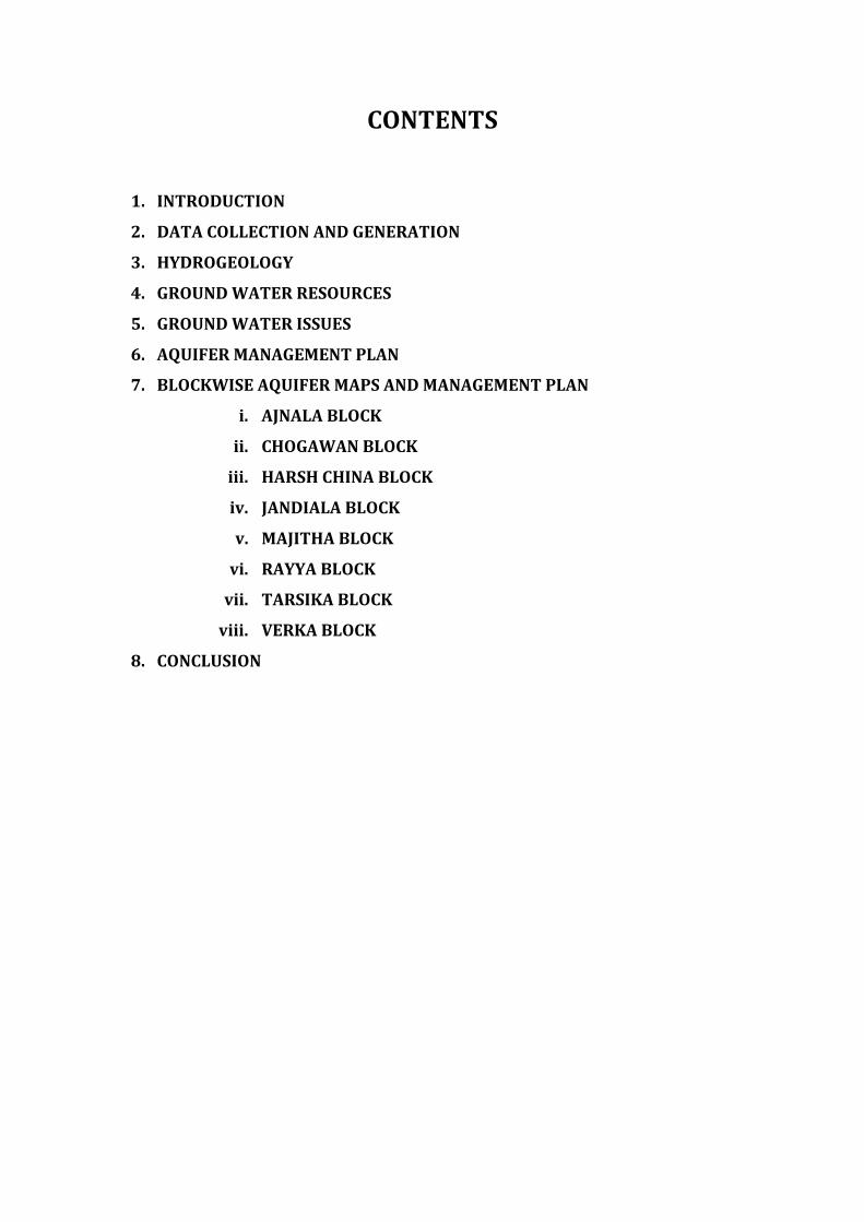
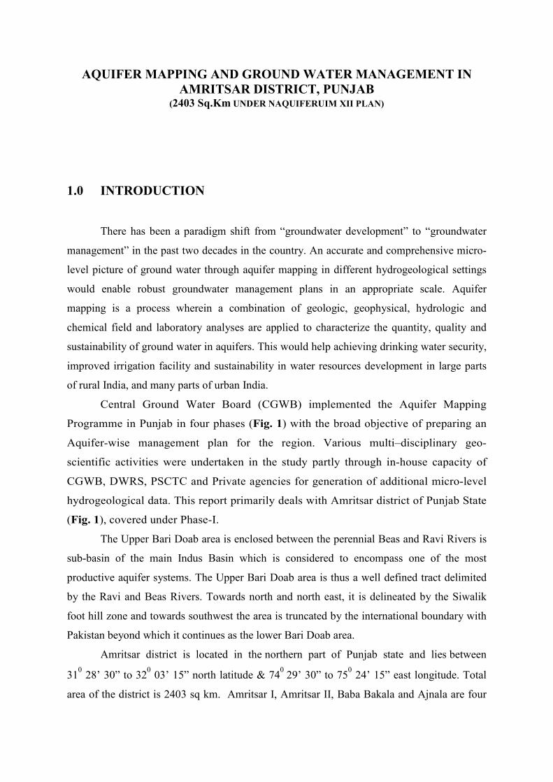
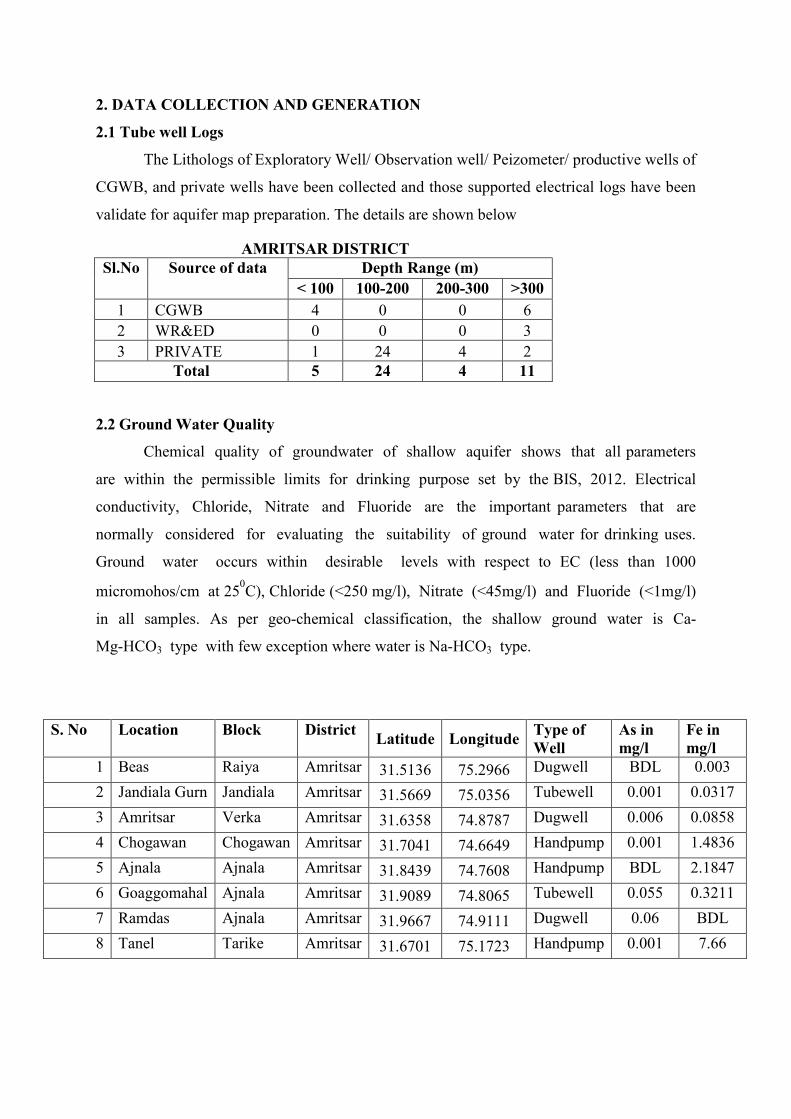
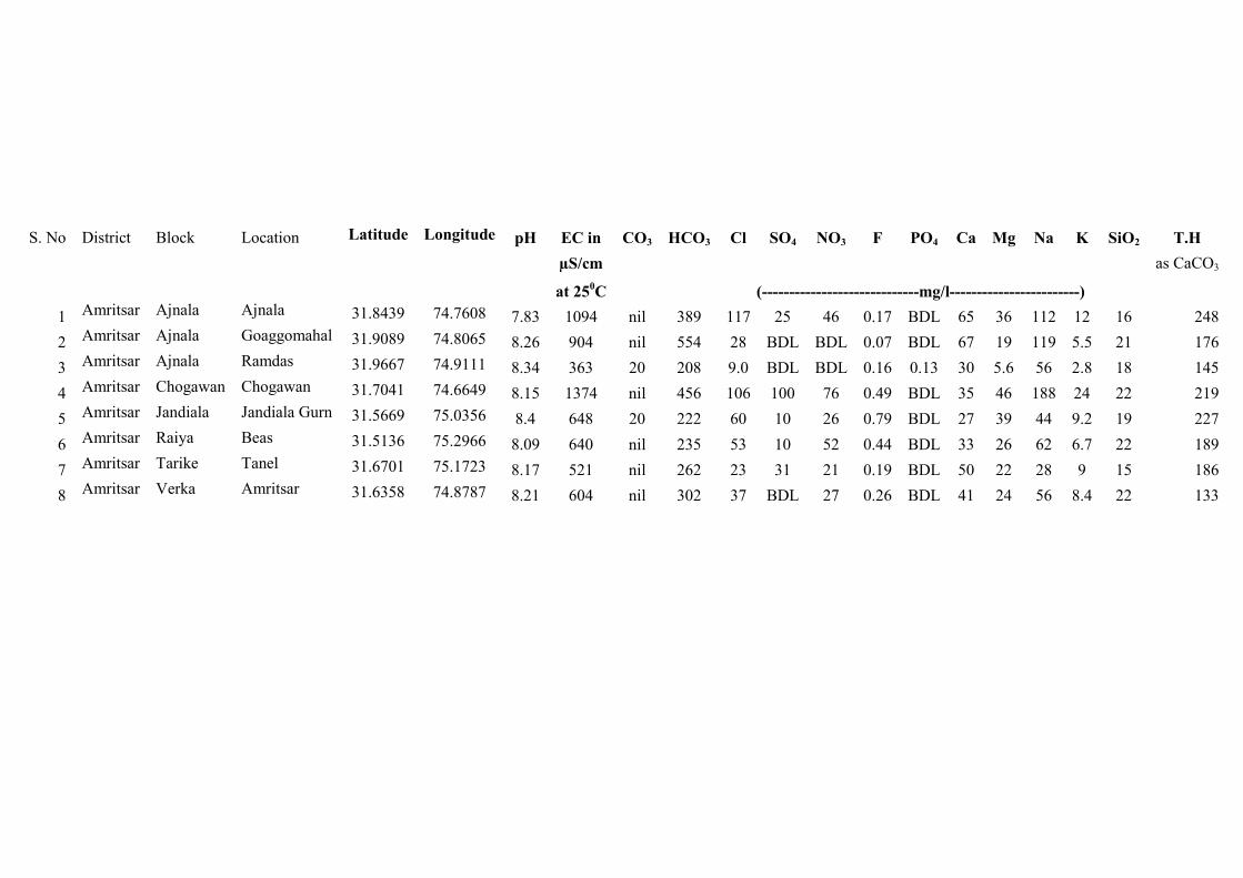
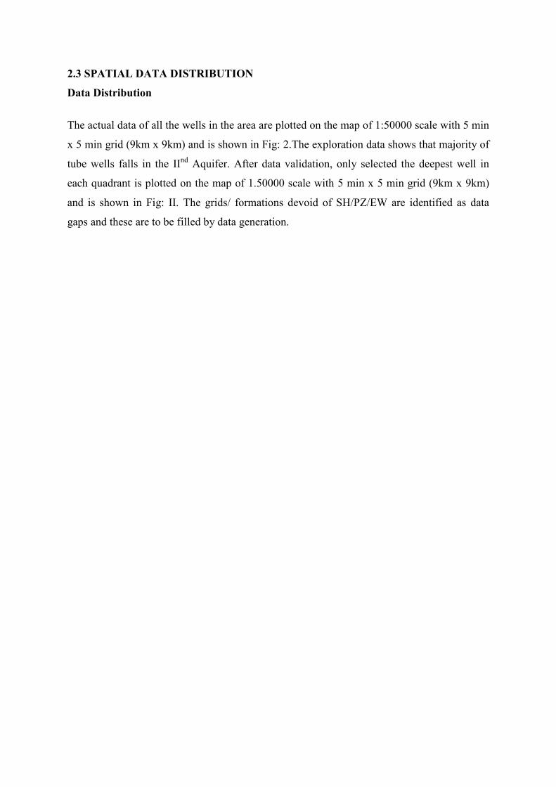
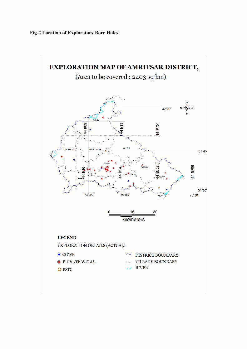
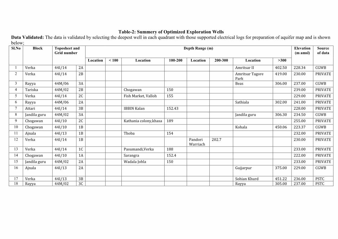
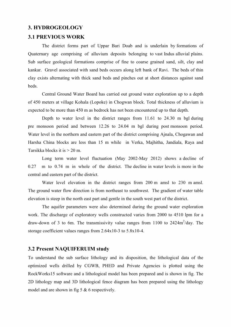
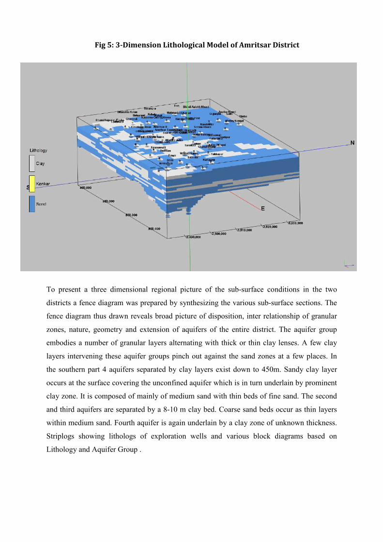
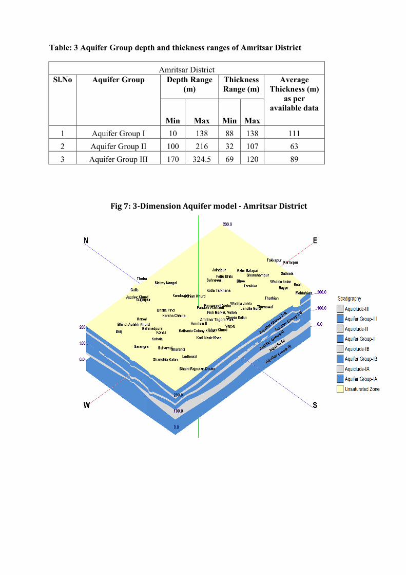
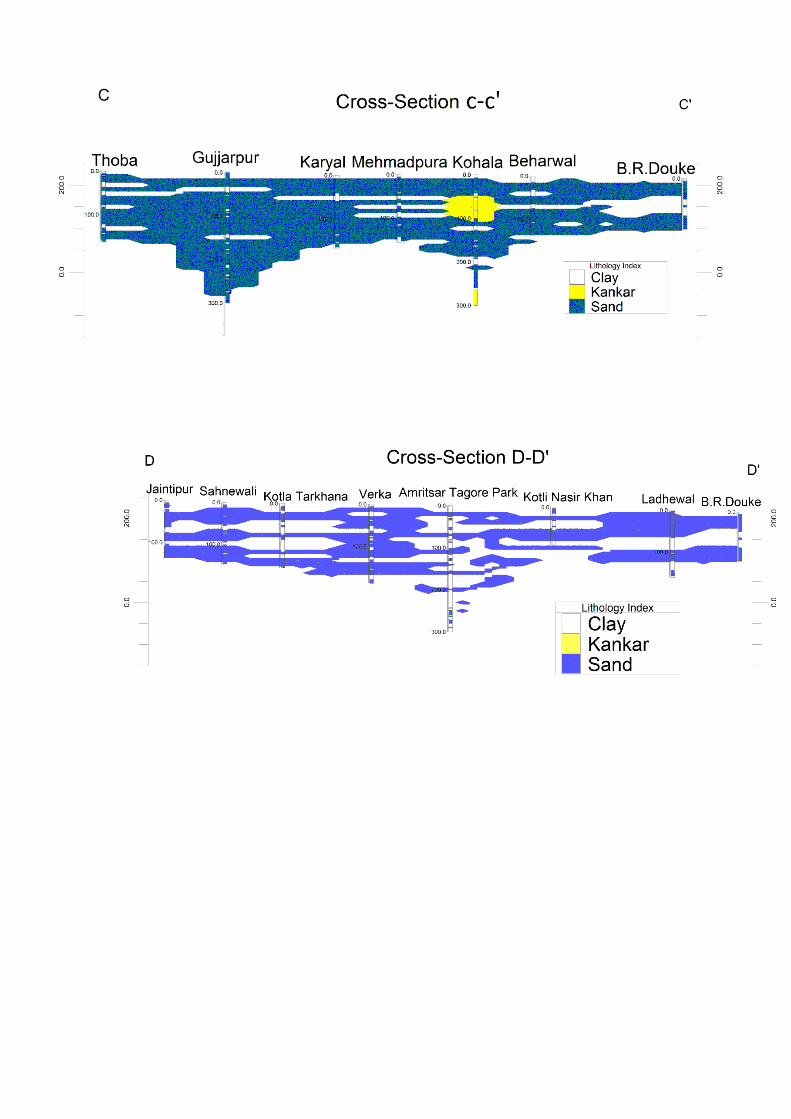
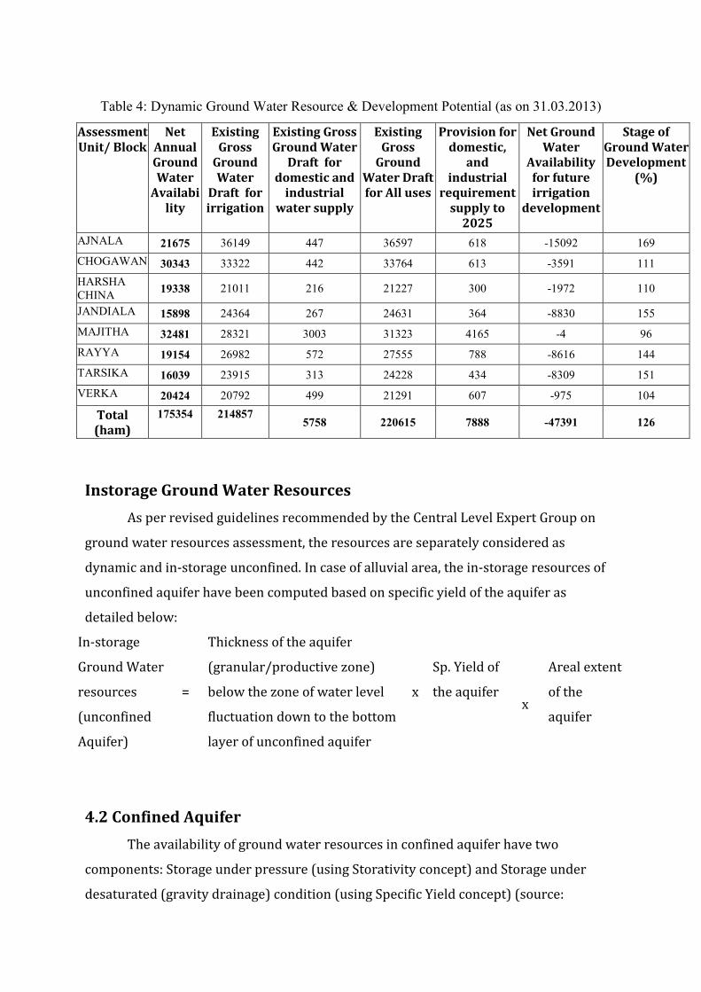
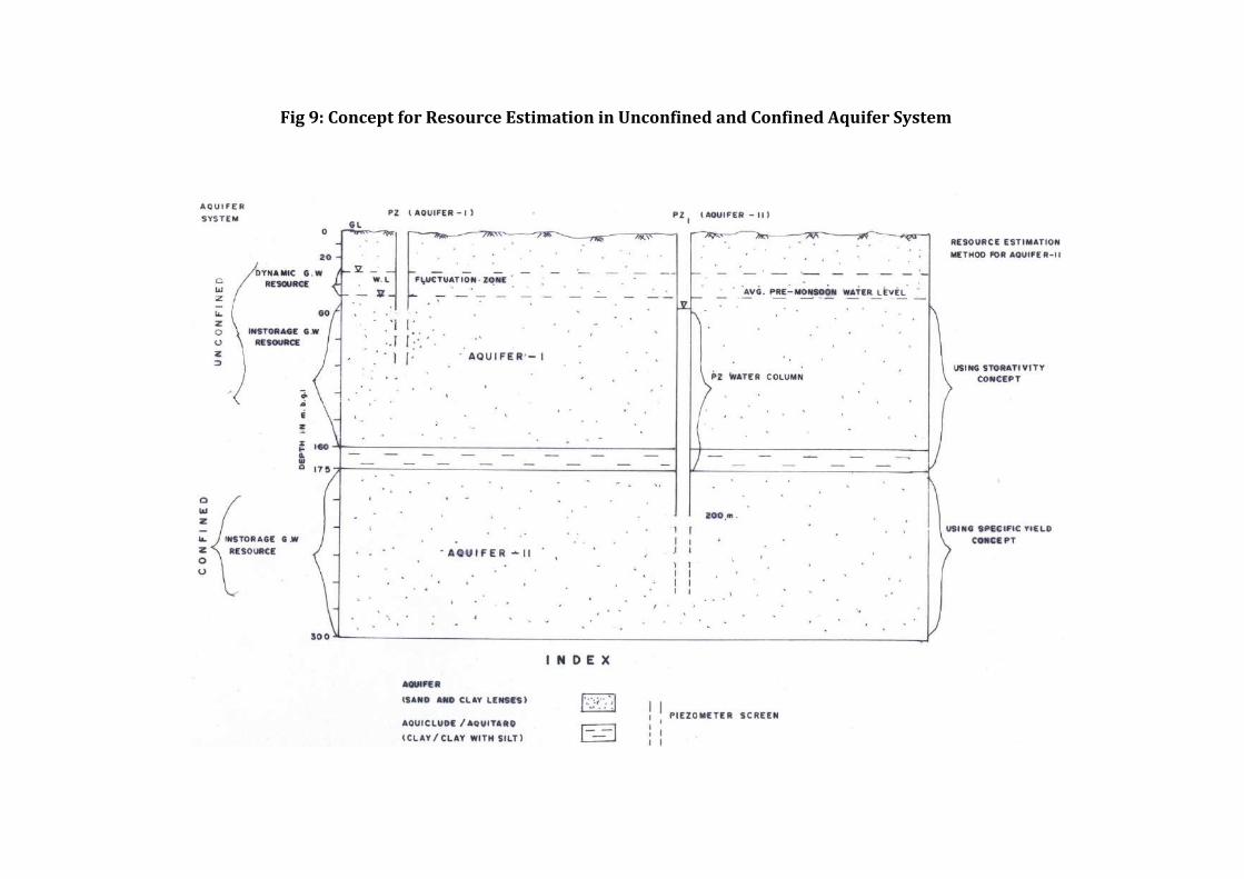
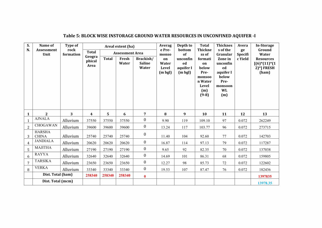
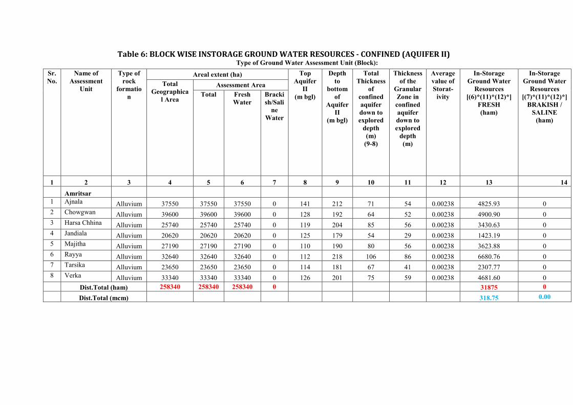
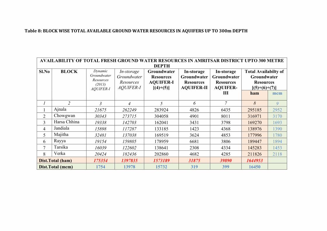
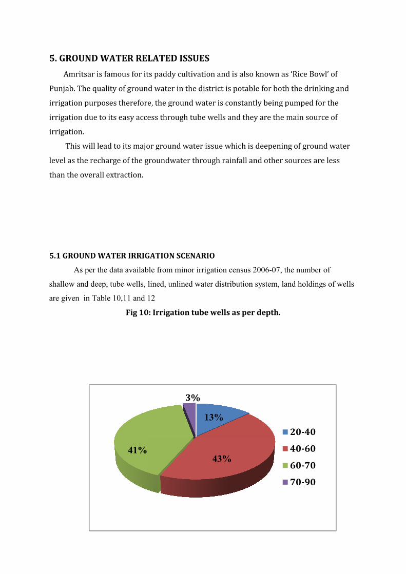
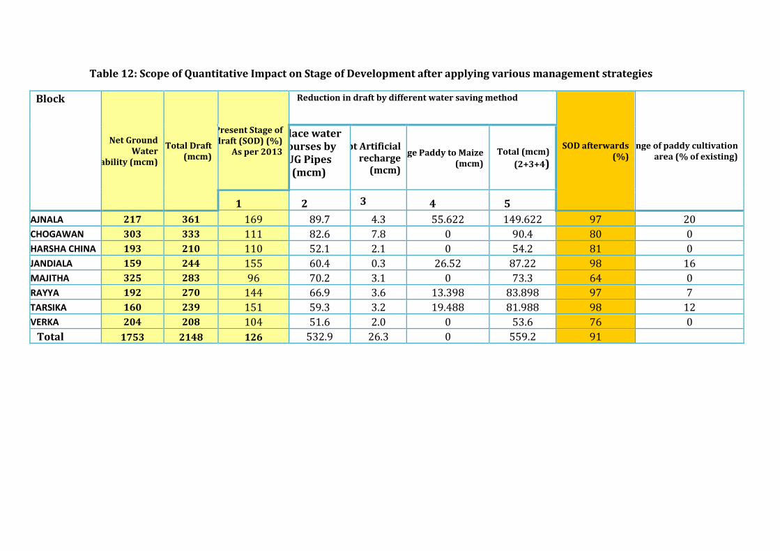

3D Lithology Fence
2 Ground Water Resource Extraction Contamination and Other Issues
Aquifer wise Water
Resource available
( mcm)
Dynamic Aquifer I 21675
In-storage Aquifer I 262249
Dynamic Aquifer II -
In-storage Aquifer II 4826
Dynamic Aquifer III -
In-storage Aquifer III 6435
Total 2952
Ground Water
Extraction (in
mcm)
Irrigation 36149
Domestic amp Industrial 447
Provision for domestic amp Industrial
requirement upto 2025 (in mcm)
618
Chemical Quality of ground water amp
contamination
Suitable for drinking and irrigation
purposes
Other issues Declining water level trend
3 Ground Water Resource Enhancement
Aquifer wise space available for
recharge and proposed interventions
Volume of unsaturated zone upto the average
depth to water level (10m)
Other interventions proposed Artificial Recharge Roof top Rainwater
Harvesting Farm recharge by constructing
pits will save 4296 mcm volume of water
4 Demand Side Interventions
Advanced Irrigation Practices Lining of underground pipelines (Kutcha channel)
will save 9134mcm volume of water wastage
Change in cropping pattern Proposed change in cropping pattern from Paddy
to maizesoyabean
40 of the total area needs to change the crop
from paddy to maizesoyabean
Anticipated volume of water to be saved by
maizesoyabean is 14 mcm
Alternate water sources Tanks ponds and canals
Regulation and Control -
Other interventions proposed if
any
-
(II) CHOWGWAN BLOCK (396 SQ KM)
1 Salient Information
Population (2011) Rural-147491
Urban-142075
Total-5416
Rainfall 2014 (Amritsar District) Average annual rainfall -6793 mm
Average Annual Rainfall (Chowgwan block) 627 mm
Agriculture and Irrigation Major Crops- Rice Wheat
Other crops-Sugarcane Potatoes Pulses
Net Area Sown- 35075 sqkm
Total Irrigated Area-35075 sqkm
Water Bodies amp Canal Irrigation
Water bodies available in the villages for storm water and untreated waste water of
villagers that can be used for irrigation after treatment The canal irrigation available in
the Chowgwan block
Ground Water Resource Availability Ground Water Resources available in the
different group of aquifers Aquifer I (96m) is very prominent in terms of thickness and
geographic extent Aquifer II (52m) amp III (85m) are less in thickness Block is
categorized as Over-Exploited as per Ground Water assessment 2013
Ground water Extraction Information regarding the abstraction from Aquifer III is
not available but there are drinking water supply tapping combined aquifer and
separate aquifer could not be assessed separately
Water level Behavior (2015) Pre Monsoon690mdash1580(mbgl) ampPost Monsoon-
~670mdash1510 (mbgl)
2 Aquifer Disposition Multiple Aquifer System (3 Aquifer System)
Aquifer Geology Type of
Aquifer
Thickness of
Granular
Zones (m)
Transmis
sivity
(m2day)
Specific
Yield
Storativity
Aquifer-I
(13-117m) Q
ua
tern
ary
All
uv
ial
de
po
sits
Unconfined 96
1450-
7190 0072 20010
-2
Aquifer-II
(128-192m)
Unconfined
to Confined 52 - NA -
Aquifer-III
(206-300m)
Unconfined
to Confined 85 - NA -
Aquifer comprises of freshwater only and the main aquifer material is sand
The non-aquifer material comprise of clay
3D Lithology model
3D Lithology Fence
3 Ground Water Resource Extraction Contamination and Other Issues
Aquifer wise Water
Resource available
( mcm)
Dynamic Aquifer I 30343
In-storage Aquifer I 273715
Dynamic Aquifer II -
In-storage Aquifer II 4901
Dynamic Aquifer III -
In-storage Aquifer III 8011
Total 3170
Ground Water
Extraction (in
mcm)
Irrigation 33322
Domestic amp Industrial 442
Provision for domestic amp Industrial
requirement in 2025 ( mcm)
613
Chemical Quality of ground water amp
contamination
Suitable for drinking and irrigation
purposes
Other issues declining water level trend
4 Ground Water Resource Enhancement
Aquifer wise space available for
recharge and proposed interventions
Volume of unsaturated zone upto the average
depth to water level (13 m)
Other interventions proposed Artificial Recharge Roof top Rainwater
Harvesting Farm recharge by constructing
pits will save 7657 mcm volume of water
5 Demand Side Interventions
Advanced Irrigation Practices Lining of underground pipelines (Kutcha channel)
will save 8421 mcm volume of water wastage
Change in cropping pattern Proposed change in cropping pattern from Paddy
to maizesoyabean
40 of the total area needs to change the crop
from paddy to maizesoyabean
Anticipated volume of water to be saved by
maizesoyabean is 16 mcm
Alternate water sources Tanks ponds and canals
Regulation and Control -
Other interventions proposed if
any
-
(III) HARSHA CHHINA BLOCK (25740 SQ KM)
1 Salient Information
Population (2011) Rural-95260
Urban- -
Total-95260
Rainfall 2014 (Amritsar District) Average annual rainfall -6793 mm
Average Annual Rainfall (Harsha Chhina block) 624 mm
Agriculture and Irrigation Major Crops- Rice Wheat
Other crops- Sugarcane Potatoes Pulses
Net Area Sown- 20259sqkm
Total Irrigated Area-20259 sqkm
Water Bodies amp Canal Irrigation
Water bodies available in the villages for storm water and untreated waste water of
villagers that can be used for irrigation after treatment The canal irrigation is also
available in the Harsha Chhina block
Ground Water Resource Availability Ground Water Resources available in the
different group of aquifers Aquifer I (77 m) is very prominent in terms of thickness and
geographic extent Aquifer II (56 m) amp III (62 m) are less in thickness Block is
categorized as Over-Exploited as per Ground Water assessment 2013
Ground water Extraction Information regarding the abstraction from Aquifer III is
not available but there are drinking water supply tapping combined aquifer and
separate aquifer could not be assessed separately
Water level Behavior (2015) Pre Monsoon 890mdash1470 (mbgl) ampPost Monsoon-
~880mdash1410 (mbgl)+6
3D Lithology model
3D Lithology Fence
2 Aquifer Disposition Multiple Aquifer System (3 Aquifer System)
Aquifer Geology Type of
Aquifer
Thickness of
Granular
Zones (m)
Transmis
sivity
(m2day)
Specific
Yield
Storativity
Aquifer-I
(11-93m) Q
ua
tern
ary
All
uv
ial
de
po
sits
Unconfined 77
1450-
7190 0072 20010
-2
Aquifer-II
(119-214m)
Unconfined
to Confined 56 - NA -
Aquifer-III
(215-300m)
Unconfined
to Confined 62 - NA -
Aquifer comprises of freshwater only and the main aquifer material is sand
The non-aquifer material comprise of clay
3 Ground Water Resource Extraction Contamination and Other Issues
Aquifer wise Water
Resource available
( mcm)
Dynamic Aquifer I 19338
In-storage Aquifer I 142703
Dynamic Aquifer II -
In-storage Aquifer II 3431
Dynamic Aquifer III -
In-storage Aquifer III 3798
Total 1693
Ground Water
Extraction (in
mcm)
Irrigation 21011
Domestic amp Industrial 216
Provision for domestic amp Industrial
requirement up to 2025 ( mcm)
300
Chemical Quality of ground water amp
contamination
Suitable for drinking and irrigation
purposes
Other issues declining water level trend
4 Ground Water Resource Enhancement
Aquifer wise space available for
recharge and proposed interventions
Volume of unsaturated zone upto the average
depth to water level (11 m)
Other interventions proposed Artificial Recharge Roof top Rainwater
Harvesting Farm recharge by constructing
pits will save 2142 mcm volume of water
5 Demand Side Interventions
Advanced Irrigation Practices Lining of underground pipelines (Kutcha channel)
will save 5310 mcm volume of water wastage
Change in cropping pattern Proposed change in cropping pattern from Paddy
to maizesoyabean
40 of the total area needs to change the crop
from paddy to maizesoyabean
Anticipated volume of water to be saved by
maizesoyabean is 12 mcm
Alternate water sources Tanks ponds and canals
Regulation and Control -
Other interventions proposed if
any
-
(IV) JANDIALA BLOCK (20620 SQ KM)
1 Salient Information
Population (2011) Rural-125742
Urban- 250
Total-125992
Rainfall 2014 (Amritsar District) Average annual rainfall -6793 mm
Average Annual Rainfall (Jandiala block) 671 mm
Agriculture and Irrigation Major Crops- Rice Wheat
Other crops- Sugarcane Potatoes Pulses
Net Area Sown- 16153 sqkm
Total Irrigated Area- 16153 sqkm
Water Bodies amp Canal Irrigation
Water bodies available in the villages for the storm water and untreated waste water of
villagers that can be used for irrigation after treatment The canal irrigation is also
available in the Jandiala block
Ground Water Resource Availability Ground Water Resources available in the
different group of aquifers Aquifer I (79 m) is very prominent in terms of thickness and
geographic extent Aquifer II (29 m) is less in thickness amp Aquifer III is (89 m) Block is
categorized as Over-Exploited as per Ground Water assessment 2013
Ground water Extraction Information regarding the abstraction from Aquifer III is
not available but there are drinking water supply tapping combined aquifer and
separate aquifer could not be assessed separately
Water level Behavior (2015) Pre Monsoon 690mdash1920 (mbgl) ampPost Monsoon-
~
640
mdash
188
2
(mb
gl)
2 Aquifer Disposition Multiple Aquifer System (3 Aquifer System)
Aquifer Geology Type of
Aquifer
Thickness of
Granular
Zones (m)
Transmis
sivity
(m2day)
Specific
Yield
Storativity
Aquifer-I
(17-114m)
Qu
ate
rna
ry
All
uv
ial
de
po
sits
Unconfined 79
1450-
7190 0072 20010
-2
Aquifer-II
(125-179m)
Unconfined
to Confined 29 - NA -
Aquifer-III
(185-300m)
Unconfined
to Confined 89 - NA -
Aquifer comprises of freshwater only and the main aquifer material is sand
The non-aquifer material comprise of clay
3D Lithology model
3D Lithology Fence
3 Ground Water Resource Extraction Contamination and Other Issues
Aquifer wise Water
Resource available
( mcm)
Dynamic Aquifer I 15898
In-storage Aquifer I 117287
Dynamic Aquifer II -
In-storage Aquifer II 1423
Dynamic Aquifer III -
In-storage Aquifer III 4368
Total 1390
Ground Water
Extraction (in
mcm)
Irrigation 24364
Domestic amp Industrial 267
Provision for domestic amp Industrial
requirement 2025 (in mcm)
364
Chemical Quality of ground water amp
contamination
Suitable for drinking and irrigation
purposes
Other issues Declining water level trend
4 Ground Water Resource Enhancement
Aquifer wise space available for
recharge and proposed interventions
Volume of unsaturated zone upto the average
depth to water level (17 m)
Other interventions proposed Artificial Recharge Roof top Rainwater
Harvesting Farm recharge by constructing
pits will save 252 mcm volume of water
5 Demand Side Interventions
Advanced Irrigation Practices Lining of underground pipelines (Kutcha channel)
will save 6117 mcm volume of water wastage
Change in cropping pattern Proposed change in cropping pattern from Paddy
to maizesoyabean
40 of the total area needs to change the crop
from paddy to maizesoyabean
Anticipated volume of water to be saved by
maizesoyabean is 9 mcm
Alternate water sources Tanks ponds and canals
Regulation and Control -
Other interventions proposed if
any
-
(V) MAJITHA BLOCK (27190 SQ KM)
1 Salient Information
Population (2011) Rural-150271
Urban- -
Total-150271
Rainfall 2014 (Amritsar District) Average annual rainfall -699 mm
Average Annual Rainfall (Majitha block) 671 mm
Agriculture and Irrigation Major Crops- Rice Wheat
Other crops- Sugarcane Potatoes Pulses
Net Area Sown- 22684 sqkm
Total Irrigated Area- 22684 sqkm
Water Bodies amp Canal Irrigation
Water bodies available in the villages for storm water and untreated waste water of
villagers that can be used for irrigation after treatment The canal irrigation is available
in the Majitha block
Ground Water Resource Availability Ground Water Resources available in the
different group of aquifers Aquifer I (70 m) is very prominent in terms of thickness and
geographic extent Aquifer II (56 m) is less in thickness amp Aquifer III is (75 m) Block is
categorized as Critical as per Ground Water assessment 2013
Ground water Extraction Information regarding the abstraction from Aquifer III is
not available but there are drinking water supply tapping combined aquifer and
separate aquifer could not be assessed separately
Water level Behavior (2015) Pre Monsoon 810-1460 (mbgl) ampPost Monsoon-
~ 680- 1510
(mbgl)
2 Aquifer Disposition Multiple Aquifer System (3 Aquifer System)
Aquifer Geology Type of
Aquifer
Thickness of
Granular
Zones (m)
Transmis
sivity
(m2day)
Specific
Yield
Storativity
Aquifer-I
(10-92m)
Qu
ate
rna
ry
All
uv
ial
de
po
sits
Unconfined 70
1450-
7190 0072 20010
-2
Aquifer-II
(110-190m)
Unconfined
to Confined 56 - NA -
Aquifer-III
(203-300m)
Unconfined
to Confined 75 - NA -
Aquifer comprises of freshwater only and the main aquifer material is sand
The non-aquifer material comprise of clay
3D Lithology model
3D Lithology Fence
3 Ground Water Resource Extraction Contamination and Other Issues
Aquifer wise Water
Resource available
(in mcm)
Dynamic Aquifer I 32481
In-storage Aquifer I 137038
Dynamic Aquifer II -
In-storage Aquifer II 3624
Dynamic Aquifer III -
In-storage Aquifer III 4853
Total 1780
Ground Water
Extraction (in
mcm)
Irrigation 28321
Domestic amp Industrial 3003
Provision for domestic amp Industrial
requirement up to 2025 (in mcm)
4165
Chemical Quality of ground water amp
contamination
Suitable for drinking and irrigation
purposes
Other issues Declining water level trend
4 Ground Water Resource Enhancement
Aquifer wise space available for
recharge and proposed interventions
Volume of unsaturated zone upto the average
depth to water level (10m)
Other interventions proposed Artificial Recharge Roof top Rainwater
Harvesting Farm recharge by constructing
pits will save 3697 mcm volume of water
5 Demand Side Interventions
Advanced Irrigation Practices Lining of underground pipelines (Kutcha channel)
will save 7155 mcm volume of water wastage
Change in cropping pattern Proposed change in cropping pattern from Paddy
to maizesoyabean
40 of the total area needs to change the crop
from paddy to maizesoyabean
Anticipated volume of water to be saved by
maizesoyabean is 10 mcm
Alternate water sources Tanks ponds and canals
Regulation and Control -
Other interventions proposed if
any
-
(VI) RAYYA BLOCK (32640 SQ KM)
1 Salient Information
Population (2011) Rural-160421
Urban- 24513
Total-184934
Rainfall 2014 (Amritsar District) Average annual rainfall -63260 mm
Average Annual Rainfall (Rayya block) 671 mm
Agriculture and Irrigation Major Crops- Rice Wheat
Other crops- Sugarcane Potatoes Pulses
Net Area Sown- 23236 sqkm
Total Irrigated Area- 23236 sqkm
Water Bodies amp Canal Irrigation
Water bodies available in the villages for storm water and untreated waste water of
villagers that can be used for irrigation after treatment The canal irrigation is also
available in the Rayya block
Ground Water Resource Availability Ground Water Resources available in the
different group of aquifers Aquifer I (68 m) is very prominent in terms of thickness and
geographic extent Aquifer II (86 m) is very prominent in terms of thickness amp Aquifer
III is (49 m) Block is categorized as Over-Exploited as per Ground Water assessment
2013
Ground water Extraction Information regarding the abstraction from Aquifer III is
not available but there are drinking water supply tapping combined aquifer and
separate aquifer could not be assessed separately
Water level Behavior (2015) Pre Monsoon 1453-1570 (mbgl) ampPost Monsoon-
~ 1270-1515 (mbgl)
2 Aquifer Disposition Multiple Aquifer System (3 Aquifer System)
Aquifer Geology Type of
Aquifer
Thickness of
Granular
Zones (m)
Transmis
sivity
(m2day)
Specific
Yield
Storativity
Aquifer-I
(15-101m)
Qu
ate
rna
ry
All
uv
ial
de
po
sits
Unconfined 68
1450-
7190 0072 20010
-2
Aquifer-II
(112-218m)
Unconfined
to Confined 86 - NA -
Aquifer-III
(233-300m)
Unconfined
to Confined 49 - NA -
Aquifer comprises of freshwater only and the main aquifer material is sand
The non-aquifer material comprise of clay
3D Lithology model
3D Lithology Fence
3 Ground Water Resource Extraction Contamination and Other Issues
Aquifer wise Water
Resource available
(in mcm)
Dynamic Aquifer I 19154
In-storage Aquifer I 159805
Dynamic Aquifer II -
In-storage Aquifer II 6681
Dynamic Aquifer III -
In-storage Aquifer III 3806
Total 1894
Ground Water
Extraction (in
mcm)
Irrigation 26982
Domestic amp Industrial 572
Provision for domestic amp Industrial
requirement up to 2025 (in mcm)
788
Chemical Quality of ground water amp
contamination
Suitable for drinking and irrigation
purposes
Other issues Declining water level trend
4 Ground Water Resource Enhancement
Aquifer wise space available for
recharge and proposed interventions
Volume of unsaturated zone upto the average
depth to water level (15m)
Other interventions proposed Artificial Recharge Roof top Rainwater
Harvesting Farm recharge by constructing
pits will save 3588 mcm volume of water
5 Demand Side Interventions
Advanced Irrigation Practices Lining of underground pipelines (Kutcha channel)
will save 6817 mcm volume of water wastage
Change in cropping pattern Proposed change in cropping pattern from Paddy
to maizesoyabean
40 of the total area needs to change the crop
from paddy to maizesoyabean
Anticipated volume of water to be saved by
maizesoyabean is 11 mcm
Alternate water sources Tanks ponds and canals
Regulation and Control -
Other interventions proposed if
any
-
(VII) TARSIKA BLOCK (23650 SQ KM)
1 Salient Information
Population (2011) Rural-129367
Urban- -
Total-129367
Rainfall 2014 (Amritsar District) Average annual rainfall -63260 mm
Average Annual Rainfall (Tarsika block) 769 mm
Agriculture and Irrigation Major Crops- Rice Wheat
Other crops- Sugarcane Potatoes Pulses
Net Area Sown- 22475 sqkm
Total Irrigated Area- 22475 sqkm
Water Bodies amp Canal Irrigation
Water bodies available in the villages for storm water and untreated waste water of
villagers that can be used for irrigation after treatment The canal irrigation is also
available in the Tarsika block
Ground Water Resource Availability Ground Water Resources available in the
different group of aquifers Aquifer I (72 m) is very prominent in terms of thickness and
geographic extent Aquifer II (41 m) is less in thickness amp Aquifer III is (77 m) Block is
categorized as Over-Exploted as per Ground Water assessment 2013
Ground water Extraction Information regarding the abstraction from Aquifer III is
not available but there are drinking water supply tapping combined aquifer and
separate aquifer could not be assessed separately
Water level Behavior (2015) Pre Monsoon 1085-1780 (mbgl) ampPost Monsoon-
~ 998-1780 (mbgl)
2 Aquifer Disposition Multiple Aquifer System (3 Aquifer System)
Aquifer Geology Type of
Aquifer
Thickness of
Granular
Zones (m)
Transmis
sivity
(m2day)
Specific
Yield
Storativity
Aquifer-I
(12-98m)
Qu
ate
rna
ry
All
uv
ial
de
po
sits
Unconfined
72 1450-
7190 0072 20010
-2
Aquifer-II
(114-181m)
Unconfined
to Confined 41 - NA -
Aquifer-III
(210-300m)
Unconfined
to Confined 77 - NA -
Aquifer comprises of freshwater only and the main aquifer material is sand
The non-aquifer material comprise of clay
3D Lithology model
3D Lithology Fence
3 Ground Water Resource Extraction Contamination and Other Issues
Aquifer wise Water
Resource available
(in mcm)
Dynamic Aquifer I 16039
In-storage Aquifer I 122602
Dynamic Aquifer II -
In-storage Aquifer II 2308
Dynamic Aquifer III -
In-storage Aquifer III 4334
Total 1453
Ground Water
Extraction (in
mcm)
Irrigation 23915
Domestic amp Industrial 313
Provision for domestic amp Industrial
requirement up to 2025 (in mcm)
434
Chemical Quality of ground water amp
contamination
Suitable for drinking and irrigation
purposes
Other issues Declining water level trend
4 Ground Water Resource Enhancement
Aquifer wise space available for
recharge and proposed interventions
Volume of unsaturated zone upto the average
depth to water level (12m)
Other interventions proposed Artificial Recharge Roof top Rainwater
Harvesting Farm recharge by constructing
pits will save 3167 mcm volume of water
5 Demand Side Interventions
Advanced Irrigation Practices Lining of underground pipelines (Kutcha channel)
will save 6042 mcm volume of water wastage
Change in cropping pattern Proposed change in cropping pattern from Paddy
to maizesoyabean
40 of the total area needs to change the crop
from paddy to maizesoyabean
Anticipated volume of water to be saved by
maizesoyabean is 9 mcm
Alternate water sources Tanks ponds and canals
Regulation and Control -
Other interventions proposed if
any
-
(VII) VERKA BLOCK (33304 SQ KM)
1 Salient Information
Population (2011) Rural-67151
Urban- 44860
Total-112011
Rainfall 2014 (Amritsar District) Average annual rainfall -63260 mm
Average Annual Rainfall (Verka block) 644 mm
Agriculture and Irrigation Major Crops- Rice Wheat
Other crops- Sugarcane Potatoes Pulses
Net Area Sown- 14762 sqkm
Total Irrigated Area- 14762 sqkm
Water Bodies amp Canal Irrigation
Water bodies available in the villages for storm water and untreated waste water of
villagers that can be used for irrigation after treatment The canal irrigation is also
available in the Verka block
Ground Water Resource Availability Ground Water Resources available in the
different group of aquifers Aquifer I (76 m) is very prominent in terms of thickness and
geographic extent Aquifer II (59 m) is less in thickness amp Aquifer III is (59m) Block is
categorized as Over-Exploited as per Ground Water assessment 2013
Ground water Extraction Information regarding the abstraction from Aquifer III is
not available but there are drinking water supply tapping combined aquifer and
separate aquifer could not be assessed separately
Water level Behavior (2015) Pre Monsoon 1280-2484 (mbgl) ampPost Monsoon-~
1280-2386 (mbgl)
2 Aquifer Disposition Multiple Aquifer System (3 Aquifer System)
Aquifer Geology Type of
Aquifer
Thickness of
Granular
Zones (m)
Transmis
sivity
(m2day)
Specific
Yield
Storativity
Aquifer-I
(20-107m) Q
ua
tern
ary
All
uv
ial
de
po
sits
Unconfined 76
1450-
7190 12 20010
-2
Aquifer-II
(126-201m)
Unconfined
to Confined 59 - NA -
Aquifer-III
(225-300m)
Unconfined
to Confined 59 - NA -
Aquifer comprises of freshwater only and the main aquifer material is sand
The non-aquifer material comprise of clay
3D Lithology model
3D Lithology Fence
3 Ground Water Resource Extraction Contamination and Other Issues
Aquifer wise Water
Resource available
(in mcm)
Dynamic Aquifer I 20424
In-storage Aquifer I 182436
Dynamic Aquifer II -
In-storage Aquifer II 4682
Dynamic Aquifer III -
In-storage Aquifer III 4285
Total 2118
Ground Water
Extraction (in
mcm)
Irrigation 20792
Domestic amp Industrial 499
Provision for domestic amp Industrial
requirement up to 2025 (in mcm)
607
Chemical Quality of ground water amp
contamination
Potable for drinking and irrigation
Other issues declining water level trend
4 Ground Water Resource Enhancement
Aquifer wise space available for
recharge and proposed interventions
Volume of unsaturated zone upto the average
depth to water level (20m)
Other interventions proposed Artificial Recharge Roof top Rainwater
Harvesting Farm recharge by constructing
pits will save 2745 mcm volume of water
5 Demand Side Interventions
Advanced Irrigation Practices Lining of underground pipelines (Kutcha channel)
will save 5254 mcm volume of water wastage
Change in cropping pattern Proposed change in cropping pattern from Paddy
to maizesoyabean
40 of the total area needs to change the crop
from paddy to maizesoyabean
Anticipated volume of water to be saved by
maizesoyabean is 7 mcm
Alternate water sources Tanks ponds and canals
Regulation and Control -
Other interventions proposed if
any
-
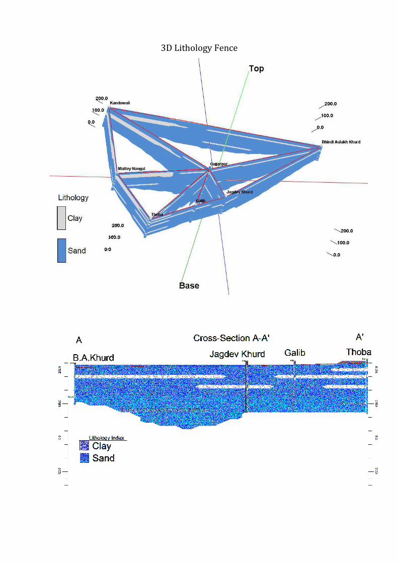
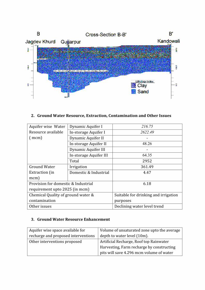

2 Aquifer Disposition Multiple Aquifer System (3 Aquifer System)
Aquifer Geology Type of
Aquifer
Thickness of
Granular
Zones (m)
Transmis
sivity
(m2day)
Specific
Yield
Storativity
Aquifer-I
(13-117m) Q
ua
tern
ary
All
uv
ial
de
po
sits
Unconfined 96
1450-
7190 0072 20010
-2
Aquifer-II
(128-192m)
Unconfined
to Confined 52 - NA -
Aquifer-III
(206-300m)
Unconfined
to Confined 85 - NA -
Aquifer comprises of freshwater only and the main aquifer material is sand
The non-aquifer material comprise of clay
3D Lithology model
3D Lithology Fence
3 Ground Water Resource Extraction Contamination and Other Issues
Aquifer wise Water
Resource available
( mcm)
Dynamic Aquifer I 30343
In-storage Aquifer I 273715
Dynamic Aquifer II -
In-storage Aquifer II 4901
Dynamic Aquifer III -
In-storage Aquifer III 8011
Total 3170
Ground Water
Extraction (in
mcm)
Irrigation 33322
Domestic amp Industrial 442
Provision for domestic amp Industrial
requirement in 2025 ( mcm)
613
Chemical Quality of ground water amp
contamination
Suitable for drinking and irrigation
purposes
Other issues declining water level trend
4 Ground Water Resource Enhancement
Aquifer wise space available for
recharge and proposed interventions
Volume of unsaturated zone upto the average
depth to water level (13 m)
Other interventions proposed Artificial Recharge Roof top Rainwater
Harvesting Farm recharge by constructing
pits will save 7657 mcm volume of water
5 Demand Side Interventions
Advanced Irrigation Practices Lining of underground pipelines (Kutcha channel)
will save 8421 mcm volume of water wastage
Change in cropping pattern Proposed change in cropping pattern from Paddy
to maizesoyabean
40 of the total area needs to change the crop
from paddy to maizesoyabean
Anticipated volume of water to be saved by
maizesoyabean is 16 mcm
Alternate water sources Tanks ponds and canals
Regulation and Control -
Other interventions proposed if
any
-
(III) HARSHA CHHINA BLOCK (25740 SQ KM)
1 Salient Information
Population (2011) Rural-95260
Urban- -
Total-95260
Rainfall 2014 (Amritsar District) Average annual rainfall -6793 mm
Average Annual Rainfall (Harsha Chhina block) 624 mm
Agriculture and Irrigation Major Crops- Rice Wheat
Other crops- Sugarcane Potatoes Pulses
Net Area Sown- 20259sqkm
Total Irrigated Area-20259 sqkm
Water Bodies amp Canal Irrigation
Water bodies available in the villages for storm water and untreated waste water of
villagers that can be used for irrigation after treatment The canal irrigation is also
available in the Harsha Chhina block
Ground Water Resource Availability Ground Water Resources available in the
different group of aquifers Aquifer I (77 m) is very prominent in terms of thickness and
geographic extent Aquifer II (56 m) amp III (62 m) are less in thickness Block is
categorized as Over-Exploited as per Ground Water assessment 2013
Ground water Extraction Information regarding the abstraction from Aquifer III is
not available but there are drinking water supply tapping combined aquifer and
separate aquifer could not be assessed separately
Water level Behavior (2015) Pre Monsoon 890mdash1470 (mbgl) ampPost Monsoon-
~880mdash1410 (mbgl)+6
3D Lithology model
3D Lithology Fence
2 Aquifer Disposition Multiple Aquifer System (3 Aquifer System)
Aquifer Geology Type of
Aquifer
Thickness of
Granular
Zones (m)
Transmis
sivity
(m2day)
Specific
Yield
Storativity
Aquifer-I
(11-93m) Q
ua
tern
ary
All
uv
ial
de
po
sits
Unconfined 77
1450-
7190 0072 20010
-2
Aquifer-II
(119-214m)
Unconfined
to Confined 56 - NA -
Aquifer-III
(215-300m)
Unconfined
to Confined 62 - NA -
Aquifer comprises of freshwater only and the main aquifer material is sand
The non-aquifer material comprise of clay
3 Ground Water Resource Extraction Contamination and Other Issues
Aquifer wise Water
Resource available
( mcm)
Dynamic Aquifer I 19338
In-storage Aquifer I 142703
Dynamic Aquifer II -
In-storage Aquifer II 3431
Dynamic Aquifer III -
In-storage Aquifer III 3798
Total 1693
Ground Water
Extraction (in
mcm)
Irrigation 21011
Domestic amp Industrial 216
Provision for domestic amp Industrial
requirement up to 2025 ( mcm)
300
Chemical Quality of ground water amp
contamination
Suitable for drinking and irrigation
purposes
Other issues declining water level trend
4 Ground Water Resource Enhancement
Aquifer wise space available for
recharge and proposed interventions
Volume of unsaturated zone upto the average
depth to water level (11 m)
Other interventions proposed Artificial Recharge Roof top Rainwater
Harvesting Farm recharge by constructing
pits will save 2142 mcm volume of water
5 Demand Side Interventions
Advanced Irrigation Practices Lining of underground pipelines (Kutcha channel)
will save 5310 mcm volume of water wastage
Change in cropping pattern Proposed change in cropping pattern from Paddy
to maizesoyabean
40 of the total area needs to change the crop
from paddy to maizesoyabean
Anticipated volume of water to be saved by
maizesoyabean is 12 mcm
Alternate water sources Tanks ponds and canals
Regulation and Control -
Other interventions proposed if
any
-
(IV) JANDIALA BLOCK (20620 SQ KM)
1 Salient Information
Population (2011) Rural-125742
Urban- 250
Total-125992
Rainfall 2014 (Amritsar District) Average annual rainfall -6793 mm
Average Annual Rainfall (Jandiala block) 671 mm
Agriculture and Irrigation Major Crops- Rice Wheat
Other crops- Sugarcane Potatoes Pulses
Net Area Sown- 16153 sqkm
Total Irrigated Area- 16153 sqkm
Water Bodies amp Canal Irrigation
Water bodies available in the villages for the storm water and untreated waste water of
villagers that can be used for irrigation after treatment The canal irrigation is also
available in the Jandiala block
Ground Water Resource Availability Ground Water Resources available in the
different group of aquifers Aquifer I (79 m) is very prominent in terms of thickness and
geographic extent Aquifer II (29 m) is less in thickness amp Aquifer III is (89 m) Block is
categorized as Over-Exploited as per Ground Water assessment 2013
Ground water Extraction Information regarding the abstraction from Aquifer III is
not available but there are drinking water supply tapping combined aquifer and
separate aquifer could not be assessed separately
Water level Behavior (2015) Pre Monsoon 690mdash1920 (mbgl) ampPost Monsoon-
~
640
mdash
188
2
(mb
gl)
2 Aquifer Disposition Multiple Aquifer System (3 Aquifer System)
Aquifer Geology Type of
Aquifer
Thickness of
Granular
Zones (m)
Transmis
sivity
(m2day)
Specific
Yield
Storativity
Aquifer-I
(17-114m)
Qu
ate
rna
ry
All
uv
ial
de
po
sits
Unconfined 79
1450-
7190 0072 20010
-2
Aquifer-II
(125-179m)
Unconfined
to Confined 29 - NA -
Aquifer-III
(185-300m)
Unconfined
to Confined 89 - NA -
Aquifer comprises of freshwater only and the main aquifer material is sand
The non-aquifer material comprise of clay
3D Lithology model
3D Lithology Fence
3 Ground Water Resource Extraction Contamination and Other Issues
Aquifer wise Water
Resource available
( mcm)
Dynamic Aquifer I 15898
In-storage Aquifer I 117287
Dynamic Aquifer II -
In-storage Aquifer II 1423
Dynamic Aquifer III -
In-storage Aquifer III 4368
Total 1390
Ground Water
Extraction (in
mcm)
Irrigation 24364
Domestic amp Industrial 267
Provision for domestic amp Industrial
requirement 2025 (in mcm)
364
Chemical Quality of ground water amp
contamination
Suitable for drinking and irrigation
purposes
Other issues Declining water level trend
4 Ground Water Resource Enhancement
Aquifer wise space available for
recharge and proposed interventions
Volume of unsaturated zone upto the average
depth to water level (17 m)
Other interventions proposed Artificial Recharge Roof top Rainwater
Harvesting Farm recharge by constructing
pits will save 252 mcm volume of water
5 Demand Side Interventions
Advanced Irrigation Practices Lining of underground pipelines (Kutcha channel)
will save 6117 mcm volume of water wastage
Change in cropping pattern Proposed change in cropping pattern from Paddy
to maizesoyabean
40 of the total area needs to change the crop
from paddy to maizesoyabean
Anticipated volume of water to be saved by
maizesoyabean is 9 mcm
Alternate water sources Tanks ponds and canals
Regulation and Control -
Other interventions proposed if
any
-
(V) MAJITHA BLOCK (27190 SQ KM)
1 Salient Information
Population (2011) Rural-150271
Urban- -
Total-150271
Rainfall 2014 (Amritsar District) Average annual rainfall -699 mm
Average Annual Rainfall (Majitha block) 671 mm
Agriculture and Irrigation Major Crops- Rice Wheat
Other crops- Sugarcane Potatoes Pulses
Net Area Sown- 22684 sqkm
Total Irrigated Area- 22684 sqkm
Water Bodies amp Canal Irrigation
Water bodies available in the villages for storm water and untreated waste water of
villagers that can be used for irrigation after treatment The canal irrigation is available
in the Majitha block
Ground Water Resource Availability Ground Water Resources available in the
different group of aquifers Aquifer I (70 m) is very prominent in terms of thickness and
geographic extent Aquifer II (56 m) is less in thickness amp Aquifer III is (75 m) Block is
categorized as Critical as per Ground Water assessment 2013
Ground water Extraction Information regarding the abstraction from Aquifer III is
not available but there are drinking water supply tapping combined aquifer and
separate aquifer could not be assessed separately
Water level Behavior (2015) Pre Monsoon 810-1460 (mbgl) ampPost Monsoon-
~ 680- 1510
(mbgl)
2 Aquifer Disposition Multiple Aquifer System (3 Aquifer System)
Aquifer Geology Type of
Aquifer
Thickness of
Granular
Zones (m)
Transmis
sivity
(m2day)
Specific
Yield
Storativity
Aquifer-I
(10-92m)
Qu
ate
rna
ry
All
uv
ial
de
po
sits
Unconfined 70
1450-
7190 0072 20010
-2
Aquifer-II
(110-190m)
Unconfined
to Confined 56 - NA -
Aquifer-III
(203-300m)
Unconfined
to Confined 75 - NA -
Aquifer comprises of freshwater only and the main aquifer material is sand
The non-aquifer material comprise of clay
3D Lithology model
3D Lithology Fence
3 Ground Water Resource Extraction Contamination and Other Issues
Aquifer wise Water
Resource available
(in mcm)
Dynamic Aquifer I 32481
In-storage Aquifer I 137038
Dynamic Aquifer II -
In-storage Aquifer II 3624
Dynamic Aquifer III -
In-storage Aquifer III 4853
Total 1780
Ground Water
Extraction (in
mcm)
Irrigation 28321
Domestic amp Industrial 3003
Provision for domestic amp Industrial
requirement up to 2025 (in mcm)
4165
Chemical Quality of ground water amp
contamination
Suitable for drinking and irrigation
purposes
Other issues Declining water level trend
4 Ground Water Resource Enhancement
Aquifer wise space available for
recharge and proposed interventions
Volume of unsaturated zone upto the average
depth to water level (10m)
Other interventions proposed Artificial Recharge Roof top Rainwater
Harvesting Farm recharge by constructing
pits will save 3697 mcm volume of water
5 Demand Side Interventions
Advanced Irrigation Practices Lining of underground pipelines (Kutcha channel)
will save 7155 mcm volume of water wastage
Change in cropping pattern Proposed change in cropping pattern from Paddy
to maizesoyabean
40 of the total area needs to change the crop
from paddy to maizesoyabean
Anticipated volume of water to be saved by
maizesoyabean is 10 mcm
Alternate water sources Tanks ponds and canals
Regulation and Control -
Other interventions proposed if
any
-
(VI) RAYYA BLOCK (32640 SQ KM)
1 Salient Information
Population (2011) Rural-160421
Urban- 24513
Total-184934
Rainfall 2014 (Amritsar District) Average annual rainfall -63260 mm
Average Annual Rainfall (Rayya block) 671 mm
Agriculture and Irrigation Major Crops- Rice Wheat
Other crops- Sugarcane Potatoes Pulses
Net Area Sown- 23236 sqkm
Total Irrigated Area- 23236 sqkm
Water Bodies amp Canal Irrigation
Water bodies available in the villages for storm water and untreated waste water of
villagers that can be used for irrigation after treatment The canal irrigation is also
available in the Rayya block
Ground Water Resource Availability Ground Water Resources available in the
different group of aquifers Aquifer I (68 m) is very prominent in terms of thickness and
geographic extent Aquifer II (86 m) is very prominent in terms of thickness amp Aquifer
III is (49 m) Block is categorized as Over-Exploited as per Ground Water assessment
2013
Ground water Extraction Information regarding the abstraction from Aquifer III is
not available but there are drinking water supply tapping combined aquifer and
separate aquifer could not be assessed separately
Water level Behavior (2015) Pre Monsoon 1453-1570 (mbgl) ampPost Monsoon-
~ 1270-1515 (mbgl)
2 Aquifer Disposition Multiple Aquifer System (3 Aquifer System)
Aquifer Geology Type of
Aquifer
Thickness of
Granular
Zones (m)
Transmis
sivity
(m2day)
Specific
Yield
Storativity
Aquifer-I
(15-101m)
Qu
ate
rna
ry
All
uv
ial
de
po
sits
Unconfined 68
1450-
7190 0072 20010
-2
Aquifer-II
(112-218m)
Unconfined
to Confined 86 - NA -
Aquifer-III
(233-300m)
Unconfined
to Confined 49 - NA -
Aquifer comprises of freshwater only and the main aquifer material is sand
The non-aquifer material comprise of clay
3D Lithology model
3D Lithology Fence
3 Ground Water Resource Extraction Contamination and Other Issues
Aquifer wise Water
Resource available
(in mcm)
Dynamic Aquifer I 19154
In-storage Aquifer I 159805
Dynamic Aquifer II -
In-storage Aquifer II 6681
Dynamic Aquifer III -
In-storage Aquifer III 3806
Total 1894
Ground Water
Extraction (in
mcm)
Irrigation 26982
Domestic amp Industrial 572
Provision for domestic amp Industrial
requirement up to 2025 (in mcm)
788
Chemical Quality of ground water amp
contamination
Suitable for drinking and irrigation
purposes
Other issues Declining water level trend
4 Ground Water Resource Enhancement
Aquifer wise space available for
recharge and proposed interventions
Volume of unsaturated zone upto the average
depth to water level (15m)
Other interventions proposed Artificial Recharge Roof top Rainwater
Harvesting Farm recharge by constructing
pits will save 3588 mcm volume of water
5 Demand Side Interventions
Advanced Irrigation Practices Lining of underground pipelines (Kutcha channel)
will save 6817 mcm volume of water wastage
Change in cropping pattern Proposed change in cropping pattern from Paddy
to maizesoyabean
40 of the total area needs to change the crop
from paddy to maizesoyabean
Anticipated volume of water to be saved by
maizesoyabean is 11 mcm
Alternate water sources Tanks ponds and canals
Regulation and Control -
Other interventions proposed if
any
-
(VII) TARSIKA BLOCK (23650 SQ KM)
1 Salient Information
Population (2011) Rural-129367
Urban- -
Total-129367
Rainfall 2014 (Amritsar District) Average annual rainfall -63260 mm
Average Annual Rainfall (Tarsika block) 769 mm
Agriculture and Irrigation Major Crops- Rice Wheat
Other crops- Sugarcane Potatoes Pulses
Net Area Sown- 22475 sqkm
Total Irrigated Area- 22475 sqkm
Water Bodies amp Canal Irrigation
Water bodies available in the villages for storm water and untreated waste water of
villagers that can be used for irrigation after treatment The canal irrigation is also
available in the Tarsika block
Ground Water Resource Availability Ground Water Resources available in the
different group of aquifers Aquifer I (72 m) is very prominent in terms of thickness and
geographic extent Aquifer II (41 m) is less in thickness amp Aquifer III is (77 m) Block is
categorized as Over-Exploted as per Ground Water assessment 2013
Ground water Extraction Information regarding the abstraction from Aquifer III is
not available but there are drinking water supply tapping combined aquifer and
separate aquifer could not be assessed separately
Water level Behavior (2015) Pre Monsoon 1085-1780 (mbgl) ampPost Monsoon-
~ 998-1780 (mbgl)
2 Aquifer Disposition Multiple Aquifer System (3 Aquifer System)
Aquifer Geology Type of
Aquifer
Thickness of
Granular
Zones (m)
Transmis
sivity
(m2day)
Specific
Yield
Storativity
Aquifer-I
(12-98m)
Qu
ate
rna
ry
All
uv
ial
de
po
sits
Unconfined
72 1450-
7190 0072 20010
-2
Aquifer-II
(114-181m)
Unconfined
to Confined 41 - NA -
Aquifer-III
(210-300m)
Unconfined
to Confined 77 - NA -
Aquifer comprises of freshwater only and the main aquifer material is sand
The non-aquifer material comprise of clay
3D Lithology model
3D Lithology Fence
3 Ground Water Resource Extraction Contamination and Other Issues
Aquifer wise Water
Resource available
(in mcm)
Dynamic Aquifer I 16039
In-storage Aquifer I 122602
Dynamic Aquifer II -
In-storage Aquifer II 2308
Dynamic Aquifer III -
In-storage Aquifer III 4334
Total 1453
Ground Water
Extraction (in
mcm)
Irrigation 23915
Domestic amp Industrial 313
Provision for domestic amp Industrial
requirement up to 2025 (in mcm)
434
Chemical Quality of ground water amp
contamination
Suitable for drinking and irrigation
purposes
Other issues Declining water level trend
4 Ground Water Resource Enhancement
Aquifer wise space available for
recharge and proposed interventions
Volume of unsaturated zone upto the average
depth to water level (12m)
Other interventions proposed Artificial Recharge Roof top Rainwater
Harvesting Farm recharge by constructing
pits will save 3167 mcm volume of water
5 Demand Side Interventions
Advanced Irrigation Practices Lining of underground pipelines (Kutcha channel)
will save 6042 mcm volume of water wastage
Change in cropping pattern Proposed change in cropping pattern from Paddy
to maizesoyabean
40 of the total area needs to change the crop
from paddy to maizesoyabean
Anticipated volume of water to be saved by
maizesoyabean is 9 mcm
Alternate water sources Tanks ponds and canals
Regulation and Control -
Other interventions proposed if
any
-
(VII) VERKA BLOCK (33304 SQ KM)
1 Salient Information
Population (2011) Rural-67151
Urban- 44860
Total-112011
Rainfall 2014 (Amritsar District) Average annual rainfall -63260 mm
Average Annual Rainfall (Verka block) 644 mm
Agriculture and Irrigation Major Crops- Rice Wheat
Other crops- Sugarcane Potatoes Pulses
Net Area Sown- 14762 sqkm
Total Irrigated Area- 14762 sqkm
Water Bodies amp Canal Irrigation
Water bodies available in the villages for storm water and untreated waste water of
villagers that can be used for irrigation after treatment The canal irrigation is also
available in the Verka block
Ground Water Resource Availability Ground Water Resources available in the
different group of aquifers Aquifer I (76 m) is very prominent in terms of thickness and
geographic extent Aquifer II (59 m) is less in thickness amp Aquifer III is (59m) Block is
categorized as Over-Exploited as per Ground Water assessment 2013
Ground water Extraction Information regarding the abstraction from Aquifer III is
not available but there are drinking water supply tapping combined aquifer and
separate aquifer could not be assessed separately
Water level Behavior (2015) Pre Monsoon 1280-2484 (mbgl) ampPost Monsoon-~
1280-2386 (mbgl)
2 Aquifer Disposition Multiple Aquifer System (3 Aquifer System)
Aquifer Geology Type of
Aquifer
Thickness of
Granular
Zones (m)
Transmis
sivity
(m2day)
Specific
Yield
Storativity
Aquifer-I
(20-107m) Q
ua
tern
ary
All
uv
ial
de
po
sits
Unconfined 76
1450-
7190 12 20010
-2
Aquifer-II
(126-201m)
Unconfined
to Confined 59 - NA -
Aquifer-III
(225-300m)
Unconfined
to Confined 59 - NA -
Aquifer comprises of freshwater only and the main aquifer material is sand
The non-aquifer material comprise of clay
3D Lithology model
3D Lithology Fence
3 Ground Water Resource Extraction Contamination and Other Issues
Aquifer wise Water
Resource available
(in mcm)
Dynamic Aquifer I 20424
In-storage Aquifer I 182436
Dynamic Aquifer II -
In-storage Aquifer II 4682
Dynamic Aquifer III -
In-storage Aquifer III 4285
Total 2118
Ground Water
Extraction (in
mcm)
Irrigation 20792
Domestic amp Industrial 499
Provision for domestic amp Industrial
requirement up to 2025 (in mcm)
607
Chemical Quality of ground water amp
contamination
Potable for drinking and irrigation
Other issues declining water level trend
4 Ground Water Resource Enhancement
Aquifer wise space available for
recharge and proposed interventions
Volume of unsaturated zone upto the average
depth to water level (20m)
Other interventions proposed Artificial Recharge Roof top Rainwater
Harvesting Farm recharge by constructing
pits will save 2745 mcm volume of water
5 Demand Side Interventions
Advanced Irrigation Practices Lining of underground pipelines (Kutcha channel)
will save 5254 mcm volume of water wastage
Change in cropping pattern Proposed change in cropping pattern from Paddy
to maizesoyabean
40 of the total area needs to change the crop
from paddy to maizesoyabean
Anticipated volume of water to be saved by
maizesoyabean is 7 mcm
Alternate water sources Tanks ponds and canals
Regulation and Control -
Other interventions proposed if
any
-

3D Lithology Fence
3 Ground Water Resource Extraction Contamination and Other Issues
Aquifer wise Water
Resource available
( mcm)
Dynamic Aquifer I 30343
In-storage Aquifer I 273715
Dynamic Aquifer II -
In-storage Aquifer II 4901
Dynamic Aquifer III -
In-storage Aquifer III 8011
Total 3170
Ground Water
Extraction (in
mcm)
Irrigation 33322
Domestic amp Industrial 442
Provision for domestic amp Industrial
requirement in 2025 ( mcm)
613
Chemical Quality of ground water amp
contamination
Suitable for drinking and irrigation
purposes
Other issues declining water level trend
4 Ground Water Resource Enhancement
Aquifer wise space available for
recharge and proposed interventions
Volume of unsaturated zone upto the average
depth to water level (13 m)
Other interventions proposed Artificial Recharge Roof top Rainwater
Harvesting Farm recharge by constructing
pits will save 7657 mcm volume of water
5 Demand Side Interventions
Advanced Irrigation Practices Lining of underground pipelines (Kutcha channel)
will save 8421 mcm volume of water wastage
Change in cropping pattern Proposed change in cropping pattern from Paddy
to maizesoyabean
40 of the total area needs to change the crop
from paddy to maizesoyabean
Anticipated volume of water to be saved by
maizesoyabean is 16 mcm
Alternate water sources Tanks ponds and canals
Regulation and Control -
Other interventions proposed if
any
-
(III) HARSHA CHHINA BLOCK (25740 SQ KM)
1 Salient Information
Population (2011) Rural-95260
Urban- -
Total-95260
Rainfall 2014 (Amritsar District) Average annual rainfall -6793 mm
Average Annual Rainfall (Harsha Chhina block) 624 mm
Agriculture and Irrigation Major Crops- Rice Wheat
Other crops- Sugarcane Potatoes Pulses
Net Area Sown- 20259sqkm
Total Irrigated Area-20259 sqkm
Water Bodies amp Canal Irrigation
Water bodies available in the villages for storm water and untreated waste water of
villagers that can be used for irrigation after treatment The canal irrigation is also
available in the Harsha Chhina block
Ground Water Resource Availability Ground Water Resources available in the
different group of aquifers Aquifer I (77 m) is very prominent in terms of thickness and
geographic extent Aquifer II (56 m) amp III (62 m) are less in thickness Block is
categorized as Over-Exploited as per Ground Water assessment 2013
Ground water Extraction Information regarding the abstraction from Aquifer III is
not available but there are drinking water supply tapping combined aquifer and
separate aquifer could not be assessed separately
Water level Behavior (2015) Pre Monsoon 890mdash1470 (mbgl) ampPost Monsoon-
~880mdash1410 (mbgl)+6
3D Lithology model
3D Lithology Fence
2 Aquifer Disposition Multiple Aquifer System (3 Aquifer System)
Aquifer Geology Type of
Aquifer
Thickness of
Granular
Zones (m)
Transmis
sivity
(m2day)
Specific
Yield
Storativity
Aquifer-I
(11-93m) Q
ua
tern
ary
All
uv
ial
de
po
sits
Unconfined 77
1450-
7190 0072 20010
-2
Aquifer-II
(119-214m)
Unconfined
to Confined 56 - NA -
Aquifer-III
(215-300m)
Unconfined
to Confined 62 - NA -
Aquifer comprises of freshwater only and the main aquifer material is sand
The non-aquifer material comprise of clay
3 Ground Water Resource Extraction Contamination and Other Issues
Aquifer wise Water
Resource available
( mcm)
Dynamic Aquifer I 19338
In-storage Aquifer I 142703
Dynamic Aquifer II -
In-storage Aquifer II 3431
Dynamic Aquifer III -
In-storage Aquifer III 3798
Total 1693
Ground Water
Extraction (in
mcm)
Irrigation 21011
Domestic amp Industrial 216
Provision for domestic amp Industrial
requirement up to 2025 ( mcm)
300
Chemical Quality of ground water amp
contamination
Suitable for drinking and irrigation
purposes
Other issues declining water level trend
4 Ground Water Resource Enhancement
Aquifer wise space available for
recharge and proposed interventions
Volume of unsaturated zone upto the average
depth to water level (11 m)
Other interventions proposed Artificial Recharge Roof top Rainwater
Harvesting Farm recharge by constructing
pits will save 2142 mcm volume of water
5 Demand Side Interventions
Advanced Irrigation Practices Lining of underground pipelines (Kutcha channel)
will save 5310 mcm volume of water wastage
Change in cropping pattern Proposed change in cropping pattern from Paddy
to maizesoyabean
40 of the total area needs to change the crop
from paddy to maizesoyabean
Anticipated volume of water to be saved by
maizesoyabean is 12 mcm
Alternate water sources Tanks ponds and canals
Regulation and Control -
Other interventions proposed if
any
-
(IV) JANDIALA BLOCK (20620 SQ KM)
1 Salient Information
Population (2011) Rural-125742
Urban- 250
Total-125992
Rainfall 2014 (Amritsar District) Average annual rainfall -6793 mm
Average Annual Rainfall (Jandiala block) 671 mm
Agriculture and Irrigation Major Crops- Rice Wheat
Other crops- Sugarcane Potatoes Pulses
Net Area Sown- 16153 sqkm
Total Irrigated Area- 16153 sqkm
Water Bodies amp Canal Irrigation
Water bodies available in the villages for the storm water and untreated waste water of
villagers that can be used for irrigation after treatment The canal irrigation is also
available in the Jandiala block
Ground Water Resource Availability Ground Water Resources available in the
different group of aquifers Aquifer I (79 m) is very prominent in terms of thickness and
geographic extent Aquifer II (29 m) is less in thickness amp Aquifer III is (89 m) Block is
categorized as Over-Exploited as per Ground Water assessment 2013
Ground water Extraction Information regarding the abstraction from Aquifer III is
not available but there are drinking water supply tapping combined aquifer and
separate aquifer could not be assessed separately
Water level Behavior (2015) Pre Monsoon 690mdash1920 (mbgl) ampPost Monsoon-
~
640
mdash
188
2
(mb
gl)
2 Aquifer Disposition Multiple Aquifer System (3 Aquifer System)
Aquifer Geology Type of
Aquifer
Thickness of
Granular
Zones (m)
Transmis
sivity
(m2day)
Specific
Yield
Storativity
Aquifer-I
(17-114m)
Qu
ate
rna
ry
All
uv
ial
de
po
sits
Unconfined 79
1450-
7190 0072 20010
-2
Aquifer-II
(125-179m)
Unconfined
to Confined 29 - NA -
Aquifer-III
(185-300m)
Unconfined
to Confined 89 - NA -
Aquifer comprises of freshwater only and the main aquifer material is sand
The non-aquifer material comprise of clay
3D Lithology model
3D Lithology Fence
3 Ground Water Resource Extraction Contamination and Other Issues
Aquifer wise Water
Resource available
( mcm)
Dynamic Aquifer I 15898
In-storage Aquifer I 117287
Dynamic Aquifer II -
In-storage Aquifer II 1423
Dynamic Aquifer III -
In-storage Aquifer III 4368
Total 1390
Ground Water
Extraction (in
mcm)
Irrigation 24364
Domestic amp Industrial 267
Provision for domestic amp Industrial
requirement 2025 (in mcm)
364
Chemical Quality of ground water amp
contamination
Suitable for drinking and irrigation
purposes
Other issues Declining water level trend
4 Ground Water Resource Enhancement
Aquifer wise space available for
recharge and proposed interventions
Volume of unsaturated zone upto the average
depth to water level (17 m)
Other interventions proposed Artificial Recharge Roof top Rainwater
Harvesting Farm recharge by constructing
pits will save 252 mcm volume of water
5 Demand Side Interventions
Advanced Irrigation Practices Lining of underground pipelines (Kutcha channel)
will save 6117 mcm volume of water wastage
Change in cropping pattern Proposed change in cropping pattern from Paddy
to maizesoyabean
40 of the total area needs to change the crop
from paddy to maizesoyabean
Anticipated volume of water to be saved by
maizesoyabean is 9 mcm
Alternate water sources Tanks ponds and canals
Regulation and Control -
Other interventions proposed if
any
-
(V) MAJITHA BLOCK (27190 SQ KM)
1 Salient Information
Population (2011) Rural-150271
Urban- -
Total-150271
Rainfall 2014 (Amritsar District) Average annual rainfall -699 mm
Average Annual Rainfall (Majitha block) 671 mm
Agriculture and Irrigation Major Crops- Rice Wheat
Other crops- Sugarcane Potatoes Pulses
Net Area Sown- 22684 sqkm
Total Irrigated Area- 22684 sqkm
Water Bodies amp Canal Irrigation
Water bodies available in the villages for storm water and untreated waste water of
villagers that can be used for irrigation after treatment The canal irrigation is available
in the Majitha block
Ground Water Resource Availability Ground Water Resources available in the
different group of aquifers Aquifer I (70 m) is very prominent in terms of thickness and
geographic extent Aquifer II (56 m) is less in thickness amp Aquifer III is (75 m) Block is
categorized as Critical as per Ground Water assessment 2013
Ground water Extraction Information regarding the abstraction from Aquifer III is
not available but there are drinking water supply tapping combined aquifer and
separate aquifer could not be assessed separately
Water level Behavior (2015) Pre Monsoon 810-1460 (mbgl) ampPost Monsoon-
~ 680- 1510
(mbgl)
2 Aquifer Disposition Multiple Aquifer System (3 Aquifer System)
Aquifer Geology Type of
Aquifer
Thickness of
Granular
Zones (m)
Transmis
sivity
(m2day)
Specific
Yield
Storativity
Aquifer-I
(10-92m)
Qu
ate
rna
ry
All
uv
ial
de
po
sits
Unconfined 70
1450-
7190 0072 20010
-2
Aquifer-II
(110-190m)
Unconfined
to Confined 56 - NA -
Aquifer-III
(203-300m)
Unconfined
to Confined 75 - NA -
Aquifer comprises of freshwater only and the main aquifer material is sand
The non-aquifer material comprise of clay
3D Lithology model
3D Lithology Fence
3 Ground Water Resource Extraction Contamination and Other Issues
Aquifer wise Water
Resource available
(in mcm)
Dynamic Aquifer I 32481
In-storage Aquifer I 137038
Dynamic Aquifer II -
In-storage Aquifer II 3624
Dynamic Aquifer III -
In-storage Aquifer III 4853
Total 1780
Ground Water
Extraction (in
mcm)
Irrigation 28321
Domestic amp Industrial 3003
Provision for domestic amp Industrial
requirement up to 2025 (in mcm)
4165
Chemical Quality of ground water amp
contamination
Suitable for drinking and irrigation
purposes
Other issues Declining water level trend
4 Ground Water Resource Enhancement
Aquifer wise space available for
recharge and proposed interventions
Volume of unsaturated zone upto the average
depth to water level (10m)
Other interventions proposed Artificial Recharge Roof top Rainwater
Harvesting Farm recharge by constructing
pits will save 3697 mcm volume of water
5 Demand Side Interventions
Advanced Irrigation Practices Lining of underground pipelines (Kutcha channel)
will save 7155 mcm volume of water wastage
Change in cropping pattern Proposed change in cropping pattern from Paddy
to maizesoyabean
40 of the total area needs to change the crop
from paddy to maizesoyabean
Anticipated volume of water to be saved by
maizesoyabean is 10 mcm
Alternate water sources Tanks ponds and canals
Regulation and Control -
Other interventions proposed if
any
-
(VI) RAYYA BLOCK (32640 SQ KM)
1 Salient Information
Population (2011) Rural-160421
Urban- 24513
Total-184934
Rainfall 2014 (Amritsar District) Average annual rainfall -63260 mm
Average Annual Rainfall (Rayya block) 671 mm
Agriculture and Irrigation Major Crops- Rice Wheat
Other crops- Sugarcane Potatoes Pulses
Net Area Sown- 23236 sqkm
Total Irrigated Area- 23236 sqkm
Water Bodies amp Canal Irrigation
Water bodies available in the villages for storm water and untreated waste water of
villagers that can be used for irrigation after treatment The canal irrigation is also
available in the Rayya block
Ground Water Resource Availability Ground Water Resources available in the
different group of aquifers Aquifer I (68 m) is very prominent in terms of thickness and
geographic extent Aquifer II (86 m) is very prominent in terms of thickness amp Aquifer
III is (49 m) Block is categorized as Over-Exploited as per Ground Water assessment
2013
Ground water Extraction Information regarding the abstraction from Aquifer III is
not available but there are drinking water supply tapping combined aquifer and
separate aquifer could not be assessed separately
Water level Behavior (2015) Pre Monsoon 1453-1570 (mbgl) ampPost Monsoon-
~ 1270-1515 (mbgl)
2 Aquifer Disposition Multiple Aquifer System (3 Aquifer System)
Aquifer Geology Type of
Aquifer
Thickness of
Granular
Zones (m)
Transmis
sivity
(m2day)
Specific
Yield
Storativity
Aquifer-I
(15-101m)
Qu
ate
rna
ry
All
uv
ial
de
po
sits
Unconfined 68
1450-
7190 0072 20010
-2
Aquifer-II
(112-218m)
Unconfined
to Confined 86 - NA -
Aquifer-III
(233-300m)
Unconfined
to Confined 49 - NA -
Aquifer comprises of freshwater only and the main aquifer material is sand
The non-aquifer material comprise of clay
3D Lithology model
3D Lithology Fence
3 Ground Water Resource Extraction Contamination and Other Issues
Aquifer wise Water
Resource available
(in mcm)
Dynamic Aquifer I 19154
In-storage Aquifer I 159805
Dynamic Aquifer II -
In-storage Aquifer II 6681
Dynamic Aquifer III -
In-storage Aquifer III 3806
Total 1894
Ground Water
Extraction (in
mcm)
Irrigation 26982
Domestic amp Industrial 572
Provision for domestic amp Industrial
requirement up to 2025 (in mcm)
788
Chemical Quality of ground water amp
contamination
Suitable for drinking and irrigation
purposes
Other issues Declining water level trend
4 Ground Water Resource Enhancement
Aquifer wise space available for
recharge and proposed interventions
Volume of unsaturated zone upto the average
depth to water level (15m)
Other interventions proposed Artificial Recharge Roof top Rainwater
Harvesting Farm recharge by constructing
pits will save 3588 mcm volume of water
5 Demand Side Interventions
Advanced Irrigation Practices Lining of underground pipelines (Kutcha channel)
will save 6817 mcm volume of water wastage
Change in cropping pattern Proposed change in cropping pattern from Paddy
to maizesoyabean
40 of the total area needs to change the crop
from paddy to maizesoyabean
Anticipated volume of water to be saved by
maizesoyabean is 11 mcm
Alternate water sources Tanks ponds and canals
Regulation and Control -
Other interventions proposed if
any
-
(VII) TARSIKA BLOCK (23650 SQ KM)
1 Salient Information
Population (2011) Rural-129367
Urban- -
Total-129367
Rainfall 2014 (Amritsar District) Average annual rainfall -63260 mm
Average Annual Rainfall (Tarsika block) 769 mm
Agriculture and Irrigation Major Crops- Rice Wheat
Other crops- Sugarcane Potatoes Pulses
Net Area Sown- 22475 sqkm
Total Irrigated Area- 22475 sqkm
Water Bodies amp Canal Irrigation
Water bodies available in the villages for storm water and untreated waste water of
villagers that can be used for irrigation after treatment The canal irrigation is also
available in the Tarsika block
Ground Water Resource Availability Ground Water Resources available in the
different group of aquifers Aquifer I (72 m) is very prominent in terms of thickness and
geographic extent Aquifer II (41 m) is less in thickness amp Aquifer III is (77 m) Block is
categorized as Over-Exploted as per Ground Water assessment 2013
Ground water Extraction Information regarding the abstraction from Aquifer III is
not available but there are drinking water supply tapping combined aquifer and
separate aquifer could not be assessed separately
Water level Behavior (2015) Pre Monsoon 1085-1780 (mbgl) ampPost Monsoon-
~ 998-1780 (mbgl)
2 Aquifer Disposition Multiple Aquifer System (3 Aquifer System)
Aquifer Geology Type of
Aquifer
Thickness of
Granular
Zones (m)
Transmis
sivity
(m2day)
Specific
Yield
Storativity
Aquifer-I
(12-98m)
Qu
ate
rna
ry
All
uv
ial
de
po
sits
Unconfined
72 1450-
7190 0072 20010
-2
Aquifer-II
(114-181m)
Unconfined
to Confined 41 - NA -
Aquifer-III
(210-300m)
Unconfined
to Confined 77 - NA -
Aquifer comprises of freshwater only and the main aquifer material is sand
The non-aquifer material comprise of clay
3D Lithology model
3D Lithology Fence
3 Ground Water Resource Extraction Contamination and Other Issues
Aquifer wise Water
Resource available
(in mcm)
Dynamic Aquifer I 16039
In-storage Aquifer I 122602
Dynamic Aquifer II -
In-storage Aquifer II 2308
Dynamic Aquifer III -
In-storage Aquifer III 4334
Total 1453
Ground Water
Extraction (in
mcm)
Irrigation 23915
Domestic amp Industrial 313
Provision for domestic amp Industrial
requirement up to 2025 (in mcm)
434
Chemical Quality of ground water amp
contamination
Suitable for drinking and irrigation
purposes
Other issues Declining water level trend
4 Ground Water Resource Enhancement
Aquifer wise space available for
recharge and proposed interventions
Volume of unsaturated zone upto the average
depth to water level (12m)
Other interventions proposed Artificial Recharge Roof top Rainwater
Harvesting Farm recharge by constructing
pits will save 3167 mcm volume of water
5 Demand Side Interventions
Advanced Irrigation Practices Lining of underground pipelines (Kutcha channel)
will save 6042 mcm volume of water wastage
Change in cropping pattern Proposed change in cropping pattern from Paddy
to maizesoyabean
40 of the total area needs to change the crop
from paddy to maizesoyabean
Anticipated volume of water to be saved by
maizesoyabean is 9 mcm
Alternate water sources Tanks ponds and canals
Regulation and Control -
Other interventions proposed if
any
-
(VII) VERKA BLOCK (33304 SQ KM)
1 Salient Information
Population (2011) Rural-67151
Urban- 44860
Total-112011
Rainfall 2014 (Amritsar District) Average annual rainfall -63260 mm
Average Annual Rainfall (Verka block) 644 mm
Agriculture and Irrigation Major Crops- Rice Wheat
Other crops- Sugarcane Potatoes Pulses
Net Area Sown- 14762 sqkm
Total Irrigated Area- 14762 sqkm
Water Bodies amp Canal Irrigation
Water bodies available in the villages for storm water and untreated waste water of
villagers that can be used for irrigation after treatment The canal irrigation is also
available in the Verka block
Ground Water Resource Availability Ground Water Resources available in the
different group of aquifers Aquifer I (76 m) is very prominent in terms of thickness and
geographic extent Aquifer II (59 m) is less in thickness amp Aquifer III is (59m) Block is
categorized as Over-Exploited as per Ground Water assessment 2013
Ground water Extraction Information regarding the abstraction from Aquifer III is
not available but there are drinking water supply tapping combined aquifer and
separate aquifer could not be assessed separately
Water level Behavior (2015) Pre Monsoon 1280-2484 (mbgl) ampPost Monsoon-~
1280-2386 (mbgl)
2 Aquifer Disposition Multiple Aquifer System (3 Aquifer System)
Aquifer Geology Type of
Aquifer
Thickness of
Granular
Zones (m)
Transmis
sivity
(m2day)
Specific
Yield
Storativity
Aquifer-I
(20-107m) Q
ua
tern
ary
All
uv
ial
de
po
sits
Unconfined 76
1450-
7190 12 20010
-2
Aquifer-II
(126-201m)
Unconfined
to Confined 59 - NA -
Aquifer-III
(225-300m)
Unconfined
to Confined 59 - NA -
Aquifer comprises of freshwater only and the main aquifer material is sand
The non-aquifer material comprise of clay
3D Lithology model
3D Lithology Fence
3 Ground Water Resource Extraction Contamination and Other Issues
Aquifer wise Water
Resource available
(in mcm)
Dynamic Aquifer I 20424
In-storage Aquifer I 182436
Dynamic Aquifer II -
In-storage Aquifer II 4682
Dynamic Aquifer III -
In-storage Aquifer III 4285
Total 2118
Ground Water
Extraction (in
mcm)
Irrigation 20792
Domestic amp Industrial 499
Provision for domestic amp Industrial
requirement up to 2025 (in mcm)
607
Chemical Quality of ground water amp
contamination
Potable for drinking and irrigation
Other issues declining water level trend
4 Ground Water Resource Enhancement
Aquifer wise space available for
recharge and proposed interventions
Volume of unsaturated zone upto the average
depth to water level (20m)
Other interventions proposed Artificial Recharge Roof top Rainwater
Harvesting Farm recharge by constructing
pits will save 2745 mcm volume of water
5 Demand Side Interventions
Advanced Irrigation Practices Lining of underground pipelines (Kutcha channel)
will save 5254 mcm volume of water wastage
Change in cropping pattern Proposed change in cropping pattern from Paddy
to maizesoyabean
40 of the total area needs to change the crop
from paddy to maizesoyabean
Anticipated volume of water to be saved by
maizesoyabean is 7 mcm
Alternate water sources Tanks ponds and canals
Regulation and Control -
Other interventions proposed if
any
-
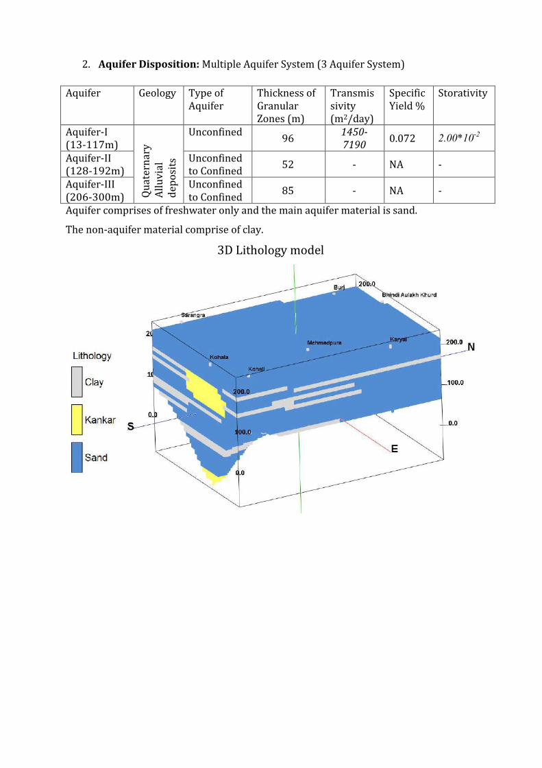
3 Ground Water Resource Extraction Contamination and Other Issues
Aquifer wise Water
Resource available
( mcm)
Dynamic Aquifer I 30343
In-storage Aquifer I 273715
Dynamic Aquifer II -
In-storage Aquifer II 4901
Dynamic Aquifer III -
In-storage Aquifer III 8011
Total 3170
Ground Water
Extraction (in
mcm)
Irrigation 33322
Domestic amp Industrial 442
Provision for domestic amp Industrial
requirement in 2025 ( mcm)
613
Chemical Quality of ground water amp
contamination
Suitable for drinking and irrigation
purposes
Other issues declining water level trend
4 Ground Water Resource Enhancement
Aquifer wise space available for
recharge and proposed interventions
Volume of unsaturated zone upto the average
depth to water level (13 m)
Other interventions proposed Artificial Recharge Roof top Rainwater
Harvesting Farm recharge by constructing
pits will save 7657 mcm volume of water
5 Demand Side Interventions
Advanced Irrigation Practices Lining of underground pipelines (Kutcha channel)
will save 8421 mcm volume of water wastage
Change in cropping pattern Proposed change in cropping pattern from Paddy
to maizesoyabean
40 of the total area needs to change the crop
from paddy to maizesoyabean
Anticipated volume of water to be saved by
maizesoyabean is 16 mcm
Alternate water sources Tanks ponds and canals
Regulation and Control -
Other interventions proposed if
any
-
(III) HARSHA CHHINA BLOCK (25740 SQ KM)
1 Salient Information
Population (2011) Rural-95260
Urban- -
Total-95260
Rainfall 2014 (Amritsar District) Average annual rainfall -6793 mm
Average Annual Rainfall (Harsha Chhina block) 624 mm
Agriculture and Irrigation Major Crops- Rice Wheat
Other crops- Sugarcane Potatoes Pulses
Net Area Sown- 20259sqkm
Total Irrigated Area-20259 sqkm
Water Bodies amp Canal Irrigation
Water bodies available in the villages for storm water and untreated waste water of
villagers that can be used for irrigation after treatment The canal irrigation is also
available in the Harsha Chhina block
Ground Water Resource Availability Ground Water Resources available in the
different group of aquifers Aquifer I (77 m) is very prominent in terms of thickness and
geographic extent Aquifer II (56 m) amp III (62 m) are less in thickness Block is
categorized as Over-Exploited as per Ground Water assessment 2013
Ground water Extraction Information regarding the abstraction from Aquifer III is
not available but there are drinking water supply tapping combined aquifer and
separate aquifer could not be assessed separately
Water level Behavior (2015) Pre Monsoon 890mdash1470 (mbgl) ampPost Monsoon-
~880mdash1410 (mbgl)+6
3D Lithology model
3D Lithology Fence
2 Aquifer Disposition Multiple Aquifer System (3 Aquifer System)
Aquifer Geology Type of
Aquifer
Thickness of
Granular
Zones (m)
Transmis
sivity
(m2day)
Specific
Yield
Storativity
Aquifer-I
(11-93m) Q
ua
tern
ary
All
uv
ial
de
po
sits
Unconfined 77
1450-
7190 0072 20010
-2
Aquifer-II
(119-214m)
Unconfined
to Confined 56 - NA -
Aquifer-III
(215-300m)
Unconfined
to Confined 62 - NA -
Aquifer comprises of freshwater only and the main aquifer material is sand
The non-aquifer material comprise of clay
3 Ground Water Resource Extraction Contamination and Other Issues
Aquifer wise Water
Resource available
( mcm)
Dynamic Aquifer I 19338
In-storage Aquifer I 142703
Dynamic Aquifer II -
In-storage Aquifer II 3431
Dynamic Aquifer III -
In-storage Aquifer III 3798
Total 1693
Ground Water
Extraction (in
mcm)
Irrigation 21011
Domestic amp Industrial 216
Provision for domestic amp Industrial
requirement up to 2025 ( mcm)
300
Chemical Quality of ground water amp
contamination
Suitable for drinking and irrigation
purposes
Other issues declining water level trend
4 Ground Water Resource Enhancement
Aquifer wise space available for
recharge and proposed interventions
Volume of unsaturated zone upto the average
depth to water level (11 m)
Other interventions proposed Artificial Recharge Roof top Rainwater
Harvesting Farm recharge by constructing
pits will save 2142 mcm volume of water
5 Demand Side Interventions
Advanced Irrigation Practices Lining of underground pipelines (Kutcha channel)
will save 5310 mcm volume of water wastage
Change in cropping pattern Proposed change in cropping pattern from Paddy
to maizesoyabean
40 of the total area needs to change the crop
from paddy to maizesoyabean
Anticipated volume of water to be saved by
maizesoyabean is 12 mcm
Alternate water sources Tanks ponds and canals
Regulation and Control -
Other interventions proposed if
any
-
(IV) JANDIALA BLOCK (20620 SQ KM)
1 Salient Information
Population (2011) Rural-125742
Urban- 250
Total-125992
Rainfall 2014 (Amritsar District) Average annual rainfall -6793 mm
Average Annual Rainfall (Jandiala block) 671 mm
Agriculture and Irrigation Major Crops- Rice Wheat
Other crops- Sugarcane Potatoes Pulses
Net Area Sown- 16153 sqkm
Total Irrigated Area- 16153 sqkm
Water Bodies amp Canal Irrigation
Water bodies available in the villages for the storm water and untreated waste water of
villagers that can be used for irrigation after treatment The canal irrigation is also
available in the Jandiala block
Ground Water Resource Availability Ground Water Resources available in the
different group of aquifers Aquifer I (79 m) is very prominent in terms of thickness and
geographic extent Aquifer II (29 m) is less in thickness amp Aquifer III is (89 m) Block is
categorized as Over-Exploited as per Ground Water assessment 2013
Ground water Extraction Information regarding the abstraction from Aquifer III is
not available but there are drinking water supply tapping combined aquifer and
separate aquifer could not be assessed separately
Water level Behavior (2015) Pre Monsoon 690mdash1920 (mbgl) ampPost Monsoon-
~
640
mdash
188
2
(mb
gl)
2 Aquifer Disposition Multiple Aquifer System (3 Aquifer System)
Aquifer Geology Type of
Aquifer
Thickness of
Granular
Zones (m)
Transmis
sivity
(m2day)
Specific
Yield
Storativity
Aquifer-I
(17-114m)
Qu
ate
rna
ry
All
uv
ial
de
po
sits
Unconfined 79
1450-
7190 0072 20010
-2
Aquifer-II
(125-179m)
Unconfined
to Confined 29 - NA -
Aquifer-III
(185-300m)
Unconfined
to Confined 89 - NA -
Aquifer comprises of freshwater only and the main aquifer material is sand
The non-aquifer material comprise of clay
3D Lithology model
3D Lithology Fence
3 Ground Water Resource Extraction Contamination and Other Issues
Aquifer wise Water
Resource available
( mcm)
Dynamic Aquifer I 15898
In-storage Aquifer I 117287
Dynamic Aquifer II -
In-storage Aquifer II 1423
Dynamic Aquifer III -
In-storage Aquifer III 4368
Total 1390
Ground Water
Extraction (in
mcm)
Irrigation 24364
Domestic amp Industrial 267
Provision for domestic amp Industrial
requirement 2025 (in mcm)
364
Chemical Quality of ground water amp
contamination
Suitable for drinking and irrigation
purposes
Other issues Declining water level trend
4 Ground Water Resource Enhancement
Aquifer wise space available for
recharge and proposed interventions
Volume of unsaturated zone upto the average
depth to water level (17 m)
Other interventions proposed Artificial Recharge Roof top Rainwater
Harvesting Farm recharge by constructing
pits will save 252 mcm volume of water
5 Demand Side Interventions
Advanced Irrigation Practices Lining of underground pipelines (Kutcha channel)
will save 6117 mcm volume of water wastage
Change in cropping pattern Proposed change in cropping pattern from Paddy
to maizesoyabean
40 of the total area needs to change the crop
from paddy to maizesoyabean
Anticipated volume of water to be saved by
maizesoyabean is 9 mcm
Alternate water sources Tanks ponds and canals
Regulation and Control -
Other interventions proposed if
any
-
(V) MAJITHA BLOCK (27190 SQ KM)
1 Salient Information
Population (2011) Rural-150271
Urban- -
Total-150271
Rainfall 2014 (Amritsar District) Average annual rainfall -699 mm
Average Annual Rainfall (Majitha block) 671 mm
Agriculture and Irrigation Major Crops- Rice Wheat
Other crops- Sugarcane Potatoes Pulses
Net Area Sown- 22684 sqkm
Total Irrigated Area- 22684 sqkm
Water Bodies amp Canal Irrigation
Water bodies available in the villages for storm water and untreated waste water of
villagers that can be used for irrigation after treatment The canal irrigation is available
in the Majitha block
Ground Water Resource Availability Ground Water Resources available in the
different group of aquifers Aquifer I (70 m) is very prominent in terms of thickness and
geographic extent Aquifer II (56 m) is less in thickness amp Aquifer III is (75 m) Block is
categorized as Critical as per Ground Water assessment 2013
Ground water Extraction Information regarding the abstraction from Aquifer III is
not available but there are drinking water supply tapping combined aquifer and
separate aquifer could not be assessed separately
Water level Behavior (2015) Pre Monsoon 810-1460 (mbgl) ampPost Monsoon-
~ 680- 1510
(mbgl)
2 Aquifer Disposition Multiple Aquifer System (3 Aquifer System)
Aquifer Geology Type of
Aquifer
Thickness of
Granular
Zones (m)
Transmis
sivity
(m2day)
Specific
Yield
Storativity
Aquifer-I
(10-92m)
Qu
ate
rna
ry
All
uv
ial
de
po
sits
Unconfined 70
1450-
7190 0072 20010
-2
Aquifer-II
(110-190m)
Unconfined
to Confined 56 - NA -
Aquifer-III
(203-300m)
Unconfined
to Confined 75 - NA -
Aquifer comprises of freshwater only and the main aquifer material is sand
The non-aquifer material comprise of clay
3D Lithology model
3D Lithology Fence
3 Ground Water Resource Extraction Contamination and Other Issues
Aquifer wise Water
Resource available
(in mcm)
Dynamic Aquifer I 32481
In-storage Aquifer I 137038
Dynamic Aquifer II -
In-storage Aquifer II 3624
Dynamic Aquifer III -
In-storage Aquifer III 4853
Total 1780
Ground Water
Extraction (in
mcm)
Irrigation 28321
Domestic amp Industrial 3003
Provision for domestic amp Industrial
requirement up to 2025 (in mcm)
4165
Chemical Quality of ground water amp
contamination
Suitable for drinking and irrigation
purposes
Other issues Declining water level trend
4 Ground Water Resource Enhancement
Aquifer wise space available for
recharge and proposed interventions
Volume of unsaturated zone upto the average
depth to water level (10m)
Other interventions proposed Artificial Recharge Roof top Rainwater
Harvesting Farm recharge by constructing
pits will save 3697 mcm volume of water
5 Demand Side Interventions
Advanced Irrigation Practices Lining of underground pipelines (Kutcha channel)
will save 7155 mcm volume of water wastage
Change in cropping pattern Proposed change in cropping pattern from Paddy
to maizesoyabean
40 of the total area needs to change the crop
from paddy to maizesoyabean
Anticipated volume of water to be saved by
maizesoyabean is 10 mcm
Alternate water sources Tanks ponds and canals
Regulation and Control -
Other interventions proposed if
any
-
(VI) RAYYA BLOCK (32640 SQ KM)
1 Salient Information
Population (2011) Rural-160421
Urban- 24513
Total-184934
Rainfall 2014 (Amritsar District) Average annual rainfall -63260 mm
Average Annual Rainfall (Rayya block) 671 mm
Agriculture and Irrigation Major Crops- Rice Wheat
Other crops- Sugarcane Potatoes Pulses
Net Area Sown- 23236 sqkm
Total Irrigated Area- 23236 sqkm
Water Bodies amp Canal Irrigation
Water bodies available in the villages for storm water and untreated waste water of
villagers that can be used for irrigation after treatment The canal irrigation is also
available in the Rayya block
Ground Water Resource Availability Ground Water Resources available in the
different group of aquifers Aquifer I (68 m) is very prominent in terms of thickness and
geographic extent Aquifer II (86 m) is very prominent in terms of thickness amp Aquifer
III is (49 m) Block is categorized as Over-Exploited as per Ground Water assessment
2013
Ground water Extraction Information regarding the abstraction from Aquifer III is
not available but there are drinking water supply tapping combined aquifer and
separate aquifer could not be assessed separately
Water level Behavior (2015) Pre Monsoon 1453-1570 (mbgl) ampPost Monsoon-
~ 1270-1515 (mbgl)
2 Aquifer Disposition Multiple Aquifer System (3 Aquifer System)
Aquifer Geology Type of
Aquifer
Thickness of
Granular
Zones (m)
Transmis
sivity
(m2day)
Specific
Yield
Storativity
Aquifer-I
(15-101m)
Qu
ate
rna
ry
All
uv
ial
de
po
sits
Unconfined 68
1450-
7190 0072 20010
-2
Aquifer-II
(112-218m)
Unconfined
to Confined 86 - NA -
Aquifer-III
(233-300m)
Unconfined
to Confined 49 - NA -
Aquifer comprises of freshwater only and the main aquifer material is sand
The non-aquifer material comprise of clay
3D Lithology model
3D Lithology Fence
3 Ground Water Resource Extraction Contamination and Other Issues
Aquifer wise Water
Resource available
(in mcm)
Dynamic Aquifer I 19154
In-storage Aquifer I 159805
Dynamic Aquifer II -
In-storage Aquifer II 6681
Dynamic Aquifer III -
In-storage Aquifer III 3806
Total 1894
Ground Water
Extraction (in
mcm)
Irrigation 26982
Domestic amp Industrial 572
Provision for domestic amp Industrial
requirement up to 2025 (in mcm)
788
Chemical Quality of ground water amp
contamination
Suitable for drinking and irrigation
purposes
Other issues Declining water level trend
4 Ground Water Resource Enhancement
Aquifer wise space available for
recharge and proposed interventions
Volume of unsaturated zone upto the average
depth to water level (15m)
Other interventions proposed Artificial Recharge Roof top Rainwater
Harvesting Farm recharge by constructing
pits will save 3588 mcm volume of water
5 Demand Side Interventions
Advanced Irrigation Practices Lining of underground pipelines (Kutcha channel)
will save 6817 mcm volume of water wastage
Change in cropping pattern Proposed change in cropping pattern from Paddy
to maizesoyabean
40 of the total area needs to change the crop
from paddy to maizesoyabean
Anticipated volume of water to be saved by
maizesoyabean is 11 mcm
Alternate water sources Tanks ponds and canals
Regulation and Control -
Other interventions proposed if
any
-
(VII) TARSIKA BLOCK (23650 SQ KM)
1 Salient Information
Population (2011) Rural-129367
Urban- -
Total-129367
Rainfall 2014 (Amritsar District) Average annual rainfall -63260 mm
Average Annual Rainfall (Tarsika block) 769 mm
Agriculture and Irrigation Major Crops- Rice Wheat
Other crops- Sugarcane Potatoes Pulses
Net Area Sown- 22475 sqkm
Total Irrigated Area- 22475 sqkm
Water Bodies amp Canal Irrigation
Water bodies available in the villages for storm water and untreated waste water of
villagers that can be used for irrigation after treatment The canal irrigation is also
available in the Tarsika block
Ground Water Resource Availability Ground Water Resources available in the
different group of aquifers Aquifer I (72 m) is very prominent in terms of thickness and
geographic extent Aquifer II (41 m) is less in thickness amp Aquifer III is (77 m) Block is
categorized as Over-Exploted as per Ground Water assessment 2013
Ground water Extraction Information regarding the abstraction from Aquifer III is
not available but there are drinking water supply tapping combined aquifer and
separate aquifer could not be assessed separately
Water level Behavior (2015) Pre Monsoon 1085-1780 (mbgl) ampPost Monsoon-
~ 998-1780 (mbgl)
2 Aquifer Disposition Multiple Aquifer System (3 Aquifer System)
Aquifer Geology Type of
Aquifer
Thickness of
Granular
Zones (m)
Transmis
sivity
(m2day)
Specific
Yield
Storativity
Aquifer-I
(12-98m)
Qu
ate
rna
ry
All
uv
ial
de
po
sits
Unconfined
72 1450-
7190 0072 20010
-2
Aquifer-II
(114-181m)
Unconfined
to Confined 41 - NA -
Aquifer-III
(210-300m)
Unconfined
to Confined 77 - NA -
Aquifer comprises of freshwater only and the main aquifer material is sand
The non-aquifer material comprise of clay
3D Lithology model
3D Lithology Fence
3 Ground Water Resource Extraction Contamination and Other Issues
Aquifer wise Water
Resource available
(in mcm)
Dynamic Aquifer I 16039
In-storage Aquifer I 122602
Dynamic Aquifer II -
In-storage Aquifer II 2308
Dynamic Aquifer III -
In-storage Aquifer III 4334
Total 1453
Ground Water
Extraction (in
mcm)
Irrigation 23915
Domestic amp Industrial 313
Provision for domestic amp Industrial
requirement up to 2025 (in mcm)
434
Chemical Quality of ground water amp
contamination
Suitable for drinking and irrigation
purposes
Other issues Declining water level trend
4 Ground Water Resource Enhancement
Aquifer wise space available for
recharge and proposed interventions
Volume of unsaturated zone upto the average
depth to water level (12m)
Other interventions proposed Artificial Recharge Roof top Rainwater
Harvesting Farm recharge by constructing
pits will save 3167 mcm volume of water
5 Demand Side Interventions
Advanced Irrigation Practices Lining of underground pipelines (Kutcha channel)
will save 6042 mcm volume of water wastage
Change in cropping pattern Proposed change in cropping pattern from Paddy
to maizesoyabean
40 of the total area needs to change the crop
from paddy to maizesoyabean
Anticipated volume of water to be saved by
maizesoyabean is 9 mcm
Alternate water sources Tanks ponds and canals
Regulation and Control -
Other interventions proposed if
any
-
(VII) VERKA BLOCK (33304 SQ KM)
1 Salient Information
Population (2011) Rural-67151
Urban- 44860
Total-112011
Rainfall 2014 (Amritsar District) Average annual rainfall -63260 mm
Average Annual Rainfall (Verka block) 644 mm
Agriculture and Irrigation Major Crops- Rice Wheat
Other crops- Sugarcane Potatoes Pulses
Net Area Sown- 14762 sqkm
Total Irrigated Area- 14762 sqkm
Water Bodies amp Canal Irrigation
Water bodies available in the villages for storm water and untreated waste water of
villagers that can be used for irrigation after treatment The canal irrigation is also
available in the Verka block
Ground Water Resource Availability Ground Water Resources available in the
different group of aquifers Aquifer I (76 m) is very prominent in terms of thickness and
geographic extent Aquifer II (59 m) is less in thickness amp Aquifer III is (59m) Block is
categorized as Over-Exploited as per Ground Water assessment 2013
Ground water Extraction Information regarding the abstraction from Aquifer III is
not available but there are drinking water supply tapping combined aquifer and
separate aquifer could not be assessed separately
Water level Behavior (2015) Pre Monsoon 1280-2484 (mbgl) ampPost Monsoon-~
1280-2386 (mbgl)
2 Aquifer Disposition Multiple Aquifer System (3 Aquifer System)
Aquifer Geology Type of
Aquifer
Thickness of
Granular
Zones (m)
Transmis
sivity
(m2day)
Specific
Yield
Storativity
Aquifer-I
(20-107m) Q
ua
tern
ary
All
uv
ial
de
po
sits
Unconfined 76
1450-
7190 12 20010
-2
Aquifer-II
(126-201m)
Unconfined
to Confined 59 - NA -
Aquifer-III
(225-300m)
Unconfined
to Confined 59 - NA -
Aquifer comprises of freshwater only and the main aquifer material is sand
The non-aquifer material comprise of clay
3D Lithology model
3D Lithology Fence
3 Ground Water Resource Extraction Contamination and Other Issues
Aquifer wise Water
Resource available
(in mcm)
Dynamic Aquifer I 20424
In-storage Aquifer I 182436
Dynamic Aquifer II -
In-storage Aquifer II 4682
Dynamic Aquifer III -
In-storage Aquifer III 4285
Total 2118
Ground Water
Extraction (in
mcm)
Irrigation 20792
Domestic amp Industrial 499
Provision for domestic amp Industrial
requirement up to 2025 (in mcm)
607
Chemical Quality of ground water amp
contamination
Potable for drinking and irrigation
Other issues declining water level trend
4 Ground Water Resource Enhancement
Aquifer wise space available for
recharge and proposed interventions
Volume of unsaturated zone upto the average
depth to water level (20m)
Other interventions proposed Artificial Recharge Roof top Rainwater
Harvesting Farm recharge by constructing
pits will save 2745 mcm volume of water
5 Demand Side Interventions
Advanced Irrigation Practices Lining of underground pipelines (Kutcha channel)
will save 5254 mcm volume of water wastage
Change in cropping pattern Proposed change in cropping pattern from Paddy
to maizesoyabean
40 of the total area needs to change the crop
from paddy to maizesoyabean
Anticipated volume of water to be saved by
maizesoyabean is 7 mcm
Alternate water sources Tanks ponds and canals
Regulation and Control -
Other interventions proposed if
any
-
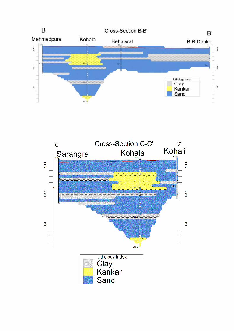
3D Lithology model
3D Lithology Fence
2 Aquifer Disposition Multiple Aquifer System (3 Aquifer System)
Aquifer Geology Type of
Aquifer
Thickness of
Granular
Zones (m)
Transmis
sivity
(m2day)
Specific
Yield
Storativity
Aquifer-I
(11-93m) Q
ua
tern
ary
All
uv
ial
de
po
sits
Unconfined 77
1450-
7190 0072 20010
-2
Aquifer-II
(119-214m)
Unconfined
to Confined 56 - NA -
Aquifer-III
(215-300m)
Unconfined
to Confined 62 - NA -
Aquifer comprises of freshwater only and the main aquifer material is sand
The non-aquifer material comprise of clay
3 Ground Water Resource Extraction Contamination and Other Issues
Aquifer wise Water
Resource available
( mcm)
Dynamic Aquifer I 19338
In-storage Aquifer I 142703
Dynamic Aquifer II -
In-storage Aquifer II 3431
Dynamic Aquifer III -
In-storage Aquifer III 3798
Total 1693
Ground Water
Extraction (in
mcm)
Irrigation 21011
Domestic amp Industrial 216
Provision for domestic amp Industrial
requirement up to 2025 ( mcm)
300
Chemical Quality of ground water amp
contamination
Suitable for drinking and irrigation
purposes
Other issues declining water level trend
4 Ground Water Resource Enhancement
Aquifer wise space available for
recharge and proposed interventions
Volume of unsaturated zone upto the average
depth to water level (11 m)
Other interventions proposed Artificial Recharge Roof top Rainwater
Harvesting Farm recharge by constructing
pits will save 2142 mcm volume of water
5 Demand Side Interventions
Advanced Irrigation Practices Lining of underground pipelines (Kutcha channel)
will save 5310 mcm volume of water wastage
Change in cropping pattern Proposed change in cropping pattern from Paddy
to maizesoyabean
40 of the total area needs to change the crop
from paddy to maizesoyabean
Anticipated volume of water to be saved by
maizesoyabean is 12 mcm
Alternate water sources Tanks ponds and canals
Regulation and Control -
Other interventions proposed if
any
-
(IV) JANDIALA BLOCK (20620 SQ KM)
1 Salient Information
Population (2011) Rural-125742
Urban- 250
Total-125992
Rainfall 2014 (Amritsar District) Average annual rainfall -6793 mm
Average Annual Rainfall (Jandiala block) 671 mm
Agriculture and Irrigation Major Crops- Rice Wheat
Other crops- Sugarcane Potatoes Pulses
Net Area Sown- 16153 sqkm
Total Irrigated Area- 16153 sqkm
Water Bodies amp Canal Irrigation
Water bodies available in the villages for the storm water and untreated waste water of
villagers that can be used for irrigation after treatment The canal irrigation is also
available in the Jandiala block
Ground Water Resource Availability Ground Water Resources available in the
different group of aquifers Aquifer I (79 m) is very prominent in terms of thickness and
geographic extent Aquifer II (29 m) is less in thickness amp Aquifer III is (89 m) Block is
categorized as Over-Exploited as per Ground Water assessment 2013
Ground water Extraction Information regarding the abstraction from Aquifer III is
not available but there are drinking water supply tapping combined aquifer and
separate aquifer could not be assessed separately
Water level Behavior (2015) Pre Monsoon 690mdash1920 (mbgl) ampPost Monsoon-
~
640
mdash
188
2
(mb
gl)
2 Aquifer Disposition Multiple Aquifer System (3 Aquifer System)
Aquifer Geology Type of
Aquifer
Thickness of
Granular
Zones (m)
Transmis
sivity
(m2day)
Specific
Yield
Storativity
Aquifer-I
(17-114m)
Qu
ate
rna
ry
All
uv
ial
de
po
sits
Unconfined 79
1450-
7190 0072 20010
-2
Aquifer-II
(125-179m)
Unconfined
to Confined 29 - NA -
Aquifer-III
(185-300m)
Unconfined
to Confined 89 - NA -
Aquifer comprises of freshwater only and the main aquifer material is sand
The non-aquifer material comprise of clay
3D Lithology model
3D Lithology Fence
3 Ground Water Resource Extraction Contamination and Other Issues
Aquifer wise Water
Resource available
( mcm)
Dynamic Aquifer I 15898
In-storage Aquifer I 117287
Dynamic Aquifer II -
In-storage Aquifer II 1423
Dynamic Aquifer III -
In-storage Aquifer III 4368
Total 1390
Ground Water
Extraction (in
mcm)
Irrigation 24364
Domestic amp Industrial 267
Provision for domestic amp Industrial
requirement 2025 (in mcm)
364
Chemical Quality of ground water amp
contamination
Suitable for drinking and irrigation
purposes
Other issues Declining water level trend
4 Ground Water Resource Enhancement
Aquifer wise space available for
recharge and proposed interventions
Volume of unsaturated zone upto the average
depth to water level (17 m)
Other interventions proposed Artificial Recharge Roof top Rainwater
Harvesting Farm recharge by constructing
pits will save 252 mcm volume of water
5 Demand Side Interventions
Advanced Irrigation Practices Lining of underground pipelines (Kutcha channel)
will save 6117 mcm volume of water wastage
Change in cropping pattern Proposed change in cropping pattern from Paddy
to maizesoyabean
40 of the total area needs to change the crop
from paddy to maizesoyabean
Anticipated volume of water to be saved by
maizesoyabean is 9 mcm
Alternate water sources Tanks ponds and canals
Regulation and Control -
Other interventions proposed if
any
-
(V) MAJITHA BLOCK (27190 SQ KM)
1 Salient Information
Population (2011) Rural-150271
Urban- -
Total-150271
Rainfall 2014 (Amritsar District) Average annual rainfall -699 mm
Average Annual Rainfall (Majitha block) 671 mm
Agriculture and Irrigation Major Crops- Rice Wheat
Other crops- Sugarcane Potatoes Pulses
Net Area Sown- 22684 sqkm
Total Irrigated Area- 22684 sqkm
Water Bodies amp Canal Irrigation
Water bodies available in the villages for storm water and untreated waste water of
villagers that can be used for irrigation after treatment The canal irrigation is available
in the Majitha block
Ground Water Resource Availability Ground Water Resources available in the
different group of aquifers Aquifer I (70 m) is very prominent in terms of thickness and
geographic extent Aquifer II (56 m) is less in thickness amp Aquifer III is (75 m) Block is
categorized as Critical as per Ground Water assessment 2013
Ground water Extraction Information regarding the abstraction from Aquifer III is
not available but there are drinking water supply tapping combined aquifer and
separate aquifer could not be assessed separately
Water level Behavior (2015) Pre Monsoon 810-1460 (mbgl) ampPost Monsoon-
~ 680- 1510
(mbgl)
2 Aquifer Disposition Multiple Aquifer System (3 Aquifer System)
Aquifer Geology Type of
Aquifer
Thickness of
Granular
Zones (m)
Transmis
sivity
(m2day)
Specific
Yield
Storativity
Aquifer-I
(10-92m)
Qu
ate
rna
ry
All
uv
ial
de
po
sits
Unconfined 70
1450-
7190 0072 20010
-2
Aquifer-II
(110-190m)
Unconfined
to Confined 56 - NA -
Aquifer-III
(203-300m)
Unconfined
to Confined 75 - NA -
Aquifer comprises of freshwater only and the main aquifer material is sand
The non-aquifer material comprise of clay
3D Lithology model
3D Lithology Fence
3 Ground Water Resource Extraction Contamination and Other Issues
Aquifer wise Water
Resource available
(in mcm)
Dynamic Aquifer I 32481
In-storage Aquifer I 137038
Dynamic Aquifer II -
In-storage Aquifer II 3624
Dynamic Aquifer III -
In-storage Aquifer III 4853
Total 1780
Ground Water
Extraction (in
mcm)
Irrigation 28321
Domestic amp Industrial 3003
Provision for domestic amp Industrial
requirement up to 2025 (in mcm)
4165
Chemical Quality of ground water amp
contamination
Suitable for drinking and irrigation
purposes
Other issues Declining water level trend
4 Ground Water Resource Enhancement
Aquifer wise space available for
recharge and proposed interventions
Volume of unsaturated zone upto the average
depth to water level (10m)
Other interventions proposed Artificial Recharge Roof top Rainwater
Harvesting Farm recharge by constructing
pits will save 3697 mcm volume of water
5 Demand Side Interventions
Advanced Irrigation Practices Lining of underground pipelines (Kutcha channel)
will save 7155 mcm volume of water wastage
Change in cropping pattern Proposed change in cropping pattern from Paddy
to maizesoyabean
40 of the total area needs to change the crop
from paddy to maizesoyabean
Anticipated volume of water to be saved by
maizesoyabean is 10 mcm
Alternate water sources Tanks ponds and canals
Regulation and Control -
Other interventions proposed if
any
-
(VI) RAYYA BLOCK (32640 SQ KM)
1 Salient Information
Population (2011) Rural-160421
Urban- 24513
Total-184934
Rainfall 2014 (Amritsar District) Average annual rainfall -63260 mm
Average Annual Rainfall (Rayya block) 671 mm
Agriculture and Irrigation Major Crops- Rice Wheat
Other crops- Sugarcane Potatoes Pulses
Net Area Sown- 23236 sqkm
Total Irrigated Area- 23236 sqkm
Water Bodies amp Canal Irrigation
Water bodies available in the villages for storm water and untreated waste water of
villagers that can be used for irrigation after treatment The canal irrigation is also
available in the Rayya block
Ground Water Resource Availability Ground Water Resources available in the
different group of aquifers Aquifer I (68 m) is very prominent in terms of thickness and
geographic extent Aquifer II (86 m) is very prominent in terms of thickness amp Aquifer
III is (49 m) Block is categorized as Over-Exploited as per Ground Water assessment
2013
Ground water Extraction Information regarding the abstraction from Aquifer III is
not available but there are drinking water supply tapping combined aquifer and
separate aquifer could not be assessed separately
Water level Behavior (2015) Pre Monsoon 1453-1570 (mbgl) ampPost Monsoon-
~ 1270-1515 (mbgl)
2 Aquifer Disposition Multiple Aquifer System (3 Aquifer System)
Aquifer Geology Type of
Aquifer
Thickness of
Granular
Zones (m)
Transmis
sivity
(m2day)
Specific
Yield
Storativity
Aquifer-I
(15-101m)
Qu
ate
rna
ry
All
uv
ial
de
po
sits
Unconfined 68
1450-
7190 0072 20010
-2
Aquifer-II
(112-218m)
Unconfined
to Confined 86 - NA -
Aquifer-III
(233-300m)
Unconfined
to Confined 49 - NA -
Aquifer comprises of freshwater only and the main aquifer material is sand
The non-aquifer material comprise of clay
3D Lithology model
3D Lithology Fence
3 Ground Water Resource Extraction Contamination and Other Issues
Aquifer wise Water
Resource available
(in mcm)
Dynamic Aquifer I 19154
In-storage Aquifer I 159805
Dynamic Aquifer II -
In-storage Aquifer II 6681
Dynamic Aquifer III -
In-storage Aquifer III 3806
Total 1894
Ground Water
Extraction (in
mcm)
Irrigation 26982
Domestic amp Industrial 572
Provision for domestic amp Industrial
requirement up to 2025 (in mcm)
788
Chemical Quality of ground water amp
contamination
Suitable for drinking and irrigation
purposes
Other issues Declining water level trend
4 Ground Water Resource Enhancement
Aquifer wise space available for
recharge and proposed interventions
Volume of unsaturated zone upto the average
depth to water level (15m)
Other interventions proposed Artificial Recharge Roof top Rainwater
Harvesting Farm recharge by constructing
pits will save 3588 mcm volume of water
5 Demand Side Interventions
Advanced Irrigation Practices Lining of underground pipelines (Kutcha channel)
will save 6817 mcm volume of water wastage
Change in cropping pattern Proposed change in cropping pattern from Paddy
to maizesoyabean
40 of the total area needs to change the crop
from paddy to maizesoyabean
Anticipated volume of water to be saved by
maizesoyabean is 11 mcm
Alternate water sources Tanks ponds and canals
Regulation and Control -
Other interventions proposed if
any
-
(VII) TARSIKA BLOCK (23650 SQ KM)
1 Salient Information
Population (2011) Rural-129367
Urban- -
Total-129367
Rainfall 2014 (Amritsar District) Average annual rainfall -63260 mm
Average Annual Rainfall (Tarsika block) 769 mm
Agriculture and Irrigation Major Crops- Rice Wheat
Other crops- Sugarcane Potatoes Pulses
Net Area Sown- 22475 sqkm
Total Irrigated Area- 22475 sqkm
Water Bodies amp Canal Irrigation
Water bodies available in the villages for storm water and untreated waste water of
villagers that can be used for irrigation after treatment The canal irrigation is also
available in the Tarsika block
Ground Water Resource Availability Ground Water Resources available in the
different group of aquifers Aquifer I (72 m) is very prominent in terms of thickness and
geographic extent Aquifer II (41 m) is less in thickness amp Aquifer III is (77 m) Block is
categorized as Over-Exploted as per Ground Water assessment 2013
Ground water Extraction Information regarding the abstraction from Aquifer III is
not available but there are drinking water supply tapping combined aquifer and
separate aquifer could not be assessed separately
Water level Behavior (2015) Pre Monsoon 1085-1780 (mbgl) ampPost Monsoon-
~ 998-1780 (mbgl)
2 Aquifer Disposition Multiple Aquifer System (3 Aquifer System)
Aquifer Geology Type of
Aquifer
Thickness of
Granular
Zones (m)
Transmis
sivity
(m2day)
Specific
Yield
Storativity
Aquifer-I
(12-98m)
Qu
ate
rna
ry
All
uv
ial
de
po
sits
Unconfined
72 1450-
7190 0072 20010
-2
Aquifer-II
(114-181m)
Unconfined
to Confined 41 - NA -
Aquifer-III
(210-300m)
Unconfined
to Confined 77 - NA -
Aquifer comprises of freshwater only and the main aquifer material is sand
The non-aquifer material comprise of clay
3D Lithology model
3D Lithology Fence
3 Ground Water Resource Extraction Contamination and Other Issues
Aquifer wise Water
Resource available
(in mcm)
Dynamic Aquifer I 16039
In-storage Aquifer I 122602
Dynamic Aquifer II -
In-storage Aquifer II 2308
Dynamic Aquifer III -
In-storage Aquifer III 4334
Total 1453
Ground Water
Extraction (in
mcm)
Irrigation 23915
Domestic amp Industrial 313
Provision for domestic amp Industrial
requirement up to 2025 (in mcm)
434
Chemical Quality of ground water amp
contamination
Suitable for drinking and irrigation
purposes
Other issues Declining water level trend
4 Ground Water Resource Enhancement
Aquifer wise space available for
recharge and proposed interventions
Volume of unsaturated zone upto the average
depth to water level (12m)
Other interventions proposed Artificial Recharge Roof top Rainwater
Harvesting Farm recharge by constructing
pits will save 3167 mcm volume of water
5 Demand Side Interventions
Advanced Irrigation Practices Lining of underground pipelines (Kutcha channel)
will save 6042 mcm volume of water wastage
Change in cropping pattern Proposed change in cropping pattern from Paddy
to maizesoyabean
40 of the total area needs to change the crop
from paddy to maizesoyabean
Anticipated volume of water to be saved by
maizesoyabean is 9 mcm
Alternate water sources Tanks ponds and canals
Regulation and Control -
Other interventions proposed if
any
-
(VII) VERKA BLOCK (33304 SQ KM)
1 Salient Information
Population (2011) Rural-67151
Urban- 44860
Total-112011
Rainfall 2014 (Amritsar District) Average annual rainfall -63260 mm
Average Annual Rainfall (Verka block) 644 mm
Agriculture and Irrigation Major Crops- Rice Wheat
Other crops- Sugarcane Potatoes Pulses
Net Area Sown- 14762 sqkm
Total Irrigated Area- 14762 sqkm
Water Bodies amp Canal Irrigation
Water bodies available in the villages for storm water and untreated waste water of
villagers that can be used for irrigation after treatment The canal irrigation is also
available in the Verka block
Ground Water Resource Availability Ground Water Resources available in the
different group of aquifers Aquifer I (76 m) is very prominent in terms of thickness and
geographic extent Aquifer II (59 m) is less in thickness amp Aquifer III is (59m) Block is
categorized as Over-Exploited as per Ground Water assessment 2013
Ground water Extraction Information regarding the abstraction from Aquifer III is
not available but there are drinking water supply tapping combined aquifer and
separate aquifer could not be assessed separately
Water level Behavior (2015) Pre Monsoon 1280-2484 (mbgl) ampPost Monsoon-~
1280-2386 (mbgl)
2 Aquifer Disposition Multiple Aquifer System (3 Aquifer System)
Aquifer Geology Type of
Aquifer
Thickness of
Granular
Zones (m)
Transmis
sivity
(m2day)
Specific
Yield
Storativity
Aquifer-I
(20-107m) Q
ua
tern
ary
All
uv
ial
de
po
sits
Unconfined 76
1450-
7190 12 20010
-2
Aquifer-II
(126-201m)
Unconfined
to Confined 59 - NA -
Aquifer-III
(225-300m)
Unconfined
to Confined 59 - NA -
Aquifer comprises of freshwater only and the main aquifer material is sand
The non-aquifer material comprise of clay
3D Lithology model
3D Lithology Fence
3 Ground Water Resource Extraction Contamination and Other Issues
Aquifer wise Water
Resource available
(in mcm)
Dynamic Aquifer I 20424
In-storage Aquifer I 182436
Dynamic Aquifer II -
In-storage Aquifer II 4682
Dynamic Aquifer III -
In-storage Aquifer III 4285
Total 2118
Ground Water
Extraction (in
mcm)
Irrigation 20792
Domestic amp Industrial 499
Provision for domestic amp Industrial
requirement up to 2025 (in mcm)
607
Chemical Quality of ground water amp
contamination
Potable for drinking and irrigation
Other issues declining water level trend
4 Ground Water Resource Enhancement
Aquifer wise space available for
recharge and proposed interventions
Volume of unsaturated zone upto the average
depth to water level (20m)
Other interventions proposed Artificial Recharge Roof top Rainwater
Harvesting Farm recharge by constructing
pits will save 2745 mcm volume of water
5 Demand Side Interventions
Advanced Irrigation Practices Lining of underground pipelines (Kutcha channel)
will save 5254 mcm volume of water wastage
Change in cropping pattern Proposed change in cropping pattern from Paddy
to maizesoyabean
40 of the total area needs to change the crop
from paddy to maizesoyabean
Anticipated volume of water to be saved by
maizesoyabean is 7 mcm
Alternate water sources Tanks ponds and canals
Regulation and Control -
Other interventions proposed if
any
-
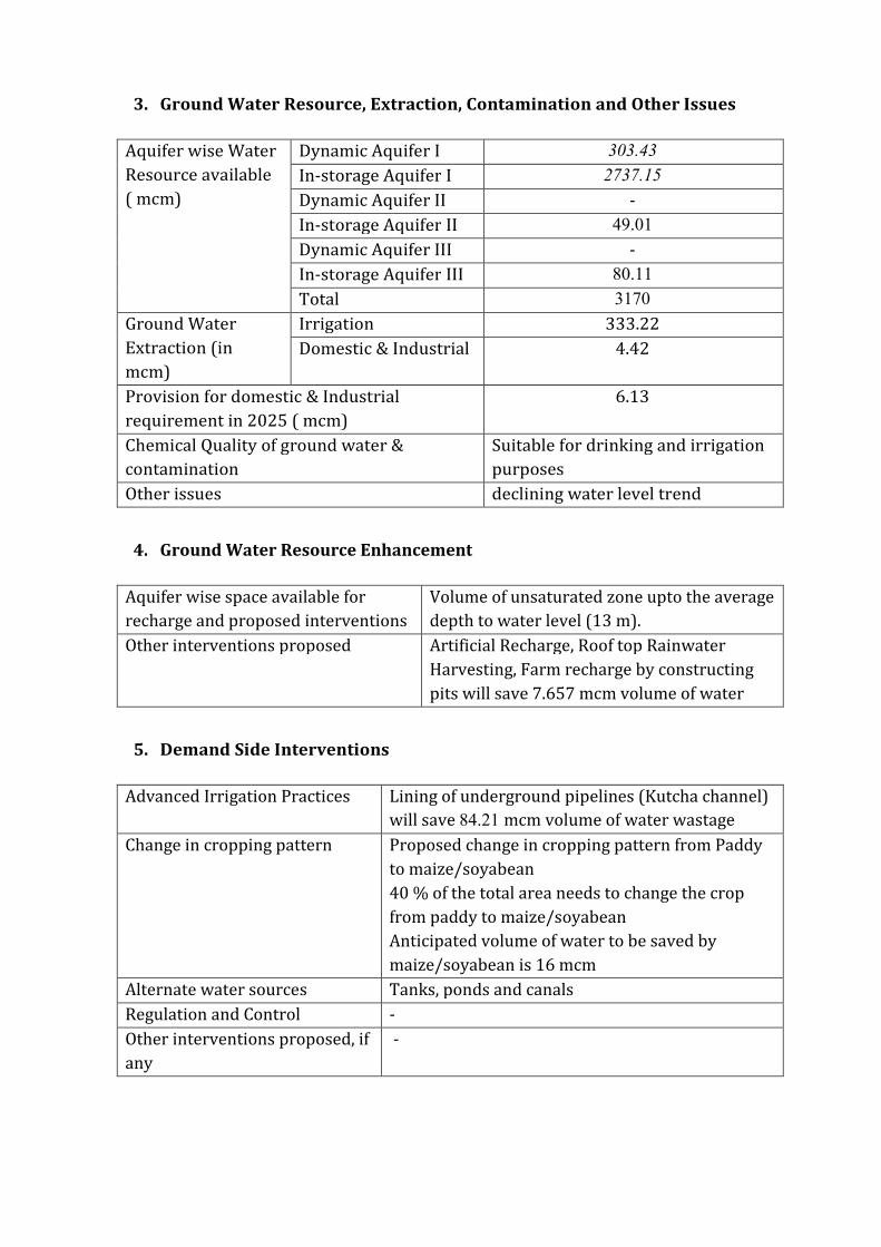
2 Aquifer Disposition Multiple Aquifer System (3 Aquifer System)
Aquifer Geology Type of
Aquifer
Thickness of
Granular
Zones (m)
Transmis
sivity
(m2day)
Specific
Yield
Storativity
Aquifer-I
(11-93m) Q
ua
tern
ary
All
uv
ial
de
po
sits
Unconfined 77
1450-
7190 0072 20010
-2
Aquifer-II
(119-214m)
Unconfined
to Confined 56 - NA -
Aquifer-III
(215-300m)
Unconfined
to Confined 62 - NA -
Aquifer comprises of freshwater only and the main aquifer material is sand
The non-aquifer material comprise of clay
3 Ground Water Resource Extraction Contamination and Other Issues
Aquifer wise Water
Resource available
( mcm)
Dynamic Aquifer I 19338
In-storage Aquifer I 142703
Dynamic Aquifer II -
In-storage Aquifer II 3431
Dynamic Aquifer III -
In-storage Aquifer III 3798
Total 1693
Ground Water
Extraction (in
mcm)
Irrigation 21011
Domestic amp Industrial 216
Provision for domestic amp Industrial
requirement up to 2025 ( mcm)
300
Chemical Quality of ground water amp
contamination
Suitable for drinking and irrigation
purposes
Other issues declining water level trend
4 Ground Water Resource Enhancement
Aquifer wise space available for
recharge and proposed interventions
Volume of unsaturated zone upto the average
depth to water level (11 m)
Other interventions proposed Artificial Recharge Roof top Rainwater
Harvesting Farm recharge by constructing
pits will save 2142 mcm volume of water
5 Demand Side Interventions
Advanced Irrigation Practices Lining of underground pipelines (Kutcha channel)
will save 5310 mcm volume of water wastage
Change in cropping pattern Proposed change in cropping pattern from Paddy
to maizesoyabean
40 of the total area needs to change the crop
from paddy to maizesoyabean
Anticipated volume of water to be saved by
maizesoyabean is 12 mcm
Alternate water sources Tanks ponds and canals
Regulation and Control -
Other interventions proposed if
any
-
(IV) JANDIALA BLOCK (20620 SQ KM)
1 Salient Information
Population (2011) Rural-125742
Urban- 250
Total-125992
Rainfall 2014 (Amritsar District) Average annual rainfall -6793 mm
Average Annual Rainfall (Jandiala block) 671 mm
Agriculture and Irrigation Major Crops- Rice Wheat
Other crops- Sugarcane Potatoes Pulses
Net Area Sown- 16153 sqkm
Total Irrigated Area- 16153 sqkm
Water Bodies amp Canal Irrigation
Water bodies available in the villages for the storm water and untreated waste water of
villagers that can be used for irrigation after treatment The canal irrigation is also
available in the Jandiala block
Ground Water Resource Availability Ground Water Resources available in the
different group of aquifers Aquifer I (79 m) is very prominent in terms of thickness and
geographic extent Aquifer II (29 m) is less in thickness amp Aquifer III is (89 m) Block is
categorized as Over-Exploited as per Ground Water assessment 2013
Ground water Extraction Information regarding the abstraction from Aquifer III is
not available but there are drinking water supply tapping combined aquifer and
separate aquifer could not be assessed separately
Water level Behavior (2015) Pre Monsoon 690mdash1920 (mbgl) ampPost Monsoon-
~
640
mdash
188
2
(mb
gl)
2 Aquifer Disposition Multiple Aquifer System (3 Aquifer System)
Aquifer Geology Type of
Aquifer
Thickness of
Granular
Zones (m)
Transmis
sivity
(m2day)
Specific
Yield
Storativity
Aquifer-I
(17-114m)
Qu
ate
rna
ry
All
uv
ial
de
po
sits
Unconfined 79
1450-
7190 0072 20010
-2
Aquifer-II
(125-179m)
Unconfined
to Confined 29 - NA -
Aquifer-III
(185-300m)
Unconfined
to Confined 89 - NA -
Aquifer comprises of freshwater only and the main aquifer material is sand
The non-aquifer material comprise of clay
3D Lithology model
3D Lithology Fence
3 Ground Water Resource Extraction Contamination and Other Issues
Aquifer wise Water
Resource available
( mcm)
Dynamic Aquifer I 15898
In-storage Aquifer I 117287
Dynamic Aquifer II -
In-storage Aquifer II 1423
Dynamic Aquifer III -
In-storage Aquifer III 4368
Total 1390
Ground Water
Extraction (in
mcm)
Irrigation 24364
Domestic amp Industrial 267
Provision for domestic amp Industrial
requirement 2025 (in mcm)
364
Chemical Quality of ground water amp
contamination
Suitable for drinking and irrigation
purposes
Other issues Declining water level trend
4 Ground Water Resource Enhancement
Aquifer wise space available for
recharge and proposed interventions
Volume of unsaturated zone upto the average
depth to water level (17 m)
Other interventions proposed Artificial Recharge Roof top Rainwater
Harvesting Farm recharge by constructing
pits will save 252 mcm volume of water
5 Demand Side Interventions
Advanced Irrigation Practices Lining of underground pipelines (Kutcha channel)
will save 6117 mcm volume of water wastage
Change in cropping pattern Proposed change in cropping pattern from Paddy
to maizesoyabean
40 of the total area needs to change the crop
from paddy to maizesoyabean
Anticipated volume of water to be saved by
maizesoyabean is 9 mcm
Alternate water sources Tanks ponds and canals
Regulation and Control -
Other interventions proposed if
any
-
(V) MAJITHA BLOCK (27190 SQ KM)
1 Salient Information
Population (2011) Rural-150271
Urban- -
Total-150271
Rainfall 2014 (Amritsar District) Average annual rainfall -699 mm
Average Annual Rainfall (Majitha block) 671 mm
Agriculture and Irrigation Major Crops- Rice Wheat
Other crops- Sugarcane Potatoes Pulses
Net Area Sown- 22684 sqkm
Total Irrigated Area- 22684 sqkm
Water Bodies amp Canal Irrigation
Water bodies available in the villages for storm water and untreated waste water of
villagers that can be used for irrigation after treatment The canal irrigation is available
in the Majitha block
Ground Water Resource Availability Ground Water Resources available in the
different group of aquifers Aquifer I (70 m) is very prominent in terms of thickness and
geographic extent Aquifer II (56 m) is less in thickness amp Aquifer III is (75 m) Block is
categorized as Critical as per Ground Water assessment 2013
Ground water Extraction Information regarding the abstraction from Aquifer III is
not available but there are drinking water supply tapping combined aquifer and
separate aquifer could not be assessed separately
Water level Behavior (2015) Pre Monsoon 810-1460 (mbgl) ampPost Monsoon-
~ 680- 1510
(mbgl)
2 Aquifer Disposition Multiple Aquifer System (3 Aquifer System)
Aquifer Geology Type of
Aquifer
Thickness of
Granular
Zones (m)
Transmis
sivity
(m2day)
Specific
Yield
Storativity
Aquifer-I
(10-92m)
Qu
ate
rna
ry
All
uv
ial
de
po
sits
Unconfined 70
1450-
7190 0072 20010
-2
Aquifer-II
(110-190m)
Unconfined
to Confined 56 - NA -
Aquifer-III
(203-300m)
Unconfined
to Confined 75 - NA -
Aquifer comprises of freshwater only and the main aquifer material is sand
The non-aquifer material comprise of clay
3D Lithology model
3D Lithology Fence
3 Ground Water Resource Extraction Contamination and Other Issues
Aquifer wise Water
Resource available
(in mcm)
Dynamic Aquifer I 32481
In-storage Aquifer I 137038
Dynamic Aquifer II -
In-storage Aquifer II 3624
Dynamic Aquifer III -
In-storage Aquifer III 4853
Total 1780
Ground Water
Extraction (in
mcm)
Irrigation 28321
Domestic amp Industrial 3003
Provision for domestic amp Industrial
requirement up to 2025 (in mcm)
4165
Chemical Quality of ground water amp
contamination
Suitable for drinking and irrigation
purposes
Other issues Declining water level trend
4 Ground Water Resource Enhancement
Aquifer wise space available for
recharge and proposed interventions
Volume of unsaturated zone upto the average
depth to water level (10m)
Other interventions proposed Artificial Recharge Roof top Rainwater
Harvesting Farm recharge by constructing
pits will save 3697 mcm volume of water
5 Demand Side Interventions
Advanced Irrigation Practices Lining of underground pipelines (Kutcha channel)
will save 7155 mcm volume of water wastage
Change in cropping pattern Proposed change in cropping pattern from Paddy
to maizesoyabean
40 of the total area needs to change the crop
from paddy to maizesoyabean
Anticipated volume of water to be saved by
maizesoyabean is 10 mcm
Alternate water sources Tanks ponds and canals
Regulation and Control -
Other interventions proposed if
any
-
(VI) RAYYA BLOCK (32640 SQ KM)
1 Salient Information
Population (2011) Rural-160421
Urban- 24513
Total-184934
Rainfall 2014 (Amritsar District) Average annual rainfall -63260 mm
Average Annual Rainfall (Rayya block) 671 mm
Agriculture and Irrigation Major Crops- Rice Wheat
Other crops- Sugarcane Potatoes Pulses
Net Area Sown- 23236 sqkm
Total Irrigated Area- 23236 sqkm
Water Bodies amp Canal Irrigation
Water bodies available in the villages for storm water and untreated waste water of
villagers that can be used for irrigation after treatment The canal irrigation is also
available in the Rayya block
Ground Water Resource Availability Ground Water Resources available in the
different group of aquifers Aquifer I (68 m) is very prominent in terms of thickness and
geographic extent Aquifer II (86 m) is very prominent in terms of thickness amp Aquifer
III is (49 m) Block is categorized as Over-Exploited as per Ground Water assessment
2013
Ground water Extraction Information regarding the abstraction from Aquifer III is
not available but there are drinking water supply tapping combined aquifer and
separate aquifer could not be assessed separately
Water level Behavior (2015) Pre Monsoon 1453-1570 (mbgl) ampPost Monsoon-
~ 1270-1515 (mbgl)
2 Aquifer Disposition Multiple Aquifer System (3 Aquifer System)
Aquifer Geology Type of
Aquifer
Thickness of
Granular
Zones (m)
Transmis
sivity
(m2day)
Specific
Yield
Storativity
Aquifer-I
(15-101m)
Qu
ate
rna
ry
All
uv
ial
de
po
sits
Unconfined 68
1450-
7190 0072 20010
-2
Aquifer-II
(112-218m)
Unconfined
to Confined 86 - NA -
Aquifer-III
(233-300m)
Unconfined
to Confined 49 - NA -
Aquifer comprises of freshwater only and the main aquifer material is sand
The non-aquifer material comprise of clay
3D Lithology model
3D Lithology Fence
3 Ground Water Resource Extraction Contamination and Other Issues
Aquifer wise Water
Resource available
(in mcm)
Dynamic Aquifer I 19154
In-storage Aquifer I 159805
Dynamic Aquifer II -
In-storage Aquifer II 6681
Dynamic Aquifer III -
In-storage Aquifer III 3806
Total 1894
Ground Water
Extraction (in
mcm)
Irrigation 26982
Domestic amp Industrial 572
Provision for domestic amp Industrial
requirement up to 2025 (in mcm)
788
Chemical Quality of ground water amp
contamination
Suitable for drinking and irrigation
purposes
Other issues Declining water level trend
4 Ground Water Resource Enhancement
Aquifer wise space available for
recharge and proposed interventions
Volume of unsaturated zone upto the average
depth to water level (15m)
Other interventions proposed Artificial Recharge Roof top Rainwater
Harvesting Farm recharge by constructing
pits will save 3588 mcm volume of water
5 Demand Side Interventions
Advanced Irrigation Practices Lining of underground pipelines (Kutcha channel)
will save 6817 mcm volume of water wastage
Change in cropping pattern Proposed change in cropping pattern from Paddy
to maizesoyabean
40 of the total area needs to change the crop
from paddy to maizesoyabean
Anticipated volume of water to be saved by
maizesoyabean is 11 mcm
Alternate water sources Tanks ponds and canals
Regulation and Control -
Other interventions proposed if
any
-
(VII) TARSIKA BLOCK (23650 SQ KM)
1 Salient Information
Population (2011) Rural-129367
Urban- -
Total-129367
Rainfall 2014 (Amritsar District) Average annual rainfall -63260 mm
Average Annual Rainfall (Tarsika block) 769 mm
Agriculture and Irrigation Major Crops- Rice Wheat
Other crops- Sugarcane Potatoes Pulses
Net Area Sown- 22475 sqkm
Total Irrigated Area- 22475 sqkm
Water Bodies amp Canal Irrigation
Water bodies available in the villages for storm water and untreated waste water of
villagers that can be used for irrigation after treatment The canal irrigation is also
available in the Tarsika block
Ground Water Resource Availability Ground Water Resources available in the
different group of aquifers Aquifer I (72 m) is very prominent in terms of thickness and
geographic extent Aquifer II (41 m) is less in thickness amp Aquifer III is (77 m) Block is
categorized as Over-Exploted as per Ground Water assessment 2013
Ground water Extraction Information regarding the abstraction from Aquifer III is
not available but there are drinking water supply tapping combined aquifer and
separate aquifer could not be assessed separately
Water level Behavior (2015) Pre Monsoon 1085-1780 (mbgl) ampPost Monsoon-
~ 998-1780 (mbgl)
2 Aquifer Disposition Multiple Aquifer System (3 Aquifer System)
Aquifer Geology Type of
Aquifer
Thickness of
Granular
Zones (m)
Transmis
sivity
(m2day)
Specific
Yield
Storativity
Aquifer-I
(12-98m)
Qu
ate
rna
ry
All
uv
ial
de
po
sits
Unconfined
72 1450-
7190 0072 20010
-2
Aquifer-II
(114-181m)
Unconfined
to Confined 41 - NA -
Aquifer-III
(210-300m)
Unconfined
to Confined 77 - NA -
Aquifer comprises of freshwater only and the main aquifer material is sand
The non-aquifer material comprise of clay
3D Lithology model
3D Lithology Fence
3 Ground Water Resource Extraction Contamination and Other Issues
Aquifer wise Water
Resource available
(in mcm)
Dynamic Aquifer I 16039
In-storage Aquifer I 122602
Dynamic Aquifer II -
In-storage Aquifer II 2308
Dynamic Aquifer III -
In-storage Aquifer III 4334
Total 1453
Ground Water
Extraction (in
mcm)
Irrigation 23915
Domestic amp Industrial 313
Provision for domestic amp Industrial
requirement up to 2025 (in mcm)
434
Chemical Quality of ground water amp
contamination
Suitable for drinking and irrigation
purposes
Other issues Declining water level trend
4 Ground Water Resource Enhancement
Aquifer wise space available for
recharge and proposed interventions
Volume of unsaturated zone upto the average
depth to water level (12m)
Other interventions proposed Artificial Recharge Roof top Rainwater
Harvesting Farm recharge by constructing
pits will save 3167 mcm volume of water
5 Demand Side Interventions
Advanced Irrigation Practices Lining of underground pipelines (Kutcha channel)
will save 6042 mcm volume of water wastage
Change in cropping pattern Proposed change in cropping pattern from Paddy
to maizesoyabean
40 of the total area needs to change the crop
from paddy to maizesoyabean
Anticipated volume of water to be saved by
maizesoyabean is 9 mcm
Alternate water sources Tanks ponds and canals
Regulation and Control -
Other interventions proposed if
any
-
(VII) VERKA BLOCK (33304 SQ KM)
1 Salient Information
Population (2011) Rural-67151
Urban- 44860
Total-112011
Rainfall 2014 (Amritsar District) Average annual rainfall -63260 mm
Average Annual Rainfall (Verka block) 644 mm
Agriculture and Irrigation Major Crops- Rice Wheat
Other crops- Sugarcane Potatoes Pulses
Net Area Sown- 14762 sqkm
Total Irrigated Area- 14762 sqkm
Water Bodies amp Canal Irrigation
Water bodies available in the villages for storm water and untreated waste water of
villagers that can be used for irrigation after treatment The canal irrigation is also
available in the Verka block
Ground Water Resource Availability Ground Water Resources available in the
different group of aquifers Aquifer I (76 m) is very prominent in terms of thickness and
geographic extent Aquifer II (59 m) is less in thickness amp Aquifer III is (59m) Block is
categorized as Over-Exploited as per Ground Water assessment 2013
Ground water Extraction Information regarding the abstraction from Aquifer III is
not available but there are drinking water supply tapping combined aquifer and
separate aquifer could not be assessed separately
Water level Behavior (2015) Pre Monsoon 1280-2484 (mbgl) ampPost Monsoon-~
1280-2386 (mbgl)
2 Aquifer Disposition Multiple Aquifer System (3 Aquifer System)
Aquifer Geology Type of
Aquifer
Thickness of
Granular
Zones (m)
Transmis
sivity
(m2day)
Specific
Yield
Storativity
Aquifer-I
(20-107m) Q
ua
tern
ary
All
uv
ial
de
po
sits
Unconfined 76
1450-
7190 12 20010
-2
Aquifer-II
(126-201m)
Unconfined
to Confined 59 - NA -
Aquifer-III
(225-300m)
Unconfined
to Confined 59 - NA -
Aquifer comprises of freshwater only and the main aquifer material is sand
The non-aquifer material comprise of clay
3D Lithology model
3D Lithology Fence
3 Ground Water Resource Extraction Contamination and Other Issues
Aquifer wise Water
Resource available
(in mcm)
Dynamic Aquifer I 20424
In-storage Aquifer I 182436
Dynamic Aquifer II -
In-storage Aquifer II 4682
Dynamic Aquifer III -
In-storage Aquifer III 4285
Total 2118
Ground Water
Extraction (in
mcm)
Irrigation 20792
Domestic amp Industrial 499
Provision for domestic amp Industrial
requirement up to 2025 (in mcm)
607
Chemical Quality of ground water amp
contamination
Potable for drinking and irrigation
Other issues declining water level trend
4 Ground Water Resource Enhancement
Aquifer wise space available for
recharge and proposed interventions
Volume of unsaturated zone upto the average
depth to water level (20m)
Other interventions proposed Artificial Recharge Roof top Rainwater
Harvesting Farm recharge by constructing
pits will save 2745 mcm volume of water
5 Demand Side Interventions
Advanced Irrigation Practices Lining of underground pipelines (Kutcha channel)
will save 5254 mcm volume of water wastage
Change in cropping pattern Proposed change in cropping pattern from Paddy
to maizesoyabean
40 of the total area needs to change the crop
from paddy to maizesoyabean
Anticipated volume of water to be saved by
maizesoyabean is 7 mcm
Alternate water sources Tanks ponds and canals
Regulation and Control -
Other interventions proposed if
any
-

5 Demand Side Interventions
Advanced Irrigation Practices Lining of underground pipelines (Kutcha channel)
will save 5310 mcm volume of water wastage
Change in cropping pattern Proposed change in cropping pattern from Paddy
to maizesoyabean
40 of the total area needs to change the crop
from paddy to maizesoyabean
Anticipated volume of water to be saved by
maizesoyabean is 12 mcm
Alternate water sources Tanks ponds and canals
Regulation and Control -
Other interventions proposed if
any
-
(IV) JANDIALA BLOCK (20620 SQ KM)
1 Salient Information
Population (2011) Rural-125742
Urban- 250
Total-125992
Rainfall 2014 (Amritsar District) Average annual rainfall -6793 mm
Average Annual Rainfall (Jandiala block) 671 mm
Agriculture and Irrigation Major Crops- Rice Wheat
Other crops- Sugarcane Potatoes Pulses
Net Area Sown- 16153 sqkm
Total Irrigated Area- 16153 sqkm
Water Bodies amp Canal Irrigation
Water bodies available in the villages for the storm water and untreated waste water of
villagers that can be used for irrigation after treatment The canal irrigation is also
available in the Jandiala block
Ground Water Resource Availability Ground Water Resources available in the
different group of aquifers Aquifer I (79 m) is very prominent in terms of thickness and
geographic extent Aquifer II (29 m) is less in thickness amp Aquifer III is (89 m) Block is
categorized as Over-Exploited as per Ground Water assessment 2013
Ground water Extraction Information regarding the abstraction from Aquifer III is
not available but there are drinking water supply tapping combined aquifer and
separate aquifer could not be assessed separately
Water level Behavior (2015) Pre Monsoon 690mdash1920 (mbgl) ampPost Monsoon-
~
640
mdash
188
2
(mb
gl)
2 Aquifer Disposition Multiple Aquifer System (3 Aquifer System)
Aquifer Geology Type of
Aquifer
Thickness of
Granular
Zones (m)
Transmis
sivity
(m2day)
Specific
Yield
Storativity
Aquifer-I
(17-114m)
Qu
ate
rna
ry
All
uv
ial
de
po
sits
Unconfined 79
1450-
7190 0072 20010
-2
Aquifer-II
(125-179m)
Unconfined
to Confined 29 - NA -
Aquifer-III
(185-300m)
Unconfined
to Confined 89 - NA -
Aquifer comprises of freshwater only and the main aquifer material is sand
The non-aquifer material comprise of clay
3D Lithology model
3D Lithology Fence
3 Ground Water Resource Extraction Contamination and Other Issues
Aquifer wise Water
Resource available
( mcm)
Dynamic Aquifer I 15898
In-storage Aquifer I 117287
Dynamic Aquifer II -
In-storage Aquifer II 1423
Dynamic Aquifer III -
In-storage Aquifer III 4368
Total 1390
Ground Water
Extraction (in
mcm)
Irrigation 24364
Domestic amp Industrial 267
Provision for domestic amp Industrial
requirement 2025 (in mcm)
364
Chemical Quality of ground water amp
contamination
Suitable for drinking and irrigation
purposes
Other issues Declining water level trend
4 Ground Water Resource Enhancement
Aquifer wise space available for
recharge and proposed interventions
Volume of unsaturated zone upto the average
depth to water level (17 m)
Other interventions proposed Artificial Recharge Roof top Rainwater
Harvesting Farm recharge by constructing
pits will save 252 mcm volume of water
5 Demand Side Interventions
Advanced Irrigation Practices Lining of underground pipelines (Kutcha channel)
will save 6117 mcm volume of water wastage
Change in cropping pattern Proposed change in cropping pattern from Paddy
to maizesoyabean
40 of the total area needs to change the crop
from paddy to maizesoyabean
Anticipated volume of water to be saved by
maizesoyabean is 9 mcm
Alternate water sources Tanks ponds and canals
Regulation and Control -
Other interventions proposed if
any
-
(V) MAJITHA BLOCK (27190 SQ KM)
1 Salient Information
Population (2011) Rural-150271
Urban- -
Total-150271
Rainfall 2014 (Amritsar District) Average annual rainfall -699 mm
Average Annual Rainfall (Majitha block) 671 mm
Agriculture and Irrigation Major Crops- Rice Wheat
Other crops- Sugarcane Potatoes Pulses
Net Area Sown- 22684 sqkm
Total Irrigated Area- 22684 sqkm
Water Bodies amp Canal Irrigation
Water bodies available in the villages for storm water and untreated waste water of
villagers that can be used for irrigation after treatment The canal irrigation is available
in the Majitha block
Ground Water Resource Availability Ground Water Resources available in the
different group of aquifers Aquifer I (70 m) is very prominent in terms of thickness and
geographic extent Aquifer II (56 m) is less in thickness amp Aquifer III is (75 m) Block is
categorized as Critical as per Ground Water assessment 2013
Ground water Extraction Information regarding the abstraction from Aquifer III is
not available but there are drinking water supply tapping combined aquifer and
separate aquifer could not be assessed separately
Water level Behavior (2015) Pre Monsoon 810-1460 (mbgl) ampPost Monsoon-
~ 680- 1510
(mbgl)
2 Aquifer Disposition Multiple Aquifer System (3 Aquifer System)
Aquifer Geology Type of
Aquifer
Thickness of
Granular
Zones (m)
Transmis
sivity
(m2day)
Specific
Yield
Storativity
Aquifer-I
(10-92m)
Qu
ate
rna
ry
All
uv
ial
de
po
sits
Unconfined 70
1450-
7190 0072 20010
-2
Aquifer-II
(110-190m)
Unconfined
to Confined 56 - NA -
Aquifer-III
(203-300m)
Unconfined
to Confined 75 - NA -
Aquifer comprises of freshwater only and the main aquifer material is sand
The non-aquifer material comprise of clay
3D Lithology model
3D Lithology Fence
3 Ground Water Resource Extraction Contamination and Other Issues
Aquifer wise Water
Resource available
(in mcm)
Dynamic Aquifer I 32481
In-storage Aquifer I 137038
Dynamic Aquifer II -
In-storage Aquifer II 3624
Dynamic Aquifer III -
In-storage Aquifer III 4853
Total 1780
Ground Water
Extraction (in
mcm)
Irrigation 28321
Domestic amp Industrial 3003
Provision for domestic amp Industrial
requirement up to 2025 (in mcm)
4165
Chemical Quality of ground water amp
contamination
Suitable for drinking and irrigation
purposes
Other issues Declining water level trend
4 Ground Water Resource Enhancement
Aquifer wise space available for
recharge and proposed interventions
Volume of unsaturated zone upto the average
depth to water level (10m)
Other interventions proposed Artificial Recharge Roof top Rainwater
Harvesting Farm recharge by constructing
pits will save 3697 mcm volume of water
5 Demand Side Interventions
Advanced Irrigation Practices Lining of underground pipelines (Kutcha channel)
will save 7155 mcm volume of water wastage
Change in cropping pattern Proposed change in cropping pattern from Paddy
to maizesoyabean
40 of the total area needs to change the crop
from paddy to maizesoyabean
Anticipated volume of water to be saved by
maizesoyabean is 10 mcm
Alternate water sources Tanks ponds and canals
Regulation and Control -
Other interventions proposed if
any
-
(VI) RAYYA BLOCK (32640 SQ KM)
1 Salient Information
Population (2011) Rural-160421
Urban- 24513
Total-184934
Rainfall 2014 (Amritsar District) Average annual rainfall -63260 mm
Average Annual Rainfall (Rayya block) 671 mm
Agriculture and Irrigation Major Crops- Rice Wheat
Other crops- Sugarcane Potatoes Pulses
Net Area Sown- 23236 sqkm
Total Irrigated Area- 23236 sqkm
Water Bodies amp Canal Irrigation
Water bodies available in the villages for storm water and untreated waste water of
villagers that can be used for irrigation after treatment The canal irrigation is also
available in the Rayya block
Ground Water Resource Availability Ground Water Resources available in the
different group of aquifers Aquifer I (68 m) is very prominent in terms of thickness and
geographic extent Aquifer II (86 m) is very prominent in terms of thickness amp Aquifer
III is (49 m) Block is categorized as Over-Exploited as per Ground Water assessment
2013
Ground water Extraction Information regarding the abstraction from Aquifer III is
not available but there are drinking water supply tapping combined aquifer and
separate aquifer could not be assessed separately
Water level Behavior (2015) Pre Monsoon 1453-1570 (mbgl) ampPost Monsoon-
~ 1270-1515 (mbgl)
2 Aquifer Disposition Multiple Aquifer System (3 Aquifer System)
Aquifer Geology Type of
Aquifer
Thickness of
Granular
Zones (m)
Transmis
sivity
(m2day)
Specific
Yield
Storativity
Aquifer-I
(15-101m)
Qu
ate
rna
ry
All
uv
ial
de
po
sits
Unconfined 68
1450-
7190 0072 20010
-2
Aquifer-II
(112-218m)
Unconfined
to Confined 86 - NA -
Aquifer-III
(233-300m)
Unconfined
to Confined 49 - NA -
Aquifer comprises of freshwater only and the main aquifer material is sand
The non-aquifer material comprise of clay
3D Lithology model
3D Lithology Fence
3 Ground Water Resource Extraction Contamination and Other Issues
Aquifer wise Water
Resource available
(in mcm)
Dynamic Aquifer I 19154
In-storage Aquifer I 159805
Dynamic Aquifer II -
In-storage Aquifer II 6681
Dynamic Aquifer III -
In-storage Aquifer III 3806
Total 1894
Ground Water
Extraction (in
mcm)
Irrigation 26982
Domestic amp Industrial 572
Provision for domestic amp Industrial
requirement up to 2025 (in mcm)
788
Chemical Quality of ground water amp
contamination
Suitable for drinking and irrigation
purposes
Other issues Declining water level trend
4 Ground Water Resource Enhancement
Aquifer wise space available for
recharge and proposed interventions
Volume of unsaturated zone upto the average
depth to water level (15m)
Other interventions proposed Artificial Recharge Roof top Rainwater
Harvesting Farm recharge by constructing
pits will save 3588 mcm volume of water
5 Demand Side Interventions
Advanced Irrigation Practices Lining of underground pipelines (Kutcha channel)
will save 6817 mcm volume of water wastage
Change in cropping pattern Proposed change in cropping pattern from Paddy
to maizesoyabean
40 of the total area needs to change the crop
from paddy to maizesoyabean
Anticipated volume of water to be saved by
maizesoyabean is 11 mcm
Alternate water sources Tanks ponds and canals
Regulation and Control -
Other interventions proposed if
any
-
(VII) TARSIKA BLOCK (23650 SQ KM)
1 Salient Information
Population (2011) Rural-129367
Urban- -
Total-129367
Rainfall 2014 (Amritsar District) Average annual rainfall -63260 mm
Average Annual Rainfall (Tarsika block) 769 mm
Agriculture and Irrigation Major Crops- Rice Wheat
Other crops- Sugarcane Potatoes Pulses
Net Area Sown- 22475 sqkm
Total Irrigated Area- 22475 sqkm
Water Bodies amp Canal Irrigation
Water bodies available in the villages for storm water and untreated waste water of
villagers that can be used for irrigation after treatment The canal irrigation is also
available in the Tarsika block
Ground Water Resource Availability Ground Water Resources available in the
different group of aquifers Aquifer I (72 m) is very prominent in terms of thickness and
geographic extent Aquifer II (41 m) is less in thickness amp Aquifer III is (77 m) Block is
categorized as Over-Exploted as per Ground Water assessment 2013
Ground water Extraction Information regarding the abstraction from Aquifer III is
not available but there are drinking water supply tapping combined aquifer and
separate aquifer could not be assessed separately
Water level Behavior (2015) Pre Monsoon 1085-1780 (mbgl) ampPost Monsoon-
~ 998-1780 (mbgl)
2 Aquifer Disposition Multiple Aquifer System (3 Aquifer System)
Aquifer Geology Type of
Aquifer
Thickness of
Granular
Zones (m)
Transmis
sivity
(m2day)
Specific
Yield
Storativity
Aquifer-I
(12-98m)
Qu
ate
rna
ry
All
uv
ial
de
po
sits
Unconfined
72 1450-
7190 0072 20010
-2
Aquifer-II
(114-181m)
Unconfined
to Confined 41 - NA -
Aquifer-III
(210-300m)
Unconfined
to Confined 77 - NA -
Aquifer comprises of freshwater only and the main aquifer material is sand
The non-aquifer material comprise of clay
3D Lithology model
3D Lithology Fence
3 Ground Water Resource Extraction Contamination and Other Issues
Aquifer wise Water
Resource available
(in mcm)
Dynamic Aquifer I 16039
In-storage Aquifer I 122602
Dynamic Aquifer II -
In-storage Aquifer II 2308
Dynamic Aquifer III -
In-storage Aquifer III 4334
Total 1453
Ground Water
Extraction (in
mcm)
Irrigation 23915
Domestic amp Industrial 313
Provision for domestic amp Industrial
requirement up to 2025 (in mcm)
434
Chemical Quality of ground water amp
contamination
Suitable for drinking and irrigation
purposes
Other issues Declining water level trend
4 Ground Water Resource Enhancement
Aquifer wise space available for
recharge and proposed interventions
Volume of unsaturated zone upto the average
depth to water level (12m)
Other interventions proposed Artificial Recharge Roof top Rainwater
Harvesting Farm recharge by constructing
pits will save 3167 mcm volume of water
5 Demand Side Interventions
Advanced Irrigation Practices Lining of underground pipelines (Kutcha channel)
will save 6042 mcm volume of water wastage
Change in cropping pattern Proposed change in cropping pattern from Paddy
to maizesoyabean
40 of the total area needs to change the crop
from paddy to maizesoyabean
Anticipated volume of water to be saved by
maizesoyabean is 9 mcm
Alternate water sources Tanks ponds and canals
Regulation and Control -
Other interventions proposed if
any
-
(VII) VERKA BLOCK (33304 SQ KM)
1 Salient Information
Population (2011) Rural-67151
Urban- 44860
Total-112011
Rainfall 2014 (Amritsar District) Average annual rainfall -63260 mm
Average Annual Rainfall (Verka block) 644 mm
Agriculture and Irrigation Major Crops- Rice Wheat
Other crops- Sugarcane Potatoes Pulses
Net Area Sown- 14762 sqkm
Total Irrigated Area- 14762 sqkm
Water Bodies amp Canal Irrigation
Water bodies available in the villages for storm water and untreated waste water of
villagers that can be used for irrigation after treatment The canal irrigation is also
available in the Verka block
Ground Water Resource Availability Ground Water Resources available in the
different group of aquifers Aquifer I (76 m) is very prominent in terms of thickness and
geographic extent Aquifer II (59 m) is less in thickness amp Aquifer III is (59m) Block is
categorized as Over-Exploited as per Ground Water assessment 2013
Ground water Extraction Information regarding the abstraction from Aquifer III is
not available but there are drinking water supply tapping combined aquifer and
separate aquifer could not be assessed separately
Water level Behavior (2015) Pre Monsoon 1280-2484 (mbgl) ampPost Monsoon-~
1280-2386 (mbgl)
2 Aquifer Disposition Multiple Aquifer System (3 Aquifer System)
Aquifer Geology Type of
Aquifer
Thickness of
Granular
Zones (m)
Transmis
sivity
(m2day)
Specific
Yield
Storativity
Aquifer-I
(20-107m) Q
ua
tern
ary
All
uv
ial
de
po
sits
Unconfined 76
1450-
7190 12 20010
-2
Aquifer-II
(126-201m)
Unconfined
to Confined 59 - NA -
Aquifer-III
(225-300m)
Unconfined
to Confined 59 - NA -
Aquifer comprises of freshwater only and the main aquifer material is sand
The non-aquifer material comprise of clay
3D Lithology model
3D Lithology Fence
3 Ground Water Resource Extraction Contamination and Other Issues
Aquifer wise Water
Resource available
(in mcm)
Dynamic Aquifer I 20424
In-storage Aquifer I 182436
Dynamic Aquifer II -
In-storage Aquifer II 4682
Dynamic Aquifer III -
In-storage Aquifer III 4285
Total 2118
Ground Water
Extraction (in
mcm)
Irrigation 20792
Domestic amp Industrial 499
Provision for domestic amp Industrial
requirement up to 2025 (in mcm)
607
Chemical Quality of ground water amp
contamination
Potable for drinking and irrigation
Other issues declining water level trend
4 Ground Water Resource Enhancement
Aquifer wise space available for
recharge and proposed interventions
Volume of unsaturated zone upto the average
depth to water level (20m)
Other interventions proposed Artificial Recharge Roof top Rainwater
Harvesting Farm recharge by constructing
pits will save 2745 mcm volume of water
5 Demand Side Interventions
Advanced Irrigation Practices Lining of underground pipelines (Kutcha channel)
will save 5254 mcm volume of water wastage
Change in cropping pattern Proposed change in cropping pattern from Paddy
to maizesoyabean
40 of the total area needs to change the crop
from paddy to maizesoyabean
Anticipated volume of water to be saved by
maizesoyabean is 7 mcm
Alternate water sources Tanks ponds and canals
Regulation and Control -
Other interventions proposed if
any
-
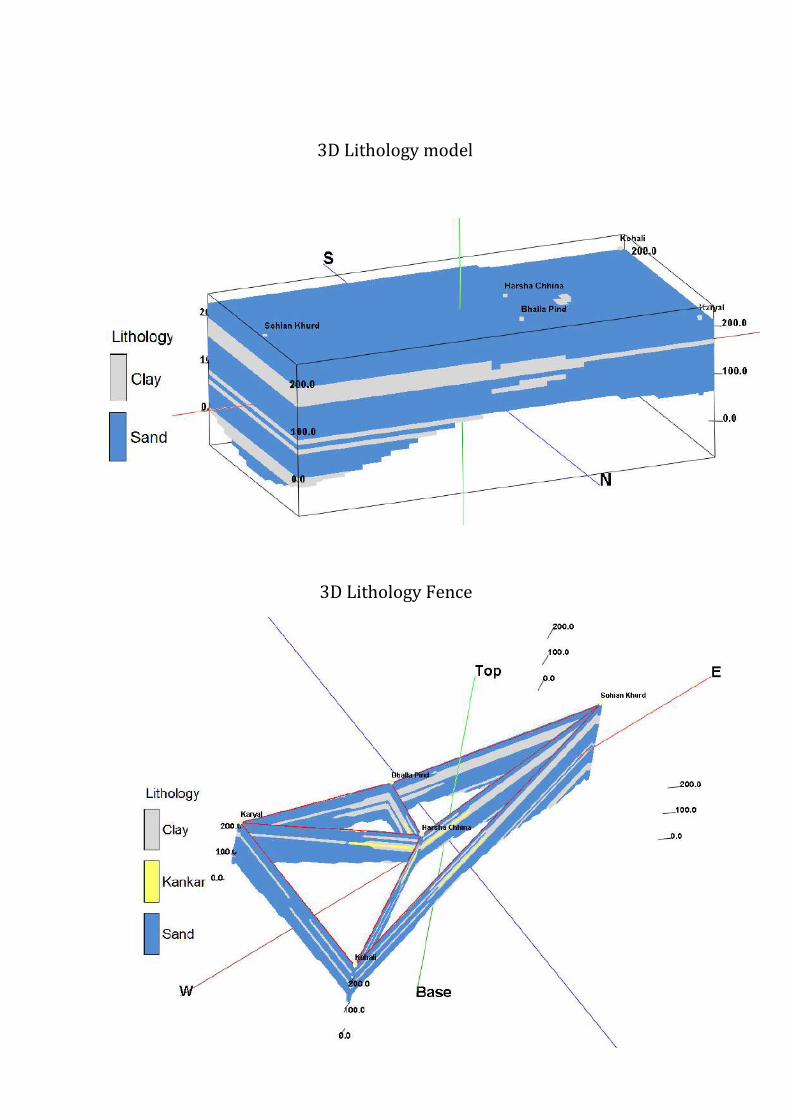

2 Aquifer Disposition Multiple Aquifer System (3 Aquifer System)
Aquifer Geology Type of
Aquifer
Thickness of
Granular
Zones (m)
Transmis
sivity
(m2day)
Specific
Yield
Storativity
Aquifer-I
(17-114m)
Qu
ate
rna
ry
All
uv
ial
de
po
sits
Unconfined 79
1450-
7190 0072 20010
-2
Aquifer-II
(125-179m)
Unconfined
to Confined 29 - NA -
Aquifer-III
(185-300m)
Unconfined
to Confined 89 - NA -
Aquifer comprises of freshwater only and the main aquifer material is sand
The non-aquifer material comprise of clay
3D Lithology model
3D Lithology Fence
3 Ground Water Resource Extraction Contamination and Other Issues
Aquifer wise Water
Resource available
( mcm)
Dynamic Aquifer I 15898
In-storage Aquifer I 117287
Dynamic Aquifer II -
In-storage Aquifer II 1423
Dynamic Aquifer III -
In-storage Aquifer III 4368
Total 1390
Ground Water
Extraction (in
mcm)
Irrigation 24364
Domestic amp Industrial 267
Provision for domestic amp Industrial
requirement 2025 (in mcm)
364
Chemical Quality of ground water amp
contamination
Suitable for drinking and irrigation
purposes
Other issues Declining water level trend
4 Ground Water Resource Enhancement
Aquifer wise space available for
recharge and proposed interventions
Volume of unsaturated zone upto the average
depth to water level (17 m)
Other interventions proposed Artificial Recharge Roof top Rainwater
Harvesting Farm recharge by constructing
pits will save 252 mcm volume of water
5 Demand Side Interventions
Advanced Irrigation Practices Lining of underground pipelines (Kutcha channel)
will save 6117 mcm volume of water wastage
Change in cropping pattern Proposed change in cropping pattern from Paddy
to maizesoyabean
40 of the total area needs to change the crop
from paddy to maizesoyabean
Anticipated volume of water to be saved by
maizesoyabean is 9 mcm
Alternate water sources Tanks ponds and canals
Regulation and Control -
Other interventions proposed if
any
-
(V) MAJITHA BLOCK (27190 SQ KM)
1 Salient Information
Population (2011) Rural-150271
Urban- -
Total-150271
Rainfall 2014 (Amritsar District) Average annual rainfall -699 mm
Average Annual Rainfall (Majitha block) 671 mm
Agriculture and Irrigation Major Crops- Rice Wheat
Other crops- Sugarcane Potatoes Pulses
Net Area Sown- 22684 sqkm
Total Irrigated Area- 22684 sqkm
Water Bodies amp Canal Irrigation
Water bodies available in the villages for storm water and untreated waste water of
villagers that can be used for irrigation after treatment The canal irrigation is available
in the Majitha block
Ground Water Resource Availability Ground Water Resources available in the
different group of aquifers Aquifer I (70 m) is very prominent in terms of thickness and
geographic extent Aquifer II (56 m) is less in thickness amp Aquifer III is (75 m) Block is
categorized as Critical as per Ground Water assessment 2013
Ground water Extraction Information regarding the abstraction from Aquifer III is
not available but there are drinking water supply tapping combined aquifer and
separate aquifer could not be assessed separately
Water level Behavior (2015) Pre Monsoon 810-1460 (mbgl) ampPost Monsoon-
~ 680- 1510
(mbgl)
2 Aquifer Disposition Multiple Aquifer System (3 Aquifer System)
Aquifer Geology Type of
Aquifer
Thickness of
Granular
Zones (m)
Transmis
sivity
(m2day)
Specific
Yield
Storativity
Aquifer-I
(10-92m)
Qu
ate
rna
ry
All
uv
ial
de
po
sits
Unconfined 70
1450-
7190 0072 20010
-2
Aquifer-II
(110-190m)
Unconfined
to Confined 56 - NA -
Aquifer-III
(203-300m)
Unconfined
to Confined 75 - NA -
Aquifer comprises of freshwater only and the main aquifer material is sand
The non-aquifer material comprise of clay
3D Lithology model
3D Lithology Fence
3 Ground Water Resource Extraction Contamination and Other Issues
Aquifer wise Water
Resource available
(in mcm)
Dynamic Aquifer I 32481
In-storage Aquifer I 137038
Dynamic Aquifer II -
In-storage Aquifer II 3624
Dynamic Aquifer III -
In-storage Aquifer III 4853
Total 1780
Ground Water
Extraction (in
mcm)
Irrigation 28321
Domestic amp Industrial 3003
Provision for domestic amp Industrial
requirement up to 2025 (in mcm)
4165
Chemical Quality of ground water amp
contamination
Suitable for drinking and irrigation
purposes
Other issues Declining water level trend
4 Ground Water Resource Enhancement
Aquifer wise space available for
recharge and proposed interventions
Volume of unsaturated zone upto the average
depth to water level (10m)
Other interventions proposed Artificial Recharge Roof top Rainwater
Harvesting Farm recharge by constructing
pits will save 3697 mcm volume of water
5 Demand Side Interventions
Advanced Irrigation Practices Lining of underground pipelines (Kutcha channel)
will save 7155 mcm volume of water wastage
Change in cropping pattern Proposed change in cropping pattern from Paddy
to maizesoyabean
40 of the total area needs to change the crop
from paddy to maizesoyabean
Anticipated volume of water to be saved by
maizesoyabean is 10 mcm
Alternate water sources Tanks ponds and canals
Regulation and Control -
Other interventions proposed if
any
-
(VI) RAYYA BLOCK (32640 SQ KM)
1 Salient Information
Population (2011) Rural-160421
Urban- 24513
Total-184934
Rainfall 2014 (Amritsar District) Average annual rainfall -63260 mm
Average Annual Rainfall (Rayya block) 671 mm
Agriculture and Irrigation Major Crops- Rice Wheat
Other crops- Sugarcane Potatoes Pulses
Net Area Sown- 23236 sqkm
Total Irrigated Area- 23236 sqkm
Water Bodies amp Canal Irrigation
Water bodies available in the villages for storm water and untreated waste water of
villagers that can be used for irrigation after treatment The canal irrigation is also
available in the Rayya block
Ground Water Resource Availability Ground Water Resources available in the
different group of aquifers Aquifer I (68 m) is very prominent in terms of thickness and
geographic extent Aquifer II (86 m) is very prominent in terms of thickness amp Aquifer
III is (49 m) Block is categorized as Over-Exploited as per Ground Water assessment
2013
Ground water Extraction Information regarding the abstraction from Aquifer III is
not available but there are drinking water supply tapping combined aquifer and
separate aquifer could not be assessed separately
Water level Behavior (2015) Pre Monsoon 1453-1570 (mbgl) ampPost Monsoon-
~ 1270-1515 (mbgl)
2 Aquifer Disposition Multiple Aquifer System (3 Aquifer System)
Aquifer Geology Type of
Aquifer
Thickness of
Granular
Zones (m)
Transmis
sivity
(m2day)
Specific
Yield
Storativity
Aquifer-I
(15-101m)
Qu
ate
rna
ry
All
uv
ial
de
po
sits
Unconfined 68
1450-
7190 0072 20010
-2
Aquifer-II
(112-218m)
Unconfined
to Confined 86 - NA -
Aquifer-III
(233-300m)
Unconfined
to Confined 49 - NA -
Aquifer comprises of freshwater only and the main aquifer material is sand
The non-aquifer material comprise of clay
3D Lithology model
3D Lithology Fence
3 Ground Water Resource Extraction Contamination and Other Issues
Aquifer wise Water
Resource available
(in mcm)
Dynamic Aquifer I 19154
In-storage Aquifer I 159805
Dynamic Aquifer II -
In-storage Aquifer II 6681
Dynamic Aquifer III -
In-storage Aquifer III 3806
Total 1894
Ground Water
Extraction (in
mcm)
Irrigation 26982
Domestic amp Industrial 572
Provision for domestic amp Industrial
requirement up to 2025 (in mcm)
788
Chemical Quality of ground water amp
contamination
Suitable for drinking and irrigation
purposes
Other issues Declining water level trend
4 Ground Water Resource Enhancement
Aquifer wise space available for
recharge and proposed interventions
Volume of unsaturated zone upto the average
depth to water level (15m)
Other interventions proposed Artificial Recharge Roof top Rainwater
Harvesting Farm recharge by constructing
pits will save 3588 mcm volume of water
5 Demand Side Interventions
Advanced Irrigation Practices Lining of underground pipelines (Kutcha channel)
will save 6817 mcm volume of water wastage
Change in cropping pattern Proposed change in cropping pattern from Paddy
to maizesoyabean
40 of the total area needs to change the crop
from paddy to maizesoyabean
Anticipated volume of water to be saved by
maizesoyabean is 11 mcm
Alternate water sources Tanks ponds and canals
Regulation and Control -
Other interventions proposed if
any
-
(VII) TARSIKA BLOCK (23650 SQ KM)
1 Salient Information
Population (2011) Rural-129367
Urban- -
Total-129367
Rainfall 2014 (Amritsar District) Average annual rainfall -63260 mm
Average Annual Rainfall (Tarsika block) 769 mm
Agriculture and Irrigation Major Crops- Rice Wheat
Other crops- Sugarcane Potatoes Pulses
Net Area Sown- 22475 sqkm
Total Irrigated Area- 22475 sqkm
Water Bodies amp Canal Irrigation
Water bodies available in the villages for storm water and untreated waste water of
villagers that can be used for irrigation after treatment The canal irrigation is also
available in the Tarsika block
Ground Water Resource Availability Ground Water Resources available in the
different group of aquifers Aquifer I (72 m) is very prominent in terms of thickness and
geographic extent Aquifer II (41 m) is less in thickness amp Aquifer III is (77 m) Block is
categorized as Over-Exploted as per Ground Water assessment 2013
Ground water Extraction Information regarding the abstraction from Aquifer III is
not available but there are drinking water supply tapping combined aquifer and
separate aquifer could not be assessed separately
Water level Behavior (2015) Pre Monsoon 1085-1780 (mbgl) ampPost Monsoon-
~ 998-1780 (mbgl)
2 Aquifer Disposition Multiple Aquifer System (3 Aquifer System)
Aquifer Geology Type of
Aquifer
Thickness of
Granular
Zones (m)
Transmis
sivity
(m2day)
Specific
Yield
Storativity
Aquifer-I
(12-98m)
Qu
ate
rna
ry
All
uv
ial
de
po
sits
Unconfined
72 1450-
7190 0072 20010
-2
Aquifer-II
(114-181m)
Unconfined
to Confined 41 - NA -
Aquifer-III
(210-300m)
Unconfined
to Confined 77 - NA -
Aquifer comprises of freshwater only and the main aquifer material is sand
The non-aquifer material comprise of clay
3D Lithology model
3D Lithology Fence
3 Ground Water Resource Extraction Contamination and Other Issues
Aquifer wise Water
Resource available
(in mcm)
Dynamic Aquifer I 16039
In-storage Aquifer I 122602
Dynamic Aquifer II -
In-storage Aquifer II 2308
Dynamic Aquifer III -
In-storage Aquifer III 4334
Total 1453
Ground Water
Extraction (in
mcm)
Irrigation 23915
Domestic amp Industrial 313
Provision for domestic amp Industrial
requirement up to 2025 (in mcm)
434
Chemical Quality of ground water amp
contamination
Suitable for drinking and irrigation
purposes
Other issues Declining water level trend
4 Ground Water Resource Enhancement
Aquifer wise space available for
recharge and proposed interventions
Volume of unsaturated zone upto the average
depth to water level (12m)
Other interventions proposed Artificial Recharge Roof top Rainwater
Harvesting Farm recharge by constructing
pits will save 3167 mcm volume of water
5 Demand Side Interventions
Advanced Irrigation Practices Lining of underground pipelines (Kutcha channel)
will save 6042 mcm volume of water wastage
Change in cropping pattern Proposed change in cropping pattern from Paddy
to maizesoyabean
40 of the total area needs to change the crop
from paddy to maizesoyabean
Anticipated volume of water to be saved by
maizesoyabean is 9 mcm
Alternate water sources Tanks ponds and canals
Regulation and Control -
Other interventions proposed if
any
-
(VII) VERKA BLOCK (33304 SQ KM)
1 Salient Information
Population (2011) Rural-67151
Urban- 44860
Total-112011
Rainfall 2014 (Amritsar District) Average annual rainfall -63260 mm
Average Annual Rainfall (Verka block) 644 mm
Agriculture and Irrigation Major Crops- Rice Wheat
Other crops- Sugarcane Potatoes Pulses
Net Area Sown- 14762 sqkm
Total Irrigated Area- 14762 sqkm
Water Bodies amp Canal Irrigation
Water bodies available in the villages for storm water and untreated waste water of
villagers that can be used for irrigation after treatment The canal irrigation is also
available in the Verka block
Ground Water Resource Availability Ground Water Resources available in the
different group of aquifers Aquifer I (76 m) is very prominent in terms of thickness and
geographic extent Aquifer II (59 m) is less in thickness amp Aquifer III is (59m) Block is
categorized as Over-Exploited as per Ground Water assessment 2013
Ground water Extraction Information regarding the abstraction from Aquifer III is
not available but there are drinking water supply tapping combined aquifer and
separate aquifer could not be assessed separately
Water level Behavior (2015) Pre Monsoon 1280-2484 (mbgl) ampPost Monsoon-~
1280-2386 (mbgl)
2 Aquifer Disposition Multiple Aquifer System (3 Aquifer System)
Aquifer Geology Type of
Aquifer
Thickness of
Granular
Zones (m)
Transmis
sivity
(m2day)
Specific
Yield
Storativity
Aquifer-I
(20-107m) Q
ua
tern
ary
All
uv
ial
de
po
sits
Unconfined 76
1450-
7190 12 20010
-2
Aquifer-II
(126-201m)
Unconfined
to Confined 59 - NA -
Aquifer-III
(225-300m)
Unconfined
to Confined 59 - NA -
Aquifer comprises of freshwater only and the main aquifer material is sand
The non-aquifer material comprise of clay
3D Lithology model
3D Lithology Fence
3 Ground Water Resource Extraction Contamination and Other Issues
Aquifer wise Water
Resource available
(in mcm)
Dynamic Aquifer I 20424
In-storage Aquifer I 182436
Dynamic Aquifer II -
In-storage Aquifer II 4682
Dynamic Aquifer III -
In-storage Aquifer III 4285
Total 2118
Ground Water
Extraction (in
mcm)
Irrigation 20792
Domestic amp Industrial 499
Provision for domestic amp Industrial
requirement up to 2025 (in mcm)
607
Chemical Quality of ground water amp
contamination
Potable for drinking and irrigation
Other issues declining water level trend
4 Ground Water Resource Enhancement
Aquifer wise space available for
recharge and proposed interventions
Volume of unsaturated zone upto the average
depth to water level (20m)
Other interventions proposed Artificial Recharge Roof top Rainwater
Harvesting Farm recharge by constructing
pits will save 2745 mcm volume of water
5 Demand Side Interventions
Advanced Irrigation Practices Lining of underground pipelines (Kutcha channel)
will save 5254 mcm volume of water wastage
Change in cropping pattern Proposed change in cropping pattern from Paddy
to maizesoyabean
40 of the total area needs to change the crop
from paddy to maizesoyabean
Anticipated volume of water to be saved by
maizesoyabean is 7 mcm
Alternate water sources Tanks ponds and canals
Regulation and Control -
Other interventions proposed if
any
-
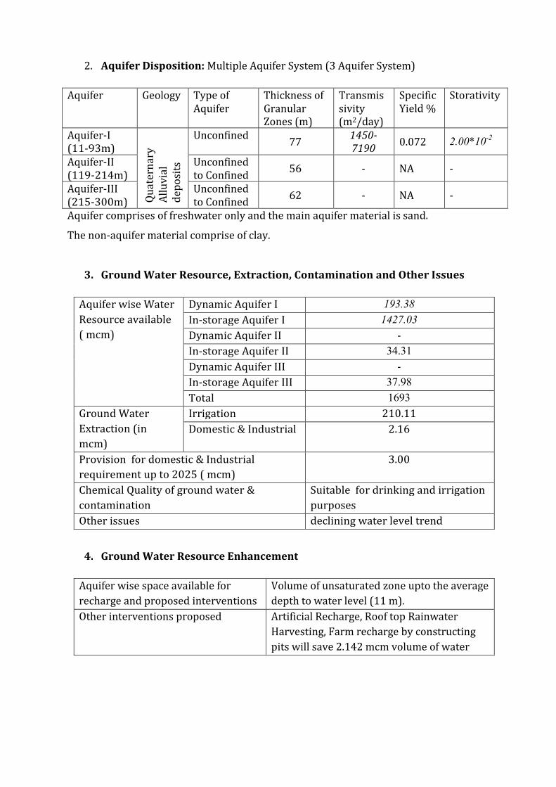
3D Lithology Fence
3 Ground Water Resource Extraction Contamination and Other Issues
Aquifer wise Water
Resource available
( mcm)
Dynamic Aquifer I 15898
In-storage Aquifer I 117287
Dynamic Aquifer II -
In-storage Aquifer II 1423
Dynamic Aquifer III -
In-storage Aquifer III 4368
Total 1390
Ground Water
Extraction (in
mcm)
Irrigation 24364
Domestic amp Industrial 267
Provision for domestic amp Industrial
requirement 2025 (in mcm)
364
Chemical Quality of ground water amp
contamination
Suitable for drinking and irrigation
purposes
Other issues Declining water level trend
4 Ground Water Resource Enhancement
Aquifer wise space available for
recharge and proposed interventions
Volume of unsaturated zone upto the average
depth to water level (17 m)
Other interventions proposed Artificial Recharge Roof top Rainwater
Harvesting Farm recharge by constructing
pits will save 252 mcm volume of water
5 Demand Side Interventions
Advanced Irrigation Practices Lining of underground pipelines (Kutcha channel)
will save 6117 mcm volume of water wastage
Change in cropping pattern Proposed change in cropping pattern from Paddy
to maizesoyabean
40 of the total area needs to change the crop
from paddy to maizesoyabean
Anticipated volume of water to be saved by
maizesoyabean is 9 mcm
Alternate water sources Tanks ponds and canals
Regulation and Control -
Other interventions proposed if
any
-
(V) MAJITHA BLOCK (27190 SQ KM)
1 Salient Information
Population (2011) Rural-150271
Urban- -
Total-150271
Rainfall 2014 (Amritsar District) Average annual rainfall -699 mm
Average Annual Rainfall (Majitha block) 671 mm
Agriculture and Irrigation Major Crops- Rice Wheat
Other crops- Sugarcane Potatoes Pulses
Net Area Sown- 22684 sqkm
Total Irrigated Area- 22684 sqkm
Water Bodies amp Canal Irrigation
Water bodies available in the villages for storm water and untreated waste water of
villagers that can be used for irrigation after treatment The canal irrigation is available
in the Majitha block
Ground Water Resource Availability Ground Water Resources available in the
different group of aquifers Aquifer I (70 m) is very prominent in terms of thickness and
geographic extent Aquifer II (56 m) is less in thickness amp Aquifer III is (75 m) Block is
categorized as Critical as per Ground Water assessment 2013
Ground water Extraction Information regarding the abstraction from Aquifer III is
not available but there are drinking water supply tapping combined aquifer and
separate aquifer could not be assessed separately
Water level Behavior (2015) Pre Monsoon 810-1460 (mbgl) ampPost Monsoon-
~ 680- 1510
(mbgl)
2 Aquifer Disposition Multiple Aquifer System (3 Aquifer System)
Aquifer Geology Type of
Aquifer
Thickness of
Granular
Zones (m)
Transmis
sivity
(m2day)
Specific
Yield
Storativity
Aquifer-I
(10-92m)
Qu
ate
rna
ry
All
uv
ial
de
po
sits
Unconfined 70
1450-
7190 0072 20010
-2
Aquifer-II
(110-190m)
Unconfined
to Confined 56 - NA -
Aquifer-III
(203-300m)
Unconfined
to Confined 75 - NA -
Aquifer comprises of freshwater only and the main aquifer material is sand
The non-aquifer material comprise of clay
3D Lithology model
3D Lithology Fence
3 Ground Water Resource Extraction Contamination and Other Issues
Aquifer wise Water
Resource available
(in mcm)
Dynamic Aquifer I 32481
In-storage Aquifer I 137038
Dynamic Aquifer II -
In-storage Aquifer II 3624
Dynamic Aquifer III -
In-storage Aquifer III 4853
Total 1780
Ground Water
Extraction (in
mcm)
Irrigation 28321
Domestic amp Industrial 3003
Provision for domestic amp Industrial
requirement up to 2025 (in mcm)
4165
Chemical Quality of ground water amp
contamination
Suitable for drinking and irrigation
purposes
Other issues Declining water level trend
4 Ground Water Resource Enhancement
Aquifer wise space available for
recharge and proposed interventions
Volume of unsaturated zone upto the average
depth to water level (10m)
Other interventions proposed Artificial Recharge Roof top Rainwater
Harvesting Farm recharge by constructing
pits will save 3697 mcm volume of water
5 Demand Side Interventions
Advanced Irrigation Practices Lining of underground pipelines (Kutcha channel)
will save 7155 mcm volume of water wastage
Change in cropping pattern Proposed change in cropping pattern from Paddy
to maizesoyabean
40 of the total area needs to change the crop
from paddy to maizesoyabean
Anticipated volume of water to be saved by
maizesoyabean is 10 mcm
Alternate water sources Tanks ponds and canals
Regulation and Control -
Other interventions proposed if
any
-
(VI) RAYYA BLOCK (32640 SQ KM)
1 Salient Information
Population (2011) Rural-160421
Urban- 24513
Total-184934
Rainfall 2014 (Amritsar District) Average annual rainfall -63260 mm
Average Annual Rainfall (Rayya block) 671 mm
Agriculture and Irrigation Major Crops- Rice Wheat
Other crops- Sugarcane Potatoes Pulses
Net Area Sown- 23236 sqkm
Total Irrigated Area- 23236 sqkm
Water Bodies amp Canal Irrigation
Water bodies available in the villages for storm water and untreated waste water of
villagers that can be used for irrigation after treatment The canal irrigation is also
available in the Rayya block
Ground Water Resource Availability Ground Water Resources available in the
different group of aquifers Aquifer I (68 m) is very prominent in terms of thickness and
geographic extent Aquifer II (86 m) is very prominent in terms of thickness amp Aquifer
III is (49 m) Block is categorized as Over-Exploited as per Ground Water assessment
2013
Ground water Extraction Information regarding the abstraction from Aquifer III is
not available but there are drinking water supply tapping combined aquifer and
separate aquifer could not be assessed separately
Water level Behavior (2015) Pre Monsoon 1453-1570 (mbgl) ampPost Monsoon-
~ 1270-1515 (mbgl)
2 Aquifer Disposition Multiple Aquifer System (3 Aquifer System)
Aquifer Geology Type of
Aquifer
Thickness of
Granular
Zones (m)
Transmis
sivity
(m2day)
Specific
Yield
Storativity
Aquifer-I
(15-101m)
Qu
ate
rna
ry
All
uv
ial
de
po
sits
Unconfined 68
1450-
7190 0072 20010
-2
Aquifer-II
(112-218m)
Unconfined
to Confined 86 - NA -
Aquifer-III
(233-300m)
Unconfined
to Confined 49 - NA -
Aquifer comprises of freshwater only and the main aquifer material is sand
The non-aquifer material comprise of clay
3D Lithology model
3D Lithology Fence
3 Ground Water Resource Extraction Contamination and Other Issues
Aquifer wise Water
Resource available
(in mcm)
Dynamic Aquifer I 19154
In-storage Aquifer I 159805
Dynamic Aquifer II -
In-storage Aquifer II 6681
Dynamic Aquifer III -
In-storage Aquifer III 3806
Total 1894
Ground Water
Extraction (in
mcm)
Irrigation 26982
Domestic amp Industrial 572
Provision for domestic amp Industrial
requirement up to 2025 (in mcm)
788
Chemical Quality of ground water amp
contamination
Suitable for drinking and irrigation
purposes
Other issues Declining water level trend
4 Ground Water Resource Enhancement
Aquifer wise space available for
recharge and proposed interventions
Volume of unsaturated zone upto the average
depth to water level (15m)
Other interventions proposed Artificial Recharge Roof top Rainwater
Harvesting Farm recharge by constructing
pits will save 3588 mcm volume of water
5 Demand Side Interventions
Advanced Irrigation Practices Lining of underground pipelines (Kutcha channel)
will save 6817 mcm volume of water wastage
Change in cropping pattern Proposed change in cropping pattern from Paddy
to maizesoyabean
40 of the total area needs to change the crop
from paddy to maizesoyabean
Anticipated volume of water to be saved by
maizesoyabean is 11 mcm
Alternate water sources Tanks ponds and canals
Regulation and Control -
Other interventions proposed if
any
-
(VII) TARSIKA BLOCK (23650 SQ KM)
1 Salient Information
Population (2011) Rural-129367
Urban- -
Total-129367
Rainfall 2014 (Amritsar District) Average annual rainfall -63260 mm
Average Annual Rainfall (Tarsika block) 769 mm
Agriculture and Irrigation Major Crops- Rice Wheat
Other crops- Sugarcane Potatoes Pulses
Net Area Sown- 22475 sqkm
Total Irrigated Area- 22475 sqkm
Water Bodies amp Canal Irrigation
Water bodies available in the villages for storm water and untreated waste water of
villagers that can be used for irrigation after treatment The canal irrigation is also
available in the Tarsika block
Ground Water Resource Availability Ground Water Resources available in the
different group of aquifers Aquifer I (72 m) is very prominent in terms of thickness and
geographic extent Aquifer II (41 m) is less in thickness amp Aquifer III is (77 m) Block is
categorized as Over-Exploted as per Ground Water assessment 2013
Ground water Extraction Information regarding the abstraction from Aquifer III is
not available but there are drinking water supply tapping combined aquifer and
separate aquifer could not be assessed separately
Water level Behavior (2015) Pre Monsoon 1085-1780 (mbgl) ampPost Monsoon-
~ 998-1780 (mbgl)
2 Aquifer Disposition Multiple Aquifer System (3 Aquifer System)
Aquifer Geology Type of
Aquifer
Thickness of
Granular
Zones (m)
Transmis
sivity
(m2day)
Specific
Yield
Storativity
Aquifer-I
(12-98m)
Qu
ate
rna
ry
All
uv
ial
de
po
sits
Unconfined
72 1450-
7190 0072 20010
-2
Aquifer-II
(114-181m)
Unconfined
to Confined 41 - NA -
Aquifer-III
(210-300m)
Unconfined
to Confined 77 - NA -
Aquifer comprises of freshwater only and the main aquifer material is sand
The non-aquifer material comprise of clay
3D Lithology model
3D Lithology Fence
3 Ground Water Resource Extraction Contamination and Other Issues
Aquifer wise Water
Resource available
(in mcm)
Dynamic Aquifer I 16039
In-storage Aquifer I 122602
Dynamic Aquifer II -
In-storage Aquifer II 2308
Dynamic Aquifer III -
In-storage Aquifer III 4334
Total 1453
Ground Water
Extraction (in
mcm)
Irrigation 23915
Domestic amp Industrial 313
Provision for domestic amp Industrial
requirement up to 2025 (in mcm)
434
Chemical Quality of ground water amp
contamination
Suitable for drinking and irrigation
purposes
Other issues Declining water level trend
4 Ground Water Resource Enhancement
Aquifer wise space available for
recharge and proposed interventions
Volume of unsaturated zone upto the average
depth to water level (12m)
Other interventions proposed Artificial Recharge Roof top Rainwater
Harvesting Farm recharge by constructing
pits will save 3167 mcm volume of water
5 Demand Side Interventions
Advanced Irrigation Practices Lining of underground pipelines (Kutcha channel)
will save 6042 mcm volume of water wastage
Change in cropping pattern Proposed change in cropping pattern from Paddy
to maizesoyabean
40 of the total area needs to change the crop
from paddy to maizesoyabean
Anticipated volume of water to be saved by
maizesoyabean is 9 mcm
Alternate water sources Tanks ponds and canals
Regulation and Control -
Other interventions proposed if
any
-
(VII) VERKA BLOCK (33304 SQ KM)
1 Salient Information
Population (2011) Rural-67151
Urban- 44860
Total-112011
Rainfall 2014 (Amritsar District) Average annual rainfall -63260 mm
Average Annual Rainfall (Verka block) 644 mm
Agriculture and Irrigation Major Crops- Rice Wheat
Other crops- Sugarcane Potatoes Pulses
Net Area Sown- 14762 sqkm
Total Irrigated Area- 14762 sqkm
Water Bodies amp Canal Irrigation
Water bodies available in the villages for storm water and untreated waste water of
villagers that can be used for irrigation after treatment The canal irrigation is also
available in the Verka block
Ground Water Resource Availability Ground Water Resources available in the
different group of aquifers Aquifer I (76 m) is very prominent in terms of thickness and
geographic extent Aquifer II (59 m) is less in thickness amp Aquifer III is (59m) Block is
categorized as Over-Exploited as per Ground Water assessment 2013
Ground water Extraction Information regarding the abstraction from Aquifer III is
not available but there are drinking water supply tapping combined aquifer and
separate aquifer could not be assessed separately
Water level Behavior (2015) Pre Monsoon 1280-2484 (mbgl) ampPost Monsoon-~
1280-2386 (mbgl)
2 Aquifer Disposition Multiple Aquifer System (3 Aquifer System)
Aquifer Geology Type of
Aquifer
Thickness of
Granular
Zones (m)
Transmis
sivity
(m2day)
Specific
Yield
Storativity
Aquifer-I
(20-107m) Q
ua
tern
ary
All
uv
ial
de
po
sits
Unconfined 76
1450-
7190 12 20010
-2
Aquifer-II
(126-201m)
Unconfined
to Confined 59 - NA -
Aquifer-III
(225-300m)
Unconfined
to Confined 59 - NA -
Aquifer comprises of freshwater only and the main aquifer material is sand
The non-aquifer material comprise of clay
3D Lithology model
3D Lithology Fence
3 Ground Water Resource Extraction Contamination and Other Issues
Aquifer wise Water
Resource available
(in mcm)
Dynamic Aquifer I 20424
In-storage Aquifer I 182436
Dynamic Aquifer II -
In-storage Aquifer II 4682
Dynamic Aquifer III -
In-storage Aquifer III 4285
Total 2118
Ground Water
Extraction (in
mcm)
Irrigation 20792
Domestic amp Industrial 499
Provision for domestic amp Industrial
requirement up to 2025 (in mcm)
607
Chemical Quality of ground water amp
contamination
Potable for drinking and irrigation
Other issues declining water level trend
4 Ground Water Resource Enhancement
Aquifer wise space available for
recharge and proposed interventions
Volume of unsaturated zone upto the average
depth to water level (20m)
Other interventions proposed Artificial Recharge Roof top Rainwater
Harvesting Farm recharge by constructing
pits will save 2745 mcm volume of water
5 Demand Side Interventions
Advanced Irrigation Practices Lining of underground pipelines (Kutcha channel)
will save 5254 mcm volume of water wastage
Change in cropping pattern Proposed change in cropping pattern from Paddy
to maizesoyabean
40 of the total area needs to change the crop
from paddy to maizesoyabean
Anticipated volume of water to be saved by
maizesoyabean is 7 mcm
Alternate water sources Tanks ponds and canals
Regulation and Control -
Other interventions proposed if
any
-
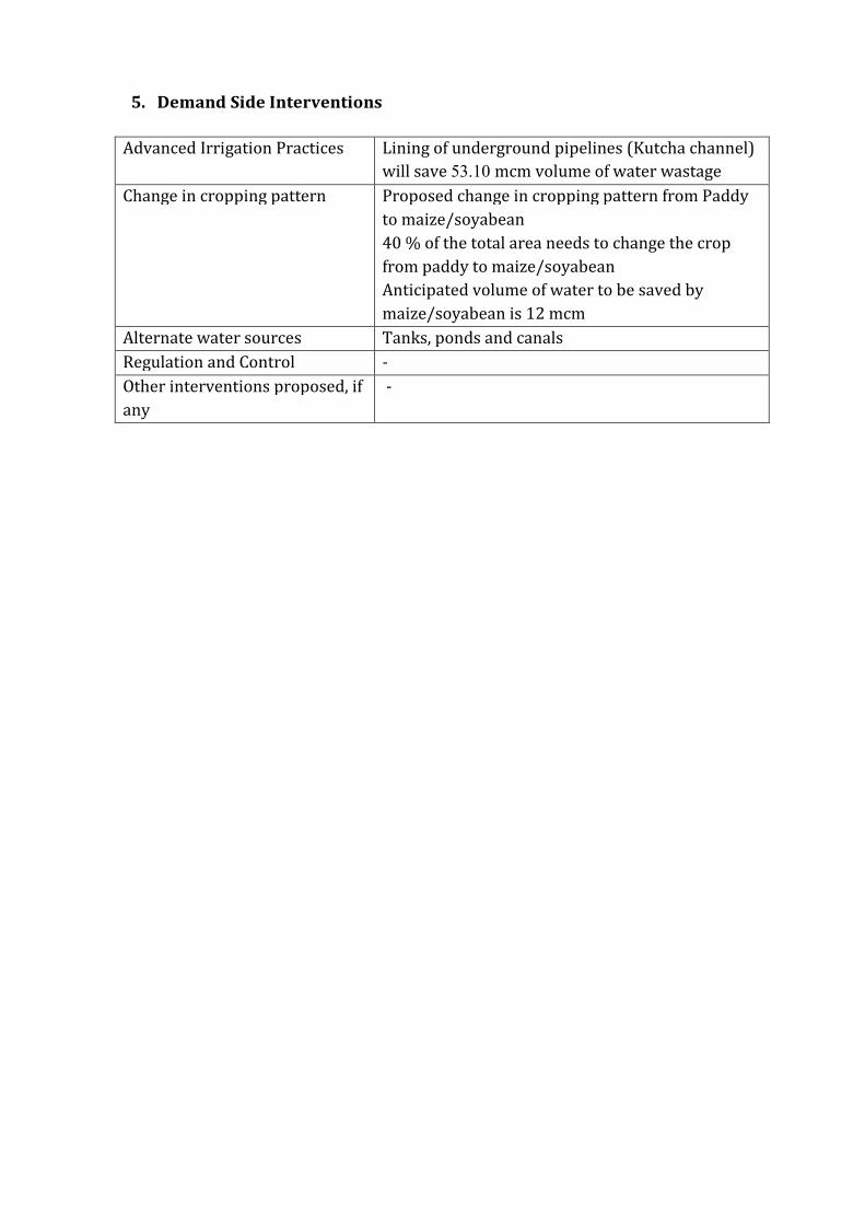
3 Ground Water Resource Extraction Contamination and Other Issues
Aquifer wise Water
Resource available
( mcm)
Dynamic Aquifer I 15898
In-storage Aquifer I 117287
Dynamic Aquifer II -
In-storage Aquifer II 1423
Dynamic Aquifer III -
In-storage Aquifer III 4368
Total 1390
Ground Water
Extraction (in
mcm)
Irrigation 24364
Domestic amp Industrial 267
Provision for domestic amp Industrial
requirement 2025 (in mcm)
364
Chemical Quality of ground water amp
contamination
Suitable for drinking and irrigation
purposes
Other issues Declining water level trend
4 Ground Water Resource Enhancement
Aquifer wise space available for
recharge and proposed interventions
Volume of unsaturated zone upto the average
depth to water level (17 m)
Other interventions proposed Artificial Recharge Roof top Rainwater
Harvesting Farm recharge by constructing
pits will save 252 mcm volume of water
5 Demand Side Interventions
Advanced Irrigation Practices Lining of underground pipelines (Kutcha channel)
will save 6117 mcm volume of water wastage
Change in cropping pattern Proposed change in cropping pattern from Paddy
to maizesoyabean
40 of the total area needs to change the crop
from paddy to maizesoyabean
Anticipated volume of water to be saved by
maizesoyabean is 9 mcm
Alternate water sources Tanks ponds and canals
Regulation and Control -
Other interventions proposed if
any
-
(V) MAJITHA BLOCK (27190 SQ KM)
1 Salient Information
Population (2011) Rural-150271
Urban- -
Total-150271
Rainfall 2014 (Amritsar District) Average annual rainfall -699 mm
Average Annual Rainfall (Majitha block) 671 mm
Agriculture and Irrigation Major Crops- Rice Wheat
Other crops- Sugarcane Potatoes Pulses
Net Area Sown- 22684 sqkm
Total Irrigated Area- 22684 sqkm
Water Bodies amp Canal Irrigation
Water bodies available in the villages for storm water and untreated waste water of
villagers that can be used for irrigation after treatment The canal irrigation is available
in the Majitha block
Ground Water Resource Availability Ground Water Resources available in the
different group of aquifers Aquifer I (70 m) is very prominent in terms of thickness and
geographic extent Aquifer II (56 m) is less in thickness amp Aquifer III is (75 m) Block is
categorized as Critical as per Ground Water assessment 2013
Ground water Extraction Information regarding the abstraction from Aquifer III is
not available but there are drinking water supply tapping combined aquifer and
separate aquifer could not be assessed separately
Water level Behavior (2015) Pre Monsoon 810-1460 (mbgl) ampPost Monsoon-
~ 680- 1510
(mbgl)
2 Aquifer Disposition Multiple Aquifer System (3 Aquifer System)
Aquifer Geology Type of
Aquifer
Thickness of
Granular
Zones (m)
Transmis
sivity
(m2day)
Specific
Yield
Storativity
Aquifer-I
(10-92m)
Qu
ate
rna
ry
All
uv
ial
de
po
sits
Unconfined 70
1450-
7190 0072 20010
-2
Aquifer-II
(110-190m)
Unconfined
to Confined 56 - NA -
Aquifer-III
(203-300m)
Unconfined
to Confined 75 - NA -
Aquifer comprises of freshwater only and the main aquifer material is sand
The non-aquifer material comprise of clay
3D Lithology model
3D Lithology Fence
3 Ground Water Resource Extraction Contamination and Other Issues
Aquifer wise Water
Resource available
(in mcm)
Dynamic Aquifer I 32481
In-storage Aquifer I 137038
Dynamic Aquifer II -
In-storage Aquifer II 3624
Dynamic Aquifer III -
In-storage Aquifer III 4853
Total 1780
Ground Water
Extraction (in
mcm)
Irrigation 28321
Domestic amp Industrial 3003
Provision for domestic amp Industrial
requirement up to 2025 (in mcm)
4165
Chemical Quality of ground water amp
contamination
Suitable for drinking and irrigation
purposes
Other issues Declining water level trend
4 Ground Water Resource Enhancement
Aquifer wise space available for
recharge and proposed interventions
Volume of unsaturated zone upto the average
depth to water level (10m)
Other interventions proposed Artificial Recharge Roof top Rainwater
Harvesting Farm recharge by constructing
pits will save 3697 mcm volume of water
5 Demand Side Interventions
Advanced Irrigation Practices Lining of underground pipelines (Kutcha channel)
will save 7155 mcm volume of water wastage
Change in cropping pattern Proposed change in cropping pattern from Paddy
to maizesoyabean
40 of the total area needs to change the crop
from paddy to maizesoyabean
Anticipated volume of water to be saved by
maizesoyabean is 10 mcm
Alternate water sources Tanks ponds and canals
Regulation and Control -
Other interventions proposed if
any
-
(VI) RAYYA BLOCK (32640 SQ KM)
1 Salient Information
Population (2011) Rural-160421
Urban- 24513
Total-184934
Rainfall 2014 (Amritsar District) Average annual rainfall -63260 mm
Average Annual Rainfall (Rayya block) 671 mm
Agriculture and Irrigation Major Crops- Rice Wheat
Other crops- Sugarcane Potatoes Pulses
Net Area Sown- 23236 sqkm
Total Irrigated Area- 23236 sqkm
Water Bodies amp Canal Irrigation
Water bodies available in the villages for storm water and untreated waste water of
villagers that can be used for irrigation after treatment The canal irrigation is also
available in the Rayya block
Ground Water Resource Availability Ground Water Resources available in the
different group of aquifers Aquifer I (68 m) is very prominent in terms of thickness and
geographic extent Aquifer II (86 m) is very prominent in terms of thickness amp Aquifer
III is (49 m) Block is categorized as Over-Exploited as per Ground Water assessment
2013
Ground water Extraction Information regarding the abstraction from Aquifer III is
not available but there are drinking water supply tapping combined aquifer and
separate aquifer could not be assessed separately
Water level Behavior (2015) Pre Monsoon 1453-1570 (mbgl) ampPost Monsoon-
~ 1270-1515 (mbgl)
2 Aquifer Disposition Multiple Aquifer System (3 Aquifer System)
Aquifer Geology Type of
Aquifer
Thickness of
Granular
Zones (m)
Transmis
sivity
(m2day)
Specific
Yield
Storativity
Aquifer-I
(15-101m)
Qu
ate
rna
ry
All
uv
ial
de
po
sits
Unconfined 68
1450-
7190 0072 20010
-2
Aquifer-II
(112-218m)
Unconfined
to Confined 86 - NA -
Aquifer-III
(233-300m)
Unconfined
to Confined 49 - NA -
Aquifer comprises of freshwater only and the main aquifer material is sand
The non-aquifer material comprise of clay
3D Lithology model
3D Lithology Fence
3 Ground Water Resource Extraction Contamination and Other Issues
Aquifer wise Water
Resource available
(in mcm)
Dynamic Aquifer I 19154
In-storage Aquifer I 159805
Dynamic Aquifer II -
In-storage Aquifer II 6681
Dynamic Aquifer III -
In-storage Aquifer III 3806
Total 1894
Ground Water
Extraction (in
mcm)
Irrigation 26982
Domestic amp Industrial 572
Provision for domestic amp Industrial
requirement up to 2025 (in mcm)
788
Chemical Quality of ground water amp
contamination
Suitable for drinking and irrigation
purposes
Other issues Declining water level trend
4 Ground Water Resource Enhancement
Aquifer wise space available for
recharge and proposed interventions
Volume of unsaturated zone upto the average
depth to water level (15m)
Other interventions proposed Artificial Recharge Roof top Rainwater
Harvesting Farm recharge by constructing
pits will save 3588 mcm volume of water
5 Demand Side Interventions
Advanced Irrigation Practices Lining of underground pipelines (Kutcha channel)
will save 6817 mcm volume of water wastage
Change in cropping pattern Proposed change in cropping pattern from Paddy
to maizesoyabean
40 of the total area needs to change the crop
from paddy to maizesoyabean
Anticipated volume of water to be saved by
maizesoyabean is 11 mcm
Alternate water sources Tanks ponds and canals
Regulation and Control -
Other interventions proposed if
any
-
(VII) TARSIKA BLOCK (23650 SQ KM)
1 Salient Information
Population (2011) Rural-129367
Urban- -
Total-129367
Rainfall 2014 (Amritsar District) Average annual rainfall -63260 mm
Average Annual Rainfall (Tarsika block) 769 mm
Agriculture and Irrigation Major Crops- Rice Wheat
Other crops- Sugarcane Potatoes Pulses
Net Area Sown- 22475 sqkm
Total Irrigated Area- 22475 sqkm
Water Bodies amp Canal Irrigation
Water bodies available in the villages for storm water and untreated waste water of
villagers that can be used for irrigation after treatment The canal irrigation is also
available in the Tarsika block
Ground Water Resource Availability Ground Water Resources available in the
different group of aquifers Aquifer I (72 m) is very prominent in terms of thickness and
geographic extent Aquifer II (41 m) is less in thickness amp Aquifer III is (77 m) Block is
categorized as Over-Exploted as per Ground Water assessment 2013
Ground water Extraction Information regarding the abstraction from Aquifer III is
not available but there are drinking water supply tapping combined aquifer and
separate aquifer could not be assessed separately
Water level Behavior (2015) Pre Monsoon 1085-1780 (mbgl) ampPost Monsoon-
~ 998-1780 (mbgl)
2 Aquifer Disposition Multiple Aquifer System (3 Aquifer System)
Aquifer Geology Type of
Aquifer
Thickness of
Granular
Zones (m)
Transmis
sivity
(m2day)
Specific
Yield
Storativity
Aquifer-I
(12-98m)
Qu
ate
rna
ry
All
uv
ial
de
po
sits
Unconfined
72 1450-
7190 0072 20010
-2
Aquifer-II
(114-181m)
Unconfined
to Confined 41 - NA -
Aquifer-III
(210-300m)
Unconfined
to Confined 77 - NA -
Aquifer comprises of freshwater only and the main aquifer material is sand
The non-aquifer material comprise of clay
3D Lithology model
3D Lithology Fence
3 Ground Water Resource Extraction Contamination and Other Issues
Aquifer wise Water
Resource available
(in mcm)
Dynamic Aquifer I 16039
In-storage Aquifer I 122602
Dynamic Aquifer II -
In-storage Aquifer II 2308
Dynamic Aquifer III -
In-storage Aquifer III 4334
Total 1453
Ground Water
Extraction (in
mcm)
Irrigation 23915
Domestic amp Industrial 313
Provision for domestic amp Industrial
requirement up to 2025 (in mcm)
434
Chemical Quality of ground water amp
contamination
Suitable for drinking and irrigation
purposes
Other issues Declining water level trend
4 Ground Water Resource Enhancement
Aquifer wise space available for
recharge and proposed interventions
Volume of unsaturated zone upto the average
depth to water level (12m)
Other interventions proposed Artificial Recharge Roof top Rainwater
Harvesting Farm recharge by constructing
pits will save 3167 mcm volume of water
5 Demand Side Interventions
Advanced Irrigation Practices Lining of underground pipelines (Kutcha channel)
will save 6042 mcm volume of water wastage
Change in cropping pattern Proposed change in cropping pattern from Paddy
to maizesoyabean
40 of the total area needs to change the crop
from paddy to maizesoyabean
Anticipated volume of water to be saved by
maizesoyabean is 9 mcm
Alternate water sources Tanks ponds and canals
Regulation and Control -
Other interventions proposed if
any
-
(VII) VERKA BLOCK (33304 SQ KM)
1 Salient Information
Population (2011) Rural-67151
Urban- 44860
Total-112011
Rainfall 2014 (Amritsar District) Average annual rainfall -63260 mm
Average Annual Rainfall (Verka block) 644 mm
Agriculture and Irrigation Major Crops- Rice Wheat
Other crops- Sugarcane Potatoes Pulses
Net Area Sown- 14762 sqkm
Total Irrigated Area- 14762 sqkm
Water Bodies amp Canal Irrigation
Water bodies available in the villages for storm water and untreated waste water of
villagers that can be used for irrigation after treatment The canal irrigation is also
available in the Verka block
Ground Water Resource Availability Ground Water Resources available in the
different group of aquifers Aquifer I (76 m) is very prominent in terms of thickness and
geographic extent Aquifer II (59 m) is less in thickness amp Aquifer III is (59m) Block is
categorized as Over-Exploited as per Ground Water assessment 2013
Ground water Extraction Information regarding the abstraction from Aquifer III is
not available but there are drinking water supply tapping combined aquifer and
separate aquifer could not be assessed separately
Water level Behavior (2015) Pre Monsoon 1280-2484 (mbgl) ampPost Monsoon-~
1280-2386 (mbgl)
2 Aquifer Disposition Multiple Aquifer System (3 Aquifer System)
Aquifer Geology Type of
Aquifer
Thickness of
Granular
Zones (m)
Transmis
sivity
(m2day)
Specific
Yield
Storativity
Aquifer-I
(20-107m) Q
ua
tern
ary
All
uv
ial
de
po
sits
Unconfined 76
1450-
7190 12 20010
-2
Aquifer-II
(126-201m)
Unconfined
to Confined 59 - NA -
Aquifer-III
(225-300m)
Unconfined
to Confined 59 - NA -
Aquifer comprises of freshwater only and the main aquifer material is sand
The non-aquifer material comprise of clay
3D Lithology model
3D Lithology Fence
3 Ground Water Resource Extraction Contamination and Other Issues
Aquifer wise Water
Resource available
(in mcm)
Dynamic Aquifer I 20424
In-storage Aquifer I 182436
Dynamic Aquifer II -
In-storage Aquifer II 4682
Dynamic Aquifer III -
In-storage Aquifer III 4285
Total 2118
Ground Water
Extraction (in
mcm)
Irrigation 20792
Domestic amp Industrial 499
Provision for domestic amp Industrial
requirement up to 2025 (in mcm)
607
Chemical Quality of ground water amp
contamination
Potable for drinking and irrigation
Other issues declining water level trend
4 Ground Water Resource Enhancement
Aquifer wise space available for
recharge and proposed interventions
Volume of unsaturated zone upto the average
depth to water level (20m)
Other interventions proposed Artificial Recharge Roof top Rainwater
Harvesting Farm recharge by constructing
pits will save 2745 mcm volume of water
5 Demand Side Interventions
Advanced Irrigation Practices Lining of underground pipelines (Kutcha channel)
will save 5254 mcm volume of water wastage
Change in cropping pattern Proposed change in cropping pattern from Paddy
to maizesoyabean
40 of the total area needs to change the crop
from paddy to maizesoyabean
Anticipated volume of water to be saved by
maizesoyabean is 7 mcm
Alternate water sources Tanks ponds and canals
Regulation and Control -
Other interventions proposed if
any
-
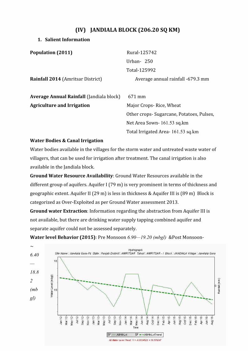
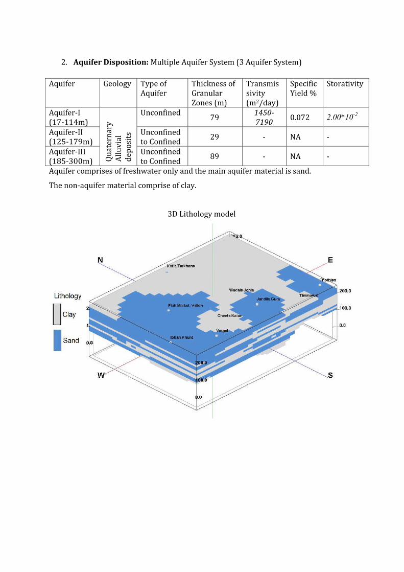
2 Aquifer Disposition Multiple Aquifer System (3 Aquifer System)
Aquifer Geology Type of
Aquifer
Thickness of
Granular
Zones (m)
Transmis
sivity
(m2day)
Specific
Yield
Storativity
Aquifer-I
(10-92m)
Qu
ate
rna
ry
All
uv
ial
de
po
sits
Unconfined 70
1450-
7190 0072 20010
-2
Aquifer-II
(110-190m)
Unconfined
to Confined 56 - NA -
Aquifer-III
(203-300m)
Unconfined
to Confined 75 - NA -
Aquifer comprises of freshwater only and the main aquifer material is sand
The non-aquifer material comprise of clay
3D Lithology model
3D Lithology Fence
3 Ground Water Resource Extraction Contamination and Other Issues
Aquifer wise Water
Resource available
(in mcm)
Dynamic Aquifer I 32481
In-storage Aquifer I 137038
Dynamic Aquifer II -
In-storage Aquifer II 3624
Dynamic Aquifer III -
In-storage Aquifer III 4853
Total 1780
Ground Water
Extraction (in
mcm)
Irrigation 28321
Domestic amp Industrial 3003
Provision for domestic amp Industrial
requirement up to 2025 (in mcm)
4165
Chemical Quality of ground water amp
contamination
Suitable for drinking and irrigation
purposes
Other issues Declining water level trend
4 Ground Water Resource Enhancement
Aquifer wise space available for
recharge and proposed interventions
Volume of unsaturated zone upto the average
depth to water level (10m)
Other interventions proposed Artificial Recharge Roof top Rainwater
Harvesting Farm recharge by constructing
pits will save 3697 mcm volume of water
5 Demand Side Interventions
Advanced Irrigation Practices Lining of underground pipelines (Kutcha channel)
will save 7155 mcm volume of water wastage
Change in cropping pattern Proposed change in cropping pattern from Paddy
to maizesoyabean
40 of the total area needs to change the crop
from paddy to maizesoyabean
Anticipated volume of water to be saved by
maizesoyabean is 10 mcm
Alternate water sources Tanks ponds and canals
Regulation and Control -
Other interventions proposed if
any
-
(VI) RAYYA BLOCK (32640 SQ KM)
1 Salient Information
Population (2011) Rural-160421
Urban- 24513
Total-184934
Rainfall 2014 (Amritsar District) Average annual rainfall -63260 mm
Average Annual Rainfall (Rayya block) 671 mm
Agriculture and Irrigation Major Crops- Rice Wheat
Other crops- Sugarcane Potatoes Pulses
Net Area Sown- 23236 sqkm
Total Irrigated Area- 23236 sqkm
Water Bodies amp Canal Irrigation
Water bodies available in the villages for storm water and untreated waste water of
villagers that can be used for irrigation after treatment The canal irrigation is also
available in the Rayya block
Ground Water Resource Availability Ground Water Resources available in the
different group of aquifers Aquifer I (68 m) is very prominent in terms of thickness and
geographic extent Aquifer II (86 m) is very prominent in terms of thickness amp Aquifer
III is (49 m) Block is categorized as Over-Exploited as per Ground Water assessment
2013
Ground water Extraction Information regarding the abstraction from Aquifer III is
not available but there are drinking water supply tapping combined aquifer and
separate aquifer could not be assessed separately
Water level Behavior (2015) Pre Monsoon 1453-1570 (mbgl) ampPost Monsoon-
~ 1270-1515 (mbgl)
2 Aquifer Disposition Multiple Aquifer System (3 Aquifer System)
Aquifer Geology Type of
Aquifer
Thickness of
Granular
Zones (m)
Transmis
sivity
(m2day)
Specific
Yield
Storativity
Aquifer-I
(15-101m)
Qu
ate
rna
ry
All
uv
ial
de
po
sits
Unconfined 68
1450-
7190 0072 20010
-2
Aquifer-II
(112-218m)
Unconfined
to Confined 86 - NA -
Aquifer-III
(233-300m)
Unconfined
to Confined 49 - NA -
Aquifer comprises of freshwater only and the main aquifer material is sand
The non-aquifer material comprise of clay
3D Lithology model
3D Lithology Fence
3 Ground Water Resource Extraction Contamination and Other Issues
Aquifer wise Water
Resource available
(in mcm)
Dynamic Aquifer I 19154
In-storage Aquifer I 159805
Dynamic Aquifer II -
In-storage Aquifer II 6681
Dynamic Aquifer III -
In-storage Aquifer III 3806
Total 1894
Ground Water
Extraction (in
mcm)
Irrigation 26982
Domestic amp Industrial 572
Provision for domestic amp Industrial
requirement up to 2025 (in mcm)
788
Chemical Quality of ground water amp
contamination
Suitable for drinking and irrigation
purposes
Other issues Declining water level trend
4 Ground Water Resource Enhancement
Aquifer wise space available for
recharge and proposed interventions
Volume of unsaturated zone upto the average
depth to water level (15m)
Other interventions proposed Artificial Recharge Roof top Rainwater
Harvesting Farm recharge by constructing
pits will save 3588 mcm volume of water
5 Demand Side Interventions
Advanced Irrigation Practices Lining of underground pipelines (Kutcha channel)
will save 6817 mcm volume of water wastage
Change in cropping pattern Proposed change in cropping pattern from Paddy
to maizesoyabean
40 of the total area needs to change the crop
from paddy to maizesoyabean
Anticipated volume of water to be saved by
maizesoyabean is 11 mcm
Alternate water sources Tanks ponds and canals
Regulation and Control -
Other interventions proposed if
any
-
(VII) TARSIKA BLOCK (23650 SQ KM)
1 Salient Information
Population (2011) Rural-129367
Urban- -
Total-129367
Rainfall 2014 (Amritsar District) Average annual rainfall -63260 mm
Average Annual Rainfall (Tarsika block) 769 mm
Agriculture and Irrigation Major Crops- Rice Wheat
Other crops- Sugarcane Potatoes Pulses
Net Area Sown- 22475 sqkm
Total Irrigated Area- 22475 sqkm
Water Bodies amp Canal Irrigation
Water bodies available in the villages for storm water and untreated waste water of
villagers that can be used for irrigation after treatment The canal irrigation is also
available in the Tarsika block
Ground Water Resource Availability Ground Water Resources available in the
different group of aquifers Aquifer I (72 m) is very prominent in terms of thickness and
geographic extent Aquifer II (41 m) is less in thickness amp Aquifer III is (77 m) Block is
categorized as Over-Exploted as per Ground Water assessment 2013
Ground water Extraction Information regarding the abstraction from Aquifer III is
not available but there are drinking water supply tapping combined aquifer and
separate aquifer could not be assessed separately
Water level Behavior (2015) Pre Monsoon 1085-1780 (mbgl) ampPost Monsoon-
~ 998-1780 (mbgl)
2 Aquifer Disposition Multiple Aquifer System (3 Aquifer System)
Aquifer Geology Type of
Aquifer
Thickness of
Granular
Zones (m)
Transmis
sivity
(m2day)
Specific
Yield
Storativity
Aquifer-I
(12-98m)
Qu
ate
rna
ry
All
uv
ial
de
po
sits
Unconfined
72 1450-
7190 0072 20010
-2
Aquifer-II
(114-181m)
Unconfined
to Confined 41 - NA -
Aquifer-III
(210-300m)
Unconfined
to Confined 77 - NA -
Aquifer comprises of freshwater only and the main aquifer material is sand
The non-aquifer material comprise of clay
3D Lithology model
3D Lithology Fence
3 Ground Water Resource Extraction Contamination and Other Issues
Aquifer wise Water
Resource available
(in mcm)
Dynamic Aquifer I 16039
In-storage Aquifer I 122602
Dynamic Aquifer II -
In-storage Aquifer II 2308
Dynamic Aquifer III -
In-storage Aquifer III 4334
Total 1453
Ground Water
Extraction (in
mcm)
Irrigation 23915
Domestic amp Industrial 313
Provision for domestic amp Industrial
requirement up to 2025 (in mcm)
434
Chemical Quality of ground water amp
contamination
Suitable for drinking and irrigation
purposes
Other issues Declining water level trend
4 Ground Water Resource Enhancement
Aquifer wise space available for
recharge and proposed interventions
Volume of unsaturated zone upto the average
depth to water level (12m)
Other interventions proposed Artificial Recharge Roof top Rainwater
Harvesting Farm recharge by constructing
pits will save 3167 mcm volume of water
5 Demand Side Interventions
Advanced Irrigation Practices Lining of underground pipelines (Kutcha channel)
will save 6042 mcm volume of water wastage
Change in cropping pattern Proposed change in cropping pattern from Paddy
to maizesoyabean
40 of the total area needs to change the crop
from paddy to maizesoyabean
Anticipated volume of water to be saved by
maizesoyabean is 9 mcm
Alternate water sources Tanks ponds and canals
Regulation and Control -
Other interventions proposed if
any
-
(VII) VERKA BLOCK (33304 SQ KM)
1 Salient Information
Population (2011) Rural-67151
Urban- 44860
Total-112011
Rainfall 2014 (Amritsar District) Average annual rainfall -63260 mm
Average Annual Rainfall (Verka block) 644 mm
Agriculture and Irrigation Major Crops- Rice Wheat
Other crops- Sugarcane Potatoes Pulses
Net Area Sown- 14762 sqkm
Total Irrigated Area- 14762 sqkm
Water Bodies amp Canal Irrigation
Water bodies available in the villages for storm water and untreated waste water of
villagers that can be used for irrigation after treatment The canal irrigation is also
available in the Verka block
Ground Water Resource Availability Ground Water Resources available in the
different group of aquifers Aquifer I (76 m) is very prominent in terms of thickness and
geographic extent Aquifer II (59 m) is less in thickness amp Aquifer III is (59m) Block is
categorized as Over-Exploited as per Ground Water assessment 2013
Ground water Extraction Information regarding the abstraction from Aquifer III is
not available but there are drinking water supply tapping combined aquifer and
separate aquifer could not be assessed separately
Water level Behavior (2015) Pre Monsoon 1280-2484 (mbgl) ampPost Monsoon-~
1280-2386 (mbgl)
2 Aquifer Disposition Multiple Aquifer System (3 Aquifer System)
Aquifer Geology Type of
Aquifer
Thickness of
Granular
Zones (m)
Transmis
sivity
(m2day)
Specific
Yield
Storativity
Aquifer-I
(20-107m) Q
ua
tern
ary
All
uv
ial
de
po
sits
Unconfined 76
1450-
7190 12 20010
-2
Aquifer-II
(126-201m)
Unconfined
to Confined 59 - NA -
Aquifer-III
(225-300m)
Unconfined
to Confined 59 - NA -
Aquifer comprises of freshwater only and the main aquifer material is sand
The non-aquifer material comprise of clay
3D Lithology model
3D Lithology Fence
3 Ground Water Resource Extraction Contamination and Other Issues
Aquifer wise Water
Resource available
(in mcm)
Dynamic Aquifer I 20424
In-storage Aquifer I 182436
Dynamic Aquifer II -
In-storage Aquifer II 4682
Dynamic Aquifer III -
In-storage Aquifer III 4285
Total 2118
Ground Water
Extraction (in
mcm)
Irrigation 20792
Domestic amp Industrial 499
Provision for domestic amp Industrial
requirement up to 2025 (in mcm)
607
Chemical Quality of ground water amp
contamination
Potable for drinking and irrigation
Other issues declining water level trend
4 Ground Water Resource Enhancement
Aquifer wise space available for
recharge and proposed interventions
Volume of unsaturated zone upto the average
depth to water level (20m)
Other interventions proposed Artificial Recharge Roof top Rainwater
Harvesting Farm recharge by constructing
pits will save 2745 mcm volume of water
5 Demand Side Interventions
Advanced Irrigation Practices Lining of underground pipelines (Kutcha channel)
will save 5254 mcm volume of water wastage
Change in cropping pattern Proposed change in cropping pattern from Paddy
to maizesoyabean
40 of the total area needs to change the crop
from paddy to maizesoyabean
Anticipated volume of water to be saved by
maizesoyabean is 7 mcm
Alternate water sources Tanks ponds and canals
Regulation and Control -
Other interventions proposed if
any
-

3D Lithology Fence
3 Ground Water Resource Extraction Contamination and Other Issues
Aquifer wise Water
Resource available
(in mcm)
Dynamic Aquifer I 32481
In-storage Aquifer I 137038
Dynamic Aquifer II -
In-storage Aquifer II 3624
Dynamic Aquifer III -
In-storage Aquifer III 4853
Total 1780
Ground Water
Extraction (in
mcm)
Irrigation 28321
Domestic amp Industrial 3003
Provision for domestic amp Industrial
requirement up to 2025 (in mcm)
4165
Chemical Quality of ground water amp
contamination
Suitable for drinking and irrigation
purposes
Other issues Declining water level trend
4 Ground Water Resource Enhancement
Aquifer wise space available for
recharge and proposed interventions
Volume of unsaturated zone upto the average
depth to water level (10m)
Other interventions proposed Artificial Recharge Roof top Rainwater
Harvesting Farm recharge by constructing
pits will save 3697 mcm volume of water
5 Demand Side Interventions
Advanced Irrigation Practices Lining of underground pipelines (Kutcha channel)
will save 7155 mcm volume of water wastage
Change in cropping pattern Proposed change in cropping pattern from Paddy
to maizesoyabean
40 of the total area needs to change the crop
from paddy to maizesoyabean
Anticipated volume of water to be saved by
maizesoyabean is 10 mcm
Alternate water sources Tanks ponds and canals
Regulation and Control -
Other interventions proposed if
any
-
(VI) RAYYA BLOCK (32640 SQ KM)
1 Salient Information
Population (2011) Rural-160421
Urban- 24513
Total-184934
Rainfall 2014 (Amritsar District) Average annual rainfall -63260 mm
Average Annual Rainfall (Rayya block) 671 mm
Agriculture and Irrigation Major Crops- Rice Wheat
Other crops- Sugarcane Potatoes Pulses
Net Area Sown- 23236 sqkm
Total Irrigated Area- 23236 sqkm
Water Bodies amp Canal Irrigation
Water bodies available in the villages for storm water and untreated waste water of
villagers that can be used for irrigation after treatment The canal irrigation is also
available in the Rayya block
Ground Water Resource Availability Ground Water Resources available in the
different group of aquifers Aquifer I (68 m) is very prominent in terms of thickness and
geographic extent Aquifer II (86 m) is very prominent in terms of thickness amp Aquifer
III is (49 m) Block is categorized as Over-Exploited as per Ground Water assessment
2013
Ground water Extraction Information regarding the abstraction from Aquifer III is
not available but there are drinking water supply tapping combined aquifer and
separate aquifer could not be assessed separately
Water level Behavior (2015) Pre Monsoon 1453-1570 (mbgl) ampPost Monsoon-
~ 1270-1515 (mbgl)
2 Aquifer Disposition Multiple Aquifer System (3 Aquifer System)
Aquifer Geology Type of
Aquifer
Thickness of
Granular
Zones (m)
Transmis
sivity
(m2day)
Specific
Yield
Storativity
Aquifer-I
(15-101m)
Qu
ate
rna
ry
All
uv
ial
de
po
sits
Unconfined 68
1450-
7190 0072 20010
-2
Aquifer-II
(112-218m)
Unconfined
to Confined 86 - NA -
Aquifer-III
(233-300m)
Unconfined
to Confined 49 - NA -
Aquifer comprises of freshwater only and the main aquifer material is sand
The non-aquifer material comprise of clay
3D Lithology model
3D Lithology Fence
3 Ground Water Resource Extraction Contamination and Other Issues
Aquifer wise Water
Resource available
(in mcm)
Dynamic Aquifer I 19154
In-storage Aquifer I 159805
Dynamic Aquifer II -
In-storage Aquifer II 6681
Dynamic Aquifer III -
In-storage Aquifer III 3806
Total 1894
Ground Water
Extraction (in
mcm)
Irrigation 26982
Domestic amp Industrial 572
Provision for domestic amp Industrial
requirement up to 2025 (in mcm)
788
Chemical Quality of ground water amp
contamination
Suitable for drinking and irrigation
purposes
Other issues Declining water level trend
4 Ground Water Resource Enhancement
Aquifer wise space available for
recharge and proposed interventions
Volume of unsaturated zone upto the average
depth to water level (15m)
Other interventions proposed Artificial Recharge Roof top Rainwater
Harvesting Farm recharge by constructing
pits will save 3588 mcm volume of water
5 Demand Side Interventions
Advanced Irrigation Practices Lining of underground pipelines (Kutcha channel)
will save 6817 mcm volume of water wastage
Change in cropping pattern Proposed change in cropping pattern from Paddy
to maizesoyabean
40 of the total area needs to change the crop
from paddy to maizesoyabean
Anticipated volume of water to be saved by
maizesoyabean is 11 mcm
Alternate water sources Tanks ponds and canals
Regulation and Control -
Other interventions proposed if
any
-
(VII) TARSIKA BLOCK (23650 SQ KM)
1 Salient Information
Population (2011) Rural-129367
Urban- -
Total-129367
Rainfall 2014 (Amritsar District) Average annual rainfall -63260 mm
Average Annual Rainfall (Tarsika block) 769 mm
Agriculture and Irrigation Major Crops- Rice Wheat
Other crops- Sugarcane Potatoes Pulses
Net Area Sown- 22475 sqkm
Total Irrigated Area- 22475 sqkm
Water Bodies amp Canal Irrigation
Water bodies available in the villages for storm water and untreated waste water of
villagers that can be used for irrigation after treatment The canal irrigation is also
available in the Tarsika block
Ground Water Resource Availability Ground Water Resources available in the
different group of aquifers Aquifer I (72 m) is very prominent in terms of thickness and
geographic extent Aquifer II (41 m) is less in thickness amp Aquifer III is (77 m) Block is
categorized as Over-Exploted as per Ground Water assessment 2013
Ground water Extraction Information regarding the abstraction from Aquifer III is
not available but there are drinking water supply tapping combined aquifer and
separate aquifer could not be assessed separately
Water level Behavior (2015) Pre Monsoon 1085-1780 (mbgl) ampPost Monsoon-
~ 998-1780 (mbgl)
2 Aquifer Disposition Multiple Aquifer System (3 Aquifer System)
Aquifer Geology Type of
Aquifer
Thickness of
Granular
Zones (m)
Transmis
sivity
(m2day)
Specific
Yield
Storativity
Aquifer-I
(12-98m)
Qu
ate
rna
ry
All
uv
ial
de
po
sits
Unconfined
72 1450-
7190 0072 20010
-2
Aquifer-II
(114-181m)
Unconfined
to Confined 41 - NA -
Aquifer-III
(210-300m)
Unconfined
to Confined 77 - NA -
Aquifer comprises of freshwater only and the main aquifer material is sand
The non-aquifer material comprise of clay
3D Lithology model
3D Lithology Fence
3 Ground Water Resource Extraction Contamination and Other Issues
Aquifer wise Water
Resource available
(in mcm)
Dynamic Aquifer I 16039
In-storage Aquifer I 122602
Dynamic Aquifer II -
In-storage Aquifer II 2308
Dynamic Aquifer III -
In-storage Aquifer III 4334
Total 1453
Ground Water
Extraction (in
mcm)
Irrigation 23915
Domestic amp Industrial 313
Provision for domestic amp Industrial
requirement up to 2025 (in mcm)
434
Chemical Quality of ground water amp
contamination
Suitable for drinking and irrigation
purposes
Other issues Declining water level trend
4 Ground Water Resource Enhancement
Aquifer wise space available for
recharge and proposed interventions
Volume of unsaturated zone upto the average
depth to water level (12m)
Other interventions proposed Artificial Recharge Roof top Rainwater
Harvesting Farm recharge by constructing
pits will save 3167 mcm volume of water
5 Demand Side Interventions
Advanced Irrigation Practices Lining of underground pipelines (Kutcha channel)
will save 6042 mcm volume of water wastage
Change in cropping pattern Proposed change in cropping pattern from Paddy
to maizesoyabean
40 of the total area needs to change the crop
from paddy to maizesoyabean
Anticipated volume of water to be saved by
maizesoyabean is 9 mcm
Alternate water sources Tanks ponds and canals
Regulation and Control -
Other interventions proposed if
any
-
(VII) VERKA BLOCK (33304 SQ KM)
1 Salient Information
Population (2011) Rural-67151
Urban- 44860
Total-112011
Rainfall 2014 (Amritsar District) Average annual rainfall -63260 mm
Average Annual Rainfall (Verka block) 644 mm
Agriculture and Irrigation Major Crops- Rice Wheat
Other crops- Sugarcane Potatoes Pulses
Net Area Sown- 14762 sqkm
Total Irrigated Area- 14762 sqkm
Water Bodies amp Canal Irrigation
Water bodies available in the villages for storm water and untreated waste water of
villagers that can be used for irrigation after treatment The canal irrigation is also
available in the Verka block
Ground Water Resource Availability Ground Water Resources available in the
different group of aquifers Aquifer I (76 m) is very prominent in terms of thickness and
geographic extent Aquifer II (59 m) is less in thickness amp Aquifer III is (59m) Block is
categorized as Over-Exploited as per Ground Water assessment 2013
Ground water Extraction Information regarding the abstraction from Aquifer III is
not available but there are drinking water supply tapping combined aquifer and
separate aquifer could not be assessed separately
Water level Behavior (2015) Pre Monsoon 1280-2484 (mbgl) ampPost Monsoon-~
1280-2386 (mbgl)
2 Aquifer Disposition Multiple Aquifer System (3 Aquifer System)
Aquifer Geology Type of
Aquifer
Thickness of
Granular
Zones (m)
Transmis
sivity
(m2day)
Specific
Yield
Storativity
Aquifer-I
(20-107m) Q
ua
tern
ary
All
uv
ial
de
po
sits
Unconfined 76
1450-
7190 12 20010
-2
Aquifer-II
(126-201m)
Unconfined
to Confined 59 - NA -
Aquifer-III
(225-300m)
Unconfined
to Confined 59 - NA -
Aquifer comprises of freshwater only and the main aquifer material is sand
The non-aquifer material comprise of clay
3D Lithology model
3D Lithology Fence
3 Ground Water Resource Extraction Contamination and Other Issues
Aquifer wise Water
Resource available
(in mcm)
Dynamic Aquifer I 20424
In-storage Aquifer I 182436
Dynamic Aquifer II -
In-storage Aquifer II 4682
Dynamic Aquifer III -
In-storage Aquifer III 4285
Total 2118
Ground Water
Extraction (in
mcm)
Irrigation 20792
Domestic amp Industrial 499
Provision for domestic amp Industrial
requirement up to 2025 (in mcm)
607
Chemical Quality of ground water amp
contamination
Potable for drinking and irrigation
Other issues declining water level trend
4 Ground Water Resource Enhancement
Aquifer wise space available for
recharge and proposed interventions
Volume of unsaturated zone upto the average
depth to water level (20m)
Other interventions proposed Artificial Recharge Roof top Rainwater
Harvesting Farm recharge by constructing
pits will save 2745 mcm volume of water
5 Demand Side Interventions
Advanced Irrigation Practices Lining of underground pipelines (Kutcha channel)
will save 5254 mcm volume of water wastage
Change in cropping pattern Proposed change in cropping pattern from Paddy
to maizesoyabean
40 of the total area needs to change the crop
from paddy to maizesoyabean
Anticipated volume of water to be saved by
maizesoyabean is 7 mcm
Alternate water sources Tanks ponds and canals
Regulation and Control -
Other interventions proposed if
any
-
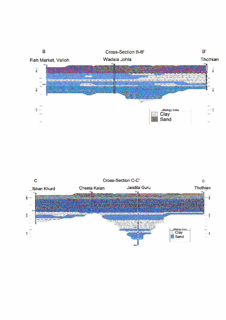
3 Ground Water Resource Extraction Contamination and Other Issues
Aquifer wise Water
Resource available
(in mcm)
Dynamic Aquifer I 32481
In-storage Aquifer I 137038
Dynamic Aquifer II -
In-storage Aquifer II 3624
Dynamic Aquifer III -
In-storage Aquifer III 4853
Total 1780
Ground Water
Extraction (in
mcm)
Irrigation 28321
Domestic amp Industrial 3003
Provision for domestic amp Industrial
requirement up to 2025 (in mcm)
4165
Chemical Quality of ground water amp
contamination
Suitable for drinking and irrigation
purposes
Other issues Declining water level trend
4 Ground Water Resource Enhancement
Aquifer wise space available for
recharge and proposed interventions
Volume of unsaturated zone upto the average
depth to water level (10m)
Other interventions proposed Artificial Recharge Roof top Rainwater
Harvesting Farm recharge by constructing
pits will save 3697 mcm volume of water
5 Demand Side Interventions
Advanced Irrigation Practices Lining of underground pipelines (Kutcha channel)
will save 7155 mcm volume of water wastage
Change in cropping pattern Proposed change in cropping pattern from Paddy
to maizesoyabean
40 of the total area needs to change the crop
from paddy to maizesoyabean
Anticipated volume of water to be saved by
maizesoyabean is 10 mcm
Alternate water sources Tanks ponds and canals
Regulation and Control -
Other interventions proposed if
any
-
(VI) RAYYA BLOCK (32640 SQ KM)
1 Salient Information
Population (2011) Rural-160421
Urban- 24513
Total-184934
Rainfall 2014 (Amritsar District) Average annual rainfall -63260 mm
Average Annual Rainfall (Rayya block) 671 mm
Agriculture and Irrigation Major Crops- Rice Wheat
Other crops- Sugarcane Potatoes Pulses
Net Area Sown- 23236 sqkm
Total Irrigated Area- 23236 sqkm
Water Bodies amp Canal Irrigation
Water bodies available in the villages for storm water and untreated waste water of
villagers that can be used for irrigation after treatment The canal irrigation is also
available in the Rayya block
Ground Water Resource Availability Ground Water Resources available in the
different group of aquifers Aquifer I (68 m) is very prominent in terms of thickness and
geographic extent Aquifer II (86 m) is very prominent in terms of thickness amp Aquifer
III is (49 m) Block is categorized as Over-Exploited as per Ground Water assessment
2013
Ground water Extraction Information regarding the abstraction from Aquifer III is
not available but there are drinking water supply tapping combined aquifer and
separate aquifer could not be assessed separately
Water level Behavior (2015) Pre Monsoon 1453-1570 (mbgl) ampPost Monsoon-
~ 1270-1515 (mbgl)
2 Aquifer Disposition Multiple Aquifer System (3 Aquifer System)
Aquifer Geology Type of
Aquifer
Thickness of
Granular
Zones (m)
Transmis
sivity
(m2day)
Specific
Yield
Storativity
Aquifer-I
(15-101m)
Qu
ate
rna
ry
All
uv
ial
de
po
sits
Unconfined 68
1450-
7190 0072 20010
-2
Aquifer-II
(112-218m)
Unconfined
to Confined 86 - NA -
Aquifer-III
(233-300m)
Unconfined
to Confined 49 - NA -
Aquifer comprises of freshwater only and the main aquifer material is sand
The non-aquifer material comprise of clay
3D Lithology model
3D Lithology Fence
3 Ground Water Resource Extraction Contamination and Other Issues
Aquifer wise Water
Resource available
(in mcm)
Dynamic Aquifer I 19154
In-storage Aquifer I 159805
Dynamic Aquifer II -
In-storage Aquifer II 6681
Dynamic Aquifer III -
In-storage Aquifer III 3806
Total 1894
Ground Water
Extraction (in
mcm)
Irrigation 26982
Domestic amp Industrial 572
Provision for domestic amp Industrial
requirement up to 2025 (in mcm)
788
Chemical Quality of ground water amp
contamination
Suitable for drinking and irrigation
purposes
Other issues Declining water level trend
4 Ground Water Resource Enhancement
Aquifer wise space available for
recharge and proposed interventions
Volume of unsaturated zone upto the average
depth to water level (15m)
Other interventions proposed Artificial Recharge Roof top Rainwater
Harvesting Farm recharge by constructing
pits will save 3588 mcm volume of water
5 Demand Side Interventions
Advanced Irrigation Practices Lining of underground pipelines (Kutcha channel)
will save 6817 mcm volume of water wastage
Change in cropping pattern Proposed change in cropping pattern from Paddy
to maizesoyabean
40 of the total area needs to change the crop
from paddy to maizesoyabean
Anticipated volume of water to be saved by
maizesoyabean is 11 mcm
Alternate water sources Tanks ponds and canals
Regulation and Control -
Other interventions proposed if
any
-
(VII) TARSIKA BLOCK (23650 SQ KM)
1 Salient Information
Population (2011) Rural-129367
Urban- -
Total-129367
Rainfall 2014 (Amritsar District) Average annual rainfall -63260 mm
Average Annual Rainfall (Tarsika block) 769 mm
Agriculture and Irrigation Major Crops- Rice Wheat
Other crops- Sugarcane Potatoes Pulses
Net Area Sown- 22475 sqkm
Total Irrigated Area- 22475 sqkm
Water Bodies amp Canal Irrigation
Water bodies available in the villages for storm water and untreated waste water of
villagers that can be used for irrigation after treatment The canal irrigation is also
available in the Tarsika block
Ground Water Resource Availability Ground Water Resources available in the
different group of aquifers Aquifer I (72 m) is very prominent in terms of thickness and
geographic extent Aquifer II (41 m) is less in thickness amp Aquifer III is (77 m) Block is
categorized as Over-Exploted as per Ground Water assessment 2013
Ground water Extraction Information regarding the abstraction from Aquifer III is
not available but there are drinking water supply tapping combined aquifer and
separate aquifer could not be assessed separately
Water level Behavior (2015) Pre Monsoon 1085-1780 (mbgl) ampPost Monsoon-
~ 998-1780 (mbgl)
2 Aquifer Disposition Multiple Aquifer System (3 Aquifer System)
Aquifer Geology Type of
Aquifer
Thickness of
Granular
Zones (m)
Transmis
sivity
(m2day)
Specific
Yield
Storativity
Aquifer-I
(12-98m)
Qu
ate
rna
ry
All
uv
ial
de
po
sits
Unconfined
72 1450-
7190 0072 20010
-2
Aquifer-II
(114-181m)
Unconfined
to Confined 41 - NA -
Aquifer-III
(210-300m)
Unconfined
to Confined 77 - NA -
Aquifer comprises of freshwater only and the main aquifer material is sand
The non-aquifer material comprise of clay
3D Lithology model
3D Lithology Fence
3 Ground Water Resource Extraction Contamination and Other Issues
Aquifer wise Water
Resource available
(in mcm)
Dynamic Aquifer I 16039
In-storage Aquifer I 122602
Dynamic Aquifer II -
In-storage Aquifer II 2308
Dynamic Aquifer III -
In-storage Aquifer III 4334
Total 1453
Ground Water
Extraction (in
mcm)
Irrigation 23915
Domestic amp Industrial 313
Provision for domestic amp Industrial
requirement up to 2025 (in mcm)
434
Chemical Quality of ground water amp
contamination
Suitable for drinking and irrigation
purposes
Other issues Declining water level trend
4 Ground Water Resource Enhancement
Aquifer wise space available for
recharge and proposed interventions
Volume of unsaturated zone upto the average
depth to water level (12m)
Other interventions proposed Artificial Recharge Roof top Rainwater
Harvesting Farm recharge by constructing
pits will save 3167 mcm volume of water
5 Demand Side Interventions
Advanced Irrigation Practices Lining of underground pipelines (Kutcha channel)
will save 6042 mcm volume of water wastage
Change in cropping pattern Proposed change in cropping pattern from Paddy
to maizesoyabean
40 of the total area needs to change the crop
from paddy to maizesoyabean
Anticipated volume of water to be saved by
maizesoyabean is 9 mcm
Alternate water sources Tanks ponds and canals
Regulation and Control -
Other interventions proposed if
any
-
(VII) VERKA BLOCK (33304 SQ KM)
1 Salient Information
Population (2011) Rural-67151
Urban- 44860
Total-112011
Rainfall 2014 (Amritsar District) Average annual rainfall -63260 mm
Average Annual Rainfall (Verka block) 644 mm
Agriculture and Irrigation Major Crops- Rice Wheat
Other crops- Sugarcane Potatoes Pulses
Net Area Sown- 14762 sqkm
Total Irrigated Area- 14762 sqkm
Water Bodies amp Canal Irrigation
Water bodies available in the villages for storm water and untreated waste water of
villagers that can be used for irrigation after treatment The canal irrigation is also
available in the Verka block
Ground Water Resource Availability Ground Water Resources available in the
different group of aquifers Aquifer I (76 m) is very prominent in terms of thickness and
geographic extent Aquifer II (59 m) is less in thickness amp Aquifer III is (59m) Block is
categorized as Over-Exploited as per Ground Water assessment 2013
Ground water Extraction Information regarding the abstraction from Aquifer III is
not available but there are drinking water supply tapping combined aquifer and
separate aquifer could not be assessed separately
Water level Behavior (2015) Pre Monsoon 1280-2484 (mbgl) ampPost Monsoon-~
1280-2386 (mbgl)
2 Aquifer Disposition Multiple Aquifer System (3 Aquifer System)
Aquifer Geology Type of
Aquifer
Thickness of
Granular
Zones (m)
Transmis
sivity
(m2day)
Specific
Yield
Storativity
Aquifer-I
(20-107m) Q
ua
tern
ary
All
uv
ial
de
po
sits
Unconfined 76
1450-
7190 12 20010
-2
Aquifer-II
(126-201m)
Unconfined
to Confined 59 - NA -
Aquifer-III
(225-300m)
Unconfined
to Confined 59 - NA -
Aquifer comprises of freshwater only and the main aquifer material is sand
The non-aquifer material comprise of clay
3D Lithology model
3D Lithology Fence
3 Ground Water Resource Extraction Contamination and Other Issues
Aquifer wise Water
Resource available
(in mcm)
Dynamic Aquifer I 20424
In-storage Aquifer I 182436
Dynamic Aquifer II -
In-storage Aquifer II 4682
Dynamic Aquifer III -
In-storage Aquifer III 4285
Total 2118
Ground Water
Extraction (in
mcm)
Irrigation 20792
Domestic amp Industrial 499
Provision for domestic amp Industrial
requirement up to 2025 (in mcm)
607
Chemical Quality of ground water amp
contamination
Potable for drinking and irrigation
Other issues declining water level trend
4 Ground Water Resource Enhancement
Aquifer wise space available for
recharge and proposed interventions
Volume of unsaturated zone upto the average
depth to water level (20m)
Other interventions proposed Artificial Recharge Roof top Rainwater
Harvesting Farm recharge by constructing
pits will save 2745 mcm volume of water
5 Demand Side Interventions
Advanced Irrigation Practices Lining of underground pipelines (Kutcha channel)
will save 5254 mcm volume of water wastage
Change in cropping pattern Proposed change in cropping pattern from Paddy
to maizesoyabean
40 of the total area needs to change the crop
from paddy to maizesoyabean
Anticipated volume of water to be saved by
maizesoyabean is 7 mcm
Alternate water sources Tanks ponds and canals
Regulation and Control -
Other interventions proposed if
any
-
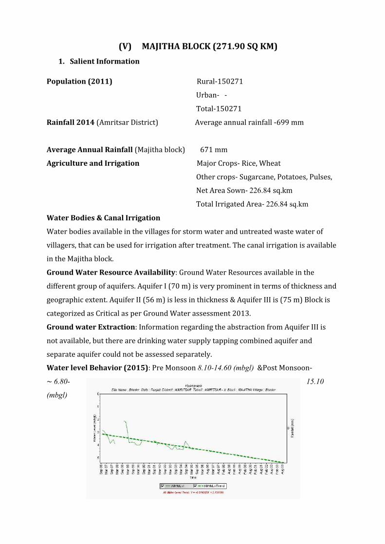
2 Aquifer Disposition Multiple Aquifer System (3 Aquifer System)
Aquifer Geology Type of
Aquifer
Thickness of
Granular
Zones (m)
Transmis
sivity
(m2day)
Specific
Yield
Storativity
Aquifer-I
(15-101m)
Qu
ate
rna
ry
All
uv
ial
de
po
sits
Unconfined 68
1450-
7190 0072 20010
-2
Aquifer-II
(112-218m)
Unconfined
to Confined 86 - NA -
Aquifer-III
(233-300m)
Unconfined
to Confined 49 - NA -
Aquifer comprises of freshwater only and the main aquifer material is sand
The non-aquifer material comprise of clay
3D Lithology model
3D Lithology Fence
3 Ground Water Resource Extraction Contamination and Other Issues
Aquifer wise Water
Resource available
(in mcm)
Dynamic Aquifer I 19154
In-storage Aquifer I 159805
Dynamic Aquifer II -
In-storage Aquifer II 6681
Dynamic Aquifer III -
In-storage Aquifer III 3806
Total 1894
Ground Water
Extraction (in
mcm)
Irrigation 26982
Domestic amp Industrial 572
Provision for domestic amp Industrial
requirement up to 2025 (in mcm)
788
Chemical Quality of ground water amp
contamination
Suitable for drinking and irrigation
purposes
Other issues Declining water level trend
4 Ground Water Resource Enhancement
Aquifer wise space available for
recharge and proposed interventions
Volume of unsaturated zone upto the average
depth to water level (15m)
Other interventions proposed Artificial Recharge Roof top Rainwater
Harvesting Farm recharge by constructing
pits will save 3588 mcm volume of water
5 Demand Side Interventions
Advanced Irrigation Practices Lining of underground pipelines (Kutcha channel)
will save 6817 mcm volume of water wastage
Change in cropping pattern Proposed change in cropping pattern from Paddy
to maizesoyabean
40 of the total area needs to change the crop
from paddy to maizesoyabean
Anticipated volume of water to be saved by
maizesoyabean is 11 mcm
Alternate water sources Tanks ponds and canals
Regulation and Control -
Other interventions proposed if
any
-
(VII) TARSIKA BLOCK (23650 SQ KM)
1 Salient Information
Population (2011) Rural-129367
Urban- -
Total-129367
Rainfall 2014 (Amritsar District) Average annual rainfall -63260 mm
Average Annual Rainfall (Tarsika block) 769 mm
Agriculture and Irrigation Major Crops- Rice Wheat
Other crops- Sugarcane Potatoes Pulses
Net Area Sown- 22475 sqkm
Total Irrigated Area- 22475 sqkm
Water Bodies amp Canal Irrigation
Water bodies available in the villages for storm water and untreated waste water of
villagers that can be used for irrigation after treatment The canal irrigation is also
available in the Tarsika block
Ground Water Resource Availability Ground Water Resources available in the
different group of aquifers Aquifer I (72 m) is very prominent in terms of thickness and
geographic extent Aquifer II (41 m) is less in thickness amp Aquifer III is (77 m) Block is
categorized as Over-Exploted as per Ground Water assessment 2013
Ground water Extraction Information regarding the abstraction from Aquifer III is
not available but there are drinking water supply tapping combined aquifer and
separate aquifer could not be assessed separately
Water level Behavior (2015) Pre Monsoon 1085-1780 (mbgl) ampPost Monsoon-
~ 998-1780 (mbgl)
2 Aquifer Disposition Multiple Aquifer System (3 Aquifer System)
Aquifer Geology Type of
Aquifer
Thickness of
Granular
Zones (m)
Transmis
sivity
(m2day)
Specific
Yield
Storativity
Aquifer-I
(12-98m)
Qu
ate
rna
ry
All
uv
ial
de
po
sits
Unconfined
72 1450-
7190 0072 20010
-2
Aquifer-II
(114-181m)
Unconfined
to Confined 41 - NA -
Aquifer-III
(210-300m)
Unconfined
to Confined 77 - NA -
Aquifer comprises of freshwater only and the main aquifer material is sand
The non-aquifer material comprise of clay
3D Lithology model
3D Lithology Fence
3 Ground Water Resource Extraction Contamination and Other Issues
Aquifer wise Water
Resource available
(in mcm)
Dynamic Aquifer I 16039
In-storage Aquifer I 122602
Dynamic Aquifer II -
In-storage Aquifer II 2308
Dynamic Aquifer III -
In-storage Aquifer III 4334
Total 1453
Ground Water
Extraction (in
mcm)
Irrigation 23915
Domestic amp Industrial 313
Provision for domestic amp Industrial
requirement up to 2025 (in mcm)
434
Chemical Quality of ground water amp
contamination
Suitable for drinking and irrigation
purposes
Other issues Declining water level trend
4 Ground Water Resource Enhancement
Aquifer wise space available for
recharge and proposed interventions
Volume of unsaturated zone upto the average
depth to water level (12m)
Other interventions proposed Artificial Recharge Roof top Rainwater
Harvesting Farm recharge by constructing
pits will save 3167 mcm volume of water
5 Demand Side Interventions
Advanced Irrigation Practices Lining of underground pipelines (Kutcha channel)
will save 6042 mcm volume of water wastage
Change in cropping pattern Proposed change in cropping pattern from Paddy
to maizesoyabean
40 of the total area needs to change the crop
from paddy to maizesoyabean
Anticipated volume of water to be saved by
maizesoyabean is 9 mcm
Alternate water sources Tanks ponds and canals
Regulation and Control -
Other interventions proposed if
any
-
(VII) VERKA BLOCK (33304 SQ KM)
1 Salient Information
Population (2011) Rural-67151
Urban- 44860
Total-112011
Rainfall 2014 (Amritsar District) Average annual rainfall -63260 mm
Average Annual Rainfall (Verka block) 644 mm
Agriculture and Irrigation Major Crops- Rice Wheat
Other crops- Sugarcane Potatoes Pulses
Net Area Sown- 14762 sqkm
Total Irrigated Area- 14762 sqkm
Water Bodies amp Canal Irrigation
Water bodies available in the villages for storm water and untreated waste water of
villagers that can be used for irrigation after treatment The canal irrigation is also
available in the Verka block
Ground Water Resource Availability Ground Water Resources available in the
different group of aquifers Aquifer I (76 m) is very prominent in terms of thickness and
geographic extent Aquifer II (59 m) is less in thickness amp Aquifer III is (59m) Block is
categorized as Over-Exploited as per Ground Water assessment 2013
Ground water Extraction Information regarding the abstraction from Aquifer III is
not available but there are drinking water supply tapping combined aquifer and
separate aquifer could not be assessed separately
Water level Behavior (2015) Pre Monsoon 1280-2484 (mbgl) ampPost Monsoon-~
1280-2386 (mbgl)
2 Aquifer Disposition Multiple Aquifer System (3 Aquifer System)
Aquifer Geology Type of
Aquifer
Thickness of
Granular
Zones (m)
Transmis
sivity
(m2day)
Specific
Yield
Storativity
Aquifer-I
(20-107m) Q
ua
tern
ary
All
uv
ial
de
po
sits
Unconfined 76
1450-
7190 12 20010
-2
Aquifer-II
(126-201m)
Unconfined
to Confined 59 - NA -
Aquifer-III
(225-300m)
Unconfined
to Confined 59 - NA -
Aquifer comprises of freshwater only and the main aquifer material is sand
The non-aquifer material comprise of clay
3D Lithology model
3D Lithology Fence
3 Ground Water Resource Extraction Contamination and Other Issues
Aquifer wise Water
Resource available
(in mcm)
Dynamic Aquifer I 20424
In-storage Aquifer I 182436
Dynamic Aquifer II -
In-storage Aquifer II 4682
Dynamic Aquifer III -
In-storage Aquifer III 4285
Total 2118
Ground Water
Extraction (in
mcm)
Irrigation 20792
Domestic amp Industrial 499
Provision for domestic amp Industrial
requirement up to 2025 (in mcm)
607
Chemical Quality of ground water amp
contamination
Potable for drinking and irrigation
Other issues declining water level trend
4 Ground Water Resource Enhancement
Aquifer wise space available for
recharge and proposed interventions
Volume of unsaturated zone upto the average
depth to water level (20m)
Other interventions proposed Artificial Recharge Roof top Rainwater
Harvesting Farm recharge by constructing
pits will save 2745 mcm volume of water
5 Demand Side Interventions
Advanced Irrigation Practices Lining of underground pipelines (Kutcha channel)
will save 5254 mcm volume of water wastage
Change in cropping pattern Proposed change in cropping pattern from Paddy
to maizesoyabean
40 of the total area needs to change the crop
from paddy to maizesoyabean
Anticipated volume of water to be saved by
maizesoyabean is 7 mcm
Alternate water sources Tanks ponds and canals
Regulation and Control -
Other interventions proposed if
any
-

3D Lithology model
3D Lithology Fence
3 Ground Water Resource Extraction Contamination and Other Issues
Aquifer wise Water
Resource available
(in mcm)
Dynamic Aquifer I 19154
In-storage Aquifer I 159805
Dynamic Aquifer II -
In-storage Aquifer II 6681
Dynamic Aquifer III -
In-storage Aquifer III 3806
Total 1894
Ground Water
Extraction (in
mcm)
Irrigation 26982
Domestic amp Industrial 572
Provision for domestic amp Industrial
requirement up to 2025 (in mcm)
788
Chemical Quality of ground water amp
contamination
Suitable for drinking and irrigation
purposes
Other issues Declining water level trend
4 Ground Water Resource Enhancement
Aquifer wise space available for
recharge and proposed interventions
Volume of unsaturated zone upto the average
depth to water level (15m)
Other interventions proposed Artificial Recharge Roof top Rainwater
Harvesting Farm recharge by constructing
pits will save 3588 mcm volume of water
5 Demand Side Interventions
Advanced Irrigation Practices Lining of underground pipelines (Kutcha channel)
will save 6817 mcm volume of water wastage
Change in cropping pattern Proposed change in cropping pattern from Paddy
to maizesoyabean
40 of the total area needs to change the crop
from paddy to maizesoyabean
Anticipated volume of water to be saved by
maizesoyabean is 11 mcm
Alternate water sources Tanks ponds and canals
Regulation and Control -
Other interventions proposed if
any
-
(VII) TARSIKA BLOCK (23650 SQ KM)
1 Salient Information
Population (2011) Rural-129367
Urban- -
Total-129367
Rainfall 2014 (Amritsar District) Average annual rainfall -63260 mm
Average Annual Rainfall (Tarsika block) 769 mm
Agriculture and Irrigation Major Crops- Rice Wheat
Other crops- Sugarcane Potatoes Pulses
Net Area Sown- 22475 sqkm
Total Irrigated Area- 22475 sqkm
Water Bodies amp Canal Irrigation
Water bodies available in the villages for storm water and untreated waste water of
villagers that can be used for irrigation after treatment The canal irrigation is also
available in the Tarsika block
Ground Water Resource Availability Ground Water Resources available in the
different group of aquifers Aquifer I (72 m) is very prominent in terms of thickness and
geographic extent Aquifer II (41 m) is less in thickness amp Aquifer III is (77 m) Block is
categorized as Over-Exploted as per Ground Water assessment 2013
Ground water Extraction Information regarding the abstraction from Aquifer III is
not available but there are drinking water supply tapping combined aquifer and
separate aquifer could not be assessed separately
Water level Behavior (2015) Pre Monsoon 1085-1780 (mbgl) ampPost Monsoon-
~ 998-1780 (mbgl)
2 Aquifer Disposition Multiple Aquifer System (3 Aquifer System)
Aquifer Geology Type of
Aquifer
Thickness of
Granular
Zones (m)
Transmis
sivity
(m2day)
Specific
Yield
Storativity
Aquifer-I
(12-98m)
Qu
ate
rna
ry
All
uv
ial
de
po
sits
Unconfined
72 1450-
7190 0072 20010
-2
Aquifer-II
(114-181m)
Unconfined
to Confined 41 - NA -
Aquifer-III
(210-300m)
Unconfined
to Confined 77 - NA -
Aquifer comprises of freshwater only and the main aquifer material is sand
The non-aquifer material comprise of clay
3D Lithology model
3D Lithology Fence
3 Ground Water Resource Extraction Contamination and Other Issues
Aquifer wise Water
Resource available
(in mcm)
Dynamic Aquifer I 16039
In-storage Aquifer I 122602
Dynamic Aquifer II -
In-storage Aquifer II 2308
Dynamic Aquifer III -
In-storage Aquifer III 4334
Total 1453
Ground Water
Extraction (in
mcm)
Irrigation 23915
Domestic amp Industrial 313
Provision for domestic amp Industrial
requirement up to 2025 (in mcm)
434
Chemical Quality of ground water amp
contamination
Suitable for drinking and irrigation
purposes
Other issues Declining water level trend
4 Ground Water Resource Enhancement
Aquifer wise space available for
recharge and proposed interventions
Volume of unsaturated zone upto the average
depth to water level (12m)
Other interventions proposed Artificial Recharge Roof top Rainwater
Harvesting Farm recharge by constructing
pits will save 3167 mcm volume of water
5 Demand Side Interventions
Advanced Irrigation Practices Lining of underground pipelines (Kutcha channel)
will save 6042 mcm volume of water wastage
Change in cropping pattern Proposed change in cropping pattern from Paddy
to maizesoyabean
40 of the total area needs to change the crop
from paddy to maizesoyabean
Anticipated volume of water to be saved by
maizesoyabean is 9 mcm
Alternate water sources Tanks ponds and canals
Regulation and Control -
Other interventions proposed if
any
-
(VII) VERKA BLOCK (33304 SQ KM)
1 Salient Information
Population (2011) Rural-67151
Urban- 44860
Total-112011
Rainfall 2014 (Amritsar District) Average annual rainfall -63260 mm
Average Annual Rainfall (Verka block) 644 mm
Agriculture and Irrigation Major Crops- Rice Wheat
Other crops- Sugarcane Potatoes Pulses
Net Area Sown- 14762 sqkm
Total Irrigated Area- 14762 sqkm
Water Bodies amp Canal Irrigation
Water bodies available in the villages for storm water and untreated waste water of
villagers that can be used for irrigation after treatment The canal irrigation is also
available in the Verka block
Ground Water Resource Availability Ground Water Resources available in the
different group of aquifers Aquifer I (76 m) is very prominent in terms of thickness and
geographic extent Aquifer II (59 m) is less in thickness amp Aquifer III is (59m) Block is
categorized as Over-Exploited as per Ground Water assessment 2013
Ground water Extraction Information regarding the abstraction from Aquifer III is
not available but there are drinking water supply tapping combined aquifer and
separate aquifer could not be assessed separately
Water level Behavior (2015) Pre Monsoon 1280-2484 (mbgl) ampPost Monsoon-~
1280-2386 (mbgl)
2 Aquifer Disposition Multiple Aquifer System (3 Aquifer System)
Aquifer Geology Type of
Aquifer
Thickness of
Granular
Zones (m)
Transmis
sivity
(m2day)
Specific
Yield
Storativity
Aquifer-I
(20-107m) Q
ua
tern
ary
All
uv
ial
de
po
sits
Unconfined 76
1450-
7190 12 20010
-2
Aquifer-II
(126-201m)
Unconfined
to Confined 59 - NA -
Aquifer-III
(225-300m)
Unconfined
to Confined 59 - NA -
Aquifer comprises of freshwater only and the main aquifer material is sand
The non-aquifer material comprise of clay
3D Lithology model
3D Lithology Fence
3 Ground Water Resource Extraction Contamination and Other Issues
Aquifer wise Water
Resource available
(in mcm)
Dynamic Aquifer I 20424
In-storage Aquifer I 182436
Dynamic Aquifer II -
In-storage Aquifer II 4682
Dynamic Aquifer III -
In-storage Aquifer III 4285
Total 2118
Ground Water
Extraction (in
mcm)
Irrigation 20792
Domestic amp Industrial 499
Provision for domestic amp Industrial
requirement up to 2025 (in mcm)
607
Chemical Quality of ground water amp
contamination
Potable for drinking and irrigation
Other issues declining water level trend
4 Ground Water Resource Enhancement
Aquifer wise space available for
recharge and proposed interventions
Volume of unsaturated zone upto the average
depth to water level (20m)
Other interventions proposed Artificial Recharge Roof top Rainwater
Harvesting Farm recharge by constructing
pits will save 2745 mcm volume of water
5 Demand Side Interventions
Advanced Irrigation Practices Lining of underground pipelines (Kutcha channel)
will save 5254 mcm volume of water wastage
Change in cropping pattern Proposed change in cropping pattern from Paddy
to maizesoyabean
40 of the total area needs to change the crop
from paddy to maizesoyabean
Anticipated volume of water to be saved by
maizesoyabean is 7 mcm
Alternate water sources Tanks ponds and canals
Regulation and Control -
Other interventions proposed if
any
-
3 Ground Water Resource Extraction Contamination and Other Issues
Aquifer wise Water
Resource available
(in mcm)
Dynamic Aquifer I 19154
In-storage Aquifer I 159805
Dynamic Aquifer II -
In-storage Aquifer II 6681
Dynamic Aquifer III -
In-storage Aquifer III 3806
Total 1894
Ground Water
Extraction (in
mcm)
Irrigation 26982
Domestic amp Industrial 572
Provision for domestic amp Industrial
requirement up to 2025 (in mcm)
788
Chemical Quality of ground water amp
contamination
Suitable for drinking and irrigation
purposes
Other issues Declining water level trend
4 Ground Water Resource Enhancement
Aquifer wise space available for
recharge and proposed interventions
Volume of unsaturated zone upto the average
depth to water level (15m)
Other interventions proposed Artificial Recharge Roof top Rainwater
Harvesting Farm recharge by constructing
pits will save 3588 mcm volume of water
5 Demand Side Interventions
Advanced Irrigation Practices Lining of underground pipelines (Kutcha channel)
will save 6817 mcm volume of water wastage
Change in cropping pattern Proposed change in cropping pattern from Paddy
to maizesoyabean
40 of the total area needs to change the crop
from paddy to maizesoyabean
Anticipated volume of water to be saved by
maizesoyabean is 11 mcm
Alternate water sources Tanks ponds and canals
Regulation and Control -
Other interventions proposed if
any
-
(VII) TARSIKA BLOCK (23650 SQ KM)
1 Salient Information
Population (2011) Rural-129367
Urban- -
Total-129367
Rainfall 2014 (Amritsar District) Average annual rainfall -63260 mm
Average Annual Rainfall (Tarsika block) 769 mm
Agriculture and Irrigation Major Crops- Rice Wheat
Other crops- Sugarcane Potatoes Pulses
Net Area Sown- 22475 sqkm
Total Irrigated Area- 22475 sqkm
Water Bodies amp Canal Irrigation
Water bodies available in the villages for storm water and untreated waste water of
villagers that can be used for irrigation after treatment The canal irrigation is also
available in the Tarsika block
Ground Water Resource Availability Ground Water Resources available in the
different group of aquifers Aquifer I (72 m) is very prominent in terms of thickness and
geographic extent Aquifer II (41 m) is less in thickness amp Aquifer III is (77 m) Block is
categorized as Over-Exploted as per Ground Water assessment 2013
Ground water Extraction Information regarding the abstraction from Aquifer III is
not available but there are drinking water supply tapping combined aquifer and
separate aquifer could not be assessed separately
Water level Behavior (2015) Pre Monsoon 1085-1780 (mbgl) ampPost Monsoon-
~ 998-1780 (mbgl)
2 Aquifer Disposition Multiple Aquifer System (3 Aquifer System)
Aquifer Geology Type of
Aquifer
Thickness of
Granular
Zones (m)
Transmis
sivity
(m2day)
Specific
Yield
Storativity
Aquifer-I
(12-98m)
Qu
ate
rna
ry
All
uv
ial
de
po
sits
Unconfined
72 1450-
7190 0072 20010
-2
Aquifer-II
(114-181m)
Unconfined
to Confined 41 - NA -
Aquifer-III
(210-300m)
Unconfined
to Confined 77 - NA -
Aquifer comprises of freshwater only and the main aquifer material is sand
The non-aquifer material comprise of clay
3D Lithology model
3D Lithology Fence
3 Ground Water Resource Extraction Contamination and Other Issues
Aquifer wise Water
Resource available
(in mcm)
Dynamic Aquifer I 16039
In-storage Aquifer I 122602
Dynamic Aquifer II -
In-storage Aquifer II 2308
Dynamic Aquifer III -
In-storage Aquifer III 4334
Total 1453
Ground Water
Extraction (in
mcm)
Irrigation 23915
Domestic amp Industrial 313
Provision for domestic amp Industrial
requirement up to 2025 (in mcm)
434
Chemical Quality of ground water amp
contamination
Suitable for drinking and irrigation
purposes
Other issues Declining water level trend
4 Ground Water Resource Enhancement
Aquifer wise space available for
recharge and proposed interventions
Volume of unsaturated zone upto the average
depth to water level (12m)
Other interventions proposed Artificial Recharge Roof top Rainwater
Harvesting Farm recharge by constructing
pits will save 3167 mcm volume of water
5 Demand Side Interventions
Advanced Irrigation Practices Lining of underground pipelines (Kutcha channel)
will save 6042 mcm volume of water wastage
Change in cropping pattern Proposed change in cropping pattern from Paddy
to maizesoyabean
40 of the total area needs to change the crop
from paddy to maizesoyabean
Anticipated volume of water to be saved by
maizesoyabean is 9 mcm
Alternate water sources Tanks ponds and canals
Regulation and Control -
Other interventions proposed if
any
-
(VII) VERKA BLOCK (33304 SQ KM)
1 Salient Information
Population (2011) Rural-67151
Urban- 44860
Total-112011
Rainfall 2014 (Amritsar District) Average annual rainfall -63260 mm
Average Annual Rainfall (Verka block) 644 mm
Agriculture and Irrigation Major Crops- Rice Wheat
Other crops- Sugarcane Potatoes Pulses
Net Area Sown- 14762 sqkm
Total Irrigated Area- 14762 sqkm
Water Bodies amp Canal Irrigation
Water bodies available in the villages for storm water and untreated waste water of
villagers that can be used for irrigation after treatment The canal irrigation is also
available in the Verka block
Ground Water Resource Availability Ground Water Resources available in the
different group of aquifers Aquifer I (76 m) is very prominent in terms of thickness and
geographic extent Aquifer II (59 m) is less in thickness amp Aquifer III is (59m) Block is
categorized as Over-Exploited as per Ground Water assessment 2013
Ground water Extraction Information regarding the abstraction from Aquifer III is
not available but there are drinking water supply tapping combined aquifer and
separate aquifer could not be assessed separately
Water level Behavior (2015) Pre Monsoon 1280-2484 (mbgl) ampPost Monsoon-~
1280-2386 (mbgl)
2 Aquifer Disposition Multiple Aquifer System (3 Aquifer System)
Aquifer Geology Type of
Aquifer
Thickness of
Granular
Zones (m)
Transmis
sivity
(m2day)
Specific
Yield
Storativity
Aquifer-I
(20-107m) Q
ua
tern
ary
All
uv
ial
de
po
sits
Unconfined 76
1450-
7190 12 20010
-2
Aquifer-II
(126-201m)
Unconfined
to Confined 59 - NA -
Aquifer-III
(225-300m)
Unconfined
to Confined 59 - NA -
Aquifer comprises of freshwater only and the main aquifer material is sand
The non-aquifer material comprise of clay
3D Lithology model
3D Lithology Fence
3 Ground Water Resource Extraction Contamination and Other Issues
Aquifer wise Water
Resource available
(in mcm)
Dynamic Aquifer I 20424
In-storage Aquifer I 182436
Dynamic Aquifer II -
In-storage Aquifer II 4682
Dynamic Aquifer III -
In-storage Aquifer III 4285
Total 2118
Ground Water
Extraction (in
mcm)
Irrigation 20792
Domestic amp Industrial 499
Provision for domestic amp Industrial
requirement up to 2025 (in mcm)
607
Chemical Quality of ground water amp
contamination
Potable for drinking and irrigation
Other issues declining water level trend
4 Ground Water Resource Enhancement
Aquifer wise space available for
recharge and proposed interventions
Volume of unsaturated zone upto the average
depth to water level (20m)
Other interventions proposed Artificial Recharge Roof top Rainwater
Harvesting Farm recharge by constructing
pits will save 2745 mcm volume of water
5 Demand Side Interventions
Advanced Irrigation Practices Lining of underground pipelines (Kutcha channel)
will save 5254 mcm volume of water wastage
Change in cropping pattern Proposed change in cropping pattern from Paddy
to maizesoyabean
40 of the total area needs to change the crop
from paddy to maizesoyabean
Anticipated volume of water to be saved by
maizesoyabean is 7 mcm
Alternate water sources Tanks ponds and canals
Regulation and Control -
Other interventions proposed if
any
-
2 Aquifer Disposition Multiple Aquifer System (3 Aquifer System)
Aquifer Geology Type of
Aquifer
Thickness of
Granular
Zones (m)
Transmis
sivity
(m2day)
Specific
Yield
Storativity
Aquifer-I
(12-98m)
Qu
ate
rna
ry
All
uv
ial
de
po
sits
Unconfined
72 1450-
7190 0072 20010
-2
Aquifer-II
(114-181m)
Unconfined
to Confined 41 - NA -
Aquifer-III
(210-300m)
Unconfined
to Confined 77 - NA -
Aquifer comprises of freshwater only and the main aquifer material is sand
The non-aquifer material comprise of clay
3D Lithology model
3D Lithology Fence
3 Ground Water Resource Extraction Contamination and Other Issues
Aquifer wise Water
Resource available
(in mcm)
Dynamic Aquifer I 16039
In-storage Aquifer I 122602
Dynamic Aquifer II -
In-storage Aquifer II 2308
Dynamic Aquifer III -
In-storage Aquifer III 4334
Total 1453
Ground Water
Extraction (in
mcm)
Irrigation 23915
Domestic amp Industrial 313
Provision for domestic amp Industrial
requirement up to 2025 (in mcm)
434
Chemical Quality of ground water amp
contamination
Suitable for drinking and irrigation
purposes
Other issues Declining water level trend
4 Ground Water Resource Enhancement
Aquifer wise space available for
recharge and proposed interventions
Volume of unsaturated zone upto the average
depth to water level (12m)
Other interventions proposed Artificial Recharge Roof top Rainwater
Harvesting Farm recharge by constructing
pits will save 3167 mcm volume of water
5 Demand Side Interventions
Advanced Irrigation Practices Lining of underground pipelines (Kutcha channel)
will save 6042 mcm volume of water wastage
Change in cropping pattern Proposed change in cropping pattern from Paddy
to maizesoyabean
40 of the total area needs to change the crop
from paddy to maizesoyabean
Anticipated volume of water to be saved by
maizesoyabean is 9 mcm
Alternate water sources Tanks ponds and canals
Regulation and Control -
Other interventions proposed if
any
-
(VII) VERKA BLOCK (33304 SQ KM)
1 Salient Information
Population (2011) Rural-67151
Urban- 44860
Total-112011
Rainfall 2014 (Amritsar District) Average annual rainfall -63260 mm
Average Annual Rainfall (Verka block) 644 mm
Agriculture and Irrigation Major Crops- Rice Wheat
Other crops- Sugarcane Potatoes Pulses
Net Area Sown- 14762 sqkm
Total Irrigated Area- 14762 sqkm
Water Bodies amp Canal Irrigation
Water bodies available in the villages for storm water and untreated waste water of
villagers that can be used for irrigation after treatment The canal irrigation is also
available in the Verka block
Ground Water Resource Availability Ground Water Resources available in the
different group of aquifers Aquifer I (76 m) is very prominent in terms of thickness and
geographic extent Aquifer II (59 m) is less in thickness amp Aquifer III is (59m) Block is
categorized as Over-Exploited as per Ground Water assessment 2013
Ground water Extraction Information regarding the abstraction from Aquifer III is
not available but there are drinking water supply tapping combined aquifer and
separate aquifer could not be assessed separately
Water level Behavior (2015) Pre Monsoon 1280-2484 (mbgl) ampPost Monsoon-~
1280-2386 (mbgl)
2 Aquifer Disposition Multiple Aquifer System (3 Aquifer System)
Aquifer Geology Type of
Aquifer
Thickness of
Granular
Zones (m)
Transmis
sivity
(m2day)
Specific
Yield
Storativity
Aquifer-I
(20-107m) Q
ua
tern
ary
All
uv
ial
de
po
sits
Unconfined 76
1450-
7190 12 20010
-2
Aquifer-II
(126-201m)
Unconfined
to Confined 59 - NA -
Aquifer-III
(225-300m)
Unconfined
to Confined 59 - NA -
Aquifer comprises of freshwater only and the main aquifer material is sand
The non-aquifer material comprise of clay
3D Lithology model
3D Lithology Fence
3 Ground Water Resource Extraction Contamination and Other Issues
Aquifer wise Water
Resource available
(in mcm)
Dynamic Aquifer I 20424
In-storage Aquifer I 182436
Dynamic Aquifer II -
In-storage Aquifer II 4682
Dynamic Aquifer III -
In-storage Aquifer III 4285
Total 2118
Ground Water
Extraction (in
mcm)
Irrigation 20792
Domestic amp Industrial 499
Provision for domestic amp Industrial
requirement up to 2025 (in mcm)
607
Chemical Quality of ground water amp
contamination
Potable for drinking and irrigation
Other issues declining water level trend
4 Ground Water Resource Enhancement
Aquifer wise space available for
recharge and proposed interventions
Volume of unsaturated zone upto the average
depth to water level (20m)
Other interventions proposed Artificial Recharge Roof top Rainwater
Harvesting Farm recharge by constructing
pits will save 2745 mcm volume of water
5 Demand Side Interventions
Advanced Irrigation Practices Lining of underground pipelines (Kutcha channel)
will save 5254 mcm volume of water wastage
Change in cropping pattern Proposed change in cropping pattern from Paddy
to maizesoyabean
40 of the total area needs to change the crop
from paddy to maizesoyabean
Anticipated volume of water to be saved by
maizesoyabean is 7 mcm
Alternate water sources Tanks ponds and canals
Regulation and Control -
Other interventions proposed if
any
-

3D Lithology Fence
3 Ground Water Resource Extraction Contamination and Other Issues
Aquifer wise Water
Resource available
(in mcm)
Dynamic Aquifer I 16039
In-storage Aquifer I 122602
Dynamic Aquifer II -
In-storage Aquifer II 2308
Dynamic Aquifer III -
In-storage Aquifer III 4334
Total 1453
Ground Water
Extraction (in
mcm)
Irrigation 23915
Domestic amp Industrial 313
Provision for domestic amp Industrial
requirement up to 2025 (in mcm)
434
Chemical Quality of ground water amp
contamination
Suitable for drinking and irrigation
purposes
Other issues Declining water level trend
4 Ground Water Resource Enhancement
Aquifer wise space available for
recharge and proposed interventions
Volume of unsaturated zone upto the average
depth to water level (12m)
Other interventions proposed Artificial Recharge Roof top Rainwater
Harvesting Farm recharge by constructing
pits will save 3167 mcm volume of water
5 Demand Side Interventions
Advanced Irrigation Practices Lining of underground pipelines (Kutcha channel)
will save 6042 mcm volume of water wastage
Change in cropping pattern Proposed change in cropping pattern from Paddy
to maizesoyabean
40 of the total area needs to change the crop
from paddy to maizesoyabean
Anticipated volume of water to be saved by
maizesoyabean is 9 mcm
Alternate water sources Tanks ponds and canals
Regulation and Control -
Other interventions proposed if
any
-
(VII) VERKA BLOCK (33304 SQ KM)
1 Salient Information
Population (2011) Rural-67151
Urban- 44860
Total-112011
Rainfall 2014 (Amritsar District) Average annual rainfall -63260 mm
Average Annual Rainfall (Verka block) 644 mm
Agriculture and Irrigation Major Crops- Rice Wheat
Other crops- Sugarcane Potatoes Pulses
Net Area Sown- 14762 sqkm
Total Irrigated Area- 14762 sqkm
Water Bodies amp Canal Irrigation
Water bodies available in the villages for storm water and untreated waste water of
villagers that can be used for irrigation after treatment The canal irrigation is also
available in the Verka block
Ground Water Resource Availability Ground Water Resources available in the
different group of aquifers Aquifer I (76 m) is very prominent in terms of thickness and
geographic extent Aquifer II (59 m) is less in thickness amp Aquifer III is (59m) Block is
categorized as Over-Exploited as per Ground Water assessment 2013
Ground water Extraction Information regarding the abstraction from Aquifer III is
not available but there are drinking water supply tapping combined aquifer and
separate aquifer could not be assessed separately
Water level Behavior (2015) Pre Monsoon 1280-2484 (mbgl) ampPost Monsoon-~
1280-2386 (mbgl)
2 Aquifer Disposition Multiple Aquifer System (3 Aquifer System)
Aquifer Geology Type of
Aquifer
Thickness of
Granular
Zones (m)
Transmis
sivity
(m2day)
Specific
Yield
Storativity
Aquifer-I
(20-107m) Q
ua
tern
ary
All
uv
ial
de
po
sits
Unconfined 76
1450-
7190 12 20010
-2
Aquifer-II
(126-201m)
Unconfined
to Confined 59 - NA -
Aquifer-III
(225-300m)
Unconfined
to Confined 59 - NA -
Aquifer comprises of freshwater only and the main aquifer material is sand
The non-aquifer material comprise of clay
3D Lithology model
3D Lithology Fence
3 Ground Water Resource Extraction Contamination and Other Issues
Aquifer wise Water
Resource available
(in mcm)
Dynamic Aquifer I 20424
In-storage Aquifer I 182436
Dynamic Aquifer II -
In-storage Aquifer II 4682
Dynamic Aquifer III -
In-storage Aquifer III 4285
Total 2118
Ground Water
Extraction (in
mcm)
Irrigation 20792
Domestic amp Industrial 499
Provision for domestic amp Industrial
requirement up to 2025 (in mcm)
607
Chemical Quality of ground water amp
contamination
Potable for drinking and irrigation
Other issues declining water level trend
4 Ground Water Resource Enhancement
Aquifer wise space available for
recharge and proposed interventions
Volume of unsaturated zone upto the average
depth to water level (20m)
Other interventions proposed Artificial Recharge Roof top Rainwater
Harvesting Farm recharge by constructing
pits will save 2745 mcm volume of water
5 Demand Side Interventions
Advanced Irrigation Practices Lining of underground pipelines (Kutcha channel)
will save 5254 mcm volume of water wastage
Change in cropping pattern Proposed change in cropping pattern from Paddy
to maizesoyabean
40 of the total area needs to change the crop
from paddy to maizesoyabean
Anticipated volume of water to be saved by
maizesoyabean is 7 mcm
Alternate water sources Tanks ponds and canals
Regulation and Control -
Other interventions proposed if
any
-

3 Ground Water Resource Extraction Contamination and Other Issues
Aquifer wise Water
Resource available
(in mcm)
Dynamic Aquifer I 16039
In-storage Aquifer I 122602
Dynamic Aquifer II -
In-storage Aquifer II 2308
Dynamic Aquifer III -
In-storage Aquifer III 4334
Total 1453
Ground Water
Extraction (in
mcm)
Irrigation 23915
Domestic amp Industrial 313
Provision for domestic amp Industrial
requirement up to 2025 (in mcm)
434
Chemical Quality of ground water amp
contamination
Suitable for drinking and irrigation
purposes
Other issues Declining water level trend
4 Ground Water Resource Enhancement
Aquifer wise space available for
recharge and proposed interventions
Volume of unsaturated zone upto the average
depth to water level (12m)
Other interventions proposed Artificial Recharge Roof top Rainwater
Harvesting Farm recharge by constructing
pits will save 3167 mcm volume of water
5 Demand Side Interventions
Advanced Irrigation Practices Lining of underground pipelines (Kutcha channel)
will save 6042 mcm volume of water wastage
Change in cropping pattern Proposed change in cropping pattern from Paddy
to maizesoyabean
40 of the total area needs to change the crop
from paddy to maizesoyabean
Anticipated volume of water to be saved by
maizesoyabean is 9 mcm
Alternate water sources Tanks ponds and canals
Regulation and Control -
Other interventions proposed if
any
-
(VII) VERKA BLOCK (33304 SQ KM)
1 Salient Information
Population (2011) Rural-67151
Urban- 44860
Total-112011
Rainfall 2014 (Amritsar District) Average annual rainfall -63260 mm
Average Annual Rainfall (Verka block) 644 mm
Agriculture and Irrigation Major Crops- Rice Wheat
Other crops- Sugarcane Potatoes Pulses
Net Area Sown- 14762 sqkm
Total Irrigated Area- 14762 sqkm
Water Bodies amp Canal Irrigation
Water bodies available in the villages for storm water and untreated waste water of
villagers that can be used for irrigation after treatment The canal irrigation is also
available in the Verka block
Ground Water Resource Availability Ground Water Resources available in the
different group of aquifers Aquifer I (76 m) is very prominent in terms of thickness and
geographic extent Aquifer II (59 m) is less in thickness amp Aquifer III is (59m) Block is
categorized as Over-Exploited as per Ground Water assessment 2013
Ground water Extraction Information regarding the abstraction from Aquifer III is
not available but there are drinking water supply tapping combined aquifer and
separate aquifer could not be assessed separately
Water level Behavior (2015) Pre Monsoon 1280-2484 (mbgl) ampPost Monsoon-~
1280-2386 (mbgl)
2 Aquifer Disposition Multiple Aquifer System (3 Aquifer System)
Aquifer Geology Type of
Aquifer
Thickness of
Granular
Zones (m)
Transmis
sivity
(m2day)
Specific
Yield
Storativity
Aquifer-I
(20-107m) Q
ua
tern
ary
All
uv
ial
de
po
sits
Unconfined 76
1450-
7190 12 20010
-2
Aquifer-II
(126-201m)
Unconfined
to Confined 59 - NA -
Aquifer-III
(225-300m)
Unconfined
to Confined 59 - NA -
Aquifer comprises of freshwater only and the main aquifer material is sand
The non-aquifer material comprise of clay
3D Lithology model
3D Lithology Fence
3 Ground Water Resource Extraction Contamination and Other Issues
Aquifer wise Water
Resource available
(in mcm)
Dynamic Aquifer I 20424
In-storage Aquifer I 182436
Dynamic Aquifer II -
In-storage Aquifer II 4682
Dynamic Aquifer III -
In-storage Aquifer III 4285
Total 2118
Ground Water
Extraction (in
mcm)
Irrigation 20792
Domestic amp Industrial 499
Provision for domestic amp Industrial
requirement up to 2025 (in mcm)
607
Chemical Quality of ground water amp
contamination
Potable for drinking and irrigation
Other issues declining water level trend
4 Ground Water Resource Enhancement
Aquifer wise space available for
recharge and proposed interventions
Volume of unsaturated zone upto the average
depth to water level (20m)
Other interventions proposed Artificial Recharge Roof top Rainwater
Harvesting Farm recharge by constructing
pits will save 2745 mcm volume of water
5 Demand Side Interventions
Advanced Irrigation Practices Lining of underground pipelines (Kutcha channel)
will save 5254 mcm volume of water wastage
Change in cropping pattern Proposed change in cropping pattern from Paddy
to maizesoyabean
40 of the total area needs to change the crop
from paddy to maizesoyabean
Anticipated volume of water to be saved by
maizesoyabean is 7 mcm
Alternate water sources Tanks ponds and canals
Regulation and Control -
Other interventions proposed if
any
-
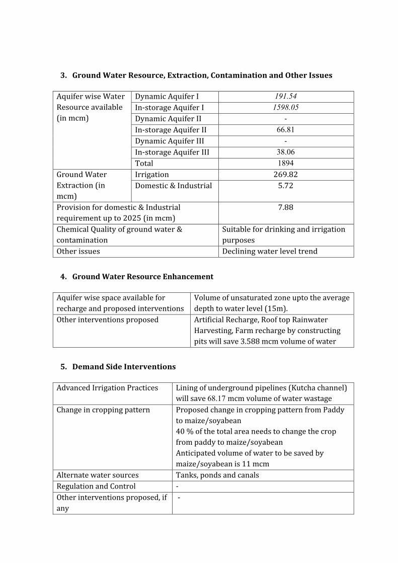
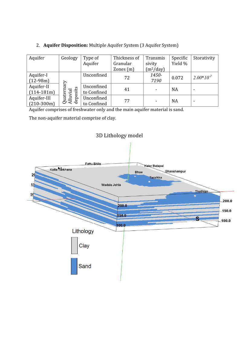
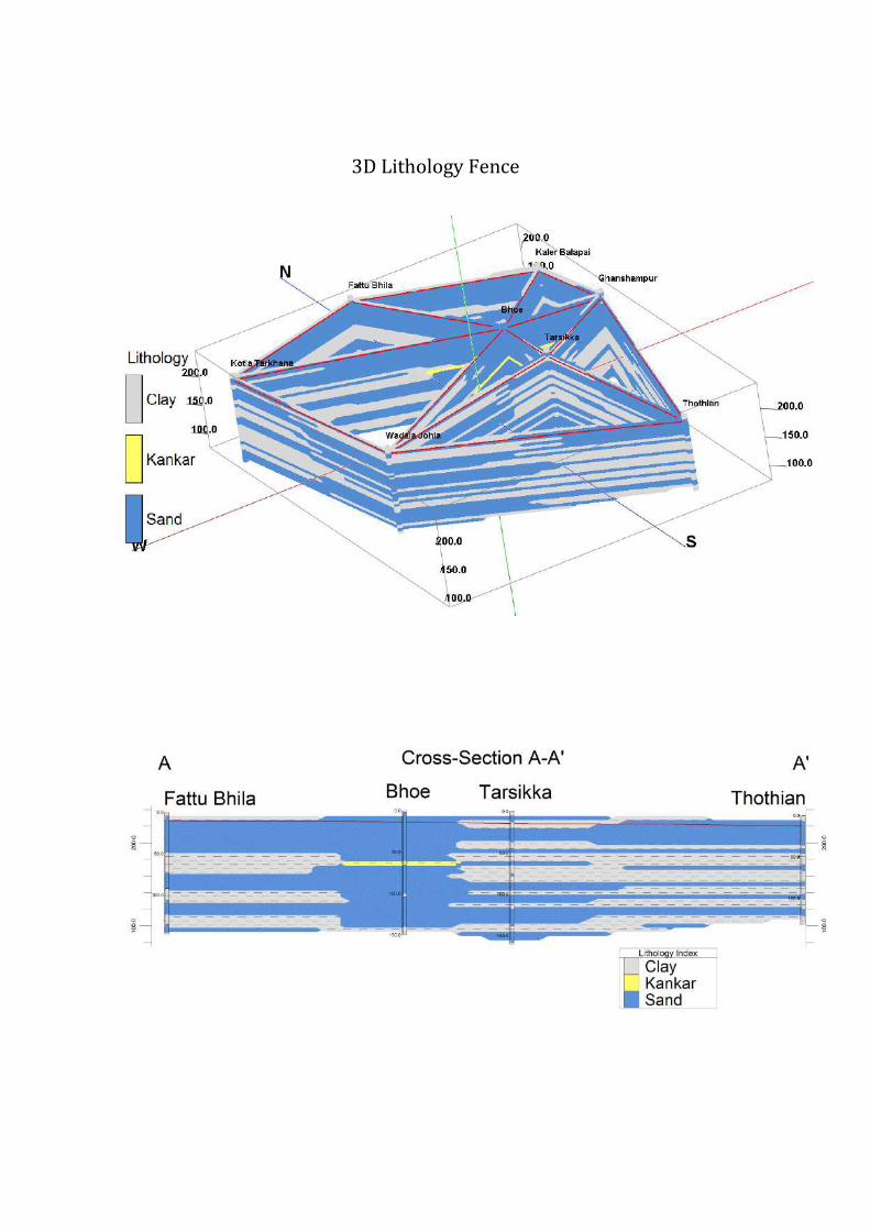


![घेरण्ड स डंलहिा[gheraṇḍa] घेरण्ड स डंलहिा maharishi university of management vedic literature collection समालधना](https://img.pdfslide.us/doc/110x75/5e7d7b9f566a002ccc36fac4/aaaaaa-a-aaaaaa-gheraa-aaaaaa-a.jpg)