Embed Size (px)
Citation preview
©"Peduzzi""2017,"UN"Environment,"scoping"mee;ng"agricultural"risk"assessment"
Past%research%on%drought"
Dr"Pascal"Peduzzi"
Scoping"mee;ng,"Boulder"2017"
©"Peduzzi""2017,"UN"Environment,"scoping"mee;ng"agricultural"risk"assessment"
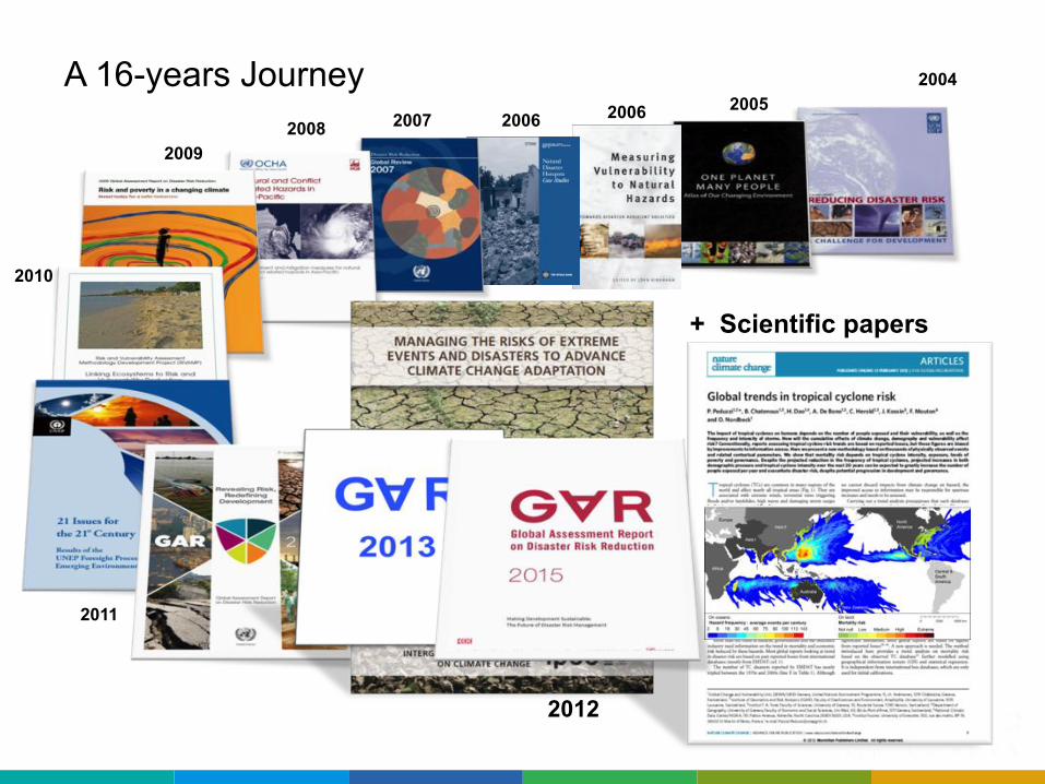
2005 2006 2006
A 16-years Journey 2004
2007 2008 2009
2010
2011
2012
+ Scientific papers
©"Peduzzi""2017,"UN"Environment,"scoping"mee;ng"agricultural"risk"assessment"
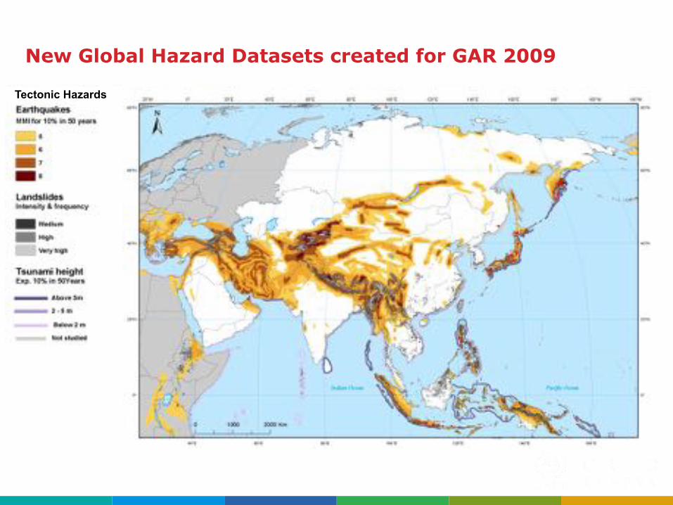
Tectonic Hazards
New Global Hazard Datasets created for GAR 2009
©"Peduzzi""2017,"UN"Environment,"scoping"mee;ng"agricultural"risk"assessment"
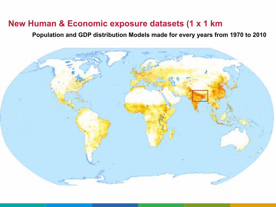
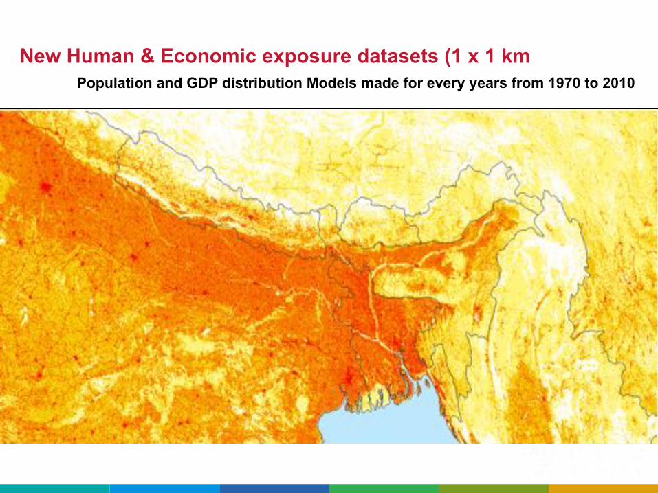
New Human & Economic exposure datasets (1 x 1 km Population and GDP distribution Models made for every years from 1970 to 2010
©"Peduzzi""2017,"UN"Environment,"scoping"mee;ng"agricultural"risk"assessment"
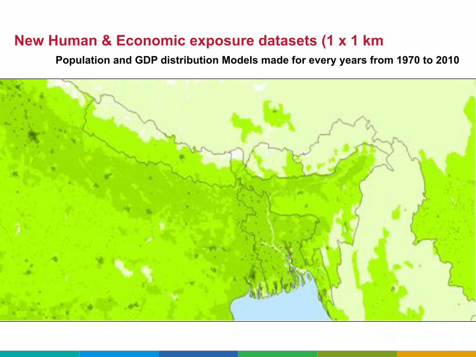
New Human & Economic exposure datasets (1 x 1 km Population and GDP distribution Models made for every years from 1970 to 2010
©"Peduzzi""2017,"UN"Environment,"scoping"mee;ng"agricultural"risk"assessment"
New Human & Economic exposure datasets (1 x 1 km Population and GDP distribution Models made for every years from 1970 to 2010
©"Peduzzi""2017,"UN"Environment,"scoping"mee;ng"agricultural"risk"assessment"
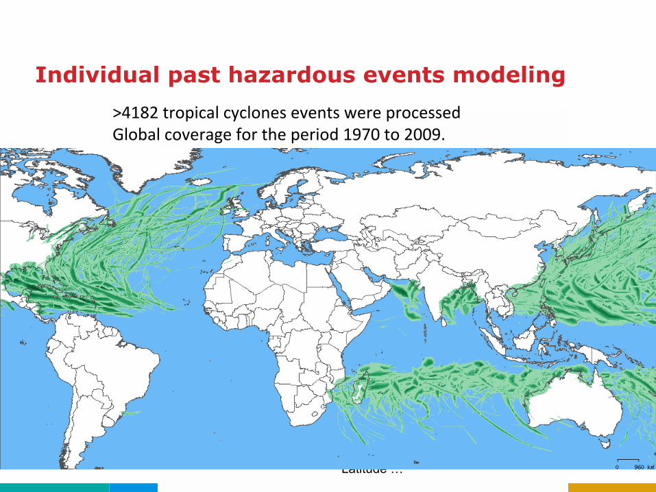
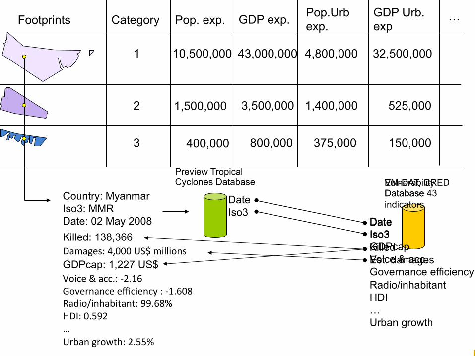
>4182"tropical"cyclones"events"were"processed"Global"coverage"for"the"period"1970"to"2009."
Using central pressure Maximum windspeed Latitude …
Individual past hazardous events modeling
©"Peduzzi""2017,"UN"Environment,"scoping"mee;ng"agricultural"risk"assessment"
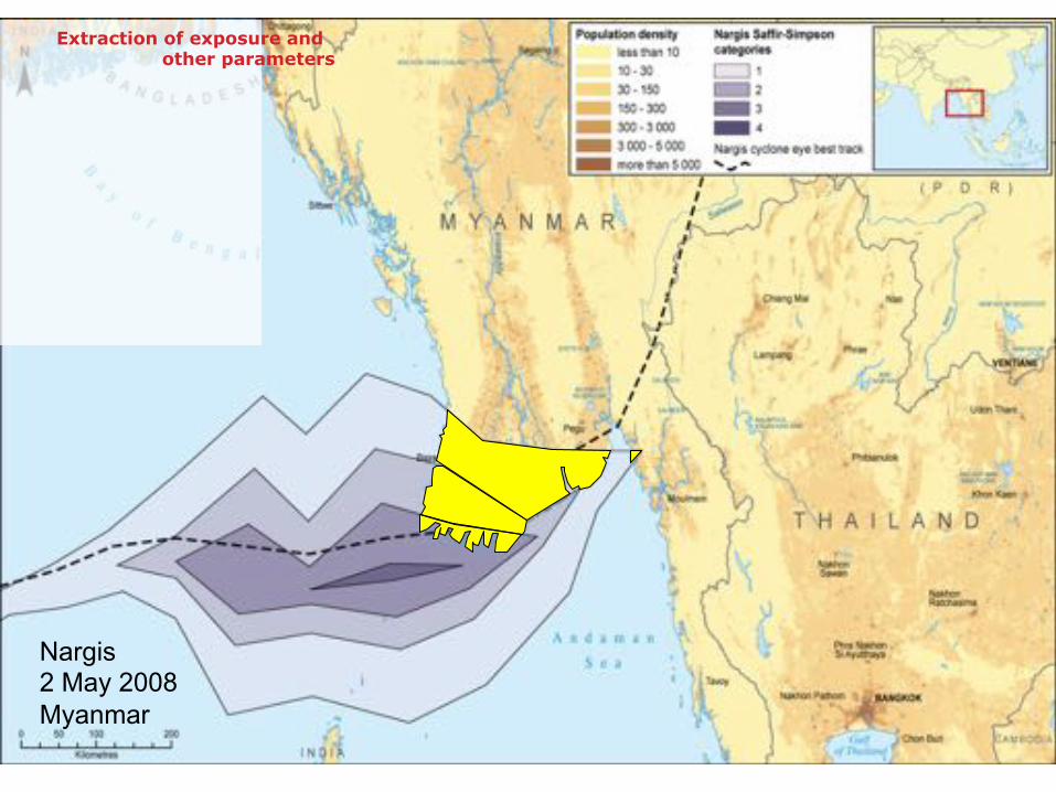
Nargis 2 May 2008 Myanmar
Extraction of exposure and other parameters
©"Peduzzi""2017,"UN"Environment,"scoping"mee;ng"agricultural"risk"assessment"
Date Iso3 Killed Est. damages
Footprints Pop. exp. GDP exp. Pop.Urb exp.
GDP Urb. exp Category
1 10,500,000 43,000,000 4,800,000 32,500,000
2 1,500,000 3,500,000 1,400,000 525,000
3 400,000 800,000 375,000 150,000
Country: Myanmar Iso3: MMR Date: 02 May 2008
Preview Tropical Cyclones Database EM-DAT, CRED
Database Date Iso3
Killed: 138,366
Vulnerability Database 43 indicators
Damages:"4,000"US$"millions"GDPcap: 1,227 US$ Voice"&"acc.:"Q2.16"Governance"efficiency":"Q1.608"Radio/inhabitant:"99.68%"HDI:"0.592"…"Urban"growth:"2.55%""
…
Date Iso3 GDPcap Voice & acc. Governance efficiency Radio/inhabitant HDI … Urban growth
©"Peduzzi""2017,"UN"Environment,"scoping"mee;ng"agricultural"risk"assessment"
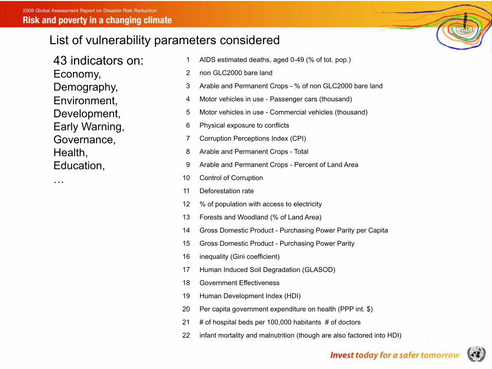
1 AIDS estimated deaths, aged 0-49 (% of tot. pop.) 2 non GLC2000 bare land 3 Arable and Permanent Crops - % of non GLC2000 bare land 4 Motor vehicles in use - Passenger cars (thousand) 5 Motor vehicles in use - Commercial vehicles (thousand) 6 Physical exposure to conflicts 7 Corruption Perceptions Index (CPI) 8 Arable and Permanent Crops - Total 9 Arable and Permanent Crops - Percent of Land Area
10 Control of Corruption 11 Deforestation rate 12 % of population with access to electricity 13 Forests and Woodland (% of Land Area) 14 Gross Domestic Product - Purchasing Power Parity per Capita 15 Gross Domestic Product - Purchasing Power Parity 16 inequality (Gini coefficient) 17 Human Induced Soil Degradation (GLASOD) 18 Government Effectiveness 19 Human Development Index (HDI) 20 Per capita government expenditure on health (PPP int. $) 21 # of hospital beds per 100,000 habitants # of doctors 22 infant mortality and malnutrition (though are also factored into HDI) 23 Improved Drinking Water Coverage - Total Population 24 telecommunications (phone density per 100,000 habitants) 25 Political Stability 26 Population (Persons (in Thousands)) 27 Urban Population (% of Total Population) 28 Radio receivers (per thousand inhabitants) 29 Regulatory Quality 30 Rule of Law 31 School enrollment, primary (total) 32 % of urban population living in slums / squatter settlements 33 Physicians density (per 10 000 population) 34 Under five years old mortality rate 35 Undernourished (% of total population) 36 Urban Population Growth on past 3 years 37 Voice and Accountability 38 Motor vehicles in use - Passenger cars (per inhabitant) 39 Motor vehicles in use - Commercial vehicles (per inhabitant) 40 School enrollment, primary (per inhabitant) 41 Population growth on 3 past years 42 income-consumption poverty (from WB poverty calculator also from MDG project) 43 Transport
43 indicators on: Economy, Demography, Environment, Development, Early Warning, Governance, Health, Education, …
List of vulnerability parameters considered
©"Peduzzi""2017,"UN"Environment,"scoping"mee;ng"agricultural"risk"assessment"
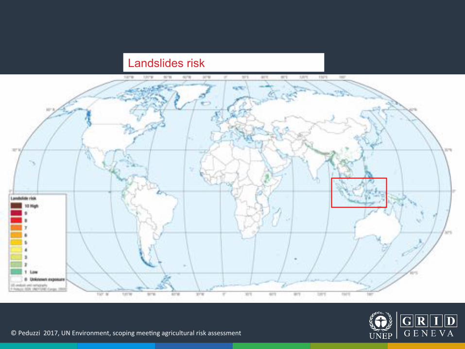
Landslides risk
©"Peduzzi""2017,"UN"Environment,"scoping"mee;ng"agricultural"risk"assessment"
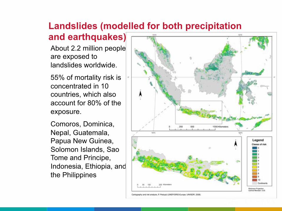
About 2.2 million people are exposed to landslides worldwide.
55% of mortality risk is concentrated in 10 countries, which also account for 80% of the exposure.
Comoros, Dominica, Nepal, Guatemala, Papua New Guinea, Solomon Islands, Sao Tome and Principe, Indonesia, Ethiopia, and the Philippines
Landslides (modelled for both precipitation and earthquakes)
©"Peduzzi""2017,"UN"Environment,"scoping"mee;ng"agricultural"risk"assessment"
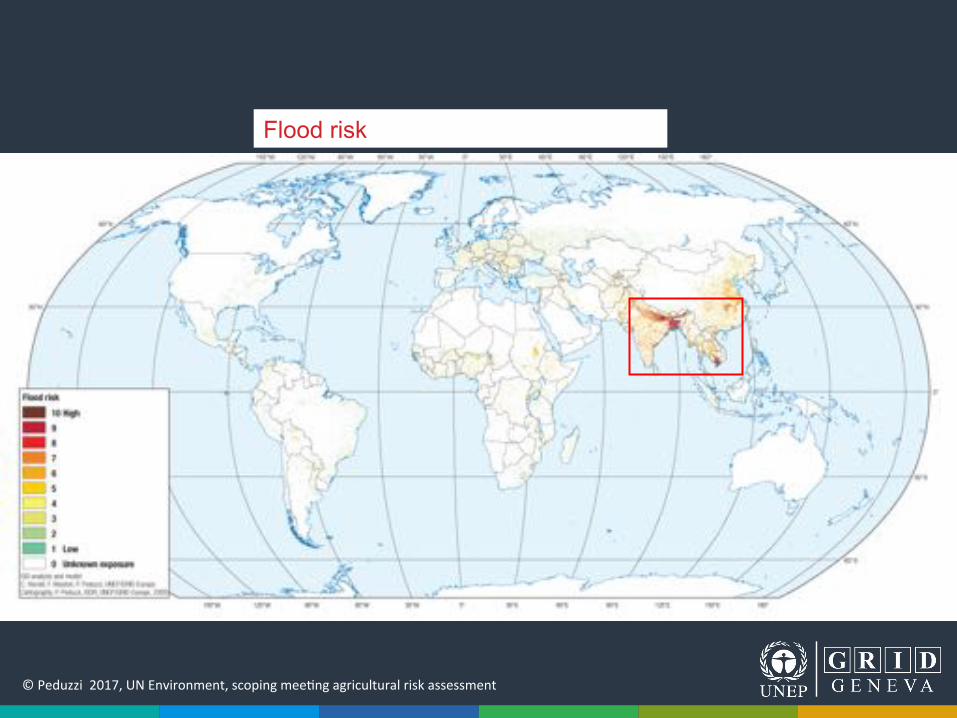
Flood risk
©"Peduzzi""2017,"UN"Environment,"scoping"mee;ng"agricultural"risk"assessment"
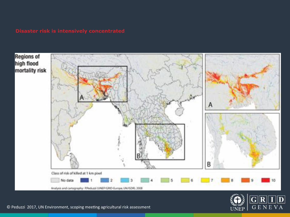
Disaster risk is intensively concentrated
©"Peduzzi""2017,"UN"Environment,"scoping"mee;ng"agricultural"risk"assessment"
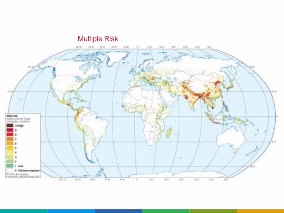
Tropical cyclones risk Earthquakes risk Multiple Risk
©"Peduzzi""2017,"UN"Environment,"scoping"mee;ng"agricultural"risk"assessment"
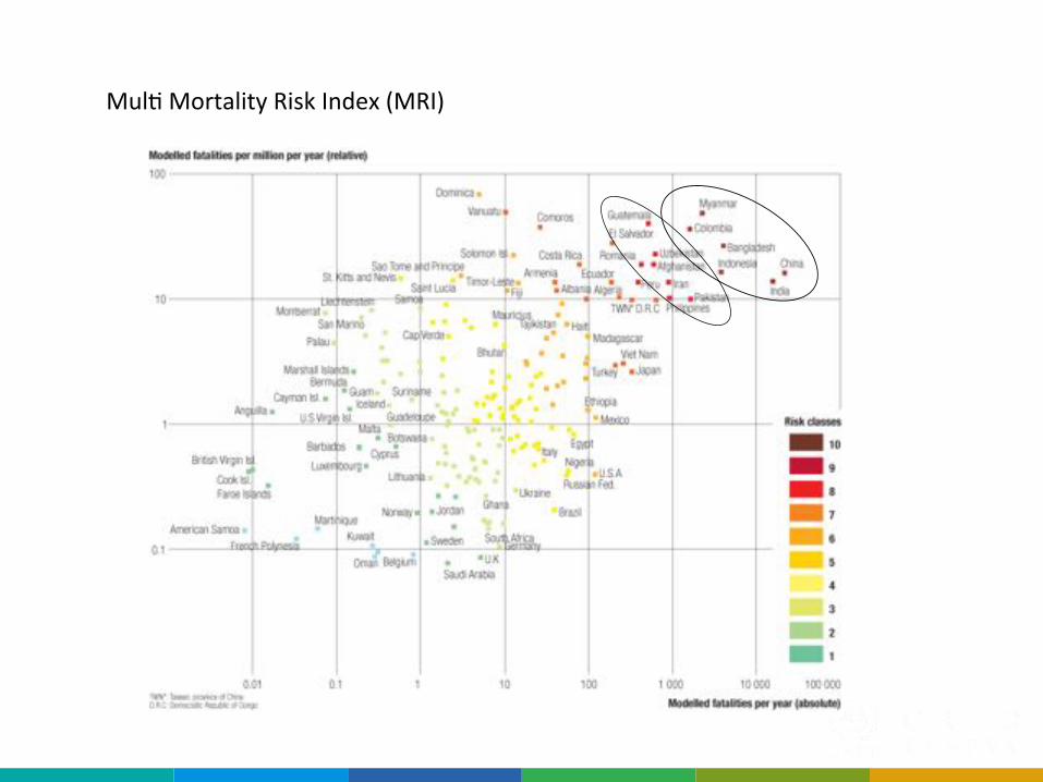
Vanuatu Mexico
BangladeshSolomon Ilands
China
Italy
OmanSaudi Arabia
Monserrat
Modelled fatalities per year (absolute)
Modelled fatalities per million inhabitant per year (relative)
Mexico
Mul;"Mortality"Risk"Index"(MRI)"
Vanuatu

©"Peduzzi""2017,"UN"Environment,"scoping"mee;ng"agricultural"risk"assessment"
Previous attempts
• Hotspots"project"2005:"used"(3"and"6"months)"and"shortage"of"precipita;on"(50%,"25%"and"10%)"at"2.5"resolu;on."Didn’t"work"for"the"UNDP"report"(reducing"Disaster"Risk,"2004)"
• GAR"2009:"SPI"+"SMI"(3,"6,"12"months,"and"50%;"25%;"10%),"2.5°"cell."No"correla;ons"were"found."
©"Peduzzi""2017,"UN"Environment,"scoping"mee;ng"agricultural"risk"assessment"
!
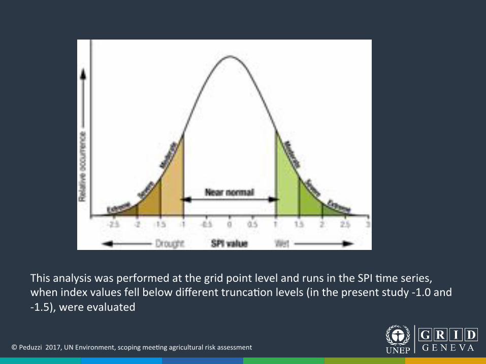
This"analysis"was"performed"at"the"grid"point"level"and"runs"in"the"SPI";me"series,"when"index"values"fell"below"different"trunca;on"levels"(in"the"present"study"Q1.0"and"Q1.5),"were"evaluated""
©"Peduzzi""2017,"UN"Environment,"scoping"mee;ng"agricultural"risk"assessment"
!
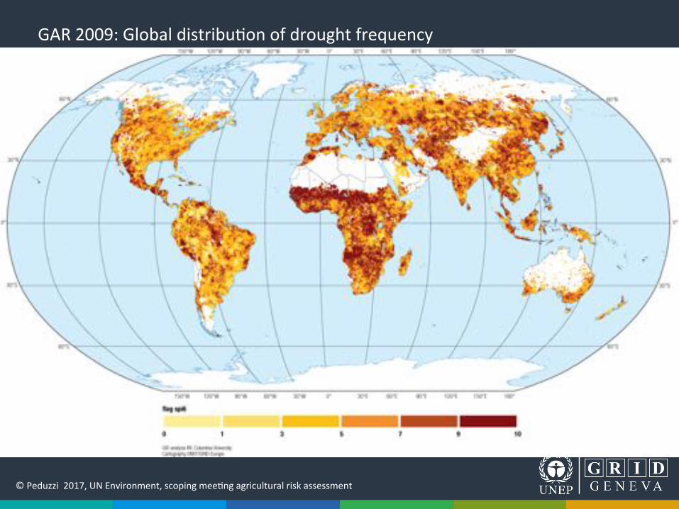
GAR"2009:"Global"distribu;on"of"drought"frequency""
©"Peduzzi""2017,"UN"Environment,"scoping"mee;ng"agricultural"risk"assessment"
©"Peduzzi""2017,"UN"Environment,"scoping"mee;ng"agricultural"risk"assessment"
!
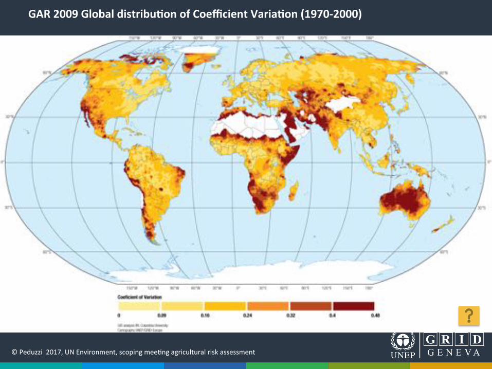
GAR%2009%Global%distribu8on%of%Coefficient%Varia8on%(1970@2000)%%
©"Peduzzi""2017,"UN"Environment,"scoping"mee;ng"agricultural"risk"assessment"
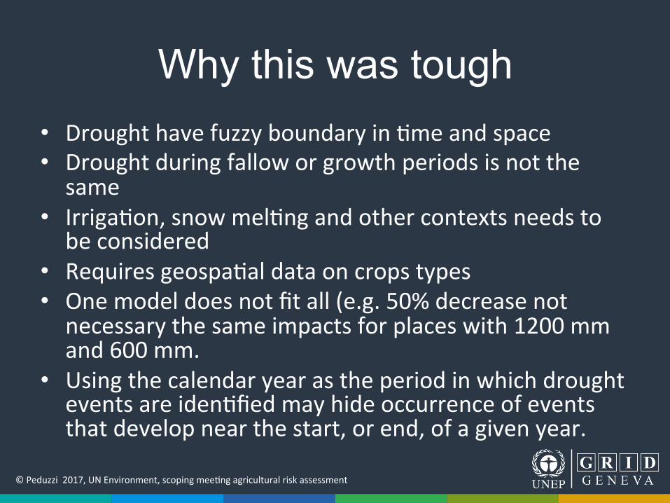
Why this was tough • Drought"have"fuzzy"boundary"in";me"and"space"• Drought"during"fallow"or"growth"periods"is"not"the"same"
• Irriga;on,"snow"mel;ng"and"other"contexts"needs"to"be"considered"
• Requires"geospa;al"data"on"crops"types"• One"model"does"not"fit"all"(e.g."50%"decrease"not"necessary"the"same"impacts"for"places"with"1200"mm"and"600"mm."
• Using"the"calendar"year"as"the"period"in"which"drought"events"are"iden;fied"may"hide"occurrence"of"events"that"develop"near"the"start,"or"end,"of"a"given"year.""
©"Peduzzi""2017,"UN"Environment,"scoping"mee;ng"agricultural"risk"assessment"
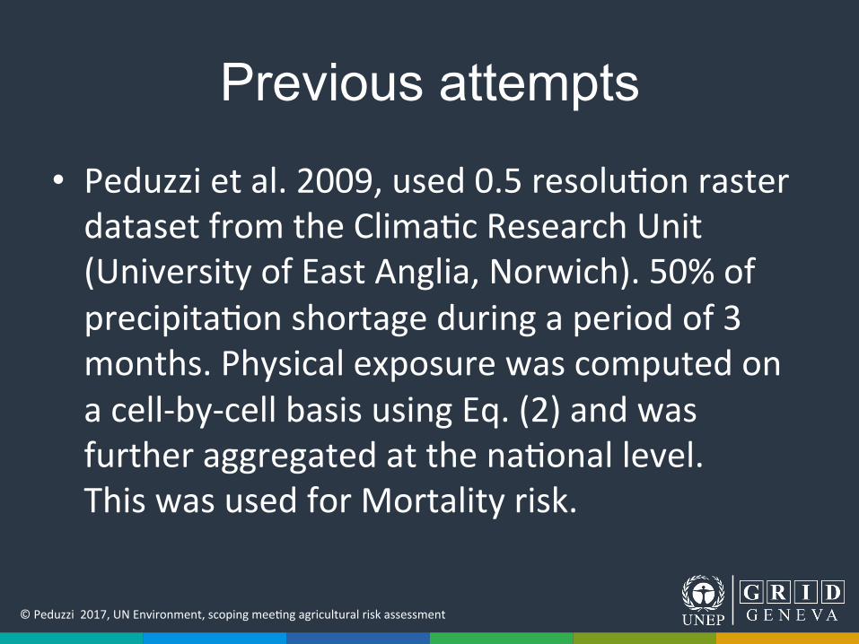
Previous attempts
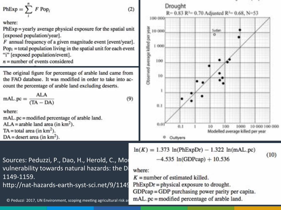
• Peduzzi"et"al."2009,"used"0.5"resolu;on"raster"dataset"from"the"Clima;c"Research"Unit"(University"of"East"Anglia,"Norwich)."50%"of"precipita;on"shortage"during"a"period"of"3"months."Physical"exposure"was"computed"on"a"cellQbyQcell"basis"using"Eq."(2)"and"was"further"aggregated"at"the"na;onal"level.""This"was"used"for"Mortality"risk."
©"Peduzzi""2017,"UN"Environment,"scoping"mee;ng"agricultural"risk"assessment"
Sources:"Peduzzi,"P.,"Dao,"H.,"Herold,"C.,"Mouton,"F."(2009)"Assessing"global"exposure"and"vulnerability"towards"natural"hazards:"the"Disaster"Risk"Index,"Nat.%Hazards%Earth%Syst.%Sci.,"9,"1149Q1159."hmp://natQhazardsQearthQsystQsci.net/9/1149/2009/nhessQ9Q1149Q2009.pdf"
©"Peduzzi""2017,"UN"Environment,"scoping"mee;ng"agricultural"risk"assessment"
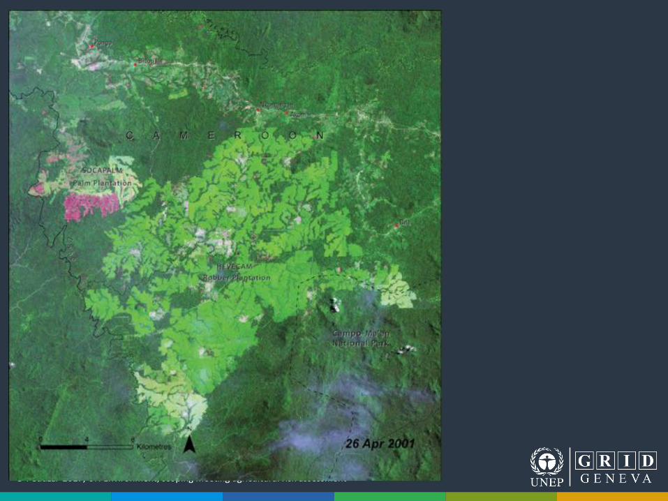
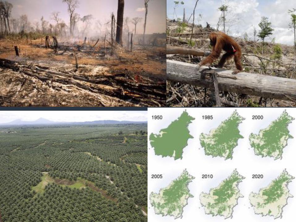
Land%cover%changes%
©"Peduzzi""2017,"UN"Environment,"scoping"mee;ng"agricultural"risk"assessment"
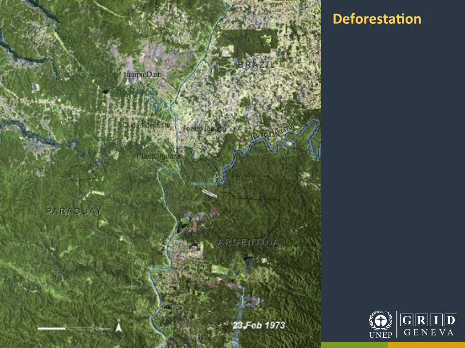
Deforesta8on%
©"Peduzzi""2017,"UN"Environment,"scoping"mee;ng"agricultural"risk"assessment"
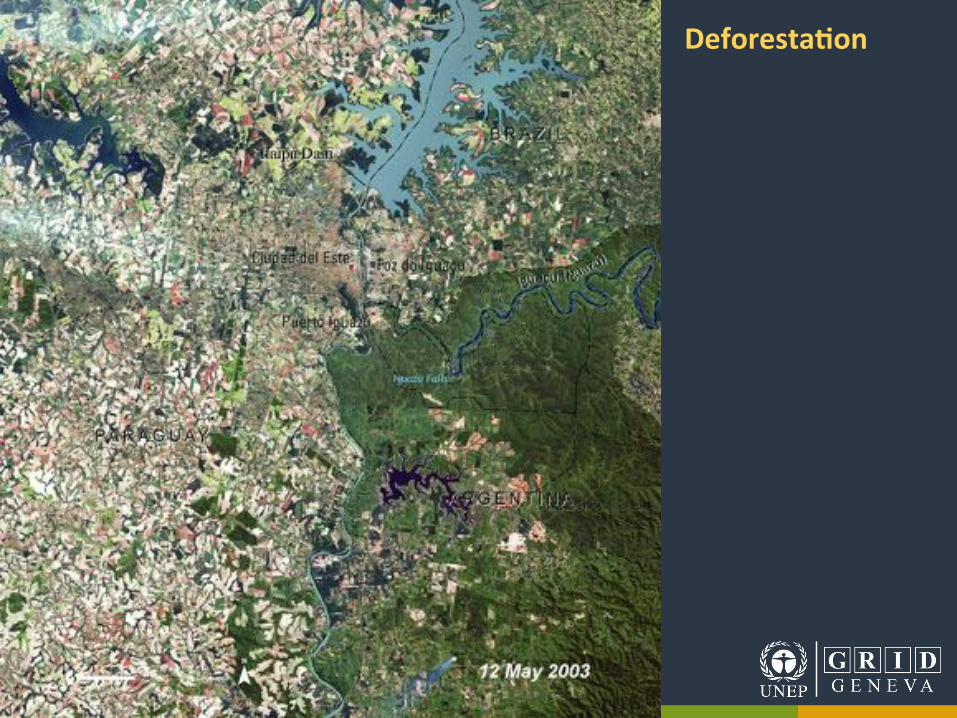
Deforesta8on%
©"Peduzzi""2017,"UN"Environment,"scoping"mee;ng"agricultural"risk"assessment"
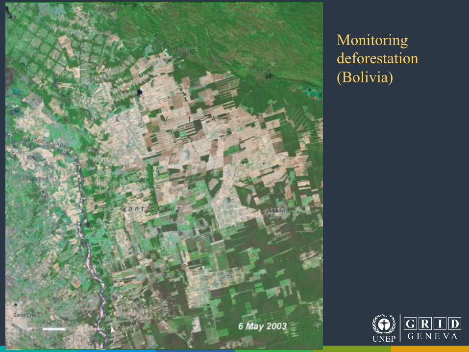
Monitoring deforestation (Bolivia)
©"Peduzzi""2017,"UN"Environment,"scoping"mee;ng"agricultural"risk"assessment"
©"Peduzzi""2017,"UN"Environment,"scoping"mee;ng"agricultural"risk"assessment"
©"Peduzzi""2017,"UN"Environment,"scoping"mee;ng"agricultural"risk"assessment"Pascal"Peduzzi,"UNEP,"2011"
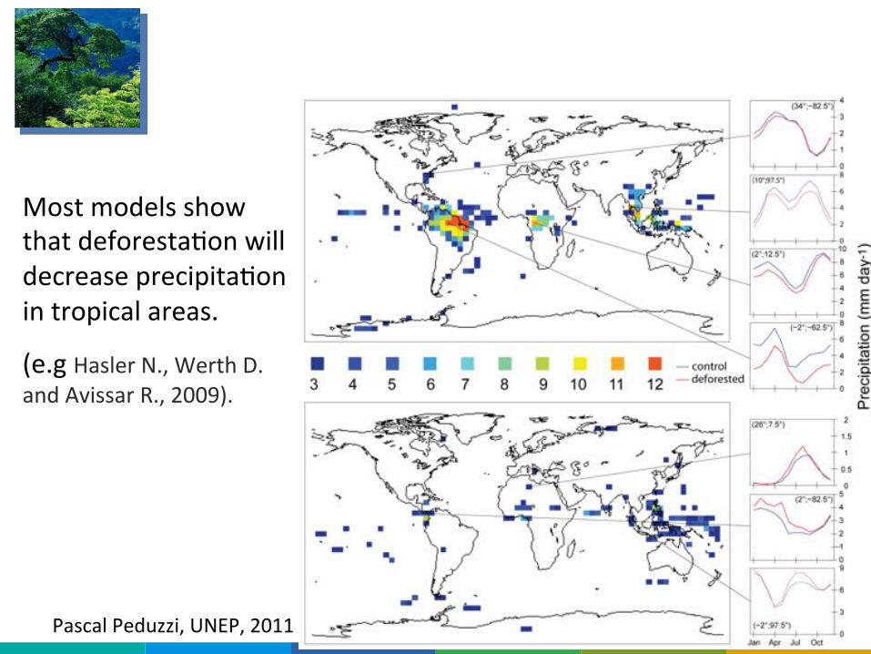
Deforestation: less rain.
Most"models"show"that"deforesta;on"will"decrease"precipita;on"in"tropical"areas."
(e.g"Hasler"N.,"Werth"D."and"Avissar"R.,"2009).""
"
©"Peduzzi""2017,"UN"Environment,"scoping"mee;ng"agricultural"risk"assessment"Pascal"Peduzzi,"UNEP,"2011"
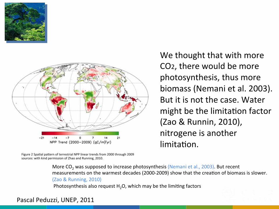
Forest: less biomass produced
Figure"2"Spa;al"pamern"of"terrestrial"NPP"linear"trends"from"2000"through"2009""sources:"with"kind"permission"of"Zhao"and"Running,"2010."
More"CO2"was"supposed"to"increase"photosynthesis"(Nemani"et"al.,"2003)."But"recent"measurements"on"the"warmest"decades"(2000Q2009)"show"that"the"crea;on"of"biomass"is"slower."(Zao"&"Running,"2010)""Photosynthesis"also"request"H2O,"which"may"be"the"limi;ng"factors""
We"thought"that"with"more"CO2,"there"would"be"more"photosynthesis,"thus"more"biomass"(Nemani"et"al."2003)."But"it"is"not"the"case."Water"might"be"the"limita;on"factor"(Zao"&"Runnin,"2010),"nitrogene"is"another"limita;on."
©"Peduzzi""2017,"UN"Environment,"scoping"mee;ng"agricultural"risk"assessment"Pascal"Peduzzi,"UNEP,"2011"
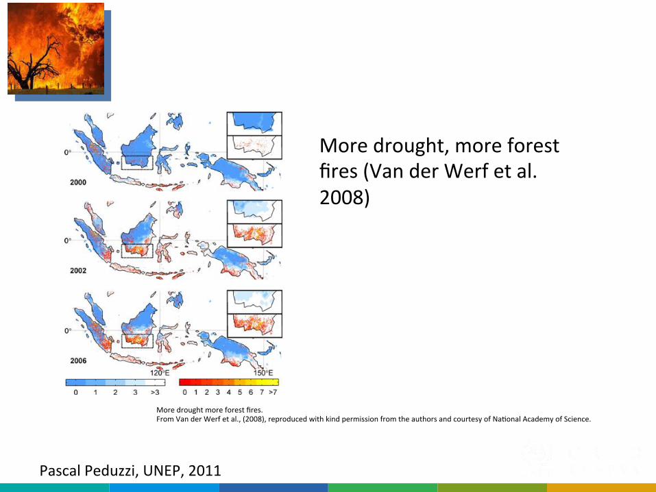
Forest: drought, more fires
More"drought,"more"forest"fires"(Van"der"Werf"et"al."2008)"
More"drought"more"forest"fires."From"Van"der"Werf"et"al.,"(2008),"reproduced"with"kind"permission"from"the"authors"and"courtesy"of"Na;onal"Academy"of"Science."
©"Peduzzi""2017,"UN"Environment,"scoping"mee;ng"agricultural"risk"assessment"
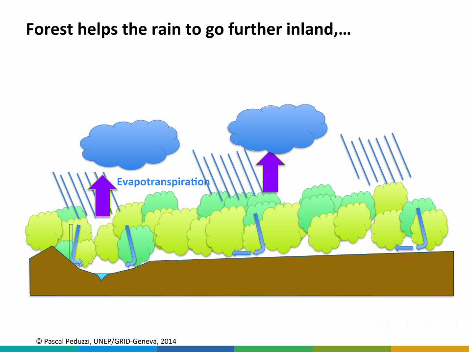
Evapotranspira8on%
Forest%helps%the%rain%to%go%further%inland,…%
©"Pascal"Peduzzi,"UNEP/GRIDQGeneva,"2014""
©"Peduzzi""2017,"UN"Environment,"scoping"mee;ng"agricultural"risk"assessment"
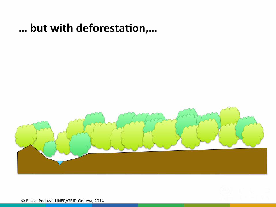
…%but%with%deforesta8on,…%
©"Pascal"Peduzzi,"UNEP/GRIDQGeneva,"2014""
©"Peduzzi""2017,"UN"Environment,"scoping"mee;ng"agricultural"risk"assessment"©"Pascal"Peduzzi,"UNEP/GRIDQGeneva,"2014""
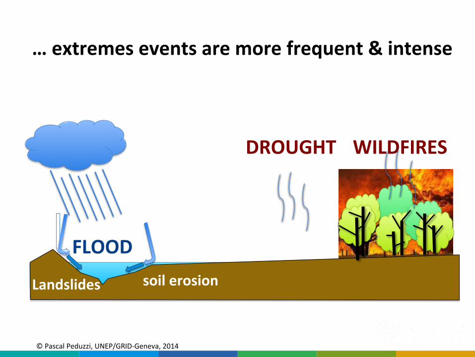
FLOOD%
DROUGHT% WILDFIRES%
…%extremes%events%are%more%frequent%&%intense%
Landslides% soil%erosion%
©"Peduzzi""2017,"UN"Environment,"scoping"mee;ng"agricultural"risk"assessment"
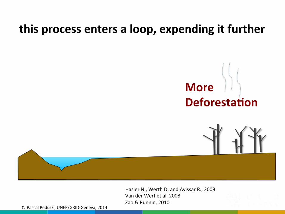
More%
Deforesta8on%
this%process%enters%a%loop,%expending%it%further%
©"Pascal"Peduzzi,"UNEP/GRIDQGeneva,"2014""
Hasler"N.,"Werth"D."and"Avissar"R.,"2009"Van"der"Werf"et"al."2008"Zao"&"Runnin,"2010"

©"Peduzzi""2017,"UN"Environment,"scoping"mee;ng"agricultural"risk"assessment"
Warmer%
%temperatures%
More CO2
More droughts
Less precipitations Higher temperatures
More Forest fires
Deforestation
Drought"can"be"a"factor"contribu;ng"to"humanQignited"forest"fires,"which"can"lead"to"widespread"deforesta;on"and"carbon"emissions"(IPCC,"SREX"p.252)"
Due to the interrelated nature of forest fires, deforestation, drought, and climate change, isolating one of the processes fails to describe the complexity of the interconnected whole.
(IPCC, SREX)
©"Pascal"Peduzzi,"UNEP/GRIDQGeneva,"2014""
©"Peduzzi""2017,"UN"Environment,"scoping"mee;ng"agricultural"risk"assessment"
A new Global GAR Exposure Model
for 2017-2020
Dr Andrea de Bono UNEP/GRID-Geneva
(already"discussed"in"2012!)"
©"Peduzzi""2017,"UN"Environment,"scoping"mee;ng"agricultural"risk"assessment"
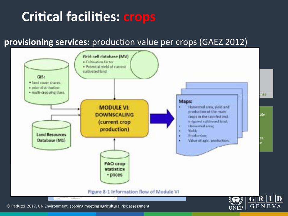
provisioning%services:%produc;on"value"per"crops"(GAEZ"2012)"
Cri8cal%facili8es:%crops%%
hXp://gaez.fao.org/Main.html#%
©"Peduzzi""2017,"UN"Environment,"scoping"mee;ng"agricultural"risk"assessment"
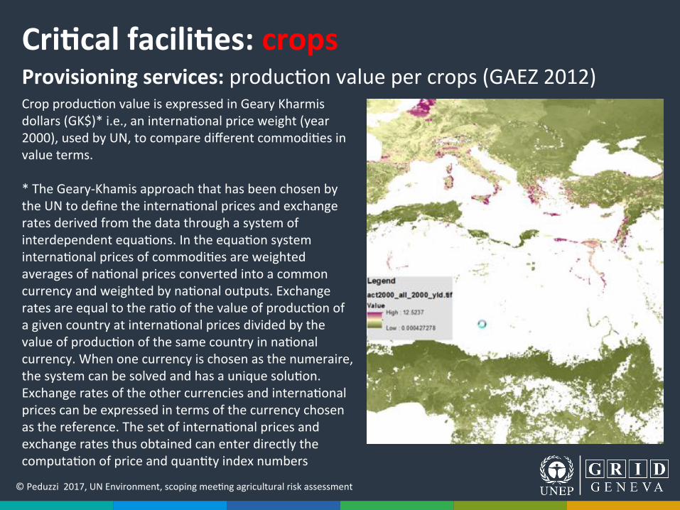
Provisioning%services:%produc;on"value"per"crops"(GAEZ"2012)"Cri8cal%facili8es:%crops%%
Crop"produc;on"value"is"expressed"in"Geary"Kharmis"dollars"(GK$)*"i.e.,"an"interna;onal"price"weight"(year"2000),"used"by"UN,"to"compare"different"commodi;es"in"value"terms.""*"The"GearyQKhamis"approach"that"has"been"chosen"by"the"UN"to"define"the"interna;onal"prices"and"exchange"rates"derived"from"the"data"through"a"system"of"interdependent"equa;ons."In"the"equa;on"system"interna;onal"prices"of"commodi;es"are"weighted"averages"of"na;onal"prices"converted"into"a"common"currency"and"weighted"by"na;onal"outputs."Exchange"rates"are"equal"to"the"ra;o"of"the"value"of"produc;on"of"a"given"country"at"interna;onal"prices"divided"by"the"value"of"produc;on"of"the"same"country"in"na;onal"currency."When"one"currency"is"chosen"as"the"numeraire,"the"system"can"be"solved"and"has"a"unique"solu;on."Exchange"rates"of"the"other"currencies"and"interna;onal"prices"can"be"expressed"in"terms"of"the"currency"chosen"as"the"reference."The"set"of"interna;onal"prices"and"exchange"rates"thus"obtained"can"enter"directly"the"computa;on"of"price"and"quan;ty"index"numbers"

©"Peduzzi""2017,"UN"Environment,"scoping"mee;ng"agricultural"risk"assessment"
Thank%you%