Embed Size (px)
Citation preview

Past and present soil use in Germany – an analysis
of the social-ecological systems “agriculture” and
“allotment gardening”
Dissertation
der Mathematisch-Naturwissenschaftlichen Fakultät
der Eberhard Karls Universität Tübingen
zur Erlangung des Grades eines
Doktors der Naturwissenschaften
(Dr. rer. nat.)
vorgelegt von
Diplom-Geographin Sandra Teuber
aus Villingen-Schwenningen
Tübingen
2017

Gedruckt mit Genehmigung der Mathematisch-Naturwissenschaftlichen Fakultät der
Eberhard Karls Universität Tübingen.
Tag der mündlichen Qualifikation: 18.12.2017
Dekan: Prof. Dr. Wolfgang Rosenstiel
1. Berichterstatter: Prof. Dr. Thomas Scholten
2. Berichterstatter: Prof. Dr. Thomas Knopf

Contents
I
Contents Contents ................................................................................................................................. I
List of figures ......................................................................................................................... II
List of tables .......................................................................................................................... II
Abbreviations ........................................................................................................................ II
1 Summary ........................................................................................................................III
2 Zusammenfassung ......................................................................................................... V
3 List of publications ........................................................................................................ VII
4 Introduction .................................................................................................................... 9
4.1 ResourceComplex “soil” ..............................................................................................11
4.2 Social-ecological systems ...........................................................................................11
4.3 RESOURCECULTURE “soil use” .....................................................................................13
4.4 The ResourceComplex “soil” within the SES “agriculture” ...........................................14
4.5 The ResourceComplex “soil” in the contemporary SES “allotment gardening” ............16
5 Objectives .....................................................................................................................18
6 Methodology ..................................................................................................................19
6.1 SES “agriculture” (Manuscript 1, 2, 4, 5) .....................................................................19
6.2 SES “allotment gardening” (Manuscript 3) ...................................................................21
7 Results ..........................................................................................................................25
7.1 The changing variables of the ResourceComplex “soil” in the SES “agriculture”
(Manuscript 1, 2, 4, 5) .......................................................................................................25
7.2 Characteristics of the ResourceComplex “soil” in the contemporary SES “allotment
gardening” (Manuscript 3) .................................................................................................29
8 Discussion .....................................................................................................................33
8.1 The ResourceComplex “soil” and the SES “agriculture” (Manuscript 1, 2, 4, 5) ...........33
8.2 The ResourceComplex “soil” and the SES “allotment gardening” (Manuscript 3) ........37
8.3 The RESOURCECULTURE concerning soil (Manuscript 1-5) ..........................................47
9 Conclusion ....................................................................................................................53
References ...........................................................................................................................55
10 Appendix ....................................................................................................................71
Manuscript 1 .....................................................................................................................73
Manuscript 2 ................................................................................................................... 107
Manuscript 3 ................................................................................................................... 123
Manuscript 4 ................................................................................................................... 153
Manuscript 5 ................................................................................................................... 199
Scientific publications and conference contributions ....................................................... 213
Acknowledgements ......................................................................................................... 215

List of figures
II
List of figures
Figure 4.1: The ResourceComplex “soil” ..............................................................................11
Figure 4.2: The relation between ResourceComplex, social-ecological systems and
ResourceCulture concerning soil use ...................................................................................13
Figure 5.1: The surveyed allotment garden areas in rural VS ...............................................23
Figure 5.2: The surveyed allotment garden areas in urban S................................................23
Figure 7.1: The adaptive cycle of the SES „agriculture“ starting with Neolithization .............27
List of tables
Table 7.1: Motivations for allotment gardening .....................................................................30
Abbreviations
AMS accelerator mass spectrometry
GMO genetically modified organism
OSL optical stimulated luminescence
S Stuttgart
SES social-ecological system
SFB Sonderforschungsbereich (= Collaborative Research Center)
VS Villingen-Schwenningen
Summary
III
1 Summary Food security has been a recurring issue in the scientific community and among policy makers,
and it affected societies in the past, for example during the World Wars. Agriculture and
especially the production of cereals are important to provide the growing world population with
enough food. This requires soils, which are suitable for cultivation, a climate in which the crops
can successfully be cultivated, tools for cultivation, and the knowledge and management
practices related to crop production. Agriculture, therefore, does not depend on a single natural
resource, but on a ResourceComplex in which soil is central.
The relevance of soil and its use in society has been investigated using the framework of the
Collaborative Research Centre (SFB 1070) RESOURCECULTURES. The focus is on the
ResourceComplex “soil”, which consists of the central resource soil, and the resources crops,
knowledge, technology in form of tools, management practices, and socio-cultural dynamics.
The investigated RESOURCECULTURE concerns soil use in Germany from the Neolithic
transition to today. The time span of several millennia necessitates a separation of the study
into different social-ecological systems (SES) which depend on the ResourceComplex “soil”.
Therefore, an SES concerning agrarian soil use from a prehistoric and historic perspective was
investigated using the adaptive cycle metaphor. The research interest was to analyze changes
occurring within the SES “agriculture”, which are observable in the variables of the
ResourceComplex “soil”. With industrialization, the ResourceComplex “soil” is no longer only
present in the SES “agriculture” but also in the SES “allotment gardening”. The different
variables of the ResourceComplex “soil” were investigated using questionnaires in six
allotment garden associations. The specific characteristics of the ResourceComplex “soil” in
the two contrasting SESs were used to define a RESOURCECULTURE concerning the
ResourceComplex “soil”.
The SES “agriculture” was analyzed using the adaptive cycle approach, which shows, that the
SES is currently in its second cycle. Changes of the variables of the ResourceComplex “soil”
indicate the different stages of the adaptive cycle and illustrate the complexity of the SES. The
agrarian tools advanced from the spade to the ard to the plow, and management practices
developed, such as crop rotation. Both had an impact on the soils of Central Europe, as the
anthropogenic colluvial deposits show. With industrialization, the SES “agriculture” transforms
and a second adaptive cycle begins. It relies on heavy machinery, industrialized fertilizer and
herbicide production, and in part on genetically modified crops. The change of the SES
“agriculture” led to more people living in urban agglomerations, where the ResourceComplex
“soil” seems unimportant for society. However, it is substantial for the gardening community in
the SES “allotment gardening”. There, soil knowledge and management practices are shaped
by traditions. Experiments with the soil, plants and management practices lead to a specific
gardening approach.

Summary
IV
Today, the ResourceComplex “soil” is used professionally by farmers and leisurely by
gardeners. Further, society depends on the ResourceComplex “soil” for food provisioning.
Most people in industrialized countries, however, do not actively engage with the
ResourceComplex, but have a passive influence on it, through socio-cultural dynamics. Still,
their dependency on agrarian products, which require soils, allows the definition of a
SOILCULTURE. This culture is shaped by the farmers, leisure gardeners, and society in general,
who rely on the ResourceComplex “soil” for food security.

Zusammenfassung
V
2 Zusammenfassung Die Sicherstellung der Ernährung ist ein wiederkehrendes Thema in der Wissenschaftswelt
und in politischen Kreisen. Ernährungssicherheit hat Gesellschaften in der Vergangenheit
beschäftigt, wie beispielsweise die Bevölkerung Europas während der Weltkriege.
Landwirtschaft, insbesondere die Produktion von Getreide, ist daher wichtig, um die
wachsende Weltbevölkerung mit ausreichend Nahrungsmitteln zu versorgen. Die
Landwirtschaft benötigt dafür Böden, die sich zur Kultivierung eignen, klimatisch günstige
Ausgangsbedingungen, Werkzeuge und Maschinen für die Kultivierung und das Wissen sowie
geeignete Bearbeitungspraktiken, die eine langfristige Landnutzung ermöglichen und die
Ernährung sichern. Die Landwirtschaft ist daher nicht von einer einzelnen natürlichen
Ressource abhängig, sondern von einem RessourcenKomplex, in dem Boden die zentrale
Rolle spielt.
Die Bedeutung des Bodens und sein Gebrauch in der Gesellschaft wird im Folgenden mithilfe
des theoretischen Rahmens des Sonderforschungsbereichs 1070 RESSOURCENKULTUREN
untersucht. Der Fokus liegt hierbei auf dem RessourcenKomplex „Boden“, welcher aus der
zentralen Ressource Boden besteht sowie aus Feldfrüchten, Wissen, Technologie in Form von
Werkzeugen, Bearbeitungspraktiken und soziokulturellen Dynamiken. Die untersuchte
RESSOURCENKULTUR betrifft die Bodennutzung in Deutschland vom Neolithikum bis heute. Die
große Zeitspanne von mehreren tausend Jahren macht es nötig, die Studie in mehrere sozial-
ökologische Systeme (social-ecological systems = SES) zu unterteilen, die vom
RessourcenKomplex „Boden“ abhängen. Daher wurde ein SES untersucht, welches die
landwirtschaftliche Bodennutzung aus einer prähistorischen und historischen Perspektive
betrachtet. Hierzu wurden die adaptiven Zyklen (adaptive cycles) als theoretische
Hintergundüberlegung genutzt. Die Forschungsfragen beschäftigen sich mit den Änderungen
im SES „Landwirtschaft“, welche insbesondere die Variablen des RessourcenKomplexes
„Boden“ betreffen. Im Rahmen der Industrialisierung gibt es dann nicht mehr nur die berufliche
Beschäftigung mit dem RessourcenKomplex „Boden“ im SES „Landwirtschaft“, sondern auch
eine Freizeitbeschäftigung mit dem RessourcenKomplex in der Form von Freizeitgärten, wie
z.B. im SES „Kleingarten“. Die Ausprägungen des ResourcenKomplexes in den beiden SESs
werden untersucht und zur Definition einer RESOURCENKULTUR genutzt, die mit Bodennutzung
zusammenhängt.
Das SES „Landwirtschaft“ befindet sich gegenwärtig im zweiten „adaptive cycle“.
Veränderungen des RessourcenKomplexes „Boden“ und seine Variablen zeigen die
unterschiedlichen Stadien des „adaptive cycles“ an und illustrieren die Komplexität des SES.
Die landwirtschaftlichen Werkzeuge entwickelten sich vom Spaten, zum Ard und weiter zum
Pflug. Auch die Bearbeitungspraktiken veränderten sich mit der Zeit, wie z.B. durch die
Einführung der Dreifelderwirtschaft. Beide Entwicklungen hatten Auswirkungen auf die Böden

Zusammenfassung
VI
Zentraleuropas, wie die anthropogenen Kolluvien zeigen. Nach der Industrialisierung hängt
das SES „Landwirtschaft“ stark von schweren Maschinen, industriell erzeugten Pestiziden und
Düngemitteln und teilweise auch von genetisch modifizierten Organismen ab. Die
Veränderungen im Rahmen der Industrialisierung führten dazu, dass mehr und mehr
Menschen in städtischen Gebieten leben, wo der RessourcenKomplex „Boden“ von
untergeordneter Bedeutung für die Gesellschaft zu sein scheint. Jedoch nutzen Freizeitgärtner
den RessourcenKomplex, z.B. in Form des SES „Kleingarten“. Dort sind das Wissen und die
Praktiken geprägt von Traditionen. Experimente mit Boden, Pflanzen und
Bearbeitungspraktiken führen zu einem individuellen Gartenmanagement.
Der RessourcenKomplex „Boden“ wird heute von den Landwirten professionell und von
Freizeitgärtnern auf freiwilliger Basis genutzt. Da die Grundnahrungsmittel für die Gesellschaft
aus der Landwirtschaft stammen, hängt das Wohlergehen der Gesellschaft vom
RessourcenKomplex „Boden“ ab. Allerdings beschäftigt sich ein Großteil der Gesellschaft,
insbesondere in den industrialisierten Ländern, nicht aktiv mit dem RessourcenKomplex
„Boden“. Durch Kaufverhalten und andere soziokulturellen Dynamiken nehmen sie dennoch
Einfluss auf den RessourcenKomplex. Durch diese Einflussnahme und die Abhängigkeit vom
RessourcenKomplex „Boden“, kann eine BODENKULTUR definiert werden. Diese Kultur wird
von den Landwirten geprägt, aber zum Teil auch von den verschiedenen Gärtnern, die den
RessourcenKomplex „Boden“ in ihrer Freizeit nutzen, sowie von der Gesellschaft durch
soziokulturelle Dynamiken.

List of publications
VII
3 List of publications
(1) SoilCultures - the adaptive cycle of agrarian soil use in Central Europe. An
interdisciplinary study using soil scientific and archaeological research.
Manuscript 1, accepted as first author in Ecology and Society 2017
Co-authors: Jan J. Ahlrichs, Jessica Henkner, Thomas Knopf, Peter Kühn, Thomas
Scholten
(2) BodenKulturen - die Bodennutzung in Mitteleuropa im Wandel der Zeit.
Manuscript 2, published as first author in Wessolek, G. (Ed.) (2015): Von ganz unten -
Warum wir unsere Böden besser schützen müssen. Oekom, 259-272.
Co-authors: Peter Kühn, Thomas Scholten
(3) Allotment gardening in Southwest Germany - a comparative analysis of motivations
and management practices
Manuscript 3, under review as first author in Agriculture and Human Values
Co-authors: Karsten Schmidt, Peter Kühn, Thomas Scholten
(4) Archaeopedology and chronostratigraphy of colluvial deposits as a proxy for regional
land use history (Baar, southwest Germany).
Manuscript 4, published as co-author in Catena 2017, Volume 155, pages 93-113.
First author: Jessica Henkner
Other co-authors: Jan J. Ahlrichs, Sean Downey, Markus Fuchs, Bruce James,
Thomas Knopf, Thomas Scholten, Peter Kühn
(5) Archaeological and Archaeopedological Approaches to Analyze the Development of
Marginal Areas in Prehistory - A Case Study from the Western Baar, SW Germany.
Manuscript 5, published as co-author in Cracow Landscape Monographs 2016, Issue
2, pages 39-48
First author: Jan J. Ahlrichs
Other co-authors: Jessica Henkner, Karsten Schmidt, Thomas Scholten, Peter Kühn,
Thomas Knopf


Introduction
9
4 Introduction Food security has been a recurring issue in the scientific community and among policy makers
(Alexandratos, 1999; Blay-Palmer et al., 2016). It also affected societies in the past, as the
examples of the Irish Potato famine (Fraser, 2003), the food scarcity in Germany during the
Second World War (Buchheim, 2010), the development of Cuban urban agriculture (Altieri et
al., 1999), or the famine in Ethiopia in 1999/2000 (Devereux, 2009) illustrate. While there are
many reasons for food insecurity, e.g. crop failure (Fraser, 2003) or an uneven access to food
due to global trade (Foley et al., 2011), food security heavily depends on agrarian products
(Cassman et al., 2003; Funk and Brown, 2009). The cultivation of agricultural foodstuff requires
soils, which are suitable for cultivation, a climate in which the crops can successfully be
cultivated, tools for cultivation, and the knowledge and management practices related to crop
production. The limited resource in this context is soil, because productive soils are not
omnipresent, and need to be in climatically favorable areas. Soils, thus, are crucial to provide
food security to a growing global population.
Food provisioning is an ecosystem service, as the Millennium Ecosystem Assessment (2005)
shows. It defines four ecosystem services: provisioning, regulating, cultural, and supporting
services (Millennium Ecosystem Assessment, 2005). These services are linked to human well-
being and involve soils, as figure A of the Millennium Ecosystem Assessment (2005) indicates.
This mentions nutrient cycling and soil formation as supporting ecosystem services, which are
connected to food provisioning (Millennium Ecosystem Assessment, 2005). Soils, thus,
contribute to the delivery of various ecosystem services, such as food production, climate
regulation, and the conservation of biodiversity, but they are not necessarily represented in
studies concerned with ecosystem services (Greiner et al., 2017). An approach which focusses
on soil functions exists in the soil science community, which also shows the multifunctionality
of soils (Greiner et al., 2017). According to Blum and Eswaran (2004) soils perform six
functions, which are the production of biomass, water filtration, preservation of the gene
reserve, provision of the physical basis for infrastructure, source of raw materials, and the
protection of geogenic and cultural heritage. These functions are also mentioned in a
Communication of the EC (2006), where the protection of these functions is stressed for socio-
economic and environmental reasons. The socio-economic importance of soils, for example,
can be seen in agriculture: Worldwide, farmers use the soils biomass production function
(Blum, 2005; Blum and Eswaran, 2004) to fulfil the nutritional needs of society. The
environmental impact of agriculture on the soil, on the other hand, can be seen through the
impact of fertilizing practices on the soils water filtrations function. While agriculture relies on
the biomass production function, it also affects the water filtration function of soils as well as
the preservation of the gene reserve. The soils multifunctionality, thus, is influenced by
agriculture, which simultaneously depends heavily on theses functions.

Introduction
10
Agriculture and with it soil cultivation spread from the Near East to Europe during the Neolithic
Transition (Bentley et al., 2003; Pinhasi et al., 2005; Whitehouse and Kirleis, 2014). As the first
farmers in Europe settled on the Loess soils (Gerlach et al., 2012; Kadereit et al., 2010; Lüning,
2000), they seem to have chosen fertile soils easy to cultivate for their settlements. Today, the
livelihood of societies worldwide still depends on agricultural products (Altieri, 2012; Angus et
al., 2009). While farm management is mechanized and motorized (Bakken et al., 2009), soil
cultivation remains a main task in agriculture and the farmers rely on the soils biomass
production function to obtain a good harvest. However, soil degradation is a major threat to
soils (Squire et al., 2015). Soil erosion or soil compaction as well as contamination with heavy
metals and other threats are jeopardizing food security. Soil scientists, who are aware of the
importance of soils, thus, try to promote soil awareness within society through actions such as
the 2015 International Year of Soils (FAO, 2015) or the International Decade of Soils from 2015
to 2024 (IUSS, 2016) to make soils part of the international political and societal agenda. In
Germany, the Federal Environmental Agency (Umweltbundesamt) yearly selects a soil type as
“soil of the year” (UBA, 2015). This action of the Federal Environmental Agency promotes soils
to a wider audience, by addressing new soil types each year and also discussing
environmental or social issues connected to the specific soil type.
In 2017, the Hortisols were chosen as “soil of the year” (UBA, 2015). These garden soils are
usually found surrounding monasteries or castles, where they give insight into past land
management practices (UBA, 2015). They develop through the application of organic material,
mixing of the topsoil through digging, and bioturbation (Blume et al., 2010). By choosing the
Hortisol as soil of the year 2017, the Federal Environmental Agency addresses the
contributions of gardens to the landscape in Germany. Further, gardens provide ecosystem
services within settlements (Calvet-Mir et al., 2012; Langemeyer et al., 2016), such as climate
regulation and water retention (Cameron et al., 2012), or habitats for flora and fauna
(Andersson et al., 2007; Jansson and Polasky, 2010). Gardens might also lead to an increased
food security today and in the future (Barthel et al., 2013).
In gardens today, soil is cultivated to produce small food quantities (Kortright and Wakefield,
2011). However, gardening is also seen as a recreational activity (Acton, 2011; Appel et al.,
2011), and often has aesthetic purposes (Lindemann-Matthies and Marty, 2013; van den Berg
and van Winsum-Westra, 2010). Gardening is practiced globally (Bell et al., 2016; Galluzzi et
al., 2010), in backyards (Taylor and Lovell, 2014), in community (Ghose and Pettygrove, 2014)
or allotment gardens (Nilsen, 2014), or through guerrilla gardening (Haide et al., 2011). Soil is,
thus, not only an important resource for soil scientist and farmers but also for several people
in industrialized societies, who use it through gardening. And even people, who do not actively
work with soil, rely on its biomass production function to fulfil their nutritional needs.
Introduction
11
Understanding the connections between soil and its users is, therefore, relevant for planning
institutions, politicians and scientists to raise awareness of environmental issues concerning
soils and to increase the acceptance of soil conservation measures.
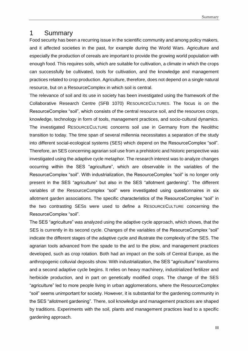
4.1 ResourceComplex “soil” The relevance of soil and its use in society has been investigated in the present thesis, applying
the framework of the Collaborative Research Centre (SFB 1070) RESOURCECULTURES. The
SFB 1070 focuses on the socio-cultural dynamics of resource use, where resources are not
separated into “tangible” and “intangible” or “natural” and “cultural” (Bartelheim et al., 2015).
Instead, the term ResourceComplex is applied, which comprises a combination of objects,
individuals, knowledge and practices (Bartelheim et al., 2015; Hardenberg et al., 2017).
ResourceComplexes develop around resources being determined as valuable by a society,
and which allow the identification of specific RESOURCECULTURES (Bartelheim et al., 2015).
This thesis focuses on the ResourceComplex “soil”, which consists of the central resource soil
in combination with the resources plants (crops) to use the soils biomass production function.
It further requires knowledge and technology to determine management practices and is
influenced by socio-cultural dynamics (Figure 4.1). The concept of ResourceComplexes is
applied methodically to investigate which variables are important and to understand
connections between soil and society. The central resource or variable in the present thesis is
soil, but the other resources constituting the ResourceComplex need to be considered to
analyze developments in soil use. All variables of the ResourceComplex interact and influence
one another, and should be investigated simultaneously. The concept of ResourceComplexes,
thus, is the foundation and structure presented in this thesis.
Figure 4.1: The ResourceComplex “soil”
4.2 Social-ecological systems ResourceComplexes are part of social-ecological systems (SES), which were introduced by
Berkes and Folke (1998b). They integrated social and ecological systems during a time, when
both were commonly investigated separately, treating the respective other system as a black

Introduction
12
box and ignoring the interdependence of both systems. The SES approach includes humans
in the analysis of ecosystems to understand the relationships between the two systems. It
focuses on an adaptive management of the ecosystem, including feedbacks provided by the
managing social systems (Berkes and Folke, 1998a, 1998b; Ostrom, 2009). It is one of several
approaches to describe systems of humans and nature (Manfredo et al., 2014). Henderson et
al. (2016), for example, work with coupled human-environment dynamics in their analysis of
the feedbacks in the system forest-grassland-agriculture.
When using the SES-approach, a general terminology is needed for scientists across
disciplines. Ostrom (2009), thus, provides a more specific framework for the SES-approach,
which consists of the users, the governance system, the resource system and the resource
unit. A resource system can refer to a protected park with a specific area, while a resource unit
is defined as the objects within the resource system, which would be trees, shrubs and lakes
in the park (Ostrom, 2009). The concept of Ostrom (2009) structures the discussion concerning
SESs and is helpful for contemporary analyses where the governance system and users can
be investigated among others through sociological and ethnological methods. However, for
prehistoric and historic times, neither the governance system nor the motivations of the
resource user can be thoroughly assessed, due to limited written sources (Teuber et al., 2015;
Teuber et al., 2017). The political systems from the Neolithic to the Romans are insufficiently
known, and even for Medieval Times the sources concerning governance are scarce. Further,
the resource unit as a concept consolidates the separation of natural and social resources. As
Ostrom (2009) divides natural and cultural or social variables, the user remains someone
outside of the resource units. The SFB 1070 dismisses the distinction between “natural” and
“cultural” resources by introducing the ResourceComplex as a concept. In the present study,
the variables of the ResourceComplex “soil” structure the investigation of the SES “agriculture”.
As knowledge, management practices and socio-cultural dynamics are intrinsic to humans, the
resource user is included in the ResourceComplex. However, Ostrom’s resource user is not
only part of the ResourceComplex “soil”, but also of several other ResourceComplexes with
many different levels and scales. Ostrom’s user, thus, influences the ResourceComplex under
investigation from the inside, through knowledge and management practices, but also as an
external factor, through participation in other ResourceComplexes, e.g. the ResourceComplex
“network”. The interaction of different ResourceComplexes leads to a complex SES (fig. 4.2),
where social and natural variables are closely connected. The present study, thus,
acknowledges the general concept of Ostrom (2009), for structuring the discussion concerning
SESs. However, ResourceComplexes structure the research concerning SESs, to emphasize
the close connection between natural and cultural resources.
The application of the ResourceComplex-concept to the SES-approach is also a reaction to
the critique of Fabinyi et al. (2014), who state, that the “social” is not adequately defined and

Introduction
13
biased. Their analysis is that focussing on a functionalist approach, e.g environmental aspects
as main reason for conservation efforts, neglects other cultural and socio-political reasons for
the emergence of management institutions (Fabinyi et al., 2014). Further, research on SESs
often focuses on institutions when investigating the social aspects and not on human agency
(Fabinyi et al., 2014). The ResourceComplex concept aims at connecting social and natural
resources. The ResourceComplex “soil” includes the soil user in the discussion by focussing
on management practices and knowledge of the user concerning the resource. It further
acknowledges socio-cultural dynamics, so that institutions are also present in the theoretical
construction.
4.3 RESOURCECULTURE “soil use” RESOURCECULTURES develop around a specific ResourceComplex. In this context, the term
culture encompasses contested systems of meaning which are learned and shared as well as
negotiated and expressed for example by common language or actions (Hardenberg et al.,
2017). The investigated RESOURCECULTURE concerning the ResourceComplex “soil”
developed in Germany from the Neolithic transition to today. This includes a time span of
several millennia and encompasses several different SESs, which are all connected to the
ResourceComplex “soil” (Figure 4.2). Therefore, an SES concerning agrarian soil use from a
prehistoric and historic perspective was investigated, namely the SES “agriculture”. Further,
an SES focusing on contemporary soil use in leisure gardens, the SES “allotment gardening”
was studied.
Figure 4.2: The RESOURCECULTURE concerning soil use is shaped by several SES. Each SES consist of several ResourceComplexes, which influence each other.

Introduction
14
The investigation of the two SESs connected to the ResourceComplex “soil” aims at identifying
a RESOURCECULTURE concerning soil use in Germany. The RESOURCECULTURE is also
connected to other SESs, such as the SES “commercial horticulture”, the SES “agrarian
technology”, the SES “soil use for infrastructure building”, the SES “environmental protection”,
etc. However, the present thesis focuses on the investigations of two SESs, where soil use is
connected to the biomass production function of soils. The characteristics of the SES “agrarian
technology” are also evaluated in part through the literature review for the SES “agriculture”.
4.4 The ResourceComplex “soil” within the SES “agriculture” The first part of the thesis focuses on agrarian soil use from the Neolithic to Modern Times.
This (pre-) historic approach was chosen to understand the temporal aspects of the human-
soil-interaction, because present conditions cannot be evaluated without knowledge of the past
(Costanza et al., 2007). Several studies of prehistoric and historic agricultural practices exist
focusing on specific (pre-) historic time frames (Knopf et al., 2012; Knopf, 2017; Lüning, 2000;
Seidl, 2006) or technological advancements (Andersen et al., 2016; Lal et al., 2007). The
present study investigates soil use in form of agriculture through an extensive literature review.
It analyses the development of soil use from Neolithic times onwards to study changes of the
SES agrarian soil use (Teuber et al., 2017), in the following refered to as SES “agriculture”.
The SES “agriculture” is not static but developed through time. This development is
investigated by using the adaptive cycle metaphor (Holling and Gunderson, 2002) and the
concept of panarchy (Gunderson, 2008; Gunderson and Holling, 2002; Holling et al., 2002b).
Originally developed for ecosystem dynamics, the adaptive cycle metaphor shows that
systems undergo four development phases: the r-phase of exploitation, the K-phase of
conservation, the Ω-phase of release or creative destruction, and the α-phase of reorganization
(Holling et al., 2002a; Holling and Gunderson, 2002). Three properties shape the cycle: the
potential of a system for change, the degree of connectedness between internal variables and
processes, and the adaptive capacity of a system (Holling, 2001). The adaptive capacity refers
to the system’s resilience to unexpected shocks. Resilience is defined as the ability of a system
to maintain its functions and remain in the stability domain it is in, despite a disturbance or
shock (Holling and Gunderson, 2002).
Holling and Gunderson (2002) state that the process of reorganization starts with the α-phase.
Potential and resilience are high. Connectedness is low. In the r-phase resilience is high, while
connectedness is low. During the K-phase connectedness increases. Simultaneously
resilience decreases. The system becomes vulnerable to disturbance. This vulnerability can
cause creative destruction in the Ω-phase, if a disturbance occurs. The system then rapidly
shifts from Ω to α. A new cycle begins with loose connections, high resilience and an increasing
potential. In this phase different recombination become possible making the outcome of the
reorganization unpredictable (Holling and Gunderson, 2002). The SES “agriculture” is

Introduction
15
undergoing these cycles. However, the adaptive cycle framework consists of different spatial
and temporal scales, so that many adaptive cycles happen on smaller scales of the SES. In
the time from the Neolithic to today local and regional developments affected the big adaptive
cycle of agrarian soil use, e.g. during the Linear Pottery Culture (Gronenborn et al., 2014;
Gronenborn et al., 2017). Another example for the application of the adaptive cycles on a
smaller scale is the Irish potato famine, which resulted in the replacement or death of many
due to a SES that was vulnerable to change (Fraser, 2003).
An important part of the adaptive cycle metaphor is that systems are not seen as static with
only one stable state to which the system returns after a disturbance (Holling and Gunderson,
2002). Instead, multi stable states exist. If a disturbance is big enough, the entire system
changes and ends up in another stability domain (Holling and Gunderson, 2002). Alternative
stable states occur in natural systems and are influenced by human dynamics (Henderson et
al., 2016). Whether an SES transforms, depends on the temporal and spatial scales on which
changes or adaptations to perturbations or new challenges occur. According to Moore et al.
(2014) SESs transform, if there is a recombination of the existing parts of the system in novel
ways after a perturbation of the system. Adaptiations of one part of the SES are not sufficient
to lead to a transformation (Moore et al., 2014). This is in accordance with Fath et al. (2015),
who state, that many small scale adaptive cycles occur in the social parts of an SES during
the r- and K-phase of a bigger adaptive cycle. This results in a prolonged K-phase of continued
development and influences the interplay between fast and slowly changing variables (Fath et
al., 2015). Further, Holling et al. (2002b) suggest, that three to five variables need to be
analyzed to understand the complexity of a system. The change of one variable is, therefore,
not enough to transform the system. The present work, thus, utilizes the components of the
ResourceComplex “soil” to analyze the SES “agriculture”. It is proposed that changes in one
variable, such as improvement of tools, do not lead to a transformation. Only when all variables
change, the system is reorganized and a new adaptive cycle starts.
Central to the analysis of the adaptive cycle metaphor are technological developments that
altered soil use, written records on agricultural practices, palynological analyses and traces of
soil management practices that are visible in soil archives today. These represent the soil,
plant and tool-aspects of the ResourceComplex “soil” and give insight into the socio-cultural
dynamics, knowledge and management practices. The social aspects need to be viewed
cautiously, due to limited sources prior to industrialization. The few existing sources are
subjected to interpretation by researchers and, thus, ambiguous.
For the reconstruction of the SES “agriculture”, colluvial deposits are of great importance
(Dreibrodt et al., 2010) to understand the central variable soil. While the term ‘colluvial deposit’
in the English language refers to slope materials in general, the German definition differentiates

Introduction
16
between natural and human induced processes (Ad-hoc-Arbeitsgruppe Boden and
Bundesanstalt für Geowissenschaften und Rohstoffe, 2005; Leopold and Völkel, 2007). In
general, the formation of colluvial deposits depends on soil erosion and accumulation
processes (Dreibrodt et al., 2010). The assumption concerning anthropogenic colluvial
deposits is that prior to land use in form of agriculture the soil in Central Europe was covered
by vegetation and, thus, protected from erosion (Leopold and Völkel, 2007). The onset of
agriculture resulted in bare soil, on which erosion occurred. The eroded material is transported
down the slope and accumulates in depressions along the slope and at the base of the hill,
leading to the formation of colluvial deposits (Lang, 2003). During recurring erosion events the
accumulated material is either covered by further deposits or transported further downslope
(Lang and Hönscheidt, 1999), where it accumulates again or is eventually transported to the
receiving water (Fuchs et al., 2010). Thus, the colluvial deposits within a catchment area are
important geoarchives. This thesis focusses on research of colluvial deposits in the context of
soil erosion events that were initiated by agrarian soil use to investigate the soil variable of the
ResourceComplex “soil”.
4.5 The ResourceComplex “soil” in the contemporary SES “allotment
gardening” In urban societies the soils biomass production function (Blum and Eswaran, 2004) is used
frequently in miscellaneous forms of urban gardening, such as allotment gardens, community
gardens or intercultural gardens (Barthel et al., 2013; Barthel and Isendahl, 2013; Müller, 2011;
Tornaghi, 2014). Further, urban gardening is becoming increasingly popular in many cities
worldwide (Alaimo et al., 2008; Barthel et al., 2014; Bell et al., 2016). The gardening
community, thus, consists of home gardeners, allotment gardeners but also of people who
garden on rooftops, in community and intercultural gardens. Some garden in pots and raised
beds, where they manufacture the soil they cultivate according to the needs of the plants.
Home- and allotment gardeners, however, work with the soil present on their land. They, thus,
also have knowledge about the soils biomass production function and the soil-plant interaction.
Therefore, the focus of the empirical part of the present study is on allotment gardens in
southwestern Germany.
Allotment gardens developed during industrialization, the Great Depression and the World
Wars to provide workers with plots for food production and recreation (Keshavarz and Bell,
2016; Nilsen, 2014). Initially seen as self-help measures (Nilsen, 2014), allotment garden
associations (= Kleingartenvereine) are still common in many German cities and towns today,
with 934 285 gardeners being member in the allotment garden association “Bundesverband
Deutscher Gartenfreunde e.V.” (Bundesverband Deutscher Gartenfreunde e.V., 2017). This
association has several rules and the federal law concerning allotment gardens (=
“Bundeskleingartengesetz”) applies to all allotment gardeners (Bundesministerium der Justiz

Introduction
17
und für Verbraucherschutz, 1983). The law, a court order concerning the law, and the statute
of the association state, that a third of the gardening area within an allotment must be used for
food production (Bundesgerichtshof, 2004; Bundesministerium der Justiz und für
Verbraucherschutz, 1983). The biomass production function of the soil is, therefore, important
in the allotment gardening community. The gardeners need to cultivate the soil on a regular
basis. Therefore, the ResourceComplex “soil” and its relevance for the SES “allotment
gardening” is investigated. The ResourceComplex “soil” consists of the soil in the garden, the
plants and tools used by the gardeners, the management practices and knowledge of the
gardeners, and the socio-cultural dynamics within the gardening community but also between
the gardening community and society in general (Figure 4.1).
The critique of Fabinyi et al. (2014) - the focus on institutions - is met with the
ResourceComplex concept. In the SES “allotment gardening”, the ResourceComplex “soil”
includes the gardener by focusing on management practices and knowledge. It also takes the
institutions into account by investigating the rules of the allotment garden association and the
laws concerning allotment gardening in Germany. It has to be stressed, that other
ResourceComplexes are present in the SES “allotment gardening”, e.g. the ResourceComplex
“networks” with the variables being the different gardeners, the management board of the
garden, the institutions, and the infrastructure.

Objectives
18
5 Objectives This thesis seeks to investigate the ResourceComplex “soil” and its development through time.
It applies the framework of the SFB 1070 to the research to define a RESOURCECULTURE
concerned with soil use for Germany. A RESOURCECULTURE is a contested system of meaning
(Hardenberg et al., 2017), with commonly learned and shared actions and language. The
RESOURCECULTURE connected to soil use consists of the SES “agriculture” and the SES
“allotment gardening”. These two investigated SESs focus on the biomass production function
of soil. With the time scale being several millennia, the analysis focuses on common features
throughout time, which are the variables soil, plants, tools, knowledge, management practices
and socio-cultural dynamics of the ResourceComplex “soil” (Figure 4.1). The definition of a
RESOURCECULTURE relies on the SES “agriculture” and the SES “allotment gardening” with the
study area being Central Europe, and more specifically Germany. The study focuses on the
objectives:
i) How did the variables of the ResourceComplex “soil” change from the Neolithic
Transition to today?
ii) What are the characteristics of the ResourceComplex “soil” today?
iii) Is it possible to define a RESOURCECULTURE concerning soil?
It is hypothesized, that the ResourceComplex “soil” developed through time and underwent
several changes. The changes to the different variables of the ResourceComplex are
observable in different archives and allow a reconstruction of the development of the
ResourceComplex.
It is further hypothesized, that the ResourceComplex “soil” is important for farmers and other
soil users such as gardeners, who have a profound understanding of the ResourceComplex
itself. In the two investigated SESs the ResourceComplex has specific characteristics.
It is also hypothesized, that a RESOURCECULTURE exists, which is closely related to the
ResourceComplex “soil” and its biomass production function.

Methodology
19
6 Methodology Several methods were used to analyze the ResourceComplex “soil” within the SES
“agriculture” and the SES “allotment gardening”. The study area for both the (pre-) historic
perspective and the present-day empirical study is Central Europe. However, the study area
for the latter is limited to the southwestern part of Germany, to the state of Baden-Wurttemberg.
6.1 SES “agriculture” (Manuscript 1, 2, 4, 5) For the prehistoric and historic perspective a literature review was conducted, focusing on
Central European studies concerned with colluvial deposits, palynology, and archaeological
surveys where agrarian tools and practices were investigated (Teuber et al., 2015; Teuber et
al., 2017). Further, literature on several agricultural writers from Antiquity to today was
investigated. These studies were analyzed using the SES-approach. The analysis focuses on
the SES “agriculture” (Teuber et al., 2017) and on the ResourceComplex “soil” with its variables
soil, plants, knowledge/technology. The development of the SES “agriculture” is evaluated with
the help of the adaptive cycle narrative (Holling et al., 2002a; Holling and Gunderson, 2002).
Archaeopedological studies contribute to the understanding of the central resource soil. The
focus is on anthropogenic colluvial deposits, which are analyzed soil scientifically.
Palynological and archaeobotanical research is used to understand the plant-aspect of the
ResourceComplex “soil”. The crops cultivated in Europe mainly originated in the Near East
and include emmer, einkorn, barley, pea and flax, which arrived in Central Europe during
Neolithization (Bakels, 2014). Several studies were used to investigate the distribution of the
different crop plants in the proximity of anthropogenic colluvial deposits (Dreslerová et al.,
2013; Rösch, 1993, 1998, 2009; Schmidl et al., 2007), to determine changes of the plant-
variable of the ResourceComplex “soil”.
Archaeological studies contribute to the understanding of the technological development in
time, which is helpful for the analysis of the tool-variable of the ResourceComplex “soil”.
Archaeological evidence for agrarian tools is scarce for pre-historic times, but several studies
investigated the technological development (Andersen et al., 2016; Gringmuth-Dallmer, 2003;
Lal et al., 2007; Mueller, 2015; Roggisch, 1989; Schultz-Klinken, 1981). The tools are also
used as a proxy for changing management practices and changing knowledge. While a digging
stick or spade requires a lot of work from the farmer, the development of the ard and later the
plow in combination with the use of animals such as the ox and later the horse for pulling the
ard or plow indicates changing management practices (Teuber et al., 2017). The ard and plow
enabled the farmer to expand the area for crop cultivation. Those tools, further, facilitated
farming on loamy to clayey soils, which are difficult to cultivate by relying only on a spade.
Management practices and knowledge as well as socio-cultural dynamics have been
investigated through interpretation of the few written sources that exist for historic times up to
the Modern Era. With Antiquity, the first written sources on agricultural practices appear in S-
Methodology
20
Europe, which are copied during medieval times and contribute to our understanding of soil
use in the past (Winiwarter, 2006). From the 19th century onwards, scientists, who are
concerned with agriculture (Liebig, 1841; Thaer, 1880) but also with soils (Darwin, 1890;
Evtuhov, 2006), further added to our understanding of soil use in history during the respective
periods. However, since there are few or no written records of small-scale farmers or farm
workers, the writings only give an insight into management practices and knowledge about
soil. They do not portrait actual valuations of the past societies, since only a small percentage
of people living in those societies contributed to the written sources. Further, the writers’
intentions are not clearly known to present-day scientists, so that all texts are subject to
interpretation. With the invention of the letter-press and due to the division of labor during
industrialization, the sources of information increase. The abundant written sources from the
1950s onward enable a clearer interpretation of the variables knowledge, management
practices and socio-cultural dynamics. The number of written sources and the diversity of
opinions in the last decades enable a more complex analysis of the ResourceComplex “soil”
and its role within the SES “agriculture” and the contribution of the different variables to the
adaptive cycle.
The study region is rather large due to the limited sources for pre-historic and historic periods.
Archaeological findings are not evenly distributed in Europe, so that the reconstruction of
agrarian soil use requires findings from several parts of Central Europe. Most studies are from
the area of present-day Germany. However, studies from the Alpine regions in the South to
the Baltic region in the North were also considered to understand the development of the SES
“agriculture”. The western and eastern boundaries are Central France and Central
Poland/Czech Republic.
The literature review was complemented by an archaeopedological study in the Baar region,
which was part of the SFB 1070 project B02. In this project, archaeologists and soil scientists
investigated the soil and culture dynamics of the Baar region from Neolithic times onwards.
Besides recording archaeological sites and finds (Ahlrichs et al., 2016), colluvial deposits were
investigated soil scientifically (Henkner et al., 2017). The colluvial deposits are analyzed to
reconstruct past land use dynamics. Four sites in the Baar region were chosen for the analysis
of colluvial deposits. The soil profiles were described in the field according to the German
classification system KA 5 (Ad-hoc-Arbeitsgruppe Boden and Bundesanstalt für
Geowissenschaften und Rohstoffe, 2005), and soil samples were taken. Analysis of the
samples took place in the Laboratory of Soil Science and Geoecology of the University of
Tübingen, and included the measurement of pH-values, Carbonate content, total C and N
contents, and the grain size distribution (Henkner et al., 2017). The deposition time can be
investigated using optical stimulated luminescence (OSL) dating, and accelerator mass

Methodology
21
spectrometry (AMS) 14C radiocarbon dating. Therefore, samples for OSL were obtain with
opaque steel cylinders, and charcoal fragments were collected in the field for AMS 14C
radiocarbon dating (Henkner et al., 2017). The dated samples provide a stratigraphy that
enables a reconstruction of past land use.
6.2 SES “allotment gardening” (Manuscript 3) The concept of ResourceComplexes was used as a tool while designing the contemporary
empirical study and composing the questionnaire. After visiting several gardens and reading
gardening literature, the crop variable was chosen as a constant. The most common food
plants in the allotment gardening community are potato, onion, carrot, tomato, zucchini,
kohlrabi, eggplant, cauliflower, broccoli, cabbage, salad, strawberry, currant, raspberry,
blackberry, apple, pear, cherry, and different herbs such as basil, parsley, and chive. The
gardening tools are also seen as a constant, with the most common tool being the spade, but
also garden forks, hoes, and motorized garden tillers. The soil knowledge as well as the
management practices were investigated using a questionnaire. The socio-cultural dynamics
were studied using the framework of the allotment gardening association, the federal laws
concerning allotment gardening, the information from the interviews with the gardeners, and
newspaper articles. The central resource soil was investigated using soil scientific analyses
but was also the focus of the questions in the questionnaire and during the interviews.
The study of the SES “allotment gardening” took place in the Baar region and in the state
capital of Baden-Wurttemberg, Stuttgart, with the aim of comparing rural and urban allotment
gardeners (= Kleingärtner) with each other. Both study areas belong to Baden-Wurttemberg
and have a similar natural environment (Teuber et al.). Further, school systems as well as
social factors are similar in both regions, so that a comparison between them is possible. The
rural region chosen for the interviews was the Black Forest-Baar-Heuberg region with its center
Villingen-Schwenningen (VS, Figure 5.1). This region was chosen due to the close cooperation
with the SFB 1070 project B02 that also had a study area there. The closest urban area to the
original study area is Stuttgart (S, Figure 5.2). This was chosen as the second region to
compare allotment gardens from urban and rural contexts (Teuber et al.). In both regions, three
allotment garden associations were investigated.
Field work took place in 2015 and 2016 after an in-depth literature research concerning the
history of allotment gardens, allotment garden associations, urban gardening, community
gardening, and garden management practices, as well as questionnaire design and
methodology. This resulted in the development of a questionnaire that consisted of open
questions, which were evaluated qualitatively, closed questions that were evaluated
quantitatively, and semi-open questions, which were evaluated using quantitative and

Methodology
22
qualitative instruments (Teuber et al.). The questionnaire investigated several topics: the
gardeners’ knowledge about soils, the gardeners’ motivation for gardening, the garden
management practices of the respective gardener, the criteria used by gardeners to determine
the soil quality in their plots, and the management practices concerning soil quality. The answer
categories were chosen according to the results of previous studies (Adderley et al., 2004;
Barrera-Bassols et al., 2009; Fry, 2000; Wahlhütter, 2011). Reasons for gardening were
investigated by others as well, but most of the studies were published after or during the first
survey year, so that they could not be considered during questionnaire design (Calvet-Mir et
al., 2016; Scheromm, 2015). Only Clayton (2007) and Kim et al. (2014) provided input on
possible motivations for gardening or gardeners knowledge of soils. Besides these topics, the
usual questions concerning age, gender, educational background, etc. were asked. The
questionnaire was interviewer administered. The interviews took place in the respective
association, more precisely in the individual gardens. Within each association, the aim was to
interview gardeners from each plot. However, not everyone was willing to participate, and in
several garden plots, the gardeners were absent. Repeated visits on different days and times
did not result in meeting these gardeners. Thus, approximately 30 % of the gardeners of each
association were interviewed. This is in accordance with the questionnaire literature, which
states that response rates are often below 50% (Baruch and Holtom, 2008; Porst, 2001), e.g.
the study of Goddard et al. (2013) had a response rate of 24%. The results of the interviewer-
administered questionnaires were analyzed using the statistical programming language R (R
Core Team, 2016). Several tests were used, according to the respective measurement of scale
(Teuber et al.). The chosen significance level is α = 0.05 for all tests. The null hypothesis H0
is µ1 = µ2, in other words µ1 - µ2 = 0 (Bortz and Schuster, 2010). Thus, the alternative
hypothesis H1 is µ1 ≠ µ2 or µ1 - µ2 ≠ 0. If p < α, the H0 is rejected and H1 accepted. The two
sample t-test (R Core Team, 2016) is used for ratio scale data. Since the variance has to be
equal to use the test, a Fisher F test (R Core Team, 2016) is performed prior to the t-test. If
the variance is not equal, Welch’s t-test (R Core Team, 2016) is used. The nonparametric
independent 2-group Mann Whitney U test (R Core Team, 2016) is used for ordinal scale data
and ratio scale data for which a normal distribution cannot be assumed. Fisher’s exact test is
used for categorical data. The open and semi-open questions are evaluated qualitatively by
analyzing the field notes and pictures taken (Teuber et al.).

Methodology
23
Figure 6.1: The surveyed allotment garden areas in rural VS.
Figure 6.2: The surveyed allotment garden areas in urban S
In each allotment garden association, three soil samples were taken from unused green
spaces, at depths of 0-10 cm and 10-20 cm, which were analyzed in the Laboratory of Soil
Science and Geoecology of the University Tubingen. Analyses included pH-values, C/N-ratio
and grain size distribution (Teuber et al.). The decision to sample from unused green spaces
was made after observations and interviews had shown diverse management practices.
Therefore, the unused soil was sampled to get the conditions of the soil prior to soil
management practices, which include different fertilizing practices. According to the

Methodology
24
management board of each association, the official activity on the green spaces had been lawn
mowing. However, the possibility exists, that gardeners distributed excess fertilizer or other
soil amendments on the green space.

Results
25
7 Results
7.1 The changing variables of the ResourceComplex “soil” in the SES
“agriculture” (Manuscript 1, 2, 4, 5) The adaptive cycle of the SES “agriculture” started with the Neolithic transition and went
through one adaptive cycle from the Neolithic Transition to the Industrial Revolution (Teuber
et al., 2017). The Neolithic Transition enabled people to settle down, using soil, new crops and
new tools, thus, the ResourceComplex “soil”, to produce higher food quantities (Childe, 1936;
Holling et al., 2002b). The SES “agriculture” underwent several minor changes from the
Neolithic to the Industrial Revolution. Innovations such as metallurgy improved agrarian tools,
which are one variable of the ResourceComplex “soil”. However, the changes were
adaptations to one part of the ResourceComplex, which influenced the SES, but did not flip it
into another stable state (Teuber et al., 2017). A second adaptive cycle started with the
Industrial Revolution (Teuber et al., 2017). Industrialization affected the SES “agriculture” and
the ResourceComplex “soil”. It led to a new adaptive cycle, with a reorganization of the
variables of the ResourceComplex “soil”, and a transformation of the SES into another stability
domain. This includes a clear division of labor and the industrialization of agricultural practices.
With the Neolithic Transition, the soil variable of the SES “agriculture” became important for
the first farmers. The soil management practices, however, had an adverse effect on the soil,
because it led to erosion on many agricultural fields throughout the first adaptive cycle. The
resulting anthropogenic colluvial deposits are used to reconstruct the development of the SES
“agriculture” (Teuber et al., 2015; Teuber et al., 2017). While anthropogenic colluvial deposits
dating to the early periods of agrarian soil use are infrequently found (Dotterweich, 2008), other
archives indicate agrarian soil use and subsequent erosion in Central Europe for that time
(Dreibrodt et al., 2010). Further, the archaeopedological study in the Baar region found traces
of agrarian soil use dating to the Neolithic (Henkner et al., 2017). The summed probability
curve of the Baar region’s colluvial deposits indicate increased erosion during the Bronze and
Iron Age, as well as in Modern Times (Henkner et al., 2017). This is in accordance with the
findings of Dreibrodt et al. (2010), who state, that a first maximum of slope deposits in Central
Europe occurred at the beginning of the Bronze Age, and a second one during Iron Age.
However, they found a maximum during medieval times (Dreibrodt et al., 2010), which is
present but not as pronounced in the Baar region (Henkner et al., 2017). Erosion and, thus,
colluviation increased during Medieval Times (Zolitschka et al., 2003). Examples for colluvial
deposits from SW-Germany include the Kraichgau where anthropogenic colluvial deposits date
to 980–1330 CE (Kadereit et al., 2010), the Krumpenschloß in the Black Forest with
anthropogenic colluvium developing between the ninth and 15th century CE (Knopf et al.,
2012), and the case study of B02 (Ahlrichs et al., 2016; Henkner et al., 2017). The soil variable,
thus, became increasingly prone to erosion.

Results
26
The first written sources on agricultural practices in Europe date to Antiquity. They deal with
the different variables of the ResourceComplex “soil”, e.g. Hesiod („Érga kaì hemérai“), Cato
(„De agri cultura“), Varro („Res rusticae“) and Columella („De re rustica“) (quoted from
Winiwarter (2006)). The agrarian texts from European Antiquity show that the
ResouceComplex “soil” and the variable soil were of interest for the scholars. The texts of the
Roman agricultural writers were still copied in Medieval Times. Furthermore, Walafrid Strabo
and Isidore of Seville contributed to the agrarian or horticultural literature (Winiwarter, 2006).
While scholars wanted to improve or conserve the knowledge of agricultural practices,
traditional soil cultivation practices were common (Dotterweich, 2013). During Medieval Times
fertilization was part of agriculture (Behre, 2000). In Northern Europe, plaggen-manuring was
practiced, and ridge and furrow was prevalent (Behre, 1976; Blume and Leinweber, 2004;
Haasis-Berner, 2012; van Mourik et al., 2012). Furthermore, the three field system with fallow
became common (Rösch et al., 1992). The soil fertility was, thus, important for the farmers and
they tried to improve it through different measures.
The scientific analysis of soils increased during the 19th century, with the books of Albrecht
Daniel Thaer, Justus von Liebig, Charles Darwin and Vasilii V. Dokuchaev (Darwin, 1890;
Liebig, 1841; Thaer, 1880). Focus of Thaer’s work was agriculture and the relevance of crop
rotation and humus (Feller et al., 2003b). Liebig worked on the development of a mineral
fertilizer (Montgomery, 2010). Darwin investigated the importance of earthworms (Brevik and
Hartemink, 2010; Brown et al., 2003; Feller et al., 2003a; Feller et al., 2006). Dokuchaev
introduced the soil profile with its A-, B-, and C-horizons (Brevik and Hartemink, 2010; Evtuhov,
2006). The ResourceComplex “soil” had become a research topic (Teuber et al., 2017).
The crop variable is visible through research in archaeobotany, palynology and anthracology
(Marquer et al., 2014; Nelle et al., 2010; Rösch, 1987). With Linear Pottery and Funnel Beaker
Culture, six of the crops domesticated in the Near East arrived in Europe, where poppy was
added as another crop plant (Bakels, 2014). Domesticated animals were also held in Central
Europe (Doppler et al., 2015). Both, the plants cultivated and the animals used for food
production relied on a small number of species (Bellwood and Oxenham, 2008). Different
studies show, that crops are used in different proportions through time, but that the main crops
are emmer, einkorn, wheat and barley (Bogaard et al., 2013; Dreßler et al., 2006; Rösch, 1993,
1998; Wieckowska et al., 2012). Only rye cultivation seems to occur later, during Medieval
Times (Behre, 1992).
During the first adaptive cycle, the tools variable developed from the spade to the ard to the
plow (Teuber et al., 2017). An excavation of an LBK well in Erkelenz-Kückhoven, near
Cologne, revealed a spade dating to 5057 BCE (Mueller, 2015). New methods and tools
developed during Bronze age, as plow marks in the soil, excavated ards at the Lago di Ledro,

Results
27
Northern Italy and in Walle, East Frisia, as well as rock carvings in Val Camonica, Northern
Italy, and Boshuslän, Sweden, show (Behre, 1998; Egg and Pare, 1995; Fries, 1995; Schultz-
Klinken, 1981; Tegtmeier, 1993; Zich, 1999). Further, cattle traction was established for pulling
the ard or carts (Bartosiewicz 2013, Eggert and Samida 2013), e.g. facilitating soil cultivation.
Agricultural technology developed during Roman times, e.g. the use of iron in spades (Mueller,
2015) or the “Roman plow” with iron shares (Lal et al., 2007).
The changes of the variables soil, crops, and tools, show, that the first adaptive cycle had a
prolonged K-phase, due to innovations happening within or to other ResourceComplexes.
Through the development of the ResourceComplex “metallurgy”, which consists of the
variables ore deposits, smelting furnaces, knowledge, tools, and processing procedure, new
tools for soil cultivation were created. These enabled the farmers to cultivate more area in a
shorter time, e.g. during the Roman Iron age with iron plow shares. However, while plowing
was facilitated, the management practice of plowing depended on man and animal power.
Animals, further, were not only needed for traction but also as a source for fertilizer. Fertilizing
is an integral part of agrarian practices in the Medieval Time period, as discussed by Behre
(2000). While fertilizing might have occurred earlier, as proposed by Bakels (1997), we find
traces of fertilizing practices that date back to Medieval Times. The plaggen soils indicate that
soil fertility was important. The farmers invested time and energy in these practices to achieve
higher yields. This changes the knowledge and management variables, which in turn affects
the soil. However, only when changes in all variables are observable, does the SES change
its stability domain and a second adaptive cycle starts.
Figure 7.1: The adaptive cycle of the SES „agriculture“ starting with Neolithization (Teuber et al., 2017).

Results
28
The SES “agriculture” and the ResourceComplex “soil” changed considerably with
industrialization (Teuber et al., 2015; Teuber et al., 2017). It moved through the Ω-phase of
creative destruction and the α-phase of reorganization (Teuber et al., 2017). The variable
knowledge and technology changed. New technological advances resulted in modern
machines for soil cultivation (Hahn, 2011; Lal et al., 2007; Seidl, 2006) or for the industrialized
production of fertilizer (Montgomery, 2010; Niedertscheider et al., 2014). Both enabled a
separation of crop production and livestock farming (Lambin et al., 2001). The widespread use
of fertilizer, pesticides, herbicides and fungicides increases the yields (Foley et al., 2005; Ponti
et al., 2012), but also affects biodiversity (Benton et al., 2003; Henle et al., 2008) and leads to
eutrophication of water bodies (Larsson and Granstedt, 2010; Monteagudo et al., 2012). The
innovations also led to considerable changes of and within society. In Germany, fewer people
work in the agrarian sector, because the industry and service sector employ most people
(Statistisches Bundesamt, 2015b). While in 1950, 24.6% of the German population worked in
agriculture (Statistisches Bundesamt, 2017), in 2014 only 1.5% of the workforce belonged to
the agrarian sector (Statistisches Bundesamt, 2015b). These farmers retain agrarian soil
knowledge, preserve traditional agrarian soil management practices and combine or substitute
them with modern knowledge and practices. Further, through globalization, agricultural
production is externalized to other countries, such as the soy bean production for livestock
feed in S-America (Gollnow and Lakes, 2014; Morton et al., 2006). The remaining farms in
Germany are managed by fewer people using industrialized methods for livestock and soil
cultivation (Lal et al., 2007; Statistisches Bundesamt, 2015a; Vigne et al., 2012). The
knowledge of soil use, which was present within society for most of human history, thus, is
retained by few, especially by farmers practicing organic farming and by other people who are
in direct and regular contact with the soil, such as gardeners.
The variable soil is still prone to erosion (Dotterweich, 2013; Verheijen et al., 2009) but also to
other forms of degradation such as compaction (Hamza and Anderson, 2005; O'Sullivan and
Simota, 1995), sealing (Artmann, 2016; Scalenghe and Marsan, 2009), nutrient depletion
(Loveland and Webb, 2003), and contamination with e.g. heavy metals (Ottesen et al., 2013;
Reimann et al., 2012).
The variable crops changed with the introduction of genetically modified organisms (Burachik,
2010; König et al., 2004; Rótolo et al., 2015). Furthermore, society depends on fewer crop
plants (Cassman et al., 2003; Godfray et al., 2010; Kearney, 2010).
Currently, the SES “agriculture” is in its second K-phase (Teuber et al., 2017): Most of
agricultural practices in industrialized countries but also in the developing world relies on heavy
machinery, mineral fertilizers and the common crop plants. Soil degradation is omnipresent,
not only in form of soil erosion but also through compaction, nutrient depletion, contamination,
and sealing.

Results
29
7.2 Characteristics of the ResourceComplex “soil” in the contemporary SES
“allotment gardening” (Manuscript 3) The investigation of the SES “allotment gardening” also relied on the ResourceComplex “soil”.
The variables socio-cultural dynamics, management practices and knowledge were
investigated, at least in part, through a literature review. The literature review concerning
allotment gardening included the federal law concerning allotment gardens
(Bundeskleingartengesetz) as well as the written records of the allotment garden associations
(Bundesverband Deutscher Gartenfreunde e.V., Landesverband der Gartenfreunde Baden-
Württemberg e.V.), and information gained through interviews with the spokesperson of each
of the 6 surveyed associations. The German federal law states specifically, that one of the
main functions of the allotment gardens is food production with recreation as an additional
function (Bundesministerium der Justiz und für Verbraucherschutz, 1983). Further, an
allotment garden has to be within an area with other gardens in order to qualify as an allotment
garden (= Kleingarten). The individual allotment is ≤400 m², the cabin has at most 24 m² and
is not suited for permanent residence (Bundesministerium der Justiz und für
Verbraucherschutz, 1983). The Bundesgerichtshof further specified the definition of the use of
allotment (= kleingärtnerische Nutzung) and stated that a third of the area has to be dedicated
to food production (Bundesgerichtshof, 2004). The Bundesverband Deutscher Gartenfreunde
e. V. discussed this topic in one of their publications with focus on the legal aspects
(Bundesverband Deutscher Gartenfreunde e.V., 2004). In all six surveyed associations, the
spokespersons and the other members of the boards explained the requirement to use a third
of the garden area for food production. However, there are differences in the enforcement of
this rule. In several of the surveyed associations, the board visits the separate gardens
repeatedly during the year, to ensure that the area for food production is big enough. There,
the different areas are exactly measured. During one of the visits to a garden area, an
observation was made, where the board counted not only the concrete slabs of the walkway
but also the cabbage heads to ensure the right relation between food related plants and build-
up area. In other associations, the board was less strict. There, the visits to the respective
allotments happen once a year. If a gardener refuses to abide to the rules, the board will issue
a warning. However, there seemed to be no hard consequences to the warning. As an
example, in one of the visited gardens, the plots were not cultivated. The bare soil was only
vegetated by an occasional weed. The plot remained in this condition throughout the garden
year. The differences between the associations can be explained by looking at the options the
board has in dealing with a non-cooperative gardener. The only possibility to enforce the rules
is to terminate the contract with an individual gardener. If there is a waiting list for the
allotments, this might be done, because a new gardener will be able to take over. However, in
some areas, the board has no one on the waiting list for a garden. Terminating a contract in

Results
30
that case is unlikely, because this would mean a deficit in the accounting department of the
association.
The Gartenfreunde agree to garden environmentally friendly, as internet sources suggest and
the individual board members state. A sustainable use of soil, water, air, animals and plants is
emphasized in S (Bezirksverband der Gartenfreunde Stuttgart e.V., 2016). Chemical fertilizers
are not allowed. Instead, compost and green manure should be used. Peat should be avoided
to protect the environment (Bezirksverband der Gartenfreunde Stuttgart e.V., 2016). The board
members of the different associations visited during the study also stressed, that fertilizing
should be done environmentally friendly. NPK-fertilizers should not be used. Instead, a diverse
set of management practices is suggested to the gardeners. However, one of the board
members stated, that this cannot be checked because individual gardeners find very clever
ways to hide the fact that they use NPK-fertilizer. Other board members also hinted that the
gardeners might bypass this rule. Still, the board members in general see it as their
responsibility, to promote environmentally friendly gardening. While the priorities are different,
e.g. compost production or bee friendly gardens, the notion is present that the allotment garden
association is acting sustainably. This is present in everyday life through courses on raised
bed gardening and tree pruning. Further, manuals concerning compost production exist.
The empirical part of this thesis investigated allotment gardeners’ motivations, management
practices and soil knowledge in SW-Germany, and, thus, the variables management practices
and knowledge, as well as the socio-cultural dynamics, at least in part. A total of 167
respondents participated, of which 71 were female and 96 were male. Most of the respondents
in urban S and rural VS are retired or do not work (Teuber et al.). At least half of the
respondents in both regions finished a secondary school (Teuber et al.). The motivations for
gardening vary between the two regions (Teuber et al.), with parents or grandparents owning
a garden and the provisioning with own fruit and vegetables as well as relaxation as main
motivations to choose allotment gardening as a leisure activity (Table 7.1).
Tab. 7.1: Motivations for allotment gardening
% S % VS
Family tradition (p = 0.002) 54,6 78,6
Own fruit/vegetables (p = 0.01) 45,4 67,1
Relaxation (p < 0.001) 30,9 71,4
Friends (p = 0.001) 6,2 24,3
Creativity (p= 0.01) 4,1 17,1
Media (p = 0.16) 1,0 5,7
School (p = 0.17) 0,0 2,9
Other 89,7 74,3

Results
31
89.7 % in S and 74.3 % in VS gave other motivations, such as getting out and enjoying nature,
a personal history with garden or agriculture, the garden as a place for children or
grandchildren, gardening as an activity for retirement or unemployment, and gardening to have
a sense of community (Teuber et al.). Family tradition and own fruit and vegetables are more
important in rural VS. However, in both regions many respondents stated that they had
recreational reasons for choosing gardening as a leisure time activity (Teuber et al.).
The garden management practices were also similar, except for digging and pest control,
which are of varying importance in the two regions (Teuber et al.). Digging is a yearly activity
for 79.4 % in S and 82.9 % in VS. However, 15.5 % in S and 5.7 % in VS do not dig. Thus,
most gardeners dig on a yearly basis. However, the no-digging approach, originating from no-
tillage in agriculture, is more common in S. In both regions, some of the gardeners who apply
the no-dig approach use raised beds instead, while others still work on a regular plot but
stopped digging and use green manure or a gardening fork to loosen up the soil. Pest control
is a yearly activity for 21.6 % in S and 2.9 % in VS, while 12.4 % in S and 57.1 % in VS do
some pest control on a weekly basis. Pest control is more important in rural VS than in urban
S (Teuber et al.). It includes several actions against snails or aphids: collecting snails off the
plot, protecting plants through straw or sand usage or applying slug pellets, among others.
Soil knowledge and soil quality assessment were also part of the questionnaire. 57.7 % in S
and 70 % in VS state that “I know different soils” applies to them. “I know the term soil erosion”
applies to 68 % in S and 50 % in VS. There is a statistical difference between the two regions
for the last statement (Teuber et al.). The statement “I’m able to assess whether the soil is
good for the plants I want to grow” applies to 54.6 % in S and 45.7 % in VS. 78.4 % in S and
78.6 % in VS gave different soil properties for soil quality assessment rather than using the
categories given in the questionnaire, which included soil color (17.5 % in S, 21.4 % in VS),
vegetation present (32 % in S, 14.3 % in VS), and workability (23.7 % in S, 37.1 % in VS)
(Teuber et al.). 59.2 % in S and 58.2 % in VS use soil texture for their soil quality assessment.
30.3 % in S and 25.5 % in VS figure out which plants grow through a trial and error approach.
In both regions, 20 % stated that the soil management resulted in a good soil. Only 6.58 % in
S and 7.27 % in VS assess the soil quality through scientific soil sampling (Teuber et al.).
The gardeners have several conservation measures to ensure a good soil quality or to improve
the soils further. In VS, soil conservation measures were discussed in the qualitative last
question, where 52.9 % of the gardeners wanted to talk about soil management more
thoroughly as the original questionnaire intended. The results show, that 19 gardeners
mentioned compost, 10 green manure, 9 manure from horses, cows or pigeons, 5 gardeners
stressed the importance of loosening up the soil with a garden fork. In the urban area, all 97

Results
32
gardeners were asked specifically about their soil conservation measures: 79.4 % use
compost, 29.9 % loosen up the soil regularly, 16.5 % apply manure from a farmer, 5.2 % use
green manure. Other measures of the urban gardeners to conserve soil quality include the use
of horn meal or shavings (26.8 %), sand (20.6%), chemical fertilizer (19.6 %, at least from time
to time), potting soil (16.5 %), organic fertilizer (11.3 %), Brennesseljauche (8.2 %), dig to
ensure the soil quality (7.2 %), stone meal (6.2 %), crop rotation (6.2 %), chalk (5.2 %), egg
shells (4.1 %), and coffee grounds (3.1 %). Several measures were only stated by one or two
respondents. Two people stated that they mulch, build terraces, or distribute guano or ash,
respectively. Single mentioned were the measures Bokashi, banana peel, malt pellet, raised
bed, and peat.
The empirical study in SW-German allotment gardens showed that the ResourceComplex
“soil” with its central resource soil is of great importance to the gardeners (Teuber et al.). The
qualitative interviews that often took place after the interviewer-administered questionnaire
shows the affinity of the gardeners toward soils and will be interpreted in the discussion part
of this thesis.
The soil analyses in the laboratory of the University Tubingen show that the gardeners work
with loamy to clayey soils (according to KA 5: Tu2, Ls2, Lu, Tu3, Lt3, Lt2). The pH-values vary
between 5.3 and 7.2 and the C/N ratios vary between 9.3 and 12.7 (Teuber et al.). The
analyses indicate soils, which are suitable for horticulture.

Discussion
33
8 Discussion The SFB 1070’s definition of resources states that resources exist in combination with other
resources, constituting a ResourceComplex (Bartelheim et al., 2015). This ResourceComplex
consists of objects, persons, knowledge and practices (Hardenberg et al., 2017). The
ResourceComplexes abolish the distinction between natural and social resources in the
present thesis, but include the notion of Ostrom (2009), who states, that users, governance
systems and resource units need to be considered. All these aspects are present in the
ResourceComplex “soil”. The combination of the different variables was necessary, because
soil as a resource can only be used, if crops are known to the people using the soil, and tools
are created to cultivate the soil. The work with soil, plants, and tools requires knowledge and
management practices, which both depend on each other and are influenced by socio-cultural
dynamics. One could argue that socio-cultural dynamics belong to the social part of a SES.
While this is true, the context here is, that the socio-cultural dynamics are an integral part of
the practices and, thus, have to be considered for the ResourceComplex as such. But not only
the socio-cultural dynamics, also the knowledge and management practices belong to the
ResourceComplex “soil”. All these variables are needed for food production, even though they
develop in close relation to the individual users and the governance system of the respective
society, as is also indicated by Ostrom (2009).
The thesis investigated the ResourceComplex “soil” through time and its influence on the SES
“agriculture” and the SES “allotment gardening”. The ResourceComplex consists of the central
resource soil in combination with crops, tools, knowledge, management practices and socio-
cultural dynamics. The ResourceComplex “soil” is essential for food production. The concept
of the ResourceComplex was used as a tool to analyze the SES “agriculture” and the SES
“allotment gardening”. Both SESs are comprised of several ResourceComplexes and both are
part of a RESOURCECULTURE concerning soil. Through the investigation of the two SESs,
differences and similarities between them were found. These define a RESOURCECULTURE
connected to soil use.
8.1 The ResourceComplex “soil” and the SES “agriculture” (Manuscript 1, 2, 4,
5) The concept of SES as well as the adaptive cycle metaphor were applied to the investigation
of the development of agrarian soil use in Central Europe (Teuber et al., 2017). The SES
“agriculture” depends on the ResourceComplex “soil”, which consist of the natural resources
soil and plants, but also includes humans through the knowledge and management practices,
that are required to use the natural resources. It is, thus, not possible to distinguish between a
social system and a natural system, because both are connected and interdependent.
Therefore, the SES “agriculture” was the focus of the present thesis.

Discussion
34
The SES “agriculture” developed with the Neolithic Transition, when people settled down and
started to practice agriculture (Teuber et al., 2015; Teuber et al., 2017). The ResourceComplex
“soil” was used to produce higher food quantities for the sedentary societies (Childe, 1936).
The central resource soil became vulnerable to erosion (Lang, 2003; Leopold and Völkel,
2007). Analyzing the resulting colluvial deposits with soil scientific methods and OSL or 14C-
dating (Henkner et al., 2017) and combining the results with archaeological studies (Ahlrichs
et al., 2016) leads to a more holistic understanding of the past. However, the dating of colluvial
deposits with both OSL and radiocarbon dating provided mixed results, with the AMS 14C-dates
being older or younger than the OSL-dates (Henkner et al., 2017). Both methods need to be
discussed to understand the problems of dating. The date provided by radiocarbon dating does
not refer to the deposition of the charcoal in the soil profile, but dates the formation time of the
analyzed object (Jull et al., 2013), in the case of colluvial deposits this refers to the growing
period of the trees (Lang and Hönscheidt, 1999). As discussed by Henkner et al. (2017), wood
is often processed before being deposited. Therefore, the charcoal pieces might date to earlier
times than the OSL dating (Henkner et al., 2017), which provides data on the last daylight
exposure of mineral grains (Lang and Nolte, 1999). The charcoal needs to be deposited on top
of the mineral grains, before the charcoal and the mineral grains are covered by soil after an
erosion event. Therefore, the charcoal might be older than the date provided through OSL-
dating. Another reason for older charcoal ages is, that the sediment might be reworked due to
recurring erosion events, leading to the development of a cascade system with temporary sinks
along the hillslope (Fuchs and Lang, 2009; Lang and Hönscheidt, 1999). Younger AMS 14C-
dates in the same level as older OSL-dates can be explained through bioturbation (Henkner
et al., 2017). Further, the calibration of the 14C-dates (Jull et al., 2013) can lead to errors as
well (Henkner et al., 2017). Luminescence dating also has error margins, e.g. insufficient
bleaching of the mineral grains prior to burial, which leads to a remnant signal and an
overestimation of the age of the deposition (Fuchs and Lang, 2009). Thus, the combination of
both methods with archaeological data contributes to a more holistic reconstruction of land use
within a certain area or region.
Another issue concerning the variable “soil” is that few colluvial deposits date to the Neolithic
(Dotterweich, 2008), which might lead to a misinterpretation of the early agrarian soil use.
Reasons for the scarcity of colluvial deposits from the Neolithic are, that the colluvial deposits
might have been eroded again after the initial deposition (Lang and Hönscheidt, 1999;
Zolitschka et al., 2003), or soil formation processes altered the deposits in a way that they are
no longer recognizable as colluvial deposits (Dotterweich, 2008). It is also possible, that
agrarian soil use was not as intensive and widespread as during the later times, e.g. during
Bronze Age. Further, colluvial deposits not always correlate with the archaeological settlement
pattern of a respective site, as the example of the Magdalenenberg in the study of Henkner et

Discussion
35
al. (2017) shows: the burial mound dates to 616 BCE (Knopf et al., 2015b; Knopf and
Seidensticker, 2012), but so far no colluvial deposits date to that time (Henkner et al., 2017).
Therefore, the reconstruction of agrarian soil use needs the cooperation of soil scientists with
archaeologists and archaeobotanists to investigate changes concerning the landscapes. With
more colluvial deposits dating to newer times, such as the Middle Ages (Henkner et al., 2017),
the reconstruction of agrarian soil use through the analysis of colluvial deposits becomes more
comprehensive.
The interdisciplinary work of soil scientists with archaeologists, historians, and
archaeobotanists also give insight into the variable management practices of the
ResourceComplex “soil”. The analysis of celtic fields (Kooistra and Maas, 2008), ridge and
furrow (Linke, 1979; Sittler, 2004; Wenzel, 2013), and plaggen manuring (Behre, 1976; Blume
and Leinweber, 2004; Groenman-van Waateringe, 1992) with different methods shape the
present understanding of the past management practices. However, the motivations of the
farmers cannot be reconstructed, unless there are written sources explaining reasons for the
management practices. Further, scientists are only able to analyze the result of the
management practices, such as the ridge and furrows. These analyses allow an interpretation
of the past methods and practices, but the actual management practice cannot be investigated.
The variable tool was investigated through a review of archaeological studies, which discussed
archaeological finds connected to agrarian soil use. Archaeological finds are distributed over
Europe, and the different settlements give an impression of the settlement patterns of a region.
However, agrarian tools were rarely found in settlements and were also absent in hoard finds,
e.g. in the agriculturally important hoard of Urach (Fries, 1995). Therefore, the study also relied
on rock paintings, the analysis of ridge and furrow remains, as well as on traces of plows in
the soil (Behre, 1998; Egg and Pare, 1995; Fries, 1995; Schultz-Klinken, 1981; Tegtmeier,
1993; Zich, 1999). This shows that interdisciplinary work is also important for the investigation
of tools and their development. With metallurgy, new production methods for agrarian tools
developed. This creates new possibilities for interdisciplinary cooperation, which includes
metallurgical, archaeological and historical sciences.
The tool variable might also be used as a proxy for the knowledge variable, as technological
development requires an increasing knowledge. The practice of tillage is used in most
agricultural systems throughout history and on a global scale (Andersen et al., 2016;
Gebregziabher et al., 2006; Lal et al., 2007; Mitchell et al., 2016; Schultz-Klinken, 1981). This
requires tools suitable for soil cultivation and the knowledge to devise management practices
that will result in a good yield. Further, certain knowledge is similar in all societies, as the
omnipresence of the same crop plants, e.g. wheat and barley (Bakels, 2014; Rösch, 1998,
2009), indicates: people knew about the edibility of those plants and the requirements for their
cultivation. It is argued here, that this knowledge developed within the social system but then

Discussion
36
became an integral part of the ResourceComplex “soil”. However, the knowledge variable
cannot be investigated by itself without reliable written records. Even for Medieval Times, the
written sources only represent the knowledge of the scholarly elite of the time and do not reflect
the knowledge of the farmer. Therefore, the knowledge variable was not investigated by itself
in the analysis of the SES “agriculture”.
The variable crop was investigated by reviewing the archaeobotanical research literature. This
includes studies with palynological analyses, but also anthracology and the analysis of macro
remains. Often, these studies also investigate archaeological sites or include soil scientific
analyses (Dreslerová et al., 2013; Dreßler et al., 2006; Feeser and Furholt, 2014). Thus, the
studies are interdisciplinary and contribute to a better understanding of the past development
within a specific region.
The SES “agriculture” underwent two adaptive cycles so far. The first adaptive cycle started
with the Neolithic Transition and lasted for several millennia. The second cycle started with the
industrialization of agriculture after the Second World War and lasts until today.
The concept of the adaptive cycle is useful for the analysis of SESs through time, as it
acknowledges different variables and their interactions (Gunderson and Holling, 2002). The
different stages of an adaptive cycle show that systems of humans and nature (= SESs) are
complex and develop through time (Holling and Gunderson, 2002). By using the adaptive cycle
for the study of the SES “agriculture” it was possible to focus on the variables of the
ResourceComplex. The interaction between the variables is complex and it is sometimes
difficult to distinguish between the social and the natural. For this reason, the concept of
ResourceComplex was applied, which acknowledges the intricate connections between
humans and nature.
The adaptive cycle concept further recognizes that adaptive cycles occur on different temporal
and spatial scales. These scales influence each other. If reorganization happens at one scale,
conservative structures at a larger scale might provide a form of memory, so that
reorganization happens along the same structures and processes that already shape the
system at that scale (Allen et al., 2014). At the same time, processes of creative destruction
can happen, which affect larger scales (Allen et al., 2014). This is also related to Fath et al.
(2015), who state, that many small-scale adaptive cycles happen during the r- and K- stages
of an adaptive cycle. All these examples indicate, that the adaptive cycle of the SES
“agriculture” is embedded in a bigger cycle, which might store memory on the structure and
processes, which will affect the development of the system after the creative destruction phase.
Further, smaller scale adaptive cycles influence the big adaptive cycle of the SES “agriculture”,
e.g. the adaptive cycle of the SES “metallurgy” affected the development of agrarian tools used
in the SES “agriculture” (Teuber et al., 2017). The fast adaptive cycle of the SES

Discussion
37
“industrialization”, also had an impact on the SES “agriculture”: it led to new technology and
an increasing knowledge, which in the end led to the creative destruction phase of the first
adaptive cycle and the reorganization of the SES “agriculture” in its contemporary form. The
adaptive cycle concept is, therefore, useful for scientific research, because it allows to focus
on a certain SESs development, while it also considers the developments of other SESs, which
can happen on different temporal and spatial scales. In combination with the
ResourceComplex-concept, the SES and the adaptive cycle enables the scientists to structure
their research concerning the investigated SES, while embedding it with other SESs.
8.2 The ResourceComplex “soil” and the SES “allotment gardening”
(Manuscript 3) The concept of ResourceComplexes served as a tool to investigate the contemporary SES
“allotment gardening” in Germany. The two constant variables tools and crops proved to be
chosen right, because no other tools were mentioned during the interviews and questionnaires.
Further, no observations concerning other tools were made during the two summers spend in
allotment gardens. While most surveyed gardeners cultivated common plants, several
gardeners also grew peppers, chili, garlic, sweet corn, rutabaga, peaches, or melons. The crop
variable can still be seen as a constant, as most plants were the ones mentioned earlier, such
as potatoes or tomatoes.
The concept of ResourceComplexes was useful for questionnaire design because it helped to
focus on certain variables. It further enabled the investigation of the ResourceComplex in the
two regions by comparing the same variables. The results indicate, that differences between
the gardeners in the urban and the rural region exist for the gardening motivation and the
management practices (Teuber et al.). The soil knowledge is similar in the rural and urban
allotment garden communities. The results of the soil analyses explain some of the statements
the gardeners made during the interviews.
One aim of the present study was to ask for the motivation of gardeners in Germany to rent an
allotment. The assumption after literature review was that food production is an important
motivation for people to start gardening in an allotment. With food production in mind, the
gardener invests time into soil cultivation, and, thus, has knowledge of the soil-plant interaction
and might also develop management practices different from the modern agricultural practices.
The questionnaire was intended to investigate, if food production is a motivation for gardening,
or if other motivations exist in the allotment gardening community.
The motivations for gardening vary significantly. Family tradition is more important for the
gardeners in VS than for the ones in S. However, 36.8 % in S and 44.2 % in VS stated a
personal history with garden and/or agriculture in the “other” category of this semi-open

Discussion
38
question (Teuber et al.). A personal relation to gardens in the past is a motivation for gardeners
to choose gardening as a leisure activity.
Own fruit and vegetables are another motivation for gardeners (Calvet-Mir et al., 2016;
Scheromm, 2015; Teuber et al.). In VS, the food aspect seems to be important, as the
explanations of the gardeners in the qualitative part of the study indicate:
“My potatoes last for ¾ of the winter.” (VS, m, 71)
“I grow enough onions for the entire year.” (VS, m, 79)
These two statements show, that the biomass production function of the soil is important for
self-sufficiency, at least for certain foodstuff, such as onions and potatoes. Other gardeners do
not have the self-sufficiency aspect present but connect a garden with vegetable plots and
flavor:
“Gardening without vegetable patches? Then I don’t need to garden.” (VS, f, 58)
“I garden to have natural fruit and veggies… Vegetables from the own garden taste better.”
(VS, f, 74)
In S, only few respondents mentioned food production in the interviews, which is in accordance
with the findings of Clayton (2007), who showed that food production is not necessarily a
motivation for gardeners. The statements of the gardeners in S also refer to food quality and
not solely to the food production function:
“If you grow it yourself, you know what’s in it.” (S, m, 62)
“We think our own vegetables taste better.” (S, m, 61)
The statements from S and VS illustrate, that different priorities exist in the gardening
community concerning food production. The rural allotment gardeners seem to value the soils
biomass production function more than the urban allotment gardeners. This is interesting
because the federal law concerning allotment gardens (Bundeskleingartengesetz) specifically
states that a third of the area of an allotment needs to be used for food production. However,
the gardeners in S, who cultivate food, often have food quality in mind when talking about
gardens and food. Kortright and Wakefield (2011), Calvet-Mir et al. (2016), and Pourias et al.
(2016) also suggest that food quality matters to the gardeners, and that growing food means
controlling what is used for production. This quality aspect was directly mentioned by three
gardeners in S and one in VS, who referred to organic food out of their garden. In general,
food as interview topic was more present in VS, but food quality was seemingly important for
the food producing gardeners in S.
Another motivation for gardening is relaxation which is more important in VS, than in S
according to the motivation question (Teuber et al.). However, in the first qualitative question
88.7 % in S and 87.1 % in VS associated the term “garden” with “recreation”. At the time of the
interview, the gardeners in S connect their gardens with recreation and relaxation, but they did
not necessarily have recreation as a motivation to start gardening. A further motivation for

Discussion
39
gardening in both regions is to get out and enjoy nature. This is also connected to recreation.
Thus, gardeners in both regions, see their garden as a place to spend their leisure time (Teuber
et al.).
Only 4.1 % in S and 17.1 % in VS garden to express own creative ideas (Teuber et al.). Since
the rules of the allotment gardening associations are restrictive this limits creativity. Thus,
gardeners who want to display their creativity probably choose other forms of gardening than
allotment associations.
Calvet-Mir et al. (2016) suggest that gardens are places to learn about nature and transmit this
knowledge to children or grandchildren. 16.1 % in S and 13.5 % in VS took up gardening for
their children or grandchildren:
“We wanted to bring the grandchildren out into nature.” (S, m, 66)
“Showing our child, where food comes from.” (S, m, 42)
Calvet-Mir et al. (2016) also indicate that gardening activities have health effects and
restorative functions. Several health-related statements show, that this notion was present in
German allotment gardens as well:
“I have a job where I sit all the time, so the garden is a compensation to that.” (VS, m, 72)
“Gardening is motion.” (VS, m, 56)
“I get moving.” (S, m, 73)
“I garden as stress relief.” (S, m, 59)
The motivation to choose gardening as a leisure activity differ between the two regions. While
the use of the ResourceComplex “soil” in terms of food production seems to be important in
the rural region, the urban allotment gardeners have other motivations for renting an allotment,
such as recreation or a personal history with garden and agriculture. Considering the federal
law concerning allotment gardens (Bundeskleingartengesetz), this finding is surprising,
because according to the law as well as the rules of the allotment garden association, food
production is important and should be done on a third of the area of each allotment. There,
thus, seems to be a varying degree of engagement with the ResourceComplex “soil” in the two
regions. While the gardeners in the rural regions use the biomass production function of soils
on a regular basis, this function seems to be of subordinate importance in the urban allotment
gardens. Therefore, the knowledge and management practices concerning the
ResourceComplex “soil” might vary between the regions.
Management practices are an integral part of the ResourceComplex “soil”. Therefore, the
management practices in allotment gardens were investigated using a questionnaire. Several
management practices such as digging, fertilizing and pest control as well as newer
approaches, such as no-dig or raised bed gardening were included in the questionnaire. Most
of the surveyed gardeners use traditional management practices, which include digging up the

Discussion
40
soil once a year. However, the no-dig approach is practiced by 15.5 % in S and 5.7 % in VS
(Teuber et al.). This approach originated in agriculture where the no-tillage approach is
connected to soil conservation methods (Aziz et al., 2013; Lal, 2013). It seems to be more
common in S than in VS to stop digging on a yearly basis. Instead, raised beds are created or
the soil of the vegetable plots is loosened with a gardening fork or by using green manure. A
reason for the difference between the two regions might be that more gardeners in rural VS
than in urban S garden because of a family tradition. If gardening was a common activity in a
family, the now active gardeners might have learned the management practices concerning
soil cultivation from the parents. Thus, they use the traditional management practices, which
include digging, instead of newer approaches that can be found in the expanding gardening
literature. Further, the age range of gardeners in S is bigger than in VS. Younger gardeners
might have an open mind concerning new management practices. And if gardening was not a
family tradition they might read about garden management practices in diverse sources such
as newspapers, blogs or the extensive gardening literature and find the no-dig approach there
(Teuber et al.). Further, the gardeners in urban S have easy access to universities, libraries,
garden courses, and highspeed internet, which facilitates information exchange and learning.
Most of the gardeners’ do not agree with the statement “I prefer chemical fertilizer from garden
centers for my plants”. While there is no preference for chemical fertilizer, it does not mean,
that these kinds of fertilizers are not used. In S, 19.6 % of the gardeners stated, that they apply
chemical fertilizers, at least from time to time. Generally, fertilizing is a yearly activity for 78 %
in both regions. Most gardeners use a mixture of compost, manure, loosening up the soil
regularly, horn meal and green manure to conserve or improve soil quality (Teuber et al.):
“We loosen up the soil regularly, because crusts develop after the rain. We also use compost
and natural organic fertilizers.” (VS, m, 64)
The male gardener from the rural region noticed natural processes occurring after the rain and
developed his management practices accordingly. By loosening up the soil after the rain, the
results of splash erosion are ameliorated. Compost and natural organic fertilizers further
contribute to the availability of plant nutrients.
All gardeners use fertilizer when working with the ResourceComplex “soil”, some even rely on
multiple soil amendments to ensure a good yield:
“Compost is worked into the soil when digging up the plot in fall. Crop rotation is used, first
beans than potatoes. I also use bark mulch, potting soil and horn meal.” (S, m, 69)
“Soil improvement is necessary. We use manure from a farmer, compost, horn shavings, and
bone meal. In fall, we sow mustard and dig it into the soil in spring.” (VS, f, 74)
The female gardener from the rural region uses a mixture of fertilizing practices to ensure good
nutrient availability in the soil. Green manure, in this case mustard, covers the soil during the
winter and, thus, protects it against erosion and silting. Furthermore, the roots of green manure

Discussion
41
loosen up the soil. The oxygen level of soils is improved, the soil biota is activated and the
amount of soil organic matter increases due to more plant remains being available. If Fabaceae
(or Leguminosae) are used as green manure, nitrogen fixation increases the N-availability for
plants. Weeds are suppressed and the plant remains of the green manure provide mulching in
the spring:
“When I started gardening here, I used two truck loads of sand to improve the soil, because it
is so loamy. Shredded plant material is worked into the soil to make it more crumbly. After
the harvest, I plant green manure… People here just do not want to abandon digging. I’m
mulching for years, it is much less work, because there are no weeds and the soil moisture
increases.” (VS, m, 65)
Mulching is another practice of the gardeners. Usually local organic material is used for
mulching, such as grass clippings or leaves. However, wood chips are sometimes applied. The
mulch helps to retain the soil moisture, suppresses weed growth and regulates the soil
temperature.
Very few gardeners (3 in VS = 4,3 %) also have a spiritual or esoteric approach using moon
calendars or homoeopathy which determine the management strategies.
“We garden after the moon calendar of Maria Thun. We use green manure for soil
improvement.” (VS, f, 74)
“I try homoeopathic gardening. Green manure is used instead of fallow. Green manure and
compost ensure soil quality.” (VS, m, 71)
The combination of these approaches with other management practices such as green manure
and compost show, that gardeners have their own view of the ResourceComplex “soil”, and
some believe in cosmological influences. Most gardeners, however, rely on tradition and the
knowledge, which they gained during years of practice, as the quantitative results (Teuber et
al.) show and the following qualitative expressions indicate:
“The soil amendments peat, sand and manure from a nearby farmer resulted in a loose and
dark soil... Crop rotation [using four different fields] is used for pest control and to ensure an
equal use of the soil, it’s also tradition… Rain leads to silting of the soil, so I loosen it up with
a digging fork to make sure that the plant roots and the soil get enough oxygen... In fall, I dig
up the soil so that the soil freezes through in winter. This results in a crumbly soil. In spring, I
only loosen the soil up. Fertilizer is used directly in the hole when planting... I also distribute
my compost on the plot.” (VS, m, 79)
The management practice of this gardener is closely connected to traditional farm
management, as the crop rotation shows. He further has an understanding of soil processes
connected to garden management, as the comment about silting indicates. However, new
techniques such as the no-dig approach are not present. Instead, the soil is dug up in fall and
compost is distributed on the fields.

Discussion
42
“I improve the soil with compost and coffee grounds which results in the best soil with a lot of
earthworms. […] Crop rotation is necessary, otherwise nothing grows. […] Only when I have
the feeling, that the soil is good, I start planting.” (VS, m, 64)
This gardener combines traditional management practices like crop rotation and compost with
coffee grounds, which are used frequently by modern urban gardening communities. He further
realized that earthworms are important and seems to be proud of the earhworms in his
vegetable plots.
“…the loamy soil retains water and plant nutrients. […] We loosen the soil up a lot, so that
the soil stays loose and that there is air in the soil. One is not supposed to dig anymore, but I
have to get air into the soil. We had a 2-year compost rotation in the past, but now we use a
fast composter. […] I recently bought a book about compost and soil organisms.” (VS, m, 67)
This comment shows the prevalence of traditional management practices, but also indicates
that an interest in newer methods exists. The fast composter is already used, but the no-dig
approach is rejected. While the first requires only a small change in the management and
facilitates the work in the garden, the no-dig approach is rejected, due to the loamy soil, which
(according to the gardener) requires constant digging and loosening.
Another form of not digging is the construction of raised beds.
“I do raised beds for 20 years now. The soil is dug up until you reach the subsoil. Tree
cuttings, perennial plant remains, etc. are put in the hole. This is topped with horse manure
and covered with the topsoil again.” (VS, m, 63)
“I reconstruct the raised beds every 2-3 years. I also work in new soil.” (S, m, 46)
The mixture of soil management practices is in accordance with Kim et al. (2014), who show
a preference of compost and mulch over commercial fertilizers and pesticides in community
gardens in Baltimore. However, Dewaelheyns et al. (2013) found that Flemish domestic
gardeners rely on lime, compost and organic fertilizers, with the amount of fertilizer used in
Flanders being excessive. The gardeners in the present survey seem to be similar to the
community gardeners in Baltimore. While they use chemical fertilizer from time to time, the
overall management practices rely on traditional soil amendments, which include compost and
manure. Raised bed gardening is a new approach in the gardening community, which is only
practiced by a few gardeners in this survey. It combines traditional management practices with
new gardening methods: the organic material remains on the plot, because raised beds are
constructed by using branches, leaves and grass clippings as well as compost, all of which
originate in the respective garden.
Pest control is another important management practice within the gardening community. 12.4
% in S and 57.1 % in VS engage in pest control activities on a weekly basis (Teuber et al.).
Pest control refers to actions against snails or aphids, and includes collecting the snails off the

Discussion
43
plot, organic remedies and the use of chemicals. Pest control is especially important, if a
reason for gardening is food production:
“Snails are a big problem. 80 % of my beans were eaten by them last year. That spoils all the
fun.” (VS, m, 64)
“Most of my nasturtium froze this year; the rest was eaten by the snails.” (VS, f, 74)
“I use snail pellets, otherwise I’d have no salad.” (VS, m, 71)
These statements indicate a connection between pest control and food production. If the
harvest matters, pest control is important. The results of the questionnaire suggest that food
production is more important for the gardeners in VS than for the ones in S. Thus, the
gardeners in rural VS are more interested in pest control.
The ResourceComplex “soil” includes the variable knowledge, which was also investigated
with the questionnaire and through informal interviews. While soil cultivation is a major activity
in the different gardens, the gardeners are not sure about their ability to assess soil quality.
Only approximately half of the gardeners in both regions state that “I’m able to assess whether
the soil is good for the plants I want to grow” (Teuber et al.). The gardeners gave descriptions
about their indicators for soil quality assessment. These qualitative statements were grouped
into “soil texture”, “trial and error”, “soil management resulted in good soil”, and “scientific soil
samples”. Besides these, the variables most often used for soil quality assessment were the
present vegetation and the workability of the soil (Teuber et al.). The answers indicate that the
gardeners use criteria observable during normal gardening activities:
“…crumbly soil…” (VS, m, 71)
“Soil needs to be loose.” (VS, f, 73) and (S, m, 75)
“It [soil] needs to feel right when touched.” (VS, m, 67) and (VS, m, 56) and (S, f, 43)
“It [soil] should be sandy and loamy.” (S, m, 75)
One gardener talked about a test that helps him determine the soil quality:
“It depends on the grip. I form a ball out of soil and drop it on the ground. If the ball falls
apart, the soil is good. A mud pile is bad.” (VS, m, 64)
This test as well as the statements given by the gardeners indicate that the gardeners rely on
their experience with the soil in their gardens. This is further demonstrated by expressions
related to experiments with soil and plants:
“If it does not grow, I plant something else next year.” (S, f, 66)
“Learning by doing.” (S, f, 56)
“Trial and error.” (VS, m, 59)
“Testing and trying.” (VS, f, 63), (VS, m, 45), (VS, f, 33), (S, m, 42) and (S, m, 59) among
others

Discussion
44
By dealing with soil and plants on a regular basis, the gardeners gradually gain knowledge
concerning soil quality. They often experiment with plants and soil, which was also observed
by Scheromm (2015). Only few gardeners assess the soil quality through scientific methods,
for example by sending soil samples to a laboratory or using test kits from a garden center to
determine pH-values. This shows that the soil knowledge of the gardeners relies on the
experience the gardener has made in his garden in previous years. As Warkentin (1999: 3)
puts it, soil knowledge and understanding is gained through trial and error processes and
observation. This is also shown by the evaluation of the question concerning soil erosion: in S,
the gardens are generally on slopes. The gardeners there know about soil erosion. In VS, the
allotments are on plains. One of the allotment garden associations in rural VS is located next
to a small creek, thus in an area prone to fluvial erosion. In this allotment garden association,
the gardeners know the term soil erosion. When answering the question related to soil erosion,
it seems that personal experience with soil erosion contributed to the soil knowledge of the
respective gardener. This observation can also be applied to the experience with certain
management practices.
The knowledge variable of the ResourceComplex “soil” is similar in both regions. Only for the
soil erosion question, there are differences between urban S and rural VS. As has been
discussed this might be due to the different landscapes in which the gardens are located.
However, in both regions, the soil knowledge is closely connected to the soil present in the
allotment and to experiences with this soil. This suggests that scientific soil knowledge is not
present in the gardening community. Instead, the gardeners experiment with practices and
gain their specific soil knowledge through experience. This knowledge seems to be closely
connected to the soil and the plants used in a specific allotment and relies on personal
experiments with soil and plants.
The variable soil of the ResourceComplex “soil” was investigated by collecting soil samples
form unused green spaces in each allotment garden association. The laboratory analyses
show that the gardeners work with loamy to clayey soils (Teuber et al.). The texture indicates
soils that are difficult to work with, due to the loam or clay content. If these soils are dry, they
are very hard, and if they are wet, they tend to be sticky. Both is challenging, if digging is a
chore during those times. This explains why many of the gardeners complained about bad soil:
“Oje, soil like concrete…” (VS, m, 68)
“…bad soil, like concrete!” (VS, f, 71)
“…huge problem [Granatenproblem], very loamy-clayey [lettig] with little humus and heavy…”
(VS, m, 76)
“…it’s hard work in the Black Forest…” (VS, m, 71)
“…very loamy and needs a lot of work.” (S, m, 61)

Discussion
45
“…sometimes difficult to cultivate…” (S, m, 48)
“…as hard as stone…” (S, f, 56)
The gardeners usually did not consider other factors, which are important for soil fertility. When
judging soil quality the pH-values and the C/N ratios should be determined (Canfield et al.,
2010; FAO, 2006). The pH-values of the soil solutions in the different garden associations vary
between 5 and 7 (Teuber et al.). The soil samples taken from unused green spaces are, thus,
acid to moderately alkaline. While a pH-value >5 guarantees that no toxic concentrations of
Al3+ and Mn2+ occur, the optimal pH value depends on the clay content and organic matter
(Blume et al., 2010). Plant growth is generally possible for pH-values between 3 and 10, but
most plants grow best at pH 6 to 7 due to a good nutrient availability at these values (FAO,
2006). The C/N ratio of productive arable land/grassland in Europe is between 10 and 15
(Blume et al., 2010). With a C/N ratio of 9 to 12 the soils within the associations provide good
conditions for gardening, especially if management practices include the addition of organic
material. As the qualitative interviews show, the gardeners in SW-German allotment garden
associations use a variety of soil amendments, including the distribution of compost. With this
management practice, the gardeners improve the soils and achieve good harvests.
While the variable soil was investigated using soil scientific research method, the importance
of soil for the gardener was examined through a qualitative open question and in the interviews
ensuing the questionnaire. The gardeners in the present study value soil:
“Soil…one works with it, it is important and needs care taking.” (VS, f, 74)
“One hast to start working with the soil, then one can’t stop. […] When I’m working with the
soil, it is wonderful.” (VS, m, 64)
“Is treated badly and little valued.” (S, f, 54)
However, the awareness that soil is essential for society seems to be connected to own
experiences:
“Earlier I thought about it as dirt. Now I know how important it is.” (VS, m, 72)
This indicates, that people, who actively deal with the ResourceComplex “soil”, are interested
in soil related challenges and questions. They, thus, might be disseminators, who promote soil
conservation to other groups in society.
Originally, the socio-cultural dynamics were investigated by a literature review concerning rules
and regulations of and within the allotment garden communities. Spiritual approaches to
gardening had either not been part of the reviewed literature, or had only been a cross-
reference. However, during field work, a few gardeners in rural VS talked about cosmological
aspects of garden life, more explicitly about gardening according to the moon calendar or
homeopathy.

Discussion
46
As Hardenberg et al. (2017) put it, resources are used to create, sustain or alter social relations
and identities by acknowledging cultural ideas and practices. These cultural ideas and
practices often contain a spiritual or cosmological level, e.g. the different resource definition of
the Dongria Kond, the NGOs and the regional government in Odisha, India (Hardenberg,
2016). Since resources are part of ResourceComplexes, the spiritual or cosmological level can
be present within a ResourceComplex. The spiritual or cosmological approach in the allotment
gardening community of SW-Germany was not explicitly investigated due to the Western
cosmology being centered around the monotheistic Judeo-Christian belief system (Sahlins,
1996). However, spiritual approaches to gardening exist in the rural allotment gardens, as 4.3
% of the gardeners consider the moon calendar when determining management practices.
While Sahlins (1996) explains the origin of Western cosmology with a focus on Judeo-Christian
cosmology, the use of moon cycles in gardening seems to imply, that values exist that are not
solely based on this Western cosmology. Further, the suggestion of Hardenberg (2016) that
the socio-cosmos affects social and cosmic relations concerning the use and valuation of a
resource differs from the findings of this study. In the allotments, there was no further
explanation concerning other spiritual practices. The gardeners only mentioned the moon
cycles and the moon calendar provided by garden journals. Therefore, a socio-cosmos after
Hardenberg (2016) cannot be identified due to the limited information available after the
explorative study of the allotment garden community’s relation to the socio-cosmos.
The ResourceComplex concept was applied in both regions to investigate the SES “allotment
gardening”. The aim was, to explore similarities and differences between the two regions. In
many aspects, there are no or only small differences between the two regions, but the
frequency of digging and pest control, as well as the motivation for gardening vary. In general,
gardeners in S and VS rely on traditional management practices when dealing with the
ResourceComplex “soil”. However, more gardeners in S practice no-digging or raised bed
gardening. This approach is also present in the rural region but not as common. A significant
difference between the two regions is the motivation for gardening, and therefore the reason
why people deal with the ResourceComplex “soil”. Surprisingly, food production and therefore
the biomass production function of the soil is not as important in the urban region as it is in the
rural allotment gardening community.
The investigation of the ResourceComplex “soil” contributes to our understanding of the SES
“allotment gardening”. Many different variables exist in this SES and shape the contact of
humans with the natural system. The gardeners invest time to work with soils and plants. This
work requires knowledge and management practices, which are in part influenced by socio-
cultural dynamics. The SES is shaped by traditional management practices and knowledge,
which the gardeners gain through experiments with soil and plants.

Discussion
47
8.3 The RESOURCECULTURE concerning soil (Manuscript 1-5) Investigating the ResourceComplex “soil” with interdisciplinary methods using research from
archaeology, history, soil science, and palynology as well as conducting the field study in the
allotment gardening community, showed that the ResourceComplex was and still is of major
importance for different SESs concerned with food production. With industrialization, a change
occurred that led to fewer people working directly with the ResourceComplex “soil”, at least in
the agrarian sector of an industrialized society such as Germany. Still, the ResourceComplex
“soil” is important for the SES “agriculture” as well as for the SES “allotment gardening”, where
citizens in diverse urban agglomerations deal with it. While the ResourceComplex “soil” has
distinctive characteristics in the different SESs, it is essential for food production and, thus,
food security. It gained importance with the Neolithic Transition and it is still used today by
farmers (Teuber et al., 2017), commercial horticulturists and by citizens through gardening
(Teuber et al.). After its first establishment, the ResourceComplex “soil” was important for most
of society for many millennia in the SES “agriculture” (Teuber et al., 2017). With
industrialization, fewer people work professionally with the ResourceComplex “soil”. However,
the SES “agriculture” is important for society, because it produces the food required by a
growing world population. We can, thus, distinguish between active and passive involvement
with the ResourceComplex “soil”, with farmers and gardeners being actively involved, while
the general society passively engages with the ResourceComplex “soil”. Through socio-
cultural dynamics society influences the general variables of the ResourceComplex, e.g.
through the purchasing behavior. Farmers and professional horticulturists, on the other hand,
actively engage with the ResourceComplex “soil”. Through their knowledge of soils and plants,
they decide management practices and what machines and tools they use for cultivation.
These decisions and practices in turn have an impact on soils and plants. Further, the
professional soil users are subjected to socio-cultural processes, e.g. the preference of organic
food by a growing proportion of society in wealthy industrialized countries. However, the
farmers and horticulturists also affect policies through their organizations, e.g. through the
Deutscher Bauernverband (= German Farmer’s Association).
The ResourceComplex is also used by a wide variety of people in industrialized countries in
form of leisure gardening, as the growing gardening community in the urban agglomerations
of the industrialized North indicates (Morgan, 2015). This activity is done in various ways, such
as in home gardens (Kortright and Wakefield, 2011), in community gardens (Holland, 2004),
through guerilla gardening (Haide et al., 2011), or in allotment gardens (Teuber et al.). Some
of these gardeners use the biomass production function of soils in their leisure time. For them,
the ResourceComplex “soil” is important. However, not everyone gardens to produce own fruit
and vegetables (Teuber et al.). Therefore, the ResourceComplex “soil” is of varying importance

Discussion
48
in the allotment gardening community and probably also in the gardening community in
general.
On a much smaller scale, the involvement of the gardeners with the ResourceComplex in the
SES “allotment gardening” is the same or at least very similar to the one of the farmers. While
food production may not be the reason for gardening, soil cultivation and the interaction
between soil and plants relies on the management practices, and is closely connected to the
knowledge of the gardener. A major difference is, that the impact of the gardeners on the policy
is more limited than the impact of farmers, because farmers have a big lobby and leisure
gardeners do not. However, the similarities of the involvement with the ResourceComplex “soil”
in both investigated SESs, allows the identification of a RESOURCECULTURE connected with
soil use. While only a small proportion of society professionally works with the
ResourceComplex “soil”, there is a growing gardening community, who engages with the
ResourceComplex. The ResourceComplex “soil” in both SESs requires comprehensive
knowledge and management practices that specifically relate to the soil and plants cultivated.
For the cultivation, tools are necessary. Further, socio-cultural dynamics influence knowledge
and management practices as well as the decision, which plants to grow. Besides these active
contributions to the ResourceComplex “soil”, all of society has a passive involvement with the
ResourceComplex through food consumption. Therefore, a SOILCULTURE still exists in
industrialized Germany.
While society depends on the ResourceComplex “soil” and its contribution to the SESs
“agriculture”, “allotment gardening”, and “commercial horticulture”, the central resource soil is
not an integral part of public discussions. The knowledge, that soils ensure food security,
provide potable water, have a high biodiversity, and supply society with building materials as
well as resources needed by various industries, exists in the soil science community. People,
who are engaged with the ResourceComplex “soil”, might also have some knowledge
concerning these soil functions. However, the public discussions do not necessarily broach the
issue of soil conservation. Instead, environmental issues connected to climate change seem
to be on the political agenda. This can be seen by studying the political programs of the major
German political parties for the German parliamentary elections of 2017: The program of the
CDU/CSU (2017) mentions soil (= “Boden”) six times. Twice, this is related to soil erosion and,
also twice, to agriculture (“bodengebundene und flächendeckende Landwirtschaft in
bäuerlicher Hand”, “Grund und Boden sind die Produktionsgrundlage unserer Landwirte”).
Twice it is used in a context not related to soil as a resource (“Boden gut gemacht”, “auf dem
Boden des Grundgesetzes”) (CDU/CSU, 2017). However, climate is referred to 21 times in
different contexts such as “Klimawandel”, “Klimaschutz” (CDU/CSU, 2017). The SPD (2017)
also mentions soil six times: Twice it is related to soil as building site (“Spekulation mit
baureifem Boden […] eine aktive Bodenpolitik”), once it has an environmental aspect (“Frische

Discussion
49
Luft, gesunde Böden, saubere Gewässer...”), once it is related to responsible agriculture (“das
Bundesbodenschutzgesetz”), and twice it has a territorial aspect (“Asylverfahren […] auf
europäischem Boden”, “auf deutschem Boden nicht geben.”). Climate is mentioned more than
30 times, e.g. “Klimaanpassung”, “Klimapolitik” (SPD, 2017). BÜNDNIS 90/DIE GRÜNEN
(2017), mentioned soil 22 times, but climate more than 140 times (similar climate aspects as
above). Environmental aspects concerned with soil are common (“Boden, Luft und Wasser
sauber bleiben”, “unsere Böden und Gewässer belasten”, “unsere Böden sind in Gefahr”,
“überlastet unsere Böden mit Gülle und Pestiziden”) (BÜNDNIS 90/DIE GRÜNEN, 2017). Soil
protection is also related to climate change (“Permafrostböden von Kanada bis Sibirien tauen”,
and “intakte Moorböden”) (BÜNDNIS 90/DIE GRÜNEN, 2017). In the program of the FDP
(2017), soil is mentioned 4 times, while climate is mentioned 30 times. The climate relations
are similar to the ones of the other political parties. The term “soil” is related to technological
development (“über Sensoren der Nährstoffgehalt im Boden messen”), a figure of speech
(“Boden, auf dem Gewalt und Diskriminierung gedeihen”, “der Nährboden entzogen werden”),
and to economy (“heimischer und maritimer Bodenschätze”) (FDP, 2017). DIE LINKE (2017)
has 19 references to soil and more than 50 to climate, with the latter being in the above
mentioned contexts. Soil is connected to housing (“einen bevorzugten Zugang zum Boden”,
“Spekulation mit Boden und Wohnraum”, “Öffentlicher Boden darf nicht privatisiert”,
“Bodenpreisdeckelung”), agriculture (“Bodeneigentum für regional verankerte
Landwirtschaftsbetriebe”, “Anbausysteme fördern, die Boden, Tiere und Pflanzen…”),
environmental aspects (“Bodenschutz ist Klimaschutz”, “Neuversieglung von Boden”),
territorial aspects (“Boden der Bundesrepublik Deutschland”), or used as a figure of speech
(“Nährboden bereitet”) (DIE LINKE, 2017). The program of the AfD (2017) has no reference to
soil, but mentions climate 15 times. However, the climate references of the AfD (2017) differ
from the positions of the other political parties, as anthropogenic climate change is questioned
and unscientific populistic platitudes are common. The different programs show, that
BÜNDNIS 90/DIE GRÜNEN and in part DIE LINKE are directly concerned with soil as a
resource and with soil protection measures. While the other big political parties acknowledge
soils in environmental contexts (except of the AfD), this is only done in a wrap up with other
resources needing protection. Most often, the term “Boden” is used in other contexts or as a
figure of speech. This implies, that SOILCULTURE cannot be used as a term for industrialized
Germany, because soils are not present in public discourse. Reasons for this could be, that
the people living in an urban agglomeration are not connected to the ecosystem services
provided by the natural environment on which they rely for their livelihood (Deutsch et al., 2013;
Folke et al., 2011). Without this connection, the knowledge about natural processes and the
human dependency on these processes might not exist. The soil science community already
tries to put soils on the political agenda through concepts such as “soil of the year”. While this

Discussion
50
is a good start, further steps are necessary to ensure soil conservation measures. The term
SOILCULTURE might be useful to integrate the ResourceComplex “soil” into the political debate.
If scientists and policy makers deal with the links within the ResourceComplex “soil” and the
feedbacks between this ResourceComplex with other ResourceComplexes, the SESs
connected to food production might be perceived differently in the social part of the respective
SES. This might lead to different socio-cultural dynamics, which influence the development of
the SESs in question and increase its overall resilience.
The two investigated SESs are an integral part of the SOILCULTURE. With a growing world
population (Barnosky et al., 2016), and especially a growing urban population (Antrop, 2000;
Deutsch et al., 2013), the two SESs as well as other SESs connected to food production, have
to provide food security. However, the urban landscape is increasing, which threatens farmland
and habitats of local wildlife (Seto et al., 2011). Through the growth of cities, valuable soils are
sealed. These soils are no longer able to provide their ecosystem functions, such as biomass
production or potable water provision. This requires an effective and resilient use of the
remaining agrarian production areas, through a combination of traditional and modern
management practices with new technologies. The practices as well as the new technologies
need to be constantly evaluated by scientists and practitioners to minimize negative feedbacks
between the ResourceComplexes of the SES “agriculture”. The concept of
ResourceComplexes in combination with the SES approach can be helpful in these studies to
focus on relevant variables and acknowledging the complexity of the SES itself.
As the urban area increases, urban agriculture in all its manifestations needs to be investigated
by scientists and considered by urban planners for its potential to contribute to food security in
and, ultimately, to the resilience of urban agglomerations. Urban gardening, as part of urban
agriculture, is a movement within cities, that has several motivations (Calvet-Mir et al., 2016;
Pourias et al., 2016; Teuber et al.), and also provides ecosystem services within urban
agglomerations (Breuste and Artmann, 2015; Middle et al., 2014). Further, Barthel et al. (2010)
suggest that social-ecological memory is shared in the gardening community and increases
the resilience of the community by retaining knowledge on food production and ecosystem
services. In the past, urban agriculture contributed to the resilience of cities such as
Constantinople or the Maya settlements (Barthel and Isendahl, 2013). Allotment gardens also
provided workers with land to increase their food security and provide a healthy leisure activity
during and after industrialization (Nilsen, 2014). During the Second World War, victory gardens
were part of the US domestic strategy, providing 40% of the domestic vegetable supply
(Lawson, 2014). The contribution of today’s urban gardening and urban agriculture to food
provisioning is estimated by several studies: Case studies in Havana, Cuba show, that urban
agriculture can contribute to food security in times of crisis. After the fall of the Soviet Union,

Discussion
51
Cuba was faced with reduced imports which led to the establishment of urban gardens and
urban agriculture, providing the urban population with 138 million kg of vegetables nationwide
in 1996 (Altieri et al., 1999). However, a recent study found, that food security might be
interpreted differently by governments and urban farmers: while the Cuban government
wanted to reduce food imports through an increase of agricultural production, the urban
farmers wanted to reduce their dependency on state-run supply (Leitgeb et al., 2016). Even
though the Cuban case might be special due to the specific circumstances in which urban
agriculture developed, other case studies also investigated the topic. The policy aspect was
studied in the USA, where New York City, Chicago, San Francisco, Seattle and Detroit were
compared with each other (Cohen, 2012). While urban agriculture is part of a wider food policy
in the respective urban agglomeration, various public, non-profit, and private stakeholders
participate in policy development for different reasons, such as creating gardens for low-
income residents for them to improve their diets, or neighborhood improvements (Cohen,
2012). Other studies use GIS and statistics to calculate the possibilities of urban agriculture to
contribute to food security. Orsini et al. (2014) calculated, that rooftop gardens could provide
12000 t y-1 of vegetables to the city of Bologna, if all possible rooftops were used for gardening.
However, the analysis of Badami and Ramankutty (2015) shows, that urban agriculture might
provide adequate vegetable yields for the urban poor in high-income countries, but does not
contribute to food security in low-income countries. Further, urban agriculture does not
necessarily have a focus on food production, as other purposes such as education or
community building seem more relevant (Specht et al., 2016). While the actual contribution to
food security has to be evaluated for each urban agglomeration, urban gardens and urban
agriculture provide the urban gardeners or farmers with food that grows in their surroundings.
Thus, transportation costs are reduced and the gardeners and farmers are reconnected to food
production processes. Further, fruit and vegetable consumption of people actively involved in
gardening might increase. Alaimo et al. (2008) showed that families of community gardeners
in Michigan consumed fruit and vegetables 1.4 more times per day than people who had no
community gardener in their family. Another study in Philadelphia also illustrates, that
gardeners ate cole crops, okra, eggplant, peppers, tomatoes, herbs and summer squash more
frequently than non-gardeners (Blair et al., 1991). However, as McCormack et al. (2010)
propose, more research on this topic is needed, to evaluate if changes in diets occur with
gardening and how much yield is obtained from urban gardens or urban agriculture.
The concept of ResourceComplexes can be applied to the analysis of the SESs “agriculture”
and “allotment gardening”. It facilitates the investigation of certain variables. Simultaneously,
it allows to focus on specific variables while acknowledging the complexity of the SES in
question. It, thus, can be used to structure further research. The concept of
ResourceComplexes also allows the definition of RESOURCECULTURES. Through the present

Discussion
52
analysis, the ResourceComplex “soil” in combiniation with the SES approach enables
scientists to study relevant varibles and promote the research to a wider audience through the
framework of the SFB 1070.

Conclusion
53
9 Conclusion The aim of the present thesis was to study the use of the ResourceComplex “soil” in Central
Europe from the Neolithic Transition to today focusing on the biomass production function of
soils. In order to achieve this, the development of the SES “agriculture” and the contemporary
characteristics of the SES “allotment gardening” were investigated.
The SES “agriculture” and with it the variables of the ResourceComplex “soil” underwent
several changes during the first adaptive cycle, which resulted in a transformation of the SES
and a second adaptive cycle. During the first adaptive cycle, the tools advanced and
management practices developed, that are still influencing agrarian soil use today, such as the
plow and crop rotation. With the second adaptive cycle after industrialization, the SES
“agriculture” and the variables of the ResourceComplex “soil” changed considerably. The SES
now relies on heavy machinery, technological progress in form of GMOs and industrialized
fertilizer and herbicide production, and it needs fewer people working with the soil. The change
of the SES “agriculture” led to more people living in urban agglomerations, where the
ResourceComplex “soil” is seemingly unimportant. However, the urban population depends
heavily on the SES “agriculture” for food provisioning. Further, the ResourceComplex “soil” is
important for the gardening community, even though food production has become a leisure
activity in the industrialized urban agglomerations in Germany.
Today, the ResourceComplex “soil” is used professionally by farmers and leisurely by
gardeners. However, the ResourceComplex “soil” has distinctive characteristics in the two
investigated SESs. In the contemporary SES “agriculture” soil cultivation relies on modern
technology, which often has detrimental effects on the soil variable. Heavy machinery
compacts the soil, tillage facilitates erosion, and pesticide as well as herbicide use affect
biodiversity within and outside of the soil. With agriculture relying on modern knowledge and
technology, new concepts like the no-tillage approach are used by farmers around the world
today. The crop variable in the SES “agriculture” is also influenced by modern technology, as
the existence of GMOs shows. The SES “allotment gardening”, on the other hand, relies on
traditional and simple tools for soil cultivation and common crop plants, from which seeds are
sometimes harvested for reuse. Both SESs are also shaped by tradition. The gardeners’
management practices have been used in agriculture for centuries. The gardeners learned
these practices either from their parents, grandparents or fellow gardeners, or through
experiments with different practices. In the SES “agriculture” tradition is also important.
Especially on organic farms, traditional management practices are typical for soil and plant
cultivation. This shows, that the common characteristic of the ResourceComplex “soil” is, that
traditional management practices and experimenting with the practices are used by the
farmers and the gardeners alike. Differences between the two SESs exist as well. Modern
technology and knowledge are used by the farmers who need to obtain a good yield to sustain

Conclusion
54
their livelihood. For the gardeners, the yield might be important, but if they do not harvest
enough foodstuff, they buy what they need in stores or on markets. They, thus, depend on the
yields of the farmers and the SES “agriculture”. Experimenting and traditions are, therefore,
less risky for the gardeners. Further, the gardeners experiment with their practices on a small
scale. They can invest a lot of time and energy into weeding or collecting snails off the plot.
On the big scale of agriculture, this is not possible, which explains the dependency on
pesticides and herbicides in the SES “agriculture”. The ResourceComplex “soil”, thus, has
different characteristics in the two investigated SESs. However, society depends on the
ResourceComplex “soil” for food provisioning. It is, therefore, possible to define a SOILCULTURE
for contemporary Germany as well as through time. Even the people who do not work on farms
or in gardens rely on the soils biomass production function and passively contribute to the
ResourceComplex “soil” through socio-cultural dynamics. However, the SOILCULTURE is not
part of public discourse, as can be seen by investigating the election program of the different
political parties in Germany for the 2017 election. The term ‘ResourceComplex “soil”’ might be
helpful for scientists to research and illustrate the close connections between the different
variables. Scientists, politicians, and the different soil users, then, need to collaborate with
each other on equal terms, to put the ResourceComplex “soil” on the agenda. This is
necessary, because the central variable soil is endangered globally among others through soil
erosion, soil compaction, and contamination with heavy metals. This threatens to impair its
vital functions for humanity, such as biomass production or water filtration. However, soil
conservation methods need to consider the other variables of the ResourceComplex, as well
as interactions with other ResourceComplexes. This is a complex endeavor, which requires
scientists from different disciplines to work together in interdisciplinary teams, while also
considering other actors such as NGOs, citizen scientists, and policy makers.

Conclusion
55
References Acton, L., 2011. Allotment Gardens: A Reflection of History, Heritage, Community and Self. PIA 21,
46–58. doi:10.5334/pia.379.
Adderley, W.P., Simpson, I.A., Kirscht, H., Adam, M., Spencer, J.Q., Sanderson, D.C.W., 2004.
Enhancing ethno-pedology: integrated approaches to Kanuri and Shuwa Arab definitions in the
Kala-Balge region, northeast Nigeria. Catena 58, 41–64. doi:
Ad-hoc-Arbeitsgruppe Boden, Bundesanstalt für Geowissenschaften und Rohstoffe, 2005.
Bodenkundliche Kartieranleitung KA5, 5.th ed. Schweizerbart, Stuttgart.
AfD, 2017. Programm für Deutschland: Wahlprogramm der Alternative für Deutschland für die Wahl
zum Deutschen Bundestag am 24. September 2017. Beschlossen auf dem Bundesparteitag in
Köln am 22./23. April 2017.
Ahlrichs, J., Henkner, J., Schmidt, K., Scholten, T., Kühn, P., Knopf, T., 2017 submitted. Bronzezeitliche
Siedlungsdynamiken zwischen der Baar und angrenzenden Naturräumen, in: Neumann, D.,
Nessel, B. (Eds.). Transporte, Transportwege und Transportstrukturen, Tübingen.
Ahlrichs, J., Henkner, J., Teuber, S., Schmidt, K., Scholten, T., Kühn, P., Knopf, T., 2016. Archaeological
and archaeopedological approaches to analyze the development of marginal areas in Prehistory.
A case study from the Western Baar, SW Germany, in: Kołodziejczyk, P., Kwiatkowska-Kopka, B.
(Eds.). Landscape as impulsion for culture: research, perception & protection: Landscape in the
past and forgotten landscapes, Krakow, pp. 39–49.
Alaimo, K., Packnett, E., Miles, R.A., Kruger, D.J., 2008. Fruit and vegetable intake among urban
community gardeners. Journal of nutrition education and behavior 40 (2), 94–101.
doi:10.1016/j.jneb.2006.12.003.
Alexandratos, N., 1999. World food and agriculture: Outlook for the medium and longer term. Proc.
Natl. Acad. Sci. USA 96, 5908–5914. doi:
Allen, C.R., Angeler, D.G., Garmestani, A.S., Gunderson, L.H., Holling, C.S., 2014. Panarchy: Theory
and Application. Ecosystems 17 (4), 578–589. doi:10.1007/s10021-013-9744-2.
Altieri, M.A., 2012. Convergence or Divide in the Movement for Sustainable and Just Agriculture, in:
Lichtfouse, E. (Ed.). Organic Fertilisation, Soil Quality and Human Health. Springer, Netherlands,
pp. 1–9.
Altieri, M.A., Companioni, N., Canizares, K., Murphy, C., Rosset, P., Bourque, M., Nicholls, C.I., 1999.
The greening of the "barrios": Urban agriculture for food security in Cuba. Agriculture and Human
Values 16, 131–140. doi:
Ament, H., 1977. Zur archäologischen Periodisierung der Merowingerzeit. Germania 55, 133–140.
doi:
Andersen, T.B., Jensen, P.S., Skovsgaard, C.V., 2016. The heavy plow and the agricultural revolution in
Medieval Europe. Journal of Development Economics 118, 133–149.
doi:10.1016/j.jdeveco.2015.08.006.
Andersson, E., Barthel, S., Ahrné, K., 2007. Measuring social-ecological dynamics behind the
generation of ecosystem services. Ecological Applications 17 (5), 1267–1278. doi:10.1890/06-
1116.1.
Angus, A., Burgess, P.J., Morris, J., Lingard, J., 2009. Agriculture and land use: Demand for and supply
of agricultural commodities, characteristics of the farming and food industries, and implications
for land use in the UK. Land Use Policy 26, S230-S242. doi:10.1016/j.landusepol.2009.09.020.
Antrop, M., 2000. Changing patterns in the urbanized countryside of Western Europe. Landscape
Ecology 15, 257–270. doi:
Appel, I., Grebe, C., Spitthöver, M., 2011. Aktuelle Garteninitiativen: Kleingärten und neue Gärten in
deutschen Großstädten. kassel university press, Kassel.

Conclusion
56
Artmann, M., 2016. Urban gray vs. urban green vs. soil protection ?: Development of a systemic
solution to soil sealing management on the example of Germany. Environmental Impact
Assessment Review 59, 27–42. doi:10.1016/j.eiar.2016.03.004.
Aziz, I., Mahmood, T., Islam, K.R., 2013. Effect of long term no-till and conventional tillage practices
on soil quality. Soil and Tillage Research 131, 28–35. doi:10.1016/j.still.2013.03.002.
Badami, M.G., Ramankutty, N., 2015. Urban agriculture and food security: A critique based on an
assessment of urban land constraints. Global Food Security 4, 8–15.
doi:10.1016/j.gfs.2014.10.003.
Badische Historische Kommission, 1904a. Topographisches Wörterbuch des Großherzogtums Baden:
Band 1. Carl Winter's Universitätsbuchhandlung, Heidelberg.
Badische Historische Kommission, 1904b. Topographisches Wörterbuch des Großherzogtums Baden:
Band 2, Heidelberg.
Bakels, C., 2014. The first farmers of the Northwest European Plain: some remarks on their crops,
crop cultivation and impact on the environment. Journal of Archaeological Science 51, 94–97.
doi:10.1016/j.jas.2012.08.046.
Bakels, C.C., 1997. The beginnings of manuring in western Europe. Antiquity 71 (272), 442–445. doi:
Bakken, A.K., Brandsæter, L.O., Eltun, R., Hansen, S., Mangerud, K., Pommeresche, R., Riley, H., 2009.
Effect of tractor weight, depth of ploughing and wheel placement during ploughing in an organic
cereal rotation on contrasting soils. Soil and Tillage Research 103 (2), 433–441.
doi:10.1016/j.still.2008.12.010.
Barnosky, A.D., Ehrlich, P.R., Hadly, E.A., 2016. Avoiding collapse: Grand challenges for science and
society to solve by 2050. Elem Sci Anth 4, 1–9. doi:10.12952/journal.elementa.000094.
Barrera-Bassols, N., Zinck, J.A., van Ranst, E., 2009. Participatory soil survey: experience in working
with a Mesoamerican indigenous community. Soil Use and Management 25 (1), 43–56.
doi:10.1111/j.1475-2743.2008.00192.x.
Bartelheim, M., Hardenberg, R., Knopf, T., Scholz, A.K., Staecker, J., 2015. 'ResourceCultures' - A
Concept for Investigating the Use of Resources in Different Societies, in: Danielisová, A.,
Fernández-Götz, M. (Eds.). Persistent Economic Ways of Living: Production, Distribution, and
Consumption in Late Prehistory and Early History. Archaeolingua, Budapest, pp. 39–50.
Barthel, S., Folke, C., Colding, J., 2010. Social-ecological memory in urban gardens - Retaining the
capacity for management of ecosystem services. Global Environmental Change 20 (2), 255–265.
doi:10.1016/j.gloenvcha.2010.01.001.
Barthel, S., Isendahl, C., 2013. Urban gardens, agriculture, and water management: Sources of
resilience for long-term food security in cities. Ecological Economics 86, 224–234.
doi:10.1016/j.ecolecon.2012.06.018.
Barthel, S., Parker, J., Ernstson, H., 2013. Food and Green Space in Cities: A Resilience Lens on
Gardens and Urban Environmental Movements. Urban Studies 52, 1–18.
doi:10.1177/0042098012472744.
Barthel, S., Parker, J., Folke, C., Colding, J., 2014. Urban Gardens: Pockets of Social Ecological
Memory, in: Tidball, K.G., Krasny, M.E. (Eds.). Greening in the Red Zone: Disaster, Resilience and
Community Greening. Springer, Dordrecht, pp. 145–158.
Baruch, Y., Holtom, B.C., 2008. Survey response rate levels and trends in organizational research.
Human Relations 61 (8), 1139–1160. doi:10.1177/0018726708094863.
Behre, K.-E., 1976. Beginn und Form der Plaggenwirtschaft in Nordwestdeutschland nach
pollenanalytischen Untersuchungen in Ostfriesland. Neue Ausgrabungen und Forschungen in
Niedersachsen 10, 197–224. doi:
Behre, K.-E., 1992. The history of rye cultivation in Europe. Veget Hist Archaeobot 1, 141–156. doi:

Conclusion
57
Behre, K.-E., 1998. Landwirtschaftliche Entwicklungslinien und die Veränderung der Kulturlandschaft
in der Bronzezeit Europas, in: Hänsel, B. (Ed.). Mensch und Umwelt in der Bronzezeit Europas.
Oetker-Voges Verlag, Kiel.
Behre, K.-E., 2000. Frühe Ackersysteme, Düngemethoden und die Entstehung der
Nordwestdeutschen Heiden. Archäologisches Korrespondenzblatt 30, 135–151. doi:
Bell, S., Fox-Kämper, R., Keshavarz, N., Benson, M., Caputo, S., Noori, S., Voigt, A., 2016. Urban
Allotment Gardens in Europe. Routledge, New York.
Bellwood, P., Oxenham, M., 2008. The Expansions of Farming Societies and the Role of the Neolithic
Demographic Transition, in: Bocquet‐Appel, J.‐P., Bar-Yosef, O. (Eds.). The Neolithic Demographic
Transition and its Consequences. C Springer Science+Business Media B.V., pp. 13–34.
Bentley, R.A., Chikhi, L., Price, T.D., 2003. The Neolithic transition in Europe: comparing broad scale
genetic and local scale isotopic evidence. Antiquity 77 (295), 63–66. doi:
Benton, T.G., Vickery, J.A., Wilson, J.D., 2003. Farmland biodiversity: Is habitat heterogeneity the
key? Trends in ecology & evolution 18 (4), 182–188. doi:10.1016/S0169-5347(03)00011-9.
Berkes, F., Folke, C., 1998a. Linking Social and Ecological Systems: Management Practices and Social
Mechanisms for Building Resilience. Cambridge University Press, Cambridge, UK.
Berkes, F., Folke, C., 1998b. Linking social and ecological systems for resilience and sustainability, in:
Berkes, F., Folke, C. (Eds.). Linking Social and Ecological Systems: Management Practices and
Social Mechanisms for Building Resilience. Cambridge University Press, Cambridge, UK, pp. 1–25.
Bezirksverband der Gartenfreunde Stuttgart e.V., 2016. Gartenordnung, Stuttgart.
Blair, D., Giesecke, C.C., Sherman, S., 1991. A dietary, social and economic evaluation of the
Philadelphia urban gardening project. Journal of Nutrition Education 23 (4), 161–167.
doi:10.1016/S0022-3182(12)81191-5.
Blay-Palmer, A., Sonnino, R., Custot, J., 2016. A food politics of the possible?: Growing sustainable
food systems through networks of knowledge. Agric Hum Values 33 (1), 27–43.
doi:10.1007/s10460-015-9592-0.
Blum, W.E.H., 2005. Functions of Soil for Society and the Environment. Rev Environ Sci Biotechnol 4
(3), 75–79. doi:10.1007/s11157-005-2236-x.
Blum, W.E.H., Eswaran, H., 2004. Soils for Sustaining Global Food Production. Journal of Food Science
69 (2), 37–42. doi:
Blume, H.-P., Brümmer, G.W., Horn, R., Kandeler, E., Kögel-Knabner, I., Kretzschmar, R., Stahr, K.,
Wilke, B.-M., 2010. Scheffer/Schachtschabel: Lehrbuch der Bodenkunde, 16. Auflage ed.
Spektrum Akademischer Verlag, Heidelberg.
Blume, H.-P., Leinweber, P., 2004. Plaggen Soils: landscape history, properties, and classification. J.
Plant Nutr. Soil Sci. 167 (3), 319–327. doi:10.1002/jpln.200420905.
Bogaard, A., Fraser, R., Heaton, T.H.E., Wallace, M., Vaiglova, P., Charles, M., Jones, G., Evershed,
R.P., Styring, A.K., Andersen, N.H., Arbogast, R.-M., Bartosiewicz, L., Gardeisen, A., Kanstrup, M.,
Maier, U., Marinova, E., Ninov, L., Schäfer, M., Stephan, E., 2013. Crop manuring and intensive
land management by Europe's first farmers. PNAS 110 (31), 12589–12594.
doi:10.1073/pnas.1305918110.
Bortz, J., Schuster, C., 2010. Statistik für Human- und Sozialwissenschaftler, 7., vollständig
überarbeitete und erweiterte Auflage ed. Springer-Verlag, Berlin, Heidelberg.
Breuste, J.H., Artmann, M., 2015. Allotment Gardens Contribute to Urban Ecosystem Service: Case
Study Salzburg, Austria. J. Urban Plann. Dev. 141 (3), A5014005. doi:10.1061/(ASCE)UP.1943-
5444.0000264.
Brevik, E.C., Hartemink, A.E., 2010. Early soil knowledge and the birth and development of soil
science. Catena 83, 23–33. doi:

Conclusion
58
Brown, G.G., Feller, C., Blanchart, E., Deleporte, P., Chernyanskii, S.S., 2003. With Darwin,
earthworms turn intelligent and become human friends. Pedobiologia 47 (5-6), 924–933.
doi:10.1078/0031-4056-00282.
Buchheim, C., 2010. Der Mythos vom "Wohlleben": Der Lebensstandard der deutschen
Zivilbevölkerung im Zweiten Weltkrieg. Vierteljahrshefte für Zeitgeschichte 58 (3), 299–328.
doi:10.1524/vfzg.2010.0016.
Buchta-Hohm, S., 1996. Das alamannische Gräberfeld von Donaueschingen: Schwarzwald-Baar-Kreis.
Forschungen und Berichte zur Vor- und Frühgeschichte in Baden-Württemberg 56. Theiss,
Stuttgart.
Bundesgerichtshof, 2004. III ZR 281/03. http://juris.bundesgerichtshof.de/cgi-
bin/rechtsprechung/document.py?Gericht=bgh&Art=en&nr=29606&pos=0&anz=1. Accessed 29
June 2017.
Bundesministerium der Justiz und für Verbraucherschutz, 1983. Bundeskleingartengesetz: BKleingG.
Bundesverband Deutscher Gartenfreunde e.V., 2004. Heft 2004. Schriftenreihe des Bundesverbandes
Deutscher Gartenfreunde e.V. Berlin 26. doi:
Bundesverband Deutscher Gartenfreunde e.V., 2017. Zahlen und Fakten. http://www.kleingarten-
bund.de/de/portrait/zahlen-und-fakten/. Accessed 19 June 2017.
BÜNDNIS 90/DIE GRÜNEN, 2017. Zukunft wird aus Mut gemacht.: Bundestagswahlprogramm 2017.
Burachik, M., 2010. Experience from use of GMOs in Argentinian agriculture, economy and
environment. New biotechnology 27 (5), 588–592. doi:10.1016/j.nbt.2010.05.011.
Calvet-Mir, L., Gómez-Baggethun, E., Reyes-García, V., 2012. Beyond food production: Ecosystem
services provided by home gardens. A case study in Vall Fosca, Catalan Pyrenees, Northeastern
Spain. Ecological Economics 74, 153–160. doi:10.1016/j.ecolecon.2011.12.011.
Calvet-Mir, L., March, H., Nordh, H., Pourias, J., Cakovská, B., 2016. Motivations behind urban
gardening: 'Here I feel alive', in: Bell, S., Fox-Kämper, R., Keshavarz, N., Benson, M., Caputo, S.,
Noori, S., Voigt, A. (Eds.). Urban Allotment Gardens in Europe. Routledge, New York, pp. 320–
341.
Cameron, R.W.F., Blanuša, T., Taylor, J.E., Salisbury, A., Halstead, A.J., Henricot, B., Thompson, K.,
2012. The domestic garden – Its contribution to urban green infrastructure. Urban Forestry &
Urban Greening 11 (2), 129–137. doi:10.1016/j.ufug.2012.01.002.
Canfield, D.E., Glazer, A.N., Falkowski, P.G., 2010. The Evolution and Future of Earth's Nitrogen Cycle.
Science 330, 192–196. doi:
Cassman, K.G., Dobermann, A., Walters, D.T., Yang, H., 2003. Meeting Cereal Demand While
Protecting Natural Resources and Improving Environmental Quality. Annu. Rev. Environ. Resourc.
28 (1), 315–358. doi:10.1146/annurev.energy.28.040202.122858.
CDU/CSU, 2017. Für ein Deutschland, in dem wir gut und gerne leben.: Regierungsprogramm 2017-
2021.
Childe, V.G., 1936. Man makes himself. Watts, London.
Christ, K., 1960. Antike Münzfunde Südwestdeutschlands: Münzfunde, Geldwirtschaft und
Geschichte im Raume Baden-Württembergs von keltischer bis in alamannische Zeit. 2,
Heidelberg.
Clayton, S., 2007. Domesticated nature: Motivations for gardening and perceptions of environmental
impact. Journal of Environmental Psychology 27 (3), 215–224. doi:10.1016/j.jenvp.2007.06.001.
Cohen, N., 2012. Planning for urban agriculture: problem recognition, policy formation, and politics,
in: Viljoen, A., Wiskerke, J.S.C. (Eds.). Sustainable food planning: evolving theory and practice.
Wageningen Academic Publishers, Wageningen, pp. 103–114.
Costanza, R., Graumlich, L., Steffen, W., Crumley, C., Dearing, J., Hibbard, K., Leemans, R., Redman,
C., Schimel, D., 2007. Sustainability or Collapse: What Can We Learn from Integrating the History

Conclusion
59
of Humans and the Rest of Nature? Ambio: A Journal of the Human Environment 36 (7), 522–527.
doi:10.1579/0044-7447(2007)36[522:SOCWCW]2.0.CO;2.
Darwin, C., 1890. The Formation of Vegetable Mould through the Action of Worms with Observation
on their habits. D. Appleton & Company, New York.
Della Casa, P., 2013. Switzerland and the Central Alps, in: Fokkens, H., Harding, A. (Eds.). The Oxford
handbook of the European Bronze Age. Oxford Univ. Press, Oxford, pp. 706–722.
Deutsch, L., Dyball, R., Steffen, W., 2013. Feeding Cities: Food Security and Ecosystem Support in an
Urbanizing World, in: Elmqvist, T., Fragkias, M., Goodness, J., Güneralp, B., Marcotullio, P.J.,
McDonald, R.I., Parnell, S., Schewenius, M., Sendstad, M., Seto, K.C., Wilkinson, C. (Eds.).
Urbanization, Biodiversity and Ecosystem Services: Challenges and Opportunities: A Global
Assessment. Springer Netherlands, pp. 505–537.
Devereux, S., 2009. Why does famine persist in Africa? Food Sec. 1 (1), 25–35. doi:10.1007/s12571-
008-0005-8.
Dewaelheyns, V., Elsen, A., Vandendriessche, H., Gulinck, H., 2013. Garden management and soil
fertility in Flemish domestic gardens. Landscape and Urban Planning 116, 25–35.
doi:10.1016/j.landurbplan.2013.03.010.
DIE LINKE, 2017. Sozial. Gerecht. Frieden. Für Alle.: Die Zukunf für die wir kämpfen! Langfassung des
Wahlprogramms zur Bundestagswahl 2017.
Doppler, T., Gerling, C., Heyd, V., Knipper, C., Kuhn, T., Lehmann, M.F., Pike, A.W.G., Schibler, J.,
2015. Landscape opening and herding strategies: Carbon isotope analyses of herbivore bone
collagen from the Neolithic and Bronze Age lakeshore site of Zurich-Mozartstrasse, Switzerland.
Quaternary International. doi:10.1016/j.quaint.2015.09.007.
Dotterweich, M., 2008. The history of soil erosion and fluvial deposits in small catchments of central
Europe: Deciphering the long-term interaction between humans and the environment — A
review. Geomorphology 101 (1-2), 192–208. doi:10.1016/j.geomorph.2008.05.023.
Dotterweich, M., 2013. The history of human-induced soil erosion: Geomorphic legacies, early
descriptions and research, and the development of soil conservation—A global synopsis.
Geomorphology 201, 1–34. doi:10.1016/j.geomorph.2013.07.021.
Dreibrodt, S., Lubos, C., Terhorst, B., Damm, B., Bork, H.-R., 2010. Historical soil erosion by water in
Germany: Scales and archives, chronology, research perspectives. Quaternary International 222
(1-2), 80–95. doi:10.1016/j.quaint.2009.06.014.
Dreslerová, D., Kočár, P., Chuman, T., Šefrna, L., Poništiak, Š., 2013. Variety in cereal cultivation in the
Late Bronze and Early Iron Ages in relation to environmental conditions. Journal of Archaeological
Science 40 (4), 1988–2000. doi:10.1016/j.jas.2012.12.010.
Dreßler, M., Selig, U., Dörfler, W., Adler, S., Schubert, H., Hübener, T., 2006. Environmental changes
and the Migration Period in northern Germany as reflected in the sediments of Lake
Dudinghausen. Quaternary Research 66 (1), 25–37. doi:10.1016/j.yqres.2006.02.007.
EC, C.o.t.E.C., 2006. The Soil Thematic Strategy: Communication from the Commission to the Council,
the European Parliament, the European Economic and Social Committee and the Committee of
the Regions - Thematic Strategy for Soil Protection [SEC(2006)620] [SEC(2006)1165] /*
COM/2006/0231 final */. http://eur-lex.europa.eu/legal-
content/EN/TXT/?uri=CELEX:52006DC0231.
Egg, M., Pare, C., 1995. Die Metallzeiten in Mitteleuropa und im Vorderen Orient: Die Abteilung
Vorgeschichte im Römisch-Germanischen Zentralmuseum 26. Verlag des Römisch-Germanischen
Zentralmuseums, Mainz.
Eggert, M.K.H., Samida, S., 2013. Ur- und Frühgeschichtliche Archäologie, 2., überarb. und aktualis.
Aufl ed. UTB 3254: basics. Francke, Tübingen, Basel.

Conclusion
60
Evtuhov, C., 2006. The Roots of Dokuchaev's Scientific Contributions: Cadastral Soil Mapping and
Agro-Environmental Issues, in: Warkentin, B.P. (Ed.). Footprints in the Soil: People and Ideas in
Soil History. Elsevier, Amsterdam, Oxford, pp. 125–148.
Fabinyi, M., Evans, L., Foale, S.J., 2014. Social-ecological systems, social diversity, and power: Insights
from anthropology and political ecology. E&S 19 (4). doi:10.5751/ES-07029-190428.
FAO, F.a.A.O.o.t.U.N., 2006. Plant nutrition for food security: A guide for integrated nutrient
management, Rome.
FAO, F.a.A.O.o.t.U.N., 2015. International Year of Soils. http://www.fao.org/soils-2015/en/. Accessed
19 June 2017.
Fath, B.D., Dean, C.A., Katzmair, H., 2015. Navigating the adaptive cycle: an approach to managing
the resilience of social systems. E&S 20 (2), 24. doi:10.5751/ES-07467-200224.
FDP, 2017. Denken wir neu.: Das Programm der Freien Demokraten zur Bundestagswahl 2017:
"Schauen wir nicht länger zu.".
Feeser, I., Furholt, M., 2014. Ritual and economic activity during the Neolithic in Schleswig-Holstein,
northern Germany: an approach to combine archaeological and palynological evidence. Journal
of Archaeological Science 51, 126–134. doi:10.1016/j.jas.2013.01.021.
Feller, C., Blanchart, E., Yaalon, D.H., 2006. Some Major Scientists (Palissy, Buffon, Thaer, Darwin and
Muller) Have Described Soil Profiles and Developed Soil survey Techniques Before 1883, in:
Warkentin, B.P. (Ed.). Footprints in the Soil: People and Ideas in Soil History. Elsevier, Amsterdam,
Oxford, pp. 85–105.
Feller, C., Brown, G.G., Blanchart, E., Deleporte, P., Chernyanskii, S.S., 2003a. Charles Darwin,
earthworms and the natural sciences: various lessons from past to future. Agriculture,
Ecosystems & Environment 99 (1-3), 29–49. doi:10.1016/S0167-8809(03)00143-9.
Feller, C.L., Thuriès, L.J.-M., Manlay, R.J., Robin, P., Frossard, E., 2003b. ”The principles of rational
agriculture” by Albrecht Daniel Thaer (1752–1828). An approach to the sustainability of cropping
systems at the beginning of the 19th century. J. Plant Nutr. Soil Sci. 166 (6), 687–698.
doi:10.1002/jpln.200321233.
Fischer, E., 1936. Beiträge zur Kulturgeographie der Baar. Dissertation, Freiburg i. Br.
Foley, J.A., DeFries, R., Asner, G.P., Barford, C., Bonan, G., Carpenter, S.R., Chapin, F.S., Coe, M.T.,
Daily, G.C., Gibbs, H.K., Helkowski, J.H., Holloway, T., Howard, E.A., Kucharik, C.J., Monfreda, C.,
Patz, J.A., Prentice, I.C., Ramankutty, N., Snyder, P.K., 2005. Global Consequences of Land Use.
Science 309, 570–574. doi:
Foley, J.A., Ramankutty, N., Brauman, K.A., Cassidy, E.S., Gerber, J.S., Johnston, M., Mueller, N.D.,
O'Connell, C., Ray, D.K., West, P.C., Balzer, C., Bennett, E.M., Carpenter, S.R., Hill, J., Monfreda, C.,
Polasky, S., Rockström, J., Sheehan, J., Siebert, S., Tilman, D., Zaks, David P M, 2011. Solutions for
a cultivated planet. Nature 478, 337–342. doi:10.1038/nature10452.
Folke, C., Jansson, Å., Rockström, J., Olsson, P., Carpenter, S.R., Chapin, F.S., Crépin, A.-S., Daily, G.,
Danell, K., Ebbesson, J., Elmqvist, T., Galaz, V., Moberg, F., Nilsson, M., Österblom, H., Ostrom, E.,
Persson, Å., Peterson, G., Polasky, S., Steffen, W., Walker, B., Westley, F., 2011. Reconnecting to
the Biosphere. Ambio: A Journal of the Human Environment 40 (7), 719–738.
doi:10.1007/s13280-011-0184-y.
Fraser, E.D.G., 2003. Social Vulnerability and Ecological Fragility: Building Bridges between Social and
Natural Sciences Using th Irish Potato Famine as a Case Study. Conservation Ecology 7 (2). doi:
Fries, J.C., 1995. Vor- und frühgeschichtliche Agrartechnik auf den Britischen Inseln und dem
Kontinent: Eine vergleichende Studie. Internationale Archäologie Band 26. Verlag Marie Leidorf
GmbH, Espelkamp.
Fry, P.E., 2000. Bäuerliche und naturwissenschaftliche Wahrnehmung von Bodenfruchtbarkeit im
Vergleich: Kommunikationshilfen für den Vollzug im Bodenschutz. Dissertation, Zürich.

Conclusion
61
Fuchs, M., Fischer, M., Reverman, R., 2010. Colluvial and alluvial sediment archives temporally
resolved by OSL dating: Implications for reconstructing soil erosion. Quaternary Geochronology 5
(2-3), 269–273. doi:10.1016/j.quageo.2009.01.006.
Fuchs, M., Lang, A., 2009. Luminescence dating of hillslope deposits—A review. Geomorphology 109
(1-2), 17–26. doi:10.1016/j.geomorph.2008.08.025.
Funk, C.C., Brown, M.E., 2009. Declining global per capita agricultural production and warming
oceans threaten food security. Food Sec. 1 (3), 271–289. doi:10.1007/s12571-009-0026-y.
Galluzzi, G., Eyzaguirre, P., Negri, V., 2010. Home gardens: Neglected hotspots of agro-biodiversity
and cultural diversity. Biodivers Conserv 19 (13), 3635–3654. doi:10.1007/s10531-010-9919-5.
Gebregziabher, S., Mouazen, A.M., van Brussel, H., Ramon, H., Nyssen, J., Verplancke, H., Behailu, M.,
Deckers, J., Baerdemaeker, J. de, 2006. Animal drawn tillage, the Ethiopian ard plough, maresha:
A review. Soil and Tillage Research 89 (2), 129–143. doi:10.1016/j.still.2005.08.010.
Gerlach, R., Fischer, P., Eckmeier, E., Hilgers, A., 2012. Buried dark soil horizons and archaeological
features in the Neolithic settlement region of the Lower Rhine area, NW Germany: Formation,
geochemistry and chronostratigraphy. Quaternary International 265, 191–204.
doi:10.1016/j.quaint.2011.10.007.
Ghose, R., Pettygrove, M., 2014. Urban Community Gardens as Spaces of Citizenship. Antipode 46
(4), 1092–1112. doi:10.1111/anti.12077.
Goddard, M.A., Dougill, A.J., Benton, T.G., 2013. Why garden for wildlife? Social and ecological
drivers, motivations and barriers for biodiversity management in residential landscapes.
Ecological Economics 86, 258–273. doi:10.1016/j.ecolecon.2012.07.016.
Godfray, H.C.J., Beddington, J.R., Crute, I.R., Haddad, L., Lawrence, D., Muir, J.F., Pretty, J., Robinson,
S., Thomas, S.M., Toulmin, C., 2010. Food Security: The Challenge of Feeding 9 Billion People.
Science 327, 812–818. doi:
Gollnow, F., Lakes, T., 2014. Policy change, land use, and agriculture: The case of soy production and
cattle ranching in Brazil, 2001–2012. Applied Geography 55, 203–211.
doi:10.1016/j.apgeog.2014.09.003.
Greiner, L., Keller, A., Grêt-Regamey, A., Papritz, A., 2017. Soil function assessment: Review of
methods for quantifying the contributions of soils to ecosystem services. Land Use Policy 69,
224–237. doi:10.1016/j.landusepol.2017.06.025.
Gringmuth-Dallmer, E., 2003. Die Landwirtschaft im frühen Mittelalter (6.-10. Jahrhundert): Die
Arbeitsgeräte und die Entwicklung der Agrarwirtschaft, in: Benecke, N., Donat, P., Gringmuth-
Dallmer, E., Willerding, U. (Eds.). Frühgeschichte der Landwirtschaft in Deutschland. Beier &
Beran. Archäologische Fachliteratur, Langenweißbach.
Groenman-van Waateringe, W., 1992. Palynology and archaeology: the history of a plaggen soil from
the Veluwe, The Netherlands. Review of Palaeobotany and Palynology 73 (1-4), 87–98.
doi:10.1016/0034-6667(92)90047-K.
Gronenborn, D., Strien, H.-C., Dietrich, S., Sirocko, F., 2014. ‘Adaptive cycles’ and climate fluctuations:
a case study from Linear Pottery Culture in western Central Europe. Journal of Archaeological
Science 51, 73–83. doi:10.1016/j.jas.2013.03.015.
Gronenborn, D., Strien, H.-C., Lemmen, C., 2017. Population dynamics, social resilience strategies,
and Adaptive Cycles in early farming societies of SW Central Europe. Quaternary International
446, 54–65. doi:10.1016/j.quaint.2017.01.018.
Guggisberg, M.A., 2008. Chronologische Fixpunkte der späten Hallstatt- und frühen Latènezeit: Der
Beitrag der klassischen Archäologie., in: Hessisches Landesmuseum Darmstadt, Landesamt für
Denkmalpflege Hessen, Archäologie und Paläontologie (Eds.). Der Glauberg in keltischer Zeit:
Zum neuesten Stand der Forschung ; öffentliches Symposium 14. - 16. September 2006
Darmstadt. Habelt, Wiesbaden, pp. 159–170.

Conclusion
62
Gunderson, L., 2008. Panarchy. Elsevier, 2634–2638.
Gunderson, L.H., Holling, C.S., 2002. Panarchy: Understanding Transformations in Human and Natural
Systems. Island Press, Washington, D.C.
Haasis-Berner, A., 2012. Relikte mittelalterlicher Landnutzung: Der ehemalige Ort Mauchen (Lkr.
Breisgau-Hochschwarzwald). Denkmalpflege in Baden-Württemberg. Nachrichtenblatt des
Landesdenkmalamtes (1), 54–55. doi:
Hahn, H.-W., 2011. Die industrielle Revolution in Deutschland. Enzyklopädie Deutscher Geschichte
49. Oldenbourg Wissenschaftsverlag GmbH, München.
Haide, E. von der, Halder, S., Jahnke, J., Mees, C., 2011. Guerilla Gardening und andere politische
Gartenbewegungen: Eine globale Perspektive, in: Müller, C. (Ed.). Urban Gardening: Über die
Rückkehr der Gärten in die Stadt. oekom verlag, München, pp. 266–278.
Hamza, M.A., Anderson, W.K., 2005. Soil compaction in cropping systems. Soil and Tillage Research
82 (2), 121–145. doi:10.1016/j.still.2004.08.009.
Hardenberg, R., 2016. Beyond Economy and Religion: Resources and Socio-cosmic Fields in Odisha,
India. Religion and Society 7 (1). doi:10.3167/arrs.2016.070106.
Hardenberg, R., Bartelheim, M., Staecker, J., 2017. The 'Resource Turn': A Sociocultural Perspective
on Resources, in: Scholz, A.K., Bartelheim, M., Hardenberg, R., Staecker, J. (Eds.).
ResourceCultures: Sociocultural Dynamics and the Use of Resources - Theories, Methods,
Perspectives. Universität Tübingen, Tübingen, pp. 13–23.
Heizmann, K., 1968. Die abgegangen Wohnplätze des Kreises Tuttlingen. Tuttlinger Heimatblätter 2,
26–44. doi:
Henderson, K.A., Bauch, C.T., Anand, M., 2016. Alternative stable states and the sustainability of
forests, grasslands, and agriculture. Proceedings of the National Academy of Sciences of the
United States of America 113 (51), 14552–14559. doi:10.1073/pnas.1604987113.
Henkner, J., Ahlrichs, J.J., Downey, S.S., Fuchs, M., James, B.R., Knopf, T., Scholten, T., Teuber, S.,
Kühn, P., 2017. Archaeopedology and chronostratigraphy of colluvial deposits as a proxy for
regional land use history (Baar, southwest Germany). Catena 155, 93–113.
doi:10.1016/j.catena.2017.03.005.
Henle, K., Alard, D., Clitherow, J., Cobb, P., Firbank, L., Kull, T., McCracken, D., Moritz, R.F.A., Niemelä,
J., Rebane, M., Wascher, D., Watt, A., Young, J., 2008. Identifying and managing the conflicts
between agriculture and biodiversity conservation in Europe–A review. Agriculture, Ecosystems &
Environment 124 (1-2), 60–71. doi:10.1016/j.agee.2007.09.005.
Hettich, M., 1984/85. 4000 Jahre – Ein Steinbeil der Jungsteinzeit auf Villinger Gemarkung.
Geschichts- und Heimatverein Villingen 9 (1), 9–13. doi:
Holland, L., 2004. Diversity and connections in community gardens: A contribution to local
sustainability. Local Environment 9 (3), 285–305. doi:10.1080/1354983042000219388.
Holling, C.S., 2001. Understanding the Complexity of Economic, Ecological, and Social Systems.
Ecosystems 4 (5), 390–405. doi:10.1007/s10021-001-0101-5.
Holling, C.S., Gunderson, L.H., 2002. Resilience and Adaptive Cycles, in: Gunderson, L.H., Holling, C.S.
(Eds.). Panarchy: Understanding Transformations in Human and Natural Systems. Island Press,
Washington, D.C., pp. 25–62.
Holling, C.S., Gunderson, L.H., Ludwig, D., 2002a. In Quest of a theory of Adaptive Change, in:
Gunderson, L.H., Holling, C.S. (Eds.). Panarchy: Understanding Transformations in Human and
Natural Systems. Island Press, Washington, D.C., pp. 3–22.
Holling, C.S., Gunderson, L.H., Peterson, G.D., 2002b. Sustainability and Panarchies, in: Gunderson,
L.H., Holling, C.S. (Eds.). Panarchy: Understanding Transformations in Human and Natural
Systems. Island Press, Washington, D.C., pp. 63–103.

Conclusion
63
IUSS, I.U.o.S.S., 2016. International Decade of Soils 2015-2024.
http://www.iuss.org/index.php?article_id=588. Accessed 19 June 2017.
Jansson, Å., Polasky, S., 2010. Quantifying Biodiversity for Building Resilience for Food Security in
Urban Landscapes: Getting Down to Business. E&S 15 (3), 20. doi:
Jull, A.J.T., Burr, G.S., Hodgins, G.W.L., 2013. Radiocarbon dating, reservoir effects, and calibration.
Quaternary International 299, 64–71. doi:10.1016/j.quaint.2012.10.028.
Kadereit, A., Kühn, P., Wagner, G.A., 2010. Holocene relief and soil changes in loess-covered areas of
south-western Germany: The pedosedimentary archives of Bretten-Bauerbach (Kraichgau).
Quaternary International 222 (1-2), 96–119. doi:10.1016/j.quaint.2009.06.025.
Kaenel, G., Müller, F., 1999. Einleitung, in: Müller, F. (Ed.). Die Schweiz vom Paläolithikum bis zum
frühen Mittelalter: vom Neandertaler zu Karl dem Grossen. Band 4, pp. 13–27.
Kearney, J., 2010. Food consumption trends and drivers. Philosophical transactions of the Royal
Society of London. Series B, Biological sciences 365 (1554), 2793–2807.
doi:10.1098/rstb.2010.0149.
Keshavarz, N., Bell, S., 2016. A history of urban gardens in Europe, in: Bell, S., Fox-Kämper, R.,
Keshavarz, N., Benson, M., Caputo, S., Noori, S., Voigt, A. (Eds.). Urban Allotment Gardens in
Europe. Routledge, New York, pp. 8–32.
Kim, B.F., Poulsen, M.N., Margulies, J.D., Dix, K.L., Palmer, A.M., Nachman, K.E., 2014. Urban
community gardeners' knowledge and perceptions of soil contaminant risks. PloS one 9 (2),
e87913. doi:10.1371/journal.pone.0087913.
Knopf, T., 2017. Ressourcennutzung und Umweltverhalten prähistorischer Bauern: Eine Analyse
archäologischer und ethnographischer Untersuchungen. Universität Tübingen, Tübingen.
Knopf, T., Ahlrichs, J., Henkner, J., Scholten, T., Kühn, P., 2015a. Archäologische und bodenkundliche
Untersuchungen zur Besiedlungs- und Landnutzungsgeschichte der Baar. Schriften des Vereins
für Geschichte und Naturgeschichte der Baar 58, 9–24. doi:
Knopf, T., Ahlrichs, J., Henkner, J., Scholten, T., Kühn, P., 2015b. Archäologische und bodenkundliche
Untersuchungen zur Besiedlungs- und Landnutzungsgeschichte der Baar. Die Schriften des
Vereins für Geschichte und Naturgeschichte der Baar 58, 9–24. doi:
Knopf, T., Baum, T., Scholten, T., Kühn, P., 2012. Landnutzung im Frühen Mittelalter: Eine
Archäopedologische Prospektion im Mittleren Schwarzwald. Archäologisches Korrespondenzblatt
42 (1), 123–133. doi:
Knopf, T., Seidensticker, D., 2012. Archäologische Untersuchungen auf der Baar: das Umland des
"Fürstengrabhügels" Magdalenenberg. Archäologische Ausgrabungen in Baden-Württemberg,
116–121. doi:
Knopf, T., Seidensticker, D., 2013. Archäologische Untersuchungen auf der Baar: das Umland des
"Fürstengrabhügels" Magdalenenberg. Archäologische Ausgrabungen in Baden-Württemberg,
116–121. doi:
König, A., Cockburn, A., Crevel, R.W.R., Debruyne, E., Grafstroem, R., Hammerling, U., Kimber, I.,
Knudsen, I., Kuiper, H.A., Peijnenburg, A.A.C.M., Penninks, A.H., Poulsen, M., Schauzu, M., Wal,
J.M., 2004. Assessment of the safety of foods derived from genetically modified (GM) crops. Food
and chemical toxicology an international journal published for the British Industrial Biological
Research Association 42 (7), 1047–1088. doi:10.1016/j.fct.2004.02.019.
Kooistra, M.J., Maas, G.J., 2008. The widespread occurrence of Celtic field systems in the central part
of the Netherlands. Journal of Archaeological Science 35 (8), 2318–2328.
doi:10.1016/j.jas.2008.03.007.
Kortright, R., Wakefield, S., 2011. Edible backyards: A qualitative study of household food growing
and its contributions to food security. Agric Hum Values 28 (1), 39–53. doi:10.1007/s10460-009-
9254-1.

Conclusion
64
Lal, R., 2013. Enhancing ecosystem services with no-till. Renew. Agric. Food Syst. 28 (02), 102–114.
doi:10.1017/S1742170512000452.
Lal, R., Reicosky, D.C., Hanson, J.D., 2007. Evolution of the plow over 10,000 years and the rationale
for no-till farming. Soil and Tillage Research 93 (1), 1–12. doi:10.1016/j.still.2006.11.004.
Lambin, E.F., Turner, B.L., Geist, H.J., Agbola, S.B., Angelsen, A., Bruce, J.W., Coomes, O.T., Dirzo, R.,
Fischer, G., Folke, C., George, P.S., Homewood, K., Imbernon, J., Leemans, R., Li, X., Moran, E.F.,
Mortimore, M., Ramakrishnan, P.S., Richards, J.F., Skånes, H., Steffen, W., Stone, G.D., Svedin, U.,
Veldkamp, T.A., Vogel, C., Xu, J., 2001. The causes of land-use and land-cover change: moving
beyond the myths. Global Environmental Change 11 (4), 261–269. doi:10.1016/S0959-
3780(01)00007-3.
Lang, A., 2003. Phases of soil erosion-derived colluviation in the loess hills of South Germany. Catena
51 (3-4), 209–221. doi:10.1016/S0341-8162(02)00166-2.
Lang, A., Hönscheidt, S., 1999. Age and source of colluvial sediments at Vaihingen–Enz, Germany.
Catena 38 (2), 89–107. doi:10.1016/S0341-8162(99)00068-5.
Lang, A., Nolte, S., 1999. The chronology of Holocene alluvial sediments from the Wetterau,
Germany, provided by optical and 14C dating. The Holocene 9 (2), 207–214. doi:
Langemeyer, J., Latkowska, M.J., Gómez-Baggethun, E.N., 2016. Ecosystem services from urban
gardens, in: Bell, S., Fox-Kämper, R., Keshavarz, N., Benson, M., Caputo, S., Noori, S., Voigt, A.
(Eds.). Urban Allotment Gardens in Europe. Routledge, New York, pp. 115–141.
Larsson, M., Granstedt, A., 2010. Sustainable governance of the agriculture and the Baltic Sea —
Agricultural reforms, food production and curbed eutrophication. Ecological Economics 69 (10),
1943–1951. doi:10.1016/j.ecolecon.2010.05.003.
Lawson, L.J., 2014. Garden for Victory! The American victory Garden Campaign of World War II, in:
Tidball, K.G., Krasny, M.E. (Eds.). Greening in the Red Zone: Disaster, Resilience and Community
Greening. Springer, Dordrecht, pp. 181–195.
Leitgeb, F., Schneider, S., Vogl, C.R., 2016. Increasing food sovereignty with urban agriculture in Cuba.
Agric Hum Values 33 (2), 415–426. doi:10.1007/s10460-015-9616-9.
Leopold, M., Völkel, J., 2007. Colluvium: Definition, differentiation, and possible suitability for
reconstructing Holocene climate data. Quaternary International 162-163, 133–140.
doi:10.1016/j.quaint.2006.10.030.
Liebig, J., 1841. Die organische Chemie in ihrer Anwendung auf Agricultur und Physiologie. Verlag von
Friedrich Vieweg und Sohn, Braunschweig.
Lindemann-Matthies, P., Marty, T., 2013. Does ecological gardening increase species richness and
aesthetic quality of a garden? Biological Conservation 159, 37–44.
doi:10.1016/j.biocon.2012.12.011.
Linke, M., 1979. Zur Verbreitung, Form und Entstehung altmärkischer Wölbäcker. Hercynia N. F. 16
(4), 431–439. doi:
Loveland, P., Webb, J., 2003. Is there a critical level of organic matter in the agricultural soils of
temperate regions: a review. Soil & Tillage Research 70, 1–18. doi:
Lüning, J., 1996. Erneute Gedanken zur Benennung der neolithischen Perioden. Germania 74 (1),
233–237. doi:
Lüning, J., 2000. Steinzeitliche Bauern in Deutschland - die Landwirtschaft im Neolithikum.
Universtitätsforschungen zur Prähistorischen Archäologie 58. Verlag Dr. Rudolf Habelt GmbH,
Bonn.
Mäder, A., Sormaz, T., 2000. Die Dendrodaten der beginnenden Spätbronzezeit (Bz D) von Elgg ZH-
Breiti. Jahrbuch der Schweizerischen Gesellschaft für Ur- und Frühgeschichte 83, 65–78.
doi:10.5169/seals-117627.

Conclusion
65
Maise, C., 2001. Zur Untergliederung der Stufe Ha C/D1 im Breisgau. Fundberichte aus Baden-
Württemberg 25, 389–461. doi:
Manfredo, M.J., Vaske, J.J., Rechkemmer, A., Duke, E.A., 2014. Understanding Society and Natural
Resources: Forging New Strands of Integration Across the Social Sciences. Springer, Dordrecht,
Heidelberg, New York, London.
Marquer, L., Gaillard, M.-J., Sugita, S., Trondman, A.-K., Mazier, F., Nielsen, A.B., Fyfe, R.M., Odgaard,
B.V., Alenius, T., Birks, H. John B., Bjune, A.E., Christiansen, J., Dodson, J., Edwards, K.J., Giesecke,
T., Herzschuh, U., Kangur, M., Lorenz, S., Poska, A., Schult, M., Seppä, H., 2014. Holocene changes
in vegetation composition in northern Europe: why quantitative pollen-based vegetation
reconstructions matter. Quaternary Science Reviews 90, 199–216.
doi:10.1016/j.quascirev.2014.02.013.
McCormack, L.A., Laska, M.N., Larson, N.I., Story, M., 2010. Review of the nutritional implications of
farmers' markets and community gardens: a call for evaluation and research efforts. Journal of
the American Dietetic Association 110 (3), 399–408. doi:10.1016/j.jada.2009.11.023.
Middle, I., Dzidic, P., Buckley, A., Bennett, D., Tye, M., Jones, R., 2014. Integrating community gardens
into public parks: An innovative approach for providing ecosystem services in urban areas. Urban
Forestry & Urban Greening 13 (4), 638–645. doi:10.1016/j.ufug.2014.09.001.
Millennium Ecosystem Assessment, 2005. Ecosystems and Human Well-Being: Synthesis,
Washington, D.C.
Mitchell, J.P., Carter, L.M., Reicosky, D.C., Shrestha, A., Pettygrove, G.S., Klonsky, K.M., Marcum, D.B.,
Chessman, D., Roy, R., Hogan, P., Dunning, L., 2016. A history of tillage in California’s Central
Valley. Soil and Tillage Research 157, 52–64. doi:10.1016/j.still.2015.10.015.
Monteagudo, L., Moreno, J.L., Picazo, F., 2012. River eutrophication: irrigated vs. non-irrigated
agriculture through different spatial scales. Water research 46 (8), 2759–2771.
doi:10.1016/j.watres.2012.02.035.
Montgomery, D.R., 2010. Dreck: Warum unsere Zivilisation den Boden unter den Füßen verliert.
oekom verlag, München.
Moore, M.-L., Tjornbo, O., Enfors, E., Knapp, C., Hodbod, J., Baggio, J.A., Norström, A., Olsson, P.,
Biggs, D., 2014. Studying the complexity of change: toward an analytical framework for
understanding deliberate social-ecological transformations. E&S 19 (4), 54. doi:10.5751/ES-
06966-190454.
Morgan, K., 2015. Nourishing the city: The rise of the urban food question in the Global North. Urban
Studies 52 (8), 1379–1394. doi:10.1177/0042098014534902.
Morton, D.C., DeFries, R.S., Shimabukuro, Y.E., Anderson, L.O., Arai, E., del Bon Espirito-Santo, F.,
Freitas, R., Morisette, J., 2006. Cropland expansion changes deforestation dynamics in the
southern Brazilian Amazon. Proceedings of the National Academy of Sciences of the United
States of America 103 (39), 14637–14641. doi:10.1073/pnas.0606377103.
Mueller, K., 2015. Der Spaten - ein Bodenbearbeitungsgerät im Wandel der Zeit, in: Blume, H.-P.,
Horn, R. (Eds.). Persönlichkeiten der Bodenkunde V: Beiträge zum 350. Jubiläum der Christian-
Albrechts- Universität zu Kiel. Vorträge der Arbeitsgruppe Geschichte der Bodenkunde im
Rahmen der Jahrestagung der Deutschen Bodenkundlichen Gesellschaft im September 2013 in
Rostock. R. Horn und K. H. Mühling, pp. 199–208.
Müller, C., 2011. Urban Gardening: Über die Rückkehr der Gärten in die Stadt. oekom verlag,
München.
Müller, J., Lohrke, B., 2011. Neue absolutchronologische Daten für diesüddeutsche
Hügelgräberbronzezeit. Germania 87, 25–38. doi:

Conclusion
66
Nelle, O., Dreibrodt, S., Dannath, Y., 2010. Combining pollen and charcoal: evaluating Holocene
vegetation composition and dynamics. Journal of Archaeological Science 37 (9), 2126–2135.
doi:10.1016/j.jas.2010.02.010.
Niedertscheider, M., Kuemmerle, T., Müller, D., Erb, K.-H., 2014. Exploring the effects of drastic
institutional and socio-economic changes on land system dynamics in Germany between 1883
and 2007. Global environmental change human and policy dimensions 28, 98–108.
doi:10.1016/j.gloenvcha.2014.06.006.
Nilsen, M., 2014. The Workin Man's Green Space: Allotment Gardens in England, France, and
Germany, 1870-1919, 1st ed. ed. University of Virginia Press, USA.
Nübling, V., 1990. Spaichingen (Lkr. Tuttlingen). Fundberichte aus Baden-Württemberg 15, 534. doi:
Orsini, F., Gasperi, D., Marchetti, L., Piovene, C., Draghetti, S., Ramazzotti, S., Bazzocchi, G.,
Gianquinto, G., 2014. Exploring the production capacity of rooftop gardens (RTGs) in urban
agriculture: The potential impact on food and nutrition security, biodiversity and other
ecosystem services in the city of Bologna. Food Sec. 6 (6), 781–792. doi:10.1007/s12571-014-
0389-6.
Ostrom, E., 2009. A General Framework for Analyzing Sustainability of Social-Ecological Systems.
Science (New York, N.Y.) 325 (5939), 419–422. doi:
O'Sullivan, M.F., Simota, C., 1995. Modelling the environmental impacts of soil compaction: a review.
Soil & Tillage Research 35, 69–84. doi:
Ottesen, R.T., Birke, M., Finne, T.E., Gosar, M., Locutura, J., Reimann, C., Tarvainen, T., 2013. Mercury
in European agricultural and grazing land soils. Applied Geochemistry 33, 1–12.
doi:10.1016/j.apgeochem.2012.12.013.
Paret, O., 1932. Die Siedlungen des römischen Württemberg: Die Römer in Württemberg III,
Stuttgart.
Pinhasi, R., Fort, J., Ammerman, A.J., 2005. Tracing the Origin and Spread of Agriculture in Europe.
PLoS Biol. 3 (12), 2220–2228. doi:
Ponti, T. de, Rijk, B., van Ittersum, Martin K., 2012. The crop yield gap between organic and
conventional agriculture. Agricultural Systems 108, 1–9. doi:10.1016/j.agsy.2011.12.004.
Poppi, L.K., 1991. The Archaeological Sources, in: Moscati, S., Arslan, E.A., Vitali, D. (Eds.). The Celts.
Rizzoli, New York, pp. 42–50.
Porst, R., 2001. Wie man die Rücklaufquote bei postalischen Befragungen erhöht.
Pourias, J., Aubry, C., Duchemin, E., 2016. Is food a motivation for urban gardeners?:
Multifunctionality and the relative importance of the food function in urban collective gardens of
Paris and Montreal. Agric Hum Values 33 (2), 257–273. doi:10.1007/s10460-015-9606-y.
R Core Team, 2016. R: A Language and Environment for Statistical Computing. R Foundation for
Statistical Computing, Vienna Austria.
Reimann, C., Flem, B., Fabian, K., Birke, M., Ladenberger, A., Négrel, P., Demetriades, A., Hoogewerff,
J., 2012. Lead and lead isotopes in agricultural soils of Europe – The continental perspective.
Applied Geochemistry 27 (3), 532–542. doi:10.1016/j.apgeochem.2011.12.012.
Revellio, P., 1933. Unsere Heimat: Heimatfunde des Kreises Villingen. Buchdruckerei T. Revellio,
Hüfingen.
Roggisch, A., 1989. Zur Geschichte des Räderpflugs in der römisch-germanischen Synthesezone im
Spiegel der lateinischsprachigen Schriftquellen. Klio - Beiträge zur Alten Geschichte 71 (1), 158–
163. doi:
Rösch, M., 1987. Der Mensch als landschaftsprägender Faktor des westlichen Bodenseegebietes seit
dem späten Atlantikum. Eiszeitalter und Gegenwart 37, 19–29. doi:
Rösch, M., 1993. Prehistoric land use as recorded in a lake-shore core at Lake Constance. Vegetation
History and Archaeobotany 2, 213–232. doi:

Conclusion
67
Rösch, M., 1998. The history of crops and crop weeds in south-western Germany from the Neolithic
period to modern times, as shown by archaeobotanical evidence. Vegetation History and
Archaeobotany 7, 109–125. doi:
Rösch, M., 2009. Vom Korn der frühen Jahre: Sieben Jahrtausende Ackerbau und Kulturlanschaft.
Denkmalpflege in Baden-Württemberg. Nachrichtenblatt des Landesdenkmalamtes 38 (3), 157–
164. doi:
Rösch, M., Jacomet, S., Karg, S., 1992. The history of cereals in the region of the former Duchy of
Swabia (Herzogtum Schwaben) from the Roman to the Post-medieval period: results of
archaeobotanical research. Vegetation History and Archaeobotany 1, 193–231. doi:
Rótolo, G.C., Francis, C., Craviotto, R.M., Viglia, S., Pereyra, A., Ulgiati, S., 2015. Time to re-think the
GMO revolution in agriculture. Ecological Informatics 26, 35–49.
doi:10.1016/j.ecoinf.2014.05.002.
Sahlins, M., 1996. The Sadness of Sweetness: The Native Anthropology of Western Cosmology [and
Comments and Reply]. Current Anthopology 37 (3). doi:
Sangmeister, E., 1993. Zeitspuren: Archäologisches aus Baden, 1. Aufl. ed. Archäologische
Nachrichten aus Baden 50.1993. Kehrer, Freiburg i. Br.
Scalenghe, R., Marsan, F.A., 2009. The anthropogenic sealing of soils in urban areas. Landscape and
Urban Planning 90 (1-2), 1–10. doi:10.1016/j.landurbplan.2008.10.011.
Schauer, P., 1971. Die Schwerter in Süddeutschland, Österreich und der Schweiz I: Griffplatten-,
Griffangel- und Griffzungenschwerter. Prähistorische Bronzefunde Abt. 4 2, München.
Scheromm, P., 2015. Motivations and practices of gardeners in urban collective gardens: The case of
Montpellier. Urban Forestry & Urban Greening 14 (3), 735–742. doi:10.1016/j.ufug.2015.02.007.
Schmid, B., 1991. Die urgeschichtlichen Funde und Fundstellen der Baar: Eine Auswertung des
Bestandes. Band 1: Text und Tafeln. Altertumswissenschaften 11. Schäuble Verlag, Rheinfelden.
Schmid, B., 1992. Die urgeschichtliche Funde und Fundstellen der Baar: Eine Auswertung des
Bestandes. Band 2: Katalog. Altertumswissenschaften 12. Schäuble Verlag, Rheinfelden.
Schmidl, A., Jacomet, S., Oeggl, K., 2007. Distribution patterns of cultivated plants in the Eastern Alps
(Central Europe) during Iron Age. Journal of Archaeological Science 34 (2), 243–254.
doi:10.1016/j.jas.2006.05.001.
Schultz-Klinken, K.-R., 1981. Haken, Pflug und Ackerbau: Ackerbausysteme des Saatfurch- und
Saatbettbaues in urgeschichtlicher und geschichtlicher Zeit sowie ihr Einfluß auf die
Bodenentwicklung. August Lax Verlagsbuchhandlung, Hildesheim.
Seidl, A., 2006. Deutsche Agrargeschichte. DLG-Verlags-GmbH, Frankfurt am Main.
Seto, K.C., Fragkias, M., Güneralp, B., Reilly, M.K., 2011. A Meta-Analysis of Global Urban Land
Expansion. PloS one 6 (8). doi:10.1371/journal.pone.0023777.g001.
Sittler, B., 2004. Revealing Historical Landscapes by using Airborne Laser Scanning: A 3-D Modell of
Ridge and Furrow in Forests near Rastatt (Germany), in: Thies, M., Koch, B., Spiecker, H.,
Weinacker, H. (Eds.). Laser-Scanners for Forest and Landscape Assessment, pp. 258–261.
SPD, 2017. Zeit für mehr Gerechtigkeit: Unser Regierungsprogramm für Deutschland.
Specht, K., Siebert, R., Thomaier, S., 2016. Perception and acceptance of agricultural production in
and on urban buildings (ZFarming): A qualitative study from Berlin, Germany. Agric Hum Values
33 (4), 753–769. doi:10.1007/s10460-015-9658-z.
Spindler, K., 1977. Aus der Geschichte: Vor- und Frühgeschichte, in: Gutknecht, R. (Ed.). Der
Schwarzwald-Baar-Kreis: Heimat und Arbeit. K. Theiss, Stuttgart, pp. 56–84.
Spindler, K., 1979. Zur Topographie der Villinger Altstadt. Fundberichte aus Baden-Württemberg 4,
391–413. doi:
Spindler, K., 1996. Der Magdalenenberg bei Villingen: Ein Fürstengrabhügel des 7. vorchristlichen
Jahrhunderts. Führer zu archäologischen Denkmälern in Baden-Württemberg 5, Stuttgart.

Conclusion
68
Spindler, K., 2004. Der Magdalenenberg bei Villingen im Schwarzwald: Bilanz nach 30 Jahren, in:
Hänsel, B. (Ed.). Parerga Praehistorica Jubiläumsschrift zur Prähistorischen Archäologie: 15 Jahre
UPA, Bonn, pp. 135–160.
Squire, G.R., Hawes, C., Valentine, T.A., Young, M.W., 2015. Degradation rate of soil function varies
with trajectory of agricultural intensification. Agriculture, Ecosystems & Environment 202, 160–
167. doi:10.1016/j.agee.2014.12.004.
Statistisches Bundesamt, 2015a. Deutschland: Statistische Länderprofile G20 Industrie- und
Schwellenländer. Ausgabe 2015.
https://www.destatis.de/DE/ZahlenFakten/LaenderRegionen/Internationales/Land/Europa/Deut
schland.html. Accessed 23 March 2016.
Statistisches Bundesamt, 2015b. Statistisches Jahrbuch: Deutschland und Internationales 2015,
Wiesbaden.
Statistisches Bundesamt, 2017. Arbeitsmarkt: Erwerbstätige im Inland nach Wirtschaftssektoren
Deutschland.
https://www.destatis.de/DE/ZahlenFakten/Indikatoren/LangeReihen/Arbeitsmarkt/lrerw013.ht
ml. Accessed 20 June 2017.
Stockhammer, P.W., Massy, K., Knipper, C., Friedrich, R., Kromer, B., Lindauer, S., Radosavljevic, J.,
Wittenborn, F., Krause, J., 2015. Rewriting the Central European Early Bronze Age Chronology:
Evidence from Large-Scale Radiocarbon Dating. PloS one 10 (10), e0139705.
doi:10.1371/journal.pone.0139705.
Stoll, H., Gehring, E., 1938. Vor- und frühgeschichtliche Karte von Rottweil und Umgebung, Rottweil.
Taylor, J.R., Lovell, S.T., 2014. Urban home food gardens in the Global North: Research traditions and
future directions. Agric Hum Values 31 (2), 285–305. doi:10.1007/s10460-013-9475-1.
Tegtmeier, U., 1993. Neolithische und bronzezeitliche Pflugspuren in Norddeutschland und den
Niederlanden. Magisterarbeit, Bonn.
Teuber, S., Ahlrichs, J., Henkner, J., Knopf, T., Kühn, P., Scholten, T., 2017. SoilCultures – the adaptive
cycle of agrarian soil use in Central Europe. E&S 22 (4), 13. doi:
Teuber, S., Kühn, P., Scholten, T., 2015. BodenKulturen - die Bodennutzung in Mitteleuropa im
Wandel der Zeit, in: Wessolek, G. (Ed.). Von ganz unten: Warum wir unsere Böden besser
schützen müssen. oekom verlag, München, pp. 259–272.
Teuber, S., Schmidt, K., Kühn, P., Scholten, T. Allotment gardens in SW-Germany – gardeners’ motives
for gardening, their management practices and soil knowledge – and the relation to ecosystem
services. in prep. doi:
Thaer, A.D., 1880. Albrecht Thaer's Grundsätze der rationellen Landwirthschaft. Wiegandt, Hempel &
Parey, Berlin.
Tornaghi, C., 2014. Critical geography of urban agriculture. Progress in Human Geography 38 (4),
551–567. doi:10.1177/0309132513512542.
UBA, U., 2015. Boden des Jahres. http://www.umweltbundesamt.de/themen/boden-
landwirtschaft/kleine-bodenkunde/boden-des-jahres#textpart-2. Accessed 21 August 2017.
van den Berg, A.E., van Winsum-Westra, M., 2010. Manicured, romantic, or wild? The relation
between need for structure and preferences for garden styles. Urban Forestry & Urban Greening
9 (3), 179–186. doi:10.1016/j.ufug.2010.01.006.
van Mourik, J.M., Seijmonsbergen, A.C., Slotboom, R.T., Wallinga, J., 2012. Impact of human land use
on soils and landforms in cultural landscapes on aeolian sandy substrates (Maashorst, SE-
Netherlands). Quaternary International 265, 74–89. doi:10.1016/j.quaint.2011.06.053.
Verheijen, F.G.A., Jones, R.J.A., Rickson, R.J., Smith, C.J., 2009. Tolerable versus actual soil erosion
rates in Europe. Earth-Science Reviews 94 (1-4), 23–38. doi:10.1016/j.earscirev.2009.02.003.
Conclusion
69
Vigne, M., Vayssières, J., Lecomte, P., Peyraud, J.-L., 2012. Evaluating the ability of current energy use
assessment methods to study contrasting livestock production systems. Journal of environmental
management 112, 199–212. doi:10.1016/j.jenvman.2012.07.017.
Wagner, E., Haug, F., 1908. Fundstätten und Funde aus vorgeschichtlicher, römischer und
alamannisch-fränkischer Zeit im Großherzogtum Baden: Band 1: Das Badische Oberland: Kreise
Konstanz, Villingen, Waldshut, Lörrach, Freiburg, Offenburg, Tübingen.
Wagner, H., 2014. Von der Steinzeit zur Stadt Neue Forschungen zur Besiedlungsgeschichte des
Fürstenbergs. Schriften des Vereins für Geschichte und Naturgeschichte der Baar 57, 33–62. doi:
Wahlhütter, S., 2011. Lokales Wissen über Boden zwischen Praxis und Theorie: Eine
kulturanthropologisch-ethnopedologische Studie im südlichen Burgenland und in der
Weststeiermark. Dissertation, Graz.
Warkentin, B.P., 1999. The return of the "other" soil scientists. Can. J. Soil. Sci. 79 (1), 1–4.
doi:10.4141/S98-044.
Weber, G., 1991/1992. Die neuentdeckte Siedlung "Laible": und die spätlatènezeitliche Besiedlung
Villingens und Umgebung. Geschichts- und Heimatverein Villingen 16, 34–40. doi:
Weber-Jenisch, G., 1994. Villingen-Schwenningen. Fundberichte aus Baden-Württemberg 19 (2), 77–
78. doi:
Wenzel, S., 2013. Mittelalterliche bis neuzeitliche Wölbäcker bei Kottenheim: Neue Erkenntnisse zur
Kulturgeschichte der Osteifel. Die Eifel 108 (2), 30–32. doi:
Whitehouse, N.J., Kirleis, W., 2014. The world reshaped: practices and impacts of early agrarian
societies. Journal of Archaeological Science 51, 1–11. doi:10.1016/j.jas.2014.08.007.
Wieckowska, M., Dörfler, W., Kirleis, W., 2012. Vegetation and settlement history of the past 9000
years as recorded by lake deposits from Großer Eutiner See (Northern Germany). Review of
Palaeobotany and Palynology 174, 79–90. doi:10.1016/j.revpalbo.2012.01.003.
Winiwarter, V., 2006. Prolegomena to a History of Soil Knowledge in Europe, in: McNeill, J.R.,
Winiwarter, V. (Eds.). Soils and Societies: Perspectives from environmental history. The White
Horse Press; White Horse Press, Isle of Harris, UK, pp. 177–215.
Zich, B., 1999. Das Hügelgräberfeld von Flintbek nach zwanzig Ausgrabungsjahren. Jahrbuch für das
ehemalige Amt Bordesholm 1, 1–52. doi:
Zolitschka, B., Behre, K.-E., Schneider, J., 2003. Human and climatic impact on the environment as
derived from colluvial, fluvial and lacustrine archives—examples from the Bronze Age to the
Migration period, Germany. Quaternary Science Reviews 22 (1), 81–100. doi:10.1016/S0277-
3791(02)00182-8.


Appendix
71
10 Appendix
(1) SoilCultures - the adaptive cycle of agrarian soil use in Central Europe. An
interdisciplinary study using soil scientific and archaeological research.
(2) BodenKulturen - die Bodennutzung in Mitteleuropa im Wandel der Zeit.
(3) Allotment gardening in Southwest Germany - a comparative analysis of motivations
and management practices
(4) Archaeopedology and chronostratigraphy of colluvial deposits as a proxy for regional
land use history (Baar, southwest Germany).
(5) Archaeological and Archaeopedological Approaches to Analyze the Development of
Marginal Areas in Prehistory - A Case Study from the Western Baar, SW Germany.


Appendix
73
Manuscript 1
SoilCultures – the adaptive cycle of agrarian soil use in Central Europe.
An interdisciplinary study using soil scientific and archaeological
research.
Accepted by Ecology and Society on September 13th, 2017.
Sandra Teuber1,2, Jan Ahlrichs2,3, Jessica Henkner1,2, Thomas Knopf2,3, Peter Kühn1,2,4,
Thomas Scholten1,2,4
1 Eberhard Karls University Tübingen, Faculty of Geoscience, Research Area Geography,
Chair of Soil Science and Geomorphology
2 Eberhard Karls University Tübingen, SFB 1070 RESOURCECULTURES
3 Eberhard Karls University Tübingen, Faculty of Philosophy, Institute of Prehistory, Early
History and Medieval Archaeology
4 Eberhard Karls University Tübingen, Faculty of Geosciences, Laboratory for Soil Science and
Geoecology
Abstract
Today’s global challenges, e.g. food security, are not unprecedented in human history. Starting
with the Neolithic Transition, the agricultural sector and society underwent several cultural and
technological changes and endured natural challenges. These challenges and changes are
analyzed by using the adaptive cycle metaphor and the social-ecological system as tools to
show the complexity of human-environment interactions and their development. The analysis
relies on archaeological, pedological and botanical research, demonstrating the importance of
interdisciplinary work. The agricultural system as a social-ecological system persisted in
Central Europe for 7000 years and underwent an adaptive cycle from the Neolithic Transition
to Industrialization. With agriculture’s mechanization, a second adaptive cycle started. The
resilience of agrarian soil use for thousands of years shows that agriculture, as a human-
environmental interaction, is adaptive to change. Understanding past agricultural challenges
and changes using archaeological and soil scientific data puts the present development into a
new perspective. A cultural perspective on soils might trigger soil protection and sustainable
land use in a technical as well as political domain. Applying social-ecological system and
adaptive cycle concepts to this interdisciplinary reconstruction of agrarian soil use illustrates
their usefulness for archaeology and soil science.

Appendix
74
Key word: adaptive cycle; agriculture; archaeobotany; archaeology; historical overview; social-
ecological system; soil science
Introduction
Global climate change, degradation and erosion of soils as well as rising social inequality and
food insecurity comprise today’s major human challenges (Tilman et al. 2002, Blum and
Eswaran 2004, Luterbacher et al. 2004, Battisti and Naylor 2009, Lal 2010, Foley et al. 2011).
Studies of past human-environment interactions show that these are not unprecedented in
history (Costanza et al. 2007, Caseldine and Turney 2010, Büntgen et al. 2011). Agriculture,
as a system based on human-environmental interaction, also has an impact on societies and
the environment in Central Europe since its origin and spread from the Near East around 9500
BCE (Evans 2012).
The development of the agricultural system is analyzed using the concepts of the adaptive
cycle and the social-ecological system (Gunderson and Holling 2002). The adaptive cycle is
repeatedly used in research, e.g. on the bioenergy sector in Northern Germany (Grundmann
et al. 2012) or on the resilience of two contrasting social-ecological systems (Carpenter et al.
2001). Dorren and Imeson (2005) used it to develop a framework on soil erosion for Southern
Limburg. Beier et al. (2009) investigated Forest Management in Alaska, and Allison and Hobbs
(2004) expanded the use of the adaptive cycle to economics in their analysis of the Western
Australian Agricultural Region. Zimmermann (2012) used a specification of the adaptive cycle
to improve the understanding of mobility structures in prehistoric Europe. These examples
show dynamic social-ecological systems, and demonstrate that the adaptive cycle is a useful
tool to investigate the development of such systems.
In the following, agrarian soil use as a social-ecological system will be introduced and analyzed
using the adaptive cycle metaphor. Due to limited written sources for prehistoric times, the
analysis focuses on archaeological, pedological, palynological and historical records that have
been published by scientists of the respective disciplines. The aim is to investigate changes in
agrarian soil use observable for the variables soil, crop and technology. Is the adaptive cycle
useful to explain changes over several thousand years? What major changes led to a
restructuring of the social-ecological system? Are the developments in the Neolithic
comparable to Industrialization? If so, are there implications for soil use in the future?
Agrarian Soil Use as a Social-Ecological System
A social-ecological system (SES) is characterized by the integration of natural and social
components (Berkes and Folke 1998, Berkes et al. 2003, Berkes 2004). SESs shape the world,
and to understand them, it is necessary to split the bigger systems into smaller parts. However,

Appendix
75
the smaller systems remain part of other SESs. The present analysis focuses on agrarian soil
use as a SES, which is part of a bigger SES and in turn can be broken up in smaller SES on
any temporal or spatial scale. The adaptive cycle metaphor (Gunderson and Holling 2002) is
used as a theoretical framework for the narrative of agricultural history in Central Europe.
The main variable of the SES agrarian soil use is soil, which has been used agriculturally since
the Neolithic Transition. This use, or more precisely deforestation, has led to changes in the
landscape and soil through erosion and accumulation processes. Under forests, the natural
vegetation in Central Europe, erosion is minor because the roots of the vegetation stabilize the
soil, preventing its erosion, and the canopy slows the rainfall (Pimentel and Kounang 1998,
Geißler et al. 2012). Thus, the erosion and accumulation of soil material is connected to
changes in the vegetation cover. Prior to the Neolithic transition this is related to climate events
(Dreibrodt et al. 2010a). After the Neolithic transition, land use change induced by humans led
to erosion and the development of so called colluvial deposits on foot slopes (Lang 2003,
Leopold and Völkel 2007). The original reason of deforestation, e.g. clearance for fields or
overgrazing, is difficult to determine, however, the analysis of colluvial deposits with 14C- and
luminescence dating, archaeobotanical, and soil scientific research methods gives insight into
the past (Eckmeier et al. 2007, Kadereit et al. 2010, Bogaard et al. 2013, Bakels 2014, Pietsch
and Kühn 2014, Henkner et al. 2017). In international literature, the term colluvial deposit is
unclearly connected to land use. Hereafter, the term anthropogenic colluvium will be used
when referring to soils, which studies suggest to have formed due to land use change and
agriculture.
Other variables of the SES agrarian soil use are climate and crops. Changes in crop plants are
observable via archaeobotanical analyses (Rösch 1996). Crop refers to cereals, i.e. barley,
wheat, rye, etc., and excludes fruit, vegetables and nuts. Climate change can be traced in ice
cores, lake and ocean sediments, corals, tree rings, fossil leaves and changes in pollen
communities (Caseldine and Turney 2010, Aranbarri et al. 2014). The effect of climate on the
settlement pattern of a region is discussed by experts (Berglund 2003, Zolitschka et al. 2003).
While it is likely that climate change had an impact on agricultural practices, the extent is not
visible in the archives available for prehistoric times. Even with written sources, these refer to
weather events and not climate per se. Therefore, climate effects on the SES agrarian soil use
will not be considered here.
The observable variable concerning society is the technological development of tools. The
variable knowledge is difficult to define for times when no written sources exist. It is assumed
here that technological development is accompanied by an increasing knowledge.
Knowledge/technology are used as one variable, which is traceable in archaeological finds.

Appendix
76
Thus, as detailed above, this study focuses only on observable variables that can be
appropriately analyzed in the SES agrarian soil use, specifically soil, crops, and technology.
The adaptive cycle of the SES agrarian soil use
The adaptive cycle was developed to explain ecosystem dynamics. It is composed of four
phases, the r-phase of exploitation, the K-phase of conservation, the Ω-phase of release or
creative destruction, and the α-phase of reorganization (Holling et al. 2002a, Holling and
Gunderson 2002). This cycle is shaped by three properties: the potential of a system for
change, the degree of connectedness between internal variables and processes, and the
adaptive capacity of a system, its resilience as a measure of its vulnerability to unexpected
shocks (Holling 2001). Holling and Gunderson (2002) state that the α-phase starts a process
of reorganization during which potential and resilience are high but connectedness is low.
During the r-phase resilience remains high and connectedness low. In the K-phase
connectedness increases while resilience decreases. The system becomes more vulnerable
to disturbance. Due to this vulnerability, a disturbance can cause creative destruction in the Ω-
phase in which potential is low. The sudden shift from Ω- to α-phase leads to a new cycle with
loose connections, high resilience and an increasing potential. In this phase, different
recombinations are possible making the outcome of the reorganization unpredictable (Holling
and Gunderson 2002).
The adaptive cycle shows that systems are dynamic. The SES agrarian soil use developed
over time and while some processes led, for example, to a deterioration of soil properties,
overall development enabled the SES to grow and diversify. With the help of the adaptive cycle
narrative, the emergence of our present-day agricultural system is analyzed. Changes of or
within the variables of the SES affect the adaptive cycle that shape the SES and determine its
resilience or vulnerability to unpredictable shocks (Holling 2001).
The variables analyzed are soil, crops and knowledge/technology. Soil formation is a slow and
complex process (Stockmann et al. 2014) and soil is therefore a slowly changing variable.
However, erosion events can be fast and lead to abrupt changes of the variable concerning its
further use (Auerswald et al. 2009). The anthropogenic colluvial deposits are used as archives
of land use. The slowly changing variable crop affects the SES through the introduction of new
crops, visible in archaeobotanical records (tab. 1, organized chronologically from Neolithic to
Modern Times). The variable knowledge/technology influences the SES through fast changes
implemented by humans, traceable in the archaeological record.
Societal changes, environmental factors or a combination of both can lead to disturbances of
the SES resulting in a reorganization of the system. After the disturbance and release, the
system is reorganized and a new phase of exploitation starts.

Appendix
77
The SES agrarian soil use underwent one adaptive cycle from the Neolithic Transition to the
Industrial Revolution (fig. 1). Through the use of soil, the introduction of crops and new agrarian
tools during the Neolithic Transition, people settled down and produced higher food quantities
(Childe 1936, Holling et al. 2002b). The Industrial Revolution marks the beginning of a second
adaptive cycle with the industrialization of agriculture and food production, simultaneously
changing society by increasing the work force of the secondary and tertiary sector. In between
those two r-phases, the majority of society practiced agriculture (Evans 2012). The main crops
of Central Europe remained similar to the ones introduced during the Neolithic, with the
exception of potato or maize, introduced after the “discovery” of the American continent during
the K-phase (Hawkes and Francisco-Ortega 1993, Rösch 1998, Rebourg et al. 2003). The soil
cultivation depended on man and animal labor. The technology improved from the spade to
the ard to the plow during the r-phase. While there was a succession of agricultural
improvements, this development is similar to the r- and K-specialists that settle in a new
habitat, as described by Holling and Gunderson (2002). Furthermore, Fath et al. (2015) state,
that in social systems many small scale adaptive cycles occur during the r- and K-phase of a
bigger adaptive cycle, resulting in a prolonged K-phase of continued development and
influencing the interplay between fast and slowly changing variables. Fath et al. (2015)
introduced a refined concept, consisting of the r-, K-, Klim-, Ω- and α-stage, and applied that
to business management. The r-stage has innovations, provides the possibility to test the
innovations, and the spirit is entrepreneurial. In the K-stage, knowledge on best practices exist,
and the previously established standards are accepted. In the added Klim-stage, crisis plans
come into action, which need technologies and cooperation to implement them. In the Ω-stage,
improvisation is important and access to a minimum of resources is required, while new actors
and new knowledge need to be accepted. In the subsequent α-stage experimenting and
development of prototypes is a key competence, which requires certain resources and a
willingness to try new paths (Fath et al. 2015). If this is applied to the adaptive cycles of agrarian
soil use, it can be shown, that the r-phase of the first and the second adaptive cycle of agrarian
soil use indeed was shaped by innovations and entrepreneurial or experimental spirit. In the
following K-phases, the previously introduced innovations are accepted and best practice
methods develop, e.g. the development and continuous use of the plow throughout the
millennia. The Klim-stage could be represented by the development of motorized agrarian tools
during industrialization, to facilitate work and free the workforce for the growing industry. In the
Ω-stage, the new machines were accepted and in the α-stage experimenting with the new
technology occurred and new pathways of agrarian soil use were explored. Further, the
development of new tools during the first adaptive cycle was accompanied by smaller adaptive
cycles within the social system, which in turn prolonged the K-phase of the big adaptive cycle
agrarian soil use. In the sections that follow, the terminology of Holling and Gunderson (2002)

Appendix
78
will be used, excluding the Klim-stage of Fath et al. (2015). However, there will be references
to the latter.
Analysis of the SES agrarian soil use in Central Europe
Beginning approximately 40,000 to 45,000 years ago the anatomically modern humans
replaced the Neanderthals in Europe (Mellars 2004, Pinhasi et al. 2012, Hublin 2015). When
the ice shields retreated after the Late Glacial Maximum (Hughes and Gibbard 2015), a new
α-phase of the ecological system started with plant species and fauna spreading into the now
ice-free space (Holling and Gunderson 2002), where soil formation processes started
(Terberger et al. 2004). The adaptive cycle was influenced by climatic changes, and different
species occupied these areas during the Early Holocene including hunter and gatherer
populations (Bos 2001, Tinner and Lotter 2001, Crombé et al. 2011, Giesecke et al. 2011).
During the Mesolithic, hunting and gathering was the subsistence form of life (Uerpmann 2007,
Bailey and Spikins 2008, Tolksdorf et al. 2009, Prummel and Niekus 2011); the impact on the
soil remained small. When humans settled down and developed agriculture, they influenced
the adaptive cycles of local ecosystems and the SES agrarian soil use began.
The r-phase of the adaptive cycle: The Neolithic transition in Central Europe:
Agriculture and agrarian soil use spread from the Near East (Davison et al. 2006, Tresset and
Vigne 2011). The time of the Neolithic Transition varies throughout Europe (Ammerman and
Cavalli-Sforza 1971, Gkiasta et al. 2003, Coward et al. 2008). Several approaches exist on
how this transition took place, e.g. people practicing agriculture moving in (demic diffusion) or
spreading of the agricultural idea (cultural diffusion) over the continent (Haak et al. 2005,
Davison et al. 2006, Larson et al. 2007, Gronenborn and Petrasch 2010, Lemmen et al. 2011,
Zvelebil et al. 2012, Brandt et al. 2015). Whether demic or cultural diffusion happened, with
the Neolithic Transition the SES agrarian soil use began. The Neolithic transition marks the
onset of the reorganization (α-phase) and the start of the r-phase of the SES agrarian soil use
in Central Europe (fig. 1). The SES variable soil became important to the sedentary people.
They cleared forests for timber, fuel and fields, changing the water and nutrient cycles, and
influencing soil formation processes (Bork et al. 2006, Kaplan et al. 2009, Gerlach and
Eckmeier 2012, Ellis et al. 2013). On slopes, the clearing of forests led to erosion and the
subsequent formation of anthropogenic colluvium in valleys and depressions along slopes
(Leopold and Völkel 2007, Houben 2012, Mitusov et al. 2014). With the beginning of the
Neolithic, an increase of slope deposits is visible in Central Europe (Dreibrodt et al. 2010b),
e.g. at the Wetterau, Central Germany (Houben et al. 2013), and at Albersdorf, Northern
Germany (Reiß et al. 2009). However, anthropogenic colluvial deposits dating to the Neolithic
remain scarce, maybe because erosion was not widespread or because they were redeposited
(Zolitschka et al. 2003) or later soil formation processes altered them. However, erosion events

Appendix
79
are also traceable in lake sediments, e.g. at Lake Belau, N. Germany, dating to the middle
Neolithic (Dreibrodt et al. 2010b).
Fig. 1: The adaptive cycles of agrarian soil use in time, modified from Holling (2001) and
Gronenborn et al. (2014).
The SES variable crops emerged during the Neolithic (tab. 1). Archaeobotanical analyses
show a vegetation change with sedentariness (Rösch 1987). Most of the crops domesticated
in the Near East arrived in Europe with the Linear Pottery Culture and the Funnel Beaker
Culture (Bakels 2014). The crops grown are similar in all Central European regions (Coward
et al. 2008), with einkorn, emmer, wheat and barley being most common (Herbig 2009,
Bogaard et al. 2011, Bogaard et al. 2013). Domesticated animals were also present in Central
Europe (Doppler et al. 2015).
The knowledge/technology variable of the SES is indirectly visible by archaeological findings:
near Cologne, an excavated well of the Linear Pottery Culture revealed a spade made out of
sycamore that dates to 5057 BCE (Mueller 2015). The spade is one of the earliest finds
concerning soil cultivation, with the Linear Pottery Culture being the initial phase of the
Neolithic (5500–2200 BCE) in Central Europe (Price et al. 2001, Eggert and Samida 2013).
Another well excavated at the Baltic Coast of Northern Germany revealed Middle Neolithic
artefacts, and archaeobotanical studies indicate agricultural land use (Brozio et al. 2014). The
well was used during the Funnel Beaker Culture (4100–2800 BCE), the first sedentary culture
in northern Germany (Kirleis et al. 2012, Brozio et al. 2014, Whitehouse and Kirleis 2014).

Appendix
80
Soil quality and the proximity to fresh water seem to have been relevant for the settlement of
regions (Lüning 2000, Rösch et al. 2002, Zolitschka et al. 2003, Fries 2005, Davison et al.
2006, Banks et al. 2013, Brozio et al. 2014). During the Neolithic, the SES agrarian soil use
was in the r-phase of exploitation by transforming the landscape to adjust it to the new human
needs connected to sedentariness. The arrival of the crop plants, the development of tools and
the onset of erosion show the emergence of the SES agrarian soil use. However, during this
phase of the general SES agrarian soil use Gronenborn et al. (2014) propose that the Linear
Pottery Culture underwent an entire adaptive cycle. This demonstrates that the adaptive cycle
consists of different spatial and temporal scales that influence the system as a whole, also
taking into account the smaller and faster cycles within social systems that influence the
variables of a bigger adaptive cycle (Fath et al. 2015). The adaptive cycle of the Linear Pottery
Culture had an influence on the SES agrarian soil use but the changes within this cycle did not
lead to an alteration of the SES itself.
After the Neolithic Transition, the SES agrarian soil use remained in the r-phase through
Bronze and Iron Age. Plow marks in the soil, excavated ards in Northern Italy and East Frisia,
as well as rock carvings in Northern Italy and Sweden, show new agricultural methods and
tools (Schultz-Klinken 1981, Tegtmeier 1993, Egg and Pare 1995, Fries 1995, Behre 1998,
Zich 1999). The use of metal started with the Bronze Age (2200–800 BC) and continued
through the pre-Roman Iron Age (800–15 BC), which consists of the Hallstatt and the La Tène
period (Eggert and Samida 2013). Main innovations are sickles during the Bronze Age and
scythes during the Iron Age (Jockenhövel 1994, Egg and Pare 1995). The use of metal shows
a technological development and an assumed increase of knowledge, leading to mining
activities that exploited previously unused natural resources, e.g. in the Black Forest, SW-
Germany (Gassmann et al. 2006). The change of the knowledge/technology variable is seen
as a development from spade to ard to plow, that can be explained using the approach of Fath
et al. (2015), that several small scale adaptive cycles can affect the r- and K-phase of a bigger
cycle. However, this knowledge did not develop due to agrarian soil use but was used in an
agricultural context later: the late La Tène hoard of Bad Buchau-Kappel in South Germany
shows the diversity of iron objects with pliers, knives, sickles, scythes, etc. (Jockenhövel 1993),
tillage tools were not found. In the agriculturally important hoard in Urach, Southern Germany,
plow-shares were also absent (Fries 1995). The ards of the type Døstrup, found in Denmark,
were used during pre-Roman Iron Age for soils under tillage, while the Walle type ard was
used to break up formerly unused soils (Fries 1995). The latter and Early Iron Age ard shares
found in the Netherlands (Sanden 1994) point to similar tillage practices in the Bronze and Iron
Ages. The results show that metallurgy developed but was not initially used for agricultural
purposes. However, in the Bronze Age cattle traction was established and used for pulling the
ard or carts (Bartosiewicz 2013), e.g. facilitating soil cultivation.
Appendix
81
The SES variable crops changed little from Neolithic to Bronze and Iron Age (tab. 1). However,
the soil variable shows an increase of anthropogenic colluvial deposits at the beginning of the
Bronze Age and again in the Iron Age (Dreibrodt et al. 2010b). Bronze Age anthropogenic
colluvial deposits were found at Albersdorf, Northern Germany (Reiß et al. 2009), at the
Frauenberg in Bavaria (Lang et al. 2003) and at the Wetterau, where colluviation also
happened during the Early Iron Age (Houben et al. 2013). Turbidites in Black Forest lakes also
begin in the Bronze Age (Rösch and Tserendorj 2011). The reason for the increased
anthropogenic colluviation could be more settlements or increased deforestation for fuel
purposes for metallurgy.
Research on Celtic fields in the Netherlands indicates an intensive agricultural system in the
late Iron Age with shorter fallow periods, higher manuring intensity and changes in tillage
practices (Spek et al. 2003). The change of management practices and the development of
the Celtic fields shows a further development of agriculture (Jankuhn 1977). However, we
argue that the SES agrarian soil use remained in the r-phase of exploitation. According to the
adaptive cycle proposed by Holling and Gunderson (2002), the creative destruction and
reorganization is a fast process. In the archaeological record, in pedological studies and in
palynology, changes are observable. However, these changes are slow, happening over
centuries rather than decades. They can be interpreted as tests of the new innovations, which
are characteristic of the r-phase (Fath et al. 2015), with entrepreneurial spirit leading to
evolving management practices using the innovations. The use of metal indicates a greater
knowledge of metallurgy and facilitated work, e.g. bronze sickles and scythes for harvesting.
However, the tools used for tillage probably remained similar to the ard found in Walle, East
Frisia that dates to the Bronze Age as the ard shares in the Netherlands suggest (Schultz-
Klinken 1981, Sanden 1994, Behre 2000). The development of these tools can be seen as a
smaller adaptive cycle that occurred in the SES metallurgy and affected the SES agrarian soil
use.
Transition to the K-phase: conservation of agriculture in Central Europe
In Antiquity, knowledge concerning agriculture was written down and documented. Greek and
Roman scholars wrote the first European literary works on agriculture. Among them were
Hesiod’s „Érga kaì hemérai“, Cato’s „De agri cultura“, Varro’s „Res rusticae“ and Columella’s
„De re rustica“ (quoted from Winiwarter 2006). These works were mainly written for the owners
of latifundia, i.e. large landowners (James et al. 2014). Columella described a test to determine
soil fertility: after digging a hole, the dug soil was refilled. If the soil formed a mound, the soil
was fertile; if the refill formed a hollow the soil was poor (McNeill and Winiwarter 2004). This
approach tests the aggregate stability of a soil, which depends on soil texture, soil organic
matter, biological activity and the mineral content of a soil. The texts show that the SES

Appendix
82
agrarian soil use moved toward the K- or conservation phase (fig. 1), with changes within
smaller and faster sub-systems influencing the adaptive cycle (Fath et al. 2015). The traditions
and land management practices were written down and the importance of “good” practices
was stressed. However, it is important to note, that the knowledge documented in the literary
works of the agrarian writers might not have been applied to agriculture north of the Alps
(Deschler-Erb and Akeret 2011), necessitating historical, archaeological, palynological and
pedological analyses to understand former land use changes.
During the Roman period, Central Europe underwent different developments. In the South and
West, the Romans controlled the provinces Germania inferior and superior as well as Raetia
(Ausbüttel 2011). The Roman influence led to the establishment of villae rusticae, Roman forts
and towns (Heiligmann 1996, Wilson 2006). A villa rustica is an agrarian production center
(Groot and Deschler-Erb 2015) and e.g. in Bavaria, Germany the production area belonging
to one villa was approximately 50 ha (Leopold et al. 2010). In present-day South Germany,
villae rusticae were usually established along the Roman roads, which made new areas
accessible (Humpert 1995, Kerig and Lechterbeck 2004, Fingerlin 2008). For the area north
and east of the Limes, there are few written sources, e.g. Caesars “de bello gallico” or
Ptolemaios “Geographike Hyphegesis” (Nüsse et al. 2011). It should be noted, that those
descriptions might reflect stereotypical depictions of barbarians (Erdrich 2001). The written
sources show a Roman viewpoint, which is in itself valuable, but to understand the SES
agrarian soil use and its adaptive cycle, we need to consider all variables. Therefore,
interdisciplinary approaches are used, such as the study of the Vecht river valley, located in
the present-day Dutch-German border area (van Beek and Groenewoudt 2011).
Archaeobotanical analyses show a continuation of the crop variable (tab. 1). In SW-Germany,
spelt was the most common crop (Rösch 2009).
Analyses at Lake Belau in Schleswig-Holstein and Lake Holzmaar in Rhineland-Palatinate
(Dreibrodt et al. 2010b) show the contrast of the soil-variable between the two regions. While
at Lake Belau soil erosion increased during pre-Roman Iron Age and decreased during the
Roman period, leading to a slower input of material into the lake; the situation at Lake Holzmaar
is different: the input of material during the period of the Roman Empire was greater than in
the pre-Roman Iron Age (Dreibrodt et al. 2010b). Anthropogenic colluvial deposits dating to
Roman times are also found at the Kaiserstuhl, SW-Germany (Mäckel et al. 2003). This shows
how difficult it is to reconstruct general agricultural practices for Central Europe for that period.
Furthermore, the increasing need for building material resulted in deforestation with its
maximum extent around 250 CE (Büntgen et al. 2011), which affects soil erosion processes.
Agricultural technology was developed during Roman times leading for example to the use of
iron in spades. In present day Germany, spades were found that date to the 1st to 3rd century

Appendix
83
and were fully made of iron (Mueller 2015). In Gallic provinces a plow with two small wheels
pulled by 4-6 oxen was used (Schneider 2007). Virgil described the “Roman plow” around 1
CE, which had iron shares (Lal et al. 2007). The further development of existing tools and the
existence of written sources concerning the agricultural practices indicate the K-phase where
connectedness increases, including knowledge and technology needed for successful
agriculture. The variable soil shows erosion and colluviation processes. However, agrarian soil
use is still connected to animal and man power with similar tools. These tools have been
improved but no invention happened that altered the actual practice of agrarian soil use.
The K-phase continued during Medieval Times (500–1500 CE), an epoch that comprises many
different dynasties, societal and regional developments (Fried 2009). In Medieval Times, the
texts of the Roman agricultural writers were still copied. Further, Isidore of Seville wrote a short
encyclopedia, discussing plowing sequence and manuring, and Walafrid Strabo wrote a poem
about 24 garden plants (Winiwarter 2006). This shows that certain groups of people wanted to
conserve and improve the knowledge of agricultural practices, indicating the K-phase of the
adaptive cycle. However, agricultural practices seem to have relied on traditional practices,
which were not necessarily related to the documented knowledge (Dotterweich 2013).
It is suggested that rye became a crop plant during the Medieval period, even though traces
of rye were found dating to the Neolithic (Behre 1992). The proportion of the different crops
changes over time and from region to region, but the plants used are the ones introduced in
the course of the Neolithic/Bronze/Iron Age/Roman Period (tab.1).
The soil variable was slowly treated differently, because fertilization became increasingly part
of agriculture during Medieval Times (Behre 2000). Furthermore, the variables soil and
knowledge/technology became interconnected. Plaggen-manuring was practiced in Northern
Europe, ridge and furrow was prevalent (Behre 1976, Blume and Leinweber 2004, Haasis-
Berner 2012, van Mourik et al. 2012), traces of which are found in the landscape today. For
plaggen-manuring the topsoil of adjacent areas was cut and distributed on the agricultural
fields, leading to the development of heath in the cutting areas while enabling the cultivation
of winter rye on the fields (Pape 1970, Behre 2000). The ridge and furrow developed due to
the change from the ard to the moldboard or heavy plow, which turned the soil in one direction
towards the middle of the field, and permitted agriculture on heavy clay soils (Seidl 2006,
Haasis-Berner 2012, Andersen et al. 2016). The micro-relief of the ridge and furrow fields
enabled agricultural success in dry and moist years. On the ridge, harvest was good even in
years with a lot of rainfall, while the furrow provided enough water during a dry year (Linke
1979). The three field system, growing two crops alternating with fallow, also spread and is
observable in the archaeobotanical record (Rösch et al. 1992).

Appendix
84
Erosion and colluviation increased during Medieval Times (Zolitschka et al. 2003, Dreibrodt et
al. 2010b, Henkner et al. 2017). Mining activities led to a rapid deforestation but also to new
regulations prohibiting forest clearing in certain areas (Steuer 1993). Deforestation for
agricultural purposes continued, leading to erosion and the formation of anthropogenic colluvial
deposits, e.g. in SW-Germany in the Kraichgau dating to 980–1330 CE (Kadereit et al. 2010)
or in the Black Forest around the Krumpenschloß between the ninth and 15th century CE
(Knopf et al. 2012). In the area of Göttingen, several refilled gullies were discovered in the
1950s (Bork 2006). Research suggests that in 1342, a heavy precipitation event in Central
Europe caused erosion in the low mountain ranges that led to the formation of gullies, which
were later refilled by pedosediments (Bork et al. 2006). This is supported by a study at the
catchment of Lake Belau in Schleswig-Holstein (Dreibrodt 2005) and another study at the
Wolfsgraben, Bavaria (Dotterweich et al. 2003, Schmitt et al. 2003). Investigations at the
Frickenhauser See, Bavaria, show that between 1000 and 1870 CE intensive soil erosion took
place (Enters et al. 2006). These archives thus show an intensification of land use. However,
humans still practiced agriculture with the help of tools and animals used for traction, the SES
agrarian soil use was not reconstructed as such but remained in the K-phase.
Soil erosion increased again during the 18th century (Dotterweich 2013), after a phase of land
abandonment at the end of the Medieval Times (Dreßler et al. 2006, Fraser 2011), which might
have happened due to a combination of erosion, crop failure and the plague. Extreme weather
events were documented (Dreibrodt et al. 2010b), e.g. the flood of 1783/84 appeared in
newspapers, letters and was recorded by meteorological stations across Central Europe
(Brázdil et al. 2010). Analyses of sedimentation rates of the river Rhine’s catchment show
increased sedimentation in floodplains and formation of anthropogenic colluvial deposits
(Hoffmann et al. 2009).
During the 19th century, the scientific analysis of soil increased. Albrecht Daniel Thaer, Justus
von Liebig, Charles Darwin and Vasilii V. Dokuchaev wrote their important works on soils
(Liebig 1841, Thaer 1880, Darwin 1890, Evtuhov 2006). Thaer focused on agriculture and the
relevance of humus and crop rotation (Feller et al. 2003b), Liebig tried to develop a mineral
fertilizer (Montgomery 2010). Darwin focused on the formation of humus and the importance
of worms (Brown et al. 2003, Feller et al. 2003a, Feller et al. 2006, Brevik and Hartemink 2010).
Dokuchaev introduced the soil profile dividing it into A-, B-, and C-horizons, and stressed that
soils should be seen as an independent research object (Evtuhov 2006, Brevik and Hartemink
2010). These works show that the variable soil had become a research topic. The variable
knowledge was increasingly interlinked with the practical soil use, at least considering the
landowners, not necessarily the peasants. The increasing knowledge eventually led to the

Appendix
85
development of new tools, which resulted in the creative destruction and reorganization of the
SES agrarian soil use.
The Ω- and α-phase of the SES agrarian soil use and the beginning of a new cycle
With industrialization, the SES agrarian soil use moved through the Ω-phase of creative
destruction and the α-phase of reorganization (fig. 1). The different variables changed
considerably.
A change of the knowledge/technology variable is observable in new machines, but also
resulted in global societal changes. Technological advances, such as the invention of the
steam engine led to motorization and mechanization of agricultural practices (Bergmann 1970,
Gessner 1976, Hahn 2011). The machine manufacturer Fowler invented the plowing engine
(Seidl 2006), and the blacksmith John Deere marketed a plow that grew in importance with the
invention of the tractor (Lal et al. 2007). Increasing knowledge and technology led to new
fertilizers. Industrialized nitrogen production using the Haber-Bosch technology increased
cereal yield in Germany between 1918 and 1938 by app. 50% (Niedertscheider et al. 2014).
These developments were closely connected to the use of fossil fuels (Schumacher 1993).
The use of new technologies changed the strong link between agriculture and animal
husbandry, because animals were no longer needed for traction and manure (Lambin et al.
2001). Traditional crop rotation practices and fallow were also abandoned due to cheap
nitrogen availability (Montgomery 2010). This development marks the r-phase of exploitation
where growth is accomplished with new efficient technologies. The innovations are tested and
entrepreneurial spirit dominates, as proposed by Fath et al. (2015). It also starts the process
towards a knowledge-based society, which influenced the agricultural sector (Uekoetter 2012),
and raised the work force in the secondary and tertiary sector (Hahn 2011), leading additionally
to urbanization (Antrop 2004) and globalization (Robertson 1992, Levitt 1999). The global trade
involves among others food, fertilizer, fodder, raw material needed for agriculture and agrarian
technology. Information exchange is enabled by the internet and relatively cheap
transportation. This global development means that we can no longer consider regional
practices when analyzing the SES agrarian soil use.
The SES variable crop changed with the introduction of genetically modified organisms and
the widespread use of pesticides, herbicides and fungicides. Fewer crop plants are used in
agriculture today. The crops variable is closely related to the knowledge variable of society
because genetically modified organisms developed through human interference (Tiedje et al.
1989, Anklam et al. 2002). Furthermore, society today depends on few crops, namely wheat,
rice and maize (Cassman 1999), e.g. Triticum aestivum became the dominant crop in 1920s
SW-Germany (Rösch et al. 1992). Monocultures of such crops are a new phenomenon, e.g.
rice (Shen et al. 2004).

Appendix
86
The soil variable is still prone to erosion but also to other forms of degradation such as
compaction and nutrient depletion. Soil erosion increased with changes of plowing intensities
due to bigger and more powerful machines, and the heavy machinery enhances soil
compaction (Lal et al. 2007). In Europe, an erosion rate of more than 1 t ha-1 y-1 is regarded
as unsustainable (Verheijen et al. 2009). Today, erosion in Europe ranges between 3 and 40
t ha-1 y-1, impairing the soil’s productivity, which is becoming more important as the global
population grows (Verheijen et al. 2009).
Another soil related aspect of the new adaptive cycle is the increase of global fertilizer use by
700% in the last 40 years (Foley et al. 2005), leading to changes in the N- and P-cycles (Smil
1999, 2000). While N can be generated using the Haber-Bosch method, most of the P used in
agriculture is of phosphate rock origin and non-renewable. The mining of these reserves,
mostly located in China, the USA and Morocco, has tripled since World War II (Cordell et al.
2009) and there has been a global increase of 20 % in P-fertilizer use between 2000 and
2008, (MacDonald et al. 2011). Losses of P and N affect off-site ecosystems, e.g.
eutrophication of lakes and marine ecosystems, and influence global warming and biodiversity,
e.g. through N2O, NO, NO3 and NH3 (Tilman et al. 2002, Lal et al. 2011). The C-cycle also
changed with the dependency on fossil fuels, leading to an increase of atmospheric
greenhouse gases from 280 ppm CO2-equivalent at the beginning of industrialization to 430
ppm in 2005 (Falkowski et al. 2000, Aertsens et al. 2013). Present fertilizer production relies
on fossil fuels and contributes to the CO2 emissions, as does the use of agricultural machinery,
land use change in form of deforestation, and fertilization (Canadell et al. 2007, West et al.
2010).
The dependence on fossil fuels indicates a growing rigidity of the SES, which would point
towards the end of the K-phase of the adaptive cycle. However, innovative concepts combine
the use of new technology and knowledge with alternative or traditional agricultural practices,
e.g. carbon sequestration in soils. Agroforestry, hedgerows, low or no tillage and cover crops
affect erosion, biodiversity, nutrient leaching, soil organic matter and C-sequestration
(Aertsens et al. 2013). This points toward the small and fast adaptive cycles influencing the
big adaptive cycle agrarian soil use and exploring alternative pathways to the challenges of
the present. However, the global cropland under no-till is only 9% (Lal 2013). In present-day
Germany, no-tillage is practiced on 1463 km², equaling 1.3%, while on 110775 km²
conservation or conventional tillage is used (Statistisches Bundesamt 2016). This shows that
even in a highly industrialized country, with rapidly increasing knowledge, no-till is only
practiced by few. This supports the suggestion that we are in the K-phase of conservation
because the majority of agrarian soil use depends on mineral fertilizers and tillage practices
with big machinery. Whether a new Ω-phase is approaching depends on today’s decisions.
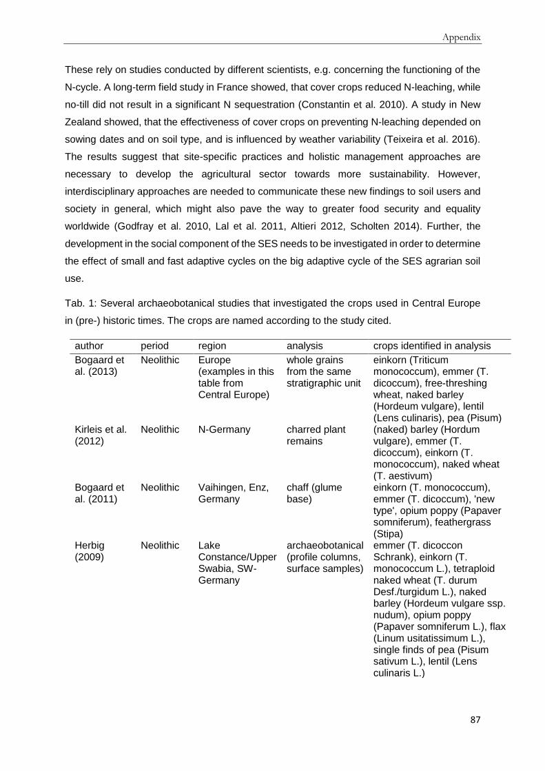
Appendix
87
These rely on studies conducted by different scientists, e.g. concerning the functioning of the
N-cycle. A long-term field study in France showed, that cover crops reduced N-leaching, while
no-till did not result in a significant N sequestration (Constantin et al. 2010). A study in New
Zealand showed, that the effectiveness of cover crops on preventing N-leaching depended on
sowing dates and on soil type, and is influenced by weather variability (Teixeira et al. 2016).
The results suggest that site-specific practices and holistic management approaches are
necessary to develop the agricultural sector towards more sustainability. However,
interdisciplinary approaches are needed to communicate these new findings to soil users and
society in general, which might also pave the way to greater food security and equality
worldwide (Godfray et al. 2010, Lal et al. 2011, Altieri 2012, Scholten 2014). Further, the
development in the social component of the SES needs to be investigated in order to determine
the effect of small and fast adaptive cycles on the big adaptive cycle of the SES agrarian soil
use.
Tab. 1: Several archaeobotanical studies that investigated the crops used in Central Europe
in (pre-) historic times. The crops are named according to the study cited.
author period region analysis crops identified in analysis
Bogaard et al. (2013)
Neolithic
Europe (examples in this table from Central Europe)
whole grains from the same stratigraphic unit
einkorn (Triticum monococcum), emmer (T. dicoccum), free-threshing wheat, naked barley (Hordeum vulgare), lentil (Lens culinaris), pea (Pisum)
Kirleis et al. (2012)
Neolithic N-Germany charred plant remains
(naked) barley (Hordum vulgare), emmer (T. dicoccum), einkorn (T. monococcum), naked wheat (T. aestivum)
Bogaard et al. (2011)
Neolithic Vaihingen, Enz, Germany
chaff (glume base)
einkorn (T. monococcum), emmer (T. dicoccum), 'new type', opium poppy (Papaver somniferum), feathergrass (Stipa)
Herbig (2009)
Neolithic Lake Constance/Upper Swabia, SW-Germany
archaeobotanical (profile columns, surface samples)
emmer (T. dicoccon Schrank), einkorn (T. monococcum L.), tetraploid naked wheat (T. durum Desf./turgidum L.), naked barley (Hordeum vulgare ssp. nudum), opium poppy (Papaver somniferum L.), flax (Linum usitatissimum L.), single finds of pea (Pisum sativum L.), lentil (Lens culinaris L.)

Appendix
88
Rösch (1987, 1993)
Neolithic to Bronze Age
Lake Constance, SW-Germany
pollen analysis naked wheat (T. aestivum/durum), barley (Hordeum vulgare L.), emmer (T. dicoccum), einkorn (T. monococcum L.), flax (Linum usitatissimum L.), opium poppy (Papaver somniferum L.), spelt (T. spelta), millet (Panicum miliaceum), pulses
Rösch (1996)
Late Neolithic to Bronze Age
SW-Germany pollen analysis, charred plant macro remains
einkorn (T. monococcum), emmer (T. dicoccum), naked wheat (T. turgidum s.l.), barley (Hordeum vulgare), spelt (T. spelta), millet (Panicum miliaceum)
Kanstrup et al. (2014)
Neolithic to Iron Age
Denmark charred archaeobotanical cereal remains, isotope analysis
emmer (T. dicoccum), spelt (T. spelta), naked barley (Hordeum vulgare, var. Nudum)
Hubbard (1980)
Neolithic to Medieval period
Europe analysis of charred remains and pottery imprints
Barley (Hordeum vulgare), emmer (T. dicoccum & dicoccoides), einkorn (T. monococcum & bocoticum), millet (Panicum miliaceum), oat (Avena sativa & strigosa), wheat (T. aestivum s.l.), rye (Secale cereale)
Mäckel et al. (2003)
Neolithic to Medieval period
Upper Rhine Lowlands, S-Black Forest, SW-Germany
pollen analysis, evaluation of fossil soils
4000 BC: cerealia
Hjelle et al (2012)
Neolithic to Medieval period
Norway pollen analysis, charred grains
charred grains of Hordeum vulgare (present from Late Neolithic to Early Bronze Age), cerealia pollen, mainly Hordeum type, but also Avena and Triticum type (Early Iron Age)
Behre (1992)
Neolithic to Medieval period
Central Europe carbonized grains, pollen diagram
rye (Secale cereale) rare in Neolithic, increasing during pre-Roman Iron Age and Roman period and great increase in the Middle Ages
Wieckowska et al. (2012)
Neolithic to modern times
Großer Eutiner See, N-Germany
pollen analysis Triticum- and Averna-type pollen, Secale (Iron Age onward), Hordeum (Iron Age onward)
Dreßler et al. (2006)
Neolithic to modern times
Lake Dudinghausen, N-Germany
pollen analysis Hordeum, Triticum, Secale (Medieval period onwars) --> cereal pollen increased in Modern times

Appendix
89
Rösch (1998)
Neolithic to modern times
SW-Germany review T. dicoccum, T. monococcum, Hordeum vulgare, T. aestivum/durum, T. spelta (minor in Neolithic but increase in Bronze Age), Secale cereale (minor in Neolithic but increase in Bronze Age), Panicum miliaceum (from Bronze Age on), Setaria italica (from Bronze Age on), Avena (from Bronze Age on), Oryza sativa (from Late Medieval period on), Zea mays (from modern times on), Linum usitatissimum, Papaver somniferum, Brassica rapa, Camelina sativa, Cannabis sativa (minor from Iron Age on), Pisum sativum, Lens culinaris, Vicia ervilia (few in Neolithic and in Iron Age), Vicia faba (from Bronze Age on), Vicia sativa (few in Roman and High Medieval times)
Rösch and Tserendorj (2011)
Bronze Age
Huzenbacher See, SW-Germany
pollen analysis cerealia, secale (Medieval period)
Gauthier and Richard (2009)
Bronze Age
Lake Bourget, France
pollen analysis cerealia
Stika and Heiss (2013)
Bronze Age
Europe review barley, emmer, einkorn, spelt, free-threshing wheat, millet, oat, rye
Dreslerova et al. (2013)
Bronze Age to Early Iron Age
Czech Republic charred plant macro-remains
emmer (T. dicoccum Schübl.), barley (Hordeum vulgare L.), millet (Panicum miliaceum L.), spelt (T. spelta L.), later also naked wheat (T. aestivum L./compactum Host./durum Desf./turgidum L.), very low numbers of oat (Avena sativa L.) and rye (Secale cereale L.)
Kerig and Lechterbeck (2004)
Bronze Age to Medieval period
Lake Steisslingen, SW-Germany
pollen analysis Triticum, Hordeum, Cerealia, rye (Iron Age)
Rösch et al. (1992)
Roman to post-Medieval period
SW-Germany, N-Switzerland
review Roman Period (1st-3rd century A.D.): Panicum miliaceum, T. spelta, Secale cereale, Hordeum vulgare, T. aestivum, T. monococcum; in native Germania T.

Appendix
90
monococcum, Hordeum vulgare and Secale cereale
Late Roman period (3rd-5th century A.D.): one site investigated on upper Danube with Hordeum vulgare, T. speta and Avena sp.; T. aestivum, T. monococcum and Secale cereale (less than 10 %) Merovingian period (6th/7th century A.D.): Avena sp., Hordeum vulgare, T. spelta, T. aestivum, T. monococcum, Secale cereale Carolingian-Ottonian period (8th-10th century A.D.): T. aestivum, T. spelta, Avena sp., T. monococcum, Hordeum vulgare and Secale cereale High Medieval period (11th-13th centruy A.D.): Secale cereale, T. spelta, T. monococcum, Avena sp., Hordeum vulgare, Panicum miliaceum, T. aestivum Early modern period (16th-19th century A.D.): Panicum miliaceum, Avena sp., Hordeum vulgare, T. aestivum, Secale cereale, T. spelta
Rebourg et al. (2003)
1493/1539 S-Spain/Germany
literature review, genetic markers
maize (Zea mays ssp. mays): several introductions
Hawkes and Francisco-Ortega (1993)
1567/1574 Gran Canaria/Tenerife
literature review potato (Solanum tuberosum/Ipomoea batatas)
Cassman (1999)
1967-1997
global harvested area wheat (T. aestivum L.), rice (Oryza sativa L.), maize (Zea mays L.)
Conclusion
The adaptive cycle narrative is useful to examine the changes occurring in a social-ecological
system (SES), such as the changes of the agrarian soil use SES over the last millennia. The
narrative helps understanding changes of and within the SES over time while focusing on
important variables, in the presented case soil, crops, knowledge/technology. This approach
could also be important for archaeological and soil scientific research in general, as the

Appendix
91
concept of SESs and adaptive cycles can be applied to broader developments within social
ecological systems, as shown in this study. It might also be used to connect individual case
studies to international contexts.
The adaptive cycle of the SES agrarian soil use started with the Neolithic Transition and
sedentariness. During the Neolithic, the Bronze and Iron Age the adaptive cycle was in the r-
phase. Innovative tools and ideas developed which enabled the societies to successfully
practice agriculture. With Antiquity, the SES moves into the K-phase, where the knowledge
concerning agricultural practices is documented by written sources and best practice methods
are determined. During the Medieval and Modern Times, the general knowledge and
agricultural knowledge in particular increases. Furthermore, agricultural tools are improved by
e.g. using iron in plow shares, thus incorporating the adaptive cycle of the SES metallurgy.
With industrialization, the SES moves through the Ω-phase of release or creative destruction
and the α-phase of reorganization. The SES changed considerably with the α-phase, leading
to a separation of animal husbandry and arable farming and a new r-phase after the
mechanization of agriculture. This is comparable to the establishment of agriculture in the
Neolithic due to the big innovations that changed the SES. The Neolithic transition led to
sedentariness, so that first settlements and probably new societal structures developed. The
Industrial Revolution enabled a diversified society with more people working outside the
agrarian business due to the innovations of the r-phase. The knowledge and technology
variable are interconnected in both r-phases, e.g. in the development of the plow and the
Haber-Bosch method. After industrialization and mechanization, agrarian soil use no longer
means work of animals and men, but work of machines. This has new consequences for the
soil variable, comparable to the consequences of deforestation, which subjected the soil to
erosion after the establishment of fields since the Neolithic. The new impact on soil includes
compaction, nutrient depletion, and other forms of soil degradation. The crops used in
agriculture were first introduced in the Neolithic. They were used in different proportions during
the last millennia. With industrialization, new genetically modified organisms were developed,
connecting the variables crop and knowledge/technology. The crop variable underwent
another change, as we depend on a limited variety of crop plants for nutrition today.
A difference between the two adaptive cycles is the speed of the transition from r- to K-phase,
which lasted several millennia in the first cycle but happened in the course of decades in the
second. The increasing knowledge of the first K-phase, which started with the Greek and
Roman agricultural writers and culminated among others with Thaer, Liebig and Darwin,
eventually had a vast effect on surplus production and technological development that resulted
in a reorganization of the SES and the second adaptive cycle. The knowledge is still increasing
steadily and technological development has led to a high-tech agribusiness, depending on
Appendix
92
computers, GIS, fertilizers and more. These new developments also affect the soil and crops
used. To investigate these effects interdisciplinary work is needed, to ensure the resilience of
the SES agrarian soil use without detrimental effects on soil, crops, knowledge/technology,
and climate. These interdisciplinary studies should include various disciplines, among others
soil science, sociology, anthropology, climatology, but also history and archaeology, to
understand the past developments of and within a region. The SES and adaptive cycle could
be used to structure the research in advance, due to the focus on specific variables, while also
including the systems approach and acknowledging the connection between natural and social
systems. Further challenges for these studies include that small scale and fast adaptive cycles
in the social system need to be investigated in order to understand the development of the big
cycle of agrarian soil use. As we are in the K-phase of the adaptive cycle, small and fast
adaptive cycles in the social system will determine how long the system remains in the present
phase. If innovations and traditions are combined and lessons from the past, e.g. concerning
erosion, are learned, the new K-phase might last for an extended time. However, if this does
not happen, a new Ω-phase might result in a reorganization of the system with an unknown
outcome. The variety of possible responses to global, regional and local challenges requires
scientists from different fields to investigate the different variables of the SES agrarian soil use
to understand the processes and interactions between and within the variables. This might
contribute to the resilience of the SES and lead to new policies on a global scale.
Interdisciplinary research helped us understand the adaptive cycle of the SES from the
Neolithic to Industrialization. It is also necessary to develop a resilient agrarian soil use for the
future.
Literature cited
Aertsens, J., L. de Nocker, and A. Gobin. 2013. Valuing the carbon sequestration potential for
European agriculture. Land Use Policy 31:584–594.
Allison, H. E., and R. J. Hobbs. 2004. Resilience, Adaptive Capacity, and the "Lock-in Trap" of
the Western Australian Agricultural Region. Ecology and Society 9(1):3.
Altieri, M. A. 2012. Convergence or Divide in the Movement for Sustainable and Just
Agriculture. Pages 1–9 in E. Lichtfouse, editor. Organic Fertilisation, Soil Quality and Human
Health. Springer, Netherlands.
Ammerman, A. J., and L. L. Cavalli-Sforza. 1971. Measuring the Rate of Spread of Early
Farming in Europe. Man, New Series 6(4):674–688.
Andersen, T. B., P. S. Jensen, and C. V. Skovsgaard. 2016. The heavy plow and the
agricultural revolution in Medieval Europe. Journal of Development Economics 118:133–149.
Anklam, E., F. Gadani, P. Heinze, H. Pijnenburg, and G. van den Eede. 2002. Analytical
methods for detection and determination of genetically modified organisms in agricultural crops
and plant-derived food products. European Food Research and Technology 214(1):3–26.

Appendix
93
Antrop, M. 2004. Landscape change and the urbanization process in Europe. Landscape and
Urban Planning 67(1-4):9–26.
Aranbarri, J., P. González-Sampériz, B. Valero-Garcés, A. Moreno, G. Gil-Romera, M. Sevilla-
Callejo, E. García-Prieto, F. Di Rita, M. P. Mata, M. Morellón, D. Magri, J. Rodríguez-Lázaro,
and J. S. Carrión. 2014. Rapid climatic changes and resilient vegetation during the Lateglacial
and Holocene in a continental region of south-western Europe. Global and Planetary Change
114:50–65.
Auerswald, K., P. Fiener, and R. Dikau. 2009. Rates of sheet and rill erosion in Germany — A
meta-analysis. Geomorphology 111(3-4):182–193.
Ausbüttel, F. M. 2011. Die Gründung und Teilung der Provinz Germania. Klio - Beiträge zur
Alten Geschichte 93(2):392–410.
Bailey, G., and P. Spikins, editors. 2008. Mesolithic Europe. Cambridge University Press, New
York.
Bakels, C. 2014. The first farmers of the Northwest European Plain: some remarks on their
crops, crop cultivation and impact on the environment. Journal of Archaeological Science
51:94–97.
Banks, W. E., N. Antunes, S. Rigaud, and F. d'Errico. 2013. Ecological constraints on the first
prehistoric farmers in Europe. Journal of Archaeological Science 40(6):2746–2753.
Bartosiewicz, L. 2013. Animals in Bronze Age Europe in H. Fokkens, and A. Harding, editors.
The Oxford Handbook of the European Bronze Age. Oxford University Press, Oxford.
Battisti, D. S., and R. L. Naylor. 2009. Historical Warnings of Future Food Insecurity with
Unprecedented Seasonal Heat. Science 323:240–244.
Behre, K.-E. 1976. Beginn und Form der Plaggenwirtschaft in Nordwestdeutschland nach
pollenanalytischen Untersuchungen in Ostfriesland. Neue Ausgrabungen und Forschungen in
Niedersachsen 10:197–224.
Behre, K.-E. 1992. The history of rye cultivation in Europe. Vegetation History and
Archaeobotany 1:141–156.
Behre, K.-E. 1998. Landwirtschaftliche Entwicklungslinien und die Veränderung der
Kulturlandschaft in der Bronzezeit Europas in B. Hänsel, editor. Mensch und Umwelt in der
Bronzezeit Europas. Oetker-Voges Verlag, Kiel.
Behre, K.-E. 2000. Frühe Ackersysteme, Düngemethoden und die Entstehung der
Nordwestdeutschen Heiden. Archäologisches Korrespondenzblatt 30:135–151.
Beier, C. M., A. L. Lovecraft, and F. S. Chapin. 2009. Growth and Collapse of a Resource
System: an Adaptive Cycle of Change in Public Lands Governance and Forest Management
in Alaska. Ecology and Society 14(2):5.
Berglund, B. E. 2003. Human impact and climate changes—synchronous events and a causal
link? Quaternary International 105(1):7–12.
Bergmann, K. 1970. Agrarromantik und Großstadtfeindschaft. Verlag Anton Hain, Meisenheim
am Glan.
Berkes, F. 2004. Rethinking Community-Based Conservation. Conservation Biology
18(3):621–630.

Appendix
94
Berkes, F., J. Colding, and C. Folke, editors. 2003. Navigating Social-Ecological Systems:
Building Resilience for Complexity and Change. Cambridge University Press, Cambridge, UK.
Berkes, F., and C. Folke, editors. 1998. Linking Social and Ecological Systems: Management
Practices and Social Mechanisms for Building Resilience. Cambridge University Press,
Cambridge, UK.
Blum, W. E., and H. Eswaran. 2004. Soils for Sustaining Global Food Production. Journal of
Food Science 69(2):37–42.
Blume, H.-P., and P. Leinweber. 2004. Plaggen Soils: landscape history, properties, and
classification. Journal of Plant Nutrition and Soil Science 167(3):319–327.
Bogaard, A., R. Fraser, T. H. E. Heaton, M. Wallace, P. Vaiglova, M. Charles, G. Jones, R. P.
Evershed, A. K. Styring, N. H. Andersen, R.-M. Arbogast, L. Bartosiewicz, A. Gardeisen, M.
Kanstrup, U. Maier, E. Marinova, L. Ninov, M. Schäfer, and E. Stephan. 2013. Crop manuring
and intensive land management by Europe's first farmers. Proceedings of the National
Academy of Sciences 110(31):12589–12594.
Bogaard, A., R. Krause, and H.-C. Strien. 2011. Towards a social geography of cultivation and
plant use in an early farming community: Vaihingen an der Enz south-west Germany. Antiquity
85:395–416.
Bork, H.-R. 2006. Landschaften der Erde unter dem Einfluss des Menschen. Primus Verlag
(Wissenschaftliche Buchgesellschaft), Darmstadt.
Bork, H.-R., S. Dreibrodt, and A. Mieth. 2006. Die langfristigen Wirkungen von
Witterungsextremen auf Umwelt und Gesellschaft. Pages 11–22 in Klimawandel - Klimafolgen
- Naturkatastrophen und deren Auswirkungen auf Umwelt und Gesellschaft (Rostock,
20.10.2006), Rostock.
Bos, J. A. 2001. Lateglacial and Early Holocene vegetation history of the northern Wetterau
and the Amöneburger Basin (Hessen), central-west Germany. Review of Palaeobotany and
Palynology 115(3-4):177–204.
Brandt, G., A. Szécsényi-Nagy, C. Roth, K. W. Alt, and W. Haak. 2015. Human paleogenetics
of Europe--the known knowns and the known unknowns. Journal of Human Evolution 79:73–
92.
Brázdil, R., G. R. Demarée, M. Deutsch, E. Garnier, A. Kiss, J. Luterbacher, N. Macdonald, C.
Rohr, P. Dobrovolný, P. Kolář, and K. Chromá. 2010. European floods during the winter
1783/1784: scenarios of an extreme event during the ‘Little Ice Age’. Theoretical and Applied
Climatology 100(1-2):163–189.
Brevik, E. C., and A. E. Hartemink. 2010. Early soil knowledge and the birth and development
of soil science. Catena 83:23–33.
Brown, G. G., C. Feller, E. Blanchart, P. Deleporte, and S. S. Chernyanskii. 2003. With Darwin,
earthworms turn intelligent and become human friends. Pedobiologia 47(5-6):924–933.
Brozio, J. P., W. Dörfler, I. Feeser, W. Kirleis, S. Klooß, and J. Müller. 2014. A Middle Neolithic
well from Northern Germany: a precise source to reconstruct water supply management,
subsistence economy, and deposition practices. Journal of Archaeological Science 51:135–
153.

Appendix
95
Büntgen, U., W. Tegel, K. Nicolussi, M. McCormick, D. Frank, V. Trouet, J. O. Kaplan, F.
Herzig, K.-U. Heussner, H. Wanner, J. Luterbacher, and J. Esper. 2011. 2500 Years of
European Climate Variability and Human Susceptibility. Science 331:578–582.
Canadell, J. G., C. Le Quéré, M. R. Raupach, C. B. Field, E. T. Buitenhuis, P. Ciais, T. J.
Conway, N. P. Gillett, R. A. Houghton, and G. Marland. 2007. Contributions to accelerating
atmospheric CO2 growth from economic activity, carbon intensity, and efficiency of natural
sinks. Proceedings of the National Academy of Sciences 104(104):18866–18870.
Carpenter, S., B. Walker, J. M. Anderies, and N. Abel. 2001. From Metaphor to Measurement:
Resilience of What to What? Ecosystems 4(8):765–781.
Caseldine, C. J., and C. Turney. 2010. The bigger picture: towards integrating palaeoclimate
and environmental data with a history of societal change. Journal of Quaternary Science
25(1):88–93.
Cassman, K. G. 1999. Ecological intensification of cereal production systems: Yield potential,
soil quality, and precision agriculture. Proceedings of the National Academy of Sciences
96:5952–5959.
Childe, V. G. 1936. Man makes himself. Watts, London.
Constantin, J., B. Mary, F. Laurent, G. Aubrion, A. Fontaine, P. Kerveillant, and N. Beaudoin.
2010. Effects of catch crops, no till and reduced nitrogen fertilization on nitrogen leaching and
balance in three long-term experiments. Agriculture, Ecosystems & Environment 135(4):268–
278.
Cordell, D., J.-O. Drangert, and S. White. 2009. The story of phosphorus: Global food security
and food for thought. Global Environmental Change 19(2):292–305.
Costanza, R., L. Graumlich, W. Steffen, C. Crumley, J. Dearing, K. Hibbard, R. Leemans, C.
Redman, and D. Schimel. 2007. Sustainability or Collapse: What Can We Learn from
Integrating the History of Humans and the Rest of Nature? AMBIO: A Journal of the Human
Environment 36(7):522–527.
Coward, F., S. Shennan, S. Colledge, J. Conolly, and M. Collard. 2008. The spread of Neolithic
plant economies from the Near East to northwest Europe: a phylogenetic analysis. Journal of
Archaeological Science 35(1):42–56.
Crombé, P., J. Sergant, E. Robinson, and J. de Reu. 2011. Hunter–gatherer responses to
environmental change during the Pleistocene–Holocene transition in the southern North Sea
basin: Final Palaeolithic–Final Mesolithic land use in northwest Belgium. Journal of
Anthropological Archaeology 30(3):454–471.
Darwin, C. 1890. The Formation of Vegetable Mould through the Action of Worms with
Observation on their habits. D. Appleton & Company, New York.
Davison, K., P. Dolukhanov, G. R. Sarson, and A. Shukurov. 2006. The role of waterways in
the spread of the Neolithic. Journal of Archaeological Science 33(5):641–652.
Deschler-Erb, S., and Ö. Akeret. 2011. Archäobiologische Forschungen zum römischen
Legionslager von Vindonissa und seinem Umland: Status quo und Potenzial. Jahresbericht
Gesellschaft Pro Vindonissa:13–36.
Doppler, T., C. Gerling, V. Heyd, C. Knipper, T. Kuhn, M. F. Lehmann, A. W. Pike, and J.
Schibler. 2015. Landscape opening and herding strategies: Carbon isotope analyses of

Appendix
96
herbivore bone collagen from the Neolithic and Bronze Age lakeshore site of Zurich-
Mozartstrasse, Switzerland. Quaternary International.
Dorren, L. K. A., and A. C. Imeson. 2005. Soil erosion and the adaptive cycle metaphor. Land
Degradation & Development 16(6):509–516.
Dotterweich, M. 2013. The history of human-induced soil erosion: Geomorphic legacies, early
descriptions and research, and the development of soil conservation—A global synopsis.
Geomorphology 201:1–34.
Dotterweich, M., A. Schmitt, G. Schmidtchen, and H.-R. Bork. 2003. Quantifying historical gully
erosion in northern Bavaria. Catena 50:135–150.
Dreibrodt, S. 2005. Detecting heavy precipitation events during the Holocene from soils, gully
fills, colluvia and lake sediments – examples from the Belauer See catchment (northern
Germany). Zeitschrift der Deutschen Gesellschaft für Geowissenschaften 156(4):573–588.
Dreibrodt, S., J. Lomax, O. Nelle, C. Lubos, P. Fischer, A. Mitusov, S. Reiss, U. Radtke, M.
Nadeau, P. Meiert Grootes, and H.-R. Bork. 2010a. Are mid-latitude slopes sensitive to climatic
oscillations? Implications from an Early Holocene sequence of slope deposits and buried soils
from eastern Germany. Geomorphology 122:351–369.
Dreibrodt, S., C. Lubos, B. Terhorst, B. Damm, and H.-R. Bork. 2010b. Historical soil erosion
by water in Germany: Scales and archives, chronology, research perspectives. Quaternary
International 222(1-2):80–95.
Dreßler, M., U. Selig, W. Dörfler, S. Adler, H. Schubert, and T. Hübener. 2006. Environmental
changes and the Migration Period in northern Germany as reflected in the sediments of Lake
Dudinghausen. Quaternary Research 66(1):25–37.
Eckmeier, E., M. Rösch, O. Ehrmann, M. W. Schmidt, W. Schier, and R. Gerlach. 2007.
Conversion of biomass to charcoal and the carbon mass balance from a slash-and-burn
experiment in a temperate deciduous forest. The Holocene 17(4):539–542.
Egg, M., and C. Pare. 1995. Die Metallzeiten in Mitteleuropa und im Vorderen Orient: Die
Abteilung Vorgeschichte im Römisch-Germanischen Zentralmuseum. Verlag des Römisch-
Germanischen Zentralmuseums, Mainz.
Eggert, M. K. H., and S. Samida. 2013. Ur- und Frühgeschichtliche Archäologie. 2. Auflage
edition. Narr Francke Attempto Verlag GmbH + Co.KG, Tübingen.
Ellis, E. C., J. O. Kaplan, D. Q. Fuller, S. Vavrus, K. Klein Goldewijk, and P. H. Verburg. 2013.
Used planet: A global history. Proceedings of the National Academy of Sciences
110(20):7978–7985.
Enters, D., A. Lücke, and B. Zolitschka. 2006. Effects of land-use change on deposition and
composition of organic matter in Frickenhauser See, northern Bavaria, Germany. The Science
of the total environment 369(1-3):178–187.
Erdrich, M. 2001. Rom und die Barbaren: Das Verhältnis zwischen dem Imperium Romanum
und den germanischen Stämmen vor seiner Nordwestgrenze von der späten römischen
Republik bis zum Gallischen Sonderreich. Philipp von Zabern, Mainz.
Evans, S. 2012. Agricultural Production and Environmental History in J. M. Pilcher, editor. The
Oxford Handbook of Food History. Oxford University Press, Oxford.

Appendix
97
Evtuhov, C. 2006. The Roots of Dokuchaev's Scientific Contributions: Cadastral Soil Mapping
and Agro-Environmental Issues. Pages 125–148 in B. P. Warkentin, editor. Footprints in the
Soil: People and Ideas in Soil History. Elsevier, Amsterdam, Oxford.
Falkowski, P., R. J. Scholes, E. Boyle, J. Canadell, D. Canfield, J. Elser, N. Gruber, K. Hibbard,
P. Högberg, S. Linder, F. T. Mackenzie, B. Moore III, T. Pedersen, Y. Rosenthal, S. Seitzinger,
V. Smetacek, and W. Steffen. 2000. The Global Carbon Cycle: A Test of Our Knowledge of
Earth as a System. Science 290:291–296.
Fath, B. D., C. A. Dean, and H. Katzmair. 2015. Navigating the adaptive cycle: an approach to
managing the resilience of social systems. Ecology and Society 20(2):24.
Feller, C., E. Blanchart, and D. H. Yaalon. 2006. Some Major Scientists (Palissy, Buffon, Thaer,
Darwin and Muller) Have Described Soil Profiles and Developed Soil survey Techniques
Before 1883. Pages 85–105 in B. P. Warkentin, editor. Footprints in the Soil: People and Ideas
in Soil History. Elsevier, Amsterdam, Oxford.
Feller, C., G. G. Brown, E. Blanchart, P. Deleporte, and S. S. Chernyanskii. 2003a. Charles
Darwin, earthworms and the natural sciences: various lessons from past to future. Agriculture,
Ecosystems & Environment 99(1-3):29–49.
Feller, C. L., L. J.-M. Thuriès, R. J. Manlay, P. Robin, and E. Frossard. 2003b. ”The principles
of rational agriculture” by Albrecht Daniel Thaer (1752–1828). An approach to the sustainability
of cropping systems at the beginning of the 19th century. Journal of Plant Nutrition and Soil
Science 166(6):687–698.
Fingerlin, G. 2008. Vom Oberrhein zur jungen Donau: Die Straße durch den südlichen
Schwarzwald in keltischer, römischer und frühmittelalterlicher Zeit. Die Schriften des Vereins
für Geschichte und Naturgeschichte der Baar 51:47–58.
Foley, J. A., R. DeFries, G. P. Asner, C. Barford, G. Bonan, S. R. Carpenter, F. S. Chapin, M.
T. Coe, G. C. Daily, H. K. Gibbs, J. H. Helkowski, T. Holloway, E. A. Howard, C. J. Kucharik,
C. Monfreda, J. A. Patz, I. C. Prentice, N. Ramankutty, and P. K. Snyder. 2005. Global
Consequences of Land Use. Science 309:570–574.
Foley, J. A., N. Ramankutty, K. A. Brauman, E. S. Cassidy, J. S. Gerber, M. Johnston, N. D.
Mueller, C. O'Connell, D. K. Ray, P. C. West, C. Balzer, E. M. Bennett, S. R. Carpenter, J. Hill,
C. Monfreda, S. Polasky, J. Rockström, J. Sheehan, S. Siebert, D. Tilman, and Zaks, David P
M. 2011. Solutions for a cultivated planet. Nature 478:337–342.
Fraser, E. D. 2011. Can economic, land use and climatic stresses lead to famine, disease,
warfare and death? Using Europe's calamitous 14th century as a parable for the modern age.
Ecological Economics 70(7):1269–1279.
Fried, J. 2009. Das Mittelalter: Geschichte und Kultur. 3. Auflage edition. C.H. Beck, München.
Fries, J. C. 1995. Vor- und frühgeschichtliche Agrartechnik auf den Britischen Inseln und dem
Kontinent: Eine vergleichende Studie. Verlag Marie Leidorf GmbH, Espelkamp.
Fries, J. E. 2005. Methodische Überlegungen zur Ressource Boden. Archäologische
Informationen 28(1&2):139–147.
Gassmann, G., M. Rösch, and G. Wieland. 2006. Das Neuenbürger Erzrevier im
Nordschwarzwald als Wirtschaftsraum während der Späthallstatt- und Frühlatènezeit.
Germania 84:273–306.

Appendix
98
Geißler, C., P. Kühn, M. Böhnke, H. Bruelheide, X. Shi, and T. Scholten. 2012. Splash erosion
potential under tree canopies in subtropical SE China. Catena 91:85–93.
Gerlach, R., and E. Eckmeier. 2012. Prehistoric Land use and Its Impact on Soil Formation
since Early Neolithic. Examples from the Lower Rhine Area. Pages 11–16 in W. Bebermeier,
R. Hebenstreit, E. Kaiser, and J. Krause, editors. Landscape Archaeology. Proceedings of the
International Conference Held in Berlin, 6th – 8th June 2012, Berlin.
Gessner, D. 1976. Agrarverbände in der Weimarer Republik: Wirtschaftliche und soziale
Voraussetzungen agrarkonservativer Politik vor 1933. Dissertation. Universität Köln, Köln.
Giesecke, T., K. D. Bennett, Birks, H. John B., A. E. Bjune, E. Bozilova, A. Feurdean, W.
Finsinger, C. Froyd, P. Pokorný, M. Rösch, H. Seppä, S. Tonkov, V. Valsecchi, and S. Wolters.
2011. The pace of Holocene vegetation change – testing for synchronous developments.
Quaternary Science Reviews 30(19-20):2805–2814.
Gkiasta, M., T. Russell, S. Shennan, and J. Steele. 2003. Neolithic transition in Europe: the
radiocarbon record revisited. Antiquity 77(295):45–62.
Godfray, H. C. J., J. R. Beddington, I. R. Crute, L. Haddad, D. Lawrence, J. F. Muir, J. Pretty,
S. Robinson, S. M. Thomas, and C. Toulmin. 2010. Food Security: The Challenge of Feeding
9 Billion People. Science 327:812–818.
Gronenborn, D., and J. Petrasch, editors. 2010. Die Neolithisierung Mitteleuropas:
Internationale Tagung, Mainz 24. bis 26. Juni 2005. Verlag des Römisch-Germanischen
Zentralmuseums Mainz.
Gronenborn, D., H.-C. Strien, S. Dietrich, and F. Sirocko. 2014. ‘Adaptive cycles’ and climate
fluctuations: a case study from Linear Pottery Culture in western Central Europe. Journal of
Archaeological Science 51:73–83.
Groot, M., and S. Deschler-Erb. 2015. Market strategies in the Roman provinces: Different
animal husbandry systems explored by a comparative regional approach. Journal of
Archaeological Science: Reports 4:447–460.
Grundmann, P., M.-H. Ehlers, and G. Uckert. 2012. Responses of agricultural bioenergy
sectors in Brandenburg (Germany) to climate, economic and legal changes: An application of
Holling's adaptive cycle. Energy Policy 48:118–129.
Gunderson, L. H., and C. S. Holling, editors. 2002. Panarchy: Understanding Transformations
in Human and Natural Systems. Island Press, Washington, D.C.
Haak, W., P. Forster, B. Bramanti, S. Matsumura, G. Brandt, M. Tänzer, R. Villemy, C.
Renfrew, D. Gronenborn, K. W. Alt, and J. Burger. 2005. Ancient DNA from the First European
Farmers in 7500-Year-Old Neolithic Sites. Science 310:1016–1018.
Haasis-Berner, A. 2012. Relikte mittelalterlicher Landnutzung: Der ehemalige Ort Mauchen
(Lkr. Breisgau-Hochschwarzwald). Denkmalpflege in Baden-Württemberg. Nachrichtenblatt
des Landesdenkmalamtes(1):54–55.
Hahn, H.-W. 2011. Die industrielle Revolution in Deutschland. Oldenbourg
Wissenschaftsverlag GmbH, München.
Hawkes, J. G., and J. Francisco-Ortega. 1993. The early history of the potato in Europe.
Euphytica 70:1–7.

Appendix
99
Heiligmann, J. 1996. Vormarsch auf die Schwäbische Alb: Das Kastell Urspring in Ulmer
Museum, editor. Römer an Donau und Iller: Neue Forschungen und Funde. Jan Thorbecke
Verlag GmbH & Co., Sigmaringen.
Henkner, J., J. J. Ahlrichs, S. S. Downey, M. Fuchs, B. R. James, T. Knopf, T. Scholten, S.
Teuber, and P. Kühn. 2017. Archaeopedology and chronostratigraphy of colluvial deposits as
a proxy for regional land use history (Baar, southwest Germany). Catena 155:93–113.
Herbig, C. 2009. Recent archaeobotanical investigations into the range and abundance of
Neolithic crop plants in settlements around Lake Constance and in Upper Swabia (south-west
Germany) in relation to cultural influences. Journal of Archaeological Science 36(6):1277–
1285.
Hoffmann, T., G. Erkens, R. Gerlach, J. Klostermann, and A. Lang. 2009. Trends and controls
of Holocene floodplain sedimentation in the Rhine catchment. Catena 77(2):96–106.
Holling, C. S. 2001. Understanding the Complexity of Economic, Ecological, and Social
Systems. Ecosystems 4(5):390–405.
Holling, C. S., and L. H. Gunderson. 2002. Resilience and Adaptive Cycles. Pages 25–62 in
L. H. Gunderson, and C. S. Holling, editors. Panarchy: Understanding Transformations in
Human and Natural Systems. Island Press, Washington, D.C.
Holling, C. S., L. H. Gunderson, and D. Ludwig. 2002a. In Quest of a theory of Adaptive
Change. Pages 3–22 in L. H. Gunderson, and C. S. Holling, editors. Panarchy: Understanding
Transformations in Human and Natural Systems. Island Press, Washington, D.C.
Holling, C. S., L. H. Gunderson, and G. D. Peterson. 2002b. Sustainability and Panarchies.
Pages 63–103 in L. H. Gunderson, and C. S. Holling, editors. Panarchy: Understanding
Transformations in Human and Natural Systems. Island Press, Washington, D.C.
Houben, P. 2012. Sediment budget for five millennia of tillage in the Rockenberg catchment
(Wetterau loess basin, Germany). Quaternary Science Reviews 52:12–23.
Houben, P., M. Schmidt, B. Mauz, A. Stobbe, and A. Lang. 2013. Asynchronous Holocene
colluvial and alluvial aggradation: A matter of hydrosedimentary connectivity. The Holocene
23(4):544–555.
Hublin, J.-J. 2015. The modern human colonization of western Eurasia: when and where?
Quaternary Science Reviews 118:194–210.
Hughes, P. D., and P. L. Gibbard. 2015. A stratigraphical basis for the Last Glacial Maximum
(LGM). Quaternary International 383:174–185.
Humpert, J. 1995. Ziele und Methoden der Altwegeforschung am Beispiel einer römischen
Straße von der Baar in den Breisgau. Die Schriften des Vereins für Geschichte und
Naturgeschichte der Baar 38:11–23.
James, B. R., W. E. Blum, and C. Dazzi. 2014. Bread and Soil in Ancient Rome: A Vision of
Abundance and an Ideal of Order Based on Wheat, Grapes, and Olives. Pages 153–173 in G.
J. Churchman, and E. R. Landa, editors. The Soil Underfoot: Infinite Possibilities for a Finite
Resource. CRC Press.
Jankuhn, H. 1977. Einführung in die Siedlungsarchäologie. Walter de Gruyter, Berlin, New
York.
Jockenhövel, A. 1993. Eisengewinnung im Mittelgebirgsraum. Pages 70–74 in H. Steuer, and
U. Zimmermann, editors. Alter Bergbau in Deutschland. Konrad Theiss Verlag, Stuttgart.
Appendix
100
Jockenhövel, A. 1994. Umwelt - Landwirtschaft - Ernährung in A. Jockenhövel, and W. Kubach,
editors. Bronzezeit in Deutschland. Konrad Theiss Verlag, Stuttgart.
Kadereit, A., P. Kühn, and G. A. Wagner. 2010. Holocene relief and soil changes in loess-
covered areas of south-western Germany: The pedosedimentary archives of Bretten-
Bauerbach (Kraichgau). Quaternary International 222(1-2):96–119.
Kaplan, J. O., K. M. Krumhardt, and N. Zimmermann. 2009. The prehistoric and preindustrial
deforestation of Europe. Quaternary Science Reviews 28:3016–3034.
Kerig, T., and J. Lechterbeck. 2004. Laminated sediments, human impact, and a multivariate
approach: a case study in linking palynology and archaeology (Steisslingen, Southwest
Germany). Quaternary International 113(1):19–39.
Kirleis, W., S. Klooß, H. Kroll, and J. Müller. 2012. Crop growing and gathering in the northern
German Neolithic: a review supplemented by new results. Vegetation History and
Archaeobotany 21(3):221–242.
Knopf, T., T. Baum, T. Scholten, and P. Kühn. 2012. Landnutzung im Frühen Mittelalter: Eine
Archäopedologische Prospektion im Mittleren Schwarzwald. Archäologisches
Korrespondenzblatt 42(1):123–133.
Lal, R. 2010. Managing soils for a warming earth in a food-insecure and energy-starved world.
Journal of Plant Nutrition and Soil Science 173(1):4–15.
Lal, R. 2013. Enhancing ecosystem services with no-till. Renewable Agriculture and Food
Systems 28(02):102–114.
Lal, R., J. A. Delgado, P. M. Groffman, N. Millar, C. Dell, and A. Rotz. 2011. Management to
mitigate and adapt to climate change. Journal of Soil and Water Conservation 66(4):276–285.
Lal, R., D. C. Reicosky, and J. D. Hanson. 2007. Evolution of the plow over 10,000 years and
the rationale for no-till farming. Soil and Tillage Research 93(1):1–12.
Lambin, E. F., B. L. Turner, H. J. Geist, S. B. Agbola, A. Angelsen, J. W. Bruce, O. T. Coomes,
R. Dirzo, G. Fischer, C. Folke, P. S. George, K. Homewood, J. Imbernon, R. Leemans, X. Li,
E. F. Moran, M. Mortimore, P. S. Ramakrishnan, J. F. Richards, H. Skånes, W. Steffen, G. D.
Stone, U. Svedin, T. A. Veldkamp, C. Vogel, and J. Xu. 2001. The causes of land-use and
land-cover change: moving beyond the myths. Global Environmental Change 11(4):261–269.
Lang, A. 2003. Phases of soil erosion-derived colluviation in the loess hills of South Germany.
Catena 51(3-4):209–221.
Lang, A., H.-P. Niller, and M. M. Rind. 2003. Land degradation in Bronze Age Germany:
Archaeological, pedological, and chronometrical evidence from a hilltop settlement on the
Frauenberg, Niederbayern. Geoarchaeology 18(7):757–778.
Larson, G., U. Albarella, K. Dobney, P. Rowley-Conwy, J. Schibler, A. Tresset, J.-D. Vigne, C.
J. Edwards, A. Schlumbaum, a. Dinu, A. Baˇlaˇçsescu, G. Dolman, A. Tagliacozzo, N.
Manaseryan, P. Miracle, L. van Wijngaarden-Bakker, M. Masseti, D. G. Bradley, and A.
Cooper. 2007. Ancient DNA, pig domestication, and the spread of the Neolithic into Europe.
Proceedings of the National Academy of Sciences 104(39):15276–15281.
Lemmen, C., D. Gronenborn, and K. W. Wirtz. 2011. A simulation of the Neolithic transition in
Western Eurasia. Journal of Archaeological Science 38(12):3459–3470.
Leopold, M., T. Plöckl, G. Forstenaicher, and J. Völkel. 2010. Integrating pedological and
geophysical methods to enhance the informative value of an archaeological prospection – The

Appendix
101
example of a Roman villa rustica near Regensburg, Germany. Journal of Archaeological
Science 37(7):1731–1741.
Leopold, M., and J. Völkel. 2007. Colluvium: Definition, differentiation, and possible suitability
for reconstructing Holocene climate data. Quaternary International 162-163:133–140.
Levitt, T. 1999. The Globalization of Markets. Pages 249–266 in R. Z. Aliber, and R. W. Click,
editors. Readings in International Business: A Decision Approach. Third printing. MIT Press,
Cambridge, Massachusetts, London, England.
Liebig, J. 1841. Die organische Chemie in ihrer Anwendung auf Agricultur und Physiologie.
Verlag von Friedrich Vieweg und Sohn, Braunschweig.
Linke, M. 1979. Zur Verbreitung, Form und Entstehung altmärkischer Wölbäcker. Hercynia N.
F. 16(4):431–439.
Lüning, J. 2000. Steinzeitliche Bauern in Deutschland - die Landwirtschaft im Neolithikum.
Verlag Dr. Rudolf Habelt GmbH, Bonn.
Luterbacher, J., D. Dietrich, E. Xoplaki, M. Grosjean, and H. Wanner. 2004. European
Seasonal and Annual Temperature Variability, Trends, and Extremes Since 1500. Science
303:1499–1503.
MacDonald, G. K., E. M. Bennett, P. A. Potter, and N. Ramankutty. 2011. Agronomic
phosphorus imbalances across the world's croplands. Proceedings of the National Academy
of Sciences 108(7):3086–3091.
Mäckel, R., R. Schneider, and J. Seidel. 2003. Anthropogenic Impact on the Landscape of
Southern Badenia (Germany) during the Holocene - Documented by Colluvial and Alluvial
Sediments. Archaeometry 45(3):487–501.
McNeill, J. R., and V. Winiwarter. 2004. Breaking the Sod: Humankind, History, and Soil.
Science 304(5677):1627–1629.
Mellars, P. 2004. Neanderthals and the modern human colonization of Europe. Nature
432:461–465.
Mitusov, A. V., O. E. Mitusova, J. Wendt, S. Dreibrodt, and H.-R. Bork. 2014. Correlation of
colluvial deposits with the modern land surface and the problem of slope profile description.
Geomorphology 220:30–40.
Montgomery, D. R. 2010. Dreck: Warum unsere Zivilisation den Boden unter den Füßen
verliert. oekom verlag, München.
Mueller, K. 2015. Der Spaten - ein Bodenbearbeitungsgerät im Wandel der Zeit. Pages 199–
208 in H.-P. Blume, and R. Horn, editors. Persönlichkeiten der Bodenkunde V: Beiträge zum
350. Jubiläum der Christian-Albrechts- Universität zu Kiel. Vorträge der Arbeitsgruppe
Geschichte der Bodenkunde im Rahmen der Jahrestagung der Deutschen Bodenkundlichen
Gesellschaft im September 2013 in Rostock. R. Horn und K. H. Mühling.
Niedertscheider, M., T. Kuemmerle, D. Müller, and K.-H. Erb. 2014. Exploring the effects of
drastic institutional and socio-economic changes on land system dynamics in Germany
between 1883 and 2007. Global environmental change human and policy dimensions 28:98–
108.
Nüsse, H.-J., C. Marx, and D. Lelgemann. 2011. Germania magna - Ein neuer Blick auf eine
alte Karte: Entzerrte geographische Daten des Ptolemaios für die antiken Orte zwischen Rhein
und Weichsel. Germania 89(1-2):115–153.
Appendix
102
Pape, J. C. 1970. Plaggen soils in the Netherlands. Geoderma 4(3):229–255.
Pietsch, D., and P. Kühn. 2014. Buried soils in the context of geoarchaeological research—
two examples from Germany and Ethiopia. Archaeological and Anthropological Sciences.
Pimentel, D., and N. Kounang. 1998. Ecology of Soil Erosion in Ecosystems. Ecosystems
1(5):416–426.
Pinhasi, R., M. G. Thomas, M. Hofreiter, M. Currat, and J. Burger. 2012. The genetic history
of Europeans. Trends in genetics TIG 28(10):496–505.
Price, T. D., R. A. Bentley, J. Lüning, D. Gronenborn, and J. Wahl. 2001. Prehistoric human
migration in the Linearbandkeramik of Central Europe. Antiquity 75(289):593–603.
Prummel, W., and M. J. Niekus. 2011. Late Mesolithic hunting of a small female aurochs in the
valley of the River Tjonger (the Netherlands) in the light of Mesolithic aurochs hunting in NW
Europe. Journal of Archaeological Science 38(7):1456–1467.
Rebourg, C., M. Chastanet, B. Gouesnard, C. Welcker, P. Dubreuil, and A. Charcosset. 2003.
Maize introduction into Europe: the history reviewed in the light of molecular data. TAG.
Theoretical and applied genetics. Theoretische und angewandte Genetik 106(5):895–903.
Reiß, S., S. Dreibrodt, C. C. M. Lubos, and H.-R. Bork. 2009. Land use history and historical
soil erosion at Albersdorf (northern Germany) — Ceased agricultural land use after the pre-
historical period. Catena 77(2):107–118.
Robertson, R. 1992. Globalization: Social Theory and Global Culture. SAGE Publications,
London, Thousand Oaks, New Delhi.
Rösch, M. 1987. Der Mensch als landschaftsprägender Faktor des westlichen
Bodenseegebietes seit dem späten Atlantikum. Eiszeitalter und Gegenwart 37:19–29.
Rösch, M. 1996. New approaches to prehistoric land-use reconstruction in south-western
Germany. Vegetation History and Archaeobotany 5:65–79.
Rösch, M. 1998. The history of crops and crop weeds in south-western Germany from the
Neolithic period to modern times, as shown by archaeobotanical evidence. Vegetation History
and Archaeobotany 7:109–125.
Rösch, M. 2009. Vom Korn der frühen Jahre: Sieben Jahrtausende Ackerbau und
Kulturlanschaft. Denkmalpflege in Baden-Württemberg. Nachrichtenblatt des
Landesdenkmalamtes 38(3):157–164.
Rösch, M., O. Ehrmann, L. Herrmann, E. Schulz, A. Bogenrieder, J. P. Goldammer, M. Hall,
H. Page, and W. Schier. 2002. An experimental approach to Neolithic shifting cultivation.
Vegetation History and Archaeobotany 11:143–154.
Rösch, M., S. Jacomet, and S. Karg. 1992. The history of cereals in the region of the former
Duchy of Swabia (Herzogtum Schwaben) from the Roman to the Post-medieval period: results
of archaeobotanical research. Vegetation History and Archaeobotany 1:193–231.
Rösch, M., and G. Tserendorj. 2011. Florengeschichtliche Beobachtungen im
Nordschwarzwald (Südwestdeutschland). Hercynia N. F. 44:53–71.
Sanden, W. v. d. 1994. Early Iron age ard shares from Drenthe, the Netherlands. Tools &
Tillage: A journal on the history of the implements of cultivation and other agricultural
processes 7(2):103–106.

Appendix
103
Schmitt, A., M. Dotterweich, G. Schmidtchen, and H.-R. Bork. 2003. Vineyards, hopgardens
and recent afforestation: effects of late Holocene land use change on soil erosion in northern
Bavaria, Germany. Catena 51:241–254.
Schneider, H. 2007. Geschichte der antiken Technik. C.H. Beck oHG, München.
Scholten, T. 2014. Mensch und Boden. Praxis Geographie(1):4–7.
Schultz-Klinken, K.-R. 1981. Haken, Pflug und Ackerbau: Ackerbausysteme des Saatfurch-
und Saatbettbaues in urgeschichtlicher und geschichtlicher Zeit sowie ihr Einfluß auf die
Bodenentwicklung. August Lax Verlagsbuchhandlung, Hildesheim.
Schumacher, E. F. 1993. Small is beautiful: A study of economics as if people mattered.
Vintage Books, London.
Seidl, A. 2006. Deutsche Agrargeschichte. DLG-Verlags-GmbH, Frankfurt am Main.
Shen, J., R. Li, F. Zhang, J. Fan, C. Tang, and Z. Rengel. 2004. Crop yields, soil fertility and
phosphorus fractions in response to long-term fertilization under the rice monoculture system
on a calcareous soil. Field Crops Research 86(2-3):225–238.
Smil, V. 1999. Nitrogen in crop production: An account of global flows. Global Biogeochemical
Cycles 13(2):647–662.
Smil, V. 2000. Phosphorus in the Environment: Natural Flows and Human Interferences. Annu.
Rev. Energy Environ. 25:53–88.
Spek, T., W. Groenman-van Waateringe, M. Kooistra, and L. Bakker. 2003. Formation and
Land-Use History of Celtic Fields in North-West Europe - An Interdisciplinary Case Study at
Zeijen, The Netherlands. European Journal of Archaeology 6(2):141–173.
Statistisches Bundesamt. 2016. Produktionsmethoden: Bodenbearbeitungsverfahren
landwirtschaftlicher Betriebe auf Ackerflächen im Wirtschaftsjahr 2009/2010. [online] URL:
https://www.destatis.de/DE/ZahlenFakten/Wirtschaftsbereiche/LandForstwirtschaftFischerei/
Produktionsmethoden/Tabellen/BodenbearbeitungsverfahrenLB.html.
Steuer, H. 1993. Von der Steinzeit bis zum Mittelalter - Erzgewinnung als Spiegel der Epochen.
Pages 7–15 in H. Steuer, and U. Zimmermann, editors. Alter Bergbau in Deutschland. Konrad
Theiss Verlag, Stuttgart.
Stockmann, U., B. Minasny, and A. B. McBratney. 2014. How fast does soil grow? Geoderma
216:48–61.
Tegtmeier, U. 1993. Neolithische und bronzezeitliche Pflugspuren in Norddeutschland und den
Niederlanden. Magisterarbeit, Bonn.
Teixeira, E. I., P. Johnstone, E. Chakwizira, J. d. Ruiter, B. Malcolm, N. Shaw, R. Zyskowski,
E. Khaembah, J. Sharp, E. Meenken, P. Fraser, S. Thomas, H. Brown, and D. Curtin. 2016.
Sources of variability in the effectiveness of winter cover crops for mitigating N leaching.
Agriculture, Ecosystems & Environment 220:226–235.
Terberger, T., P. de Klerk, H. Helbig, K. Kaiser, and P. Kühn. 2004. Late Weichselian
landscape development and human settlement in Mecklenburg-Vorpommern (NE Germany).
Eiszeitalter und Gegenwart 54:138–175.
Thaer, A. D. 1880. Albrecht Thaer's Grundsätze der rationellen Landwirthschaft. Wiegandt,
Hempel & Parey, Berlin.

Appendix
104
Tiedje, J. M., R. K. Colwell, Y. L. Grossman, R. E. Hodson, R. E. Lenski, R. N. Mack, and P.
J. Regal. 1989. The Planned Introduction of Genetically Engineered Organisms: Ecological
Considerations and Recommendations. Ecology 70(2):298–315. [online] URL:
http://www.jstor.org/stable/1937535.
Tilman, D., K. G. Cassman, P. A. Matson, R. L. Naylor, and S. Polasky. 2002. Agricultural
sustainability and intensive production practices. Nature 418:671–677.
Tinner, W., and A. F. Lotter. 2001. Central European vegetation response to abrupt climate
change at 8.2 ka. Geology 29(6):551–554.
Tolksdorf, J. F., K. Kaiser, S. Veil, N. Klasen, and H. Brückner. 2009. The Early Mesolithic
Haverbeck site, Northwest Germany: evidence for Preboreal settlement in the Western and
Central European Plain. Journal of Archaeological Science 36(7):1466–1476.
Tresset, A., and J.-D. Vigne. 2011. Last hunter-gatherers and first farmers of Europe. Comptes
rendus biologies 334(3):182–189.
Uekoetter, F. 2012. Die Wahrheit ist auf dem Feld: Eine Wissensgeschichte der deutschen
Landwirtschaft. Vandenhoeck & Ruprecht GmbH, Göttingen.
Uerpmann, H.-P. 2007. Von Wildbeutern zu Ackerbauern: Die Neolithische Revolution der
menschlichen Subsistenz. Mitteilungen der Gesellschaft für Urgeschichte 16:55–74.
van Beek, R., and B. Groenewoudt. 2011. An Odyssey along the River Vecht in the Dutch-
German border area: A Region Analysis of Roman-period Sites in Germania Magna. Germania
89(1-2).
van Mourik, J. M., A. C. Seijmonsbergen, R. T. Slotboom, and J. Wallinga. 2012. Impact of
human land use on soils and landforms in cultural landscapes on aeolian sandy substrates
(Maashorst, SE-Netherlands). Quaternary International 265:74–89.
Verheijen, F., R. Jones, R. J. Rickson, and C. J. Smith. 2009. Tolerable versus actual soil
erosion rates in Europe. Earth-Science Reviews 94(1-4):23–38.
West, P. C., H. K. Gibbs, C. Monfreda, J. Wagner, C. C. Barford, S. R. Carpenter, and J. A.
Foley. 2010. Trading carbon for food: global comparison of carbon stocks vs. crop yields on
agricultural land. Proceedings of the National Academy of Sciences 107(46):19645–19648.
Whitehouse, N. J., and W. Kirleis. 2014. The world reshaped: practices and impacts of early
agrarian societies. Journal of Archaeological Science 51:1–11.
Wilson, R. J. A. 2006. What's New in Roman Baden-Württemberg? Journal of Roman Studies
96:198–212.
Winiwarter, V. 2006. Prolegomena to a History of Soil Knowledge in Europe. Pages 177–215
in J. R. McNeill, and V. Winiwarter, editors. Soils and Societies: Perspectives from
environmental history. 2nd rev. ed. The White Horse Press; White Horse Press, Isle of Harris,
UK.
Zich, B. 1999. Das Hügelgräberfeld von Flintbek nach zwanzig Ausgrabungsjahren. Jahrbuch
für das ehemalige Amt Bordesholm 1:1–52.
Zimmermann, A. 2012. Cultural cycles in Central Europe during the Holocene. Quaternary
International 274:251–258.

Appendix
105
Zolitschka, B., K.-E. Behre, and J. Schneider. 2003. Human and climatic impact on the
environment as derived from colluvial, fluvial and lacustrine archives—examples from the
Bronze Age to the Migration period, Germany. Quaternary Science Reviews 22(1):81–100.
Zvelebil, M., M. C. Lillie, J. Montgomery, A. Lukes, P. Pettitt, and M. P. Richards. 2012. The
emergence of the LBK: Migration, memory and meaning at the transition to agriculture. Pages
133–148 in E. Kaiser, J. Burger, and W. Schier, editors. Population Dynamics in Prehistory
and Early History: New Approaches by Using Stable Isotopes and Genetics. de Gruyter, Berlin,
Boston.

Appendix
107
Manuscript 2
BodenKulturen – die Bodennutzung in Mitteleuropa im Wandel der Zeit
Published in Wessolek, G. (Ed.) (2015): Von ganz unten - Warum wir unsere Böden besser
schützen müssen. Oekom, 259-272.
Sandra Teuber, Peter Kühn und Thomas Scholten
Einleitung
Deutschland ist heute ein Industrieland mit einem vielerorts von Städten geprägten
Landschaftsbild. Von den insgesamt 81,8 Millionen Einwohnern lebten 2011 rund 62,9
Millionen in städtischen bis mittelstark besiedelten Gebieten. Nur 18,9 Millionen Menschen
besiedeln den ländlichen Raum mit einer Bevölkerungsdichte von weniger als 100 Einwohnern
pro Quadratkilometer.1 Im Jahr 2012 gab es insgesamt 41,6 Millionen Erwerbstätige, wovon
10,3 Millionen im produzierenden Gewerbe, 30,6 Millionen im Dienstleistungsbereich und 0,7
Millionen in der Land- und Forstwirtschaft und der Fischerei beschäftigt waren.1 Diese Zahlen
zeigen, dass heute dem ländlichen Raum mit 23,1 Prozent der Bevölkerung eine
verhältnismäßig geringe Bedeutung als Wohnort und Arbeitsstätte zukommt. Die
Landwirtschaft spielt inzwischen bei der Erwerbstätigkeit eine völlig untergeordnete Rolle. In
2011 trug sie nur 0,9 Prozent zur Bruttowertschöpfung Deutschlands bei.2
Diese Sachlage indes gilt nur für die jüngere Vergangenheit. Viele Jahrhunderte arbeitete der
Großteil der Bevölkerung Europas in der Land- und Forstwirtschaft und stand so täglich mit
dem Boden und den darauf wachsenden Feldfrüchten in unmittelbarem Kontakt. Das
Kultivieren von Böden und das alltägliche Leben waren eng miteinander verflochten. Diese
»BodenKulturen« existieren insofern auch heute, als der überwiegende Teil der
Nahrungsmittel nach wie vor durch Anbau auf natürlichen Böden erzeugt wird. Aber unsere
Beziehung zum Boden hat sich geändert. Viele erleben und bezeichnen Boden als »Schmutz«
oder »Dreck«3 und haben den Bezug zu unserer Lebensgrundlage verloren. Wie ist es dazu
gekommen?
Dieser Frage wollen wir uns widmen und stellen dazu die Entwicklung der Landwirtschaft und
des Bodenwissens in Mitteleuropa in einen historischen Kontext. Anhand verschiedener
geschichtlicher Ereignisse (s. Bild 63) wird nachverfolgt, wie sich die Landnutzung und das
Verhältnis der Gesellschaft zum Boden immer wieder gewandelt haben. Der Schwerpunkt liegt
dabei auf dem Gebiet des heutigen Deutschlands.

Appendix
108
Bild 63: Zeitstrahl mit wichtigen Ereignissen in Bezug auf die Entwicklung der Bodennutzung
durch den Menschen
Beginn der Bodennutzung durch den Menschen
Landwirtschaft und Bodennutzung nahmen ihren Ausgangspunkt in Mesopotamien und
breiteten sich von dort in ganz Europa aus. In Mitteleuropa erschien die bandkeramische Kultur
um 5500 v. Chr. und besiedelte zunächst die landwirtschaftlich produktiven Lössgebiete,
außerhalb derer weiterhin Jäger- und Sammlergemeinschaften lebten.4,5 Beginnend mit dem
Übergang zum sesshaften Ackerbau veränderten die Menschen die Landschaften Europas
nachhaltig, indem sie Land »urbar« machten. Sie rodeten Wälder, um das Holz für Hausbau
und Energieerzeugung zu nutzen und Felder für den Ackerbau anzulegen.6 Damit begann der
Eingriff des Menschen in die natürliche Bodenverbreitung. Der Wasser- und Stoffhaushalt
unserer Böden veränderte sich ebenso wie Prozesse der Bodenbildung.7
Die Rodung von Wäldern an Hängen führte vielerorts zu Erosion durch Wasser. Dabei wurden
zunächst die humosen und nährstoffreichen Oberböden abgetragen, mit dem
Oberflächenabfluss abtransportiert und anschließend am Hangfuß und in Senken in Form
sogenannter Kolluvien abgelagert.8 Bei Winderosion in trockenen Gebieten erfolgte die
Abtragung flächenhaft auf exponierten Feldern mit anschließender Deposition im
Windschatten von Hindernissen oder in Bereichen geringerer Windgeschwindigkeit. Diese
Kolluvien kann man heute mit bodenwissenschaftlichen Verfahren (s. Bild 64) wie
beispielsweise bodenchemischen Analysen, Mikromorphologie, Pollenanalyse, 14C- und
Lumineszenz-Datierungen analysieren und so die Besiedelungsgeschichte eines Raumes
rekonstruieren. Untersuchungen im Mittleren Schwarzwald und im Oberrheingraben etwa
ergaben, dass im Wasenweiler Ried südlich des Kaiserstuhls die ersten Getreidepollen bereits
während des Neolithikums auftauchten.9 Ab 3000 v. Chr. sind sie dort durchgehend zu finden
und weisen auf landwirtschaftliche Tätigkeit hin.9 Auch im Einzugsgebiet des Rockenberg in

Appendix
109
der Wetterau begann die Kolluvienbildung rund 4400 v. Chr. und verdeutlicht den
anthropogenen Einfluss auf das Gebiet.10 Diese Ergebnisse lassen bereits erkennen, dass bei
der Besiedelung bevorzugt Gunsträume erschlossen wurden.
Den Menschen im Neolithikum waren die Bodenqualität und damit die Eignung einer Region
für die Versorgung mit Nahrungsmitteln durchaus bewusst und wichtig.11 Ebenso von
Bedeutung war die Nähe zu Wasser – zur Trinkwasserversorgung. In Ermangelung
schriftlicher Aufzeichnungen können weitere Faktoren, die bei der Wahl von
Siedlungsstandorten ebenfalls eine Rolle gespielt haben dürften, nur vermutet werden. Zu
nennen wären hierbei ebene Flächen, mittlere Hanglagen und südexponierte Standorte.11 Der
heutige Stand der Forschung lässt eine vollständige Rekonstruktion der Besiedelung des
neolithischen Mitteleuropa leider nicht zu. In jedem Fall aber bilden die Sesshaftigkeit und die
Landwirtschaft die Voraussetzung für das Entstehen von Siedlungen und später Städten.11
Literarische Texte über die Landwirtschaft und den Boden zur Zeit der Römer
In der Antike entstanden die ersten literarischenWerke Europas, die sich mit guter
landwirtschaftlicher Praxis befassten. Dazu zählen »´Eργα και ημ´ϵραι« (»´Erga kai hemérai«)
von Hesiod, »De agri cultura« von Cato, »Res rusticae« von Varro und »De re rustica« von
Columella.12 Columella beschrieb in seinem Werk einen Test, mit dem die Bodenfruchtbarkeit
herausgefunden werden konnte: Man grabe ein Loch und fülle dann die Erde wieder hinein.
Entsteht dabei ein Haufen, ist der Boden fruchtbar; füllt der Boden die Grube nicht aus, ist er
nicht gut.13 Dieses einfache Verfahren prüft die Aggregatstabilität des Bodens, die von der
Korngrößenverteilung, der organischen Substanz, der biologischen Aktivität und dem
Mineralbestand des Bodens abhängt. Wenn die Erde die Grube nicht ausfüllt, heißt das, der
Boden verdichtet sich beim Wiederauffüllen der Grube. Wasser kann dann schlechter in den
Boden infiltrieren, und die Vegetation wird nicht ausreichend mit Luft versorgt. In der Folge fällt
der Ertrag schlechter aus als bei einem Boden, der einen Haufen bildet. Dieser einfache Test
zeigt, dass bereits vor rund 2000 Jahren die systematische Analyse von Boden begann, wobei
die Frage der Bodenfruchtbarkeit im Vordergrund stand.
Die genannten römischen Texte können heute noch von uns nachgelesen werden, da man sie
im Mittelalter oft abgeschrieben hat und auch heute weiter verlegt. Mithin maß man diesen
bodenkundlichenWerken eine große Bedeutung bei, denn sonst hätte man sich den Aufwand
erspart, den das Erstellen eines Textes vor der Erfindung des Buchdrucks erforderte.12
Boden und Landwirtschaft im Mittelalter
Das Frühmittelalter war von der Herrschaft der Merowinger und Karolingergeprägt, die zur Zeit
Karls des Großen ihren Höhepunkt erreichte. Das Fundament der Wirtschaft Mitteleuropas

Appendix
110
bildete die Landwirtschaft.14,15 Wie im Neolithikum wurden vornehmlich Standorte mit guten
Böden besiedelt.
Dank langsam einsetzender Fortschritte in der Landbewirtschaftung fand allmählich eine
Abkehr von der Subsistenzwirtschaft statt. Mussten doch Überschüsse produziert werden, um
jene Teile der Bevölkerung zu versorgen, die in den entstehenden urbanen Zentren lebten und
nicht mehr in der Landwirtschaft arbeiteten.14,16 Die zunehmende Besiedelung – anhand
archäologischer Befunde und Ortsnamen gut nachverfolgbar – lässt zudem auf ein
Bevölkerungswachstum schließen, das zu einer Ausdehnung der Siedlungsstrukturen in
Richtung der Mittelgebirge führte.15,16 Städte waren bereits zur Zeit der Römer entstanden,
darunter Aachen, Köln, Regensburg und Trier, die dann im Mittelalter an Bedeutung
gewannen. Ab dem Mittelalter kam es zu einer deutlichen Arbeitsteilung, wobei zwar der
größte Teil der Bevölkerung nach wie vor in der Landwirtschaft tätig war, es aber zunehmend
Menschen gab, die im sekundären oder tertiären Wirtschaftsbereich arbeiteten.15
Die Besiedelung neuer Räume und das Bevölkerungswachstum waren nur möglich, weil die
Versorgung mit Nahrungsmitteln gut war. Dies lag an einer sich verändernden
Bewirtschaftungsweise. In Norddeutschland beispielsweise entstand die Plaggenwirtschaft
und vielerorts findet man noch heute Wölbäcker, die ein Beleg dieser Änderungen sind.
Untersuchungen von tiefgründigen humosen Oberböden in Norddeutschland aber auch in den
Niederlanden und Dänemark haben ergeben, dass diese Böden durch den Auftrag von
Plaggen entstanden sind.17-21 Dabei wurden Heide- oder Grassoden in Ställen als Einstreu
verwendet und anschließend auf die Felder aufgetragen. Es entstand der Boden
„Plaggenesch“, auf dem erfolgreich Landwirtschaft betrieben werden konnte. Die Flächen, von
denen die Soden stammten, degradierten im Zuge der Plaggenwirtschaft allerdings und
bedurften langer Erholungsphasen von bis zu 15 Jahren. Der Auftrag von Plaggen war
notwendig, um die sandigen und nährstoffarmen Böden Norddeutschlands und in den
Niederlanden erfolgreich für die Landwirtschaft nutzen zu können. Erst nachdem im 19.
Jahrhundert kommerzielle Dünger billig verfügbar waren, konnten die Felder und damit die
darauf wachsenden Pflanzen anderweitig mit Nährstoffen versorgt werden.17 Die ältesten
dieser Auftragsböden wurden auf Sylt gefunden und stammen aus der Späten Bronze Zeit,
weshalb angenommen wird, dass die Nordfriesen als erstes die Plaggenwirtschaft zur
Düngung ihrer Felder verwendeten.19 Durch 14C-Datierungen und archäologische
Untersuchungen konnte nachgewiesen werden, dass ab dem Mittelalter Plaggenwirtschaft
auch in Nordwestdeutschland, Belgien und den Niederlanden betrieben wurde.
Einen weiteren Hinweis auf sich veränderte Bearbeitungsformen liefern die Wölbäcker. Diese
sind unter Wald oder Wiesen erhalten geblieben und können daher heute noch Rückschlüsse
auf die Bewirtschaftungsweise längst vergangener Zeit liefern.22-24 Die damals verwendeten

Appendix
111
Streichbrett- oder Beetpflüge wendeten die Scholle nur in eine Richtung. Da das Umsetzen
und Wenden des Pfluges schwer war, legte man lange und eher schmale Äcker an. Nachdem
man das Feld der Länge nach gepflügt hatte, wendete man den Pflug in einem engen Bogen
und pflügte den Boden gegen die bereits umgeworfene Scholle in Richtung der Ackermitte.
Dies wurde bei jedem Wenden wiederholt, so dass in der Ackermitte eine Wölbung entstand,
während die Ränder des Ackers vertieft wurden. Die Pflugtechnik wurde auf ebenen Flächen
aber auch an Hängen angewandt, wobei teilweise parallel zum Hang aber auch mit dem Hang
gepflügt wurde.25 Durch diese Vorgehensweise entstanden die Wölbäcker. Diese weisen ein
Mikrorelief auf. In den entstehenden Mulden war auch in trockenen Jahren eine ertragreiche
Ernte möglich, während die Wölbungen in feuchten Jahren von Vorteil waren. Die Orte, an
denen nicht hangparallel sondern mit der Steigung gepflügt wurde, waren besonders
erosionsanfällig, da Niederschlagswasser in den Mulden schnell abfließen und den
fruchtbaren Boden mit sich abtragen konnte.26
Ein einschneidendes Ereignis für die Bevölkerung und die Landwirtschaft im Spätmittelalter
war ein Starkregen, der zwischen dem 19. und dem 21. Juli 1342 in weiten Teilen
Mitteleuropas Überflutungen verursachte.27 Im Zuge des Bevölkerungs-wachstums hatte die
landwirtschaftliche Erschließung in der ersten Hälfte des 14. Jahrhunderts ihre größte
Ausdehnung erreicht, auch schwer zu bearbeitende Böden waren nach und nach unter den
Pflug genommen worden.3,28 Die Starkniederschläge trafen daher auf intensiv genutzte
Flächen. An den landwirtschaftlich bestellten Hängen kam es zur schwersten bislang
nachgewiesenen Bodenerosion im gesamten Holozän (11 700 Jahre bis heute), die in
Mitteleuropa außerhalb der Alpen durch ein einzelnes Ereignis ausgelöst wurde.7 Die
Konsequenzen waren Ernteausfälle und Hunger, was zu Abwanderung und der Aufgabe von
Siedlungen führte.27 Als Folge der Siedlungsaufgabe kam es zur neuerlichen Bewaldung
ehemals landwirtschaftlich genutzter Flächen.29,30
Die verheerenden Auswirkungen dieses Niederschlagsereignisses machen deutlich, wie
wichtig ein bewusster und nachhaltiger Umgang mit dem Boden ist, und welch zentrale Rolle
die Ressource Boden für Gesellschaften spielt. An vielen Mittelgebirgshängen trug der
Starkregen die geringmächtige Bodendecke komplett ab,7 wodurch eine weitere
landwirtschaftliche Nutzung der Hänge auf Jahre hinaus nicht mehr möglich war. Auch heute
sind global betrachtet insgesamt 1094 Millionen Hektar der Landoberfläche von Erosion durch
Wasser betroffen, weitere 549 Millionen Hektar von Winderosion.31 Jährlich erodieren 75
Milliarden Tonnen Boden. Am meisten betroffen davon sind landwirtschaftlich genutzte
Flächen.32 Das bedeutet, dass global gesehen rund 906 kg ha−1 a−1 Boden erodiert.33 Nur 700
kg ha−1 a−1 Boden durchschnittlich bildet sich neu.33 In der Bilanz verlieren wir durch Erosion
jährlich unwiederbringlich mehr Boden als sich bilden kann.

Appendix
112
Die Bodenerosion entzieht sich meist der Wahrnehmung, da nur nach Starkniederschlägen
die Veränderungen an der Bodenoberfläche gut zu sehen sind (z. B. durch Sedimentaufträge).
Gleichwohl sollten die Zahlen zu denken geben und uns verstärkt zu Bodenschutzmaßnahmen
veranlassen, um eine standortgerechte, nachhaltige Landwirtschaft langfristig zu ermöglichen
und Erosion zu vermeiden.
Wissenschaftliche Beschäftigung mit Boden und Landwirtschaft im 18. und 19.
Jahrhundert
Ende des 18. Jahrhunderts begann die wissenschaftliche Auseinandersetzung mit dem
Boden. Albrecht Daniel Thaer (1752–1828) schrieb sein vierteiliges Werk »Grundsätze der
rationellen Landwirthschaft«, in dem es u. a. um die Beurteilung der Bodengüte anhand einfach
zu beobachtender Boden- und Pflanzenmerkmale ging, um die Bedeutung des Düngers und
des Humus für landwirtschaftliche Erträge und um die Vor- und Nachteile der Felder- und der
Wechselwirtschaft in ihren unterschiedlichen Ausprägungen.34 Justus von Liebig (1803–1873)
befasste sich in seinem Werk »Die organische Chemie in ihrer Anwendung auf die Agricultur
und Physiologie« mit der Pflanzenernährung und versuchte einen Mineraldünger zu
entwickeln, um damit die von den Pflanzen aufgenommenen Nährstoffe im Boden zu
ersetzen.35 Seine Versuche und Theorien bilden bis heute den Ausgangspunkt der modernen
Agrochemie.3 Die Produktion chemischer Düngemittel wurde erst möglich, als Fritz Haber
Anfang des 20. Jahrhunderts die Ammoniaksynthese gelang. Diese wurde von Carl Bosch an
industrielle Erfordernisse angepasst und leitete den Wandel hin zur Verwendung chemisch
produzierter Düngemittel ein.3 Im Jahr 1881 erschien Charles Darwins (1809–1882) »The
Formation of Vegetable Moulds Through the Action of Worms with Observations of their
Habits«, was aus heutiger Sicht erstmals die Bildung von Humus thematisierte und
wissenschaftlich untersuchte. Innerhalb eines Monats wurden 3500 Exemplare verkauft.36 Die
hohe Auflage und der rasche Vertrieb lassen darauf schließen, dass das Thema von großem
Interesse in Gelehrtenkreisen war. Bereits 1838, also 43 Jahre vorher, hatte Darwin einen
Aufsatz veröffentlicht, in dem er die Bedeutung der Regenwürmer bei der Bodenbildung
erklärt.37 Er beschreibt darin erstmals bodenbiologische Prozesse und stellt das Konzept der
Bioturbation vor, also die Durchmischung von Boden durch Bodentiere.36,38 Gegen Ende des
19. Jahrhunderts führte Vasilii V. Dokuchaev (1846–1903) das Bodenprofil mit der heute noch
in der Bodenkunde verwendeten Unterteilung in A-, B- und C-Horizonte ein.38,39 Damit gilt er
neben Eugene Hilgard als der Begründer der modernen Bodenkunde.39 Dokuchaev vertrat die
Ansicht, Böden sollten als eigenständige Einheit der Naturwissenschaften untersucht werden
und plädierte dafür, die verschiedenen Faktoren, die den Boden beeinflussen, bei der
Bodenuntersuchung zu berücksichtigen.38

Appendix
113
Die eingehende Auseinandersetzung Thaers, Liebigs, Darwins und Dokuchaevs mit dem
Boden zeigt, dass der Boden nicht nur für die bodenbearbeitende Bevölkerung und
Landwirtschaft eine Rolle spielte. Vielmehr standen Bodenfunktionen, Bodenentstehung und
der Erhalt der Bodenfruchtbarkeit auch im Interesse derWissenschaft und der Gelehrten.
Albrecht Thaer beispielsweise war Arzt und kein Landwirt. Er betrieb Gärtnerei als Hobby, bis
er sich aus Interesse der Landwirtschaft zuwandte. Daraufhin schränkte er seine Tätigkeit als
Arzt immer mehr ein, um sich der Landwirtschaftslehre zu widmen.34 Liebig hatte sich als
Chemiker zunächst mit Silber- und Quecksilberverbindungen befasst, bevor er sich, durch
Alexander von Humboldt gefördert, der organischen Chemie und der Pflanzenernährung
zuwandte.35 Seine Forschung zu den Lebensvoraussetzungen von Organismen zeigt, dass es
ein Verständnis für die Zusammenhänge von Nährstoffkreislauf und Pflanzenernährung gab.
Neben der Forschung spielte auch die Wissensvermittlung eine zunehmend wichtige Rolle.
Nachdem die Bauern im Zuge der Bauernbefreiung in der ersten Hälfte des 19. Jahrhunderts
zu Vollbürgern geworden waren und die allgemeine Schulpflicht zu einem höheren
Bildungsstand der Bevölkerung geführt hatte, erhöhte sich der Bedarf an weiterführenden
Bildungseinrichtungen.34,40 So etwa gründete Johann Schwerz 1818 im Auftrag von König
Wilhelm I. von Württemberg die Königlich Württembergische Unterrichts- und Versuchsanstalt
in Hohenheim bei Stuttgart.40,41 Für die bäuerliche Bevölkerung richtete man im gleichen
Zeitraum Ackerbauschulen ein, die weniger elitär als Universitäten oder Akademien waren,
und wovon die heutige Michelsenschule in Hildesheim die bekannteste ist.40 Außerdem gab
es Winterschulen, in denen im Regelfall über zwei Winter hinweg Naturwissenschaften,
Produktionstechnik und Betriebsführung unterrichtet wurden – für die Söhne aus Familien, die
nicht die finanziellen Möglichkeiten hatten, um ganz auf die Arbeitskraft jener zu verzichten.40
Allmählich also fand eine Abkehr von rein mündlich überlieferten landwirtschaftlichen
Methoden in den Familien hin zu einer stärker verschulten Landwirtschaftspraxis statt.
Schulen, die sich mit der »rationellen Landwirthschaft«34 befassten, breiteten sich aus, und die
Bodenwissenschaften gewannen an Bedeutung. Darauf weisen auch die wachsenden
Studierendenzahlen hin: An der Landwirtschaftlichen Hochschule Hohenheim beispielsweise
studierten 1922 bereits 1000 Studenten.41
Industrialisierung und Globalisierung der Landwirtschaft
Nach dem Ende des Ersten Weltkrieges kehrte eine große Zahl von Soldaten nach
Deutschland zurück, die durch die sogenannte »Innere Kolonisation« mit Siedlerstellen
versorgt wurden. Davon versprach man sich eine Intensivierung der landwirtschaftlichen
Produktion und gleichzeitig einen höheren Grad an Selbstversorgung in Deutschland.40 Diese
»Innere Kolonisation« war auch deshalb notwendig, weil das Deutsche Reich durch den
Versailler Vertrag 14,3 Prozent seines Territoriums, vor allem große Teile Westpreußens und

Appendix
114
Posens verloren hatte.40,42,43 Beide hatten bislang durch ihre agrarische Überproduktion auch
andere Teile Deutschlands mit Nahrung versorgt. Die neu geschaffenen Siedlerstellen sollten
neben der Ernährungssicherung auch eine Stärkung der mittelständischen Bauern
gewährleisten, um so die Abwanderung in Städte oder ins Ausland zu verhindern.40 Eine Volks-
und Berufszählung im Jahr 1925 ergab dann auch, dass 30,5 Prozent der Bevölkerung (9,8
Millionen) hauptberuflich im Bereich Land- und Forstwirtschaft, Gartenbau und Fischerei tätig
waren, und weitere 4,1 Millionen Erwerbstätige nebenberuflich in diesem Wirtschaftszweig
arbeiteten.43 Der Vergleich mit den hier eingangs genannten heutigen Zahlen zeigt, wie sehr
die Beschäftigtenzahl in diesem Bereich seitdem abgenommen hat: 2012 waren nur noch 669
000 in der Land- und Forstwirtschaft sowie der Fischerei beschäftigt,1 also nur noch 1,6
Prozent der in 2012 Erwerbstätigen.
Bild 64: Bodenkundliche Untersuchung von Kolluvien auf der Baar in Baden-Württemberg,
Universität Tübingen
Agrarpolitisch war nach dem Ersten Weltkrieg überdies eine Ausdehnung der Kleinstbetriebe
und Kleingärten erwünscht, wodurch auch Städter »Freud und Leid der Landwirte«39 erleben
konnten und zur Versorgung mit Nahrungsmitteln beitrugen. Um die heimische Landwirtschaft
zu unterstützen, wurde das Reichsministerium für Ernährung, Landwirtschaft und Forsten
gegründet, das auf Reichsebene die Agrarpolitik bestimmte und Agrarprotektionismus betrieb,
der 1925 zur Wiedereinführung der Agrarzölle führte.42,43 Neben den agrarpolitischen
Änderungen kam es in der Landwirtschaft der Weimarer Republik zu Änderungen im Rahmen

Appendix
115
der Industrialisierung, die zu einer zunehmend mechanisierten Landwirtschaft und einem
höheren Verbrauch an mineralischen Düngemitteln führte.42 Trotz dieser Änderungen und der
Marktorientierung der Bauern blieben die Dörfer in den 20er Jahren eine Art
Schicksalsgemeinschaft: Bei der Bodenbearbeitung kooperierten Vollerwerbsmit
Nebenerwerbslandwirten, Nachbarschaftshilfe war wichtig und Dorfnormen diktierten den
Alltag.44 In den 30er Jahren kamen die Nationalsozialisten an die Macht, deren Blut und
Boden-Ideologie an anderer Stelle in diesem Buch behandelt wird.
Nach dem Zweiten Weltkrieg gewannen die Boden- und Pflanzenbauwissenschaften deutlich
an Bedeutung, galt es doch politisch, die Versorgung der kriegsgeschädigten Bevölkerung und
der über acht Millionen Flüchtlinge aus den ehemaligen Ostgebieten Deutschlands
sicherzustellen. Ab den 60ern nahm man dann auch die Situation der hungernden
Bevölkerung in den Entwicklungsländern in den Blick.
Diese Aufgaben ließen sich nur durch eine Modernisierung und Intensivierung der
landwirtschaftlichen Produktionssysteme bewältigen.45 Schon 1950 erreichte die Produktion
der Landwirtschaft in Deutschland Vorkriegsniveau, vor allem dank des Einsatzes von
Mineraldüngern und Maschinen.40 In der sowjetischen Besatzungszone kam es im Zuge der
Bodenreform von 1945 zunächst zu einer Enteignung von Großgrundbesitzern und danach zu
einer Kollektivierung und Industrialisierung der Landwirtschaft. Resultat waren
landwirtschaftliche Produktionsgenossenschaften (LPG), deren Größe industrielle
Produktionsverfahren ermöglichte. Anders als in der DDR blieben in der BRD bäuerliche
Familienbetriebe erhalten. Auch sollten die landwirtschaftlichen Strukturen an sich geschützt
werden.40 Dennoch verringerte sich die Zahl der Beschäftigten in der Landwirtschaft stetig.
Während um 1900 noch 38,2 Prozent der Erwerbstätigen in der Land- und Forstwirtschaft und
Fischerei arbeiteten, waren es um 1950 in der BRD nur noch 24,3 Prozent und 2000 lediglich
2,5 Prozent (Tab. 3).46 Obwohl immer weniger Menschen in der Landwirtschaft tätig waren,
erfüllte diese die von der Politik, Gesellschaft und Wirtschaft zugeschriebene Aufgabe, nämlich
die Versorgung der Bevölkerung mit preisgünstigen Nahrungsmitteln. Grundlage dafür war die
massive Weiterentwicklung der Produktionstechnik. Versorgte ein Landwirt 1900
durchschnittlich 4 Personen, waren es in der BRD 1950 schon 10 und im Jahr 2000 dann 119
Personen.46
Sowohl bei der Pflanzen- als auch bei der Tierzucht hatte es unterdessen enorme Fortschritte
gegeben, und überdies wurden im großen Stil Mineraldünger und Pflanzenschutzmittel im
Ackerbau sowie Kraftfutter bei der Tiermast eingesetzt. Die mineralischen Düngemittel
ermöglichten eine Spezialisierung auf Ackerbau, da man den Stallmist aus der Tierhaltung
nicht mehr für die Düngung der Felder brauchte. So löste sich die jahrhundertelange enge
Verbindung von Ackerbau und Viehhaltung auf. Auch die traditionelle Fruchtwechsel und

Appendix
116
Brachwirtschaft zum Erhalt der Bodenfruchtbarkeit fand nicht mehr statt. Stickstoff als
Düngemittel ersetzte die Regeneration der Böden und war billig verfügbar.3 Auch die
Motorisierung und Mechanisierung der landwirtschaftlichen Arbeitsschritte trug dazu bei, dass
die wachsende Bevölkerung mit Nahrungsmitteln versorgt werden konnte. Man konnte
Arbeitsschritte zusammenlegen und die Arbeitszeit für die Bestellung oder das Abernten eines
Feldes extrem verringern, wodurch viel weniger Arbeitskräfte in der Landwirtschaft benötigt
wurden.
Tabelle 3: Erwerbstätigkeit der Bevölkerung und Anteil der Erwerbstätigen im Bereich der
Land- und Forstwirtschaft, Fischerei (Angaben in Mio.)
Erwerbstätige Früheres
Bundesgebiet
Deutschland
1970† 1980† 1990† 2000‡ 2010◊
gesamt 26,0 26,9 29,3 39,0 41,0
Land- und
Fortstwirtschaft
2,37 1,44 1,07 0,94 0,66
† [46] ‡ [52] ◊ [53]
All diese Entwicklungen hatten und haben jedoch auch negative Auswirkungen auf die Umwelt.
Lange folgte man dem Grundsatz »viel hilft viel«. Sowohl Dünger als auch
Pflanzenschutzmittel wurden häufig in sehr hohen Mengen aufgebracht.47 Dies führte zur
Belastung des Oberflächen- und Grundwassers und minderte die Biodiversität ganzer
Landschaftsräume. Zudem hat sich die Landschaft selbst durch die modernen
Anbaumethoden stark verändert. Nun dominieren größere Felder, die mit größeren
Landmaschinen befahren werden. Sie ersetzen die kleineren Felder, auf denen früher eine
vielseitige, abwechslungsreiche Landwirtschaft betrieben wurde.47
In dieser Zeit der rasanten technischen und wirtschaftlichen Entwicklung vor dem Hintergrund
weltweit steigender Bevölkerungszahlen kam und kommt es verstärkt zur »Abkehr von der
Scholle« – der Boden selbst steht nicht mehr im Mittelpunkt der Nahrungsmittelproduktion.
Vielmehr übernehmen Technik und Agrochemie diese zentrale Rolle, wobei der Mensch vom
Boden entfremdet wird. Einen weiteren Faktor stellt das zunehmende Hygienebewusstsein
nach dem Zweiten Weltkrieg dar. Sauberkeit und die damit verbundenen technischen und
chemischen Entwicklungen bewirken, dass der Boden langsam aber sicher mit Schmutz und
»Dreck« assoziiert wird.

Appendix
117
Umweltbewusstsein und Globalisierung.
Ende der 1960er Jahre wurde die Umweltproblematik der industrialisierten Wirtschaftsweise
erstmals in der Politik diskutiert. So brachte die Regierung der BRD 1971 das
Umweltprogramm auf den Weg.28 Seitdem sind Umweltveränderungen wie Bodenerosion und
Bodenkontamination, Grundwasserverschmutzung und die Funktion des Bodens als Senke
und Filter für Giftstoffe auch Themen in den Bodenwissenschaften.48
Hier spielen neben den Veränderungen in der Landwirtschaft auch Veränderungen auf den
internationalen Märkten eine Rolle. Im Blick auf die Außenhandelsentwicklung Deutschlands
fällt auf, dass bereits im Jahr 1950 Waren im Wert von 4275 Millionen Euro ausgeführt
wurden.49 Davon entfielen rund 100 Millionen Euro auf Güter aus der Ernährungswirtschaft.50
Die Einfuhr von Waren betrug 5815 Millionen Euro,49 wovon 2563 Millionen Euro an Güter aus
dem Bereich Ernährungswirtschaft entfielen.51 Mithin war Deutschland trotz steigender
Mechanisierung und Industrialisierung der Landwirtschaft nach dem Zweiten Weltkrieg
zunehmend auf Nahrungsmittelimporte angewiesen. Der Vergleich mit 2013 zeigt, dass sich
das Import- und Exportaufkommen Deutschlands stark gesteigert hat: 2013 betrug die Ausfuhr
von Waren 1093115 Millionen Euro, die Einfuhr 898164 Millionen Euro.49 Im Bereich der
Ernährungswirtschaft wurden Waren im Wert von 66049 Millionen Euro exportiert50 und Waren
im Wert von 74646 Millionen Euro importiert.51 Der Import von Gütern aus dem Bereich
Ernährungswirtschaft überwiegt also nach wie vor, wobei der Export in diesem Bereich
zugenommen hat. Auf dem Boden gewachsene Nahrungsmittel werden zunehmend zum
Handelsgut oder sogar zum Spekulationsobjekt. Damit setzt sich die mit der Industrialisierung
entstandene Entkoppelung von Boden und Daseinserhaltung fort.
Obwohl wir täglich Nahrung zu uns nehmen, scheinen heute Bodennutzung und
Landwirtschaft von eher untergeordnetem gesellschaftlichem Interesse zu sein. Zwar sind
Naturschutzthemen immer stärker in den Medien präsent, doch wird der Boden meist nur in
Zusammenhang mit Klimaerwärmung erwähnt und nicht wirklich als eigenes Schutzgut. Auch
dort, wo man den Zusammenhang von Globalisierung und Landwirtschaft thematisiert, bleiben
die Bedeutung von Erosion und Versiegelung sowie von Bodenkontamination für die
Nahrungsmittelproduktion häufig unbeachtet. Grund für dieses Desinteresse dürfte die
Entfremdung großer Teile der Gesellschaft vom Boden sein.
Doch steht uns trotz Globalisierung und scheinbar unbegrenztemWachstum nur eine
begrenzte Bodenfläche zur Verfügung. Einen Teil davon haben wir bereits unwiederbringlich
zerstört.

Appendix
118
Schlussfolgerung und Ausblick
Wie die Geschichte der Bodennutzung durch den Menschen zeigt, lebte viele Jahrhunderte
lang ein großer Teil der Bevölkerung direkt von der Landwirtschaft und kam täglich mit dem
Boden in Berührung. Man kann in diesem Zusammenhang insofern von einer »BodenKultur«
sprechen, als hier eine direkte Abhängigkeit der Gesellschaft vom Boden bestand: Auf ihm
wurde die Nahrung erlebbar angebaut. Eine schlechte Bodenbewirtschaftungspraxis
resultierte in schlechtem Ertrag und Hungersnöten. Auch konnten, wie das
Niederschlagsereignis von 1342 zeigt, Naturgewalten zu verheerenden Folgen für die
Landwirtschaft und Umwelt führen. Die Landwirtschaft beruhte zudem viele Jahrhunderte auf
der Dreifelder- bzw. Fruchtwechselwirtschaft mit Brachzeiten. Im Zuge der Industrialisierung
wurde diese Wirtschaftsweise aufgegeben, und eine stete Intensivierung der
Flächenbewirtschaftung setzte ein. Immer weniger Landwirte wurden benötigt, um die
Bevölkerung mit Nahrungsmitteln zu versorgen. Dies alles führte dazu, dass der Boden immer
mehr aus unserer individuellen und gesellschaftlichen Wahrnehmung entschwand.
Eines ist sicher: Erst durch die globalen Umweltthemen (Waldsterben infolge von
Bodenversauerung) gibt es eine verstärkte ökologische, wirtschaftliche und kulturelle
Beschäftigung mit dem Thema Boden, wie die Vielzahl an bodenkundlichen Publikationen in
Fachzeitschriften zeigt. Auch die Medien greifen verstärkt umweltrelevante Themen auf.
Dieser Trend setzt sich durch die vielschichtigen wissenschaftlichen Fragen zur Rolle der
Böden im Kontext des Klimawandels bis heute fort. Eine auf Dauer zentrale Frage bleibt, wie
und nach welchen Kriterien national und global ein nachhaltiger Umgang und damit auch ein
verantwortbares Bewirtschaften und Handeln mit unseren endlichen Bodenressourcen
erfolgen soll.
Literatur
1 Statistisches Bundesamt (2013) Statistisches Jahrbuch. Deutschland und Internationales.
Wiesbaden.
2 Bundesministerium für Ernährung, Landwirtschaft und Verbraucherschutz (2012)
Statistisches Jahrbuch über Ernährung, Landwirtschaft und Forsten der Bundesrepublik
Deutschland. Münster-Hiltrup.
3 Montgomery DR (2010) Dreck. Warum unsere Zivilisation den Boden unter den Füßen
verliert. München: oekom verlag.
4 Dotterweich M (2008) The history of soil erosion and fluvial deposits in small catchments of
central Europe: Deciphering the long-term interaction between humans and the environment
— A review. Geomorphology 101 (1-2): 192–208.
5 Price TD, Bentley RA, Lüning J, Gronenborn D, Wahl J (2001) Prehistoric human migration
in the Linearbandkeramik of Central Europe. Antiquity 75 (289).

Appendix
119
6 Ellis EC, Kaplan JO, Fuller DQ, Vavrus S, Klein Goldewijk K et al. (2013) Used planet: A
global history. Proceedings of the National Academy of Sciences 110 (20): 7978–7985.
7 Bork H, Dreibrodt S, Mieth A (2006) Die langfristigen Wirkungen von Witterungsextremen
auf Umwelt und Gesellschaft. Klimawandel - Klimafolgen - Naturkatastrophen und deren
Auswirkungen auf Umwelt und Gesellschaft. Rostock. pp. 11–22.
8 Scheffer F, Schachtschabel P, Blume H, Brümmer GW, Horn R et al. (2010) Lehrbuch der
Bodenkunde. Heidelberg: Spektrum Akademischer Verlag.
9 Mäckel R, Schneider R, Seidel J (2003) Anthropogenic Impact on the Landscape of
Southern Badenia (Germany) during the Holocene - Documented by Colluvial and Alluvial
Sediments. Archaeometry 45 (3): 487–501.
10 Houben P, Schmidt M, Mauz B, Stobbe A, Lang A (2013) Asynchronous Holocene
colluvial and alluvial aggradation: A matter of hydrosedimentary connectivity. The Holocene
23 (4): 544–555.
11 Lüning J (2000) Steinzeitliche Bauern in Deutschland - die Landwirtschaft im Neolithikum.
Bonn: Verlag Dr. Rudolf Habelt GmbH.
12 Winiwarter V (2006) Prolegomena to a History of Soil Knowledge in Europe. In: McNeill
JR, Winiwarter V, editors. Soils and Societies. Perspectives from environmental history. Isle
of Harris, UK: The White Horse Press; White Horse Press. pp. 177–215.
13 McNeill JR, Winiwarter V (2004) Breaking the Sod: Humankind, History, and Soil. Science
304 (5677): 1627–1629.
14 Willerding U (2003) Die Landwirtschaft im frühen Mittelalter. Ackerbau. In: Benecke N,
Donat P, Gringmuth-Dallmer E, Willerding U, editors. Frühgeschichte der Landwirtschaft in
Deutschland. Langenweißbach: Beier & Beran. Archäologische Fachliteratur.
15 Müller H (2008) Mittelalter. Berlin: Akademie Verlag.
16 Rückert P, Lorenz S (2009) Landnutzung und Landschaftsentwicklung im deutschen
Südwesten. Ein Forschungsprojekt zur Umweltgeschichte im landesgeschichtlichen Kontext.
In: Lorenz S, Rückert P, editors. Landnutzung und Landschaftsentwicklung im deutschen
Südwesten. Zur Umweltgeschichte im späten Mittelalter und in der frühen Neuzeit. Stuttgart:
W. Kohlhammer.
17 Pape JC (1970) Plaggen soils in the Netherlands. Geoderma 4 (3): 229–255.
18 Behre K (1976) Beginn und Form der Plaggenwirtschaft in Nordwestdeutschland nach
pollenanalytischen Untersuchungen in Ostfriesland. Neue Ausgrabungen und Forschungen
in Niedersachsen 10.
19 Blume H, Leinweber P (2004) Plaggen Soils: landscape history, properties, and
classification. J. Plant Nutr. Soil Sci. 167 (3): 319–327.
20 Davidson DA, Dercon G, Stewart M, Watson F (2006) The legacy of past urban waste
disposal on local soils. Journal of Archaeological Science 33 (6): 778–783.
21 Groenman-van Waateringe W (1992) Palynology and archaeology: the history of a
plaggen soil from the Veluwe, The Netherlands. Review of Palaeobotany and Palynology 73
(1-4): 87–98.
22 Wenzel S (2013) Mittelalterliche bis neuzeitliche Wölbäcker bei Kottenheim. Neue
Erkenntnisse zur Kulturgeschichte der Osteifel. Die Eifel 108 (2).

Appendix
120
23 Haasis-Berner A (2012) Relikte mittelalterlicher Landnutzung. Der ehemalige Ort
Mauchen (Lkr. Breisgau-Hochschwarzwald). Denkmalpflege in Baden-Württemberg
Nachrichtenblatt des Landesdenkmalamtes (1).
24 Küster H (1997) Geschichte der Landschaft in Mitteleuropa. Von der Eiszeit bis zur
Gegenwart. München: C.H. Beck.
25 Linke M (1979) Zur Verbreitung, Form und Entstehung altmärkischer Wölbäcker. Hercynia
N. F. 16 (4).
26 Winiwarter V, Bork H (2014) Geschichte unserer Umwelt. Sechzig Reisen durch die Zeit.
Darmstadt: Primus Verlag (Wissenschaftliche Buchgesellschaft).
27 Bork H (2006) Landschaften der Erde unter dem Einfluss des Menschen. Darmstadt:
Wiss. Buchges.
28 Thoenes HW, Lazar S, Huck S, Miehlich G (2004) Bodenbewusstsein - Wahrnehmung,
Geschichte und Initiativen. In: Rosenkranz D, Bachmann G, König W, Einsele G, editors.
Bodenschutz, ergänzbares Handbuch. 41. Lfg., VIII 04. Berlin: Erich Schmidt Verlag.
29 Dotterweich M, Schmitt A, Schmidtchen G, Bork H (2003) Quantifying historical gully
erosion in northern Bavaria. Catena 50: 135–150.
30 Schmitt A, Dotterweich M, Schmidtchen G, Bork H (2003) Vineyards, hopgardens and
recent afforestation: effects of late Holocene land use change on soil erosion in northern
Bavaria, Germany. Catena 51: 241–254.
31 Lal R (2003) Soil erosion and the global carbon budget. Environment International 29 (4):
437–450.
32 Pimentel D, Harvey C, Resosudarmo P, Sinclair K, Kurz D et al. (1995) Environmental
and Economic Costs of Soil Erosion and Conservation Benefits. Science 267 (5201): 1117–
1123.
33 Wakatsuki T, Rasyidin A (1992) Rates of weathering and soil formation. Geoderma 52 (3-
4): 251–263.
34 Thaer AD (1880) Albrecht Thaer's Grundsätze der rationellen Landwirthschaft. Berlin:
Wiegandt, Hempel & Parey. -XLIII, 1100 p.
35 Liebig J (1841) Die organische Chemie in ihrer Anwendung auf Agricultur und
Physiologie. Braunschweig: Verlag von Friedrich Vieweg und Sohn.
36 Feller C, Brown GG, Blanchart E, Deleporte P, Chernyanskii SS (2003) Charles Darwin,
earthworms and the natural sciences: various lessons from past to future. Agriculture,
Ecosystems & Environment 99 (1-3): 29–49.
37 Brown GG, Feller C, Blanchart E, Deleporte P, Chernyanskii SS (2003) With Darwin,
earthworms turn intelligent and become human friends. Pedobiologia 47 (5-6): 924–933.
38 Brevik EC, Hartemink AE (2010) Early soil knowledge and the birth and development of
soil science. Catena 83: 23–33.
39 Evtuhov C (2006) The Roots of Dokuchaev's Scientific Contributions: Cadastral Soil
Mapping and Agro-Environmental Issues. In: Warkentin BP, editor. Footprints in the Soil.
People and Ideas in Soil History. Amsterdam, Oxford: Elsevier.
40 Seidl A (2006) Deutsche Agrargeschichte. Frankfurt am Main: DLG-Verlags-GmbH.

Appendix
121
41 Uni Hohenheim (2014) Geschichte. 1847 bis 1933. Available: https://www.uni-
hohenheim.de/geschichte#jfmulticontent_c148402-3. Accessed 30 June 2014.
42 Gessner D (1976) Agrarverbände in der Weimarer Republik. Wirtschaftliche und soziale
Voraussetzungen agrarkonservativer Politik vor 1933. Köln.
43 Becker H (1990) Handlungsspielräume der Agrarpolitik in der Weimarer Republik
zwischen 1923 und 1929. Göttingen: Steiner.
44 Pyta W (1996) Dorfgemeinschaft und Parteipolitik 1918-1933. Die Verschränkung von
Milieu und Parteien in den protestantischen Landgebieten Deutschlands in der Weimarer
Republik. Köln.
45 Sillitoe P (1998) Knowing the land: soil and land resource evaluation and indigenous
knowledge. Soil Use and Management 14: 188–193.
46 Bundesministerium für Verbraucherschutz, Ernährung und Landwirtschaft (2001)
Statistisches Jahrbuch über Ernährung, Landwirtschaft und Forsten der Bundesrepublik
Deutschland 2001. Münster-Hiltrup.
47 Haber W (2007) Energy, food, and land — The ecological traps of humankind. Env Sci
Poll Res Int 14 (6): 359–365.
48 Hartemink AE (2009) The depiction of soil profiles since the late 1700s. Catena 79 (2):
113–127.
49 Statistisches Bundesamt (2014) Außenhandel. Gesamtentwicklung des deutschen
Außenhandels ab 1950. Available:
https://www.destatis.de/DE/ZahlenFakten/GesamtwirtschaftUmwelt/Aussenhandel/Gesamten
twicklung/Tabellen/GesamtentwicklungAussenhandel.pdf?__blob=publicationFile. Accessed
10 November 2014.
50 Statistisches Bundesamt (2014) Außenhandel. Ausfuhr. Available:
https://www.destatis.de/DE/ZahlenFakten/Indikatoren/LangeReihen/Aussenhandel/lrahl03.ht
ml. Accessed 10 November 2014.
51 Statistisches Bundesamt (2014) Außenhandel. Einfuhr. Available:
https://www.destatis.de/DE/ZahlenFakten/Indikatoren/LangeReihen/Aussenhandel/lrahl02.ht
ml. Accessed 10 November 2014.
52 Bundesministerium für Ernährung, Landwirtschaft und Verbraucherschutz (2010)
Statistisches Jahrbuch über Ernährung, Landwirtschaft und Forsten der Bundesrepublik
Deutschland 2010. Bremerhaven.
53 Bundesministerium für Ernährung und Landwirtschaft (2015) Erwerbstätige nach
Wirtschaftsbereichen und Stellung im Beruf. Available: http://berichte.bmelv-statistik.de/SJT-
2010800-0000.pdf.


Appendix
123
Manuscript 3
Allotment gardening in Southwest Germany – a comparative analysis of
motivations and management practices
Under Review in Agriculture and Human Values since August 2017
TEUBER, Sandra: Eberhard Karls University Tübingen, Chair of Soil Science and
Geomorphology, Research Area Geography, Department of Geosciences; Eberhard Karls
University Tübingen, SFB 1070 Resource Cultures; Rümelinstraße 19-23, 72070 Tübingen,
Germany; +49-7071-29-77523; [email protected]; Orcid-ID: 0000-0002-0580-
0723
SCHMIDT, Karsten: Eberhard Karls University Tübingen, Chair of Soil Science and
Geomorphology, Research Area Geography, Department of Geosciences; Eberhard Karls
University Tübingen, SFB 1070 Resource Cultures; [email protected]
KÜHN, Peter: Eberhard Karls University Tübingen, Chair of Soil Science and
Geomorphology, Research Area Geography, Department of Geosciences; Eberhard Karls
University Tübingen, SFB 1070 Resource Cultures; Eberhard Karls University Tübingen,
Laboratory for Soil Science and Geoecology, Research Area Geography, Department of
Geosciences; [email protected]
SCHOLTEN, Thomas: Eberhard Karls University Tübingen, Chair of Soil Science and
Geomorphology, Research Area Geography, Department of Geosciences; Eberhard Karls
University Tübingen, SFB 1070 Resource Cultures; Eberhard Karls University Tübingen,
Laboratory for Soil Science and Geoecology, Research Area Geography, Department of
geosciences; [email protected]
Introduction
Gardening is a common free time activity. In 2016, 8.4 million people in Germany gardened
several times a week (approximately 10% of the population), and 14.2 million people (17.3%)
worked in the garden several times a month (statista 2017; Destatis 2017). These gardeners
provide ecosystem services (Calvet-Mir et al. 2012; Breuste and Artmann 2015; Langemeyer
et al. 2016), and, thus affect the resilience of settlements (Barthel and Isendahl 2013).
Several garden forms exist: Home gardening, community gardening, and allotment gardening.
Home gardening means food production on own or rented property surrounding ones
residence, including back/front yards and balconies (Kortright and Wakefield 2011; Taylor and
Lovell 2014). However, not everyone who owns or rents a house uses their yard for gardening
in terms of food production (Kortright and Wakefield 2011). Especially in industrialized
countries, the yard often contains lawns, trees, and ornamental plants (Clayton 2007; Galluzzi

Appendix
124
et al. 2010; Smith et al. 2005), and front yards are increasingly paved (Perry and Nawaz 2008),
requiring little maintenance effort.
Community and allotment gardening are often used synonymously or combined to mean urban
gardening. In this paper, we distinguish between the two forms of gardening. Community
gardening refers to plots that are used by a group of people who decide as a community what
they want to do with the plots (Guitart et al. 2012; Spilková 2017; Drake and Lawson 2015).
Allotment gardens (= German “Kleingarten”) are parcels that are used for non-commercial food
production, where each allotment lies within an area with several other allotment parcels, and
the area has common institutions such as playgrounds or a clubhouse (Appel et al. 2011). The
allotment garden parcels in Germany are rented by individuals or families, who decide
management practices on their individual allotments, which are in accordance with the rules
of the allotment gardening association and the existing laws. In Germany, a law states that one
third of the allotment parcel has to be used for plots with the aim of food production
(Bundesministerium der Justiz und für Verbraucherschutz 1983). In this paper, allotment
gardening refers to the German “Kleingarten”, where food production is necessary and related
to soil use, which distinguishes it from other forms of urban gardening, where food production
is not necessary and gardening can happen in pots instead of in the soil.
In Germany, allotment gardening has a long history (Nilsen 2014; Keshavarz and Bell 2016).
It is still very common, with the biggest German allotment association having 947.137 members
(Bundesverband Deutscher Gartenfreunde e.V. 2017). The present study investigates German
allotment gardens in a rural and an urban region, following the discussion of Schupp and Sharp
(2012) about the differences between rural and urban home gardening. Both regions are in
SW-Germany, and the distance between them is only approximately 100 km. However, the
urban region is the state capital of Baden-Wurttemberg with an urban lifestyle and a densely
populated area, while the rural region is the town of Villingen-Schwenningen with less urban
infrastructure, e.g. concerning public transport. The aim of the study is to compare allotment
gardening between the two regions, which adds to the understanding of gardening motivations
and practices in an industrialized country. The comparison, further, informs planners and
practitioners, who develop programs or start new garden initiatives, about motivations,
management practices and soil related knowledge of allotment gardeners.

Appendix
125
Fig. 1: The resource complex soil in German allotment gardens, the investigated components
are displayed in bold.
So far, only few studies investigated the soil aspect in relation to gardening, even though soils
are essential for food production (Koch et al. 2013). When it was done, the focus was on soil
fertility and fertilizer use (Dewaelheyns et al. 2013) or on the knowledge of soil contamination
(Kim et al. 2014). We therefore added the soil perspective to our study, to draw attention to
soil as a natural resource. In an allotment garden, soil is used according to the gardener’s
knowledge and the existing allotment association rules to determine management practices to
produce food using certain plants. This constitutes a resource complex, which is a combination
of individuals, objects, knowledge and practices and enables the use of a specific resource
(Bartelheim et al. 2015; Hardenberg et al. 2017). Resource complexes, thus, combine natural
and cultural/social component, with soil and plants being natural ones and knowledge,
practices and rules being social ones. The concept of resource complexes is used as analytical
tool to understand the processes within social-ecological systems (Berkes and Folke 1998)
and the resilience of these systems (Berkes et al. 2003).
This study investigates the resource complex soil (Fig. 1), where soil is the central resource,
because it provides nutrients and water for the plants. Another important resource are the
plants growing in the soil, as they are the result of the effort of the gardener. However, to utilize
soil and plants, knowledge is necessary. This involves knowledge of edible plants as well as
knowledge about soil cultivation and soil quality assessment. This knowledge leads to the
establishment of management practices and rules, which in turn influence the other
components of the resource complex, e.g. management practices such as raised bed
gardening affects the soil. While all components of the resource complex are important and
contribute to the specific form of the resource complex, the interaction of soils and plants is
especially important, because without soil, plant production is very difficult and requires

Appendix
126
enormous amounts of fertilizer and energy, e.g. in hydroponics. Therefore, the focus of the
study is on soil. This involves management practices concerning soil and knowledge of soil.
We investigated these three components of the resource complex. We treated the components
“tools”, “plants” and “rules” as constant. The tools, that were observed during the first garden
visits, were different kinds of spades, garden forks, and, occasionally, motorized garden tillers.
During field work, no differences in the tools were observed. No observation concerning
differences in plant cultivation was made during the field work, with the exception of two peach
trees, which were located in an urban allotment garden. However, the climate in the rural region
is harsher than in the urban allotment gardens, which, probably, explains the presence of
peach trees in the urban area. The rules concerning allotment gardening are the same in both
regions, as all the surveyed gardens belonged to the same allotment garden association and
are subjected to the same German laws.
The resource complex soil is important for the social-ecological system (SES) of allotment
gardening, but it is also used in the SESs horticulture and agriculture. The use of the resource
complex soil by German allotment gardeners contributes to the provision of ecosystem
services in urban agglomerations and has the potential to increase the resilience of these
agglomerations. The present study, thus, aims at analyzing the following objectives in a rural
and an urban allotment garden context:
(i) What are the motivations for people to rent an allotment within a gardening association
and actively use the resource complex?
(ii) What management practices are used by allotment gardeners?
(iii) Is soil knowledge present in the allotment gardening community? And, does the
knowledge concerning soil quality differ from soil scientific criteria?
These objectives (Fig. 2) were investigated using a mixed method approach consisting of
questionnaires, interviews and scientific soil sampling.

Appendix
127
Fig. 2: Objectives investigated in this study in an urban (top) and rural (bottom) region (scale
1:50.000 for both).
Source: OpenStreetMap 2017
Motivation for gardening and the relation to ecosystem services and resilience
In recent years, gardening has become a research focus in several disciplines. Especially the
motivation of the gardeners to choose this pastime was well investigated. Recurring
motivations for gardening are food production (Kortright and Wakefield 2011; Calvet-Mir et al.

Appendix
128
2016; Kiesling and Manning 2010; Guitart et al. 2012; Appel et al. 2011; Pourias et al. 2016),
recreation (Acton 2011; Appel et al. 2011), creative expression (Kiesling and Manning 2010),
health aspects (Kiesling and Manning 2010; Guitart et al. 2012), connecting to and learning
about nature (Calvet-Mir et al. 2016; Kiesling and Manning 2010; Guitart et al. 2012), social-
cultural relations (Calvet-Mir et al. 2016; Guitart et al. 2012), and to contribute to the
environmental or political city scape (Calvet-Mir et al. 2016; Schukoske 2000). Understanding
gardener’s motivations for gardening is important to increase the provision of ecosystem
services within settlements, because gardens provide a multitude of ecosystem services.
Among these services are climate regulation and water retention (Cameron et al. 2012),
habitats for flora and fauna (Andersson et al. 2007; Goddard et al. 2010; Jansson and Polasky
2010), provision of food and medicinal plants (Alaimo et al. 2008; Blair et al. 1991; Heistinger
2011), and recreation (Borgstedt 2011; Kaplan and Kaplan 1990). According to the Millennium
Ecosystem Assessment (2005) these services have provisioning, regulating, cultural and
supporting functions. In the context of this study, the provisioning and cultural functions of the
ecosystem services are important.
In the past, provisioning was a major ecosystem service function of urban gardens (Barthel
and Isendahl 2013; Barthel et al. 2013). During the Industrial Revolution, the World Wars and
the Great Depression allotment gardens formed as self-help measure for nutritional, health
and educational reasons in many countries, e.g. Germany and France (Nilsen 2014;
Keshavarz and Bell 2016). Today, there is a decline of urban green spaces used for gardening
and a subsequent loss of knowledge concerning food production (Barthel et al. 2013; Barthel
and Isendahl 2013), and less direct contact to soil and plants. However, allotment gardeners
use the resource complex soil regularly, and previous studies, e.g. Pourias et al. (2016),
suggest, that food production is a main reason for gardening. This study investigates, if the
provisioning ecosystem service function is the motivation for gardeners to choose this pastime.
The cultural ecosystem service function might also be present in the gardening community, as
urban gardens and collectively managed parks are recreational places (Wolch et al. 2014) that
provide a place to experience and value nature (Kim et al. 2014; Samways 2007). Acton (2011)
and Appel et al. (2011) state that recreation is a major function of allotment gardens. This study
investigates, if recreational motivations and the cultural ecosystem service function encourage
SW-German allotment gardeners to choose this pastime.
The provision of ecosystem services in gardens contributes to the resilience of communities
by e.g. retaining knowledge concerning food production (Barthel et al. 2013; Barthel and
Isendahl 2013). Resilience here refers to the term ‘ecological resilience’, which is defined as
the extent of disturbance a system can absorb before redefining its structure (Gunderson 2000;
Holling and Gunderson 2002). This is essential for SESs such as urban agglomerations, which

Appendix
129
are prone to change, e.g. through climate change or changing economic situations. Gardens
can contribute to the resilience of communities, because they provide a variety of ecosystem
services such as provisioning of food and fresh water, but also a habitat for (native) flora and
fauna. Gardeners, further, retain the social-ecological memory of food production (Colding and
Barthel 2013; Barthel et al. 2014) in a society, where very few people work with the resource
complex soil to produce foodstuff (Teuber et al. 2015). This memory can be accessed in times
of crisis, as it has happened during the Second World War in form of the Victory Gardens in
the USA (Lawson 2014), or in the allotment gardens in Germany (Nilsen 2014). Further, in
gardens, societal aspects and nature are closely connected, as is discussed by Classens
(2015). However, gardens are not on the agenda of policy makers (Dewaelheyns et al. 2014),
even though they can expose citizens to natural processes (Jansson 2013; Miller 2005) and
to urban ecosystem services (Gómez-Baggethun and Barton 2013). Putting gardens on
political and social agendas and reconnecting society to nature might not only lead to more
resilience within communities but also eventually to the emergence of environmental
stewardship (Andersson et al. 2014). Therefore, this study investigates the motivation of the
gardeners and connects them to the ecosystem services, especially to the provisioning and
cultural functions (Millennium Ecosystem Assessment 2005).
Management practices in gardens
In the gardening community, a variety of management practices exists. In traditional garden
management, the soil is dug up in fall, and loosened up in spring before sowing. Besides this,
the no-dig approach (Aziz et al. 2013; Cannell and Hawes 1994), raised bed gardening (Caputo
et al. 2016) or square foot gardening (Bartholomew 2005) are practices commonly used. As in
agriculture, all these management practices can be done in an organic way or using the
methods of conventional agriculture including fertilizer and pesticides (Mäder et al. 2002;
Trewavas 2001). However, so far little is known about the management practices in allotment
gardens in industrialized countries. We therefore ask, how the gardeners manage their
allotment and compare rural and urban allotment gardening practices.
Soil knowledge of soil users and soil scientific knowledge
So far, research on soil knowledge of soil users is limited to ethnopedological research
(Barrera-Bassols and Zinck 2003), which is usually done in the developing world (Barrera-
Bassols and Toledo 2005; WinklerPrins and Barrera-Bassols 2004; Krasilnikov and Tabor
2010) by different disciplines such as social anthropology, agronomy, rural geography or soil
science (Barrera-Bassols and Zinck 2003). The results of these studies are local classification
systems, e.g. of the Yucatec Maya (Bautista and Zinck 2010), or farmer based knowledge of
resource management (Price 2007). However, the knowledge of soil users in Germany has, to

Appendix
130
the knowledge of the authors, not been investigated. Therefore, this study investigates the soil
knowledge of the allotment gardeners concerning soil erosion and soil quality assessment.
Soil erosion is linked to land use (Leopold and Völkel 2007; Lang 2003). It is a process
endangering the food security on a global scale (Montgomery 2007). Prior to the establishment
of agriculture, the natural vegetation protected the soil against water and wind erosion,
because the roots stabilized and the canopy covered the soil (Pimentel and Kounang 1998).
Starting with the Neolithic Transition, humankind settled down and cultivated the soil (Teuber
et al. 2015), simultaneously removing the natural vegetation and facilitating first soil erosion
processes (Dotterweich 2008). The use of advanced technology first during the 16th to 19th
century and again after the industrialization of agriculture, led to increased erosion (McNeill
and Winiwarter 2004). Today, soil erosion rates on arable land are greater than soil formation
rates, even though the rates vary between different studies (Verheijen et al. 2009; Montgomery
2007; Cerdan et al. 2010; Lal 2003). Soil, therefore, needs protection, which requires an
awareness in society concerning the process of soil erosion. We asked the gardeners, who
work with soil on a regular basis, if they know about soil erosion and the negative impact on
soil fertility and plant production.
Soil quality is important for obtaining a good yield. Knowledge about soil quality is influencing
management practices and possibly increasing the yield. Several of the first soil scientists,
therefore, investigated soil from an agrarian and production perspective (Thaer 1880; Liebig
1841). Today, soil scientists determine soil quality among others through the soils pH-value,
the soil texture and the C/N-ratio. These soil properties indicate the suitability of a soil for plants
(Abdul Khalil et al. 2015; FAO 2006b): The pH-value reflects soil formation processes and
affects soil-dwelling organisms and the nutrient availability for plants (Blume et al. 2010; FAO
2006b). The soil texture determines among others the water retention capacity and together
with the influence of lateral water or groundwater the oxygen level in soils (Vos et al. 2016;
Blume et al. 2010). The C/N-ratio affects the N-availability for plants (Canfield et al. 2010).
These soil properties were determined using soil samples from the different associations and
analyzing these in the laboratory. Further, the allotment gardeners were asked, if they assess
their soil’s quality and if so, what criteria they use. The aim was, to investigate, if soil quality
matters to the gardeners. The results of the soil sampling and the questionnaires were used
to compare the soil quality assessment of the gardeners with a soil scientific evaluation of soil
quality.
Methodology
Study site
The study was performed in Baden-Wurttemberg, in the rural Black Forest – Baar region
(Villingen-Schwenningen - VS), and in the state capital Stuttgart (S). The Black Forest – Baar
Appendix
131
region has an area of 252 904 ha and a population of 476 635, equaling a population density
of 188 persons per km² (Statistisches Landesamt Baden-Württemberg 2016). The Baar basin
is a trough between the Black Forest and the Swabian Jura (Henkner et al. 2017). The
continental climate has a mean annual precipitation of 700-800 mm y-1, and a mean annual
temperature of 6-7°C with high temperature fluctuations during the day and year (Ministerium
für Umwelt, Klima und Energiewirtschaft Baden-Württemberg 2016). Cold air pockets are
climatic features, which are associated with late frost and high frost frequencies (Frankenberg
and Siegmund 1996).
The urban area of Stuttgart is 20 735 ha with 604 297 inhabitants, and a population density of
2859 persons per km² in 2014 (Landeshauptstadt Stuttgart 2015). It has an urban climate,
which is further influenced by its location in a basin with differences in altitude of 260 m
between basin bottom and surrounding ridges (Verband Region Stuttgart 2008). The average
temperature in the city center is 10°C with an annual precipitation of 679 mm y-1, inversions
occur regularly (Verband Region Stuttgart 2008).
Questionnaires
The questionnaire investigated the motivation of the gardener to start gardening, their
management practices and their soil knowledge. Further, the common questions concerning
age, gender, educational background, and employment status were asked. Questions
investigating the background also included garden visits per week, travel time to the garden,
and garden or farm ownership of grandparents and parents. The questionnaire started with a
qualitative question, to facilitate the start of the questionnaire. This question asked for the
associations of the gardeners with nature, garden, and soil. The answers to this question are
used to put the results of the statistical analysis into a more holistic perspective. At the end of
the questionnaire, many gardeners continued to talk about their garden, soil, and plants, so
that qualitative interviews ensued. The information provided by the gardeners during these
interviews are used to illustrate the use and knowledge of the resource complex soil.
The questionnaire asked for the motivation to choose gardening as a leisure activity. The
motivations were investigated with a set of questions, which asked among others about the
role of family tradition, food production and recreation. The respondents also had the chance
to add further reasons for gardening. The answer possibilities were “yes” and “no”, therefore
categorical variables.
The management practices were investigated with closed questions concerning the frequency
of gardening activities, e.g. how often do you fertilize your plot? The answer categories were
“never, “yearly”, “monthly”, “weekly”, and “daily”. This investigates management practices,
such as digging, weeding and fertilizing. If digging is done yearly, traditional management

Appendix
132
practices are used. If digging is never done, this points towards new forms of management
practices, such as raised bed gardening and no-dig. In all cases, the gardeners, who stated
“never”, explained why they never dig, and showed the surveyor their raised beds or plots.
Further, the preference for chemical fertilizer use was asked by using the statement “I prefer
chemical fertilizer for my plants”. The respondents had to choose which of the categories
“applies”, “applies in part”, “neither/nor”, “does rather not apply” or “does not apply” fits for
them. In most cases, management practices were also a topic of the qualitative interviews after
finishing the questionnaire.
Another set of questions investigates the gardeners’ soil knowledge, including soil erosion, soil
quality assessment and the criteria used for this assessment. For the knowledge concerning
soil erosion and the general knowledge of soil quality, the respondents were given statements
with the answer categories applies to does not apply (s. “preference of chemical fertilizer”).
Several criteria were given for soil quality assessment, e.g. soil color or the present vegetation.
The respondents had the possibility to add their own criteria or tell the surveyor about specific
tests they perform when assessing their soil.
After pre-tests with volunteers outside of the investigated sites, the questionnaires were used
in an interviewer administered survey in six allotment gardening associations, three in rural VS
and three in urban S. The response rate within the different allotment gardening associations
was 25-30 %, with 70 gardeners participating in the survey in rural VS and 97 in urban S. All
respondents provided verbal consent prior to participation. All interviewer-administered
questionnaires were taken within the respective garden association and in the individual
garden of the respondent. The surveyor was therefore able to get an impression of the
gardening practices, e.g. presence of raised beds.
Statistics
The quantitative data collected with the questionnaire are evaluated using the statistical
programming language R (R Core Team 2016). The answer frequencies are counted and given
in percentages in the following.
Several different statistical analyses are used due to different levels of measurement. They
test, whether the two groups are statistically similar (Tab. 1). The chosen significance level is
α = 0.05 for all tests. For ratio scale data, the two sample t-test (R Core Team 2016) is used.
For ordinal scale data and ratio scale data for which a normal distribution cannot be assumed,
the nonparametric independent 2-group Mann Whitney U test (R Core Team 2016) is used. In
R this is done with the Wilcox test (R Core Team 2016). Fisher’s exact test is used for
categorical data.
Appendix
133
The open questions are evaluated qualitatively. The answers are grouped in new categories.
Field notes and pictures were taken to capture information such as presence of raised beds,
compost heaps or bird/insect friendly structures, diversity of flowering plants, or soil related
information such as dry cracks in clayey soils.
Soil sampling and analyses
In each allotment gardening association, three soil samples at a depth of 0-10 and 10-20 cm
were taken from an unused green space to determine soil texture, CN-ratio and pH-values.
The interviews with the different gardeners had shown that management practices are diverse
in all the associations. Therefore, sampling from an unused area took place, to obtain
information about the non-amended soil condition.
The green spaces were chosen in accordance with the management board of each association
to ensure that there had been no fertilizing in the last 5 years. In all cases, the board verified
that the sampling area had not been used in the last 5-20 years. The only official activity on
the green spaces was lawn mowing. Sampling took place in the summer of 2016.
Soil analyses were done in the Laboratory of Soil Science and Geoecology at the University
Tübingen. Samples were air-dried and sieved < 2 mm.
For soil texture, wet sieving was used for grain sizes from 2000 µm to 20 µm using sodium
diphosphate (Na4P2O7) as a dispersant. X-Ray granulometry with the SediGraph 5120
(Micromeritics) was used for grain sizes < 20 µm. Those samples containing appreciable
amounts of humus were pre-treated with H2O2. Soil texture classes are given after the German
description KA 5 (Ad-hoc-Arbeitsgruppe Boden and Bundesanstalt für Geowissenschaften und
Rohstoffe 2005) and the WRB soil description guidelines (FAO 2006a).
Soil-pH was determined using a soil to solution ratio of 1:2.5 (CaCl2, H2O, with an electrode
Sentix 81, WTW, pH 340) (Blume et al. 2010).
Samples < 2 mm were ground using a ball mill for determination of carbonate, C and N content.
Carbonate content was determined gas volumetrically using a Calcimeter (“Calcimeter”,
Eijkelkamp, Giesbeek) for all samples with a pH > 6.8.
The element analyzer Vario EL III (Elementar) was used to determine total C and total N
contents [mass %] with oxidative heat combustion at 1150 °C in a He atmosphere. Corg was
calculated using Ctotal - (CaCO3 * 0.1200428) (DIN ISO 10694).

Appendix
134
Results
Of the 167 respondents, 71 were female and 96 male. The female to male ratio is similar in
both regions with 42 to 55 in the urban area and 29 to 41 in the rural area (Tab. 1). The age
distribution (Fig. 3) was assessed in all allotments, but two respondents in S refused to answer.
Fig. 3: Age of the gardeners in the urban (S, n = 95) and rural (VS, n = 70) region.
The educational background is similar in the urban and the rural surroundings (Tab. 1). 49.5
% in S and 56.5 % in VS attended a secondary school. The proportion of gardeners with
university degree is almost double in S (16.5 %) compared to VS (8.7 %) and, in turn, the
proportion of secondary school as educational background distinctly higher in VS. 20.6 % in S
and 23.2 % in VS have a foreign school degree.
The employment situation is similar in both areas, with 52.6 % in S and 67.1 % in VS not
working/retired. 36.1 % in S and 25.7 % in VS are fulltime employed.
For travel time, the average is used for evaluation. The mean travel time from the place of
residence to the garden is 16 minutes (sd = 11.7 minutes) in the urban area, with a minimum
of 1.5 minutes and a maximum of 70 minutes. For the rural area, the mean travel time is 13
minutes (sd = 6.9 minutes), with a minimum of 2.5 minutes and a maximum of 40 minutes.
The garden visits per week was often answered with an approximation, e.g. “I’m in the garden
2-3 times a week”. For these, the average is used. Almost daily is attributed with 6 days a
week. The weekly stay of the gardeners in their allotment ranges from once a week to daily,
with a mean of 4 (sd = 2.07) and a median of 3.5 in S, and a mean of 5.3 times (sd = 1.89) and
a median of 6 in VS, showing a difference between the regions (Tab. 1).
Table 1: Statistical tests with results of the analyses

Appendix
135
In S, 26.8 % of the respondents remember school lessons that were related to soil or
agriculture, in the rural region this is the case for 34.3 % of the gardeners. 79.4 % of the
respondents in S and 90 % of the rural respondents stated that their parents had had a garden.
The grandparents of 68% of the urban respondents had a garden; the same was the case for
75.7 % in the rural area. Parents that were farmers applied to 32 % of the urban gardeners,
and to 42.9 % of the rural. 45.4 % of the respondents in S and 55.7% in VS had grandparents
that were farmers. There is no significant difference in the background between the two groups
as far as school lessons and garden/farm ownership of the parents or grandparents are
concerned.
Motivation for gardening in SW-German allotment gardens
The questions asked for several of the motivations, which were stated by other studies as
reasons why people start gardening. Further, the respondents were able to add items to the
list. Most often family tradition, own fruit and vegetables, as well as relaxation are the
motivation for the surveyed gardeners to rent a garden in an allotment garden association.
54.6 % of the respondents in S, and 78.6 % of the respondents in VS state family tradition,
e.g. parents and grandparents owning gardens, as a motivation for gardening in the allotment.
Own fruit or vegetables are stated as motivation for gardening by 45.4 % in S and by 67.1 %
in VS. Relaxation as motivation for gardening is important for 30.9 % in S and 71.4 % in VS.
Friends that motivated the respondents to choose the pastime gardening are given as a reason

Appendix
136
by 6.2 % in S and 24.3 % in VS. Gardening to express own creative ideas is a motivation for
4.1 % in S and 17.1 % in VS. There are no statistical differences between the two groups
concerning media coverage and school lessons as influencing factors for gardening, as only 1
% of the respondents in S and 5.7 % in VS are active allotment gardeners because media
coverage in form of newspaper articles, TV shows or internet blogs raised their interest. School
lessons raised interest in gardening for 2.9 % in VS and none in S.
Other motivations were frequently chosen, by 89.7 % in S and 74.3 % in VS (Tab. 2).
Table 2: Other motivations for gardening, % depends on the n (87 for S; 52 for VS), multiple
answers possible.
Management practices in SW-German allotment gardens
79.4 % in S and 82.9 % in VS dig in their garden once or twice a year. 15.5 % in S and 5.7 %
in VS do not dig at all, which is related to the no-till approach in agriculture. Pest control is
done yearly by 21.6 % in S and 2.9 % in VS, while 12.4 % in S and 57.1 % in VS do some pest
control on a weekly basis. Pest control here includes all actions against snails or aphids, such
as collecting the snails off the plot, putting sand around plants or using slug pellets. For both
digging and pest control, there is a significant difference between the groups.
In S, 79.4 % of the respondents’ sow yearly and in VS, sowing is done yearly by 84.3 %.
Fertilizing is a yearly activity for 78. 4 % in S and 78.6 % in VS.
A further question concerned the statement about the preference of chemical fertilizer use with
the answer categories “does not apply” to “applies”. 68 % in S and 85.7 % in VS chose “does
not apply”.
The non-structured interviews after the questionnaires showed that soil management is
important to the gardeners. 52.9 % of the gardeners in VS described their soil management
thoroughly, e.g.:
“The soil amendments peat, sand, and manure from a nearby farmer resulted in a loose and
dark soil... Crop rotation [using four different fields] is used for pest control and to ensure an
equal use of the soil, it’s also tradition… Rain leads to silting of the soil, so I loosen it up with
a digging fork to make sure that the plant roots and the soil get enough oxygen... In fall, I dig

Appendix
137
up the soil so that the soil freezes through in winter. This results in a crumbly soil. In spring, I
only loosen the soil up. Fertilizer is used directly in the hole when planting... I also distribute
my compost on the plot.” (VS, m, 79)
“I garden according to the moon calendar of Maria Thun. Plants that fit together are planted
together in crop rotation. Green manure, compost and organic fertilizers are used.” (VS, f, 79)
“I do raised beds for 20 years now. The soil is dug up until you reach the subsoil. Tree cuttings,
perennial plant remains, etc. are put in the hole. This is topped with horse manure and covered
with the topsoil again.” (VS, m, 63)
The urban respondents gave a list of soil amendments or practices used, with several
measurements being used simultaneously. Among these, compost was used by most.
Loosening up the soil regularly, the use of horn meal or shavings, and the use of sand were
also very common. A fifth of the respondents in S admitted that they use chemical fertilizer, at
least from time to time.
Besides compost, sand and loosening the soil with garden forks, gardeners in both regions
use manure from a farmer, potting soil, organic fertilizer, Brennesseljauche (a brew where
stinging nettle is added to water, after that mixture sat for a while, the brew is diluted and
applied to the plot), mulching, and stone meal. Some gardeners dig to ensure the soil quality,
use crop rotation, chalk, and green manure. Several measures were only stated by one or two
respondents: terraces, guano, or ash, Bokashi, banana peel, malt pellet, and peat.
Soil knowledge of the gardeners in SW-German allotment gardens
68 % in S and 50 % in VS state that “I know the term soil erosion” applies to them. The
statement “I’m able to assess whether the soil is good for the plants I want to grow” was used
as a starting point for the block on knowledge about soil quality. 54.6 % in S and 45.7 % in VS
state, that this applies to them.
When asked, how they assess soil quality, the gardeners described different soil properties
rather than using the categories given in the questionnaire, which included soil color (17.5 %
in S, 21.4 % in VS), vegetation present (32 % in S, 14.3 % in VS), and workability (23.7 % in
S, 37.1 % in VS). 78.4 % in S and 78.6 % in VS used the “other” category; the following
percentages depend on these numbers. These qualitative criteria are grouped into “soil
texture”, “trial and error”, “soil management resulted in good soil”, and “scientific soil samples”.
Soil texture is important for 59.2 % in S and 58.2 % in VS. A trial and error approach to figure
out which plants grow and which do not, is used by 30.3 % in S and 25.5 % in VS. 20 % in
both regions stated that their soil management resulted in a good soil. 6.58 % in S and 7.27 %
in VS use scientific soil samples for soil quality assessment.

Appendix
138
Scientific soil sampling
Soil samples were taken in all associations. In urban S, one of the three associations had three
properties. Therefore, the association urban 3 had more soil samples analyzed (Tab 3). Soil
texture varies between loamy and clayey. The pH-values are between 5 and 7. The C/N ratio
has a range of 9 to 12.
Table 3: Results of the laboratory analyses.
Discussion
The allotment gardeners in both regions are similar in age to the studies of Breuste (2010),
who compared allotment gardeners from Salzburg, Darmstadt, Regensburg and Halle with
each other. This is also in congruity with the home gardening study of Kiesling and Manning
(2010). A reason for the older ages of gardeners could be that younger people might explore
other forms of urban gardening, such as community gardens. This is shown in the study of
Scheromm (2015), where 2/3 of the allotment gardeners and only 1/3 of the community
gardeners are retired.
The travel time of the gardeners varies. However, the results show that most gardeners in the
case study but also in the comparative analysis of Breuste (2010) live close to their respective
gardens.
A significant difference (Tab 1) between S and VS exists in the garden visits per week. The
gardeners in S do not visit their allotments as often as the gardeners in VS and the case study
of Breuste (2010). A reason might be that urban S offers a more diverse set of free-time
activities than VS. Further, food production is more important in rural VS, and requires frequent
garden visits.

Appendix
139
A similarity is, that approximately 20 % of the respondent in both regions are immigrants who
have a foreign school degree. This shows, that gardening in an allotment is of interest for
different groups in society, and might be used for social integration, which is also proposed by
Taylor and Lovell (2014).
Motivation for gardening in SW-Germany, the relation to ecosystem services and resilience
aspects
The motivations for allotment gardening, and thus for the use of the resource complex soil,
vary significantly. More respondents in VS than in S stated family tradition as a reason for
gardening in the allotment. However, in the category “other” 36.8 % in S and 44.2 % in VS
stated a personal history with garden and/or agriculture. Thus, a personal relation to gardens
in the past led many respondents to rent an own garden.
Food production is a reason for gardening in the present study but also in different studies
concerning home gardens (Kortright and Wakefield 2011; Calvet-Mir et al. 2012; Kiesling and
Manning 2010; Taylor and Lovell 2014) or urban gardening in general (Calvet-Mir et al. 2016;
Pourias et al. 2016). In community gardens the food aspect seems less relevant (Spilková
2017; Guitart et al. 2012) or one of several equally important benefits (Drake and Lawson
2015). Scheromm (2015) also shows differences between allotment and community gardeners
concerning the food production motivation. We show that food production is of varying
importance in urban and rural allotment gardens. In rural VS, several statements of the
allotment gardeners concerning their association with “garden” indicate that food production is
important and in many interviews, the food topic was mentioned, e.g.:
“I garden to have natural fruit and veggies… Vegetables from the own garden taste better.”
(VS, f, 74)
“My potatoes last for ¾ of the winter.” (VS, m, 71)
“I grow enough onions for the entire year.” (VS, m, 79)
“Gardening without vegetable patches? Then I don’t need to garden.” (VS, f, 58)
The respondents in VS often showed the surveyor around the plot and proudly presented their
plants. In S, the respondents infrequently mentioned food production in the interviews or as a
response to their association with “garden”:
“If you grow it yourself, you know what’s in it.” (S, m, 62)
“Organic food.” (S, f, 66)
In the survey of Clayton (2007), the benefits of ”producing herbs and food” is also less
important than the other benefits given there. The present study indicates a bigger focus on

Appendix
140
food production in rural allotment gardens. The significant difference between the urban and
rural allotment gardeners is especially interesting because the German law concerning
allotment gardens states the importance of foodstuff production. The results of the
questionnaire indicate that the provisioning ecosystem service function is a motivation for
gardening in the rural area. There, the gardeners use the resource complex soil, because they
want to produce their own food. In the urban region, food production and the provisioning
ecosystem service are not the main motivation for gardening. However, the gardeners with the
motivation of food production have knowledge on plants and soil and, thus, retain the social-
ecological memory of food production. This memory is important, especially in times of crisis,
to strengthen the resilience of urban agglomerations.
Calvet-Mir et al. (2016), Pourias et al. (2016) and Kortright and Wakefield (2011) showed that
the quality of the food matters to gardeners in general, and that they can only control what they
eat, if it is grown in the own garden. Three allotment gardeners in S but only one in VS directly
mentioned the aspect of organic food. While food as interview topic was more present in VS,
food quality is a concern to the gardeners in S who have food production as a motivation to
rent an allotment and use the resource complex soil in their leisure time.
Relaxation as motivation for gardening is more important in VS, than in S. However, the term
“garden” was associated with “recreation” by 88.7 % in S and 87.1 % in VS in the first qualitative
question. Maybe gardeners in S connect their gardens with recreation and relaxation, but it
was not the first motivation for them to rent an allotment parcel. Furthermore, another
motivation for gardening in both regions is to get out and enjoy nature, which relates to a
recreational activity, and was also shown in the study of Pourias et al. (2016). In both regions,
the gardeners see their garden as a place to spend their leisure time. Thus, the cultural
ecosystem service function is important for allotment gardeners in SW-Germany. The leisure
aspect is also present in the study of Scheromm (2015).
60 % of the gardeners surveyed by Kiesling and Manning (2010) stated that a relative, friend
or neighbor sparked their interest in gardening. Only 6.2 % of the respondents in S and 24.3
% in VS had friends as a reason for gardening in an allotment. So the present results differ
from the results of Kiesling and Manning (2010). However, their study combined friends,
neighbors, and families, while family tradition was separated in the present study.
Gardening to express own creative ideas is a motivation for 4.1 % in S and 17.1 % in VS.
However, the rules of the allotment gardening associations are rather restrictive on what is
permitted in the gardens. It is necessary that a third of the entire garden is dedicated to the
cultivation of foodstuff. The gardeners have to plant foodstuff in their gardens and while the
plant selection and arrangement can be very creative, there are boundaries on what is
possible. Gardening in German allotments is therefore different to backyard gardens where

Appendix
141
there are fewer restrictions limiting the gardeners’ creativity. This might explain that few
gardeners in S and VS stated the expression of their creativity as a motivation for gardening.
Gardens are seen as places to learn about nature and transmit this knowledge to children and
grandchildren, as Calvet-Mir et al. (2016) and Pourias et al. (2016) suggest. 16.1 % in S and
13.5 % in VS took up gardening for their children or grandchildren:
“Showing our child, where food comes from.” (S, m, 42)
Calvet-Mir et al. (2016) and Pourias et al. (2016) also show that gardening activities such as
weeding and pruning have health effects in terms of physical activity, and psychologically
restorative effects. In the present study, several gardeners gave health related statements:
“I have a job where I sit all the time, so the garden is a compensation to that.” (VS, m, 72)
“Gardening is motion.” (VS, m, 56)
“I get moving.” (S, m, 73)
“I garden as stress relief.” (S, m, 59)
However, restorative functions were only mentioned by few allotment gardeners in the present
study. The reason for that may be that food production and recreation are more obvious
reasons for gardening and are therefore answers that come to mind more easily in a survey
situation.
The results show, that the provisioning and the cultural ecosystem service function affect the
decision of the gardeners to rent an allotment. However, food production is not the main reason
to start gardening in an allotment, and differences between the two regions exist. The
provisioning ecosystem service motivates more gardeners in the rural area to start gardening
in an allotment. The cultural ecosystem service function is an important motivation for the
allotment gardeners to rent their plot. While the motivations for gardening vary, the contribution
of gardens to ecosystem services in urban agglomerations exist (Calvet-Mir et al. 2012;
Breuste and Artmann 2015; Langemeyer et al. 2016). Besides the provisioning and cultural
ecosystem service functions, the gardens have regulating and supporting ecosystem service
functions (Millennium Ecosystem Assessment 2005), e.g. the regulating ecosystem service of
pollination (Jansson and Polasky 2010). Further, gardens have the potential to increase
biodiversity (Smith et al. 2005; Smith et al. 2006; Gaston et al. 2005), which is an important
factor for the provision of ecosystem services in general (Millennium Ecosystem Assessment
2005). The contribution of allotment gardens to the resilience of urban agglomerations is, thus,
not limited to retaining the social-ecological memory of food production, but also includes the
provision of habitats to natural flora and fauna and, consequently, the protection of biodiversity.

Appendix
142
Management practices in allotment gardens in SW-Germany
Several management practices exist to cultivate the soil. When asked about the different
activities that are performed in a typical garden year, most of the gardeners stated traditional
management practices, where digging is a yearly activity. However, 15.5 % in S and 5.7 % in
VS stated that they do not dig at all. This is related to the no-till approach in agriculture and to
raised bed gardening, which seems to be more common in S than in VS. A reason for the
difference between the urban and the rural region might be that family tradition was the reason
for gardening for more gardeners in VS than in S. If gardening is a family tradition than the
management practices might have been conveyed from the parent to the now active
gardeners. New methods and techniques, thus, have little effect on their garden management.
Furthermore, in S the gardening community has younger people than in VS. The younger
gardeners might read about garden management practices in newspapers, blogs or the
extensive gardening literature and find the no-dig approach there. Another explanation for the
presence of newer methods in the urban allotment gardens might be, that information in urban
agglomerations is readily available through well-equipped libraries, the presence of
universities, talks and presentations by experts, and a better infrastructure concerning high-
speed internet access.
Another difference in the garden management practices concerns pest control, which 12.4 %
in S and 57.1 % in VS do on a weekly basis. Actions against snails or aphids, such as collecting
the snails off the plot, are important, if a reason for gardening is food production. As stated
above, food production is a bigger topic for the gardeners in VS than in S. The gardeners in
VS are, thus, more interested in pest control:
“Snails are a big problem. 80 % of my beans were eaten by them last year. That spoils all the
fun.” (VS, m, 64)
“Most of my nasturtium froze this year; the rest was eaten by the snails.” (VS, f, 74)
“I use snail pellets, otherwise I’d have no salad.” (VS, m, 71)
These statements show that pest control is closely related to food production. If the amount of
harvest does not matter, pest control is not as important. Pest control also seems to be of
minor concern to the gardeners that participated in the survey of Scheromm (2015).
Most of the gardeners’ state, that “I prefer chemical fertilizer from garden centers for my plants”
does not apply to them. While they do not prefer chemical fertilizer, this does not mean, that
they do not use it. This is observable in S, where several gardeners use chemical fertilizer, at
least from time to time. The results are in accordance with Kim et al. (2014), who show that
community gardeners in Baltimore prefer composting and mulching over commercial fertilizers
and pesticides. Dewaelheyns et al. (2013) also show that Flemish domestic gardeners use

Appendix
143
lime, compost and organic fertilizers. However, Dewaelheyns et al. (2013) investigated the
amount of fertilizer use in Flanders to be excessive. The gardeners in the present survey do
not prefer chemical fertilizers and use several management practices to ensure a good soil
quality. The widespread use of compost, green manure, manure from horses, cows or pigeons,
and loosening up the soil with a garden fork indicate a traditional gardening approach in both
regions. However, a few respondents mentioned mulching, no-digging and raised bed
gardening, illustrating that new methods are used in allotment gardens as well. Further studies
are needed to investigate the actual soil conservation measures in the gardening community.
Soil knowledge of the allotment gardeners in SW-Germany compared with soil scientific
knowledge
Soil cultivation is a major activity in the different gardens. However, the statement “I’m able to
assess whether the soil is good for the plants I want to grow” applied to only half of the
gardeners in both regions. The gardeners use different soil properties to assess soil quality.
Approximately 78 % in both regions used other categories than the ones given in the
questionnaire. These qualitative answers were grouped into “soil texture”, “trial and error”, “soil
management resulted in good soil”, and “scientific soil samples”. Besides these, the present
vegetation and the workability of the soil were most commonly used to assess the soil quality.
The answers show that the gardeners use criteria that are observable during normal gardening
activities:
“…crumbly soil…” (VS, m, 71)
“Soil needs to be loose.” (VS, f, 73) and (S, m, 75)
“It [soil] needs to feel right when touched.” (VS, m, 67) and (VS, m, 56) and (S, f, 43)
One gardener even described a test related to soil texture and moisture:
“It depends on the grip. I form a ball out of soil and drop it on the ground. If the ball falls apart,
the soil is good. A mud pile is bad.” (VS, m, 64)
The statements indicate that the gardeners rely on their experience with the soil present in
their respective gardens, when assessing its quality. This experience is gained through
experiments:
“Testing and trying.” (VS, f, 63), (VS, m, 45), (VS, f, 33), (S, m, 42) and (S, m, 59) among
others
Soil knowledge is gradually gained by dealing with the material on a regular basis. The results
concerning the knowledge of the term soil erosion also show this: the gardeners in S, whose
gardens are generally on slopes, state, that they know what soil erosion is. In VS, however,
the gardeners’ allotments are generally on plains. Only one allotment garden association is in

Appendix
144
an area prone to erosion. In this case, it is fluvial erosion that causes the loss of fertile topsoil
due to a small creek next to the allotment garden association. There, the gardeners generally
know the term soil erosion. The respondents thus relied on their personal and practical
experience when answering the soil related questions. Often these experiences were gained
through experimenting with plants and soil, which is similar to the results of Scheromm (2015).
Only few gardeners use scientific research by sending soil samples to a laboratory or using
test kits from a garden center to determine pH-values. The laboratory analyses show that the
gardeners work with loamy to clayey soils. While these soils might be difficult to cultivate, the
texture alone does not determine its fertility. Other factors are the pH-value which affects the
availability of nutrients (FAO 2006b) and the C/N ratio (Canfield et al. 2010). The pH-values of
the soil solutions in the respective garden associations vary between 5 and 7. This puts the
soil samples taken from unused green spaces in the context of acid to moderately alkaline.
The pH-value should be >5, so that no toxic concentrations of Al3+ and Mn2+ occur, but the
optimal pH value depends on the clay content and organic matter (Blume et al. 2010). In
general, plant growth is possible for pH-values between 3 and 10, but for most plants, nutrient
availability is best at pH 6-7 (FAO 2006b). In Europe, the C/N ratio of productive arable
land/grassland is between 10 and 15 (Blume et al. 2010). The C/N ratio of the garden soils has
a range of 9 to 12 providing good conditions for gardening, especially if organic material is
added. Decades of gardening in the same spots altered the original soils, so that several
gardeners state that they have a good and crumbly soil now.
Conclusions and Outlook
The SES allotment gardening was investigated in contemporary German allotment garden
associations by using the concept of resource complexes as an analytical tool. The use of the
resource complex soil in the SES allotment gardening contributes to the provisioning of
ecosystem services in settlements.
The results indicate different motivations for gardening between the two regions. The
provisioning ecosystem service function is a bigger motivation for gardening in the rural region.
The cultural ecosystem service function in form of recreation is used by all gardeners. Soil
cultivation as a major task in the allotment gardening community relies on traditional methods,
but new management practices are present in both regions. Soil knowledge relies on
experience in the respective garden. These results indicate that in both regions the resource
complex soil is used, but that differences exist. In the rural region, the resource complex soil
is closely connected to food production and the provisioning ecosystem service function. In the
urban region, the resource complex soil is used for recreational purposes and is also
approached through newer forms of management practices.
Appendix
145
The gardeners contribute to an increasing use of ecosystem services in urban agglomerations
and can thus be considered stewards of the environment. The contribution of free time
gardeners to the use and protection of ecosystem services in urban surroundings happens on
a small scale. Nonetheless, it is an important activity because it fosters the engagement with
nature and food production. It is, thus, a first step towards a more engaged citizenship, and
towards the activation of more members of society for ecosystem stewardship. Knowing the
motivations for the active use of the resource complex soil enables scientist, planners and
practitioners to develop tools and programs, which encourage citizens to become active and
contribute to a greener urban environment. Interdisciplinary work is necessary to further
investigate who is gardening where, including all forms of gardening such as allotments, home-
and community gardens. Through these actions, ecosystem services become visible to more
people in an urban area, which possibly leads to an increasing social-ecological memory of
food production processes. Further, it might facilitate the implementation of environmental
protection measures within communities.
Gardening also draws the attention of the gardener to soil and the functions it provides. The
variety of soil conservation measures shows, that gardeners care for the soil in their allotment
garden. They experiment with practices and gain soil knowledge through regularly working
with it. This indicates a certain interest in soil related subjects and, thus, is a possibility to
increase the acceptance of soil conservation methods in the gardening community. Bottom-up
approaches within the respective allotment gardens, discussions between soil scientists and
gardeners on equal terms, or programs within communities can address this topic and possibly
raise awareness for soil protection on bigger scales.
References
Abdul Khalil, H.P.S., Md. Sohrab Hossain, Enih Rosamah, N. A. Azli, N. Saddon, Y.
Davoudpoura, Md. Nazrul Islam, and Rudi Dungani. 2015. The role of soil properties and it’s
interaction towards quality plant fiber: A review. Renewable and Sustainable Energy Reviews
43: 1006–1015. doi: 10.1016/j.rser.2014.11.099.
Acton, Lesley. 2011. Allotment Gardens: A Reflection of History, Heritage, Community and
Self. Papers from the Institute of Archaeology 21: 46–58. doi: 10.5334/pia.379.
Ad-hoc-Arbeitsgruppe Boden, and Bundesanstalt für Geowissenschaften und Rohstoffe
(eds.). 2005. Bodenkundliche Kartieranleitung KA5, 5th edn. Stuttgart: Schweizerbart.
Alaimo, Katherine, Elizabeth Packnett, Richard A. Miles, and Daniel J. Kruger. 2008. Fruit and
vegetable intake among urban community gardeners. Journal of nutrition education and
behavior 40 (2): 94–101. doi: 10.1016/j.jneb.2006.12.003.
Andersson, E., S. Barthel, and K. Ahrné. 2007. Measuring social-ecological dynamics behind
the generation of ecosystem services. Ecological Applications 17 (5): 1267–1278. doi:
10.1890/06-1116.1.

Appendix
146
Andersson, Erik, Stephan Barthel, Sara Borgstroö, Johan Colding, Thomas Elmqvist, Carl
Folke, and Asa Gren. 2014. Reconnecting cities to the biosphere: stewardship of green
infrastructure and urban ecosystem services. AMBIO: A Journal of the Human Environment
43 (4): 445–453. doi: 10.1007/s13280-014-0506-y.
Appel, Ilka, Christina Grebe, and Maria Spitthöver. 2011. Aktuelle Garteninitiativen.
Kleingärten und neue Gärten in deutschen Großstädten. Kassel: kassel university press.
Aziz, Irfan, Tariq Mahmood, and K. Rafiq Islam. 2013. Effect of long term no-till and
conventional tillage practices on soil quality. Soil and Tillage Research 131: 28–35. doi:
10.1016/j.still.2013.03.002.
Barrera-Bassols, Narciso, and Victor M. Toledo. 2005. Ethnoecology of the Yucatec Maya:
Symbolism, Knowledge and Managing of Natural Ressources. Journal of Latin American
Geography 4 (1): 9–41.
Barrera-Bassols, Narciso, and J. Alfred Zinck. 2003. Ethnopedology: a worldwide view on the
soil knowledge of local people. Geoderma 111: 171–195.
Bartelheim, Martin, Roland Hardenberg, Thomas Knopf, Anke K. Scholz, and Jörn Staecker.
2015. 'ResourceCultures' - A Concept for Investigating the Use of Resources in Different
Societies. In Persistent Economic Ways of Living: Production, Distribution, and Consumption
in Late Prehistory and Early History, ed. Alzběta Danielisová and Manuel Fernández-Götz, 39–
50, vol. 35. Budapest: Archaeolingua.
Barthel, S., J. Parker, and H. Ernstson. 2013. Food and Green Space in Cities: A Resilience
Lens on Gardens and Urban Environmental Movements. Urban Studies 52: 1–18. doi:
10.1177/0042098012472744.
Barthel, Stephan, and Christian Isendahl. 2013. Urban gardens, agriculture, and water
management: Sources of resilience for long-term food security in cities. Ecological Economics
86: 224–234. doi: 10.1016/j.ecolecon.2012.06.018.
Barthel, Stephan, John Parker, Carl Folke, and Johan Colding. 2014. Urban Gardens: Pockets
of Social Ecological Memory. In Greening in the Red Zone: Disaster, Resilience and
Community Greening, ed. Keith G. Tidball and Marianne E. Krasny, 145–158. Dordrecht:
Springer.
Bartholomew, Mel. 2005. Square Foot Gardening: A New Way to Garden in Less Space with
Less Work: Rodale.
Bautista, Francisco, and J. Alfred Zinck. 2010. Construction of an Yucatec Maya soil
classification and comparison with the WRB framework. Journal of ethnobiology and
ethnomedicine 6 (7). doi: 10.1186/1746-4269-6-7.
Berkes, Fikret, Johan Colding, and Carl Folke (eds.). 2003. Navigating Social-Ecological
Systems. Building Resilience for Complexity and Change. Cambridge, UK: Cambridge
University Press.
Berkes, Fikret, and Carl Folke (eds.). 1998. Linking Social and Ecological Systems.
Management Practices and Social Mechanisms for Building Resilience. Cambridge, UK:
Cambridge University Press.
Blair, Dorothy, Carol C. Giesecke, and Sandra Sherman. 1991. A dietary, social and economic
evaluation of the Philadelphia urban gardening project. Journal of Nutrition Education 23 (4):
161–167. doi: 10.1016/S0022-3182(12)81191-5.

Appendix
147
Blume, H.-P., G. W. Brümmer, R. Horn, E. Kandeler, I. Kögel-Knabner, R. Kretzschmar, K.
Stahr, and B.-M. Wilke. 2010. Scheffer/Schachtschabel. Lehrbuch der Bodenkunde, 16th edn.
Heidelberg: Spektrum Akademischer Verlag.
Borgstedt, Silke. 2011. Das Paradies vor der Haustür: Die Ursprünge einer Sehnsucht aus der
Perspektive soziokultureller Trendforschung. In Urban Gardening: Über die Rückkehr der
Gärten in die Stadt, ed. Christa Müller, 118–125. München: oekom verlag.
Breuste, Jürgen. 2010. Allotment Gardens as Part of Urban Green Infrastructure: Actual
Trends and Perspectives in Central Europe. In Urban Biodiversity and Design, ed. Norbert
Müller, Peter Werner and John G. Kelcey, 463–475. UK: Wiley-Blackwell.
Breuste, Jürgen H., and Martina Artmann. 2015. Allotment Gardens Contribute to Urban
Ecosystem Service: Case Study Salzburg, Austria. Journal of Urban Planning and
Development 141 (3): A5014005. doi: 10.1061/(ASCE)UP.1943-5444.0000264.
Bundesministerium der Justiz und für Verbraucherschutz. 1983. Bundeskleingartengesetz.
BKleingG.
Bundesverband Deutscher Gartenfreunde e.V. 2017. Zahlen und Fakten.
http://www.kleingarten-bund.de/de/portrait/zahlen-und-fakten/. Accessed 19 June 2017.
Calvet-Mir, Laura, Erik Gómez-Baggethun, and Victoria Reyes-García. 2012. Beyond food
production: Ecosystem services provided by home gardens. A case study in Vall Fosca,
Catalan Pyrenees, Northeastern Spain. Ecological Economics 74: 153–160. doi:
10.1016/j.ecolecon.2011.12.011.
Calvet-Mir, Laura, Hug March, Helena Nordh, Jeanne Pourias, and Barbora Cakovská. 2016.
Motivations behind urban gardening: 'Here I feel alive'. In Urban Allotment Gardens in Europe,
ed. Simon Bell, Runrid Fox-Kämper, Nazila Keshavarz, Mary Benson, Silvio Caputo, Susan
Noori and Annette Voigt, 320–341. New York: Routledge.
Cameron, Ross W.F., Tijana Blanuša, Jane E. Taylor, Andrew Salisbury, Andrew J. Halstead,
Béatrice Henricot, and Ken Thompson. 2012. The domestic garden – Its contribution to urban
green infrastructure. Urban Forestry & Urban Greening 11 (2): 129–137. doi:
10.1016/j.ufug.2012.01.002.
Canfield, Donald E., Alexander N. Glazer, and Paul G. Falkowski. 2010. The Evolution and
Future of Earth's Nitrogen Cycle. Science 330: 192–196.
Cannell, R. Q., and J. D. Hawes. 1994. Trends in tillage practices in relation to sustainable
crop production with special reference to temperate climates. Soil & Tillage Research 30: 245–
282.
Caputo, Silvio, Eva Schwab, and Kostas Tsiambaos. 2016. Emergent approaches to urban
gardening. In Urban Allotment Gardens in Europe, ed. Simon Bell, Runrid Fox-Kämper, Nazila
Keshavarz, Mary Benson, Silvio Caputo, Susan Noori and Annette Voigt, 229–253. New York:
Routledge.
Cerdan, O., G. Govers, Y. Le Bissonnais, K. van Oost, J. Poesen, N. Saby, A. Gobin, A. Vacca,
J. Quinton, K. Auerswald, A. Klik, F.J.P.M. Kwaad, D. Raclot, I. Ionita, J. Rejman, S. Rousseva,
T. Muxart, M. J. Roxo, and T. Dostal. 2010. Rates and spatial variations of soil erosion in
Europe: A study based on erosion plot data. Geomorphology 122 (1-2): 167–177. doi:
10.1016/j.geomorph.2010.06.011.
Classens, Michael. 2015. The nature of urban gardens: Toward a political ecology of urban
agriculture. Agriculture and Human Values 32 (2): 229–239. doi: 10.1007/s10460-014-9540-4.

Appendix
148
Clayton, Susan. 2007. Domesticated nature: Motivations for gardening and perceptions of
environmental impact. Journal of Environmental Psychology 27 (3): 215–224. doi:
10.1016/j.jenvp.2007.06.001.
Colding, Johan, and Stephan Barthel. 2013. The potential of ‘Urban Green Commons’ in the
resilience building of cities. Ecological Economics 86: 156–166. doi:
10.1016/j.ecolecon.2012.10.016.
Destatis, Statistisches Bundesamt. 2017. Bevölkerung.
https://www.destatis.de/DE/ZahlenFakten/GesellschaftStaat/Bevoelkerung/Bevoelkerung.htm
l. Accessed 7 February 2017.
Dewaelheyns, Valerie, Annemie Elsen, Hilde Vandendriessche, and Hubert Gulinck. 2013.
Garden management and soil fertility in Flemish domestic gardens. Landscape and Urban
Planning 116: 25–35. doi: 10.1016/j.landurbplan.2013.03.010.
Dewaelheyns, Valerie, Elke Rogge, and Hubert Gulinck. 2014. Putting domestic gardens on
the agenda using empirical spatial data: The case of Flanders. Applied Geography 50: 132–
143. doi: 10.1016/j.apgeog.2014.02.011.
Dotterweich, Markus. 2008. The history of soil erosion and fluvial deposits in small catchments
of central Europe: Deciphering the long-term interaction between humans and the environment
— A review. Geomorphology 101 (1-2): 192–208. doi: 10.1016/j.geomorph.2008.05.023.
Drake, Luke, and Laura J. Lawson. 2015. Results of a US and Canada community garden
survey: Shared challenges in garden management amid diverse geographical and
organizational contexts. Agriculture and Human Values 32 (2): 241–254. doi: 10.1007/s10460-
014-9558-7.
FAO, Food and Agriculture Organization of the United Nations. 2006a. Guidelines for soil
description. Rome.
FAO, Food and Agriculture Organization of the United Nations. 2006b. Plant nutrition for food
security. A guide for integrated nutrient management. Rome.
Frankenberg, Peter, and Alexander Siegmund. 1996. Das Klima der Südbaar - eine
Zwischenbilanz fünfjähriger Messungen an der Klimastation Fürstenberg. Die Schriften des
Vereins für Geschichte und Naturgeschichte der Baar 39: 59–82.
Galluzzi, Gea, Pablo Eyzaguirre, and Valeria Negri. 2010. Home gardens: Neglected hotspots
of agro-biodiversity and cultural diversity. Biodiversity and Conservation 19 (13): 3635–3654.
doi: 10.1007/s10531-010-9919-5.
Gaston, Kevin J., Richard M. Smith, Ken Thompson, and Philip H. Warren. 2005. Urban
domestic gardens (II): experimental tests of methods for increasing biodiversity. Biodiversity
and Conservation 14: 395–413.
Goddard, Mark A., Andrew J. Dougill, and Tim G. Benton. 2010. Scaling up from gardens:
biodiversity conservation in urban environments. Trends in ecology & evolution 25 (2): 90–98.
doi: 10.1016/j.tree.2009.07.016.
Gómez-Baggethun, Erik, and David N. Barton. 2013. Classifying and valuing ecosystem
services for urban planning. Ecological Economics 86: 235–245. doi:
10.1016/j.ecolecon.2012.08.019.

Appendix
149
Guitart, Daniela, Catherine Pickering, and Jason Byrne. 2012. Past results and future
directions in urban community gardens research. Urban Forestry & Urban Greening 11 (4):
364–373. doi: 10.1016/j.ufug.2012.06.007.
Gunderson, Lance H. 2000. Ecological Resilience - in Theory and Application. Annu. Rev.
Ecol. Syst. 31: 425–439.
Hardenberg, Roland, Martin Bartelheim, and Jörn Staecker. 2017. The 'Resource Turn': A
Sociocultural Perspective on Resources. In ResourceCultures: Sociocultural Dynamics and
the Use of Resources - Theories, Methods, Perspectives, ed. Anke K. Scholz, Martin
Bartelheim, Roland Hardenberg and Jörn Staecker, 13–23. Tübingen: Universität Tübingen.
Heistinger, Andrea. 2011. Leben von Gärten: Warum urbane Gärten wichtig sind für
Ernährungssouveränität, Eigenmacht und Sortenvielfalt. In Urban Gardening: Über die
Rückkehr der Gärten in die Stadt, ed. Christa Müller, 305–318. München: oekom verlag.
Henkner, Jessica, Jan J. Ahlrichs, Sean S. Downey, Markus Fuchs, Bruce R. James, Thomas
Knopf, Thomas Scholten, Sandra Teuber, and Peter Kühn. 2017. Archaeopedology and
chronostratigraphy of colluvial deposits as a proxy for regional land use history (Baar,
southwest Germany). Catena 155: 93–113. doi: 10.1016/j.catena.2017.03.005.
Holling, C. S., and Lance H. Gunderson. 2002. Resilience and Adaptive Cycles. In Panarchy:
Understanding Transformations in Human and Natural Systems, ed. Lance H. Gunderson and
C. S. Holling, 25–62. Washington, D.C.: Island Press.
Jansson, Åsa. 2013. Reaching for a sustainable, resilient urban future using the lens of
ecosystem services. Ecological Economics 86: 285–291. doi:
10.1016/j.ecolecon.2012.06.013.
Jansson, Åsa, and Steven Polasky. 2010. Quantifying Biodiversity for Building Resilience for
Food Security in Urban Landscapes: Getting Down to Business. Ecology and Society 15 (3):
20.
Kaplan, Rachel, and Stephen Kaplan. 1990. Restorative Experience: The Healing Power of
Nearby Nature. In The Meaning of Gardens, ed. Mark Francis and Hester, Randolph T. Jr.,
238–243. Cambridge, Massachusetts, London, England: MIT Press.
Keshavarz, Nazila, and Simon Bell. 2016. A history of urban gardens in Europe. In Urban
Allotment Gardens in Europe, ed. Simon Bell, Runrid Fox-Kämper, Nazila Keshavarz, Mary
Benson, Silvio Caputo, Susan Noori and Annette Voigt, 8–32. New York: Routledge.
Kiesling, Frances M., and Christie M. Manning. 2010. How green is your thumb?:
Environmental gardening identity and ecological gardening practices. Journal of Environmental
Psychology 30 (3): 315–327. doi: 10.1016/j.jenvp.2010.02.004.
Kim, Brent F., Melissa N. Poulsen, Jared D. Margulies, Katie L. Dix, Anne M. Palmer, and
Keeve E. Nachman. 2014. Urban community gardeners' knowledge and perceptions of soil
contaminant risks. PloS one 9 (2): e87913. doi: 10.1371/journal.pone.0087913.
Koch, Andrea, Alex McBratney, Mark Adams, Damien Field, Robert Hill, John Crawford,
Budiman Minasny, Rattan Lal, Lynette Abbott, Anthony O'Donnell, Denis Angers, Jeffrey
Baldock, Edward Barbier, Dan Binkley, William Parton, Diana H. Wall, Michael Bird, Johan
Bouma, Claire Chenu, Cornelia Butler Flora, Keith Goulding, Sabine Grunwald, Jon Hempel,
Julie Jastrow, Johannes Lehmann, Klaus Lorenz, Cristine L. Morgan, Charles W. Rice, David
Whitehead, Iain Young, and Michael Zimmermann. 2013. Soil Security: Solving the Global Soil
Crisis. Global Policy 4 (4): 434–441. doi: 10.1111/1758-5899.12096.

Appendix
150
Kortright, Robin, and Sarah Wakefield. 2011. Edible backyards: A qualitative study of
household food growing and its contributions to food security. Agriculture and Human Values
28 (1): 39–53. doi: 10.1007/s10460-009-9254-1.
Krasilnikov, Pavel, and Joseph Tabor. 2010. Ethnopedology and Folk Soil Taxonomies. In
Soils, Plant Growth and Crop Production, III, ed. Willy H. Verheye. Oxford: Eolss Publishers
Co. Ltd.
Lal, R. 2003. Soil erosion and the global carbon budget. Environment International 29 (4): 437–
450. doi: 10.1016/S0160-4120(02)00192-7.
Landeshauptstadt Stuttgart, Statistisches Amt. 2015. Stuttgart in Zahlen. Stuttgart.
Lang, Andreas. 2003. Phases of soil erosion-derived colluviation in the loess hills of South
Germany. Catena 51 (3-4): 209–221. doi: 10.1016/S0341-8162(02)00166-2.
Langemeyer, Johannes, Monika Joanna Latkowska, and Erik Nicolas Gómez-Baggethun.
2016. Ecosystem services from urban gardens. In Urban Allotment Gardens in Europe, ed.
Simon Bell, Runrid Fox-Kämper, Nazila Keshavarz, Mary Benson, Silvio Caputo, Susan Noori
and Annette Voigt, 115–141. New York: Routledge.
Lawson, Laura J. 2014. Garden for Victory! The American victory Garden Campaign of World
War II. In Greening in the Red Zone: Disaster, Resilience and Community Greening, ed. Keith
G. Tidball and Marianne E. Krasny, 181–195. Dordrecht: Springer.
Leopold, Matthias, and Jörg Völkel. 2007. Colluvium: Definition, differentiation, and possible
suitability for reconstructing Holocene climate data. Quaternary International 162-163: 133–
140. doi: 10.1016/j.quaint.2006.10.030.
Liebig, Justus. 1841. Die organische Chemie in ihrer Anwendung auf Agricultur und
Physiologie. Braunschweig: Verlag von Friedrich Vieweg und Sohn.
Mäder, Paul, Andreas Fließbach, David Dubois, Lucie Gunst, Padruot Fried, and Urs Niggli.
2002. Soil Fertility and Biodiversity in Organic Farming. Science 296: 1694–1697.
McNeill, J. R., and Verena Winiwarter. 2004. Breaking the Sod: Humankind, History, and Soil.
Science 304 (5677): 1627–1629. doi: 10.1126/science.1099893.
Millennium Ecosystem Assessment. 2005. Ecosystems and Human Well-Being. Synthesis.
Washington, D.C.
Miller, James R. 2005. Biodiversity conservation and the extinction of experience. Trends in
ecology & evolution 20 (8): 430–434. doi: 10.1016/j.tree.2005.05.013.
Ministerium für Umwelt, Klima und Energiewirtschaft Baden-Württemberg. 2016. Baar,
Wutachgebiet und Klettgau: Klima. http://www.themenpark-umwelt.baden-
wuerttemberg.de/servlet/is/12823/?path=4422;6114;&part=17230&partId=6. Accessed 9
March 2016.
Montgomery, David R. 2007. Soil erosion and agricultural sustainability. Proceedings of the
National Academy of Sciences 104 (33): 13268–13272.
Nilsen, Micheline. 2014. The Workin Man's Green Space. Allotment Gardens in England,
France, and Germany, 1870-1919, 1st edn. USA: University of Virginia Press.
Perry, Thomas, and Rizwan Nawaz. 2008. An investigation into the extent and impacts of hard
surfacing of domestic gardens in an area of Leeds, United Kingdom. Landscape and Urban
Planning 86 (1): 1–13. doi: 10.1016/j.landurbplan.2007.12.004.

Appendix
151
Pimentel, David, and Nadia Kounang. 1998. Ecology of Soil Erosion in Ecosystems.
Ecosystems 1 (5): 416–426. doi: 10.1007/s100219900035.
Pourias, Jeanne, Christine Aubry, and Eric Duchemin. 2016. Is food a motivation for urban
gardeners?: Multifunctionality and the relative importance of the food function in urban
collective gardens of Paris and Montreal. Agriculture and Human Values 33 (2): 257–273. doi:
10.1007/s10460-015-9606-y.
Price, Lisa Leimar. 2007. Locating farmer-based knowledge and vested interests in natural
resource management: the interface of ethnopedology, land tenure and gender in soil erosion
management in the Manupali watershed, Philippines. Journal of Ethnobiology and
Ethnomedicine 3 (1): 30–40. doi: 10.1186/1746-4269-3-30.
R Core Team. 2016. R: A Language and Environment for Statistical Computing. Vienna ,
Austria: R Foundation for Statistical Computing.
Samways, Michael J. 2007. Rescuing the extinction of experience. Biodiversity and
Conservation 16 (7): 1995–1997.
Scheromm, Pascale. 2015. Motivations and practices of gardeners in urban collective gardens:
The case of Montpellier. Urban Forestry & Urban Greening 14 (3): 735–742. doi:
10.1016/j.ufug.2015.02.007.
Schukoske, Jane E. 2000. Community development through gardening: State and local
policies transforming urban open space. Legislation and Public Policy 3: 351–392.
Schupp, Justin L., and Jeff S. Sharp. 2012. Exploring the social bases of home gardening.
Agriculture and Human Values 29 (1): 93–105. doi: 10.1007/s10460-011-9321-2.
Smith, R. M., K. Thompson, J. G. Hodgson, P. H. Warren, and K. J. Gaston. 2006. Urban
domestic gardens (IX): Composition and richness of the vascular plant flora, and implications
for native biodiversity. Biological Conservation 129 (3): 312–322. doi:
10.1016/j.biocon.2005.10.045.
Smith, Richard M., Kevin J. Gaston, Philip H. Warren, and Ken Thompson. 2005. Urban
domestic gardens (V): Relationships between landcover composition, housing and landscape.
Landscape Ecology 20 (2): 235–253. doi: 10.1007/s10980-004-3160-0.
Spilková, Jana. 2017. Producing space, cultivating community: The story of Prague´s new
community gardens. Agriculture and Human Values 12 (2): 230. doi: 10.1007/s10460-017-
9782-z.
statista. 2017. Bevölkerung in Deutschland nach Häufigkeit der Gartenarbeit in der Freizeit
von 2013 bis 2016 (Personen in Millionen).
https://de.statista.com/statistik/daten/studie/171915/umfrage/haeufigkeit-gartenarbeit-in-der-
freizeit/.
Statistisches Landesamt Baden-Württemberg. 2016. Bevölkerung im Überblick:
Gemeindegebiet, Bevölkerung und Bevölkerungsdichte seit 1961 Region Schwarzwald-Baar-
Heuberg. http://www.statistik.baden-
wuerttemberg.de/BevoelkGebiet/Bevoelkerung/01515020.tab?R=RV32. Accessed 9 March
2016.
Taylor, John R., and Sarah Taylor Lovell. 2014. Urban home food gardens in the Global North:
Research traditions and future directions. Agriculture and Human Values 31 (2): 285–305. doi:
10.1007/s10460-013-9475-1.

Appendix
152
Teuber, Sandra, Peter Kühn, and Thomas Scholten. 2015. BodenKulturen - die Bodennutzung
in Mitteleuropa im Wandel der Zeit. In Von ganz unten: Warum wir unsere Böden besser
schützen müssen, ed. Gerd Wessolek, 259–272. München: oekom verlag.
Thaer, Albrecht Daniel. 1880. Albrecht Thaer's Grundsätze der rationellen Landwirthschaft.
Berlin: Wiegandt, Hempel & Parey.
Trewavas, Anthony. 2001. Urban myths of organic farming: Organic agriculture began as an
ideology, but can it meet today's needs? Nature 410: 409–410.
Verband Region Stuttgart. 2008. Klimaatlas Region Stuttgart. Schriftenreihe Verband Region
Stuttgart Nummer 26.
Verheijen, F.G.A., R.J.A. Jones, R. J. Rickson, and C. J. Smith. 2009. Tolerable versus actual
soil erosion rates in Europe. Earth-Science Reviews 94 (1-4): 23–38. doi:
10.1016/j.earscirev.2009.02.003.
Vos, Cora, Axel Don, Roland Prietz, Arne Heidkamp, and Annette Freibauer. 2016. Field-
based soil-texture estimates could replace laboratory analysis. Geoderma 267: 215–219. doi:
10.1016/j.geoderma.2015.12.022.
WinklerPrins, A.M.G.A., and Narciso Barrera-Bassols. 2004. Latin American ethnopedology:
A vision of its past, present, and future. Agriculture and Human Values 21: 139–156.
Wolch, Jennifer R., Jason Byrne, and Joshua P. Newell. 2014. Urban green space, public
health, and environmental justice: The challenge of making cities ‘just green enough’.
Landscape and Urban Planning 125: 234–244. doi: 10.1016/j.landurbplan.2014.01.017.

Appendix
153
Manuscript 4
Archaeopedology and chronostratigraphy of colluvial deposits as a proxy
for regional land use history (Baar, southwest Germany).
Published in Catena 2017, Volume 155, pages 93-113.
Jessica Henkner, Jan J. Ahlrichs, Sean Downey, Markus Fuchs, Bruce James, Thomas
Knopf, Thomas Scholten, Sandra Teuber, Peter Kühn
1 Abstract
Soils are the basis of our food production, supplying plants with nutrients and water. Farming
leaves traces in the soil because cultivation can cause soil erosion. One result is the formation
of colluvial deposits, which can be used as geoarchives of past human impacts on their
terrestrial environment. The present study combines pedological and archaeological
knowledge with chronostratigraphic analyses to infer deposition phases of colluvial material,
thereby allowing the reconstruction of past land use and settlement activities in the Baar region,
SW Germany. Local colluvial signals are interpreted as a regional proxy for increased soil
erosion and colluviation. On the Baar, seven main deposition phases of colluvial material can
be detected by 28 luminescence dates and 41 radiocarbon ages distributed through 26 soil
profiles. Our results indicate increased colluviation in the younger Neolithic (~3800 BCE), the
early to middle Bronze Age (~1550 BCE), the Iron Age (~500 BCE), the Roman Empire (~100
CE) and from the high Middle Ages onwards (>1200 CE, 1300 CE, 1600 CE). These dates
and record of colluviation complement archaeological knowledge of the fundamental impact of
human activities on the landscape due to sedentism and agriculture (early anthropogenic
hypothesis). Our study shows that most periods of intensified colluvial deposition often, but not
always, date to times with colder, more humid climatic periods. The spatial and temporal
correlation of main depositional phases with archaeological finds points to land use as the
determining factor of colluvial deposition, at least since Roman times.
2 Introduction
Today many landscapes and geographic regions are considered unfavorable for settlement or
permanent use due to climate, soils, topography, and native plant communities, while others
are classified as favorable. In central Europe, the concept of favorable and unfavorable regions
refers to the environmental conditions and the time a region has been settled (Gebhardt, 2007).
A favorable area (German: Gunstraum or Altsiedelland) is assumed to have been settled

Appendix
154
earlier than an unfavorable area. Reasons for an early settlement could include a more
accessible landscape, fertile soils, warmer climate and sufficient rainfall for agriculture.
Unfavorable areas are usually characterized as being less productive for agriculture, and
therefore were supposedly settled later. However, the application of this definition to a research
question needs to be explained in specific geographic and archaeological contexts. An
interdisciplinary prehistoric archaeology and soil science project at the University of Tübingen
is examining land use and settlement history in unfavorable areas in southwestern Germany.
The focus is on soils that are a key resource for food production and human habitation. The
technological capacity of human societies to use and modify soils has changed dramatically
through time, as have the reasons for carrying out these activities. Soils itself preserve the
signature of past human activities, as well as, paleoenvironmental conditions (James et al.,
2014; Nicolay et al., 2014; Pietsch and Kühn, 2014).
Soils have been a research focus since the times of Thaer (in Kraft et al., 1880) and Liebig
(1840), who studied agricultural land use. The first scientist to describe soils and their
properties were Dokuchaev in Russia (Glinka, 1927) and Hilgard (1914) in North America.
They suggested that soils result from interactions among parent material, climate, topography,
biota and time. In 1941, Jenny (1994) explained soil formation in his quantitative pedology,
which is based on these five functionally related soil forming factors. The theories and concepts
of soil formation include the shape of the soil surface as an essential variable, at least since
Milne (1935) published the concept of a catena. A catena or toposequence describes soils
along a landscape sequence, where soil properties change gradually depending on geologic,
geomorphic, atmospheric, or biologic processes (Wysocki and Zanner, 2006). However, none
of these concepts explicitly include the effect of human activities on soil formation and erosion
processes. This is changing; the term Anthropocene highlights a new geological epoch
characterized by a significant transformation of the natural environment by humans (Crutzen
and Stoermer, 2000; Lewis and Maslin, 2015; Ruddiman, 2013). Richter et al. (2015) describe
how humans have altered soils chemically, physically, and biologically, transforming them into
a human-natural system. This process started with the so called Neolithic Revolution – the
transition from a hunting and gathering society to sedentism and the use of agricultural
production. These changes in human settlement patterns, techniques for subsistence, and
social organization subsequently triggered the Neolithic Revolution or Neolithic Demographic
Transition, which saw higher carrying capacities and increased demographic growth rates
(Bocquet-Appel, 2011; Downey et al., 2014). During this period, permanent land uses like
farming, which involves digging, plowing, and harvesting, ultimately led to deforestation (Fyfe
et al., 2015) and bare soils along slopes are prone to soil erosion. The eroded soil is deposited
in depressions and along slopes, and called colluvial deposit. These deposits are important
archives of the physical and cultural heritage of the region (Dreibrodt et al., 2010b;

Appendix
155
Landesanstalt für Umwelt, Messungen und Naturschutz Baden-Württemberg (LUBW), 2008;
Miehlich, 2009).
The German term Kolluvium is used when describing slope deposits formed by human induced
or intensified soil erosion due to their land use (Ad-hoc-AG Boden, 2005; Kleber, 2006; Leopold
and Völkel, 2007a). The characteristic corresponding land use is agriculture (Blume et al.,
2010; Bork, 2006), but it could also be deforestation, mining, village establishment or
infrastructure building. Hunter and gatherer populations also used the land and depended on
the soil, but non-sedentary societies had smaller impacts on soil erosion and colluvial
deposition than did agricultural societies (Miller, 2006). Thus, farming marks the beginning of
a more intense and permanent anthropogenic land use that led to the formation of colluvial
deposits. In this paper, the terms colluvium and colluvial deposit are used to describe soil
landscape features formed by anthropogenic processes, including induced or intensified soil
erosion by water and down slope deposition of eroded material. The term colluvial soil horizon
describes a soil horizon out of colluvial material. These colluvial deposits are important
resources to understand land use and settlement history (Emadodin et al., 2011; Leopold and
Völkel, 2007a; Pietsch and Kühn, 2014). Further relocation of colluvial material, as well as
absent, sustainable, or soil conserving land use lead to missing colluvial deposits. Soil
formation, per the concept of Jenny (1994), takes place in periods of physical
geomorphodynamic stability. If this stability is disturbed soil relocation occurs and pedogenesis
slows dramatically. Environmental influences, especially precipitation variation and
thunderstorm events associated with climate change, should be considered when interpreting
and quantifying colluvial deposits as anthropogenic geoarchives (Dreibrodt et al., 2010a).
A colluvial deposit is always directly related to adjacent upward slope areas and thus it can be
considered a local, high-resolution spatial phenomenon. The situation on nearby slopes can
be different. If colluvial deposits are archives representing the impact of humans on their
environment (Verstraeten et al., 2009), they can be used as a local proxy for the intensity and
duration of human settlement, land uses, and migration during the Holocene (Dotterweich and
Dreibrodt, 2011; Helbig et al., 2002; Leopold and Völkel, 2007b; Schroedter et al., 2013). Thus,
we hypothesize that a geomorphological and spatially controlled sample of colluvial deposits
can be taken as a regional proxy for land use history. Consequently, the research presented
in this paper focusses on the following objectives:
(i) Analyzing the local chronostratigraphy and archaeopedology of colluvial deposits in
different areas of the Baar region
(ii) Identifying main periods of colluvial deposit formation across the Baar region

Appendix
156
(iii) Inferring possible causes of the formation of colluvial deposits as related to human land
use history and climate
2.1 Regional setting of the Baar
The study area in southwest Germany comprises the granitic basement of the Black Forest to
the west and the limestone escarpment of the Swabian Jura to the east (Fig. 1). In between is
the Baar, a depression of older escarpments that includes the Danube River and its headwater
streams, the Brigach and Breg. The entire study area is an unfavorable region, but compared
to the Black Forest and Swabian Jura the Baar can be considered a favorable region for
agriculture because it has fertile soils, often influenced by loess deposits (Kösel and Rilling,
2002; Lazar, 2005). The area was known as the breadbasket of the Baden region (Reich, 1859;
Schröder, 2001). The Baar has an average elevation of about 700-800 m, and it has a lower
relief intensity than the Black Forest and Swabian Jura. Mean annual temperature is 7 8 °C
and mean annual precipitation is approximately 850 mm (Siegmund, 2006). Swabian Jura and
Black Forest have lower average temperatures and higher annual precipitation; they are
considered unfavorable for agricultural land use. In the low mountain range of Black Forest,
soils tend to be more acidic, and the relief is higher, having peaks of up to 1000 m height. On
the 750-900 m high plateau of the Swabian Jura, the supply of fresh water is limited because
of low water storage capacity in the bedrock, and depends mostly on precipitation. Thus, this
paper focuses on the Baar region, representing a rather favorable area for agricultural land
use.
During the winter, stable atmospheric inversions occur in the Baar that can create heavy fog
and many freezing days (122 ±10 days from 1994-1996); along with short periods of frost-free
days (approximately 140 days) (Siegmund, 2006). The Baar region is therefore more
unfavorable than regions to the south and north, such as the Upper Rhine lowlands or the
Hegau region.

Appendix
157
Fig. 1. SRTM image (Jarvis et al., 2008) of the study area in SW Germany, covering the eastern
Black Forest in the west, the Baar in the center and the western Swabian Jura to the east (all
separated by dash-dot lines). The study sites (marked with circles) Magdalenenberg (Mag),
Grueningen (Gru), Fuerstenberg (Fue) and Spaichingen (Spa) are situated on the Baar; the
others sites are located in neighboring regions. Modern settlements are given in italics.
Four sites on the Baar were chosen for archaeopedological and chronostratigraphic analyses
because they provided the oldest archaeological findings in the Baar region, as known from
literature. Since the locations were chosen in accordance with archaeological evidence (Tab.
1), we hypothesize that the phases of colluvial deposition can be linked to the local and regional
settlement history. We, thus, use the colluvial deposits as a proxy for land use history. The four
sites are: (1) The Magdalenenberg (Mag) site in the northwestern Baar close to Villingen, with
its famous burial mound built of wood and earthen material dating to 616 BCE (Knopf, 2012).
The location of the corresponding ancient settlement(s) is unknown. Archaeological findings
indicate land use here since the Neolithic (Schmid, 1991; 1992). The bedrock is middle Triassic
limestone, partially covered by loess containing Holocene slope deposits
(Regierungspräsidium Freiburg, Landesamt für Geologie, Rohstoffe und Bergbau, 2013). (2)
The Grueningen (Gru) site is located above the Brigach River near Donaueschingen. The
dominant bedrock in the area is limestone covered by Pleistocene-to-Holocene deposits,
containing admixtures of loess. (3) The Fuerstenberg (Fue) site is in the southern Baar and
close to the transition to the Swabian Jura. It comprises slope deposits from late Jurassic
limestone to early Jurassic clay-rich sediments covered by relocated loess. (4) At the site close

Appendix
158
to the town Spaichingen (Spa) the upper and middle slope is built up by limestone (middle
Jurassic); the lower part consists of early Jurassic claystone and is covered by Holocene
sediments.
Slopes and depressions at all four sites are covered by slope deposits, of periglacial or
anthropogenic origin during the Quaternary, which are the parent material for soil formation
(Kösel and Rilling, 2002). Regosols and Cambisols (according to the World Reference Base
of Soil Resources, IUSS Working Group WRB, 2015) are the most common soil types on these
sites. As a result of different pedogenic processes, Luvisols, Vertisols, and Gleysols occur as
well.
2.2 Settlement and land use history of the Baar region
The cultural periods of SW Germany are given in Table 1 starting with the Neolithic Period at
the beginning of agricultural activities within the study area. Each period is documented by
artifacts found in a 2 km radius around the pedological study sites. Additionally, many finds are
known from other sites in the Baar region (Schmid, 1991, 1992). On the western and southern
Baar, two settlements from the first sedentary settlers and farmers of the Early Neolithic period,
known as the Linear Pottery Culture, are identified (Nübling, 2005; Schmid, 1991; 1992). Stone
tools from the Magdalenenberg and other sites indicate Early Neolithic activity on the western
and eastern Baar (Schmid, 1991; 1992). Findings from the middle Bronze Age cluster around
Donaueschingen and Villingen-Schwenningen, other finds from the Bronze Age are scattered
across the Baar. During the Urnfield Period, the settlements were concentrated on the western
Baar, and two settlement sites are known near Spaichingen (Hanöffner, 2005; Schmid, 1991,
1992). With the transition to the Iron Age, the number of known archaeological sites increases.
During the Roman occupation settlements are known around Huefingen and Villingen-
Schwenningen, while only a few farmsteads are found in the vicinity of Spaichingen (Paret,
1932; Schmid, 1992). In the eastern Baar, few settlements date to ±10 to 300 CE (Christ, 1960;
Hübener, 1972; Spindler, 1977). In the Middle Ages, the number of archaeological sites
markedly increases and the overall settlement pattern changes (Buchta-Hohm, 1996; Fischer,
1936; Revellio, 1935). Most archaeological sites are found in the valleys of the Brigach and
Breg Rivers. In the east, south, and center of the Baar, settlements were rather loosely
scattered. The distribution of the medieval sites is comparable to today's settlement pattern of
the Baar.

Appendix
159
3 Methods
3.1 Field
Field work for this study was carried out from 2013 to 2015. It included the description of 26
soil profiles, following the German soil classification system (Ad-hoc-AG Boden, 2005), the
Food and Agriculture Organization of the United Nations (FAO) (2006), and the WRB 2015
(IUSS Working Group WRB, 2015). The German classification system includes the horizon
designation M (M = Lat. Migrare, to migrate) for anthropogenic colluvial horizons lacking other
pedogenic properties. Since it is important to differentiate colluvial horizons from others with
different pedogenic development, we use the M horizon together with the FAO nomenclature.
German soil types were translated into WRB using translation software (Eberhardt et al.,
2013a, 2014). Soil properties like type and abundance of coarse fragments (e.g. limestone),
redoximorphic features, root abundance and special features in the soil (pieces of charcoal or
burned clay) were described according to Ad-hoc-AG Boden (2005).
The soil profiles are located along catenas reaching from the upper slope to foot slope
positions. Catenas represent a sequence of soil profiles along a slope having different
characteristics due differences in topography, elevation, drainage, erosion or deposition
(Schaetzl, 2013). The locations of catenas and soil profiles were chosen to represent a
stratigraphy of colluvial deposits in close proximity to known prehistoric activities, documented
by prehistoric settlements or findings (Tab. 1). Dating was done on colluvial deposits showing
the most detailed pedostratigraphy and being characteristic for the site. In order to prevent
sampling bias for a specific time soil samples for dating were collected consistently from all
soil horizons, where sampling was possible.
Tab. 1: Summary of archaeological finds sorted by cultural periods in SW Germany in a 2 km
radius around each of the four study sites on the Baar. Questionable interpretation of the
material is marked with a “?”. Not listed are many known undated stone and earth mounds.
Period (duration; references)
Site Finds and records
Interpretation
References
Neolithic
Early Neolithic (5500-5000 BCE; Lüning, 1996)
Mag Flint tools Single finds (Schmid, 1991, 1992)
Middle Neolithic (5000-4400 BCE; Lüning, 1996)
Younger Neolithic (4400-3500 BCE; Lüning, 1996)
Late Neolithic (3500-2800 BCE; Lüning, 1996)
Final Neolithic (2800-2150 BCE; Lüning, 1996; Stockhammer et al., 2015)
Neolithic in general Mag Stone axe Single find (Hettich, 1984/85)

Appendix
160
Fue Sherds, flint artifacts
Settlement? (Revellio, 1933; Schmid, 1992)
Spa Scraper Single find (Nübling, 1990)
Bronze Age
Early Bronze Age (2150-1550 BCE; Stockhammer et al., 2015)
Middle Bronze Age (1550-1300 BCE; Della Casa, 2013; Müller and Lohrke, 2011)
Gru Human remains, metal artifacts
Burial site (Schauer, 1971; Wagner and Haug, 1908)
Spa Human remains, metal artifacts
Burial site (Schmid, 1992)
Late Bronze Age (1300-1200 BCE; Della Casa, 2013; Mäder and Sormaz, 2000; Müller and Lohrke, 2011)
Urnfield period (1200-800 BCE; Della Casa, 2013)
Gru Sherds, bronze needle
Settlement? (Knopf et al., 2015a; Knopf and Seidensticker, 2013)
Gru 2 vessels Deposition (Ahlrichs et al., 2017 submitted)
Fue Sherds Settlement? (Wagner, 2014)
Spa Many sherds on several sites
Settlement? (Schmid, 1991, 1992)
Iron Age
Hallstatt Period (800-450 BCE; Guggisberg, 2008; Maise, 2001)
Mag Burial mounds Burial sites (Spindler, 1977, 1996, 2004)
Gru Human remains, sherds, metal artifacts, etc.
Burial site (Schmid, 1991, 1992)
Fue Sherds Settlement? (Wagner, 2014) Latène Period (450 BCE- ±1; Kaenel and Müller, 1999; Poppi, 1991)
Mag Sherds in a pit Settlement (Weber-Jenisch, 1994) Mag Sherds, coins,
glass jewelry Settlement? (Weber, 1991/1992)
Spa Coin Single find (Fischer, 1936)
Roman Empire
Roman Empire (±1 -375 CE; Eggert and Samida, 2013)
Mag Coins Single finds (Christ, 1960) Mag Terra-Sigillata
fragments Burial? (Hettich, 1984/85)
Fue Sherds Settlement? (Revellio, 1933) Fue Remnants of a
building Farmstead (Fischer, 1936)
Fue Coins Single finds (Fischer, 1936; Wagner and Haug, 1908)
Spa Remnants of a building
Farmstead (Paret, 1932)
Spa Sherds Settlement? (Schmid, 1992) Migration Period (375-450 CE, Eggert and Samida, 2013)
Middle Ages
Merovingian Period (450-750 CE; Ament, 1977)
Mag Bronze needle Single find (Hettich, 1984/85; Spindler, 1979)
Gru Several burials Cemetery (Buchta-Hohm, 1996; Wagner and Haug, 1908)
Spa Several burials Cemetery (Buchta-Hohm, 1996; Stoll and Gehring, 1938)
Spa Remnants of buildings
Village (Paret, 1932)
Spa Human remains Cemetery? (Buchta-Hohm, 1996)

Appendix
161
High Middles Ages (750-1250 CE; Sangmeister, 1993)
Mag 2 historical records
Fortification (Buchta-Hohm, 1996)
Mag Historical record Settlement (Badische Historische Kommission, 1904b; Spindler, 1979)
Gru Historical records Settlement (Buchta-Hohm, 1996) Fue Historical records Settlement (Badische Historische
Kommission, 1904a; Wagner, 2014)
Spa 4 historical records
Deserted village
(Buchta-Hohm, 1996; Heizmann, 1968; Paret, 1932)
Late Middle Ages (1250-1500 CE)
Middle Ages in general Gru Aerial photo Cemetery? local archaeological records (Ortsakten)
Gru Aerial photo; Remnants of a building
Village local archaeological records (Ortsakten)
Gru 2 historical records
Farmstead?
(Badische Historische Kommission, 1904a)
Gru Earth walls Fortification local archaeological records (Ortsakten)
Spa Aerial photo Settlement? local archaeological records (Ortsakten)
Spa Sherds Single finds local archaeological records (Ortsakten)
A total of 339 bulk samples and 318 volumetric samples (each consisting of 3 x 100 cm3
subsamples) were taken from all horizons. From each colluvial horizon, the upper 5 cm were
sampled separately, and colluvial horizons thicker than 20 cm were split into thinner sampling
units. If we found pottery fragments in the soil, we collected and took them as indicators of a
nearby settlement (Niller, 2001; Wunderlich, 2000). A lack of pottery fragments might indicate
agricultural land use or deforestation (Mäckel et al., 2003).
3.2 Laboratory
Soil-pH was determined using a soil-to-solution (CaCl2, H2O, with Sentix 81, WTW, pH 340)
ratio of 1:2.5 (Blume et al., 2010). Carbonate content was determined volumetrically by CO2
evolution using a Calcimeter (“Calcimeter”, Eijkelkamp, Giesbeek). Total C and N contents
[mass %] were analyzed using oxidative heat combustion at 1150 °C in a He atmosphere
(element analyzer “vario EL III”, Elementar Analysesysteme GmbH, Germany, in CNS mode).
Soil organic C content (SOC) was determined using: SOC = Ctotal-CaCO3x0.1200428, soil
organic matter (SOM) was calculated using the factor 1.72 (Eberhardt et al., 2013b). Bulk
density [g cm 3] was gravimetrically determined (cf. Don et al., 2007). Texture was determined
by X-ray granulometry using SediGraph 5120 (Micromeritics GmbH, Mönchengladbach) for
grain sizes < 20 µm and combined sieving for grain sizes from 2000 µm to 20 µm.

Appendix
162
To estimate depositional ages of the colluvial sediments, optical stimulated luminescence
(OSL) dating was applied, using opaque steel cylinders with a diameter of 4.5 cm for sampling.
For equivalent dose (De) determinations, the coarse grain (90-200 µm) quartz fraction was
prepared and measured with a single-aliquot regenerative-dose (SAR) protocol after Murray
and Wintle (2000). All luminescence measurements were carried out at the luminescence
laboratory of the Justus-Liebig-University in Giessen, using a Freiberg Instruments Lexsyg
reader (Lomax et al., 2014). For data analysis, the R luminescence package (Kreutzer et al.,
2016) was used.
To avoid modern bleaching by bioturbation, the upper 30 cm of the profiles were not sampled
for OSL dating. In consequence, colluvial deposition of the modern era might be
underrepresented. This might also apply to older colluvial deposits, because of the generally
better preservation of younger deposits. However, the general suitability of OSL dating on
colluvial deposits, is shown in numerous studies, despite issues of partial bleaching (e.g. Fuchs
et al., 2011; Fuchs and Lang, 2009; Kadereit et al., 2010). Most samples have good properties
for luminescence dating, showing a bright luminescence signal. Therefore, small aliquots with
a diameter of 1 2 mm were measured. In the case of skewness of the equivalent dose
distribution a minimum age model was used. Skewness can result from partial bleaching or in
situ redeposition.
AMS 14C radiocarbon dating of charcoal fragments found within the colluvial sediments was
carried out at the laboratories of Erlangen, Jena, Mannheim, and Poznan. The pretreatment
was done using the ABA (acid-base-acid) or, in case of samples measured in Jena, by an
ABOx (acid-base-oxidation) procedure (Steinhof et al., 2017). The conversion of the 14C
isotope ratios in calendar and calibrated dates was done with OxCal 4.2 using the IntCal13
calibration curve (Bronk Ramsey, 2009; Reimer, 2013).
The basic assumption for the interpretation of charcoal ages is that no relocation within the soil
profile occurred. Occasionally, we encountered sample dates which appear to be out of
sequence in relationship to other dated samples within a soil profile. In those cases, where the
majority of dates formed a clear stratigraphic sequence, and certain charcoal samples date to
much older or younger times than would have been expected due to their sampling location
within the sequence, we assumed relocation of those sample by natural processes of
bioturbation or redeposition. Age inconsistencies may also be due to the use or re-use of old
timber because the samples date to the time when the tree grew, rather than the time when
the wood was processed and used. These confounding effects can also explain charcoal ages
which appear older than OSL ages. Another assumption is that the charcoal fragments are the
result of consecutive inputs, most probably of anthropogenic origin, because single charcoal
pieces are distributed throughout the soil profiles and not layered. If the pretreatment omitted

Appendix
163
all contaminations, the age of the charcoal represents the age of the layer plus the time span
from growing to deposition, i.e. the charcoal age is an upper limit for the age of the colluvial
horizon. The true age of the formation of colluvial deposits is not necessarily dated with the
radiocarbon or luminescence method.
The radiocarbon calibration process can also introduce additional errors if particular dates are
associated with problematic parts of the calibration curve ("wiggles" or non-linearities of the
calibration curve), which result in extremely large and non-normal standard error estimates,
even for very accurately dated samples. Finally, younger charcoal samples might be
overrepresented because of better preservation and an increasing probability of destructive
processes like erosion and weathering (Eckmeier et al., 2011; Lang, 2003; Surovell et al.,
2009), which limits the explanatory power especially for older periods. Thus, radiocarbon ages
from charcoal could be older, younger, or of the same age than OSL samples, depending on
site taphonomy and date calibration dynamics. In addition, ten radiocarbon ages were omitted
from the analysis because they dated soil organic matter, which gives older ages, since it
originates from the older soil formation phase and was relocated with the colluvial material.
Only the available radiocarbon and OSL ages from colluvial layers with a high reliability, based
on the comparison with luminescence ages and the stratigraphic context, were used for the
calculation of the summed probability density (SPD) plots (Downey et al., 2014; Parnell et al.,
2008). Soil pit locations were purposefully sampled from archaeological contexts; however,
within each soil pit, soil material for dating was sampled from the top to the bottom of the
vertical pit wall, and from within each identifiable and dateable layer. Because of this, the
distribution of the date samples represents an unbiased, temporal sample and therefore the
SPD curves from the 14C and OSL dates and error distributions are valid profiles of the
colluviation intensity of these sites through time. To calculate SPDs, uncalibrated radiocarbon
ages and errors were used and calibrated using the statistical software package Bchron
(Parnell, 2016) and the calibration curve IntCal13 (Reimer, 2013). The SPD for the OSL dates
was generated by sampling from a Gaussian distribution for each date where the mean was
estimated as the date and the standard deviation was estimated as the OSL error distribution.
The different age probability curves are summed and plotted.
4 Results
4.1 Stratigraphy and properties of colluvial deposits on the Baar
Colluvial deposits cover almost the entire area of the studied slopes, although they are
expected to be limited to and thicker in foot slope positions (Ad-hoc-AG Boden, 2005). In this
study, more than 130 colluvial soil horizons were described from 26 individual soil profiles, with
an average of 5 colluvial horizons per soil profile. Most of the soils (#23 out of 26) were
classified as Kolluvisols, the others as Rendzinas or Parabraunerde within the German

Appendix
164
Classification System (Ad-hoc-AG Boden, 2005). Following the IUSS Working Group WRB
(2015), 14 of the soils were classified as Cambisols, 6 as Regosols, and a few as Luvisols and
Umbrisols.
Magdalenenberg
The catena at Magdalenenberg (Fig. 2) shows a characteristic distribution of colluvial deposits
with an onset in the middle slope (between Mag4 and Mag3) and an increase in thickness and
numbers of separate colluvial layers at lower slope positions (Mag1 and Mag2). Soil horizon
boundaries are roughly parallel to the slope surface. Signs of former agricultural use (relic Ap
horizon) are found on the plateau under forest (Mag6) and on the smoother middle and lower
slope (from B1 downwards). Soil profile Mag1 was opened in 2010 (=Mag1_10) and again
2014 (=Mag1_14). The lowest colluvial horizons of Mag1 and Mag2 are underlain by in situ
weathered material from limestone showing signs of water logging and clay relocation or
periglacial slope deposits. The SOC content of the Mag1_14 soil profile decreases with depth
from 4 % in the Ap to an average 1.15 % in colluvial horizons, and to 0.2 % in in situ horizons
(Tab. 2). The Mesolithic OSL age (GI-0133) from the lowest colluvial horizon (2 M4) indicates
pre agricultural soil erosion. The overlying M3 and M2 horizons formed in the late Mesolithic
and younger Neolithic (GI-0132, GI-0131). Until the high Middle Ages, no colluvial horizons
were formed, but archaeological evidence such as the Magdalenenberg burial mound point to
human presence during this time (Tab.1). The upper 47 cm of the soil were accumulated from
the high Middle Ages (750-1250 CE, GI-0130) onwards.
Tab. 2: Selected soil properties of Mag1_14: Haplic Umbrisol (Anthric, Aric, Clayic, Colluvic,
Raptic)
Horizon Lower boundary [cm]
Substrate genesis
SOC [%] Further soil properties
Ap 25 colluvial 4.03
M1 40 colluvial 2.20
M2 60 colluvial 1.32
M3 70 colluvial 0.64 10% limestones, redoximorphic features
2 M4 80 colluvial 0.45 10% limestones, redoximorphic features
3 CBsg 95+ weathered 0.20

Appendix
165
Fig. 2: Catena Magdalenenberg. The drawing of the catena is based on work from 2010; the
profile Mag 1 displays the soil description of 2014.
Fuerstenberg
The catena on the southwestern slope of Fuerstenberg (Fig. 3) also shows a downslope
continuum of the colluvial horizons. However, they are not necessarily parallel to the surface,
but show a paleorelief with depressions, indicated by the boundary A. The colluvial cover at
mid and lower slope positions (from auger Bf13 downwards) is built up by organic matter-rich
material containing limestones, and can be differentiated in up to 6 colluvial horizons. Today
the slope is drained and used for growing crops (wheat: Triticum aestivum, rapeseed: Brassica
napus). The bedrock is covered by periglacial slope deposits from the late Jurassic limestone
and overlying nearly 2 m thick colluvial deposits, indicating long anthropogenic land use. On
the middle slope (between Bf47 and Bf13) there are two colluvial horizons, but then they
increase again to four (Fue10, Bf50). A change of substrate and probably paleorelief occur
between Bf13 and the soil profile Fue10. The upper slope soils are siltier, lighter brown, contain
less SOC content, and are rich in limestone and CaCO3 content. The soil pH is about 0.5 units
higher than on the lower slope. The profile Fue10 can be differentiated in four colluvial
horizons, of which the deeper two horizons show a remarkable dark brown color and high SOC
content. Further upslope (from Fue11 upslope) the thickness of the colluvial horizons declines

Appendix
166
rapidly and Regosols dominate the soilscape covered by grass. The late Jurassic escarpment
above is covered by mixed hardwood and coniferous forest vegetation.
Fig. 3: Catena and soils at the south western slope of the Fuerstenberg.
Fue8 and Fue9 (Tab. 3), situated on the south facing footslope, are characteristic soil profiles
of lower slope positions in the transition area to the Swabian Jura. Six colluvial soil horizons
have formed from the Neolithic to modern times, having an average SOC content of
approximately 2.3 %. On average, the colluvial horizons of Fue8 contain 1.9 % SOC. At the
depth of 125-170 cm, a former relocated Ah surface horizon (M5 and M6, containing 2.04 %
SOC) is buried and contains a charcoal piece dating to 1750-1610 cal BCE (130-140 cm, Erl-
20273). The corresponding OSL age dates to 5490-4290 BCE (135 cm, GI 0183). Below

Appendix
167
approximately 190 cm non-colluvial horizons are developed in weathering products of the
middle Jurassic. These horizons show vertic features. The profile Fue9 has a similar
pedostratigraphy (Tab. 3), but dates to older time periods (Fig. 3, Tab. 7, Tab. 8) and contains
more SOC in colluvial horizons (2.6 % SOC).
Tab. 3: Selected soil properties of profile Fue8: Epieutric Colluvic Regosol (Aric, Pantoclayic,
Humic, Raptic, Bathythaptomollic) on the left and Fue9: Eutric Colluvic Regosol (Aric, Humic,
Raptic, Anosiltic, Bathyclayic) on the right.
Horizon
Lower boundary [cm]
Substrate genesis
SOC [%]
further properties
Horizon
Lower boundary [cm]
Substrate genesis
SOC [%]
further properties
Ap 30 colluvial 3.02 10% limestones
Ap 25 colluvial 2.82 10% limestones
M1 55 colluvial 2.07 20% limestones
M1 55 colluvial 2.07
M2 90 colluvial 1.68 M2 90 colluvial 2.01
M3 110 colluvial 1.74 M3 110 colluvial 2.62
M4 125 colluvial 1.62 M4 135 colluvial 3.12
M5 140 colluvial 1.86 M5 150 colluvial 3.32
M6 170 colluvial 2.22 M6 170 colluvial 2.96
Ahb 185 weathered
1.33 Ahb 190 weathered
1.71 vertic
2 Bwg 200 weathered
0.60 Redoximorphic p.; vertic
2 Bwg 210 weathered
0.73 Redoximorphic p.; vertic
3 CBg 230+ weathered
0.31 Redoximorphic p.
2 Cbg 230+ weathered
0.35 Redoximorphic p.; vertic
The Fuerstenberg NW catena (Fig. 4) is more complex and is influenced by a fluctuating water
table (from Bf57 to Bf 64). The lower slope is used for agricultural crops (wheat and corn: Zea
mays). The middle slope is used as a pasture for sheep and as a mixed fruit orchard. The relief
shows signs of a series of small, independent landslides. The upper mid-slope between Bf70
and Fue7 is terraced with signs of former plowing. Colluvial deposits are thicker and more
differentiated just above the terrace step. Thickness and number of colluvial horizons decrease
upslope to the next terrace. The colluvial horizons have high SOC contents and merge to a
hortic horizon in the gentler upper mid-slope (Fue7). The steep upper slope from Bf73 upwards
is covered by mixed hardwood forest and is dominated by Regosols.

Appendix
168
Fig. 4: Catena and soils on the NW slope of Fuerstenberg.
The paleorelief is highly variable along the slope. It is formed by land use and small scale
landslides. The four colluvial horizons of soil profile Fue4 (Tab. 4) show only small differences
in color, coarse fragment content and soil structure. The SOC content averages 2.7 %. The
dating of charcoal pieces (Erl-20271- 20272, Erl-20139-20140; Tab. 8, Fig. 4) indicate a rapid
formation of colluvial deposits in the late Middle Ages to the early Modern Period. Profile Fue3
(Tab. 4) is typical for poorly drained downslope positions, having a thick colluvial cover with
about 1.9 % SOC and a strong groundwater influence resulting in gleyic properties below 60
cm. Dating of one charcoal piece from the lowest horizon (2 MBrl2, 110 cm) indicates colluvial
formation around 560 cal BCE (Erl-20138).

Appendix
169
Tab. 4: Selected soil properties of Fue3 (left): Eutric Endogleyic Cambisol (Pantoclayic,
Colluvic, Humic, Raptic) and Fue4 (right): Eutric Protic Colluvic Regosol (Pantoclayic, Humic,
Raptic).
Horizon
lower boundary [cm]
Substrate genesis
SOC [%]
further properties
Horizon
lower boundary [cm]
Substrate genesis
SOC [%]
further properties
Ah 10 colluvial 4.00 Ah 10 colluvial/ landslide
4.88
M1 25 colluvial 2.75
Ap 25 colluvial/ landslide
3.49
M2 60 colluvial 2.30
M1 70 colluvial/ landslide
2.54
2 MBrl1 100 colluvial 1.54 15% pelites, redoximorphic features; gleyic
M2 100 colluvial/ landslide
2.53
2 MBrl2 170+ colluvial 1.06 Reductimorphic colors; gleyic
2 M3 115 colluvial/ landslide
2.49
2 M4 140 colluvial/
landslide 2.14
3 C 170+ weathered
1.23
Spaichingen
Colluvial deposits near Spaichingen (Fig. 5) show a complex relief development with up to
seven colluvial horizons (Spa2), which are not parallel to the present surface and do not show
a continuous development along the slope. The boundary A indicates a changing paleorelief
and intense land use or anthropogenic shaping from the younger Neolithic onwards (Tab. 8).
The catena shows that the thickness and number of colluvial horizons in the lower positions
(auger Bs19-Bs12) are smaller compared to the soil profile Spa1. These sites are closer to the
main drainage and next to a formerly open running drainage. In Spa1, an underground small
creek was discovered at 2.2 m depth, which was buried by colluvial deposits already during
the younger Neolithic (3950-3780 cal BCE, P 12878, Tab. 8).
Recent land use is similar to Fuerstenberg, with crop cultivation (wheat) on the lower slope
and pasture on the middle slope. The upslope is covered by mixed hardwood and coniferous
forest. The soils are artificially drained, and the current influence of groundwater and interflow
is limited to below 160 cm.
The soil profile Spa2 (Tab. 5) has eight colluvial horizons with an average SOC content of 1.6
%. The lower two colluvial horizons are influenced by steady interflow and capillary fringe-
induced redoximorphic features (MBl1 and MBl2). Reduced features are evident below 70 cm
and increase in number with depth until the saturated zone is reached at 115 cm. The 3 Cr

Appendix
170
horizon consists of coarse periglacial slope deposit. Spa3 shows a similar pedostratigraphy
but fewer horizons are present.
Fig. 5: Catena Spaichingen.
The finding of a sherd dating to the Hallstatt period at the base of the second colluvial horizon
in Spa4 (Tab. 5) shows the relation between human activity and formation of colluvial deposits.
The uppermost colluvial horizon (2 M1) of Spa4 can be dated to 1030-1210 CE (OSL dating,
GI 0254), the underlying horizon also originates from the high Middle Ages (GI 0255). Both
horizons contain 20-30 % limestones in contrast to the over- and underlying horizons. In
addition to the sherd, two charcoal pieces were found in 120 and 176 cm depth (3 M3 and 3

Appendix
171
M5) also dating to the Hallstatt period (Beta-437969, Beta-437970). The 3 M3 and 3 M5
horizons were dated to the Roman Empire and Iron Age (GI 0256, GI 0257). That means that
an older sherd and charcoal pieces were incorporated into the colluvial deposit during Iron Age
to Roman Empire. SOC content of colluvial horizons change minimally (~1.4 %), down to the
3 M6 horizon with 1.7 % SOC. This horizon can be dated to the Bronze Age (GI 0259). The
slightly higher SOC content and the longer gap between the dates indicate a longer
geomorphodynamic stable period. Colluvial material covers coarse periglacial slope deposits
and loamy sediments without coarse fragments.
Tab. 5: Selected soil properties of Spa2 (left): Eutric Cambisol (Pantoclayic, Colluvic, Humic,
Raptic, B athyloamic) and Spa4 (right): Eutric Cambisol (Pantoclayic, Colluvic, Humic, Raptic).
Horizon lower boundary [cm]
Substrate genesis
SOC [%]
further properties
Horizon lower boundary [cm]
Substrate genesis
SOC [%]
further properties
Ah 10 colluvial 4.04 Ah1 5 colluvial 5.50
2 M1 48 colluvial 2.31 Ah2 12 colluvial 5.12
2 M2 58 colluvial 1.16 M1 50 colluvial 1.45 30% limestone
2 M3 70 colluvial 1.21 2 M2 88 colluvial 1.42 20% limestone
2 M4 86 colluvial 1.52 reductimorphic colors
3 M3 135 colluvial 1.46
2 M5 115 colluvial 1.65 reductimorphic colors
3 M4 162 colluvial 1.37
2 M6 140 colluvial 1.50 reductimorphic colors
3 M5 195 colluvial 1.46
2 MBl1 150 colluvial 1.30 reductimorphic colors
3 M6 231 colluvial 1.69
2 MBl2 160 colluvial 0.99 4 C 255 periglacial deposit
0.28 85% limestone
3 Cr 180+ periglacial deposit
0.39 75% limestone 5 C 265+ weathered 0.13
Grueningen
The gently inclining south facing slope (2-5%, Fig. 6) is used for crops, the lower slope as
grassland. The upper part resembles a small plateau on which Bronze Age ceramics were
found (Knopf et al., 2015; Knopf and Seidensticker, 2013). Pedogenesis was dominated by
weathering of limestone and loess, which were translocated by solifluidal processes under
periglacial conditions during the last glacial period. The periglacial layers are covered by
colluvial deposits. There are three colluvial horizons at the middle slope (auger GB3, Gru8_10)
but only one on the lower slope (GB5, GB6). Colluvial accumulation differentiates again at the
south facing bottom slope and in the depression (GB7, GB8). No colluvial material can be
found on the north facing lower slope (GB9).
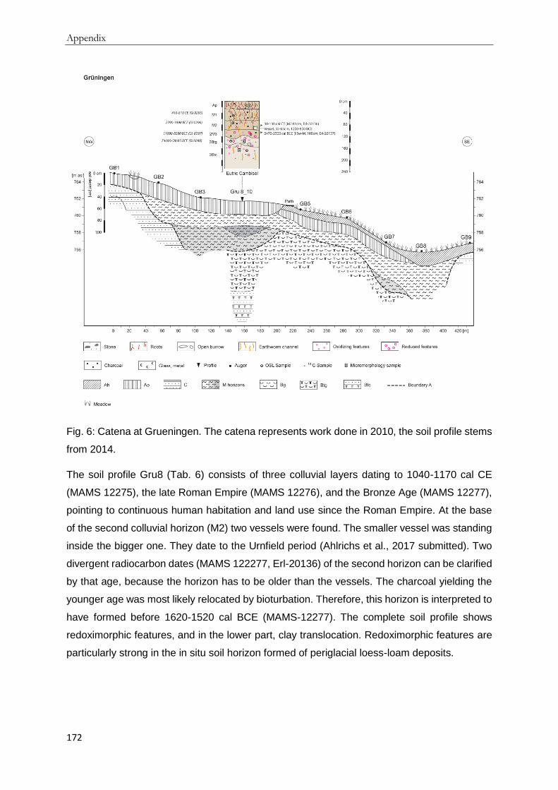
Appendix
172
Fig. 6: Catena at Grueningen. The catena represents work done in 2010, the soil profile stems
from 2014.
The soil profile Gru8 (Tab. 6) consists of three colluvial layers dating to 1040-1170 cal CE
(MAMS 12275), the late Roman Empire (MAMS 12276), and the Bronze Age (MAMS 12277),
pointing to continuous human habitation and land use since the Roman Empire. At the base
of the second colluvial horizon (M2) two vessels were found. The smaller vessel was standing
inside the bigger one. They date to the Urnfield period (Ahlrichs et al., 2017 submitted). Two
divergent radiocarbon dates (MAMS 122277, Erl-20136) of the second horizon can be clarified
by that age, because the horizon has to be older than the vessels. The charcoal yielding the
younger age was most likely relocated by bioturbation. Therefore, this horizon is interpreted to
have formed before 1620-1520 cal BCE (MAMS-12277). The complete soil profile shows
redoximorphic features, and in the lower part, clay translocation. Redoximorphic features are
particularly strong in the in situ soil horizon formed of periglacial loess-loam deposits.

Appendix
173
Tab. 6: Selected soil properties of Gru8_14 (left): Eutric Cambisol (Geoabruptic, Aric, Colluvic,
Endoloamic, Raptic, Siltic) and Gru9 (right): Endoskeletic Cambic Phaeozem (Anthric, Aric,
Pantoclayic, Colluvic, Raptic).
Horizon
lower boundary [cm]
Substrate genesis
SOC [%]
further properties
Horizon
lower boundary [cm]
Substrate genesis
SOC [%]
further properties
Ap 25 colluvial 1.23 Ah 10 colluvial 3.41
M1 65 colluvial 0.57
Ap 25 colluvial 2.83
M2 96 colluvial 0.37
M1 50 colluvial 1.75
2 M3 120 colluvial 0.33 redoximorphic features, Mg nodules
2 M2 85 colluvial 0.97 60% limestone
2 Btg 145 weathered 0.27 clay coatings, Mg nodules, redoximorphic features
3 M3 120 colluvial 0.84
2 CBt 210+ weathered 0.17 clay coatings, Mg nodules, redoximorphic features
4 M4 160 colluvial 1.10 40% limestone rich
5 M5 195 colluvial 0.63
6 Bw 210 weathered 0.36 20%
limestones 6 CBt 230+ weathered 0.56 60%
limestone, clay coatings
Another soil profile (Gru9, Tab. 6) is located in a depression about 800 m to the east. The
depression is filled with 2 m of organic matter-rich (1.3 % SOC) soil material. The profile
consists of five dark brown colluvial horizons, including alternating limestone-rich layers. A
radiocarbon age from 200 cm depth indicates the formation of the lowest colluvial horizon
during the middle Bronze Age (Erl-20135). The limestone-rich layers are not dated, but the
third colluvial horizon (3 M3) dates to the Roman Empire (Erl-20134) and the overlying first
(M1) to early Modern Times (Erl-20133). Along the boundary of the depression about 2 m thick
Luvisols were found. The surrounding catchment of the depression has a soil cover of about
20-30 cm thickness, with grassland used for hay.
4.2 Chronostratigraphy of colluvial deposits and archaeological finds
The AMS 14C and luminescence ages (Tab. 7, Tab. 8, Fig. 7) complement the archaeological
record (Tab. 1) of settlements and land use in the Baar area. Considering differences among
the Baar sites, the formation of colluvial deposits at Magdalenenberg and Fuerstenberg began
during the Neolithic. At Fuerstenberg, the deposition phases indicate land use in the younger
to final Neolithic, middle Bronze Age, Iron Age, Roman Empire, and the transition of late Middle

Appendix
174
Ages to the early Modern Period (Fig. 7). The Magdalenenberg site has a gap in the colluvial
stratigraphy from late Neolithic to high Middle Ages. In this case the excellent agreement of
radiocarbon and OSL ages (GI0131, Erl-20132 and GI0130, Erl.20131, GI0129) provides a
robust chronostratigraphy of the formation of colluvial deposits. The colluvial stratigraphy of
Grueningen starts with the Bronze Age, with no signal in the Iron Age. The deposition of
colluvial deposits at Spaichingen started in the Bronze Age and continued until the early
Modern Times.
Tab. 7: OSL ages of colluvial deposits on the Baar. Age refers to the year of dating, rounded
to 2010.
Lab code
Profile # Horizon Depth [cm]
De [Gy] Age [ka ± 1 σ]
b2k [a ± 1 σ]
BCE/CE
GI0129 Mag 1_14 M1 30 2.33 ± 0.11 0.59 ± 0.05 580 ± 50 1370 - 1470 CE
GI0130 Mag 1_14 M1 47 2.97 ± 0.14 0.77 ± 0.07 760 ± 70 1170 - 1310 CE
GI0131 Mag 1_14 M2 62 25 ± 1.5 6.1 ± 0.6 6090 ± 600 4690 - 3490 BCE
GI0132 Mag 1_14 M2 69 30.5 ± 1.5 8.2 ± 0.8 8190 ± 800 6990 - 5390 BCE
GI0133 Mag 1_14 2 M4 75 40.6 ± 2 11.8 ± 1.2 11790 ± 1200 10990 - 8590 BCE
GI0179 Fue 8 M1 48 1.17 ± 0.08 0.31 ± 0.03 300 ± 30 1670 - 1730 CE
GI0180 Fue 8 M2 75 3.38 ± 0.1 0.89 ± 0.09 880 ± 90 1030 - 1210 CE
GI0181 Fue 8 M3 100 6.56 ± 0.22 2 ± 0.2 1990 ± 200 190 BCE - 210 CE
GI0182 Fue 8 M4 115 8.57 ± 0.35 2.8 ± 0.2 2790 ± 200 990 - 590 BCE
GI0183 Fue 8 M5 135 20.1 ± 0.9 6.9 ± 0.6 6890 ± 600 5490 - 4290 BCE
GI0184 Fue 8 M6 162 22.3 ± 0.7 6.5 ± 0.7 6490 ± 700 5190 - 3790 BCE
GI0247 Fue 9 M4 125 15.71 ± 0.54 5.26 ± 0.42 5250 ± 420 3670 - 2830 BCE
GI0248 Fue 9 M6 155 21.35 ± 0.96 6.61 ± 0.62 6600 ± 620 5220 - 3980 BCE
GI0254 Spa 4 M1 43 2.51 ± 0.19 0.89 ± 0.09 880 ± 90 1030 - 1210 CE
GI0255 Spa 4 2 M2 74 3.56 ± 0.17 1.22 ± 0.12 1210 ± 120 670 - 910 CE
GI0256 Spa 4 3 M3 112 6.09 ± 0.32 1.96 ± 0.18 1950 ± 180 130 BCE - 230 CE
GI0257 Spa 4 3 M4 154 7.28 ± 0.3 2.27 ± 0.2 2260 ± 200 460 - 60 BCE
GI0258 Spa 4 3 M5 180 7.68 ± 0.42 2.32 ± 0.21 2310 ± 210 520 - 100 BCE
GI0259 Spa 4 3 M6 218 9.95 ± 0.73 3.1 ± 0.34 3090 ± 340 1430 - 750 BCE
GI0275 Spa 1 M2 49 1.29 ± 0.17 0.52 ± 0.08 510 ± 80 1410 - 1570 CE
GI0276 Spa 1 M3 77 2.39 ± 0.09 0.82 ± 0.07 810 ± 70 1120 - 1260 CE
GI0277 Spa 1 M4 119 3.18 ± 0.13 1.1 ± 0.1 1090 ± 100 810 - 1010 CE
GI0278 Spa 1 2 M5 150 5.8 ± 0.2 2.2 ± 0.2 2190 ± 200 390 BCE - 10 CE
GI0279 Spa 1 2 MBl 183 7.62 ± 0.27 2.6 ± 0.2 2590 ± 200 790 - 390 BCE
GI0295 Gru 8_14 M1 48 4 ± 0.3 1.4 ± 0.2 1390 ± 200 410 - 810 CE
GI0296 Gru 8_14 M2 72 13.48 ± 0.66 4.4 ± 0.4 4390 ± 400 2790 - 1990 BCE
GI0297 Gru 8_14 2 M3 110 34.8 ± 3.22 11.7 ± 1.4 11690 ± 1400 11090 - 8290 BCE
GI0298 Gru 8_14 2 Btg 133 192.57 ± 16.55
68.7 ± 8 68690 ± 8000 74690 - 58690 BCE

Appendix
175
Tab. 8: AMS 14C ages of charcoal fragments from colluvial deposits on the Baar. Uncalibrated
ages are given as BP [a before 1950] and 14aN [‰]: Fraction of modern carbon (F14C), incl.
normalization for d13C (Mook and van der Plicht, 1999; Reimer et al., 2004). Calibrated ages
are given with 1σ (and 2σ) and rounded to 10 yr. Calibration was done with OxCal 4.2. 2016
and IntCal13.
° = excluded date, dated soil organic matter; *= excluded date.
Lab code
Profile # Depth [cm]
Horizon 14aN [‰]
δ13C [‰]
BP [a ± error]
cal BCE/CE (1σ)
cal BCE/CE (2σ)
Median cal BP (1σ)
Erl-20138
Fue 3 110 2 MBrl2
-25.5 2443 ± 42
cal BCE 740-410
cal BCE 760-400
cal BCE 560
2690-2360
Erl-20139
Fue 4 80 M2
-26.7 310 ± 36
cal CE 1510-1650
cal CE 1470-1660
cal CE 1560
440-300
Erl-20271
Fue 4 85 M1
-24.5 384 ± 46
cal CE 1440-1620
cal CE 1430-1640
cal CE 1510
510-330
Erl-20140
Fue 4 95 M2
-24.8 293 ± 40
cal CE 1520-1650
cal CE 1470-1800
cal CE 1570
430-300
Erl-20272
Fue 4 70-80 M1
-27.5 311 ± 47
cal CE 1510-1650
cal CE 1460-1660
cal CE 1560
440-300
Erl-20144 °
Fue 8 100 M3
-25.3 2884 ± 36
cal BCE 1120-1000
cal BCE 1210-930
cal BCE 1060
3070-2950
Erl-20146 °
Fue 8 130 M5
-25.9 5105 ± 42
cal BCE 3970-3800
cal BCE 3980-3790
cal BCE 3870
5920-5750
Erl-20273
Fue 8 130-140
M4
-24.3 3369 ± 50
cal BCE 1750-1610
cal BCE 1870-1520
cal BCE 1660
3700-3560
Erl-20145 °
Fue 8 150-160
M6
-26.6 4417 ± 46
cal BCE 3270-2920
cal BCE 3340-2910
cal BCE 3060
5220-4870
Erl-20141 *
Fue 8 20-30 M1
-28.7 -562 ± 35
cal CE 1890-1910
cal CE 1890-1910
cal CE 1900
60-40
Erl-20142
Fue 8 50-60 M1-2
-23.9 325 ± 36
cal CE 1510-1640
cal CE 1470-1650
cal CE 1560
440-310
Erl-20143
Fue 8 75-80 M2
-25.2 627 ± 34
cal CE 1290-1400
cal CE 1280-1400
cal CE 1350
660-550
Erl-20276
Fue 9 90 M2
-25.6 4557 ± 67
cal BCE 3490-3100
cal BCE 3520-3020
cal BCE 3240
5440-5050
Erl-20277
Fue 9 115 M3
-25 4477 ± 58
cal BCE 3340-3030
cal BCE 3360-2930
cal BCE 3190
5290-4980
Erl-20278
Fue 9 135 M4
-27.7 6526 ± 66
cal BCE 5560-5380
cal BCE 5620-5360
cal BCE 5490
7510-7330
Erl-20280 *
Fue 9 195 2 Bwg
-25.7 10879 ± 92
cal BCE 10900-10740
cal BCE 11050-10710
cal BCE 10830
12850-12690

Appendix
176
Erl-20279
Fue 9 150-170
M6
-25.5 7129 ± 67
cal BCE 6070-5920
cal BCE 6210-5840
cal BCE 6010
8020-7860
Erl-20275
Fue 9 60-70 M1
-25.3 3918 ± 61
cal BCE 2480-2290
cal BCE 2580-2200
cal BCE 2400
4430-4240
Erl-20147
Fue 10 85 M2
-25.3 655 ± 37
cal CE 1280-1390
cal CE 1270-1400
cal CE 1340
670-560
Erl-20274
Fue 10 87 M2
-27 1622 ± 158
cal CE 250-590
cal CE 50-690
cal CE 410
1700-1360
Erl-20149 °
Fue 10 127 Ahb2
-25 3855 ± 37
cal BCE 2460-2210
cal BCE 2470-2200
cal BCE 2330
4410-4160
Erl-20148 °
Fue 10 95-100
Ahb1
-27.9 2581 ± 36
cal BCE 810-760
cal BCE 820-550
cal BCE 780
2760-2710
Erl-20281
Fue 11 27 M1
-24.9 782 ± 61
cal 1290 cal CE 1040-1390
cal CE 1230
760-660
Erl-20282
Fue 11 65 M2
-25.5 382 ± 48
cal CE 1440-1630
cal CE 1440-1640
cal CE 1520
510-320
P 13415
Gei 2 88 2 MBg2 0.697 ± 0.005
2899 ± 39
cal BCE 1200-1000
cal BCE 1260-920
cal BCE 1090
3150-2950
P 13418
Gei 2 144 3 MBg 0.603 ± 0.003
4070 ± 26
cal BCE 2840-2490
cal BCE 2860-2480
cal BCE 2620
4790-4440
Erl-20270 *
Gru 9 30 M1
-24.6 231 ± 45
cal CE 1630-...
cal CE 1510-...
cal CE 1730
320-...
Erl-20133
Gru 9 35 M1
-23.2 291 ± 32
cal CE 1520-1660
cal CE 1490-1670
cal CE 1570
430-290
Erl-20134
Gru 9 90 M3
-22.6 1950 ± 34
cal CE 1-90
cal BCE 40-cal CE 130
cal CE 50
1950-1860
Erl-20135
Gru 9 200 M6
-24.1 3251 ± 37
cal BCE 1610-1460
cal BCE 1620-1440
cal BCE 1530
3560-3410
MAMS 12275
Gru 8_10 40 M1
-18,7 909 ± 21
cal CE 1040-1170
cal CE 1030-1190
cal CE 1100
910-780
MAMS 12276
Gru 8_10 50 M2
-20,6 1569 ± 21
cal CE 420-540
cal CE 420-550
cal CE 480
1530-1410
MAMS 12277
Gru 8_10 72 2 M3
-23,7 3283 ± 25
cal BCE 1620-1520
CE 1190-cal BCE 1620-1500
cal BCE 1560
3560-3470
MAMS 12281 °
Gru 8_10 80-85 2 M3
-33.5 4061 ± 38
cal BCE 2840-2490
cal BCE 2860-2470
cal BCE 2600
4790-4440
Erl-20136
Gru 8_14 83 M2
-24.8 1918 ± 38
cal CE 30-130
cal CE 1-220
cal CE 90
1920-1820
Erl-20137
Gru 8_14 105 2 M3
-23.5 3889 ± 40
cal BCE 2470-2300
cal BCE 2480-2210
cal BCE 2380
4410-4250
Poz-36957
Mag 2 70 ?
705 ± 30
cal CE 1260-1300
cal CE 1250-1390
cal CE 1280
690-650

Appendix
177
Poz-36958
Mag 3 50 ?
795 ± 30
cal CE 1220-1270
cal CE 1180-1280
cal CE 1240
730-680
Poz-36971 °
Mag 5 ? ?
295 ± 30
cal CE 1520-1650
cal CE 1490-1660
cal CE 1570
430-300
Poz-36972 °
Mag 6 ? ?
70 ± 35 cal CE 1690-1920
cal CE 1680-1930
cal CE 1850
260-30
Erl-20268 *
Mag 11 45 M1
-29.7 356 ± 975
cal CE 640-...
cal BCE 900-...
cal CE 1070
1310-...
Erl-20269 *
Mag 11 55 M2
-21.7 213 ± 53
cal CE 1640-...
cal CE 1520-...
cal CE 1760
310-...
Poz-36952
Mag 1_10 34 M1
635 ± 30
cal CE 1290-1390
cal CE 1280-1400
cal CE 1350
660-560
Poz-36953
Mag 1_10 49 M1
905 ± 30
cal CE 1040-1170
cal CE 1030-1210
cal CE 1110
910-780
Poz-36954
Mag 1_10 65 M2
4970 ± 40
cal BCE 3800-3690
cal BCE 3930-3650
cal BCE 3750
5740-5640
Poz-36955 °
Mag 1_10 ? ?
1080 ± 30
cal CE 900-1000
cal CE 890-1020
cal CE 970
1050-950
Poz-36956 °
Mag 1_10 ? ?
2170 ± 30
cal BCE 360-170
cal BCE 360-110
cal BCE 260
2310-2120
Erl-20131
Mag 1_14 25 M1
-25 746 ± 33
cal CE 1250-1290
cal CE 1220-1300
cal CE 1270
700-660
Erl-20132
Mag 1_14 75 2 M4
-25.2 5071 ± 51
cal BCE 3950-3800
cal BCE 3980-3710
cal BCE 3870
5900-5740
P 12875
Spa 1 80 M3 0.735 ± 0.003
2470 ± 22
cal BCE 760-530
cal BCE 770-430
cal BCE 630
2710-2480
P 12876
Spa 1 115 M3 0.646 ± 0.003
3510 ± 20
cal BCE 1890-1770
cal BCE 1930-1740
cal BCE 1830
3840-3720
P 12877
Spa 1 148 M5 0.652 ± 0.002
3437 ± 18
cal BCE 1860-1690
cal BCE 1880-1660
cal BCE 1740
3810-3630
P 12878
Spa 1 185 2 MBl 0.534 ± 0.002
5040 ± 18
cal BCE 3950-3780
cal BCE 3960-3710
cal BCE 3870
5890-5730
P 12879 *
Spa 4 112 3 M3 0.599 ± 0.002
4122 ± 19
cal BCE 2860-2620
cal BCE 2870-2570
cal BCE 2710
4810-4570
Beta-437969
Spa 4 120 3 M3 0.737 ± 0.003
-27 2450 ± 30
cal BCE 750-430
cal BCE 760-410
cal BCE 580
2700-2370
P 13413
Spa 4 120 3 M3 0.724 ± 0.004
2592 ± 31
cal BCE 820-670
cal BCE 840-540
cal BCE 780
2770-2620
P 12880 *
Spa 4 127 3 M3 0.631 ± 0.002
3696 ± 18
cal BCE 2140-2030
cal BCE 2200-1980
cal BCE 2090
4090-3980

Appendix
178
P 12881 *
Spa 4 155 3 M4 0.585 ± 0.002
4307 ± 18
cal BCE 2930-2880
cal BCE 3020-2880
cal BCE 2910
4880-4830
Beta-437970
Spa 4 176 3 M5 0.739 ± 0.003
-23.3 2430 ± 30
cal BCE 730-410
cal BCE 750-400
cal BCE 510
2680-2360
P 12882 *
Spa 4 184 3 M5 0.551 ± 0.002
4791 ± 19
cal BCE 3640-3530
cal BCE 3650-3510
cal BCE 3570
5590-5470
P 12883 *
Spa 4 218 3 M6 0.496 ± 0.002
5631 ± 18
cal BCE 4510-4370
cal BCE 4540-4360
cal BCE 4460
6460-6320
P 12884 *
Spa 4 232 3 M6 0.535 ± 0.002
5032 ± 17
cal BCE 3940-3770
cal BCE 3950-3710
cal BCE 3860
5890-5720
The archaeological record of land use and settlements starts with Mesolithic finds at the
Magdalenenberg site (Schmid, 1991, 1992). Neolithic artifacts were found at Magdalenenberg,
Spaichingen and Fuerstenberg (Nübling, 1990; Schmid, 1991, 1992). Datings from these three
sites yield a better chronological differentiation of time periods with intense land use than the
discovered archaeological finds do. There is no archaeological evidence for human presence
at the study sites during the early Bronze Age. In Grueningen, colluviation occurred earlier
than known from the archaeological findings, indicating human presence as early as the middle
Bronze Age. Many archaeological sites, including the Magdalenenberg, the largest burial
mound in central Europe from 616 BCE (Knopf et al., 2015; Knopf and Seidensticker, 2013;
Spindler, 2004), are known in the western Baar, but, no colluvial deposits date to the Hallstatt
period. Colluviation dating to the Hallstatt period took place only in the eastern and southern
Baar. Radiocarbon ages from Grueningen point to land use from the Roman Empire onwards.
Samples dating to the Middle Ages correlate well with historical records. The town of Villingen,
next to the Magdalenenberg site, was first mentioned in the written record around 800 CE
(Jenisch et al., 1999). The town of Fuerstenberg existed on the plateau above the slopes
studied here from at least 1175 until 1841 CE (Wagner, 2014). The AMS 14C dates of charcoal
samples from Grueningen can also be correlated with historical records of the nearby village
of Grueningen, which according to historical records existed from 1139 CE onwards (Badische
Historische Kommission, 1904b). Dates from Spaichingen also agree with known
archaeological sites (Buchta-Hohm, 1996; Paret, 1932; Stoll and Gehring, 1938).
The summed probability density (SPD) curves show peaks along a time axis of increased
probability of dates from a specific time (Fig. 8). These dates are interpreted as being
connected to colluviation. The peaks of the SPD curve of OSL ages decrease and widen with
older ages, because of their wider error estimates. The OSL SPD shows an increase of dates
in the middle to younger Neolithic in samples from the Magdalenenberg and Fuerstenberg site.
The following peak around 500 CE comprises dates from Fuerstenberg and Spaichingen. This

Appendix
179
peak is higher and narrower than the preceding ones. The pronounced depression falls in the
Migration and Merovingian period. Increased probability in the high and late Middle Ages is
evident at all sites except Grueningen). Radiocarbon dates result in narrower and therefore
higher SPD peaks. The oldest peak dates to the late Mesolithic at the Fuerstenberg. There are
several pronounced individual peaks from the late Neolithic onwards, and they originate from
the samples at Fuerstenberg, Grueningen and Spaichingen. The Magdalenenberg dates
appear only in the younger Neolithic and the high-to-late Middle Ages. The increased
probability of dates in the Middle Ages counts for all of the sites except Spaichingen, where
only older charcoal was found.
Fig. 7: AMS 14C and OSL ages of colluvial deposits across the Baar compared to known
archaeological finds at each site from the Mesolithic to Middle Ages.
.

Appendix
180
Fig. 8: Summed probability density (SPD) curves of ages from anthropogenic soil-erosion
derived colluvial deposits. Grey line: OSL data (n=28), black line: AMS14C data (n=41).
5 Discussion
5.1 Main phases of formation of colluvial deposits across the Baar
Colluvial deposits present a high resolution spatial archive of the land use history of the area
upslope, from which the material was eroded (Bettis, 2003; Emadodin et al., 2011; Leopold
and Völkel, 2007a). The application of the catena concept at several sites provides 13
representative, well-stratified soil profiles for dating and further analysis.
Intensive land use seems to have started in the south and northwest of the Baar, since the
oldest colluvial ages stem from the sites at Fuerstenberg and Magdalenenberg (Fig. 7, Tab. 7,
Tab. 8). Based on a uniformitarian perspective, assuming that general climate differences
within the region did not change during the Holocene, the earlier onset of permanent land use
(most likely agriculture) might be explained by higher temperatures and fewer frost days
compared to other parts of the Baar.
Summing up the SPDs of radiocarbon and luminescence ages, seven main phases of
increased probability of colluviation can be differentiated as distinct maxima from several

Appendix
181
secondary peaks with lower probability (Fig. 9). The oldest peak dates to around 3800 cal BCE,
i.e. the younger Neolithic (1), and is followed by smaller peaks of increased probability for
colluvial formation during the late Neolithic to early Bronze Age. Temporary sediment sinks on
slopes can accumulate colluvial deposit for a certain time before the material is eroded and
transported further downslope, thereby resetting the physical signal for OSL dating which
results in a younger age. This is known as the cascade model of colluvial formation, which
might be an explanation for the minimal available information about Neolithic colluvial deposits
(Lang and Hönscheidt, 1999). Increased colluviation is calculated for the middle Bronze Age
(2) and Latène Period (3). The main deposition phase (4) around 100 CE is connected to the
Romans and their land use. The following Migration period shows decreased colluviation. From
the high Middle Ages onwards the probability of colluvia formation is doubled. Colluviation
increases even more to the end of the high Middle Ages (5) and around 1300 (6) and 1600 cal
CE (7).
In southern Baden, west of the Black Forest, Mäckel et al. (2002) found a similar colluviation
sequence. During the early and middle Bronze Age, colluviation increased, which might be
explained by a major increase in the area of open land during the transition from the Neolithic
to the Bronze Age (Mäckel et al., 2003). This is in accordance with the presented SPD curve
showing increasing colluviation in the Bronze Age. The increased colluviation can be
interpreted as increased land use intensity, which often starts with deforestation. The phase of
higher colluviation is followed by a decrease and a subsequent increase until Roman times.
During the Migration period little colluviation occurred. Colluviation increases again from the
Middle Ages to Modern Times.
A study from southern Germany, including the Baar, used 60 OSL ages and found three
phases of increased soil erosion derived colluviation (Lang, 2003). These phases are in the
Latène Period (2.1 ka) and the high Middle Ages (1.2 ka and 0.9 ka). Further minor peaks
occur in the Urnfield Period, the final Neolithic and the early to middle Neolithic. The
comparison shows that the increased colluviation probability in loess hills is different from the
probability presented in this study. This might be explained by different land use dynamics with
time and the properties of the soils. Hoffmann et al. (2008) studied phases of increased
geomorphic stability and activity of different sediments in Germany and came up with phases
of increased relative probability for geomorphologic activity dating to exactly the same time
periods as the colluviation phases on the Baar.
5.2 Possible causes for the main phases of colluviation
Precipitation, topography, vegetative cover, plant species, and soil properties determine the
general likelihood of soil erosion, but the most important factor is land use as influenced by
and interacting with the above environmental aspects. Important elements of agrarian land use

Appendix
182
are tillage, field size and crop rotation (c.f. Bork, 1989); further human impact originates from
deforestation for hunting, grazing, building of infrastructure, mining, or charcoal production.
The characteristics and ages of several colluvial deposits point to varying land use patterns
since the Neolithic. At the Fuerstenberg and Magdalenenberg sites, the colluvial signal starts
with the Neolithic, whereas in Spaichingen and Grueningen the oldest ages point to a human
influence from the Bronze Age onwards. The type of land use cannot be determined from the
occurrence of colluvial deposits alone, but it seems most likely that is was agrarian land use
after deforestation, since there is no evidence of other land use activities like deforestation for
hunting, grazing, building of infrastructure, mining, or charcoal production. The colluvial
deposits contain only some ceramic sherds and charcoal pieces are not layered, but occur
randomly distributed within soil horizons. This points to the sites being used for agriculture
rather than as a settlement area (Häbich, 2009). The widely spread multilayered thick colluvial
deposits containing only a few artifacts/ceramics, cannot be explained without invoking the
presence and activity of humans increasing soil erosion. The simple differentiation between
natural and anthropogenic processes causing colluviation based on the absence or presence
of artifacts (Mäckel et al., 2003) cannot be adopted here.
A helpful concept is the boundary A by Edgeworth et al. (2015), which separates the natural
ground surface from the human-modified soil profile or sediment stratigraphy. The boundary A
in the soil profiles of the Baar region marks the transition between in situ soil with little or no
human influence and the colluvial deposits (Fig. 2 to Fig. 6). Thus it gives an impression of the
paleorelief, not considering later soil erosion of the colluvial material. It also illustrates the
dimensions of the formative forces of humans on the landscape.
To illustrate the discussion of the potential causes of the identified seven main phases of
colluvial deposition we compiled the key information in Figure 9.
The oldest main colluviation phase (1) falls in a wetter and colder period of the younger
Neolithic (Haas et al., 1998; Jäger, 2002; Negendank, 2004). Therefore, the peak indicating
higher colluvial deposition can be explained by higher erosion due to higher precipitation. 14C
production rates point to variable solar activity reaching a local minimum during that time.
Lower 14C production rates are often correlated with colder temperatures and higher amounts
of ice raft debris in the northern hemisphere (Engels and van Geel, 2012; Kromer and Friedrich,
2007). Despite some reconstructions pointing to colder climate, alpine and continental glaciers
did not advance (Koch and Clague, 2006). Climate reconstruction from the NGRIP GICC05
shows no clear pattern of δ 18O during that time (NGRIP Members, 2004). Nevertheless,
despite the above mentioned factors, the onset of sedentism and agriculture seems to be the
most likely trigger for colluviation. The first evidence of agriculture in the region stems from
cereal pollen from the late Atlantic period (about 4850-3150 cal BCE). These cereal pollen
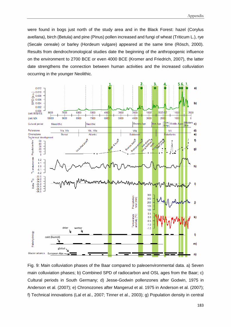
Appendix
183
were found in bogs just north of the study area and in the Black Forest: hazel (Corylus
avellana), birch (Betula) and pine (Pinus) pollen increased and fungi of wheat (Triticum L.), rye
(Secale cereale) or barley (Hordeum vulgare) appeared at the same time (Rösch, 2000).
Results from dendrochronological studies date the beginning of the anthropogenic influence
on the environment to 2700 BCE or even 4000 BCE (Kromer and Friedrich, 2007), the latter
date strengthens the connection between human activities and the increased colluviation
occurring in the younger Neolithic.
Fig. 9: Main colluviation phases of the Baar compared to paleoenvironmental data. a) Seven
main colluviation phases; b) Combined SPD of radiocarbon and OSL ages from the Baar; c)
Cultural periods in South Germany; d) Jesse-Godwin pollenzones after Godwin, 1975 in
Anderson et al. (2007); e) Chronozones after Mangerud et al. 1975 in Anderson et al. (2007);
f) Technical innovations (Lal et al., 2007; Tinner et al., 2003); g) Population density in central

Appendix
184
Europe (Henning, 1994; Zimmermann, 1996); h) Anomalies of atmospheric 14C production
rates compared to the mean (Kromer and Friedrich, 2007); i) δ 18 O [‰] record from NGRIP1,
100 year means compared to the mean of all δ 18 O values (GICC05, NGRIP Members, 2004;
Vinther et al., 2006); j) Tree ring based reconstruction of precipitation from April to June in
central Europe with respect to the 1901-2001 period (dashed line), 50 year means of yearly
data (Büntgen et al., 2011); k) Tree ring based reconstruction of summer (June-August)
temperature anomalies in central Europe with respect to 1990-2000, 50 year means of yearly
data (Büntgen et al., 2011); l) Wet phases in central Europe (Jäger, 2002); m) Cold and humid
phases in central Europe until 2000 BP (Haas et al., 1998); n) Glacial fluctuations during the
Holocene (Koch and Clague, 2006).
The second main depositional phase (2) from the early to middle Bronze Age falls in the final
phase of a cold and humid period (Haas et al., 1998; Negendank, 2004; Schönwiese, 1995).
Lake levels were low (Magny et al., 2003) and glaciers advanced in the European Alps (Koch
and Clague, 2006). The advance of glaciers can be taken as an indicator for longer cold and
wet periods. The 14C production rates show an indifferent to positive trend during the time
period (Kromer and Friedrich, 2007). This supports a climate change to a warmer and drier
state. Population density was still very low and may not have had an influence on colluviation
during this period, but the development of ards, bronze tools, and pulled plows seem to
increase the sensitivity of soils at gentle rolling hills to erosion and colluvial deposition (Lal et
al., 2007; Teuber et al., 2016; Tinner et al., 2003). This development in agricultural techniques
may have intensified the formation of colluvial deposits. This phase of increased colluviation
ends with the beginning of a dry period around 1400 CE (Haas et al., 1998; Jäger, 2002;
Schönwiese, 1995). The luminescence ages clearly point to an increased base level of
colluviation from that period onwards (approx. 1000 BCE-250 CE).
The increased probability of colluviation during the Iron Age (3) results from the data of the
eastern and southern Baar and falls in a cold and humid phase (Haas et al., 1998; Jäger, 2002;
Schönwiese, 1995) with decreasing land use intensity (Dotterweich, 2008), advancing Swiss
glaciers (Glaser et al., 2005; Koch and Clague, 2006), low 14C production rates (Kromer and
Friedrich, 2007) and δ 18O levels (NGRIP Members, 2004). Climate reconstruction from pollen
points to a strong decrease of summer temperatures during that phase, but also lower summer
precipitation (Büntgen et al., 2011). This rather unfavorable climate might have resulted in the
formation of spatially different intensities of colluvial deposit development. During the Iron Age,
smelting of iron ore may have been a likely land use consuming much wood or charcoal, if
mined and refined in the region. This technology would have been used in kilns at local spots,
rather than on a wider landscape, leading to deforestation but not necessarily to charcoal
deposition in soils. Dotterweich (2008) assumes lower percentages of fields and grasslands

Appendix
185
compared to woodlands and forests during that time, which could strengthen the idea of
naturally occurring small forest fires or deforestation for smelting as a source of the few
charcoals in the western Baar. Colluviation seems to have taken place in Spaichingen in
particular and marginally in Fuerstenberg, but no Iron Age datings could be obtained from the
western Baar so far.
The colluviation phase (4) during the Roman Empire (around 100 CE) is also reported in other
studies and areas (James et al., 2014; van der Leeuw and The ARCHAEOMEDES research
team, 2005). This is the only phase falling into a rather dry and warm period, the so called
Roman optimum (Büntgen et al., 2011; Haas et al., 1998; Schönwiese, 1995). The increased
probability of colluviation can be correlated with Roman progress in agricultural techniques,
improving settlement infrastructure (van der Leeuw and The ARCHAEOMEDES research
team, 2005), increasing population (Zimmermann, 1996), the use of limestone to make
cement, and higher land use intensity (Dotterweich, 2008; Jäger, 1994). Contradictory to a
warming climate, Jäger (2002) reconstructed a wet phase, and Koch and Clague (2006)
suggested glacier advance in the European Alps. Those differences might be due to local
climatic phenomena. The following climate pessimum and the decline of population density
during Migration time (Zimmermann, 1996) led to decreased colluviation across the Baar.
A minor peak of increased colluviation in the Merovingian Period is coeval with the population
density peak, which is otherwise not clearly mirrored in the colluvial stratigraphy. Zimmermann
(1996) offers corrections to population density for that time, which could point to a wide range
of population density across the area, leading to large differences on a small spatial scale. This
might support the observation that the highest population density (up to that time) only led to
a minor increase of colluviation (around 600 CE) at the investigated sites.
Toward the end of the high Middle Ages (5) colluviation increased strongly and led to a doubled
probability of the formation of colluvia from then onwards, which agrees with elevated
population density (Zimmermann, 1996) and increased soil erosion (Bork, 1989). Human
influence during the Medieval Climate Optimum in the high Middle Ages is visible in the OSL
SPD and also in the vegetation record. Near the Magdalenenberg site, walnut (Juglans regia)
remains and pollen were found (Rösch, 1999), which indicate relatively high temperatures or
possibly trade connections to a region, where walnut trees grew naturally.
Heavy rainfall events and intensive land use for agriculture are supposed to have been the
main triggers for soil erosion and formation of colluvial deposits around 1300 CE in central
Europe (Bork, 1998; Dotterweich, 2008; Dotterweich and Dreibrodt, 2011), when additionally,
the area of arable land reached a local high (James, 2013; Lang et al., 2003). Catastrophic
events (e.g. heavy rainfall and flooding, drought, war, epidemic diseases) seem to have had a
major shaping impact on landscapes (Dotterweich and Dreibrodt, 2011). Precipitation

Appendix
186
reconstruction shows an increase (Büntgen et al., 2011; Jäger, 2002) and temperatures
reconstructed from trees dropped (Büntgen et al., 2011). 14C production rates increase from
the high Middle Ages to the Modern Era (Kromer and Friedrich, 2007), but that is hardly
reflected in climate parameters. Only about 100 years later in the late Middle Ages, the area
covered by forests reached a local peak, but forest was then continuously reduced in favor of
agricultural land (Dotterweich, 2008; Jäger, 1994; James, 2013). From the Middle Ages
onwards, continuous agricultural land use can be shown through pollen analysis; mainly rye
(Secale cereale), wheat (Triticum aestivum), spelt (Triticum spelta), and hemp (Cannabis
sativa) were grown across the Baar (Sudhaus, 2005).
Increased probable colluviation around 1300 cal CE (6) and 1600 cal CE (7) follows increasing
and rapidly declining population density (Henning, 1994). Human population declines in the
cold and wet period of the beginning of and later during the pronounced Little Ice Age (Jäger,
2002; Schönwiese, 1995) with advancing glaciers in the Alps (Glaser et al., 2005; Koch and
Clague, 2006) and high lake levels (Magny et al., 2003). But despite the unfavorable climatic
conditions, agricultural land use (fields and grassland) reached a peak in the late Middle Ages
(Dotterweich, 2008; Jäger, 1994). The increased colluviation might be explained by the need
for further intensification of land use and increasing plowing depth for higher yields (Benecke
et al., 2003; Dreibrodt et al., 2010a; Lang and Hönscheidt, 1999). This shows that
environmental factors as triggers for soil erosion and the formation of colluvial deposits became
less important. Human presence and agricultural techniques become more and more important
and progressively control slope processes (Hoffmann et al., 2008; Hudson et al., 2015; Kaplan
et al., 2009; Verstraeten et al., 2009; Zolitschka et al., 2003).
6 Synthesis
Colder humid phases, in general, seem to be correlated with higher accumulation of colluvial
material. In the southern and western Baar the oldest colluvial deposits date to the beginning
of the Neolithic. In the eastern Baar and on top of a plateau, human influence is detectable
from the Bronze Age onward. SPDs show main depositional phases for the Baar region in the
younger Neolithic, the early to middle Bronze Age, the Iron Age, Roman Empire and from the
high Middle Ages onwards. But colluviation is not a linear process, but is based on erosion and
intermediate storage of soil material on slopes (Fuchs and Lang, 2009), so that the main
deposition times found here have to be seen as an approximation of periods with increased
human activities. We demonstrated that a number of variables, particularly climate, population
density, and land use control soil erosion and accumulation from the Neolithic to Iron Age.
During that time, reconstructions of climate parameters point to climate being the main
controlling factor and population density and land use being indirect factors.

Appendix
187
From the Roman Period onward, human activities are the main drivers of soil erosion and thus
for the formation of colluvial deposits. The sensitivity of landscapes to erosion is mainly
controlled by land use, since land use disturbs the vegetation cover and loosens the soil,
thereby making soils, especially on slopes, prone to soil erosion. Climate and population
pressure are indirect factors forcing changes in the intensity and kind of land use (Lang, 2003;
Zolitschka, 2002; Zolitschka et al., 2003). In this context rainfall finally triggers soil erosion.
Therefore the formation of colluvial deposits can be seen as a pseudo-natural (Häbich, 2009)
or quasi-natural process (Rathjens, 1979) because it results from anthropogenic actions, but
the process itself is natural.
7 Conclusions
Analyzing multilayered colluvial deposits in the vicinity of archaeological finds adds human
activities and their influence on landscapes to the reconstruction of geomorphodynamic
(un)stable periods. Phases of geomorphodynamic instability can be correlated with the phases
of formation of colluvial deposits. We conclude that colluvial deposits can be used as a local
proxy with a high spatial resolution regarding land use. However, to go from a local to a more
general signal for a region a comparative evaluation of the local colluvial information is
necessary to extrapolate colluvial deposition phases, possible driving forces, and human
activities to a broader region. Thus, based on the colluvial chronostratigraphy of the four
investigated sites on the Baar and including archaeological and paleoenvironmental
information the general land use history of the Baar can be reconstructed.
Archaeopedological analyses of 26 soil profiles (with 130 colluvial layers) including 69 OSL
and AMS 14C ages of sediments and charcoal fragments demonstrated that colluvial deposits,
in combination with other archaeological and environmental data, can be used as a regional
proxy for inferring land use on the Baar. The main findings lead to the following conclusions:
• Multilayered colluvial deposits can be found even at upper slope and mid-slope
positions, caused by the unknown palaeorelief and the site-specific land use history.
• Pedological and chronological data create a more accurate picture of past human
activities, and they complement archaeological knowledge about settlements and
human activities in a region.
• Main depositional phases are reconstructed from site specific pedo- and
chronostratigraphies. In the southern and western area of the Baar the formative
element of human activities on landscapes started with the beginning of the Neolithic.
In the eastern Baar and on a plateau in the western Baar, human influence is detectable
particularly from the Bronze Age onward.
Appendix
188
• SPDs show main depositional phases for the Baar region in the younger Neolithic, the
early to middle Bronze Age, the Iron Age, the Roman Empire, and from the high and
late Middle Ages onwards. This points to land use change and more intense land use
on the Baar in different time periods.
• The increased colluviation probability of the Baar region is different to the probability of
gentle rolling loess regions. This might be explained by different land use dynamics
with time and soil material and different paleoenvironmental conditions.
• The correlation of SPDs with other environmental variables, like paleoclimate, shows
that most phases of intensified colluviation occur in periods with higher precipitation
and lower temperatures.
• Additionally, colluviation seems to follow population density, as shown for the Roman
Empire and the Migration periods. This points to a coupled influence of climate and
humans controlling colluviation, at least from the Romans onward when population
reached a certain threshold.
• Colluvial deposits do not indicate the activity of foraging societies, since colluviation
needs time and intense land use to manifest human activity. The onset of colluviation
in the Neolithic fortifies the early anthropogenic hypothesis and the influence of human
induced land use change on soil erosion and accumulation and thereby landscape
change.
Our results show that the integrated application of archaeological, pedological, and
paleoenvironmental analyses and knowledge, i.e. archaeopedology, helps to get a better
understanding of regional land use patterns in time and space. Regional archaeopedological
analyses display the human potential to change and modify landscapes, and demonstrate this
as early as prehistoric times.
Author contribution
Jessica Henkner, Peter Kühn, Thomas Scholten, Thomas Knopf and Jan Ahlrichs designed
the study and JH carried it out. JH prepared the manuscript with contributions from all co-
authors. Markus Fuchs was responsible for OSL dating. Sean Downey contributed the script
to calculate the SPDs and helped with the interpretation. Bruce James and Sandra Teuber
contributed particularly to the interpretation and discussion of the results.
Acknowledgements
This study is part of the Collaborative Research Center 1070 ResourceCultures (SFB1070)
financed by the German Research Foundation (DFG). The study was also supported by the

Appendix
189
Graduate School of the University of Maryland, College Park and the Institutional Strategy of
the University of Tübingen (DFG, ZUK 63).
We are grateful to many student helpers and technical assistants from the Tübingen University,
who worked in the field and the lab, especially Christoph Behnke, Dominik Birkenmaier and
Rita Mögenburg. We are especially grateful to Kurt Rilling and Michael Kösel from the
Landesamt für Geologie, Rohstoffe und Bergbau for great input and discussions in the field.
The many farmers, who supported our work by allowing us to work on their land, are
acknowledged. Thanks to Dr. Einar Eberhardt for support with the translation of KA5
classification to WRB and FAO. Thanks go to Richard Szydlak, who drew the catenas after
drafts by JH. Johanna Lomax and Andrea Junge (all Justus-Liebig-University Gießen)
supported the luminescence dating. Thanks to Barret Wessel, who made useful comments on
the manuscript. We also thank two unknown reviewers for their helpful comments and
suggestions.
References
Ad-hoc-AG Boden (Ed.), 2005. Bodenkundliche Kartieranleitung. KA5, 5., verb. und erw. Aufl.
ed. Schweizerbart, Stuttgart, 438 S.
Ahlrichs, J., Henkner, J., Schmidt, K., Scholten, T., Kühn, P., Knopf, T., 2017 submitted.
Bronzezeitliche Siedlungsdynamiken zwischen der Baar und angrenzenden Naturräumen, in:
Transporte, Transportwege und Transportstrukturen. Jahressitzung der Arbeitsgemeinschaft
Bronzezeit, Tübingen. 30.-31. Oktober 2015, Tübingen.
Ament, H., 1977. Zur archäologischen Periodisierung der Merowingerzeit. Germania 55, 133–
140.
Badische Historische Kommission (Ed.), 1904a. Topographisches Wörterbuch des
Großherzogtums Baden: Band 1. Carl Winter's Universitätsbuchhandlung, Heidelberg.
Badische Historische Kommission (Ed.), 1904b. Topographisches Wörterbuch des
Großherzogtums Baden: Band 2, Heidelberg.
Benecke, N., Donat, P., Gringmuth-Dallmer, E., Willerding, U. (Eds.), 2003. Frühgeschichte
der Landwirtschaft in Deutschland. Beier & Beran. Archäologische Fachliteratur,
Langenweissbach.
Bettis, E.A., 2003. Patterns in Holocene colluvium and alluvial fans across the prairie-forest
transition in the midcontinent USA. Geoarchaeology 18 (7), 779–797. doi:10.1002/gea.10087.
Blume, H.-P., Brümmer, G.W., Horn, R., Kandeler, E., Kögel-Knabner, I., Kretzschmar, R.,
Stahr, K., Wilke, B.-M., 2010. Scheffer/Schachtschabel. Lehrbuch der Bodenkunde, 16. Aufl
ed. Spektrum, Akad. Verl., Heidelberg, Berlin, XIV, 569 S.
Bocquet-Appel, J.-P., 2011. When the world's population took off: the springboard of the
Neolithic Demographic Transition. Science (New York, N.Y.) 333 (6042), 560–561.
doi:10.1126/science.1208880.

Appendix
190
Bork, H.-R., 1989. Soil erosion during the past millennium in Central Europe and its
significance within the geomorphodynamics of the Holocene, in: Ahnert, F. (Ed.), Landforms
and Landform Evolution in West Germany, Frankfurt a. M., pp. 121–131.
Bork, H.-R., 1998. Landschaftsentwicklung in Mitteleuropa: Wirkungen des Menschen auf
Landschaften, 1. Aufl. ed. Klett-Perthes, Gotha [u.a.], 328 S.
Bork, H.-R., 2006. Landschaften der Erde unter dem Einfluss des Menschen.
Wissenschaftliche Buchgesellschaft, Darmstadt, 207 S.
Bronk Ramsey, C., 2009. Bayesian Analysis of Radiocarbon Dates. Radiocarbon 51 (01), 337–
360. doi:10.1017/S0033822200033865.
Buchta-Hohm, S., 1996. Das alamannische Gräberfeld von Donaueschingen: Schwarzwald-
Baar-Kreis. Theiss, Stuttgart, 67 pp.
Büntgen, U., Tegel, W., Nicolussi, K., McCormick, M., Frank, D.C., Trouet, V., Kaplan, J.O.,
Herzig, F., Heussner, K.-U., Wanner, H., Luterbacher, J., Esper, J., 2011. 2500 years of
European climate variability and human susceptibility. Science 331 (6017), 578–582.
Christ, K., 1960. Antike Münzfunde Südwestdeutschlands: Münzfunde, Geldwirtschaft und
Geschichte im Raume Baden-Württembergs von keltischer bis in alamannische Zeit. 2,
Heidelberg.
Crutzen, P., Stoermer, E.F., 2000. The "Anthropocene". Global Change Newsletter 41, 17–18.
Della Casa, P., 2013. Switzerland and the Central Alps, in: Fokkens, H., Harding, A. (Eds.),
The Oxford handbook of the European Bronze Age, 1. ed. ed. Oxford Univ. Press, Oxford, pp.
706–722.
Don, A., Schumacher, J., Scherer-Lorenzen, M., Scholten, T., Schulze, E.-D., 2007. Spatial
and vertical variation of soil carbon at two grassland sites — Implications for measuring soil
carbon stocks. Geoderma 141 (3-4), 272–282. doi:10.1016/j.geoderma.2007.06.003.
Dotterweich, M., 2008. The history of soil erosion and fluvial deposits in small catchments of
central Europe: Deciphering the long-term interaction between humans and the environment
— A review. Geomorphology 101 (1-2), 192–208. doi:10.1016/j.geomorph.2008.05.023.
Dotterweich, M., Dreibrodt, S., 2011. Past land use and soil erosion processes in central
Europe. PAGES news 19 (2), 49–51.
Downey, S.S., Bocaege, E., Kerig, T., Edinborough, K., Shennan, S., 2014. The neolithic
demographic transition in Europe: correlation with juvenility index supports interpretation of the
summed calibrated radiocarbon date probability distribution (SCDPD) as a valid demographic
proxy. PloS one 9 (8), e105730. doi:10.1371/journal.pone.0105730.
Dreibrodt, S., Lomax, J., Nelle, O., Lubos, Carolin Clara Marie, Fischer, P., Mitusov, A., Reiß,
S., Radtke, U., Nadeau, M.-J., Grootes, P.M., Bork, H.-R., 2010a. Are mid-latitude slopes
sensitive to climatic oscillations? Implications from an Early Holocene sequence of slope
deposits and buried soils from eastern Germany. Geomorphology 122 (3-4), 351–369.
doi:10.1016/j.geomorph.2010.05.015.
Dreibrodt, S., Lubos, Carolin Clara Marie, Terhorst, B., Damm, B., Bork, H.-R., 2010b.
Historical soil erosion by water in Germany: Scales and archives, chronology, research
perspectives. Quaternary International 222 (1-2), 80–95. doi:10.1016/j.quaint.2009.06.014.

Appendix
191
Eberhardt, E., Schad, P., Berner, T., Lehmann, C., Walthert, L., Pietsch, D., 2013a.
Ableitungsschlüssel zur Klassierung von Böden nach WRB 2007: aus Daten der KA 5-
Nomenklatur. Handbuch. Version 1.0, Hannover, Berlin.
Eberhardt, E., Schad, P., Berner, T., Lehmann, C., Walthert, L., Pietsch, D., 2013b.
Ableitungsschlüssel zur Klassifizierung von Böden nach WRB 2007: aus Daten der KA 5-
Nomenklatur. Handbuch, Hannover, Berlin.
Eberhardt, E., Schad, P., Berner, T., Lehmann, C., Walthert, L., Pietsch, D., 2014.
Ableitungsschlüssel KA5 (2005) nach WRB (2007). Bundesanstalt für Geowissenschaften und
Rohstoffe (BGR) (de).
Eckmeier, E., Pätzold, S., Lehndorff, E., Gerlach, R., 2011. Geochemische Untersuchungen
von Böden zur Rekonstruktion der prähistorischen Landnutzungsgeschichte, in: Bork, H.-R.,
Meller, H., Gerlach, R. (Eds.), Umweltarchäologie - Naturkatastrophen und Umweltwandel im
archäologischen Befund. 3. Mitteldeutscher Archäologentag vom 7. bis 9. Oktober 2010 in
Halle (Saale), pp. 37–45.
Edgeworth, M., Richter, D.d., Waters, C., Haff, P., Neal, C., Price, S.J., 2015. Diachronous
beginnings of the Anthropocene: The lower bounding surface of anthropogenic deposits. The
Anthropocene Review 2 (1), 33–58. doi:10.1177/2053019614565394.
Eggert, M.K.H., Samida, S., 2013. Ur- und Frühgeschichtliche Archäologie, 2., überarb. und
aktualis. Aufl ed. Francke, Tübingen, Basel, XI, 334 S.
Emadodin, I., Reiß, S., Bork, H.-R., 2011. Colluviation and soil formation as geoindicators to
study long-term environmental changes. Environ Earth Sci 62 (8), 1695–1706.
doi:10.1007/s12665-010-0665-5.
Engels, S., van Geel, B., 2012. The effects of changing solar activity on climate: Contributions
from palaeoclimatological studies. J. Space Weather Space Clim. 2, A09.
doi:10.1051/swsc/2012009.
Fischer, E., 1936. Beiträge zur Kulturgeographie der Baar. Dissertation, Freiburg i. Br.
Food and Agriculture Organization of the United Nations (FAO), 2006. Guidelines for soil
description, 4th ed. Food and Agriculture Organization of the United Nations, Rome, 97 pp.
Fuchs, M., Lang, A., 2009. Luminescence dating of hillslope deposits—A review.
Geomorphology 109 (1-2), 17–26. doi:10.1016/j.geomorph.2008.08.025.
Fuchs, M., Will, M., Kunert, E., Kreutzer, S., Fischer, M., Reverman, R., 2011. The temporal
and spatial quantification of Holocene sediment dynamics in a meso-scale catchment in
northern Bavaria, Germany. The Holocene 21 (7), 1093–1104.
doi:10.1177/0959683611400459.
Fyfe, R.M., Woodbridge, J., Roberts, N., 2015. From forest to farmland: pollen-inferred land
cover change across Europe using the pseudobiomization approach. Global change biology
21 (3), 1197–1212. doi:10.1111/gcb.12776.
Gebhardt, H. (Ed.), 2007. Geographie Baden-Württembergs: Raum, Entwicklung, Regionen.
Kohlhammer, Stuttgart, 376 S.
Glaser, R., Ammann, B., Brauer, A., Heiri, O., Jacobeit, J., Lotter, A.F., Luterbacher, J., Maisch,
M., Magny, M.J., Pfister, C., Tinner, W., Veit, H., Wanner, H., 2005. Palaeoclimate within the
river Rhine catchment during Holocene and historic times. erd 59, 251–275.

Appendix
192
Glinka, K.D., 1927. Dokuchaiev's ideas in the development of pedology and cognate sciences.
The Academy, Leningrad.
Guggisberg, M.A., 2008. Chronologische Fixpunkte der späten Hallstatt- und frühen
Latènezeit: Der Beitrag der klassischen Archäologie., in: Hessisches Landesmuseum
Darmstadt, Landesamt für Denkmalpflege Hessen, Archäologie und Paläontologie (Eds.), Der
Glauberg in keltischer Zeit. Zum neuesten Stand der Forschung ; öffentliches Symposium 14.
- 16. September 2006 Darmstadt. Habelt, Wiesbaden, pp. 159–170.
Haas, J.N., Richoz, I., Tinner, W., Wick, L., 1998. Synchronous Holocene climatic oscillations
recorded on the Swiss Plateau and at timberline in the Alps. The Holocene 8 (3), 301–309.
doi:10.1191/095968398675491173.
Häbich, S., 2009. Umweltbedingte und anthropogene Geomorphodynamik im europäischen
Hauptwasserscheidengebiet des Mittleren Schwarzwald. Dissertation. Institut für Physische
Geographie und Institut für Kulturgeographie der Universität Freiburg, Freiburg i. Br.
Hanöffner, A., 2005. Spaichingen (Lkr. Tuttlingen). Fundberichte aus Baden-Württemberg 28
(2), 141.
Heizmann, K., 1968. Die abgegangen Wohnplätze des Kreises Tuttlingen. Tuttlinger
Heimatblätter 2, 26–44.
Helbig, H., Klerk, P.d., Kühn, P., Kwasniowski, J., 2002. Colluvial sequences on till plains in
Vorpommern (NE Germany). Zeit fur Geo Supp 128, 81–100.
Henning, F.-W., 1994. Das vorindustrielle Deutschland 800 bis 1800, 5., durchges. und erg.
Aufl. ed. Schöningh, Paderborn, 323 pp.
Hettich, M., 1984/85. 4000 Jahre – Ein Steinbeil der Jungsteinzeit auf Villinger Gemarkung.
Geschichts- und Heimatverein Villingen 9 (1), 9–13.
Hilgard, E.W., 1914. Soils. Macmillan, New York.
Hoffmann, T., Lang, A., Dikau, R., 2008. Holocene river activity: analysing 14C-dated fluvial
and colluvial sediments from Germany. Quaternary Science Reviews 27 (21-22), 2031–2040.
doi:10.1016/j.quascirev.2008.06.014.
Hübener, W., 1972. Beiträge der frühgeschichtlichen Archäologie zur Geschichte der Baar, in:
Müller, W. (Ed.), Villingen und die Westbaar. Konkordia, Bühl, pp. 42–55.
Hudson, P., Goudie, A.S., Asrat, A., 2015. Human Impacts on Landscapes: Sustainability and
the role of Geomorphology. Zeit fur Geo Supp 59 (2), 1–5. doi:10.1127/zfg_suppl/2015/S-
59201.
IUSS Working Group WRB, 2015. World reference base for soil resources 2014: International
soil classification system for naming soils and creating legends for soil maps. Update 2015.
World soil resources reports 106, Rome, 191 pp.
Jäger, H., 1994. Einführung in die Umweltgeschichte. Wiss. Buchges, Darmstadt, VI, 245 S.
Jäger, K.-D., 2002. Oscillations of the water balance during the Holocene in interior Central
Europe—features, dating and consequences. Quaternary International 91 (1), 33–37.
doi:10.1016/S1040-6182(01)00100-8.
James, B.R., Blum, Winfried E. H., Dazzi, C., 2014. Bread and Soil in Ancient Rome: A Vision
of Abundance and an Ideal of Order Based on Wheat, Grapes, and Olives, in: Churchman,

Appendix
193
G.J., Landa, E. (Eds.), The soil underfoot. Infinite possibilities for a finite resource. CRC
Press/Taylor and Francis, Boca Raton, pp. 153–174.
James, L.A., 2013. Impacts of Early Agriculture and Deforestation on Geomorphic Systems,
in: Shroder, J.F. (Ed.), Treatise on geomorphology. Elsevier/Acad. Press, Amsterdam, pp. 48–
67.
Jarvis, A., Reuter, H.I., Nelson, A., Guevara, E., 2008. Hole-filled SRTM for the globe Version
4: CGIAR-CSI SRTM 90m Database.
Jenisch, B., Lohrum, B., Rösch, M. (Eds.), 1999. Die Entstehung der Stadt Villingen:
Archäologische Zeugnisse und Quellenüberlieferung, 573 pp.
Jenny, H., 1994. Factors of soil formation: A system of quantitative pedology, Unabridged,
unaltered republ., new foreword ed. Dover Publ, New York, 281 pp.
Kadereit, A., Kühn, P., Wagner, G.A., 2010. Holocene relief and soil changes in loess-covered
areas of south-western Germany: The pedosedimentary archives of Bretten-Bauerbach
(Kraichgau). Quaternary International 222 (1-2), 96–119. doi:10.1016/j.quaint.2009.06.025.
Kaenel, G., Müller, F., 1999. Einleitung, in: Müller, F. (Ed.), Die Schweiz vom Paläolithikum bis
zum frühen Mittelalter. vom Neandertaler zu Karl dem Grossen. Band 4, pp. 13–27.
Kaplan, J.O., Krumhardt, K.M., Zimmermann, N., 2009. The prehistoric and preindustrial
deforestation of Europe. Quaternary Science Reviews 28 (27-28), 3016–3034.
doi:10.1016/j.quascirev.2009.09.028.
Kleber, A., 2006. "Kolluvium" does not equal "colluvium". Zeit fur Geo Supp 50 (4), 541–542.
Knopf, T., 2012. Neue Forschungen im Umland des Magdalenenbergs, in: Wege und
Transport. Beiträge zur Sitzung der AG Eisenzeit während der 80. Verbandstagung des West-
und Süddeutschen Verbandes für Altertumsforschung e.V. in Nürnberg 2010. 80.
Verbandstagung des West- und Süddeutschen Verbandes für Altertumsforschung e.V.,
Nürnberg. 2010, pp. 209–220.
Knopf, T., Ahlrichs, J., Henkner, J., Scholten, T., Kühn, P., 2015. Archäologische und
bodenkundliche Untersuchungen zur Besiedlungs- und Landnutzungsgeschichte der Baar.
Schriften des Vereins für Geschichte und Naturgeschichte der Baar 58, 9–24.
Knopf, T., Seidensticker, D., 2013. Archäologische Untersuchungen auf der Baar: das Umland
des "Fürstengrabhügels" Magdalenenberg. Archäologische Ausgrabungen in Baden-
Württemberg, 116–121.
Koch, J., Clague, J.J., 2006. Are insolation and sunspot activity the primary drivers of Holocene
glacier fluctuations? PAGES news 14 (3), 20–21.
Kösel, M., Rilling, K., 2002. Die Böden der Baar - ein Beitrag zur regionalen Bodenkunde
Südwestdeutschlands. Schriften des Vereins für Geschichte und Naturgeschichte der Baar 45,
99–128.
Kraft, G., Lehmann, G., Thaer, A., Thiel, H. (Eds.), 1880. Albrecht Thaer's Grundsätze der
rationellen Landwirthschaft, Berlin.
Kreutzer, S., Dietze, M., Burow, C., Fuchs, M.C., Schmidt, C., Fischer, M., Firedrich, J.,
Mercier, N., Smedley, R.K., Durcan, J., King, G., 2016. Comprehensive Luminescence Dating
Data Analysis. R package.

Appendix
194
Kromer, B., Friedrich, M., 2007. Jahrringchronologien und Radiokohlenstoff: Ein ideales
Gespann in der Paläoklimaforschung. Geographische Rundschau 59 (4), 50–55.
Lal, R., Reicosky, D.C., Hanson, J.D., 2007. Evolution of the plow over 10,000 years and the
rationale for no-till farming. Soil & Tillage Research 93 (1), 1–12.
doi:10.1016/j.still.2006.11.004.
Landesanstalt für Umwelt, Messungen und Naturschutz Baden-Württemberg (LUBW) (Ed.),
2008. Böden als Archive der Natur- und Kulturgeschichte: Grundlagen und beispielhafte
Auswertung, Dez. 2008, 1. Aufl. ed. LUBW, Karlsruhe, 19 S.
Lang, A., 2003. Phases of soil erosion-derived colluviation in the loess hills of South Germany.
CATENA 51, 209–221.
Lang, A., Bork, H.-R., Mäckel, R., Preston, N., Wunderlich, J., Dikau, R., 2003. Changes in
sediment flux and storage within a fluvial system: Some examples from the Rhine catchment.
Hydrol. Process. 17 (16), 3321–3334. doi:10.1002/hyp.1389.
Lang, A., Hönscheidt, S., 1999. Age and source of colluvial sediments at Vaihingen–Enz,
Germany. CATENA 38 (2), 89–107. doi:10.1016/S0341-8162(99)00068-5.
Lazar, S., 2005. Bodenzustandsbericht Baar, 1st ed. Landesamt für Umweltschutz Baden-
Württemberg, Karlsruhe, 195 pp.
Leopold, M., Völkel, J., 2007a. Colluvium: Definition, differentiation, and possible suitability for
reconstructing Holocene climate data. Quaternary International 162-163, 133–140.
doi:10.1016/j.quaint.2006.10.030.
Leopold, M., Völkel, J., 2007b. Quantifying prehistoric soil erosion—A review of soil loss
methods and their application to a Celtic square enclosure (Viereckschanze) in Southern
Germany. Geoarchaeology 22 (8), 873–889. doi:10.1002/gea.20199.
Lewis, S.L., Maslin, M.A., 2015. Defining the anthropocene. Nature 519 (7542), 171–180.
doi:10.1038/nature14258.
Liebig, J., 1840. Die organische Chemie in ihrer Anwendung auf Agricultur und Physiologie,
Braunschweig.
Lomax, J., Kreutzer, S., Fuchs, M., 2014. Performance tests using the Lexsyg luminescence
reader. Geochronometria 41 (4), 327–333. doi:10.2478/s13386-013-0174-x.
http://dx.doi.org/10.2478/s13386-013-0174-x.
Lüning, J., 1996. Erneute Gedanken zur Benennung der neolithischen Perioden. Germania 74
(1), 233–237.
Mäckel, R., Schneider, R., Friedmann, A., Seidel, J., 2002. Environmental changes and human
impact on the relief development in the Upper Rhine valley and Black Forest (South-West
Germany) during the Holocene. Zeit fur Geo Supp 128, 31–45.
Mäckel, R., Schneider, R., Seidel, J., 2003. Anthropogenic impact on the landscape of
southern Badenia (Germany) during the Holocene - Documented by colluvial and alluvial
sediments. Archaeometry 45 (3), 487–501. doi:10.1111/1475-4754.00123.
Mäder, A., Sormaz, T., 2000. Die Dendrodaten der beginnenden Spätbronzezeit (Bz D) von
Elgg ZH-Breiti. Jahrbuch der Schweizerischen Gesellschaft für Ur- und Frühgeschichte 83,
65–78. doi:10.5169/seals-117627.

Appendix
195
Magny, M.J., Bégeot, C., Guiot, J., Peyron, O., 2003. Contrasting patterns of hydrological
changes in Europe in response to Holocene climate cooling phases. Quaternary Science
Reviews 22 (15-17), 1589–1596. doi:10.1016/S0277-3791(03)00131-8.
Maise, C., 2001. Zur Untergliederung der Stufe Ha C/D1 im Breisgau. Fundberichte aus
Baden-Württemberg 25, 389–461.
Miehlich, G., 2009. Böden als Archive der Natur- und Kulturgeschichte. MNA Berichte 1, 76–
85.
Miller, F.P., 2006. Planet and Human Society, Soil as a Heritage of. Encyclopedia of Soil
Science, 1288–1293.
Milne, G., 1935. Some suggested units of classification and mapping particularly for East
African Soils. Soil Research 4, 183–198.
Mook, W.G., van der Plicht, J., 1999. Reporting 14C Activities and Concentrations.
Radiocarbon 41 (3), 227–239.
Müller, J., Lohrke, B., 2011. Neue absolutchronologische Daten für die süddeutsche
Hügelgräberbronzezeit. Germania 87, 25–38.
Murray, A.S., Wintle, A.G., 2000. Luminescence dating of quartz using an improved single-
aliquot regenerative-dose protocol. Radiation Measurements 32 (1), 57–73.
doi:10.1016/S1350-4487(99)00253-X.
Negendank, J.F.W., 2004. The Holocene: considerations with regard to its climate and climate
archives, in: Fischer, H. (Ed.), The climate in historical times. Towards a synthesis of holocene
proxy data and climate models. Springer, Berlin, London, pp. 1–12.
NGRIP Members, 2004. High-resolution record of Northern Hemisphere climate extending into
the last interglacial period. Nature 431 (7005), 147–151. doi:10.1038/nature02805.
Nicolay, A., Raab, A., Raab, T., Rösler, H., Bönisch, E., Murray, A.S., 2014. Evidence of
(pre)historic to modern landscape and land use history near Jänschwalde (Brandenburg,
Germany), in: Engel, M., Brückner, H. (Eds.), Geoarchaeology. Exploring terrestrial archives
for evidence of human interaction with the envionment, vol. 2. Borntraeger, pp. 7–31.
Niller, H.-P., 2001. Wandel prähistorischer Landschaften: Kolluvien, Auenlehme und Böden:
Archive zu Rekonstruktion vorgeschichtlicher anthropogener Landschaftsveränderungen im
Lößgebiet bei Regensburg. erd 55 (1), 32–48.
Nübling, V., 1990. Spaichingen (Lkr. Tuttlingen). Fundberichte aus Baden-Württemberg 15,
534.
Nübling, V., 2005. Donaueschingen. Fundberichte aus Baden-Württemberg 28 (2), 122–124.
Paret, O., 1932. Die Siedlungen des römischen Württemberg: Die Römer in Württemberg III,
Stuttgart.
Parnell, A.C., 2016. Bchron: Radiocarbon Dating, Age-Depth Modelling, Relative Sea Level
Rate Estimation, and Non-Parametric Phase Modelling.
Parnell, A.C., Haslett, J., Allen, J.R.M., Buck, C.E., Huntley, B., 2008. A flexible approach to
assessing synchroneity of past events using Bayesian reconstructions of sedimentation
history. Quaternary Science Reviews 27 (19-20), 1872–1885.
doi:10.1016/j.quascirev.2008.07.009.

Appendix
196
Pietsch, D., Kühn, P., 2014. Buried soils in the context of geoarchaeological research—two
examples from Germany and Ethiopia. Archaeol Anthropol Sci. doi:10.1007/s12520-014-0180-
9.
Poppi, L.K., 1991. The Archaeological Sources, in: Moscati, S., Arslan, E.A., Vitali, D. (Eds.),
The Celts. Rizzoli, New York, pp. 42–50.
Rathjens, C., 1979. Die Formung der Erdoberfläche unter dem Einfluß des Menschen:
Grundzüge der Anthropogenetischen Geomorphologie. Teubner, Stuttgart, 160 pp.
Regierungspräsidium Freiburg, Landesamt für Geologie, Rohstoffe und Bergbau, 2013.
Geologische Grundflächen - Geologische Karte von Baden-Württemberg 1:50 000:
blattschnittfreie Geodaten der Integrierten geowissenschaftlichen Landesaufnahme (GeoLa).
Reich, L., 1859. Die badische Landschaft Baar. Badenia oder das badische Volk (1), 431–461.
Reimer, P., 2013. IntCal13 and Marine13 Radiocarbon Age Calibration Curves 0–50,000
Years cal BP. Radiocarbon 55 (4), 1869–1887. doi:10.2458/azu_js_rc.55.16947.
Reimer, P., Brown, T.A., Reimer, R.W., 2004. Discussion: Reporting and calibration of post-
bomb 14C Data. Radiocarbon 46 (3), 1299–1304.
Revellio, P., 1933. Unsere Heimat: Heimatfunde des Kreises Villingen. Buchdruckerei T.
Revellio, Hüfingen.
Revellio, P., 1935. Aus der Geschichte der Baar im Mittelalter: Schwarzwald Baar Kreis
Villingen. M. Link, Schwenningen.
Richter, D.d., Bacon, A.R., Brecheisen, Z., Mobley, M.L., 2015. Soil in the Anthropocene. IOP
Conf. Ser.: Earth Environ. Sci. 25, 12010. doi:10.1088/1755-1315/25/1/012010.
Rösch, M., 1999. Ernährung und Umwelt im mittelalterlichen Villingen. Botanische
Untersuchungen an archäologischen Bodenfunden, in: Jenisch, B., Lohrum, B., Rösch, M.
(Eds.), Die Entstehung der Stadt Villingen. Archäologische Zeugnisse und
Quellenüberlieferung, pp. 365–573.
Rösch, M., 2000. Long-term human impact as registered in an upland pollen profile from the
southern Black Forest, south-western Germany. Vegetation History and Archaeobotany 9 (4),
205–218. doi:10.1007/BF01294635.
Ruddiman, W.F., 2013. The Anthropocene. Annu. Rev. Earth Planet. Sci. 41 (1), 45–68.
doi:10.1146/annurev-earth-050212-123944.
Sangmeister, E. (Ed.), 1993. Zeitspuren: Archäologisches aus Baden, 1. Aufl. ed. Kehrer,
Freiburg i. Br., 240 pp.
Schaetzl, R.J., 2013. Catenas and Soils, in: Shroder, J.F. (Ed.), Treatise on geomorphology.
Elsevier/Acad. Press, Amsterdam, pp. 145–158.
Schauer, P., 1971. Die Schwerter in Süddeutschland, Österreich und der Schweiz I:
Griffplatten-, Griffangel- und Griffzungenschwerter, München, X, 264, 154 S.
Schmid, B., 1991. Die urgeschichtlichen Funde und Fundstellen der Baar: Eine Auswertung
des Bestandes. Band 1: Text und Tafeln. Schäuble Verlag, Rheinfelden.
Schmid, B., 1992. Die urgeschichtlichen Funde und Fundstellen der Baar: Eine Auswertung
des Bestandes. Band 2: Katalog. Schäuble Verlag, Rheinfelden.

Appendix
197
Schönwiese, C., 1995. Klimaänderungen: Daten, analysen, prognosen. Springer-Verlag,
Berlin, xiii, 224.
Schröder, K.H., 2001. Naturräumliche Grundlagen der Landesgeschichte, in: Schwarzmaier,
H., Schaab, M. (Eds.), Handbuch der baden-württembergischen Geschichte. Band 1.
Allgemeine Geschichte. Von der Urzeit bis zum Ende der Staufer, pp. 1–27.
Schroedter, T.M., Dreibrodt, S., Hofmann, R., Lomax, J., Müller, J., Nelle, O., 2013.
Interdisciplinary interpretation of challenging archives: Charcoal assemblages in Drina Valley
alluvial and colluvial sediments (Jagnilo, Bosnia and Herzegovina). Quaternary International
289, 36–45. doi:10.1016/j.quaint.2012.02.030.
Siegmund, A., 2006. Der Klimacharackter der Baar - ein regionales Querprofil, in: Siegmund,
A. (Ed.), Faszination Baar. Porträts aus Natur und Landschaft, 2 ed. Mory, Donaueschingen,
pp. 115–132.
Spindler, K., 1977. Aus der Geschichte: Vor- und Frühgeschichte, in: Gutknecht, R. (Ed.), Der
Schwarzwald-Baar-Kreis. Heimat und Arbeit. K. Theiss, Stuttgart, pp. 56–84.
Spindler, K., 1979. Zur Topographie der Villinger Altstadt. Fundberichte aus Baden-
Württemberg 4, 391–413.
Spindler, K. (Ed.), 1996. Der Magdalenenberg bei Villingen: Ein Fürstengrabhügel des 7.
vorchristlichen Jahrhunderts, Stuttgart.
Spindler, K., 2004. Der Magdalenenberg bei Villingen im Schwarzwald: Bilanz nach 30 Jahren,
in: Hänsel, B. (Ed.), Parerga Praehistorica Jubiläumsschrift zur Prähistorischen Archäologie.
15 Jahre UPA, Bonn, pp. 135–160.
Steinhof, A., Altenburg, M., Göbel, M., Machts, H., 2017. Sample preparation at the Jena 14C
laboratory. Radiocarbon 59 (3), 815–830. 10.1017/RDC.2017.50.
Stockhammer, P.W., Massy, K., Knipper, C., Friedrich, R., Kromer, B., Lindauer, S.,
Radosavljevic, J., Wittenborn, F., Krause, J., 2015. Rewriting the Central European Early
Bronze Age Chronology: Evidence from Large-Scale Radiocarbon Dating. PloS one 10 (10),
e0139705. doi:10.1371/journal.pone.0139705.
Stoll, H., Gehring, E., 1938. Vor- und frühgeschichtliche Karte von Rottweil und Umgebung,
Rottweil.
Sudhaus, D., 2005. Paläoökologische Untersuchungen zur spätglazialen und holozänen
Landschaftsgeschichte des Ostschwarzwaldes im Vergleich mit den Buntsandsteinvogesen.
Freiburger Geographische Hefte 64.
Surovell, T.A., Byrd Finley, J., Smith, G.M., Brantingham, P.J., Kelly, R., 2009. Correcting
temporal frequency distributions for taphonomic bias. Journal of Archaeological Science 36
(8), 1715–1724. doi:10.1016/j.jas.2009.03.029.
Teuber, S., Ahlrichs, J., Henkner, J., Knopf, T., Kühn, P., Scholten, T., 2016. SoilCultures –
the adaptive cycle of agrarian soil use in Central Europe. submitted.
Tinner, W., Lotter, A.F., Ammann, B., Conedera, M., Hubschmid, P., van Leeuwen, J.F.N.,
Wehrli, M., 2003. Climatic change and contemporaneous land-use phases north and south of
the Alps 2300 BC to 800 AD. Quaternary Science Reviews 22 (14), 1447–1460.
doi:10.1016/S0277-3791(03)00083-0.

Appendix
198
van der Leeuw, S.E., The ARCHAEOMEDES research team, 2005. Climate, hydrology, land
use, and environmental degradation in the lower Rhone Valley during the Roman period.
Comptes Rendus Geoscience 337 (1-2), 9–27. doi:10.1016/j.crte.2004.10.018.
Verstraeten, G., Lang, A., Houben, P., 2009. Human impact on sediment dynamics —
quantification and timing. CATENA 77 (2), 77–80. doi:10.1016/j.catena.2009.01.005.
Wagner, E., Haug, F. (Eds.), 1908. Fundstätten und Funde aus vorgeschichtlicher, römischer
und alamannisch-fränkischer Zeit im Großherzogtum Baden: Band 1: Das Badische Oberland:
Kreise Konstanz, Villingen, Waldshut, Lörrach, Freiburg, Offenburg, Tübingen, 298 pp.
Wagner, H., 2014. Von der Steinzeit zur Stadt Neue Forschungen zur Besiedlungsgeschichte
des Fürstenbergs. Schriften des Vereins für Geschichte und Naturgeschichte der Baar 57, 33–
62.
Weber, G., 1991/1992. Die neuentdeckte Siedlung "Laible": und die spätlatènezeitliche
Besiedlung Villingens und Umgebung. Geschichts- und Heimatverein Villingen 16, 34–40.
Weber-Jenisch, G., 1994. Villingen-Schwenningen. Fundberichte aus Baden-Württemberg 19
(2), 77–78.
Wunderlich, J., 2000. Prähistorische und historische Bodenerosion im Amöneburger Becken -
Abgeleitet aus einer Sequenz datierter Kolluvien. Berichte der Kommission für Archäologische
Landesforschung in Hessen 5, 9–16.
Wysocki, D.A., Zanner, C.W., 2006. Landscape Elements, in: Lal, R. (Ed.), Encyclopedia of
soil science. Volume 2, 2nd ed. ed. Taylor & Francis, New York, Abingdon, Oxon, pp. 1008–
1012.
Zimmermann, A., 1996. Zur Bevölkerungsdichte in der Urgeschichte Mitteleuropas, in:
Campen, I., Hahn, J., Uerpmann, M. (Eds.), Spuren der Jagd - die Jagd nach Spuren.
Festschrift für Hansjürgen Müller-Beck. Mo Vince, Tübingen, pp. 49–61.
Zolitschka, B., 2002. Late Quaternary sediment yield variations - natural versus human forcing.
Zeit fur Geo Supp 128, 1–15.
Zolitschka, B., Behre, K.-E., Schneider, J., 2003. Human and climatic impact on the
environment as derived from colluvial, fluvial and lacustrine archives—examples from the
Bronze Age to the Migration period, Germany. Quaternary Science Reviews 22 (1), 81–100.
doi:10.1016/S0277-3791(02)00182-8.
Appendix
199
Manuscript 5
Archaeological and Archaeopedological Approaches to Analyze the
Development of Marginal Areas in Prehistory - A Case Study from the
Western Baar, SW Germany.
Published in Cracow Landscape Monographs 2016, Issue 2, pages 39-48
Jan J. Ahlrichs1,2, Jessica Henkner1,3, SandraTeuber3, Karsten Schmidt3, Thomas Scholten3,4,
Peter Kühn3,4, Thomas Knopf2
1 Collaborative Research Center 1070 ResourceCultures (University of Tübingen);
2 Institute of Pre- and Protohistory and Medieval Archaeology(University of Tübingen);
3 Department of Geosciences, Soil Science & Geomorphology Working Group (University of
Tübingen);
4 Laboratory of Soil Science and Geoecology (University of Tübingen)
Abstract
The first results of an interdisciplinary research project are discussed: It explores the pre- and
early historic settlement dynamics between favorable and unfavorable landscapes in SW
Germany using an integrated archaeological/ archaeopedological approach with a focus on
colluvial deposits. The study area extends from the eastern slopes of the Black Forest across
the Baar to the southwestern part of the Swabian Jura. We provide evidence for continuous
land use at the boundary of the Black Forest from the Younger Neolithic onwards. Land use
even in gentle rolling areas such as the Baar triggered soil erosion leading to a coverage of
archaeological sites with younger sediments at foot-slope and mid-slope positions. We
detected phases of land use during the transition from the early to the middle Bronze Age and
the Roman period – for which no archaeological indications were available so far. Our
combination of different disciplines appeared as a major advantage for the exploration of low
mountain areas. Our results also question the commonly held notion, according to which
modern marginal areas were perceived as marginal areas in prehistory as well.
Keywords
Landscape Archaeology, Archaeopedology, Colluvial deposits, Baar, Black Forest

Appendix
200
1. Introduction
The Black Forest is one of the most famous examples of low mountain ranges, which are
commonly the classic marginal areas in Central Europe (Denecke 1992: 9–10). It is the largest
and highest low mountain range in Germany. Considering the natural conditions and the
historical records, since the early
19th century it was a general agreement that the Black Forest was not continuously inhabited
before the High Middle Ages (Brückner 1980: 159–160; Sick 1992; Schaab 2003: 7–12). Thus
the Black Forest was thought to have been the last marginal landscape in SW Germany to be
settled. Hence it is called “Jungsiedelland”, i.e. late-settled landscape (Gradmann 1948;
Gradmann 1964a: 56–89).
This view was generally supported by archaeologists until the 1990s, arguing that the Black
Forest was an impenetrable primeval forest, which people avoided whenever they had the
chance to do so. Archaeological finds were either ignored or interpreted as evidence of
occasional expeditions (Wahle 1973: 6, 10; Sick 1992: 49–53; Schaab 2003: 5–8). Often
demographic pressures and conflicts were hypothesized of being the main triggers for
enforced movements into the Black Forest (Kullen 1989: 42–43; Schmid 1991: 80–81).
However, until the 1990s, no field surveys were conducted to test this hypothesis (Valde-
Nowak and Kienlin 2002: 40).
In the early 1990s excavations of Mesolithic open air sites provided evidence for early human
presence in the Northern Black Forest (Pasda 1994). They also show that the visibility of the
archaeological sites is restricted in low mountain ranges, on the slopes by dense forests and
in the valleys due to recent deposits (Pasda 1998). When systematic field surveys were carried
out on the western side of the Black Forest in 1999 and 2000, numerous Mesolithic and
Neolithic sites were located (Valde-Nowak and Kienlin
2002; Kienlin and Valde-Nowak 2004). Archaeobotanical studies provide additional evidence
for early anthropogenic activities in the Neolithic and an unambiguous land use in the following
Bronze and Iron Ages in the Northern Black Forest (Rösch 2009; Rösch et al. 2009). It was
also possible to connect the land use from the Latène period to the extraction and smelting of
iron ores (Gassmann et al. 2006). In addition pollen profiles and alluvial clay deposits are
known from the Middle Black Forest holding out the prospect of land use during the Bronze
and Iron Ages in this area (Häbich et al. 2005; Sudhaus et al.
2008). Knopf et al. (2012) were able to demonstrate the research potential of colluvial deposits,
which provided evidence for intensive land use in the 9th–10th century AD on the east-facing
slopes in the Middle Black Forest. Colluvial deposits are the correlate sediments of soil erosion
at the base of hill slopes implying considerable human impact on the landscape (Kadereit et
Appendix
201
al. 2010). They function as archives and can be studied in order to assess the anthropogenic
influence on soil, topography and vegetation, i.e. to reconstruct the landscape (Leopold and
Völkel 2007; Vogt 2014).
The research from the last two decades opens the demand for a reassessment of the
theoretical concepts of marginal and late-settled areas, since these areas were settled earlier
than commonly assumed (Andersson 1998; Coles and Mills 1998; Svensson and Gardiner
2009; Holm et al. 2009; Schreg 2014). In this paper we describe two soil profiles on the western
Baar and correlate their colluvial stratification with the archaeological record in order to
investigate the continuity of the pre- and early historic land use in this region.
2. Research Project and Study Area
The interdisciplinary research project “Favour – Disfavour? Resource development in marginal
areas” is within the framework of the Tübingen CRC 1070 “Resource Cultures” (Bartelheim et
al. 2015). We use methods from archaeology and soil science in order to investigate pre- and
early historic settlement dynamics between favourable and unfavourable regions. One of the
objectives is to decipher the period of times during which these regions were developed and
what resources were involved in this process. The project seeks to overcome traditional
narratives such as conflict situations, demographic pressures and climatic changes as main
triggers for movements into unfavourable regions.
The study area extends from the eastern slopes of the Middle Black Forest across the Baar to
the south-western part of the Swabian Jura. Due to its continental climate, fertile soils and low
terrain intensity the Baar is considered as an old-settled landscape, i.e. “Altsiedellandschaft”.
With reference to the agricultural potential of the Baar, both the Black Forest and the Swabian
Jura represent unfavourable landscapes, characterized by high annual precipitation (750–
1000 mm), low temperatures (4–7 °C) and infertile soils (Siegmund 1999; Kösel and Rilling
2002). Winter and frost periods last several weeks longer compared to the Baar region
(Gradmann 1964b: 48–87). Steep slopes and acidic soils are typical for the Black Forest,
whereas the high plateau of the Swabian Jura is a landscape mainly dominated by Karst,
hence water storage is restricted (Gradmann 1964b: 265–319).

Appendix
202
Fig.1. Study area of the research project “Favour – Disfavour? Resource development in
marginal areas”.
2.1. Research methods
For the archaeological investigation of the study area a database was set up in 2014, based
on local archaeological records from State Office for Cultural Heritage Baden-Württemberg
and a literature review. It contains 1826 sites covering the period from the early Holocene until
the 12th century AD. This database was used to select locations for the investigation of
colluvial deposits in the study area. Pieces of charcoal from the colluvial deposits were used
for AMS radiocarbon dating. These 14C ages provide the maximum age of colluvial deposition.
Since the locations for the pedological investigations were selected on the basis of
archaeological data, we are able to discuss the 14C ages of the colluvial sediments on a
regional level. However, it is difficult to determine the exact kind of land use strategies, which
triggered the formation of the colluvia. Thus the term “land use” cannot be specified here.
2.2. Archaeological research in the baar
In the second half of the 19th century the topographer E. Paulus conducted field surveys in the
study area. He was able to map several hitherto unknown prehistoric burial mounds as well as
farmsteads and roads from the Roman period (Paulus 1882). At the beginning of the 20th
century a comprehensive catalogue of the known prehistoric and early historic finds was
published (Wagner 1908). After the First World War, P. Revellio led the archaeological

Appendix
203
research in the Baar until the 1950s. He collected material at construction sites and carried out
rescue excavations as well as field surveys (Revellio 1932; Schmid
1991: 22). Between 1932 and 1935 H. Stoll carried out field surveys in the vicinity of
Spaichingen and on the high plateau of the Swabian Jura (Stoll and Gehring 1938). In addition,
he wrote a manuscript about the prehistory of the Baar, which was not published due to his
early death (Goessler 1948: 442). In the mid-1930s E. Fischer discussed the distribution of the
prehistoric sites in relation to the favorable and unfavorable conditions of the natural
environment (Fischer 1936). On the occasion of the excavation of the Hallstatt period grave
mound Magdalenenberg K. Spindler (1977) published an additional paper on the settlement
history. In the 1980s the last comprehensive reappraisal of prehistoric sites, accompanied by
field surveys around Villingen-Schwenningen and Grüningen, was done by B. Schmid (Schmid
1991: 22,
75–76). Lately, surveys were conducted between 2010 and 2012 in the vicinity of the
Magdalenenberg and Grüningen (Knopf 2012; Knopf and Seidensticker 2012). In the southern
part of the Baar the Fürstenberg was systematically surveyed (Wagner 2014).
2.3. Colluvial deposits at the Magdalenenberg and Grüningen
Considering the numerous mentioned archaeological surveys the sites Magdalenenberg near
Villingen and Grüningen were chosen to analyze colluvial deposits. Both sites are located in
the western Baar, close to the Black Forest (Fig. 2).
The soil profile 1 at the Magdalenenberg is located downslope on the north facing slope of the
Magdalenenberg itself (Knopf et al 2015). The soil consists mainly of colluvial material,
underlying periglacial material originates from the Lower Muschelkalk. Different colluvial soil
horizons point to different phases of human land use. Almost all 14C ages are in accordance
with the colluvial stratigraphy (Tab. 1). An exception in this respect is sample Poz-36954. It
was taken at a depth of 65 cm, but is older than the sample Erl-20132 from a depth of 75 cm.
Since the physical ages of all samples are correct, it seems likely that this older charcoal
sample was rearranged, e.g. due to bioturbation. The upper 70 cm of soil show some
redoximorphic features and are affected by clay illuviation and the transportation and
accumulation of organic matter. The abundance of redoximorphic features increases with
depth, which indicates a water influenced horizon. Today the land is used as a mowing
meadow, but the 80 cm colluvial deposition indicates more intense land use over the last nearly
6000 years until 1000 years ago (Tab. 1).
Soil profile 8 from Grüningen shows a very similar picture, but is still used for crop production
(Tab. 2). It is situated on a southeast facing slope. The soil consists of 120 cm colluvial material
with underlying loess (wind-transported silt-sized sediment in a periglacial environment). The

Appendix
204
underlying geology (upper Muschelkalk, Trochitenkalk Formation) does not influence soil
development because it is covered by loess. The charcoal in the deepest colluvial horizon
dates to 2472–2278 cal BC (Erl-20137). The time difference to the upper horizon comprises
about 2000 years. This difference is also visible in the distinct redoximorphic features of the
lower horizon. Two charcoal samples from the same colluvial horizon are contradicting (Tab.
2). The sample MAMS-12277 was taken at a depth of 72 cm and dated to 1620–1500 cal BC.
However, sample Erl-20136, which was taken at a depth of 83 cm and is significantly younger,
i.e. 2–177 cal AD. During our fieldwork we discovered artefacts dating to 1300–800 cal BC
(Urnfield period) in this profile at a depth of 80 cm. Thus the sample Erl-20136 must have been
moved by bioturbation downwards into the older colluvial deposit.
Both sites show a long history of land use alternating with periods of extensive land use visible
through the differentiation of the horizons.
Table 1. Soil profile from Magdalenenberg (Mag 1).AMS14C ages using charcoal.
Table 2. Soil profile from Grüningen (Gru 8). AMS 14C ages using charcoal.
2.4. Correlation with archaeological data from Magdalenenberg and Grüningen
The medieval 14C-datings from upper horizons of the profile 1 from Magdalenenberg (Mag 1)
correlate with archaeological finds and historical records. Phases of high (Poz-36953) and late
medieval (Poz-36952 and Erl-20131) land use can be associated with the town of Villingen,
which was first mentioned in 817 AD and is close to the site (Jenisch 1999: 35). These deposits
may also be related to close-by fortifications from the high-medieval period (Spindler 1979:
371–372; Buchta-Hohm 1996: 122–123). New is the evidence of late Neolithic land use (Poz-
36954 and Erl-20132). So far, two Neolithic sites with small finds are known from the immediate
vicinity (Fig. 2). In the course of construction works in 1969 several flint implements were
discovered less than 1 km to the northeast probably dating to early Neolithic (Schmid 1991:
Appendix
205
25). In addition a stone axe was found in 1983, when a farmer prospected one of his fields
(Hettich 1984/85). Furthermore, there is a collection with 19 stone axes in the Museum of
Villingen. However, the provenience of these finds has not been documented (Schmid 1992:
125–126). While these findings could suggest at best a temporary use of this area, it is now
possible to detect an unambiguous phase of land use in the Younger Neolithic through the
analysis of colluvial deposits (Knopf and Seidensticker 2012). It seems likely that this land use
was accompanied by a long-term existing settlement in the area as well as an increased
penetration of the eastern slopes of the Middle Black Forest, which are only a few kilometres
away (Fig. 2). This assumption is supported by findings from other parts of the Black Forest.
Pollen profiles from the Northern Black Forest indicate a human impact during the Younger
Neolithic (Rösch 2009: 342). The surveys of Valde-Nowak and Kienlin (2002: 45–47) provided
evidence for an intensified phase of land use during the Younger and Final Neolithic on the
western side of the Black Forest as well.
A correlation with adjacent Iron Age settlements has not been possible so far. South of
the Magdalenenberg pottery fragments, glass jewellery and so-called “rainbow cups” were
collected in the late 1970s and early 1980s, dating to the Latène period (Hettich 1984/85;
Weber 1991/92). Another settlement is known from the Gerberstr. 76 in Villingen (Weber-
Jenisch 1994). There are two possible explanations for the absence of colluvial deposits from
the Latène period in profile Mag 1. The site from Gerberstr. 76 is about 2 km away (Fig. 2).
Thus it is possible that the people living there used other fields for agriculture. It should also
be borne in mind that the colluvial deposits from Mag 1 only represent the land use from the
corresponding slope area on the northern side of the Magdalenenberg. For this reason it
cannot be ruled out that the southern slope was agriculturally used during the Latène period.
No colluvial deposits date to the Hallstatt period. However, archaeobotanical analysis of
sediments from the Magdalenenberg itself revealed that the area was used as pasture land at
that time (Fritz 1980: 95–96).
With regard to the mentioned archaeological field surveys profile 8 (Gru 8) from the area west
of Grüningen provided surprising results. The medieval colluvial deposit from this profile
(MAMS 12275) fits to the earliest historical record of Grüningen from the 12th century (Buchta-
Hohm 1996: Tab. 1).
The previous phase of land use during the Merovingian period (MAMS 12276) correlates with
contemporaneous cemeteries from the Brigachtal valley (Wagner 1908: 107–108) and
Wolterdingen (Buchta-Hohm 1996: 123; Fig. 2).

Appendix
206
Figure 2. Soil profiles and archaeological sites in the western Baar.
Unexpectedly, a phase of Roman land use could be detected, sample Erl-20136 dates to the
transition from the early to mid-Roman period (Sangmeister 1993: 122). From the nearby area
there are no archaeological finds known from this period. The closest Roman sites are located
ca. 3–5 km away in Bräunlingen and Überauchen (Thom 1969: 5, 74–75; Fig. 2). However,
this colluvial deposit from Gru8

Appendix
207
indicates a possible Roman farmstead around Grüningen, which probably was involved in the
supply network for the Castrum a few kilometres south in Hüfingen (Mayer-Reppert et al.
1995).
Since the choice of location for Gru8 was oriented towards a potential settlement from the
Urnfield period located on the upper slope, colluvial deposits from this period were expected.
Indeed the profile revealed a phase of land use from the Bronze Age. Surprisingly the AMS
14C age from sample MAMS 12277 indicates a phase of land use during the 15–17th century
cal BC, i.e. at the transition from the early to the middle Bronze Age (Della Casa 2013 : 211).
This is in contrast to the archaeological evidence for the Bronze Age settlement of this area
(Ahlrichs et al. 2016). The closest known sites from the Early Bronze Age are located in the
valley of the Danube (Oberath 2000). The same applies to the nearest Middle Bronze Age
settlement, located 4 km to the north-east in the Brigach valley (Schmid 1992: 122–123; Fig.
2). About 1.2km southeast of Gru8 a late Middle Bronze Age burial (Schmid 1991: 37) was
discovered and excavated in the 1850s (Schmid 1992: 11–12). Therefore the burial took place
at a time when the colluvial deposits already existed. Apart from this site some stone and earth
mounds are known from the vicinity, which have not been excavated so far (Knopf et al. 2015).
Assuming that land was used in the immediate surroundings of the settlements, there might
be at least one settlement dating to the transition from early to middle Bronze Age nearby
profile Gru8 (Fig. 2).
Profile Gru 8 does not have a phase of colluviation from the Urnfield period but it contained a
deposition of ceramics from this period. It was discovered in 2014, with the base at 80 cm
depth and consists of a 16.5 x 15 cm large vessel in which a 6.8 x 7.5 cm small cup was found.
No additional artefacts or human remains were found. The intentional deposition of the two
vessels is probably related to the contemporaneous settlement in the upper slope area. These
kinds of depositions are also known from other settlements from this period (Ahlrichs et al.
2016).
Finally, the thickness of the colluvial deposits from Mag 1 and Gru 8 is not only an indicator for
phases of land use. The colluvial stratigraphy also provides source critical information for the
question, why there are no archaeological correlates for certain phases of land use, despite
the numerous field surveys. The depth of the colluvial deposits shows that the relief intensity
is sufficient enough to reduce the visibility of archaeological sites in the field, even if the slope
gradient is not high. So far this has only been considered for river valleys with steeper slopes
(e.g. Paret 1961: 154–156; Wahle 1973: 2).

Appendix
208
3. Concluding Remarks
The integrated combination of archaeological and pedological methods provides unambiguous
evidence for continuous phases of land use on the western Baar, starting at the latest in the
Young Neolithic and lasting until the Middle Ages. Considering the archaeological evidence
and the colluvial stratigraphies from Magdalenenberg and Grüningen it seems possible that
the Neolithic settlement of the western Baar has been accompanied by a penetration into the
Black Forest – perhaps for summer pasture. The thickness and the fine stratigraphy of colluvial
deposits indicate that even in areas with gentle slopes such as the western Baar, there might
be more archaeological sites that are overlain by younger colluvial deposits.
Bibliography
Ahlrichs, J.J., Henkner, J., Schmidt, K., Scholten, T., Kühn, P. and Knopf, T. (2016). Bronzezeitliche Siedlungsdynamiken zwischen der Baar und angrenzenden Naturräumen. In: D. Neumann and B. Nessel, eds., Transporte, Transportwege und Transportstrukturen. Jahressitzung der Arbeitsgemeinschaft Bronzezeit, Tübingen 30.–31. Oktober 2015. Manuscript submitted for peer-review.
Andersson, H. (1998). Utmark In: H. Andersson, L. Ersgard and, E. Svensson, eds, Outland Use in Preindustrial Europe. Lund Studies in Medevial Archaelogy 20. Lund: Lund University, pp. 5–8. Bartelheim, M., Hardenberg, R., Knopf, T., Scholz, A. and Staecker, J. (2015). ‘ResourceCultures’: A Concept for Investigating the Use of Resources in Different Societies. In: A. Danielisova and M. Fernández-Götz, eds., Persistent Economic Ways of Living Production, Distribution, and Consumption in Late Prehistory and Early History. Archaeolingua 35. Budapest: Archaeolingua, pp. 39–49.
Brückner, H. (1980). Die Entwicklung der Wälder des Schwarzwaldes durch die Nutzung vergangen er Jahrhunderte und ihre heutige Bedeutung. In: E. Liehland and W.D. Sick, eds., Der Schwarzwald – Beiträge zur Landeskunde. Bühl/Baden: Konkordia, pp. 155–180.
Buchta-Hohm, S. (1996). Das alamannische Gräberfeld von Donaueschingen. Forschungen und Berichte zur Vor- und Frühgeschichte in Baden-Württemberg 56. PhD. Universität Würzburg.
Coles, G. and Mills, C.M. (1998). Clinging on for grim life: an introduction to marginality as an archaeological issue. In: G. Coles and C. M. Mills, eds., Life on the edge: human settlement and marginality. Symposia of the Association for Environmental Archaeology 13. Oxford: Oxbow Books, pp. VII–XII.
Della Casa, P. (2013). Switzerland and the Central Alps. In: A. Harding – H. Fokkens, eds., The Oxford
Handbook of the European Bronze Age. Oxford: Oxford University Press, pp. 706–722.
Denecke, D. (1992). Siedlungsentwicklung und wirtschaftliche Erschließung der hohen Mittelgebirge in Deutschland. Ein historisch-geographischer Forschungsüberblick. Siedlungsforschung, 10(1), pp. 9–48. Fischer, E. (1936). Beiträge zur Kulturgeographie der Baar. Badische geographische Abhandlungen 16. PhD. Universität Freiburg.
Fritz, W. (1980). Die aktualistische Rekonstruktion der hallstattzeitlichen Vegetation am Magdalenenberg auf Grund pflanzlicher Subfossilien. In: K. Spindler, ed., Magdalenenberg, Band 6. Villingen: Neckar- Verlag, pp. 27–114.

Appendix
209
Goessler, P. (1944–1948). Zur Erinnerung an Dr. Hermann Stoll, gestorben am 10. Dezember 1944.
Zeitschrift für Württembergische Landesgeschichte, 8(1), pp. 415–445.
Gradmann, R. (1948). Alt- und jungbesiedeltes Land. Studium generale, 1(3), pp. 163–177.
Gradmann, R. (1964a). Süddeutschland I. Allgemeiner Teil, 2nd ed. Darmstadt: Wissenschaftliche
Buchgesellschaft.
Gradmann, R. (1964b). Süddeutschland II. Die einzelnen Landschaften, 2nd ed. Darmstadt:
Wissenschaftliche Buchgesellschaft.
Hettich, M. (1984/85). Ein Steinbeil der Jungsteinzeit auf Villinger Gemarkung. Geschichts- und
Heimatverein Villingen, 9(1), pp. 9–13.
Jenisch, B. (1999). Die Entstehung der Stadt Villingen. Forschungen und Berichte der Archäologie des
Mittelalters in Baden-Württemberg 22. PhD. Universität Tübingen.
Kadereit, A., Kühn, P. and Wagner, G.A., 2010. Holocene relief and soil changes in loess-covered areas of south-western Germany: The pedosedimentary archives of Bretten-Bauerbach (Kraichgau). Quaternary International, 222(1–2), pp. 96–119.
Kienlin, T. L. and Valde-Nowak, P. (2004). Neolithic Transhumance in the Black Forest Mountains, SW
Germany. Journal of Field Archaeology, 29(1–2), pp. 29–44.
Knopf, T. (2012). Neue Forschungen im Umland des Magdalenenbergs. In: C. Tappert, C. Later, J. Fries- Knoblach, P.C. Ramsl, P. Trebsche and S. Wefersand J. Wiethold, eds., Wege und Transport. Beiträge zur Sitzung der AG Eisenzeit in Nürnberg 2010. Langenweissbach: Beier & Beran, pp. 209–220.
Knopf, T. and Seidensticker, D. (2012). Archäologische Untersuchungen auf der Baar: das Umland des
„Fürstengrabhügels“ Magdalenenberg. Archäologische Ausgrabungen in Baden-Württemberg, 2012(1), pp. 116–122.
Knopf, T., Baum, T., Scholten, T. and Kühn, P. (2012). Landnutzung im frühen Mittelalter. Eine archäopedologische Prospektion im Mittleren Schwarzwald. Archäologisches Korrespondenzblatt, 42(1), pp. 123–133.
Knopf, T., Ahlrichs, J.J., Henkner, J., Scholten, T. and Kühn, P. (2015). Archäologische und bodenkundliche Untersuchungen zur Besiedlungs- und Landnutzungsgeschichte der Baar. Schriften des Vereins für Geschichte und Naturgeschichte der Baar, 58(1), pp. 9–24.
Kösel, M. and Rilling, K. (2002). Die Böden der Baar – ein Beitrag zur regionalen Bodenkunde Südwestdeutschlands. Schriften des Vereins für Geschichte und Naturgeschichte der Baar, 45(1), pp. 99–128.
Kullen, S. (1989). Baden-Württemberg, 3rd ed. Stuttgart: Klett.

Appendix
210
Leopold, M. and Völkel, J. (2007). Colluvium: Definition, differentiation, and possible suitability for reconstructing Holocene climate data. Quaternary International, pp. 162–163(1), pp. 133–140.
Mayer-Reppert, P., Balzert, M., Fingerlin, G. and Heim-Wenzler, J. (1995). Brigobannis: Das römische
Hüfingen. Führer zu archäologischen Denkmälern in Baden-Württemberg 19. Stuttgart: Theiss.
Oberath, S. (2000). Ein Beitrag zur Frühbronzezeit in Südwestdeutschland. Fundberichte aus Baden- Württemberg, 24(1), pp. 191–214.
Pasda, C. (1994). Altensteig und Ettlingen – Mesolithische Fundstellen am Rand des Nordschwarzwalds. Fundberichte aus Baden-Württemberg, 19(1), pp. 99–174.
Pasda, C. (1998). Zur Erhaltung steinzeitlicher Fundstellen in Flußtälern der Mittelgebirge – Ein Beispiel aus dem Nordschwarzwald. In: N.J. Conard and C.-J. Kind, eds., Aktuelle Forschungen zum Mesolithikum. Current Mesolithic Research. Urgeschichtliche Materialhefte 12. Tübingen: Mo-Vince, pp. 223–228.
Paret, O. (1961). Württemberg in vor- und frühgeschichtlicher Zeit. Stuttgart: Kohlhammer. Paulus, E. (1882). Archäologische Karte von Württemberg. Stuttgart: K. Statist.
Revellio, P. (1932). Aus der Ur- und Frühgeschichte der Baar. Schwenningen: Link.
Rösch, M. (2009). Botanical evidence for prehistoric and medieval land use in the Black Forest. In: J. Klápště, ed., Medieval Rural Settlement in Marginal Landscapes. Mittelalterliche Siedlung in ländlichen Randgebieten: Ruralia VII, 8th–14th September 2007, Cardiff, Wales, U.K. Turnhout: Brepols, pp. 335–343. Rösch, M., Gassmann, G. and Wieland, G. (2009). Keltische Montanindustrie im Schwarzwald: Eine Spurensuche. In: S. Zimmer, ed., Kelten am Rhein: Akten des dreizehnten Internationalen Keltologiekongresses: Proceedings of the thirteenth International Congress of Celtic Studies: 23. bis 27. Juli 2007 in Bonn. Beihefte der Bonner Jahrbücher 58. Mainz am Rhein: Zabern, pp. 263–278. Sangmeister, E. (1993). Zeitspuren. Archäologisches aus Baden. Freiburg: Kehrer.
Schaab, M. (2003). Beiträge zur Siedlungs- und Wirtschaftsgeschichte des Schwarzwaldes. Veröffentlichungen der Kommission für Geschichtliche Landeskunde in Baden-Württemberg: Reihe B, Forschungen 156. Stuttgart: Kohlhammer.
Schmid, B. (1991). Die urgeschichtlichen Funde und Fundstellen der Baar, Text und Tafeln. Rheinfelden: Schäuble.
Schmid, B. (1992). Die urgeschichtlichen Funde und Fundstellen der Baar, Katalog. Rheinfelden: Schäuble. Schreg, R. (2014). Uncultivated landscapes or wilderness? Early medieval land use in low mountain ranges and flood plains of Southern Germany. European Journal of Post-Classical Archaeologies, 4(1), pp. 69–98.
Sick, W.-D. (1992). Die Besiedlung der Mittelgebirge im alemannischen Raum. Siedlungsforschung, 10(1), pp. 49–62.
Siegmund, A. (1999). Das Klima der Baar. Mannheimer geographische Arbeiten 51. PhD. Universität Mannheim.
Spindler, K. (1977). Vor- und Frühgeschichte. In: R. Gutknecht, ed., Der Schwarzwald-Baar-Kreis. Stuttgart: Theiss, pp. 56–84.
Spindler, K. (1979). Zur Topographie der Villinger Alstadt. Fundberichte aus Baden-Württemberg, 4(1), pp. 391–392.

Appendix
211
Stoll, H. and Gehring, E. (1938). Vor- und frühgeschichtliche Karte von Rottweil und Umgebung. Rottweil: Rottweiler Geschichts- und Altertumsverein.
Sudhaus, D., Rüggeberg, J., Zollinger, G. and Häbich, S. (2008). Pollenanalysen zur Rekonstruktion der Vegetations- und Landschaftsgeschichte im oberen Schiltach-Einzugsgebiet (Mittlerer Schwarzwald). Berichte der Naturforschenden Gesellschaft zu Freiburg i. Br., 98(1), pp. 181–192.
Thom, H. (1969). Die Besiedlung im Bereich der Baar in römischer und alemannischer Zeit nach den archäologischen Funden, Teil B: Katalog. Freiburg: Institut für Ur- und Frühgeschichte.
Valde-Nowak, P. and Kienlin, T.L. (2002). Neolithische Transhumanz in den Mittelgebirgen: Ein Survey im westlichen Schwarzwald. Praehistorische Zeitschrift, 77(1), pp. 29–75.
Vogt, R. (2014). Kolluvien als Archive für anthropogen ausgelöste Landschaftsveränderungen an Beispielen aus der westlichen Bodenseeregion. Materialhefte zur Archäologie in Baden-Württemberg 99. Darmstadt: Theiss.
Wagner, E. (1908). Fundstätten und Funde aus vorgeschichtlicher, römischer und alamannisch-fränkischer Zeit im Großherzogtum Baden, Band 1. Tübingen: Mohr.
Wagner, H. (2014). Von der Steinzeit zur Stadt: Neue Forschungen zur Besiedlungsgeschichte des Fürstenbergs. Schriften des Vereins für Geschichte und Naturgeschichte der Baar, 57(1), 33–62.
Wahle, E. (1973). Beiwort zu den Karten III, 1–2. In: K. H. Schröder and M. Schaab, eds., Historischer Atlas von Baden-Württemberg, Band III. Vor- und Frühgeschichte. Stuttgart: ////, pp. 1–12.
Weber, G. (1991/92). Die neuentdeckte Siedlung Villingen "Laible": und die spätlatènezeitliche Besiedlung Villingens und Umgebung. Geschichts- und Heimatverein Villingen Jahresheft, 16(1), 34–40.
Weber-Jenisch, G. (1994). Villingen-Schwenningen. Fundberichte aus Baden-Württemberg, 19(2), 77–78.


Appendix
213
Scientific publications and conference contributions
Scientific papers (peer-reviewed)
Teuber, S.; Ahlrichs, J. J., Henkner, J., Knopf, T., Kühn, P., Scholten, T. (2017):
SoilCultures - the adaptive cycle of agrarian soil use in Central Europe. An
interdisciplinary study using soil scientific and archaeological research.
accepted by Ecology and Society on September 13th, 2017
[first submitted June 2016]
Teuber, S., Kühn, P., Scholten, T. (2015): BodenKulturen - die Bodennutzung in
Mitteleuropa im Wandel der Zeit.
published in Wessolek, G. (Ed.) (2015): Von ganz unten - Warum wir unsere Böden
besser schützen müssen. Oekom, 259-272.
Teuber, S., Schmidt, K., Kühn, P., Scholten, T. (xxxx): Allotment gardening in
Southwest Germany - a comparative analysis of motivations and management
practices
under review in Agriculture and Human Values [submitted August 2017]
Henkner, J., Ahlrichs, J. J., Downey, S., Fuchs, M., James, B., Knopf, T., Scholten,
T., Teuber, S., Kühn, P. (2017): Archaeopedology and chronostratigraphy of colluvial
deposits as a proxy for regional land use history (Baar, southwest Germany).
published in Catena 2017, Volume 155, pages 93-113.
Ahlrichs, J. J., Henkner, J., Teuber, S., Schmidt, K., Scholten, T., Kühn, P., Knopf, T.
(2016): Archaeological and Archaeopedological Approaches to Analyze the
Development of Marginal Areas in Prehistory - A Case Study from the Western Baar,
SW Germany.
published in Cracow Landscape Monographs 2016, Issue 2, pages 39-48
Other publications
Hansen, L., Tarpini, R., Gassmann, G., Abele, J., Hartmayer, R., Teuber, S., Scholten,
T., Krausse, D. (2017): Ländliche Siedlungsstellen im Umland des “Fürstensitzes”
Heuneburg
Published in Landesamt für Denkmalpflege (2017): Archäologische Ausgrabungen in
Baden Württemberg 2016

Appendix
214
Conference contributions:
Teuber, S., Schmidt, K., Kühn, P., Scholten, T. (2017) Bodennutzung in Kleingärten.
Presentation at the DBG-Conference 2017 in Göttingen, Germany.
Teuber, S., Kühn, P., Scholten, T. (2017): Soil use in gardens as chance to socially
promote the Sustainable Development Goals. PICO-presentation at the EGU General
Assembly 2017, Vienna, Austria.
Teuber, S., Kühn, P., Scholten, T. (2017): Gardens, Soils and Science. Presentation at
the workshop “Knowing Soils: An Anthropology of Agricultural Knowledge” of the
Collaborative Research Center 923 “Threatened Order – Societies under Stress”,
Tübingen, Germany.
Teuber, S., Scholten, T. (2016): Kleingärtner und Boden – Wahrnehmung und Nutzung.
Presentation at the Symposium “Wahrnehmung und Bewertung von Böden in der
Gesellschaft”, Karlsruhe, Germany.
Teuber, S. (2016): Innovations and traditions in garden management practices – curse
and blessing for private gardening. Poster presentation at the conference “Resources
in social Context(s): Curse, Conflicts and the Sacred” of the Collaborative Research
Center 1070, Tübingen, Germany.
Teuber, S., Kühn, P., Scholten, T. (2016): The role of soil quality and soil conservation
for private gardening in South-West Germany. Presentation at the EGU General
Assembly 2016, Vienna, Austria.
Teuber, S, Scholten, T. (2015): Ethnopedologische Analyse der gesellschaftlichen
Bodennutzung und des Bodenwissens in Südwestdeutschland. Presentation at the
DBG-Conference 2015, Munich, Germany.

Appendix
215
Acknowledgements
First, I want to thank my supervisor Prof. Dr. Thomas Scholten for giving me the opportunity to
become part of his workgroup and offering me the possibility to design my own PhD-project.
Thank you for your support, trust, constructive feedback, and your general help during this
exciting and challenging time.
I am grateful to Prof. Dr. Thomas Knopf for evaluating this thesis. Thank you for the
conversations and the support during the last years.
It has been a great experience, to be associated with the Collaborative Research Center 1070.
Many thanks go to the board and administration, namely Prof. Dr. Martin Bartelheim, Prof. Dr.
Roland Hardenberg, Prof. Dr. Jörn Staecker, Dr. Anke Scholz and Shyamala Subramanian.
Further, I want to thank PD Dr. Sabine Klocke-Daffa for her work as spokesperson for the Mini-
Graduiertenkolleg “Netzwerke und RessourcenComplexe”. I also thank all members of the
Mini-Graduiertenkolleg for the fruitful discussions and the helpful feedback. In particular, I want
to thank my roommates during the time at the SFB-house, Pia Hilsberg, Karin Pfister, Marc
Schwenzer and Daniel Steinberg. Thank you for the discussions and the coffee breaks. I,
further, thank all my colleagues and friends from the SFB 1070, especially Jessica Henkner,
Anne Merker, Marco Krätschmer, Janina Diekmann, René Kunze, Jan Ahlrichs, Jörg
Widmaier, Christina Vossler-Wolf and Xenja Herren, for their support and help as well as for
the distraction and the good times.
Special thanks go out to Sabine Flaiz, Rita Mögenburg and all the student helpers of the
Laboratory of Soil Science and Geoecology. I am grateful for the help of Mario Ahner, who
made it possible to get the soil samples ready for last minute CNS-analysis.
I also want to thank Dr. Peter Kühn, Dr. Karsten Schmidt and Dr. Steffen Seitz for their constant
support, help and feedback. Their office doors were always open and the discussions helped
me a lot. I, also, thank everyone of the soil science work group for the good times at the
institute, at conferences, in the field and in the lab.
Last but not least, I thank my family for their trust and constant support during the last years.