Embed Size (px)
Citation preview
PART II: Ulaanbaatar City
Master Planning 2030

The Study on City Master Plan and Urban Development of Ulaanbaatar City (UBMPS) FINAL REPORT Vol.2 Main Text
5-1
5 GENERAL FRAMEWORK TO REVISE EXISTING MASTER PLAN
5.1 Long-term Socio-economic Development Prospects for Mongolia
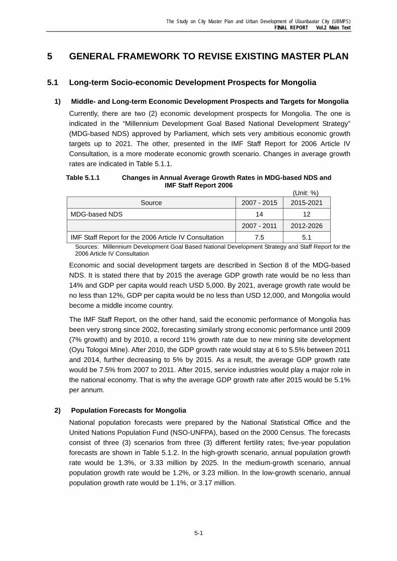
1) Middle- and Long-term Economic Development Prospects and Targets for Mongolia Currently, there are two (2) economic development prospects for Mongolia. The one is indicated in the “Millennium Development Goal Based National Development Strategy” (MDG-based NDS) approved by Parliament, which sets very ambitious economic growth targets up to 2021. The other, presented in the IMF Staff Report for 2006 Article IV Consultation, is a more moderate economic growth scenario. Changes in average growth rates are indicated in Table 5.1.1.
Table 5.1.1 Changes in Annual Average Growth Rates in MDG-based NDS and IMF Staff Report 2006
(Unit: %) Source 2007 - 2015 2015-2021
MDG-based NDS 14 12
2007 - 2011 2012-2026
IMF Staff Report for the 2006 Article IV Consultation 7.5 5.1 Sources: Millennium Development Goal Based National Development Strategy and Staff Report for the 2006 Article IV Consultation
Economic and social development targets are described in Section 8 of the MDG-based NDS. It is stated there that by 2015 the average GDP growth rate would be no less than 14% and GDP per capita would reach USD 5,000. By 2021, average growth rate would be no less than 12%, GDP per capita would be no less than USD 12,000, and Mongolia would become a middle income country.
The IMF Staff Report, on the other hand, said the economic performance of Mongolia has been very strong since 2002, forecasting similarly strong economic performance until 2009 (7% growth) and by 2010, a record 11% growth rate due to new mining site development (Oyu Tologoi Mine). After 2010, the GDP growth rate would stay at 6 to 5.5% between 2011 and 2014, further decreasing to 5% by 2015. As a result, the average GDP growth rate would be 7.5% from 2007 to 2011. After 2015, service industries would play a major role in the national economy. That is why the average GDP growth rate after 2015 would be 5.1% per annum.
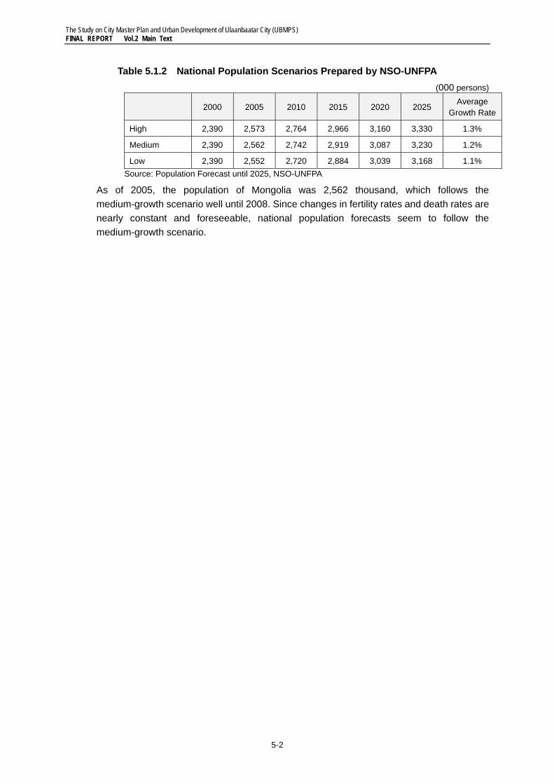
2) Population Forecasts for Mongolia National population forecasts were prepared by the National Statistical Office and the United Nations Population Fund (NSO-UNFPA), based on the 2000 Census. The forecasts consist of three (3) scenarios from three (3) different fertility rates; five-year population forecasts are shown in Table 5.1.2. In the high-growth scenario, annual population growth rate would be 1.3%, or 3.33 million by 2025. In the medium-growth scenario, annual population growth rate would be 1.2%, or 3.23 million. In the low-growth scenario, annual population growth rate would be 1.1%, or 3.17 million.
The Study on City Master Plan and Urban Development of Ulaanbaatar City (UBMPS) FINAL REPORT Vol.2 Main Text
5-2
Table 5.1.2 National Population Scenarios Prepared by NSO-UNFPA (000 persons)
2000 2005 2010 2015 2020 2025 Average
Growth Rate
High 2,390 2,573 2,764 2,966 3,160 3,330 1.3%
Medium 2,390 2,562 2,742 2,919 3,087 3,230 1.2%
Low 2,390 2,552 2,720 2,884 3,039 3,168 1.1% Source: Population Forecast until 2025, NSO-UNFPA
As of 2005, the population of Mongolia was 2,562 thousand, which follows the medium-growth scenario well until 2008. Since changes in fertility rates and death rates are nearly constant and foreseeable, national population forecasts seem to follow the medium-growth scenario.
The Study on City Master Plan and Urban Development of Ulaanbaatar City (UBMPS) FINAL REPORT Vol.2 Main Text
5-3
5.2 Conceptual Setting of Regional Development Framework
1) Existing Regional Framework The existing Urban Master Plan, UBMP 2020, was planned in the development context at the national and regional levels. Also, Ulaanbaatar City and its surrounding areas were considered as an independent development zone. Since the city needs to alleviate population concentration in its area by developing satellite cities, the following concepts are proposed:
• Further development of the existing towns of Songino, Tuul, Ulziit, Khonkhor, Gatsuurt, Jargalant, and Terelj;
• New town developments in Argalant, Rashaant, Bayanzurkh, and Bayangol; and
• Free trade zone development around Nalaikh Town.
Communications and utilities are planned to be developed in satellite cities together with the promotion of small and medium enterprises, thereby leading the development of satellite cities into integrated settlement clusters.
Meanwhile, the National Development Strategy addresses the priority outcomes of regional development in the Phase I period of 2007 - 2015, as follows:
• Establish industrial and technological parks in regional centers and focal economic and trade zones in the regions and make them operational, and
• Create the basis for a knowledge-based economy.1
To this end, the implementation strategy for the Ulaanbaatar region includes the industrial development of the three remote districts.
Ulaanbaatar Region Development Program (2005─2015)2 provides the basic principle in developing satellite cities and villages around Ulaanbaatar City to reduce population concentration in and migration to Ulaanbaatar City. To this end, the development of satellite cities is expected to be achieved through the relocation of industries from Ulaanbaatar region.
2) Proposed Concept for Ulaanbaatar Metropolitan Area The Ulaanbaatar Metropolitan Area will encompass the area within a 50km radius from the city center to include Nalaikh, Zuunmod, and the planned new international airport. The following concepts are proposed to develop the area (see Figure 5.2.1):
1 The Government of Mongolia, “Millennium Development Goals Based Comprehensive National Development
Strategy of Mongolia (Draft),” Ulaanbaatar City, 2007, p. 95. 2 This program was approved under the Resolution of the Government of Mongolia, No. 197, dated 16 August,
2006.
The Study on City Master Plan and Urban Development of Ulaanbaatar City (UBMPS) FINAL REPORT Vol.2 Main Text
5-4
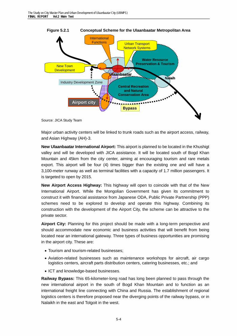
Figure 5.2.1 Conceptual Scheme for the Ulaanbaatar Metropolitan Area
Source: JICA Study Team Major urban activity centers will be linked to trunk roads such as the airport access, railway, and Asian Highway (AH)-3.
New Ulaanbaatar International Airport: This airport is planned to be located in the Khushigt valley and will be developed with JICA assistance. It will be located south of Bogd Khan Mountain and 45km from the city center, aiming at encouraging tourism and rare metals export. This airport will be four (4) times bigger than the existing one and will have a 3,100-meter runway as well as terminal facilities with a capacity of 1.7 million passengers. It is targeted to open by 2015.
New Airport Access Highway: This highway will open to coincide with that of the New International Airport. While the Mongolian Government has given its commitment to construct it with financial assistance from Japanese ODA, Public Private Partnership (PPP) schemes need to be explored to develop and operate this highway. Combining its construction with the development of the Airport City, the scheme can be attractive to the private sector.
Airport City: Planning for this project should be made with a long-term perspective and should accommodate new economic and business activities that will benefit from being located near an international gateway. Three types of business opportunities are promising in the airport city. These are:
• Tourism and tourism-related businesses;
• Aviation-related businesses such as maintenance workshops for aircraft, air cargo logistics centers, aircraft parts distribution centers, catering businesses, etc.; and
• ICT and knowledge-based businesses.
Railway Bypass: This 65-kilometer-long road has long been planned to pass through the new international airport in the south of Bogd Khan Mountain and to function as an international freight line connecting with China and Russia. The establishment of regional logistics centers is therefore proposed near the diverging points of the railway bypass, or in Nalaikh in the east and Tolgoit in the west.
Water ResourcePreservation & Tourism
Central Recreation and Natural
Conservation Area
Airport cityAirport city
International Functions
Industry Development ZoneIndustry Development Zone
BBypassypass
New Town Development
Urban Transport Network Systems
UlaanbaatarUlaanbaatarNalaih
Water ResourcePreservation & Tourism
Central Recreation and Natural
Conservation Area
Airport cityAirport city
International Functions
Industry Development ZoneIndustry Development Zone
BBypassypass
New Town Development
Urban Transport Network Systems
UlaanbaatarUlaanbaatarNalaih
The Study on City Master Plan and Urban Development of Ulaanbaatar City (UBMPS) FINAL REPORT Vol.2 Main Text
5-5
Ulaanbaatar City will be served with a hierarchical urban transportation network which will be connected to regional and international transportation facilities.
Asian Highway: The national road from Altanbulag (Russian border) to Zamin-uud (Chinese border) is designated as Asian Highway No. 3 (AH-3) with AH Design Standard Class III. Since 1995, the Government of Mongolia has implemented AH-3 development projects with ADB assistance, namely Road Development Phase-1 (1995-2000): Ulaanbaatar-Altanbulag (312km)3; Road Development Phase-2 (2000-2005): Nalaikh-Choir (200km), and Road Development Phase-3 (2006-2009): Sainshand-Zamin-uud (282km).To further meet potential demand due to extensive mineral development, a number of plans and projects on air, rail, and road transportation are being promoted as briefly explained below.
3) Economic Function of Remote Districts As mentioned in Section 5.2.1, three remote districts were proposed to be part of Ulaanbaatar region However, only Nalaikh can be regarded as part of the Ulaanbaatar Metropolitan Area, because the other two districts are distant; Bagakhangai and Baganuur are 90 and 140km from the city center. What should be done is for the two districts to enhance their roles as engines of socio-economic development by leveraging on their unique characteristics, as shown in Table 5.2.1.
Table 5.2.1 Development Directions for Three Remote Districts
Source: JICA Study Team
As part of the Ulaanbaatar Metropolitan Area, Nalaikh can function as an “industrial incubator” that will promote new industrial and technological breakthroughs. To facilitate the economic development of this satellite city, domestic and foreign direct investments (FDIs) need to be attracted. Becoming a “logistics center” is another important function that this town can assume. The population of Nalaikh District by 2030 is expected to increase by 2.8 times from the 2007 level of about 28,000, or 78,500.
Baganuur is rich in mineral resources, such as coal, and is close to Herlen River, a rich source of water. With these characteristics, Baganuur has a great potential of becoming an “energy production center” and a resource-based industrial center. Its population by 2020 is
3 The section between Ulaanbaatar and Nalaikh is deemed the last section of AH-3 in Mongolia, for which a feasibility study was conducted in 2007 by the Korea International Cooperation Agency (KOICA). The KOICA study prepared two alternative routes for the Ulaanbaatar Bypass between Nalaikh and the Western Checkpoint at the 22nd Km-post; one will pass the foot of Bogd Khan Mountain in the north (Alternative 1: L=52.9 km) and the other in the south (Alternative 2: L=64.8 km). Regardless of which alternative will be chosen, a new highway will be required to connect Ulaanbaatar City to the new airport and Zuunmod, because the study gives priority to the bypass.
2007 2020 2030
Nalaikh 30 Km 28,152 55,000 78,500
Baganuur 140 Km 25,969 39,000 45,800
Bagakhangai 90 Km 3,864 6,000 6,500
57,985 100,000 130,900
Remote Districts Direction of Development
Total
Km from UBCentral
Population
New Industrial Promotion Park& Logistic Center
UB Metropolitan Industrial andEnergy Center
Agro-industrial Center
The Study on City Master Plan and Urban Development of Ulaanbaatar City (UBMPS) FINAL REPORT Vol.2 Main Text
5-6
expected to reach 45,800 from 26,000 at present. However, should industries located in this area, the population will easily surpass this projection.
Bagakhangai is located at a railway junction and can be regarded as the southern gateway to the Ulaanbaatar Metropolitan Area. Because of this locational advantage, it has the potential to attract agro-processing industries, targeting the Ulaanbaatar market. Therefore, the government should provide special incentives to such investments. Otherwise this small township would deteriorate.
Figure 5.2.2 Proposed Regional Development Structure
Source: JICA Study Team
Tolgoit: Logistic Park
New International Airport
Airport City
Nalaikh: New Industrial Promotion Center& Logistic Center
Baganuur: Industrial& Energy Center
Bagakhangai: Agro-industry Center
The Study on City Master Plan and Urban Development of Ulaanbaatar City (UBMPS) FINAL REPORT Vol.2 Main Text
5-7
5.3 Urban Development Vision and Objectives for Ulaanbaatar City
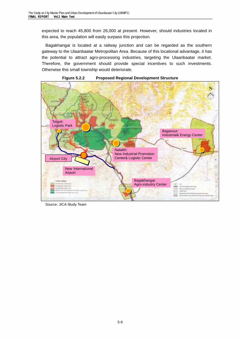
1) Public Perception on Future Ulaanbaatar City The HIS results provided a number of significant implications for urban planning. To the question of what images should be pursued for Ulaanbaatar City in the future, the four (4) most preferred images in order of importance are: 1) clean, 2) harmony, 3) peaceful, and 4) nature, as shown in Figure 5.3.1.
This implies that security and environment are the most important aspects of their life. The security of a healthy life was the most frequent choice as the most important aspect for a good living environment. The most important urban services that were most frequently chosen were “urban air quality” and “health/welfare service.” “Health service facilities” was also the most commonly requested important facility needed to be located near residences.
Figure 5.3.1 People’s Choices on Urban Images for Ulaanbaatar City
Source: Household Interview Survey, 2007, JICA Study Team
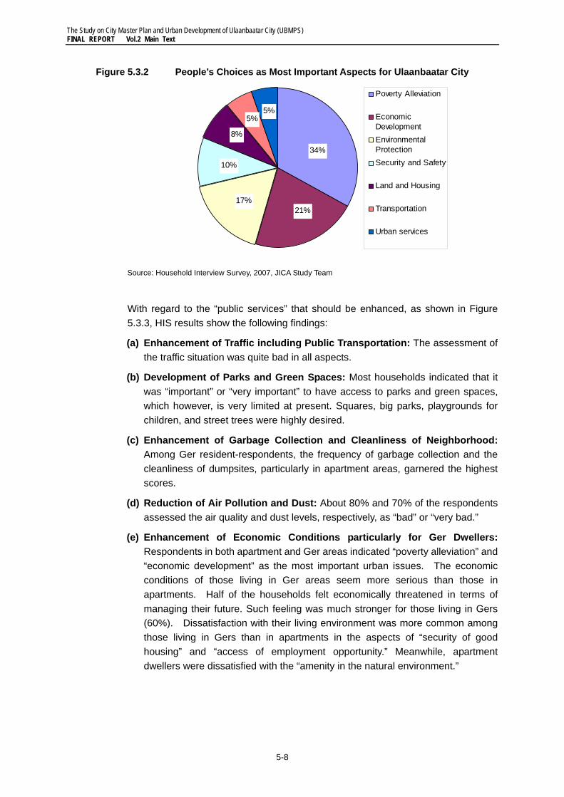
Meanwhile, to the question on what the most important planning aspects should be tackled with best effort, the people selected: 1) poverty alleviation (34%), 2) economic development (21%), and 3) environmental protection (17%), as shown in Figure 5.3.2. The people’s perception of the current situation seems to be very balanced; it shows they are most concerned with economic development, but with planning emphasis on environmental conservation.
0% 20% 40% 60% 80% 100%
Ger Area
Apartment
All
Clean HarmonyPeaceful NatureHighly developed Modern Safe Culture/heritage International/global FriendlyScientific/ high-tech center Tourism centerOthers
The Study on City Master Plan and Urban Development of Ulaanbaatar City (UBMPS) FINAL REPORT Vol.2 Main Text
5-8
Figure 5.3.2 People’s Choices as Most Important Aspects for Ulaanbaatar City
Source: Household Interview Survey, 2007, JICA Study Team
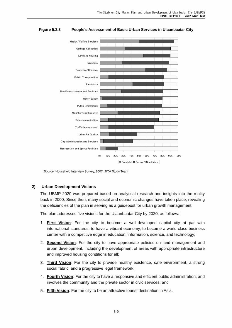
With regard to the “public services” that should be enhanced, as shown in Figure 5.3.3, HIS results show the following findings:
(a) Enhancement of Traffic including Public Transportation: The assessment of the traffic situation was quite bad in all aspects.
(b) Development of Parks and Green Spaces: Most households indicated that it was “important” or “very important” to have access to parks and green spaces, which however, is very limited at present. Squares, big parks, playgrounds for children, and street trees were highly desired.
(c) Enhancement of Garbage Collection and Cleanliness of Neighborhood: Among Ger resident-respondents, the frequency of garbage collection and the cleanliness of dumpsites, particularly in apartment areas, garnered the highest scores.
(d) Reduction of Air Pollution and Dust: About 80% and 70% of the respondents assessed the air quality and dust levels, respectively, as “bad” or “very bad.”
(e) Enhancement of Economic Conditions particularly for Ger Dwellers: Respondents in both apartment and Ger areas indicated “poverty alleviation” and “economic development” as the most important urban issues. The economic conditions of those living in Ger areas seem more serious than those in apartments. Half of the households felt economically threatened in terms of managing their future. Such feeling was much stronger for those living in Gers (60%). Dissatisfaction with their living environment was more common among those living in Gers than in apartments in the aspects of “security of good housing” and “access of employment opportunity.” Meanwhile, apartment dwellers were dissatisfied with the “amenity in the natural environment.”
5%
34%
21%17%
10%
8%
5%
Poverty Alleviation
EconomicDevelopmentEnvironmentalProtection Security and Safety
Land and Housing
Transportation
Urban services
The Study on City Master Plan and Urban Development of Ulaanbaatar City (UBMPS) FINAL REPORT Vol.2 Main Text
5-9
Figure 5.3.3 People’s Assessment of Basic Urban Services in Ulaanbaatar City
Source: Household Interview Survey, 2007, JICA Study Team
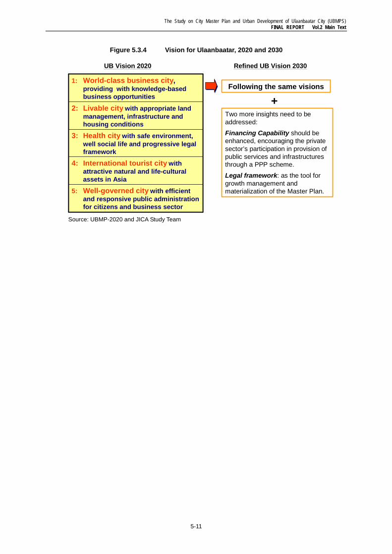
2) Urban Development Visions The UBMP 2020 was prepared based on analytical research and insights into the reality back in 2000. Since then, many social and economic changes have taken place, revealing the deficiencies of the plan in serving as a guidepost for urban growth management.
The plan addresses five visions for the Ulaanbaatar City by 2020, as follows:
1. First Vision: For the city to become a well-developed capital city at par with international standards, to have a vibrant economy, to become a world-class business center with a competitive edge in education, information, science, and technology;
2. Second Vision: For the city to have appropriate policies on land management and urban development, including the development of areas with appropriate infrastructure and improved housing conditions for all;
3. Third Vision: For the city to provide healthy existence, safe environment, a strong social fabric, and a progressive legal framework;
4. Fourth Vision: For the city to have a responsive and efficient public administration, and involves the community and the private sector in civic services; and
5. Fifth Vision: For the city to be an attractive tourist destination in Asia.
0% 10% 20% 30% 40% 50% 60% 70% 80% 90% 100%
Recreaction and Sports Facilities
City Administration and Services
Urban Air Quality
Traffic Management
Telecommunication
Neighborhood Security
Public Information
Water Supply
Road Infrastrucutre and Facilities
Electricity
Public Trasnporation
Sewerage/Drainage
Education
Land and Housing
Garbage Collection
Health/Welfare Services
Good Job So-so Need More
The Study on City Master Plan and Urban Development of Ulaanbaatar City (UBMPS) FINAL REPORT Vol.2 Main Text
5-10
These visions expressed in UBMP 2020 are all considered appropriate and are appreciated by the people as shown in HIS results. Therefore, this JICA Study is adopting the same visions over the same planning horizon, and is pursuing very similar goals.
However, two (2) points do not appeared in the planning visions of the UBMP 2020: the one is financing capability, wherein the private sector has to be encouraged to help provide public services and infrastructure through PPP schemes. The other point missing in the plan is the development of a legal framework to materialize these visions.
3) Planning Objectives The UBMP 2020 stipulates several planning objectives, as follows:
1. To determine the basic approach to establishing comfortable living conditions for the present and future residents and to support a sustainable city development under new socio-economic situations;
2. To maintain the equilibrium between the needs of national parks and the environmental impact of daily activities;
3. To determine basic approach to establish residents comfortable living conditions for the present and future and support sustainable city development in new socio-economic situations;
4. To keep equilibrium of national conservation parks and ecological safety of the environment of living activities;
5. To create an environment in conformity with territorial requirements, space, and concept of beauty by using traditional methods of urban planning;
6. To meet the safety requirements of transportation and engineering infrastructure;
7. To re-develop Ger and other residential areas, and increase housing supply;
8. To improve the industrial zoning system and land uses; and
9. To establish community centers and improve social infrastructure.
While the above objectives are relevant and appropriate and have been adopted in the JICA Study, the following additional objectives are being examined:
10. To develop new urban agglomerations, or new towns, in a planned manner to accommodate increasing housing demand and economic requirements, including those of the industrial and service sectors, well beyond 2020;
11. To ensure year-round commercial activities, as well as recreation/tourism and other services in the CBD, which will become the center of a World City;
12. To improve people’s mobility through more energy-efficient and time-saving public transportation system along major corridors;
13. To develop an urban planning legal framework in conformity with the Civil Law, Land Law, and the other relevant acts/regulations; and
14. To develop a comprehensive housing finance system to help improve the housing conditions of low- and middle-income households.
The Study on City Master Plan and Urban Development of Ulaanbaatar City (UBMPS) FINAL REPORT Vol.2 Main Text
5-11
Figure 5.3.4 Vision for Ulaanbaatar, 2020 and 2030
Source: UBMP-2020 and JICA Study Team
5: Well-governed city with efficient and responsive public administration for citizens and business sector
4: International tourist city with attractive natural and life-cultural assets in Asia
3: Health city with safe environment, well social life and progressive legal framework
2: Livable city with appropriate land management, infrastructure and housing conditions
1: World-class business city,providing with knowledge-based business opportunities
UB Vision 2020
Following the same visions
Two more insights need to be addressed:
Financing Capability should be enhanced, encouraging the private sector’s participation in provision of public services and infrastructures through a PPP scheme.
Legal framework: as the tool for growth management and materialization of the Master Plan.
+
Refined UB Vision 2030
The Study on City Master Plan and Urban Development of Ulaanbaatar City (UBMPS) FINAL REPORT Vol.2 Main Text
5-12
5.4 Socio-economic Framework for 2020 and 2030
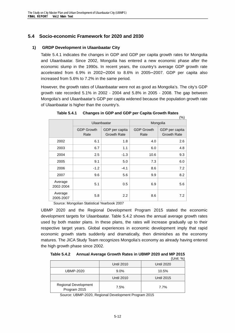
1) GRDP Development in Ulaanbaatar City Table 5.4.1 indicates the changes in GDP and GDP per capita growth rates for Mongolia and Ulaanbaatar. Since 2002, Mongolia has entered a new economic phase after the economic slump in the 1990s. In recent years, the country’s average GDP growth rate accelerated from 6.9% in 2002─2004 to 8.6% in 2005─2007. GDP per capita also increased from 5.6% to 7.2% in the same period.
However, the growth rates of Ulaanbaatar were not as good as Mongolia’s. The city’s GDP growth rate recorded 5.1% in 2002 - 2004 and 5.8% in 2005 - 2008. The gap between Mongolia’s and Ulaanbaatar’s GDP per capita widened because the population growth rate of Ulaanbaatar is higher than the country’s.
Table 5.4.1 Changes in GDP and GDP per Capita Growth Rates (%)
Ulaanbaatar Mongolia
GDP Growth Rate
GDP per capita Growth Rate
GDP Growth Rate
GDP per capita Growth Rate
2002 6.1 1.8 4.0 2.6
2003 6.7 1.1 6.0 4.8
2004 2.5 -1.3 10.6 9.3
2005 9.1 5.0 7.3 6.0
2006 -1.2 -4.1 8.6 7.2
2007 9.6 5.6 9.9 8.2
Average 2002-2004
5.1 0.5 6.9 5.6
Average 2005-2007
5.8 2.2 8.6 7.2
Source: Mongolian Statistical Yearbook 2007
UBMP 2020 and the Regional Development Program 2015 stated the economic development targets for Ulaanbaatar. Table 5.4.2 shows the annual average growth rates used by both master plans. In these plans, the rates will increase gradually up to their respective target years. Global experiences in economic development imply that rapid economic growth starts suddenly and dramatically, then diminishes as the economy matures. The JICA Study Team recognizes Mongolia’s economy as already having entered the high growth phase since 2002.
Table 5.4.2 Annual Average Growth Rates in UBMP 2020 and MP 2015 (Unit: %)
Until 2010 Until 2020
UBMP-2020 9.0% 10.5%
Until 2010 Until 2015
Regional Development Program 2015
7.5% 7.7%
Source: UBMP-2020, Regional Development Program 2015
The Study on City Master Plan and Urban Development of Ulaanbaatar City (UBMPS) FINAL REPORT Vol.2 Main Text
5-13
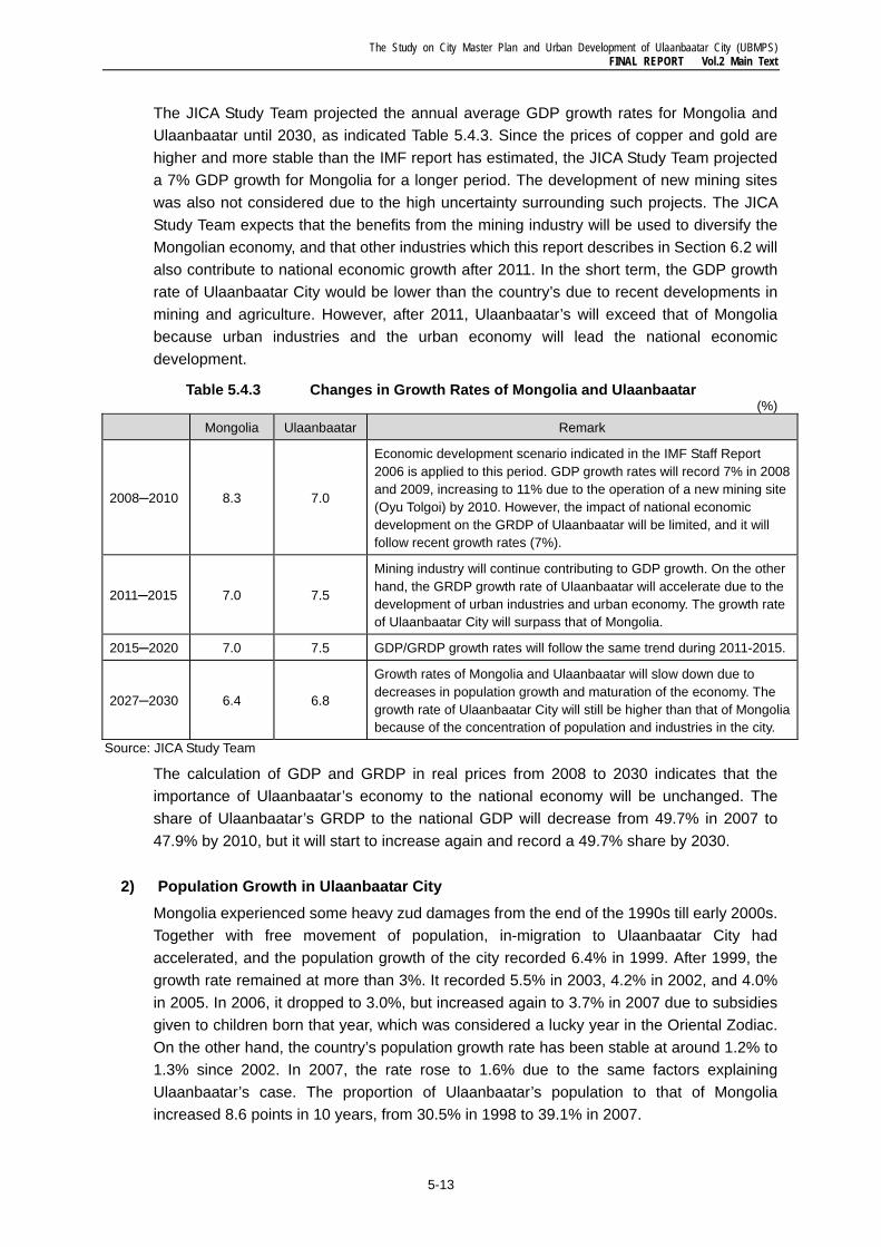
The JICA Study Team projected the annual average GDP growth rates for Mongolia and Ulaanbaatar until 2030, as indicated Table 5.4.3. Since the prices of copper and gold are higher and more stable than the IMF report has estimated, the JICA Study Team projected a 7% GDP growth for Mongolia for a longer period. The development of new mining sites was also not considered due to the high uncertainty surrounding such projects. The JICA Study Team expects that the benefits from the mining industry will be used to diversify the Mongolian economy, and that other industries which this report describes in Section 6.2 will also contribute to national economic growth after 2011. In the short term, the GDP growth rate of Ulaanbaatar City would be lower than the country’s due to recent developments in mining and agriculture. However, after 2011, Ulaanbaatar’s will exceed that of Mongolia because urban industries and the urban economy will lead the national economic development.
Table 5.4.3 Changes in Growth Rates of Mongolia and Ulaanbaatar (%)
Mongolia Ulaanbaatar Remark
2008─2010 8.3 7.0
Economic development scenario indicated in the IMF Staff Report 2006 is applied to this period. GDP growth rates will record 7% in 2008 and 2009, increasing to 11% due to the operation of a new mining site (Oyu Tolgoi) by 2010. However, the impact of national economic development on the GRDP of Ulaanbaatar will be limited, and it will follow recent growth rates (7%).
2011─2015 7.0 7.5
Mining industry will continue contributing to GDP growth. On the other hand, the GRDP growth rate of Ulaanbaatar will accelerate due to the development of urban industries and urban economy. The growth rate of Ulaanbaatar City will surpass that of Mongolia.
2015─2020 7.0 7.5 GDP/GRDP growth rates will follow the same trend during 2011-2015.
2027─2030 6.4 6.8
Growth rates of Mongolia and Ulaanbaatar will slow down due to decreases in population growth and maturation of the economy. The growth rate of Ulaanbaatar City will still be higher than that of Mongolia because of the concentration of population and industries in the city.
Source: JICA Study Team
The calculation of GDP and GRDP in real prices from 2008 to 2030 indicates that the importance of Ulaanbaatar’s economy to the national economy will be unchanged. The share of Ulaanbaatar’s GRDP to the national GDP will decrease from 49.7% in 2007 to 47.9% by 2010, but it will start to increase again and record a 49.7% share by 2030.
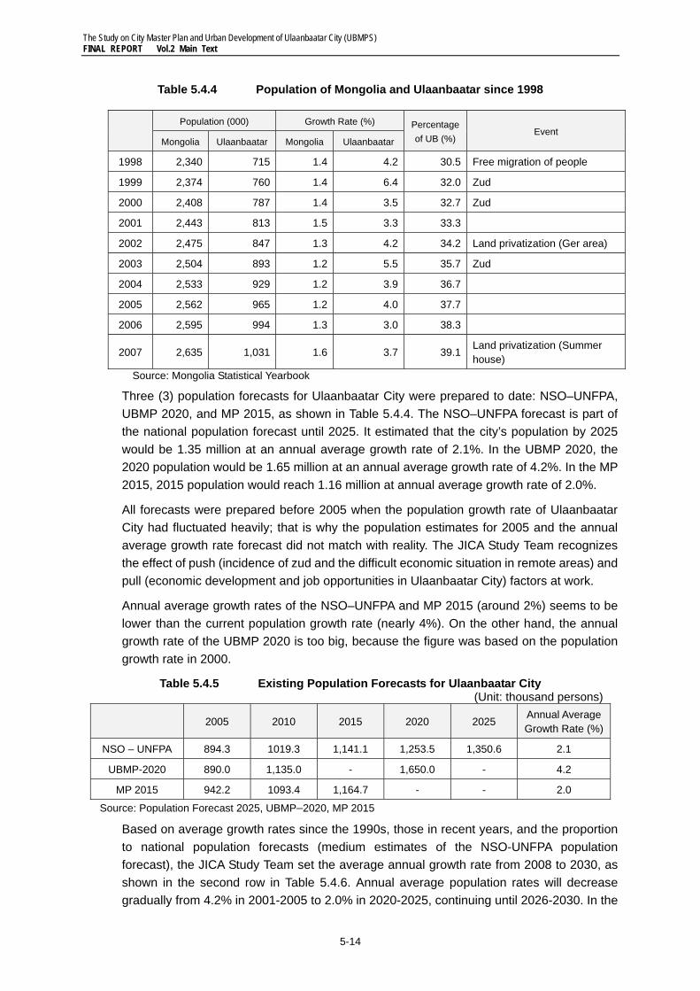
2) Population Growth in Ulaanbaatar City Mongolia experienced some heavy zud damages from the end of the 1990s till early 2000s. Together with free movement of population, in-migration to Ulaanbaatar City had accelerated, and the population growth of the city recorded 6.4% in 1999. After 1999, the growth rate remained at more than 3%. It recorded 5.5% in 2003, 4.2% in 2002, and 4.0% in 2005. In 2006, it dropped to 3.0%, but increased again to 3.7% in 2007 due to subsidies given to children born that year, which was considered a lucky year in the Oriental Zodiac. On the other hand, the country’s population growth rate has been stable at around 1.2% to 1.3% since 2002. In 2007, the rate rose to 1.6% due to the same factors explaining Ulaanbaatar’s case. The proportion of Ulaanbaatar’s population to that of Mongolia increased 8.6 points in 10 years, from 30.5% in 1998 to 39.1% in 2007.
The Study on City Master Plan and Urban Development of Ulaanbaatar City (UBMPS) FINAL REPORT Vol.2 Main Text
5-14
Table 5.4.4 Population of Mongolia and Ulaanbaatar since 1998
Population (000) Growth Rate (%) Percentage
of UB (%) Event
Mongolia Ulaanbaatar Mongolia Ulaanbaatar
1998 2,340 715 1.4 4.2 30.5 Free migration of people
1999 2,374 760 1.4 6.4 32.0 Zud
2000 2,408 787 1.4 3.5 32.7 Zud
2001 2,443 813 1.5 3.3 33.3
2002 2,475 847 1.3 4.2 34.2 Land privatization (Ger area)
2003 2,504 893 1.2 5.5 35.7 Zud
2004 2,533 929 1.2 3.9 36.7
2005 2,562 965 1.2 4.0 37.7
2006 2,595 994 1.3 3.0 38.3
2007 2,635 1,031 1.6 3.7 39.1Land privatization (Summer house)
Source: Mongolia Statistical Yearbook
Three (3) population forecasts for Ulaanbaatar City were prepared to date: NSO–UNFPA, UBMP 2020, and MP 2015, as shown in Table 5.4.4. The NSO–UNFPA forecast is part of the national population forecast until 2025. It estimated that the city’s population by 2025 would be 1.35 million at an annual average growth rate of 2.1%. In the UBMP 2020, the 2020 population would be 1.65 million at an annual average growth rate of 4.2%. In the MP 2015, 2015 population would reach 1.16 million at annual average growth rate of 2.0%.
All forecasts were prepared before 2005 when the population growth rate of Ulaanbaatar City had fluctuated heavily; that is why the population estimates for 2005 and the annual average growth rate forecast did not match with reality. The JICA Study Team recognizes the effect of push (incidence of zud and the difficult economic situation in remote areas) and pull (economic development and job opportunities in Ulaanbaatar City) factors at work.
Annual average growth rates of the NSO–UNFPA and MP 2015 (around 2%) seems to be lower than the current population growth rate (nearly 4%). On the other hand, the annual growth rate of the UBMP 2020 is too big, because the figure was based on the population growth rate in 2000.
Table 5.4.5 Existing Population Forecasts for Ulaanbaatar City (Unit: thousand persons)
2005 2010 2015 2020 2025
Annual Average Growth Rate (%)
NSO – UNFPA 894.3 1019.3 1,141.1 1,253.5 1,350.6 2.1
UBMP-2020 890.0 1,135.0 - 1,650.0 - 4.2
MP 2015 942.2 1093.4 1,164.7 - - 2.0
Source: Population Forecast 2025, UBMP–2020, MP 2015
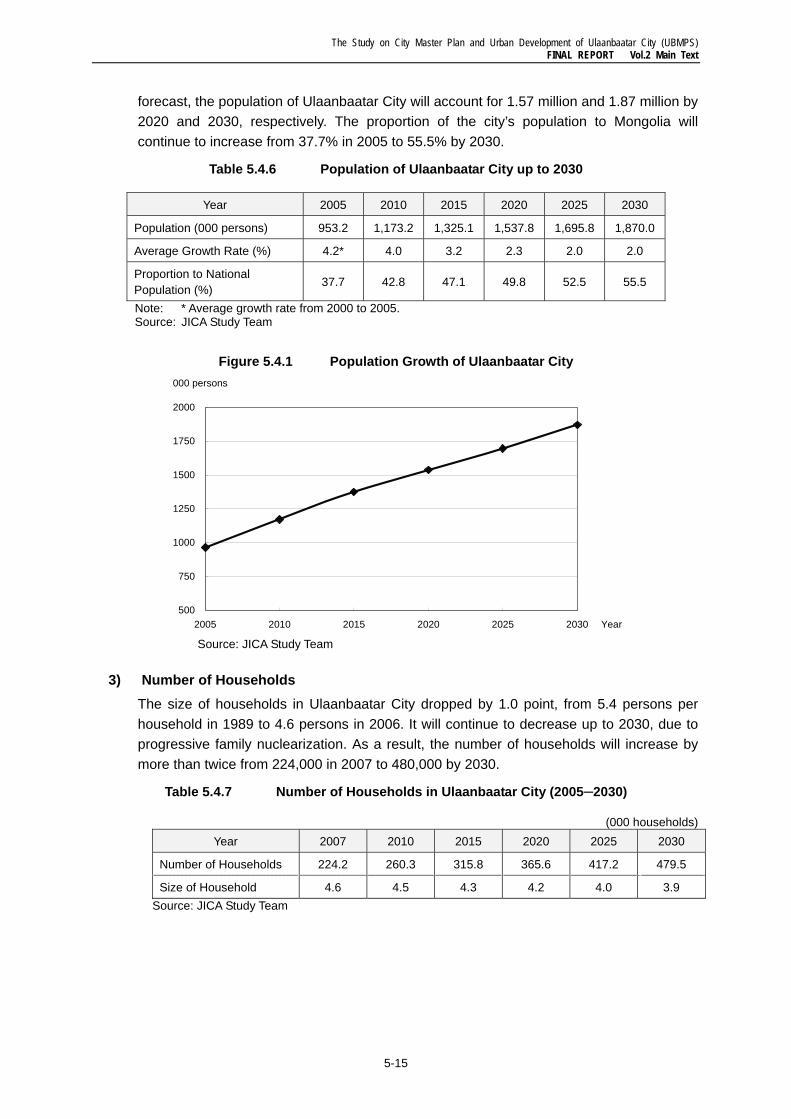
Based on average growth rates since the 1990s, those in recent years, and the proportion to national population forecasts (medium estimates of the NSO-UNFPA population forecast), the JICA Study Team set the average annual growth rate from 2008 to 2030, as shown in the second row in Table 5.4.6. Annual average population rates will decrease gradually from 4.2% in 2001-2005 to 2.0% in 2020-2025, continuing until 2026-2030. In the
The Study on City Master Plan and Urban Development of Ulaanbaatar City (UBMPS) FINAL REPORT Vol.2 Main Text
5-15
forecast, the population of Ulaanbaatar City will account for 1.57 million and 1.87 million by 2020 and 2030, respectively. The proportion of the city’s population to Mongolia will continue to increase from 37.7% in 2005 to 55.5% by 2030.
Table 5.4.6 Population of Ulaanbaatar City up to 2030
Year 2005 2010 2015 2020 2025 2030
Population (000 persons) 953.2 1,173.2 1,325.1 1,537.8 1,695.8 1,870.0
Average Growth Rate (%) 4.2* 4.0 3.2 2.3 2.0 2.0
Proportion to National Population (%)
37.7 42.8 47.1 49.8 52.5 55.5
Note: * Average growth rate from 2000 to 2005. Source: JICA Study Team
Figure 5.4.1 Population Growth of Ulaanbaatar City
Source: JICA Study Team
3) Number of Households The size of households in Ulaanbaatar City dropped by 1.0 point, from 5.4 persons per household in 1989 to 4.6 persons in 2006. It will continue to decrease up to 2030, due to progressive family nuclearization. As a result, the number of households will increase by more than twice from 224,000 in 2007 to 480,000 by 2030.
Table 5.4.7 Number of Households in Ulaanbaatar City (2005─2030)
(000 households) Year 2007 2010 2015 2020 2025 2030
Number of Households 224.2 260.3 315.8 365.6 417.2 479.5
Size of Household 4.6 4.5 4.3 4.2 4.0 3.9 Source: JICA Study Team
500
750
1000
1250
1500
1750
2000
2005 2010 2015 2020 2025 2030 Year
000 persons
The Study on City Master Plan and Urban Development of Ulaanbaatar City (UBMPS) FINAL REPORT Vol.2 Main Text
5-16
5.5 Strengthening of Competitiveness and Robust Economic Development It is necessary to promote future urban industries to secure sustainable economic development of Ulaanbaatar and provide job opportunity for residents in Ulaanbaatar. These urban industries will be engines of growth for the national economic development in future because the GRDP of Ulaanbaatar occupies almost 50% of the national GDP.
1) Characteristics of Market Based on an assessment of the economy of Mongolia and Ulaanbaatar, JICA Study Team identified the following characteristics about market in Mongolia and the surrounding countries.
• Limited scale of domestic market: Since current national population is only 2.6 million, it is difficult to introduce import-substitution industry. Future industries of Mongolia and Ulaanbaatar must overcome such limited scale of the domestic market.
• Great Neighboring International Market: Fortunately Mongolia is surrounded by the big and rapidly developing countries of China and Russia. These countries would provide with large markets to Mongolia in future. However, at the same time, these big markets are likely to easily penetrate or exploit the Mongolian market for their interests.
• High Cost Structure: Economy of Mongolia and Ulaanbaatar always has to pay comparatively high costs for consumers’ products and transportation, due to being a landlocked state. Before 2005, the garment industry was booming in Ulaanbaatar due to “Agreement on Textiles and Clothing between China and other countries”, however, after 2005 when the export quota of China was removed, the industry suffered from a heavy damage because transportation costs are very high and transportation time long. This fact implies that the leading industries of Mongolia and the urban industries of Ulaanbaatar have to optimize the use of Mongolian resources in order to cover such costs.
• Use of benefits from mining industry: The mining industry will greatly benefit the Mongolia people. A proper use of such benefits is very important to develop leading industries which can bring the sustainable development of Ulaanbaatar City.
• Rapidly growing domestic demands for consumable goods: Along with the economic growth and income increase, domestic demands particularly for consumers’ goods are rapidly growing, but most of those are being imported mainly from China. Although manufacturing of consumer durables and appliances may be difficult to be fostered due to the economy of scale, an import substitution policy needs to be explored for agricultural and food products which are domestically consumed in daily lives.
2) Leading Industries for Ulaanbaatar Based on the above understanding of the economy, JICA Study Team identified the following five (5) industries as leading industries which are endowed with great potentials in the global market in the future. We recognize it is required both to reestablish traditional industries which fully use Mongolian domestic resources and to develop new industries which
The Study on City Master Plan and Urban Development of Ulaanbaatar City (UBMPS) FINAL REPORT Vol.2 Main Text
5-17
overcome the smaller scale market in Mongolia. These industries are:
• Mining-supporting and mining-related industries,
• Tourism and tourism-related service industry,
• Processing industry of cashmere,
• Information Communication Technology (ICT) and Business Process Outsourcing (BPO) business, and
• Agricultural products and food processing.
The mining industry is important in Mongolia’s economy now and will be in the future. Currently it occupies 30% of GDP, 60% of exports and employs 4% of the total labor force. Although copper and gold mines are located outside of Ulaanbaatar City (Erdenet and South Gobi), supporting services of mining activities such as logistics, administration, insurance, spare parts procurement are to be performed in Ulaanbaatar City. It is said in the mining industry that a direct investment of one (1) US dollar generates an indirect investment of 1.5 to 2 US dollars, and employment of one (1) person in the mining industry generates employment of four (4) persons in the related industries.
In 2007, the Mining Association had 80 mining and mining related companies. Due to the new Mining Law and introduction of tax reform in 2007, international investors started hesitating to invest to the mining industry. As a result, the contribution of the mining industry to GDP growth was 0.4% in 2007. The other difficulty of the mining industry is lack of infrastructure in the remote area. In particular road network is very poor in rural areas.
The business situation of the mining industry depends on that of international economy. Although the mining industry enjoys booming in recent years, it is not sure whether the booming will come to an end. That is why the government should try to maximize benefit from the mining industry during its current boom. The government should make an effort to conclude an agreement with the private investors about allocation of benefit and taxation. If the mining boom finishes without new investments, Mongolian people cannot receive benefit for their future investment.
Tourism is already an important industry for Mongolia. During summer season, a large number of foreign tourists visit Mongolia. Tourist arrivals to Mongolia have nearly tripled in six (6) years (from 158,000 in 2000 to 452,000 in 2007)4. Average length of stay is 12 nights, and average spending is US$ 106 per day per person. This contributes significantly to foreign currency earnings. Currently foreign tourists stay in Ulaanbaatar City for three (3) days.
It is necessary for Ulaanbaatar to enhance its gateway function through improvement of tourist sites and tourist services, and development of tour routes. Currently it is not so easy for independent foreign tourists to go around Ulaanbaatar City. It is necessary to improve provision of tourist information for visitors, and to formulate tourist circuit routes in Ulaanbaatar.
4 Out of 452,000 international arrivals, the number of Chinese visitors for business purpose was 211,000 in 2007. Even with Chinese visitors excluded, the number of visitors has increased by 1.5 times in four (4) years from 161,000 in 2004 to 241,000 in 2007.
The Study on City Master Plan and Urban Development of Ulaanbaatar City (UBMPS) FINAL REPORT Vol.2 Main Text
5-18
Ministry of Road, Transportation and Tourism owns three (3) Tourist Information Centers at the Central Post Office, Railway Station and Chinggis Khaan Airport. It is true that locations of these centers are gateways of Ulaanbaatar City, but these centers cannot meet needs of visitors fully. That is why it is necessary to cooperate with private tourism companies and agents to enhance information provision. Private tourism companies and agents are located allover of the city and provide tourism information to visitors independently. If Tourism Information Centers develop a network with these tourism companies and agents, they can update tourism information service frequently, and information provision function will be upgraded from point to area. Together with networking among the Tourism Information Centers, tourism companies and pubs, installation of signage and beautification around tourist sites are also needed.
The other important action by the public sector (both of the Central Government and Ulaanbaatar City Government) is to support human resource development. It is necessary to develop educational facilities for hotel & restaurant business in cooperation with the hotel & restaurant industry. There is an educational facility for middle-class management in Ulaanbaatar, according to Tourism Department of then MRTT and Tourism Department of Ulaanbaatar City, but most curricula are classroom lectures. It is necessary to invite hotel and restaurant managers as lecturers and to develop curriculum which has training programs at hotels and restaurants.
Value-added processing of cashmere was a major industry for Ulaanbaatar City until the beginning of 1990s but it ran down during the economic transition. From the point of the effective use of resources in Mongolia, these industries are still important. According to interviews to Cashmere and Wool Association and Leather Processing Association, the number of the member companies is 30 to 40, and the number of employees is 4,000 to 5,000 persons in each industry. Currently large percentages of raw material for these industries are exported to China with a limited processing; however, this industry will absorb more employment and generate more value added if these companies can procure more materials. According to the associations, they have potential markets to provide their products. The most serious problem is lack of raw materials.
There are other issues to be solved such as lack of working and investment capitals and treatment of industrial wastewater. Due to an environmentally bad image, relocations of these businesses are currently being discussed. Under such circumstances, the Central Government and City Government can support the industries from the following points.
The first one is to prohibit these industries from exporting unprocessed raw materials. Experience of metallurgy is a good example for these industries. Until 2005 scrapped steel was exported to China, and an operational rate of Darkhan Metal Plant was around 20 – 30%. However, after the enactment of a law which prohibits the export of scrapped steel to overseas countries, the rate has increased to 70 - 80%. A possible policy measure to keep raw materials inside Mongolia is to impose an export tax.
The second action to be taken by the government is to support efficient land use of these industries. The current industrial area was developed more than 30 yeas ago, and designed for heavy industries. It is necessary to use land for more efficiently in the market economy. The government will provide support in terms of technical, financial and institutional aspects to use industrial land more efficiently. In order to consolidate the land
The Study on City Master Plan and Urban Development of Ulaanbaatar City (UBMPS) FINAL REPORT Vol.2 Main Text
5-19
for an industrial purpose, it is necessary to obtain consensus from the companies in these industries, and to cooperate with the associations. At the same time, improvement of infrastructure such as a wastewater treatment plant is needed. Improvement of infrastructure will contribute to an efficient energy use of the industries and to dispose of wastewater. Consolidation of land for industrial use will generate new land for residence, and improvement of infrastructure will assuage peoples’ concern about environmentally negative effluent.
ICT and Business Process Outsourcing (BPO) business are newly developing businesses. Thirty (30) companies belong to the Mongolia Software Industry Association (MOSA), and five (5) to six (6) companies are working as BPO companies for Japan and other countries now. Many Mongolian people have been well-educated with good foreign languages commands. Their predominant capacity in accepting and adapting different foreign culture is also an advantage for BPO. These businesses will provide a big potential for younger generations.
According to MOSA, the number of programmers in Ulaanbaatar is 1,000, and MOSA has a future vision that the number of software companies should reach 200, the number of software engineers 1,000 persons, and the annual revenue of the industry USD100 billion. MOSA started to contact Japanese ICT companies and receive technical supports from Association for Overseas Technical Scholarship (AOTS), a technical training organization of the Japanese Government. Since the industry is emerging and has the potential of future development, government supports are also important.
One of the concerns of the software companies is lack of skilled programmers. That is why some software companies established training facilities by themselves. The ICT Authority also started financial support to such private training schools and universities. Possible support to the ICT industries other than support to human resource development is providing ICT service projects. For example, the investment to an ICT system within the government offices is a good starting project, and development of ICT systems for remote education and other public services is a necessary project in Mongolia. By use of open source software, the government can supply needs for ICT services to software companies in Ulaanbaatar. Local governments in Japan, such as Nagasaki Prefectural Government and Shimane Prefectural Government show useful examples in terms of overall ICT system design and relationship between the public sector and private sector in the system design.
Agricultural products and food processing industries should be strongly supported by the government under an import substitution policy. Fresh and safe perishable foods are highly demanded by people who are getting more consciousness on health. Agricultural activities should be encouraged in suburban areas in Ulaanbaatar City, providing farmers with tax incentives and subsidies for seeds procurement. Processing industries of agricultural products such as meats and dairy products may be located in designated industrial zones in Ulaanbaatar City.
3) Support for Human Resource Development Two (2) kinds of supports by the Central Government and the City Government are necessary for promotion of the industries in Ulaanbaatar City: that is, support in “human resource development” and “technical and financial support” to start-up companies. In
The Study on City Master Plan and Urban Development of Ulaanbaatar City (UBMPS) FINAL REPORT Vol.2 Main Text
5-20
2006-2007, the number of graduates of universities, higher educational institutes and collages was 26,000 persons, accounted for around 50% of the population at the age of 22 years old5. However, the curriculum of universities doesn’t meet demands for human resources needed in industries. As described above, the ICT industries themselves have to train graduates of universities. Some interviewees from the tourism industry pointed out that the curriculum of universities for tourism business is almost lecture-based and students do not have practical training. It is necessary to support development of new and practical curriculum and collaboration between the academic and business society.
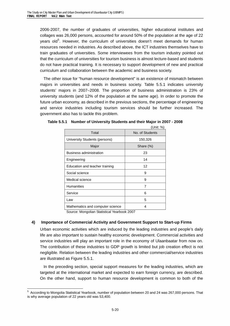
The other issue for “human resource development” is an existence of mismatch between majors in universities and needs in business society. Table 5.5.1 indicates university students’ majors in 2007–2008. The proportion of business administration is 23% of university students (and 12% of the population at the same age). In order to promote the future urban economy, as described in the previous sections, the percentage of engineering and service industries including tourism services should be further increased. The government also has to tackle this problem.
Table 5.5.1 Number of University Students and their Major in 2007 - 2008 (Unit: %)
Total No. of Students
University Students (persons) 150,326
Major Share (%)
Business administration 23
Engineering 14
Education and teacher training 12
Social science 9
Medical science 9
Humanities 7
Service 6
Law 5
Mathematics and computer science 4 Source: Mongolian Statistical Yearbook 2007
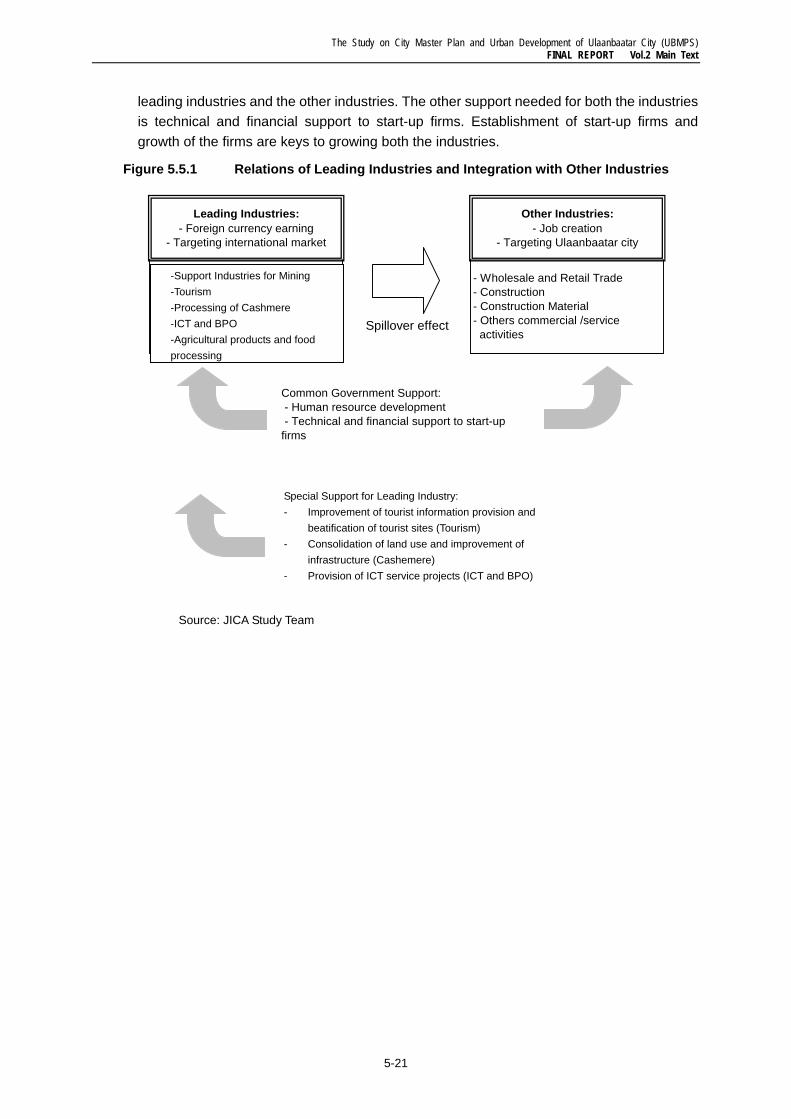
4) Importance of Commercial Activity and Government Support to Start-up Firms Urban economic activities which are induced by the leading industries and people’s daily life are also important to sustain healthy economic development. Commercial activities and service industries will play an important role in the economy of Ulaanbaatar from now on. The contribution of these industries to GDP growth is limited but job creation effect is not negligible. Relation between the leading industries and other commercial/service industries are illustrated as Figure 5.5.1.
In the preceding section, special support measures for the leading industries, which are targeted at the international market and expected to earn foreign currency, are described. On the other hand, support to human resource development is common to both of the
5 According to Mongolia Statistical Yearbook, number of population between 20 and 24 was 267,000 persons. That is why average population of 22 years old was 53,400.
The Study on City Master Plan and Urban Development of Ulaanbaatar City (UBMPS) FINAL REPORT Vol.2 Main Text
5-21
leading industries and the other industries. The other support needed for both the industries is technical and financial support to start-up firms. Establishment of start-up firms and growth of the firms are keys to growing both the industries.
Figure 5.5.1 Relations of Leading Industries and Integration with Other Industries
Source: JICA Study Team
- Support Industries for Minig- Tourism- Processing of Cashmere and Leather- ICT and BPO
- Wholesale and Retail Trade- Construction- Construction Material- Others commercial /service activities
Common Government Support: - Human resource development - Technical and financial support to start-upfirms
Special support for Leading Industry:- Improvement of tourist information provision and beatification of tourist sites (Tourism)- Consolidation of land use and improvement of infrastructure (Cashmere and leather processing) - Provision of ICT service projects (ICT and BPO)
Leading Industries:- Foreign currency earning
- Targeting international market
Other Industries:- Job creation
- Targeting Ulaanbaatar city
Spillover effect
-Support Industries for Mining -Tourism -Processing of Cashmere
-ICT and BPO -Agricultural products and food
processing
Special Support for Leading Industry: - Improvement of tourist information provision and
beatification of tourist sites (Tourism) - Consolidation of land use and improvement of
infrastructure (Cashemere) - Provision of ICT service projects (ICT and BPO)
The Study on City Master Plan and Urban Development of Ulaanbaatar City (UBMPS) FINAL REPORT Vol.2: Main Text
6-1
6 URBAN GROWTH MANAGEMENTMENT BASED ON A COMPACT CITY CONCEPT
6.1 Land Evaluation for Land Use Planning
1) Land Evaluation Methodology
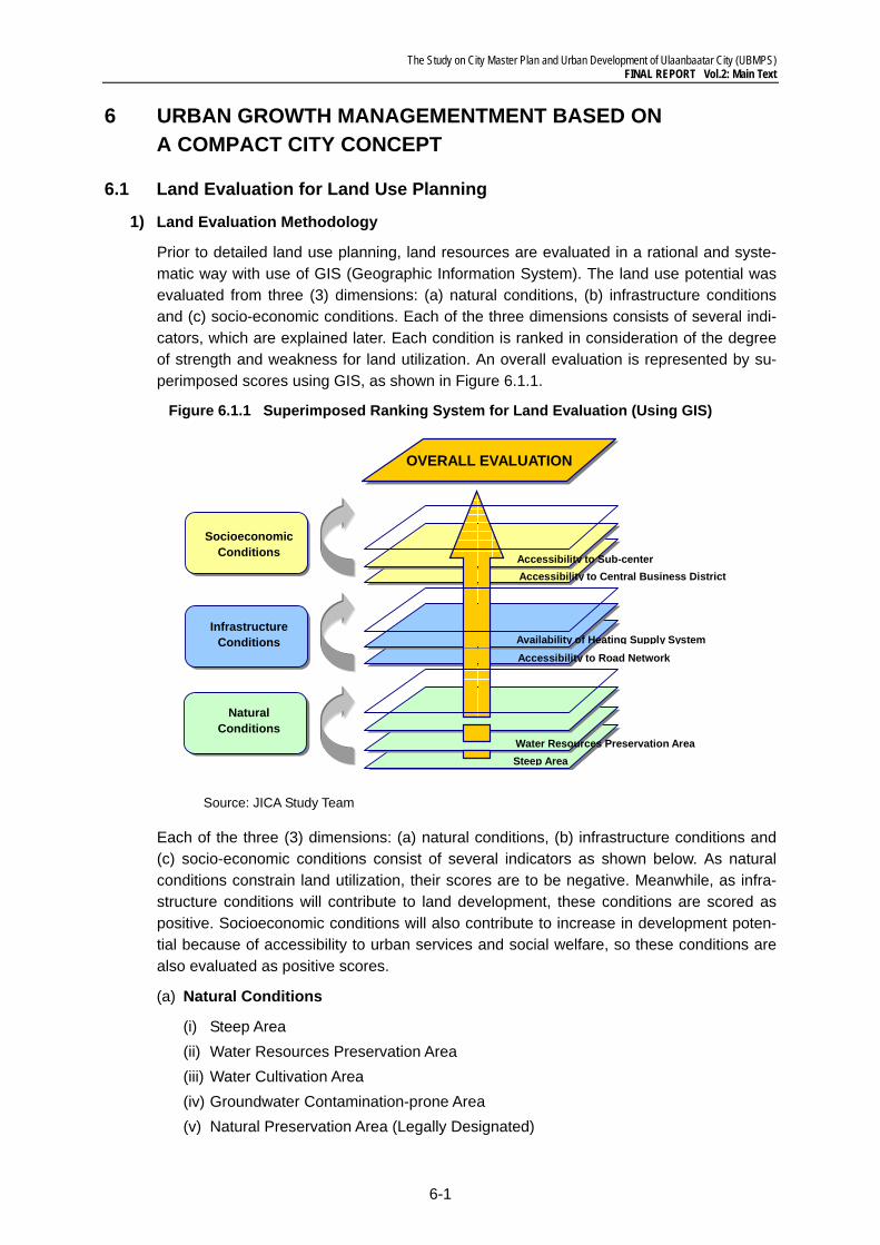
Prior to detailed land use planning, land resources are evaluated in a rational and syste-matic way with use of GIS (Geographic Information System). The land use potential was evaluated from three (3) dimensions: (a) natural conditions, (b) infrastructure conditions and (c) socio-economic conditions. Each of the three dimensions consists of several indi-cators, which are explained later. Each condition is ranked in consideration of the degree of strength and weakness for land utilization. An overall evaluation is represented by su-perimposed scores using GIS, as shown in Figure 6.1.1.
Figure 6.1.1 Superimposed Ranking System for Land Evaluation (Using GIS)
Source: JICA Study Team
Each of the three (3) dimensions: (a) natural conditions, (b) infrastructure conditions and (c) socio-economic conditions consist of several indicators as shown below. As natural conditions constrain land utilization, their scores are to be negative. Meanwhile, as infra-structure conditions will contribute to land development, these conditions are scored as positive. Socioeconomic conditions will also contribute to increase in development poten-tial because of accessibility to urban services and social welfare, so these conditions are also evaluated as positive scores.
(a) Natural Conditions
(i) Steep Area (ii) Water Resources Preservation Area (iii) Water Cultivation Area (iv) Groundwater Contamination-prone Area (v) Natural Preservation Area (Legally Designated)
Infrastructure Conditions
Natural Conditions
Socioeconomic Conditions
OVERALL EVALUATION
Steep AreaWater Resources Preservation Area
Accessibility to Road Network Availability of Heating Supply System
Accessibility to Central Business District Accessibility to Sub-center
The Study on City Master Plan and Urban Development of Ulaanbaatar City (UBMPS) FINAL REPORT Vol.2: Main Text
6-2
(vi) Fertile Land Suitable for Agriculture (vii) Forest Land (viii) Flood-prone Area
(b) Infrastructure Conditions
(i) Accessibility to Road Network (ii) Availability of Heating Supply System (iii) Availability of Water Supply System (iv) Availability of Sewerage System (v) Availability of Electricity Network (vi) Availability of Telecommunication Network (vii) Availability of Kiosk Distribution
(c) Socio-economic Conditions
(i) Accessibility to Central Business District (ii) Accessibility to Sub-centers (iii) Accessibility to Railway Stations (iv) Accessibility to Bus Routes (v) Accessibility to Schools (vi) Accessibility to Parks (vii) Accessibility to Religious Facilities
2) Development Suitability Analysis and Development Potentiality Analysis
The following four (4) analyses are conducted for further land use planning.
(a) Analysis I: Development Suitability Analysis based on Natural Conditions (b) Analysis II: Development Potential Analysis based on Trend Urbanization (c) Analysis III: Development Potential Analysis based on Existing Infrastructure Condi-
tions (d) Analysis IV: Development Potential Analysis based on Adequate Land Utilization
Firstly, “Development Suitability Analysis based on Natural Conditions” identifies “Suitabili-ty” or “Unsuitability” for land development. Secondly, “Development Potential Analysis based on Trend Urbanization” simulates future trend urbanization and identifies problems without appropriate control measures for future urbanization. Thirdly, “Development Po-tential Analysis based on Existing Infrastructure Conditions” identifies development poten-tial and urbanization suitable areas with most use of the existing infrastructures. Finally, “Development Potential Analysis based on Adequate Land Utilization” identifies future ur-banization suitable areas by balancing urban development and protection of environmen-tal resources. It also effectively takes advantage of the existing infrastructures and urban services, which will be taken into consideration for determination of future Urbanization Promotion Area (UPA).
(1) Analysis I: Development Suitability Analysis based on Natural Conditions
“Suitability” or “Unsuitability” for land development can be identified from the aspect of natural conditions, based on the scoring system as explained in Table 6.1.1. Based on the methodology above, “Suitability” or “Unsuitability” for land development was evaluated by
The Study on City Master Plan and Urban Development of Ulaanbaatar City (UBMPS) FINAL REPORT Vol.2: Main Text
6-3
totaling scores of the subject natural conditions by GIS. The result is shown in Figures 6.1.2 and 6.1.3, indicating the distribution of land unsuitable for urban development. The analytical result obviously indicates that area suitable for development exists scarcely in the east area of UB City, and by contrast widespread in the west area. Based on this ana-lytical result, area to be designated for urbanization promotion was determined.
Table 6.1.1 Ranking System for Land Evaluation based on Natural Conditions
Subjects Ranking Scores
-10 -5 -4 -3 -2 -1 0
Nat
ural
Con
ditio
ns
Steep Area More than 16° 13 - 16° 10 - 13° 7 - 10°
Water Resources Preservation Area
Inside Riverbed
Buffer of Riverbed Other Areas
Water Cultivation Area Inside Other Areas
Groundwater Contamination-prone Area
Above
Groundwa-ter Stream
Buffer of
Groundwater Stream
Natural Preser-vation Area (Le-gally Designat-ed)
Inside Other Areas
Fertile Land Suitable for Agri-culture
Inside Other Areas
Forest Land Inside Other Areas
Flood-prone Area Inside Other Areas
Source: JICA Study Team
The Study on City Master Plan and Urban Development of Ulaanbaatar City (UBMPS) FINAL REPORT Vol.2: Main Text
6-4
Figure 6.1.2 Land Development Suitability based on Natural Conditions (UB Metropolitan Area)
Source: JICA Study Team
Suitable Unsuitable
Most Unsuitable
The Study on City Master Plan and Urban Development of Ulaanbaatar City (UBMPS) FINAL REPORT Vol.2: Main Text
6-5
Figure 6.1.3 Land Development Suitability based on Natural Conditions (Ulaanbaatar City)
Source: JICA Study Team
Suitable Unsuitable
Most Unsuitable
The Study on City Master Plan and Urban Development of Ulaanbaatar City (UBMPS) FINAL REPORT Vol.2: Main Text
6-6
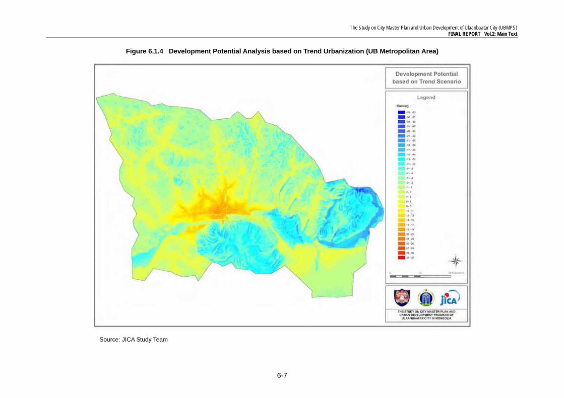
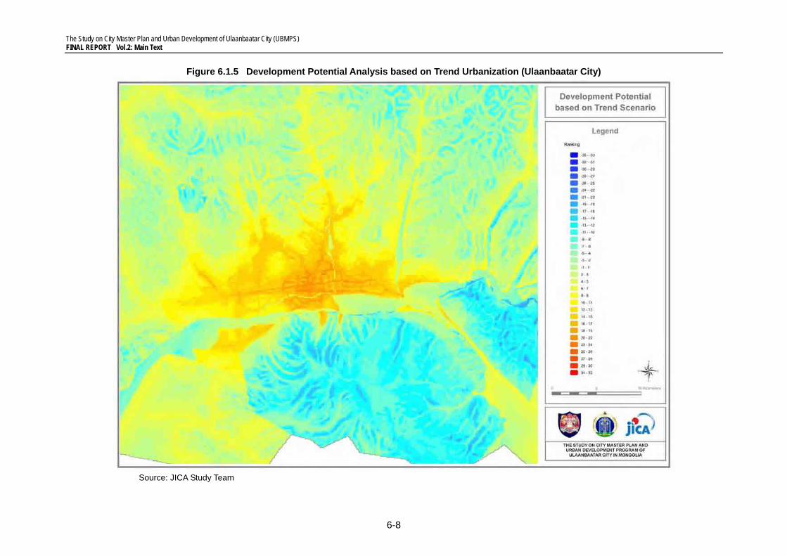
(2) Analysis II: Development Potentiality Analysis based on Trend Urbanization
Future trend urbanization is simulated based on the current urbanization trend in order to identify future urbanization problems. Urbanization process is found even in the following areas whose natural conditions are expected to constrain urbanization, but actually do not. Such conditions are rescored to reflect the actual trend of urbanization.
(i) Urbanization in water resources preservation area (ii) Urbanization in flood-prone area (iii) Urbanization in fertile land suitable for agricultural and forest land
For the purpose of simulation of future trend urbanization, natural conditions and their ef-fects are rescored as shown in Table 6.1.2. Specifically, natural conditions other than “Steep Area” and “Inside Riverbed” in water preservation areas are not assigned as con-straints. The result of future trend urbanization simulation is shown on Figures 6.1.4 and 6.1.5.
The following are clarified by comparing the development suitability maps (Figures 6.1.2 and 6.1.3) and the future trend urbanization simulation maps (Figures 6.1.4 and 6.1.5).
• Extensive northward urbanization in the water preservation and underground contamination-prone areas and toward water cultivation area
• Extensive eastward urbanization in the water preservation area and upstream area of Tuul River
It is predicted that the continuity of the current urbanization would cause a huge environ-mental loss, especially severe damage to water resources which may endanger the urban sustainability of Ulaanbaatar City. It is, therefore, imperative to establish urbanization con-trol measures including determination of the Urbanization Promotion Area (UPA) and de-velopment of institutional framework.
The Study on City Master Plan and Urban Development of Ulaanbaatar City (UBMPS) FINAL REPORT Vol.2: Main Text
6-7
Figure 6.1.4 Development Potential Analysis based on Trend Urbanization (UB Metropolitan Area)
Source: JICA Study Team
The Study on City Master Plan and Urban Development of Ulaanbaatar City (UBMPS) FINAL REPORT Vol.2: Main Text
6-8
Figure 6.1.5 Development Potential Analysis based on Trend Urbanization (Ulaanbaatar City)
Source: JICA Study Team
The Study on City Master Plan and Urban Development of Ulaanbaatar City (UBMPS) FINAL REPORT Vol.2: Main Text
6-9
Table 6.1.2 Ranking System for Trend Urbanization Simulation
Subjects Ranking Scores -10 -5 -4 -3 -2 -1 0 1 2 3 4 5
Natur
al Co
nditio
ns
Steep Area More than 16° 13 - 16° 10 - 13° 7 - 10°
Water Resources Preserva-tion Area
Inside Riverbed Other
Areas
Water Cultivation Area Other Areas
Groundwater Contamination-prone Area All Areas
Natural Preservation Area (Legally Designated) All Areas
Fertile Land Suitable for Agriculture All Areas Forest Land All Areas Flood-prone Area All Areas
Infra
struc
ture C
ondit
ions
Accessibility to Road Net-work Other
Areas 2000~ 2500m
1500~ 2000m
1000~ 1500m
500~ 1000
m 0~500
m Availability of Heating Supply System Not
Available Available (100m)
Availability of Water Supply System Not
Available Available (100m)
Availability of Sewage Sys-tem Not
Available Available (100m)
Availability of Electricity Network Not
Available Available (100m)
Availability of Telecommuni-cation Network Not
Available Available (100m)
Availability of Kiosk Distribu-tion Not
Available Available (500m)
Socio
econ
omic
Cond
itions
Accessibility to Central Business District Other
Areas 10000~ 15000m
5000~ 10000m
2500~ 5000m
1000~2500
m 0~100
0m
Accessibility to Sub-centers 1000~ 2500m 0~1000m
Accessibility to Railway Stations Other
Areas 1000~ 2500m
500~ 1000m 0~500m
Accessibility to Bus Routes Other Areas 1000~
2500m 500~
1000m 0~500m
Accessibility to Schools 500~ 1000m 0~500m
Accessibility to Parks 500~ 1000m 0~500m
Accessibility to Religious Facilities 500~
1000m 0~500m
Source: JICA Study Team
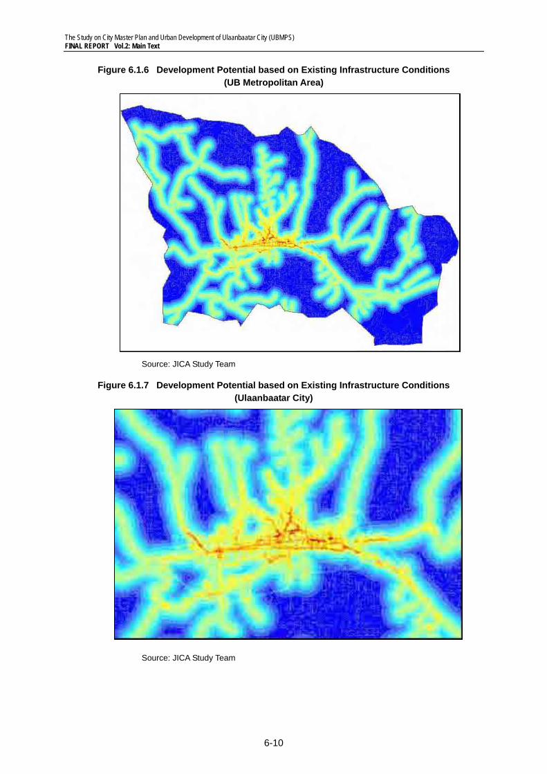
(3) Analysis III: Development Potential Analysis based on Existing Infrastructure Conditions
Development potential and urbanization suitable areas are identified only from a viewpoint of availability of the existing infrastructure. The result of the GIS analysis is shown in Fig-ures 6.1.6 and 6.1.7. Scores are given based on the existing infrastructure conditions as shown in Table 6.1.3. High potentiality indicates the availability of various existing infra-structures with lower development cost to access newly developed/planned infrastruc-tures.
The Study on City Master Plan and Urban Development of Ulaanbaatar City (UBMPS) FINAL REPORT Vol.2: Main Text
6-10
Figure 6.1.6 Development Potential based on Existing Infrastructure Conditions (UB Metropolitan Area)
Source: JICA Study Team
Figure 6.1.7 Development Potential based on Existing Infrastructure Conditions (Ulaanbaatar City)
Source: JICA Study Team
The Study on City Master Plan and Urban Development of Ulaanbaatar City (UBMPS) FINAL REPORT Vol.2: Main Text
6-11
(4) Analysis IV: Development Potential based on Adequate Land Utilization
Development potentiality is evaluated based on the score of adequacy of land utilization. Adequate land utilization is considered to be achieved by utilizing areas based on natural conditions, fully taking advantage of the existing urban services and infrastructures. This contributes to minimizing environmental loss and development cost for infrastructures and public services. The analytical result is shown in Figures 6.1.8 and 6.1.9, and scores to be given are tabulated in Table 6.1.3. This result will be employed to determine Urbanization Promotion Area (UPA) by comparing Trend Urbanization Case (Figures 6.1.4 and 6.1.5) and Adequate Land Utilization (Figures 6.1.8 and 6.1.9).
The Study on City Master Plan and Urban Development of Ulaanbaatar City (UBMPS) FINAL REPORT Vol.2: Main Text
6-12
Figure 6.1.8 Development Potential based on Adequate Land Utilization (UB Metropolitan Area)
Source: JICA Study Team
The Study on City Master Plan and Urban Development of Ulaanbaatar City (UBMPS) FINAL REPORT Vol.2: Main Text
6-13
Figure 6.1.9 Development Potential based on Adequate Land Utilization (Ulaanbaatar City)
Source: JICA Study Team
The Study on City Master Plan and Urban Development of Ulaanbaatar City (UBMPS) FINAL REPORT Vol.2: Main Text
6-14
Table 6.1.3 Ranking System for Development Potentiality based on Adequate Land Utilization
Subjects Ranking Scores -10 -5 -4 -3 -2 -1 0 1 2 3 4 5
Natur
al Co
nditio
ns
Steep Area More than 16° 13 - 16° 10 - 13° 7 - 10°
Water Resources Preser-vation Area Riverbed
Buffer Area of
Riverbed Other
Areas
Water Cultivation Area Inside Other Areas
Groundwater Contamina-tion-prone Area
Above Ground-
water Stream
Buffer Area of Ground-
water Stream
Natural Preservation Area (Legally Designated) Inside Other
Areas
Fertile Land Suitable for Agriculture Inside Other
Areas
Forest Land Inside Other Areas
Flood-prone Area Inside Other Areas
Infra
struc
ture C
ondit
ions
Accessibility to Road Net-work Other
Areas 2000~ 2500m
1500~ 2000m
1000~ 1500m
500~ 1000m
0~ 500m
Availability of Heating Supply System Not
Available Available (100m)
Availability of Water Supply System Not
Available Available (100m)
Availability of Sewage System Not
Available Available (100m)
Availability of Electricity Network Not
Available Available (100m)
Availability of Telecommu-nication Network Not
Available Available (100m)
Availability of Kiosk Distri-bution Not
Available Available (500m)
Socio
econ
omic
Cond
itions
Accessibility to Central Business District Other
Areas 10000~ 15000m
5000~ 10000m
2500~ 5000m
1000~ 2500m
0~ 1000m
Accessibility to Sub-centers 1000~
2500m 0~
1000m
Accessibility to Railway Stations Other
Areas 1000~ 2500m
500~ 1000m
0~ 500m
Accessibility to Bus Routes Other
Areas 1000~ 2500m
500~ 1000m
0~ 500m
Accessibility to Schools 500~ 1000m
0~ 500m
Accessibility to Parks 500~ 1000m
0~ 500m
Accessibility to Religious Facilities 500~
1000m 0~
500m
Source: JICA Study Team
3) Proposed Land Use Concepts
The current urbanization trend toward the upper stream of the Tuul River tends to in-crease damage of environmental resources, and such a trend should be carefully con-trolled. The land use of Ulaanbaatar City should be determined based on the following ba-sic strategies.
(i) Strictly conserve the watershed forest areas and special protection areas, which are assessed as environmentally sensitive, such as: • Eastward areas alongside the upper stream of Tuul River;
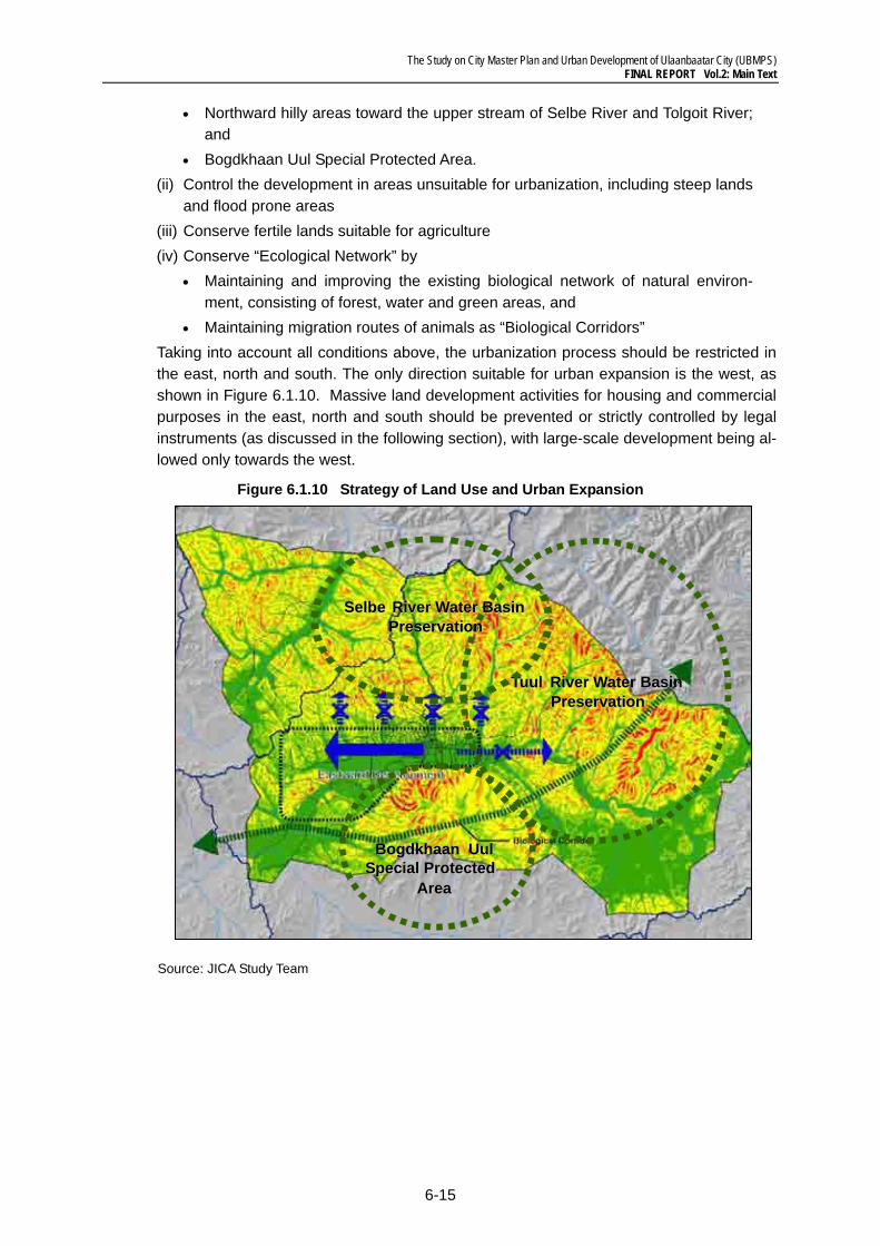
The Study on City Master Plan and Urban Development of Ulaanbaatar City (UBMPS) FINAL REPORT Vol.2: Main Text
6-15
• Northward hilly areas toward the upper stream of Selbe River and Tolgoit River; and
• Bogdkhaan Uul Special Protected Area. (ii) Control the development in areas unsuitable for urbanization, including steep lands
and flood prone areas (iii) Conserve fertile lands suitable for agriculture (iv) Conserve “Ecological Network” by
• Maintaining and improving the existing biological network of natural environ-ment, consisting of forest, water and green areas, and
• Maintaining migration routes of animals as “Biological Corridors” Taking into account all conditions above, the urbanization process should be restricted in the east, north and south. The only direction suitable for urban expansion is the west, as shown in Figure 6.1.10. Massive land development activities for housing and commercial purposes in the east, north and south should be prevented or strictly controlled by legal instruments (as discussed in the following section), with large-scale development being al-lowed only towards the west.
Figure 6.1.10 Strategy of Land Use and Urban Expansion
Source: JICA Study Team
TuulTuul River Water Basin River Water Basin Preservation Preservation
SelbeSelbe River Water BasinRiver Water BasinPreservationPreservation
BogdkhaanBogdkhaan UulUulSpecial Protected Special Protected
AreaArea
The Study on City Master Plan and Urban Development of Ulaanbaatar City (UBMPS) FINAL REPORT Vol.2: Main Text
6-16
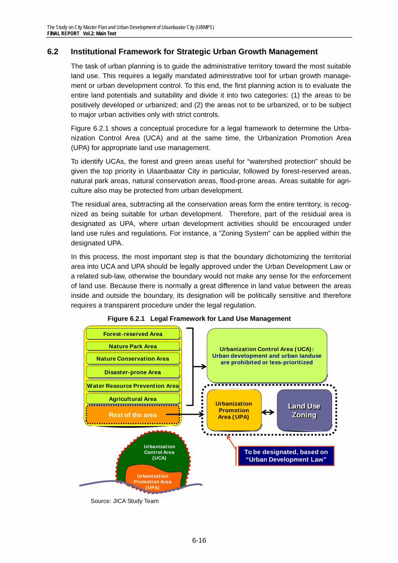
6.2 Institutional Framework for Strategic Urban Growth Management
The task of urban planning is to guide the administrative territory toward the most suitable land use. This requires a legally mandated administrative tool for urban growth manage-ment or urban development control. To this end, the first planning action is to evaluate the entire land potentials and suitability and divide it into two categories: (1) the areas to be positively developed or urbanized; and (2) the areas not to be urbanized, or to be subject to major urban activities only with strict controls.
Figure 6.2.1 shows a conceptual procedure for a legal framework to determine the Urba-nization Control Area (UCA) and at the same time, the Urbanization Promotion Area (UPA) for appropriate land use management.
To identify UCAs, the forest and green areas useful for “watershed protection” should be given the top priority in Ulaanbaatar City in particular, followed by forest-reserved areas, natural park areas, natural conservation areas, flood-prone areas. Areas suitable for agri-culture also may be protected from urban development.
The residual area, subtracting all the conservation areas form the entire territory, is recog-nized as being suitable for urban development. Therefore, part of the residual area is designated as UPA, where urban development activities should be encouraged under land use rules and regulations. For instance, a “Zoning System” can be applied within the designated UPA.
In this process, the most important step is that the boundary dichotomizing the territorial area into UCA and UPA should be legally approved under the Urban Development Law or a related sub-law, otherwise the boundary would not make any sense for the enforcement of land use. Because there is normally a great difference in land value between the areas inside and outside the boundary, its designation will be politically sensitive and therefore requires a transparent procedure under the legal regulation.
Figure 6.2.1 Legal Framework for Land Use Management
Source: JICA Study Team
Urban Promotion Area(UPA)
UrbanizationPromotionArea (UPA)
Urbanization Control Area (UCA):Urban development and urban landuse
are prohibited or less-prioritized
UrbanizationPromotion Area
(UPA)
UrbanizationControl Area
(UCA)
Disaster-prone Area
Agricultural Area
Forest-reserved Area
Nature Park Area
Nature Conservation Area
Water Resource Prevention Area
Rest of the areaLand UseZoning
To be designated, based on “Urban Development Law”
The Study on City Master Plan and Urban Development of Ulaanbaatar City (UBMPS) FINAL REPORT Vol.2: Main Text
6-17
6.3 Urban Structure for the Compact City
1) Alternative Scenarios on Growth Management
Given a scenario of “Do-Nothing” on land use management for the urbanization process, urban sprawl will continue over any available areas in Ulaanbaatar City. The land will be occupied in a disorderly fashion, thereby blighting the city and eroding the potential for ur-ban economic growth. Therefore, the management of urban growth will surely become crucial along with growing an urban economy.
Based on the same recognition as above, UBMP-2020 proposed a controlled-expanded urbanization pattern in association with the development of several new urban settlement areas. This approach would be appropriate, given a well-functioning management system for land development and construction activities by the private sector.
Another scenario, which deserves to be pursued to revise the Master Plan, is so-called “Guided-growth approach” to form a Compact City, instead of allowing urban sprawl. Based on past experiences in other cities in the world, the public mass-transit system will be an effective tool to guide urban development activities, so the compact city is regarded as a mass-transit-led urbanization pattern based on integration with transport systems and land use management.
2) Formation of Guided Compact City
The “Compact City” can be defined in several ways, depending on the characteristics of the city and planning objectives. Nowadays, the compact city concept is often used as a planning approach to form an environmentally sustainable urban system1, or an energy-efficient urban structure under rapid increase in urban populations.
According to this, a Compact City should have conditions and/or elements as follows:
(i) High-density settlement (ii) Less dependency on automobiles (iii) Clear delineation from surrounding area (iv) Mixed land use (v) Social fairness (vi) Self-sufficiency of daily life (vii) Independent governance
In addition, the following planning issues are envisaged for materialization of a Compact City.
(a) Quality Mass-transit Corridors: An efficient public transportation system, comprised of mass-transit as a backbone and effective feeder systems is to be established.
(b) Integrated Urban and/or Land-use Development and Revitalization of Inner City: high-density habitation and intensive land use for commercial and business activities need to be promoted.
(c) Efficient Supply of Social Infrastructures and Public Services: Energy-saving/efficient and resource recycling-oriented urban systems are pursued.
1 The first definition was made by Danzwik and Saaty (1978).
The Study on City Master Plan and Urban Development of Ulaanbaatar City (UBMPS) FINAL REPORT Vol.2: Main Text
6-18
(d) Adequate Institutional Framework for Private Sector Investment: Properly-managed active private sector participation in development of a Compact City is es-sential.
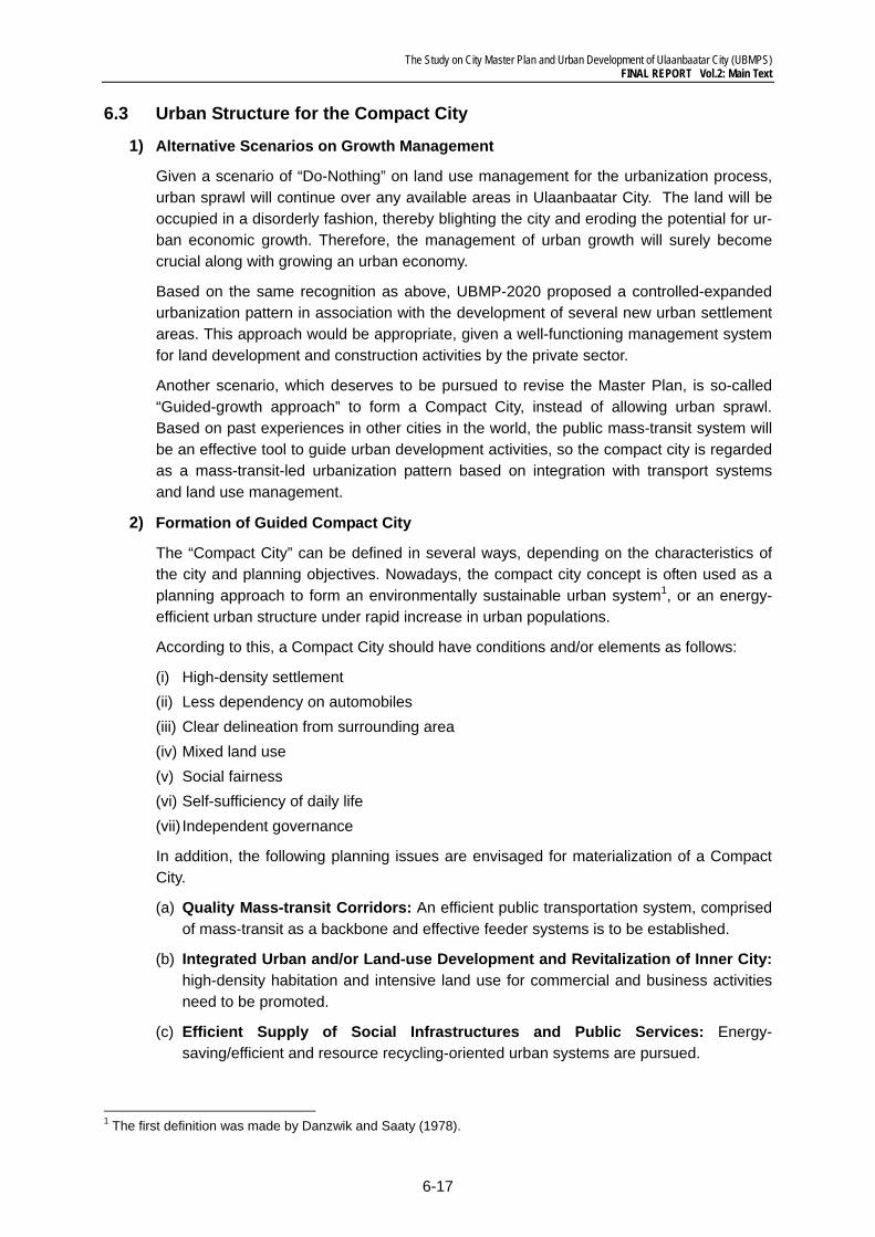
Figure 6.3.1 Urban Sprawl and Guided Move to Compact City
Source: JICA Study Team
3) Urbanization Pattern under the “Compact City Scenario”
The Compact City Scenario shall require a smaller Urbanization Promotion Area than that of the “Do-Nothing” Scenario because higher densification of existing urbanization areas will obviate disorderly urban sprawl.
The current density of the existing urbanized area is about 60 persons/ha on average. The underlying issue for “Compact City” is how intensively the existing built-up area can accommodate new comers, or how high the population density could practically become. Facilitation of urban redevelopment and/or renewal will be a prerequisite to address the concept of Compact City.
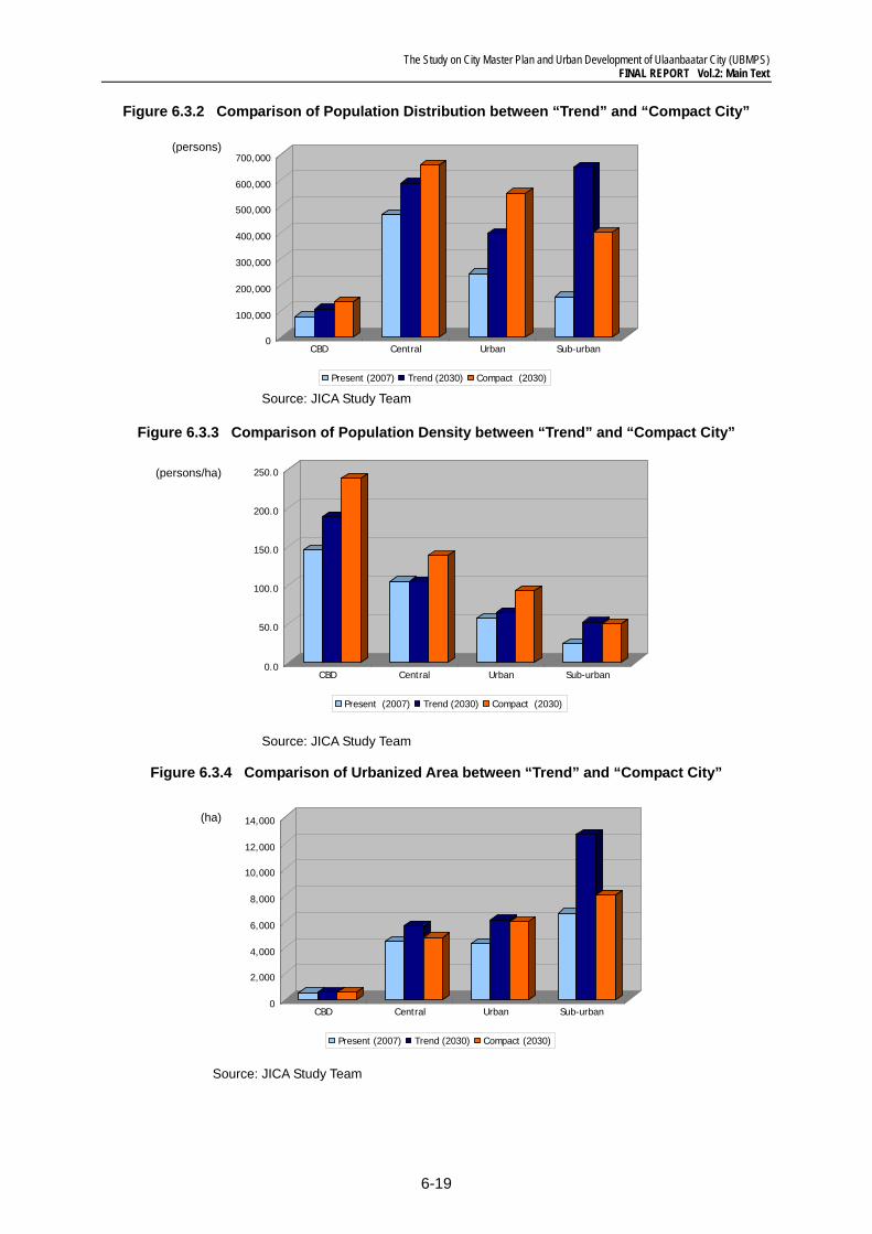
An examination of future urbanization patterns in 2030 was made and the result is sum-marized in Table 6.3.1, presenting a comparison between “Trend (Do-nothing) Scenario” and “Compact City Scenario” in population, Urbanized Areas and Population Density in four (4) categories of area that represent the geographical proximity to the CBD, as shown in Figure 6.4.5. It is obvious that the urbanized area of the Compact City will be smaller than that of the Trend Scenario, totaling about 19,300 ha for the Compact City and about 25,000 ha for the trend scenario in 2030. Approximately 9,000 ha shall be additionally ex-panded from the present 2007 in the Trend Scenario, compared with about 5,700 ha in the Compact City.
The population density will be 90.0 persons/ha for the Compact City, compared with 69.4 persons/ha for the Trend Scenario on average.
The comparison in area distributions is understandable from Figures 6.3.2 and 6.3.4. As seen in these figures, the Compact City tends to facilitate more densification in the central area by controlling urban sprawl to sub-urban areas. Thereby, benefits from the Compact City will lead to more efficient transportation, higher people’s mobility, a more efficient in-frastructure network, better cost-performance and less environmental load on the entire city.
Urban Sprawl Guided to COMPACT CITY
The Study on City Master Plan and Urban Development of Ulaanbaatar City (UBMPS) FINAL REPORT Vol.2: Main Text
6-19
Figure 6.3.2 Comparison of Population Distribution between “Trend” and “Compact City”
Source: JICA Study Team
Figure 6.3.3 Comparison of Population Density between “Trend” and “Compact City”
Source: JICA Study Team
Figure 6.3.4 Comparison of Urbanized Area between “Trend” and “Compact City”
Source: JICA Study Team
0
100,000
200,000
300,000
400,000
500,000
600,000
700,000
CBD Central Urban Sub-urban
Present (2007) Trend (2030) Compact (2030)
(persons)
0.0
50.0
100.0
150.0
200.0
250.0
CBD Central Urban Sub-urban
Present (2007) Trend (2030) Compact (2030)
(persons/ha)
0
2,000
4,000
6,000
8,000
10,000
12,000
14,000
CBD Central Urban Sub-urban
Present (2007) Trend (2030) Compact (2030)
(ha)
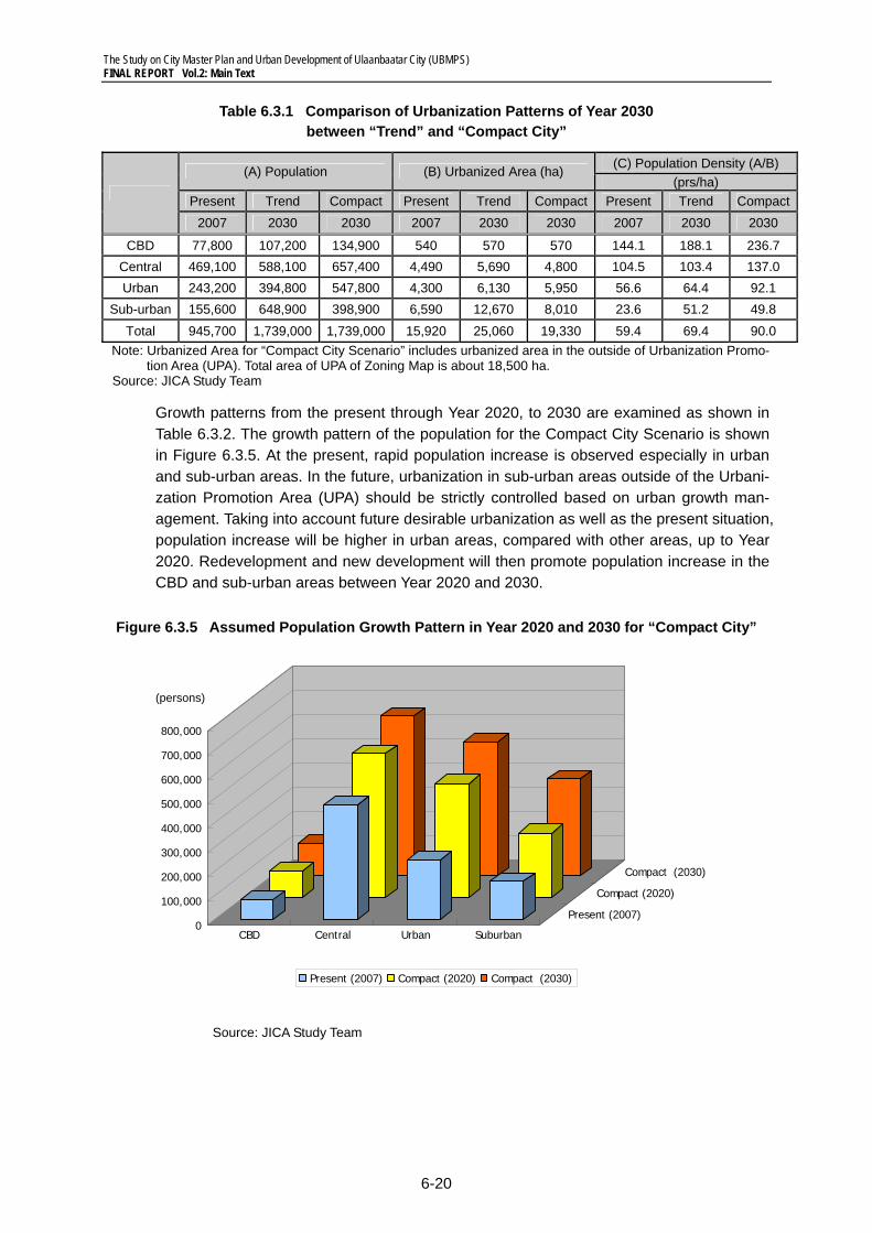
The Study on City Master Plan and Urban Development of Ulaanbaatar City (UBMPS) FINAL REPORT Vol.2: Main Text
6-20
Table 6.3.1 Comparison of Urbanization Patterns of Year 2030 between “Trend” and “Compact City”
(A) Population (B) Urbanized Area (ha) (C) Population Density (A/B)
(prs/ha) Present Trend Compact Present Trend Compact Present Trend Compact
2007 2030 2030 2007 2030 2030 2007 2030 2030
CBD 77,800 107,200 134,900 540 570 570 144.1 188.1 236.7 Central 469,100 588,100 657,400 4,490 5,690 4,800 104.5 103.4 137.0 Urban 243,200 394,800 547,800 4,300 6,130 5,950 56.6 64.4 92.1
Sub-urban 155,600 648,900 398,900 6,590 12,670 8,010 23.6 51.2 49.8 Total 945,700 1,739,000 1,739,000 15,920 25,060 19,330 59.4 69.4 90.0
Note: Urbanized Area for “Compact City Scenario” includes urbanized area in the outside of Urbanization Promo-tion Area (UPA). Total area of UPA of Zoning Map is about 18,500 ha.
Source: JICA Study Team
Growth patterns from the present through Year 2020, to 2030 are examined as shown in Table 6.3.2. The growth pattern of the population for the Compact City Scenario is shown in Figure 6.3.5. At the present, rapid population increase is observed especially in urban and sub-urban areas. In the future, urbanization in sub-urban areas outside of the Urbani-zation Promotion Area (UPA) should be strictly controlled based on urban growth man-agement. Taking into account future desirable urbanization as well as the present situation, population increase will be higher in urban areas, compared with other areas, up to Year 2020. Redevelopment and new development will then promote population increase in the CBD and sub-urban areas between Year 2020 and 2030.
Figure 6.3.5 Assumed Population Growth Pattern in Year 2020 and 2030 for “Compact City”
Source: JICA Study Team
0
100,000
200,000
300,000
400,000
500,000
600,000
700,000
800,000
CBD Central Urban Suburban
Present (2007)
Compact (2020)
Compact (2030)
Present (2007) Compact (2020) Compact (2030)
(persons)
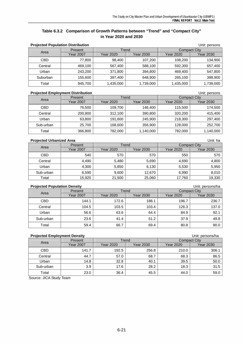
The Study on City Master Plan and Urban Development of Ulaanbaatar City (UBMPS) FINAL REPORT Vol.2: Main Text
6-21
Table 6.3.2 Comparison of Growth Patterns between “Trend” and “Compact City” in Year 2020 and 2030
Projected Population Distribution Unit: persons
Area Present Trend Compact City Year 2007 Year 2020 Year 2030 Year 2020 Year 2030
CBD 77,800 98,400 107,200 108,200 134,900 Central 469,100 567,400 588,100 592,300 657,400 Urban 243,200 371,800 394,800 469,400 547,800
Suburban 155,600 397,400 648,900 265,100 398,900 Total 945,700 1,435,000 1,739,000 1,435,000 1,739,000
Projected Employment Distribution Unit: persons
Area Present Trend Compact City Year 2007 Year 2020 Year 2030 Year 2020 Year 2030
CBD 76,500 109,700 146,400 115,500 174,500 Central 200,800 312,100 390,800 320,200 415,400 Urban 63,800 191,600 245,900 218,300 297,400
Sub-urban 25,700 168,600 356,900 128,000 252,700 Total 366,800 782,000 1,140,000 782,000 1,140,000
Projected Urbanized Area Unit: ha
Area Present Trend Compact City Year 2007 Year 2020 Year 2030 Year 2020 Year 2030
CBD 540 570 570 550 570 Central 4,490 5,480 5,690 4,690 4,800 Urban 4,300 5,850 6,130 5,530 5,950
Sub-urban 6,590 9,600 12,670 6,990 8,010 Total 15,920 21,500 25,060 17,760 19,330
Projected Population Density Unit: persons/ha
Area Present Trend Compact City Year 2007 Year 2020 Year 2030 Year 2020 Year 2030
CBD 144.1 172.6 188.1 196.7 236.7 Central 104.5 103.5 103.4 126.3 137.0 Urban 56.6 63.6 64.4 84.9 92.1
Sub-urban 23.6 41.4 51.2 37.9 49.8
Total 59.4 66.7 69.4 80.8 90.0
Projected Employment Density Unit: persons/ha
Area Present Trend Compact City Year 2007 Year 2020 Year 2030 Year 2020 Year 2030
CBD 141.7 192.5 256.8 210.0 306.1 Central 44.7 57.0 68.7 68.3 86.5 Urban 14.8 32.8 40.1 39.5 50.0
Sub-urban 3.9 17.6 28.2 18.3 31.5 Total 23.0 36.4 45.5 44.0 59.0
Source: JICA Study Team
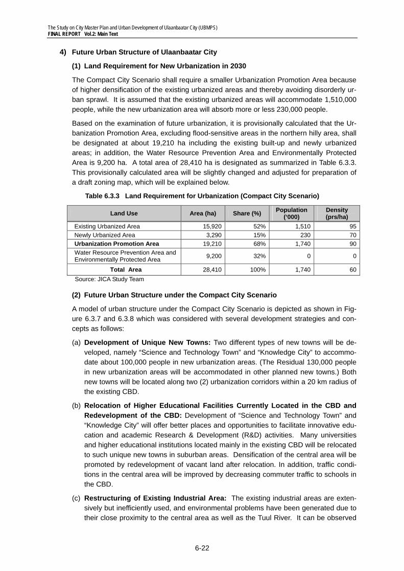
The Study on City Master Plan and Urban Development of Ulaanbaatar City (UBMPS) FINAL REPORT Vol.2: Main Text
6-22
4) Future Urban Structure of Ulaanbaatar City
(1) Land Requirement for New Urbanization in 2030
The Compact City Scenario shall require a smaller Urbanization Promotion Area because of higher densification of the existing urbanized areas and thereby avoiding disorderly ur-ban sprawl. It is assumed that the existing urbanized areas will accommodate 1,510,000 people, while the new urbanization area will absorb more or less 230,000 people.
Based on the examination of future urbanization, it is provisionally calculated that the Ur-banization Promotion Area, excluding flood-sensitive areas in the northern hilly area, shall be designated at about 19,210 ha including the existing built-up and newly urbanized areas; in addition, the Water Resource Prevention Area and Environmentally Protected Area is 9,200 ha. A total area of 28,410 ha is designated as summarized in Table 6.3.3. This provisionally calculated area will be slightly changed and adjusted for preparation of a draft zoning map, which will be explained below.
Table 6.3.3 Land Requirement for Urbanization (Compact City Scenario)
Land Use Area (ha) Share (%) Population (‘000)
Density (prs/ha)
Existing Urbanized Area 15,920 52% 1,510 95Newly Urbanized Area 3,290 15% 230 70Urbanization Promotion Area 19,210 68% 1,740 90Water Resource Prevention Area and Environmentally Protected Area 9,200 32% 0 0
Total Area 28,410 100% 1,740 60Source: JICA Study Team
(2) Future Urban Structure under the Compact City Scenario
A model of urban structure under the Compact City Scenario is depicted as shown in Fig-ure 6.3.7 and 6.3.8 which was considered with several development strategies and con-cepts as follows:
(a) Development of Unique New Towns: Two different types of new towns will be de-veloped, namely “Science and Technology Town” and “Knowledge City” to accommo-date about 100,000 people in new urbanization areas. (The Residual 130,000 people in new urbanization areas will be accommodated in other planned new towns.) Both new towns will be located along two (2) urbanization corridors within a 20 km radius of the existing CBD.
(b) Relocation of Higher Educational Facilities Currently Located in the CBD and Redevelopment of the CBD: Development of “Science and Technology Town” and “Knowledge City” will offer better places and opportunities to facilitate innovative edu-cation and academic Research & Development (R&D) activities. Many universities and higher educational institutions located mainly in the existing CBD will be relocated to such unique new towns in suburban areas. Densification of the central area will be promoted by redevelopment of vacant land after relocation. In addition, traffic condi-tions in the central area will be improved by decreasing commuter traffic to schools in the CBD.
(c) Restructuring of Existing Industrial Area: The existing industrial areas are exten-sively but inefficiently used, and environmental problems have been generated due to their close proximity to the central area as well as the Tuul River. It can be observed
The Study on City Master Plan and Urban Development of Ulaanbaatar City (UBMPS) FINAL REPORT Vol.2: Main Text
6-23
that a number of factories are not in operation or are neglected with poor manage-ment of facilities. These factories and warehouses should be encouraged to relocate to the planned industrial parks or designated industrial zones. The area after reloca-tion of those industries shall be converted into more efficient land use for housing and/or commercial uses.
(d) Development of Rail-based Public Transportation Systems: Two (2) lines of rail-based public transportation system will be developed along the two (2) urbanization corridors, that is, the western and southwestern corridors. The first line will run on Peace Avenue from the present east tram terminal, passing through the CBD, to a new town of “Knowledge City.” The second line will run from the CBD, through Peace Bridge, to “Science and Technology Town”. Sections of both lines running through the CBD will be underground (approx. 5 km). These new public transport systems may be named “Ulaanbaatar Metro-Transit System (UMTS)”.
(e) Redevelopment of Sub-centers Centered on Railway Stations: Redevelopment for intensive land use should be promoted in the surrounding areas of selected stations of the UMTS. A number of sub-centers whose developments are facilitated as commer-cial, service and business centers shall be designated in the revised Master Plan. In addition, underground malls will be developed at railway stations at Sukhbaatar Square and the State Department Store to create gathering spaces even in the severe climate of winter in Mongolia (See Figure 6.3.6). This redevelopment will contribute to increasing railway users.
(f) Restructuring and Improvement of Ger Areas/Ger Settlements: Affordable social housing should be developed with vacant land created by restructuring the existing industrial areas. Residents in Ger areas will be resettled in such social housing units or the residential areas to be specially designated in the revised Master Plan. The north-side hills, which are currently Ger areas, have superior environments, including provision of sunshine by facing to the south and panoramic views of Ulaanbaatar City and Bogd Khan Mountain. These areas may be converted into quality and prestigious residential areas with good environments.
(g) Protection for Flood Disaster and Land Sliding: Roads on the north-side hills serve as boundaries of the Urbanization Promotion Area. The road section will be designed for prevention of flood disasters and landslides.
(h) Development of Green Belt: Green belt will be developed between the existing ur-banized areas and new towns. It will be integrated into a network of natural environ-ments at regional levels.
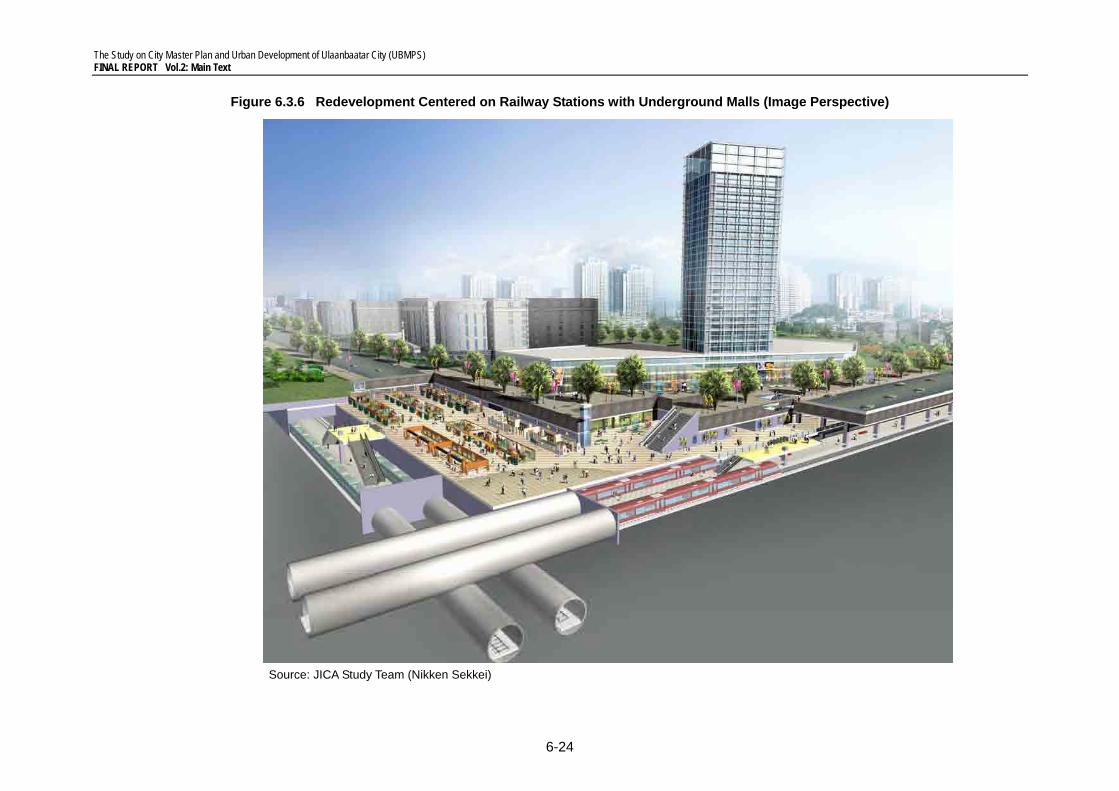
The Study on City Master Plan and Urban Development of Ulaanbaatar City (UBMPS) FINAL REPORT Vol.2: Main Text
6-24
Figure 6.3.6 Redevelopment Centered on Railway Stations with Underground Malls (Image Perspective)
Source: JICA Study Team (Nikken Sekkei)
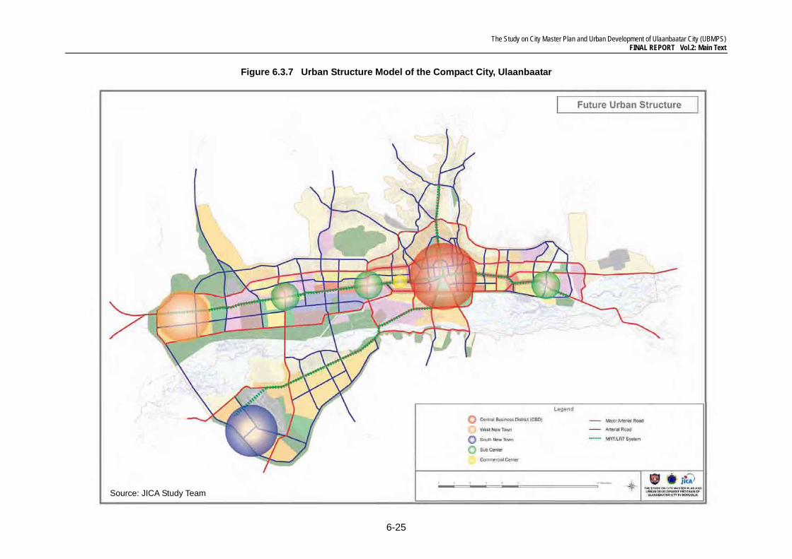
The Study on City Master Plan and Urban Development of Ulaanbaatar City (UBMPS) FINAL REPORT Vol.2: Main Text
6-25
Figure 6.3.7 Urban Structure Model of the Compact City, Ulaanbaatar
Source: JICA Study Team
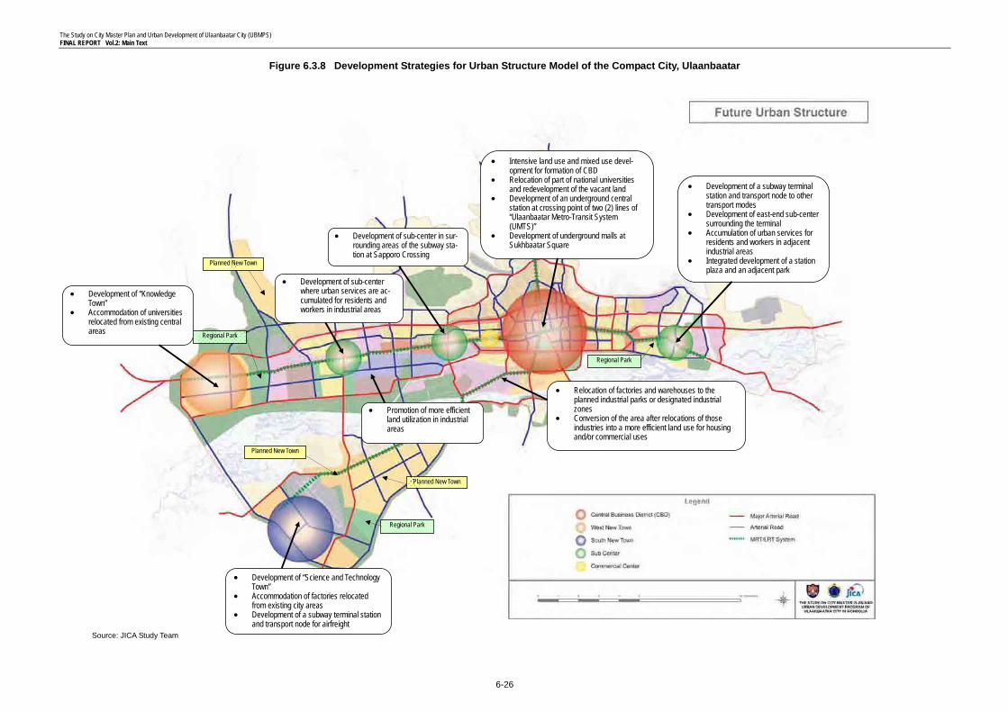
The Study on City Master Plan and Urban Development of Ulaanbaatar City (UBMPS) FINAL REPORT Vol.2: Main Text
6-26
Figure 6.3.8 Development Strategies for Urban Structure Model of the Compact City, Ulaanbaatar
• Development of a subway terminal station and transport node to other transport modes
• Development of east-end sub-center surrounding the terminal
• Accumulation of urban services for residents and workers in adjacent industrial areas
• Integrated development of a station plaza and an adjacent park
• Intensive land use and mixed use devel-opment for formation of CBD
• Relocation of part of national universities and redevelopment of the vacant land
• Development of an underground central station at crossing point of two (2) lines of “Ulaanbaatar Metro-Transit System (UMTS)”
• Development of underground malls at Sukhbaatar Square
• Development of “Science and Technology Town”
• Accommodation of factories relocated from existing city areas
• Development of a subway terminal station and transport node for airfreight
Planned New Town
Planned New Town
Regional Park
• Development of “Knowledge Town”
• Accommodation of universities relocated from existing central areas Regional Park
Planned New Town
• Development of sub-center in sur-rounding areas of the subway sta-tion at Sapporo Crossing
• Development of sub-center where urban services are ac-cumulated for residents and workers in industrial areas
• Relocation of factories and warehouses to the planned industrial parks or designated industrial zones
• Conversion of the area after relocations of those industries into a more efficient land use for housing and/or commercial uses
• Promotion of more efficient land utilization in industrial areas
Regional Park
Source: JICA Study Team
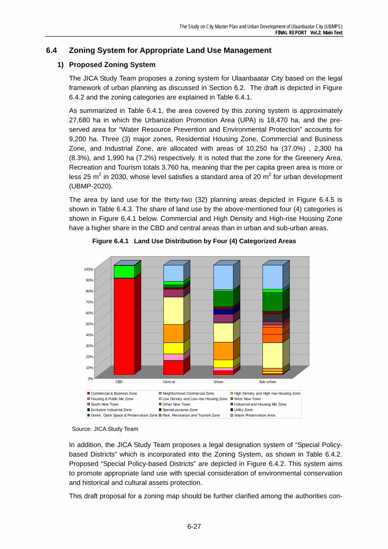
The Study on City Master Plan and Urban Development of Ulaanbaatar City (UBMPS) FINAL REPORT Vol.2: Main Text
6-27
6.4 Zoning System for Appropriate Land Use Management
1) Proposed Zoning System
The JICA Study Team proposes a zoning system for Ulaanbaatar City based on the legal framework of urban planning as discussed in Section 6.2. The draft is depicted in Figure 6.4.2 and the zoning categories are explained in Table 6.4.1.
As summarized in Table 6.4.1, the area covered by this zoning system is approximately 27,680 ha in which the Urbanization Promotion Area (UPA) is 18,470 ha, and the pre-served area for “Water Resource Prevention and Environmental Protection” accounts for 9,200 ha. Three (3) major zones, Residential Housing Zone, Commercial and Business Zone, and Industrial Zone, are allocated with areas of 10,250 ha (37.0%) , 2,300 ha (8.3%), and 1,990 ha (7.2%) respectively. It is noted that the zone for the Greenery Area, Recreation and Tourism totals 3,760 ha, meaning that the per capita green area is more or less 25 m2 in 2030, whose level satisfies a standard area of 20 m2 for urban development (UBMP-2020).
The area by land use for the thirty-two (32) planning areas depicted in Figure 6.4.5 is shown in Table 6.4.3. The share of land use by the above-mentioned four (4) categories is shown in Figure 6.4.1 below. Commercial and High Density and High-rise Housing Zone have a higher share in the CBD and central areas than in urban and sub-urban areas.
Figure 6.4.1 Land Use Distribution by Four (4) Categorized Areas
Source: JICA Study Team
In addition, the JICA Study Team proposes a legal designation system of “Special Policy-based Districts” which is incorporated into the Zoning System, as shown in Table 6.4.2. Proposed “Special Policy-based Districts” are depicted in Figure 6.4.2. This system aims to promote appropriate land use with special consideration of environmental conservation and historical and cultural assets protection.
This draft proposal for a zoning map should be further clarified among the authorities con-
0%
10%
20%
30%
40%
50%
60%
70%
80%
90%
100%
CBD Central Urban Sub-urban
Commercial & Business Zone Neighborhood Commercial Zone High Density and High-rise Housing ZoneHousing & Public Mix Zone Low Density and Low-rise Housing Zone West New TownSouth New Town Other New Town Industrial and Housing Mix ZoneExclusive Industrial Zone Special-purpose Zone Utility ZoneGreen, Open Space & Preservation Zone Park, Recreation and Tourism Zone Water Preservation Area
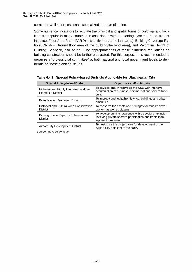
The Study on City Master Plan and Urban Development of Ulaanbaatar City (UBMPS) FINAL REPORT Vol.2: Main Text
6-28
cerned as well as professionals specialized in urban planning.
Some numerical indicators to regulate the physical and spatial forms of buildings and facil-ities are popular in many countries in association with the zoning system. These are, for instance, Floor Area Ratio (FAR % = total floor area/the land area), Building Coverage Ra-tio (BCR % = Ground floor area of the building/the land area), and Maximum Height of Building, Set-back, and so on. The appropriateness of these numerical regulations on building construction should be further elaborated. For this purpose, it is recommended to organize a “professional committee” at both national and local government levels to deli-berate on these planning issues.
Table 6.4.2 Special Policy-based Districts Applicable for Ulaanbaatar City Special Policy-based District Objectives and/or Targets
High-rise and Highly Intensive Landuse Promotion District
To develop and/or redevelop the CBD with intensive accumulation of business, commercial and service func-tions
Beautification Promotion District To improve and revitalize historical buildings and urban amenities.
Historical and Cultural Area Conservation District
To conserve the assets and heritages for tourism devel-opment as well as citizens.
Parking Space Capacity Enhancement District
To develop parking lots/space with a special emphasis, involving private sector’s participation and traffic man-agement measures.
Airport City Development District To designate the project area for development of the Airport City adjacent to the NUIA.
Source: JICA Study Team
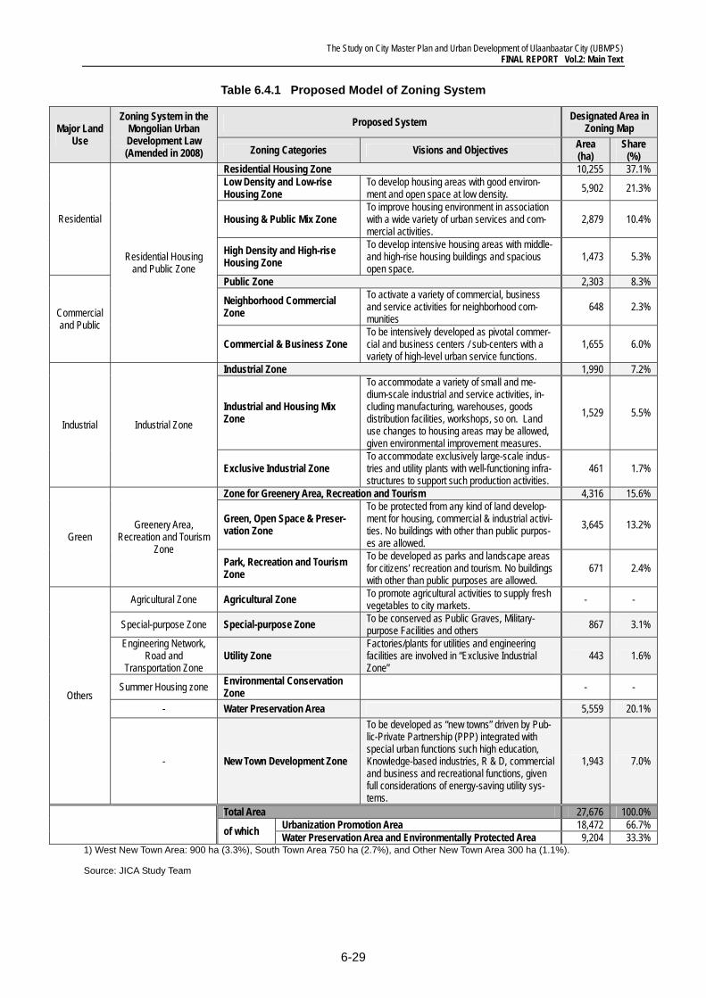
The Study on City Master Plan and Urban Development of Ulaanbaatar City (UBMPS) FINAL REPORT Vol.2: Main Text
6-29
Table 6.4.1 Proposed Model of Zoning System
Major Land Use
Zoning System in the Mongolian Urban Development Law (Amended in 2008)
Proposed System Designated Area in Zoning Map
Zoning Categories Visions and Objectives Area (ha)
Share (%)
Residential
Residential Housing and Public Zone
Residential Housing Zone 10,255 37.1% Low Density and Low-rise Housing Zone
To develop housing areas with good environ-ment and open space at low density. 5,902 21.3%
Housing & Public Mix Zone To improve housing environment in association with a wide variety of urban services and com-mercial activities.
2,879 10.4%
High Density and High-rise Housing Zone
To develop intensive housing areas with middle- and high-rise housing buildings and spacious open space.
1,473 5.3%
Commercial and Public
Public Zone 2,303 8.3%
Neighborhood Commercial Zone
To activate a variety of commercial, business and service activities for neighborhood com-munities
648 2.3%
Commercial & Business Zone To be intensively developed as pivotal commer-cial and business centers / sub-centers with a variety of high-level urban service functions.
1,655 6.0%
Industrial Industrial Zone
Industrial Zone 1,990 7.2%
Industrial and Housing Mix Zone
To accommodate a variety of small and me-dium-scale industrial and service activities, in-cluding manufacturing, warehouses, goods distribution facilities, workshops, so on. Land use changes to housing areas may be allowed, given environmental improvement measures.
1,529 5.5%
Exclusive Industrial Zone To accommodate exclusively large-scale indus-tries and utility plants with well-functioning infra-structures to support such production activities.
461 1.7%
Green Greenery Area,
Recreation and Tourism Zone
Zone for Greenery Area, Recreation and Tourism 4,316 15.6%
Green, Open Space & Preser-vation Zone
To be protected from any kind of land develop-ment for housing, commercial & industrial activi-ties. No buildings with other than public purpos-es are allowed.
3,645 13.2%
Park, Recreation and Tourism Zone
To be developed as parks and landscape areas for citizens’ recreation and tourism. No buildings with other than public purposes are allowed.
671 2.4%
Others
Agricultural Zone Agricultural Zone To promote agricultural activities to supply fresh vegetables to city markets. - -
Special-purpose Zone Special-purpose Zone To be conserved as Public Graves, Military-purpose Facilities and others 867 3.1%
Engineering Network, Road and
Transportation Zone Utility Zone
Factories/plants for utilities and engineering facilities are involved in “Exclusive Industrial Zone”
443 1.6%
Summer Housing zone Environmental Conservation Zone - -
- Water Preservation Area 5,559 20.1%
- New Town Development Zone
To be developed as “new towns” driven by Pub-lic-Private Partnership (PPP) integrated with special urban functions such high education, Knowledge-based industries, R & D, commercial and business and recreational functions, given full considerations of energy-saving utility sys-tems.
1,943 7.0%
Total Area 27,676 100.0%
of which Urbanization Promotion Area 18,472 66.7% Water Preservation Area and Environmentally Protected Area 9,204 33.3%
1) West New Town Area: 900 ha (3.3%), South Town Area 750 ha (2.7%), and Other New Town Area 300 ha (1.1%).
Source: JICA Study Team
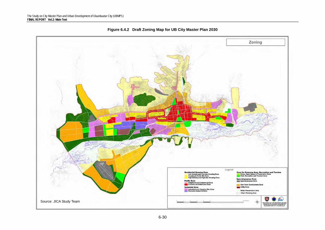
The Study on City Master Plan and Urban Development of Ulaanbaatar City (UBMPS) FINAL REPORT Vol.2: Main Text
6-30
Figure 6.4.2 Draft Zoning Map for UB City Master Plan 2030
Source: JICA Study Team
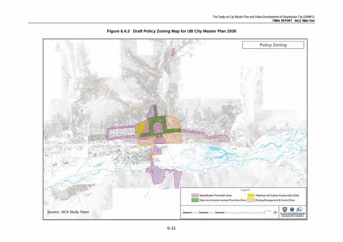
The Study on City Master Plan and Urban Development of Ulaanbaatar City (UBMPS) FINAL REPORT Vol.2: Main Text
6-31
Figure 6.4.3 Draft Policy Zoning Map for UB City Master Plan 2030
Source: JICA Study Team
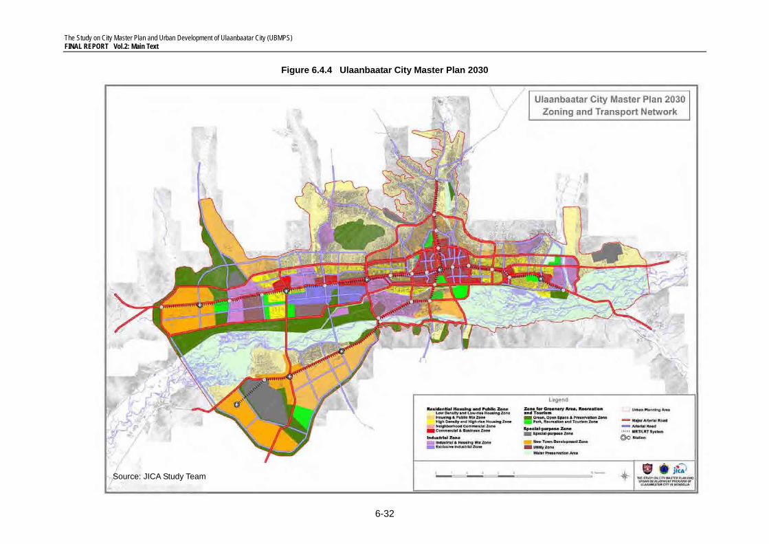
The Study on City Master Plan and Urban Development of Ulaanbaatar City (UBMPS) FINAL REPORT Vol.2: Main Text
6-32
Figure 6.4.4 Ulaanbaatar City Master Plan 2030
Source: JICA Study Team
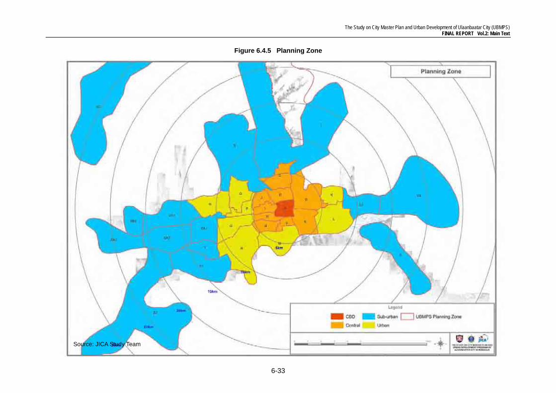
The Study on City Master Plan and Urban Development of Ulaanbaatar City (UBMPS) FINAL REPORT Vol.2: Main Text
6-33
Figure 6.4.5 Planning Zone
Source: JICA Study Team
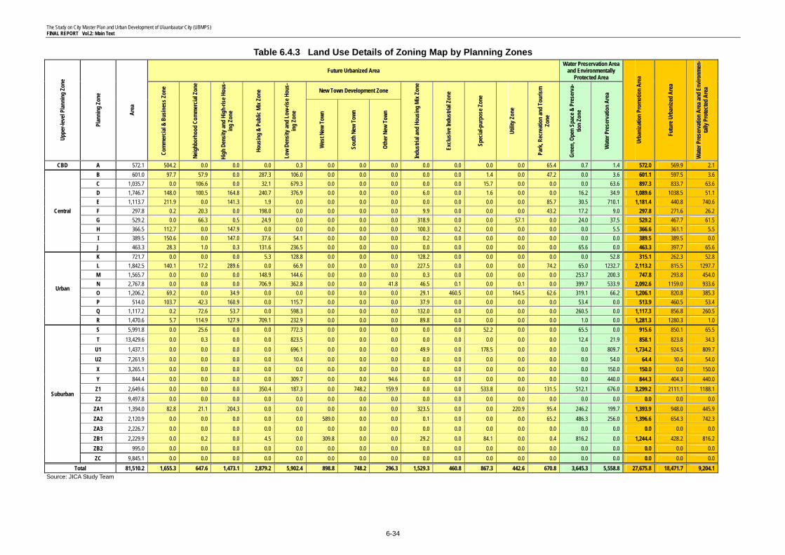
The Study on City Master Plan and Urban Development of Ulaanbaatar City (UBMPS) FINAL REPORT Vol.2: Main Text
6-34
Table 6.4.3 Land Use Details of Zoning Map by Planning Zones Up
per-l
evel
Plan
ning
Zon
e
Plan
ning
Zon
e
Area
Future Urbanized Area Water Preservation Area
and Environmentally Protected Area
Urba
niza
tion
Prom
otio
n Ar
ea
Futu
re U
rban
ized
Area
Wat
er P
rese
rvat
ion
Area
and
Envir
onm
en-
tally
Pro
tect
ed A
rea
Com
mer
cial &
Bus
ines
s Zon
e
Neig
hbor
hood
Com
mer
cial Z
one
High
Den
sity a
nd H
igh-
rise H
ous-
ing
Zone
Hous
ing
& Pu
blic
Mix Z
one
Low
Dens
ity an
d Lo
w-ris
e Hou
s-in
g Zo
ne
New Town Development Zone
Indu
stria
l and
Hou
sing
Mix Z
one
Exclu
sive I
ndus
trial
Zone
Spec
ial-p
urpo
se Z
one
Utilit
y Zon
e
Park
, Rec
reat
ion
and
Tour
ism
Zone
Gree
n, O
pen
Spac
e & P
rese
rva-
tion
Zone
Wat
er P
rese
rvat
ion
Area
Wes
t New
Tow
n
Sout
h Ne
w To
wn
Othe
r New
Tow
n
CBD A 572.1 504.2 0.0 0.0 0.0 0.3 0.0 0.0 0.0 0.0 0.0 0.0 0.0 65.4 0.7 1.4 572.0 569.9 2.1
Central
B 601.0 97.7 57.9 0.0 287.3 106.0 0.0 0.0 0.0 0.0 0.0 1.4 0.0 47.2 0.0 3.6 601.1 597.5 3.6 C 1,035.7 0.0 106.6 0.0 32.1 679.3 0.0 0.0 0.0 0.0 0.0 15.7 0.0 0.0 0.0 63.6 897.3 833.7 63.6 D 1,746.7 148.0 100.5 164.8 240.7 376.9 0.0 0.0 0.0 6.0 0.0 1.6 0.0 0.0 16.2 34.9 1,089.6 1038.5 51.1 E 1,113.7 211.9 0.0 141.3 1.9 0.0 0.0 0.0 0.0 0.0 0.0 0.0 0.0 85.7 30.5 710.1 1,181.4 440.8 740.6 F 297.8 0.2 20.3 0.0 198.0 0.0 0.0 0.0 0.0 9.9 0.0 0.0 0.0 43.2 17.2 9.0 297.8 271.6 26.2 G 529.2 0.0 66.3 0.5 24.9 0.0 0.0 0.0 0.0 318.9 0.0 0.0 57.1 0.0 24.0 37.5 529.2 467.7 61.5 H 366.5 112.7 0.0 147.9 0.0 0.0 0.0 0.0 0.0 100.3 0.2 0.0 0.0 0.0 0.0 5.5 366.6 361.1 5.5 I 389.5 150.6 0.0 147.0 37.6 54.1 0.0 0.0 0.0 0.2 0.0 0.0 0.0 0.0 0.0 0.0 389.5 389.5 0.0 J 463.3 28.3 1.0 0.3 131.6 236.5 0.0 0.0 0.0 0.0 0.0 0.0 0.0 0.0 65.6 0.0 463.3 397.7 65.6
Urban
K 721.7 0.0 0.0 0.0 5.3 128.8 0.0 0.0 0.0 128.2 0.0 0.0 0.0 0.0 0.0 52.8 315.1 262.3 52.8 L 1,842.5 140.1 17.2 289.6 0.0 66.9 0.0 0.0 0.0 227.5 0.0 0.0 0.0 74.2 65.0 1232.7 2,113.2 815.5 1297.7 M 1,565.7 0.0 0.0 0.0 148.9 144.6 0.0 0.0 0.0 0.3 0.0 0.0 0.0 0.0 253.7 200.3 747.8 293.8 454.0 N 2,767.8 0.0 0.8 0.0 706.9 362.8 0.0 0.0 41.8 46.5 0.1 0.0 0.1 0.0 399.7 533.9 2,092.6 1159.0 933.6 O 1,206.2 69.2 0.0 34.9 0.0 0.0 0.0 0.0 0.0 29.1 460.5 0.0 164.5 62.6 319.1 66.2 1,206.1 820.8 385.3 P 514.0 103.7 42.3 160.9 0.0 115.7 0.0 0.0 0.0 37.9 0.0 0.0 0.0 0.0 53.4 0.0 513.9 460.5 53.4 Q 1,117.2 0.2 72.6 53.7 0.0 598.3 0.0 0.0 0.0 132.0 0.0 0.0 0.0 0.0 260.5 0.0 1,117.3 856.8 260.5 R 1,470.6 5.7 114.9 127.9 709.1 232.9 0.0 0.0 0.0 89.8 0.0 0.0 0.0 0.0 1.0 0.0 1,281.3 1280.3 1.0
Suburban
S 5,991.8 0.0 25.6 0.0 0.0 772.3 0.0 0.0 0.0 0.0 0.0 52.2 0.0 0.0 65.5 0.0 915.6 850.1 65.5 T 13,429.6 0.0 0.3 0.0 0.0 823.5 0.0 0.0 0.0 0.0 0.0 0.0 0.0 0.0 12.4 21.9 858.1 823.8 34.3
U1 1,437.1 0.0 0.0 0.0 0.0 696.1 0.0 0.0 0.0 49.9 0.0 178.5 0.0 0.0 0.0 809.7 1,734.2 924.5 809.7 U2 7,261.9 0.0 0.0 0.0 0.0 10.4 0.0 0.0 0.0 0.0 0.0 0.0 0.0 0.0 0.0 54.0 64.4 10.4 54.0 X 3,265.1 0.0 0.0 0.0 0.0 0.0 0.0 0.0 0.0 0.0 0.0 0.0 0.0 0.0 0.0 150.0 150.0 0.0 150.0 Y 844.4 0.0 0.0 0.0 0.0 309.7 0.0 0.0 94.6 0.0 0.0 0.0 0.0 0.0 0.0 440.0 844.3 404.3 440.0 Z1 2,649.6 0.0 0.0 0.0 350.4 187.3 0.0 748.2 159.9 0.0 0.0 533.8 0.0 131.5 512.1 676.0 3,299.2 2111.1 1188.1 Z2 9,497.8 0.0 0.0 0.0 0.0 0.0 0.0 0.0 0.0 0.0 0.0 0.0 0.0 0.0 0.0 0.0 0.0 0.0 0.0
ZA1 1,394.0 82.8 21.1 204.3 0.0 0.0 0.0 0.0 0.0 323.5 0.0 0.0 220.9 95.4 246.2 199.7 1,393.9 948.0 445.9 ZA2 2,120.9 0.0 0.0 0.0 0.0 0.0 589.0 0.0 0.0 0.1 0.0 0.0 0.0 65.2 486.3 256.0 1,396.6 654.3 742.3 ZA3 2,226.7 0.0 0.0 0.0 0.0 0.0 0.0 0.0 0.0 0.0 0.0 0.0 0.0 0.0 0.0 0.0 0.0 0.0 0.0 ZB1 2,229.9 0.0 0.2 0.0 4.5 0.0 309.8 0.0 0.0 29.2 0.0 84.1 0.0 0.4 816.2 0.0 1,244.4 428.2 816.2 ZB2 995.0 0.0 0.0 0.0 0.0 0.0 0.0 0.0 0.0 0.0 0.0 0.0 0.0 0.0 0.0 0.0 0.0 0.0 0.0 ZC 9,845.1 0.0 0.0 0.0 0.0 0.0 0.0 0.0 0.0 0.0 0.0 0.0 0.0 0.0 0.0 0.0 0.0 0.0 0.0
Total 81,510.2 1,655.3 647.6 1,473.1 2,879.2 5,902.4 898.8 748.2 296.3 1,529.3 460.8 867.3 442.6 670.8 3,645.3 5,558.8 27,675.8 18,471.7 9,204.1 Source: JICA Study Team
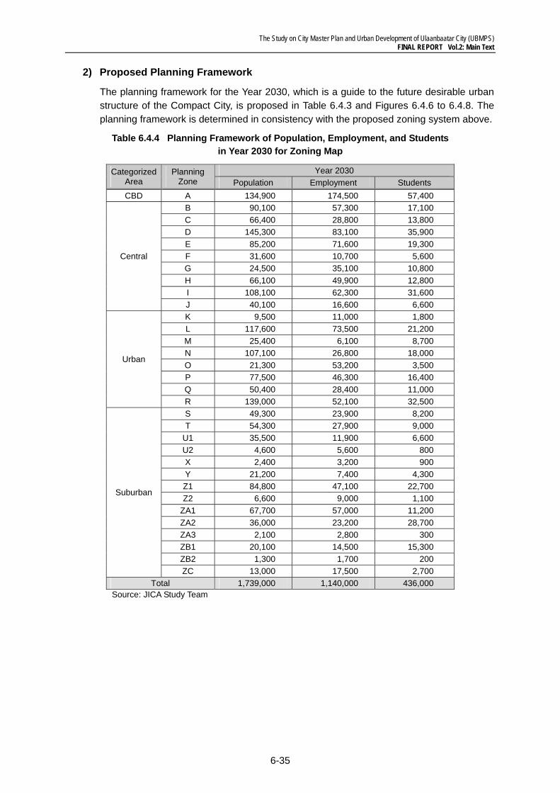
The Study on City Master Plan and Urban Development of Ulaanbaatar City (UBMPS) FINAL REPORT Vol.2: Main Text
6-35
2) Proposed Planning Framework
The planning framework for the Year 2030, which is a guide to the future desirable urban structure of the Compact City, is proposed in Table 6.4.3 and Figures 6.4.6 to 6.4.8. The planning framework is determined in consistency with the proposed zoning system above.
Table 6.4.4 Planning Framework of Population, Employment, and Students in Year 2030 for Zoning Map
Categorized Area
Planning Zone
Year 2030 Population Employment Students
CBD A 134,900 174,500 57,400
Central
B 90,100 57,300 17,100 C 66,400 28,800 13,800 D 145,300 83,100 35,900 E 85,200 71,600 19,300 F 31,600 10,700 5,600 G 24,500 35,100 10,800 H 66,100 49,900 12,800 I 108,100 62,300 31,600 J 40,100 16,600 6,600
Urban
K 9,500 11,000 1,800 L 117,600 73,500 21,200 M 25,400 6,100 8,700 N 107,100 26,800 18,000 O 21,300 53,200 3,500 P 77,500 46,300 16,400 Q 50,400 28,400 11,000 R 139,000 52,100 32,500
Suburban
S 49,300 23,900 8,200 T 54,300 27,900 9,000
U1 35,500 11,900 6,600 U2 4,600 5,600 800 X 2,400 3,200 900 Y 21,200 7,400 4,300 Z1 84,800 47,100 22,700 Z2 6,600 9,000 1,100
ZA1 67,700 57,000 11,200 ZA2 36,000 23,200 28,700 ZA3 2,100 2,800 300 ZB1 20,100 14,500 15,300 ZB2 1,300 1,700 200 ZC 13,000 17,500 2,700
Total 1,739,000 1,140,000 436,000 Source: JICA Study Team
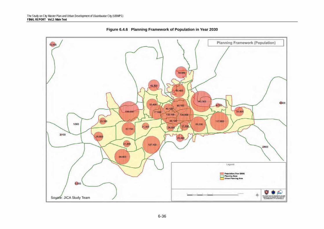
The Study on City Master Plan and Urban Development of Ulaanbaatar City (UBMPS) FINAL REPORT Vol.2: Main Text
6-36
Figure 6.4.6 Planning Framework of Population in Year 2030
Source: JICA Study Team
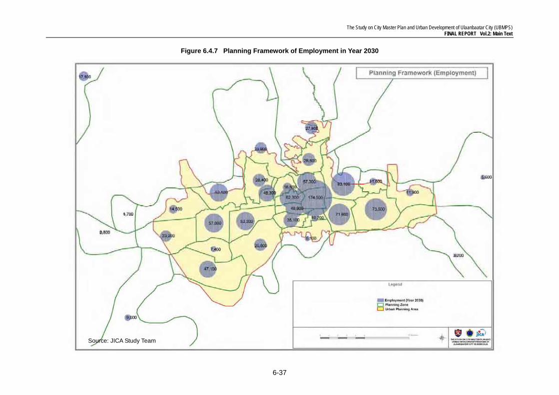
The Study on City Master Plan and Urban Development of Ulaanbaatar City (UBMPS) FINAL REPORT Vol.2: Main Text
6-37
Figure 6.4.7 Planning Framework of Employment in Year 2030
Source: JICA Study Team
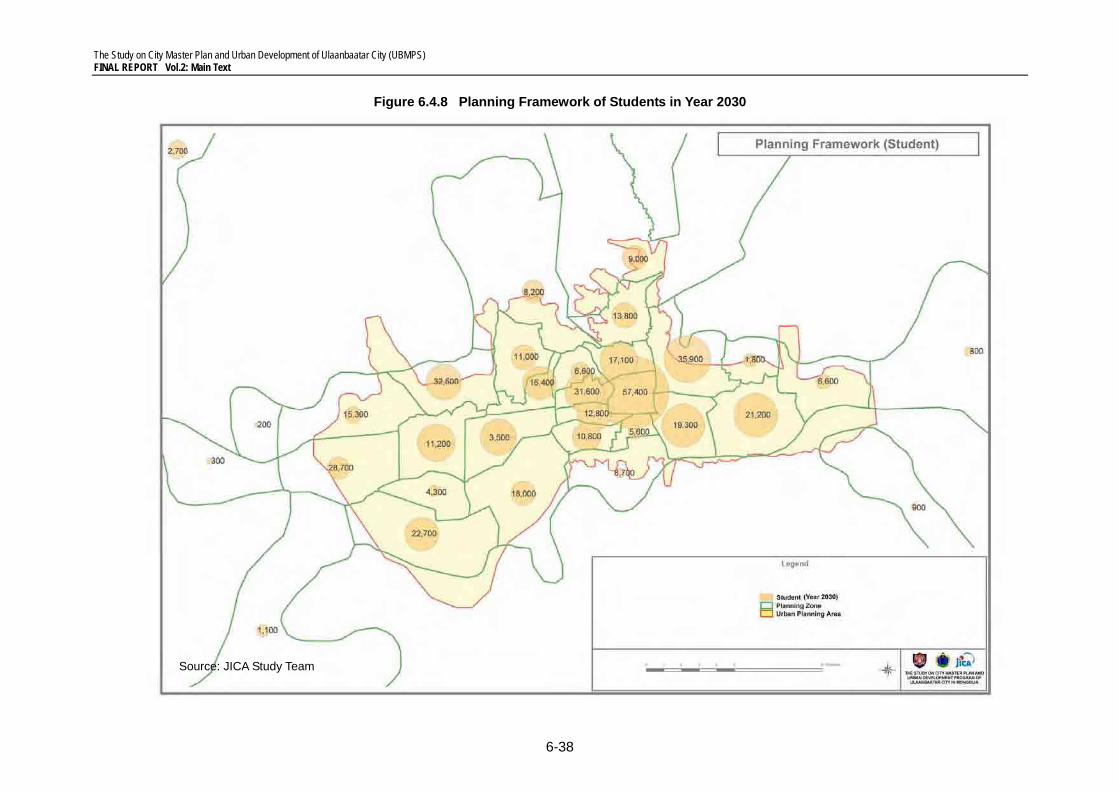
The Study on City Master Plan and Urban Development of Ulaanbaatar City (UBMPS) FINAL REPORT Vol.2: Main Text
6-38
Figure 6.4.8 Planning Framework of Students in Year 2030
Source: JICA Study Team
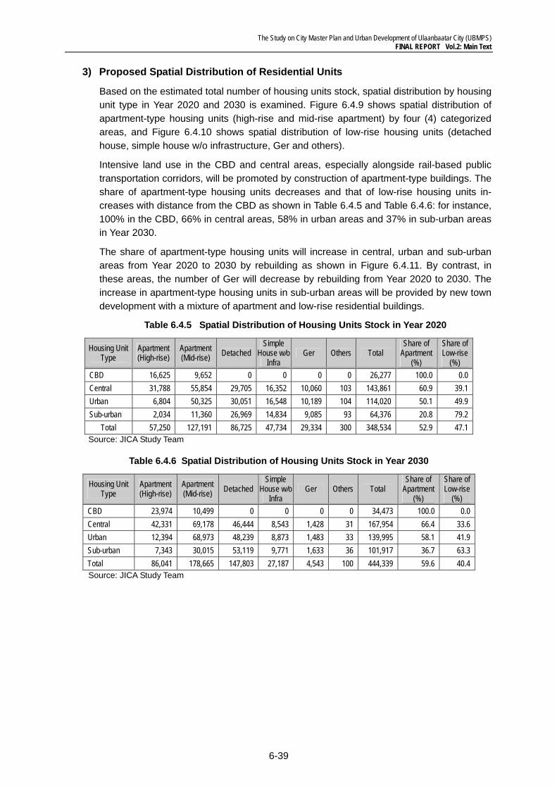
The Study on City Master Plan and Urban Development of Ulaanbaatar City (UBMPS) FINAL REPORT Vol.2: Main Text
6-39
3) Proposed Spatial Distribution of Residential Units
Based on the estimated total number of housing units stock, spatial distribution by housing unit type in Year 2020 and 2030 is examined. Figure 6.4.9 shows spatial distribution of apartment-type housing units (high-rise and mid-rise apartment) by four (4) categorized areas, and Figure 6.4.10 shows spatial distribution of low-rise housing units (detached house, simple house w/o infrastructure, Ger and others).
Intensive land use in the CBD and central areas, especially alongside rail-based public transportation corridors, will be promoted by construction of apartment-type buildings. The share of apartment-type housing units decreases and that of low-rise housing units in-creases with distance from the CBD as shown in Table 6.4.5 and Table 6.4.6: for instance, 100% in the CBD, 66% in central areas, 58% in urban areas and 37% in sub-urban areas in Year 2030.
The share of apartment-type housing units will increase in central, urban and sub-urban areas from Year 2020 to 2030 by rebuilding as shown in Figure 6.4.11. By contrast, in these areas, the number of Ger will decrease by rebuilding from Year 2020 to 2030. The increase in apartment-type housing units in sub-urban areas will be provided by new town development with a mixture of apartment and low-rise residential buildings.
Table 6.4.5 Spatial Distribution of Housing Units Stock in Year 2020
Housing Unit Type
Apartment (High-rise)
Apartment (Mid-rise) Detached
Simple House w/o
Infra Ger Others Total
Share of Apartment
(%)
Share of Low-rise
(%) CBD 16,625 9,652 0 0 0 0 26,277 100.0 0.0 Central 31,788 55,854 29,705 16,352 10,060 103 143,861 60.9 39.1 Urban 6,804 50,325 30,051 16,548 10,189 104 114,020 50.1 49.9 Sub-urban 2,034 11,360 26,969 14,834 9,085 93 64,376 20.8 79.2
Total 57,250 127,191 86,725 47,734 29,334 300 348,534 52.9 47.1 Source: JICA Study Team
Table 6.4.6 Spatial Distribution of Housing Units Stock in Year 2030
Housing Unit Type
Apartment (High-rise)
Apartment (Mid-rise) Detached
Simple House w/o
Infra Ger Others Total
Share of Apartment
(%)
Share of Low-rise
(%) CBD 23,974 10,499 0 0 0 0 34,473 100.0 0.0 Central 42,331 69,178 46,444 8,543 1,428 31 167,954 66.4 33.6 Urban 12,394 68,973 48,239 8,873 1,483 33 139,995 58.1 41.9 Sub-urban 7,343 30,015 53,119 9,771 1,633 36 101,917 36.7 63.3 Total 86,041 178,665 147,803 27,187 4,543 100 444,339 59.6 40.4 Source: JICA Study Team
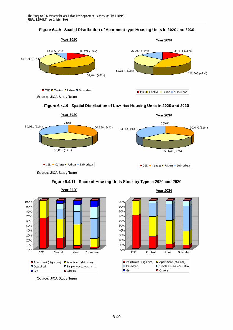
The Study on City Master Plan and Urban Development of Ulaanbaatar City (UBMPS) FINAL REPORT Vol.2: Main Text
6-40
Figure 6.4.9 Spatial Distribution of Apartment-type Housing Units in 2020 and 2030
Source: JICA Study Team
Figure 6.4.10 Spatial Distribution of Low-rise Housing Units in 2020 and 2030
Source: JICA Study Team
Figure 6.4.11 Share of Housing Units Stock by Type in 2020 and 2030
Source: JICA Study Team
Year 2020 Year 2030
64,559 (36%)
58,628 (33%)
56,446 (31%)0 (0%)
CBD Central Urban Sub-urban
50,981 (31%)
56,891 (35%)
56,220 (34%)
0 (0%)
CBD Central Urban Sub-urban
0%
10%
20%
30%
40%
50%
60%
70%
80%
90%
100%
CBD Central Urban Sub-urban
Apartment (High-rise) Apartment (Mid-rise)Detached Simple House w/o InfraGer Others
0%
10%
20%
30%
40%
50%
60%
70%
80%
90%
100%
CBD Central Urban Sub-urban
Apartment (High-rise) Apartment (Mid-rise)Detached Simple House w/o InfraGer Others
Year 2020 Year 2030
57,129 (31%)
26,277 (14%)13,395 (7%)
87,641 (48%)
CBD Central Urban Sub-urban
111,508 (42%)
34,473 (13%)
81,367 (31%)
37,358 (14%)
CBD Central Urban Sub-urban
Year 2020 Year 2030
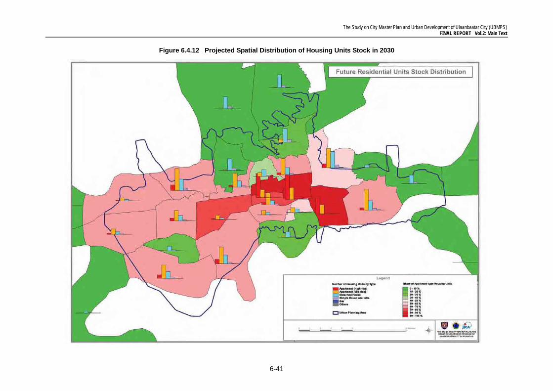
The Study on City Master Plan and Urban Development of Ulaanbaatar City (UBMPS) FINAL REPORT Vol.2: Main Text
6-41
Figure 6.4.12 Projected Spatial Distribution of Housing Units Stock in 2030
The Study on City Master Plan and Urban Development of Ulaanbaatar City (UBMPS) FINAL REPORT Vol.2: Main Text
6-42
6.5 Urban Green Network System
The JICA Study Team proposes the Urban Green Network System as depicted in Figure 6.5.2. The Urban Green Network System will play an essential role in balancing the natu-ral and built environments, preserving environmental resources, maintaining and improv-ing ecological networks, creating urban amenities, etc. For these purposes, it needs to be structured as a networked system of water preservation areas, green and open space, parks and street planting, etc.
The proposed Urban Green Network System shown in Figure 6.5.3 is planned based on the following concepts:
(a) Utilization of Trans-City Rivers as the Main Framework of Urban Green Network System: The Tuul River and its four tributaries, the Selbe River, Ulastai River, Tolgoit River and Bayang River, should be utilized as the main framework for the urban green network system. Especially, the Tuul River provides an invaluable habitat for flora and fauna, and also creates open space accessible to an enriched natural environment. These spaces should be more strictly protected by taking countermeasures against recent environmental degradation caused by industrial wastewater and uncontrolled development activities.
(b) Development of Green Network System Integrated with Disaster Management: It is essential to develop a green network system from the viewpoint of disaster man-agement. For instance, greening of river-side spaces should be strategically promoted for both purposes of flooding protection and development of recreational spaces.
(c) Balancing Environmental Preservation and Tourism Promotion in Bogdkhan Uul Special Protected Area: Bogdkhan Uul Special Protected Area holds invaluable envi-ronmental resources, including forest areas, and provides tourism and recreation op-portunities easily accessible from the central area of UB City. It is also a symbolic fea-ture for UB City as a sacred place, which creates spectacular landscapes. Bogdkhan Uul Special Protected Area, as an integrated part of the Urban Green Network System, needs to be preserved and utilized for tourism promotion in a balanced manner.
(d) Allocation of Large-scale Green and Open Space as Buffer Areas: Green and open spaces should be allocated as buffer areas between built and natural environ-ments. Greenbelt is planned between new towns and existing urbanized areas to avoid continuously expanded built-up areas. In addition, large-scale green and open spaces alongside the Tuul River are planned to protect water preservation areas and enhance accessibility to river-side recreational spaces.
(e) Greening in Industrial Areas and Surrounding Areas of Industrial Facilities: Greening in industrial areas and surrounding areas of power plants, WWTPs, etc. should be promoted to mitigate environmental degradation including noise and air pol-lution. It also contributes to creating favorable environment in industrial areas.
(f) Promotion of Greening on North-side Hilly Areas: Greening should be promoted on the north-side hilly areas of disaster prevention roads for prevention of land sliding due to floods. It also contributes to connecting an inner-city green network with north-side forest areas outside of the urbanization promotion area.
(g) Development of Continuous Street Greening: Street greening should be promoted in the form of connecting the above-mentioned environmental and cultural spaces. In
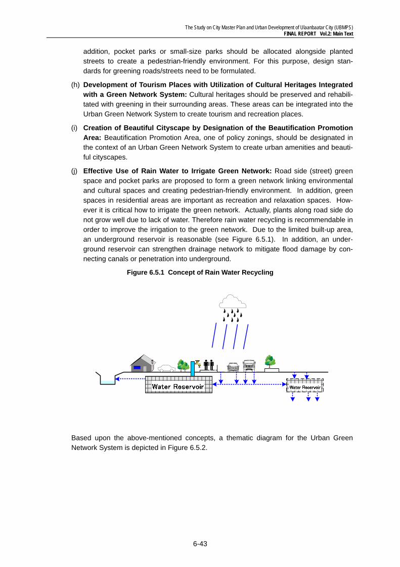
The Study on City Master Plan and Urban Development of Ulaanbaatar City (UBMPS) FINAL REPORT Vol.2: Main Text
6-43
addition, pocket parks or small-size parks should be allocated alongside planted streets to create a pedestrian-friendly environment. For this purpose, design stan-dards for greening roads/streets need to be formulated.
(h) Development of Tourism Places with Utilization of Cultural Heritages Integrated with a Green Network System: Cultural heritages should be preserved and rehabili-tated with greening in their surrounding areas. These areas can be integrated into the Urban Green Network System to create tourism and recreation places.
(i) Creation of Beautiful Cityscape by Designation of the Beautification Promotion Area: Beautification Promotion Area, one of policy zonings, should be designated in the context of an Urban Green Network System to create urban amenities and beauti-ful cityscapes.
(j) Effective Use of Rain Water to Irrigate Green Network: Road side (street) green space and pocket parks are proposed to form a green network linking environmental and cultural spaces and creating pedestrian-friendly environment. In addition, green spaces in residential areas are important as recreation and relaxation spaces. How-ever it is critical how to irrigate the green network. Actually, plants along road side do not grow well due to lack of water. Therefore rain water recycling is recommendable in order to improve the irrigation to the green network. Due to the limited built-up area, an underground reservoir is reasonable (see Figure 6.5.1). In addition, an under-ground reservoir can strengthen drainage network to mitigate flood damage by con-necting canals or penetration into underground.
Figure 6.5.1 Concept of Rain Water Recycling
Based upon the above-mentioned concepts, a thematic diagram for the Urban Green Network System is depicted in Figure 6.5.2.
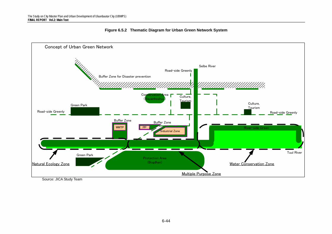
The Study on City Master Plan and Urban Development of Ulaanbaatar City (UBMPS) FINAL REPORT Vol.2: Main Text
6-44
Figure 6.5.2 Thematic Diagram for Urban Green Network System
Source: JICA Study Team
Selbe River
Tuul River
Water Conservation Zone
River-side Green
Road-side Greenly
Buffer Zone
Conservation Area( ) Bayanhoshuu
Green Park
Concept of Urban Green Network
Culture,Tourism
Culture,Tourism
Buffer Zone for Disaster prevention
WWTPIndustrial Zone
Buffer Zone
Protection Area(Bogdhan)
Road-side Greenly
PP
Green Park
Road-side Greenly
Multiple Purpose Zone
Natural Ecology Zone
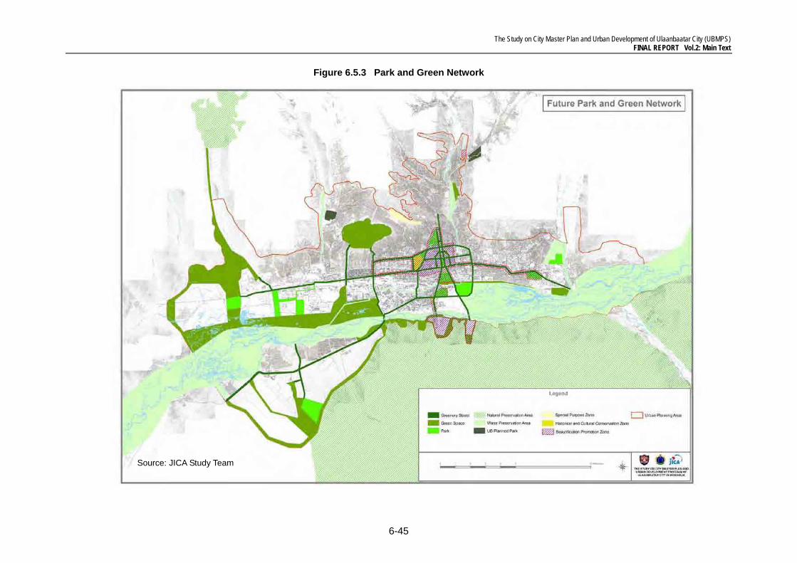
The Study on City Master Plan and Urban Development of Ulaanbaatar City (UBMPS) FINAL REPORT Vol.2: Main Text
6-45
Figure 6.5.3 Park and Green Network
Source: JICA Study Team


![[WeGO e-Government Program]City Paper Presentation : Ulaanbaatar(Mongolia)](https://img.pdfslide.us/doc/110x75/55c4c258bb61ebfb1d8b4821/wego-e-government-programcity-paper-presentation-ulaanbaatarmongolia.jpg)


![[Urban management policy training] ulaanbaatar city presentation](https://img.pdfslide.us/doc/110x75/58776dcb1a28ab5b568b52b3/urban-management-policy-training-ulaanbaatar-city-presentation.jpg)


![[Transportation] 11.12. enkh, shatar (ulaanbaatar)](https://img.pdfslide.us/doc/110x75/54bf3f4b4a7959f4238b45cb/transportation-1112-enkh-shatar-ulaanbaatar.jpg)

![[2015 e-Government Program]City Paper Presentation : Ulaanbaatar(Mongolia)](https://img.pdfslide.us/doc/110x75/58776ded1a28ab5b568b5305/2015-e-government-programcity-paper-presentation-ulaanbaatarmongolia.jpg)