Embed Size (px)
Citation preview
Ver.1.2 Coolangatta 1 of 29
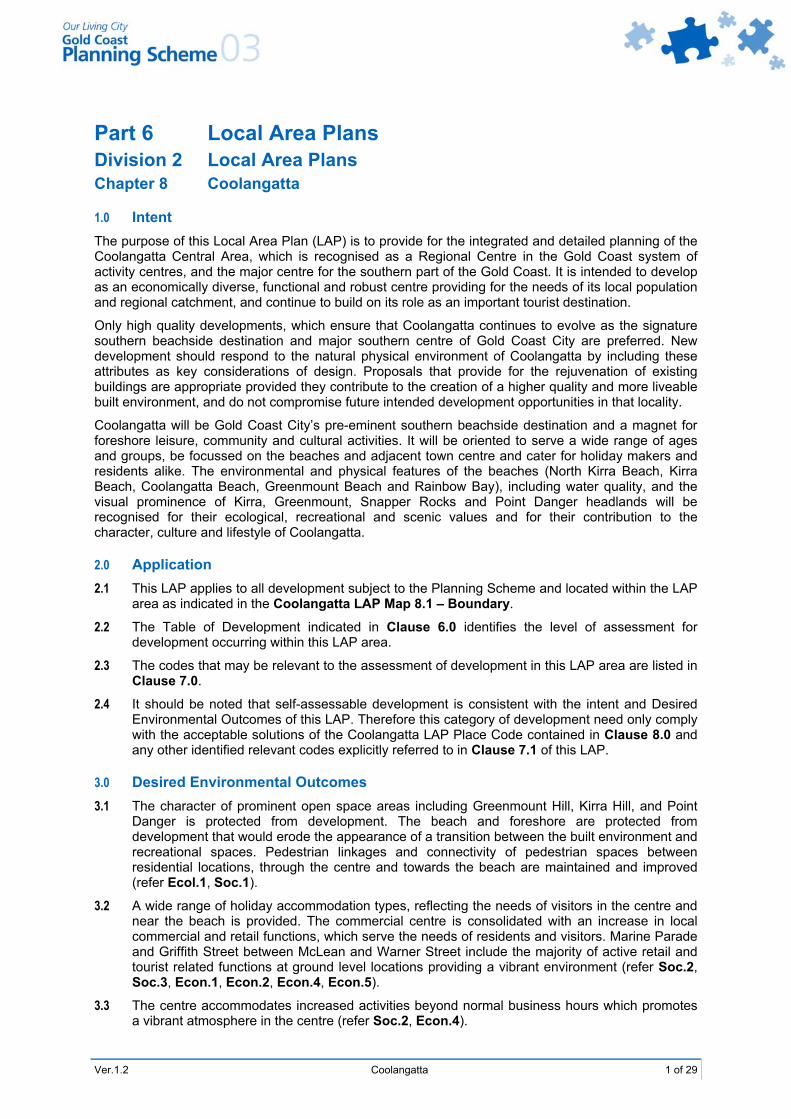
Part 6 Local Area Plans Division 2 Local Area Plans Chapter 8 Coolangatta
1.0 Intent The purpose of this Local Area Plan (LAP) is to provide for the integrated and detailed planning of the Coolangatta Central Area, which is recognised as a Regional Centre in the Gold Coast system of activity centres, and the major centre for the southern part of the Gold Coast. It is intended to develop as an economically diverse, functional and robust centre providing for the needs of its local population and regional catchment, and continue to build on its role as an important tourist destination.
Only high quality developments, which ensure that Coolangatta continues to evolve as the signature southern beachside destination and major southern centre of Gold Coast City are preferred. New development should respond to the natural physical environment of Coolangatta by including these attributes as key considerations of design. Proposals that provide for the rejuvenation of existing buildings are appropriate provided they contribute to the creation of a higher quality and more liveable built environment, and do not compromise future intended development opportunities in that locality.
Coolangatta will be Gold Coast City’s pre-eminent southern beachside destination and a magnet for foreshore leisure, community and cultural activities. It will be oriented to serve a wide range of ages and groups, be focussed on the beaches and adjacent town centre and cater for holiday makers and residents alike. The environmental and physical features of the beaches (North Kirra Beach, Kirra Beach, Coolangatta Beach, Greenmount Beach and Rainbow Bay), including water quality, and the visual prominence of Kirra, Greenmount, Snapper Rocks and Point Danger headlands will be recognised for their ecological, recreational and scenic values and for their contribution to the character, culture and lifestyle of Coolangatta.
2.0 Application 2.1 This LAP applies to all development subject to the Planning Scheme and located within the LAP
area as indicated in the Coolangatta LAP Map 8.1 – Boundary.
2.2 The Table of Development indicated in Clause 6.0 identifies the level of assessment for development occurring within this LAP area.
2.3 The codes that may be relevant to the assessment of development in this LAP area are listed in Clause 7.0.
2.4 It should be noted that self-assessable development is consistent with the intent and Desired Environmental Outcomes of this LAP. Therefore this category of development need only comply with the acceptable solutions of the Coolangatta LAP Place Code contained in Clause 8.0 and any other identified relevant codes explicitly referred to in Clause 7.1 of this LAP.
3.0 Desired Environmental Outcomes 3.1 The character of prominent open space areas including Greenmount Hill, Kirra Hill, and Point
Danger is protected from development. The beach and foreshore are protected from development that would erode the appearance of a transition between the built environment and recreational spaces. Pedestrian linkages and connectivity of pedestrian spaces between residential locations, through the centre and towards the beach are maintained and improved (refer Ecol.1, Soc.1).
3.2 A wide range of holiday accommodation types, reflecting the needs of visitors in the centre and near the beach is provided. The commercial centre is consolidated with an increase in local commercial and retail functions, which serve the needs of residents and visitors. Marine Parade and Griffith Street between McLean and Warner Street include the majority of active retail and tourist related functions at ground level locations providing a vibrant environment (refer Soc.2, Soc.3, Econ.1, Econ.2, Econ.4, Econ.5).
3.3 The centre accommodates increased activities beyond normal business hours which promotes a vibrant atmosphere in the centre (refer Soc.2, Econ.4).
2 of 29 Coolangatta Ver.1.2
3.4 Detached dwellings, residential amenity and dominant streetscape features are retained in existing low density residential locations (refer Soc.1, Soc.2, Soc.3).
3.5 The impacts of unit and tower development are managed so that the amenity of surrounding locations is not adversely impacted (refer Soc.5).
3.6 A moderate increase in population density in the centre occurs through mixed use development where amenity impacts are well managed (refer Econ.2, Soc.2, Soc.3, Soc.5).
3.7 High standards of urban design, which promotes responsive built environment through pedestrian compatible spaces, energy efficiency, and visual interest are achieved (refer Soc.5).
3.8 Traffic interactions and land use interactions are effectively managed and future transport options including light rail are maintained (refer Ecol.3 and Soc.6).
3.9 Transport linkages to the surrounding residential catchment, for pedestrians, cyclists, motorists and public transport patrons are improved (refer DEO Soc.6).
4.0 Local Area Features Coolangatta is a coastal location at the southern tip of the Gold Coast and borders with New South Wales and Tweed Shire. Smaller scale retailing, tourism related functions, and a growing educational sector are contributing industries in the centre, which compete with a greater range of services and facilities in Tweed Heads. Coolangatta has a diverse range of holiday accommodation, with a variety of high rise and medium density holiday and resort developments located along the beachfront and the headlands.
The association between Griffith Street and the beach is an important attribute of Coolangatta, along with interaction between these locations and residential areas. Permanent residential living is generally located away from the beach, much of which is on the ridgelines overlooking the ocean. The growing importance of Coolangatta Airport with improved future transport linkages will offer an opportunity for increased tourist growth and employment in the area.
Coolangatta has a distinctive and unique physical environment, not similar to any other coastal locations on the Gold Coast. Beaches are the most significant attraction of the area, with prominent headlands that can be seen from distant northern suburbs, and steep topography enclosing Coolangatta. The beaches including Kirra and Snapper Rocks are renowned surfing locations and also support surf life saving clubs which host national surf life saving competitions.
The natural attributes of Coolangatta, being beaches, sea and landform, create a picturesque setting which supports a special and valued lifestyle. The potential for new development to detrimentally impact upon these attributes will be a major consideration in the Council’s assessment of impact assessable development applications.
Appropriate development will have regard to its setting and incorporate appropriate measures to mitigate off-site impacts (including visual amenity, identified view corridor protection and overshadowing impacts).
The existing road configuration and hilly topography of Coolangatta, presents difficulties in traffic management and has created a ‘through route’ atmosphere for some prominent Coolangatta Centre streets, and amenity issues in residential locations. Distributor roads in Coolangatta do not connect with distributor roads in Tweed Heads. The provision of public transport, especially with no express services to Surfers Paradise, makes living in Coolangatta and working and travelling elsewhere more challenging for some members of the community.
The Tugun Bypass is expected to have a more immediate influence in the near future, with further proposals including light rail, and a possible Robina to Coolangatta railway extension to have a major influence on transport and accessibility in the future.
Improved pedestrian and cyclist movement and circulation will enhance access between residential areas, the Centre, beach and foreshore areas.
Ver.1.2 Coolangatta 3 of 29
5.0 Precincts The Coolangatta LAP aims to build on Coolangatta’s strengths and distinctive natural attributes by enhancing and integrating the many positive natural features with the built environment, and the needs of both residents and visitors alike. The LAP promotes appropriate interactions between the built environment, traffic and transport and land use. The LAP recognises potential future transport infrastructure in the region, including light rail, which should in turn provide increased economic opportunities.
The Coolangatta LAP contains eight land use precincts, which are identified on Coolangatta LAP Map 8.2 – Precincts:
Precinct 1 Coolangatta Centre
Precinct 2 Point Danger, Rainbow Bay, Greenmount Hill
Precinct 3 Open Space
Precinct 4 Medium Density Residential
Precinct 5 Ridge Residential
Precinct 6 Kirra South
Precinct 7 Kirra
Precinct 8 Community Purpose
5.1 Precinct 1 Coolangatta Centre Intent
This precinct offers the highest development potential in the Local Area Plan appropriate to a Regional Centre, particularly between Marine Parade and Griffith St; with uses preferred including a wide range of commercial activities, retail shops, offices, entertainment, community services, and tourist and residential accommodation. Car parking is to be designed so it does not form a dominant part of the streetscape. It is necessary to accommodate a transition between the centre core and the tourism residential uses adjoining in Precinct 2 therefore it has been divided into two sub-precincts: Sub-precinct 1a – Central Core Sub-precinct 1b – Transition Area
5.1.1 Sub-precinct 1a Central Core Intent
New development is to address the street, with residential mixed use development in above ground locations and active frontages at ground floor locations. Development is to improve mid block pedestrian access between the centre and the beach, with connections to surrounding precincts to encourage movement and interaction between private development and public spaces.
Towers are to be positioned towards Marine Parade, whilst existing lower scale development on the southern side of Griffith St should be maintained and consolidated. Entertainment is preferred in this central area as it is an important element in creating and maintaining a vibrant activity centre.
McLean Street is a popular pedestrian spine, accordingly future infill development should include tourist, commercial and retail functions. Permanent residential or tourist accommodation and/or office space is envisaged above ground level. Mixed use development should consolidate active street frontages provided amenity impacts can be managed. Shared access points are sought to limit pedestrian and vehicle conflict, with the provision of arcades in appropriately spaced locale to link uses and transport nodes with the centre and the beach.
Chalk Street is intended to remain a service road and also provide active frontages. New development will be designed to provide greater visual interest when viewed from Chalk Street. Development incorporating several allotments is to include design elements reflecting the fine grain of the existing pattern of subdivision.
5.1.2 Sub-precinct 1b Transition Area Intent
Land between McDonald and Clarke St is intended to provide a transition area between the centre and Greenmount Hill, with the focus on maintaining active street frontages of a continuous shopping strip along Griffith Street. High rise residential, resort development, and mixed use retail is appropriate, providing amenity impacts can be managed with the scale of development to be less than that found in Central Core area. Access to allotments should be limited to Marine Parade. Active street frontages are also desirable along Marine Parade.
4 of 29 Coolangatta Ver.1.2
5.2 Precinct 2 Point Danger, Rainbow Bay, Greenmount Hill Intent
This precinct is intended to comprise a mix of permanent residential accommodation, visitor accommodation and local services that serve the resident and visitor population. Development is intended to be at a lesser intensity and scale than in the centre.
Local services are intended to be of a scale which does not undermine centre uses, and does not create residential amenity impacts. These local services are intended to be concentrated in locations currently accommodating non-residential uses, highlighted on Coolangatta LAP Map 8.2 – Precincts in the hashed areas of Precinct 2.
The hashed areas in this precinct include the only land in the precinct intended for local services to serve the needs of local residents and visitors. Uses, which are more suited to being located in the centre, are not appropriate. New development is intended to be mixed use and retain local service functions at ground level. Protection of existing vegetation and existing views/site lines across the Bay is envisaged throughout the precinct.
5.3 Precinct 3 Open Space Intent
The open space precinct includes all public and private active and passive recreation spaces in Coolangatta. Limited commercial facilities may be appropriate subject to the location, need for such facilities, and amenity impacts.
Any future development is integrated with the Southern Points Promenade Project. Further expansion of existing Surf Life Saving Clubs beyond existing boundaries are not envisaged although redevelopment within these boundaries may be appropriate where: redevelopment results in a building exhibiting a high quality of architectural design; facilities providing a service available to the public are provided (including a predominance of
areas accessible to children); and views to the beach are enhanced from land side locations.
Any development must not detract from the visual amenity of the prominent natural features, such as Greenmount Hill or create residential amenity impacts.
New development or redevelopment of existing spaces and sites within the open space precinct should have due regard to crime prevention through environmental design principles.
Any future development of Goodwin Park for community facilities or combined community facilities including function rooms, may be appropriate subject to hydrological investigations establishing the engineering feasibility of further development in this location and how it is linked with the Centre.
Kirra Caravan Park is intended to remain as an important location for affordable accommodation.
5.4 Precinct 4 Medium Density Residential Intent
This precinct includes a range of medium density residential accommodation intended to take advantage of the close proximity and accessibility of centre services and facilities. Unit development of a lesser scale and intensity than the centre will form an appropriate transition between lower density housing on the residential ridges. Development is intended to address the street, be of a high design quality, minimising intrusion on adjoining properties, and set amongst landscaped gardens.
Development immediately adjoining Goodwin Park is to be dual facing where proposals address both the street and Goodwin Park to facilitate passive surveillance of the park. Development should also take advantage of the Park acting as a pedestrian thoroughfare. Suitably designed development of a higher density, including tourist accommodation is envisaged utilising Goodwin Park as a direct connection to the centre.
The surrounding area in this precinct is intended to provide a mix of residential and accommodation alternatives, including apartments and attached housing in close proximity to the centre at a lower scale than surrounding the park. Centre activities or local services are not envisaged considering the proximity and accessibility of land to the centre.
5.5 Precinct 5 Ridge Residential Intent
This precinct is to retain a predominantly low key residential nature set amongst hilly topography, with a green streetscape, affording good views towards the ocean and Tweed Heads. Attached dwellings may be appropriate where the scale of development and design features reflect that of surrounding properties and amenity impacts can be managed.
Ver.1.2 Coolangatta 5 of 29
Any new development is to be site responsive; minimising cut and fill development, with buildings adopting split-level and/or pole footings. Any increase in unit development including apartments and tourist accommodation is considered unsuitable in this precinct considering the topography and potential for higher traffic generation on roads that are generally unsuitable for high traffic volumes.
Existing vegetation provides much of the character to the precinct and is to be retained where possible or at the least, disturbance minimised as part of any development proposal.
5.6 Precinct 6 Kirra South Intent
Kirra South Precinct is appropriate for a mix of detached housing and compatible attached dwellings, and considering it is predominantly a permanent residential location, tourist accommodation is not envisaged on a large scale. Particularly as other locations in the plan area are more suitably located to services and facilities.
The existing industrial activities area within this principally residential precinct will be replaced by residential development over time, with development provisions including a three (3) storey height limit north of Bolton Street intended to facilitate this process. The vegetative buffer from Bolton St to Appel St should be retained until such a time.
A future pedestrian connection between Bolton Street and Appel Street is envisaged and will be required as part of a favourable development proposal in that location.
5.7 Precinct 7 Kirra Intent
The Kirra Precinct is intended to contain a mix of tourist accommodation, residential living and local services to meet the need of residents and the visitor population. Considering the predominant beach location, and proximity to the town centre along Musgrave St/Marine Pde, this area as shaded on Coolangatta LAP Map 8.2 – Precincts, is considered appropriate for low scale retail and services to address tourist and residential needs.
Uses, which are more akin to the regional centre designation including entertainment, community services and higher order commercial and retail functions, are not appropriate.
The precinct has high pedestrian and transport accessibility to the beach due to the grid road system, and should be planned around the pedestrian network as illustrated on Coolangatta LAP Map 8.6 – Pedestrian Network Plan and Important Street Frontages.
Tourist and residential accommodation is preferred in areas west adjoining Precinct 1, (fronting Garrick St) taking advantage of the views and higher elevations. Height and density controls throughout the precinct are receptive to the topography of Kirra Hill. Development will be required to provide a convenient mid-block pedestrian access between McLean and Garrick Street.
A mix of dwelling types is suitable for permanent residential use in the areas bound by Winston St to the north and Coolangatta Rd to the South, with development set amongst landscaped grounds forming a transition between centre activities and other residential accommodation located further west.
5.8 Precinct 8 Community Purpose Intent
The Community Purposes Precinct comprises land for community uses, including schools, which can not be adequately accommodated in other precincts. Limited commercial facilities and temporary uses may be considered appropriate. The future use of the railway cutting for light rail or multi modal transport opportunities is currently under consideration. Development, which impacts on the railway cutting and undermines future transport options, is not considered appropriate.
Land between Lanham and Chalk Street remains an important car parking location and an important public transport opportunity. Other suitable temporary uses may be considered appropriate. Future development that could prejudice any future proposed light rail connection or public transport facilities would not be favourably considered.
6 of 29 Coolangatta Ver.1.2
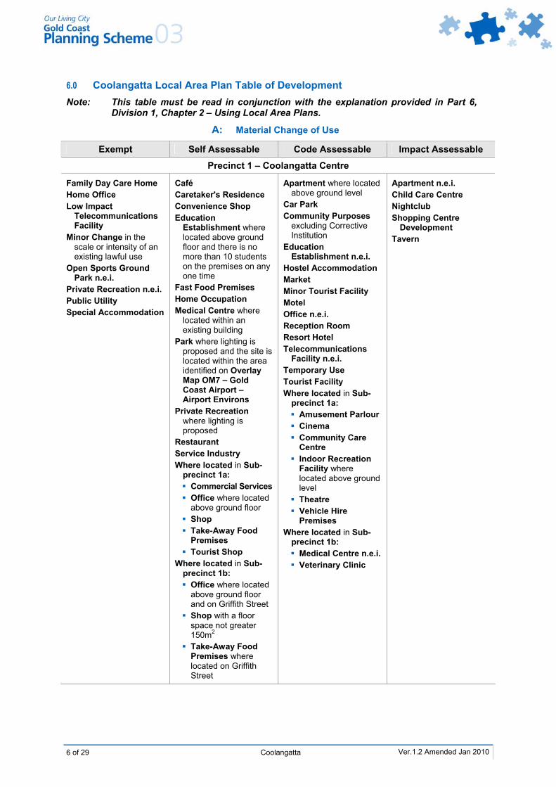
6.0 Coolangatta Local Area Plan Table of Development Note: This table must be read in conjunction with the explanation provided in Part 6,
Division 1, Chapter 2 – Using Local Area Plans.
A: Material Change of Use
Exempt Self Assessable Code Assessable Impact Assessable
Precinct 1 – Coolangatta Centre
Family Day Care Home Home Office Low Impact
Telecommunications Facility
Minor Change in the scale or intensity of an existing lawful use
Open Sports Ground Park n.e.i.
Private Recreation n.e.i. Public Utility Special Accommodation
Café Caretaker's Residence Convenience Shop Education
Establishment where located above ground floor and there is no more than 10 students on the premises on any one time
Fast Food Premises Home Occupation Medical Centre where
located within an existing building
Park where lighting is proposed and the site is located within the area identified on Overlay Map OM7 – Gold Coast Airport – Airport Environs
Private Recreation where lighting is proposed
Restaurant Service Industry Where located in Sub-
precinct 1a: Commercial Services Office where located
above ground floor Shop Take-Away Food
Premises Tourist Shop
Where located in Sub-precinct 1b: Office where located
above ground floor and on Griffith Street
Shop with a floor space not greater 150m2
Take-Away Food Premises where located on Griffith Street
Apartment where located above ground level
Car Park Community Purposes
excluding Corrective Institution
Education Establishment n.e.i.
Hostel Accommodation Market Minor Tourist Facility Motel Office n.e.i. Reception Room Resort Hotel Telecommunications
Facility n.e.i. Temporary Use Tourist Facility Where located in Sub-
precinct 1a: Amusement Parlour Cinema Community Care Centre
Indoor Recreation Facility where located above ground level
Theatre Vehicle Hire Premises
Where located in Sub-precinct 1b: Medical Centre n.e.i. Veterinary Clinic
Apartment n.e.i. Child Care Centre Nightclub Shopping Centre
Development Tavern
Ver.1.2 Amended Jan 2010
Ver.1.2 Coolangatta 7 of 29
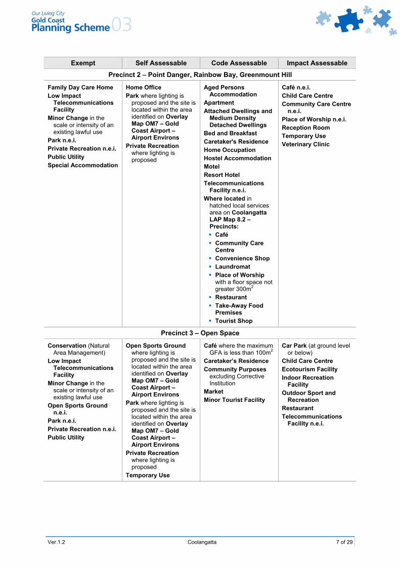
Exempt Self Assessable Code Assessable Impact Assessable
Precinct 2 – Point Danger, Rainbow Bay, Greenmount Hill
Family Day Care Home Low Impact
Telecommunications Facility
Minor Change in the scale or intensity of an existing lawful use
Park n.e.i. Private Recreation n.e.i. Public Utility Special Accommodation
Home Office Park where lighting is
proposed and the site is located within the area identified on Overlay Map OM7 – Gold Coast Airport – Airport Environs
Private Recreation where lighting is proposed
Aged Persons Accommodation
Apartment Attached Dwellings and
Medium Density Detached Dwellings
Bed and Breakfast Caretaker's Residence Home Occupation Hostel Accommodation Motel Resort Hotel Telecommunications
Facility n.e.i. Where located in
hatched local services area on Coolangatta LAP Map 8.2 – Precincts: Café Community Care
Centre Convenience Shop Laundromat Place of Worship
with a floor space not greater 300m2
Restaurant Take-Away Food
Premises Tourist Shop
Café n.e.i. Child Care Centre Community Care Centre
n.e.i. Place of Worship n.e.i. Reception Room Temporary Use Veterinary Clinic
Precinct 3 – Open Space
Conservation (Natural Area Management)
Low Impact Telecommunications Facility
Minor Change in the scale or intensity of an existing lawful use
Open Sports Ground n.e.i.
Park n.e.i. Private Recreation n.e.i. Public Utility
Open Sports Ground where lighting is proposed and the site is located within the area identified on Overlay Map OM7 – Gold Coast Airport – Airport Environs
Park where lighting is proposed and the site is located within the area identified on Overlay Map OM7 – Gold Coast Airport – Airport Environs
Private Recreation where lighting is proposed
Temporary Use
Café where the maximum GFA is less than 100m2
Caretaker’s Residence Community Purposes
excluding Corrective Institution
Market Minor Tourist Facility
Car Park (at ground level or below)
Child Care Centre Ecotourism Facility Indoor Recreation
Facility Outdoor Sport and
Recreation Restaurant Telecommunications
Facility n.e.i.
8 of 29 Coolangatta Ver.1.2
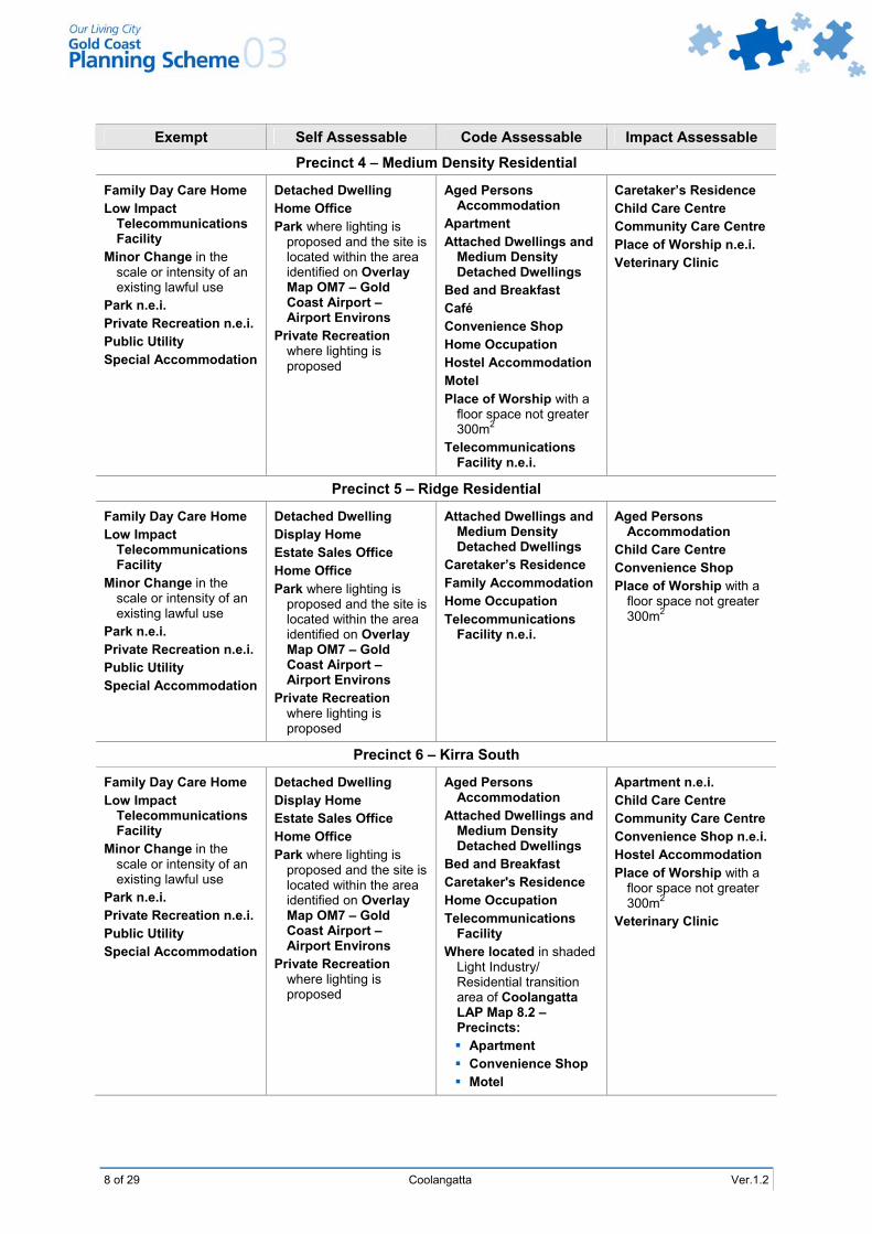
Exempt Self Assessable Code Assessable Impact Assessable
Precinct 4 – Medium Density Residential
Family Day Care Home Low Impact
Telecommunications Facility
Minor Change in the scale or intensity of an existing lawful use
Park n.e.i. Private Recreation n.e.i. Public Utility Special Accommodation
Detached Dwelling Home Office Park where lighting is
proposed and the site is located within the area identified on Overlay Map OM7 – Gold Coast Airport – Airport Environs
Private Recreation where lighting is proposed
Aged Persons Accommodation
Apartment Attached Dwellings and
Medium Density Detached Dwellings
Bed and Breakfast Café Convenience Shop Home Occupation Hostel Accommodation Motel Place of Worship with a
floor space not greater 300m2
Telecommunications Facility n.e.i.
Caretaker’s Residence Child Care Centre Community Care Centre Place of Worship n.e.i. Veterinary Clinic
Precinct 5 – Ridge Residential
Family Day Care Home Low Impact
Telecommunications Facility
Minor Change in the scale or intensity of an existing lawful use
Park n.e.i. Private Recreation n.e.i. Public Utility Special Accommodation
Detached Dwelling Display Home Estate Sales Office Home Office Park where lighting is
proposed and the site is located within the area identified on Overlay Map OM7 – Gold Coast Airport – Airport Environs
Private Recreation where lighting is proposed
Attached Dwellings and Medium Density Detached Dwellings
Caretaker’s Residence Family Accommodation Home Occupation Telecommunications
Facility n.e.i.
Aged Persons Accommodation
Child Care Centre Convenience Shop Place of Worship with a
floor space not greater 300m2
Precinct 6 – Kirra South
Family Day Care Home Low Impact
Telecommunications Facility
Minor Change in the scale or intensity of an existing lawful use
Park n.e.i. Private Recreation n.e.i. Public Utility Special Accommodation
Detached Dwelling Display Home Estate Sales Office Home Office Park where lighting is
proposed and the site is located within the area identified on Overlay Map OM7 – Gold Coast Airport – Airport Environs
Private Recreation where lighting is proposed
Aged Persons Accommodation
Attached Dwellings and Medium Density Detached Dwellings
Bed and Breakfast Caretaker's Residence Home Occupation Telecommunications
Facility Where located in shaded
Light Industry/ Residential transition area of Coolangatta LAP Map 8.2 – Precincts: Apartment Convenience Shop Motel
Apartment n.e.i. Child Care Centre Community Care Centre Convenience Shop n.e.i. Hostel Accommodation Place of Worship with a
floor space not greater 300m2
Veterinary Clinic
Ver.1.2 Coolangatta 9 of 29
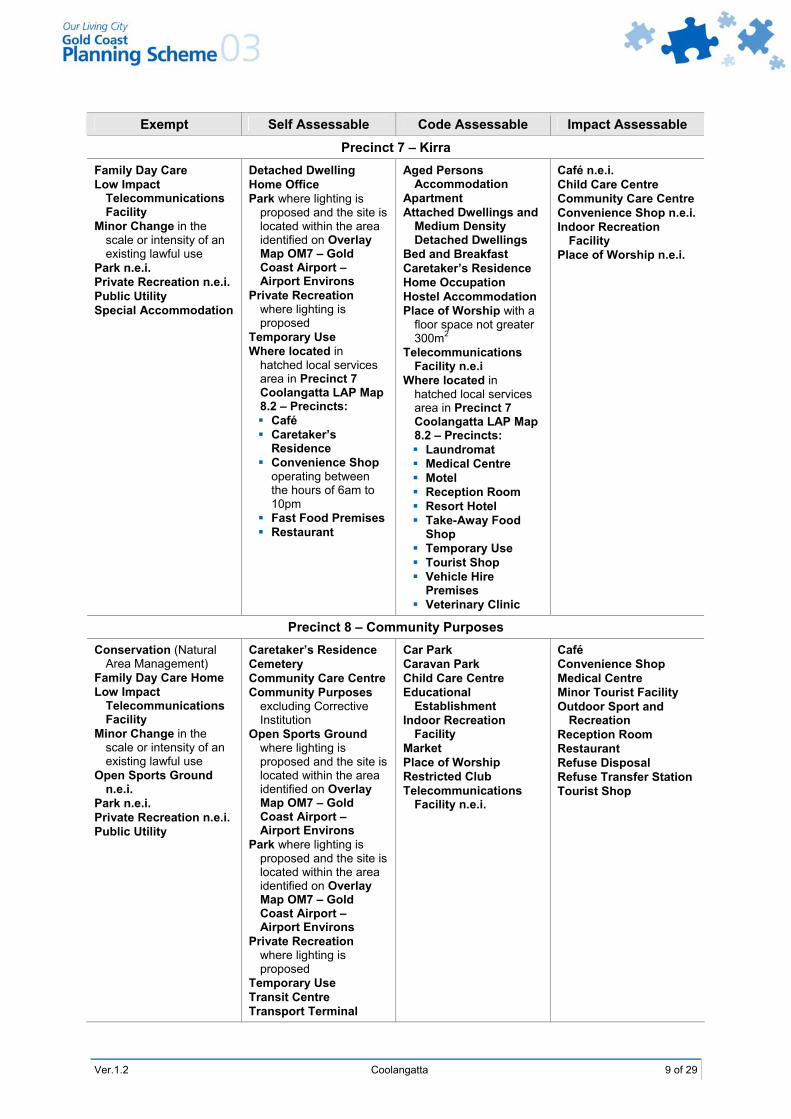
Exempt Self Assessable Code Assessable Impact Assessable
Precinct 7 – Kirra Family Day Care Low Impact
Telecommunications Facility
Minor Change in the scale or intensity of an existing lawful use
Park n.e.i. Private Recreation n.e.i. Public Utility Special Accommodation
Detached Dwelling Home Office Park where lighting is
proposed and the site is located within the area identified on Overlay Map OM7 – Gold Coast Airport – Airport Environs
Private Recreation where lighting is proposed
Temporary Use Where located in
hatched local services area in Precinct 7 Coolangatta LAP Map 8.2 – Precincts: Café Caretaker’s
Residence Convenience Shop
operating between the hours of 6am to 10pm
Fast Food Premises Restaurant
Aged Persons Accommodation
Apartment Attached Dwellings and
Medium Density Detached Dwellings
Bed and Breakfast Caretaker’s Residence Home Occupation Hostel Accommodation Place of Worship with a
floor space not greater 300m2
Telecommunications Facility n.e.i
Where located in hatched local services area in Precinct 7 Coolangatta LAP Map 8.2 – Precincts: Laundromat Medical Centre Motel Reception Room Resort Hotel Take-Away Food
Shop Temporary Use Tourist Shop Vehicle Hire
Premises Veterinary Clinic
Café n.e.i. Child Care Centre Community Care Centre Convenience Shop n.e.i. Indoor Recreation
Facility Place of Worship n.e.i.
Precinct 8 – Community Purposes Conservation (Natural
Area Management) Family Day Care Home Low Impact
Telecommunications Facility
Minor Change in the scale or intensity of an existing lawful use
Open Sports Ground n.e.i.
Park n.e.i. Private Recreation n.e.i. Public Utility
Caretaker’s Residence Cemetery Community Care Centre Community Purposes
excluding Corrective Institution
Open Sports Ground where lighting is proposed and the site is located within the area identified on Overlay Map OM7 – Gold Coast Airport – Airport Environs
Park where lighting is proposed and the site is located within the area identified on Overlay Map OM7 – Gold Coast Airport – Airport Environs
Private Recreation where lighting is proposed
Temporary Use Transit Centre Transport Terminal
Car Park Caravan Park Child Care Centre Educational
Establishment Indoor Recreation
Facility Market Place of Worship Restricted Club Telecommunications
Facility n.e.i.
Café Convenience Shop Medical Centre Minor Tourist Facility Outdoor Sport and
Recreation Reception Room Restaurant Refuse Disposal Refuse Transfer Station Tourist Shop
10 of 29 Coolangatta Ver.1.2
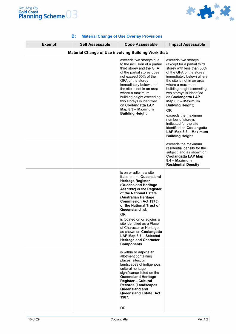
B: Material Change of Use Overlay Provisions
Exempt Self Assessable Code Assessable Impact Assessable
Material Change of Use involving Building Work that:
exceeds two storeys due to the inclusion of a partial third storey and the GFA of the partial storey does not exceed 50% of the GFA of the storey immediately below, and the site is not in an area where a maximum building height exceeding two storeys is identified on Coolangatta LAP Map 8.3 – Maximum Building Height
exceeds two storeys (except for a partial third storey with less than 50% of the GFA of the storey immediately below) where the site is not in an area where a maximum building height exceeding two storeys is identified on Coolangatta LAP Map 8.3 – Maximum Building Height; OR exceeds the maximum number of storeys indicated for the site identified on Coolangatta LAP Map 8.3 – Maximum Building Height
exceeds the maximum residential density for the subject land as shown on Coolangatta LAP Map 8.4 – Maximum Residential Density
is on or adjoins a site listed on the Queensland Heritage Register (Queensland Heritage Act 1992) or the Register of the National Estate (Australian Heritage Commission Act 1975) or the National Trust of Queensland list; OR is located on or adjoins a site identified as a Place of Character or Heritage as shown on Coolangatta LAP Map 8.7 – Selected Heritage and Character Components
is within or adjoins an allotment containing places, sites, or landscapes of indigenous cultural heritage significance listed on the Queensland Heritage Register – Cultural Records (Landscapes Queensland and Queensland Estate) Act 1987; OR
Ver.1.2 Coolangatta 11 of 29
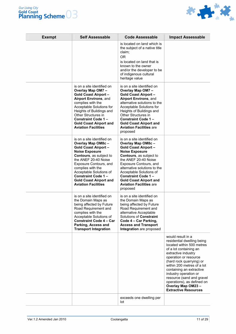
Exempt Self Assessable Code Assessable Impact Assessable is located on land which is the subject of a native title claim; OR is located on land that is known to the owner and/or the developer to be of indigenous cultural heritage value
is on a site identified on Overlay Map OM7 – Gold Coast Airport – Airport Environs, and complies with the Acceptable Solutions for Heights of Buildings and Other Structures in Constraint Code 1 – Gold Coast Airport and Aviation Facilities
is on a site identified on Overlay Map OM7 – Gold Coast Airport – Airport Environs, and alternative solutions to the Acceptable Solutions for Heights of Buildings and Other Structures in Constraint Code 1 – Gold Coast Airport and Aviation Facilities are proposed
is on a site identified on Overlay Map OM8c – Gold Coast Airport – Noise Exposure Contours, as subject to the ANEF 20-40 Noise Exposure Contours, and complies with the Acceptable Solutions of Constraint Code 1 – Gold Coast Airport and Aviation Facilities
is on a site identified on Overlay Map OM8c – Gold Coast Airport – Noise Exposure Contours, as subject to the ANEF 20-40 Noise Exposure Contours, and alternative solutions to the Acceptable Solutions of Constraint Code 1 – Gold Coast Airport and Aviation Facilities are proposed
is on a site identified on the Domain Maps as being affected by Future Road Requirement and complies with the Acceptable Solutions of Constraint Code 4 – Car Parking, Access and Transport Integration
is on a site identified on the Domain Maps as being affected by Future Road Requirement and alternative Acceptable Solutions of Constraint Code 4 – Car Parking, Access and Transport Integration are proposed
would result in a residential dwelling being located within 500 metres of a lot containing an extractive industry operation or resource (hard rock quarrying) or within 200 metres of a lot containing an extractive industry operation or resource (sand and gravel operations), as defined on Overlay Map OM23 – Extractive Resources
exceeds one dwelling per lot
Ver.1.2 Amended Jan 2010
12 of 29 Coolangatta Ver.1.2
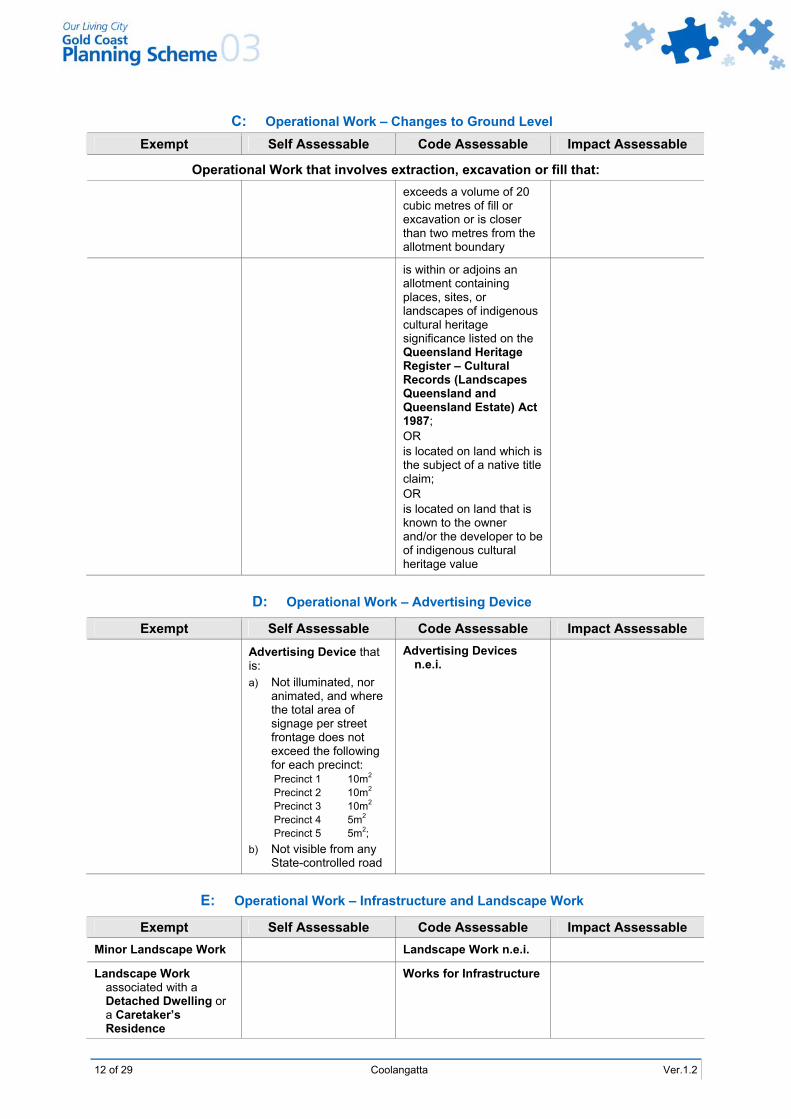
C: Operational Work – Changes to Ground Level Exempt Self Assessable Code Assessable Impact Assessable
Operational Work that involves extraction, excavation or fill that: exceeds a volume of 20
cubic metres of fill or excavation or is closer than two metres from the allotment boundary
is within or adjoins an allotment containing places, sites, or landscapes of indigenous cultural heritage significance listed on the Queensland Heritage Register – Cultural Records (Landscapes Queensland and Queensland Estate) Act 1987; OR is located on land which is the subject of a native title claim; OR is located on land that is known to the owner and/or the developer to be of indigenous cultural heritage value
D: Operational Work – Advertising Device
Exempt Self Assessable Code Assessable Impact Assessable Advertising Device that
is: a) Not illuminated, nor
animated, and where the total area of signage per street frontage does not exceed the following for each precinct: Precinct 1 10m2 Precinct 2 10m2 Precinct 3 10m2 Precinct 4 5m2 Precinct 5 5m2;
b) Not visible from any State-controlled road
Advertising Devices n.e.i.
E: Operational Work – Infrastructure and Landscape Work
Exempt Self Assessable Code Assessable Impact Assessable Minor Landscape Work Landscape Work n.e.i.
Landscape Work associated with a Detached Dwelling or a Caretaker’s Residence
Works for Infrastructure
Ver.1.2 Coolangatta 13 of 29
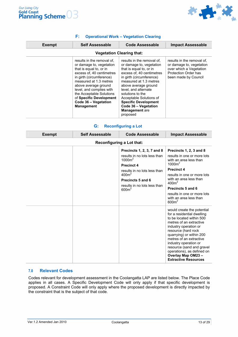
F: Operational Work – Vegetation Clearing
Exempt Self Assessable Code Assessable Impact Assessable
Vegetation Clearing that:
results in the removal of, or damage to, vegetation that is equal to, or in excess of, 40 centimetres in girth (circumference) measured at 1.3 metres above average ground level, and complies with the Acceptable Solutions of Specific Development Code 36 – Vegetation Management
results in the removal of, or damage to, vegetation that is equal to, or in excess of, 40 centimetres in girth (circumference) measured at 1.3 metres above average ground level, and alternate solutions to the Acceptable Solutions of Specific Development Code 36 – Vegetation Management are proposed
results in the removal of, or damage to, vegetation over which a Vegetation Protection Order has been made by Council
G: Reconfiguring a Lot
Exempt Self Assessable Code Assessable Impact Assessable
Reconfiguring a Lot that:
Precincts 1, 2, 3, 7 and 8 results in no lots less than 1000m2 Precinct 4 results in no lots less than 400m2 Precincts 5 and 6 results in no lots less than 600m2
Precincts 1, 2, 3 and 8 results in one or more lots with an area less than 1000m2 Precinct 4 results in one or more lots with an area less than 400m2 Precincts 5 and 6 results in one or more lots with an area less than 600m2
would create the potential for a residential dwelling to be located within 500 metres of an extractive industry operation or resource (hard rock quarrying) or within 200 metres of an extractive industry operation or resource (sand and gravel operations), as defined on Overlay Map OM23 – Extractive Resources
7.0 Relevant Codes Codes relevant for development assessment in the Coolangatta LAP are listed below. The Place Code applies in all cases. A Specific Development Code will only apply if that specific development is proposed. A Constraint Code will only apply where the proposed development is directly impacted by the constraint that is the subject of that code.
Ver.1.2 Amended Jan 2010
14 of 29 Coolangatta Ver.1.2
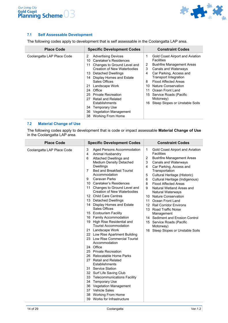
7.1 Self Assessable Development
The following codes apply to development that is self assessable in the Coolangatta LAP area.
Place Code Specific Development Codes Constraint Codes
Coolangatta LAP Place Code 2 Advertising Devices 10 Caretaker’s Residences 11 Changes to Ground Level and
Creation of New Waterbodies 13 Detached Dwellings 14 Display Homes and Estate
Sales Offices 21 Landscape Work 24 Office 25 Private Recreation 27 Retail and Related
Establishments 34 Temporary Use 36 Vegetation Management 38 Working From Home
1 Gold Coast Airport and Aviation Facilities
2 Bushfire Management Areas 3 Canals and Waterways 4 Car Parking, Access and
Transport Integration 8 Flood Affected Areas 10 Nature Conservation 11 Ocean Front Land 15 Service Roads (Pacific
Motorway) 16 Steep Slopes or Unstable Soils
7.2 Material Change of Use
The following codes apply to development that is code or impact assessable Material Change of Use in the Coolangatta LAP area.
Place Code Specific Development Codes Constraint Codes
Coolangatta LAP Place Code 3 Aged Persons Accommodation 4 Animal Husbandry 6 Attached Dwellings and
Medium Density Detached Dwellings
7 Bed and Breakfast Tourist Accommodation
9 Caravan Parks 10 Caretaker’s Residences 11 Changes to Ground Level and
Creation of New Waterbodies 12 Child Care Centres 13 Detached Dwellings 14 Display Homes and Estate
Sales Offices 15 Ecotourism Facility 16 Family Accommodation 19 High Rise Residential and
Tourist Accommodation 21 Landscape Work 22 Low Rise Apartment Building 23 Low Rise Commercial Tourist
Accommodation 24 Office 25 Private Recreation 26 Relocatable Home Parks 27 Retail and Related
Establishments 31 Service Station 32 Surf Life Saving Club 33 Telecommunications Facility 34 Temporary Use 36 Vegetation Management 37 Vehicle Sales 38 Working From Home 39 Works for Infrastructure
1 Gold Coast Airport and Aviation Facilities
2 Bushfire Management Areas 3 Canals and Waterways 4 Car Parking, Access and
Transportation 5 Cultural Heritage (Historic) 6 Cultural Heritage (Indigenous) 8 Flood Affected Areas 9 Natural Wetland Areas and
Natural Waterways 10 Nature Conservation 11 Ocean Front Land 12 Rail Corridor Environs 13 Road Traffic Noise
Management 14 Sediment and Erosion Control 15 Service Roads (Pacific
Motorway) 16 Steep Slopes or Unstable Soils
Ver.1.2 Coolangatta 15 of 29
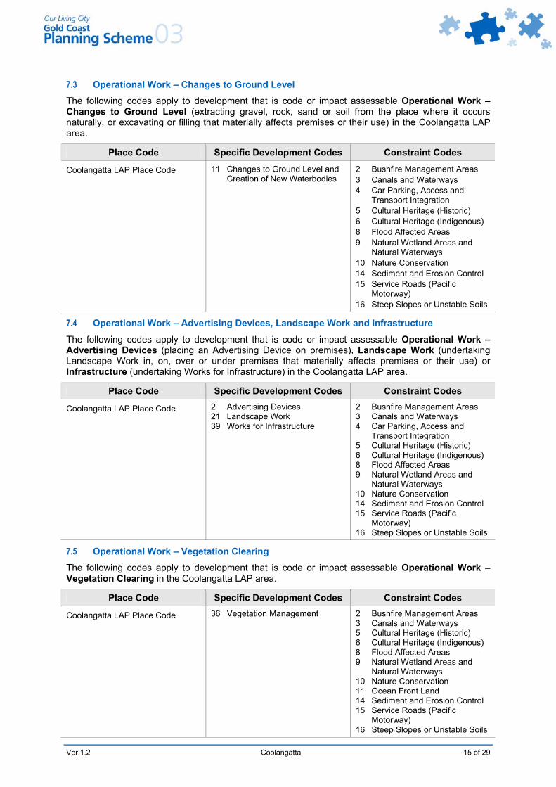
7.3 Operational Work – Changes to Ground Level
The following codes apply to development that is code or impact assessable Operational Work – Changes to Ground Level (extracting gravel, rock, sand or soil from the place where it occurs naturally, or excavating or filling that materially affects premises or their use) in the Coolangatta LAP area.
Place Code Specific Development Codes Constraint Codes
Coolangatta LAP Place Code 11 Changes to Ground Level and Creation of New Waterbodies
2 Bushfire Management Areas 3 Canals and Waterways 4 Car Parking, Access and
Transport Integration 5 Cultural Heritage (Historic) 6 Cultural Heritage (Indigenous) 8 Flood Affected Areas 9 Natural Wetland Areas and
Natural Waterways 10 Nature Conservation 14 Sediment and Erosion Control 15 Service Roads (Pacific
Motorway) 16 Steep Slopes or Unstable Soils
7.4 Operational Work – Advertising Devices, Landscape Work and Infrastructure
The following codes apply to development that is code or impact assessable Operational Work – Advertising Devices (placing an Advertising Device on premises), Landscape Work (undertaking Landscape Work in, on, over or under premises that materially affects premises or their use) or Infrastructure (undertaking Works for Infrastructure) in the Coolangatta LAP area.
Place Code Specific Development Codes Constraint Codes
Coolangatta LAP Place Code 2 Advertising Devices 21 Landscape Work 39 Works for Infrastructure
2 Bushfire Management Areas 3 Canals and Waterways 4 Car Parking, Access and
Transport Integration 5 Cultural Heritage (Historic) 6 Cultural Heritage (Indigenous) 8 Flood Affected Areas 9 Natural Wetland Areas and
Natural Waterways 10 Nature Conservation 14 Sediment and Erosion Control 15 Service Roads (Pacific
Motorway) 16 Steep Slopes or Unstable Soils
7.5 Operational Work – Vegetation Clearing
The following codes apply to development that is code or impact assessable Operational Work – Vegetation Clearing in the Coolangatta LAP area.
Place Code Specific Development Codes Constraint Codes
Coolangatta LAP Place Code 36 Vegetation Management 2 Bushfire Management Areas 3 Canals and Waterways 5 Cultural Heritage (Historic) 6 Cultural Heritage (Indigenous) 8 Flood Affected Areas 9 Natural Wetland Areas and
Natural Waterways 10 Nature Conservation 11 Ocean Front Land 14 Sediment and Erosion Control 15 Service Roads (Pacific
Motorway) 16 Steep Slopes or Unstable Soils
16 of 29 Coolangatta Ver.1.2
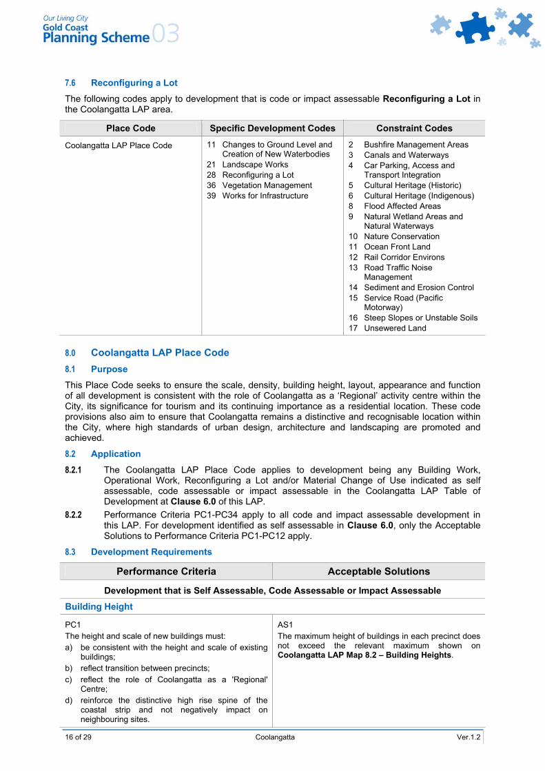
7.6 Reconfiguring a Lot
The following codes apply to development that is code or impact assessable Reconfiguring a Lot in the Coolangatta LAP area.
Place Code Specific Development Codes Constraint Codes
Coolangatta LAP Place Code 11 Changes to Ground Level and Creation of New Waterbodies
21 Landscape Works 28 Reconfiguring a Lot 36 Vegetation Management 39 Works for Infrastructure
2 Bushfire Management Areas 3 Canals and Waterways 4 Car Parking, Access and
Transport Integration 5 Cultural Heritage (Historic) 6 Cultural Heritage (Indigenous) 8 Flood Affected Areas 9 Natural Wetland Areas and
Natural Waterways 10 Nature Conservation 11 Ocean Front Land 12 Rail Corridor Environs 13 Road Traffic Noise
Management 14 Sediment and Erosion Control 15 Service Road (Pacific
Motorway) 16 Steep Slopes or Unstable Soils 17 Unsewered Land
8.0 Coolangatta LAP Place Code 8.1 Purpose
This Place Code seeks to ensure the scale, density, building height, layout, appearance and function of all development is consistent with the role of Coolangatta as a ‘Regional’ activity centre within the City, its significance for tourism and its continuing importance as a residential location. These code provisions also aim to ensure that Coolangatta remains a distinctive and recognisable location within the City, where high standards of urban design, architecture and landscaping are promoted and achieved.
8.2 Application
8.2.1 The Coolangatta LAP Place Code applies to development being any Building Work, Operational Work, Reconfiguring a Lot and/or Material Change of Use indicated as self assessable, code assessable or impact assessable in the Coolangatta LAP Table of Development at Clause 6.0 of this LAP.
8.2.2 Performance Criteria PC1-PC34 apply to all code and impact assessable development in this LAP. For development identified as self assessable in Clause 6.0, only the Acceptable Solutions to Performance Criteria PC1-PC12 apply.
8.3 Development Requirements
Performance Criteria Acceptable Solutions
Development that is Self Assessable, Code Assessable or Impact Assessable
Building Height
PC1 The height and scale of new buildings must: a) be consistent with the height and scale of existing
buildings; b) reflect transition between precincts; c) reflect the role of Coolangatta as a 'Regional'
Centre; d) reinforce the distinctive high rise spine of the
coastal strip and not negatively impact on neighbouring sites.
AS1 The maximum height of buildings in each precinct does not exceed the relevant maximum shown on Coolangatta LAP Map 8.2 – Building Heights.
Ver.1.2 Coolangatta 17 of 29
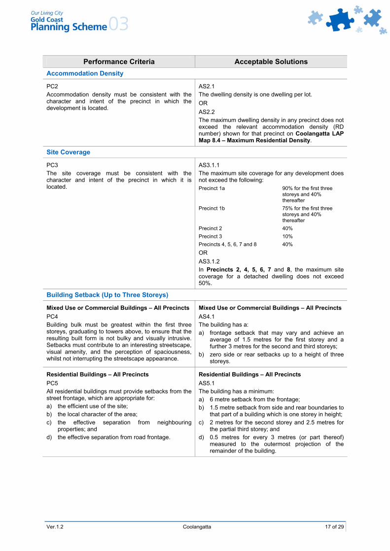
Performance Criteria Acceptable Solutions Accommodation Density
PC2 Accommodation density must be consistent with the character and intent of the precinct in which the development is located.
AS2.1 The dwelling density is one dwelling per lot. OR AS2.2 The maximum dwelling density in any precinct does not exceed the relevant accommodation density (RD number) shown for that precinct on Coolangatta LAP Map 8.4 – Maximum Residential Density.
Site Coverage
PC3 The site coverage must be consistent with the character and intent of the precinct in which it is located.
AS3.1.1 The maximum site coverage for any development does not exceed the following: Precinct 1a 90% for the first three
storeys and 40% thereafter
Precinct 1b 75% for the first three storeys and 40% thereafter
Precinct 2 40% Precinct 3 10% Precincts 4, 5, 6, 7 and 8 40% OR AS3.1.2 In Precincts 2, 4, 5, 6, 7 and 8, the maximum site coverage for a detached dwelling does not exceed 50%.
Building Setback (Up to Three Storeys)
Mixed Use or Commercial Buildings – All Precincts PC4 Building bulk must be greatest within the first three storeys, graduating to towers above, to ensure that the resulting built form is not bulky and visually intrusive. Setbacks must contribute to an interesting streetscape, visual amenity, and the perception of spaciousness, whilst not interrupting the streetscape appearance.
Mixed Use or Commercial Buildings – All Precincts AS4.1 The building has a: a) frontage setback that may vary and achieve an
average of 1.5 metres for the first storey and a further 3 metres for the second and third storeys;
b) zero side or rear setbacks up to a height of three storeys.
Residential Buildings – All Precincts PC5 All residential buildings must provide setbacks from the street frontage, which are appropriate for: a) the efficient use of the site; b) the local character of the area; c) the effective separation from neighbouring
properties; and d) the effective separation from road frontage.
Residential Buildings – All Precincts AS5.1 The building has a minimum: a) 6 metre setback from the frontage; b) 1.5 metre setback from side and rear boundaries to
that part of a building which is one storey in height; c) 2 metres for the second storey and 2.5 metres for
the partial third storey; and d) 0.5 metres for every 3 metres (or part thereof)
measured to the outermost projection of the remainder of the building.
18 of 29 Coolangatta Ver.1.2
Performance Criteria Acceptable Solutions Building Setback (Above Three Storeys)
Mixed Use or Commercial Buildings – All Precincts PC6 The upper storeys of buildings must not cause adverse impact on neighbouring sites. The development opportunities of neighbouring sites must be considered when assessing impacts of development.
Mixed Use or Commercial Buildings – All Precincts AS6.1 Above three storeys, the tower is setback at least 3 metres from all podium edges which have a street frontage. AS6.2 The tower is setback 2 metres from inside the podium edge for the initial two storeys plus 0.5 metres for every 3 metres (or part thereof) measured to the outermost projection of the remainder of tower.
Frontage Controls
PC7 Building setbacks and building design must contribute to character, an interesting streetscape appearance, and to the visual amenity of Coolangatta.
AS7.1 Lengths of walls in excess of 25 metres are not provided on the same alignment. AS7.2 Walls include variations such as recesses, balconies, windows and other features, which provide articulation. AS7.3 Garages and garage doors are not dominant streetscape features.
PC8 Outdoor areas fronting streets must be treated appropriately through screening or other design elements to minimise adverse effects on the privacy of neighbouring properties.
AS8 Outdoor areas such as unenclosed decks, terraces and balconies fronting the street are designed so that they do not: a) extend beyond the front property boundary of the
site; b) adversely affect adjoining developments; c) result in adverse visual impacts due to the loss of
suitable building setbacks. And include: a) sideways screening, planters and other acceptable
measures to limit privacy impacts on neighbouring properties.
Precincts 1, 2 and 7 PC9 All commercial or mixed use buildings must be designed to achieve a continuous activity frontage for the local business centre, with ample space for pedestrian traffic.
Precincts 1, 2 and 7 AS9 Where a mixed use building is proposed, residential uses are located above the ground floor, or to the rear of the development.
Awnings
Precincts 1, 2 and 7 PC10 Development must provide awnings where nominated along Important Street Frontages as identified on Coolangatta LAP Map 8.6 – Pedestrian Network Plan and Important Street Frontages to provide sun and rain protection to pedestrians.
Precincts 1, 2 and 7 AS10 Development incorporates awnings that extend the full width of the building and footpath as identified on Coolangatta LAP Map 8.6 – Pedestrian Network Plan and Important Street Frontages.
Ver.1.2 Coolangatta 19 of 29
Performance Criteria Acceptable Solutions Pedestrian Entrances
PC11 All new development fronting an Important Street Frontage as shown on Coolangatta LAP Map 8.6 – Pedestrian Network Plan and Important Street Frontages must incorporate pedestrian entrance points that are: a) visible and prominent to Marine Parade; and b) address the street.
AS11 A pedestrian entry point is provided to Marine Parade.
Stormwater
PC12 Buildings must be set back to maintain and improve stormwater drainage in the LAP area through the provision of drainage reserves.
AS12 Overland drainage flow paths are provided on areas shown on Coolangatta LAP Map 8.5 – Overland Flows.
Development that is Code Assessable or Impact Assessable
Siting
PC13 All buildings must be sited to complement the streetscape and built form of the surrounding area to reduce potential conflicts between adjoining uses, having regard to Planning Scheme Policy 17 – Site Analysis.
AS13 No Acceptable Solution provided.
PC14 All buildings must be sited to minimise impacts on views from surrounding properties and ensure that views to and from Kirra headland are retained. Note: An amenity impact analysis report is
required to be submitted as part of the development proposal.
AS14 No Acceptable Solution provided.
Building Appearance
PC15 The design of all buildings in the Coolangatta LAP area must: a) promote the theme of a modern, cosmopolitan,
prosperous, leisure oriented centre; b) achieve development of high quality structures that
contribute to a lively streetscape and complements development on adjoining sites;
c) address public streets and other public areas; and d) must be an attractive and functional component of
the centre as a whole.
AS15.1 All development is oriented so as to address and complement public streets and public areas. AS15.2 Walls in excess of 15 metres in length along a single plane or elevation are avoided, unless such walls are punctuated by: a) balconies, awnings, eaves; b) a variety of building materials to avoid design
repetition; and c) variation such as stepping, curving, angling with
the wall planes. AS15.3 The roof areas of buildings are designed to hide or disguise all rooftop machinery and service equipment including lift and plant rooms. Roof areas are designed to promote an interesting and diverse outlook from all public and private areas. AS15.4 A maximum horizontal dimension of any one alignment facing the street is 6m or land identified as an important street frontage has vertical dimensions or other design features to provide the appearance of smaller scale tenancies.
20 of 29 Coolangatta Ver.1.2
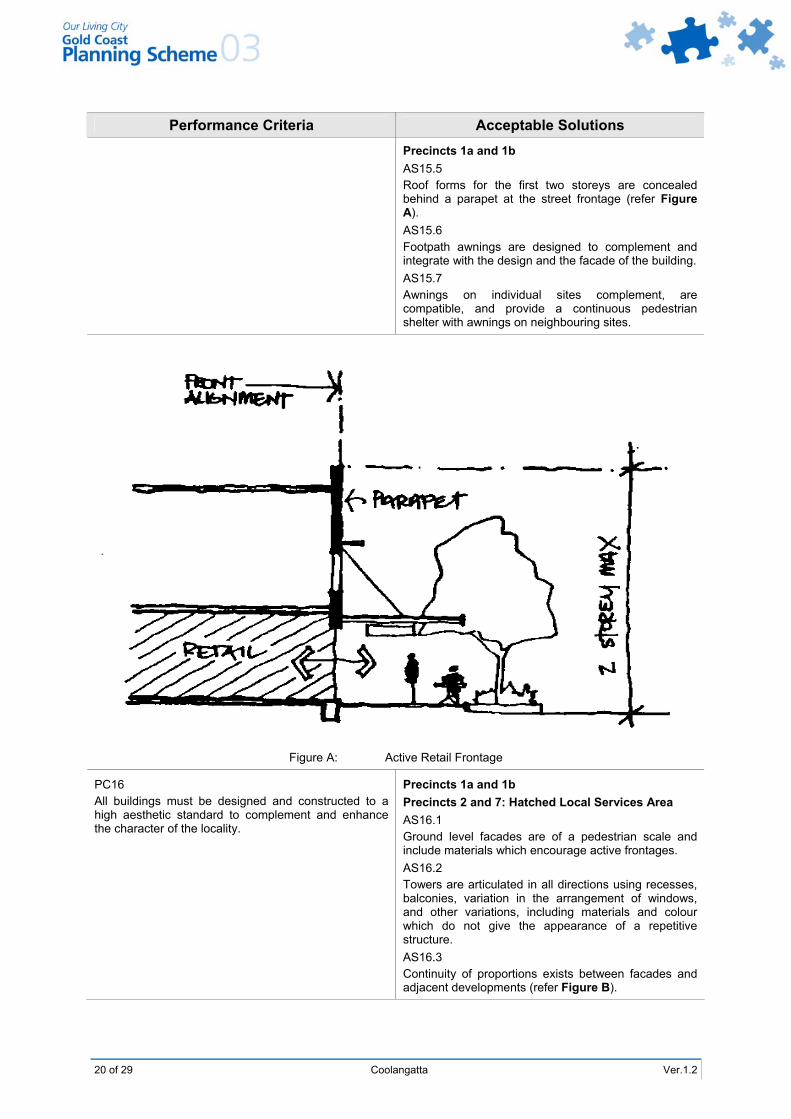
Performance Criteria Acceptable Solutions Precincts 1a and 1b AS15.5 Roof forms for the first two storeys are concealed behind a parapet at the street frontage (refer Figure A). AS15.6 Footpath awnings are designed to complement and integrate with the design and the facade of the building. AS15.7 Awnings on individual sites complement, are compatible, and provide a continuous pedestrian shelter with awnings on neighbouring sites.
Figure A: Active Retail Frontage
PC16 All buildings must be designed and constructed to a high aesthetic standard to complement and enhance the character of the locality.
Precincts 1a and 1b Precincts 2 and 7: Hatched Local Services Area AS16.1 Ground level facades are of a pedestrian scale and include materials which encourage active frontages. AS16.2 Towers are articulated in all directions using recesses, balconies, variation in the arrangement of windows, and other variations, including materials and colour which do not give the appearance of a repetitive structure. AS16.3 Continuity of proportions exists between facades and adjacent developments (refer Figure B).
Ver.1.2 Coolangatta 21 of 29
Performance Criteria Acceptable Solutions
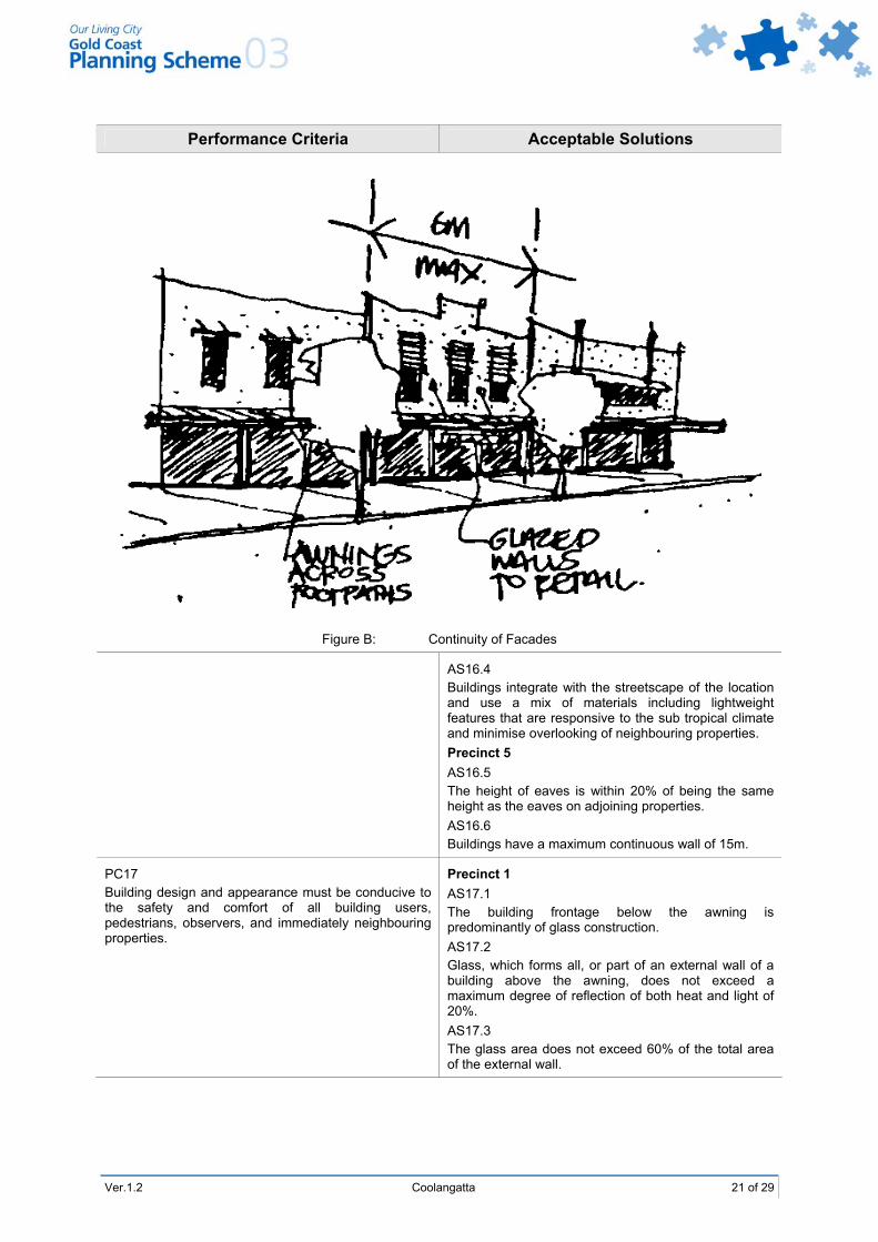
Figure B: Continuity of Facades
AS16.4 Buildings integrate with the streetscape of the location and use a mix of materials including lightweight features that are responsive to the sub tropical climate and minimise overlooking of neighbouring properties. Precinct 5 AS16.5 The height of eaves is within 20% of being the same height as the eaves on adjoining properties. AS16.6 Buildings have a maximum continuous wall of 15m.
PC17 Building design and appearance must be conducive to the safety and comfort of all building users, pedestrians, observers, and immediately neighbouring properties.
Precinct 1 AS17.1 The building frontage below the awning is predominantly of glass construction. AS17.2 Glass, which forms all, or part of an external wall of a building above the awning, does not exceed a maximum degree of reflection of both heat and light of 20%. AS17.3 The glass area does not exceed 60% of the total area of the external wall.
22 of 29 Coolangatta Ver.1.2
Performance Criteria Acceptable Solutions Precinct 1
Precincts 2 and 7 Hatched Local Services Areas AS17.4 Pedestrian awnings are provided above all public footways and inter-block arcade links for all development within Precinct 1 (excluding west central core Marine Parade to Musgrave Street) Precinct 2 local services, Precinct 7 mixed use residential and local services area where fronting an Important Street Frontage shown on Coolangatta LAP Map 8.6 – Pedestrian Network Plan and Important Street Frontages. Awnings are cantilevered or suspended at a minimum width of 3.0 metres over the adjoining footway where the width road reserve and footpath permits. Note: Proposals for footpath awnings may
be considered appropriate in other precincts provided that public benefit can be demonstrated.
All Precincts (where Non-residential adjoins Residential or Mixed Use Development) AS17.5 Equipment that has potential to create noise (whether continuous or intermittent) is designed and located to minimise the penetration of noise to dwelling units on the premises and to residential premises external to the site. Precinct 4 (adjacent to Goodwin Park) AS17.6 The design of new buildings provides windows of habitable rooms facing Goodwin Park.
PC18 All car park areas must be designed and constructed to service the needs of all users and to complement the character of the locality.
All Precincts AS18.1 All car park areas are constructed and detailed to ensure they do not dominate the street frontage of the development. Car park areas provided at ground level are located behind dwellings or recessed behind the dwelling frontage. A18.2 Building materials, patterns, textures and colours used in garage and carport structures are complementary to those of the principal building on the site. Precincts 1a and 1b AS18.3 Off street parking is not a visible part of the streetscape on land fronting Marine Parade, Griffith Street or McLean Street.
PC19 The volume of ground level car parking must be minimised, with underground car parking facilities to be used where possible.
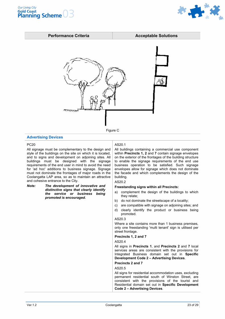
AS19.1 On sites fronting important street frontage shown on Coolangatta LAP Map 8.6 – Pedestrian Network Plan and Important Street Frontages basement car parking is not higher than the footpath at the front boundary (refer Figure C).
Ver.1.2 Coolangatta 23 of 29
Performance Criteria Acceptable Solutions
Figure C
Advertising Devices
PC20 All signage must be complementary to the design and style of the buildings on the site on which it is located, and to signs and development on adjoining sites. All buildings must be designed with the signage requirements of the end user in mind to avoid the need for 'ad hoc' additions to business signage. Signage must not dominate the frontages of major roads in the Coolangatta LAP area, so as to maintain an attractive and cohesive entrance to the City. Note: The development of innovative and
distinctive signs that clearly identify the service or business being promoted is encouraged.
AS20.1 All buildings containing a commercial use component within Precincts 1, 2 and 7 contain signage envelopes on the exterior of the frontages of the building structure to enable the signage requirements of the end use business operation to be satisfied. Such signage envelopes allow for signage which does not dominate the facade and which complements the design of the building. AS20.2 Freestanding signs within all Precincts: a) complement the design of the buildings to which
they relate; b) do not dominate the streetscape of a locality; c) are compatible with signage on adjoining sites; and d) clearly identify the product or business being
promoted. AS20.3 Where a site contains more than 1 business premises, only one freestanding 'multi tenant' sign is utilised per street frontage. Precincts 1, 2 and 7 AS20.4 All signs in Precincts 1, and Precincts 2 and 7 local services areas are consistent with the provisions for Integrated Business domain set out in Specific Development Code 2 – Advertising Devices. Precincts 2 and 7 AS20.5 All signs for residential accommodation uses, excluding permanent residential south of Winston Street, are consistent with the provisions of the tourist and Residential domain set out in Specific Development Code 2 – Advertising Devices.
24 of 29 Coolangatta Ver.1.2
Performance Criteria Acceptable Solutions Landscape Works
PC21 Extensive areas of visible ground level landscaping must be provided to a standard that promotes a pleasant, attractive and functional pedestrian environment with a sub-tropical character.
AS21.1 Landscape works include features where the vegetation component is located at street level, on top of the podium levels or on terraces, balconies and decks. Local native coastal species and/or vegetation with climbing/trailing characteristics are used. AS21.2 Footpath paving treatments and street furniture integrate with adjoining development, and setback areas are integrated with public footpaths. AS21.3 Landscape works are provided at ground level and are designed in accordance with Part 7, Division 2, Chapter 21 Landscape Works Code Clause 3.0. AS21.4 Landscape plans are submitted and approved in accordance with Part 7, Division 2, Chapter 21 Landscape Works Code Clause 3.0.
PC22 All ground level parking must be suitably landscaped to provide an attractive and pleasant outlook, providing shade for parked vehicles, and contributing towards the quality presentation of new developments. Note: Extensive at-grade car parking will
not be considered favourably in areas outside Precinct 1 or designated as Important Street Frontages on Coolangatta LAP Map 8.6 – Pedestrian Network Plan and Important Street Frontages.
AS22.1 Significant trees are preserved and incorporated into car parking designs where reasonably possible. AS22.2 Landscaped bays for the planting of shade trees are provided at regular intervals throughout car parking areas at the rate of 1 landscaped bay per 8 vehicle parking bays. Landscape bays have the same dimensions as vehicle parking spaces. AS22.3 Any portion of a car parking area that is not utilised for parking bays, access aisles or any other essential purpose, is utilised for landscaping.
Reconfiguring A Lot – Lot Size
PC23 All allotments must be of sufficient area and dimensions to accommodate buildings, designed to the criteria in this LAP.
AS23.1 The allotment dimensions shall be in accordance with Specific Development Code 28 – Reconfiguration of a Lot. AS23.2 The minimum frontage of land proposed to be used for non-residential or commercial purposes in this LAP is fifteen (15) metres. AS23.3 For other development minimum frontages shall be in accordance with Specific Development Code 28 – Reconfiguration of a Lot.
Ver.1.2 Coolangatta 25 of 29
Performance Criteria Acceptable Solutions Amenity Protection
PC24 A new use must not detract from the amenity of the local area, having regard, but not limited, to the impact of: a) noise; b) hours of operation; c) traffic; d) lighting; e) signage; f) visual amenity; g) privacy; h) odour and emissions.
AS24 No acceptable solution provided.
PC25 The proposed development must take into account and seek to ameliorate any negative aspects of the existing residential amenity of the local area, having regard, but not limited, to the existing impact of: a) noise; b) hours of operation; c) traffic; d) lighting; e) signage; f) visual amenity; g) privacy; h) odour and emissions.
AS25 No acceptable solution provided.
Access Provisions
PC26 The LAP area must have a high standard of accessibility for public transport, private motor vehicles, pedestrians (including disabled access and cyclists).
AS26.1 New development contributes to: a) developing off street car parking facilities; b) encouraging the development of a pedestrian
walkway system based on a network of shopping arcades, open space links and widened footpaths throughout the central area;
c) improving vehicular traffic flows and reducing conflicts between local and through traffic;
d) reducing pedestrian/vehicular conflict by provision of a system of rear vehicular access lane ways;
e) promoting pedestrian mid-block access in locations identified in Coolangatta LAP Map 8.6 – Pedestrian Network Plan and Important Street Frontages;
f) promoting the co-location of public transport in the Lanham Street/Chalk Street area; and
g) contributing to the enhancement of pedestrian paths identified in Coolangatta LAP Map 8.6 – Pedestrian Network Plan and Important Street Frontages.
AS26.2 Disabled Access complies with AS1428 – Design for Access and Mobility.
26 of 29 Coolangatta Ver.1.2
Performance Criteria Acceptable Solutions
PC27 Conflicts between pedestrians and vehicles at entrance points to parking areas must be minimised.
AS27.1 No additional access points are provided fronting Griffith Street. Elsewhere no more than one vehicle access point per development site is provided. AS27.2 No loading areas or refuse storage areas are located adjoining any Important Street Frontage identified on Coolangatta LAP Map 8.6 – Pedestrian Network Plan and Important Street Frontages. AS27.3 Entrance points to parking and loading areas have clear and unobstructed visibility of pedestrian pathway areas, with pedestrian crossing points clearly identified giving priority to pedestrians. AS27.4 Rear lanes and/or streets that lesser pedestrian activity, are used for access to basements, servicing and parking areas on sites which have more than one street frontage. AS27.5 Footpaths are provided along the site frontages to all public streets.
Car Parking Provision
PC28 Car parking, and access requirements must ensure that the vehicular and pedestrian needs associated with development area adequately accommodated.
AS28.1 Provision is made by each development for car parking at the rates provided for in Constraint Code 4 – Car Parking, Access and Transport Integration. AS28.2 For residential development on site car parking is provided consistent with the following rates: a) in Precinct 1 McLean to Warner Street - 0% of the
standard car parking requirement from Constraint Code 4 – Car Parking, Access and Transport Integration;
b) in Precinct 1 McLean to Garrick Street - at least 50% of the standard car parking requirement from Constraint Code 4 – Car Parking, Access and Transport Integration;
c) in Precinct 2 and 7 at least 70% of the standard car parking requirement from Constraint Code 4 - Car Parking, Access and Transport Integration;
d) in other precincts 100% of the standard car parking requirement specified in Constraint Code 4 – Car Parking, Access and Transport Integration.
AND AS28.3 Council has resolved to accept cash in-lieu of car parking for any shortfall in on site provision or the required spaces are to be made available on a site within walking distance from the site on a basis suitable to Council for the satisfaction of required on site car parking requirements.
Ver.1.2 Coolangatta 27 of 29
Performance Criteria Acceptable Solutions Public Convenience Facilities
PC29 Commercial developments must include public convenience facilities, where there is a need for their provision.
AS29 Where provided, public toilet facilities are open and readily accessible to the general public during retail trading hours or other trading hours relevant to the development. Such facilities are: a) in clear view and in close proximity to late night
activities; b) located in areas of high levels of natural
surveillance by passing pedestrians and motorists; c) in areas which avoid loitering opportunities; and d) lighting complies with Australian Standard
(AS1158.1:1986).
Building Services
PC30 Adequate facilities for commercial and mixed use buildings for the loading and unloading of goods must be provided to meet the needs of the development.
AS30 A loading area is provided on site that is separated from the public access areas and readily accessible from all commercial tenancies on the site is in accordance with Constraint Code 4 – Car Parking Access and Transport Integration.
PC31 Adequate facilities for servicing of the development with a refuse disposal service must be provided to meet the needs of the development.
AS31.1 Provision is made for the storage of refuse on site and the suitable access for the removal of refuse is in accordance with Specific Development Code 4 – Car Parking Access and Transport Integration. OR Specific Development Code 22 – Low Rise Apartments for Precincts 3, 5 and Precinct 7 Low Scale Residential choice, permanent residential south of Winston Street and mixed use residential/low scale local services. AS31.2 All outdoor storage or refuse disposal areas are screened from public view is in accordance with Specific Development Code 19 – High Rise Tourist and Residential Accommodation for Precincts 1 and 2 and Precinct 7 Mixed Use residential/local services and mixed residential/tourist accommodation. OR Specific Development Code 22 – Low Rise Apartments for Precincts 3 and 5 and Precinct 7 low scale residential and permanent residential south of Winston Street and mixed use residential/local services.
Local Character
PC32 Places of local character significance identified on Figure 8.6 and described in Table 8.2 must be protected where practicable and otherwise recognised and suitably recorded.
AS32.1 The site is identified on Coolangatta LAP Map 8.7 – Selected Heritage and Character Components and the heritage and character elements of the site have been identified as significant and are protected. OR
28 of 29 Coolangatta Ver.1.2
Performance Criteria Acceptable Solutions AS32.2
Prior to the demolition, removal or significant alteration of any place identified on Coolangatta LAP Map 8.7 – Selected Heritage and Character Components a character significance assessment report will be required. The report will be completed by a suitably qualified professional and will identify: a) the importance and condition of the building; b) what impact the proposed development is likely to
have on the heritage values of the site; c) if applicable, the grounds for determining that
preservation is not a desirable or feasible alternative; and
d) if the building does not have heritage value, what measures are proposed for the preservation or enhancement of the building or if the building is not proposed to be preserved what measures are proposed to record its heritage value.
PC33 Positive incentives are provided to property owners to encourage the retention of places of local character significance.
AS33 One or more of the following bonuses is, at Council's absolute discretion, made available by Council to the developer: a) the repositioning of the existing building on the site
to better facilitate development of the balance area provided the following criteria are met: the building is not being moved towards the
street alignment so as to be more than two metres forward of a building on an adjoining lot; and
the building is not located closer than 1.0 metres to a side boundary of a site.
b) the car-parking provision for the total development assessment on the basis of Constraint Code 4 – Car Parking, Access and Transport Integration may be reduced by 50%.
Plot Ratio
PC34 The bulk of the development proposal must be proportional to the character of the local area, with some bonus in floor space available where identified public benefits are provided and/or exhibits an unusually high standard of urban design. Building bulk will generally be greater within Precinct 1 with a lesser building bulk being permitted in peripheral commercial and tourist accommodation precincts where development is intended to be less intensive. The intent of this section is to allow for a built form that addresses the street at ground level, with tall, narrow structures above third floor level, to enable sunlight penetration and views to be achieved.
All Precincts AS34.1 The basic plot ratios described for each precinct in the Table to Performance Criterion PC34 are not exceeded. OR AS34.2 The basic plot ratio is exceeded by the incorporation of bonus element, in a development consistent with the provisions of Planning Scheme Policy 18 – Using the Urban Design Bonus Provisions, provided that the maximum plot ratios described for each precinct in the Table to Performance Criterion PC34, are not exceeded.
Table to Performance Criterion PC34 – Plot Ratio Controls by Precinct Precincts 1 and 7 a) the basic plot ratio is 3:1 b) the maximum plot ratio is 6.5:1
Precincts 3 and 8 a) no plot ratio applies
Precincts 2, 4, 5 and 6 a) the basic plot ratio is 2:1 b) the maximum plot ratio is 4:1
Ver.1.2 Coolangatta 29 of 29
8.4 Indigenous Cultural Heritage
Assessments of Indigenous Cultural heritage already undertaken demonstrate that the LAP area contains elements of significant Aboriginal cultural heritage value. On the basis of these assessments and others undertaken in similar areas, it is highly probable that other significant sites exist in the area. Among the cultural sites or materials already identified are shell middens believed to be among the oldest on the Gold Coast, vegetated areas accessed for their Aboriginal economic values, and various stone scatters indicative of camping sites. These values need to be adequately protected and conserved as part of any development process. Moreover, those cultural values yet to be revealed by surveys need to be identified early in the process of site planning, and adequately protected and conserved as part of any development process.
8.5 Places of Character or Heritage Significance
Places of character or heritage significance as identified on Coolangatta LAP Map 8.7 – Selected Heritage and Character Components:
1. The Wreck of the Coolangatta
2. Sunnyside Holiday Units
3. Kirra Beach Pavilion (Kirra Surf Riders Club, Pizza Hut)
4. Kirra Shelter Shed
5. Coolangatta Surf Life Saving Club
6. Former Kirrabelle Hotel (The Sands)
7. Former Jazzland Dance Hall
8. Thompson House
9. Shops 17, 23 and 25 Griffith St
10. St Augustine's Church
11. War Memorial – US Soldiers
12. Captain Cook Memorial
13. Former Coolangatta State School