Embed Size (px)
Citation preview
PARRISH & HEIMBECKERPROPOSED FRASER GRAIN TERMINAL EXPORT FACILITY
VIEWSCAPE & SHADE STUDY
Prepared for:
Hemmera Envirochem Ltd.
18th Floor, 4730 Kingsway
Burnaby, BC V5H 0C6
Prepared by:
Enns Gauthier Landscape Architects Inc.
202 - 175 East Broadway
Vancouver, BC V5T 1W2
Issued: June 5th, 2017
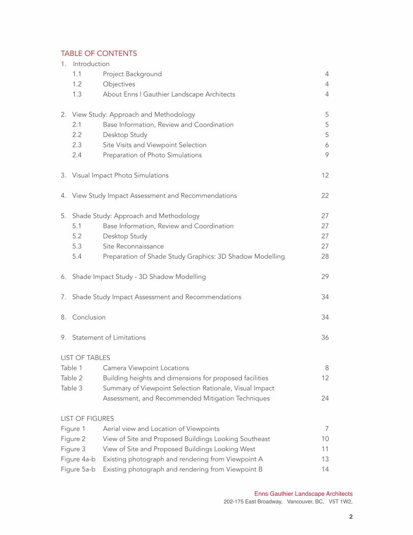
TABLE OF CONTENTS
1. Introduction
1.1 Project Background 4
1.2 Objectives 4
1.3 About Enns | Gauthier Landscape Architects 4
2. View Study: Approach and Methodology 5
2.1 Base Information, Review and Coordination 5
2.2 Desktop Study 5
2.3 Site Visits and Viewpoint Selection 6
2.4 Preparation of Photo Simulations 9
3. Visual Impact Photo Simulations 12
4. View Study Impact Assessment and Recommendations 22
5. Shade Study: Approach and Methodology 27
5.1 Base Information, Review and Coordination 27
5.2 Desktop Study 27
5.3 Site Reconnaissance 27
5.4 Preparation of Shade Study Graphics: 3D Shadow Modelling 28
6. Shade Impact Study - 3D Shadow Modelling 29
7. Shade Study Impact Assessment and Recommendations 34
8. Conclusion 34
9. Statement of Limitations 36
LIST OF TABLES
Table 1 Camera Viewpoint Locations 8
Table 2 Building heights and dimensions for proposed facilities 12
Table 3 Summary of Viewpoint Selection Rationale, Visual Impact
Assessment, and Recommended Mitigation Techniques 24
LIST OF FIGURES
Figure 1 Aerial view and Location of Viewpoints 7
Figure 2 View of Site and Proposed Buildings Looking Southeast 10
Figure 3 View of Site and Proposed Buildings Looking West 11
Figure 4a-b Existing photograph and rendering from Viewpoint A 13
Figure 5a-b Existing photograph and rendering from Viewpoint B 14
Enns Gauthier Landscape Architects
202-175 East Broadway, Vancouver, BC, V5T 1W2,
�2
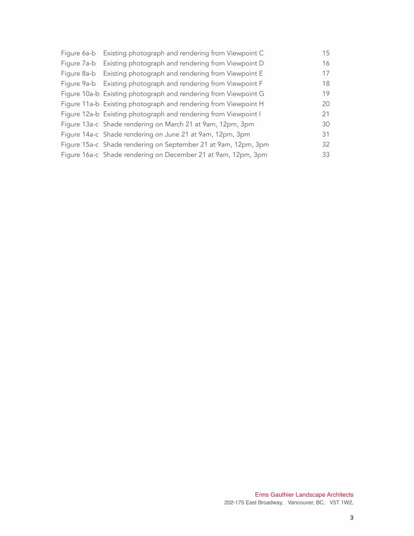
Figure 6a-b Existing photograph and rendering from Viewpoint C 15
Figure 7a-b Existing photograph and rendering from Viewpoint D 16
Figure 8a-b Existing photograph and rendering from Viewpoint E 17
Figure 9a-b Existing photograph and rendering from Viewpoint F 18
Figure 10a-b Existing photograph and rendering from Viewpoint G 19
Figure 11a-b Existing photograph and rendering from Viewpoint H 20
Figure 12a-b Existing photograph and rendering from Viewpoint I 21
Figure 13a-c Shade rendering on March 21 at 9am, 12pm, 3pm 30
Figure 14a-c Shade rendering on June 21 at 9am, 12pm, 3pm 31
Figure 15a-c Shade rendering on September 21 at 9am, 12pm, 3pm 32
Figure 16a-c Shade rendering on December 21 at 9am, 12pm, 3pm 33
Enns Gauthier Landscape Architects
202-175 East Broadway, Vancouver, BC, V5T 1W2,
�3
1. Introduction
1.1 Project Background
Parrish & Heimbecker Ltd (P&H) is proposing to build a new state-of-the-art Fraser Grain
Terminal Export Facility (the “Project”) at 11041 Elevator Road, Surrey. The site is bounded by
Fraser Surrey Docks to the Northwest and South, and a lumber facility (Western Cleanwood /
Surewood Forest Products) to the East. This land is owned by Port Metro Vancouver (PMV) and
was formerly leased by Bekaert Canada Ltd. (Bekaert). The new grain facility will serve as a trans-
shipment storage location for bulk grain products, and will include loading and unloading
infrastructure, storage silos, a transfer tower and gallery, and ancillary works.
The Project, which comprises 1 permit application, will be equipped with:
• rail car unloading system;
• storage silos;
• vessel bulk grain loading terminal for overseas shipment;
• rail car and truck loading installations for feedmills; and,
• container loading system for overseas shipments.
1.2 Objectives
In accordance to the PMV Project and Environmental Review Guidelines - View and Shade
Impact July 2015 (PERG VS 2015), the Project requires analysis of the effects of the proposed
siting, massing and height to public and private views of the visual landscape to the surrounding
community and skyline. The guidelines also require study into the potential shade impacts on
the surrounding areas from the proposed Project. Photographs and visual renderings have been
provided of existing and proposed developments according to PERG VS 2015 guidelines, and
potential mitigation strategies for view and shade effects have been discussed in this report as
well.
The Project is zoned Port Terminal in the PMV Land Use Plan (October 29 2014). Consistent with
PMV’s approvals process, a visual impact assessment has been conducted for the proposed new
grain facility. The purpose of this assessment is to:
• Demonstrate that P&H has considered the provisions and requirements of the PERG VS
2015;
• To guide the application of visual mitigation measures;
• To support community information sharing and the consultation process.
Enns | Gauthier Landscape Architects has been tasked with performing the Views and Shade
study. Together in collaboration with other environmental and engineering firms, the Project
Team will deliver all necessary reports to PMV for permit approval.
1.3 About Enns | Gauthier Landscape Architects
Enns | Gauthier Landscape Architects (E|G) was formed in 2014 with an eye towards bringing
greater creativity, adaptability and collaboration to the practice of landscape architecture. E|G is
Enns Gauthier Landscape Architects
202-175 East Broadway, Vancouver, BC, V5T 1W2,
�4
built upon the collective experiences of over 20 years spent planning, designing and managing
landscape projects for some of Greater Vancouver’s premier urban development brands,
municipalities and institutions. Based in Vancouver, BC, E|G has worked on similar projects
involving regenerative design, large-scale master planning and analysis, visual resource
management, graphic renderings and manipulation, and site reconnaissance, documentation
and field review. As landscape architects experienced working in collaborative environments, E|G
will work closely with the Project Team to deliver a high quality and comprehensive Report for
the Client.
2. View Study: Approach and Methodology This view study and impact assessment will focus on how the proposed Project infrastructure,
siting, layout, massing, materials and height impact the surrounding community and views from
public areas. The following outlines our approach and methodology.
2.1 Base Information, Review and Coordination
Base information was acquired from Hemmera Envirochem (Hemmera), CMC Engineering
(CMC), vegetation specialists, surveyors and civil engineers. This information included:
• Site existing ground contours;
• Site aerial photos, at-grade site photos;
• CAD drawings of existing and proposed facilities;
• Rendering perspective of proposed facilities;
• Plans for new equipment, structures, and buildings,
• Elevation drawings of Main Plant area;
• Sections of proposed structures, orthophotos / satellite images in plan view of
the site;
• Mapping of existing vegetation on site to be preserved and protected.
Information from these documents was gathered and overlaid to form an accurate and
informative assessment of the site’s conditions.
2.2 Desktop Study
A literature review of local and regional land use policies, environmental guidelines, PMV
standards and BC visual Quality Objective Guidelines was conducted. As the site is within PMV’s
jurisdiction and its land use is designated Port Terminal, the Project must adhere to the PERG VS
2015 document. As-built drawings of the proposed new infrastructure provided by CMC were
reviewed and assessed. Aerial photos, satellite images, and at-grade photos were used to
conduct an initial study of the immediate and surrounding areas. City topographic maps were
Enns Gauthier Landscape Architects
202-175 East Broadway, Vancouver, BC, V5T 1W2,
�5
also consulted to get a better understanding of elevation changes surrounding the project site.
2.3 Site Visits and Viewpoint Selection
Site reconnaissance is an important part of information gathering and ‘ground truthing’ to assess
the the accuracy of the base information and back ground studies. Site visits of the site,
adjacent properties and the surrounding area occurred on October 27, 2015 and July 27, 2016.
The purpose of the first site visit was to review existing site conditions and identify potential
locations for the view study graphics within the site as well as additional locations in the
neighbouring vicinity. Viewpoint selection criteria were established prior to site reconnaissance
to help determine possible view points, as follows:
• high-use public spaces with views to the site
• viewpoints at elevations with potential view windows over existing trees
• main roadways in the vicinity of the site with high traffic volumes
• residential roadways within the vicinity of the site whose view quality and
neighbourhood ‘character’ may be affected by the new facilities
• institutions and community buildings with potential views to the project site
• tourist destinations
• recreational trails and public parks
An additional site visit was conducted on July 26, 2016 after feedback was gathered from PMV,
Hemmera and CMC to obtain information from a greater variety of viewpoints from the
residential community and public vantage points. This site visit also provided a better
understanding of the potential viewpoints in summer conditions, when all trees are leafing out.
This information helped to refine the viewpoint selection process even further, as many of the
deciduous trees were bare at the time of the initial site visit.
As a result of the 2 site visits and correspondence with the Project Team, 9 locations (A to I, see
Figure 1) were chosen as viewpoints for this study. The viewpoints chosen offered formed an
accurate representation of the view impacts of the new facility on the surrounding communities:
the South Fraser Perimeter Road; River Road; on the North side of the Fraser River from
Queensborough; Westminster Quay; and Pier Park in New Westminster. The views from these
areas are significant due to their location established in residential neighbourhoods, civic
gathering places, parks, trails and tourism destinations within the surrounding community. Each
viewpoint, its orientation, description of location, elevation and distance from the site are
summarized in Table 1.
Enns Gauthier Landscape Architects
202-175 East Broadway, Vancouver, BC, V5T 1W2,
�6
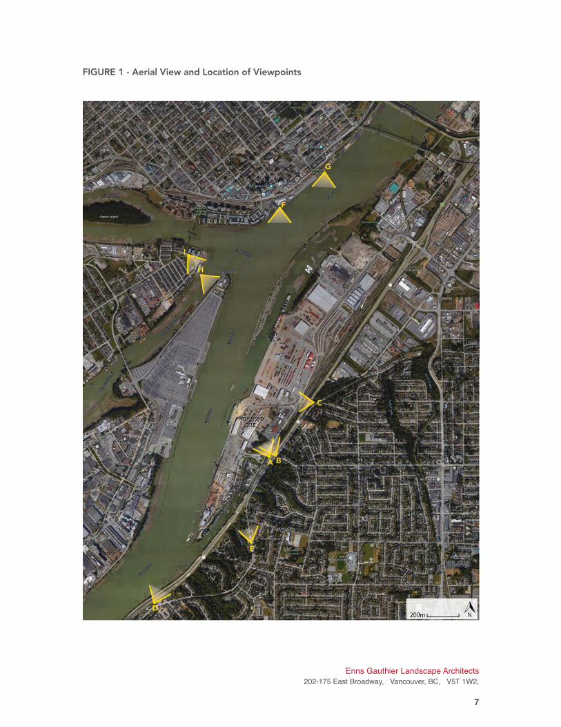
FIGURE 1 - Aerial View and Location of Viewpoints
Enns Gauthier Landscape Architects
202-175 East Broadway, Vancouver, BC, V5T 1W2,
�7
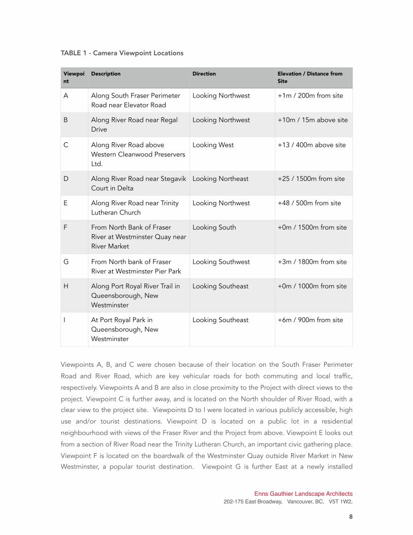
TABLE 1 - Camera Viewpoint Locations
Viewpoints A, B, and C were chosen because of their location on the South Fraser Perimeter
Road and River Road, which are key vehicular roads for both commuting and local traffic,
respectively. Viewpoints A and B are also in close proximity to the Project with direct views to the
project. Viewpoint C is further away, and is located on the North shoulder of River Road, with a
clear view to the project site. Viewpoints D to I were located in various publicly accessible, high
use and/or tourist destinations. Viewpoint D is located on a public lot in a residential
neighbourhood with views of the Fraser River and the Project from above. Viewpoint E looks out
from a section of River Road near the Trinity Lutheran Church, an important civic gathering place.
Viewpoint F is located on the boardwalk of the Westminster Quay outside River Market in New
Westminster, a popular tourist destination. Viewpoint G is further East at a newly installed
Viewpoi
nt
Description Direction Elevation / Distance from
Site
A Along South Fraser Perimeter
Road near Elevator Road
Looking Northwest +1m / 200m from site
B Along River Road near Regal
Drive
Looking Northwest +10m / 15m above site
C Along River Road above
Western Cleanwood Preservers
Ltd.
Looking West +13 / 400m above site
D Along River Road near Stegavik
Court in Delta
Looking Northeast +25 / 1500m from site
E Along River Road near Trinity
Lutheran Church
Looking Northwest +48 / 500m from site
F From North Bank of Fraser
River at Westminster Quay near
River Market
Looking South +0m / 1500m from site
G From North bank of Fraser
River at Westminster Pier Park
Looking Southwest +3m / 1800m from site
H Along Port Royal River Trail in
Queensborough, New
Westminster
Looking Southeast +0m / 1000m from site
I At Port Royal Park in
Queensborough, New
Westminster
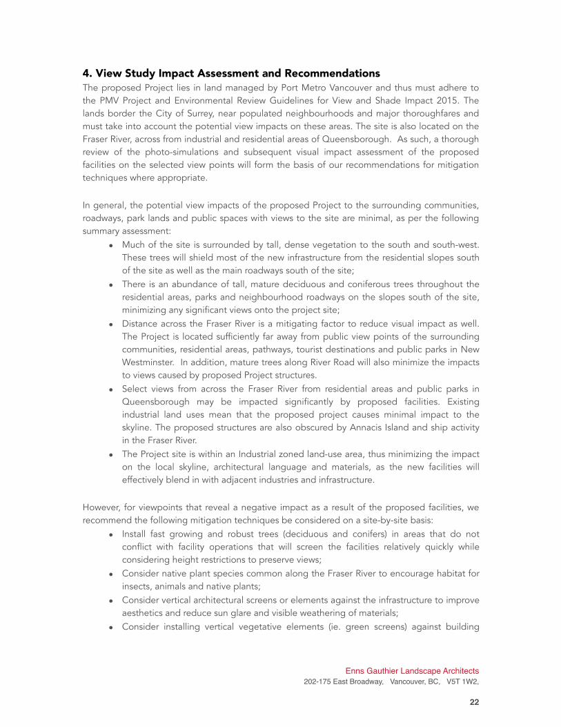
Looking Southeast +6m / 900m from site
Enns Gauthier Landscape Architects
202-175 East Broadway, Vancouver, BC, V5T 1W2,
�8
popular park and civi space named Westminster Pier Park. Viewpoints H and I are located on
popular riverfront trails and parks with views to the Project on Queensborough Island.
Once viewpoints were documented and approved, graphic work began to create realistic photo-
simulations of the proposed infrastructure from each view point location.
2.4 Preparation of Photo Simulations
Renderings of the future view of the Project buildings and structures were prepared for each of
the viewpoints (Figures 4-b to 12-b). The methodology to create the photo simulations is as
follows:
1. Original viewpoint photos for foreground details / existing landscape features (by
EG);
2. Survey data (height contours) of the surrounding landscape (City of Surrey);
3. Technical drawings of the proposed site plans / building dimensions (provided by
CMC, 2016)
4. CAD base plans of the proposed facility were confirmed (provided by CMC);
5. Overlay the base plans with computer-generated 3D models of the proposed
infrastructure (provided by CMC), (see Figures 2 + 3);
6. Confirm the heights and dimensions of the Project’s infrastructure (by CMC), (see
Table 2);
7. Confirm building facade and infrastructure materials (by CMC), (see Table 2);
8. Generate “snapshots” with 3D model corresponding with approved viewpoints;
9. Import 3D snapshot “frames” to photo manipulation software (Photoshop) and
produce realistically rendered buildings, structures, and surfaces and vegetation;
Enns Gauthier Landscape Architects
202-175 East Broadway, Vancouver, BC, V5T 1W2,
�9
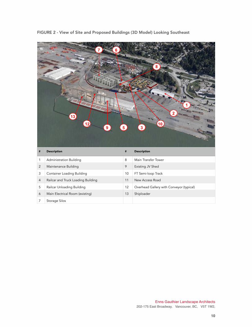
FIGURE 2 - View of Site and Proposed Buildings (3D Model) Looking Southeast
!
Enns Gauthier Landscape Architects
202-175 East Broadway, Vancouver, BC, V5T 1W2,
�10
# Description # Description
1 Administration Building 8 Main Transfer Tower
2 Maintenance Building 9 Existing JV Shed
3 Container Loading Building 10 FT Semi-loop Track
4 Railcar and Truck Loading Building 11 New Access Road
5 Railcar Unloading Building 12 Overhead Gallery with Conveyor (typical)
6 Main Electrical Room (existing) 13 Shiploader
7 Storage Silos
7 6
8
13
1259
1
2
103
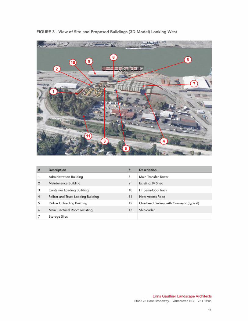
FIGURE 3 - View of Site and Proposed Buildings (3D Model) Looking West
Enns Gauthier Landscape Architects
202-175 East Broadway, Vancouver, BC, V5T 1W2,
�11
# Description # Description
1 Administration Building 8 Main Transfer Tower
2 Maintenance Building 9 Existing JV Shed
3 Container Loading Building 10 FT Semi-loop Track
4 Railcar and Truck Loading Building 11 New Access Road
5 Railcar Unloading Building 12 Overhead Gallery with Conveyor (typical)
6 Main Electrical Room (existing) 13 Shiploader
7 Storage Silos
9
85
7
4
6
3
11
1
2
10
TABLE 2 - Building Heights and Dimensions for Proposed Facilities
(as per CMC, 2016 data)
3. Visual Impact Photo Simulations
After the computer-generated model “snapshots” were superimposed on the current viewpoints
they were further manipulated to remove site features that will no longer be present (ie.
removed vegetation) and to add proposed infrastructure. In the following section, a photograph
of existing conditions from the selected viewpoint is shown beside a computer rendered image
to illustrate the potential impacts of the proposed Project from that vantage point. Existing and
rendered graphics are shown in the subsequent Figures 4-12 along with a description of the
viewpoint, rationale for site selection, and preliminary assessment of visual impacts.
Structure of Element Height (m) Facade Materials / Finish
Rail Unloading Building 13.25 Heron Blue
Overhead Galleries 42.46 Galvanized
Transfer Tower 49.11 Galvanized
Container Loading Tower 26.15 Galvanized
Administration Building 5.82 • Select Cedarmill in Countrylane red
• Galvalume
Maintenance Building 6.92 Heron Blue
Electrical Room #1 (Existing) 4 Painted Grey
Silos (Big) 33.96 Galvanized
Silos (Small) 25.79 Galvanized
Rail and Truck Loading Building 13.64 Heron Blue
Enns Gauthier Landscape Architects
202-175 East Broadway, Vancouver, BC, V5T 1W2,
�12
VIEWPOINT A: Along South Fraser Perimeter Road near Elevator Road (Looking Northwest)
FIGURE 4A - Existing Conditions
FIGURE 4A - Photo-simulation
Enns Gauthier Landscape Architects
202-175 East Broadway, Vancouver, BC, V5T 1W2,
�13
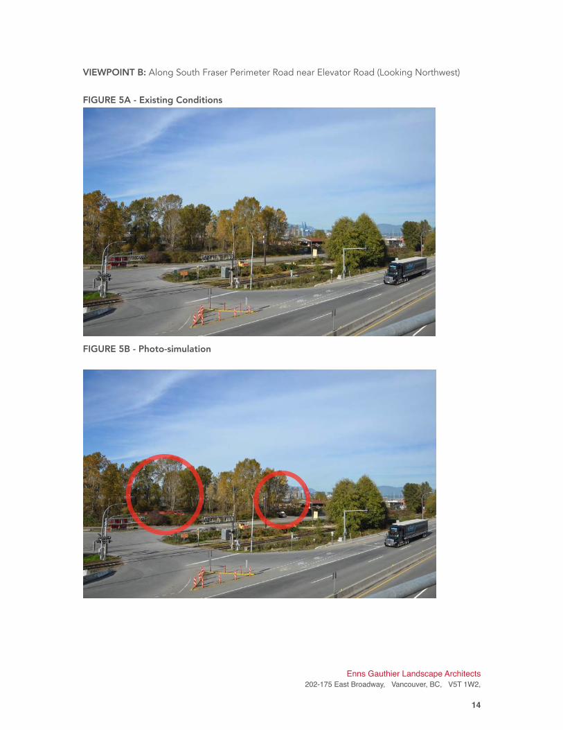
VIEWPOINT B: Along South Fraser Perimeter Road near Elevator Road (Looking Northwest)
FIGURE 5A - Existing Conditions
FIGURE 5B - Photo-simulation
Enns Gauthier Landscape Architects
202-175 East Broadway, Vancouver, BC, V5T 1W2,
�14

VIEWPOINT C: Along River Road near Western Cleanwood Preservers Ltd. (Looking West)
FIGURE 6A - Existing Conditions
FIGURE 6B - Photo-simulation
=
Enns Gauthier Landscape Architects
202-175 East Broadway, Vancouver, BC, V5T 1W2,
�15
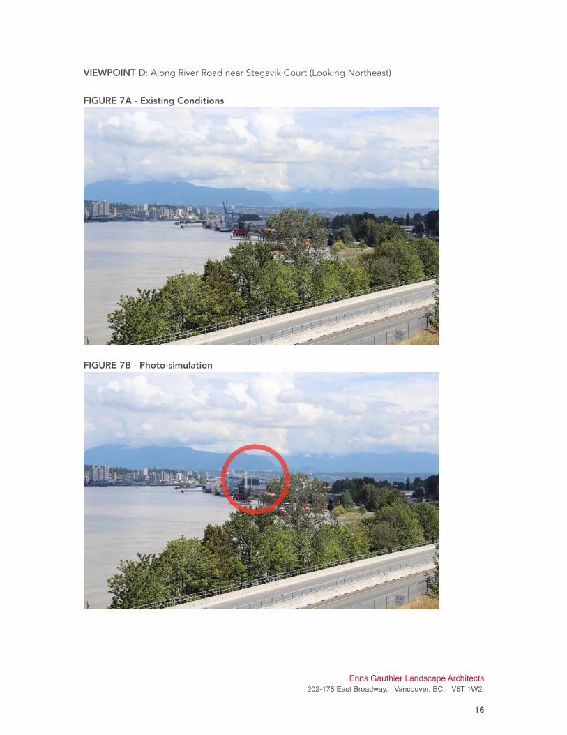
VIEWPOINT D: Along River Road near Stegavik Court (Looking Northeast)
FIGURE 7A - Existing Conditions
FIGURE 7B - Photo-simulation
Enns Gauthier Landscape Architects
202-175 East Broadway, Vancouver, BC, V5T 1W2,
�16
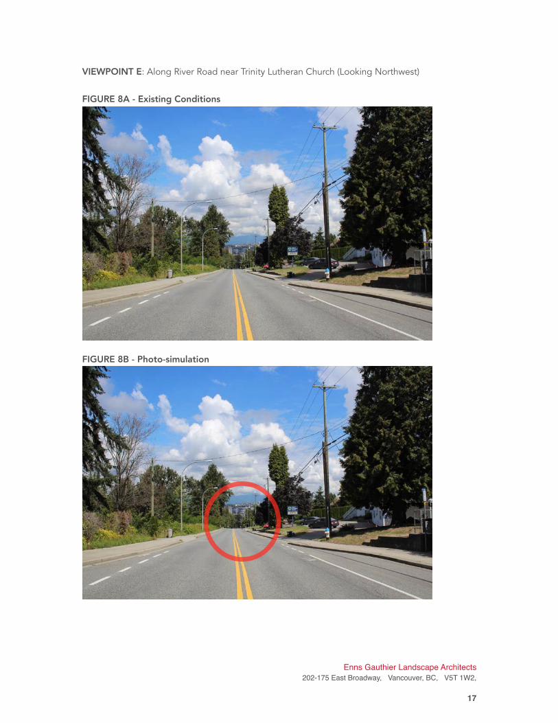
VIEWPOINT E: Along River Road near Trinity Lutheran Church (Looking Northwest)
FIGURE 8A - Existing Conditions
FIGURE 8B - Photo-simulation
Enns Gauthier Landscape Architects
202-175 East Broadway, Vancouver, BC, V5T 1W2,
�17
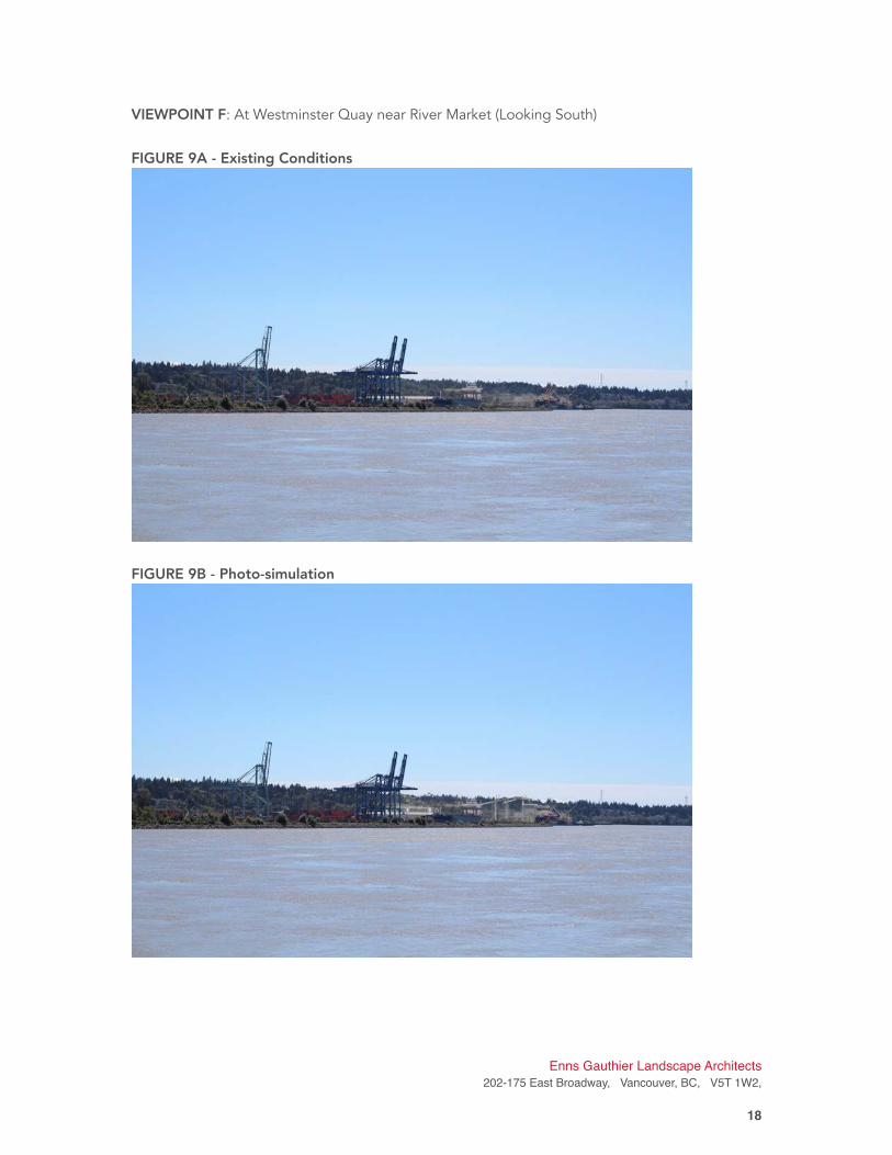
VIEWPOINT F: At Westminster Quay near River Market (Looking South)
FIGURE 9A - Existing Conditions
FIGURE 9B - Photo-simulation
Enns Gauthier Landscape Architects
202-175 East Broadway, Vancouver, BC, V5T 1W2,
�18
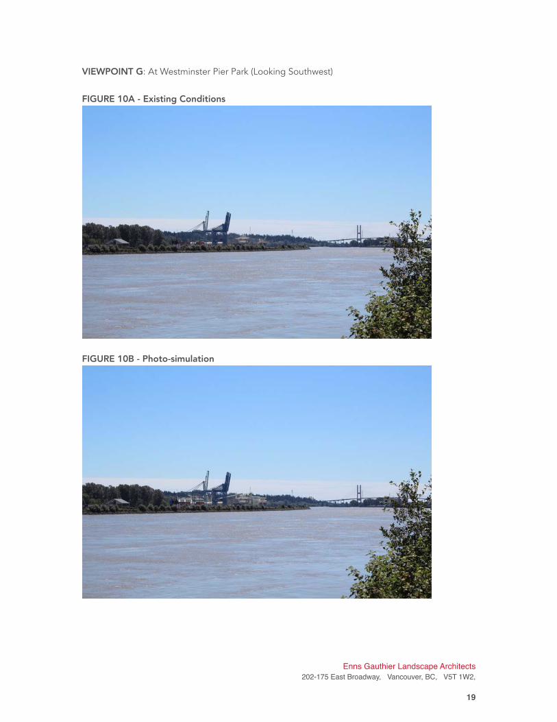
VIEWPOINT G: At Westminster Pier Park (Looking Southwest)
FIGURE 10A - Existing Conditions
FIGURE 10B - Photo-simulation
Enns Gauthier Landscape Architects
202-175 East Broadway, Vancouver, BC, V5T 1W2,
�19

VIEWPOINT H: At Port Royal River Trail in Queensborough (Looking Southeast)
FIGURE 11A - Existing Conditions
FIGURE 11B - Photo-simulation
Enns Gauthier Landscape Architects
202-175 East Broadway, Vancouver, BC, V5T 1W2,
�20
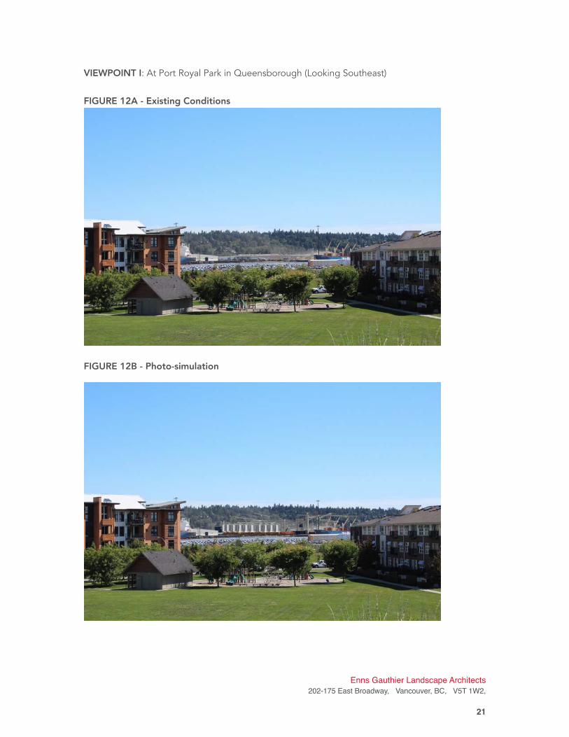
VIEWPOINT I: At Port Royal Park in Queensborough (Looking Southeast)
FIGURE 12A - Existing Conditions
FIGURE 12B - Photo-simulation
•
Enns Gauthier Landscape Architects
202-175 East Broadway, Vancouver, BC, V5T 1W2,
�21
4. View Study Impact Assessment and Recommendations The proposed Project lies in land managed by Port Metro Vancouver and thus must adhere to
the PMV Project and Environmental Review Guidelines for View and Shade Impact 2015. The
lands border the City of Surrey, near populated neighbourhoods and major thoroughfares and
must take into account the potential view impacts on these areas. The site is also located on the
Fraser River, across from industrial and residential areas of Queensborough. As such, a thorough
review of the photo-simulations and subsequent visual impact assessment of the proposed
facilities on the selected view points will form the basis of our recommendations for mitigation
techniques where appropriate.
In general, the potential view impacts of the proposed Project to the surrounding communities,
roadways, park lands and public spaces with views to the site are minimal, as per the following
summary assessment:
• Much of the site is surrounded by tall, dense vegetation to the south and south-west.
These trees will shield most of the new infrastructure from the residential slopes south
of the site as well as the main roadways south of the site;
• There is an abundance of tall, mature deciduous and coniferous trees throughout the
residential areas, parks and neighbourhood roadways on the slopes south of the site,
minimizing any significant views onto the project site;
• Distance across the Fraser River is a mitigating factor to reduce visual impact as well.
The Project is located sufficiently far away from public view points of the surrounding
communities, residential areas, pathways, tourist destinations and public parks in New
Westminster. In addition, mature trees along River Road will also minimize the impacts
to views caused by proposed Project structures.
• Select views from across the Fraser River from residential areas and public parks in
Queensborough may be impacted significantly by proposed facilities. Existing
industrial land uses mean that the proposed project causes minimal impact to the
skyline. The proposed structures are also obscured by Annacis Island and ship activity
in the Fraser River.
• The Project site is within an Industrial zoned land-use area, thus minimizing the impact
on the local skyline, architectural language and materials, as the new facilities will
effectively blend in with adjacent industries and infrastructure.
However, for viewpoints that reveal a negative impact as a result of the proposed facilities, we
recommend the following mitigation techniques be considered on a site-by-site basis:
• Install fast growing and robust trees (deciduous and conifers) in areas that do not
conflict with facility operations that will screen the facilities relatively quickly while
considering height restrictions to preserve views;
• Consider native plant species common along the Fraser River to encourage habitat for
insects, animals and native plants;
• Consider vertical architectural screens or elements against the infrastructure to improve
aesthetics and reduce sun glare and visible weathering of materials;
• Consider installing vertical vegetative elements (ie. green screens) against building
Enns Gauthier Landscape Architects
202-175 East Broadway, Vancouver, BC, V5T 1W2,
�22
facades and expansive walls that encourage vertical plant growth and help reduce sun
glare and heat island effect;
• In some cases, consider exploring opportunities to educate the public about the Fraser
River’s industrial heritage in unique, creative and interactive ways through signage,
education, child play and public art.
Table 3 on the following pages outlines the viewpoint selection rationale, the visual impact
assessment for each viewpoint location, and recommended measures to take for each location
to mitigate the visual impacts on the surrounding community if applicable.
Enns Gauthier Landscape Architects
202-175 East Broadway, Vancouver, BC, V5T 1W2,
�23
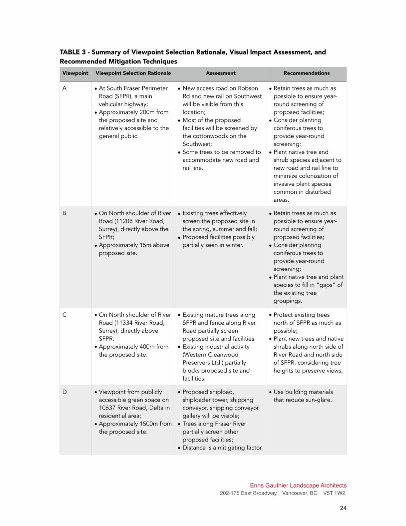
TABLE 3 - Summary of Viewpoint Selection Rationale, Visual Impact Assessment, and
Recommended Mitigation Techniques
Viewpoint Viewpoint Selection Rationale Assessment Recommendations
A • At South Fraser Perimeter
Road (SFPR), a main
vehicular highway;
• Approximately 200m from
the proposed site and
relatively accessible to the
general public.
• New access road on Robson
Rd and new rail on Southwest
will be visible from this
location;
• Most of the proposed
facilities will be screened by
the cottonwoods on the
Southwest;
• Some trees to be removed to
accommodate new road and
rail line.
• Retain trees as much as
possible to ensure year-
round screening of
proposed facilities;
• Consider planting
coniferous trees to
provide year-round
screening;
• Plant native tree and
shrub species adjacent to
new road and rail line to
minimize colonization of
invasive plant species
common in disturbed
areas.
B • On North shoulder of River
Road (11208 River Road,
Surrey), directly above the
SFPR;
• Approximately 15m above
proposed site.
• Existing trees effectively
screen the proposed site in
the spring, summer and fall;
• Proposed facilities possibly
partially seen in winter.
• Retain trees as much as
possible to ensure year-
round screening of
proposed facilities;
• Consider planting
coniferous trees to
provide year-round
screening;
• Plant native tree and plant
species to fill in “gaps” of
the existing tree
groupings.
C • On North shoulder of River
Road (11334 River Road,
Surrey), directly above
SFPR.
• Approximately 400m from
the proposed site.
• Existing mature trees along
SFPR and fence along River
Road partially screen
proposed site and facilities.
• Existing industrial activity
(Western Cleanwood
Preservers Ltd.) partially
blocks proposed site and
facilities.
• Protect existing trees
north of SFPR as much as
possible;
• Plant new trees and native
shrubs along north side of
River Road and north side
of SFPR, considering tree
heights to preserve views;
D • Viewpoint from publicly
accessible green space on
10637 River Road, Delta in
residential area;
• Approximately 1500m from
the proposed site.
• Proposed shipload,
shiploader tower, shipping
conveyor, shipping conveyor
gallery will be visible;
• Trees along Fraser River
partially screen other
proposed facilities;
• Distance is a mitigating factor.
• Use building materials
that reduce sun-glare.
Enns Gauthier Landscape Architects
202-175 East Broadway, Vancouver, BC, V5T 1W2,
�24
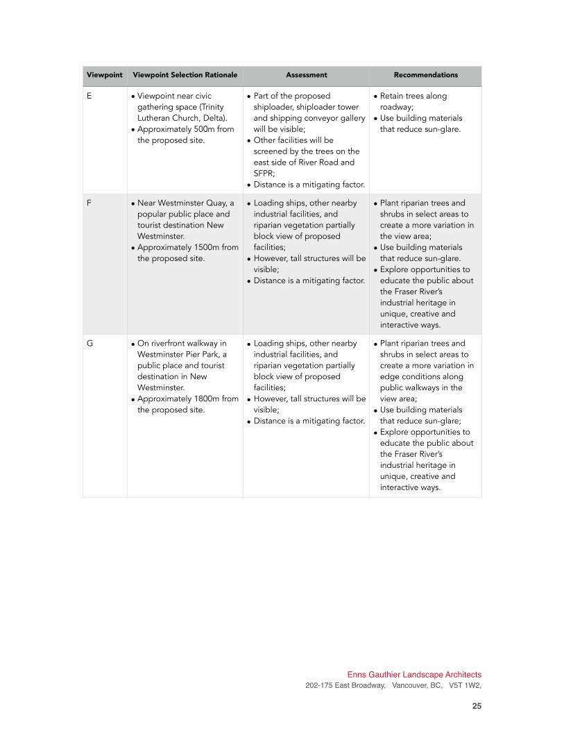
E • Viewpoint near civic
gathering space (Trinity
Lutheran Church, Delta).
• Approximately 500m from
the proposed site.
• Part of the proposed
shiploader, shiploader tower
and shipping conveyor gallery
will be visible;
• Other facilities will be
screened by the trees on the
east side of River Road and
SFPR;
• Distance is a mitigating factor.
• Retain trees along
roadway;
• Use building materials
that reduce sun-glare.
F • Near Westminster Quay, a
popular public place and
tourist destination New
Westminster.
• Approximately 1500m from
the proposed site.
• Loading ships, other nearby
industrial facilities, and
riparian vegetation partially
block view of proposed
facilities;
• However, tall structures will be
visible;
• Distance is a mitigating factor.
• Plant riparian trees and
shrubs in select areas to
create a more variation in
the view area;
• Use building materials
that reduce sun-glare.
• Explore opportunities to
educate the public about
the Fraser River’s
industrial heritage in
unique, creative and
interactive ways.
G • On riverfront walkway in
Westminster Pier Park, a
public place and tourist
destination in New
Westminster.
• Approximately 1800m from
the proposed site.
• Loading ships, other nearby
industrial facilities, and
riparian vegetation partially
block view of proposed
facilities;
• However, tall structures will be
visible;
• Distance is a mitigating factor.
• Plant riparian trees and
shrubs in select areas to
create a more variation in
edge conditions along
public walkways in the
view area;
• Use building materials
that reduce sun-glare;
• Explore opportunities to
educate the public about
the Fraser River’s
industrial heritage in
unique, creative and
interactive ways.
Viewpoint Viewpoint Selection Rationale Assessment Recommendations
Enns Gauthier Landscape Architects
202-175 East Broadway, Vancouver, BC, V5T 1W2,
�25
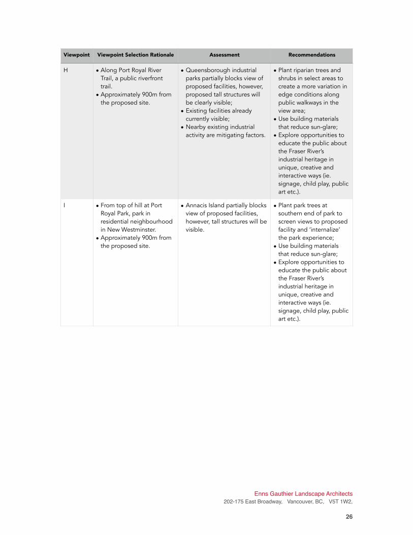
H • Along Port Royal River
Trail, a public riverfront
trail.
• Approximately 900m from
the proposed site.
• Queensborough industrial
parks partially blocks view of
proposed facilities, however,
proposed tall structures will
be clearly visible;
• Existing facilities already
currently visible;
• Nearby existing industrial
activity are mitigating factors.
• Plant riparian trees and
shrubs in select areas to
create a more variation in
edge conditions along
public walkways in the
view area;
• Use building materials
that reduce sun-glare;
• Explore opportunities to
educate the public about
the Fraser River’s
industrial heritage in
unique, creative and
interactive ways (ie.
signage, child play, public
art etc.).
I • From top of hill at Port
Royal Park, park in
residential neighbourhood
in New Westminster.
• Approximately 900m from
the proposed site.
• Annacis Island partially blocks
view of proposed facilities,
however, tall structures will be
visible.
• Plant park trees at
southern end of park to
screen views to proposed
facility and ‘internalize’
the park experience;
• Use building materials
that reduce sun-glare;
• Explore opportunities to
educate the public about
the Fraser River’s
industrial heritage in
unique, creative and
interactive ways (ie.
signage, child play, public
art etc.).
Viewpoint Viewpoint Selection Rationale Assessment Recommendations
Enns Gauthier Landscape Architects
202-175 East Broadway, Vancouver, BC, V5T 1W2,
�26
5. Shade Study: Approach and Methodology The Shade Study report will focus on how shade generated by the proposed Project siting,
layout, massing, and height may have impacts on the surrounding community and public areas
during different times of the day and year. The following outlines our approach and
methodology.
5.1 Base Information, Review and Coordination
Base information was acquired from Hemmera Envirochem (Hemmera), CMC Engineering
(CMC), vegetation specialists, surveyors and civil engineers. Information from these documents
was gathered and overlaid to form an accurate and informative picture of the site’s conditions
and adjacent land uses, infrastructure, and potential public areas could receive an increase in
shade. This information included:
• Site existing ground contours;
• Site aerial photos, at-grade site photos showing current adjacent land use and zoning;
• CAD drawings of existing and proposed facilities;
• Rendering perspective of proposed facilities;
• Plans for new equipment, structures, and buildings,
• Elevation drawings of Main Plant area;
• Sections of proposed structures, orthophotos / satellite images in plan view of the site.
It was noted during this process that all adjacent buildings to the project site are zoned
industrial, limiting any shade affects on public spaces, roads, residential lots or parks. Similarly,
the adjacent industrial buildings are a sufficient distance away from the proposed new
infrastructure, resulting in an expected low shade impact and minimal (if any) reduction in direct
sunlight received at these adjacent buildings.
5.2 Desktop Study
A literature review of local and regional land use policies, environmental guidelines, PMV
standards and BC visual Quality Objective Guidelines was conducted. As-built drawings of the
proposed new infrastructure provided by CMC were reviewed. Aerial photos, orthophotos and
Google Maps were used to study the immediate and surrounding areas, buildings, uses and
vegetation that might be affected by the proposed infrastructure.
5.3 Site Reconnaissance
Visits of the site, adjacent properties and the surrounding area served to review existing
conditions and helped to confirm and identify adjacent land-uses and properties, potential
Enns Gauthier Landscape Architects
202-175 East Broadway, Vancouver, BC, V5T 1W2,
�27
locations for public gatherings, community gardens playgrounds or other uses that may be
negatively affected by shade. Site reconnaissance is an important part of information gathering
and ‘ground truthing’ to assess the the accuracy of the base information and desktop studies.
Site visits of the site, adjacent properties and the surrounding area occurred on October 27,
2015 and July 27, 2016. The purpose of these visits was to review existing site conditions,
confirm adjacent land-uses, identify potential buildings or infrastructure close enough to the
Project site that may be affected by increased shade. Existing vegetation adjacent to the Project
site was also inspected (from the Project Site) for potential reduced direct sunlight due to shade
thrown from the proposed new facilities.
It was confirmed during both site visits that the surrounding land use is exclusively industrial,
with no public roads, parks, paths, community assets, public gathering spaces or residential
areas close enough to be affected. It was also confirmed that due to the nature of industrial
sites, there were no concerns of impacted vegetation (through loss of direct sunlight) in areas
adjacent to the site due to the proposed facilities.
5.4 Preparation of Shade Study Graphics: 3D Shadow Modelling
A 3D model (provided by CMC) was imported into CAD based drawings (Vectorworks). Shadow
settings were then applied to the model on the dates required of the PMV PERG during 3 time
periods at 9am, 12pm, and 3pm:
• Spring Equinox (March 21)
• Summer Solstice (June 21)
• Fall Equinox (September 21)
• Winter Solstice (December 21)
The shade study graphics were completed through the following process:
1. Exported 3-dimensional design model from AutoCAD into CAD-based software
(Vectorworks);
2. Simplified the model to remove unnecessary elements (i.e. interior and underground
features);
3. Exported an initial base image of the model without shadows;
4. Applied shadow settings on the location of the site according to the requested dates and
times in the PMV PERG (July 2015).
5. Overlay the model and various shadow settings onto the base orthophoto, to scale.
6. For clarity, enhanced contrast of shadows and proposed infrastructure in Photoshop.
Enns Gauthier Landscape Architects
202-175 East Broadway, Vancouver, BC, V5T 1W2,
�28
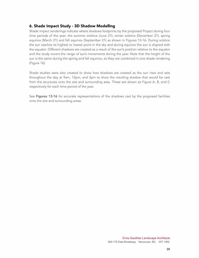
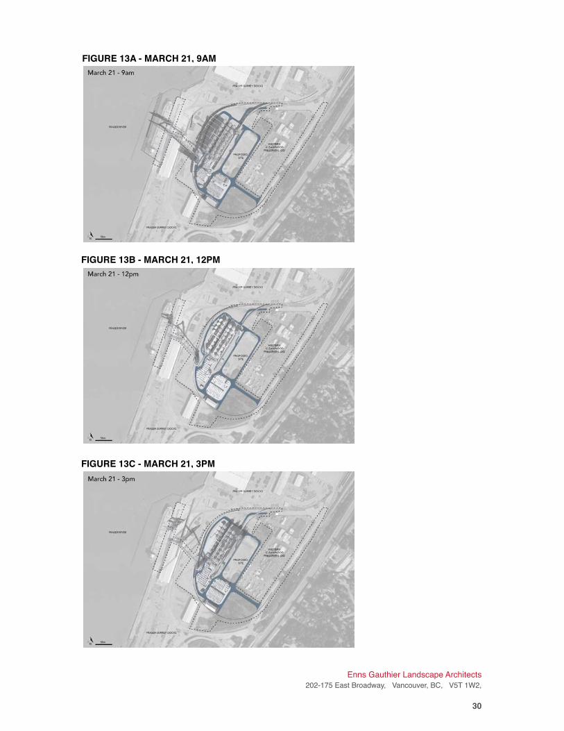
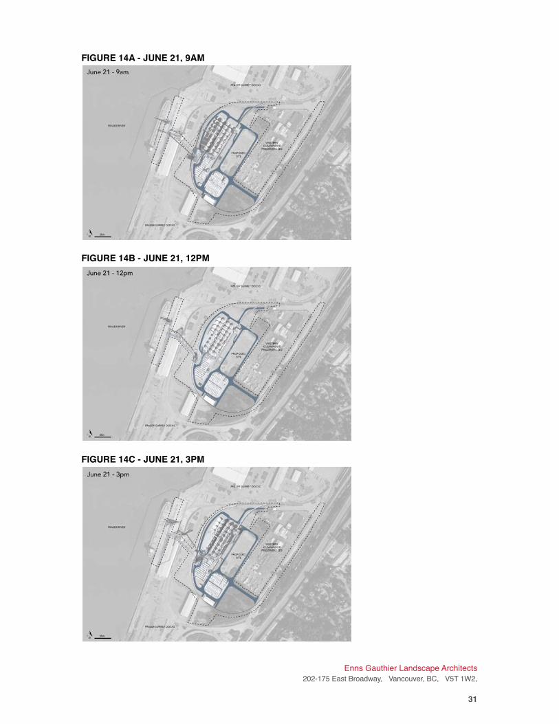
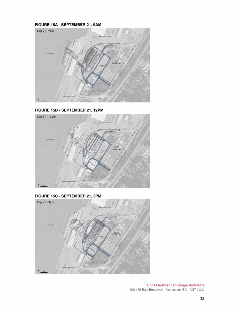
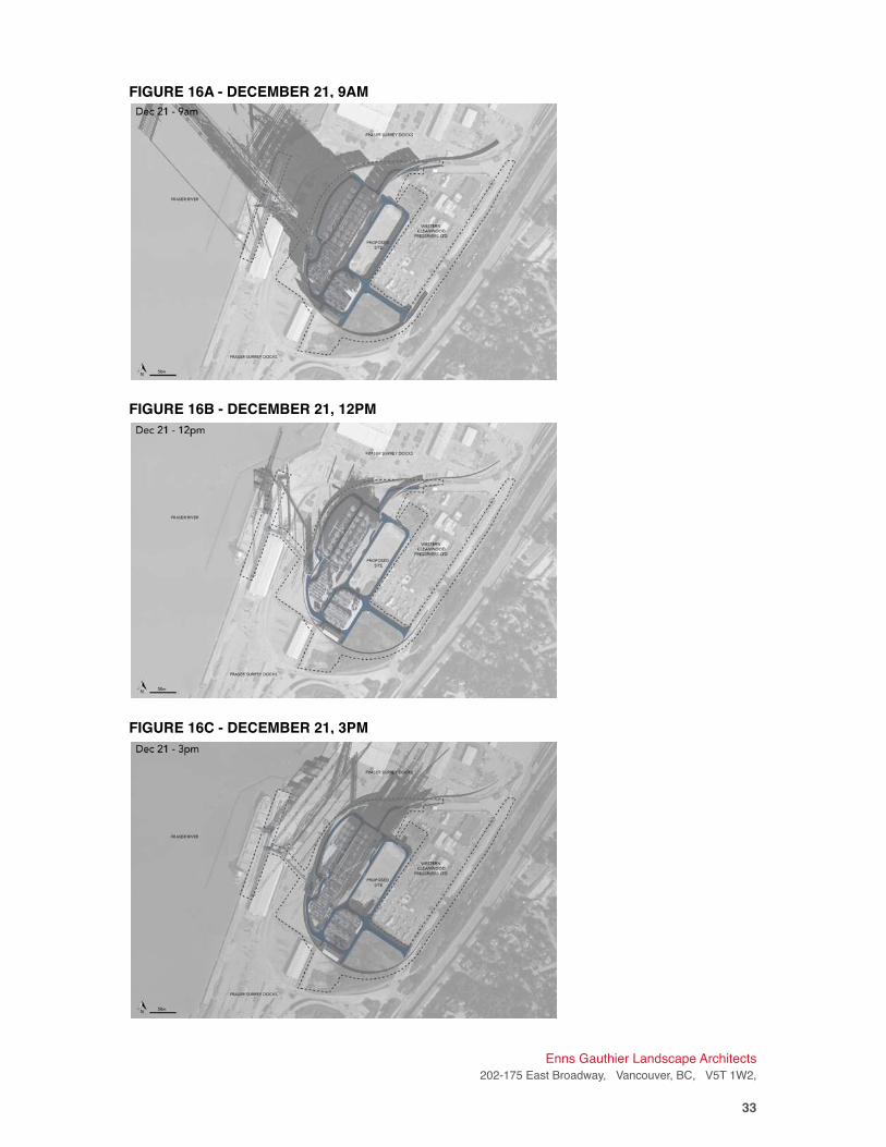
6. Shade Impact Study - 3D Shadow Modelling Shade impact renderings indicate where shadows footprints by the proposed Project during four
time periods of the year: the summer solstice (June 21), winter solstice (December 21), spring
equinox (March 21) and fall equinox (September 21) as shown in Figures 13-16. During solstice
the sun reaches its highest or lowest point in the sky and during equinox the sun is aligned with
the equator. Different shadows are created as a result of the sun’s position relative to the equator
and the study covers the range of sun’s movements during the year. Note that the height of the
sun is the same during the spring and fall equinox, so they are combined in one shade rendering
(Figure 16).
Shade studies were also created to show how shadows are created as the sun rises and sets
throughout the day at 9am, 12pm, and 3pm to show the resulting shadow that would be cast
from the structures onto the site and surrounding area. These are shown as Figure A, B, and C
respectively for each time period of the year.
See Figures 13-16 for accurate representations of the shadows cast by the proposed facilities
onto the site and surrounding areas.
Enns Gauthier Landscape Architects
202-175 East Broadway, Vancouver, BC, V5T 1W2,
�29
Enns Gauthier Landscape Architects
202-175 East Broadway, Vancouver, BC, V5T 1W2,
�30
FIGURE 13A - MARCH 21, 9AM
FIGURE 13B - MARCH 21, 12PM
FIGURE 13C - MARCH 21, 3PM
Enns Gauthier Landscape Architects
202-175 East Broadway, Vancouver, BC, V5T 1W2,
�31
FIGURE 14A - JUNE 21, 9AM
FIGURE 14B - JUNE 21, 12PM
FIGURE 14C - JUNE 21, 3PM
Enns Gauthier Landscape Architects
202-175 East Broadway, Vancouver, BC, V5T 1W2,
�32
FIGURE 15A - SEPTEMBER 21, 9AM
FIGURE 15B - SEPTEMBER 21, 12PM
FIGURE 15C - SEPTEMBER 21, 3PM
Enns Gauthier Landscape Architects
202-175 East Broadway, Vancouver, BC, V5T 1W2,
�33
FIGURE 16A - DECEMBER 21, 9AM
FIGURE 16B - DECEMBER 21, 12PM
FIGURE 16C - DECEMBER 21, 3PM
7. Shade Study Impact Assessment and Recommendations In summary, the shade impact renderings and 3D shadow models indicate that the proposed
Project is sufficiently far from the surrounding residential communities and the road such that
there is little to no impact caused by shadows to the public. The renderings also shows that the
adjacent industrial site to the northeast is generally unaffected by shade early Spring to late Fall;
however, this site is somewhat affected by the shade caused by the new silos around the time of
the winter solstice (December 21), particularly in the late afternoon and evening as the sun
migrates to the west, as seen in Figures 14a and 14c. However, these effects, given the nature
of the industrial zone in this area, are considered minimal, and do not require mitigation against
potential shade impacts.
8. Conclusion Based on the graphic renderings and simulations contained herein, the proposed new Fraser
Grain Terminal Export Facility adheres to the guidelines set out in PERG VS 2015. The Project is
consistent with existing land uses and increases efficiencies and productivity of PMV industrial
land.
In general, the proposed new Fraser Grain Terminal Export Facility will have minimal impact on
views from the surrounding communities. To the south and west of the site, existing mature tree
stands form a natural vegetative screen to the proposed facilities. To the east, the views are
more open to the project site; however, the existing industrial use and infrastructure
predominates in this area, and is similar to the proposed infrastructure in terms of skyline,
massing and building materials. As such, the views to the project site would not be adversely
affected. The most affected views to the site are from the north, along the New Westminster
and Queensborough water fronts facing south and south west. Recommendations on
techniques to mitigate adverse visual impacts have been discussed in this report for key public,
tourist and residential locations in this area. In certain areas where these mitigation techniques
are not applicable or desired, an alternative approach is to celebrate the rich industrial heritage
of the Fraser River through education, child play, interpretive signage and public art.
Likewise, the shade impact on the site and surrounding areas would be minimal, given the
current industrial land-use zone surrounding the site, as well as the large distances from the site
to any public place, roadway, pathway, gathering space or residence. It is important to note that
the materials and sizes of the proposed elevators, storage structures, and rail ramps are
consistent with prior use on the site and surrounding industrial and port activity, and are not
viewed as a negative effect on the Project.
Study findings produced and analyzed in this View and Shade Study Report will be submitted to
Port Metro Vancouver for approval. Subsequently, a public consultation component may follow
where information is shared with the public. Input may be sought from the public with regard to
further mitigation strategies and techniques.
Enns Gauthier Landscape Architects
202-175 East Broadway, Vancouver, BC, V5T 1W2,
�34
Report prepared by:
Enns | Gauthier Landscape Architects Inc.
Imelda Nurwisah, MES (Urban and Regional Planning), LEED Green Associate
Masters of Environmental Studies
Elaine Zeng, MLA
Intern Landscape Architect
Mike Enns, BCSLA, CSLA
Principal
Enns Gauthier Landscape Architects
202-175 East Broadway, Vancouver, BC, V5T 1W2,
�35
9. Statement of Limitations This report has been prepared by Enns | Gauthier Landscape Architects (E|G), based on fieldwork
conducted and renderings produced by E|G, for the sole benefit and exclusive use of Parrish &
Heimbecker (P&H) Fraser Grain Terminal Export Facility and Hemmera Envirochem Ltd.
(Hemmera) The material in it reflects E|G’s best judgement in light of the information available to
it at the time of preparing this Report. Any use that a third party makes of this Report, or any
reliance on or decision made based on it, is the responsibility of such third parties. E|G accepts
no responsibility for damages, if any, suffered by any third party as a result of decisions made or
actions taken based on this Report.
E|G has performed the work as described above and made the findings and conclusions set out
in this Report in a manner consistent with the level of care and skill normally exercised by
members of the landscape architecture and planning profession practicing under similar
conditions at the time the work was performed.
This Report represents a reasonable review of the information available to E|G within the
established Scope, work schedule and budgetary constraints. The conclusions and
recommendations contained in this Report are based upon applicable legislation existing at the
time the Report was drafted. Any changes in the legislation may alter the conclusions and /or
recommendations contained in the Report. Regulatory implications discussed in this Report were
based on the applicable legislation existing at the time this Report was written.
In preparing this Report, E|G has relied in good faith on information provided by others as noted
in this Report, and has assumed that the information provided by those individuals is both
factual and accurate. E|G accepts no responsibility for any deficiency, misstatement or inaccuracy
in this Report resulting from the information provide by those individuals.
The liability of E|G to P&H and Hemmera shall be limited to injury or loss caused by the
negligent acts of E|G. The total aggregate liability of E|G related to this agreement shall not
exceed the lesser of the actual damages incurred, or the total fee of E|G for services rendered
for this project.
Enns Gauthier Landscape Architects
202-175 East Broadway, Vancouver, BC, V5T 1W2,
�36