Embed Size (px)
Citation preview

Paradise Stream Watershed Assessment
Data Gap Evaluation
Principle Investigator/ Presented by: Mr. Brian Oram, PG, PASEO
Co-PI’s: Dr. Dale Bruns & Mr. Bill ToothillWilkes University, GeoEnvironmental
Sciences and Engineering http://www.wilkes.edu
1-800-572-4444 ext 4619

Center for Environmental Quality
Non-profit/ equal opportunity employer, is operated and
managed, within the GeoEnvironmental Sciences andEngineering Department.Outreach Programs Environmental and Professional Education and
Training Applied Research and Water Quality Monitoring Community and Business Outreach Programs Private Well Owner/ Watershed Group Programs Certified Testing Laboratory
Website: http://www.water-research.net

Paradise Creek Watershed

Data Gap Analysis Compile Available Data (Multiple Sources) Correct Typographical Errors Remove (<, >, 0, nd, ?) Correct Date Errors – like 02/12/1192 Develop Spatial Information for Sampling Sites Evaluate other Sources of Spatial Data for [Dams, USGS
Stations, Hazardous Sites, Roads, Land-Use Non-Point Sources (Septic, Stormwater Run-off) Hydrography.]
Present Readily Available Data using a Geographic Information System (GIS) and Lay Foundation for the Development of a Geospatial and Relational Database.
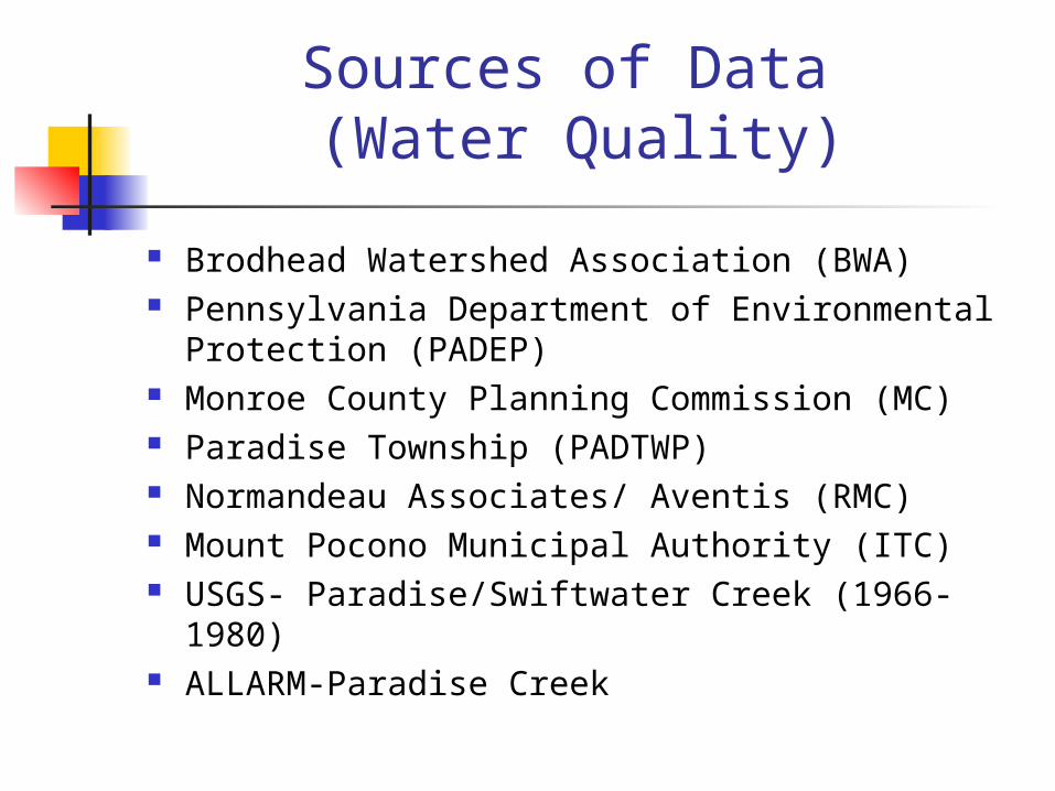
Sources of Data (Water Quality)
Brodhead Watershed Association (BWA) Pennsylvania Department of Environmental
Protection (PADEP) Monroe County Planning Commission (MC) Paradise Township (PADTWP) Normandeau Associates/ Aventis (RMC) Mount Pocono Municipal Authority (ITC) USGS- Paradise/Swiftwater Creek (1966- 1980) ALLARM-Paradise Creek

Data Sources (Spatial-GIS Data) Monroe County Planning Commission Wilkes University Center for
Environmental Quality and GIS/Remote Sensing Laboratories
EPA Basins (http://www.epa.gov/OST/BASINS/)*
USGS PAGIS Consortium (http://www.pagis.org)
Pennsylvania Spatial Data Access (PASDA)* Data requires correction and is not reliable.

Data Summary Tables
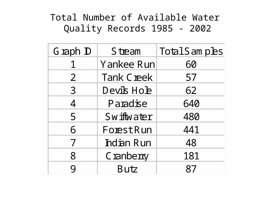
Total Number of Available Water Quality Records 1985 - 2002
Graph ID Stream Total Samples1 Yankee Run 602 Tank Creek 573 Devils Hole 624 Paradise 6405 Swiftwater 4806 Forest Run 4417 Indian Run 488 Cranberry 1819 Butz 87


Importance of Volunteer Monitoring
BWA- Brodhead Watershed Association
Graph ID Stream Stream Code w/o BWA with BWA1 Yankee Run YANKRU 8 602 Tank Creek TANKCR 0 573 Devils Hole DEVH 10 624 Paradise PARCR 13 6405 Swiftwater SWCR 125 4806 Forest Run FHR 65 4417 Indian Run INR 4 488 Cranberry CRANCR 0 1819 Butz BUTZ 0 87


Sampling Sites (1985-2002)

Overall Stream QualityAquatic Life Cold Water Fishes—Maintenance or propagation, or both, of fish species including the family Salmonidae and additional flora and fauna which are indigenous to a cold water habitat.
EV –CWF- Exceptional Value Cold Water FishesDevils Hole – Basin to South Boundary of State Game Land
HQ –CWF- High Quality Cold Water FishesDevils Hole – From South Boundary of Games Land to MouthButz RunCranberry CreekSwiftwater CreekParadise CreekUnnamed Tributaries to ParadiseYankee Run
Source:PACode93

Water Quality Data Needs
Establish Fixed Water Quality Stations and Establish Protocols for Testing, Monitoring, Sampling, and QC/QA Plan
Confirm Methods Used for Existing Data and Complete Screening of Existing Data
Develop a Field and Laboratory Data/ Reporting Format
Increase Monitoring Frequency (Monthly) at Selected Sites
Improve Field Monitoring Capability for Volunteer Groups
Stormwater or Storm Event Sampling Real-Time/24-hour monitoring (?)

Hydrogeological Needs Inventory of Water Sources (Wells and Springs)
– PAGIS Data Inventory/ PADEP- Integration into Existing Wellhead Protection Programs or Expand these programs to include groundwater monitoring.
Establish Stream Gauging Stations within the Watershed (Combination of Continuous and Fixed Point Stations)
Stream and Stream Bank Stability Assessment and Inventory

GIS Needs Updated Land-Use/Land Cover Mapping
Document Location and Description of Hazardous Sites or Non-Point Sources
Field Confirm Sampling Site Locations
Additional Corrections Needed to Available Public Datasets
Develop a Metadata Format and Acquire Metadata for Available Datasets and Water Quality Data as part of QA/QC Plan

Paradise Creek Watershed

Paradise Stream Watershed Assessment – Preliminary
Data Gap Evaluation
Prepared by: Mr. Brian Oram, PG, PASEO
Wilkes University, GeoEnvironmental Sciences and Engineering
http://www.water-research.net1-800-572-4444 ext 4619

What is GIS?A GIS is defined as an organized collection of computerhardware, software, geographic data, and personnel
designed toefficiently capture, store, update, manipulate, analyze, and display all forms of geographically referenced information.
(ESRI,1995).
GIS is a very powerful tool for storing and accessinggeographic information, conducting geographic analysis, andproducing high-quality maps and other types of graphic
output.

![Tunably-Oblivious Memory: Generalizing ORAM to Enable ...ravi/Papers/DBConf/p313-dautrich.pdf · cal ORAM [22,23] requires log 2Nndwidth cost. Path ba ORAM [24] requires closer to](https://img.pdfslide.us/doc/110x75/5f0ac97b7e708231d42d56fb/tunably-oblivious-memory-generalizing-oram-to-enable-ravipapersdbconfp313-.jpg)


![SCORAM: Oblivious RAM for Secure Computationhubert/ccs14a.pdf · ORAM by Shi et al. [30] performs the same as a naively implemented Path ORAM [34], although Path ORAM is asymptotically](https://img.pdfslide.us/doc/110x75/5f0ac9767e708231d42d56e3/scoram-oblivious-ram-for-secure-computation-hubert-oram-by-shi-et-al-30.jpg)


![Three-Party ORAM for Secure Computation · ORAM for Secure Computation (SC-ORAM) [17], which is a protocol that securely implements a RAM functionality, i.e. given a secret-sharing](https://img.pdfslide.us/doc/110x75/5f0ac6817e708231d42d4814/three-party-oram-for-secure-computation-oram-for-secure-computation-sc-oram-17.jpg)