Embed Size (px)
Citation preview
WATER RESOURCES DATA - FLORIDA, 2004
VOLUME 2B: SOUTH FLORIDA
543
Palm Beach County
WATER RESOURCES DATA - FLORIDA, 2004
VOLUME 2B: SOUTH FLORIDA
544
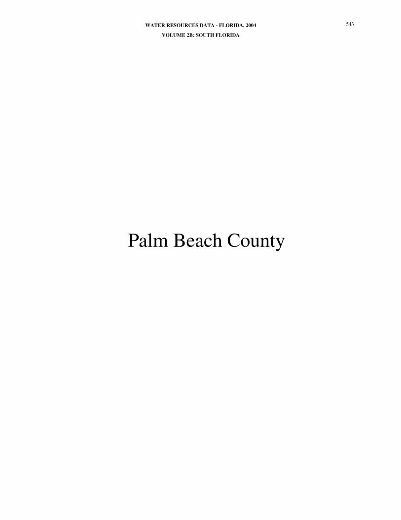
Key to site locations on figure # 20
PALM BEACH COUNTY
Index Site Well PageNumber Number Name Number1 264005080233501 PB 99 572
2 263328080085201 PB 445 566
3 262114080054001 PB 491 547
4 264230080120501 PB 561 575
5 265812080053901 PB 565 585
6 263524080124301 PB 683 568
7 264208080192201 PB 685 574
8 265633080203001 PB 689 584
9 262218080070101 PB 732 551
10 264123080053801 PB 809 573
11 265106080241402 PB 831 580
12 262435080042904 PB 948 555
13 263044080035102 PB 1195 562
14 262313080044401 PB 1457 552
15 262317080074601 PB 1491 553
16 263255080133601 PB 1576 565
17 263021080070102 PB 1628 561
18 263656080033502 PB 1639 571
19 265233080054001 PB 1642 581
20 262410080090801 PB 1661 554
21 264839080115001 PB 1662 578
22 262209080044702 PB 1669 550
23 262159080054201 PB 1680 549
24 262130080080701 PB 1684 548
25 262033080064001 PB 1686 546
26 262755080040101 PB 1707 558
27 262713080041901 PB 1710 557
28 262803080041101 PB 1714 559
29 263453080031501 PB 1717 567
30 263633080031401 PB 1723 569
31 264643080033401 PB 1726 576
32 264717080033501 PB 1727 577
33 265550080070701 PB 1732 582
34 265611080080201 PB 1733 583
35 264858080044801 PB 1734 579
36 263053080034401 PB 1736 564
WATER RESOURCES DATA - FLORIDA, 2004
VOLUME 2B: SOUTH FLORIDA
545
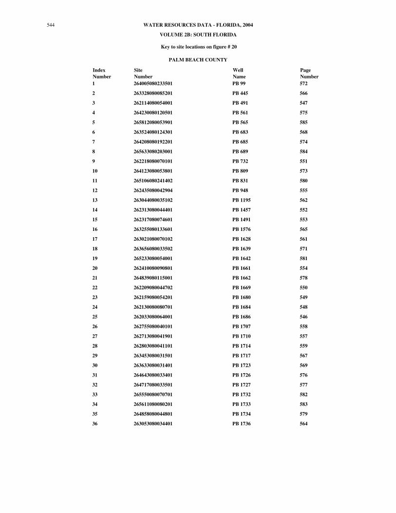
Figure 20. Location of wells in Palm Beach County
3
9
2
6
1
7 4
8
5
25
24
23
221415
20 12
28
27
26
1713
361629
30
18
10
31
3221 35
11
19
33
34
80°45' 80°30' 80°15' 80°00'
26°15'
26°30'
26°45'
27°00'
EXPLANATION
WELL AND INDEX NUMBER
PALM BEACH
WEST PALM BEACH CANAL
OCEAN CANAL
HILLSBORO CANAL
MIAMI CANAL
Belle Glade
South Bay
Boca Raton
Delray Beach
WEST PALM BEACH CANAL
98
27
1
441
27
441
441
FLO
RID
A’S
TURN
PIKE
1
Jupiter
Riviera Beach
West Palm Beach
Lake Worth
Boynton Beach
95
95
95
710
809
704
0 10 205 Miles
0 10 205 Kilometers
546 WELL DESCRIPTIONS AND WATER LEVEL MEASUREMENTS
PALM BEACH COUNTY
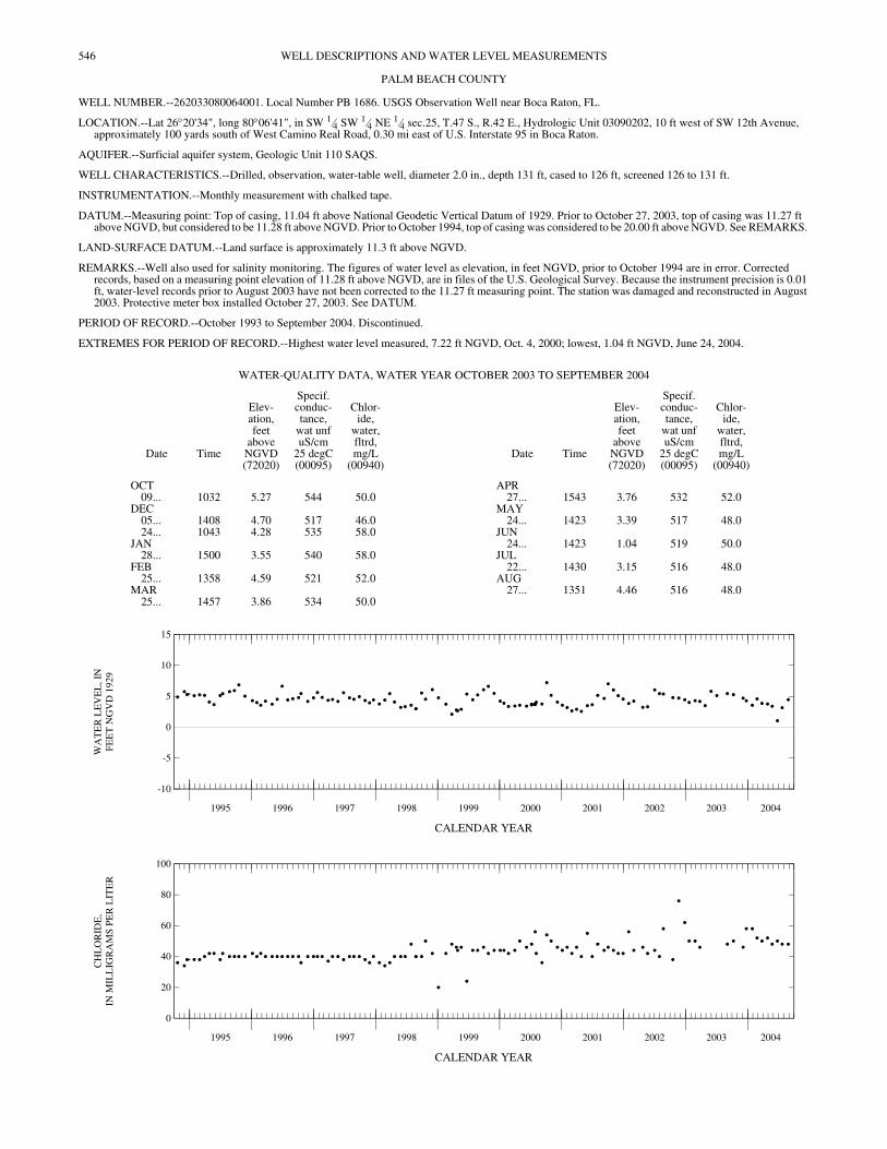
WELL NUMBER.--262033080064001. Local Number PB 1686. USGS Observation Well near Boca Raton, FL.
LOCATION.--Lat 26°20'34", long 80°06'41", in SW 1⁄4 SW 1⁄4 NE 1⁄4 sec.25, T.47 S., R.42 E., Hydrologic Unit 03090202, 10 ft west of SW 12th Avenue, approximately 100 yards south of West Camino Real Road, 0.30 mi east of U.S. Interstate 95 in Boca Raton.
AQUIFER.--Surficial aquifer system, Geologic Unit 110 SAQS.
WELL CHARACTERISTICS.--Drilled, observation, water-table well, diameter 2.0 in., depth 131 ft, cased to 126 ft, screened 126 to 131 ft.
INSTRUMENTATION.--Monthly measurement with chalked tape.
DATUM.--Measuring point: Top of casing, 11.04 ft above National Geodetic Vertical Datum of 1929. Prior to October 27, 2003, top of casing was 11.27 ft above NGVD, but considered to be 11.28 ft above NGVD. Prior to October 1994, top of casing was considered to be 20.00 ft above NGVD. See REMARKS.
LAND-SURFACE DATUM.--Land surface is approximately 11.3 ft above NGVD.
REMARKS.--Well also used for salinity monitoring. The figures of water level as elevation, in feet NGVD, prior to October 1994 are in error. Corrected records, based on a measuring point elevation of 11.28 ft above NGVD, are in files of the U.S. Geological Survey. Because the instrument precision is 0.01 ft, water-level records prior to August 2003 have not been corrected to the 11.27 ft measuring point. The station was damaged and reconstructed in August 2003. Protective meter box installed October 27, 2003. See DATUM.
PERIOD OF RECORD.--October 1993 to September 2004. Discontinued.
EXTREMES FOR PERIOD OF RECORD.--Highest water level measured, 7.22 ft NGVD, Oct. 4, 2000; lowest, 1.04 ft NGVD, June 24, 2004.
CALENDAR YEAR
CALENDAR YEAR
WATER-QUALITY DATA, WATER YEAR OCTOBER 2003 TO SEPTEMBER 2004
Date Time
Elev-ation,feet
aboveNGVD(72020)
Specif.conduc-tance,
wat unfuS/cm
25 degC(00095)
Chlor-ide,
water,fltrd,mg/L
(00940)Date Time
Elev-ation,feet
aboveNGVD(72020)
Specif.conduc-tance,
wat unfuS/cm
25 degC(00095)
Chlor-ide,
water,fltrd,mg/L
(00940)
OCT APR09... 1032 5.27 544 50.0 27... 1543 3.76 532 52.0
DEC MAY05... 1408 4.70 517 46.0 24... 1423 3.39 517 48.024... 1043 4.28 535 58.0 JUN
JAN 24... 1423 1.04 519 50.028... 1500 3.55 540 58.0 JUL
FEB 22... 1430 3.15 516 48.025... 1358 4.59 521 52.0 AUG
MAR 27... 1351 4.46 516 48.025... 1457 3.86 534 50.0
1995 1996 1997 1998 1999 2000 2001 2002 2003 2004
-10
-5
0
5
10
15
WA
TE
R L
EV
EL
, IN
FEE
T N
GV
D 1
929
1995 1996 1997 1998 1999 2000 2001 2002 2003 2004
0
20
40
60
80
100
CH
LO
RID
E,
IN M
ILL
IGR
AM
S P
ER
LIT
ER
547WELL DESCRIPTIONS AND WATER LEVEL MEASUREMENTS
PALM BEACH COUNTY—Continued
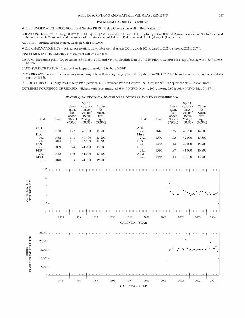
WELL NUMBER.--262114080054001. Local Number PB 491. USGS Observation Well in Boca Raton, FL.
LOCATION.--Lat 26°21'15", long 80°04'49", in NE 1⁄4 SE 1⁄4 SW 1⁄4 sec.20, T.47 S., R.43 E., Hydrologic Unit 03090202, near the corner of NE 3rd Court and NE 4th Street, 0.25 mi north and 0.4 mi east of the intersection of Palmetto Park Road and U.S. Highway 1. (Corrected).
AQUIFER.--Surficial aquifer system, Geologic Unit 110 SAQS.
WELL CHARACTERISTICS.--Drilled, observation, water-table well, diameter 2.0 in., depth 207 ft, cased to 202 ft, screened 202 to 207 ft.
INSTRUMENTATION.--Monthly measurement with chalked tape.
DATUM.--Measuring point: Top of casing, 8.34 ft above National Vertical Geodetic Datum of 1929. Prior to October 1981, top of casing was 8.33 ft above NGVD.
LAND-SURFACE DATUM.--Land surface is approximately 8.6 ft above NGVD.
REMARKS.--Well is also used for salinity monitoring. The well was originally open to the aquifer from 202 to 207 ft. The well is obstructed or collapsed at a depth of 182 ft.
PERIOD OF RECORD.--May 1974 to May 1982 (semiannual), November 1982 to October 1993, October 2001 to September 2004. Discontinued.
EXTREMES FOR PERIOD OF RECORD.--Highest water level measured, 6.44 ft NGVD, Nov. 1, 2001; lowest, 0.90 ft below NGVD, May 7, 1974.
CALENDAR YEAR
CALENDAR YEAR
WATER-QUALITY DATA, WATER YEAR OCTOBER 2003 TO SEPTEMBER 2004
Date Time
Elev-ation,feet
aboveNGVD(72020)
Specif.conduc-tance,
wat unfuS/cm
25 degC(00095)
Chlor-ide,
water,fltrd,mg/L
(00940)Date Time
Elev-ation,feet
aboveNGVD(72020)
Specif.conduc-tance,
wat unfuS/cm
25 degC(00095)
Chlor-ide,
water,fltrd,mg/L
(00940)
OCT APR09... 1158 1.77 40,700 15,200 27... 1616 .55 40,200 14,900
DEC MAY05... 1432 1.48 40,400 15,200 24... 1500 -.03 42,000 15,80024... 1043 1.01 38,500 15,300 JUN
JAN 24... 1438 .14 42,000 15,70029... 1059 .24 41,900 15,500 JUL
FEB 22... 1520 .87 41,000 16,80026... 1443 1.46 41,300 15,700 AUG
MAR 27... 1436 1.14 40,700 13,90030... 1048 .03 41,700 19,200
1995 1996 1997 1998 1999 2000 2001 2002 2003 2004
-10
-5
0
5
10
15
WA
TE
R L
EV
EL
, IN
FEE
T N
GV
D 1
929
1995 1996 1997 1998 1999 2000 2001 2002 2003 2004
0
5,000
10,000
15,000
20,000
25,000
CH
LO
RID
E,
IN M
ILL
IGR
AM
S P
ER
LIT
ER
548 WELL DESCRIPTIONS AND WATER LEVEL MEASUREMENTS
PALM BEACH COUNTY—Continued
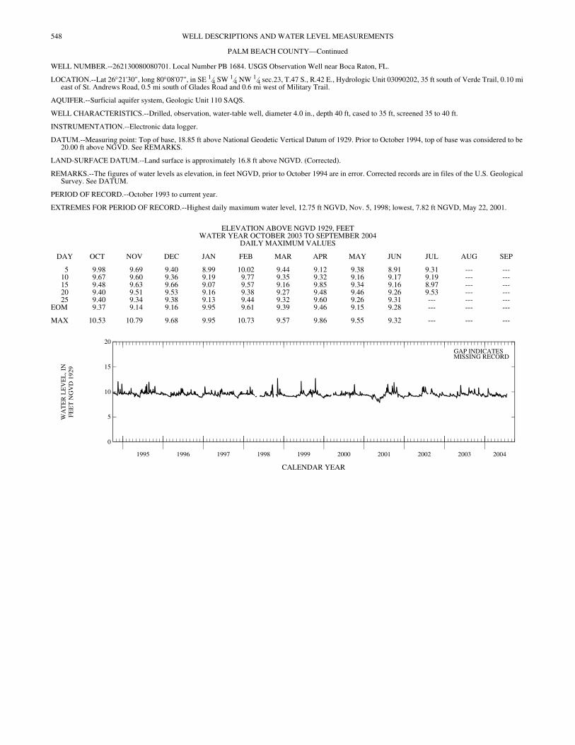
WELL NUMBER.--262130080080701. Local Number PB 1684. USGS Observation Well near Boca Raton, FL.
LOCATION.--Lat 26°21'30", long 80°08'07", in SE 1⁄4 SW 1⁄4 NW 1⁄4 sec.23, T.47 S., R.42 E., Hydrologic Unit 03090202, 35 ft south of Verde Trail, 0.10 mi east of St. Andrews Road, 0.5 mi south of Glades Road and 0.6 mi west of Military Trail.
AQUIFER.--Surficial aquifer system, Geologic Unit 110 SAQS.
WELL CHARACTERISTICS.--Drilled, observation, water-table well, diameter 4.0 in., depth 40 ft, cased to 35 ft, screened 35 to 40 ft.
INSTRUMENTATION.--Electronic data logger.
DATUM.--Measuring point: Top of base, 18.85 ft above National Geodetic Vertical Datum of 1929. Prior to October 1994, top of base was considered to be 20.00 ft above NGVD. See REMARKS.
LAND-SURFACE DATUM.--Land surface is approximately 16.8 ft above NGVD. (Corrected).
REMARKS.--The figures of water levels as elevation, in feet NGVD, prior to October 1994 are in error. Corrected records are in files of the U.S. Geological Survey. See DATUM.
PERIOD OF RECORD.--October 1993 to current year.
EXTREMES FOR PERIOD OF RECORD.--Highest daily maximum water level, 12.75 ft NGVD, Nov. 5, 1998; lowest, 7.82 ft NGVD, May 22, 2001.
CALENDAR YEAR
ELEVATION ABOVE NGVD 1929, FEET WATER YEAR OCTOBER 2003 TO SEPTEMBER 2004
DAILY MAXIMUM VALUES
DAY OCT NOV DEC JAN FEB MAR APR MAY JUN JUL AUG SEP
5 9.98 9.69 9.40 8.99 10.02 9.44 9.12 9.38 8.91 9.31 --- ---10 9.67 9.60 9.36 9.19 9.77 9.35 9.32 9.16 9.17 9.19 --- ---15 9.48 9.63 9.66 9.07 9.57 9.16 9.85 9.34 9.16 8.97 --- ---20 9.40 9.51 9.53 9.16 9.38 9.27 9.48 9.46 9.26 9.53 --- ---25 9.40 9.34 9.38 9.13 9.44 9.32 9.60 9.26 9.31 --- --- ---
EOM 9.37 9.14 9.16 9.95 9.61 9.39 9.46 9.15 9.28 --- --- ---
MAX 10.53 10.79 9.68 9.95 10.73 9.57 9.86 9.55 9.32 --- --- ---
1995 1996 1997 1998 1999 2000 2001 2002 2003 2004
0
5
10
15
20
WA
TE
R L
EV
EL
, IN
FEE
T N
GV
D 1
929
GAP INDICATESMISSING RECORD
549WELL DESCRIPTIONS AND WATER LEVEL MEASUREMENTS
PALM BEACH COUNTY—Continued
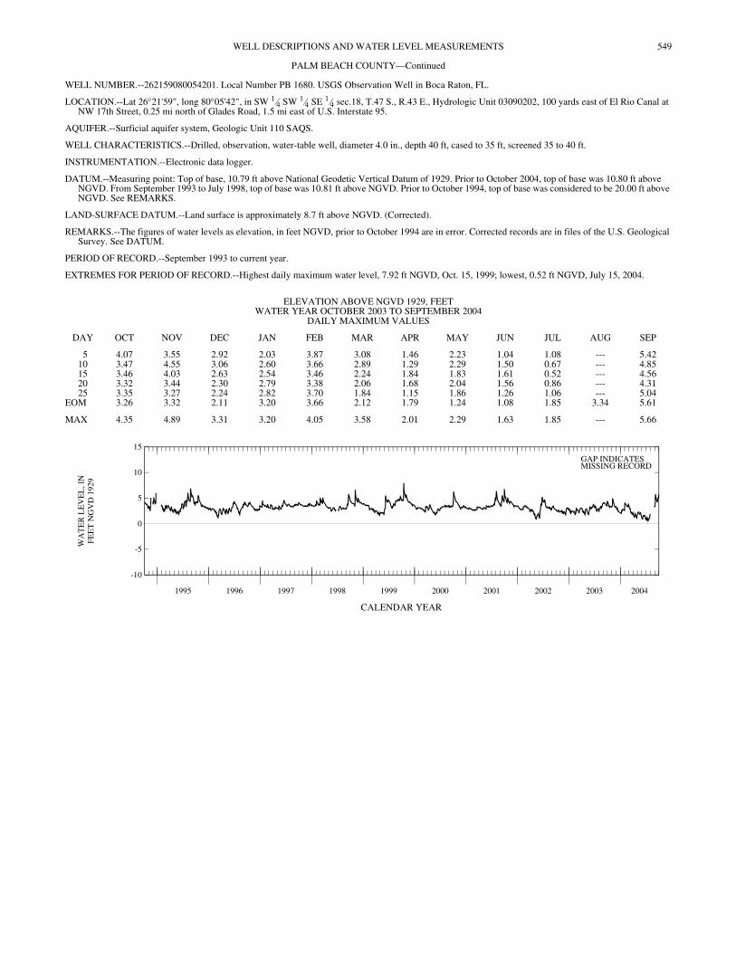
WELL NUMBER.--262159080054201. Local Number PB 1680. USGS Observation Well in Boca Raton, FL.
LOCATION.--Lat 26°21'59", long 80°05'42", in SW 1⁄4 SW 1⁄4 SE 1⁄4 sec.18, T.47 S., R.43 E., Hydrologic Unit 03090202, 100 yards east of El Rio Canal at NW 17th Street, 0.25 mi north of Glades Road, 1.5 mi east of U.S. Interstate 95.
AQUIFER.--Surficial aquifer system, Geologic Unit 110 SAQS.
WELL CHARACTERISTICS.--Drilled, observation, water-table well, diameter 4.0 in., depth 40 ft, cased to 35 ft, screened 35 to 40 ft.
INSTRUMENTATION.--Electronic data logger.
DATUM.--Measuring point: Top of base, 10.79 ft above National Geodetic Vertical Datum of 1929. Prior to October 2004, top of base was 10.80 ft above NGVD. From September 1993 to July 1998, top of base was 10.81 ft above NGVD. Prior to October 1994, top of base was considered to be 20.00 ft above NGVD. See REMARKS.
LAND-SURFACE DATUM.--Land surface is approximately 8.7 ft above NGVD. (Corrected).
REMARKS.--The figures of water levels as elevation, in feet NGVD, prior to October 1994 are in error. Corrected records are in files of the U.S. Geological Survey. See DATUM.
PERIOD OF RECORD.--September 1993 to current year.
EXTREMES FOR PERIOD OF RECORD.--Highest daily maximum water level, 7.92 ft NGVD, Oct. 15, 1999; lowest, 0.52 ft NGVD, July 15, 2004.
CALENDAR YEAR
ELEVATION ABOVE NGVD 1929, FEET WATER YEAR OCTOBER 2003 TO SEPTEMBER 2004
DAILY MAXIMUM VALUES
DAY OCT NOV DEC JAN FEB MAR APR MAY JUN JUL AUG SEP
5 4.07 3.55 2.92 2.03 3.87 3.08 1.46 2.23 1.04 1.08 --- 5.4210 3.47 4.55 3.06 2.60 3.66 2.89 1.29 2.29 1.50 0.67 --- 4.8515 3.46 4.03 2.63 2.54 3.46 2.24 1.84 1.83 1.61 0.52 --- 4.5620 3.32 3.44 2.30 2.79 3.38 2.06 1.68 2.04 1.56 0.86 --- 4.3125 3.35 3.27 2.24 2.82 3.70 1.84 1.15 1.86 1.26 1.06 --- 5.04
EOM 3.26 3.32 2.11 3.20 3.66 2.12 1.79 1.24 1.08 1.85 3.34 5.61
MAX 4.35 4.89 3.31 3.20 4.05 3.58 2.01 2.29 1.63 1.85 --- 5.66
1995 1996 1997 1998 1999 2000 2001 2002 2003 2004
-10
-5
0
5
10
15
WA
TE
R L
EV
EL
, IN
FEE
T N
GV
D 1
929
GAP INDICATESMISSING RECORD
550 WELL DESCRIPTIONS AND WATER LEVEL MEASUREMENTS
PALM BEACH COUNTY—Continued
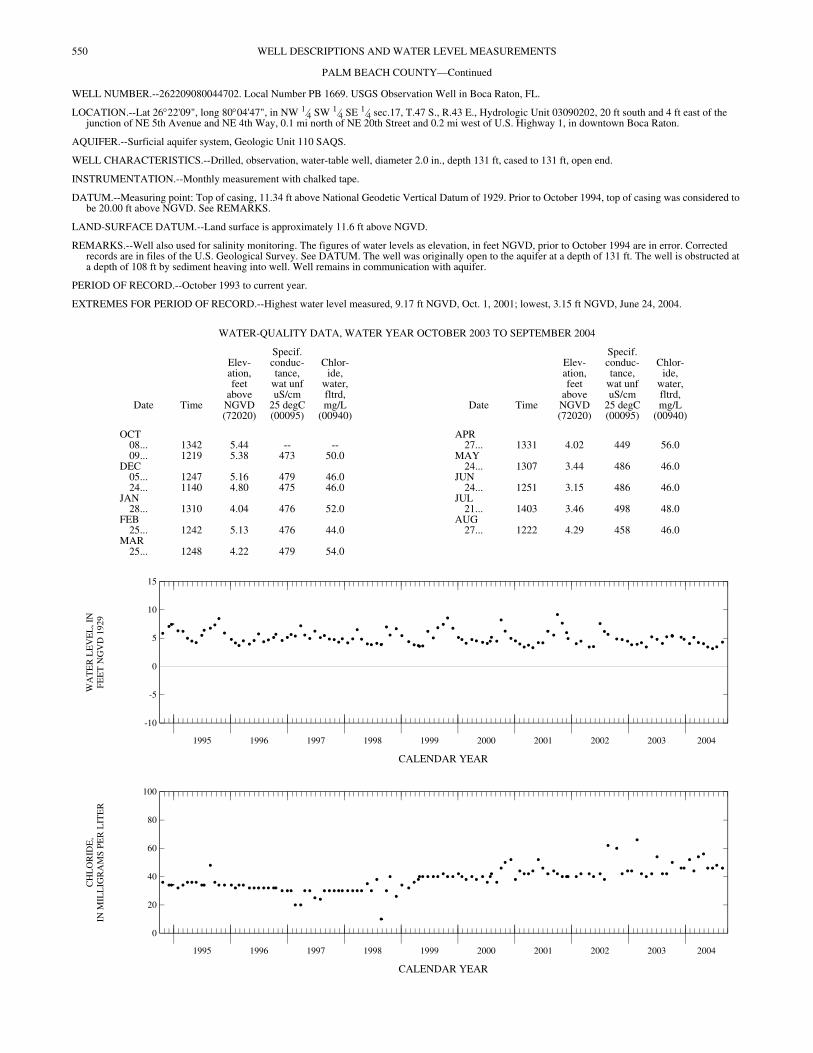
WELL NUMBER.--262209080044702. Local Number PB 1669. USGS Observation Well in Boca Raton, FL.
LOCATION.--Lat 26°22'09", long 80°04'47", in NW 1⁄4 SW 1⁄4 SE 1⁄4 sec.17, T.47 S., R.43 E., Hydrologic Unit 03090202, 20 ft south and 4 ft east of the junction of NE 5th Avenue and NE 4th Way, 0.1 mi north of NE 20th Street and 0.2 mi west of U.S. Highway 1, in downtown Boca Raton.
AQUIFER.--Surficial aquifer system, Geologic Unit 110 SAQS.
WELL CHARACTERISTICS.--Drilled, observation, water-table well, diameter 2.0 in., depth 131 ft, cased to 131 ft, open end.
INSTRUMENTATION.--Monthly measurement with chalked tape.
DATUM.--Measuring point: Top of casing, 11.34 ft above National Geodetic Vertical Datum of 1929. Prior to October 1994, top of casing was considered to be 20.00 ft above NGVD. See REMARKS.
LAND-SURFACE DATUM.--Land surface is approximately 11.6 ft above NGVD.
REMARKS.--Well also used for salinity monitoring. The figures of water levels as elevation, in feet NGVD, prior to October 1994 are in error. Corrected records are in files of the U.S. Geological Survey. See DATUM. The well was originally open to the aquifer at a depth of 131 ft. The well is obstructed at a depth of 108 ft by sediment heaving into well. Well remains in communication with aquifer.
PERIOD OF RECORD.--October 1993 to current year.
EXTREMES FOR PERIOD OF RECORD.--Highest water level measured, 9.17 ft NGVD, Oct. 1, 2001; lowest, 3.15 ft NGVD, June 24, 2004.
CALENDAR YEAR
CALENDAR YEAR
WATER-QUALITY DATA, WATER YEAR OCTOBER 2003 TO SEPTEMBER 2004
Date Time
Elev-ation,feet
aboveNGVD(72020)
Specif.conduc-tance,
wat unfuS/cm
25 degC(00095)
Chlor-ide,
water,fltrd,mg/L
(00940)Date Time
Elev-ation,feet
aboveNGVD(72020)
Specif.conduc-tance,
wat unfuS/cm
25 degC(00095)
Chlor-ide,
water,fltrd,mg/L
(00940)
OCT APR08... 1342 5.44 -- -- 27... 1331 4.02 449 56.009... 1219 5.38 473 50.0 MAY
DEC 24... 1307 3.44 486 46.005... 1247 5.16 479 46.0 JUN24... 1140 4.80 475 46.0 24... 1251 3.15 486 46.0
JAN JUL28... 1310 4.04 476 52.0 21... 1403 3.46 498 48.0
FEB AUG25... 1242 5.13 476 44.0 27... 1222 4.29 458 46.0
MAR25... 1248 4.22 479 54.0
1995 1996 1997 1998 1999 2000 2001 2002 2003 2004
-10
-5
0
5
10
15
WA
TE
R L
EV
EL
, IN
FEE
T N
GV
D 1
929
1995 1996 1997 1998 1999 2000 2001 2002 2003 2004
0
20
40
60
80
100
CH
LO
RID
E,
IN M
ILL
IGR
AM
S P
ER
LIT
ER
551WELL DESCRIPTIONS AND WATER LEVEL MEASUREMENTS
PALM BEACH COUNTY—Continued
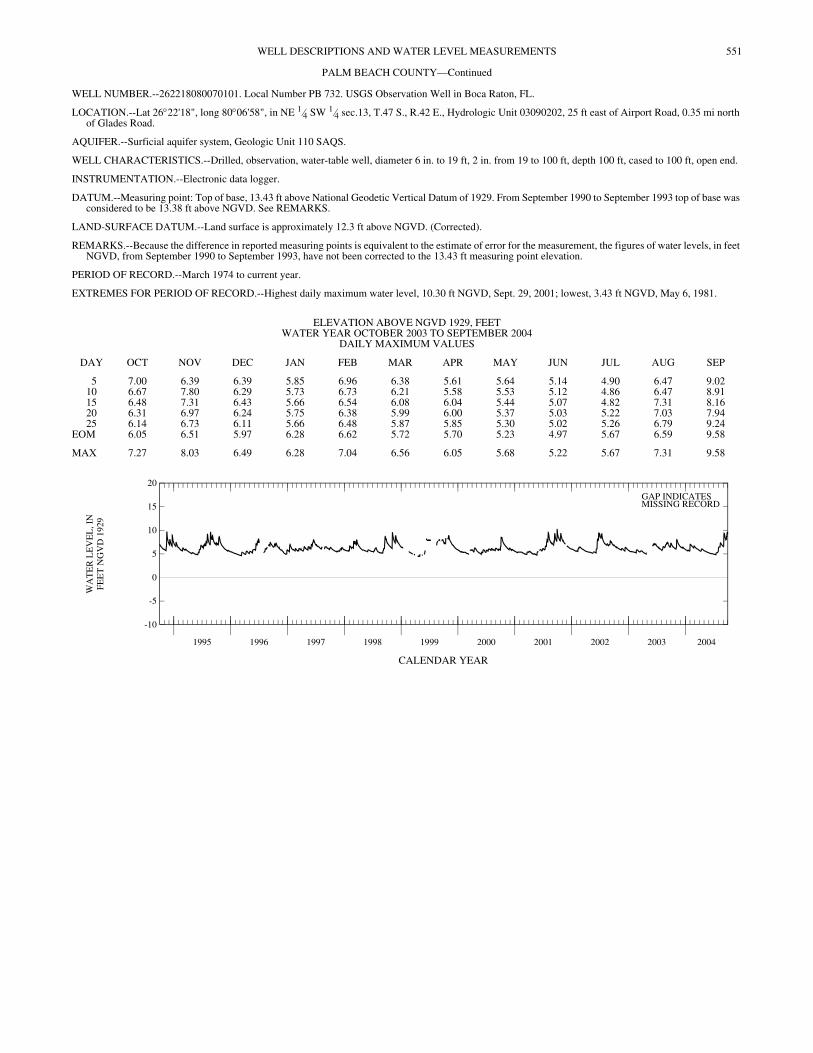
WELL NUMBER.--262218080070101. Local Number PB 732. USGS Observation Well in Boca Raton, FL.
LOCATION.--Lat 26°22'18", long 80°06'58", in NE 1⁄4 SW 1⁄4 sec.13, T.47 S., R.42 E., Hydrologic Unit 03090202, 25 ft east of Airport Road, 0.35 mi north of Glades Road.
AQUIFER.--Surficial aquifer system, Geologic Unit 110 SAQS.
WELL CHARACTERISTICS.--Drilled, observation, water-table well, diameter 6 in. to 19 ft, 2 in. from 19 to 100 ft, depth 100 ft, cased to 100 ft, open end.
INSTRUMENTATION.--Electronic data logger.
DATUM.--Measuring point: Top of base, 13.43 ft above National Geodetic Vertical Datum of 1929. From September 1990 to September 1993 top of base was considered to be 13.38 ft above NGVD. See REMARKS.
LAND-SURFACE DATUM.--Land surface is approximately 12.3 ft above NGVD. (Corrected).
REMARKS.--Because the difference in reported measuring points is equivalent to the estimate of error for the measurement, the figures of water levels, in feet NGVD, from September 1990 to September 1993, have not been corrected to the 13.43 ft measuring point elevation.
PERIOD OF RECORD.--March 1974 to current year.
EXTREMES FOR PERIOD OF RECORD.--Highest daily maximum water level, 10.30 ft NGVD, Sept. 29, 2001; lowest, 3.43 ft NGVD, May 6, 1981.
CALENDAR YEAR
ELEVATION ABOVE NGVD 1929, FEET WATER YEAR OCTOBER 2003 TO SEPTEMBER 2004
DAILY MAXIMUM VALUES
DAY OCT NOV DEC JAN FEB MAR APR MAY JUN JUL AUG SEP
5 7.00 6.39 6.39 5.85 6.96 6.38 5.61 5.64 5.14 4.90 6.47 9.0210 6.67 7.80 6.29 5.73 6.73 6.21 5.58 5.53 5.12 4.86 6.47 8.9115 6.48 7.31 6.43 5.66 6.54 6.08 6.04 5.44 5.07 4.82 7.31 8.1620 6.31 6.97 6.24 5.75 6.38 5.99 6.00 5.37 5.03 5.22 7.03 7.9425 6.14 6.73 6.11 5.66 6.48 5.87 5.85 5.30 5.02 5.26 6.79 9.24
EOM 6.05 6.51 5.97 6.28 6.62 5.72 5.70 5.23 4.97 5.67 6.59 9.58
MAX 7.27 8.03 6.49 6.28 7.04 6.56 6.05 5.68 5.22 5.67 7.31 9.58
1995 1996 1997 1998 1999 2000 2001 2002 2003 2004
-10
-5
0
5
10
15
20
WA
TE
R L
EV
EL
, IN
FEE
T N
GV
D 1
929
GAP INDICATESMISSING RECORD
552 WELL DESCRIPTIONS AND WATER LEVEL MEASUREMENTS
PALM BEACH COUNTY—Continued
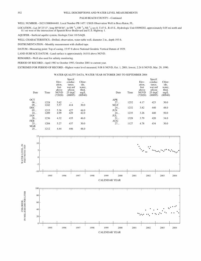
WELL NUMBER.--262313080044401. Local Number PB 1457. USGS Observation Well in Boca Raton, FL.
LOCATION.--Lat 26°23'13", long 80°04'44", in SW 1⁄4 SW 1⁄4 NE 1⁄4 sec.8, T.47 S., R.43 E., Hydrologic Unit 03090202, approximately 0.05 mi north and 0.1 mi west of the intersection of Spanish River Boulevard and U.S. Highway 1.
AQUIFER.--Surficial aquifer system, Geologic Unit 110 SAQS.
WELL CHARACTERISTICS.--Drilled, observation, water-table well, diameter 2 in., depth 193 ft.
INSTRUMENTATION.--Monthly measurement with chalked tape.
DATUM.--Measuring point: Top of casing, 15.97 ft above National Geodetic Vertical Datum of 1929.
LAND-SURFACE DATUM.--Land surface is approximately 16.0 ft above NGVD.
REMARKS.--Well also used for salinity monitoring.
PERIOD OF RECORD.--April 1983 to October 1993, October 2001 to current year.
EXTREMES FOR PERIOD OF RECORD.--Highest water level measured, 9.08 ft NGVD, Oct. 1, 2001; lowest, 2.24 ft NGVD, Mar. 29, 1990.
CALENDAR YEAR
CALENDAR YEAR
WATER-QUALITY DATA, WATER YEAR OCTOBER 2003 TO SEPTEMBER 2004
Date Time
Elev-ation,feet
aboveNGVD(72020)
Specif.conduc-tance,
wat unfuS/cm
25 degC(00095)
Chlor-ide,
water,fltrd,mg/L
(00940)Date Time
Elev-ation,feet
aboveNGVD(72020)
Specif.conduc-tance,
wat unfuS/cm
25 degC(00095)
Chlor-ide,
water,fltrd,mg/L
(00940)
OCT APR08... 1324 5.62 -- -- 27... 1252 4.17 423 30.009... 1242 5.57 414 30.0 MAY
DEC 24... 1232 3.82 440 48.005... 1215 5.36 427 44.0 JUN24... 1209 4.99 429 42.0 24... 1235 3.26 440 50.0
JAN JUL28... 1236 4.32 435 46.0 21... 1328 3.79 420 34.0
FEB AUG25... 1204 5.27 437 30.0 27... 1127 4.78 434 30.0
MAR25... 1212 4.44 446 48.0
1995 1996 1997 1998 1999 2000 2001 2002 2003 2004
-10
-5
0
5
10
15
WA
TE
R L
EV
EL
, IN
FEE
T N
GV
D 1
929
1995 1996 1997 1998 1999 2000 2001 2002 2003 2004
0
20
40
60
80
100
CH
LO
RID
E,
IN M
ILL
IGR
AM
S P
ER
LIT
ER
553WELL DESCRIPTIONS AND WATER LEVEL MEASUREMENTS
PALM BEACH COUNTY—Continued
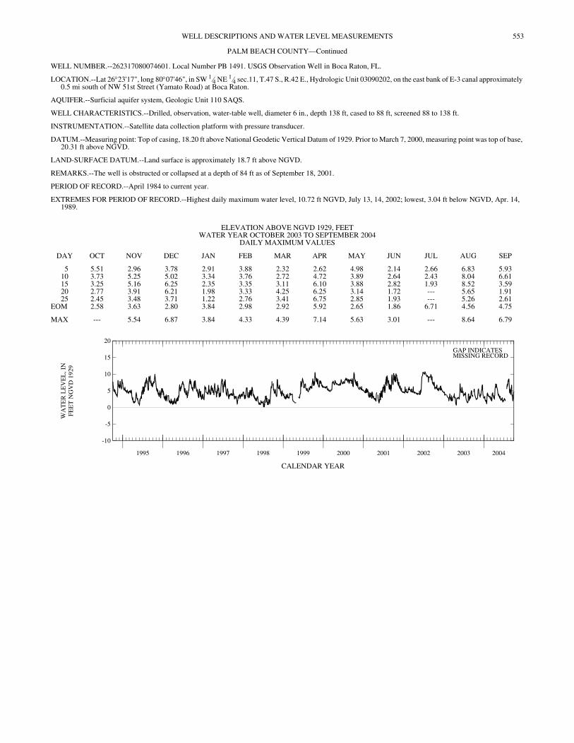
WELL NUMBER.--262317080074601. Local Number PB 1491. USGS Observation Well in Boca Raton, FL.
LOCATION.--Lat 26°23'17", long 80°07'46", in SW 1⁄4 NE 1⁄4 sec.11, T.47 S., R.42 E., Hydrologic Unit 03090202, on the east bank of E-3 canal approximately 0.5 mi south of NW 51st Street (Yamato Road) at Boca Raton.
AQUIFER.--Surficial aquifer system, Geologic Unit 110 SAQS.
WELL CHARACTERISTICS.--Drilled, observation, water-table well, diameter 6 in., depth 138 ft, cased to 88 ft, screened 88 to 138 ft.
INSTRUMENTATION.--Satellite data collection platform with pressure transducer.
DATUM.--Measuring point: Top of casing, 18.20 ft above National Geodetic Vertical Datum of 1929. Prior to March 7, 2000, measuring point was top of base, 20.31 ft above NGVD.
LAND-SURFACE DATUM.--Land surface is approximately 18.7 ft above NGVD.
REMARKS.--The well is obstructed or collapsed at a depth of 84 ft as of September 18, 2001.
PERIOD OF RECORD.--April 1984 to current year.
EXTREMES FOR PERIOD OF RECORD.--Highest daily maximum water level, 10.72 ft NGVD, July 13, 14, 2002; lowest, 3.04 ft below NGVD, Apr. 14, 1989.
CALENDAR YEAR
ELEVATION ABOVE NGVD 1929, FEET WATER YEAR OCTOBER 2003 TO SEPTEMBER 2004
DAILY MAXIMUM VALUES
DAY OCT NOV DEC JAN FEB MAR APR MAY JUN JUL AUG SEP
5 5.51 2.96 3.78 2.91 3.88 2.32 2.62 4.98 2.14 2.66 6.83 5.9310 3.73 5.25 5.02 3.34 3.76 2.72 4.72 3.89 2.64 2.43 8.04 6.6115 3.25 5.16 6.25 2.35 3.35 3.11 6.10 3.88 2.82 1.93 8.52 3.5920 2.77 3.91 6.21 1.98 3.33 4.25 6.25 3.14 1.72 --- 5.65 1.9125 2.45 3.48 3.71 1.22 2.76 3.41 6.75 2.85 1.93 --- 5.26 2.61
EOM 2.58 3.63 2.80 3.84 2.98 2.92 5.92 2.65 1.86 6.71 4.56 4.75
MAX --- 5.54 6.87 3.84 4.33 4.39 7.14 5.63 3.01 --- 8.64 6.79
1995 1996 1997 1998 1999 2000 2001 2002 2003 2004
-10
-5
0
5
10
15
20
WA
TE
R L
EV
EL
, IN
FEE
T N
GV
D 1
929
GAP INDICATESMISSING RECORD
554 WELL DESCRIPTIONS AND WATER LEVEL MEASUREMENTS
PALM BEACH COUNTY—Continued
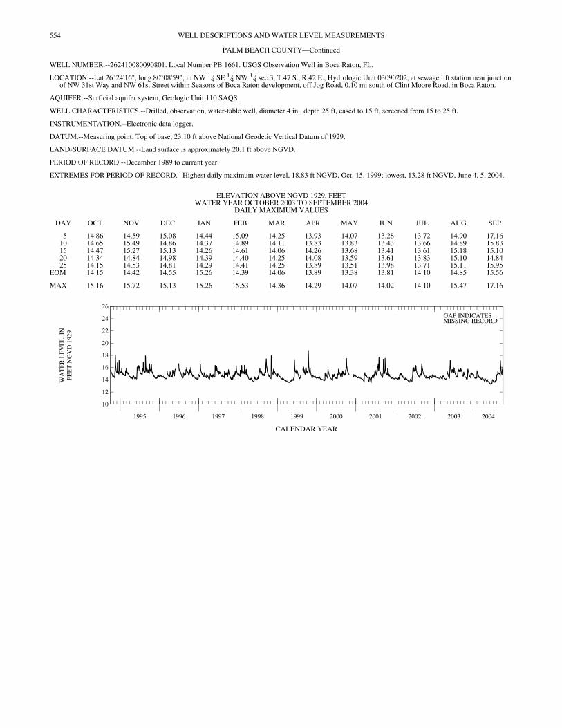
WELL NUMBER.--262410080090801. Local Number PB 1661. USGS Observation Well in Boca Raton, FL.
LOCATION.--Lat 26°24'16", long 80°08'59", in NW 1⁄4 SE 1⁄4 NW 1⁄4 sec.3, T.47 S., R.42 E., Hydrologic Unit 03090202, at sewage lift station near junction of NW 31st Way and NW 61st Street within Seasons of Boca Raton development, off Jog Road, 0.10 mi south of Clint Moore Road, in Boca Raton.
AQUIFER.--Surficial aquifer system, Geologic Unit 110 SAQS.
WELL CHARACTERISTICS.--Drilled, observation, water-table well, diameter 4 in., depth 25 ft, cased to 15 ft, screened from 15 to 25 ft.
INSTRUMENTATION.--Electronic data logger.
DATUM.--Measuring point: Top of base, 23.10 ft above National Geodetic Vertical Datum of 1929.
LAND-SURFACE DATUM.--Land surface is approximately 20.1 ft above NGVD.
PERIOD OF RECORD.--December 1989 to current year.
EXTREMES FOR PERIOD OF RECORD.--Highest daily maximum water level, 18.83 ft NGVD, Oct. 15, 1999; lowest, 13.28 ft NGVD, June 4, 5, 2004.
CALENDAR YEAR
ELEVATION ABOVE NGVD 1929, FEET WATER YEAR OCTOBER 2003 TO SEPTEMBER 2004
DAILY MAXIMUM VALUES
DAY OCT NOV DEC JAN FEB MAR APR MAY JUN JUL AUG SEP
5 14.86 14.59 15.08 14.44 15.09 14.25 13.93 14.07 13.28 13.72 14.90 17.1610 14.65 15.49 14.86 14.37 14.89 14.11 13.83 13.83 13.43 13.66 14.89 15.8315 14.47 15.27 15.13 14.26 14.61 14.06 14.26 13.68 13.41 13.61 15.18 15.1020 14.34 14.84 14.98 14.39 14.40 14.25 14.08 13.59 13.61 13.83 15.10 14.8425 14.15 14.53 14.81 14.29 14.41 14.25 13.89 13.51 13.98 13.71 15.11 15.95
EOM 14.15 14.42 14.55 15.26 14.39 14.06 13.89 13.38 13.81 14.10 14.85 15.56
MAX 15.16 15.72 15.13 15.26 15.53 14.36 14.29 14.07 14.02 14.10 15.47 17.16
1995 1996 1997 1998 1999 2000 2001 2002 2003 2004
10
12
14
16
18
20
22
24
26
WA
TE
R L
EV
EL
, IN
FEE
T N
GV
D 1
929
GAP INDICATESMISSING RECORD
555WELL DESCRIPTIONS AND WATER LEVEL MEASUREMENTS
PALM BEACH COUNTY—Continued
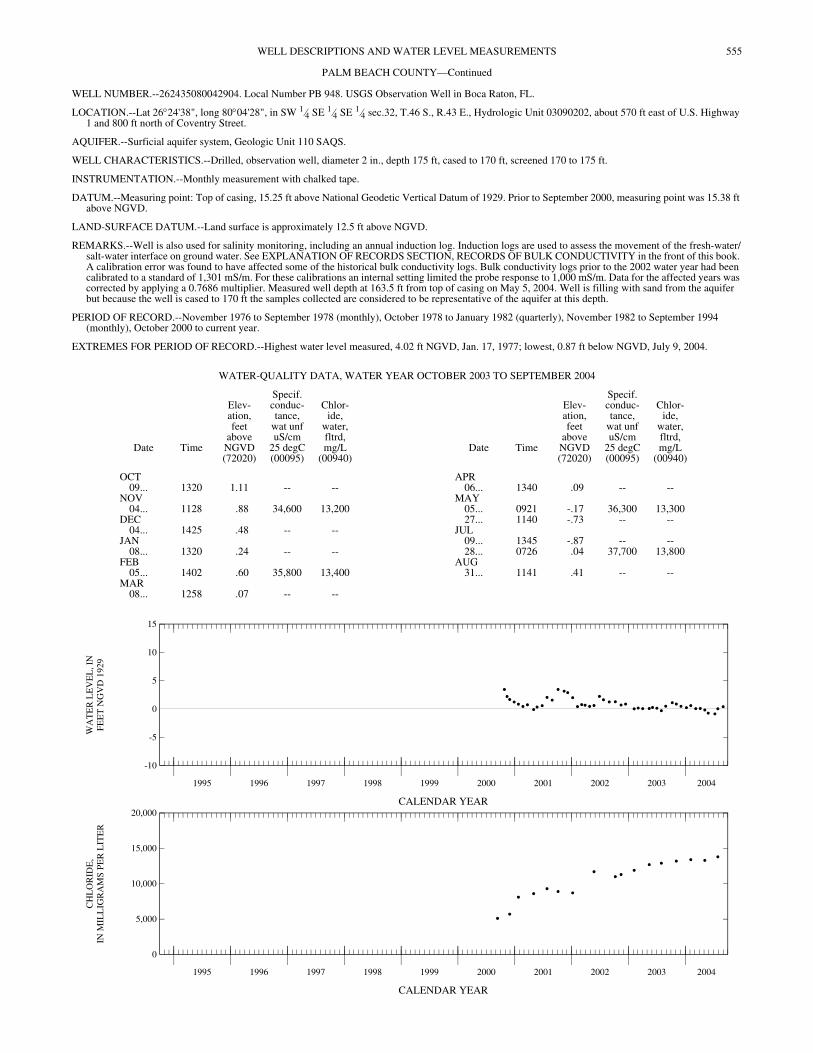
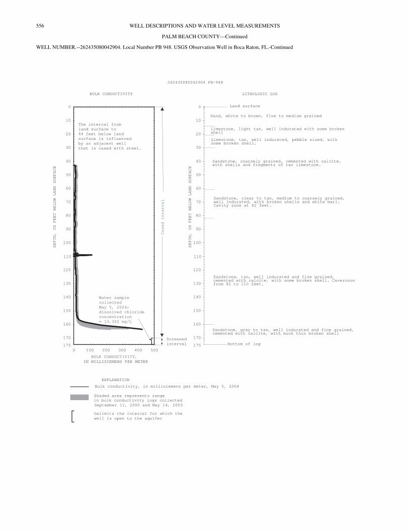
WELL NUMBER.--262435080042904. Local Number PB 948. USGS Observation Well in Boca Raton, FL.
LOCATION.--Lat 26°24'38", long 80°04'28", in SW 1⁄4 SE 1⁄4 SE 1⁄4 sec.32, T.46 S., R.43 E., Hydrologic Unit 03090202, about 570 ft east of U.S. Highway 1 and 800 ft north of Coventry Street.
AQUIFER.--Surficial aquifer system, Geologic Unit 110 SAQS.
WELL CHARACTERISTICS.--Drilled, observation well, diameter 2 in., depth 175 ft, cased to 170 ft, screened 170 to 175 ft.
INSTRUMENTATION.--Monthly measurement with chalked tape.
DATUM.--Measuring point: Top of casing, 15.25 ft above National Geodetic Vertical Datum of 1929. Prior to September 2000, measuring point was 15.38 ft above NGVD.
LAND-SURFACE DATUM.--Land surface is approximately 12.5 ft above NGVD.
REMARKS.--Well is also used for salinity monitoring, including an annual induction log. Induction logs are used to assess the movement of the fresh-water/salt-water interface on ground water. See EXPLANATION OF RECORDS SECTION, RECORDS OF BULK CONDUCTIVITY in the front of this book. A calibration error was found to have affected some of the historical bulk conductivity logs. Bulk conductivity logs prior to the 2002 water year had been calibrated to a standard of 1,301 mS/m. For these calibrations an internal setting limited the probe response to 1,000 mS/m. Data for the affected years was corrected by applying a 0.7686 multiplier. Measured well depth at 163.5 ft from top of casing on May 5, 2004. Well is filling with sand from the aquifer but because the well is cased to 170 ft the samples collected are considered to be representative of the aquifer at this depth.
PERIOD OF RECORD.--November 1976 to September 1978 (monthly), October 1978 to January 1982 (quarterly), November 1982 to September 1994 (monthly), October 2000 to current year.
EXTREMES FOR PERIOD OF RECORD.--Highest water level measured, 4.02 ft NGVD, Jan. 17, 1977; lowest, 0.87 ft below NGVD, July 9, 2004.
CALENDAR YEAR
CALENDAR YEAR
WATER-QUALITY DATA, WATER YEAR OCTOBER 2003 TO SEPTEMBER 2004
Date Time
Elev-ation,feet
aboveNGVD(72020)
Specif.conduc-tance,
wat unfuS/cm
25 degC(00095)
Chlor-ide,
water,fltrd,mg/L
(00940)Date Time
Elev-ation,feet
aboveNGVD(72020)
Specif.conduc-tance,
wat unfuS/cm
25 degC(00095)
Chlor-ide,
water,fltrd,mg/L
(00940)
OCT APR09... 1320 1.11 -- -- 06... 1340 .09 -- --
NOV MAY04... 1128 .88 34,600 13,200 05... 0921 -.17 36,300 13,300
DEC 27... 1140 -.73 -- --04... 1425 .48 -- -- JUL
JAN 09... 1345 -.87 -- --08... 1320 .24 -- -- 28... 0726 .04 37,700 13,800
FEB AUG05... 1402 .60 35,800 13,400 31... 1141 .41 -- --
MAR08... 1258 .07 -- --
1995 1996 1997 1998 1999 2000 2001 2002 2003 2004
-10
-5
0
5
10
15
WA
TE
R L
EV
EL
, IN
FEE
T N
GV
D 1
929
1995 1996 1997 1998 1999 2000 2001 2002 2003 2004
0
5,000
10,000
15,000
20,000
CH
LO
RID
E,
IN M
ILL
IGR
AM
S P
ER
LIT
ER
556 WELL DESCRIPTIONS AND WATER LEVEL MEASUREMENTS
PALM BEACH COUNTY—Continued
WELL NUMBER.--262435080042904. Local Number PB 948. USGS Observation Well in Boca Raton, FL.-Continued
LITHOLOGIC LOG
Land surface
Bottom of log
DEPTH,
IN
FEET
BELOW
LAND
SURFACE
0
10
20
30
40
50
60
70
80
90
100
110
120
130
140
150
160
170
175
Sand, white to brown, fine to medium grained
Limestone, light tan, well indurated with some brokenshell
Limestone, tan, well indurated, pebble sized, withsome broken shell.
Sandstone, coarsely grained, cemented with calcite,with shells and fragments of tan limestone.
Sandstone, tan, well indurated and fine grained,cemented with calcite, with some broken shell. Cavernousfrom 82 to 110 feet.
Sandstone, clear to tan, medium to coarsely grained,well indurated, with broken shells and white marl.Cavity zone at 82 feet.
Sandstone, gray to tan, well indurated and fine grained,cemented with calcite, with much thin broken shell
262435080042904 PB-948
Screened
interval
EXPLANATION
BULK CONDUCTIVITY
[ Delimits the interval for which the
well is open to the aquifer
Bulk conductivity, in millisiemens per meter, May 5, 2004
DEPTH,
IN
FEET
BELOW
LAND
SURFACE
0
10
20
30
40
50
60
70
80
90
100
110
120
130
140
150
160
170
0 100 200 300 400 500
BULK CONDUCTIVITY,
IN MILLISIEMENS PER METER
Water sample
collected
May
issolved chloride
concentration
= 13,300
5, 2004;
d
mg/L
175[
The interval from
land surface to
44 feet below land
surface is influenced
by an adjacent well
that is cased with steel.
Shaded area represents range
in bulk conductivity logs collected
September 11, 2000 and May 14, 2003
Casedinterval
557WELL DESCRIPTIONS AND WATER LEVEL MEASUREMENTS
PALM BEACH COUNTY—Continued
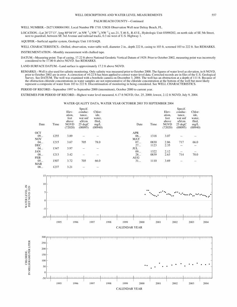
WELL NUMBER.--262713080041901. Local Number PB 1710. USGS Observation Well near Delray Beach, FL.
LOCATION.--Lat 26°27'13", long 80°04'19", in NW 1⁄4 NW 1⁄4 NW 1⁄4 sec.21, T.46 S., R.43 E., Hydrologic Unit 03090202, on north side of SE 5th Street, next to guardrail, between SE 3rd Avenue and railroad tracks, 0.3 mi west of U.S. Highway 1.
AQUIFER.--Surficial aquifer system, Geologic Unit 110 SAQS.
WELL CHARACTERISTICS.--Drilled, observation, water-table well, diameter 2 in., depth 222 ft, casing to 103 ft, screened 103 to 222 ft. See REMARKS.
INSTRUMENTATION.--Monthly measurement with chalked tape.
DATUM.--Measuring point: Top of casing, 17.22 ft above National Geodetic Vertical Datum of 1929. Prior to October 2002, measuring point was incorrectly considered to be 17.00 ft above NGVD. See REMARKS.
LAND-SURFACE DATUM.--Land surface is approximately 17.2 ft above NGVD.
REMARKS.--Well is also used for salinity monitoring. Only salinity was measured prior to October 2000. The figures of water level as elevation, in ft NGVD, prior to October 2002 are in error. A correction of +0.22 ft has been applied to correct water-level data. Corrected records are in files of the U.S. Geological Survey. See DATUM. The well was examined with a borehole camera on December 3, 2004. The well has an obstruction at a depth of 111 ft. Because of the obstruction chloride concentrations in water samples are not representative of the chloride concentration at the bottom of the well but most likely represent a composite of water from 103 to 222 ft. Discontinuation of monitoring in being considered. See WELL CHARACTERISTICS.
PERIOD OF RECORD.--September 1997 to September 2000 (intermittent), October 2000 to current year.
EXTREMES FOR PERIOD OF RECORD.--Highest water level measured, 6.17 ft NGVD, Oct. 25, 2000; lowest, 2.12 ft NGVD, July 9, 2004.
CALENDAR YEAR
CALENDAR YEAR
WATER-QUALITY DATA, WATER YEAR OCTOBER 2003 TO SEPTEMBER 2004
Date Time
Elev-ation,feet
aboveNGVD(72020)
Specif.conduc-tance,
wat unfuS/cm
25 degC(00095)
Chlor-ide,
water,fltrd,mg/L
(00940)Date Time
Elev-ation,feet
aboveNGVD(72020)
Specif.conduc-tance,
wat unfuS/cm
25 degC(00095)
Chlor-ide,
water,fltrd,mg/L
(00940)
OCT APR09... 1255 3.89 -- -- 06... 1318 3.07 -- --
NOV MAY04... 1215 3.67 705 78.0 07... 0830 2.86 717 66.0
DEC 27... 1123 2.35 -- --04... 1347 3.97 -- -- JUL
JAN 09... 1322 2.12 -- --08... 1213 3.42 -- -- 28... 0839 2.63 714 70.0
FEB AUG05... 1507 3.72 705 66.0 31... 1110 3.69 -- --
MAR08... 1237 3.21 -- --
1995 1996 1997 1998 1999 2000 2001 2002 2003 2004
-10
-5
0
5
10
15
WA
TE
R L
EV
EL
, IN
FEE
T N
GV
D 1
929
1995 1996 1997 1998 1999 2000 2001 2002 2003 2004
-50
0
50
100
150
200
250
300
CH
LO
RID
E,
IN M
ILL
IGR
AM
S P
ER
LIT
ER
558 WELL DESCRIPTIONS AND WATER LEVEL MEASUREMENTS
PALM BEACH COUNTY-Continued
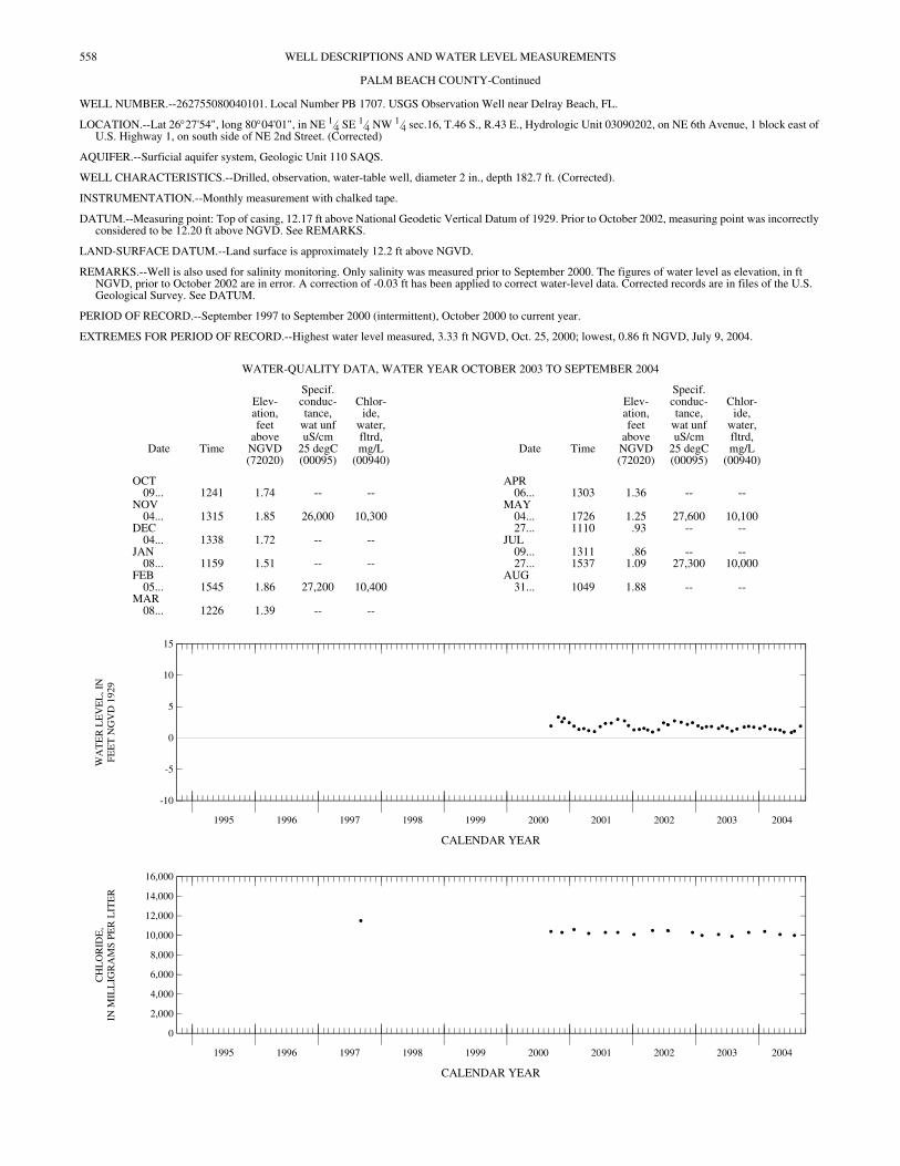
WELL NUMBER.--262755080040101. Local Number PB 1707. USGS Observation Well near Delray Beach, FL.
LOCATION.--Lat 26°27'54", long 80°04'01", in NE 1⁄4 SE 1⁄4 NW 1⁄4 sec.16, T.46 S., R.43 E., Hydrologic Unit 03090202, on NE 6th Avenue, 1 block east of U.S. Highway 1, on south side of NE 2nd Street. (Corrected)
AQUIFER.--Surficial aquifer system, Geologic Unit 110 SAQS.
WELL CHARACTERISTICS.--Drilled, observation, water-table well, diameter 2 in., depth 182.7 ft. (Corrected).
INSTRUMENTATION.--Monthly measurement with chalked tape.
DATUM.--Measuring point: Top of casing, 12.17 ft above National Geodetic Vertical Datum of 1929. Prior to October 2002, measuring point was incorrectly considered to be 12.20 ft above NGVD. See REMARKS.
LAND-SURFACE DATUM.--Land surface is approximately 12.2 ft above NGVD.
REMARKS.--Well is also used for salinity monitoring. Only salinity was measured prior to September 2000. The figures of water level as elevation, in ft NGVD, prior to October 2002 are in error. A correction of -0.03 ft has been applied to correct water-level data. Corrected records are in files of the U.S. Geological Survey. See DATUM.
PERIOD OF RECORD.--September 1997 to September 2000 (intermittent), October 2000 to current year.
EXTREMES FOR PERIOD OF RECORD.--Highest water level measured, 3.33 ft NGVD, Oct. 25, 2000; lowest, 0.86 ft NGVD, July 9, 2004.
CALENDAR YEAR
CALENDAR YEAR
WATER-QUALITY DATA, WATER YEAR OCTOBER 2003 TO SEPTEMBER 2004
Date Time
Elev-ation,feet
aboveNGVD(72020)
Specif.conduc-tance,
wat unfuS/cm
25 degC(00095)
Chlor-ide,
water,fltrd,mg/L
(00940)Date Time
Elev-ation,feet
aboveNGVD(72020)
Specif.conduc-tance,
wat unfuS/cm
25 degC(00095)
Chlor-ide,
water,fltrd,mg/L
(00940)
OCT APR09... 1241 1.74 -- -- 06... 1303 1.36 -- --
NOV MAY04... 1315 1.85 26,000 10,300 04... 1726 1.25 27,600 10,100
DEC 27... 1110 .93 -- --04... 1338 1.72 -- -- JUL
JAN 09... 1311 .86 -- --08... 1159 1.51 -- -- 27... 1537 1.09 27,300 10,000
FEB AUG05... 1545 1.86 27,200 10,400 31... 1049 1.88 -- --
MAR08... 1226 1.39 -- --
1995 1996 1997 1998 1999 2000 2001 2002 2003 2004
-10
-5
0
5
10
15
WA
TE
R L
EV
EL
, IN
FEE
T N
GV
D 1
929
1995 1996 1997 1998 1999 2000 2001 2002 2003 2004
0
2,000
4,000
6,000
8,000
10,000
12,000
14,000
16,000
CH
LO
RID
E,
IN M
ILL
IGR
AM
S P
ER
LIT
ER
559WELL DESCRIPTIONS AND WATER LEVEL MEASUREMENTS
PALM BEACH COUNTY—Continued
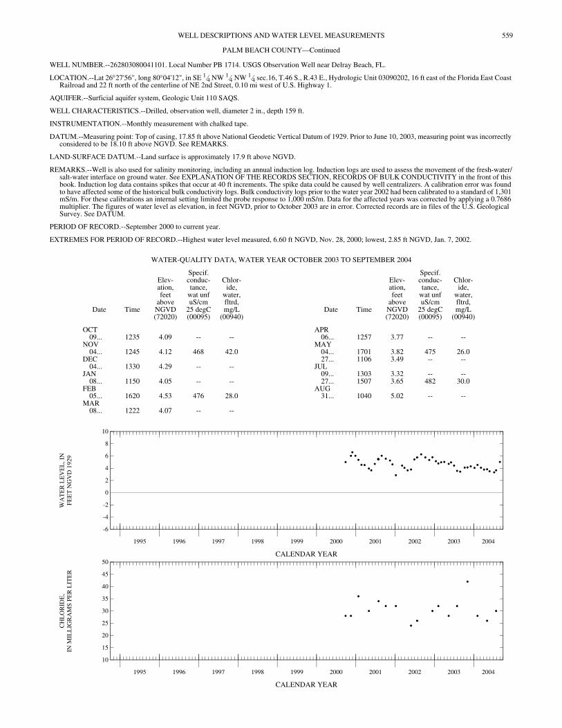
WELL NUMBER.--262803080041101. Local Number PB 1714. USGS Observation Well near Delray Beach, FL.
LOCATION.--Lat 26°27'56", long 80°04'12", in SE 1⁄4 NW 1⁄4 NW 1⁄4 sec.16, T.46 S., R.43 E., Hydrologic Unit 03090202, 16 ft east of the Florida East Coast Railroad and 22 ft north of the centerline of NE 2nd Street, 0.10 mi west of U.S. Highway 1.
AQUIFER.--Surficial aquifer system, Geologic Unit 110 SAQS.
WELL CHARACTERISTICS.--Drilled, observation well, diameter 2 in., depth 159 ft.
INSTRUMENTATION.--Monthly measurement with chalked tape.
DATUM.--Measuring point: Top of casing, 17.85 ft above National Geodetic Vertical Datum of 1929. Prior to June 10, 2003, measuring point was incorrectly considered to be 18.10 ft above NGVD. See REMARKS.
LAND-SURFACE DATUM.--Land surface is approximately 17.9 ft above NGVD.
REMARKS.--Well is also used for salinity monitoring, including an annual induction log. Induction logs are used to assess the movement of the fresh-water/salt-water interface on ground water. See EXPLANATION OF THE RECORDS SECTION, RECORDS OF BULK CONDUCTIVITY in the front of this book. Induction log data contains spikes that occur at 40 ft increments. The spike data could be caused by well centralizers. A calibration error was found to have affected some of the historical bulk conductivity logs. Bulk conductivity logs prior to the water year 2002 had been calibrated to a standard of 1,301 mS/m. For these calibrations an internal setting limited the probe response to 1,000 mS/m. Data for the affected years was corrected by applying a 0.7686 multiplier. The figures of water level as elevation, in feet NGVD, prior to October 2003 are in error. Corrected records are in files of the U.S. Geological Survey. See DATUM.
PERIOD OF RECORD.--September 2000 to current year.
EXTREMES FOR PERIOD OF RECORD.--Highest water level measured, 6.60 ft NGVD, Nov. 28, 2000; lowest, 2.85 ft NGVD, Jan. 7, 2002.
CALENDAR YEAR
CALENDAR YEAR
WATER-QUALITY DATA, WATER YEAR OCTOBER 2003 TO SEPTEMBER 2004
Date Time
Elev-ation,feet
aboveNGVD(72020)
Specif.conduc-tance,
wat unfuS/cm
25 degC(00095)
Chlor-ide,
water,fltrd,mg/L
(00940)Date Time
Elev-ation,feet
aboveNGVD(72020)
Specif.conduc-tance,
wat unfuS/cm
25 degC(00095)
Chlor-ide,
water,fltrd,mg/L
(00940)
OCT APR09... 1235 4.09 -- -- 06... 1257 3.77 -- --
NOV MAY04... 1245 4.12 468 42.0 04... 1701 3.82 475 26.0
DEC 27... 1106 3.49 -- --04... 1330 4.29 -- -- JUL
JAN 09... 1303 3.32 -- --08... 1150 4.05 -- -- 27... 1507 3.65 482 30.0
FEB AUG05... 1620 4.53 476 28.0 31... 1040 5.02 -- --
MAR08... 1222 4.07 -- --
1995 1996 1997 1998 1999 2000 2001 2002 2003 2004
-6
-4
-2
0
2
4
6
8
10
WA
TE
R L
EV
EL
, IN
FEE
T N
GV
D 1
929
1995 1996 1997 1998 1999 2000 2001 2002 2003 2004
10
15
20
25
30
35
40
45
50
CH
LO
RID
E,
IN M
ILL
IGR
AM
S P
ER
LIT
ER

560 WELL DESCRIPTIONS AND WATER LEVEL MEASUREMENTS
PALM BEACH COUNTY—Continued
WELL NUMBER.--262803080041101. Local Number PB 1714. USGS Observation Well near Delray Beach, FL.-Continued
EXPLANATION
BULK CONDUCTIVITY LITHOLOGIC LOG
Bulk conductivity, in millisiemens per meter, May 4, 2004
DEPTH,
IN
FEET
BELOW
LAND
SURFACE
0 50 100 150 200
BULK CONDUCTIVITY,
IN MILLISIEMENS PER METER
Water sample
collected
May 4, 2004;
dissolved chloride
concentration
= 26 mg/L
No lithologic log is
available for this well.
Shaded area represents range
in bulk conductivity logs collected
September 26, 2000 and May 13, 2003
0
10
20
30
40
50
60
70
80
90
100
110
120
130
140
150
159
262803080041101 PB-1714
Casedinterval
Screened
interval
unknown
561WELL DESCRIPTIONS AND WATER LEVEL MEASUREMENTS
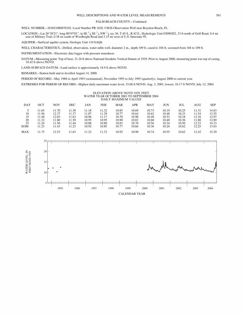
PALM BEACH COUNTY—Continued
WELL NUMBER.--263021080070102. Local Number PB 1628. USGS Observation Well near Boynton Beach, FL.
LOCATION.--Lat 26°30'21", long 80°07'01", in SE 1⁄4 SE 1⁄4 NW 1⁄4 sec.36, T.45 S., R.42 E., Hydrologic Unit 03090202, 33 ft north of Golf Road, 0.4 mi east of Military Trail, 0.38 mi south of Woolbright Road and 3.15 mi west of U.S. Interstate 95.
AQUIFER.--Surficial aquifer system, Geologic Unit 110 SAQS.
WELL CHARACTERISTICS.--Drilled, observation, water-table well, diameter 2 in., depth 109 ft, cased to 104 ft, screened from 104 to 109 ft.
INSTRUMENTATION.--Electronic data logger with pressure transducer.
DATUM.--Measuring point: Top of base, 21.26 ft above National Geodetic Vertical Datum of 1929. Prior to August 2000, measuring point was top of casing, 18.42 ft above NGVD.
LAND-SURFACE DATUM.--Land surface is approximately 18.9 ft above NGVD.
REMARKS.--Station built and re-levelled August 14, 2000.
PERIOD OF RECORD.--May 1988 to April 1993 (semiannual), November 1993 to July 1995 (quarterly), August 2000 to current year.
EXTREMES FOR PERIOD OF RECORD.--Highest daily maximum water level, 15.68 ft NGVD, Aug. 3, 2001; lowest, 10.17 ft NGVD, July 12, 2004.
CALENDAR YEAR
ELEVATION ABOVE NGVD 1929, FEET WATER YEAR OCTOBER 2003 TO SEPTEMBER 2004
DAILY MAXIMUM VALUES
DAY OCT NOV DEC JAN FEB MAR APR MAY JUN JUL AUG SEP
5 11.65 11.70 11.38 11.18 11.32 10.85 10.69 10.73 10.19 10.25 11.31 14.8310 11.56 12.37 11.37 11.07 11.29 10.77 10.64 10.62 10.48 10.23 11.54 13.5515 11.48 12.03 11.63 10.96 11.17 10.70 10.90 10.49 10.53 10.18 12.16 12.9720 11.32 11.80 11.50 10.95 10.95 10.90 10.83 10.60 10.40 10.36 11.88 12.8925 11.24 11.56 11.44 10.88 10.80 10.83 10.70 10.56 10.34 10.50 12.23 14.33
EOM 11.23 11.43 11.23 10.92 10.85 10.77 10.66 10.36 10.26 10.62 12.25 13.63
MAX 11.75 12.53 11.63 11.22 11.33 10.92 10.90 10.74 10.55 10.62 12.42 15.29
1995 1996 1997 1998 1999 2000 2001 2002 2003 2004
5
10
15
20
25
WA
TE
R L
EV
EL
, IN
FEE
T N
GV
D 1
929

562 WELL DESCRIPTIONS AND WATER LEVEL MEASUREMENTS
PALM BEACH COUNTY—Continued
WELL NUMBER.--263044080035102. Local Number PB 1195. USGS Observation Well in Boynton Beach, FL.
LOCATION.--Lat 26°30'47", long 80°03'47", in NE 1⁄4 NW 1⁄4 NE 1⁄4 sec.33, T.45 S., R.43 E., Hydrologic Unit 03090202, about 500 ft southwest of the intersection of the Florida East Coast Railroad and East Woolbright Road, 0.5 mi east of U.S. Interstate 95, about 400 ft south of East Woolbright Road and about 350 ft east of Seacreast Boulevard.
AQUIFER.--Surficial aquifer system, Geologic Unit 110 SAQS.
WELL CHARACTERISTICS.--Drilled, observation, diameter 4 in., depth 325 ft, cased to 300 ft, screened 300 to 320 ft.
INSTRUMENTATION.--Monthly measurement with chalked tape.
DATUM.--Measuring point: Top of casing, 20.13 ft above National Geodetic Vertical Datum of 1929.
LAND-SURFACE DATUM.--Land surface is approximately 19.0 ft above NGVD.
REMARKS.--Well is also used for salinity monitoring, including an annual induction log. Induction logs are used to assess the movement of the fresh-water/salt-water interface on ground water. See EXPLANATION OF THE RECORDS SECTION, RECORDS OF BULK CONDUCTIVITY in the front of this book. A calibration error was found to have affected some of the historical bulk conductivity logs. Bulk conductivity logs prior to the water year 2002 had been calibrated to a standard of 1,301 mS/m. For these calibrations an internal setting limited the probe response to 1,000 mS/m. Data for the affected years was corrected by applying a 0.7686 multiplier. Records of water-level elevation prior to October 2001, are available in the files of the U.S. Geological Survey.
PERIOD OF RECORD.--September 2000 to current year.
EXTREMES FOR PERIOD OF RECORD.--Highest water level measured, 6.24 ft NGVD, Jan. 7, 2002; lowest, 2.06 ft below NGVD, Nov. 13, 2002.
CALENDAR YEAR
CALENDAR YEAR
WATER-QUALITY DATA, WATER YEAR OCTOBER 2003 TO SEPTEMBER 2004
Date Time
Elev-ation,feet
aboveNGVD(72020)
Specif.conduc-tance,
wat unfuS/cm
25 degC(00095)
Chlor-ide,
water,fltrd,mg/L
(00940)Date Time
Elev-ation,feet
aboveNGVD(72020)
Specif.conduc-tance,
wat unfuS/cm
25 degC(00095)
Chlor-ide,
water,fltrd,mg/L
(00940)
OCT APR09... 1208 -.91 -- -- 06... 1243 -.89 -- --
NOV MAY04... 1424 -.71 33,700 12,700 04... 1414 -.81 35,000 12,700
DEC 27... 1039 -1.68 -- --04... 1259 -.62 -- -- JUL
JAN 09... 1242 -2.02 -- --08... 1115 -.77 -- -- 26... 1143 -1.32 34,900 12,500
FEB AUG05... 1209 -.34 35,100 12,900 31... 1003 -.09 -- --
MAR08... 1202 -.84 -- --
1995 1996 1997 1998 1999 2000 2001 2002 2003 2004
-10
-5
0
5
10
15
WA
TE
R L
EV
EL
, IN
FEE
T N
GV
D 1
929
1995 1996 1997 1998 1999 2000 2001 2002 2003 2004
4,000
6,000
8,000
10,000
12,000
14,000
16,000
CH
LO
RID
E,
IN M
ILL
IGR
AM
S P
ER
LIT
ER

563WELL DESCRIPTIONS AND WATER LEVEL MEASUREMENTS
PALM BEACH COUNTY—Continued
WELL NUMBER.--263044080035102. Local Number PB 1195. USGS Observation Well in Boynton Beach, FL.-Continued
EXPLANATION
BULK CONDUCTIVITY LITHOLOGIC LOG
Casedinterval
Screened
interval
[ Delimits the interval for which the
well is open to the aquifer
Land surface
Bottom of log
DEPTH,
IN
FEET
BELOW
LAND
SURFACE
Bulk conductivity, in millisiemens per meter, May 4, 2004
DEPTH,
IN
FEET
BELOW
LAND
SURFACE
40
60
80
100
120
140
160
180
200
220
240
260
280
300
320
0 500 1000 1500
BULK CONDUCTIVITY,
IN MILLISIEMENS PER METER
0
20
40
60
80
100
120
140
160
180
200
220
240
260
280
300
320
Water sample
collected
May
issolved
chloride
concentration
= 12,700
4, 2004;
d
mg/L
[
0
20
325325
Sandy limestone, medium light gray to light gray, hard,with abundant shell fragments
Unconsolidated shell fragments with quartz sand, sandis fine to coarsely grained
Sandstone, dark yellowish orange, fine to coarsely grained,poorly cemented with calcite, with shell fragments
Sandstone, white to dark yellowish gray, fine to coarselygrained, grains are clear, poorly cemented with calcite,with shell fragments
Sandstone, dark reddish brown, fine to coarselygrained, grains are clear, well cemented with chert, withshell fragments
Sandstone, grayish orange, well consolidated and wellcemented with calcite, grains are sub-angular to rounded,
Sandstone, grayish orange, well consolidated and wellcemented with calcite, grains are sub-angular to rounded,with abundant shell fragments
Sandstone, grayish orange to light olive gray, wellconsolidated and well cemented with calcite, fine to mediumgrained, grains are angular to rounded, with abundantshell fragments and fine black grains
Sandstone, light olive gray, well sorted, looselyconsolidated and cemented with calcite, very fine tocoarse grained, with some shell fragments and fineblack grains
Modified CH2MHILL Southeast, Inc. (1993, Appendix C.)The location of the well from which the lithology is describedin the report is 70 feet to the north of PB-1195.
from
Shaded area represents range
in bulk conductivity logs collected
September 15, 2000 and May 13, 2003
263044080035102 PB-1195
564 WELL DESCRIPTIONS AND WATER LEVEL MEASUREMENTS
PALM BEACH COUNTY—Continued
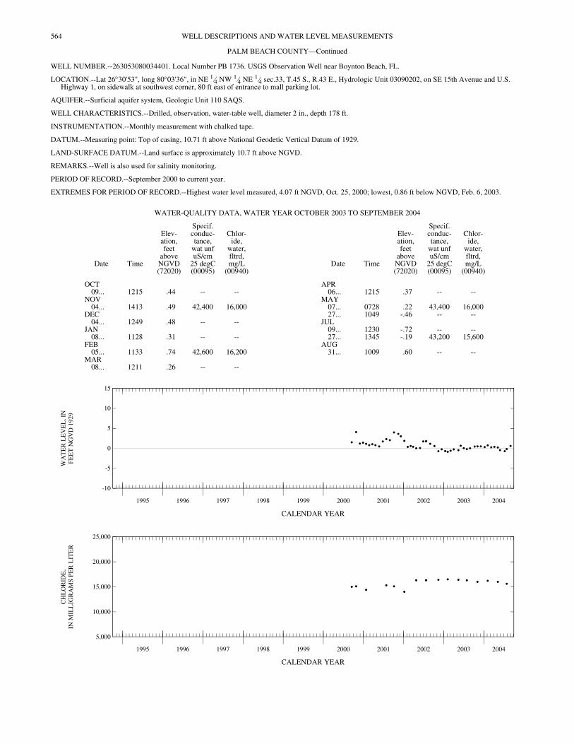
WELL NUMBER.--263053080034401. Local Number PB 1736. USGS Observation Well near Boynton Beach, FL.
LOCATION.--Lat 26°30'53", long 80°03'36", in NE 1⁄4 NW 1⁄4 NE 1⁄4 sec.33, T.45 S., R.43 E., Hydrologic Unit 03090202, on SE 15th Avenue and U.S. Highway 1, on sidewalk at southwest corner, 80 ft east of entrance to mall parking lot.
AQUIFER.--Surficial aquifer system, Geologic Unit 110 SAQS.
WELL CHARACTERISTICS.--Drilled, observation, water-table well, diameter 2 in., depth 178 ft.
INSTRUMENTATION.--Monthly measurement with chalked tape.
DATUM.--Measuring point: Top of casing, 10.71 ft above National Geodetic Vertical Datum of 1929.
LAND-SURFACE DATUM.--Land surface is approximately 10.7 ft above NGVD.
REMARKS.--Well is also used for salinity monitoring.
PERIOD OF RECORD.--September 2000 to current year.
EXTREMES FOR PERIOD OF RECORD.--Highest water level measured, 4.07 ft NGVD, Oct. 25, 2000; lowest, 0.86 ft below NGVD, Feb. 6, 2003.
CALENDAR YEAR
CALENDAR YEAR
WATER-QUALITY DATA, WATER YEAR OCTOBER 2003 TO SEPTEMBER 2004
Date Time
Elev-ation,feet
aboveNGVD(72020)
Specif.conduc-tance,
wat unfuS/cm
25 degC(00095)
Chlor-ide,
water,fltrd,mg/L
(00940)Date Time
Elev-ation,feet
aboveNGVD(72020)
Specif.conduc-tance,
wat unfuS/cm
25 degC(00095)
Chlor-ide,
water,fltrd,mg/L
(00940)
OCT APR09... 1215 .44 -- -- 06... 1215 .37 -- --
NOV MAY04... 1413 .49 42,400 16,000 07... 0728 .22 43,400 16,000
DEC 27... 1049 -.46 -- --04... 1249 .48 -- -- JUL
JAN 09... 1230 -.72 -- --08... 1128 .31 -- -- 27... 1345 -.19 43,200 15,600
FEB AUG05... 1133 .74 42,600 16,200 31... 1009 .60 -- --
MAR08... 1211 .26 -- --
1995 1996 1997 1998 1999 2000 2001 2002 2003 2004
-10
-5
0
5
10
15
WA
TE
R L
EV
EL
, IN
FEE
T N
GV
D 1
929
1995 1996 1997 1998 1999 2000 2001 2002 2003 2004
5,000
10,000
15,000
20,000
25,000
CH
LO
RID
E,
IN M
ILL
IGR
AM
S P
ER
LIT
ER
565WELL DESCRIPTIONS AND WATER LEVEL MEASUREMENTS
PALM BEACH COUNTY—Continued
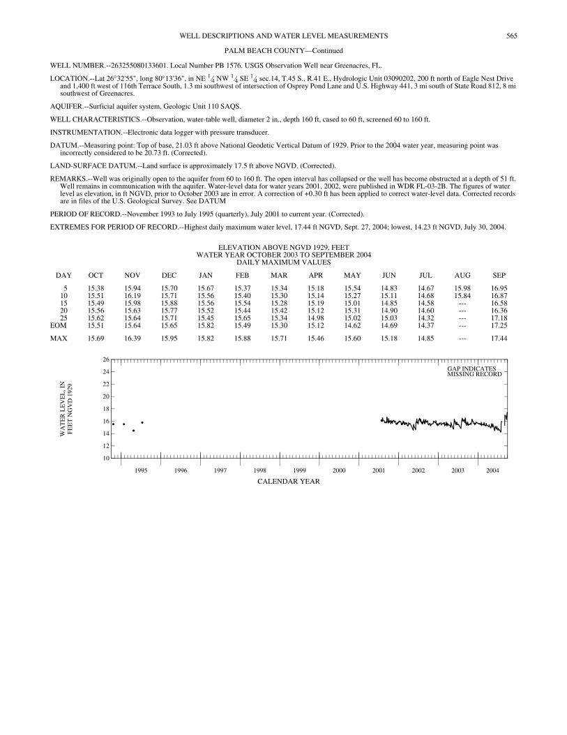
WELL NUMBER.--263255080133601. Local Number PB 1576. USGS Observation Well near Greenacres, FL.
LOCATION.--Lat 26°32'55", long 80°13'36", in NE 1⁄4 NW 1⁄4 SE 1⁄4 sec.14, T.45 S., R.41 E., Hydrologic Unit 03090202, 200 ft north of Eagle Nest Drive and 1,400 ft west of 116th Terrace South, 1.3 mi southwest of intersection of Osprey Pond Lane and U.S. Highway 441, 3 mi south of State Road 812, 8 mi southwest of Greenacres.
AQUIFER.--Surficial aquifer system, Geologic Unit 110 SAQS.
WELL CHARACTERISTICS.--Observation, water-table well, diameter 2 in., depth 160 ft, cased to 60 ft, screened 60 to 160 ft.
INSTRUMENTATION.--Electronic data logger with pressure transducer.
DATUM.--Measuring point: Top of base, 21.03 ft above National Geodetic Vertical Datum of 1929. Prior to the 2004 water year, measuring point was incorrectly considered to be 20.73 ft. (Corrected).
LAND-SURFACE DATUM.--Land surface is approximately 17.5 ft above NGVD. (Corrected).
REMARKS.--Well was originally open to the aquifer from 60 to 160 ft. The open interval has collapsed or the well has become obstructed at a depth of 51 ft. Well remains in communication with the aquifer. Water-level data for water years 2001, 2002, were published in WDR FL-03-2B. The figures of water level as elevation, in ft NGVD, prior to October 2003 are in error. A correction of +0.30 ft has been applied to correct water-level data. Corrected records are in files of the U.S. Geological Survey. See DATUM
PERIOD OF RECORD.--November 1993 to July 1995 (quarterly), July 2001 to current year. (Corrected).
EXTREMES FOR PERIOD OF RECORD.--Highest daily maximum water level, 17.44 ft NGVD, Sept. 27, 2004; lowest, 14.23 ft NGVD, July 30, 2004.
CALENDAR YEAR
ELEVATION ABOVE NGVD 1929, FEET WATER YEAR OCTOBER 2003 TO SEPTEMBER 2004
DAILY MAXIMUM VALUES
DAY OCT NOV DEC JAN FEB MAR APR MAY JUN JUL AUG SEP
5 15.38 15.94 15.70 15.67 15.37 15.34 15.18 15.54 14.83 14.67 15.98 16.9510 15.51 16.19 15.71 15.56 15.40 15.30 15.14 15.27 15.11 14.68 15.84 16.8715 15.49 15.98 15.88 15.56 15.54 15.28 15.19 15.01 14.85 14.58 --- 16.5820 15.56 15.63 15.77 15.52 15.44 15.42 15.12 15.31 14.90 14.60 --- 16.3625 15.62 15.64 15.71 15.45 15.65 15.34 14.98 15.02 15.03 14.32 --- 17.18
EOM 15.51 15.64 15.65 15.82 15.49 15.30 15.12 14.62 14.69 14.37 --- 17.25
MAX 15.69 16.39 15.95 15.82 15.88 15.71 15.46 15.60 15.18 14.85 --- 17.44
1995 1996 1997 1998 1999 2000 2001 2002 2003 2004
10
12
14
16
18
20
22
24
26
WA
TE
R L
EV
EL
, IN
FEE
T N
GV
D 1
929
GAP INDICATESMISSING RECORD
566 WELL DESCRIPTIONS AND WATER LEVEL MEASUREMENTS
PALM BEACH COUNTY—Continued
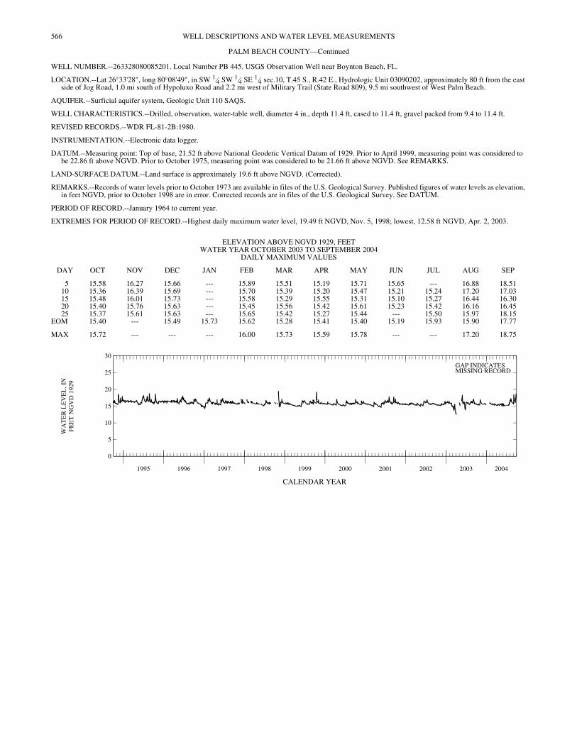
WELL NUMBER.--263328080085201. Local Number PB 445. USGS Observation Well near Boynton Beach, FL.
LOCATION.--Lat 26°33'28", long 80°08'49", in SW 1⁄4 SW 1⁄4 SE 1⁄4 sec.10, T.45 S., R.42 E., Hydrologic Unit 03090202, approximately 80 ft from the east side of Jog Road, 1.0 mi south of Hypoluxo Road and 2.2 mi west of Military Trail (State Road 809), 9.5 mi southwest of West Palm Beach.
AQUIFER.--Surficial aquifer system, Geologic Unit 110 SAQS.
WELL CHARACTERISTICS.--Drilled, observation, water-table well, diameter 4 in., depth 11.4 ft, cased to 11.4 ft, gravel packed from 9.4 to 11.4 ft.
REVISED RECORDS.--WDR FL-81-2B:1980.
INSTRUMENTATION.--Electronic data logger.
DATUM.--Measuring point: Top of base, 21.52 ft above National Geodetic Vertical Datum of 1929. Prior to April 1999, measuring point was considered to be 22.86 ft above NGVD. Prior to October 1975, measuring point was considered to be 21.66 ft above NGVD. See REMARKS.
LAND-SURFACE DATUM.--Land surface is approximately 19.6 ft above NGVD. (Corrected).
REMARKS.--Records of water levels prior to October 1973 are available in files of the U.S. Geological Survey. Published figures of water levels as elevation, in feet NGVD, prior to October 1998 are in error. Corrected records are in files of the U.S. Geological Survey. See DATUM.
PERIOD OF RECORD.--January 1964 to current year.
EXTREMES FOR PERIOD OF RECORD.--Highest daily maximum water level, 19.49 ft NGVD, Nov. 5, 1998; lowest, 12.58 ft NGVD, Apr. 2, 2003.
CALENDAR YEAR
ELEVATION ABOVE NGVD 1929, FEET WATER YEAR OCTOBER 2003 TO SEPTEMBER 2004
DAILY MAXIMUM VALUES
DAY OCT NOV DEC JAN FEB MAR APR MAY JUN JUL AUG SEP
5 15.58 16.27 15.66 --- 15.89 15.51 15.19 15.71 15.65 --- 16.88 18.5110 15.36 16.39 15.69 --- 15.70 15.39 15.20 15.47 15.21 15.24 17.20 17.0315 15.48 16.01 15.73 --- 15.58 15.29 15.55 15.31 15.10 15.27 16.44 16.3020 15.40 15.76 15.63 --- 15.45 15.56 15.42 15.61 15.23 15.42 16.16 16.4525 15.37 15.61 15.63 --- 15.65 15.42 15.27 15.44 --- 15.50 15.97 18.15
EOM 15.40 --- 15.49 15.73 15.62 15.28 15.41 15.40 15.19 15.93 15.90 17.77
MAX 15.72 --- --- --- 16.00 15.73 15.59 15.78 --- --- 17.20 18.75
1995 1996 1997 1998 1999 2000 2001 2002 2003 2004
0
5
10
15
20
25
30
WA
TE
R L
EV
EL
, IN
FEE
T N
GV
D 1
929
GAP INDICATESMISSING RECORD
567WELL DESCRIPTIONS AND WATER LEVEL MEASUREMENTS
PALM BEACH COUNTY—Continued
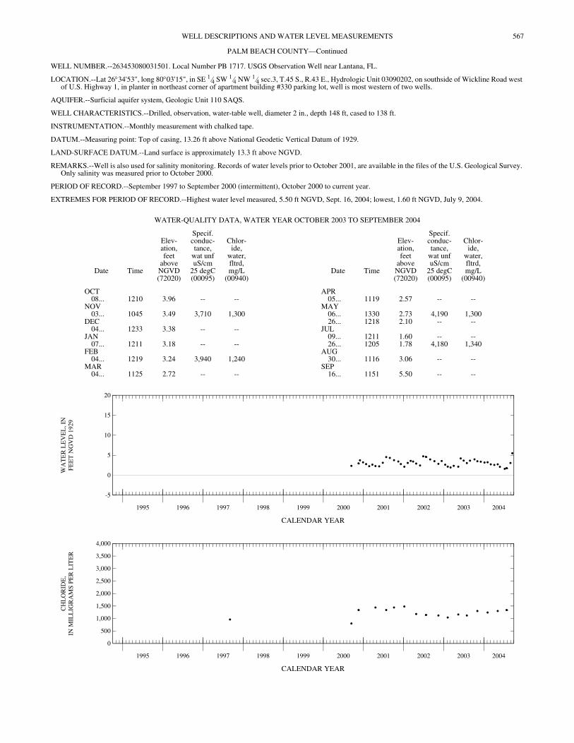
WELL NUMBER.--263453080031501. Local Number PB 1717. USGS Observation Well near Lantana, FL.
LOCATION.--Lat 26°34'53", long 80°03'15", in SE 1⁄4 SW 1⁄4 NW 1⁄4 sec.3, T.45 S., R.43 E., Hydrologic Unit 03090202, on southside of Wickline Road west of U.S. Highway 1, in planter in northeast corner of apartment building #330 parking lot, well is most western of two wells.
AQUIFER.--Surficial aquifer system, Geologic Unit 110 SAQS.
WELL CHARACTERISTICS.--Drilled, observation, water-table well, diameter 2 in., depth 148 ft, cased to 138 ft.
INSTRUMENTATION.--Monthly measurement with chalked tape.
DATUM.--Measuring point: Top of casing, 13.26 ft above National Geodetic Vertical Datum of 1929.
LAND-SURFACE DATUM.--Land surface is approximately 13.3 ft above NGVD.
REMARKS.--Well is also used for salinity monitoring. Records of water levels prior to October 2001, are available in the files of the U.S. Geological Survey. Only salinity was measured prior to October 2000.
PERIOD OF RECORD.--September 1997 to September 2000 (intermittent), October 2000 to current year.
EXTREMES FOR PERIOD OF RECORD.--Highest water level measured, 5.50 ft NGVD, Sept. 16, 2004; lowest, 1.60 ft NGVD, July 9, 2004.
CALENDAR YEAR
CALENDAR YEAR
WATER-QUALITY DATA, WATER YEAR OCTOBER 2003 TO SEPTEMBER 2004
Date Time
Elev-ation,feet
aboveNGVD(72020)
Specif.conduc-tance,
wat unfuS/cm
25 degC(00095)
Chlor-ide,
water,fltrd,mg/L
(00940)Date Time
Elev-ation,feet
aboveNGVD(72020)
Specif.conduc-tance,
wat unfuS/cm
25 degC(00095)
Chlor-ide,
water,fltrd,mg/L
(00940)
OCT APR08... 1210 3.96 -- -- 05... 1119 2.57 -- --
NOV MAY03... 1045 3.49 3,710 1,300 06... 1330 2.73 4,190 1,300
DEC 26... 1218 2.10 -- --04... 1233 3.38 -- -- JUL
JAN 09... 1211 1.60 -- --07... 1211 3.18 -- -- 26... 1205 1.78 4,180 1,340
FEB AUG04... 1219 3.24 3,940 1,240 30... 1116 3.06 -- --
MAR SEP04... 1125 2.72 -- -- 16... 1151 5.50 -- --
1995 1996 1997 1998 1999 2000 2001 2002 2003 2004
-5
0
5
10
15
20
WA
TE
R L
EV
EL
, IN
FEE
T N
GV
D 1
929
1995 1996 1997 1998 1999 2000 2001 2002 2003 2004
0
500
1,000
1,500
2,000
2,500
3,000
3,500
4,000
CH
LO
RID
E,
IN M
ILL
IGR
AM
S P
ER
LIT
ER

568 WELL DESCRIPTIONS AND WATER LEVEL MEASUREMENTS
PALM BEACH COUNTY—Continued
WELL NUMBER.--263524080124301. Local Number PB 683. USGS Observation Well near West Palm Beach, FL.
LOCATION.--Lat 26°35'24", long 80°12'43", in SE 1⁄4 NW 1⁄4 NE 1⁄4 sec.37, T.44 1⁄2 S., R.41 E., Hydrologic Unit 03090202, 0.3 mi west of U.S. Highway 441, south of Lantana Road near TV tower, and 11 mi southwest of West Palm Beach.
AQUIFER.--Surficial aquifer system, Geologic Unit 110 SAQS.
WELL CHARACTERISTICS.--Drilled, observation, water-table well, diameter 6 in., depth 17 ft, cased to 17 ft, open end.
INSTRUMENTATION.--Electronic data logger.
DATUM.--Measuring point: Top of base, 20.85 ft above National Geodetic Vertical Datum of 1929. Prior to October 1989, measuring point was considered to be 18.95 ft above NGVD. See REMARKS.
LAND-SURFACE DATUM.--Land surface is approximately 18.4 ft above NGVD. (Corrected).
REMARKS.--The figures of water levels as elevation, in feet NGVD, prior to October 1989 are in error. Corrected records are in the files of the U.S. Geological Survey. The well has become obstructed at a depth of 13 ft. A review of water-level records indicates that the well remains in good hydrologic communication with the aquifer. See DATUM.
PERIOD OF RECORD.--June 1973 to May 1977, May 1979 to current year.
EXTREMES FOR PERIOD OF RECORD.--Highest daily maximum water level, 18.67 ft NGVD, Sept. 27, 28, 2004; lowest, 13.61 ft NGVD, May 5-8, 1975.
CALENDAR YEAR
ELEVATION ABOVE NGVD 1929, FEET WATER YEAR OCTOBER 2003 TO SEPTEMBER 2004
DAILY MAXIMUM VALUES
DAY OCT NOV DEC JAN FEB MAR APR MAY JUN JUL AUG SEP
5 16.36 16.48 15.77 15.62 16.07 15.66 14.93 15.92 14.95 14.55 16.63 18.2010 15.98 17.03 15.94 15.51 15.81 15.39 14.83 15.45 15.64 15.11 16.90 18.2915 15.77 16.55 16.52 15.36 15.60 15.18 15.43 15.20 15.27 --- 16.64 17.9720 15.55 16.20 16.19 15.48 15.44 15.72 15.12 15.86 14.95 --- 17.05 17.4025 15.39 15.94 16.10 15.28 15.83 15.35 14.89 15.34 14.81 --- 17.15 17.91
EOM 15.34 15.75 15.78 15.74 15.99 15.09 15.05 14.95 14.63 14.90 16.56 18.54
MAX 16.98 17.44 16.52 15.75 16.28 15.90 15.43 16.01 15.64 --- 17.16 18.67
1995 1996 1997 1998 1999 2000 2001 2002 2003 2004
0
5
10
15
20
25
30
WA
TE
R L
EV
EL
, IN
FEE
T N
GV
D 1
929
GAP INDICATESMISSING RECORD
569WELL DESCRIPTIONS AND WATER LEVEL MEASUREMENTS
PALM BEACH COUNTY—Continued
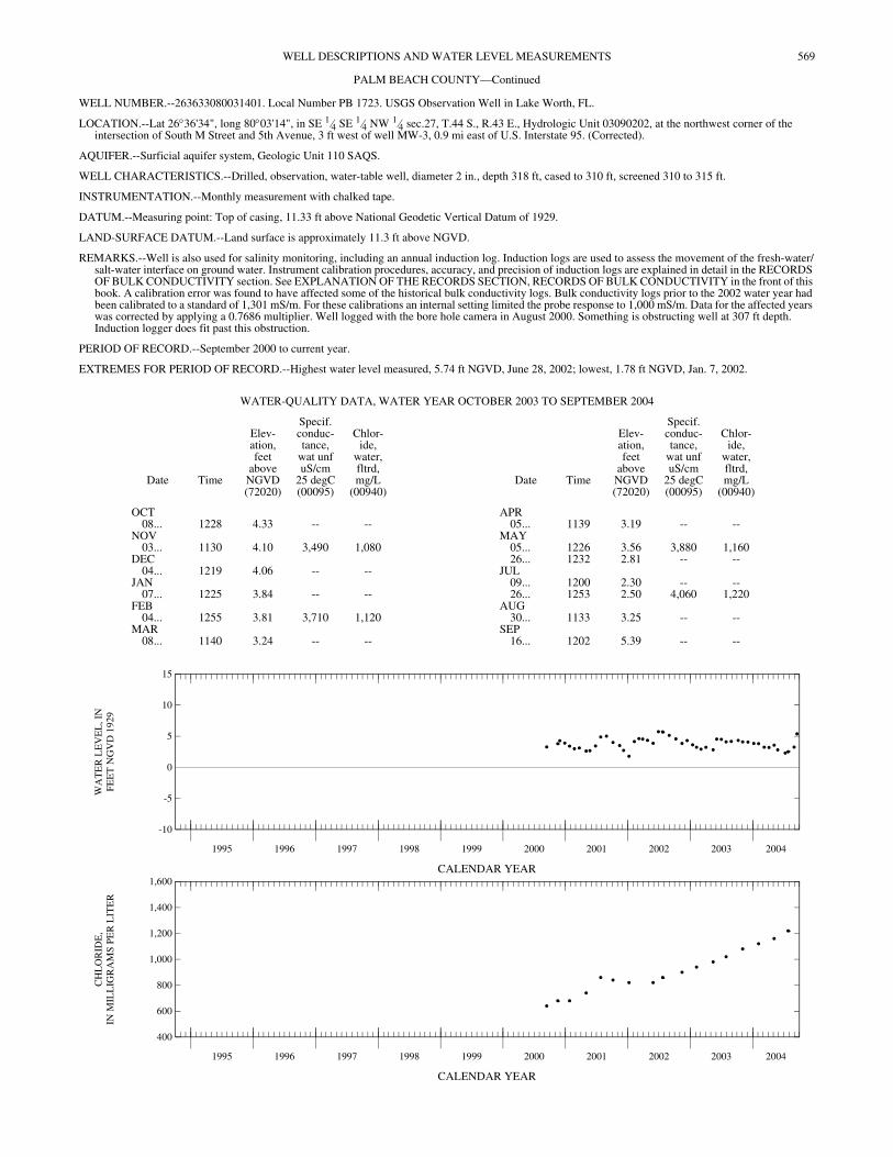
WELL NUMBER.--263633080031401. Local Number PB 1723. USGS Observation Well in Lake Worth, FL.
LOCATION.--Lat 26°36'34", long 80°03'14", in SE 1⁄4 SE 1⁄4 NW 1⁄4 sec.27, T.44 S., R.43 E., Hydrologic Unit 03090202, at the northwest corner of the intersection of South M Street and 5th Avenue, 3 ft west of well MW-3, 0.9 mi east of U.S. Interstate 95. (Corrected).
AQUIFER.--Surficial aquifer system, Geologic Unit 110 SAQS.
WELL CHARACTERISTICS.--Drilled, observation, water-table well, diameter 2 in., depth 318 ft, cased to 310 ft, screened 310 to 315 ft.
INSTRUMENTATION.--Monthly measurement with chalked tape.
DATUM.--Measuring point: Top of casing, 11.33 ft above National Geodetic Vertical Datum of 1929.
LAND-SURFACE DATUM.--Land surface is approximately 11.3 ft above NGVD.
REMARKS.--Well is also used for salinity monitoring, including an annual induction log. Induction logs are used to assess the movement of the fresh-water/salt-water interface on ground water. Instrument calibration procedures, accuracy, and precision of induction logs are explained in detail in the RECORDS OF BULK CONDUCTIVITY section. See EXPLANATION OF THE RECORDS SECTION, RECORDS OF BULK CONDUCTIVITY in the front of this book. A calibration error was found to have affected some of the historical bulk conductivity logs. Bulk conductivity logs prior to the 2002 water year had been calibrated to a standard of 1,301 mS/m. For these calibrations an internal setting limited the probe response to 1,000 mS/m. Data for the affected years was corrected by applying a 0.7686 multiplier. Well logged with the bore hole camera in August 2000. Something is obstructing well at 307 ft depth. Induction logger does fit past this obstruction.
PERIOD OF RECORD.--September 2000 to current year.
EXTREMES FOR PERIOD OF RECORD.--Highest water level measured, 5.74 ft NGVD, June 28, 2002; lowest, 1.78 ft NGVD, Jan. 7, 2002.
CALENDAR YEAR
CALENDAR YEAR
WATER-QUALITY DATA, WATER YEAR OCTOBER 2003 TO SEPTEMBER 2004
Date Time
Elev-ation,feet
aboveNGVD(72020)
Specif.conduc-tance,
wat unfuS/cm
25 degC(00095)
Chlor-ide,
water,fltrd,mg/L
(00940)Date Time
Elev-ation,feet
aboveNGVD(72020)
Specif.conduc-tance,
wat unfuS/cm
25 degC(00095)
Chlor-ide,
water,fltrd,mg/L
(00940)
OCT APR08... 1228 4.33 -- -- 05... 1139 3.19 -- --
NOV MAY03... 1130 4.10 3,490 1,080 05... 1226 3.56 3,880 1,160
DEC 26... 1232 2.81 -- --04... 1219 4.06 -- -- JUL
JAN 09... 1200 2.30 -- --07... 1225 3.84 -- -- 26... 1253 2.50 4,060 1,220
FEB AUG04... 1255 3.81 3,710 1,120 30... 1133 3.25 -- --
MAR SEP08... 1140 3.24 -- -- 16... 1202 5.39 -- --
1995 1996 1997 1998 1999 2000 2001 2002 2003 2004
-10
-5
0
5
10
15
WA
TE
R L
EV
EL
, IN
FEE
T N
GV
D 1
929
1995 1996 1997 1998 1999 2000 2001 2002 2003 2004
400
600
800
1,000
1,200
1,400
1,600
CH
LO
RID
E,
IN M
ILL
IGR
AM
S P
ER
LIT
ER
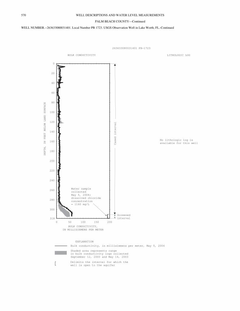
570 WELL DESCRIPTIONS AND WATER LEVEL MEASUREMENTS
PALM BEACH COUNTY—Continued
WELL NUMBER.--263633080031401. Local Number PB 1723. USGS Observation Well in Lake Worth, FL.-Continued
EXPLANATION
BULK CONDUCTIVITY LITHOLOGIC LOG
Casedinterval
Screened
interval
[ Delimits the interval for which the
well is open to the aquifer
Bulk conductivity, in millisiemens per meter, May 5, 2004
0 50 100 150 200
BULK CONDUCTIVITY,
IN MILLISIEMENS PER METER
DEPTH,
IN
FEET
BELOW
LAND
SURFACE
0
20
40
60
80
100
120
140
160
180
200
220
240
260
280
300
318[
Water sample
collected
May
issolved chloride
concentration
= 1160
5, 2004;
d
mg/L
No lithologic log is
available for this well
Shaded area represents range
in bulk conductivity logs collected
September 12, 2000 and May 14, 2003
263633080031401 PB-1723

571WELL DESCRIPTIONS AND WATER LEVEL MEASUREMENTS
PALM BEACH COUNTY—Continued
WELL NUMBER.--263656080033502. Local Number PB 1639. USGS Observation Well in Lake Worth, FL.
LOCATION.--Lat 26°36'56", long 80°03'35", in NW 1⁄4 NE 1⁄4 NE 1⁄4 sec.28, T.44 S., R.43 E., Hydrologic Unit 03090202, on east right of way of Florida East Coast Railroad and south side of Lake Avenue, near City Hall in Lake Worth.
AQUIFER.--Surficial aquifer system, Geologic Unit 110 SAQS.
WELL CHARACTERISTICS.--Drilled, observation, water-table well, diameter 4 in., depth 25 ft, cased to 20 ft, screened from 20 to 25 ft.
INSTRUMENTATION.--Electronic data logger.
DATUM.--Measuring point: Top of base, 19.73 ft above National Geodetic Vertical Datum of 1929. Prior to June 5, 1996, measuring point was 18.45 ft above NGVD.
LAND-SURFACE DATUM.--Land surface is approximately 17.6 ft above NGVD. (Corrected).
REMARKS.--Station reconstructed June 5, 1996.
PERIOD OF RECORD.--May 1989 (semiannual), August 1989 to current year.
EXTREMES FOR PERIOD OF RECORD.--Highest daily maximum water level, 10.83 ft NGVD, Oct. 21, 22, 1995; lowest, 1.97 ft NGVD, July 15, 2004.
CALENDAR YEAR
ELEVATION ABOVE NGVD 1929, FEET WATER YEAR OCTOBER 2003 TO SEPTEMBER 2004
DAILY MAXIMUM VALUES
DAY OCT NOV DEC JAN FEB MAR APR MAY JUN JUL AUG SEP
5 4.71 4.25 4.31 4.13 3.82 3.38 3.06 3.31 2.61 2.16 2.96 5.2710 4.52 5.10 4.25 4.02 3.59 3.28 2.96 3.26 2.53 2.07 3.14 6.0715 4.34 4.97 4.42 3.88 3.52 3.19 3.04 3.08 2.47 1.97 3.36 6.0620 4.19 4.74 4.35 3.78 3.44 3.30 2.97 2.94 2.35 2.24 3.43 6.0825 4.05 4.57 4.46 3.73 3.44 3.18 2.86 2.83 2.28 2.23 3.44 6.42
EOM 3.93 4.38 4.21 3.73 3.57 3.11 3.14 2.71 2.21 2.28 3.32 8.28
MAX 4.75 5.10 4.46 4.16 3.88 3.54 3.14 3.31 2.69 2.28 3.44 8.28
1995 1996 1997 1998 1999 2000 2001 2002 2003 2004
-5
0
5
10
15
20
WA
TE
R L
EV
EL
, IN
FEE
T N
GV
D 1
929
GAP INDICATESMISSING RECORD
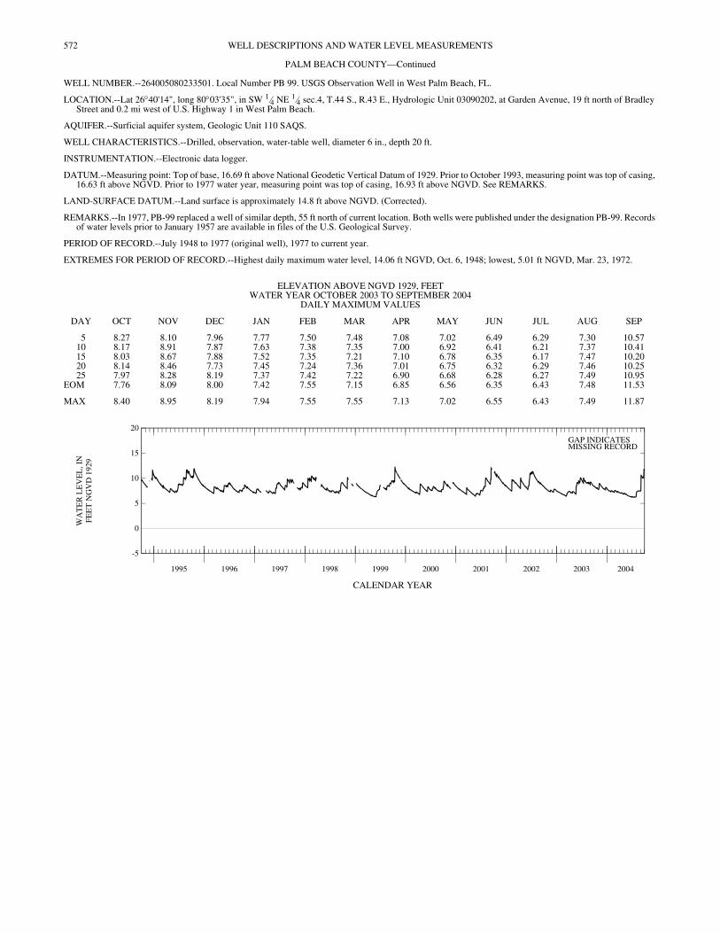
572 WELL DESCRIPTIONS AND WATER LEVEL MEASUREMENTS
PALM BEACH COUNTY—Continued
WELL NUMBER.--264005080233501. Local Number PB 99. USGS Observation Well in West Palm Beach, FL.
LOCATION.--Lat 26°40'14", long 80°03'35", in SW 1⁄4 NE 1⁄4 sec.4, T.44 S., R.43 E., Hydrologic Unit 03090202, at Garden Avenue, 19 ft north of Bradley Street and 0.2 mi west of U.S. Highway 1 in West Palm Beach.
AQUIFER.--Surficial aquifer system, Geologic Unit 110 SAQS.
WELL CHARACTERISTICS.--Drilled, observation, water-table well, diameter 6 in., depth 20 ft.
INSTRUMENTATION.--Electronic data logger.
DATUM.--Measuring point: Top of base, 16.69 ft above National Geodetic Vertical Datum of 1929. Prior to October 1993, measuring point was top of casing, 16.63 ft above NGVD. Prior to 1977 water year, measuring point was top of casing, 16.93 ft above NGVD. See REMARKS.
LAND-SURFACE DATUM.--Land surface is approximately 14.8 ft above NGVD. (Corrected).
REMARKS.--In 1977, PB-99 replaced a well of similar depth, 55 ft north of current location. Both wells were published under the designation PB-99. Records of water levels prior to January 1957 are available in files of the U.S. Geological Survey.
PERIOD OF RECORD.--July 1948 to 1977 (original well), 1977 to current year.
EXTREMES FOR PERIOD OF RECORD.--Highest daily maximum water level, 14.06 ft NGVD, Oct. 6, 1948; lowest, 5.01 ft NGVD, Mar. 23, 1972.
CALENDAR YEAR
ELEVATION ABOVE NGVD 1929, FEET WATER YEAR OCTOBER 2003 TO SEPTEMBER 2004
DAILY MAXIMUM VALUES
DAY OCT NOV DEC JAN FEB MAR APR MAY JUN JUL AUG SEP
5 8.27 8.10 7.96 7.77 7.50 7.48 7.08 7.02 6.49 6.29 7.30 10.5710 8.17 8.91 7.87 7.63 7.38 7.35 7.00 6.92 6.41 6.21 7.37 10.4115 8.03 8.67 7.88 7.52 7.35 7.21 7.10 6.78 6.35 6.17 7.47 10.2020 8.14 8.46 7.73 7.45 7.24 7.36 7.01 6.75 6.32 6.29 7.46 10.2525 7.97 8.28 8.19 7.37 7.42 7.22 6.90 6.68 6.28 6.27 7.49 10.95
EOM 7.76 8.09 8.00 7.42 7.55 7.15 6.85 6.56 6.35 6.43 7.48 11.53
MAX 8.40 8.95 8.19 7.94 7.55 7.55 7.13 7.02 6.55 6.43 7.49 11.87
1995 1996 1997 1998 1999 2000 2001 2002 2003 2004
-5
0
5
10
15
20
WA
TE
R L
EV
EL
, IN
FEE
T N
GV
D 1
929
GAP INDICATESMISSING RECORD
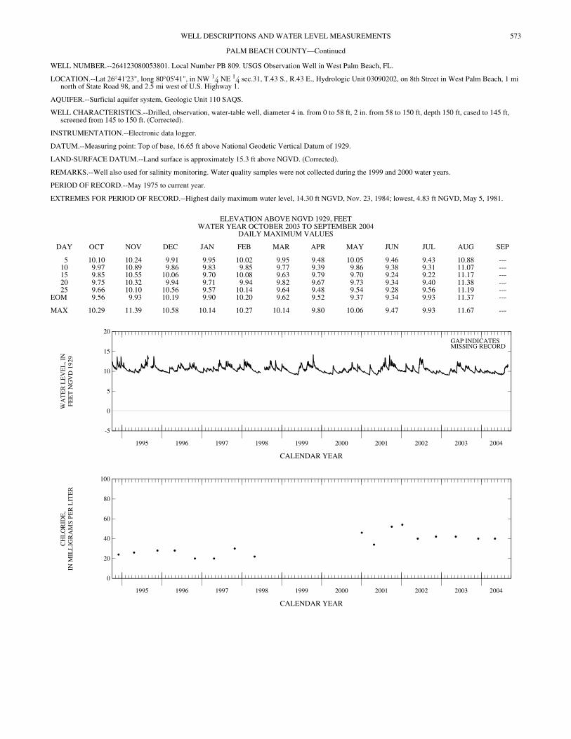
573WELL DESCRIPTIONS AND WATER LEVEL MEASUREMENTS
PALM BEACH COUNTY—Continued
WELL NUMBER.--264123080053801. Local Number PB 809. USGS Observation Well in West Palm Beach, FL.
LOCATION.--Lat 26°41'23", long 80°05'41", in NW 1⁄4 NE 1⁄4 sec.31, T.43 S., R.43 E., Hydrologic Unit 03090202, on 8th Street in West Palm Beach, 1 mi north of State Road 98, and 2.5 mi west of U.S. Highway 1.
AQUIFER.--Surficial aquifer system, Geologic Unit 110 SAQS.
WELL CHARACTERISTICS.--Drilled, observation, water-table well, diameter 4 in. from 0 to 58 ft, 2 in. from 58 to 150 ft, depth 150 ft, cased to 145 ft, screened from 145 to 150 ft. (Corrected).
INSTRUMENTATION.--Electronic data logger.
DATUM.--Measuring point: Top of base, 16.65 ft above National Geodetic Vertical Datum of 1929.
LAND-SURFACE DATUM.--Land surface is approximately 15.3 ft above NGVD. (Corrected).
REMARKS.--Well also used for salinity monitoring. Water quality samples were not collected during the 1999 and 2000 water years.
PERIOD OF RECORD.--May 1975 to current year.
EXTREMES FOR PERIOD OF RECORD.--Highest daily maximum water level, 14.30 ft NGVD, Nov. 23, 1984; lowest, 4.83 ft NGVD, May 5, 1981.
CALENDAR YEAR
CALENDAR YEAR
ELEVATION ABOVE NGVD 1929, FEET WATER YEAR OCTOBER 2003 TO SEPTEMBER 2004
DAILY MAXIMUM VALUES
DAY OCT NOV DEC JAN FEB MAR APR MAY JUN JUL AUG SEP
5 10.10 10.24 9.91 9.95 10.02 9.95 9.48 10.05 9.46 9.43 10.88 ---10 9.97 10.89 9.86 9.83 9.85 9.77 9.39 9.86 9.38 9.31 11.07 ---15 9.85 10.55 10.06 9.70 10.08 9.63 9.79 9.70 9.24 9.22 11.17 ---20 9.75 10.32 9.94 9.71 9.94 9.82 9.67 9.73 9.34 9.40 11.38 ---25 9.66 10.10 10.56 9.57 10.14 9.64 9.48 9.54 9.28 9.56 11.19 ---
EOM 9.56 9.93 10.19 9.90 10.20 9.62 9.52 9.37 9.34 9.93 11.37 ---
MAX 10.29 11.39 10.58 10.14 10.27 10.14 9.80 10.06 9.47 9.93 11.67 ---
1995 1996 1997 1998 1999 2000 2001 2002 2003 2004
-5
0
5
10
15
20
WA
TE
R L
EV
EL
, IN
FEE
T N
GV
D 1
929
GAP INDICATESMISSING RECORD
1995 1996 1997 1998 1999 2000 2001 2002 2003 2004
0
20
40
60
80
100
CH
LO
RID
E,
IN M
ILL
IGR
AM
S P
ER
LIT
ER
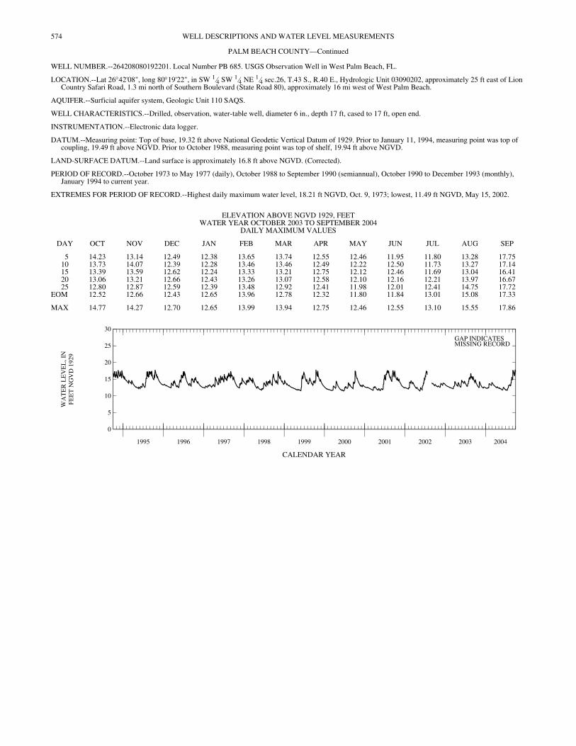
574 WELL DESCRIPTIONS AND WATER LEVEL MEASUREMENTS
PALM BEACH COUNTY—Continued
WELL NUMBER.--264208080192201. Local Number PB 685. USGS Observation Well in West Palm Beach, FL.
LOCATION.--Lat 26°42'08", long 80°19'22", in SW 1⁄4 SW 1⁄4 NE 1⁄4 sec.26, T.43 S., R.40 E., Hydrologic Unit 03090202, approximately 25 ft east of Lion Country Safari Road, 1.3 mi north of Southern Boulevard (State Road 80), approximately 16 mi west of West Palm Beach.
AQUIFER.--Surficial aquifer system, Geologic Unit 110 SAQS.
WELL CHARACTERISTICS.--Drilled, observation, water-table well, diameter 6 in., depth 17 ft, cased to 17 ft, open end.
INSTRUMENTATION.--Electronic data logger.
DATUM.--Measuring point: Top of base, 19.32 ft above National Geodetic Vertical Datum of 1929. Prior to January 11, 1994, measuring point was top of coupling, 19.49 ft above NGVD. Prior to October 1988, measuring point was top of shelf, 19.94 ft above NGVD.
LAND-SURFACE DATUM.--Land surface is approximately 16.8 ft above NGVD. (Corrected).
PERIOD OF RECORD.--October 1973 to May 1977 (daily), October 1988 to September 1990 (semiannual), October 1990 to December 1993 (monthly), January 1994 to current year.
EXTREMES FOR PERIOD OF RECORD.--Highest daily maximum water level, 18.21 ft NGVD, Oct. 9, 1973; lowest, 11.49 ft NGVD, May 15, 2002.
CALENDAR YEAR
ELEVATION ABOVE NGVD 1929, FEET WATER YEAR OCTOBER 2003 TO SEPTEMBER 2004
DAILY MAXIMUM VALUES
DAY OCT NOV DEC JAN FEB MAR APR MAY JUN JUL AUG SEP
5 14.23 13.14 12.49 12.38 13.65 13.74 12.55 12.46 11.95 11.80 13.28 17.7510 13.73 14.07 12.39 12.28 13.46 13.46 12.49 12.22 12.50 11.73 13.27 17.1415 13.39 13.59 12.62 12.24 13.33 13.21 12.75 12.12 12.46 11.69 13.04 16.4120 13.06 13.21 12.66 12.43 13.26 13.07 12.58 12.10 12.16 12.21 13.97 16.6725 12.80 12.87 12.59 12.39 13.48 12.92 12.41 11.98 12.01 12.41 14.75 17.72
EOM 12.52 12.66 12.43 12.65 13.96 12.78 12.32 11.80 11.84 13.01 15.08 17.33
MAX 14.77 14.27 12.70 12.65 13.99 13.94 12.75 12.46 12.55 13.10 15.55 17.86
1995 1996 1997 1998 1999 2000 2001 2002 2003 2004
0
5
10
15
20
25
30
WA
TE
R L
EV
EL
, IN
FEE
T N
GV
D 1
929
GAP INDICATESMISSING RECORD
575WELL DESCRIPTIONS AND WATER LEVEL MEASUREMENTS
PALM BEACH COUNTY—Continued
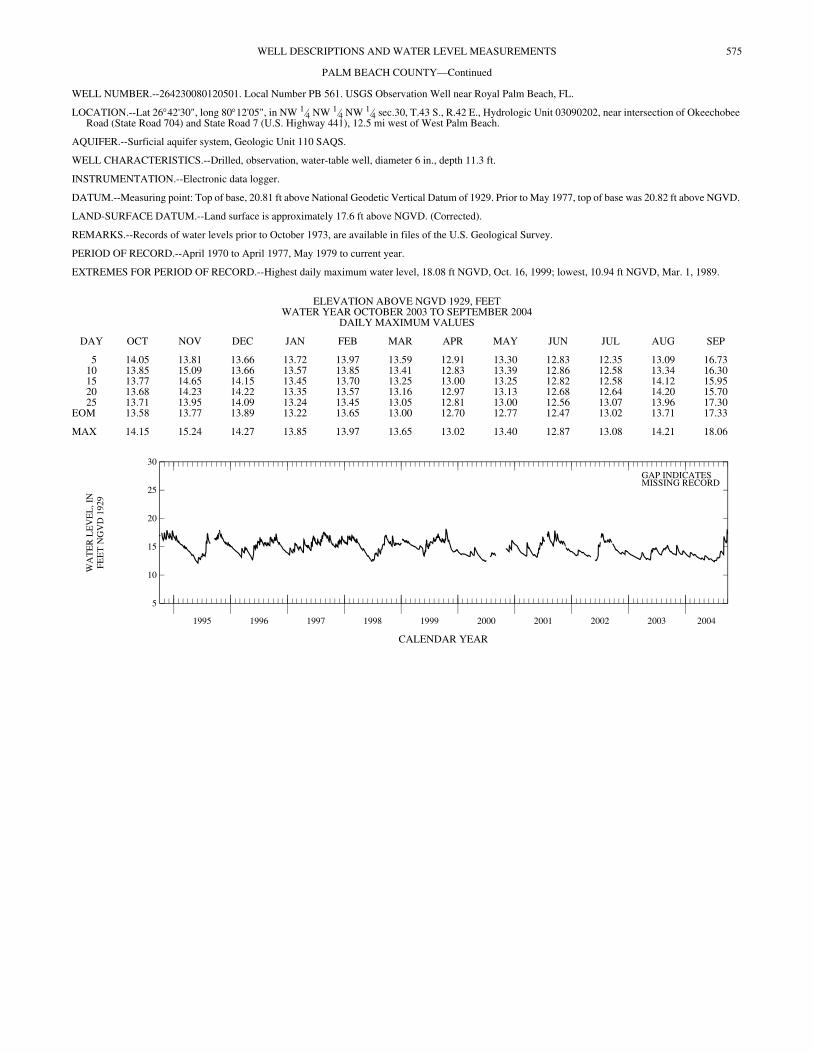
WELL NUMBER.--264230080120501. Local Number PB 561. USGS Observation Well near Royal Palm Beach, FL.
LOCATION.--Lat 26°42'30", long 80°12'05", in NW 1⁄4 NW 1⁄4 NW 1⁄4 sec.30, T.43 S., R.42 E., Hydrologic Unit 03090202, near intersection of Okeechobee Road (State Road 704) and State Road 7 (U.S. Highway 441), 12.5 mi west of West Palm Beach.
AQUIFER.--Surficial aquifer system, Geologic Unit 110 SAQS.
WELL CHARACTERISTICS.--Drilled, observation, water-table well, diameter 6 in., depth 11.3 ft.
INSTRUMENTATION.--Electronic data logger.
DATUM.--Measuring point: Top of base, 20.81 ft above National Geodetic Vertical Datum of 1929. Prior to May 1977, top of base was 20.82 ft above NGVD.
LAND-SURFACE DATUM.--Land surface is approximately 17.6 ft above NGVD. (Corrected).
REMARKS.--Records of water levels prior to October 1973, are available in files of the U.S. Geological Survey.
PERIOD OF RECORD.--April 1970 to April 1977, May 1979 to current year.
EXTREMES FOR PERIOD OF RECORD.--Highest daily maximum water level, 18.08 ft NGVD, Oct. 16, 1999; lowest, 10.94 ft NGVD, Mar. 1, 1989.
CALENDAR YEAR
ELEVATION ABOVE NGVD 1929, FEET WATER YEAR OCTOBER 2003 TO SEPTEMBER 2004
DAILY MAXIMUM VALUES
DAY OCT NOV DEC JAN FEB MAR APR MAY JUN JUL AUG SEP
5 14.05 13.81 13.66 13.72 13.97 13.59 12.91 13.30 12.83 12.35 13.09 16.7310 13.85 15.09 13.66 13.57 13.85 13.41 12.83 13.39 12.86 12.58 13.34 16.3015 13.77 14.65 14.15 13.45 13.70 13.25 13.00 13.25 12.82 12.58 14.12 15.9520 13.68 14.23 14.22 13.35 13.57 13.16 12.97 13.13 12.68 12.64 14.20 15.7025 13.71 13.95 14.09 13.24 13.45 13.05 12.81 13.00 12.56 13.07 13.96 17.30
EOM 13.58 13.77 13.89 13.22 13.65 13.00 12.70 12.77 12.47 13.02 13.71 17.33
MAX 14.15 15.24 14.27 13.85 13.97 13.65 13.02 13.40 12.87 13.08 14.21 18.06
1995 1996 1997 1998 1999 2000 2001 2002 2003 2004
5
10
15
20
25
30
WA
TE
R L
EV
EL
, IN
FEE
T N
GV
D 1
929
GAP INDICATESMISSING RECORD
576 WELL DESCRIPTIONS AND WATER LEVEL MEASUREMENTS
PALM BEACH COUNTY—Continued
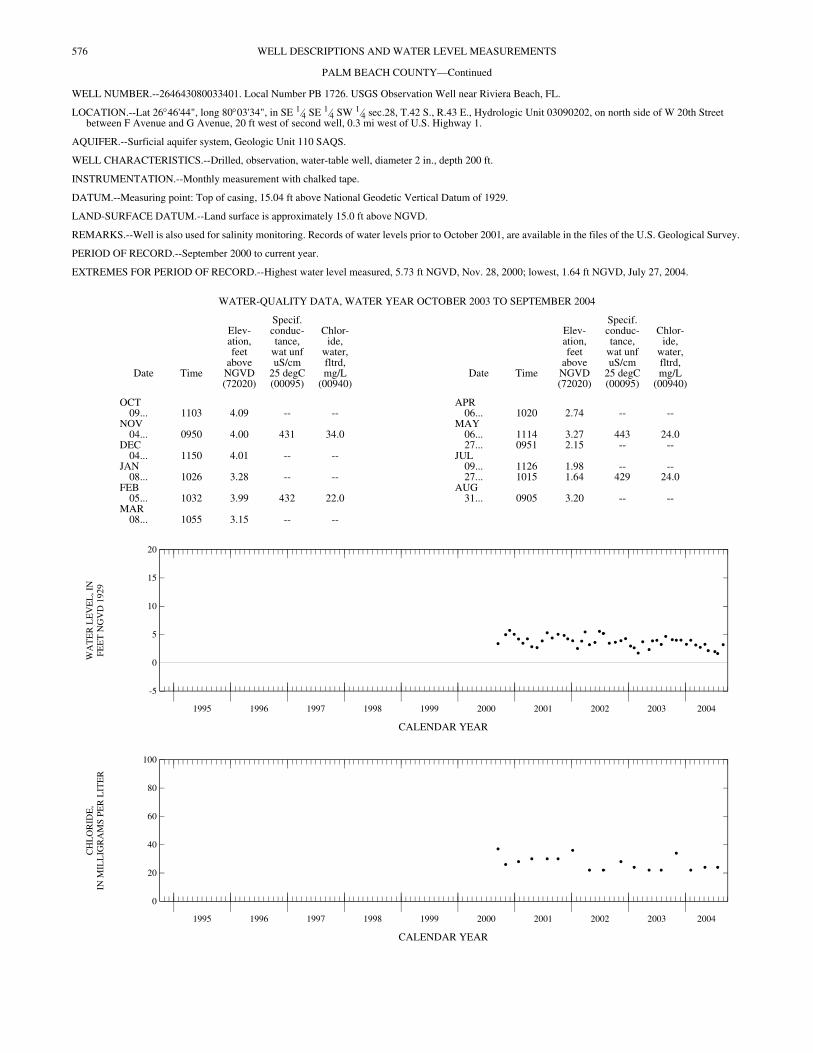
WELL NUMBER.--264643080033401. Local Number PB 1726. USGS Observation Well near Riviera Beach, FL.
LOCATION.--Lat 26°46'44", long 80°03'34", in SE 1⁄4 SE 1⁄4 SW 1⁄4 sec.28, T.42 S., R.43 E., Hydrologic Unit 03090202, on north side of W 20th Street between F Avenue and G Avenue, 20 ft west of second well, 0.3 mi west of U.S. Highway 1.
AQUIFER.--Surficial aquifer system, Geologic Unit 110 SAQS.
WELL CHARACTERISTICS.--Drilled, observation, water-table well, diameter 2 in., depth 200 ft.
INSTRUMENTATION.--Monthly measurement with chalked tape.
DATUM.--Measuring point: Top of casing, 15.04 ft above National Geodetic Vertical Datum of 1929.
LAND-SURFACE DATUM.--Land surface is approximately 15.0 ft above NGVD.
REMARKS.--Well is also used for salinity monitoring. Records of water levels prior to October 2001, are available in the files of the U.S. Geological Survey.
PERIOD OF RECORD.--September 2000 to current year.
EXTREMES FOR PERIOD OF RECORD.--Highest water level measured, 5.73 ft NGVD, Nov. 28, 2000; lowest, 1.64 ft NGVD, July 27, 2004.
CALENDAR YEAR
CALENDAR YEAR
WATER-QUALITY DATA, WATER YEAR OCTOBER 2003 TO SEPTEMBER 2004
Date Time
Elev-ation,feet
aboveNGVD(72020)
Specif.conduc-tance,
wat unfuS/cm
25 degC(00095)
Chlor-ide,
water,fltrd,mg/L
(00940)Date Time
Elev-ation,feet
aboveNGVD(72020)
Specif.conduc-tance,
wat unfuS/cm
25 degC(00095)
Chlor-ide,
water,fltrd,mg/L
(00940)
OCT APR09... 1103 4.09 -- -- 06... 1020 2.74 -- --
NOV MAY04... 0950 4.00 431 34.0 06... 1114 3.27 443 24.0
DEC 27... 0951 2.15 -- --04... 1150 4.01 -- -- JUL
JAN 09... 1126 1.98 -- --08... 1026 3.28 -- -- 27... 1015 1.64 429 24.0
FEB AUG05... 1032 3.99 432 22.0 31... 0905 3.20 -- --
MAR08... 1055 3.15 -- --
1995 1996 1997 1998 1999 2000 2001 2002 2003 2004
-5
0
5
10
15
20
WA
TE
R L
EV
EL
, IN
FEE
T N
GV
D 1
929
1995 1996 1997 1998 1999 2000 2001 2002 2003 2004
0
20
40
60
80
100
CH
LO
RID
E,
IN M
ILL
IGR
AM
S P
ER
LIT
ER
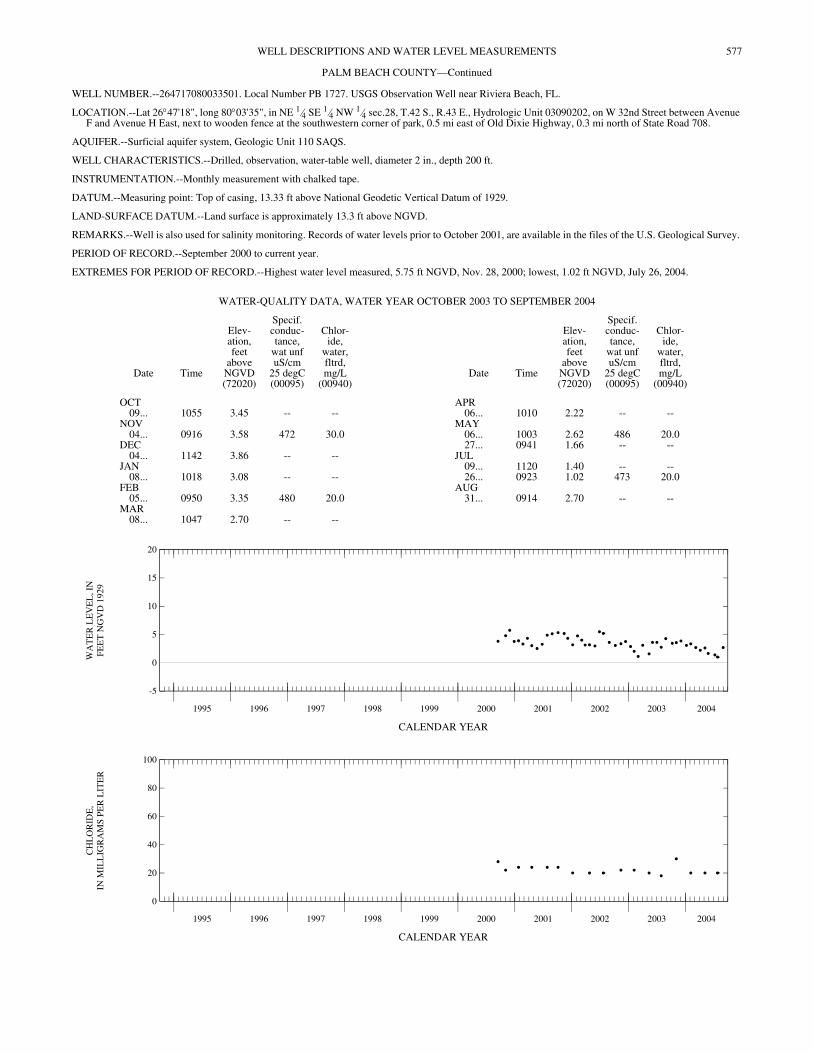
577WELL DESCRIPTIONS AND WATER LEVEL MEASUREMENTS
PALM BEACH COUNTY—Continued
WELL NUMBER.--264717080033501. Local Number PB 1727. USGS Observation Well near Riviera Beach, FL.
LOCATION.--Lat 26°47'18", long 80°03'35", in NE 1⁄4 SE 1⁄4 NW 1⁄4 sec.28, T.42 S., R.43 E., Hydrologic Unit 03090202, on W 32nd Street between Avenue F and Avenue H East, next to wooden fence at the southwestern corner of park, 0.5 mi east of Old Dixie Highway, 0.3 mi north of State Road 708.
AQUIFER.--Surficial aquifer system, Geologic Unit 110 SAQS.
WELL CHARACTERISTICS.--Drilled, observation, water-table well, diameter 2 in., depth 200 ft.
INSTRUMENTATION.--Monthly measurement with chalked tape.
DATUM.--Measuring point: Top of casing, 13.33 ft above National Geodetic Vertical Datum of 1929.
LAND-SURFACE DATUM.--Land surface is approximately 13.3 ft above NGVD.
REMARKS.--Well is also used for salinity monitoring. Records of water levels prior to October 2001, are available in the files of the U.S. Geological Survey.
PERIOD OF RECORD.--September 2000 to current year.
EXTREMES FOR PERIOD OF RECORD.--Highest water level measured, 5.75 ft NGVD, Nov. 28, 2000; lowest, 1.02 ft NGVD, July 26, 2004.
CALENDAR YEAR
CALENDAR YEAR
WATER-QUALITY DATA, WATER YEAR OCTOBER 2003 TO SEPTEMBER 2004
Date Time
Elev-ation,feet
aboveNGVD(72020)
Specif.conduc-tance,
wat unfuS/cm
25 degC(00095)
Chlor-ide,
water,fltrd,mg/L
(00940)Date Time
Elev-ation,feet
aboveNGVD(72020)
Specif.conduc-tance,
wat unfuS/cm
25 degC(00095)
Chlor-ide,
water,fltrd,mg/L
(00940)
OCT APR09... 1055 3.45 -- -- 06... 1010 2.22 -- --
NOV MAY04... 0916 3.58 472 30.0 06... 1003 2.62 486 20.0
DEC 27... 0941 1.66 -- --04... 1142 3.86 -- -- JUL
JAN 09... 1120 1.40 -- --08... 1018 3.08 -- -- 26... 0923 1.02 473 20.0
FEB AUG05... 0950 3.35 480 20.0 31... 0914 2.70 -- --
MAR08... 1047 2.70 -- --
1995 1996 1997 1998 1999 2000 2001 2002 2003 2004
-5
0
5
10
15
20
WA
TE
R L
EV
EL
, IN
FEE
T N
GV
D 1
929
1995 1996 1997 1998 1999 2000 2001 2002 2003 2004
0
20
40
60
80
100
CH
LO
RID
E,
IN M
ILL
IGR
AM
S P
ER
LIT
ER
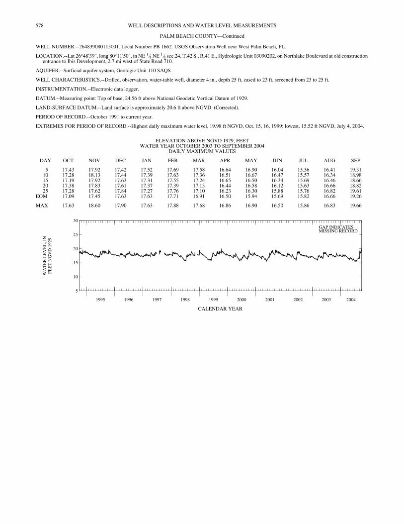
578 WELL DESCRIPTIONS AND WATER LEVEL MEASUREMENTS
PALM BEACH COUNTY—Continued
WELL NUMBER.--264839080115001. Local Number PB 1662. USGS Observation Well near West Palm Beach, FL.
LOCATION.--Lat 26°48'39", long 80°11'50", in NE 1⁄4 NE 1⁄4 sec.24, T.42 S., R.41 E., Hydrologic Unit 03090202, on Northlake Boulevard at old construction entrance to Ibis Development, 2.7 mi west of State Road 710.
AQUIFER.--Surficial aquifer system, Geologic Unit 110 SAQS.
WELL CHARACTERISTICS.--Drilled, observation, water-table well, diameter 4 in., depth 25 ft, cased to 23 ft, screened from 23 to 25 ft.
INSTRUMENTATION.--Electronic data logger.
DATUM.--Measuring point: Top of base, 24.56 ft above National Geodetic Vertical Datum of 1929.
LAND-SURFACE DATUM.--Land surface is approximately 20.6 ft above NGVD. (Corrected).
PERIOD OF RECORD.--October 1991 to current year.
EXTREMES FOR PERIOD OF RECORD.--Highest daily maximum water level, 19.98 ft NGVD, Oct. 15, 16, 1999; lowest, 15.52 ft NGVD, July 4, 2004.
CALENDAR YEAR
ELEVATION ABOVE NGVD 1929, FEET WATER YEAR OCTOBER 2003 TO SEPTEMBER 2004
DAILY MAXIMUM VALUES
DAY OCT NOV DEC JAN FEB MAR APR MAY JUN JUL AUG SEP
5 17.43 17.92 17.42 17.52 17.69 17.58 16.64 16.90 16.04 15.56 16.41 19.3110 17.28 18.13 17.44 17.39 17.63 17.36 16.51 16.67 16.47 15.57 16.34 18.9815 17.19 17.92 17.63 17.31 17.55 17.24 16.65 16.50 16.34 15.69 16.46 18.6620 17.38 17.83 17.61 17.37 17.39 17.13 16.44 16.58 16.12 15.63 16.66 18.8225 17.28 17.62 17.84 17.27 17.76 17.10 16.23 16.30 15.88 15.76 16.82 19.61
EOM 17.09 17.45 17.63 17.63 17.71 16.91 16.50 15.94 15.69 15.82 16.66 19.26
MAX 17.63 18.60 17.90 17.63 17.88 17.68 16.86 16.90 16.50 15.86 16.83 19.66
1995 1996 1997 1998 1999 2000 2001 2002 2003 2004
5
10
15
20
25
30
WA
TE
R L
EV
EL
, IN
FEE
T N
GV
D 1
929
GAP INDICATESMISSING RECORD

579WELL DESCRIPTIONS AND WATER LEVEL MEASUREMENTS
PALM BEACH COUNTY—Continued
WELL NUMBER.--264858080044801. Local Number PB 1734. USGS Observation Well near North Palm Beach, FL.
LOCATION.--Lat 26°48'58", long 80°04'49", in SW 1⁄4 SW 1⁄4 NW 1⁄4 sec.17, T.42 S., R.43 E., Hydrologic Unit 03090202, on U.S. Highway 1 Alternate A1A (State Road 811) just north of Hinda Road, 20 ft north from end of eastern side road parallel to U.S. Highway 1 Alternate A1A, 1.2 mi east of U.S. Interstate 95. (Corrected).
AQUIFER.--Surficial aquifer system, Geologic Unit 110 SAQS.
WELL CHARACTERISTICS.--Drilled, observation, water-table well, diameter 2 in., depth 115 ft, cased to 95 ft, screened 95 to 115 ft.
INSTRUMENTATION.--Monthly measurement with chalked tape.
DATUM.--Measuring point: Top of casing, 10.62 ft above National Geodetic Vertical Datum of 1929.
LAND-SURFACE DATUM.--Land surface is approximately 10.6 ft above NGVD.
REMARKS.--Well is also used for salinity monitoring. Records of water levels prior to October 2001, are available in the files of the U.S. Geological Survey.
PERIOD OF RECORD.--September 2000 to current year.
EXTREMES FOR PERIOD OF RECORD.--Highest water level measured, 2.71 ft NGVD, Oct. 9, 2003; lowest, 0.45 ft NGVD, Jan. 7, 2002.
CALENDAR YEAR
CALENDAR YEAR
WATER-QUALITY DATA, WATER YEAR OCTOBER 2003 TO SEPTEMBER 2004
Date Time
Elev-ation,feet
aboveNGVD(72020)
Specif.conduc-tance,
wat unfuS/cm
25 degC(00095)
Chlor-ide,
water,fltrd,mg/L
(00940)Date Time
Elev-ation,feet
aboveNGVD(72020)
Specif.conduc-tance,
wat unfuS/cm
25 degC(00095)
Chlor-ide,
water,fltrd,mg/L
(00940)
OCT APR09... 1040 2.71 -- -- 06... 0950 1.85 -- --
NOV MAY04... 0850 2.62 460 46.0 06... 0920 1.83 461 40.0
DEC 27... 0927 1.13 -- --04... 1127 2.11 -- -- JUL
JAN 09... 1059 .78 -- --08... 0958 1.85 -- -- 27... 0852 .86 451 42.0
FEB AUG05... 0920 2.64 451 42.0 31... 0925 1.41 -- --
MAR08... 1030 1.89 -- --
1995 1996 1997 1998 1999 2000 2001 2002 2003 2004
-5
0
5
10
15
20
WA
TE
R L
EV
EL
, IN
FEE
T N
GV
D 1
929
1995 1996 1997 1998 1999 2000 2001 2002 2003 2004
0
20
40
60
80
100
CH
LO
RID
E,
IN M
ILL
IGR
AM
S P
ER
LIT
ER

580 WELL DESCRIPTIONS AND WATER LEVEL MEASUREMENTS
PALM BEACH COUNTY—Continued
WELL NUMBER.--265106080241402. Local Number PB 831. USGS Observation Well near Palm Beach Gardens, FL.
LOCATION.--Lat 26°51'04", long 80°24'43", in SW 1⁄4 NE 1⁄4 NW 1⁄4 sec.2, T.42 S., R.39 E., Hydrologic Unit 03090202, 30 ft west of principal dirt road within J.W. Corbett Wildlife Management Area, 8.7 mi from north entrance at junction of State Road 706 and State Road 710, approximately 15 mi west of Palm Beach Gardens. (Corrected).
AQUIFER.--Surficial aquifer system, Geologic Unit 110 SAQS.
WELL CHARACTERISTICS.--Drilled, observation, water-table well, diameter 4 in., depth 25 ft, cased to 21 ft, screened from 21 to 25 ft.
INSTRUMENTATION.--Electronic data logger.
DATUM.--Measuring point: Top of base, 26.47 ft above National Geodetic Vertical Datum of 1929. Prior to October 1988, top of base was incorrectly considered to be 24.90 ft above NGVD. See REMARKS.
LAND-SURFACE DATUM.--Land surface is approximately 24.0 ft above NGVD. (Corrected).
REMARKS.--Previously published figures of water levels as elevations in feet NGVD, prior to October 1988 are in error. Previously corrected figures in the files of the U.S. Geological Survey have been calculated based on an arbitrary 25.0 ft measuring point. A correction of +0.10 ft is required to correct the water-level data. See DATUM. Well was originally open to the aquifer from 21 to 25 ft. The open interval has collapsed or become obstructed at 21 ft.
PERIOD OF RECORD.--November 1974 to current year.
EXTREMES FOR PERIOD OF RECORD.--Highest daily maximum water level, 23.79 ft NGVD, May 5, 1975; lowest, 18.53 ft NGVD, June 5, 1989.
CALENDAR YEAR
ELEVATION ABOVE NGVD 1929, FEET WATER YEAR OCTOBER 2003 TO SEPTEMBER 2004
DAILY MAXIMUM VALUES
DAY OCT NOV DEC JAN FEB MAR APR MAY JUN JUL AUG SEP
5 22.44 22.49 22.26 21.63 21.85 21.71 20.26 20.64 20.40 21.39 22.22 23.0510 22.11 22.48 22.00 21.46 21.54 21.38 20.05 20.16 20.50 20.83 22.31 22.8615 21.93 22.26 22.32 21.28 21.74 21.12 20.55 19.85 20.97 21.21 22.63 22.5520 21.68 22.30 22.20 21.78 21.29 20.95 20.12 19.63 21.41 21.60 22.36 22.7725 21.45 21.99 22.10 21.32 22.17 20.74 19.83 19.40 21.47 21.56 22.41 23.21
EOM 21.26 21.78 21.81 22.14 22.01 20.50 20.29 19.18 21.20 21.73 21.99 ---
MAX 22.70 22.57 22.35 22.14 22.20 21.95 20.65 20.68 21.67 21.98 22.63 ---
1995 1996 1997 1998 1999 2000 2001 2002 2003 2004
10
15
20
25
30
35
WA
TE
R L
EV
EL
, IN
FEE
T N
GV
D 1
929
GAP INDICATESMISSING RECORD
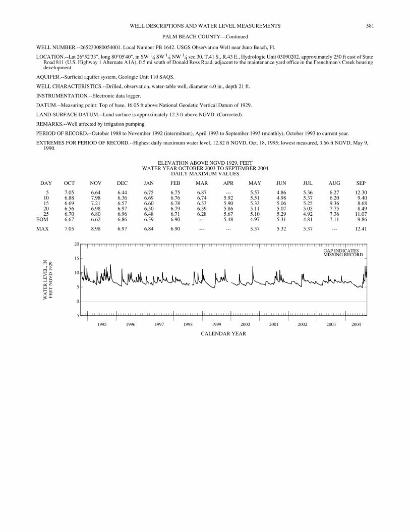
581WELL DESCRIPTIONS AND WATER LEVEL MEASUREMENTS
PALM BEACH COUNTY—Continued
WELL NUMBER.--265233080054001. Local Number PB 1642. USGS Observation Well near Juno Beach, Fl.
LOCATION.--Lat 26°52'33", long 80°05'40", in SW 1⁄4 SW 1⁄4 NW 1⁄4 sec.30, T.41 S., R.43 E., Hydrologic Unit 03090202, approximately 250 ft east of State Road 811 (U.S. Highway 1 Alternate A1A), 0.5 mi south of Donald Ross Road, adjacent to the maintenance yard office in the Frenchman's Creek housing development.
AQUIFER.--Surficial aquifer system, Geologic Unit 110 SAQS.
WELL CHARACTERISTICS.--Drilled, observation, water-table well, diameter 4.0 in., depth 21 ft.
INSTRUMENTATION.--Electronic data logger.
DATUM.--Measuring point: Top of base, 16.05 ft above National Geodetic Vertical Datum of 1929.
LAND-SURFACE DATUM.--Land surface is approximately 12.3 ft above NGVD. (Corrected).
REMARKS.--Well affected by irrigation pumping.
PERIOD OF RECORD.--October 1988 to November 1992 (intermittent), April 1993 to September 1993 (monthly), October 1993 to current year.
EXTREMES FOR PERIOD OF RECORD.--Highest daily maximum water level, 12.82 ft NGVD, Oct. 18, 1995; lowest measured, 3.66 ft NGVD, May 9, 1990.
CALENDAR YEAR
ELEVATION ABOVE NGVD 1929, FEET WATER YEAR OCTOBER 2003 TO SEPTEMBER 2004
DAILY MAXIMUM VALUES
DAY OCT NOV DEC JAN FEB MAR APR MAY JUN JUL AUG SEP
5 7.05 6.64 6.44 6.75 6.75 6.87 --- 5.57 4.86 5.36 6.27 12.3010 6.88 7.98 6.36 6.69 6.76 6.74 5.92 5.51 4.98 5.37 6.20 9.4015 6.69 7.21 6.57 6.60 6.78 6.53 5.90 5.33 5.06 5.25 9.36 8.6820 6.56 6.98 6.97 6.50 6.79 6.39 5.86 5.11 5.07 5.05 7.75 8.4925 6.70 6.80 6.96 6.48 6.71 6.28 5.67 5.10 5.29 4.92 7.36 11.07
EOM 6.67 6.62 6.86 6.39 6.90 --- 5.48 4.97 5.31 4.81 7.11 9.86
MAX 7.05 8.98 6.97 6.84 6.90 --- --- 5.57 5.32 5.37 --- 12.41
1995 1996 1997 1998 1999 2000 2001 2002 2003 2004
-5
0
5
10
15
20
WA
TE
R L
EV
EL
, IN
FEE
T N
GV
D 1
929
GAP INDICATESMISSING RECORD
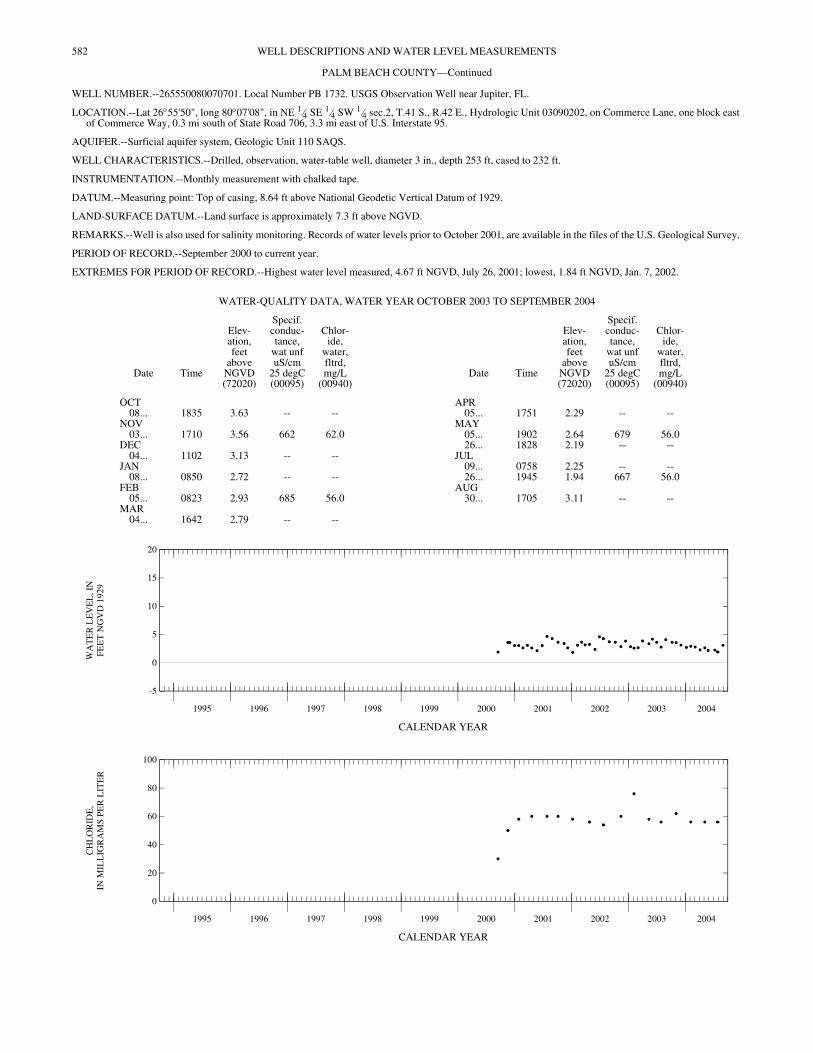
582 WELL DESCRIPTIONS AND WATER LEVEL MEASUREMENTS
PALM BEACH COUNTY—Continued
WELL NUMBER.--265550080070701. Local Number PB 1732. USGS Observation Well near Jupiter, FL.
LOCATION.--Lat 26°55'50", long 80°07'08", in NE 1⁄4 SE 1⁄4 SW 1⁄4 sec.2, T.41 S., R.42 E., Hydrologic Unit 03090202, on Commerce Lane, one block east of Commerce Way, 0.3 mi south of State Road 706, 3.3 mi east of U.S. Interstate 95.
AQUIFER.--Surficial aquifer system, Geologic Unit 110 SAQS.
WELL CHARACTERISTICS.--Drilled, observation, water-table well, diameter 3 in., depth 253 ft, cased to 232 ft.
INSTRUMENTATION.--Monthly measurement with chalked tape.
DATUM.--Measuring point: Top of casing, 8.64 ft above National Geodetic Vertical Datum of 1929.
LAND-SURFACE DATUM.--Land surface is approximately 7.3 ft above NGVD.
REMARKS.--Well is also used for salinity monitoring. Records of water levels prior to October 2001, are available in the files of the U.S. Geological Survey.
PERIOD OF RECORD.--September 2000 to current year.
EXTREMES FOR PERIOD OF RECORD.--Highest water level measured, 4.67 ft NGVD, July 26, 2001; lowest, 1.84 ft NGVD, Jan. 7, 2002.
CALENDAR YEAR
CALENDAR YEAR
WATER-QUALITY DATA, WATER YEAR OCTOBER 2003 TO SEPTEMBER 2004
Date Time
Elev-ation,feet
aboveNGVD(72020)
Specif.conduc-tance,
wat unfuS/cm
25 degC(00095)
Chlor-ide,
water,fltrd,mg/L
(00940)Date Time
Elev-ation,feet
aboveNGVD(72020)
Specif.conduc-tance,
wat unfuS/cm
25 degC(00095)
Chlor-ide,
water,fltrd,mg/L
(00940)
OCT APR08... 1835 3.63 -- -- 05... 1751 2.29 -- --
NOV MAY03... 1710 3.56 662 62.0 05... 1902 2.64 679 56.0
DEC 26... 1828 2.19 -- --04... 1102 3.13 -- -- JUL
JAN 09... 0758 2.25 -- --08... 0850 2.72 -- -- 26... 1945 1.94 667 56.0
FEB AUG05... 0823 2.93 685 56.0 30... 1705 3.11 -- --
MAR04... 1642 2.79 -- --
1995 1996 1997 1998 1999 2000 2001 2002 2003 2004
-5
0
5
10
15
20
WA
TE
R L
EV
EL
, IN
FEE
T N
GV
D 1
929
1995 1996 1997 1998 1999 2000 2001 2002 2003 2004
0
20
40
60
80
100
CH
LO
RID
E,
IN M
ILL
IGR
AM
S P
ER
LIT
ER

583WELL DESCRIPTIONS AND WATER LEVEL MEASUREMENTS
PALM BEACH COUNTY—Continued
WELL NUMBER.--265611080080201. Local Number PB 1733. USGS Observation Well near Jupiter, FL.
LOCATION.--Lat 26°56'16", long 80°08'01", in SW 1⁄4 SW 1⁄4 NE 1⁄4 sec.3, T.41 S., R.42 E., Hydrologic Unit 03090202, on southeast corner of North Central Boulevard and Riverwalk Road, 0.2 mi north of State Road 706, 1.1 mi east of U.S. Interstate 95.
AQUIFER.--Surficial aquifer system, Geologic Unit 110 SAQS.
WELL CHARACTERISTICS.--Drilled, observation, water-table well, diameter 3 in., depth 210 ft, cased to 189 ft, screened 189 to 210 ft.
INSTRUMENTATION.--Monthly measurement with chalked tape.
DATUM.--Measuring point: Top of casing, 12.45 ft above National Geodetic Vertical Datum of 1929.
LAND-SURFACE DATUM.--Land surface is approximately 11.4 ft above NGVD.
REMARKS.--Well is also used for salinity monitoring. Records of water levels prior to October 2001, are available in the files of the U.S. Geological Survey.
PERIOD OF RECORD.--September 2000 to current year.
EXTREMES FOR PERIOD OR RECORD.--Highest water level measured, 5.23 ft NGVD, Aug. 28, 2001; lowest, 0.81 ft NGVD, Sept. 14, 2000.
CALENDAR YEAR
CALENDAR YEAR
WATER-QUALITY DATA, WATER YEAR OCTOBER 2003 TO SEPTEMBER 2004
Date Time
Elev-ation,feet
aboveNGVD(72020)
Specif.conduc-tance,
wat unfuS/cm
25 degC(00095)
Chlor-ide,
water,fltrd,mg/L
(00940)Date Time
Elev-ation,feet
aboveNGVD(72020)
Specif.conduc-tance,
wat unfuS/cm
25 degC(00095)
Chlor-ide,
water,fltrd,mg/L
(00940)
OCT APR08... 1820 4.22 -- -- 05... 1739 1.65 -- --
NOV MAY03... 1654 4.11 1,560 280 05... 1824 2.13 1,630 280
DEC 26... 1811 2.14 -- --04... 1050 3.76 -- -- JUL
JAN 09... 0810 1.55 -- --08... 0900 2.77 -- -- 26... 0722 1.62 1,590 275
FEB AUG05... 0850 2.85 1,580 280 30... 1650 2.97 -- --
MAR04... 1630 2.26 -- --
1995 1996 1997 1998 1999 2000 2001 2002 2003 2004
-5
0
5
10
15
20
WA
TE
R L
EV
EL
, IN
FEE
T N
GV
D 1
929
1995 1996 1997 1998 1999 2000 2001 2002 2003 2004
100
150
200
250
300
CH
LO
RID
E,
IN M
ILL
IGR
AM
S P
ER
LIT
ER
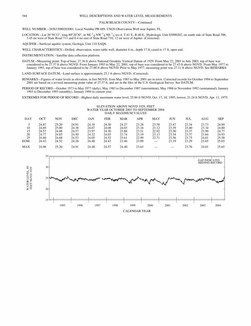
584 WELL DESCRIPTIONS AND WATER LEVEL MEASUREMENTS
PALM BEACH COUNTY—Continued
WELL NUMBER.--265633080203001. Local Number PB 689. USGS Observation Well near Jupiter, FL.
LOCATION.--Lat 26°56'33", long 80°20'30", in NE 1⁄4 NW 1⁄4 NE 1⁄4 sec.4, T.41 S., R.40 E., Hydrologic Unit 03090202, on south side of State Road 706, 3.45 mi west of State Road 711 and 0.4 mi east of State Road 710, 12 mi west of Jupiter. (Corrected).
AQUIFER.--Surficial aquifer system, Geologic Unit 110 SAQS.
WELL CHARACTERISTICS.--Drilled, observation, water-table well, diameter 6 in., depth 17 ft, cased to 17 ft, open end.
INSTRUMENTATION.--Satellite data collection platform.
DATUM.--Measuring point: Top of base, 27.36 ft above National Geodetic Vertical Datum of 1929. From May 22, 2001 to July 2003, top of base was considered to be 27.37 ft above NGVD. From January 1993 to May 22, 2001, top of base was considered to be 27.43 ft above NGVD. From May 1977 to January 1993, top of base was considered to be 27.00 ft above NGVD. Prior to May 1977, measuring point was 27.11 ft above NGVD. See REMARKS.
LAND-SURFACE DATUM.--Land surface is approximately 25.1 ft above NGVD. (Corrected).
REMARKS.--Figures of water levels as elevation, in feet NGVD, from May 1983 to May 2001 are in error. Corrected records for October 1994 to September 2001 are based on a revised measuring point value of 27.37 ft, and are in the files of the U.S. Geological Survey. See DATUM.
PERIOD OF RECORD.--October 1973 to May 1977 (daily), May 1983 to December 1987 (intermittent), May 1988 to November 1992 (semiannual), January 1993 to December 1993 (monthly), January 1994 to current year.
EXTREMES FOR PERIOD OF RECORD.--Highest daily maximum water level, 25.86 ft NGVD, Oct. 17, 18, 1995; lowest, 21.24 ft NGVD, Apr. 11, 1975.
CALENDAR YEAR
ELEVATION ABOVE NGVD 1929, FEET WATER YEAR OCTOBER 2003 TO SEPTEMBER 2004
DAILY MAXIMUM VALUES
DAY OCT NOV DEC JAN FEB MAR APR MAY JUN JUL AUG SEP
5 24.87 25.20 24.91 24.18 24.30 24.27 23.28 23.58 23.47 23.34 23.73 24.8910 24.69 25.00 24.38 24.07 24.08 24.03 23.16 23.12 23.39 23.40 23.34 24.8015 24.57 24.88 24.57 23.97 24.30 23.88 23.51 22.92 23.30 23.37 23.99 24.7720 24.77 24.85 24.50 24.32 24.03 23.74 23.19 23.13 23.34 23.37 23.84 24.9325 24.60 24.68 24.53 24.05 24.52 23.61 22.99 22.71 23.56 23.75 24.01 25.58
EOM 24.43 24.52 24.28 24.48 24.43 23.46 23.09 --- 23.19 23.29 23.65 25.65
MAX 24.98 25.20 24.91 24.48 24.57 24.40 23.63 --- --- 23.76 24.01 25.65
1995 1996 1997 1998 1999 2000 2001 2002 2003 2004
15
20
25
30
35
WA
TE
R L
EV
EL
, IN
FEE
T N
GV
D 1
929
GAP INDICATESMISSING RECORD
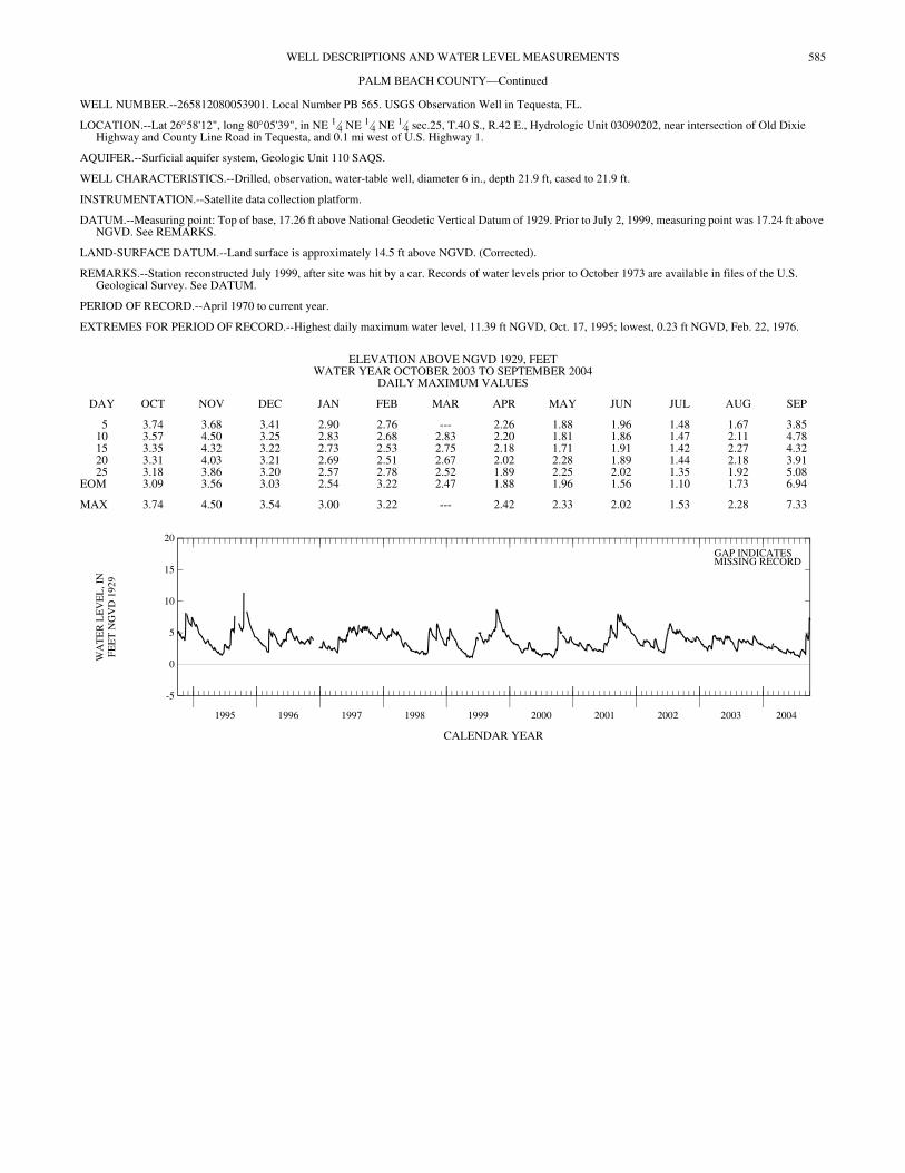
585WELL DESCRIPTIONS AND WATER LEVEL MEASUREMENTS
PALM BEACH COUNTY—Continued
WELL NUMBER.--265812080053901. Local Number PB 565. USGS Observation Well in Tequesta, FL.
LOCATION.--Lat 26°58'12", long 80°05'39", in NE 1⁄4 NE 1⁄4 NE 1⁄4 sec.25, T.40 S., R.42 E., Hydrologic Unit 03090202, near intersection of Old Dixie Highway and County Line Road in Tequesta, and 0.1 mi west of U.S. Highway 1.
AQUIFER.--Surficial aquifer system, Geologic Unit 110 SAQS.
WELL CHARACTERISTICS.--Drilled, observation, water-table well, diameter 6 in., depth 21.9 ft, cased to 21.9 ft.
INSTRUMENTATION.--Satellite data collection platform.
DATUM.--Measuring point: Top of base, 17.26 ft above National Geodetic Vertical Datum of 1929. Prior to July 2, 1999, measuring point was 17.24 ft above NGVD. See REMARKS.
LAND-SURFACE DATUM.--Land surface is approximately 14.5 ft above NGVD. (Corrected).
REMARKS.--Station reconstructed July 1999, after site was hit by a car. Records of water levels prior to October 1973 are available in files of the U.S. Geological Survey. See DATUM.
PERIOD OF RECORD.--April 1970 to current year.
EXTREMES FOR PERIOD OF RECORD.--Highest daily maximum water level, 11.39 ft NGVD, Oct. 17, 1995; lowest, 0.23 ft NGVD, Feb. 22, 1976.
CALENDAR YEAR
ELEVATION ABOVE NGVD 1929, FEET WATER YEAR OCTOBER 2003 TO SEPTEMBER 2004
DAILY MAXIMUM VALUES
DAY OCT NOV DEC JAN FEB MAR APR MAY JUN JUL AUG SEP
5 3.74 3.68 3.41 2.90 2.76 --- 2.26 1.88 1.96 1.48 1.67 3.8510 3.57 4.50 3.25 2.83 2.68 2.83 2.20 1.81 1.86 1.47 2.11 4.7815 3.35 4.32 3.22 2.73 2.53 2.75 2.18 1.71 1.91 1.42 2.27 4.3220 3.31 4.03 3.21 2.69 2.51 2.67 2.02 2.28 1.89 1.44 2.18 3.9125 3.18 3.86 3.20 2.57 2.78 2.52 1.89 2.25 2.02 1.35 1.92 5.08
EOM 3.09 3.56 3.03 2.54 3.22 2.47 1.88 1.96 1.56 1.10 1.73 6.94
MAX 3.74 4.50 3.54 3.00 3.22 --- 2.42 2.33 2.02 1.53 2.28 7.33
1995 1996 1997 1998 1999 2000 2001 2002 2003 2004
-5
0
5
10
15
20
WA
TE
R L
EV
EL
, IN
FEE
T N
GV
D 1
929
GAP INDICATESMISSING RECORD
THIS PAGE IS INTENTIONALLY BLANK
586