Embed Size (px)
Citation preview
Paléorient and CNRS Editions are collaborating with JSTOR to digitize, preserve and extend access to Paléorient.
http://www.jstor.org
PaléorientCNRS Editions
Late Quaternary problems of the Egyptian Nile : stratigraphy, environments, prehistory Author(s): Karl W. BUTZER Source: Paléorient, Vol. 23, No. 2, PALÉOENVIRONNMENT ET SOCIÉTÉS HUMAINES AU
MOYEN-ORIENT DE 20 000 BP À 6 000 BP (1997), pp. 151-173Published by: and Paléorient CNRS EditionsStable URL: http://www.jstor.org/stable/41492699Accessed: 13-03-2015 20:58 UTC
Your use of the JSTOR archive indicates your acceptance of the Terms & Conditions of Use, available at http://www.jstor.org/page/info/about/policies/terms.jsp
JSTOR is a not-for-profit service that helps scholars, researchers, and students discover, use, and build upon a wide range of contentin a trusted digital archive. We use information technology and tools to increase productivity and facilitate new forms of scholarship.For more information about JSTOR, please contact [email protected].
This content downloaded from 128.62.59.252 on Fri, 13 Mar 2015 20:58:09 UTCAll use subject to JSTOR Terms and Conditions

Late Quaternary problems
of the Egyptian Nile :
stratigraphy, environments, prehistory
K.W. BUTZER
Abstract : More than 35 years of continuing research into the Late Quaternary and prehistory of the Nile Valley, Fayum, and Delta has created a large literature , complicated by contradictory or duplicated terminologies, affecting both lithostratigraphies and archaeology. As a result, the significance of this material is accessible or comprehensible to only a handful of specialists. This paper attempts to provide a critical review of the key litho strati graphic units, their chronology and environmental implications. It focuses on the Middle Paleolithic silts, the Late Paleolithic silt and channel complex, the critical Holocene sequence of the Fayum, and how these now relate to recent work in the Delta. The dilemma posed by a vigorous Nile in Egypt at a time of presumed drier climate over Ethiopia is examined via the paleo-hydrology of a nilotic channel. The Holocene record of the Fayum and Delta indicates high variability and continual energy flux, so that there are no clear-cut trends, with only brief spans of quasi-equilibrium. By comparison, the late Pleistocene record appears to be oversimplified, by implicitly referring apparent stages to an artificial model of aggrading or stable floodplains. Whereas evolution of the Late Paleolithic industries c. 21-12 ka shows as much continuity as change, major Nile entrenchment after 12 ka led to significant population decline, and the Epipaleolithic suggests a fundamental social realignment and ecological readaptation. It is doubtful whether the " Wild Nile " event of 12, 5-12 ka had major human repercussions.
Résumé : Les recherches poursuivies depuis plus de trente-cinq ans sur le Quaternaire récent et la préhistoire de la Vallée du Nil, du Fayoum et du Delta du Nil ont suscité de nombreuses publications que compliquent des terminologies multiples, voire contradictoires, affectant à la fois les couches géologiques et l'archéologie. Il en ressort que le matériel n'est accessible ou compréhensible qu 'à une poignée de spécialistes. Cet article essaie de fournir une analyse critique des unités lithostratigraphiques essentielles, leurs chronologies et leurs implications pour V environnement. L'accent est mis sur les limons du Paléolithique Moyen, ceux du Paléolithique supérieur et le complexe du cours, la séquence Holocène clé du Fayoum et la façon dont ces éléments peuvent être mis en relation avec les observations faites récemment sur le Delta. Le dilemme posé par un Nil vigoureux en Egypte à une période considérée comme assez sèche en Ethiopie est examiné à travers la paléo-hydrologie d'un bras du Nil. Les données sur l' Holocène du Fayoum et du Delta indiquent une grande variabilité et un flux d'énergie continu, de sorte qu'aucune tendance nette ne se dessine, mais seulement quelques brefs épisodes d'un quasi-équilibre. Par comparaison, les données du Pléistocène récent apparaissent trop simplifiées, du fait qu'elles se réfirent implicitement à des stades apparents d'un modèle artificiel de plaines en cours d'alluvionnement ou stables. L'évolution des industries du Paléolithique supérieur, ca 21-12 Ka montre autant de continuité que de changement, le principal creusement du Nil après 12 Ka a conduit à un déclin significatif du peuplement et l'Epipaléolithique suggère à la fois un remaniement de la société et une réadaptation écologique importante. Il semble douteux que l'événement (12,5-12 Ka) du «Nil sauvage » ait eu des répercussions importantes sur les populations.
Key-words : Egypt, Nile, Late Quaternary, Late Paleolithic, Epipaleolithic. Mots clefs : Égypte, Nil, Quaternaire récent, Paléolithique supérieur, Epipaléolithique.
Paléorient, vol. 23/2, p. 151-173, © CNRS ÉDITIONS 1998 Manuscrit reçu le 15 octobre 1997, accepté le 16 décembre 1997.
This content downloaded from 128.62.59.252 on Fri, 13 Mar 2015 20:58:09 UTCAll use subject to JSTOR Terms and Conditions

152 K.W. BuTZER
INTRODUCTION
A review of the late Quaternary record of the Egyptian Nile Valley has become overdue. By Middle Eastern stand- ards, the persistence and scope of the research carried out since 1961 are unprecedented. Although triggered by the Nubian Monuments Campaign, work soon spread to the Nu- bian resettlement areas of Upper Egypt and then to the Fayum. As the political climate within Egypt relaxed, new research was extended to Upper Egypt and initiated in the Delta, not to mention the Libyan Desert and Sinai, areas beyond the scope of this paper. The literature is substantial and, as the effort has diversified, increasingly scattered. At the same time, even though Quaternary research has been very much applied, to the needs of prehistoric surveys and excavations, it has established few bridges with Egyptological archaeology, ex- cept in the Delta. A similar rift divides the Quaternary pre- history of Egypt from its counterpart in southwestern Asia.
This analytical review will focus on what we seem to know, what we need to know, and what we have failed to address1'2. Major attention is given to the Late Paleolithic silt and channel complex, and the Fayum lake sequence. Paleo-channel hydraulics elucidate Nile behavior during the late Pleistocene, and the "Wild Nile" problem is discussed. The ensemble is then related to recent research in the Nile Delta, although the splitting of industries and occasional redundancy make it difficult to review the archaeological associations systematically3. But the big picture has been satisfactorily outlined and publication has been exemplary4. The zooarchaeological faunas of prehistoric Egypt have been comprehensively reviewed5 as has the Paleolithic botanical material6.
THE LATE PLEISTOCENE LITHOSTRATIGRAPHIC RECORD
To facilitate discussion of the late Pleistocene nilotic re- cord, without resorting to lithostratigraphic tables, the ar-
chaeological 14C dates from Nubia and Upper Egypt7 are
compiled in figure 2. The histograms are organized by cen- turies from 30,000 to 10,000 BP (before present, uncalibra- ted) ; assays with standard deviations greater than 500 years are rejected. Even allowing for some faulty dates, the mate- rials arrange themselves into discrete clusters at c. 19,2 -
16,8 ka, 15,2 - 12,0 ka, and 11,6 - 10,8 ka. Except for three sites, there is no convincing archaeology between 30 and 20 ka. Both the clusters and the lacunae highlight the nilotic
sedimentary units of the late Pleistocene, and raise the ques- tion whether the gaps indeed mark an absence of prehistoric settlement. They offer a convenient proxy record of visible or accessible archaeology, related to the geoarchaeological record.
Lithostratigraphic units are normally defined on the basis of professional description of facies sequences, identified from sedimentological analyses, with respect to a specific geomorphological and stratigraphie context. The point is to be able to compare and contrast sedimentary sequences from
place to place, as an independent tool in potential correlation. In Nubia and Upper Egypt, however, formal lithostratigraphic units defined in 1968 s were later modified with little regard for such criteria, and new correlations made on the basis of then shaky radiocarbon chronologies9. Terminologies became a source of confusion rather than clarity. I will therefore describe the basic units, indicate the original designation and its author(s) but refer to them by informal designations.
Late Pleistocene deposits are best developed and studied (a) in Lower Nubia, between Wadi Haifa and Kasr Ibrim; (b) in the Wadi Kubbanniya, northwest of Aswan ; (c) on the Kom Ombo Plain; (d) on the western desert edge around Edfu and Esna; and (e) along the desert margins between Qena and Asyut. Older beds consist of weathered, high gravel "terraces", or pediment surfaces with veneers of coarse de- tritus10. But there also are calcified, basal wadi fills that
1. Earlier reviews by Butzer, 1980 and Said, 1981 : 44-97, are dated, but Paulissen and Vermeersch (1987) have attempted a first, new and critical re-examination of the database and assumptions. Research prior to 1961 is reported on in Butzer, 1980, and is not discussed further here. 2. Although my fieldwork in Egypt dates to 1956-63, I learned much that was pertinent to the prehistoric Nile while working along Ethiopia's Omo River, Butzer, 1970, 1980, and in the Vaal and Orange Basins of South Africa, Butzer, 1984. 3. An excellent and up-to-date summary of the prehistoric archaeology of the Nile Valley is given by Wendorf and Schild, 1989b : especially 808-818. For a stylistic evaluation by principal components analysis, see Close et al., 1979; Close, 1989. 4. Wendorf, 1968; Wendorf and Schild, 1976, 1989b, 1993; also Hassan, 1980 in part dated, e.g. the claim for grain cultivation in the Late Paleolithic. 5. Gauthier and Van Neer, 1989; also Churcher, 1972; Brewer, 1989 and Wendorf et al., 1997. 6. Wetterstrom, 1989 and Hillman et al., 1989.
7. Wendorf and Schild, 1976, 1989; Wendorf et al., 1989; Vermeersch, 1978 ; Vermeersch and Paulissen, 1993 ; Vermeersch et al., 1989 ; Butzer and Hansen, 1968. 8. Butzer and Hansen, 1968 ; De Heinzelin, 1968. 9. Wendorf and Schild, 1976. 10. Butzer and Hansen, 1968 : ch. 2 and 5 ; De Heinzelin, 1968 ; Paulissen and Vermeersch, 1987; Vermeersch et al., 1990.
Paléorient, voi. 23/2, p. 151-173 © CNRS ÉDITIONS 1998
This content downloaded from 128.62.59.252 on Fri, 13 Mar 2015 20:58:09 UTCAll use subject to JSTOR Terms and Conditions

Late Quaternary problems of the Egyptian Nile : stratigraphy, environments, prehistory 153
include a strong component of nilotic silts, representing the valley margins of a very different Nile floodplain, dominated by bed-load deposits, these mark a transitional type of Nile system once thought to date as recently as c. 27 ka (Korosko Formation)11, but must now be considered as older than c. 75 ka.
Equally important as a context for the Late Pleistocene sequences is the discovery of massive nilotic silts (Dendara Formation) under gravel "terraces" with Acheulian artifacts, attaining + 15 m near Qena and + 23 m at Aby dos12. For the first time these beds provide a strong case for an Ethiopian flood-silt regime in Egypt during mid-Pleistocene time, when both the local Nile tributaries and defunct desert water- courses13 still transported bed-load clasts over significant distances.
A MIDDLE PALEOLITHIC SILT FLOODPLAIN
The oldest preserved unit with géomorphologie and facies development comparable to the modern Nile floodplain is well developed between Wadi Haifa and Kom Ombo (Dibei- ra-Jer Formation, De Heinzelin, equivalent to Masmas For- mation, Butzer and Hansen 14) and appears to be present near Edfu and Esna, underneath units with late Paleolithic archaeo- logy 15 . Thickness in Nubia exceeds 31m, and 20 m (possibly 43 m in cores) at Kom Ombo, absolute elevation decreasing from 154 m at the Sudanese border to 110 m at Wadi Kub- baniya and 103 m near Kom Ombo. The mean gradient of this floodplain was 1 : 7,150, compared with 1 : 10,100 for the pre-High Dam era (121 m at the border, 88 m near Kom Ombo). The slope of this great silt floodplain was 41 % steeper than today, indicating a more dynamic river than the modern Egyptian Nile (rather than a lower base level 1,200 km downstream).
This dynamism was not a result of increased discharge by local, ephemeral watercourses (wadis). In the east, in Nubia, silts ponded up various wadis without interdigitation of tor- rential deposits from the Eastern Desert, but higher sand components, despite the distinctly dark sediment color, sug- gest reworking of older wadi beds or some mixing by periodic wadi activity. West of the river, in Nubia and especially Wadi
Kubbaniya, marginal silts may be interdigitated with dune sand16 areas where dunes are still present at the desert margins and eolian activity remains effective. On the Kom Ombo Plain, where these silts are exposed across some 200 km2, there is notably little evidence of wadi accumula- tion17. The great wadis Kharit and Shait to the east were essentially inactive, with only a very few lenticles of ponded sediment, with stagnant-water gastropods, enriched with sand. In a modern drainage line to the south, 13 m of compact silt are only interrupted by three continuous lenses of wadi wash. This indicates a hyperarid local climate, with no more wadi activity than in recent times.
The great silt floodplain is almost exclusively a nilotic phenomenon, and before land grading activities in 1962-63, excellent exposures on the Kom Ombo Plain showed mono- tonous exposures of overbank silts, with a modal texture of silty loams (50-80% silt faction). Terminal deposits were more clayey (25-50% clay), allowing development of striking pellitic vertisols with slickensides. The axial channel is no- where preserved, but there are secondary channels with as- sociated crevasse splays. These had widths of 150 to 200 m, and one example had a width of 175 m and a depth of 5,5 m, with a hydraulic radius of 3,3 and a reconstructed channel- forming peak discharge of 1,360 m3/sec (see below)18. These secondary channels meandered, and the crevasse deposits and the abrupt switches of their channel infillings from sand to silt, point to unstable meander belts prone to avulsion. In effect, the Kom Ombo Plain had one or more yazoo channels, similar to those of the lower Mississippl.
Early efforts to reliably date this ancient floodplain were unsuccessful, both at Kom Ombo and in Nubia. It includes no archaeology at Kom Ombo, but the valley margin facies in Nubia include sites of the Levalloisian Khormusan industry, now recognized as a Middle Paleolithic variant, older than 44,500 ka19. The most important archaeological context, however, is Wadi Kubbaniya, where related overbank silts are interbedded with dune sands, and date upwards of 45 ka, even 60 ka, based on inconsistent T/L dates20. This appears to place the great silt floodplain within oxygen isotope stage 3.
The major Middle Paleolithic occurrences at В ir Tarfawi in the Western Desert belong to stage 5, but their environ-
11. Butzer and Hansen, 1968 : 87-97, 266-272. 12. Paulissen and Vermeersch, 1987. 13. McHugh et al ., 1988. 14. De Heinzelin, 1968; Butzer and Hansen, 1968 : 97-107; 272-274. 15. Wendorf and Schild, 1976 : tig. 8, 10, 21.
16. Schild and Wendorf, 1989. 17. Butzer and Hansen, 1968 : fig. 3-2, 3-4, and 3-9; 125-127. 18. Ibid . : fig. 3-7 and 3-8, 99-102. 19. Wendorf, 1968; Wendorf et al., 1979. Relatively small collections of "Mousteroid" artifacts were made from these deposits, but Aterían materials are found below them in a wadi gravel. 20. Schild and Wendorf, 1989.
Paléorient, vol. 23/2, p. 151-173 © CNRS ÉDITIONS 1998
This content downloaded from 128.62.59.252 on Fri, 13 Mar 2015 20:58:09 UTCAll use subject to JSTOR Terms and Conditions
154 K.W. BUTZER
mental context was distinctly moister than now21 precluding equivalence with the Middle Paleolithic silt floodplain of the Nile Valley. Older Middle Paleolithic deposits do exist in the Valley, however; near Abydos such sites are found in Nile silt or gravel, interbedded with thick wadi deposits, at 8 to 11 in above floodplain22.
THE LATE PALEOLITHIC SILT AND CHANNEL COMPLEX
As accretion of the Middle Paleolithic floodplain ceased, deep cracking vertisols developed. Eventually the Nile en- trenched its channel by at least 20-25 m and deflation began to erode shallow basins in the Middle Paleolithic silts along the western margins of the valley, in Nubia and possibly near Edfu.
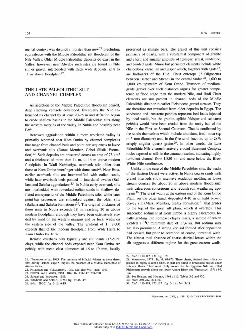
Renewed aggradation within a more restricted valley is primarily recorded near Kom Ombo by channel complexes that range from channel beds and point-bar sequences to levee and overbank silts (Darau Member, Gebel Silsila Forma- tion)23. Such deposits are preserved across an area of 75 km2 and a thickness of more than 14 m, to 14 m above modern floodplain. In Wadi Kubbaniya, overbank silts older than those at Kom Ombo interfinger with dune sand24. Near Esna, earlier overbank silts are interstratified with eolian sands, while later overbank beds ponded in interdunal swales (Bal- lana and Sahaba aggradations25. In Nubia early overbank silts are interbedded with reworked eolian sands in shallow, de- flated embayments of the Middle Paleolithic silts, while later point-bar sequences are embanked against the older silts (Ballana and Sahaba formations)26. The original thickness of these units in Nubia exceeds 18 m, reaching 20 m above modern floodplain, although they have been extensively ero- ded by wind on the western margins and by local wadis on the eastern side of the valley. The gradient of 1 : 8,600 exceeds that of the modern floodplain from Wadi Haifa to Kom Ombo by 16%.
Related overbank silts typically are silt loams (15-50% clay), while the channel beds exposed near Kom Ombo are pebbly, with mean clast diameters of 16 to 19 mm, locally
preserved as shingle bars. The gravel of this unit consists primarily of quartz, with a substantial component of granite and chert, and smaller amounts of feldspar, schist, sandstone, and banded agate. Minor but persistent elements include white chalcedony, carnelian and jasper which, together with agate27, are hallmarks of the Hudi Chert outcrops (? Oligocene) between Berber and Shendi in the central Sudan28, 1,600 to 1,800 km upstream of Kom Ombo. Transport of medium- grade gravel over such distances argues for greater compe- tence at flood stage than the modern Nile, and Hudi Chert elements are not present in channel beds of the Middle Paleolithic silts nor in earlier Pleistocene gravel terraces. They are therefore not reworked from older deposits in Egypt. The sandstone and ironstone pebbles represent bed-loads injected by local wadis, but the granite, aplitic feldspar and schistose pebbles would have been eroded from the rocky bed of the Nile in the First or Second Cataracts. That is confirmed by the sands themselves which include abundant, fresh mica (up to 3 mm diameter) and, in the fine sand fraction, up to 28 % crisply angular quartz grains29. In other words, the Late Paleolithic Nile channels actively eroded Basement Complex rocks exposed as sills in the cataract reaches, indicating highly turbulent channel flow 1,850 km and more below the Blue- White Nile confluence.
Unlike in the case of the Middle Paleolithic silts, the wadis of the Eastern Desert were active. In Nubia coarse sands with gravel interbeds show intensive oxidation mottling in lower stream courses (to about 20 m above modern floodplain), with calcareous concretions and reddish soil weathering ups- tream30. The great wadis at the eastern end of the Kom Ombo Plain, on the other hand, deposited 4-10 m of light brown, clayey silt (Malki Member, Ineiba Formation)31 that grades to the top of the great silt plain, which it overlaps. This suspended sediment at Kom Ombo is highly calcareous, lo- cally grading into compact clayey marls, a sample of which yielded a 14C minimum date of 17,4 ka. But sodium salts are also prominent. A strong vertisol formed after deposition had ceased, but prior to accretion of coarse, torrential wash. The almost total absence of coarse detrital lenses within the silt suggests a different regime for the great eastern wadis,
21. Wendorf et al., 1993. The presence of bifacial foliates at these desert sites during isotope stage 5 implies the presence of a Middle Paleolithic of Aterían facies. 22. Paulissen and Vermeersch, 1987. See also Van Peer, 1993. 23. Butzer and Hansen, 1968 : 107-116, 131-147, 274-280. 24. Schild and Wendorf, 1989. 25. Wendorf and Schild, 1976 : fig. 29-46, 49. 26. Ibid. : 290-2, fig. 6-10, 6-19.
27. Ibid. : 110-112, 131, fig 3-21. 28. Whiteman, 1971 : fig. 4, 90-973. These cherts, derived from silica de- posited in highly alkaline lakes, in part are found in brecciated masses under volcanic flows. Their most likely source for the Egyptian Nile are rolled Pleistocene gravels along the lower Atbara River, see Whiteman, 1971 : 97, 126. 29. See Butzer and Hansen, 1968 : 110, Tables 3-5 and C-2. 30. Ibid : 280-282, 294-307. 31. Ibid. : 116-119, 125-127; fig. 3-1 to 3-4, 3-18.
Paléorient, vol. 23/2, p. 151-173 © CNRS ÉDITIONS 1998
This content downloaded from 128.62.59.252 on Fri, 13 Mar 2015 20:58:09 UTCAll use subject to JSTOR Terms and Conditions

Late Quaternary problems of the Egyptian Nile : stratigraphy, environments, prehistory 155
which must have had a far better groundcover, reduced peak discharges, and prolonged periods of non-torrential flow, at least towards the edge of the plain. Here the older nilotic silts appear to have formed a barrier to unimpeded, nileward drainage, thus ponding extensive clay-silt playas, i.e. ephe- meral lakes. Another facies variant is encountered at El Kab (Hellal Lithozone)32, where nilotic silts are interdigitated with fine sandy wadi deposits at 7 m above modern floodplain. None of the exposures seems to clarify whether local runoff was in season with Nile flood silts, i.e. whether rainfall in the Eastern Desert came in summer or winter or both.
These end-Pleistocene wadi deposits were at least in part contemporaneous with the Late Paleolithic channel complex, and while remaining hyperarid, the Eastern Desert was so- mewhat wetter and better vegetated at the time, reducing transport of the crude rubble more typical of the Holocene. In the broader context of Saharan aridity at the time, this raises questions whether the anomaly was due to latitude, elevation or topography. But the volume of water and sedi- ment reaching the Nile Valley was evidently small ; its contri- bution to Nile discharge will have been insignificant, to the Nile bed-load little more than incidental.
PALEO-HYDRAULICS OF THE CHANNEL COMPLEX
The dynamism of the channel -complex is best illustrated by the hydraulics of the channels themselves. These are extensively preserved west and north of Kom Ombo, and the largest ran eastward from Fatira and then northward through the desert pass east of Gebel Silsila33. Remnants of levee deposits on both sides of the former Fatira Channel, as well as mid-channel ridges formed of more fine-grained and compact infillings, delineate a width of 430 m. The much deflated levee outcrops reach 99.7 m elevation, indicating a bankful level above 100 m, while deflation hollows to 93 m do not expose the channel floor. Projected lateral gradients indicate an original bankfull depth of 10 m, a channel cross- sectional area (A) of 3,150 m2 and a hydraulic radius (R) of 6,9. Channel roughness (n) is estimated at 0.0102, and channel slope (S) 0.000105 34.
According to the Rotnicki-Manning equation, developed from a sample of 1352 lowland rivers with sandy to gravelly
beds35, peak formative discharge Q = (0.9208/n)AR°167 x (RS)0-5 - 2.362. By this estimate, excluding the water still
passing to the west of Gebel Silsila, and ignoring overbank discharge, the Fatira Channel was formed by peak discharges in the order of 10,300 m3/sec.
The Fatira Channel is not directly dated, but by 13,9 ka the channel had shifted, reducing its width to 370 m and its
depth to 6,5 m, after which the estimated formative discharge was limited to about 3,900 m3/sec. The new channel has reworked Silsilian artifacts at its base (GS2B-I-1), and Afian occupations interbedded with its point-bar deposits (GS2B-I- 2/3), dating 13,6-13,1 ka36. Nearby are remnants of a minor overflow channel with an intact Silsilian site (GS2B-II)37 dated 14,4 ka by shell, 15,3 ka by charcoal, neither corrected for isotopie fractionation. Finally, near Gebel Silsila, undated Silsilian levels underlie a Sebekian living floor (GS 1 -III) 38
with acceptable dates of 14,2 14,1 ka, and an aberrant assay of 16,0 ka. The Silsilian and Sebekian are quite different in terms of raw material, technology and typology, the former notable for its use of Hudi Chert and its microburin technique, the latter only using chert from Pleistocene terraces, with different cores, no microburins, but longer blades. Nonethe- less the two industries may be partly concurrent within the district. The main Fatira Channel would be no younger than site GS2B-II (14,4 or 15,3 ka).
Other channels, formerly well preserved to the west of Kom Ombo, have widths of only 100-250 m, and represent true secondary arms of the main Nile39. Some of these are associated with Afian sites and have shell dates of 13,2 and 12,6 ka, only slightly younger than the Fatira Channel. The Channel Complex of the Kom Ombo Plain may therefore have a time depth of 15,3-12,5 ka.
As a group, it is noteworthy that the Kom Ombo channels represent a state of continuing flux rather than a stable
"stage", either as a result of rapid sedimentation (filling in
32. Vermeersch, 1978. 33. Butzer and Hansen, 1968 : 132-141, 168-177; fig. 3-13. 34. See G. Williams (1986) for a critical review of various equations.
35. See Rotnicki (1983) for the elaborated Manning equation, Church, 1978, for a realistic estimation of n. 36. Butzer and Hansen, 1968: 168-177; fig. 3-13, 3-26, 3-27. There are three dates : 13,560 b.p. on shell, 13,070 b.p. on charcoal, and 13,240 b.p. on shell, the last reported by Haas and Haynes, 1975. Identification of the industry as Afian is courtesy of J.L. Phillips, pers. comm. 37. Phillips and Butzer, 1973. Fractionation is not the major problem, however, because for Late Pleistocene charcoal samples from Egypt the variation is no more than several decades, for shell a few centuries, see Haas, 1989 ; Wendorf and Schild, 1989b : 808. The main problem is incomplete sample pretreatment, so that many of the dates generated during the 1960s have proven to be as much as a millennium too young, see Wendorf et al., 1979. 38. Smith, 1966, 1967. 39. Butzer and Hansen, 1968 : 143-146, 180-181 ; tig. 3-31, 3-32. tor dating the sites, see Smith, 1967 ; his Sebilian II is equivalent to the Afian.
Paléorient, vol. 23/2, p. 151-173 © CNRS ÉDITIONS 1998
This content downloaded from 128.62.59.252 on Fri, 13 Mar 2015 20:58:09 UTCAll use subject to JSTOR Terms and Conditions

156 K.W. BUTZER
Fig. 1 : The Egyptian Nile (A), the channels at Kom Ombo (В), and the sources of the Upper Nile Basin (C).
channels) or periodic pulses of high energy (breaking in new channels), or a combination thereof. Although the Fatira Channel banks were reasonably stable, it did fill up with sand, which is consonant with an oversteepened gradient. At the same time there are clues that discharge fluctuated consi- derably over time, judging by calcareous rhyzoliths formed below some levee-edge archaeological surfaces compacted by sodium salt enrichment at site (GS2B-I). But the pulses of waxing Nile discharge record an anomalously vigorous Nile, eroding bedrock sills in the cataract reaches, transporting gravel twice the mass of contemporary clasts over distances of 1,800 km, mobilizing subrounded boulders on the flanks of Gebel-Silsila, and spawning at least one branching paleo- channel with a formative peak discharge of 10,300 m3/sec. By comparison, the channel of the Lower Nubian Nile (before construction of the first Aswan Dam in 1902) yields a figure of 12,700 m3/sec, while the mean measured discharge at Aswan during the peak month of September was 7,500 m3/sec for 1912-73 and 9,200 m3/sec for 1878-9 40. Bearing in mind that the estimate for the major Fatira Channel represents only
a part of the Nile waters at the time, flood discharge about 15 ka was substantially greater than during the last century.
That water was not derived from the Eastern Desert or any other Saharan sources, but from Ethiopian flood dis- charge. This is borne out by the rare earth elements (fig. 2), the heavy mineral fraction, and above all the clay mineralogy of the clay-size fraction. A total of 43 standard X-ray diffrac- tograms are available for both Nile and wadi sediments that span the Pleistocene to early Holocene time range41. Diffrac- tograms provide a replicable proxy record of characteristic clay minerals, but their peaks reflect as much on crystallinity as on quantity42.
This body of analytical data shows clearly that the nilotic deposits are sharply distinguished from the desert soils and sediments, the former dominated by montmorillonite, the
40. Willcocks and Craig, 1913 : Table 127.
41. Butzer and Hansen, 1968 : Appendix D, fig. D-l to D-6. 42. Actual quantification of clay minerals involves a tedious battery of different chemical tests, based on differing assumptions that generally lead to "totals" of somewhat over 100%. Only such tests allow separation of chlorite from kaolinite and a full appreciation of the significance of mont- morillonite and illite, interlayered with phyllosilicates such as mica, vermi- culite or chlorite. In effect, the diffractograms overestimate quartz and underestimate the interlayed minerals. El Attar and Jackson, 1973.
Paléorient, vol. 23/2, p. 151-173 © CNRS ÉDITIONS 1998
This content downloaded from 128.62.59.252 on Fri, 13 Mar 2015 20:58:09 UTCAll use subject to JSTOR Terms and Conditions

Late Quaternary problems of the Egyptian Nile : stratigraphy, environments, prehistory 157
Fig. 2 : Clustering of Late Pleistocene archaeological dates for Upper Egypt and Nubia. For sources, see text.
latter by kaolinite. The preeminence of montmorillonite is replicated for modern Nile silts, but desert sediments have more prominent kaolinite readings. Chemical quantification underscores the distinction, namely that whereas kaolinite now represents 22,5-24,5 % of the montmorillonite plus kao- linite total, that value is only 13.5 % for the Channel Complex and 17% for the Middle Paleolithic floodplain43. In other words, the late Pleistocene nilotic units had somewhat less kaolinite than modern Nile silts do. That implies a re- duced White Nile input, since the kaolinite ratio is 21 % for White Nile sediments but only 11% for the Blue Nile clay fraction. In sum, (a) the clay fraction of the late Pleistocene nilotic sediment does not reveal a tangible component of desert-derived clays, either in lower Nubia or on the Kom Ombo Plain; and (b) the late Pleistocene nilotic sediments record a somewhat greater proportion of runoff from the Ethiopian Plateau and less from the White Nile Basin. The hydraulics of the Fatira Channel alone argue that its formative peak discharge, presumably during September, was almost the same as today about 15 ka; in combination with the alternate channel west of Gebel Silsila, that value was even greater. Although the duration of the summer rainfall season over Ethiopia may have been reduced implying a greater concentration of discharge in one month, peak discharge today is automatically modulated by a very complex Ethiopian drainage network as well as a flow distance of almost 2,500 km.
The empirical evidence from Egypt, both in the field and the laboratory, contradicts deductive arguments that the Late
Pleistocene nilotic silts in Egypt record declining Nile floods, deposited as the river choked in its own sediment44. By that standard, the modern Nile or lower Mississippi would simi- larly be in decline. Streams with a high ratio of suspended sediment, and prone to overbank discharge, will indeed de- posit overbank silts even while they may aggrade sands within their channels. More serious is recent interpretation of the late Paleolithic Nile as a braided river with shallow, anasto- mosing and rapidly changing channels. The fault is actually my own, for using "braided" in an inexcusably loose manner (instead of "island-braided", as for example, along the upper Mississippi River), and not specifying a time scale for "rapid" change45. The positive outcome, however, is that I have been forced to go back to my field notes to address the question of channel form and hydraulics. As discussed above, the main Fatira Channel had an hydraulic radius of 6,9, compared with 4,5 for its successor, and 5,4-10 for the Nile or 8,9 for the Blue Nile above Khartum, both about A.D. 190046. These are the hydraulic radii of sinuous streams; for anastomosing, bar-braided channels, hydraulic radii tend to only fractional values. Although the trace of the Fatira Channel could not be established for more than 1 km, due to land grading activities before 1962, numerous exposures documented its
43. See ibid. Kaolinite also dominates recent wadi deposits derived from desert sources. Stanley and Wingerath, 1996.
44. Fairbridge, 1963, echoed in Adamson, 1982 : 227-229, Table 10.1 and Wendorf and Schild 1989 : 771. Declining Nile channel discharge and sediment entrapment through the High Dam has, since the 1970s, led to increasing entrenchment of the river downstream. This is the opposite to what Fairbridge and Adamson would predict. 45. Butzer, 1980b : 268. On the distinction between island-braiding and bar-braiding, see Chorley et al., 1984 : 305. 46. See profiles in Willcocks and Craig, 1913 : 91, 93, 367, PL 5 and 6. b. By the Rotnicki equation, Blue Nile peak discharge above Khartum was 13,300 m3/sec at the turn of the century, when flood stage was only three- quarters bankfull. Original channel formation would have required closer to 20,000 m3/sec.
Paléorient, vol. 23/2, p. 151-173 © CNRS ÉDITIONS 1998
This content downloaded from 128.62.59.252 on Fri, 13 Mar 2015 20:58:09 UTCAll use subject to JSTOR Terms and Conditions

158 K.W. BUTZER
banks, analogous to those of the modern Nile and formed by backset levees of cohesive silt, so much so as to be resistant to deflation. Like the modern Nile, it was a relative stable channel, metamorphosing over time scales of centuries, rather than years or decades.
It is true that the equatorial lakes, including Lake Turkana with its Ethiopian upland catchment, were low at this time, and I myself was instrumental in establishing that fact47. But we continue to lack any empirical information about the Blue Nile basin during the Late Pleistocene, and the available studies are limited to the stretch from Sennar and Khartum, where a sedimentary record from before 23 ka to 12 ka appears to be missing48. In Egypt there is, as demonstrated above, evidence that Nile peak discharge was at least as effective as in more recent times, without implying that annual discharge remained the same. At the same time, it must be emphasized that the diversified mammalian, bird, and fish fauna from site GSI (Sebekian levels) argues for year-round human occupation, and well- watered channels during the winter months that suppported 22 species of migrant birds as well as mature catfish49. Until adequate studies have been carried out between Sennar and the Abbai canyon, it might be wise to avoid further ex cathedra statements about what the Nile "should" have been doing.
TEMPORAL AND SPATIAL COORDINATES FOR THE LATE PALEOLITHIC AGGRADATION
The Late Paleolithic Channel Complex discussed for Kom Ombo dates back to 16 or 15 ka. but there are older Late Paleolithic deposits, as can be inferred from the cluster of dates 19,2-16,8 ka in figure 2.
(a) In southern Lower Nubia, on the western desert edge, fluvially reworked eolian sands reach 141 m (+ 20 m) and
rest on the vertisol of the Middle Paleolithic silts50. These transgressive sediments include Halfan sites (19,2-18,6 ka), the earliest artifacts of which include Hudi Chert, and are sealed by silts with vertisolic development.
(b) In Wadi Kubbaniya, apparently two bodies of eolian sands interfinger with overbank Nile silts, locally interbedded with ephemeral ponds51. Reaching an elevation of 111 m (+ 19 m), this complex rests on Middle Paleolithic silts and eolian sands that have been eroded by wind and water. Fakhurian and Kubbaniyan (= Halfan) occupations are found within such interbedded sediments in the upper half or so of the accumulation period, and three are dated 20,7-17,0 ka by an unusually large and reasonably consistent suite of 14C dates. Nilotic sedimentation must have begun several millen- nia earlier. Vertisols formed both before and after the minor ponding episode. Most of the archaeological sites lie at 104- 108 m, in what must have been the seasonal or interannual range of Nile flood variation at the time. Dune advance stopped in some areas shortly after 17 ka, presumably as the flood level rose, and overbank silts were again deposited to 111 m elevation. At this time, sites become scarce and the preferred human habitat within this elongated embay ment probably was transformed. Dune reactivation before 13 ka, presumably at a time of lower floods, created a basin that then began to fill with marly clays, marls, and laminated diatomites, found at 109-111 m elevation. The multiple ponds, some of them perennial and fairly deep, were primarily fed by Nile seepage, as opposed to flooding. About 12,6 ka the floods rose dramatically, depositing lake margin silts, marls and finally reworked sands to 117 or more (+ 25 m), contem- porary with an Isnan occupation dated 12,4 ka.
(c) On the Kom Ombo Plain, only fragments of older late Paleolithic sediments remained undisturbed at the surface in 1962 : a minor channel (at Khor el-Sil) with deflated Halfan artifacts and a high-error date of 17 ka52. Up to 98 m ele- vation today, these beds originally attained about + 12 m. Whether this Manshiya channel represents a major change of hydrology with respect to the Fatira Channel could not be determined.
(d) Further north, near Edfu (El-Kilh), a disturbed remnant of sandy silts at + 7 m had mainly deflated Idfuan sites with dates of 17,8-16,9 ka53. Near Esna, coarse eolian sands un- comformably overlie heavy clay silts with vertisolic pheno-
47. Butzer et al., 1972. 48. Adamson et al ., 1982. 49. Churcher, 1972; Churcher and Smith, 1972. This faunal evidence contradicts the claim of Wendorf and Schild, 1989b: 771, that the late Paleolithic Nile was "a comparatively small stream with a floodplain set by several ephemeral braided channels, with little or no flowing water, but with a large flood after the seasonal rains each year at the headwaters". In fact, their own seasonality diagram, Wendorf and Schild, 1989b : fig. 44.8, as well as a number of in-text interpretations also contradict this interpretation. Note that there would be no "flood fishing" during June or July, see Shahin, 1985 : Table 8.29 and fig. 8.51, as shown on their diagram, since flood waters on average only began to enter the basins at Aswan on August 12, Willcocks and Craig, 1913 : 311, fig. 24. Spawning of catfish on the floodplain would begin after that point.
50. De Heinzelin, 1968 : esp. figs. 12 and 72. 51. Schild and Wendorf, 1989. Figure 13.34 is critical to overview their argument. 52. Butzer and Hansen, 1968: 141-143, 177-180, fig. 3-1. 53. Wendorf and Schild, 1976: 27-41.
Paléorient, vol. 23/2, p. 151-173 © CNRS ÉDITIONS 1998
This content downloaded from 128.62.59.252 on Fri, 13 Mar 2015 20:58:09 UTCAll use subject to JSTOR Terms and Conditions

Late Quaternary problems of the Egyptian Nile : stratigraphy, environments, prehistory 159
mena, and are interbedded with lenticles of nilotic silt54. Associated Fakhurian sites have 14C dates of 18 and 17,6 ka, and a seepage pond is dated 16,8 ka. An Idfuan site has a T/L date of 21,6 ka. After some Nile incision, the interdunal swales were filled 12,6 ka with silts and pond deposits to + 8m, including Silsilian, Afian and Isnan sites. North of Luxor, eroded nilotic silts to + 9 m have a hearth dated 16,8 ka55. These various exposures on the western Valley margins show that the rudiments of the Wadi Kubbaniya stratigraphy persist for more than 200 km downstream.
(e) Near Qena (El-Makhadma) there are two silts on the eastern desert edge56. One has an Upper Paleolithic site of Idfuan affinity at + 2 m, dated 24,7 ka by T/L ; although not interbedded with wadi deposits, local sands separate it from embanked nilotic silts to + 6 m, where there are sites with 1 1 14C dates 13,4-12,1 ka and artifacts that poorly fit established categories. Wadi deposition then resumed until about 6,3 ka. Opposite Qena, on the western margins near El-Kumbilat, a burned layer above cemented dune sands and under a nilotic silt was dated 12,5 ka; wadi deposits overlie the sequence57. Finally, north of Dishna on the eastern margins, two nilotic silts are interdigitated with wadi deposits that do not directly mix because they were seasonally out of phase58. The first silt reaches + 3 m, the second + 4 m and forms a thick, raised levee, behind which alkaline playa deposits accumulated later. Several Isnan occupations and a Sebilian site are found in the uppermost, younger silt, above a burned horizon, possibly of similar age to that from El Kumbilat.
Reviewing these local stratigraphies serves to place the Late Paleolithic silt and channel complex into a fuller pers- pective along a stretch of 320 km downstream of Aswan, as well as 340 km upstream to Wadi Haifa. The most complete sequence is represented in Wadi Kubbaniya but even here, despite a sophisticated research program, the interfingering of facies as well as the difficult correlation of many sites and sections across a large and complicated terrain do not yet allow a complete and fully dated microstratigraphy. That is not an implied criticism, but a recognition that this particular project has the distinction of revealing just how complex the changes across a few millennia were.
Age approximations for the earlier silts by T/L at Esna and Qena59 suggest the possibility that the complete span of time
represented by the Late Paleolithic sediments is 25 to 12 ka, although there will have been several periods of intervening, minor Nile entrenchment. At other times, flood levels appa- rently oscillated between +12 and + 19 m, and towards 12,5 ka they reached + 24 m. The Channel Complex of Kom Ombo remains unique, in providing information on hydraulic behavior during the last third of this time zone, although the presence of Hudi Chert since at least 19 ka argues for earlier, vigorous bedload transport as well. The floodplain was simi- larly oversteepened as the Middle Paleolithic Silt Floodplain, although gradients varied from 1 : 9 000 to 1 : 7 200, sug- gesting adjustments to changing water : sediment ratios.
The prominence of dune sands in most western desert-mar- gin sites prior to 16 or 17 ka, and their continued activation in some settings until 12,5 ka, may be an accident of just where mobile, eolian bed-forms were previously located, and when their path intersected with the eastern floodplain edge. Examination on a case-by-case basis may however dispel that impression. The interfingering of wadi deposits on the eastern desert margins suggests that local watercourses were at least as active as now, with high-order drainages producing the finest sediment grades. Coarser, less sorted rubbles were more characteristic after 12 ka than before. That is compatible with hyperaridity in Egypt, but seems to suggest lower peak dis- charge for the augmented local rains of isotope stage 2.
THE LATE PALEOLITHIC ARCHAEOLOGICAL SPECTRUM
The striking peaks of 14C dates ca. 18 and 12,5 ka in figure 2 are not entirely a function of readier access to dating facilities by more recent projects. Sites related to the earliest deposits are definitely uncommon, even allowing for younger covering mantles. The scarcity of sites after 17 ka in Wadi Kubbaniya is a case in point : riparian-edge locations were reduced but did not disappear, and periods of river entrench- ment probably did not span more than a few centuries. Perhaps the adaptive strategies of prehistoric groups were more spe- cific than site location, lithic assemblages, and faunal palimp- sests suggest, and responded to subtle changes of local habitats or regional environmental mosaics that still defy full identi- fication.
The large suite of Late Paleolithic industries has begun to take on discernible configuration, thanks to comparative sta- tistical study of stylistic variation. Dendrograms and principal components plots allow assessments of proximity that go
54. Ibid. : 47-91. 55. Ibid. : fig. 57. 56. Vermeersch et al, 1989; Wendorf and Schild, 1976 : fig. 65. 57. Wendorf and Schild, 1976 : fig. 58. 58. Ibid. : 121-149. 59. Paulissen and Vermeersch, 1987; Vermeersch and Paulissen, 1993.
Paléorient, vol. 23/2, p. 151-173 © CNRS ÉDITIONS 1998
This content downloaded from 128.62.59.252 on Fri, 13 Mar 2015 20:58:09 UTCAll use subject to JSTOR Terms and Conditions

160 K.W. BUTZER
beyond typology, and also incorporate attributes linked to technology60. Combined with improving temporal resolution this now suggests that a good part of the observed variability relates to change over time and even spatial divergence. Another major variable is raw material, which influences technology and artifact size, and the selection of which de- pends as much on choice as on availability. Last but not least, site function plays a significant role, both within a longer-term habitation site with multiple activity-areas, and between "home" and special-activity sites, used only once or repeate- dly over protracted periods of time. Although much attention has been paid in prehistoric Egyptian archaeology to lithic raw material, accessible outcrops have not been mapped, quarry sites have barely been examined, and the itineraries in between have not been reconstructed. Similarly, the rela- tionships between raw material size and technology or artifact class-size have not been examined. Finally, there has been insufficient attention to the ratio and classes of debitage, limiting interpretation of site function in settings where bone preservation only rarely allows a statistical evaluation of, for example, animal butchery and processing activities. A better understanding of activity-related tool-kits, used for different tasks or seasons, might help differentiate micro-habitats and their exploitation where animal bone is poorly preserved or absent. Since all too many Nile Valley sites are conflated at or near the surface, that would permit a more refined geoar- chaeological evaluation.
Within these constraints, a brief synopsis and evaluation of the Late Paleolithic industries61 can only be very tentative. The Fakhurian, noted for small sites dating from before 21 ka to about 19 ka, is characterized by abundant backed bladelets, with some Ouchtata retouch, and it lacks the conservative Levallois technique. It appears to be replaced by the Kubba- niyan, dating about 19 to 17 ka, which although dominated by backed bladelets, uses the Levallois techniques in core preparation and has a much higher incidence of Ouchtata retouch among its finished tools. These were larger sites, occupied for much of the year. Stylistic criteria show that the Kubbaniyan and Fakhurian are quite distinct, that an earlier and a later Kubbaniyan can be clearly distinguished within a time span of only two millennia, and that the Halfan of
Nubia, with which it shares the distinctive Haifa flakes, is identical. The Fakhurian, however, is much closer to the later than to the earlier Kubbaniyan in stylistic terms62. More problematic is the Idfuan, which has sites both with and without Levallois technology and prepared Haifa flakes. But these are commonly large, clustered workshop sites, with few finished tools but larger blades. This may not, therefore, be a valid industry rather than a reflection of special-activity Kubbaniyan sites, a suggestion that would be supported by approximate dates of 18-17 ka.
These early industries, which probably represent a coherent technocomplex, were largely replaced at the end of the Kub- baniya silt and dune period. The oldest of the new industries appear to be the Silsilian (or Ballanan), dating perhaps 16- 14 ka. It is notable for its arch-backed and truncated bladelets as well as abundant microburins, but Levallois technology is not present. According to the principal components analysis, the Silsilian is close to the later Kubbaniyan in stylistic terms, but even closer to the subsequent Afian according to the stylistic dendrogram63. The Afian (formerly Sebilian II) is tentatively dated 14-12.5 ka and in addition to high percent- ages of backed and truncated bladelets, has a good proportion of geometric microliths (especially trapezes) and, at least initially, employed the Levallois technique fairly regularly. Unlike the Silsilian, which may bridge the Afian and Kub- baniyan, Afian artifacts were primarily made on Hudi Chert pebbles. Overlapping in part with the Afian is the Sebekian, which fits comfortably within the earlier Kubbaniyan in sty- listic terms, despite its younger age. This and a late but undated Fakhurian-like site (E7 1K12, near Esna) suggest that some, smaller and once isolated groups may have continued to practice older repertoires of flint-knapping.
By 13 ka the prehistoric picture was changing. Two new and distinctive industries appear, while regional divergence between Upper Egypt and Nubia increases. New, for example, is the Sebilian (formerly Sebilian I), a Levallois flake industry with rough, abruptly retouched tools on poor, miscellaneous raw materials. Archaic in appearance and technology, the minimally dated Sebilian may possibly represent opportunistic knapping of immediately available rocks by subgroups away from a base-camp and engaged in a transient activity such as butchery or animal-kills. Also new is the Isnan (also Menchian), a non-Levallois industry dominated by end-scra- pers but including small percentages of arch-backed bladelets and trapezes. Sometimes made on large flint modules, it is
60. A notable contribution to stylistic groupings of these sites is made by the scaled, linkage dendrograms of Close et al., 1979 : fig. 5-5, and Close, 1989 : fig. 43.5, based on principal components analysis. On these criteria the Kubbaniyan, Halfan and Sebekian would be more or less the same, closely related to the Fakhurian on the one hand and the Afian on the other. 61. The data base for much of the subsequent discussion is available in Wendorf and Schild, 1976, 1989b ; also Wendorf, 1968 ; Vermeersch, 1978 and Vermeersch et al, 1993.
62. Close, 1989. 63. Ibid.
Paléorient, vol. 23/2, p. 151-173 © CNRS ÉDITIONS 1998
This content downloaded from 128.62.59.252 on Fri, 13 Mar 2015 20:58:09 UTCAll use subject to JSTOR Terms and Conditions

Late Quaternary problems of the Egyptian Nile : stratigraphy, environments, prehistory 161
tempting to see the Isnan assemblages (12,8-11,5 ka) as spe- cial-purpose tool-kits, perhaps related to the Afian tradition. Whereas the Sebilian is found in both Egypt and Nubia, the Isnan is not found in the south, where an alternative tradition appears in the form of the Qadan, extending from before 13,7 ka into the Holocene. While emphasizing side-scrapers, the arch-backed bladelets, geometric microliths (mainly lu- nates), grinding stones, and lingering Levallois technology of the Qadan suggest another "post-Kubbaniyan" development, analogous to the Afian.
It would appear that the Late Paleolithic evolved across these 18 millennia more through recombinations of older information than the incorporation of new ideas from without. There are few sites around 16 ka, presumably reflecting downcutting of the Nile and poor site preservation or visibi- lity. But there appears to be no incisive break in the industrial traditions, and the Silsilian, Afian and Qadan seem to fit comfortably within the same technologies as the Fakhurian and Kubbaniyan. Although adaptive strategies will have conti- nually been adjusted to the changing behavior of the Nile, the faunal inventories and lithic assemblages do not hint at any fundamental réévaluation of resource use, at least not until the appearance of the Sebilian and Isnan.
THE WILD NILE
By 1967 it became evident that a phenomenal event closed out the Late Paleolithic aggradation, when Nile flood deposits swept over outcrops of Middle Paleolithic or early Late Paleolithic silts, both in Lower Nubia and the Kom Ombo Plain. Sufficiently abrupt and brief to leave no more than thick pockets of sediment in protected areas, no evidence remains of a systematic floodplain response. In northernmost Sudan64 (Dibeira East, site 34), coarse, crossbedded fluvial sands were followed by a gravel point-bar that embedded a reworked Qadan site together with animal bone, leaving about a meter of deposit on a bedrock platform to 149 m (+ 28 m). Nile shell provided dates of 11,4 ka and 11,2 ka. Near the Second Cataract (Khor Musa, site 1024), a deflated Sebilian site on a verti sol, developed in Middle Paleolithic floodplain silt, is veneered by pebbles with Hudi Chert, as also found in the gravel bar at Dibeira East. Again attaining 149 m, charcoal from fire pits gave dates of 11 ka and 10,95 ka. A
number of similar but undated locales confirm these features in Egyptian Nubia65.
South of Kom Ombo (New Ballana I), 3 m of silty clay with vertisolic alteration and salt precipitates rest on outcrops of Middle Paleolithic silt in a steep, bedrock valley66. Abun- dant shell provided dates of 12,5 ka and 11,7 ka. These perched and isolated deposits are at 112 m (+24 m), the same elevation as a salt crust on a deeply cracking vertisol, developed on the Middle Paleolithic floodplain 11 km to the NE, near New Abu Simbel67. Shell disaggregated from the crust gave a date of 12,0 ka. None of the dates from Kom Ombo or Nubia were corrected for fractionation and probably are too young.
These well-documented occurrences identify a stage with frequent or regular Nile floods 5-10 m higher than the pre- existing Late Paleolithic floodplains. This catastrophic event was coeval with earliest aggradation of the Blue Nile silt fan above Khartum68, and must relate to dramatic changes in the Upper Nile Basin.
More recent work in Wadi Kubbaniya also identified a comparably rapid rise of Nile flood deposits from 111 to 117 or 118 m between about 12,6 and 12,3 ka; exceptionally high flood waters entered far up the wadi but left only 50 cm of thin-bedded silts and marls (+25 to 26 m)69. Near Qena (El-Makhadma), floods lapped at the foot of the desert cliffs to + 6 m, reflecting the conflation of gradients along this stretch; eleven recent dates on charcoal place the onset of the event (Sheikh Hussein silts) at about 12,5 ka70. Since overbank silts can be selectively trapped in a backwater such as New Ballana, 3 m of localized deposition in 500 to 750 years (40-60 cm per century) is feasible if erosion is preclu- ded. As at El-Makhadma71, the silt unit at New Ballana is free of any wadi admixture, setting a terminus for Late Pleistocene wadi activation.
Following the Wild Nile era, the Nile was rapidly entren- ched, removing older overbank deposits, including those of the Wild Nile, down to below + 3 m. But subsequently the river once again aggraded rapidly to + 1 5 m ( Arminna Mem- ber, Butzer and Hansen; Arkin Formation, De Heinzelin). Nile oyster, attached to reworked basal cobbles, gave a date
64. De Heinzelin, 1968 : 11, fig. 51-56.
65. Butzer and Hansen, 1968 : 278-280. 66. Ibid. : 126-130, fig. 3-6. 67. Ibid. : 105-107, 115-116. 68. Adamson et al. , 1982. 69. Schild and Wendorf, 1989. 70. Vermeersch et al. , 1989. In the wadi interbedding near Dishna, see Wendorf and Schild, 1976 : fig. 94. 71. Vermeersch, 1978; Wendorf and Schild, 1976: 310-319; Wendorf et al. , 1979.
Paléorient, vol. 23/2, p. 151-173 © CNRS ÉDITIONS 1998
This content downloaded from 128.62.59.252 on Fri, 13 Mar 2015 20:58:09 UTCAll use subject to JSTOR Terms and Conditions

162 K.W. BUTZER
of 11,1 ka for the rising channel in Egyptian Nubia72, with a similar date of 11,2 ka reported on oyster in Sudanese Nubia73. Overbank silt loams are more characteristic, how- ever, and deposits do not exceed 5 to 10 m in thickness. This unit was initially only recognized in southern Lower Nubia, where it interfingers with a new generation of torrential wadi deposits; these were seasonally out of phase with the Nile floods, as indicated by angular pedons of silt reworked (in dry condition) by wadi spates. Both here and at Kom Ombo these wadi deposits indicate flashy discharge events, in contrast to the more equitable rains of the period before 12,5 ka74.
Subsequent work showed the presence of post- Wild Nile silts at El Kab (+ 2 m, with dates of 8,4-7,8 ka)75, El Kilh (date of 11,56 ka)76, and near Esna (+2 m, dates of 10,4 and 9,3 ka)77, suggesting a time range of 11,5-7,8 ka. In fact, there appear to have been two aggradation pulses, the first ending by 9,3 ka, the second beginning before 8,8 ka78. Indeed, aggradation of the nilotic silts resumed or continued even as a reddish paleosol began to form about 8,9 ka on the final Pleistocene wadi unit in Nubia (Wadi Or)79. Rene- wed nilotic aggradation to + 5 m was underway before 5,6 ka, until a downward adjustment of the Nile began after 1,200 ВСЕ. But the Holocene history of the Nile is better traced in the Fay um.
Did the Wild Nile episode overwhelm existing nilotic adaptations by converting a free-draining floodplain into sea- sonal lakes and off-season marsh? The evidence is ambi- guous. For one, an industrial turnover had already begun by 13 ka80. The Sebilian and Isnan, whether accepted as func- tional facies or valid industries, as well as the Qadan, suggest a trend to heavier, processing tools such as scrapers, and a reduction of bladelets and geometries, that may have been used for hunting or fish spearing. This trend, the economic implications of which are obscure, culminates with the so- called Arkinian industry, represented by a single site in Nubia (DIW-1, 10,6 ka). It has an abundance of heavy-duty equip-
ment, including big cortical flakes worked on only one side, and probably represents a special-activity Qadan site. Site size also expanded exponentially in some areas, inferring repetitive use of selected locations across decades, an idea supported by post molds and very large pits found at El-Ma- khadma81. Site number and size seem to have peaked c. 12 ka.
When archaeological visibility resumes, after perhaps 500 years of deep Nile entrenchment, the Sebilian is gone, the Isnan fading away, and only the Qadan continues. Sites are very few and a great deal smaller. Within a millennium, however, a new technocomplex is evident, representing the Epipaleolithic, with three contemporary industries in place, the Shamarkian in Nubia, the Elkabian in Upper Egypt, and the Qarunian in the Fayum. These are broadly similar, with a return to arch-backed bladelets and geometries, but core preparation had been greatly simplified, and in stylistic terms there is greater similarity with the Ibero-Maurusian of North- west Africa than with the Afian82. Variability among these industries can probably be related to small differences in local adaptation. Site size increases over time, but only some of the Qarunian sites qualify as large. Overall, this was an incisive change, marked by a drastic, demographic reduction, the disappearance of at least some social entities, and the acceptance of novel information from the outside. An ecolo- gical readaptation seems plausible, but its nature remains elusive. Fishing became very important in the Fayum, but there are no substantial grounds to argue for a greater em- phasis on aquatic resources in the Nile Valley sites, because these resources were already intensively exploited during the final phases of the Late Paleolithic.
My interpretation is that the entrenchment of the Nile after 12 ka was far more significant than the supposed ravages of the Wild Nile for a number of reasons : (1) The archaeological discontinuity comes after the Wild Nile episode, not during it. (2) Pulses of high flood energy, although not of the same amplitude, were a regular part of long term floodplain ecology during the Late Paleolithic, so that these peoples will have had considerable experience in dealing with them. (3) The entrenchment after 12 ka was "catastrophic" in its scale and duration, and nothing like it had been experienced between 21 and 12 ka. (4) Channel entrenchment severely curtails aquatic food resources, because a downcutting channel even- tually carves out a narrower floodplain at a lower level; limited flooding implies little "overbank" spawning and few
72. Butzer and Hansen, 1968 : 276, 307-310. 73. De Heinzelin, 1968. 74. Butzer and Hansen, 1968, for Nubia : 280-290, figs. 6-8, 6-9; for Kom Ombo: 119-121. 75. Vermeersch, 1978. 76. Wendorf and Schild, 1976 : 40-41. This site (E7IP5) has an atypical Isnan assemblage, see Wendorf and Schild, 1976 : 302. 77. Wendorf and Schild, 1976 : 85-86. 78. De Heinzelin, 1968 : 31 ; Wendorf et al., 1979. 79. Butzer and Hansen, 1968 : 294-307. This Omda soil has a depth of 30-100 cm, and has notable, authigenic kaolinite. 80. The distinctiveness of the Late Paleolithic microlithic industries appears to blur after 13 ka, with the assemblages of El-Makhadna 2 and 4 showing characteristics of both the Afian and Silsilian, see Vermeersch et al., 1993.
81. Vermeersch et al., 1993. 82. Close et al., 1978.
Paléorient, vol. 23/2, p. 151-173 © CNRS ÉDITIONS 1998
This content downloaded from 128.62.59.252 on Fri, 13 Mar 2015 20:58:09 UTCAll use subject to JSTOR Terms and Conditions

Late Quaternary problems of the Egyptian Nile : stratigraphy, environments, prehistory 163
fish ; other resources also suffer with limited flooding, because primary productivity declines, grazing mammals find less grass or browse, and vegetation withers earlier in the low- flood season on a floodplain that is incompletely inundated.
In short, the fundamental social realignment and apparent ecological readaptation at the end of the Late Paleolithic can very probably be linked to channel entrenchment, rather than the Wild Nile.
THE HOLOCENE RECORD OF THE FAYUM LAKES
For part of the late Pleistocene, the Fayum Depression was essentially dry and subject to deflation, rather than an adjunct to the Nile Valley. That implies that the Late Paleo- lithic Nile floodplain near Lahun was not higher, as in sou- thern Egypt, but at least 20 m lower than today. Presumably that reflects deep, channel incision in the modern Delta region, in response to a glacio-eustatic lowering of Mediter- ranean sea level by roughly 100 m. The first influx of sub- stantial Nile waters via the Hawara channel into the Fayum relates to an aggrading Nile floodplain in Lower Egypt, controlled by a transgressive Mediterranean Sea. The simple presence or absence of nilotic sediments in the Fayum does not, by itself, demonstrate a fundamental change in Nile hydrology during the late Pleistocene versus the Holocene. But the fluctuations of the Holocene lakes in the Fayum provide an invaluable proxy record for Nile behavior during the last ten millennia.
During the early 1900s the Nile floodplain at the Lahun entrance was at 26,5 m above sea level83, with a cumulative thickness of 6-10 m of clay and silt deposited in the depres- sion during Holocene time on top of older sands and gra- vels84. Assuming a sedimentation rate of 10 cm per century near Lahun, average flood elevation inside and outside the Fayum would have only been about 17 m some 10 to 11 millennia ago, as shown in the graphic reconstruction of Fayum lake levels in figure 385, buttressed by 36 14C dates and some good pottery dating for the historical era86. This
and the other curves of figure 3 use calibrated years ВСЕ87, both to avoid the strong temporal distortions of 14C dating during mid-Holocene time and to eliminate a mix of "before present" and historical dates.
Significantly, figure 3 shows that the Fayum lake levels only rarely approached or topped this theoretical trace of rising floodplain level. Most of the time, the Nile flood waters at Lahun were insufficient to fill the Fayum, or their ingress through the Hawara channel was partially blocked by sedi- ment, or both. Obstruction by sediment is most likely when a series of unusually high floods is followed by lower ones. The first pharaoh suspected of artificial intervention into the system - a possible barrage at Hawara - was Amenemhet III (1843-1797 ВСЕ), and flood control was certainly achieved under the Ptolemies during the 3rd century ВСЕ. Major recessions of the lake c. 7,400, 5,800, 4,000, and during most of the 3rd millennium ВСЕ, consequently point to low or indifferent floods, while high lakes c. 6,100 and 4,100 ВСЕ suggest anomalously strong inundations.
The Holocene Fayum sedimentary sequence can be pre- sented in the form of four "cycles" (A to D), that can be readily equated with the informal lithozones of the Polish research group.
Cycle A. The apparently first Holocene surge of Nile water into the Fayum is essentially undated, but appears to antedate 7,500 ВСЕ. It is recorded by fine to medium grade, foreset- bedded sands at about 9 m elevation, representing beach-near shallow waters. Subsequently, a thick chalky diatomite was deposited, then thin organic or reduced clay interbeds, and finally a chalk unit that was roughly contemporary with foreset, nearshore sands to at least 15 m. True diatomi tes preferentially form in deeper, poorly aerated waters, free from wave agitation. But the Fayum "diatomites" consist primarily of a carbonate groundmass that embeds silica skeletons of diatoms. Preserved to an elevation of at least 13 m, the main diatomite suggests a lake about as high as the Nile floodplain, and the "chalk" unit, although implying better aeration, is better labeled as "marl", and embeds suspended Nile sedi- ment. The clay interbeds, locally replaced by gastropod brec- cias, indicate a regressive interruption with a high-error date of 7,800 ВСЕ on a reworked Qarunian site. Finally, deep, polygonal cracking networks in the chalk or diatomite record a major regression, marking the end of Cycle A.
The high lake levels of Cycle A appear to overlap with part of the Nile aggradation that began about 11,5 ka
83. See Willcocks and Craig, 1913 : 443. 84. See Attia, 1954: 106-113. 85. The following synthesis is based on Wendorf and Schild, 1976 : 155- 226; Ginter et al, 1982a, 1982b; Kozlowski and Ginter, 1989; Dagan- Ginter et al. , 1984; Hassan, 1986. 86. Arnold and Arnold, 1979. 87. Stuiver and Reiner, 1993.
Paléorient, vol. 23/2, p. 151-173 © CNRS ÉDITIONS 1998
This content downloaded from 128.62.59.252 on Fri, 13 Mar 2015 20:58:09 UTCAll use subject to JSTOR Terms and Conditions

Fig. 3 : Holocene proxy records for the Lower Nile system : Delta peat formation, Fayum lake levels, rare earth elements ( core S-22), and a tentative interpretation of Nile discharge components. For sources used, see text.
Paléorient, vol. 23/2, p. 151-173 © CNRS ÉDITIONS 1998
This content downloaded from 128.62.59.252 on Fri, 13 Mar 2015 20:58:09 UTCAll use subject to JSTOR Terms and Conditions

Late Quaternary problems of the Egyptian Nile : stratigraphy, environments, prehistory 165
Table 1 : Summary of Late Pleistocene Sedimentary Units and Industries from the Egyptian Nile Valley.
Epipaleolithic Silts (11,5-7,8 ka) Nilotic aggradation in southern Nubia and Upper Egypt, mainly overbank silts, in two pulses (11,5-9,3 ka and 8,9-7,8 ka). Cumulative sedimentation 5-10 m. Coeval with torrential wadi alluviation (winter), terminated by reddish, kaolinitic paleosol after 8,9 ka. Includes related microlithic industries (SHAMARKIAN, ELKABIAN, QARUNIAN, also QADAN), that may indicate a shift to riparian mammals and aquatic resources. > Major Nile entrenchment, to near or below modern floodplain. -12,0-11,5 ka < Late Paleolithic Silt and Channel Complex ([?] 25-12 ka) D. " Wild Nile " alluviation (12,5-12,0 ka). - Catastrophic flooding to 5-10 m above previous norm, without corresponding build-up of channel. Maximum thickness observed, 3 m. - Little evidence of wadi activity. - Industries include ISNAN, SEBILIAN and QADAN. - Dating based on a mix of direct and bracketing dates of both older and younger vintage. C. Kom Ombo Silt and Channel Complex f~ 15,8-12,5 ka). - Nilotic aggradation of channel beds, overbank silts and interdunal ponds. Clasts of Hudi Chert were transported 1,800 km from the central Sudan. Gradual shift to island-braiding with multiple channels at Kom Ombo. Maximum measured thickness, 10 m. On west bank, eolian activity or dune advances on a local basis. On east bank, accumulation of sands in small wadis, or clay playas in embouchures of large ones, beginning 17 ka or earlier. [Late Paleolithic industries, most but not all microlithic, and some with lingering Levallois technology, including : SEBEKIAN, SILS1LIAN, BALLANAN, AFIAN, QADAN, ISNAN, SEBILIAN. Economy similar to that of B, but grinding stones common late in sequence, possibly to mash tubers.] - Dating inadequate and largely based on older dates, inconsistently pretreated. > Nile incision probable, scale unknown < B. Kubbaniya Silts and Dunes ([?] 20-15,8 ka). - Widespread activation of dunes along western banks, interfingering with overbank silts of Nile. - A number of related industries : FAKHURIAN, HALFAN, KUBBANIYAN, IDFUAN. Resource exploitation distinctly ecotonal. Dating of sites within the lithozone excellent, less than ideal for the upper and lower contacts. A. Shuwikhat Silts ([?] 25-[?] 20 ka). - An earlier silt is uncertain, but there appear to be older sites such as at Qena, while the lower silts and eolian interbeds in Wadi Kubbaniya are undated. This entity is tentative at present. > Extended period of lower Nile floodplains and deflation, age unknown < Middle Paleolithic Silt Floodplain (before 40 ka). Extensive floodplain silts interfingering with dune sands to the west but with no evidence of wadi activity to the eastern desert margins. Middle Paleolithic, including KHORMUSAN sites. Older Middle Paleolithic silts of nilotic origin exist, interbedded with wadi detritus ; a variety of surface industries have been identified, but lack stratigraphie context.
i
(11,000 ВСЕ) and ended about 7,8 ka (6,600 ВСЕ) (Ta- ble 1). The Fayum evidence supports that Epipaleolithic Nile alluviation proceeded in several pulses, and suggests that the red, kaolinitic paleosol in Nubia forming after 8,9 ka (7,900 ВСЕ) was coeval with the cracking (vertisolic ?) soil at the end of Fayum Cycle A.
Cycle B. Given the greater prominence of nearshore de- positional environments represented, a number of Epipaleo- lithic (Qarunian) sites help fix Cycle В with 14C dates to between 7,400 and 6,000 ВСЕ. The initial high water phase was variable, with interbedded lenticles of chalk and organic or reduced clays. After 6,600 ВСЕ, lake levels were some- what lower, with marshy fringes, extensive shallow-water fine
sands, and possible wadi activation across several centuries. A subsequent transgressive pulse accumulated chalks, chalky diatomites with organic clay interbeds, or coarse, foreset sands recording nearshore beach environments (that are miscons- trued as true delta deposits in the Polish reports). Lake levels reached 20 m or more at some point.
Only the last phase of Cycle В records a major influx of Nile waters. The deposits of cycles A and В were grouped by the Polish Mission as their lithostratigraphic unit LMD.
Cycle C. A regression between cycles В and С is indicated by a complex of slope rubble and stream gravel at the base of the next transgressive deposits. Cycle С dates c. 6,000 to 4,100 ВСЕ, comprising units GHS and CWSS of the Polish
Paléorient, vol. 23/2, p. 151-173 © CNRS ÉDITIONS 1998
This content downloaded from 128.62.59.252 on Fri, 13 Mar 2015 20:58:09 UTCAll use subject to JSTOR Terms and Conditions

166 K.W. BUTZER
Mission, and includes a range of Neolithic, lakeshore sites (Fayumian or Fayum A, shifting about 4,350 ВСЕ to Moe- rian, including some Fayum B, as understood earlier). The initial higher lake was only at an intermediate level, with interbedded organic clays and reworked, sandy diatomite rubble ; deeper waters eventually saw accumulation of chalky diatomite, with organic inclusions. A regressive phase is mar- ked by gleyed (reduced) and laminated fine sands, with root casts, about 4,750 ВСЕ. A return to higher waters deposited silts and gastropod sands, interbedded with reduced but cracked clays; subsequently ripple marks indicate shallow waters, probably in marshy embayments with increasing emergence, and hints of vertisol formation. The cycle culmi- nated in very thick, foreset sands, recording nearshore rewor- king of dunes, and a watermark above 20 m.
Cycles С and D were separated by a brief but prominent regression c. 4,000 ВСЕ, indicated by a thin humic soil or a calcic horizon, with subsequent gully-cutting.
Cycle D. The Polish Mission identified a lithostratigraphic complex with four parts as BS (Brown Sands). Dating c. 4,100-1,700 ВСЕ, it fits poorly into the earlier model of cycles. These "brown sands" represent stained quartz grains, reworked from Eocene rock outcrops, and there are no deep- water sediments or massive, nearshore sands. BS I begins with colluvial infilling of a gully and continues with reduced, silty fine sands that represent shallow-water depositional en- vironments, linked to both Moerian and Predynastic sites. Later, coarse shore sands with colluvial rubble were termi- nated by an incipient soil with plant stems (undated) or a layer of detrital gypsum. The lake appears to have been low for most of 3rd millennium, but below Qasr el-Sagha a diabase ramp or quay was constructed c. 2,400-2,300 ВСЕ88, related to water levels between 12 and 22 m, when a nearby "Eastern Settlement" was first occupied (pottery dating and
14c assay of 2,340 ВСЕ), in connection with quarrying one activity for building stone that was probably shipped across the Fayum lake.
The subsequent phases of Cycle D are more tangible, representing three dramatic transgressions closely tied to 12th Dynasty archaeology89. BS II marks shore sands with pot-
sherds, lapping up against the older structures and settlement, to an elevation of 22 m ; these beds show an incipient calcic soil horizon. Presumably as the lake receded a little, the unfinished Qasr-el-Sagha temple was built on high ground; pottery links with the Kahun town near the Fayum entrance tie construction to pharaoh Sesostris II (1897-78). His suc- cessor Sesostris III (1878-43) left no record of building ac- tivity in the Fayum, and the new, walled "Western Settlement" at Qasr-el-Sagha, on pottery criteria, is of the same age as the Amenemhet III pyramid complex at Dahshur (c. 1843- 25 ВСЕ). The latter monarch also first built a small temple at Medinet Madi in the southeastern Fayum, with a platform at 9.7 m - significant because it implies a lower lake at about the same time. The lake may have been a little higher c. 1878-1843, preceding the BS III transgression which un- dermined and partly destroyed the "Western Settlement", covering it with fine, shallow water sands to 22 m ; this was no earlier than 1825 and probably after the short reign of Amenemhet IV (1797-1790), who was still able to complete the temple at Medinet Madi.
There was gully-cutting during subsequent recessions of the lake, while the "Western" and "Eastern" settlements were reinforced and, during brief episodes of quarry activity, used by small garrisons during 13th Dynasty times (c. 1790- 1674 ВСЕ). The final transgression, BS IV, topped 24 m and razed the settlements, which were definitively abandoned. Some protective limestone slabs may have been put in place during Ramessid quarrying for the Medinet Madi temple; during the 9th to 5th centuries ВСЕ the lake level again was near 20 m.
The preceding synthesis and facies interpretation are based on a critical analysis of an exceptionally fragmented body of literature90. Figure 3 elucidates Holocene Nile behavior in the lower valley, only a short distance above the head of the Delta. It also is the best proxy trace of nilotic aggradation and downcutting for the Holocene Nile. Measured against the rising flood datum, it further suggests a model for late pre- historic river behavior somewhat different than that suggested by the floodplain sediments and their architecture. Variability was a great deal more characteristic than expected, with a number of protracted "low points" that must have had human repercussions. Despite the impression of a mainly aggrading 88. New Scientist 142, 28 May, 1994 : 11.
89. The phenomally high, Middle Kingdom floods provide an important benchmark for interpreting the Wild Nile, because of supporting, historical inscriptions of the same period. In the constricted Nile gorge at Semna (Second Cataract), there are over 20 high-water marks dating c. 1840-1770 ВСЕ for floods averaging 9 m above the present average, Bell, 1975. These are corroborated by a similar inscription of the same age at Ashkut, and another of slightly younger date in the temple of Karnak. Such floods imply three times the mean peak volume of the highest floods of the late 1800s;
at Aswan they would have raised maximum flood levels 4 to 7 m above the 1870-99 averages, Bell, 1975 : fig. 5, or 3 to 5 m across the broader floodplain at Cairo. This is compatible with Wild Nile floods up to 10 m higher than average at Kom Ombo. The Middle Kingdom perturbations (2 years out of every 5) lasted 250-350 years, suggesting an anomaly broadly similar to that of the Wild Nile. 90. See n. 86.
Paléorient, vol. 23/2, p. 151-173 © CNRS ÉDITIONS 1998
This content downloaded from 128.62.59.252 on Fri, 13 Mar 2015 20:58:09 UTCAll use subject to JSTOR Terms and Conditions

Late Quaternary problems of the Egyptian Nile : stratigraphy, environments, prehistory 167
late prehistoric river, net aggradation was probably limited to a number of comparatively brief "spurts". Any semblance of modal behavior appears to have been at discharge and sedi- mentation norms roughly similar to those of the 19th century.
The Fayum evidence for moister local climate is limited to several weak paleosols and suggestions of greater fluvial activity about 7,000, 5,900, and 4,000 ВСЕ. The so-called delta beds, on the other hand, document wave undercutting of windborne sands, either because of an unusually high lake, or mobilization of dunes otherwise fixed by vegetation. The remainder of the record implies that the desert surface of northern Egypt had some sort of vegetation cover for most, but not all of the time between 7,500 and 1,700 ВСЕ. But the details of Holocene climate in Egypt are most apparent in the Western Desert, which lies beyond the scope of this paper91.
We turn now to the Nile Delta, before discussing the larger interpretive framework.
PERSPECTIVES FROM THE LOWER DELTA PLAIN
The Delta holds significant clues to understanding the changing patterns of Nile behavior. During the late Pleisto- cene, when the Mediterranean Sea was some 100 m lower, fluvial and deltaic environments extended out 40 to 50 km beyond the modern coast. In response the Nile channel and distributaries were entrenched up to 30 m below the present surface into older Pleistocene sands and gravels. In the sou- thern half of the Delta, these channels are tentatively identi- fied on the basis of their finer, micaceous sands, in turn covered by Holocene overbank silt-clays, that thicken coast- ward from 10 to over 40 92. Just how far this incision was projected upvalley is uncertain, but it helps explain the cutting off of the Fayum and may account for the disappearance of the oversteepened, Late Paleolithic silts underneath the mo- dern floodplain, downstream of Asyut.
Information is a great deal better in modern coastal proxi- mity, where a systematic program of coring has yielded profiles that now document the last 20 to 40 ka93. Prior to 12 ka this area saw deposition of alluvial sands on a low-re- lief, partially vegetated plain that was substantially exposed.
Such sands interfinger with overbank silts or sandy muds, accumulated in ephemeral depressions bordering the channels. About 11,5-8 ka this coastal fringe was reworked by waves and currents in a high-energy, nearshore environment, as the sea level rose. After another di sconformi ty, thick prodeltaic muds began to build up by 7,5 ka, eventually giving form to a shifting, north-south sequence of beach ridges, backshore eolian sands, brackish lagoons, marshland, sandy distributary channels, and silty to sandy muds of the lower delta plain. Delta formation was a response to reduced gradients and ponding, related to a continuing rise of sea level until 5 ka, as well as a rapid influx of fluvial sediment.
The offshore and coastal drilling programs provide basic stratigraphie frameworks for the late Quaternary, but relatively little to elucidate the primary issues identified in this paper. For example, two cores some 200 km offshore identify three cyclothems94 that have been approximately dated and were primarily related to the waxing and waning of glacio-eustatic cycles ; by changing both sea level and coastal distance, such cycles controlled sedimentation rates on the deep-sea margins of the Nile cone, which accelerated between 35 and 25 ka, and decreased steadily between 25 and 6 ka. More intriguing are the sapropels, that record periods with little vertical mixing and stagnation in the near-bottom waters of the Me- diterranean Sea. Dated about 40-38 ka, 25-23 ka and 8,3- 6,6 ka, the sapropels appear to represent large quantities of relatively warm Nile discharge into a cold sea, prior to a more general warming. The second case in point concerns the fine-grade sedimentary cycles identified by the coastal drilling program. In contrast to channel sands, some 14 facies sequences of stiff muds were reportedly deposited in channel proximity, preferentially between 28 ka and 18 ka95. Whether that argues for changing Nile transport parameters upstream of the Delta is unclear.
Two more informative links are provided between the fluvial and coastal environment. Both derive from Egyptolo- gical initiatives. One of these is found in the northwest, around the ancient site of Buto, 30 km south of the modern coastal lagoon96. A series of cores struck late Pleistocene fluvial clays, silts and fine sands at - 4 m (below modern sea level), and at increasing depths further seaward. Calca- reous enrichment at the top of this buried and eroded surface extends over wide areas and includes concretions up to 2 cm
91. Butzer, 1995. For a critique of the new environmental determinism, see Butzer, 1997. 92. Butzer, 1976 : 22-25 ; Sestini, 1989 : fig. 8. 93. Stanley and Warne, 1993; Stanley et al., 1992.
94. Stanley and Maldonado, 1977. The sedimentation rates alluded to here were measured from their figure 2, for cores P6510-4 and P65 10-14. 95. Chen and Stanley, 1993, especially figs. 15A and 13. 96. Wunderlich, 1989, as complemented by the geoelectric and resistivity profiles of El Gamili and Hassan, 1989.
Paléorient, vol. 23/2, p. 151-173 © CNRS ÉDITIONS 1998
This content downloaded from 128.62.59.252 on Fri, 13 Mar 2015 20:58:09 UTCAll use subject to JSTOR Terms and Conditions

168 K.W. BUTZER
diameter. Interpreted as the calcic horizon of a fossil soil, two 14C assays gave apparent ages of 13,6 and 14,3 ka. This surface was again eroded and covered by discrete zones of medium-grade sand, typically 2 m thick, but locally attaining 6 m. The particle size composition and heavy mineral content indicate a fluvial origin, as part of a distributary channel, but the very top was reworked by wind, prior to formation of a paleosol with humification and limited carbonate mobiliza- tion. At about that time peat marsh began to develop in low lying areas, interlinked by organic muds, which thicken north- wards from 50 cm to 2 m, where the oldest 14C date was obtained : 7,360 bp or about 6,100 ВСЕ.
Similar peat or highly organic horizons have also been tapped by the coastal drilling program, and both sets of 14C dates are combined for the northwest Delta in figure 397. Since extensive marshes persisted on the lower coastal plain and in the delta fringe until the present century, it is not surprising that these dates span almost 6,000 years. But there is a certain clustering about 5,500-3,500 ВСЕ, presumably reflecting Delta response to the culmination of the marine transgression.
The second key link is found in the eastern Delta, where there has been considerable geoarchaeological investigation of the subsurface98. This area is noted for its "turtle backs", scattered small or large ridges of coarse, older Pleistocene sands, some of which are now mantled by Nile mud, others still exposed. Quasi-linear depressions were first cut by Nile distributaries, and remodeled by wind, but then began to fill in with stratified sands, silts, clay, calcareous muds or even fine gravel, in what were small basins. With a single date of 5,200 ВСЕ, this basal, Holocene fill was locally deflated, before reduced, humic clays began to accumulate on a larger scale, in what were marshy environments 4,600-2,500 ВСЕ. Sedimentation then slowed and sheet wash swept a mix of soil, eolian sand, and cultural debris off some of the exposed turtle backs. Eventually aggradation stopped and one distri- butary channel was entrenched to 10 m below sea level; it filled in with sediment about 1500 ВСЕ, by which time alluviation of typical Nile muds had begun. Here again, 14C dates from several projects can be combined with those from the coastal drilling programs99, to add the eastern Delta peats
to figure 3. Although fewer, they reinforce the cluster patterns that highlight the break in sedimentation about 2,500 ВСЕ, as well as the episode of channel entrenchment, with a switch from basin clays to overbank silts after 2,000 ВСЕ. In the eastern Delta there was a hydrological change shortly after 5,000 ВСЕ that initiated marshy conditions, whereas in the northwestern Delta drainage temporarily improved about 4,200 ВСЕ.
It is tempting to interpret such changes in the lagoonal delta fringe or on the lower delta plain by isostatic readjus- tment, autocompaction of sediments, and other tectonic fac- tors, and surely they have played an important role in the bigger picture as well as some of the details. But the Fayum record cautions against overlooking primary changes in the Nile hydrologie regime. Three of the four hydrologie shifts on the lower delta plain coincided with demonstrable surges of the Nile floods 4,800, 4,200 and 2,000-1,500 ВСЕ. In 1888 the channels of the Rosetta and Damietta branches within 100 km of the coast were entrenched to between 8 and 13 m below sea level100; declining discharge would lead to channel filling, whereas rapid increases of discharge would lead to both channel deepening and divergence of waters by overbank flow, to converge in new and shallow, secondary or tertiary ("overflow") channels.
That is what happened after 2,000 ВСЕ, leading to run- nelling of the marsh clay surfaces and cutting of new channels to well below sea level. Five centuries or so earlier there was no flood surge, and instead sheet wash from higher ground began to prograde several hundred meters onto the floodplain, with little attrition by overbank flow. The sedimentation shift c. 2,500 ВСЕ is therefore best interpreted by waning Nile floods. The hydrologie shifts c. 4,900 ВСЕ in the eastern Delta and c. 4,200 ВСЕ in the northwest are more obscure and not fully in phase between the two regions, but the brevity of these events precludes a tectonic explanation. A new core in the central Delta (S-86, Kafr el Zaiyat) supports sedimen- tation breaks c. 4,200 and 2,550 ВСЕ (dates interpolated), the first indicated by mud cracks and eolian deposits, the second by a layer of calcareous nodules101. The raised chan- nel sands at Buto, following the strong calcic paleosol (? c. 15-13 ka), may possibly relate to the Wild Nile stage. The paleosol itself calls for a wetter local climate, to allow partial leaching102. Finally, local eolian activity on sandy surfaces above flood level is hardly noteworthy in an envi- ronment today receiving only 1 00 mm of rainfall per annum.
97. Ibid. ; Stanley et al, 1992. 98. De Wit, 1993; De Wit and Van Straten, 1988; Andres and Wunder- lich, 1991 ; Krzyzaniak, 1993. For older 14C dates from the Delta region, see Hassan, 1985. 99. Coutellier and Stanley, 1987; Leroy, 1992. The eastern Delta marsh- land during the later Holocene had papyrus thickets and floating Azolla, according to Leroy's pollen work. It was a wetland with permanent standing water.
100. See Willcocks and Craig, 1913 : Plate 7. 101. Chen and Stanley, 1993. 102. Wunderlich, 1989.
Paléorient, vol. 23/2, p. 151-173 © CNRS ÉDITIONS 1998
This content downloaded from 128.62.59.252 on Fri, 13 Mar 2015 20:58:09 UTCAll use subject to JSTOR Terms and Conditions

Late Quaternary problems of the Egyptian Nile : stratigraphy, environments, prehistory 169
Returning to the deep coastal cores, I have little confidence that heavy mineral statistics can be used to delineate shifting components of Ethiopian and White Nile discharge103, rather than hydrodynamic sorting of heavy minerals of widely dif- ferent specific gravities in rapidly changing depositional en- vironments. But the complex patterns of rare earth elements (REEs) appear promising 104. These are measured by neutron activation of the silt fraction, to potentially register changing proportions of suspended sediment derived from different parts of the upper Nile Basin. The principle is that different rock types, characteristic of the Atbara, Blue Nile, Sobat, and Bahr-el-Jebel drainages, produce distinctive weathering pro- ducts, and that some of these can be used to identify discharge components105. Thus, higher values of the lanthanum to lutetium ratio imply greater Blue Nile and Atbara discharge, or reduced White Nile input, while higher values of the chromium to scandium ratio infer either greater White Nile and/or Atbara discharge or reduced Blue Nile influx106.
The rare earth trace elements plotted in figure 3 are meant to be suggestive only, because the curves illustrate the po- tential of a technique that could be refined and applied systematically to critical, long exposures in Egypt or Nubia that are tightly dated. A glance at the Holocene curves (fig. 3) suggests intriguing discontinuities in Upper Nile hydrology c. 6,000, 4,200, 2,350 and 1,000 ВСЕ. The Late Pleistocene record is too widely spaced and chronologically insecure, but Blue Nile components appear to stand out more prominently after 6,500 ВСЕ, and the Atbara component was possibly insignificant prior to 17,5 ka.
Figure 3 includes an explicitly speculative interpretation of relative Nile discharge components, based on semi-quan- titative parameters for deviations of both REE curves from the mean. Low values in one scaled trace do not necessarily infer dwindling discharge from that source, but may only reflect average conditions or that the proportion of water from another drainage basin was greater. Until we understand the variables better, these graphics should be viewed as a reflec-
tion of system dynamics, liable to repeated equilibrium shifts in the interplay between three major drainage basins and their runoff107. That is complicated by the fact that overbank flooding in Egypt, between August and November, prior to the High Aswan Dam, was determined by the peak flow of the Blue Nile and Atbara, while the White Nile sustained the Egyptian Nile at a quarter or half bankful during January to June. Yet, White Nile discharge well above average in early summer served to reinforce the impact of the Blue Nile and Atabara flood crest. It is a very complex system indeed and the generalized interpretation offered in figure 3 suggests a possible way as to how eventually long, semi-continuous records might replace numerous local stratigraphies.
The main import of the REE curves at present is as a powerful heuristic device, to illustrate that the Egyptian Nile responded to various permutations of discharge from at least three major basins. Trends in climate or hydrology can only be defined in statistical terms. For example, the Little Ice Age finds climatological definition in changing amplitudes and recurrence intervals of extreme events, that take on a more palpable reality in proxy records such as glacier ad- vances or tree ring densities. Sedimentary sequences tend to oversimplify what really happened and obscure the systemic interactions between inputs and response. That is particularly problematical for late Pleistocene alluvial sequences that are implicitly conceptualized by an artificial model of stages, focused on idealized, aggrading or stable floodplains.
CONCLUDING DISCUSSION
The late Quaternary record for the lower delta plain re- inforces the Fayum record in identifying several different kinds of quasi-equilibrium, typically persisting for only 500- 1,500 years, interrupted by much shorter but equally formative "events", that included episodes of high or low Niles or both. Nile behavior did not respond to a few simple variables by a repetitive cycle of aggradation-stabilization-entrenchment, spanning several millennia. The Nile truly is a complex response system, and its behavior is better envisioned as a cascade of widely differing energy pulses, reflecting multiple inputs and feedbacks. Recognizing such pulses in the over- simplified, late Pleistocene alluvial record promises to be a challenging task.
103. Foucault and Stanley, 1989. 104. Hamrousch and Stanley, 1990; Allen et al, 1992. 105. El- Kammer et al. , 1992. 106. The weaknesses of this interpretation are that : (a) The parameters for comparison are based on a limited number of sediment samples long stored in Cairo, rather than from a suite of samples directly collected at critical points along the main, upper Nile tributaries; indeed, it is critical to know the range of variability in modern samples, (b) The various trace elements are subject to differential sorting over the long transport distances between the central Sudan and Egypt, and may also be susceptible to some hydrody- namic sorting in different facies media, (c) The Delta cores in question are minimally dated, and interpolation is difficult for those parts older than 10 ka when sediment rates were far slower; also, minor erosional breaks are probable but difficult to identify. 107. See Willcocks and Craig, 1913; Shahin, 1985.
Paléorient, vol. 23/2, p. 151-173 © CNRS ÉDITIONS 1998
This content downloaded from 128.62.59.252 on Fri, 13 Mar 2015 20:58:09 UTCAll use subject to JSTOR Terms and Conditions
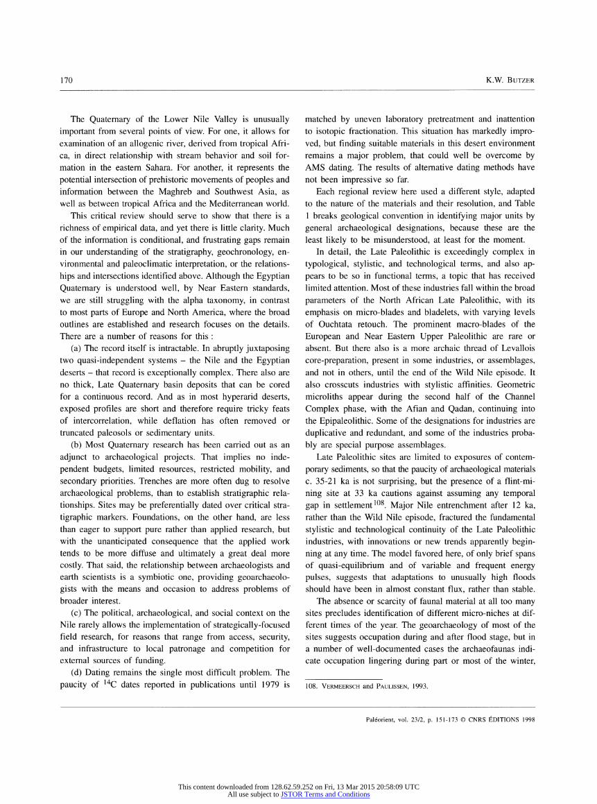
170 K.W. BuTZER
The Quaternary of the Lower Nile Valley is unusually important from several points of view. For one, it allows for examination of an allogenic river, derived from tropical Afri- ca, in direct relationship with stream behavior and soil for- mation in the eastern Sahara. For another, it represents the potential intersection of prehistoric movements of peoples and information between the Maghreb and Southwest Asia, as well as between tropical Africa and the Mediterranean world.
This critical review should serve to show that there is a richness of empirical data, and yet there is little clarity. Much of the information is conditional, and frustrating gaps remain in our understanding of the stratigraphy, geochronology, en- vironmental and paleoclimatic interpretation, or the relations- hips and intersections identified above. Although the Egyptian Quaternary is understood well, by Near Eastern standards, we are still struggling with the alpha taxonomy, in contrast to most parts of Europe and North America, where the broad outlines are established and research focuses on the details. There are a number of reasons for this :
(a) The record itself is intractable. In abruptly juxtaposing two quasi-independent systems - the Nile and the Egyptian deserts - that record is exceptionally complex. There also are no thick, Late Quaternary basin deposits that can be cored for a continuous record. And as in most hyperarid deserts, exposed profiles are short and therefore require tricky feats of intercorrelation, while deflation has often removed or truncated paleosols or sedimentary units.
(b) Most Quaternary research has been carried out as an adjunct to archaeological projects. That implies no inde- pendent budgets, limited resources, restricted mobility, and secondary priorities. Trenches are more often dug to resolve archaeological problems, than to establish stratigraphie rela- tionships. Sites may be preferentially dated over critical stra- tigraphie markers. Foundations, on the other hand, are less than eager to support pure rather than applied research, but with the unanticipated consequence that the applied work tends to be more diffuse and ultimately a great deal more costly. That said, the relationship between archaeologists and earth scientists is a symbiotic one, providing geoarchaeolo- gists with the means and occasion to address problems of broader interest.
(c) The political, archaeological, and social context on the Nile rarely allows the implementation of strategically-focused field research, for reasons that range from access, security, and infrastructure to local patronage and competition for external sources of funding.
(d) Dating remains the single most difficult problem. The paucity of 14C dates reported in publications until 1979 is
matched by uneven laboratory pretreatment and inattention to isotopie fractionation. This situation has markedly impro- ved, but finding suitable materials in this desert environment remains a major problem, that could well be overcome by AMS dating. The results of alternative dating methods have not been impressive so far.
Each regional review here used a different style, adapted to the nature of the materials and their resolution, and Table 1 breaks geological convention in identifying major units by general archaeological designations, because these are the least likely to be misunderstood, at least for the moment.
In detail, the Late Paleolithic is exceedingly complex in typological, stylistic, and technological terms, and also ap- pears to be so in functional terms, a topic that has received limited attention. Most of these industries fall within the broad parameters of the North African Late Paleolithic, with its emphasis on micro-blades and bladelets, with varying levels of Ouchtata retouch. The prominent macro-blades of the European and Near Eastern Upper Paleolithic are rare or absent. But there also is a more archaic thread of Levallois core-preparation, present in some industries, or assemblages, and not in others, until the end of the Wild Nile episode. It also crosscuts industries with stylistic affinities. Geometric microliths appear during the second half of the Channel Complex phase, with the Afian and Qadan, continuing into the Epipaleolithic. Some of the designations for industries are duplicative and redundant, and some of the industries proba- bly are special purpose assemblages.
Late Paleolithic sites are limited to exposures of contem- porary sediments, so that the paucity of archaeological materials c. 35-21 ka is not surprising, but the presence of a flint-mi- ning site at 33 ka cautions against assuming any temporal gap in settlement108. Major Nile entrenchment after 12 ka, rather than the Wild Nile episode, fractured the fundamental stylistic and technological continuity of the Late Paleolithic industries, with innovations or new trends apparently begin- ning at any time. The model favored here, of only brief spans of quasi-equilibrium and of variable and frequent energy pulses, suggests that adaptations to unusually high floods should have been in almost constant flux, rather than stable.
The absence or scarcity of faunal material at all too many sites precludes identification of different micro-niches at dif- ferent times of the year. The geoarchaeology of most of the sites suggests occupation during and after flood stage, but in a number of well-documented cases the archaeofaunas indi- cate occupation lingering during part or most of the winter,
108. Vermeersch and Paulissen, 1993.
Paléorient, vol. 23/2, p. 151-173 © CNRS ÉDITIONS 1998
This content downloaded from 128.62.59.252 on Fri, 13 Mar 2015 20:58:09 UTCAll use subject to JSTOR Terms and Conditions

Late Quaternary problems of the Egyptian Nile : stratigraphy, environments, prehistory 171
post-flood season. Exploitation of the wadi resources, espe- cially east of the Nile, where a little more rain would ensure grazing opportunities on a periodic basis109, remains only a theoretical probability until appropriate camp sites are found. For the interim, the hard evidence points to interwoven adap- tations to a riparian ecotone, ranging from aquatic to desert- edge resources.
When the Neolithic appears in the Nile Valley and Fayum, about 5,500 ВСЕ, it is evident in the presence of domesticated sheep, cattle, and wheat, more so than in its lithic artifacts110. And this Nile Valley Neolithic is substantially younger than the first steps to food production in the Saharan oases. In the Fayum, transitional economies such as the Moerian persisted until the first Predynastic presence, after 4,000 ВСЕ.
ACKNOWLEDGEMENTS
Many individuals have been helpful along the way, including David Helgren (San Jose), Jean de Heinzelin (Ghent), Bruce Gladfelter (Chicago), Lech Krzyzaniak (Poznan), H.J. Pachur (Berlin), Louis Scott (Bloemfontein), John Vogel (Pretoria), and Fred Wendorf (Dal- las). The illustrations were ably drawn by Susan Long, and the endless word processing was greatly facilitated by Kelly Hobbs. The paper is dedicated to Pierre Vermeersch (Leuven).
Karl W BUTZER Department of Geography The University of Texas USA-Austin , TX 78712
109. For exemple, Butzer and Hansen, 1968 : 181-187, with map fig. 4-4. 110. See Brewer, 1989.
BIBLIOGRAPHY
Adamson D.A. 1982 The integrated Nile. In : Williams M.A.J, and Adamson D.A.
(eds). A Land between two Niles : 223-234. Rotterdam : A.A. Balkema.
Adamson D.A., Wiliams M.A.J, and Gillespie R. 1982 Paleogeography of the Gezira and of the lower Blue and White
Nile Valley. In : Williams M.A.J, and Adamson D.A. (eds). A Land between two Niles : 223-234. Rotterdam : A.A. Bal- kema.
Allen R.O., Hamroush H. and Stanley D.J. 1992 Impact of the environment on Egyptian civilization before the
Pharaohs. Analytical Chemistry 65 : 32A-43A. Andres W. and Wunderlich J. 1991 Late Pleistocene and Holocene evolution in the eastern Nile
Delta and comparisons with the western Delta. In : Brückner H. and Radtke U. (eds). From the North Sea to the Indian Ocean : 120-130. Stuttgart : F. Steiner.
Arnold D. and Arnold D. 1979 Der Tempel Qasr el-Sagha. Mainz : P. von Zabern.
Atti a M.I. 1954 Deposits in the Nile Valley and the Delta. Cairo : Geological
Survey of Egypt. Bell B. 1975 Climate and the history of Egypt : The Middle Kingdom.
American Journal of Archaeology 79 : 223-269. Brewer D.J. 1989 Fishermen, Hunters and Herders : Zooarchaeology in the
Fayum, Egypt (ca. 8200-5000 bp). BAR Int. Ser. 478. Oxford. Butzer K.W. 1970 Contemporary depositional environments in the Omo Delta and
some applications. Nature 226 : 425-430. 1976 Early Hydraulic Civilization in Egypt: A Study in Cultural
Ecology. Chicago : University of Chicago Press. 1980a The Holocene lake plain of North Rudolf, East Africa. Physical
Geography 1 : 44-58. 1980b Pleistocene history of the Nile Valley in Egypt and Lower
Nubia. In : Williams M.A.J, and Faure H. (eds) The Sahara and the Nile : 253-280. Rotterdam : A.A. Balkema.
1984 Late Quaternary environments in South Africa. In : Vogel J.C. (ed.). Late Cainozoic Paleoclimates of the Southern Hemi- sphere : 235-264. Rotterdam : A.A. Balkema.
1995 Environmental change in the Near East and human impact on the land. In : Sasson J.M. (ed.). Civilizations of the Ancient Near East : 123-151. New York: Macmillan, Vol. 1.
1997 Sociopolitical discontinuity in the Near East c. 2200 ВСЕ : Scenarios from Palestine and Egypt. In : Dalfes H.N., Kukla G. and Weiss H. (eds) Third Millennium ВС Climate Change and Old World Collapse, NATO Global Environmental Change Series 49 : 245-296. Berlin : Springer.
Butzer K.W. and Hansen C.L. 1968 Desert and River in Nubia : Geomorphology and Prehistoric
Environments at the Aswan Reservoir. Madison : University of Wisconsin Press. 1 vol. plus map roll.
Butzer K.W., Isaac G.L., Richardson R.L. and Washburn-Kamau C. 1971 Radiocarbon dating of East African lake levels. Science 175 :
1069-1076. Chen Z. and Stanley D.J. 1993 Alluvial stiff muds (Late Pleistocene) underlying the lower
Nile Delta plain : Petrology, stratigraphy and origin. Journal of Coastal Research 9 : 539-576.
Chen Z., Warne A. G. and Stanley D.J. 1992 Late Quaternary evolution of the northwest Nile Delta between
Rosetta and Alexandria, Egypt. Journal of Coastal Research 8 : 527-561.
Chorley R.J., Schümm S.A. and Sugden D.E. 1984 Geomorphology. London : Methuen. Church M. 1978 Paleohydrological reconstructions from a Holocene valley fill.
In : M i all A.D. (ed.). Fluvial Sedimentology 50-79. Calgary : Canadian Society of Petroleum Geologists.
Churcher C.S. 1972 Late Pleistocene vertebrates from archaeological sites in the
Plain of Kom Ombo, Upper Egypt. Toronto : Royal Ontario Museum, Life Sciences Contributions 82.
Close A.E. (ed.) 1987 Prehistory of Arid North Africa : Essays in Honor of Fred
Wendorf. Dallas : Southern Methodist University Press.
Paléorient, vol. 23/2, p. 151-173 © CNRS ÉDITIONS 1998
This content downloaded from 128.62.59.252 on Fri, 13 Mar 2015 20:58:09 UTCAll use subject to JSTOR Terms and Conditions

172 K.W. BUTZER
1989 Stylistic study of the Late Paleolithic of Wadi Kubbaniya and the lower Nile Valley. In : Wendorf F. and Schild R. (eds), The Prehistory of Wadi Kubbaniya , Vol. 3 : 752-767 . Dallas : Southern Methodist University Press.
Close A.E., Wendorf F. and Schild F. 1979 The Afian : A Study of Stylistic Variation in a Nilotic industry.
Dallas : Southern Methodist University, Department of Anthro- pology.
Coutellier V. and Stanley D.J. 1987 Late Quaternary stratigraphy and palaeogeography of the east-
ern Nile Delta, Egypt. Marine Geology 11 : 257-275. Dagan-Ginter A., Ginter В., Kozlowski J.K., Pawlikowski M. and Sliwa J. 1984 Excavations in the region of Qasr-el-Sagha, 1981 : Contribu-
tion to the Neolithic period, Middle Kingdom settlement and chronological sequences in the northern Fayum Desert. Mit- teilungen, Deutsches Archäologisches Institut, Abteilung Kairo 40 : 33-102.
De Heinzelin J. 1968 Geological history of the Nile Valley in Nubia, 19-55. In :
Wendorf F. (ed.), Prehistory of Nubia. Dallas : Southern Methodist University Press.
De Wit H.E. 1993 The evolution of the Eastern Nile Delta as a factor in the
development of human culture. In : Krzyzaniak L., Kobusie- wicz M. and Alexander J. (eds) Environmental Change and Human Culture in the Nile Basin and northern Africa until the second Millennium B.C. : 305-320. Poznan : Poznan Ar- chaeological Museum.
De Wit H.E. and Van Stralen L. 1988 Geoarchaeology and ancient distributaries in the eastern Nile
Delta. Amsterdam : University of Amsterdam, Laboratory of Physical Geography and Soil Science Report 32.
El-Attar H.A. and Jackson M.L. 1973 Montmorillonitic soils developed in Nile River sediments. Soil
Science 116: 191-201. El-Gamili M.M. and Hassan E.H. 1989 Geophysical Investigations for Holocene paleo-hydrography in
the northwestern Nile Delta. In : The Archaeology, Geography and History of the Egyptian Delta in Pharaonic Times : 125- 154. Oxford : Wadham College, Discussions in Egyptology 1.
El-Kammar A.A., Philip G. and Arafa E.H. 1992 Geochemistry of recent Nile sediments from the main Nile
course in Egypt, and the principal tributaries in Ethiopia and Sudan. In : Geology of the Arab World : 527-541. Cairo : Cairo University.
Fairbridge R.W. 1963 Nile sedimentation above Wadi Haifa during the last 20,000
years. Kush 9 : 96-107. Foucault A. and Stanley D.J. 1989 Late Quaternary palaeoclimatic oscillations in East Africa re-
corded by heavy minerals in the Nile Delta. Nature 339 : 44-46.
Gautier A. and Van Neer W. 1989 Animal remains from the Late Paleolithic sequence at Wadi
Kubbaniya. In : Wendorf F. and Schild R. (eds). The Pre- history of Wadi Kubbaniya 2: 119-151. Dallas: Southern Methodist University Press.
Ginter В., Kozlowski J.K., Pawlikowski M. and Sliwa J. 1982a El-Tarif and Qasr-el-Sagha. Mitteilungen, Deutsches Archäo-
logisches Institut, Abteilung Kairo 38 : 97-129. Ginter В., Kozlowski J.K., Pawlikowski M., Sliwa J. and Pazdur M.F. 1982b Qasr-el-Sagha 1980 : Contributions to the Holocene Geology,
the Predynastic and Dynastic Settlements in the Northern Fayum Desert. Warsaw-Krakow : Nakladem Uniwersytetu Ja- giellonskiego.
Haas H. 1989 The radiocarbon dates from Wadi Kubbaniya. In : Wendorf
and Schild R. (eds). The Prehistory of Wadi Kubbaniya 2 : 274-279. Dallas : Southern Methodist University Press.
Haas H. and Haynes C.V. 1975 Southern Methodist University radiocarbon date list II. Radio-
carbon 17 : 354-363. Hamrousch H.A. and Stanley D.J. 1990 Paleoclimatic oscillations in East Africa interpreted by analysis
of trace elements in the Nile Delta sediments. Episodes 13 : 264-269.
Hassan F.A. 1976 Heavy mineral analysis of some Pleistocene sediments in the
Nile Valley. In : Wendorf F. and Schild R. (eds). Prehistory of the Nile Vallley : 331-338. New York : Academic Press.
1980 Prehistoric settlements along the Nile. In : Williams M.A.J. and Faure H. (eds). The Sahara and the Nile : 421-450. Rotterdam : A.A. Balkema.
1985 Radiocarbon chronology of Neolithic and Predynastic sites in Upper Egypt and the Delta. African Archaeological Review 3 : 95-116.
1986 Holocene lakes and prehistoric settlements in the western Fayum, Egypt. Journal of Archaeological Science 13: 483- 501.
Hassan F.A. and Attia A.K 1976 X-ray mineralogy of some Quaternary Nile sediments. In :
Wendorf F. and Schild R. (eds). Prehistory of the Nile Valley : 339-342. New York : Academic Press.
Hillman G., Madeyska E. and Hather J. 1989 Wild plant foods and diet at Late Paleolithic Wadi Kubbaniya :
The evidence from charred remains. In : Wendorf F. and Schild R. (eds). The Prehistory of Wadi Kubbaniya 2 : 162- 242. Dallas : Southern Methodist University Press.
Kozlowski J.K. and Ginter B. 1989 The Fayum Neolithic in the light of new disclosure. In :
Krzyzaniak L. and Kobusiewicz M. (eds) Late Prehistory of the Nile Basin and the Sahara : 157-180. Poznan : Poznan Archaeological Museum.
Krzyzaniak L. 1993 New data on the late prehistoric settlement at Minshat Abu
Omar, eastern Nile Delta. In : Krzyzaniak L., Kobusiewicz M. and Alexander J. (eds). Environmental Change and Hu- man Culture in the Nile Basin and northern Africa until the Second Millenium B.C. : 321-325. Poznan : Poznan Archaeo- logical Museum.
Leroy S.A. 1992 Palynological evidence of Azolla nilotica in recent Holocene
of the eastern Nile Delta and palaeo-environment. Vegetation History and Archaeobotany 1 : 43-52.
McHugh W.P., Breed C.S., Schaber G.G., McCauley J.F and Szabo B.J. 1988 Acheulian sites along the "radar rivers", southern Egyptian
Sahara. Journal of Field Archaeology 15 : 361-379.
Paléorient, vol. 23/2, p. 151-173 © CNRS ÉDITIONS 1998
This content downloaded from 128.62.59.252 on Fri, 13 Mar 2015 20:58:09 UTCAll use subject to JSTOR Terms and Conditions

Late Quaternary problems of the Egyptian Nile : stratigraphy, environments, prehistory 173
Paulissen E. and Vermeersch P.M. 1987 Earth, man and climate in the Egyptian Nile Valley during the
Pleistocene. In : Close A.E. (ed.), Prehistory of Arid North Africa : 29-60. Dallas : Southern Methodist University Press.
Phillips J.L. and Butzer K.W. 1973 A "Silsilian" occupation site (GS-2B-II) of the Kom Ombo
Plain, Upper Egypt : Geology, archeology and paleo-ecology. Quaternaria 17 : 343-386.
Rotnicki К. 1983 Modelling past discharges of meandering rivers. In : Gregory
K.J. (ed.). Background to Paleohydrology : 321-354. New York : Wiley.
Said R. 1981 The Geological Evolution of the River Nile. New York and
Berlin : Springer. Schild R. and Wendorf F. 1989 The late Pleistocene Nile in Wadi Kubbaniya. In : Wendorf
F., Schild R. and Close A.E. (eds). The Prehistory of Wadi Kubbaniya : Stratigraphy, Paleoeconomy and Environment : 15-100. Dallas : Southern Methodist University Press.
Sestini G. 1989 Nile Delta : a review of depositi onal environments and geo-
logical history. In : Whateley M.K.G. and Pickering K.T. (eds). Deltas: Sites and Traps for Fossil Fuels : 99-127. Oxford : Blackwell, Geological Society Special Publication 41.
Shahin M. 1985 Hydrology of the Nile Basin. Amsterdam : Elsevier. Smith P.E.L. 1966 The Late Paleolithic of Northeast Africa in the light of recent
research. American Anthropologist 62 (2, pt. 2) : 326-355. 1967 New investigations in the late Pleistocene archaeology of the
Kom Ombo Plain (Upper Egypt). Quaternaria 9: 141-152. Stanley D.J. and Maldonado A. 1977 Nile Cone : Late Quaternary stratigraphy and sediment disper-
sal. Nature 266 : 129-135. Stanley D.J. and Warne A.C. 1993 Nile Delta : Recent geological evolution and human impact.
Science 60 : 628-634. Stanley D.J., Warne A.G., Davis H.R., Bernasconi M. and Chen Z. 1992 Late Quaternary evolution of the North-central Nile Delta from
Manzala to Burullus lagoons, Egypt. National Geographic Research and Exploration 8 : 22-5 1 .
Stanley D.J. and Wingerath J.G. 1996 Nile sediment dispersal altered by the Aswan High Dam : the
kaolinite trace. Marine Geology, 133 : 1-9. Stuiver M. and Reimer P.J. 1993 Extended 14C database and revised CALIB 3.0 14C age cali-
bration program. Radiocarbon 35 : 212-230. Van Peer P. 1993 Levallois variability and the Middle Paleolithic of the Lower
Nile Valley and the Eastern Sahara. In : Krzyzaniak L., Kobusiewicz M. and Alexander J. (eds). Environmental Change and Human Culture in the Nile Basin and Northern Africa until the Second Millenium B.C. : 129-144. Poznan Archaeological Museum.
Vermeersch P.M. 1978 El Kab II : L'Elkabien, épipaléolithique de la Vallée du Nil
égyptien. Leuven : Publications du Comité des Fouilles Belges en Egypte.
Vermeersch P.M. and Paulissen E. 1993 Paleolithic chert quarrying and mining in Egypt. In : Krzyza-
niak L., Kobusiewicz M. and Alexander J. (eds). Environ- mental Change and Human Culture in the Nile Basin and Northern Africa until the Second Millenium B.C. : 337-349. Poznan Archaeological Museum.
Vermeersch P.M., Paulissen E. and Van Neer W. 1989 The Late Paleolithic Makhadma sites (Egypt) : Environment
and subsistence. In : Krzyzaniak L. and Kobusiewicz M. (eds). Late Prehistory of the Nile Basin and the Sahara : 87-116. Poznan : Poznan Archaeological Museum.
1990 Le Paléolithique dans la Vallée du Nil égyptien. L'Anthropo- logie 94 : 435-458.
Wendorf F. and Schild R. 1976 Prehistory of the Nile Valley. New York : Academic Press. 1989a The Prehistory of Wadi Kubbaniya. Vol. 2 Stratigraphy, Pa-
leoeconomy, and Environment. Dallas : Southern Methodist University Press.
1989b Summary and Synthesis. In : Wendorf F. and Schild R. (eds). The Prehistory of Wadi Kubbaniya , Vol. 3 : 768-824. Dallas : Southern Methodist University Press.
Wendorf F., Schild R. and Close A.E. (eds) 1990 The Prehistory of Wadi Kubbaniya. Vol. 3. Dallas : Southern
Methodist University Press. 1993 Egypt during the Last Interglacial : The Middle Paleolithic of
Bir Tarfawi and Bir Sahara East. New York : Plenum. Wendorf F., Schild R. and Haas H. 1979 A new radiocarbon chronology for prehistoric sites in Nubia.
Journal of Field Archaeology 6 : 219-223. Wendorf F., Schild R., Baker P., Gautier A., Longo L. and Mohammed A. 1997 A Late Paleolithic Kill-Butchery Camp in Upper Egypt. Dal-
las : Southern Methodist University, Department of Anthropo- logy.
Wetterstrom W. 1993 Foraging and farming in Egypt : The transition from hunting
and gathering to horticulture in the Nile Valley. In : Shaw T., Sinclair P., Bassey A. and Okpoko A. (eds). The Archaeology in Africa : food, Metals and towns : 165-226. London : Rout- ledge.
Whiteman A.J. 197 1 The geology of the Sudan Republic. Oxford : Oxford University
Press. Willcocks W. and Craig J.I. 1913 Egyptian Irrigation, 2 vol. London : E. & F.N. Spon. Williams G.P. 1984 Paleohydrologic equations for rivers. In : Costa J.E. and Fleis-
her P.J. (eds). Developments and Applications of Geomorpho- logy : 343-367. New York : Springer Verlag.
Williams M.A.J, and Adamson D.A. (eds) 1982 A Land between Two Niles : Quaternary Geology and Biology
of the Central Sudan. Rotterdam : A.A. Balkema. Wunderlich J. 1989 Untersuchungen zur Entwicklung des westlichen Nildeltas im
Holozän. Marburger Geographische Arbeiten 114. Marburg.
Paléorient, vol. 23/2, p. 151-173 © CNRS ÉDITIONS 1998
This content downloaded from 128.62.59.252 on Fri, 13 Mar 2015 20:58:09 UTCAll use subject to JSTOR Terms and Conditions