Embed Size (px)
Citation preview

International Journal of Korean History (Vol.26 No.1, Feb. 2021) 177
Painting the Void: The Instrumentalization of
Cartography in Neo-Confucian Chosŏn and
Renaissance France through Landscape Painting
and Perspective (15th-16th centuries)
Jérémie Eyssette*
Introduction
Maps derive value from the balance between the information their car-
tographers supply or subtract. When involuntary, absence of data is at-
tributed to negligence or ignorance. When intentional, it tends to connote
deceit. Previous studies praised the plethora of entries which points to
scientific precocity in Yi Hoe’s (李薈, 1354-1409) P’altodo (八道圖, Map
of the Eight Provinces, 1400) and Honil kangni yŏktae kukto chi to (混一
疆理歷代國都之圖, Map of Integrated Lands and Regions of Historical
Countries and Capitals, 1402) or Kangnido,1 and in Oronce Fine’s
(1494-1555) Recens et integra orbis descriptio (1536) and Nova totius
* Assistant Professor, Chosun University
1 Oh Sanghak, “Honil kangni yŏktae kukto chi to tamnon ŭi pip'anjŏk kŏmt'o,”
Han'gukkojidoyŏn'guhak'oe haksultaehoe (2012): 91-109; Nurlan Kenzheakhmet,
“Central Asian Place Names in the Kangnido,” Journal of Asian History 49, no. 1-
2 (2015): 141-160; Nurlan Kenzheakhmet, “The Place Names of Euro-Africa in
the Kangnido,” The Silk Road 14 (2016): 106-125. Jerry Brotton, A History of the
World in 12 Maps (New York: Viking, 2013), 114-145; Gari Ledyard, “Cartog-
raphy in Korea,” in The History of Cartography, ed. Catherine Delano Smith, Na

Painting the Void 178
Galliae descriptio (1538)2 –thereafter Fine’s world map and France
map. From a comparative perspective, one benefit from delving into the
Kangnido’s sources is to establish a connection with later Western car-
tography, and in particular with Oronce Fine (1494-1555) who also re-
lied on Ptolemy and similar tools. Parallels can be extended to the polit-
ical sphere. Both cartographers were closely linked to the powers that
be3 at a time the burgeoning Yi and Valois dynasties were seeking to
establish a new modus operandi with a continental hegemon –the Ming
and Habsburg Empires.
An introduction to Yi Hoe and Fine’s maps will show that they have al-
ready been credited with sharing common sources and reflecting these
shifting circumstances. Missing from the literature, however, is a com-
prehensive analysis of cartographic instrumentalization through the
prisms of landscape painting and perspective. At some overarching level,
this research can be seen as a conversation between these painting tradi-
tions as insightfully analyzed by the art historians François Cheng and
than Sivin, Cordell Yee, et al. (Chicago: J.B. Harley et D. Woodward, 1994), 235-
345.
2 Lt-colonel Langlois, “Étude sur deux cartes d’Oronce Fine de 1531 et 1536,”
Journal de la Société des Américanistes 14-15 (1922): 83-97 ; Lucien Gallois, “La
grande carte de France d’Oronce Fine, ” Annales de Géographie 44, no. 250
(1935): 337-348 ; Alexander Marr, The worlds of Oronce Fine, Mathematics, In-
struments and Print in Renaissance France (Donington: Shaun Tyas, 2009).
3 In 1530, Oronce Fine was appointed as lecteur royal by Francis I at the first chair
of mathematics at Collège Royal (today’s Collège de France), a scientific and cul-
tural institution founded by king Francis I that year. He held this position until his
death in 1555. After passing the civil service examination in 1382, Yi Hoe served
both in the Koryŏ and Chosŏn governments. Following King T’aejo’s will to keep
some military officers away from the defense ministry (兵曹正郞), Yi Hoe was
exiled to Sunch’ŏn in 1394. The year he confectioned the Kangnido (1402), he was
appointed as Legal Secretary (kŏmsang) and held official positions until his death
in 1409. Kenneth Robinson, “Yi Hoe and His Korean Ancestors in T’aean Yi Ge-
nealogies,” Seoul Journal of Korean Studies 21, no. 2 (December 2008): 234-237.

Jérémie Eyssette 179
The Ryūkoku Kangnido (164 x 171.8 cm), 混一疆理歷代國都之圖, Honil kangni
yŏktae kukto chi to, Map of Integrated Lands and Regions of Historical Countries
and Capitals, 1479-1485.
Reproduced with permission from Ōmiya Library, Ryūkoku University, Kyoto,
Japan.
Daniel Arasse.4 It will seek to address Cheng’s regret that “with regards
4 This research will essentially hinge upon the theories developed in: François
Cheng, Vide et plein, Le langage pictural chinois (Paris: Seuil, 1991); François
Cheng, Souffle-Esprit (Paris: Seuil, 2006); Daniel Arasse, Histoires de peinture
(Paris: Gallimard, 2004) ; Daniel Arasse, Le Détail (Paris: Flammarion, 1996).
François Cheng (1929-now) is an eminent Sinologist who became member of the
Académie Française in 2002. Daniel Arasse (1946-2003) worked as study director
at EHESS (School of Social Sciences). As an art historian, he specialized in Re-
naissance and Italian art.

Painting the Void 180
to its application in practical fields, the notion of void has never been
studied in a systematic manner,”5 and fulfill Daniel Arasse’s late wish to
further explore the political dimension of vacuum and perspective.6 The
techniques and concepts that nurture landscape painting and perspective
will be examined to show how they apply to the instrumentalization of the
Detail of the Korean Peninsula inspired by the lost P’altodo (1400) on the Ryūkoku
Kangnido, 1479-1485.
Reproduced with permission from Ōmiya Library, Ryūkoku University, Kyoto,
Japan.7
5 Cheng, Vide, 46.
6 Arasse, Histoires, 63; Arasse, Le Détail, 149-155.
7 Digital reproductions are also available at: “Reproduction of the Ryūkoku
Kangnido,” Busan Historical and Cultural Collections, accessed December 15,
2020, http://busan.grandculture.net/Contents/Index?local=busan.
Also available at: “Colored reproduction of the Ryūkoku Kangnido,” Insitute of
Korean Studies, Kyujanggak, accessed December 15, 2020, http://kyudb.sn
u.ac.kr/book/view.do.

Jérémie Eyssette 181
Kangnido and Fine’s maps. What the discussion will seek to bring to the
fore is that far from being peripheral to their work, Yi Hoe and Fine’s
respective resort to landscape painting and perspective structure their
maps. Not only do they make possible the polarity between science and
ignorance, and the politically-motivated dialectics between secrecy and
ostentation, but they also extend the meaning of their maps beyond con-
ventional spatial and temporal benchmarks. The conclusion will establish
a four-pronged typology of voids as instrumentalized on these maps, and
potentially on others.
Recens et integra orbis descriptio (51 x 57 cm), Oronce Fine, 1536.
Reproduced with permission from BNF, Cartes et Plans, Rés. Ge DD 2987 (63).8
8 “Recens et integra orbis descriptio,” Oronce Fine, Bibliothèque nationale de France,
accessed December 15, 2020, http://expositions.bnf.fr/lamer/grand/054.htm.
Painting the Void 182
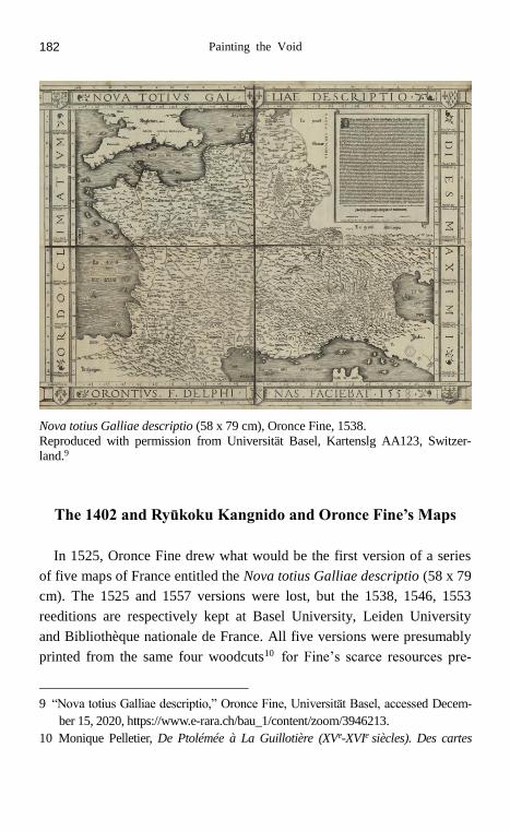
Nova totius Galliae descriptio (58 x 79 cm), Oronce Fine, 1538.
Reproduced with permission from Universität Basel, Kartenslg AA123, Switzer-
land.9
The 1402 and Ryūkoku Kangnido and Oronce Fine’s Maps
In 1525, Oronce Fine drew what would be the first version of a series
of five maps of France entitled the Nova totius Galliae descriptio (58 x 79
cm). The 1525 and 1557 versions were lost, but the 1538, 1546, 1553
reeditions are respectively kept at Basel University, Leiden University
and Bibliothèque nationale de France. All five versions were presumably
printed from the same four woodcuts10 for Fine’s scarce resources pre-
9 “Nova totius Galliae descriptio,” Oronce Fine, Universität Basel, accessed Decem-
ber 15, 2020, https://www.e-rara.ch/bau_1/content/zoom/3946213.
10 Monique Pelletier, De Ptolémée à La Guillotière (XVe-XVIe siècles). Des cartes
Jérémie Eyssette 183
vented him from updating coordinates he had nonetheless improved.11
Aside from preservation conditions, all three extant versions are almost
identical. France, or rather Gaul, appears surrounded by the ancient divi-
sions of the Roman Empire. The title and the Ptolemaic climates are in
Latin, but the commemoration and some toponyms are written in French.
According to the cartographer’s commemoration, the map was intended
to “generally describe and reform the longitudes and latitudes, and situa-
tion of the main places, coasts, rivers and mountains”12 so as to please
“all the mathematics’ friends.”13 This scientific letter of intent is con-
firmed on his world map entitled the Recens et integra orbis descriptio
(51 x 57 cm, 1536), which resorts to a single heart-shaped projection,
whereas a simple trapezoidal projection is used on France map. The Hel-
lenic geometric heritage conveyed by Ptolemy through both maps first
meets the eye. But Fine also alludes to “the numerous observations from
recent hydrographers.”14 This would indicate that the former cartographic
tradition had to be combined with a second strand of sources –the con-
temporaneous explorations reported by argonauts on portolans. This epis-
temic duality permeates the linguistic field too since Fine used a bilingual
nomenclature in Latin and French on France map. This happened at a
time when Fine was appointed royal lecturer by Francis I in the first chair
of mathematics at the recently created Collège de France (1530). Nine
years later, the Villers-Côtterets ruling (1539) prohibited Latin in legal
documents and converted French into the administration’s official lan-
guage. These initiatives were widely perceived as challenging Paris Uni-
pour la France, pourquoi, comment ? (Paris: CTHS, 2009), 22.
11 Gallois, “La grande carte de France d’Oronce Fine,” 338.
12 Oronce Fine, “Légende de la Nova totius Galliae descriptio (1538),” in Lucien
Gallois, “Oronce Fine et sa grande carte de France de 1525,” Bulletin de
l’Association de géographes français 99, 13e année (juillet-octobre 1936): 113.
13 Oronce Fine, “Légende de la Recens et integra orbis descriptio,” in Lt-colonel
Langlois, “Étude sur deux cartes d’Oronce Fine de 1531 et 1536,” Journal de la
Société des Américanistes 14-15 (1922): 93.
14 Fine, “Légende,” 93.
Painting the Void 184
versity and the Church’ monopoly on science and faith imparted in Lat-
in.15 Reflecting this, a dual order emerges from Fine’s work –Ptolemy
and portolans; knowledge and power.
One century before Fine, Yi Hoe also drew a map of his kingdom, the
P’altodo (1400), and a world map, the Kangnido (1402). Both were lost
but somehow survived through other maps. According to academic con-
sensus, the P’altodo served as a model for Yi Hoe when drawing the Ko-
rean peninsula on the 1402 Kangnido.16 As for the oldest extant version
of the Kangnido, it is preserved at the Ryūkoku University and is there-
fore known as the Ryūkoku Kangnido. A nearly square silk roll of 164 x
171,8 cm, it was originally attached to a wooden rod. Kenneth Robinson
estimated its dating between 1479-1485.17 Its cartographer remains un-
known, as were those of the three later versions (Honkōji, Tenri and
Honmyōji, circa 1560) probably also despoiled during the Imjin wars
(1592-1598). Based on Robinson’s assumption that the shapes and pro-
portions of the 1402 Kangnido are preserved on the Ryūkoku Kangnido,18
this study will focus on these two versions. Surmising Yi Hoe’s intentions
proves difficult since his biography and the T’aean Yi Genealogies were
embellished.19 What is verifiable, however, is that after passing the high-
er civil service examination in 1382, he held various posts under the
Koryŏ and the Chosŏn governments. Exiled in Sunch’ŏn (1394), he re-
turned to the capital (1402) where he was asked by his superiors Yi Mu
and Kim Sahyŏng to make a world map. In the commemoration written
by Kwŏn Kŭn (權近) –an official from the Ŭijŏngbu (議政府, State
Council)– only two cartographic references are explicit –the
15 Marc Fumaroli, Les origines du Collège de France (1500-1600) (Paris: Collège de
France, 1998), 3-108, 185-208.
16 Ledyard, “Cartography,” 247.
17 Kenneth Robinson, “Chosŏn Korea in the Ryūkoku Kangnido: Dating the Oldest
Extant Korean Map of the World (15th century),” Imago Mundi 59, Part 2 (2007):
177-192.
18 Robinson, “Chosŏn Korea,” 185-188.
19 Kenneth Robinson, “Yi Hoe,” 221-250.
Jérémie Eyssette 185
Shengjiaoguangbeitu (聲教廣被圖, circa 1330) and the Hunyijianglitu (混
一疆理圖, prior to 1392).20 With respect to the content of the map, Chi-
nese capitals of historical and administrative significance are enumerated
from right to left under the title. In addition to featuring 425 place-names
for the sole Korean peninsula, the Ryūkoku Kangnido is the first Far
Eastern world map including continents beyond the Confucian realm: the
Arabic peninsula and Africa are easily recognizable but it also includes
place-names from Europe as will be detailed below. Yet in the graphics of
the commemoration and the painting itself, pride of place is given to Chi-
na which visually occupies two thirds of the map. The accuracy of the
Korean peninsula on the Ryūkoku Kangnido cannot be matched by Fine’s
inequal treatment of provinces and even less so by his approximate re-
course to portolans. The Ryūkoku Kangnido’s cartographer painted a re-
alistically rugged peninsula where Fine traced an unrealistic rectilinear
Atlantic coast. Just like France, Korea’s surface seems increased to the
detriment of its neighbors –except China. More surprisingly, considering
that the Kangnido included the Azores, it pivoted Japan 90 degrees
clockwise to the South of Korea, allegedly due to a prosaic lack of space
on the silk roll.21 As for the rationale for making this map, Kwŏn Kŭn
explains that the Kangnido’ viewers can “know the world” and its patrons
“get help in the work of government”22 –scientific and political ambitions
akin to Fine’s.
Literature Review: Absences and Presences
The Ryūkoku Kangnido and Fine’s maps have inspired many learned
20 Kwŏn Kŭn, “Commemoration of the Kangnido,” quoted in Gari Ledyard, “Cartog-
raphy in Korea,” in The History of Cartography, ed. Catherine Delano Smith, Na-
than Sivin, Cordell Yee, et al. (Chicago: J.B. Harley et D. Woodward, 1994), 245.
21 Ledyard, “Cartography,” 247.
22 Ledyard, “Cartography,” 245.

Painting the Void 186
glosses. This section will first review the main contributions in the litera-
ture. It will then argue that a comparative approach can help structure and
further these analyses around a common dimension that has been, if not
entirely ignored, at least widely toned down –painting techniques and
their conceptual toolbox.
By silencing more than stating sources, Kwŏn Kŭn’s commemoration
has fueled speculations on other possible influences. As regards Chinese
toponyms, Philippe Pelletier suggested a possible filiation from the Yuditu
(與地圖, 1320),23 and Oh Kilsun stressed similarities with the Yuanjing-
shidadiandilitu (元經世大典地理圖, 1331).24 Even though it sought to
take distance with Koryŏ, the nascent Chosŏn inherited from it a concern
for administering its territory through maps. Han Youngwoo exemplifies
this practice by referring to the Koryŏjirido (高麗地理圖), mentioned in
the Liaoshi (遼史) and sent to the Liao court in 1002, or to the
Odoyanggyedo (五道兩界圖, circa 1150).25 Beyond Korea, Bae Woosung
conjectured that Yi Hoe could have had access to Gyoki-style maps (行基
図) –through the diplomat Pak Tonji (朴惇之) who went to Japan between
1398 and 1402. He thus “added a map of Japan”, as Kwŏn Kŭn laconical-
ly puts it.26 Besides, previous studies have shown that, courtesy of the
Mongols who brought Arabic-Persian geographical knowledge to the Yu-
an court, the areas West of China are provided with 640 toponyms tran-
23 Philippe Pelletier, L’Extrême-Orient. L’invention d’une histoire et d’une
géographie (Paris: Gallimard, 2011), 172.
24 Oh Kilsun, “Wŏn'gyŏngsedaejŏnjirido e naonŭn chimyŏng ŭi chosa wa Honil
kangni yŏktae kukto chi to sŏyŏkchimyŏng gwaŭi pigyo,” Han'gukkojidoyŏn'gu 2,
no. 2 (2010): 99-100.
25 Han Youngwoo, “The historical development of Korean cartography,” in The art-
istry of early Korean Cartography, ed. Han Youngwoo, Ahn Hwijoon, Bae
Woosung (Honolulu: University of Hawai’i Press, 2009), 4-5.
26 Bae Woosung, “Joseon Maps and East Asia, Mapping the World: the Joseon
Worldview as seen through old maps,” in The Artistry of Early Korean Cartog-
raphy, ed. Han Youngwoo et al. (Honolulu: University of Hawai’i Press, 2009), 57;
Kwŏn Kŭn, “Commemoration,” 245.

Jérémie Eyssette 187
scribed in traditional Chinese characters from Mongol, Turkish, Persian,
Arabic, Indian, Slav, Greek, Latin, Spanish and Catalan toponyms.27
The reasons for re-engaging a 600-year-old map and its exegeses will
now be specified. As mentioned in the introduction, the plethora of entries
and landmasses on the Ryūkoku Kangnido have been widely acclaimed as
unmistakable signs of scientific precocity.28 To name just one, Africa is
circumvented before Bartolemeu Dias’s journey in 1488. In other words,
the Ryūkoku Kangnido not only goes far beyond the Sino-centric doxa,
but some of its content also predates the state of knowledge in Europe.
Even though occasional errors and other anomalies such as the inflated
size of China and Korea, the position of Japan south and not east of Korea
have been noted,29 disproportionate attention has been paid to what lies
on the map. And when the interaction between what went missing and
what surfaces on the map was tackled, it was either imputed to a clumsy
amalgam of cartographic traditions (from Koryŏ, Yuan China, Gyoki-
style maps, geomancy and Arab-Persian geography)30 or to political mo-
tives.31 On the margins of these investigations, the general crossed influ-
ences between painting and cartography have been discussed by Ahn
Hwijoon.32 Gari Ledyard33 and Kenneth Robinson34 stressed how later
27 Oh Kilsun, “Wŏn'gyŏngsedaejŏnjirido,” 99; Angelo Cattaneo, “World Cartography
in the Jesuit Mission in China. Cosmography, Theology, Pedagogy,” in Education
for New Times: Revisiting Pedagogical Models in the Jesuit Tradition, ed. Artur K.
Wardega S.J. (Macau: Macau Ricci Institute, 2014), 77.
28 Oh Sanghak, “Honil kangni yŏktae kukto chi to,” 91-109; Kenzheakhmet, “The
place names,” 141-160; Kenzheakhmet, “The Place Names,” 106-125.
29 Bae Woosung, “Joseon Maps,” 57; Oh Sanghak, “Chosŏnshidae ŭi ilbonjido wa
ilbon inshik,” Taehanjirihak'oeji 38, no. 1 (2003): 33-34; Hirotada Kawamura, “川
村博忠, 近世絵図の地図性 一 地図の向き一,” 地理科学 45 no. 3 (1990): 137-
138.
30 For a critical discussion on the Ryūkoku Kangnido’s approximative integration of
sources, see Oh Sanghak, “Chosŏnshidae,” 32-47.
31 Choi Changmo, “Chosŏnshidae kojidoŭi arabiaㆍ ap'ŭrik'a ihae sogo,” Han'guk-
kojidoyŏn'guhak'oe haksultaehoe (2012): 23-52; Short, Korea, 16-26.
32 Ahn Hwijoon, “Early cartography and painting,” in The artistry of early Korean

Painting the Void 188
versions of the Kangnido included more Daoist elements and progressive-
ly adopted the mould of ch'ŏnhado maps. Applied to the Ryūkoku
Kangnido proper, previous studies pointed out ornamental details35 or
nuances in the coloring codes through spectrometric analysis.36 But aes-
thetic considerations have not given way to a thorough analysis of land-
scape painting as a possible structuring framework for interpreting the
Ryūkoku Kangnido.
As regards the academic literature on Fine, three waves of critical anal-
yses addressed his work. During his life, Jean Borrel and Pedro Nunes
questioned the validity of his mathematical demonstrations but left his
geographical record untarnished.37 At the turn of the 20th century, Lucien
Gallois’ thesis and articles gave a more comprehensive appraisal of Fine
as a polymath –in spite of all well versed in mathematics, geometry and
geography– who could design and fix most of the tools required to deter-
Cartography, ed. Han Youngwoo et al. (Honolulu: University of Hawai’i Press,
2009), 133-155.
33 Ledyard, “Cartography,” 254-267.
34 In support of the thesis that the Ryūkoku Kangnido is despiritualized, one could
quote in extenso Kenneth Robinson who notes that “compared to the Ryūkoku
Kangnido, the Honkōji Kangnido (…) include [s a] greater number of imagined
lands derived from Daoist texts and ancient histories”. Besides, Mt. Kunlun reap-
pears on the Tenri and Honmyōji Kangnido which both include more Daoist imag-
inary places –copied from the 十洲記– than the Ryūkoku Kangnido and Honkōji
Kangnido. Kenneth Robinson, “Daoist Geographies in Three Korean World
Maps,” Journal of Daoist Studies 3 (2010): 101-112.
35 Ahn, “Early cartography,” 136-137.
36 Okada Yoshihiro, “Ch'ogojŏngmil hwasangch'ŏri e ŭihan Honil kangni yŏktae
kukto chi to ŭi kwahakpunsŏk,” Han'gukkojidoyŏn'guhak'oe haksultaehoe (2012):
86.
37 Jean Borrel, Confutatio quadraturæ circuli libri ab Orontio Finæ factæ , in Opera
geometrica, quorum tituli sequuntur, Lyon, T. Bertellus, 1554 ; Pedro Nunes, De
erratis Orontii Finæ i Regii Mathematicarum Lutetiæ Professoris, Coimbra,
J. Barreira et J. Alvares, 1546.
Jérémie Eyssette 189
mine coordinates.38 Prior to being an artist, the Renaissance artifex was
in effect “a producer of useful objects.”39 More recently, a collective pub-
lication delved into the various aspects of his work; namely, the propae-
deutic status of mathematics, algebra, practical geometry and sundials.40
In particular, Jean-Jacques Brioist proceeded with a detailed examination
of his cartographical methods.41 In comparing the latitudes and longi-
tudes calculated by Martin Waldeseemüller, Fine and his successors (Jean
Jolivet, Guillaume Postel and François La Guillotière), Monique Pelletier
established that the accuracy of Fine’s coordinates placed him among the
best cosmographers in 16th century Europe.42 Elsewhere, Pelletier also
underlined the political and historical dimensions of Fine’s work.43 How-
ever, mathematical and technical investigations have been implemented
separately from the political aspects of Fine’s maps. Similarly to the
Ryūkoku Kangnido, analyses related to the cartographer’s skills as an
artist –drawings carved on woods in Fine’s case– have been very limited:
Gallois praises the adventitious adornments of the frame but Broc also
38 Lucien Gallois, De Orontio Finaeo gallico geographo (Paris: E. Leroux, 1890) ;
Lucien Gallois, “La grande carte de France d’Oronce Fine,” 337-348 ; Lucien Gal-
lois, “Oronce Fine,” 107-115.
39 André Chastel, “L’artiste,” in L’homme de la Renaissance, ed. Eugenio Garin (Par-
is: Seuil, 2002), 257.
40 Alexander Marr, The worlds of Oronce Fine (Donington: Shaun Tyas, 2009); see
also Angela Axworthy, Le mathématicien renaissant et son savoir, Le statut des
mathématiques selon Oronce Fine (Paris: Classiques Garnier, 2016).
41 Jean-Jacques Brioist, “Oronce Fine and cartographical methods,” in The worlds of
Oronce Fine, Mathematics, Instruments and Print in Renaissance France, ed. Al-
exander Marr (Donington: Shaun Tyas, 2009), 137-155.
42 Pelletier, De Ptolémée, 17-19.
43 Monique Pelletier, Cartographie de la France et du monde de la Renaissance au
Siècle des lumières (Paris: Éditions de la Bibliothèque nationale de France,
2002), 11 ; Isabelle Pantin, “Oronce Fine’s Role as Royal Lecturer,” in The worlds
of Oronce Fine, Mathematics, Instruments and Print in Renaissance France,” ed.
Alexander Marr (Donington: Shaun Tyas, 2009), 16.

Painting the Void 190
mocks an oronymy resembling molehills.44 Most importantly, the manner
in which the geometrics of perspective could embrace Fine and Francis
I’s political agenda has not been fully appreciated.
Landscape Painting and Perspective as Cartographic Keys
Examining the philosophical background to Buddhist and Taoist land-
scape painting shanshuihua (山水畫), François Cheng translates the ideo-
gram li (理) as “principle or internal structure.” The artist’s task is there-
fore “less about describing the external aspects of the world than about
capturing the internal principles that structure all things and connect them
to each other.”45 Often opposed to these traditions, Confucianism and its
approach to geography dili (地理, which Pelletier translates as “ordering
of the earth”)46 follow the literal meaning of li, “to put (things) in order.”
This definition presupposes that things were not in order, and should be
rectified (to use the Confucian terminology) and reverted into a normative
order. Whether li refers to an ontological Taoist notion or a Confucian
precept, both interpretations overlap when they tell of a gap between ma-
terial contingencies and immaterial aspirations. At the Tohwasŏ (圖畫署),
where artists indifferently devoted themselves to cartography and land-
scape painting imported from China since Koryŏ,47 the painters turned
cartographers might have more or less consciously resorted to an array of
shanshuihua techniques and concepts to serve the interests of their freshly
enthroned Neo-Confucian patrons. In a more ceremonial vein, “landscape
44 Numa Broc, “Quelle est la plus ancienne carte ‘moderne’ de la France ?,” Annales
de Géographie 92, no. 513 (1983): 516; Lucien Gallois, “Un géographe dauphi-
nois : Oronce Fine et le Dauphiné sur sa carte de France de 1525,” Recueil des
travaux de l’Institut de géographie alpine 6, no. 1 (1918): 3-13; Gallois, “La
grande carte de France d’Oronce Fine,” 347.
45 Cheng, Souffle-Esprit, 155.
46 Pelletier, L’Extrême-Orient, 73.
47 Ahn, “Early Cartography,” 142.

Jérémie Eyssette 191
depictions were also part of the documentary painting kyehaedo used to
record and celebrate political events such as the inauguration of provin-
cial governors or civil service examinations.”48
Although expressed differently, the relation between painting, cartog-
raphy and politics in Europe is no less eloquent. Florence, the birthplace
of perspective (1420-1450), was simultaneously at the cutting edge of
cartography. According to Arasse, the relation between perspective and
cartography is intimate for both delivered measured representations of
space.49 Perspective also acquired political overtones from its very incep-
tion. In order to distinguish himself from his rival Paolo Strozzi who
magnified his power through gothic paintings, Cosimo de’ Medici chose
the sober style of perspective articulated by the principles of sobrietas and
res publica in Florence public chapels. The emerging sponsors of per-
spective were using it against their political rivals and against the Church;
for perspective, and the rationality it drew on, became the symbolic form
of a de-theologized world.50 Once summoned to “hide the secret of the
Incarnation within the visible scope of the Annunciation”,51 the painters’
expertise in perspective now embraced the vision of their new employers
–political leaders. Francis I, who famously brought Italian painters to his
court, is portrayed in a 1534 illumination in perspective52 as patron of the
arts and letters, surrounded by his most conservative advisors all in favour
48 Short, Korea, 17.
49 Arasse, Histoires, 60-68.
50 Arasse, Histoires, 65.
51 The paintings illustrating this idea are The Annunciation (1344) by Ambrogio Lo-
renzetti; The Annunciation (1445) by Domenico Veneziano; and The Annunciation
(1470) by Piero della Francesca. Arasse stresses that “perspective was not at all a
constraint to painters, but rather an instrument they toyed with and to which they
could give different meanings”. Arasse, Histoires, 76-83.
52 Jean Clouet, “Antoine Macault lisant sa traduction au roi François Ier et à sa cour,
Les trois premiers livres de Diodore de Sicile,” RMN Grand Palais, Domaine de
Chantilly, Musée Condé, accessed December 15, 2020, https://www.phot
o.rmn.fr/archive/01-004920-2C6NU0GQF8JP.html.

Painting the Void 192
of the Papacy and Charles V after the Cambrai Treaty (1529). But, be-
yond this idealized portrayal where everything is luxury, calm and wis-
dom, peace is but a respite allowing for the conduct of a secret diplomatic
guerrilla to counter the emperor’s [Charles V] schemes. 53 Whether
through geometry or li, paintings are suffused with an unspoken order.
But lest it is to “too full” or “too accomplished,”54 the shanshuihua paint-
er always keeps an element of void from his originally blank roll. And,
following Alberti’s advice whereby the presence of voids prevents picto-
rial chaos,55 the perspective painter constructs an image in three dimen-
sions whose depth conceals as much as it suggests.
In oriental landscape painting, blanks and strokes are the pictorial illus-
trations of couple concepts such as xu-shi (虚-實, empty-full), yin-xian
(隐-现, invisible-visible), wu-you (无-有, not have-have).56 Non-painted
voids are therefore far from being unthought. There are instead an “emi-
nently dynamic and active element,” the “ultimate place where transfor-
mations occur”.57 Insofar as an analogy may be attempted, vanishing
points and lines alike, existing data can be “hidden within the visible,”
while “the unfigurable surfaces from the figure, the inexpressible from the
speech, the immensity from the measure.”58 Though visually expressed,
perspective is the result of an intellectual operation and addresses the
mind of its viewers. Hence a certain level of abstraction required in the
process: “one has to be able to imagine the world to produce a map, yet
any map that seeks to describe the world is ipso facto an invitation to im-
agine it.”59 This back-and-forth oscillation from mind to map is also re-
53 Edith Garnier, Guillaume du Bellay, l’ange gardien de François Ier (Paris: Félin,
2016), 235-236.
54 Cheng, Souffe-Esprit, 25.
55 Leon-Battista Alberti, De la peinture, trans. Claudius Popelin (Paris: A. Lévy,
1868), 154.
56 Cheng, Vide, 53-84
57 Cheng, Vide, 45.
58 Arasse, Histoires, 78-82.
59 Gilles Tiberghien, Finis Terrae. Imaginaires et imaginations cartographiques (Par-

Jérémie Eyssette 193
flected in the etymology of the pictogram tu (圖, K. to) which literally
means a “plan” or a “drawing” but which can also happen to signify “to
estimate,” “to calculate,” “to try for” and “to scheme.”60 In French, the
words géographie and carte for “map” came to be adopted in 1525 and
1532,61 at the height of Fine’s career, which also tends to prove that new
practices and functions required new words. But some of these accepta-
tions were already engraved in the Latin term Fine used in the titles of his
maps –descriptio: “reproduction,” “drawing,” “outline,” “delimitation,”
“setting of functions,” “definition in philosophy,” and of course “descrip-
tion.”62 In other words, maps are, as the word geography suggests, both a
drawing and a writing of the world. They illustrate concepts which have
been forged, and must be traced, in a wider para-text. In that sense, the
enmeshment between tu (images) and shu (texts)63 may find Western
resonances in the rich acceptations of the term descriptio.
Having established this, the below sections will consist of demonstrat-
ing that Yi Hoe’s tu and Fine’s descriptio enable them and their patrons to
reach their goals –showing scientific updates and hiding ignorance, laud-
ing the past while anticipating future events, feigning adherence to the
status quo while devising revisionist policies– with all the more efficiency
that they were assisted by landscape painting and perspective.
Scientific Links and Gaps
Authoritative studies have lauded Yi Hoe and Fine’s maps for their
contribution to scientific progress. Yet, in spite of their claims to portray
is: Bayard, 2007), 45-46.
60 Léon Wieger, Chinese characters, Their origin, etymology, history, classification
and signification (New York: Dover Publications, 1965), 686.
61 Jean Dubois, Henri Mitterrand and Albert Dauzat, Dictionnaire étymologique (Par-
is: Larousse, 2007), 138-361.
62 Félix Gaffiot, Dictionnaire Latin-Français (Paris: Hachette, 1990), 505.
63 Brotton, A History, 124.

Painting the Void 194
integrated lands and regions or an integra orbis descriptio, quite a few
are either misrepresented or elided thanks to painting techniques. The first
operation when considering a drawing in perspective, which Fine then
carved on printing woodblocks, is not to determine the vanishing point
but to set the framing,64 which evidently determines what the viewer sees.
Appealing to the eyes of the connoisseur as well as the casual cartophile,
Fine’s heart-shaped projection embraces the latest scientific break-
throughs as well as its biases. Fine is first of all indebted to Ptolemy in as
much as he perpetuates the orthonormed system which consists, through a
graticule, of defining a place as a geometrical point resulting from the
intersection of two lines –a meridian and a parallel– and to determine its
longitude and latitude in a map subsumed into a 360-degree circle.65 On
France map, Fine resorts to a simple trapezoidal projection, whereas on
his world map he uses a more elaborate single heart-shaped projection
already tested by three contemporary cartographers66 but also bequeathed
by Ptolemy. The ecumene –a three-pronged landmass composed of Eu-
rope, Asia and Africa– is thus extended into a world map featuring the
fourth continent –America as designated for the first time in Waldseemül-
ler’s map (1507)– without discontinuity between its Northern and South-
ern parts as was the case until then.67 In an oblique allusion to the porto-
lans that emerged in Europe by the end of the 13th century, Fine admits
having streamlined his maps “according to numerous observations from
recent hydrographers.”68 Enriched by this tradition, his world map mar-
ginalizes the view that the Indian Ocean was a closed sea surrounded by
Africa, Asia and the Austral land. Likewise, he includes the Terra fran-
cesca nuper lustrata, or Baccalear region, recently discovered by Verra-
64 Alberti, De la peinture, 124.
65 Tiberghien, Finis Terrae, 91-92.
66 Brioist, “Oronce Fine,” 151.
67 Langlois, “Étude,” 89.
68 Fine, “Légende,” 93.

Jérémie Eyssette 195
zano in 1524 on behalf of the king of France.69 Fine thus depicts the
world according to an updated state of science and discoveries France
appears to contribute to.
Be that as it may, Fine’s map-viewers are lured into seizing the whole
world in one glimpse. They are slightly overhanging it since the meridi-
ans all converge towards a lowered North pole. This overlooking angle
reduces but does not altogether manage to conceal an hyperinflated South
Pole –Terra australis nuper inventa sed non dum plene examinata–, thus
illustrating the erroneous conviction according to which the continental
landmass in the Northern hemisphere had to be balanced by its Southern
equivalent. Commonly thought to be significantly smaller than South
America, North America appears in similar proportions to its counterpart
because it is daringly merged with Asia at latitudes clearly below the Ber-
ing Strait. Contrary to Fine with Korea –Western cartography accurately
localized Korea for the first time in Joan Blaeu’s Atlas Maior (1662)–,70
the Ryūkoku Kangnido’s cartographer manages to locate and name Falixi
(法里昔, France), along with other European places –Alunia (阿鲁尼阿,
Germany), Malixilina (麻里昔里那, Marseille or Barcelona).71 Unlike
previous Arab maps, it gives a Southern, not Eastern, orientation to the
Southern tip of Africa.72 But without disregarding the fact that when the
1402 Kangnido was drawn Europe knew hardly more of the world than
mappae mundi cared to show, it makes important omissions such as
America73 and, as in Fine’s case, Oceania. In the same subtractive vein,
its continental bias dries up the earth of the Pacific and Atlantic Oceans,
the list of capitals dissimulates and embellishes unexplored Northern lati-
tudes, while both poles are conveniently framed out.
69 Langlois, “Étude,” 88.
70 Short, Korea, 36-47.
71 Kenzheakhmet, “The Place Names,” 107.
72 Oh Sanghak, “Honil kangni yŏktae kukto chi to ŭi ch'oegŭn tamnon gwa chido ŭi
chaep'yŏngga,” Kukt'ojirihak'oeji 50, no. 1 (2016): 131.
73 Kenneth Robinson, “Gavin Menzies, 1421, and the Ryūkoku Kangnido,” Ming
Studies 61 (April 2010): 56-70.

Painting the Void 196
Much as French and Korean lacunae reflect the uneven progress of ge-
ography as well as the difficulty in harmonizing heterogeneous carto-
graphic epistemes,74 the visualization of lands unexplored by their car-
tographers –Fine only went to Italy a year before drawing France map
while Yi Hoe went to China five years after drawing the 1402 Kangnido–
is ultimately made possible by painting techniques which doctor scientific
dubiety. Fine seizes the orb geometrically, but pictorially vanishing lines
induce vanishing data which, as perspective theories put it, are “hidden
within what can be seen:” 75 since the map is centered on a meridian tan-
gent to Europe and Africa’s Western coasts, the unfamiliar territories of
America and Asia conveniently disappear into a fleeting rotundity at the
horizon of which Korea is not named. Likewise, the Ryūkoku Kangnido’s
cartographer inflates or deflates chosen areas in an interplay of micro-
cosms and macrocosms whereby, in a typical landscape painting vein,
further away places can appear closer than those at the fore:76 the Korean
and Arabic peninsulas are inflated to the detriment of Japan, Africa and
an Indian subcontinent conspicuous by its absence.
Beneath asymmetries and nescience, an assiduous examination of un-
represented elements also tells of tenuous exchanges. By juxtaposing
Gangem and Malacha, Fine, in Ptolemy’s footsteps, erases or rather
merges India into Eastern antipodes. More confusingly, its toponym ap-
pears twice (intra-Gangem and extra-Gangem) on his world map. Alt-
hough India was known by Koreans through Buddhism since the 4th cen-
tury at least, its absence on the Ryūkoku Kangnido is also deriving from
Ptolemy through the intercession of Arabo-Persian maps.77 Here, para-
74 For a critical discussion on Fine’s difficulties with portolans, see François de Dain-
ville, “Cartographie historique occidentale,” Annuaire 1969-1970, École pratique
des hautes études. 4e section, Sciences historiques et philologiques (1970): 524.
For a critical discussion on the Ryūkoku Kangnido’s approximative integration of
sources, see Oh Sanghak, “Chosŏnshidae,” 32-47.
75 Arasse, Histoires, 83.
76 Cheng, Vide, 101.
77 Oh Sanghak, “Honil kangni yŏktae kukto chi to,” 119.

Jérémie Eyssette 197
doxically, it is a visually missing element and a cognitive gap which point
to epistemic links. Eurasian exchanges are also patent on an astronomical
map –Position of the Heavenly Bodies in their Natural Order and their
Allocated Celestial Fields– which includes Greek zodiac signs transcribed
in Chinese.78
Off the maps, other transmissions occurred in the opposite, westward
direction. To determine coordinates and to design tools himself –epicyclic
planetary clock, ivory dial, sundials and a méthéoroscope (an astrolabe
modified by adding a compass)–, Fine benefited from Far Eastern tech-
nical inventions –compass, equatorial torquetum (Guo Shuo Jin, 1270)–
incremented by Arab sciences –astrolabes.79 In a rare occurrence, Fine
even admits to having perused a manuscript in “Arabic tongue” which
enriched his study of burning mirrors De speculo ustorio (1551) and his
associated interest in perspective.80 A century earlier, these instruments
were no secrets to Koreans who had refined their own equivalents –the
kanŭi (簡儀) established Seoul’s latitude with a margin of error of one
decimal;81 the injiŭi (印地儀) measured latitudes and distances;82 and the
kyuhyŏng (窺衡) improved triangulation calculations. Nevertheless, their
applications tended to serve astronomy and rituals83 rather than cartog-
raphy proper, thus eluding once again the visible scope of the Ryūkoku
Kangnido. Similarly, the exactitude of odometers like kirigoch'a (記里鼓
車) and posuch'ŏk (步數尺) were used for cadastral plans, road surveys
and distances between cities which, as far as the Ryūkoku Kangnido is
78 Brotton, A History, 116-117.
79 Jérémie Eyssette, Le Déroulement des Mondes, l’instrumentalisation car-
tographique du néoconfucianisme en Corée et de la Renaissance en France (XVe-
XVIe siècles) (Paris: L’Harmattan, 2020), 101-130.
80 Sven Dupré, “Printing practical mathematics”, in The Worlds of Oronce Fine, ed.
Alexander Marr (Donington: Shaun Tyas, 2009), 70-72.
81 Ledyard, “Cartography,” 288.
82 Che Honggyu, “Map commentaries,” in Old Maps of Korea, Han’guk ko chido, ed.
Yi Ch’an (Seoul: Han’guk Tosogwanhak Yon’guhoe, 1977), 227.
83 Bae Kichan, Le roi Sejong le Grand (Séoul: Diamond Sutra group, 2001), 78-79

Painting the Void 198
concerned, are relatively well rendered for China and Chosŏn, but much
more inconsistent as the subjective drudgery of merging cartographic tra-
ditions takes over non-Confucian territories.
Whereas Fine’s maps and the Ryūkoku Kangnido are often taken as
window cases of their advanced state of knowledge, it is a common mis-
take and asymmetries which point to invisible connections: they shared
the Ptolemaic, India-free heritage while the Korean cartographer left
mostly untouched technical devices Fine could not dispense with. Con-
trasting with bona fide voids, others were soon invested with political
objectives which landscape painting and perspective managed to display
or dissimulate.
Instrumentalizing Spatial and Temporal Voids
The frame chosen in the Nova totius Galliae descriptio whereby France
only occupies half the space is presented as a reminiscence of France
former political unit –Gaul. Broc highlights this diachronic perspective as
follows: “it not only features the France of the Valois dynasty, but also
the left bank of the Rhine river, Switzerland, Northern Italy up until the
Adriatic, Central Italy until Pisa and Roma. The chosen limits are those of
Gaul, or rather the Gauls (Cisalpine, Transalpine, Belgium), and not those
of 16th century France.”84 Pelletier specifies this lineage by reminding
that in his translation of The Gallic Wars (1485), Robert Gaguin “uses
indifferently Gallia and Francia, Gallus and Francus to affirm the continu-
ity, that seems to him essential, between Gaul and what was then
France”.85 In drawing a Gaul-France heir of the Roman Empire, Fine ad-
vocates a form of historical legitimacy made even more explicit in Com-
mentaires de la guerre gallique (1520) where the lives of Julius Caesar
84 Broc, “Quelle est la plus ancienne carte ‘moderne’ de la France ?,” 515.
85 Pelletier, Cartographie, 11.

Jérémie Eyssette 199
and Francis I are compared.86 On France map, this historical parallelism
is perpetuated by a bilingual nomenclature in Latin and French. But it is
Latin that is given prevalence on the map, mounted as it is within four
strips all written in Europe’s lingua franca: on top, the title (Nova totius
Galliae descriptio); at the bottom, the signature and date of confection
(Orontius F. Delphinas Faciebat 1538); on the left, the Ptolemaic cli-
mates (Ordo Climatum); and on the right, the duration of the longest day
(Dies Maximi). These strips are all doubled with their respective cardinal
directions, latitudinal and longitudinal coordinates. Within that frame,
scriptural indications in Latin can be divided into the ancient divisions of
the Roman Empire (Gallia Narbonensis, Gallia Cisalpina, Gallia Trans-
alpina, Gallia Belgica, Gallia Celtica), ethnonyms and toponyms. Latin
therefore adds historical depth to scientific authority but it also mirrors a
political vision.
Under the pax romana the concept of world order derived from an as-
sociation between the Gladius swords of the Empire and the Papacy. In-
asmuch as Renaissance drew inspiration from a Latin model, the ideal
European monarch was supposed to act as “the vicar of God and Christ on
earth like Popes and Emperors before him.”87 To some modest extent, the
“very Christian King”88 in Fine’s address still cared to translate this uni-
versal morality into concrete policies. Through the 18th August 1516 Con-
cordat of Bologna, the Papacy was entitled to manage the Church of
France incomes and to veto any appointment made by the king, thus ac-
knowledging the primacy of the Papacy over the Church of France. Be-
sides, after losing the wars of the League of Cognac (1526-1530) –which
sealed an alliance between Francis I and Pope Clement VII– the king of
France, as a token of truce, was reluctantly drawn into marrying Eleonore,
86 Pantin, “Oronce Fine’s Role,” 16.
87 Sébastien Nadiras, “1308. A l’égal du pape et de l’empereur: le roi de France à
Lyon”, in Histoire mondiale de la France, ed. Patrick Boucheron (Paris: Seuil,
2017), 197.
88 Fine, “Légende,” 93.
Painting the Void 200
the Emperor Charles V’s sister. These two instances converge to show
that Fine’s map strives to echo the past so as to overplay Francis I’s ad-
herence to the status quo and placate suspicions from his main rivals –the
Pope and Charles V.
On the Ryūkoku Kangnido, China’s centrality is matched by the car-
tographer’s insistence on shredding it in a venerated past. The Middle
Kingdom radiates at the center of the “four seas”89 which the Shangshu
(尚書, 10th century B.C.) used as cardinal points. A list of Chinese capi-
tals of historical and administrative significance overhangs the depicted
world. Interestingly enough, the toponymy in China itself is contemporary
to the dynasty which integrated Neo-Confucianism as the ruling ideology
and transferred it to the Koryŏ King Ch'ungnyŏrwang (1274-1308) –the
Yuan. Replicating Yi Sŏnggye’s adoption of the suzerain calendar
zhengshuo (正朔), Kwŏn Kŭn dates his map “in the fourth year of the
Jianwen era”,90 the second emperor of the Ming dynasty and grandson of
its founder Hongwu. Situating Chosŏn within Chinese spatial and tem-
poral coordinates, the 1402 Kangnido was at some level marking the in-
vestiture of Chosŏn within “the Confucian ritualized world order of the
tribute system chaogong (朝貢).”91 Inequal hierarchical status is therefore
displayed with corresponding proportions. Gravitating around an unparal-
leled China, the size of Chosŏn –which sent three annual embassies to
Ming China throughout the 15th century– is doubled while Japan, where a
non-Confucian Daimyō reigned, is dwindled by half. Still a Chinese prov-
ince at the time of the 1402 Kangnido, Annan (安南) –Vietnam’s adminis-
trative nomenclature since the Song dynasty– is absorbed into a China
bordering on Asia. In this regional order, the celestial mandate tianming
(天命) was bestowed upon the ruling family –in modern terms, the state
89 Kwŏn Kŭn, “Commemoration,” 245.
90 Kwŏn Kŭn, “Commemoration,” 245.
91 Cha Hyewon, “Was Joseon a Model or an Exception? Reconsidering the Tributary
Relations during Ming China,” Korea Journal 51, no. 4 (Winter 2011): 34.

Jérémie Eyssette 201
family guojia (國家).92 This analogy between familial and political struc-
tures signified that just like filial piety xiaodao (孝道) commanded obedi-
ence to the elderly, a vassal kingdom was not entitled to question his su-
zerain as stipulated by the foreign policy axiom yixiaonida (以小逆大), or
« a small nation shall not attack a bigger one ». By invoking history, the
Ryūkoku Kangnido and Fine tend to legitimize and adhere to a form of
status quo. Yet more subversive elements also lie in the folds of the maps.
Pelletier notes that France map feeds on the Renaissance undercurrents
that glorify Gaul; but at the same time, they “discredit the medieval dis-
memberment of Louis the Pious’ [Charlemagne’s son] empire,”93 thus
alluding to a more recent past and indirectly calling for action. The trans-
gressive nature of visual representations is elucidated by Arasse who,
elaborating on Alberti’s De pictura, signals that the mathematical dis-
course of perspective should reflect the princely discourse and, as such,
refrain from giving away too many details. Visual clarity is conducive to
persuasive efficiency and in the process of selecting information, new
values can be forged.94 When applied to Fine’s maps, this input of per-
spective theory exposes the weakness of the status quo narrative. As re-
gards the disputed frontier between France and Italy, it was composed on
the French side of the Dauphiné, Savoie and Provence provinces. Howev-
er, on France map, only Fine’s native Dauphiné is relatively accurately
represented while Savoie, strategically the most sensitive area, “is very
poorly treated.”95 This inequality of treatment cannot be imputed to mere
ignorance since Fine, accompanying the king, visited this region and
Piedmont where he was consulted on constructing fortifications. More
telling of his intention to misrepresent what constituted a ceaselessly dis-
puted frontier, Fine drew a map of Dauphiné, Savoie and Piedmont in
92 Christofer Schipper, “Le chinois,” in Tour du monde des concepts, ed. Pierre Le-
gendre (Paris: Fayard, 2013), 175.
93 Pelletier, De Ptolémée, 20.
94 Arasse, Le Détail, 154-155.
95 Gallois, “Un géographe dauphinois,” 16.

Painting the Void 202
1543 and, rather than adjoining it to France map, offered it to the king on
a separate exemplary only published a decade later in such a small format
that it was almost illegible.96 As in the classical Renaissance painting
(compositio), the balance between the diversity of visual elements (varie-
tas) and their intervals (vacuum) articulates the painting but also subtly
hierarchises it.97 On Fine’s map, this translates into granting France a
greater status in the regional order. The Eastern flank of the country
spreads eastward beyond the mistake in longitudinal calculation that
would deprive France of 20% of its territory a century later. This liberty
materializes in the fact that Fine’s oronymy is overstepping borders be-
yond what the Italian Republics would have consented to. Drawing on
Alberti’s theory of contours, Fine conceals this territorial gain by tracing
outlines “in an almost invisible manner.”98 Similarly, Fine leads his map-
viewers to believe that further up North the Eastern border stretches until
the Rhine river –indicated, like other rivers, by a double stroke– while in
fact it includes at most Barrois, a suzerainty of the king of France on the
left bank of the Meuse river. Observing that France dimensions are hyper-
trophied is another way of stating that its neighbors are undersized. The
frame of France map excludes from its scope 3/4 of Espaigne (seemingly
spelled Byspaigne), Angleterre, Grand Alemaigne and Italie’s surfaces.
As a reminder of current conflicts, these are named, for the occasion, in a
language already competing with Latin for the status of diplomatic lingua
franca –French. Charles V’s territories, which since the 1494 Tordesillas
Treaty spanned more or less half the globe, are not mentioned on Fine’s
world map. They are only gratified with a modest Espaigne in the bottom
left corner of France map where Fine chooses to append his key on Grand
Alemaigne, cartographically stamping on German grandeur.
From the 18th century onwards, as Kim Seonmin suggested, “the Tu-
men and Yalu Rivers were a political space where the hierarchical tribu-
96 Gallois, “La grande carte de France d’Oronce Fine,” 347.
97 Arasse, Le Détail, 152.
98 Alberti, De la peinture, 139.

Jérémie Eyssette 203
tary relationship that existed between the Qing and Chosŏn courts could
be visualized.”99 Indeed, diplomatic borders appeared for the first time on
Mukedeng’s Sketch of Mt. Paektu and the Sino-Korean border (1712) in a
ch'ŏnhado atlas100 –and coincidentally on Jacques Cassini’s Carte de
France (1718). Though spheres of allegiance were just as important in the
15th century, matters were cartographically less linear. This is reflected in
the full and abbreviated forms of the map’s title. The Yuan dynasty pro-
gressively dropped the appellation Huayitu (華夷圖), which discriminated
between China and Barbarians, and described instead Hunyitu (混一圖,
amalgamated worlds).101 The prefix hun (混, K. hon) is kept in the full
title (混一疆理歷代國都之圖), which poses the question of a hierarchical
re-ordering in this new amalgamated configuration. This is confirmed by
the abbreviated denomination of the Kangnido (疆理圖), which literally
translates as “map ordering territories”, not diplomatic borders. In the
pictogram jiang (疆, K. kang), the radical on the left part represents a bow
with a handle (弓) in the middle, and in its most ancient form this bow
can be bent or vibrate.102 The bow itself shelters a territory (土) while the
right part of the pictogram is composed of the character three (三) be-
tween the lines of which two fields (田) are inserted.103 But the brush
strokes meant to represent delimitations among territories in the picto-
gram are not replicated on the map for Chosŏn’s eight newly revamped
provinces104 or between Chosŏn, China and the non-Confucian world.
Building on Robinson’s research, Short argues that the Ryūkoku
Kangnido “is a world map with three levels of accuracy: at the center is
an up-to-date picture of the administrative and military geography of Ko-
99 Kim Seonmin, “Hunchun, the Qing-Chosŏn Borderland in the Eighteenth Centu-
ry,” International Journal of Korean History 21, no. 1 (February 2016): 186.
100 Pierre Singaravélou, Fabrice Argounès, Le monde vu d’Asie, Une histoire car-
tographique (Paris: Seuil, 2018), 75.
101 Han, “The historical development of Korean cartography,” 6.
102 Wieger, Chinese characters, 222.
103 Wieger, Chinese characters, 29.
104 Robinson, “Chosŏn Korea,” 178-179.

Painting the Void 204
rea; in the next ring are clumsier, more anachronistic depictions of China
and Japan; and finally, the rest of the world forms a hazy outer ring”.105
Drawing a parallel between this depiction and the theoretical apparatus of
landscape painting is useful for defining more accurately the interrelations
between the three areas of the map. As a substitute for vanishing perspec-
tives, Cheng notes that landscape painting also expresses “distances”
through three internal sections: three mountain ranges are separated by
empty spaces, suggesting an incommensurable space and inducing the
viewer to take a qualitative leap from one to another.106 To put it even
more succinctly, “the void fosters interactions between space and
time.”107 Following this line of interpretation, the relatively empty spaces
in place of brush strokes for borders in the Ryūkoku Kangnido’s tripartite
structure do not separate an up-to-date Chosŏn, a toponymic Yuan China,
and areas beyond Confucian landmarks as much as they interconnect
them. It is therefore necessary to nuance Choi’s analysis according to
which “empty spaces” only characterize the “external world” (i.e.: the
non-Confucian world).108 Empty spaces are also located not without but
within what he calls the “internal world” (i.e.: the Confucian world), and
more specifically between China and Korea.
To separate the two political entities that were Ming China and Chosŏn
Korea, Yi Hoe and the Ryūkoku Kangnido cartographer drew a notorious-
ly imprecise Northern area.109 In the Northern buffer zone, Robinson
notes that no information is available on Jurchen villages located between
China and Chosŏn110; and the seventeen army bases non identified on the
Ryūkoku Kangnido are all located in the two Northern provinces of
105 Short, Korea, 5-6.
106 Cheng, Vide, 103.
107 Cheng, Vide, 67.
108 Choi, “ Chosŏnshidae kojido,” 38-40.
109 All the quoted literature on the Kangnido touches upon the Northern area whose
main interpretations are provided by Gari Ledyard (1994), Kenneth Robinson
(2007) and Oh Sanghak (2016).
110 Robinson, “Chosŏn Korea,” 187.

Jérémie Eyssette 205
Hamgyŏng and P’yŏngan.111 While Yi Hoe could accurately locate re-
mote places across the Eurasian landmass, why would an oftentimes sur-
veyed area depart from realism? There is a misinterpretation in consider-
ing that empty spaces equate to places of lesser value necessarily situated
outside the Confucian realm. The reluctance to characterize the Northern
frontier as an empty space might be explained by the fact that its relative
size on the map is small and therefore appears inconsequential or, at any
rate, less empty that the vast areas spanning the non-Confucian world. But
there is something qualitatively distinct from Jia Dan (賈耽)’s shrinking
operation suo (缩)112 –used in oriental cartography in lieu of scales– since
the Northern area is “over-shrunk” in comparison to an otherwise over-
blown peninsula. “The art of not showing everything” (yin-xian) ex-
pressed in landscape painting with “the interruption of strokes (…) and
partial or total omissions”113 finds a new expression on the Ryūkoku
Kangnido. The plethora of toponyms on the Korean peninsula and the
cartographer’s meticulousness reach their limits between the river
Chŏngch’ŏn and its Northern parallels formed by the Yalu and Tumen
rivers: the Liaodong plains is abnormally compressed; the Yalu and Tu-
men rivers’ estuaries are located too south; and an inexistent tributary is
added to the Yalu river which is drawn horizontally whereas its orienta-
tion should be north/east-south/west.114
The geopolitical context sheds light on these cartographic imprecisions.
Jurchen attacks notwithstanding, Yongle (r. 1402-1424) established the
Jianzhou Guard in 1403, Tianshun (r. 1457-1464) reinforced military
strength on the outer rings of the Empire, and the Tongp'alch'am (東八站,
East Eight Posts) were reconstructed in the late 15th century.115 On the
111 Robinson, “Chosŏn Korea,” 181.
112 Linda Rui Feng, “Can Lost Maps Speak? Toward a Cultural History of Map
Reading in Medieval China,” Imago Mundi 70, Part 2 (2018): 172.
113 Cheng, Vide, 85.
114 Ledyard, “Cartography,” 291.
115 Lee Jungshin, “Koreans’ Perceptions of the Liaodong Region During the Chosŏn
Dynasty,” International Journal of Korean History 21, no. 1 (February 2016): 60-

Painting the Void 206
other side of the front, the outposts of Kyŏngsŏng (1356), Kyŏnghŭng
(1398) and Kanggye (1400), the Yukchin (六鎭, Six Fortified Outposts)
and the Sagun (四郡, Four Counties, 1433-1443) were incorporated into
Chosŏn, while Sŏngchong (r. 1469-1494) ambiguously combined farming
and military policies along the Yalu river. On the Ryūkoku Kangnido, the
partially updated information and distortions are a measure of the topi-
cality of issues that invalidates the overdone dichotomy between an
anachronistic outside world and an updated inside world. In fact, the dif-
ferentiated treatment of data within the inside world can be considered as
an interpretative key that connects the inside to the outside worlds and
reveals the underplayed tensions between Chosŏn and its neighbors in a
way that is analogous with Fine’s doctored Eastern front.
Conclusion
This research stemmed from the observation that both Yi Hoe and Fine
drew kingdom and world maps at a time when Neo-Confucian Chosŏn
and Renaissance France underwent significant cultural and political trans-
formations. Separate studies already noticed the political use of cartog-
raphy in 15th century Chosŏn and 16th century France. Building on them,
this research strove to show that it is not only possible to compare the
Ryūkoku Kangnido and Fine’s maps, but that parallels could also high-
light the significance of their respective painting techniques for decipher-
ing the instrumentalization of cartography. Paradoxically, missing ele-
ments or voids allow for new comparative forays between Korean and
French cartographies.
A first category of voids encompassed the epistemic and technological
bridges that tenuously connected 15th century Chosŏn and 16th century
62; Liu Jing and Piao Yan, “Expansion, Contestation, and Boundary Making:
Chosŏn Korea and Ming China’s Border Relations over the Yalu River Region,”
International Journal of Korean History 25, no. 2 (August 2020): 110-115.

Jérémie Eyssette 207
France. Mostly invisible to the naked eye, they occasionally surface on
the maps: in a discreet tribute to Ptolemy, Yi Hoe and Fine both signifi-
cantly downsize India, and Fine indicates Montes Lunae which also ap-
pears on the Honkōji Kangnido under the entry 這不魯哈麻 (zhebu-
luhama). Besides, the tools Fine used for calculating coordinates were
remotely derived from Chinese or Arab inventions, which, improved by
Koreans, contributed to Chosŏn’s state-of-the-art geographical surveys in
the 15th century and to the exactitude of relative distances within China
and the Korean peninsula on the Ryūkoku Kangnido. This is not to allege
that early modern relations between France and Korea were channeled
through direct court or individual exchanges. Instead, the technological
foundations of Yi Hoe and Fine’s maps better fit within a Eurasian history
of techniques which allows for the cross-breeding of technical generations
along discordant times and scales.116
Admittedly, most maps are a compromise between science and igno-
rance. This study argued that the delusions of landscape painting and per-
spective were crucial in hiding the cartographers’ dubiety or blowing their
advanced state of knowledge. Here, a second category of voids focused
on the visual effects –as opposed to theoretical precepts– resulting from
these painting techniques. On the examined maps, one cannot help but
notice unreasonable disproportions between different pictorial elements.
Thanks to trapezoidal and heart-shaped projections Fine makes optimal
use of vanishing lines to underrepresent the areas of the globe he ignores.
With all the caution that this analogy requires, Yi Hoe and later the
Ryūkoku Kangnido cartographer resort to inequal scales, which landscape
painting thrives on, to enlarge China and Korea to the detriment of Japan,
India, Central Asia, Africa and Europe, not to mention the areas that con-
veniently disappear off the frame. On the Ryūkoku Kangnido, voids are
created along the Northern frontier and other neuralgic areas like counties,
116 Guillaume Carnino, Liliane Hilaire-Pérez and Aleksandra Kobiljski, Histoire des
techniques, Mondes, sociétés, cultures (XVIe-XVIIIe siècle) (Paris: PUF, 2016), 21,
485.

Painting the Void 208
navy and military bases. Where Yi Hoe deflates bordering areas, Fine
inflates them. In doing so, both scoop them out of toponyms and resort to
imaginary oronymic and fluvial representations. These painting tech-
niques were not exclusive to these cartographers. Neither was the fact that
these maps happened to be politicized by their burgeoning political re-
gimes –the Yi and Valois dynasties. But this study stressed that on these
maps, and potentially on others, the correlations between these techniques,
their conceptual apparatus and their cartographic instrumentalization have
been under-researched.
If one accepts the premises that the art of not showing everything is
conducive to transformations117 and the balance between Alberti’s varie-
tas and vacuum brings forward new values,118 as landscape painting and
perspective respectively do, then these painting traditions were not simply
ornamental or accidentally compatible with the (in)visualization of scien-
tific as well as political messages. The broader signification of spatial
discontinuities and decentering –the third category of voids– can also be
found in the conceptual, not just technical, underpinnings of these paint-
ing traditions. Robinson recognizes that only Chosŏn Korea is gratified
with place-names updates between the 1402 and the Ryūkoku
Kangnido.119 As Short formulated it, “a contemporaneous Korea is em-
bedded in an anachronistic world.”120 This was certainly not alien to the
broader rectification of names that the Neo-Confucians were implement-
ing either in the form of the general Confucianisation of toponyms,121 the
creation of a vernacular script han'gŭl (1446) or the promulgation of the
Kyŏngguktaejŏn (經國大典, National Code, 1471), which all took place
between the two examined versions of the Kangnido. On some landscape
117 Cheng, Vide, 45.
118 Arasse, Le Détail, 149-155.
119 Robinson, “Chosŏn Korea,” 183-186.
120 Short, Korea, 5-6.
121 Kim Sunbae, “The Confucian Transformation of Toponyms and the Coexistence
of Contested Toponyms in Korea,” Korea Journal 52, no. 1 (Spring 2012): 105-
139.

Jérémie Eyssette 209
paintings, textual addenda were also used to create spatial depth.122 On
others, a double perspective simultaneously offered an aerial view and an
oblique projection. Such a decentered perspective surreptitiously incited
the viewers to gaze at something unspoken and apparently invisible which
actually turned out to be the true theme of the painting.123 A decentred
reading of the Ryūkoku Kangnido would indeed feed the alternative nar-
rative according to which, through an enlarged, toponymically updated
peninsula, Chosŏn leaders were claiming for themselves more than the
vassal status the tributary system granted them. In Europe, Ghiberti and
Uccello had invented their own versions of bifocal perspectives. But Fi-
ne’s maps are unequivocally centred on France. The most dissident, and
decentered, elements therefore lie in the fact that Fine seeks to turn politi-
cal defeats into cartographic victories. In 1519, Francis I lost the elections
to the throne of the Holy Roman Empire to Charles V. At the bottom of
France map, Charles V’s terrestrial and spiritual empires are cornered into
insignificant Espaigne and Romme. Like Mt. Kunlun on the Ryūkoku
Kangnido, the Holy See is omitted; and like Mt. Paektu on the Ryūkoku
Kangnido, Mt. Sinai appears with no specific mention on Fine’s world
map, whereas Jerusalem was still on top of contemporaneous East-
oriented mappae mundi. Far from being trivial, this shift from spiritual
canons directly derives from the main characteristic of perspectiva artifi-
cialis, which became “open to the interests of man.”124 “At [his] own
risks,”125 Fine was thus designing a map to be seen from the perspective
of Francis I, not God.
Under a fourth a category of temporal voids, extrapolating painting
concepts to cartography yields unexpected results. Alberti conceived his
panels as theatrical scenes where the storia unfolds. That is to say, the
unification of place did not necessarily suppose a temporal unification
122 Cheng, Vide, 25.
123 Cheng, Vide, 23.
124 Arasse, Histoires, 66.
125 Fine, “Légende,” 93.

Painting the Void 210
and the story could be represented along “three different temporalities”.126
Extending the connection between perspective, cartography and history, it
is interesting to note that many maps in 16th century France and beyond
were entitled theatrum, implying some kind of illustrated narration. Dia-
chronicity is patent on the 1525 France map where a past Gaul and a con-
temporaneous France are superposed. This historical depth is furthered by
four later versions in 1538, 1546, 1553 and 1557 which were deemed
sufficiently realistic to be continuously reedited without modifications up
to three decades later. This would seem to indicate that Fine’s maps could
have been designed from a three-fold temporality which not only echoed
past glories in the present but also projected future conquests in the 16th
century and even beyond. To give substance to this claim, one only has to
acknowledge the fact that the cartographic imprecisions on Fine’s maps,
whose different editions punctuate the Italian Wars, are but reflections of
geopolitical fluctuations on the Eastern border. The first edition of France
map (1525) coincided with the defeat of Pavia and the loss of the prov-
ince of Milan while the second one is published in 1538, two years only
after Francis I reconquered Bresse, Bugey, Savoie and the Northern
Piedmont (January-February 1536). Further up North, the mutacions (i.e.:
the word then used for “changes”) of the Eastern border are still an issue
at the end of Fine’s life: in 1552, five years before the last publication of
his France map (1557), the city of Metz and the bishoprics of Toul and
Verdun are occupied by Henri II –Francis I’s successor– while Lyon re-
mains a “quasi-border city.”127 With the assistance of perspective, Fine’s
maps can therefore be seen as concave mirrors in which past, present and
future events converge towards the optical and conceptual axis of their
viewers.
This floating temporality also characterizes the Kangnido: eight dec-
ades separate its first version (1402) from the Ryūkoku one (1479-1485),
and one more century the latter from the Honkōji, Tenri and Honmyōji
126 Arasse, Histoires, 66-70.
127 Arlette Jouanna, La France du XVIe siècle, 1483-1598 (Paris: PUF, 2016), 4.

Jérémie Eyssette 211
versions (circa 1560). On all four versions of the Kangnido, on the earlier
cartographic models they drew inspiration from and on later Korean maps,
the Northern area was compressed and distorted by cartographers until the
18th century. As far as the sole 15th century is concerned, Jing Liu and
Yan Piao convincingly stressed that the geopolitical “vagueness of the
Korea-China frontier”128 was due to unstable Chosŏn-Ming relations. Yet
the fact that the same vagueness and voids were cartographically translat-
ed and perpetuated before and beyond the time frame comprised within
the 1402 and Ryūkoku Kangnido suggests that maps were not mere repos-
itories of time-bound realities. As with landscape paintings, the ritual of
unfolding and contemplating maps meant renewing past temporalities as
well as predicting future ones.
References
1. Ahn, Hwijoon. “Early Cartography and Painting.” In The Artistry of
Early Korean Cartography, edited by Han Youngwoo, Ahn Hwijoon,
Bae Woosung, 133-183. Honolulu: University of Hawai’i Press, 2009.
2. Alberti, Leon-Battista. De la peinture. Translated by Claudius
Popelin. Paris: A. Lévy, 1868.
3. Arasse, Daniel. Le Détail. Paris: Flammarion, 1996.
4. Arasse, Daniel. Histoires, Histoires de peinture. Paris: Gallimard, 2004.
5. Axworthy, Angela. Le mathématicien renaissant et son savoir, Le
statut des mathématiques selon Oronce Fine. Paris: Classiques
Garnier, 2016.
6. Bae, Kichan. Le roi Sejong le Grand. Séoul: Diamond Sutra group, 2001.
7. Bae, Woosung. “Joseon Maps and East Asia, Mapping the World: the
Joseon Worldview as seen through old maps.” In The Artistry of Ear-
ly Korean Cartography, edited by Han Youngwoo et al., 93-132.
Honolulu: University of Hawai’i Press, 2009.
128 Liu and Piao, “Expansion,” 110-115.

Painting the Void 212
8. Brioist, Jean-Jacques. “Oronce Fine and cartographical methods.” In
The Worlds of Oronce Fine, edited by Alexander Marr, 137-155.
Donington: Shaun Tyas, 2009.
9. Broc, Numa. “Quelle est la plus ancienne carte ‘moderne’ de la
France ?.” Annales de Géographie 92, no. 513, (1983): 513-530.
10. Brotton, Jerry. A History of the World in 12 Maps. New York: Viking,
2013.
11. Busan Historical and Cultural Collections. “Reproduction of the
Ryūkoku Kangnido.” Accessed December 15, 2020. http://busan.gr
andculture.net/Contents/Index?local=busan.
12. Carnino, Guillaume, Hilaire-Pérez, Liliane, and Kobiljski,
Aleksandra. Histoire des techniques, Mondes, sociétés, cultures
(XVIe-XVIIIe siècle). Paris: PUF, 2016.
13. Cattaneo, Angelo. “World Cartography in the Jesuit Mission in China.
Cosmography, Theology, Pedagogy.” In Education for New Times:
Revisiting Pedagogical Models in the Jesuit Tradition, edited by Ar-
tur K. Wardega S.J., 71-86. Macau: Macau Ricci Institute, 2014.
14. Cha, Hyewon. “Was Joseon a Model or an Exception? Reconsidering
the Tributary Relations during Ming China.” Korea Journal 51, no. 4
(Winter 2011): 33-58.
15. Chastel, André. “L’artiste.” In L’homme de la Renaissance, edited by
Eugenio Garin, 255-288. Paris: Seuil, 2002.
16. Che, Honggyu. “Map commentaries.” In Old Maps of Korea,
Han’guk ko chido, edited by Yi Chan, 221-230. Seoul: Han’guk
Tosogwanhak Yon’guhoe, 1977.
17. Cheng, François. Vide et plein, Le langage pictural chinois. Paris:
Seuil, 1991.
18. Cheng, François. Souffle-Esprit. Textes théoriques chinois sur l’art
pictural. Paris: Seuil, 2006.
19. Choi, Changmo. “Chosŏnshidae kojidoŭi arabiaㆍap'ŭrik'a ihae
sogo,” Han'gukkojidoyŏn'guhak'oe haksultaehoe (2012): 23-52.
20. Clouet, Jean. “Antoine Macault lisant sa traduction au roi François Ier
et à sa cour, Les trois premiers livres de Diodore de Sicile.” RMN

Jérémie Eyssette 213
Grand Palais, Domaine de Chantilly, Musée Condé. Accessed De-
cember 15, 2020. https://www.photo.rmn.fr/archive/01-004920-
2C6NU0GQF8JP.html.
21. Dainville, François de. “Cartographie historique occidentale.”
Annuaire 1969-1970, École pratique des hautes études. 4e section,
Sciences historiques et philologiques (1970): 523-534.
22. Dubois, Jean, Mitterrand, Henri, and Dauzat, Albert. Dictionnaire
étymologique. Paris: Larousse, 2007.
23. Dupré, Sven. “Printing practical mathematics.” In The Worlds of
Oronce Fine, edited by Alexander Marr, 64-82. Donington: Shaun
Tyas, 2009.
24. Eyssette, Jérémie. Le Déroulement des Mondes, l’instrumentalisation
cartographique du néoconfucianisme en Corée et de la Renaissance
en France (XVe-XVIe siècles). Paris: L’Harmattan, 2020.
25. Feng, Linda Rui. “Can Lost Maps Speak? Toward a Cultural History
of Map Reading in Medieval China.” Imago Mundi 70, Part 2 (2018):
169-182.
26. Fine, Oronce. “Recens et integra orbis descriptio.” Bibliothèque
nationale de France. Accessed December 15, 2020, http://expositio
ns.bnf.fr/lamer/grand/054.htm.
27. Fine, Oronce. “Nova totius Galliae description.” Universität Basel.
Accessed December 15, 2020. https://www.e-rara.ch/bau_1/content/
zoom/3946213.
28. Fine, Oronce. “Légende de la Recens et integra orbis descriptio.”
Quoted in Lt-colonel Langlois, “Étude sur deux cartes d’Oronce Fine
de 1531 et 1536.” Journal de la Société des Américanistes 14-15
(1922): 83-97.
29. Fumaroli, Marc. Les origines du Collège de France (1500-1600).
Paris: Collège de France, 1998.
30. Gaffiot, Félix. Dictionnaire Latin-Français. Paris: Hachette, 1990.
31. Gallois, Lucien. “Un géographe dauphinois : Oronce Fine et le
Dauphiné sur sa carte de France de 1525.” Recueil des travaux de
l’Institut de géographie alpine 6, no. 1 (1918): 1-25.

Painting the Void 214
32. Gallois, Lucien. “La grande carte de France d’Oronce Fine, ” Annales
de Géographie 44, no. 250 (1935): 337-348
33. Gallois, Lucien. “Oronce Fine et sa grande carte de France de 1525,”
Bulletin de l’Association de géographes français 99, 13e année
(juillet-octobre 1936): 107-115.
34. Garnier, Edith. Guillaume du Bellay, l’ange gardien de François Ier.
Paris: Félin, 2016.
35. Han, Youngwoo. “The historical development of Korean cartog-
raphy.” In The Artistry of Early Korean Cartography, edited by Han
Youngwoo et al., 3-92. Honolulu: University of Hawai’i Press, 2009.
36. Institute of Korean Studies “Colored reproduction of the Ryūkoku
Kangnido.” Kyujanggak. Accessed December 15, 2020. http://kyud
b.snu.ac.kr/book/view.do.
37. Jouanna, Arlette. La France du XVIe siècle, 1483-1598. Paris: PUF,
2016.
38. Kawamura, Hirotada. “川 村博忠, 近世絵図の地図性 一 地図の向
き一.” 地理科学 45.3 (1990): 137-143.
39. Kenzheakhmet, Nurlan. “The place names of Central Asia in the
Kangnido.” Journal of Asian History 49 (2015): 141-160.
40. Kenzheakhmet, Nurlan. “The Place Names of Euro-Africa in the
Kangnido.” The Silk Road 14 (2016): 106-125.
41. Kim, Seonmin. “Hunchun, the Qing-Chosŏn Borderland in the Eight-
eenth Century.” International Journal of Korean History 21, no. 1
(February 2016): 157-191.
42. Kim, Sunbae. “The Confucian Transformation of Toponyms and the
Coexistence of Contested Toponyms in Korea.” Korea Journal 52,
no. 1 (Spring 2012): 105-139.
43. Kwŏn Kŭn “Commemoration of the Kangnido.” Quoted in Gari Le-
dyard, “Cartography in Korea.” In The History of Cartography, edit-
ed by Catherine Delano Smith, Nathan Sivin, Cordell Yee, et al., 235-
345. Chicago: J.B. Harley et D. Woodward, 1994.
44. Langlois, Lt-colonel, “Étude sur deux cartes d’Oronce Fine de 1531 et
1536.” Journal de la Société des Américanistes 14-15 (1922): 83-97.

Jérémie Eyssette 215
45. Ledyard, Gari. “Cartography in Korea.” In The History of Cartog-
raphy, edited by Catherine Delano Smith, Nathan Sivin, Cordell Yee,
et al., 235-345. Chicago: J.B. Harley et D. Woodward, 1994.
46. Lee, Jungshin. “Koreans’ Perceptions of the Liaodong Region During
the Chosŏn Dynasty.” International Journal of Korean History 21, no.
1 (February 2016): 47-85.
47. Liu, Jing, and Piao, Yan. “Expansion, Contestation, and Boundary
Making: Chosŏn Korea and Ming China’s Border Relations over the
Yalu River Region.” International Journal of Korean History 25, no.
1 (February 2020): 105-142.
48. Marr, Alexander. The worlds of Oronce Fine, Mathematics, Instru-
ments and Print in Renaissance France. Donington: Shaun Tyas, 2009.
49. Nadiras, Sébastien. “1308. A l’égal du pape et de l’empereur: le roi
de France à Lyon.” In Histoire mondiale de la France, edited by
Patrick Boucheron, 194-198. Paris: Seuil, 2017.
50. Oh, Kilsun. “Wŏn'gyŏngsedaejŏnjirido e naonŭn chimyŏng ŭi chosa
wa Honil kangni yŏktae kukto chi to sŏyŏkchimyŏng gwaŭi pigyo.”
Han'gukkojidoyŏn'gu 2, no. 2 (2010): 83-105.
51. Oh, Sanghak. “Chosŏnshidaeŭi ilbonjido wa ilbon inshik.”
Taehanjirihak'oeji 38, no. 1 (2003): 32-47.
52. Oh, Sanghak. “Chosŏnshidae segyejido wa chunghwajŏk segyeinshik.”
Han'gukkojidoyŏn'gu 1, no.1 (2009): 5-18.
53. Oh, Sanghak. “Honil kangni yŏktae kukto chi to tamnon ŭi pip'anjŏk
kŏmt'o.” Han'gukkojidoyŏn'guhak'oe haksultaehoe (2012): 91-109.
54. Oh, Sanghak. “Honil kangni yŏktae kukto chi to ŭi ch'oegŭn tamnon gwa
chido ŭi chaep'yŏngga.” Kukt'ojirihak'oeji 50, no. 1 (2016): 117-134.
55. Okada, Yoshihiro. “Ch'ogojŏngmil hwasangch'ŏri e ŭihan Honil
kangni yŏktae kukto chi to ŭi kwahakpunsŏk.” Han'gukkojido
yŏn'guhak'oe haksultaehoe (2012): 85-88.
56. Pantin, Isabelle. “Oronce Fine’s Role as Royal Lecturer.” In The
Worlds of Oronce Fine, edited by Alexander Marr, 13-30. Donington:
Shaun Tyas, 2009.
57. Pelletier, Monique. Cartographie de la France et du monde de la
Painting the Void 216
Renaissance au Siècle des lumières. Paris: Éditions de la
Bibliothèque nationale de France, 2002.
58. Pelletier, Monique. De Ptolémée à La Guillotière (XVe-XVIe siècles).
Des cartes pour la France, pourquoi, comment ?. Paris: CTHS, 2009.
59. Pelletier, Philippe. L’Extrême-Orient. L’invention d’une histoire et
d’une géographie. Paris: Gallimard, 2011.
60. Robinson, Kenneth. “Chosŏn Korea in the Ryūkoku Kangnido: Da-
ting the Oldest Extant Korean Map of the World (15th century).”
Imago Mundi 59, Part 2 (2007): 177-192.
61. Robinson, Kenneth. “Yi Hoe and His Korean Ancestors in T’aean Yi
Genealogies.” Seoul Journal of Korean Studies 21, no. 2 (December
2008): 221-250.
62. Robinson, Kenneth. “Gavin Menzies, 1421, and the Ryūkoku
Kangnido.” Ming Studies 61 (April 2010): 56-70.
63. Robinson, Kenneth. “Daoist Geographies in Three Korean World
Maps.” Journal of Daoist Studies 3 (2010): 91-116.
64. Schipper, Christofer. “Le chinois.” In Tour du monde des concepts,
edited by Pierre Legendre, 135-188. Paris: Fayard, 2013.
65. Short, John. Korea, A Cartographic History. Chicago: University of
Chicago Press, 2012.
66. Singaravélou, Pierre and Argounès, Fabrice. Le monde vu d’Asie,
Une histoire cartographique. Paris: Seuil, 2018.
67. Tiberghien, Gilles. Finis Terrae. Imaginaires et imaginations
cartographiques. Paris: Bayard, 2007.
68. Wieger, Léon. Chinese characters, Their origin, etymology, history,
classification and signification. New York: Dover Publications,
1965.129
Submission Date: 6.24.2020. Completion of Review: 1.20.2021.
Accepted: 1.29.2021.

Jérémie Eyssette 217
<Abstract>
Painting the Void: The Instrumentalization of
Cartography in Neo-Confucian Chosŏn and
Renaissance France through Landscape Painting
and Perspective (15th-16th centuries)
Jérémie Eyssette
At prima facie, the Ryūkoku Kangnido (1479-1485) is a tribute to sino-
centrism in its scientific, cultural and political expressions. But the exam-
ination of data surfacing on the map and its commemoration is often con-
ducted to the detriment of the interplay between what is shown and what
is intentionally shunted off the map. Repairing this imbalance by investi-
gating the nature of cartographic “voids” is instructive in at least three
ways. Subjacent epistemic and technological connections can be estab-
lished between the Ryūkoku Kangnido and Western cartography –here,
Oronce Fine’s Recens et integra orbis descriptio (1536) and Nova totius
Galliae descriptio (1538). More fundamentally, this study contends that
the Ryūkoku Kangnido and Fine’s maps are structured by techniques and
concepts borrowed from landscape painting and perspective. Compatible
with the scientific and political polarities between knowledge and igno-
rance, secrecy and ostentation, this approach can also yield new insights
into the cartographic instrumentalization of Neo-Confucian Chosŏn and
Renaissance France.
Keywords: Ryūkoku Kangnido (1479-1485); Recens et integra orbis
descriptio (1536); Nova totius Galliae descriptio (1538); Neo-
Confucian Chosŏn; Renaissance France; cartographic instrumentaliza-
tion; landscape painting; perspective.

Painting the Void 218
<국문초록>
여백(餘白) 표현: 조선 성리학과 프랑스 르네상스 시대
(15-16세기)에 산수화와 원근법을 통해 제작된 지도 도구화
Jérémie Eyssette (조선대학교)
류코쿠 강리도 (혼일강리역대국도지도 混一疆理歷代國都之圖, 1479-1485)는 일견
중국 중심주의에 대한 과학적, 문화적, 정치적 헌사처럼 보인다. 그러나 지도와 그것의
서문에서 나타난 정보를 분석해 보면, 보여지는 것과 의도적으로 숨겨진 것 사이의 상
호작용을 감안하지 않은 채 분석이 추진되어 왔다. 지도제작에서 이와 같은 « 여백(餘
白) »의 본질을 검토하여 불균형을 바로잡는 것은 세 가지 사고 기조를 열어 준다. 류
코쿠 강리도와 서양지도 제작 간에 기술 및 인식론적으로 연관될 수 있다 – 서양 지도
로는 대표적으로 오롱스 핀의 Recens et integra orbis descriptio (세계지도, 1536)와
Nova totius Galliae descriptio (프랑스 지도, 1538)가 있다. 본 연구는 더 근본적으로 류
코쿠 강리도와 핀의 지도가 산수화와 원근법의 기법 및 개념으로 구성되어 있다고 주
장한다. 이와 같은 접근법은 지식과 무지, 비밀과 과시 사이의 과학적, 정치적 양극성
과 양립할 수 있으며, 또한 조선의 성리학과 프랑스의 르네상스 지도 도구화에 새로운
관점을 제공할 수 있다.
주제어: 류코쿠 강리도(혼일강리역대국도지도, 1479-1485) ; Recens et integra orbis
descriptio (오롱스 핀의 세계지도, 1536) ; Nova totius Galliae descriptio (오롱스 핀의
프랑스 지도, 1538) ; 조선 성리학 ; 프랑스 르네상스 ; 지도 도구화 ; 산수화; 원근법.