Embed Size (px)
Citation preview

Page 1 of 75

Page 2 of 75
Macarthur Bush Fire Management Committee Bush Fire Risk Management Plan
Reviewed and amended February 2012. Approved by BFMC June 2012.

Page 3 of 75
Table of Contents
Glossary 7
Chapter 1. Introduction 9
1.2 Aim and Objectives 9
1.3 Description of the Macarthur BFMC Area 10 1.3.1 Location and land tenure 10 1.3.2 Climate and bush fire season 10 1.3.3 Population and demographic information 10 1.3.4 History of bush fire frequency and ignition cause 13
Chapter 2. Identifying and Assessing the Bush Fire Risk 14
2.1 Process 14
2.2 Communication and Consultation 14
2.3 Identifying the Bush Fire Risk 15 2.3.1 Assets 15 2.3.2 Assessing the Bush Fire Risk -Consequence 16 2.3.3 Assessing the Bush Fire Risk -Likelihood 17 2.3.4 Identifying the level of risk 17 2.3.5 Evaluating the Bush Fire Risk 17 2.3.6 Prioritising Treatments 17 2.3.7 Risk Acceptability 17
Chapter 3. Treating the Risk 19
3.1 Bush Fire Management Zones 19
3.2 BFMC Wide Treatments 22
3.3 Asset Specific Treatments 23
3.4 Fire Thresholds 25
3.5 Annual Works Programs 26
3.6 Implementation 26
Chapter 4. Performance Monitoring and Reviewing 27
4.1 Review 27
4.2 Monitoring 27
4.3 Reporting 27
4.4 Performance Measurements 27
APPENDIX Listing 28
Appendix 1 Community Participation Strategy 1.1Principals of Community Consultation 29
1.2 The Consultation Process 30
1.2.1 Define Aims and Parameters 31 1.2.2 Statement of Intent 32 1.2.3 Engage Key Stakeholders 32 1.2.4 Coordinate Timing 33 1.2.5 Method of Consultation 33

Page 4 of 75
1.2.6 Maximising Participation 34
1.3 Consultation Actions 35 1.3.1 Community Meetings and Forums 35 1.3.2 Focus Groups (Workshops) 36 1.3.3 Utilising Community Leaders 37 1.3.4 Large Group Method – Open kiosk method 38
1.4 Feed back from consultations 39
Appendix 2
Community Consultation Survey 40
Appendix 3 Community Participation Strategy Template 42
Appendix 4 Consultation Survey Result 47
Appendix 5 Asset Register 49
Appendix 6 Treatment Register 57
Appendix 7 - (1-8) Maps 75
List of Tables
Table 0.1 Census Data Macarthur Region 11 Table 3.1 Bush Fire Management Zones: Purpose, objectives and characteristics 21 Table 3.2 Asset specific treatments used in the Macarthur BFMC area 24 Table 3.3 Fire Thresholds for Vegetation Categories 25 List of Figures Figure AA Macarthur BFMC Age Distribution (2006 Data) 12 Figure AB Language principally spoken at home – Macarthur BFMC 12 Figure 2.1 Overview of the risk assessment process 14


Page 6 of 75
Amendment List
Amendment Entered Number Date Signature Date

Page 7 of 75
Glossary
Assets: anything valued by the community which includes houses, crops, heritage buildings and places, infrastructure, the environment, businesses, and forests, that may be at risk from bush fire.
Bush Fire: a general term used to describe fire in vegetation, includes grass fire.
Bush Fire Hazard: the potential severity of a bush fire, which is determined by fuel load, fuel arrangement and topography under a given climatic condition.
Bush Fire Risk: the chance of a bush fire igniting, spreading and causing damage to the community or the assets they value.
Bush Fire Risk Management: a systematic process that provides a range of treatments which contribute to the well being of communities and the environment, which suffer the adverse effects of wildfire/bush fire.
Bush Fire Threat: potential bush fire exposure of an asset due to the proximity and type of a hazard and the slope on which the hazard is situated. Consequence: outcome or impact of a bush fire event.
Fire Fighting Authorities: the NSW Rural Fire Service, Fire & Rescue NSW, the National Parks and Wildlife Service and Forests NSW.
Likelihood: the chance of a bush fire igniting and spreading.
Major Bush Fire: A bush fire which requires the attendance of multiple brigades, or causes damage to property or injury to one or more persons.
Display area: geographic area determined by the Bush Fire Management Committee which is used to provide a suitable area and scale for community participation and mapping display purposes.
Recovery costs: the capacity of an asset to recover from the impacts of a bush fire.
Risk Acceptance: an informed decision to accept the consequences and the likelihood of a particular risk.
Risk Analysis: a systematic process to understand the nature of and to deduce the level of risk.
Risk Assessment: the overall process of risk identification, risk analysis and risk evaluation.
Risk Identification: the process of determining what, where, when, why, and how something could happen.
Risk Treatment: the process of selection and implementation of measures to modify risk.
Vulnerability: the susceptibility of an asset to the impacts of bush fire.

Page 8 of 75
Acronyms
APZ: Asset Protection Zone
AS/NZS: Australian Standards / New Zealand Standards
BFMC: Bush Fire Management Committee
BFCC: Bush Fire Coordinating Committee
BFRMP: Bush Fire Risk Management Plan
ESD: Ecologically Sustainable Development
FEZ: Fire Exclusion Zone
LGA: Local Government Area
LMZ: Land Management Zone
MDA: Map Display Area
NPWS or DECC: National Parks and Wildlife Service
F&R NSW or NSWFB: Fire and Rescue NSW
OFH: Overall Fuel Hazard
POM: Plan of Management
RFS: Rural Fire Service
SFAZ: Strategic Fire Advantage Zone
SFP: Special Fire Protection

Page 9 of 75
Chapter 1: Introduction
1.1 Background
Under the Rural Fires Act 1997 the Bush Fire Coordinating Committee (BFCC) must constitute a Bush Fire Management Committee (BFMC) for each area in the State, which is subject to the risk of bush fires. Each BFMC is required to prepare and submit to the BFCC a draft Bush Fire Risk Management Plan (BFRMP).
A BFRMP is a strategic document that identifies community assets at risk and sets out a five-year program of coordinated multi-agency treatments to reduce the risk of bush fire to the assets. Treatments may include such things as hazard reduction burning, grazing, community education, fire trail maintenance and establishing Community Fire Units (CFU).
Annual programs to implement the treatments identified in this plan will be undertaken by the relevant land managers and fire fighting authorities.
In exercising its functions under the Rural Fires Act 1997, including the preparation of a draft bush fire risk management plan, the Macarthur BFMC is required to have regard to the principles of ecologically sustainable development (ESD).
This document and the accompanying maps together form the BFRMP for the Macarthur BFMC area.
This BFRMP has been prepared by the Macarthur BFMC and covers both public and private lands. This BFRMP must be reviewed and updated within each successive five-year period from the constitution of the BFMC. This document forms part of the review of the endorsed BFRMP of 2009, in which a review has taken place by all agencies of the endorsed plan 18 months after adoption.
The BFCC recognises that climate change has the potential to increase bush fire risk. The risk assessment process applied in this BFRMP is based on current climatic conditions. The BFCC will monitor information on climate change and will modify the process when necessary.
1.2 Aim and Objectives
The aim of this BFRMP is to minimise the risk of adverse impact of bush fires on life, property and the environment.
The objectives of this BFRMP are to:
reduce the number of human-induced bush fire ignitions that cause damage to life, property and the environment;
manage fuel to reduce the rate of spread and intensity of bush fires, while minimising environmental/ecological impacts;
reduce community vulnerability to bush fires by improving preparedness and effectively contain fires with a potential to cause damage to life, property and the environment.

Page 10 of 75
1.3 Description of the Macarthur BFMC Area
1.3.1 Location and land tenure
The Macarthur Bush Fire Management Committee (BFMC) area is located in the Sydney Basin more specifically the South Western Sydney Corridor between the Georges and Nepean Rivers within the state of New South Wales and includes the Local Government Area/s of Camden, Campbelltown and Liverpool Cities.
1.3.2 Climate and bush fire season The Macarthur BFMC area of responsibility generally experiences a warm temperate climate, with high summer rainfalls between January and March, low relative humidity with little variation throughout the year, and predominant northwest to southerly winds in summer.
Local climatic conditions are influenced by topography and rainfall patterns reflect elevation and distance from the coast. The more eastern portions of the BFMC area (Campbelltown East) area have traditionally higher rainfall patterns when compared to western areas (Luddenham, Bringelly, and Cobbitty).
The warmest months are November to March, with May to August being the cooler, drier months. The greatest period of fire danger occurs after a dry winter and spring, before the onset of rain in summer. Occasional strong winds with cold fronts during summer can lead to extreme fire danger.
During the fire season, weather conditions of concern are hot, dry winds, particularly from the north-west, accompanied by temperatures above 30 degrees and low relative humidity. These conditions are sometimes followed by a rapid change producing strong southerly winds and high intensity storms, with concentrated periods of lightning with little rain. In most years, summer rainfall and slightly higher relative humidity in the latter months of summer generally characterises the end of the fire season.
1.3.3 Population and demographic information
The population of the Macarthur BFMC area is approximately 357 324 people. Table 01 drawn from 2006 census data depicts the breakdown of population demographics. The Macarthur BFMC area as seen in Diagram AA has a younger population, with the main age group 25 to 54 years. The second biggest age bracket is the 15 to 24 years. The Macarthur BFMC recognises the diversity of populations within the Sydney Basin and in particular the Macarthur BFMC area of responsibility. Analysis of the languages spoken at home will inform the BFMC in the preparation of Community Engagement Strategies and ensure better dissemination of the Bush Fire awareness message. (Diagram AB)

Page 11 of 75
Table 0.1

Page 12 of 75

Page 13 of 75
1.3.4 History of bush fire frequency and ignition cause The Macarthur Bush Fire Management Committee (BFMC) area has on average 417 bush fires per year, of which annually 5 on average can be considered to be major fires.
The main sources of ignition in the Macarthur BFMC area are varied in nature, the BFMC during consultation processes with the public and fire fighting agencies can document the following anecdotal evidence to ignition cause and fire frequency. The Macarthur BFMC has an average five large scale fires occurring within the BFMC especially within the Campbelltown portion. Below demonstrates the larger fires affecting the BFMC area.
Year Cause Extent 25 September 1965
Arson 13,179ha across Cataract, O’Hares Creek and Woronora catchments. 8,727ha of the area burnt was in the O’Hares Creek catchments, including the National Park and Wildlife Service (NPWS) reserves Commonwealth and Private Lands.
28 October 1968
Escaped back burn from Cataract Fire. Joined by main fire from Wedderburn.
9,421ha of bushland and five houses; Woronora and O’Hares Creek catchments burnt, including Private and NPWS Estate.
11 November 1990 23 December 1990
Arson 1665ha including the eastern part of O’Hares Creek catchments. 7,572ha including the western part of O’Hares. Fire started near the town of Appin, jumped the Appin Rd and Lysaghts trail and entered the reserves. The above two fires burnt the majority of the NPWS reserves.
25 December 2001
Power lines arcing. 44,970ha including all of the NPWS reserves. Fire started near the town of Appin, jumped the Appin Rd and Lysaghts trail and entered the reserves, continuing east to Helensburgh.
The Macarthur Bush Fire Management Committee recognises that deliberate misuse of fire and arson related activities form a majority of the ignition causes within the Zone.
Within the Macarthur zone there are three main areas where deliberate use of fire occurs, these are motor vehicle, structure/house, and bushland settings. The occurrences of these instances are very frequent and statistically average twice daily.
The BFMC have to date identified areas already prevalent to fire due to misuse or arson related incidents. These include Simmo’s Beach Recreation Reserve, suburbs of Macquarie Fields, Airds, Austral, St Helens Park, East Campbelltown, Casula, Long Point and Kentlyn.

Page 14 of 75
Chapter 2: Identifying and Assessing the Bush Fire Risk
2.1 Process The Australia/New Zealand Standard AS/NZS 4360: 2004 Risk Management was used as the basis for the risk assessment process. See Figure 2.1 for the steps involved. For a detailed description of the process undertaken see the Bush Fire Risk Management Planning Guidelines for Bush Fire Management Committees on the Rural Fire Service (RFS) website: www.rfs.nsw.gov.au.
Figure 2.1 Overview of the risk assessment process
2.2 Communication and Consultation
Community participation is an integral part of risk management. The Community Participation Strategy involved developing and implementing a process to address the needs, issues and concerns of stakeholders within the Bush Fire Management Committee area in regards to the Bush Fire Risk Management Plan. See Appendix 1-4 for the Community Participation Strategy used by the Macarthur BFMC in preparing this BFRMP.

Page 15 of 75
2.3 Identifying the Bush Fire Risk
Identifying the level of bush fire risk firstly involved identifying important community assets considered to be at risk from bush fire in the Macarthur Management Committee BFMC area, and then assessing the likelihood and consequence ratings.
2.3.1 Assets
BFMC members and the community, including Rural Fire Service (RFS) volunteers, identified assets within the Macarthur BFMC area that they believed were at risk of bush fire.
The assets were divided into four asset types:
Human settlement
Residential areas including urban bushland interface areas and rural properties; Special Fire Protection areas including schools, hospitals, nursing homes, and tourist
facilities; and Other human settlement areas including commercial and industrial areas where distinct
from major towns. Economic
Agricultural; e.g. major silos, regional saleyards, cropping/grazing land; Commercial/industrial e.g. major industries, waste treatment plants, sawmills; Infrastructure e.g. large power lines, gas and oil pipelines, railway lines, electricity
substations, communication facilities; Tourist and recreational e.g. tourist sites and facilities, resorts, retreats;
Mines; Commercial forests e.g. pine plantations, eucalypt plantations and commercial native
forests; and Drinking water catchments.
Environmental
Threatened species, populations and ecological communities and Ramsar wetlands; Locally important species and ecological communities, such as species and ecological
communities especially sensitive to fire.
Page 16 of 75
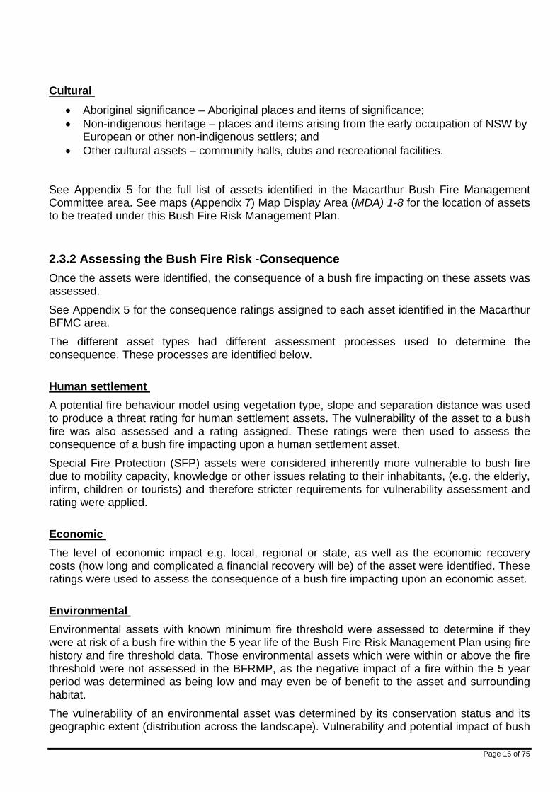
Cultural
Aboriginal significance – Aboriginal places and items of significance; Non-indigenous heritage – places and items arising from the early occupation of NSW by
European or other non-indigenous settlers; and Other cultural assets – community halls, clubs and recreational facilities.
See Appendix 5 for the full list of assets identified in the Macarthur Bush Fire Management Committee area. See maps (Appendix 7) Map Display Area (MDA) 1-8 for the location of assets to be treated under this Bush Fire Risk Management Plan.
2.3.2 Assessing the Bush Fire Risk -Consequence
Once the assets were identified, the consequence of a bush fire impacting on these assets was assessed.
See Appendix 5 for the consequence ratings assigned to each asset identified in the Macarthur BFMC area.
The different asset types had different assessment processes used to determine the consequence. These processes are identified below.
Human settlement
A potential fire behaviour model using vegetation type, slope and separation distance was used to produce a threat rating for human settlement assets. The vulnerability of the asset to a bush fire was also assessed and a rating assigned. These ratings were then used to assess the consequence of a bush fire impacting upon a human settlement asset.
Special Fire Protection (SFP) assets were considered inherently more vulnerable to bush fire due to mobility capacity, knowledge or other issues relating to their inhabitants, (e.g. the elderly, infirm, children or tourists) and therefore stricter requirements for vulnerability assessment and rating were applied.
Economic
The level of economic impact e.g. local, regional or state, as well as the economic recovery costs (how long and complicated a financial recovery will be) of the asset were identified. These ratings were used to assess the consequence of a bush fire impacting upon an economic asset.
Environmental
Environmental assets with known minimum fire threshold were assessed to determine if they were at risk of a bush fire within the 5 year life of the Bush Fire Risk Management Plan using fire history and fire threshold data. Those environmental assets which were within or above the fire threshold were not assessed in the BFRMP, as the negative impact of a fire within the 5 year period was determined as being low and may even be of benefit to the asset and surrounding habitat.
The vulnerability of an environmental asset was determined by its conservation status and its geographic extent (distribution across the landscape). Vulnerability and potential impact of bush

Page 17 of 75
fire were used to assess the consequence of a bush fire impacting upon an environmental asset.
Cultural
For non-indigenous historical, Aboriginal and other cultural assets a potential fire behaviour model using fuel load, slope and proximity was used to produce a threat rating. The physical vulnerability of the asset to a bush fire was also assessed. These ratings were then used to assess the consequence of a bush fire impacting upon a cultural asset.
2.3.3 Assessing the bush fire risk - likelihood For all asset types the likelihood of a bush fire occurring was assessed. This involves considering fire history, including ignition cause and patterns, known fire paths, access, containment potential and potential fire run (size of the vegetated area).
See Appendix 5 for the likelihood ratings assigned to each asset identified in the Macarthur Bush Fire Management Committee area.
2.3.4 Identifying the level of risk The consequence and likelihood ratings were then used to identify the level of risk. See Appendix 5 for the risk ratings assigned to each asset identified in the Macarthur Bush Fire Management Committee area.
2.3.5 Evaluating the bush fire risk Once the risk ratings for each asset were identified, they were evaluated to:
a) Confirm that risk levels identified in the risk analysis process are appropriate and reflect the relative seriousness of the bush fire risk;
b) Identify which assets require treatments; and c) Identify treatment priorities.
2.3.6 Prioritising treatments
No organisation has limitless resources to deal with adverse risk. It is therefore necessary to define priorities. The bush fire risk ratings determined were used to prioritise the risk treatments, i.e. areas of extreme risk were considered first for treatment, then very high, then high then medium then low.
2.3.7 Risk acceptability
Risks below a certain level were assessed as not requiring treatment within the life of this plan. This is due to a combination of factors including complexities regarding Bush Fire issues; number of assets identified for treatment and available financial resources of the associated land manager or combined BFMC member agencies under any mutual agreements.

Page 18 of 75
Within the Macarthur Bush Fire Management Committee BFMC area the level of acceptability is High. Areas of high, medium or low risk are likely to be managed by routine procedures and may not necessarily require a specific application of resources. Agencies within the Bushfire Management Committee area may address lower hazard assets if resources exist.
Assets relating to Aboriginal Heritage and some Threatened Species have not been assigned treatment options within the Macarthur Bush Fire Risk Management Plan (BFRMP) even though the overall hazard assessment process has returned a risk rating of High and above. Where these assets exist treatment options were investigated and found if applied would pose greater risk than wildfire and as such accepted the Bush Fire residual risk.
Minto Heights Rural Fire Brigade – Open Day 2006

Page 19 of 75
Chapter 3 Treating the Risk
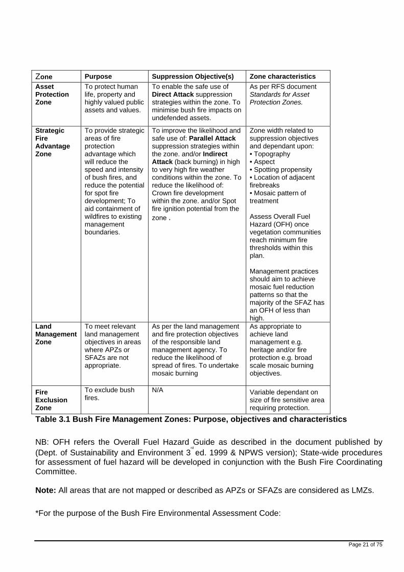
3.1 Bush Fire Management Zones
Bush Fire Management Zones were identified within the Macarthur Bush Fire Management Committee area and mapped (see Appendix 7 maps Map Display Area 1 -8). These zones identify the fire management intent for a specific area. See Table 3.1 for descriptions of the zones and their purposes. The four categories of Bush Fire Management Zones are:
Asset Protection Zone (APZ); Strategic Fire Advantage Zone (SFAZ); Land Management Zone (LMZ); and Fire Exclusion Zone (FEZ).
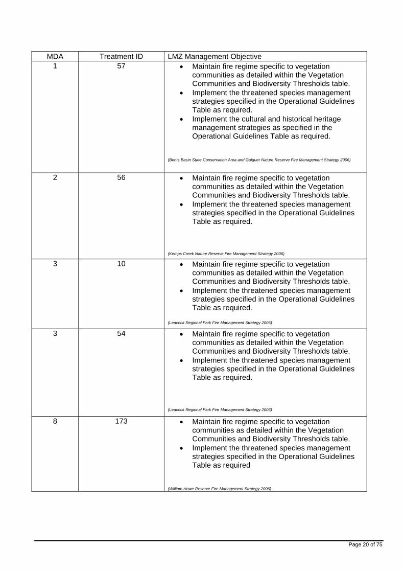
Some of these zones (usually Land Management Zones) may be further classified within this category by the land manager, e.g. LMZ -Heritage Management Zone (NPWS).
LMZs that have been identified as a polygon on the map will have defined management objectives. Below is a list of each identified LMZ and its associated management objectives.
NSW Rural Fire Service – Victorian Deployment February 2006
Page 20 of 75
MDA Treatment ID LMZ Management Objective 1 57 Maintain fire regime specific to vegetation
communities as detailed within the Vegetation Communities and Biodiversity Thresholds table.
Implement the threatened species management strategies specified in the Operational Guidelines Table as required.
Implement the cultural and historical heritage management strategies as specified in the Operational Guidelines Table as required.
(Bents Basin State Conservation Area and Gulguer Nature Reserve Fire Management Strategy 2006)
2 56 Maintain fire regime specific to vegetation communities as detailed within the Vegetation Communities and Biodiversity Thresholds table.
Implement the threatened species management strategies specified in the Operational Guidelines Table as required.
(Kemps Creek Nature Reserve Fire Management Strategy 2006)
3 10 Maintain fire regime specific to vegetation communities as detailed within the Vegetation Communities and Biodiversity Thresholds table.
Implement the threatened species management strategies specified in the Operational Guidelines Table as required.
(Leacock Regional Park Fire Management Strategy 2006)
3 54 Maintain fire regime specific to vegetation communities as detailed within the Vegetation Communities and Biodiversity Thresholds table.
Implement the threatened species management strategies specified in the Operational Guidelines Table as required.
(Leacock Regional Park Fire Management Strategy 2006)
8 173 Maintain fire regime specific to vegetation communities as detailed within the Vegetation Communities and Biodiversity Thresholds table.
Implement the threatened species management strategies specified in the Operational Guidelines Table as required
(William Howe Reserve Fire Management Strategy 2006)
Page 21 of 75
Zone Purpose Suppression Objective(s) Zone characteristics
Asset Protection Zone
To protect human life, property and highly valued public assets and values.
To enable the safe use of Direct Attack suppression strategies within the zone. To minimise bush fire impacts on undefended assets.
As per RFS document Standards for Asset Protection Zones.
Strategic Fire Advantage Zone
To provide strategic areas of fire protection advantage which will reduce the speed and intensity of bush fires, and reduce the potential for spot fire development; To aid containment of wildfires to existing management boundaries.
To improve the likelihood and safe use of: Parallel Attack suppression strategies within the zone. and/or Indirect Attack (back burning) in high to very high fire weather conditions within the zone. To reduce the likelihood of: Crown fire development within the zone. and/or Spot fire ignition potential from the zone .
Zone width related to suppression objectives and dependant upon: • Topography • Aspect • Spotting propensity • Location of adjacent firebreaks • Mosaic pattern of treatment Assess Overall Fuel Hazard (OFH) once vegetation communities reach minimum fire thresholds within this plan. Management practices should aim to achieve mosaic fuel reduction patterns so that the majority of the SFAZ has an OFH of less than high.
Land Management Zone
To meet relevant land management objectives in areas where APZs or SFAZs are not appropriate.
As per the land management and fire protection objectives of the responsible land management agency. To reduce the likelihood of spread of fires. To undertake mosaic burning
As appropriate to achieve land management e.g. heritage and/or fire protection e.g. broad scale mosaic burning objectives.
Fire Exclusion Zone
To exclude bush fires.
N/A Variable dependant on size of fire sensitive area requiring protection.
Table 3.1 Bush Fire Management Zones: Purpose, objectives and characteristics
NB: OFH refers the Overall Fuel Hazard Guide as described in the document published by (Dept. of Sustainability and Environment 3
rd
ed. 1999 & NPWS version); State-wide procedures for assessment of fuel hazard will be developed in conjunction with the Bush Fire Coordinating Committee.
Note: All areas that are not mapped or described as APZs or SFAZs are considered as LMZs.
*For the purpose of the Bush Fire Environmental Assessment Code:

Page 22 of 75
1. Plantations that are approved under the Plantations & Reafforestation Act 1999 after closure of the public exhibition period for this BFRMP are considered to be identified in this BFRMP; and
2. Retained vegetation within the aforementioned plantations is considered to be a Strategic Fire Advantage Zone identified in the text of this BFRMP as long as it meets the suppression objectives for Strategic Fire Advantage Zones (SFAZs) included in the Bush Fire Risk Management Plan (BFRMP), and is not mapped or otherwise described as a Fire Exclusion Zone in the BFRMP.
3.2 BFMC Wide Treatments
Bush Fire Management Committee wide treatments are activities which reduce the overall bush fire risk within the BFMC area and are undertaken on an ongoing basis as part of normal business. These treatments are not linked to specific assets in the Bush Fire Risk Management Plan (BFRMP), rather they are applied across all or part of the BFMC area as designated by legislation or agency policy. BFMC wide treatments include the following:
• Reviewing the bush fire prone land map
These maps identify bush fire prone land and are used to trigger whether a development application is assessed using Planning for Bush Fire Protection
1
.
• Ensuring developments in bush fire prone land comply with Planning for Bush Fire Protection
This assessment process requires new applications for development to include bush fire protection measures.
• Using the Local Environment Plan/s (LEPs) to control developments in areas with a bush fire risk
LEPs can be used to exclude development in extreme bush fire risk areas or where bush fire protection measures cannot be incorporated.
• Varying the standard bush fire danger period as required
In years where the weather is particularly adverse the bush fire danger period may be brought in early or extended. This is assessed every year by the BFMC, upon recommendation by Senior Rural Fire Service Volunteers and members of the Macarthur BFMC Operations Group as prescribed within the Section 52 Operations Plan.
• Requiring permits during the bush fire danger period
In the bush fire danger period a fire safety permit is required to light a fire in the open. Permits specify conditions such as fire fighting equipment that must be on site, or restrict burns based on weather conditions.
• Prosecution of offenders in relation to deliberate ignitions
Under the Rural Fires Act 1997 persons may be prosecuted for breaching the conditions on a fire permit, lighting a fire during a Total Fire Ban, allowing fire to escape their property, or other breaches of the Act. In addition member agencies of the BFMC will cooperate with the NSW Police in relation to the prosecution of arsonists under the Crimes Act 1900.

Page 23 of 75
1 NSW Rural Fire Service 2006 Planning for Bush Fire Protection: A guide for councils, planners, fire
authorities and developers. • Investigation of bush fire cause
All bush fires which do not have a known cause are endeavoured (where resources allow) to be investigated to identify how they started.
• Normal fire suppression activities
Responding to bush fire is a normal business activity for the fire fighting authorities.
• Assessing and managing compliance with strategic fire fighting resource allocation provisions
Strategic fire fighting resource allocation provisions is the process used to identify the number of stations, brigades and appliances required in an area, and consider members, training, assets and hazards.
• Preparation of a S52 Operations Coordination Plan
The Operations Coordination Plan is prepared biannually and sets out how coordinated fire fighting will occur. It includes specific operational restrictions on fire fighting techniques in certain areas, where fires will be managed from, and how agencies involved can communicate during operations.
• Fire Management Plans or Plans of Management
Some land management agencies have developed Fire Management Strategies or Plans of Management with specific fire or fuel management strategies, for example a Forests NSW Regional Fuel Management Risk Plan, a NPWS Fire Management Strategy or Local Government plans of management. These publicly exhibited plans form the basis for operational fire planning on public parks, reserves and forests.
• Bush Fire Hazard Complaints
If someone is concerned about possible bush fire hazards on a neighbouring property or any other land, then this can be reported to the RFS Commissioner or their local RFS Fire Control Centre. The complaint will be investigated and may result in a notice being issued to the landowner or manager to reduce the hazard.
3.3 Asset Specific Treatments There are five broad strategy groups available to treat the bush fire risk to assets identified in the Bush Fire Risk Management Plan.
The types of asset specific treatments in each strategy group used in the Macarthur BFMC area is listed below. A full list of the treatment strategies in the Macarthur BFMC area are in Appendix 6.

Page 24 of 75
Strategy Targeted treatments used in the Macarthur BFMC area Ignition Management
Road Side Vegetation Management: aim to prevent ignition prevalence on roadsides, and inhibit the spread of any occurring fire.
Vegetation Inspections and Management: aim to prevent the occurrence of Bush Fires associated with power infrastructure.
Restrict Vehicle Access: aim to prevent unauthorised access to bushland areas (interface) with gates, locks and barrier fencing. (primary treatment for fires started by dumping of stolen motor vehicles)
Hazard Reduction
Strategic Fire Advantage Zone Management: aim to maintain identified SFAZ by mechanical slashing or prescribed burning.
Asset Protection Zone Management: aim to maintain identified APZ by mechanical slashing / hand clearing or prescribed burning.
Land Management Zone Management: aim to maintain identified LMZ in accordance with relevant Fire Management Plans prescribed.
Community Education
Community Engagement Strategy Implementation: development and execution of targeted community engagement initiatives.
Property Planning
Pre-Incident Planning: aim to undertake pre-incident planning regimes as identified.
Preparedness Fire & Rescue NSW Operational Pre-Incident Planning: aim to ensure adequate response and recorded information for assets identified at risk.
Table 3.2 Asset specific treatments used in the BFMC area

Page 25 of 75
3.4 Fire Thresholds The vegetation in the Macarthur BFMC area was classified into fire threshold categories (Table 3.3*).
Vegetation formation Minimum SFAZ Threshold
Minimum LMZ Threshold
Maximum Threshold
Notes
Rainforest NA NA NA Fire should be avoided.
Alpine complex NA NA NA Fire should be avoided.
Wet Sclerophyll forest (shrubby subformation) 25 30 60
Crown fires should be avoided in the lower end of the interval range.
Wet Sclerophyll forest (grassy subformation) 10 15 50
Crown fires should be avoided in the lower end of the interval range.
Grassy woodland 5 8 40
Minimum interval of 10 years should apply in the southern Tablelands area. Occasional intervals greater then 15 years may be desirable.
Grassland 2 3 10
Occasional intervals greater than 7 years should be included in coastal areas. There was insufficient data to give a maximum interval; available evidence indicates maximum intervals should be approximately 10 years.
Dry sclerophyll forest (shrub/grass subformation)
5 8 50 Occasional intervals greater than 25 years may be desirable.
Dry sclerophyll forest (shrub subformation)
7 10 30 Occasional intervals greater than 25 years may be desirable.
Heathlands 7 10 30 Occasional intervals greater than 20 years may be desirable.
Freshwater wetlands 6 10 35 Occasional intervals greater than 30 years may be desirable.
Forested wetlands 7 10 35 Some intervals greater than 20 years may be desirable.
Saline wetlands NA NA NA Fire should be avoided.
Semi-arid woodlands (grassy subformation) 6 9 No max
Not enough data for a maximum fire interval.
Semi-arid woodlands (shrubby subformation) 10 15 No Max
Not enough data for a maximum fire interval.
Arid shrublands (chenopod subformation NA NA NA Fire should be avoided.
Arid shrublands (acacia subformation) 10 15 No Max
Not enough data for a maximum fire interval.
Table 3.3 Fire Thresholds for Vegetation Categories
Page 26 of 75
3.5 Annual Works Programs
The land management agencies and fire fighting authorities responsible for implementing the treatments identified in this plan will include those treatments in their annual works programs detailing how, when, and where the required activities will be undertaken.
3.6 Implementation
When the treatments identified in this BFRMP are implemented there are a number of issues that need to be considered by the responsible agency including environmental assessments and approvals, smoke management and prescribed burn plans.
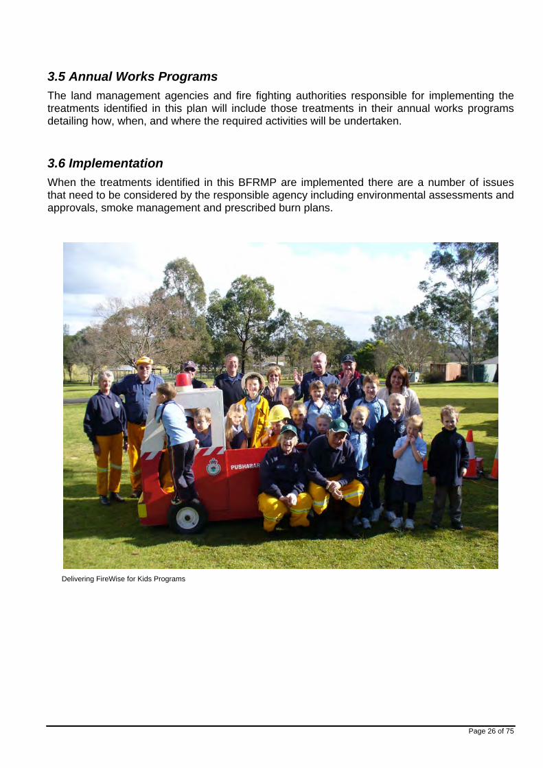
Delivering FireWise for Kids Programs

Page 27 of 75
Chapter 4. Performance Monitoring and Reviewing
4.1 Review
This Bush Fire Risk Management Plan must be reviewed and updated within each successive five-year period from the constitution of the BFMC. The Macarthur BFMC will also review this plan as necessary to account for any changes in context or risk. This may be triggered by a range of circumstances, including but not limited to:
changes to the BFMC area, organisational responsibilities or legislation; changes to the bush fire risk in the area; or following a major fire event.
4.2 Monitoring
The Macarthur Bush Fire Management Committee is required to monitor progress towards the completion of treatment works listed in the Bush Fire Risk Management Plan, and the timeliness of the works.
4.3 Reporting
The Bush Fire Management Committee is required to report annually to the Bush Fire Coordinating Committee on its progress in implementing the bush fire risk management activities identified in this plan. The Bush Fire Management Committee is to use any reporting mechanisms from time to time as determined by the Bush Fire Coordinating Committee.
4.4 Performance Measurements
State wide performance measurements which are linked to the BFRMP have been identified by the BFCC. All BFMCs must use these to monitor and report on their success in reducing the bush fire risk in their BFMC area.

Page 28 of 75
Appendices
Appendix 1 Communication and Consultation Strategy
Appendix 2 Community Consultation Survey
Appendix 3 Community Participation Strategy
Appendix 4 Community Consultation Results
Appendix 5 Asset Register
Appendix 6 Treatment Register
Appendix 7 Maps

Page 29 of 75
COMMUNICATION AND CONSULTATION STRATEGY
Appendix 1

Page 30 of 75
1.1 Principals of Community Consultation
The Macarthur Bush Fire Management Committee will develop consultation strategy and consultations using the following seven principals of good consultation.
Focus and commitment
Inclusiveness, accessibility and diversity
Provision of information
Timing
Responsiveness and feedback
Evaluation
Resourcing.
1.2 The Consultation Process
The Macarthur Bush Fire Management Committee will adopt the eight step guide to effective
consultation.

Page 31 of 75
1.2.1 Define Aims and Parameters
a) What is the main purpose of the consultation? The main purpose of the consultation process is to ensure adequate and timely dissemination and collection of information to and from the community in respect to Bush Fire Risk Management.
b) What information is to be conveyed and received? The Bush Fire Management Committee need to convey to the public the importance of Bush Fire risk management planning and the fundamentals of risk identification and mitigation processes. In return the Bush Fire Management Committee seek contribution from the community as to human, environmental and socioeconomic assets identified at risk of Bush Fire. Further more the committee seek community input to the programs and initiatives to be implemented to mitigate and control Bush Fire risks.
c) Who will be affected by the decisions made? The Committee has identified all land holders and occupiers in the Macarthur will directly or indirectly be affected by the decisions made by the committee. People identified to be more affected are those people living and occupying known areas of Bush Fire incidents and lands classed as Bush Fire prone.
d) Who should be consulted? The Committee recognise that as the plan affects all land parcels in the Macarthur, everybody has a vested interest in the risk planning process. People identified as especially requiring degrees of consultation are those people at greater identifiable risk of the effects of Bush Fire.
e) Consultation Issues? The Committee has identified the major issue with respect to the consultation process will be the timeframe allotted for the program to be concluded by before the Risk Plan is to go on public display.
f) How will outcomes and concerns raised during consultation be communicated back? The Committee recognise that people when contributing to the plan will have a need to be informed of the outcome of any changes or decisions made as a direct result of their submission. In the main general comments and suggestions will be incorporated and communicated to the public as part of the 42 day public submission review period in accordance with the Rural Fires Regulation 1997.

Page 32 of 75
1.2.2 Statement of Intent
To engage identified key stakeholders and the general community to consult on the preparation of the Bush Fire Risk Management Plan in accordance with Section 52 Rural Fires Act 1997. The aim of the consultative process is to extract from member agencies and the community information to assist the Bush Fire Management Committee in the identification of community assets and risk minimisation strategy, as well as other information that will form part of the Plan.
1.2.3 Engage Key Stakeholders
The Bush Fire Management Committee identify that the following as Key Stakeholders in the Bush Fire Risk Management Planning Process. Identification of stakeholders is not limited to those listed.
Camden Municipal Council
Campbelltown City Council
Liverpool City Council
Wollondilly Rural Fire District
Cumberland Rural Fire Zone
Sutherland Rural Fire District
Illawarra Rural Fire Zone
NSW Rural Fire Brigades (Macarthur)
Fire and Rescue NSW
National Parks and Wildlife Service
Endeavour Energy
Transgrid
Sydney Water
Roads & Traffic Authority
M5 Motorway M7 Motorway
Villages (communities) of Macarthur
Regeneration bodies (Macarthur)
Environmental Protection Agency (EPA)
Dept Planning NSW
Aboriginal Lands Council
Australian Defence Force
Railcorp
Australian Botanic Garden, Mount Annan.

Page 33 of 75
1.2.4 Coordinate Timing.
The Bush Fire Management Committee has considered the following as a suggested timing for the coordination of the consultative process.
The following calendar print out outline target dates and key meetings held in the consultative process. Extra consultation may take place not listed within the calendar as the situations arise at short notice.
1.2.5 Method of Consultation
In choosing an appropriate method of consultation thought must be given to the type and quantity of information that is required.
In considering the method of consultation certain factors need to be investigated by the committee.
a) Type of information required b) Time frame for available consultation c) Size and characteristics of the target group d) Analysis of the benefit, constraint of costing e) Tailoring of consultation methods to best suit the consultative base f) Availability of resources.
Communication Methods: The following is seen as a method of informing potential participants and the community about upcoming consultative events.
Letters – This is a personally addressed letter to a targeted audience, directly affected by the Bush Fire Risk Management planning process. Letters are used to direct a return comment or inform of future consultative developments.
Letter Box Drop – This is a non addressed letter to the owner/occupier of a target area that invites feedback or informs of future planned consultative methods.
Council / Other Newsletter – A widely distributed document that contains mainly a vision, mission or broad scope information about the Bush Fire Planning Process. This method can be utilised to inform of upcoming consultative methods. However limited distribution and frequency will depend on success.
Local Newspaper – Advertisements and special articles placed in local newspapers distributed to areas affected by the consultative process and Bush Fire prone residences.

Page 34 of 75
1.2.6 Maximising Participation
Effectively publicising the consultation is essential if the committee are to engage the stakeholders. The following channels are available to the committee to undertake this function:
1.2.7 Use some or all of the current community facilities including health centres, libraries, Councils Customer Support Centre, Hospitals, Schools, Church’s and sporting groups.
1.2.8 Community Groups, Schools / Interagency – ask them to include on their mail outs etc.
1.2.9 Seek assistance from community accesses groups such as Macarthur Community Forum, Macarthur Diversity Services Inc, or Macarthur Disability Services to ensure consultation with people with special access needs.
1.2.10 Arrange to place information with private shopping industries, Macarthur Square, Campbelltown Mall, Narellan Mall, and other major shopping facilities.
1.2.11 Utilise Service Clubs (RSL, Leagues etc) to post information in public foyers.
1.2.12 Use of local media outlets to promote the process. Macarthur Chronicle, Camden Advertiser and Liverpool Champion, Macarthur Advertiser, District Advertiser.
1.2.13 Place notices in Council and Community newsletters
1.2.14 Utilise free to air radio communications (C93.1 FM and Macarthur Community Radio.

Page 35 of 75
1.2.7 Consultation Actions
The committee after analysis of the methods of consultation have derived the following methods to be adopted in the interim with a progress evaluation of effectiveness with view to change methods if required.
1.2.7.1 Community Meetings and Forums
Community meetings and forums bring together people of like minds to discuss the Bush Fire Risk Management process. They are usually held at a community venue, in close proximity to the community.
The community meeting / forum can be held on different scales from LGA wide to community specific (eg. Wedderburn, Luddenham, Cobbitty)
Meetings are to be called between 1 ½ to 2 ½ hours, any longer and the meeting can lose focus or drift from the set agenda.
Lead time needs to be considered when planning these meetings to ensure adequate selection of communication methods, as poorly attended public meetings tend to have a negative impact on the community and the committee. Strengths and Weaknesses of the Community Meeting
STRENGH WEAKNESS
Provides free speech without • If not facilitated correctly can rebuttal inhibit speech.
Meets most statutory • May create a community Vs requirements BFMC (RFS) environment
Attendees views are conveyed • Has the ability to be to others overpowered by vocal minority
• Not conducive to communicating with all target groups.

Page 36 of 75
1.2.7.2 Focus Groups (Workshops)
Focus groups are the congregation of five to fifteen people led by a trained facilitator. Participants are residents or people with a particular interest or stake in Bush Fire management.
A focus group should be conducted between 2 and 4 hours, any longer sessions are best broken up by refreshment breaks.
Effective communication methods need to be adopted to ensure adequate attendance and preparation of workbooks and other workshop materials.
Workbooks: The BFRMP covers a wide variety of opportunity for various stakeholders to have input into the following identified areas:
� Vegetation Mapping
� Vegetation Classification
� Bush Fire Risk Classification
� Assets Identification
� Risk rating and likelihood
� Management strategies
� Community Education
� Arson identification and prevention
� Hazard reduction identification
Well developed facilitation skills are essential. Focus groups rely on the appropriate selection of attendees best suited to express ideas and opinion.
STRENGH WEAKNESS
Obtains in depth discussion • Not always representative People may feel more • Targets small percentage of
comfortable in focus group total target area setting
Promotes debate. • Involves a significant amount of staff time
Has potential for productive outcome
Provides effective networking This method would be best suited for consultation between neighbouring NSW Rural Fire Service Districts / Zones as well as other committee member agencies.

Page 37 of 75
1.2.7.3 Community Leaders
Community Leaders are identified by the committee to target selected communities that are often not represented in normal situations.
Community leaders can have the added benefit of acting as an ongoing liaison between the committee and the selected community.
This method is particularly suited to the Macarthur where it has been identified a wide variety of multilingual communities exist in the rural areas and more importantly in identifiable Bush Fire prone lands. Existing community groups can be approached to provide a representative.
STRENGH WEAKNESS
Engages NESB (non English • Not a formal research method. speaking background) persons to discussion not readily • Need to ensure representative available has that community backing as nominated rep.
Enables Culturally and Linguistically Diverse individuals to be heard.
Increases the level of understanding about the Bush Fire management committee in cultural areas previously not informed.

Page 38 of 75
1.2.7.4 Large Group Method – Open kiosk method
Open space kiosk function is a conference based on an open invitation and voluntary participation. Facilitators establish a kiosk type arrangement around the room where each facilitator has an identified topic to discuss and gain community comment and input.
A minimum of one day has been suggested in articles based on effective open space technology, large group consultation. The method is dependant on wide advertising and a combination of communication methods to endure adequate attendance by the targeted community area within the Macarthur.
Facilitators require strict adherence to pre planned topic discussion papers and need to avoid discussion outside of their nominated function as these will most likely be covered by other facilitators.

Page 39 of 75
1.2.8 Feedback from consultations
Member agencies and community groups throughout the process would have given of their time and valuable opinion to contribute to the decision making process of the Macarthur Bush Fire Management Committee, and their continuing involvement should be encouraged and fostered.
The Bush Fire Management Committee, need to acknowledge their contribution by providing an element of feedback to participants. Ideally at the conclusion of the consultive process those persons recorded as having contributed should be thanked.
Direct feedback in the first instance will be provided in the public exhibition of the draft Bush Fire Risk Management Plan. Specific feedback should be provided by the committee where express concerns have been raised by community members.
Appendix 2 contains a evaluation form filled in by participants on a volunteer basis to allow the committee to capture consultation effectiveness and use this to alter future methods. The forms will also allow a database to be created of persons participating in the consultative process for any ongoing or future consults.
Appendix 3 contains the listing of community consultations that took place and respective outcome.
Appendix 4 Contains an overall view of the feedback forms and respective outcomes.

Page 40 of 75
Appendix 2
Community Consultation Survey

Page 41 of 75

Page 42 of 75
This Page has been Intentionally Left Blank

Page 43 of 75
Appendix 3
Community Participation Strategy Template

Page 44 of 75
Community Participation Strategy Template Date Target Method of Method of Key messages/ purpose Resources required Responsibility
Audience communication notification 17th BFMC Sub Meeting Email / Letter Stakeholder contribution N/A Jason Heffernan December Committee 2007 4th January 2008
Liverpool City Council
Meeting Email / Letter Council Internal Systems
Stakeholder Contribution (LCC) and Staff (community) input.
N/A Jason Heffernan
11th RFS Meeting / Email / Letter Stakeholder Contribution N/A Jason Heffernan January Members & Presentation Media (Radio) and Community 2008 Community Consultation 14th RFS Meeting / Email / Letter Stakeholder Contribution N/A Jason Heffernan January Members & Presentation Media (Radio) and Community 2008 Community Consultation 15th NSWFB Stn Meeting Email / Letter Stakeholder Contribution N/A Jason Heffernan January 93 Notice Board (Stn 93) and Staff 2008 (community) input. 15th NSWFB Stn Meeting Email / Letter Stakeholder Contribution N/A Jason Heffernan January 248 Notice Board (Stn 248) and Staff 2008 (community) input. 16th NSWFB Stn Meeting Email / Letter Stakeholder Contribution N/A Jason Heffernan January 92 Notice Board (Stn 92) and Staff 2008 (community) input. 16th RFS Meeting / Email / Letter Stakeholder Contribution N/A Jason Heffernan January Members & Presentation Media (Radio) (RFS Vols) and 2008 Community (community) input. 20th RFS Meeting / Email / Letter Stakeholder Contribution N/A Jason Heffernan January Members & Presentation Media (Radio) (Rfs Vols) and 2008 Community (community) input. 23rd Camden Meeting Email / Letters Stakeholder Contribution N/A Jason Heffernan January Council 2008

Page 45 of 75
Page 45 of 60 Date Target
Audience Method of communication
Method of notification
Key messages/ purpose Resources required Responsibility
14th April Community Liverpool City Media Release Stakeholder contribution N/A Jason Heffernan 2008 Meeting Community Council Website Consultation Night 5th May BFMC Sub Meeting Email / Letter Stakeholder contribution N/A Jason Heffernan 2008 Committee 14th March BFMC Sub Meeting Email Stakeholder contribution N/A Jason Heffernan 2008 Committee 20th April BFMC Sub Meeting Email Stakeholder contribution N/A Jason Heffernan 2009 Committee 25th May BFMC Sub Meeting Email Stakeholder contribution N/A Jason Heffernan 2009 Committee 23rd June Campbelltow Council Committee Business Papers Stakeholder report / N/A Jason Heffernan 2009 n City Meeting contribution Council 29th June BFMC Sub Meeting Email Stakeholder contribution N/A Jason Heffernan 2009 Committee 13th July Councillor Meeting / Email / Letter / Stakeholder contribution / N/A Jason Heffernan 2009 Briefing Night Presentation / Council Report Community Kiosk representation (councillors) 15th July Community Meeting / Media Release Community contribution N/A Jason Heffernan 2009 Meeting Presentation / Email Kiosk Letters 16th July Community Meeting / Media Release Community contribution N/A Jason Heffernan 2009 Meeting Presentation / Email Kiosk Letters 27th July 2009
BFMC Sub Committee
Meeting Email Stakeholder contribution N/A Jason Heffernan
February 2012
Community and Stakeholders
Reviewed Plan located in FCCs, NPWS Offices and Council Chambers
Media Release Stakeholder and community contribution
Copies of plan. Kerry Parkinson

Page 46 of 75
This page Intentionally Left Blank

Page 47 of 75
Appendix 4
Community Consultation Results

Page 48 of 75

Page 49 of 75
Appendix 5
Asset Register

Page 50 of 75
Asset No Asset Type Asset Name Asset Location (LGA) Map No Risk Rating
0 Human Settlement Scattered Rural Properties MDA 1 Liverpool LGA (MDA1) MDA 1 NA (Low)
0 Human Settlement Scatterd Rural Properties within MDA 5 Campbelltown LGA MDA 5 3A (High)
0 Cultural Heritage Aboriginal assets of HIGH vulnerability undefined
0 Cultural Heritage Aboriginal assets of MODERATE vulnerability undefined
2 Environmental Endangered Fauna Liverpool LGA MDA 3
3 Environmental Endangered Flora Liverpool LGA MDA 3
4 Environmental Endangered Flora Camden LGA MDA 7
5 Human Settlement Interface CUDGEGONG RD Campbelltown LGA MDA 4 1A (Extreme)
6 Human Settlement Interface RICHMOND CRS Campbelltown LGA MDA 4 1A (Extreme)
7 Human Settlement Interface NYMBOIDA CRS Campbelltown LGA MDA 4 1A (Extreme)
8 Human Settlement Interface LEICHHARDT ST Campbelltown LGA MDA 4 1A (Extreme)
9 Human Settlement Interface CURRAN AVE Campbelltown LGA MDA 4 1B (Extreme)
10 Human Settlement Interface CANBERRA / RESERVE CRS Campbelltown LGA MDA 4 1B (Extreme)
11 Human Settlement Interface LEUMEAH Campbelltown LGA MDA 4 1B (Extreme)
12 Human Settlement Interface PLEASURE POINT Liverpool LGA MDA 4 1B (Extreme)
13 Human Settlement Interface WEST WEDDERBURN Campbelltown LGA MDA 5 1B (Extreme)
14 Human Settlement Watchtower Assembly Liverpool LGA MDA 6 1B (Extreme)
15 Cultural Heritage Ingleburn Military Camp Campbelltown LGA MDA 6 1B (Extreme)
16 Human Settlement Interface EMERALD DRIVE Campbelltown LGA MDA 6 1C (Extreme)
17 Human Settlement Interface MACQUARIE FIELDS Campbelltown LGA MDA 4 2A (Very High)
18 Human Settlement Macquarie Fields TAFE Campus Campbelltown LGA MDA 4 1C (Extreme)
19 Human Settlement Wombat Willows Child Care Centre Campbelltown LGA MDA 4 1C (Extreme)
20 Human Settlement Miller Technical High School Liverpool LGA MDA 3 1C (Extreme)
21 Human Settlement Interface GILL / BENT PL Campbelltown LGA MDA 4 1C (Extreme)
22 Human Settlement St Marys Primary School Campbelltown LGA MDA 6 1C (Extreme)
23 Human Settlement Hoxton Park Public School Liverpool LGA MDA 3 NA (Low)
24 Environmental Endangered Flora Liverpool LGA MDA 4 1C (Extreme)
25 Human Settlement Interface EUCALYPTUS CCT Camden LGA MDA 8 2A (Very High)

Page 51 of 75
Asset No Asset Type Asset Name Asset Location (LGA) Map No Risk Rating
26 Human Settlement Interface WATTLE GROVE Liverpool LGA MDA 4 2A (Very High)
27 Human Settlement Interface VOYAGER POINT Liverpool LGA MDA 3 2A (Very High)
28 Human Settlement Interface LONG POINT Campbelltown LGA MDA 4 2A (Very High)
29 Human Settlement Interface KENTLYN Campbelltown LGA MDA 4 2A (Very High)
30 Human Settlement Interface VARROVILLE Campbelltown LGA MDA 6 2A (Very High)
31 Economic Endeavour Energy Power Infrastructure All LGAs 2A (Very High)
32 Human Settlement Interface GLENFIELD Campbelltown LGA MDA 4 2A (Very High)
33 Human Settlement Interface MINTO HEIGHTS Campbelltown LGA MDA 4 2A (Very High)
34 Economic Glenfield Sewage Treatment Plant Campbelltown LGA MDA 4 2A (Very High)
35 Human Settlement Russian Retirement Village Campbelltown LGA MDA 4 2A (Very High)
36 Human Settlement Interface LEUMEAH Campbelltown LGA MDA 4 2A (Very High)
37 Human Settlement Interface CONJOLA CRS Campbelltown LGA MDA 4 2A (Very High)
38 Human Settlement Kemps Creek Public School Liverpool LGA MDA 2 2A (Very High)
39 Human Settlement Christadelphian Heritage College Liverpool LGA MDA 2 2A (Very High)
40 Economic Liverpool Sub Station Liverpool LGA MDA 3 2A (Very High)
41 Human Settlement Bringelly Pre‐School Liverpool LGA MDA 1 2A (Very High)
43 Human Settlement Carmelite Monastery Campbelltown LGA MDA 6 2A (Very High)
44 Human Settlement Interface CARNES HILL Liverpool LGA MDA 2 2A (Very High)
45 Human Settlement Interface 22ND / KIRKPATRICK Liverpool LGA MDA 2 2A (Very High)
46 Human Settlement Interface EAST WEDDERBURN Campbelltown LGA MDA 5 2A (Very High)
47 Human Settlement Interface CATHERINE FIELDS Camden LGA MDA 6 2A (Very High)
48 Economic The Australian Botanic Garden (Mt Annan) Camden LGA MDA 8 2A (Very High)
49 Economic Jack's Gully Waste Facility Camden LGA MDA 8 2A (Very High)
50 Human Settlement Cobbitty School Camden LGA MDA 7 2A (Very High)
51 Human Settlement Interface CASULA ROAD Liverpool LGA MDA 3 2A (Very High)
52 Human Settlement All Saints Catholic Seniors College Liverpool LGA MDA 3 2A (Very High)
53 Economic Bents Basin State Conservation Area Liverpool LGA MDA 1 2C (Very High)
54 Human Settlement Interface INGLEBURN Campbelltown LGA MDA 4 2C (Very High)
55 Cultural Heritage Freres Crossing Campbelltown LGA MDA 4 2C (Very High)

Page 52 of 75
Asset No Asset Type Asset Name Asset Location (LGA) Map No Risk Rating
56 Human Settlement Interface AIRDS Campbelltown LGA MDA 4;MDA 5 2C (Very High)
57 Human Settlement Rural Residential GREENDALE Liverpool LGA MDA 1 3A (High)
58 Human Settlement Interface HARRINGTON PARK Camden LGA MDA 8 3A (High)
59 Economic Pope Shenouda Coptic Christian Centre Campbelltown LGA MDA 4 3A (High)
60 Human Settlement Rainbow Family Care Centre Campbelltown LGA MDA 4 4 (Medium)
61 Human Settlement Miller TAFE Campus Liverpool LGA MDA 3 4 (Medium)
62 Human Settlement Interface BINGARA ROAD Campbelltown LGA MDA 4 3A (High)
63 Economic Kemps Creek Switching Sub Station Liverpool LGA MDA 2 3A (High)
64 Economic Sydney International Shooting Centre Liverpool LGA MDA 2 3A (High)
65 Human Settlement Interface KEMPS CREEK Liverpool LGA MDA 2 3A (High)
66 Human Settlement Kemps Creek Childrens Cottage Liverpool LGA MDA 2 4 (Medium)
67 Human Settlement Interface FIRST AVE Liverpool LGA MDA 3 3A (High)
68 Cultural Heritage Greendale Heritage Church Liverpool LGA MDA 1 3A (High)
70 Cultural Heritage Macquarie House Camden LGA MDA 8 3A (High)
71 Human Settlement Carrington Hospital Camden LGA MDA 8 3A (High)
72 Human Settlement Carrington Aged Care Facility Camden LGA MDA 8 3A (High)
73 Human Settlement Interface WELLING DRIVE Camden LGA MDA 8 3A (High)
74 Human Settlement Odyssey House Campbelltown LGA MDA 6 4 (Medium)
75 Human Settlement Interface MENANGLE PARK Campbelltown LGA MDA 8 3A (High)
76 Human Settlement Interface COBBITTY Camden LGA MDA 7 3A (High)
77 Human Settlement Interface CHIPPING NORTON LAKES Liverpool LGA MDA 3 3A (High)
78 Human Settlement Interface MOOREBANK Liverpool LGA MDA 3 3A (High)
79 Human Settlement Interface MCMILLAN PARK Liverpool LGA MDA 3 3A (High)
80 Human Settlement Interface LEPPINGTON Camden LGA MDA 6 3A (High)
81 Cultural Heritage Gledswood Homestead Camden LGA MDA 6 3A (High)
82 Cultural Heritage Raby House Camden LGA MDA 6 3A (High)
83 Human Settlement St Gregory's College Camden LGA MDA 6 4 (Medium)
84 Human Settlement Bethlehem Monastery Campbelltown LGA MDA 6 3A (High)
85 Human Settlement Maryfields Rehabilitation Centre Campbelltown LGA MDA 6 3A (High)

Page 53 of 75
Asset No Asset Type Asset Name Asset Location (LGA) Map No Risk Rating
86 Human Settlement Interface ELLIS LANE Camden LGA MDA 8 3A (High)
87 Human Settlement Interface THE LANES / KIRKHAM Camden LGA MDA 8 3A (High)
88 Human Settlement Mater Dei College Camden LGA MDA 7 4 (Medium)
88 Human Settlement Mater Dei College Camden LGA MDA 7 4 (Medium)
89 Economic St Paul Church Cobbitty Camden LGA MDA 7 3A (High)
90 Human Settlement Scattered Rural Properties Within MDA 7 Camden LGA MDA 7 3A (High)
91 Human Settlement Interface EAGLE VA / ESCHOL / KEARNS Campbelltown LGA MDA 6 3A (High)
92 Human Settlement Interface DENHAM COURT Campbelltown / Liverpool LGA MDA 6 3A (High)
93 Human Settlement Interface CECIL HILLS Liverpool LGA MDA 3 3A (High)
94 Human Settlement Interface ST HELENS PARK Campbelltown LGA MDA 5 3B (High)
95 Human Settlement Ashcroft High School Liverpool LGA MDA 3 4 (Medium)
96 Economic Long Point Camp Campbelltown LGA MDA 4 3D (High)
97 Economic Macquarie Fields Neighbourhood Centre Campbelltown LGA MDA 4 3D (High)
98 Economic Simmos Beach Campbelltown LGA MDA 4 3D (High)
99 Economic Vietnamese Catholic Centre Liverpool LGA MDA 1 3D (High)
100 Economic Western Sydney Regional Park Liverpool LGA MDA 2 3D (High)
101 Economic Kemps Creek Bowling Club Liverpool LGA MDA 2 3D (High)
102 Human Settlement Interface RUSE Campbelltown LGA MDA 4 3A (High)
103 Human Settlement Interface BRINGELLY Liverpool LGA MDA 6 4 (Medium)
104 Human Settlement Luddenham Public School Liverpool LGA MDA 1 4 (Medium)
105 Human Settlement Bringelly Public School Liverpool LGA MDA 1 4 (Medium)
106 Human Settlement Properties AUSTRAL Precinct Liverpool LGA MDA 2 4 (Medium)
107 Human Settlement Kentlyn Primary School Campbelltown LGA MDA 4 1C (Extreme)
108 Human Settlement Interface SOUTH CABRAMATTA CREEK Liverpool LGA MDA 3 4 (Medium)
109 Human Settlement Properties ROSSMORE precinct Liverpool LGA MDA 2 4 (Medium)
110 Human Settlement Good Shepherd Primary School Liverpool LGA MDA 3 4 (Medium)
111 Human Settlement Hammond Village Liverpool LGA MDA 3 4 (Medium)
112 Economic Minto Heights Rural Fire Station Campbelltown LGA MDA 4 4 (Medium)
113 Economic Vijayaloka Buddhist Retreat Centre Campbelltown LGA MDA 4 4 (Medium)

Page 54 of 75
Asset No Asset Type Asset Name Asset Location (LGA) Map No Risk Rating
114 Economic Minto Bush Camp Campbelltown LGA MDA 4 4 (Medium)
115 Economic Minto Nudist Camp Campbelltown LGA MDA 4 4 (Medium)
116 Economic Hillview Nudist Camp Campbelltown LGA MDA 4 4 (Medium)
117 Economic Glenfield Scout Camp Liverpool LGA MDA 4 4 (Medium)
118 Human Settlement Interface NORTH CABRAMATTA CREEK Liverpool LGA MDA 3 4 (Medium)
119 Economic Mobile Phone Communications Tower Campbelltown LGA MDA 4 4 (Medium)
120 Economic Mobile Phone Communications Site Campbelltown LGA MDA 4 4 (Medium)
121 Economic Endeavour Energy Training Centre Liverpool LGA MDA 3 4 (Medium)
122 Human Settlement Interface GEORGE CALEY RES Camden LGA MDA 8 4 (Medium)
123 Economic Power House Museum Liverpool LGA MDA 3 4 (Medium)
124 Economic Haigh Park Liverpool LGA MDA 3 4 (Medium)
125 Human Settlement Interface THE GRANGE Liverpool LGA MDA 2 4 (Medium)
126 Economic Camden Valley Golf Resort Camden LGA MDA 6 4 (Medium)
127 Economic Varroville Communications Tower Campbelltown LGA MDA 6 4 (Medium)
128 Economic Teen Ranch Camden LGA MDA 7 4 (Medium)
129 Economic UNI SYD Plant Breeding Inst Camden LGA MDA 7 4 (Medium)
130 Economic Casula Motel Liverpool LGA MDA 3 3D (High)
131 Human Settlement Interface LEACOCK LANE Liverpool LGA MDA 3 3B (High)
132 Human Settlement Interface HOXTON PARK Liverpool LGA MDA 3 NA (Low)
133 Human Settlement LUDDENHAM Village Liverpool LGA MDA 1 NA (Low)
134 Economic STREETS ICE CREAM Campbelltown LGA MDA 4 NA (Low)
135 Human Settlement Interface BADGERYS CREEK Liverpool LGA MDA 2 NA (Low)
136 Human Settlement Badgerys Creek Public School Liverpool LGA MDA 2 4 (Medium)
137 Human Settlement William Carey Christian College Liverpool LGA MDA 3 4 (Medium)
138 Human Settlement Interface BRIGGS PL Campbelltown LGA MDA 5 4 (Medium)
139 Human Settlement Poor Clare Convent Campbelltown LGA MDA 6 NA (Low)
140 Human Settlement Interface CAMDEN Camden LGA MDA 8 NA (Low)
141 Human Settlement Macarthur Anglican College Camden LGA MDA 7 4 (Medium)
142 Human Settlement University Western Sydney Campbelltown LGA MDA 6 4 (Medium)
Page 55 of 75
Asset No Asset Type Asset Name Asset Location (LGA) Map No Risk Rating
143 Human Settlement Luddenham Day Care Centre Liverpool LGA MDA 1 4 (Medium)
144 Economic Shell / IGA Service Station / Supermarket Liverpool LGA MDA 1 NA (Low)
145 Human Settlement Interface WILLIAM HOWE RES Camden LGA MDA 8 NA (Low)
146 Economic Menangle Park Paceway Campbelltown LGA MDA 8 NA (Low)
147 Human Settlement Broughton Anglican College Campbelltown LGA MDA 8 4 (Medium)
148 Human Settlement Religion Assembly Hall Camden LGA MDA 6 NA (Low)
149 Economic Truck Rest Area Hume Hwy Campbelltown LGA MDA 6 NA (Low)
150 Economic Holsworthy Military Base Liverpool LGA MDA 4;MDA 5 1C (Extreme)
150 Economic Holsworthy Military Base Liverpool LGA MDA 4;MDA 5 1C (Extreme)
151 Economic Kemps Creek Nature Reserve Liverpool LGA MDA 2 3A (High)
152 Economic Dharawal State Conservation Area Campbelltown LGA MDA 5 2A (Very High)
153 Economic Camden West Treatment Plant Camden LGA MDA 8 2A (Very High)
154 Human Settlement Interface KINGS BUSH Camden LGA MDA 8 NA (Low)
155 Environmental Endangered Flora Campbelltown LGA MDA 4 1C (Extreme)
156 Economic Woodbine Indust Area Campbelltown LGA MDA 6 4 (Medium)
157 Human Settlement Interface (WOODBINE) Campbelltown LGA MDA 6 2A (Very High)
157 Human Settlement Interface (WOODBINE) Campbelltown LGA MDA 6 2A (Very High)
158 Human Settlement Interface BOW BOWING Campbelltown LGA MDA 6 4 (Medium)
159 Human Settlement Kilbride Nursing Home Campbelltown LGA MDA 5 2A (Very High)
160 Human Settlement St Helens Park Public School Campbelltown LGA MDA 5 1A (Extreme)
161 Human Settlement Interface BRADBURY Campbelltown LGA MDA 5 3A (High)
162 Human Settlement Interface MINTO Campbelltown LGA MDA 4 4 (Medium)
163 Human Settlement Interface FREEMAN/BAINBRIDGE Campbelltown LGA MDA 4 2A (Very High)
164 Human Settlement Interface COLONG CRESCENT Campbelltown LGA MDA 4 1B (Extreme)
165 Human Settlement Interface COOK RESERVE Campbelltown LGA MDA 4 2A (Very High)
166 Human Settlement Inteface ROSEMEADOW Campbelltown LGA MDA 5 3C (High)
167 Human Settlement Wedderburn Resource Centre Campbelltown LGA MDA 5 1C (Extreme)
168 Economic William Howe Reservoir Camden LGA MDA 8 3A (High)
170 Economic AGL Coal Seam Gas Plant Campbelltown LGA MDA 8 4 (Medium)

Page 56 of 75
Asset No Asset Type Asset Name Asset Location (LGA) Map No Risk Rating
171 Economic Rail Corridor Holsworthy Liverpool LGA MDA 4 2A (Very High)
172 Economic Rail Corridor Voyager Point Liverpool LGA MDA 4 2A (Very High)
173 Economic Harlands Orchard Wedderburn Campbelltown LGA MDA 5 2C (Very High)
175 Economic Brickworks Badgerys Creek Liverpool LGA MDA 2 4 (Medium)

Page 57 of 75
Appendix 6
Treatment Register

Page 58 of 75
This page has been intentionally left blank

Page 59 of 75
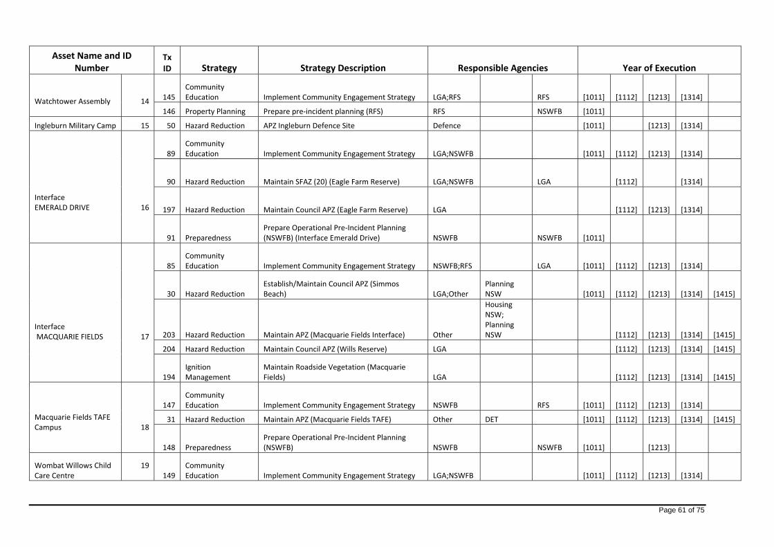
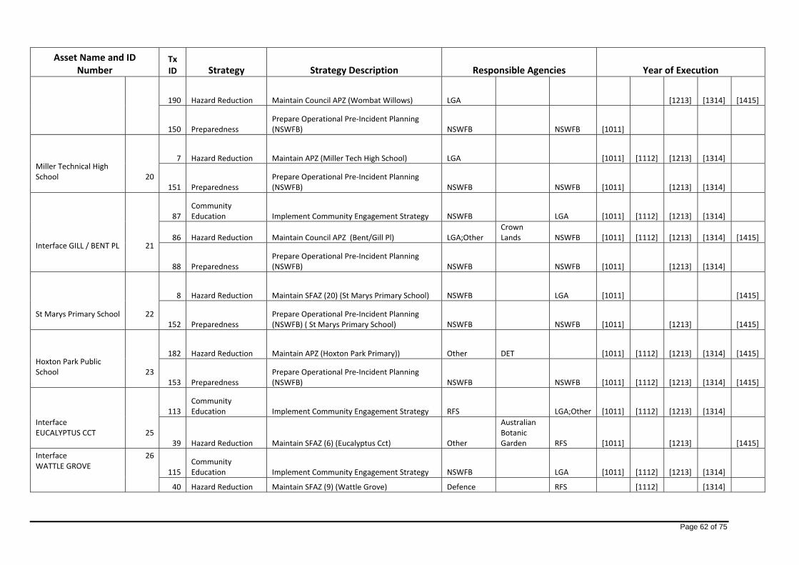
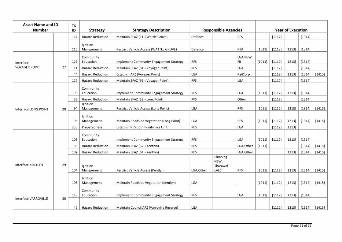
Asset Name and ID Number
Tx ID Strategy Strategy Description Responsible Agencies Year of Execution
Interface CUDGEGONG RD
5
63 Community Education Implement Community Engagement Strategy NSWFB LGA;RFS [1011] [1112] [1213] [1314]
62 Hazard Reduction Maintain APZ (Cudgegong Road) LGA;Other Planning NSW RFS [1011] [1112] [1213] [1314] [1415]
64 Ignition Management Restrict Vehicle Access (Cudgegong Road) LGA [1011] [1112] [1213] [1314] [1415]
65 Preparedness Prepare Operational Pre‐Incident Planning (NSWFB) NSWFB NSWFB [1011]
Interface RICHMOND CRES
6
67 Community Education Implement Community Engagement Strategy NSWFB LGA [1011] [1112] [1213] [1314] [1415]
66 Hazard Reduction Maintain Council APZ (Richmond Cres) LGA [1011] [1112] [1213] [1314] [1415]
196 Hazard Reduction Maintain Council APZ (Gwydir Place) LGA [1112] [1213] [1314] [1415]
68 Preparedness Prepare Operational Pre‐Incident Planning (NSWFB) NSWFB NSWFB [1011]
Interface NYMBOIDA CRES
7
70 Community Education Implement Community Engagement Strategy LGA NSWFB [1011] [1112] [1213] [1314]
69 Hazard Reduction Maintain APZ (Nymboida Crescent) LGA;Other Planning NSW RFS [1011] [1112] [1213] [1314] [1415]
71 Preparedness Prepare Operational Pre‐Incident Planning (NSWFB) NSWFB NSWFB [1011] [1112] [1213] [1314]
Interface LEICHHARDT ST
8
73 Community Education
Implement Comm Engagement Strategy Leichardt St NSWFB LGA [1011] [1112] [1213] [1314] [1415]
72 Hazard Reduction Maintain APZ (Leichhardt St) LGA;Other Planning NSW [1011] [1112] [1213]
Interface CURRAN AVE
9 74
Community Education
Implement Community Engagement Strategy Curran Ave NSWFB LGA [1011] [1112] [1213] [1314]

Page 60 of 75
Asset Name and ID Number
Tx ID Strategy Strategy Description Responsible Agencies Year of Execution
75 Hazard Reduction Maintain Council APZ (Bingara Reserve) LGA [1011] [1112] [1213] [1314] [1415]
Interface CANBERRA / RESERVE CRES
10
77 Community Education
Implement Comm Engagement Strategy Canberra Cr LGA;RFS RFS [1011] [1112] [1213] [1314]
76 Hazard Reduction Maintain Council APZ (Canberra Cres) LGA [1011] [1112] [1213] [1314] [1415]
78 Preparedness Prepare Operational Pre‐Incident Planning (NSWFB) NSWFB NSWFB [1011]
Interface LEUMEAH
11
79 Community Education
Implement Comm Engagement Strategy Leumeah NSWFB LGA [1011] [1112] [1213] [1314]
24 Hazard Reduction Establish/Maintain Council APZ (West Smiths Ck) LGA NSWFB [1112] [1213] [1314] [1415]
202 Hazard Reduction Establish/Maintain Council APZ (Carrington Cct) LGA [1112] [1213] [1314] [1415]
80 Preparedness Prepare Operational Pre‐Incident Planning (NSWFB) NSWFB NSWFB [1011] [1213] [1314]
Interface PLEASURE POINT
12
81 Community Education Implement Community Engagement Strategy RFS LGA [1011] [1112] [1213] [1314]
25 Hazard Reduction Establish APZ (Pleasure Point) Private;Defence LGA;RFS [1011] [1213] [1415]
226 Hazard Reduction Maintain SFAZ 129 ‐ Camp Sapper RFS Defence [1112]
Interface WEST WEDDERBURN
13
82 Community Education Implement Community Engagement Strategy RFS LGA [1011] [1112] [1213] [1314]
26 Hazard Reduction Maintain SFAZ (28) (Bellbird North) RFS Private [1112] [1314]
174 Hazard Reduction Maintain SFAZ (125) Wedderburn/O'Hares Rd RFS LGA [1112] [1314]
84 Ignition Management Maintain Roadside Vegetation (Wedderburn) LGA [1011] [1112] [1213] [1314] [1415]
Page 61 of 75
Asset Name and ID Number
Tx ID Strategy Strategy Description Responsible Agencies Year of Execution
Watchtower Assembly
14
145 Community Education Implement Community Engagement Strategy LGA;RFS RFS [1011] [1112] [1213] [1314]
146 Property Planning Prepare pre‐incident planning (RFS) RFS NSWFB [1011]
Ingleburn Military Camp 15 50 Hazard Reduction APZ Ingleburn Defence Site Defence [1011] [1213] [1314]
Interface EMERALD DRIVE
16
89 Community Education Implement Community Engagement Strategy LGA;NSWFB [1011] [1112] [1213] [1314]
90 Hazard Reduction Maintain SFAZ (20) (Eagle Farm Reserve) LGA;NSWFB LGA [1112] [1314]
197 Hazard Reduction Maintain Council APZ (Eagle Farm Reserve) LGA [1112] [1213] [1314]
91 Preparedness Prepare Operational Pre‐Incident Planning (NSWFB) (Interface Emerald Drive) NSWFB NSWFB [1011]
Interface MACQUARIE FIELDS
17
85 Community Education Implement Community Engagement Strategy NSWFB;RFS LGA [1011] [1112] [1213] [1314]
30 Hazard Reduction Establish/Maintain Council APZ (Simmos Beach) LGA;Other
Planning NSW [1011] [1112] [1213] [1314] [1415]
203 Hazard Reduction Maintain APZ (Macquarie Fields Interface) Other
Housing NSW; Planning NSW [1112] [1213] [1314] [1415]
204 Hazard Reduction Maintain Council APZ (Wills Reserve) LGA [1112] [1213] [1314] [1415]
194 Ignition Management
Maintain Roadside Vegetation (Macquarie Fields) LGA [1112] [1213] [1314] [1415]
Macquarie Fields TAFE Campus
18
147 Community Education Implement Community Engagement Strategy NSWFB RFS [1011] [1112] [1213] [1314]
31 Hazard Reduction Maintain APZ (Macquarie Fields TAFE) Other DET [1011] [1112] [1213] [1314] [1415]
148 Preparedness Prepare Operational Pre‐Incident Planning (NSWFB) NSWFB NSWFB [1011] [1213]
Wombat Willows Child Care Centre
19 149
Community Education Implement Community Engagement Strategy LGA;NSWFB [1011] [1112] [1213] [1314]
Page 62 of 75
Asset Name and ID Number
Tx ID Strategy Strategy Description Responsible Agencies Year of Execution
190 Hazard Reduction Maintain Council APZ (Wombat Willows) LGA [1213] [1314] [1415]
150 Preparedness Prepare Operational Pre‐Incident Planning (NSWFB) NSWFB NSWFB [1011]
Miller Technical High School
20
7 Hazard Reduction Maintain APZ (Miller Tech High School) LGA [1011] [1112] [1213] [1314]
151 Preparedness Prepare Operational Pre‐Incident Planning (NSWFB) NSWFB NSWFB [1011] [1213] [1314]
Interface GILL / BENT PL
21
87 Community Education Implement Community Engagement Strategy NSWFB LGA [1011] [1112] [1213] [1314]
86 Hazard Reduction Maintain Council APZ (Bent/Gill Pl) LGA;Other Crown Lands NSWFB [1011] [1112] [1213] [1314] [1415]
88 Preparedness Prepare Operational Pre‐Incident Planning (NSWFB) NSWFB NSWFB [1011] [1213] [1314]
St Marys Primary School
22
8 Hazard Reduction Maintain SFAZ (20) (St Marys Primary School) NSWFB LGA [1011] [1415]
152 Preparedness Prepare Operational Pre‐Incident Planning (NSWFB) ( St Marys Primary School) NSWFB NSWFB [1011] [1213] [1415]
Hoxton Park Public School
23
182 Hazard Reduction Maintain APZ (Hoxton Park Primary)) Other DET [1011] [1112] [1213] [1314] [1415]
153 Preparedness Prepare Operational Pre‐Incident Planning (NSWFB) NSWFB NSWFB [1011] [1112] [1213] [1314] [1415]
Interface EUCALYPTUS CCT
25
113 Community Education Implement Community Engagement Strategy RFS LGA;Other [1011] [1112] [1213] [1314]
39 Hazard Reduction Maintain SFAZ (6) (Eucalyptus Cct) Other
Australian Botanic Garden RFS [1011] [1213] [1415]
Interface WATTLE GROVE
26
115 Community Education Implement Community Engagement Strategy NSWFB LGA [1011] [1112] [1213] [1314]
40 Hazard Reduction Maintain SFAZ (9) (Wattle Grove) Defence RFS [1112] [1314]
Page 63 of 75
Asset Name and ID Number
Tx ID Strategy Strategy Description Responsible Agencies Year of Execution
114 Hazard Reduction Maintain SFAZ (11) (Wattle Grove) Defence RFS [1112] [1314]
116 Ignition Management Restrict Vehicle Access (WATTLE GROVE) Defence RTA [1011] [1112] [1213] [1314]
Interface VOYAGER POINT
27
126 Community Education Implement Community Engagement Strategy RFS
LGA;NSWFB [1011] [1112] [1213] [1314]
11 Hazard Reduction Maintain SFAZ (81) (Voyager Point) RFS LGA [1112] [1314]
44 Hazard Reduction Establish APZ (Voyager Point) LGA RailCorp [1112] [1213] [1314] [1415]
127 Hazard Reduction Maintain SFAZ (95) (Voyager Point) RFS LGA [1112] [1314]
Interface LONG POINT
28
93 Community Education Implement Community Engagement Strategy RFS LGA [1011] [1112] [1213] [1314]
36 Hazard Reduction Maintain SFAZ (58) (Long Point) RFS Other [1112] [1314]
94 Ignition Management Restrict Vehicle Access (Long Point) LGA RFS [1011] [1112] [1213] [1314] [1415]
95 Ignition Management Maintain Roadside Vegetation (Long Point) LGA RFS [1011] [1112] [1213] [1314] [1415]
235 Preparedness Establish RFS Community Fire Unit RFS LGA [1112] [1213]
Interface KENTLYN
29
103 Community Education Implement Community Engagement Strategy RFS LGA [1011] [1112] [1213] [1314]
38 Hazard Reduction Maintain SFAZ (62) (Kentlyn) RFS LGA;Other [1011] [1314] [1415]
102 Hazard Reduction Maintain SFAZ (64) (Kentlyn) RFS LGA;Other [1213] [1314] [1415]
104 Ignition Management Restrict Vehicle Access (Kentlyn) LGA;Other
Planning NSW; Tharawal LALC RFS [1011] [1112] [1213] [1314] [1415]
105 Ignition Management Maintain Roadside Vegetation (Kentlyn) LGA [1011] [1112] [1213] [1314] [1415]
Interface VARROVILLE
30
119 Community Education Implement Community Engagement Strategy RFS LGA [1011] [1112] [1213] [1314]
42 Hazard Reduction Maintain Council APZ (Varroville Reserve) LGA [1112] [1213] [1314] [1415]
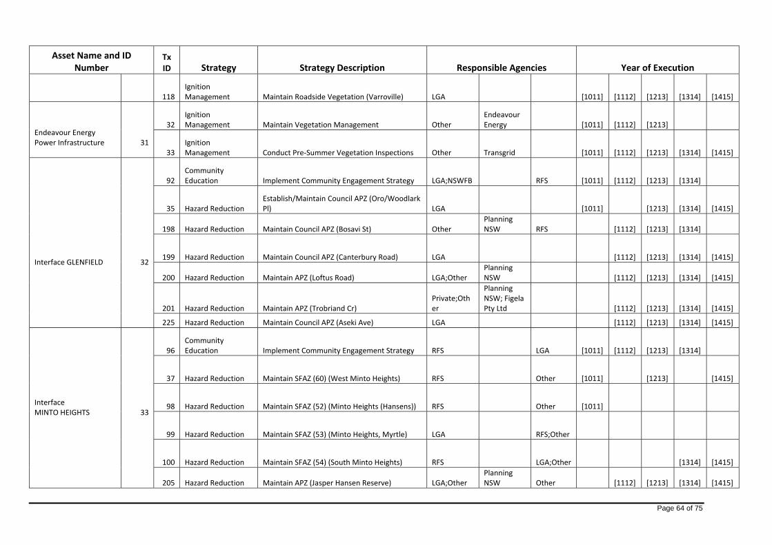
Page 64 of 75
Asset Name and ID Number
Tx ID Strategy Strategy Description Responsible Agencies Year of Execution
118 Ignition Management Maintain Roadside Vegetation (Varroville) LGA [1011] [1112] [1213] [1314] [1415]
Endeavour Energy Power Infrastructure
31
32 Ignition Management Maintain Vegetation Management Other
Endeavour Energy [1011] [1112] [1213]
33 Ignition Management Conduct Pre‐Summer Vegetation Inspections Other Transgrid [1011] [1112] [1213] [1314] [1415]
Interface GLENFIELD
32
92 Community Education Implement Community Engagement Strategy LGA;NSWFB RFS [1011] [1112] [1213] [1314]
35 Hazard Reduction Establish/Maintain Council APZ (Oro/Woodlark Pl) LGA [1011] [1213] [1314] [1415]
198 Hazard Reduction Maintain Council APZ (Bosavi St) Other Planning NSW RFS [1112] [1213] [1314]
199 Hazard Reduction Maintain Council APZ (Canterbury Road) LGA [1112] [1213] [1314] [1415]
200 Hazard Reduction Maintain APZ (Loftus Road) LGA;Other Planning NSW [1112] [1213] [1314] [1415]
201 Hazard Reduction Maintain APZ (Trobriand Cr) Private;Other
Planning NSW; Figela Pty Ltd [1112] [1213] [1314] [1415]
225 Hazard Reduction Maintain Council APZ (Aseki Ave) LGA [1112] [1213] [1314] [1415]
Interface MINTO HEIGHTS
33
96 Community Education Implement Community Engagement Strategy RFS LGA [1011] [1112] [1213] [1314]
37 Hazard Reduction Maintain SFAZ (60) (West Minto Heights) RFS Other [1011] [1213] [1415]
98 Hazard Reduction Maintain SFAZ (52) (Minto Heights (Hansens)) RFS Other [1011]
99 Hazard Reduction Maintain SFAZ (53) (Minto Heights, Myrtle) LGA RFS;Other
100 Hazard Reduction Maintain SFAZ (54) (South Minto Heights) RFS LGA;Other [1314] [1415]
205 Hazard Reduction Maintain APZ (Jasper Hansen Reserve) LGA;Other Planning NSW Other [1112] [1213] [1314] [1415]

Page 65 of 75
Asset Name and ID Number
Tx ID Strategy Strategy Description Responsible Agencies Year of Execution
97 Ignition Management Restrict Vehicle Access (Minto Heights) LGA;Other
Planning NSW RFS [1011] [1112] [1213] [1314] [1415]
191 Ignition Management Maintain Roadside Vegetation (Minto Heights) LGA [1112] [1213] [1314] [1415]
Glenfield Sewage Treatment Plant
34
34 Hazard Reduction Maintain SFAZ (56) (Genfield Waste Plant) RFS Other [1112] [1314]
167 Property Planning Prepare pre‐incident planning (RFS) RFS NSWFB [1011] [1213]
Russian Retirement Village
35
154 Community Education Implement Comm Ed Strategy (Russian Village) RFS LGA [1011] [1112] [1213] [1314]
156 Hazard Reduction Maintain SFAZ (64) (Kentlyn) RFS;Other
Planning; Tharawal LALC
DL;LGA;Other [1314]
155 Preparedness Prepare Operational Pre‐Incident Planning (NSWFB) NSWFB;RFS NSWFB [1011] [1112] [1213] [1314]
Interface LEUMEAH
36
106 Community Education Implement Community Engagement Strategy NSWFB LGA [1011] [1112] [1213] [1314]
109 Hazard Reduction Maintain SFAZ (77) (LEUMEAH/KENTLYN) RFS;Other
Planning; Tharawal LALC LGA;Other [1112]
27 Ignition Management Maintain Roadside Vegetation (Ingleburn) LGA [1011] [1112] [1213] [1314] [1415]
Interface CONJOLA CRS
37
111 Community Education Implement Community Engagement Strategy NSWFB LGA [1011] [1112] [1213] [1314]
110 Hazard Reduction Maintain Council APZ (Conjola Cres) LGA [1011] [1112] [1213] [1314] [1415]
112 Ignition Management Restrict Vehicle Access (Smith Creek Reserve) LGA NSWFB [1011] [1112] [1213] [1314] [1415]
Kemps Creek Public School
38
157 Community Education Implement Community Engagement Strategy RFS LGA [1011] [1112] [1213] [1314]
9 Hazard Reduction Maintain SFAZ (78) (Kemps Creek Public) RFS [1011] [1213] [1415]
158 Property Planning Prepare pre‐incident planning (RFS) RFS NSWFB [1011] [1213] [1314]

Page 66 of 75
Asset Name and ID Number
Tx ID Strategy Strategy Description Responsible Agencies Year of Execution
Christadelphian Heritage College
39
159 Community Education Implement Community Engagement Strategy LGA;RFS RFS [1011] [1112] [1213] [1314]
160 Property Planning Prepare pre‐incident planning (RFS) RFS NSWFB [1011]
Liverpool Sub Station 40 168 Preparedness Prepare Operational Pre‐Incident Planning (NSWFB) NSWFB NSWFB [1011]
Bringelly Pre‐School
41
161 Community Education Implement Community Engagement Strategy LGA;RFS RFS [1011] [1112] [1213] [1314]
162 Property Planning Prepare pre‐incident planning (RFS) RFS NSWFB [1011]
Carmelite Monastery
43
143 Community Education
Implement Comm Ed Strategy (Carmelite Monastery) LGA;RFS RFS [1011] [1112] [1213] [1314]
144 Property Planning Prepare pre‐incident planning (RFS) (Carmelite) RFS NSWFB [1011]
Interface CARNES HILL
44
120 Community Education Implement Community Engagement Strategy NSWFB LGA [1011] [1112] [1213] [1314]
43 Hazard Reduction Maintain APZ (Carnes Hill) Other
Western Sydney Parklands Trust Private [1112] [1213] [1314]
121 Ignition Management Restrict Vehicle Access (CARNES HILL) Other
Western Sydney Parklands Trust [1011] [1112] [1213] [1314]
Interface 22ND / KIRKPATRICK
45
122 Community Education Implement Community Engagement Strategy RFS Other [1011] [1112] [1213] [1314]
47 Hazard Reduction Maintain APZ (22nd/Kirkpatrick) Other
Western Syd Parkland Trust [1112] [1213] [1314] [1415]
Interface EAST WEDDERBURN
46
123 Community Education Implement Community Engagement Strategy RFS LGA [1011] [1112] [1213] [1314]
5 Hazard Reduction Maintain SFAZ (75) (Katana Rd) RFS LGA;Private [1011] [1213] [1314] [1415]

Page 67 of 75
Asset Name and ID Number
Tx ID Strategy Strategy Description Responsible Agencies Year of Execution
124 Hazard Reduction Maintain SFAZ (116) (East Wedderburn) DECC RFS
Interface CATHERINE FIELDS 47 125
Community Education Implement Community Engagement Strategy RFS LGA [1011] [1112] [1213] [1314]
The Australian Botanic Garden (Mt Annan)
48
171 Community Education Implement Comm Ed Strategy (MABG) NSWFB;RFS LGA [1011] [1112] [1213] [1314]
51 Hazard Reduction Maintain Slashed Perimeter Fire Breaks Other
Australian Botanic Garden (Mt Annan) [1011] [1112] [1213]
Jack's Gully Waste Facility 49 169 Property Planning Prepare pre‐incident planning (RFS) RFS NSWFB [1011]
Cobbitty School
50
163 Community Education Implement Community Engagement Strategy RFS LGA [1011] [1112] [1213] [1314] [1415]
164 Property Planning Prepare pre‐incident planning (RFS) RFS NSWFB [1011]
Interface CASULA ROAD
51
128 Community Education Implement Community Engagement Strategy NSWFB LGA [1011] [1112] [1213] [1314]
45 Hazard Reduction Maintain APZ (Casula Rd) DECC LGA [1011] [1112] [1213] [1314]
54 Hazard Reduction Maintain LMZ (106 / 107) Leacock Regional Park DECC [1011] [1415]
All Saints Catholic Seniors College
52
165 Community Education Implement Community Engagement Strategy NSWFB LGA [1011] [1112] [1213] [1314]
229 Hazard Reduction Maintain APZ (229) All Saints Catholic College Private [1415]
166 Preparedness Prepare Operational Pre‐Incident Planning (NSWFB) NSWFB NSWFB [1011] [1213] [1314]
Bents Basin State Conservation Area
53
57 Hazard Reduction LMZ (113) (Bents Basin) DECC RFS [1011] [1213] [1415]
172 Hazard Reduction Maintain SFAZ (111) (Bents Basin) DECC [1112] [1314]

Page 68 of 75
Asset Name and ID Number
Tx ID Strategy Strategy Description Responsible Agencies Year of Execution
Interface INGLEBURN
54
129 Community Education Implement Community Engagement Strategy NSWFB LGA [1011] [1112] [1213] [1314]
131 Hazard Reduction Maintain SFAZ (66) (Ingleburn) Private;RFS;Other
Planning NSW [1112] [1314]
27 Ignition Management Maintain Roadside Vegetation (Ingleburn) LGA [1011] [1112] [1213] [1314] [1415]
130 Ignition Management Restrict Vehicle Access (Ingleburn) LGA;Other Planning RFS [1011] [1112] [1213] [1314] [1415]
Interface AIRDS
56
132 Community Education Implement Community Engagement Strategy NSWFB;RFS LGA [1011] [1112] [1213] [1314]
48 Hazard Reduction Maintain SFAZ (65) (Airds) RFS Other [1213] [1314] [1415]
195 Hazard Reduction Maintain APZ (Airds Eastern Interface) LGA;Other Housing; Planning Other [1112] [1213] [1314] [1415]
212 Hazard Reduction Maintain Council APZ (Clyde & Hastings Pl) LGA [1112] [1213] [1314] [1415]
213 Hazard Reduction Maintain APZ (Deane Park) LGA;Other Landcom Other [1112] [1213] [1314] [1415]
133 Ignition Management Restrict Vehicle Access (AIRDS) LGA;Other
Housing; Planning RFS [1011] [1112]
Rural Residential GREENDALE 57 134
Ignition Management Maintain Roadside Vegetation (GREENDALE) LGA [1011] [1112] [1213]
Miller TAFE Campus 61 183 Hazard Reduction Maintain APZ (Miller TAFE) LGA [1011] [1112] [1213] [1314] [1415]
Interface BINGARA ROAD 62 6 Hazard Reduction Maintain Council APZ (Bingara Reserve) LGA [1011] [1112] [1213] [1314] [1415]
Kemps Creek Switching Sub Station
63
56 Hazard Reduction Maintain LMZ (108) (Kemps Creek Nature Reserve) DECC [1112] [1314]
180 Hazard Reduction Maintain APZ (Kemps Creek Sub Station) Other Transgrid [1011] [1112] [1213] [1314] [1415]
33 Ignition Management Conduct Pre‐Summer Vegetation Inspections Other Transgrid [1011] [1112] [1213] [1314] [1415]
Kemps Creek Childrens Cottage 66 242
Community Education Implement Community Engagement Strategy RFS LGA [1213] [1415]

Page 69 of 75
Asset Name and ID Number
Tx ID Strategy Strategy Description Responsible Agencies Year of Execution
Odyssey House 74 243 Hazard Reduction Maintain APZ (243) Odyssey House Private [1213] [1314] [1415] Interface CHIPPING NORTON LAKES 77 14 Hazard Reduction Maintain APZ (CHIPPING NORTON) LGA [1011] [1112] [1213] [1314] [1415]
Interface MOOREBANK 78 16 Hazard Reduction Maintain APZ (MOOREBANK) LGA [1011] [1112] [1213] [1314] [1415]
Interface MCMILLAN PARK 79 15 Hazard Reduction Maintain APZ (MCMILLIAN PARK) LGA [1011] [1112] [1213] [1314] [1415]
Mater Dei College
88
245 Community Education Implement Community Engagement Strategy RFS LGA [1213] [1314]
244 Hazard Reduction Maintain APZ (244) (Mater Dei School) Private RFS [1213] [1314] [1415]
Interface DENHAM COURT
92
141 Hazard Reduction Maintain SFAZ (35) (HUME HWY) RTA [1112] [1213] [1314] [1415]
236 Hazard Reduction Maintain APZ (Denham Court) Other Landcom [1314] [1415]
193 Ignition Management Maintain Roadside Vegetation (Denham Court) LGA [1112] [1213] [1314] [1415]
Interface CECIL HILLS
93
12 Hazard Reduction Maintain APZ (Cecil Hills) Other
Western Sydney Parklands Trust LGA [1011] [1112] [1213] [1314] [1415]
181 Hazard Reduction Maintain APZ (Cecil Hills) Other
Western Sydney Parklands Trust LGA [1011] [1112] [1213] [1314] [1415]
Interface ST HELENS PARK
94
135 Community Education Implement Comm Ed Strategy (St Helens Pk) NSWFB;RFS LGA [1011] [1112] [1213] [1314]
136 Hazard Reduction Maintain SFAZ (68) (St Helens Park, Derwin) RFS;Other Planning LGA;Other [1213] [1314] [1415]
137 Hazard Reduction Maintain SFAZ (67) (St Helens Park) LGA;RFS LGA;Private;Other [1112] [1213] [1314] [1415]
207 Hazard Reduction Maintain APZ (Parma Crescent) LGA;Other Dept. Planning [1112] [1213] [1314] [1415]
Page 70 of 75
Asset Name and ID Number
Tx ID Strategy Strategy Description Responsible Agencies Year of Execution
208 Hazard Reduction Maintain APZ (Scattergood Reserve) LGA;Other Planning NSW RFS [1112] [1213] [1314] [1415]
209 Hazard Reduction Maintain Council APZ (Gibbs Pl) LGA [1112] [1213] [1314] [1415]
211 Hazard Reduction Establish/Maintain Council APZ (Rangers Reserve) LGA [1112] [1213] [1314] [1415]
Ashcroft High School 95 185 Hazard Reduction Maintain APZ (Interface North Cabbramatta Crk) LGA [1011] [1112] [1213] [1314] [1415]
Simmos Beach 98 187 Hazard Reduction Maintain Council APZ (Mary/Victoria) LGA [1011] [1112] [1213] [1314] [1415]
Interface RUSE 102 206 Hazard Reduction Maintain APZ (Greenway St) Other Planning NSW RFS [1112] [1213] [1314] [1415]
Luddenham Public School 104 239
Community Education Implement Community Engagement Strategy RFS
LGA;NSWFB [1011] [1112] [1213] [1314]
Bringelly Public School 105 240 Property Planning Prepare pre‐incident planning (RFS) RFS NSWFB [1011]
Kentlyn Primary School 107 232 Preparedness Prepare Operational Pre‐Incident Planning (NSWFB)
NSWFB;RFS;Other DET LGA [1011] [1112] [1213] [1314]
Interface SOUTH CABRAMATTA CREEK 108 184 Hazard Reduction
Maintain APZ (Interface South Cabbramatta Crk) LGA [1011] [1112] [1213] [1314] [1415]
Hammond Village 111 241 Preparedness Prepare Operational Pre‐Incident Planning (NSWFB) NSWFB NSWFB [1213] [1415]
Interface NORTH CABRAMATTA CREEK 118 185 Hazard Reduction
Maintain APZ (Interface North Cabbramatta Crk) LGA [1011] [1112] [1213] [1314] [1415]
Interface GEORGE CALEY RES 122 61 Hazard Reduction Maintain APZ GEORGE CALEY RESERVE LGA [1112] [1213] [1314]
Haigh Park 124 186 Hazard Reduction Maintain APZ (Haigh Park) LGA [1011] [1112] [1213] [1314] [1415]
Varroville Communications Tower 127 246 Hazard Reduction
Maintain Council APZ (Varroville Comms Tower) LGA [1314]
Casula Motel 130 54 Hazard Reduction Maintain LMZ (106 / 107) Leacock Regional Park DECC [1011] [1415]
Page 71 of 75
Asset Name and ID Number
Tx ID Strategy Strategy Description Responsible Agencies Year of Execution
Interface LEACOCK LANE 131 54 Hazard Reduction
Maintain LMZ (106 / 107) Leacock Regional Park DECC [1011] [1415]
Interface HOXTON PARK 132 49 Hazard Reduction Maintain APZ (Hoxton Park) LGA [1112] [1213] [1314] [1415]
Interface BRIGGS PL
138
138 Hazard Reduction Maintain SFAZ (70) (St Helens Park) RFS LGA;Private [1112] [1213] [1415]
139 Hazard Reduction Maintain SFAZ (29) (St Helens Park) RFS Private;Other [1112] [1314]
140 Hazard Reduction Maintain Council APZ (St Helens Park) LGA;Other Planning NSW RFS [1011] [1112] [1213] [1314] [1415]
Interface WILLIAM HOWE RES 145 173 Hazard Reduction Maintain LMZ (124) William Howe Reserve DECC [1011] [1213] [1415]
Broughton Anglican College 147 142 Hazard Reduction Maintain SFAZ (36) (HUME HWY) RTA LGA [1112] [1213] [1314] [1415]
Holsworthy Military Base
150
52 Hazard Reduction Maintain SFAZ (97/12) (Holsworthy Military Base) Defence RFS [1011] [1213] [1415]
228 Hazard Reduction Maintain SFAZ (89) ‐ Small Arms Range (Holsworthy) Defence RFS [1112] [1213] [1314]
Kemps Creek Nature Reserve 151 56 Hazard Reduction
Maintain LMZ (108) (Kemps Creek Nature Reserve) DECC [1112] [1314]
Dharawal State Conservation Area
152
60 Hazard Reduction Maintain SFAZ (120) (Dharawal SCA) DECC [1011] [1213] [1314]
175 Hazard Reduction Maintain SFAZ (119) (Dharawal SCA) DECC [1314] [1415]
176 Hazard Reduction Maintain SFAZ (116) (Dharawal SCA) DECC RFS [1011]
177 Hazard Reduction Maintain SFAZ (118) (Dharawal SCA) DECC [1011] [1213] [1314]
178 Hazard Reduction Maintain SFAZ (120) (Dharawal SCA) DECC [1011] [1213] [1314]
179 Hazard Reduction Maintain SFAZ (127) (Dharawal SCA) DECC [1011] [1213] [1314]
Camden West Treatment Plant 153 170 Property Planning Prepare pre‐incident planning (RFS) RFS NSWFB [1011]
Woodbine Indust Area 156 188 Hazard Reduction Maintain APZ (Blaxland Road) LGA [1011] [1112] [1213] [1314] [1415]

Page 72 of 75
Asset Name and ID Number
Tx ID Strategy Strategy Description Responsible Agencies Year of Execution
Interface (WOODBINE)
157
189 Hazard Reduction Maintain Council APZ (North Steyne Road) LGA [1011] [1112] [1213] [1314] [1415]
210 Hazard Reduction Maintain Council APZ (Wanda Pl) LGA [1112] [1213] [1314] [1415]
Interface BOW BOWING 158 214 Hazard Reduction Maintain Council APZ (Minto Basin) LGA [1112] [1213] [1314]
Kilbride Nursing Home 159 221 Hazard Reduction Maintain APZ (Kilbride Nursing Home) Private [1112] [1213] [1314]
St Helens Park Public School 160 223 Hazard Reduction Maintain APZ (St Helens Park Public School)
Private;Other DET RFS [1112] [1213] [1314] [1415]
Interface BRADBURY 161 215 Hazard Reduction Maintain Council APZ (Fishers Ghost Reserve) LGA [1112] [1213] [1314] [1415]
Interface MINTO 162 216 Hazard Reduction Maintain Council APZ (Bunker Reserve) LGA [1112] [1213] [1314] [1415]
Interface FREEMAN/BAINBRIDGE
163
217 Hazard Reduction Establish/Maintain APZ (Freeman/Bainbridge) LGA;Other Planning NSW RFS [1112] [1213] [1314] [1415]
218 Hazard Reduction Maintain APZ (Bicentenary Reserve) LGA;Other Housing NSW RFS [1112] [1213] [1314] [1415]
Interface COLONG CRESCENT 164 219 Hazard Reduction Establish/Maintain Council APZ (Colong Cr) LGA [1112] [1213] [1314] [1415]
Interface COOK RESERVE 165 220 Hazard Reduction Establish/Maintain Council APZ (Cook Reserve) LGA [1112] [1213] [1314] [1415]
Inteface ROSEMEADOW 166 222 Hazard Reduction Maintain Council APZ (Noorumba Reserve) LGA [1112] [1213] [1314] [1415]
Wedderburn Resource Centre 167 224 Hazard Reduction
Maintain Council APZ (Wedderburn Rsource Centre) LGA [1112] [1213] [1314] [1415]
AGL Coal Seam Gas Plant 170 231 Preparedness Prepare Pre Incident Planning
NSWFB;RFS;Other AGL [1213] [1314] [1415]
Rail Corridor Holsworthy 171 234 Hazard Reduction Maintain APZ (233) Holsworthy Rail Corridor RailCorp [1112] [1213] [1314]

Page 73 of 75
Asset Name and ID Number
Tx ID Strategy Strategy Description Responsible Agencies Year of Execution
Rail Corridor Voyager Point 172 233 Hazard Reduction
Maintain APZ (233) Voyager Point Rail Corridor RailCorp [1112] [1213] [1314]
Harlands Orchard Wedderburn 173 247 Hazard Reduction Maintain SFAZ (119) Harlands Orchard DECC;Other
Tharawal LALC RFS [1213] [1314]

Page 74 of 75
Appendix 7
MAPS
Map Number Description Map 1 Liverpool West Areas Map 2 Liverpool Central Areas Map 3 Liverpool Eastern Areas Map 4 Campbelltown Northern Areas Map 5 Campbelltown Southern Areas Map 6 Camden Northern Areas Map 7 Camden Western Areas Map 8 Camden Southern Areas

Page 75 of 75
Reference:
Australian Bureau of Statistics (ABS) Census Data 2006 www.abs.gov.au
Dept. of Sustainability and Environment 3rd
ed. 1999 & NPWS version: Overall Fuel Hazard
Assessment Guide.
Bush Fire Environmental Assessment Code; NSW Rural Fire Service (2006)
Rural Fires Act 1997 [NSW]
Rural Fires Regulation 2001 [NSW]
NSW Rural Fire Service 2006 Planning for Bush Fire Protection: A guide for councils, planners,
fire authorities and developers.
NSW National Parks and Wildlife Service 2006 Leacock Regional Park: Fire Management
Strategy.
NSW National Parks and Wildlife Service 2006, Kemps Creek Nature Reserve: Fire Management
Strategy.
NSW National Parks and Wildlife Service 2006, Bents Basin State Conservation Area and
Gulguer Nature Reserve: Fire Management Strategy.
Management (Robbins et al) 2000 Prentice Hall Publishers
www.vlgaconsultation.org.au/groups.shtml
Camden City Council: “Community Consultation Policy and Toolkit” Policy Register 2005.

Wallacia
Luddenham
Bringelly
Badgerys Creek
Greendale
PARK ROAD ELIZABETH DRIVE
MULGOA
ROAD
69
95
77
45
64
157
165
109
151
146
162
122
121
120
50
141
160
2
1
MDA 1
MDA 7
MDA 2
MDA 6
150°45'0"E
150°45'0"E
150°40'0"E
150°40'0"E
33°55'0"S 33°55'0"S
5
4
6
8
1
3
7
2
Macarthur BFMC BushFire Risk Management
Plan 2012
MDA 1 - Map Display Area
Map 1 of 8
This Bush Fire Risk Management Plan (BFRMP) has been prepared by the MacarthurBush Fire Management Committee (BFMC) pursuant to section 52 of the Rural FiresAct 1997.
The aim of this BFRMP is to reduce the adverse impact of bush fires on life, propertyand the environment.
The objectives of this BFRMP are to:- reduce the number of human-induced bush fire ignitions that cause damage to life,property or the environment;- manage fuel to reduce the spread and intensity of bush fires while minimisingenvironmental/ecological impacts;- reduce the community's vulnerability to bush fires by improving its preparedness; and- effectively contain fires with a potential to cause damage to life, property and theenvironment.
This map forms part of the BFRMP for the Macarthur BFMC, covering the localgovernment area(s) of Camden, Campbelltown and Liverpool. It should be viewed inconjunction with the accompanying BFRMP document which provides further details onthe BFMC area, the assets assessed and the risk assessment process used.
ReviewUnder the Rural Fires Act 1997 this plan must be reviewed and updated within eachsuccessive five year period following the constitution of the BFMC. The MacarthurBFMC will also review this plan as necessary. This may be triggered by a range ofcircumstances, including but not limited to:- changes to the BFMC area, organisational reponsibilities or legislation;- changes to the bush fire risk in the area; or- following a major fire event.
AssetsThis BFRMP identifies the assets that are considered by the Macarthur BFMC andcommunity to be at risk from bush fires, assesses the bush fire risk to each asset andassigns treatments designed to mitigate the risk. Assets in the BFMC area identified asrequiring treatments are listed in the assets table. Other assets within the BFMC areathat were assessed as not requiring treatments within the life of this plan are listed inthe appendix to the BFRMP document. The Map Ref number "NA" denotes non-spatialassets.
TreatmentsSpecific treatments assigned to assets in the Macarthur area are listed in thetreatments table and linked to the assets which they are designed to protect. StandardBFMC wide treatments (i.e. not linked to a specific asset) which occur on an ongoingbasis within the BFMC area are:- reviewing the bush fire prone land map;- ensuring developments in the bush fire prone land comply with Planning for BushFire Protection;- using the Local Environment Plan/s (LEPs) to control development in areas with abush fire risk;- varying the standard bush fire danger period as required;- requiring permits during bush fire danger periods- prosecution of arsonists/offenders- investigation of bush fire cause;- normal fire suppression activities;- assessing and managing compliance with strategic fire-fighting resource allocationmanagement systems;- preparation of a S52 Operations Coordination Plan;
Note on LMZ: All areas not specifically mapped as an APZ, SFAZ or FEZ areconsidered as LMZ for this risk management plan. For areas identified by an LMZpolygon on the map, please refer to the BFRMP document for the specific landmanagement objectives.
DisclaimerThe Macarthur BFMC makes every effort to ensure the quality of the informationavailable on this map. Before relying on the information on this map, users shouldcarefully evaluate its accuracy, completeness and relevance for their purposes, andshould obtain any appropriate professional advice relevant to their particularcircumstances.
The Macarthur BFMC can not guarantee and assumes no legal liability or responsibilityfor the accuracy, currency or completeness of the information. Copyright: MacarthurBFMC 2007.
Authorized by .......................................................... of Macarthur BFMC.Date created: Thursday, June 28, 2012
BFRR version 2.1.2.1
AssetProtectionZone
To protect human life,property and highlyvalued public assetsand values.
To enable the safeuse of Direct Attacksupression strategieswithin the zone.To minimise bush fireimpacts onundefended assets.
As per RFSdocument Standardsfor Asset ProtectionZones.
StrategicFireAdvantageZone
To provide strategicareas of fireprotection advantagewhich will reduce thespeed and intensity ofbush fires, andreduce the potentialfor spot firedevelopment.To aid containment ofwildfires to existingmanagementboudnaries.
To improve thelikelihood and safeuse of:Parallel Attacksuppressionstrategies within thezone.and/orIndirect Attack (backburning) in high tovery high weatherconditions within thezone.
To reduce thelikelihood of:Crown firedevelopment withinthe zone.and/orSpot fire ignitionpotential from thezone.
Zone width related tosuppressionobjectives anddependant upon:- Topography- Aspect- Spotting propensity- Location ofadjacent fire breaks- Mosaic pattern oftreatmentAssess Overall FuelHazard (OFH) oncevegetationcommunities reachminimum firethresholds within thisplan.Managementpractices should aimto achieve mosaicfuel reductionpatterns so that themajority of the SFAZhas an OFH of lessthan high..
LandManagementZone
To meet relevant landmanagementobjectives in areawhere APZs orSFAZs are notappropriate.
As per the landmanagement and fireprotection objectivesof the responsibleland managementagency.To reduce thelikelihood of spread offires.To undertake mosaicburning.
As appropriate toachieve landmanagement, e.g.heritage and/or fireprotection e.g. broadscale mosaic burningobjectives.
FireExclusionZone
To exclude bush fires. N/A Variable dependanton size of firesensitive arearequiring protection.
Zone Purpose Suppression Zone
Assets
Map Ref Asset name Asset type Subtype Risk level Priority Treatment
35 Endeavour Energy Power Infrastructure Economic Infrastructure Very High 2A T67;68
45 Bringelly Pre-School Human Special Fire Very High 2A T127;128
64 Bents Basin State Conservation Area Economic Tourist and Very High 2C T164;170
69 Rural Residential GREENDALE Human Residential High 3A T181
121 Luddenham Public School Human Special Fire Medium 4 T211
122 Bringelly Public School Human Special Fire Medium 4 T212
Inset map 1. Luddenham
Inset map 2. Bringelly Precint
Treatments
ID Treatment strategy Action Agencies (Support)
T67 Ignition Management Maintain Vegetation Management Endeavour Energy
T68 Ignition Management Conduct Pre-Summer Vegetation Inspections Transgrid
T127 Community Education Implement Community Engagement Strategy LGA, RFS (RFS)
T128 Property Planning Prepare pre-incident planning (RFS) RFS (NSWFB)
T164 Hazard Reduction LMZ (113) (Bents Basin) DECC (RFS)
T170 Hazard Reduction Maintain SFAZ (111) (Bents Basin) DECC
T181 Ignition Management Maintain Roadside Vegetation (GREENDALE) LGA
T211 Community Education Implement Community Engagement Strategy RFS (LGA, NSWFB)
T212 Property Planning Prepare pre-incident planning (RFS) RFS (NSWFB)
0 0.3 0.6 0.9 1.2
km @ A0

Austral
Rossmore
Bringelly
Cecil Park
West Hoxton
Hoxton Park
Kemps Creek
Badgerys Creek
Horningsea Park
ELIZABETH DRIVE
MAMRE ROAD
CAMDEN VALLEY WAY
WA
LLG
RO
VE
RO
AD
98
4342
75
74
73
157
100
111
110
158
147
115
146
125
162
123
122
120
141
47
159
50
48
1
MDA 2
MDA 1
MDA 6
MDA 3
MDA 7
150°50'0"E
150°50'0"E
150°45'0"E
150°45'0"E
33°55'0"S 33°55'0"S 5
4
6
8
1
3
7
2
Macarthur BFMC BushFire Risk Management
Plan 2012
MDA 2 - Map Display Area
Map 2 of 8
This Bush Fire Risk Management Plan (BFRMP) has been prepared by the MacarthurBush Fire Management Committee (BFMC) pursuant to section 52 of the Rural FiresAct 1997.
The aim of this BFRMP is to reduce the adverse impact of bush fires on life, propertyand the environment.
The objectives of this BFRMP are to:- reduce the number of human-induced bush fire ignitions that cause damage to life,property or the environment;- manage fuel to reduce the spread and intensity of bush fires while minimisingenvironmental/ecological impacts;- reduce the community's vulnerability to bush fires by improving its preparedness; and- effectively contain fires with a potential to cause damage to life, property and theenvironment.
This map forms part of the BFRMP for the Macarthur BFMC, covering the localgovernment area(s) of Camden, Campbelltown and Liverpool. It should be viewed inconjunction with the accompanying BFRMP document which provides further details onthe BFMC area, the assets assessed and the risk assessment process used.
ReviewUnder the Rural Fires Act 1997 this plan must be reviewed and updated within eachsuccessive five year period following the constitution of the BFMC. The MacarthurBFMC will also review this plan as necessary. This may be triggered by a range ofcircumstances, including but not limited to:- changes to the BFMC area, organisational reponsibilities or legislation;- changes to the bush fire risk in the area; or- following a major fire event.
AssetsThis BFRMP identifies the assets that are considered by the Macarthur BFMC andcommunity to be at risk from bush fires, assesses the bush fire risk to each asset andassigns treatments designed to mitigate the risk. Assets in the BFMC area identified asrequiring treatments are listed in the assets table. Other assets within the BFMC areathat were assessed as not requiring treatments within the life of this plan are listed inthe appendix to the BFRMP document. The Map Ref number "NA" denotes non-spatialassets.
TreatmentsSpecific treatments assigned to assets in the Macarthur area are listed in thetreatments table and linked to the assets which they are designed to protect. StandardBFMC wide treatments (i.e. not linked to a specific asset) which occur on an ongoingbasis within the BFMC area are:- reviewing the bush fire prone land map;- ensuring developments in the bush fire prone land comply with Planning for BushFire Protection;- using the Local Environment Plan/s (LEPs) to control development in areas with abush fire risk;- varying the standard bush fire danger period as required;- requiring permits during bush fire danger periods- prosecution of arsonists/offenders- investigation of bush fire cause;- normal fire suppression activities;- assessing and managing compliance with strategic fire-fighting resource allocationmanagement systems;- preparation of a S52 Operations Coordination Plan;
Note on LMZ: All areas not specifically mapped as an APZ, SFAZ or FEZ areconsidered as LMZ for this risk management plan. For areas identified by an LMZpolygon on the map, please refer to the BFRMP document for the specific landmanagement objectives.
DisclaimerThe Macarthur BFMC makes every effort to ensure the quality of the informationavailable on this map. Before relying on the information on this map, users shouldcarefully evaluate its accuracy, completeness and relevance for their purposes, andshould obtain any appropriate professional advice relevant to their particularcircumstances.
The Macarthur BFMC can not guarantee and assumes no legal liability or responsibilityfor the accuracy, currency or completeness of the information. Copyright: MacarthurBFMC 2007.
Authorized by .......................................................... of Macarthur BFMC.Date created: Thursday, June 28, 2012
BFRR version 2.1.2.1
AssetProtectionZone
To protect human life,property and highlyvalued public assetsand values.
To enable the safeuse of Direct Attacksupression strategieswithin the zone.To minimise bush fireimpacts onundefended assets.
As per RFSdocument Standardsfor Asset ProtectionZones.
StrategicFireAdvantageZone
To provide strategicareas of fireprotection advantagewhich will reduce thespeed and intensity ofbush fires, andreduce the potentialfor spot firedevelopment.To aid containment ofwildfires to existingmanagementboudnaries.
To improve thelikelihood and safeuse of:Parallel Attacksuppressionstrategies within thezone.and/orIndirect Attack (backburning) in high tovery high weatherconditions within thezone.
To reduce thelikelihood of:Crown firedevelopment withinthe zone.and/orSpot fire ignitionpotential from thezone.
Zone width related tosuppressionobjectives anddependant upon:- Topography- Aspect- Spotting propensity- Location ofadjacent fire breaks- Mosaic pattern oftreatmentAssess Overall FuelHazard (OFH) oncevegetationcommunities reachminimum firethresholds within thisplan.Managementpractices should aimto achieve mosaicfuel reductionpatterns so that themajority of the SFAZhas an OFH of lessthan high..
LandManagementZone
To meet relevant landmanagementobjectives in areawhere APZs orSFAZs are notappropriate.
As per the landmanagement and fireprotection objectivesof the responsibleland managementagency.To reduce thelikelihood of spread offires.To undertake mosaicburning.
As appropriate toachieve landmanagement, e.g.heritage and/or fireprotection e.g. broadscale mosaic burningobjectives.
FireExclusionZone
To exclude bush fires. N/A Variable dependanton size of firesensitive arearequiring protection.
Zone Purpose Suppression Zone
Assets
Map Ref Asset name Asset type Subtype Risk level Priority Treatment
35 Endeavour Energy Power Infrastructure Economic Infrastructure Very High 2A T67;68
42 Kemps Creek Public School Human Special Fire Very High 2A T63;123;124
43 Christadelphian Heritage College Human Special Fire Very High 2A T125;126
47 Interface CARNES HILL Human Residential Very High 2A T77;109;110
48 Interface 22ND / KIRKPATRICK Human Residential Very High 2A T111;80
73 Kemps Creek Switching Sub Station Economic Infrastructure High 3A T68;180;183
100 Kemps Creek Nature Reserve Economic Tourist and High 3A T180
115 Kemps Creek Childrens Cottage Human Special Fire Medium 4 T214
Inset map 1. Kemps Creek
Treatments
ID Treatment strategy Action Agencies (Support)
T63 Hazard Reduction Maintain SFAZ (78) (Kemps Creek Public) RFS
T67 Ignition Management Maintain Vegetation Management Endeavour Energy
T68 Ignition Management Conduct Pre-Summer Vegetation Inspections Transgrid
T77 Hazard Reduction Maintain APZ (Carnes Hill) Western Sydney Parklands Trust
T80 Hazard Reduction Maintain APZ (22nd/Kirkpatrick) Western Syd Parkland Trust
T109 Community Education Implement Community Engagement Strategy NSWFB (LGA)
T110 Ignition Management Restrict Vehicle Access (CARNES HILL) Western Sydney Parklands Trust
T111 Community Education Implement Community Engagement Strategy RFS (WSPT)
T123 Community Education Implement Community Engagement Strategy RFS (LGA)
T124 Property Planning Prepare pre-incident planning (RFS) RFS (NSWFB)
T125 Community Education Implement Community Engagement Strategy LGA, RFS (RFS)
T126 Property Planning Prepare pre-incident planning (RFS) RFS (NSWFB)
T180 Hazard Reduction Maintain LMZ (108) (Kemps Creek Nature DECC
T183 Hazard Reduction Maintain APZ (Kemps Creek Sub Station) Transgrid
T214 Community Education Implement Community Engagement Strategy RFS (LGA)
0 0.25 0.5 0.75 1
km @ A0

Busby
Miller
Lurnea
Casula
Wakeley
Sadleir
Lansvale
Carramar
Ashcroft
Prestons
Villawood
Moorebank
Liverpool
Fairfield
Lansdowne
Bonnyrigg
Glenfield
Cabramatta
Heckenberg
Cartwright
Cecil Park
Abbotsbury
West Hoxton
Canley Vale
Hoxton Park
Prairiewood
Warwick Farm
Hammondville
Hinchinbrook
Green Valley
Edensor Park
Voyager Point
Anzac Village
St Johns Park
Fairfield East
Fairfield West
Canley Heights
Edmondson Park
Mount Pritchard
Greenfield Park
Cabramatta West
Chatham Village
Chipping Norton
Fairfield Heights
Bonnyrigg Heights
Holsworthy Village
Holsworthy Barracks
Ingleburn Military Camp
Wattle Grove
Horningsea Park
ELIZABETH DRIVE
CABRAMATTA ROAD
NEWBRIDGE ROAD
CAMDEN VALLEY WAY
SOUTH WESTERN MOTORWAY
HENRY LAWSON DRIVE
HEATHCOTE ROAD
SOU
TH W
ES
TER
N F
RE
EWAY
WO
ODVI
LLE
ROAD
HU
ME
HIG
HW
AY
CAM
BR
IDG
E S
TREE
T
CO
PEL
AN
D S
TREE
T
OR
ANG
E G
RO
VE R
OAD
CAMPBELLTOWN ROAD
WA
LLG
RO
VE
RO
AD
MOOREBAN
K AV
ENUE
TERMINUS STREET
JOSE
PH S
TREE
T
MILPERRA ROAD
NEW
CAM
BR
IDG
E S
TRE
ET
HUME HIGHWAY
NEWBRIDGE ROAD
HUME HIGHWAYHU
ME
HIGH
WAY
CAM
BR
IDG
E S
TREE
T
HUM
E HI
GHW
AY
TERMINUS STREET
HENR
Y LA
WSO
N DR
IVE
JOS
EPH
STR
EE
T
HEN
RY
LAW
SON
DR
IVE
WOODV
ILLE
ROAD
CO
PEL
AN
D S
TREE
T
HUME HIG
HWAY
HUME HIGHWAY
SOUTH WESTERN MOTORWAY
SOUTH WESTERN FREEWAY
OR
AN
GE
GR
OVE
RO
AD
MILPERRA ROAD
25
98
55
15
14
44
20
112
110
158
140
139147
126
137
119
114
133
6263
84
124
97
85
86
134
76
97
313130
3697
47
159
30
104
48
127
54
97
1
3
MDA 3
MDA 6
MDA 4
MDA 2
MDA 2
150°55'0"E
150°55'0"E
150°50'0"E
150°50'0"E
33°55'0"S 33°55'0"S
5
4
6
8
1
3
7
2
Macarthur BFMC BushFire Risk Management
Plan 2012
MDA 3 - Map Display Area
Map 3 of 8
This Bush Fire Risk Management Plan (BFRMP) has been prepared by the MacarthurBush Fire Management Committee (BFMC) pursuant to section 52 of the Rural FiresAct 1997.
The aim of this BFRMP is to reduce the adverse impact of bush fires on life, propertyand the environment.
The objectives of this BFRMP are to:- reduce the number of human-induced bush fire ignitions that cause damage to life,property or the environment;- manage fuel to reduce the spread and intensity of bush fires while minimisingenvironmental/ecological impacts;- reduce the community's vulnerability to bush fires by improving its preparedness; and- effectively contain fires with a potential to cause damage to life, property and theenvironment.
This map forms part of the BFRMP for the Macarthur BFMC, covering the localgovernment area(s) of Camden, Campbelltown and Liverpool. It should be viewed inconjunction with the accompanying BFRMP document which provides further details onthe BFMC area, the assets assessed and the risk assessment process used.
ReviewUnder the Rural Fires Act 1997 this plan must be reviewed and updated within eachsuccessive five year period following the constitution of the BFMC. The MacarthurBFMC will also review this plan as necessary. This may be triggered by a range ofcircumstances, including but not limited to:- changes to the BFMC area, organisational reponsibilities or legislation;- changes to the bush fire risk in the area; or- following a major fire event.
AssetsThis BFRMP identifies the assets that are considered by the Macarthur BFMC andcommunity to be at risk from bush fires, assesses the bush fire risk to each asset andassigns treatments designed to mitigate the risk. Assets in the BFMC area identified asrequiring treatments are listed in the assets table. Other assets within the BFMC areathat were assessed as not requiring treatments within the life of this plan are listed inthe appendix to the BFRMP document. The Map Ref number "NA" denotes non-spatialassets.
TreatmentsSpecific treatments assigned to assets in the Macarthur area are listed in thetreatments table and linked to the assets which they are designed to protect. StandardBFMC wide treatments (i.e. not linked to a specific asset) which occur on an ongoingbasis within the BFMC area are:- reviewing the bush fire prone land map;- ensuring developments in the bush fire prone land comply with Planning for BushFire Protection;- using the Local Environment Plan/s (LEPs) to control development in areas with abush fire risk;- varying the standard bush fire danger period as required;- requiring permits during bush fire danger periods- prosecution of arsonists/offenders- investigation of bush fire cause;- normal fire suppression activities;- assessing and managing compliance with strategic fire-fighting resource allocationmanagement systems;- preparation of a S52 Operations Coordination Plan;
Note on LMZ: All areas not specifically mapped as an APZ, SFAZ or FEZ areconsidered as LMZ for this risk management plan. For areas identified by an LMZpolygon on the map, please refer to the BFRMP document for the specific landmanagement objectives.
DisclaimerThe Macarthur BFMC makes every effort to ensure the quality of the informationavailable on this map. Before relying on the information on this map, users shouldcarefully evaluate its accuracy, completeness and relevance for their purposes, andshould obtain any appropriate professional advice relevant to their particularcircumstances.
The Macarthur BFMC can not guarantee and assumes no legal liability or responsibilityfor the accuracy, currency or completeness of the information. Copyright: MacarthurBFMC 2007.
Authorized by .......................................................... of Macarthur BFMC.Date created: Thursday, June 28, 2012
BFRR version 2.1.2.1
AssetProtectionZone
To protect human life,property and highlyvalued public assetsand values.
To enable the safeuse of Direct Attacksupression strategieswithin the zone.To minimise bush fireimpacts onundefended assets.
As per RFSdocument Standardsfor Asset ProtectionZones.
StrategicFireAdvantageZone
To provide strategicareas of fireprotection advantagewhich will reduce thespeed and intensity ofbush fires, andreduce the potentialfor spot firedevelopment.To aid containment ofwildfires to existingmanagementboudnaries.
To improve thelikelihood and safeuse of:Parallel Attacksuppressionstrategies within thezone.and/orIndirect Attack (backburning) in high tovery high weatherconditions within thezone.
To reduce thelikelihood of:Crown firedevelopment withinthe zone.and/orSpot fire ignitionpotential from thezone.
Zone width related tosuppressionobjectives anddependant upon:- Topography- Aspect- Spotting propensity- Location ofadjacent fire breaks- Mosaic pattern oftreatmentAssess Overall FuelHazard (OFH) oncevegetationcommunities reachminimum firethresholds within thisplan.Managementpractices should aimto achieve mosaicfuel reductionpatterns so that themajority of the SFAZhas an OFH of lessthan high..
LandManagementZone
To meet relevant landmanagementobjectives in areawhere APZs orSFAZs are notappropriate.
As per the landmanagement and fireprotection objectivesof the responsibleland managementagency.To reduce thelikelihood of spread offires.To undertake mosaicburning.
As appropriate toachieve landmanagement, e.g.heritage and/or fireprotection e.g. broadscale mosaic burningobjectives.
FireExclusionZone
To exclude bush fires. N/A Variable dependanton size of firesensitive arearequiring protection.
Zone Purpose Suppression Zone
Assets
Map Ref Asset name Asset type Subtype Risk level Priority Treatment
20 Miller Technical High School Human Special Fire Extreme 1C T41;55
31 Interface VOYAGER POINT Human Residential Very High 2A (1)
35 Endeavour Energy Power Infrastructure Economic Infrastructure Very High 2A T67;68
44 Liverpool Sub Station Economic Infrastructure Very High 2A T134
54 Interface CASULA ROAD Human Residential Very High 2A T79;82;117
55 All Saints Catholic Seniors College Human Special Fire Very High 2A (2)
84 Interface CHIPPING NORTON LAKES Human Residential High 3A T177
85 Interface MOOREBANK Human Residential High 3A T179
86 Interface MCMILLAN PARK Human Residential High 3A T178
98 Interface CECIL HILLS Human Residential High 3A T176;184
104 Interface LEACOCK LANE Human Residential High 3B T82
112 Casula Motel Economic Tourist and High 3D T82
114 Miller TAFE Campus Human Special Fire Medium 4 T203
119 Ashcroft High School Human Special Fire Medium 4 T205
124 Interface SOUTH CABRAMATTA Human Residential Medium 4 T204
127 Hammond Village Human Special Fire Medium 4 T213
134 Interface NORTH CABRAMATTA Human Residential Medium 4 T205
140 Haigh Park Economic Tourist and Medium 4 T206
158 Hoxton Park Public School Human Special Fire Low NA T220;222
159 Interface HOXTON PARK Human Residential Low NA T219
(1):T78;115;116;64
(2):T131;132;159
Inset map 1. Holsworthy / Wattle Grove
Inset map 3. Leacock Regional Park (NPWS)
Treatments
ID Treatment strategy Action Agencies (Support)
T41 Hazard Reduction Maintain APZ (Miller Tech High School) LGA
T55 Preparedness Prepare Operational Pre-Incident Planning NSWFB (NSWFB)
T64 Hazard Reduction Maintain SFAZ (81) (Voyager Point) RFS (LGA)
T67 Ignition Management Maintain Vegetation Management Endeavour Energy
T68 Ignition Management Conduct Pre-Summer Vegetation Inspections Transgrid
T78 Hazard Reduction Establish APZ (Voyager Point) LGA (RailCorp)
T79 Hazard Reduction Maintain APZ (Casula Rd) DECC (LGA)
T82 Hazard Reduction Maintain LMZ (106 / 107) Leacock Regional DECC
T115 Community Education Implement Community Engagement Strategy RFS (LGA, NSWFB)
T116 Hazard Reduction Maintain SFAZ (95) (Voyager Point) RFS (LGA)
T117 Community Education Implement Community Engagement Strategy NSWFB (LGA)
T131 Community Education Implement Community Engagement Strategy NSWFB (LGA)
T132 Preparedness Prepare Operational Pre-Incident Planning NSWFB (NSWFB)
T134 Preparedness Prepare Operational Pre-Incident Planning NSWFB (NSWFB)
T159 Hazard Reduction Maintain APZ (229) All Saints Catholic College Private
T176 Hazard Reduction Maintain APZ (Cecil Hills) Western Sydney Parklands Trust
T177 Hazard Reduction Maintain APZ (CHIPPING NORTON) LGA
T178 Hazard Reduction Maintain APZ (MCMILLIAN PARK) LGA
T179 Hazard Reduction Maintain APZ (MOOREBANK) LGA
T184 Hazard Reduction Maintain APZ (Cecil Hills) Western Sydney Parklands Trust
T203 Hazard Reduction Maintain APZ (Miller TAFE) LGA
T204 Hazard Reduction Maintain APZ (Interface South Cabbramatta Crk) LGA
T205 Hazard Reduction Maintain APZ (Interface North Cabbramatta Crk) LGA
T206 Hazard Reduction Maintain APZ (Haigh Park) LGA
T213 Preparedness Prepare Operational Pre-Incident Planning NSWFB (NSWFB)
T219 Hazard Reduction Maintain APZ (Hoxton Park) LGA
Treatments
ID Treatment strategy Action Agencies (Support)
T220 Preparedness Prepare Operational Pre-Incident Planning NSWFB (NSWFB)
T222 Hazard Reduction Maintain APZ (Hoxton Park Primary)) DET
0 0.3 0.6 0.9 1.2
km @ A0

Raby
Ruse
Minto
Airds
Kearns
Kentlyn
Panania
Leumeah
Bradbury
WoodbineClaymore
Ingleburn
Glenfield
Ambarvale
Bow Bowing
Blairmount
East Hills
Long Point
Eagle Vale
St Andrews
Varroville
Sandy Point
Eschol Park
Blair Athol
Campbelltown
Picnic Point
Denham Court
Voyager Point
Minto Heights
Englorie Park
Pleasure Point
Edmondson Park
Chatham Village
Macquarie Fields
Holsworthy Village
Holsworthy Barracks
Ingleburn Military Camp
Holsworthy
Leppington
Wattle Grove
Barden Ridge
Macquarie Links
HUME HIGHWAY
HEATHCOTE
ROAD
CAMDEN VALLEY WAY
APPI
N R
OA
D
NEW ILLAWARRA ROAD
CAM
PBE
LLTO
WN
RO
AD
HENRY LAWSON DRIVE
NARELLAN ROAD
PRINCES H
IGHW
AY
KELLICAR ROAD
SOU
TH W
ES
TER
N F
RE
EWAY
OXLEY STREETMOORE STREET
GIL
CH
RIS
T D
RIV
E
OXLEY
BYPASS
HU
ME
HIG
HW
AY
PRINCES H
IGHW
AY
HUME HIGHWAY
HUME HIGHWAY
NARELLAN ROAD
CAMDEN VALLEY WAY
SOU
TH W
ES
TER
N F
RE
EWAY
OXLEY
BYPASS
979797
97
97
58
25
55
15
14
90
87
46
35
22
66
3924
3819 18
71
169
163
143
168
116
161
133
132
131
130129
128
113136
135
107
106
108
6263
96
97
72
96
33
97
37
37
97
65 32
28
97
34
3131
40
11
150
103
33
16
60
33
36
30
7
4
99
6
153
67
12
58
103
41
10
9
5
30
101
104
67
60
154
101
67
61
61
9
61
155
21
58
101
17
MDA 4
MDA 6
MDA 5
MDA 3
MDA 8
151°0'0"E
151°0'0"E
150°55'0"E
150°55'0"E
150°50'0"E
150°50'0"E
34°0'0"S 34°0'0"S
34°5'0"S 34°5'0"S
5
4
6
8
1
3
7
2
Macarthur BFMC BushFire Risk Management
Plan 2012
MDA 4 - Map Display Area
Map 4 of 8
This Bush Fire Risk Management Plan (BFRMP) has been prepared by the MacarthurBush Fire Management Committee (BFMC) pursuant to section 52 of the Rural FiresAct 1997.
The aim of this BFRMP is to reduce the adverse impact of bush fires on life, propertyand the environment.
The objectives of this BFRMP are to:- reduce the number of human-induced bush fire ignitions that cause damage to life,property or the environment;- manage fuel to reduce the spread and intensity of bush fires while minimisingenvironmental/ecological impacts;- reduce the community's vulnerability to bush fires by improving its preparedness; and- effectively contain fires with a potential to cause damage to life, property and theenvironment.
This map forms part of the BFRMP for the Macarthur BFMC, covering the localgovernment area(s) of Camden, Campbelltown and Liverpool. It should be viewed inconjunction with the accompanying BFRMP document which provides further details onthe BFMC area, the assets assessed and the risk assessment process used.
ReviewUnder the Rural Fires Act 1997 this plan must be reviewed and updated within eachsuccessive five year period following the constitution of the BFMC. The MacarthurBFMC will also review this plan as necessary. This may be triggered by a range ofcircumstances, including but not limited to:- changes to the BFMC area, organisational reponsibilities or legislation;- changes to the bush fire risk in the area; or- following a major fire event.
AssetsThis BFRMP identifies the assets that are considered by the Macarthur BFMC andcommunity to be at risk from bush fires, assesses the bush fire risk to each asset andassigns treatments designed to mitigate the risk. Assets in the BFMC area identified asrequiring treatments are listed in the assets table. Other assets within the BFMC areathat were assessed as not requiring treatments within the life of this plan are listed inthe appendix to the BFRMP document. The Map Ref number "NA" denotes non-spatialassets.
TreatmentsSpecific treatments assigned to assets in the Macarthur area are listed in thetreatments table and linked to the assets which they are designed to protect. StandardBFMC wide treatments (i.e. not linked to a specific asset) which occur on an ongoingbasis within the BFMC area are:- reviewing the bush fire prone land map;- ensuring developments in the bush fire prone land comply with Planning for BushFire Protection;- using the Local Environment Plan/s (LEPs) to control development in areas with abush fire risk;- varying the standard bush fire danger period as required;- requiring permits during bush fire danger periods- prosecution of arsonists/offenders- investigation of bush fire cause;- normal fire suppression activities;- assessing and managing compliance with strategic fire-fighting resource allocationmanagement systems;- preparation of a S52 Operations Coordination Plan;
Note on LMZ: All areas not specifically mapped as an APZ, SFAZ or FEZ areconsidered as LMZ for this risk management plan. For areas identified by an LMZpolygon on the map, please refer to the BFRMP document for the specific landmanagement objectives.
DisclaimerThe Macarthur BFMC makes every effort to ensure the quality of the informationavailable on this map. Before relying on the information on this map, users shouldcarefully evaluate its accuracy, completeness and relevance for their purposes, andshould obtain any appropriate professional advice relevant to their particularcircumstances.
The Macarthur BFMC can not guarantee and assumes no legal liability or responsibilityfor the accuracy, currency or completeness of the information. Copyright: MacarthurBFMC 2007.
Authorized by .......................................................... of Macarthur BFMC.Date created: Thursday, June 28, 2012
BFRR version 2.1.2.1
AssetProtectionZone
To protect human life,property and highlyvalued public assetsand values.
To enable the safeuse of Direct Attacksupression strategieswithin the zone.To minimise bush fireimpacts onundefended assets.
As per RFSdocument Standardsfor Asset ProtectionZones.
StrategicFireAdvantageZone
To provide strategicareas of fireprotection advantagewhich will reduce thespeed and intensity ofbush fires, andreduce the potentialfor spot firedevelopment.To aid containment ofwildfires to existingmanagementboudnaries.
To improve thelikelihood and safeuse of:Parallel Attacksuppressionstrategies within thezone.and/orIndirect Attack (backburning) in high tovery high weatherconditions within thezone.
To reduce thelikelihood of:Crown firedevelopment withinthe zone.and/orSpot fire ignitionpotential from thezone.
Zone width related tosuppressionobjectives anddependant upon:- Topography- Aspect- Spotting propensity- Location ofadjacent fire breaks- Mosaic pattern oftreatmentAssess Overall FuelHazard (OFH) oncevegetationcommunities reachminimum firethresholds within thisplan.Managementpractices should aimto achieve mosaicfuel reductionpatterns so that themajority of the SFAZhas an OFH of lessthan high..
LandManagementZone
To meet relevant landmanagementobjectives in areawhere APZs orSFAZs are notappropriate.
As per the landmanagement and fireprotection objectivesof the responsibleland managementagency.To reduce thelikelihood of spread offires.To undertake mosaicburning.
As appropriate toachieve landmanagement, e.g.heritage and/or fireprotection e.g. broadscale mosaic burningobjectives.
FireExclusionZone
To exclude bush fires. N/A Variable dependanton size of firesensitive arearequiring protection.
Zone Purpose Suppression Zone
Assets
Map Ref Asset name Asset type Subtype Risk level Priority Treatment
4 Interface CUDGEGONG RD Human Residential Extreme 1A T8;9;10;7
5 Interface RICHMOND CRS Human Residential Extreme 1A (1)
6 Interface NYMBOIDA CRS Human Residential Extreme 1A T14;16;15
7 Interface LEICHHARDT ST Human Residential Extreme 1A T17;18
9 Interface CURRAN AVE Human Residential Extreme 1B T25;26
10 Interface CANBERRA / RESERVE CRS Human Residential Extreme 1B T27;28;29
11 Interface LEUMEAH Human Residential Extreme 1B (2)
12 Interface PLEASURE POINT Human Residential Extreme 1B T22;32;40
16 Interface COLONG CRESCENT Human Residential Extreme 1B T39
18 Macquarie Fields TAFE Campus Human Special Fire Extreme 1C T43;51;52
19 Wombat Willows Child Care Centre Human Special Fire Extreme 1C T53;54;57
21 Interface GILL / BENT PL Human Residential Extreme 1C T45;46;47
24 Kentlyn Primary School Human Special Fire Extreme 1C T61
25 Holsworthy Military Base Economic Infrastructure Extreme 1C T44;60
28 Interface MACQUARIE FIELDS Human Residential Very High 2A (3)
30 Interface WATTLE GROVE Human Residential Very High 2A (4)
32 Interface LONG POINT Human Residential Very High 2A (5)
33 Interface KENTLYN Human Residential Very High 2A (6)
35 Endeavour Energy Power Infrastructure Economic Infrastructure Very High 2A T67;68
36 Interface GLENFIELD Human Residential Very High 2A (7)
37 Interface MINTO HEIGHTS Human Residential Very High 2A (8)
38 Glenfield Sewage Treatment Plant Economic Infrastructure Very High 2A T69;133
39 Russian Retirement Village Human Special Fire Very High 2A (9)
40 Interface LEUMEAH Human Residential Very High 2A T98;99;65
41 Interface CONJOLA CRS Human Residential Very High 2A (10)
60 Interface FREEMAN/BAINBRIDGE Human Residential Very High 2A T154;155
61 Interface COOK RESERVE Human Residential Very High 2A T156
62 Rail Corridor Holsworthy Economic Infrastructure Very High 2A T161
63 Rail Corridor Voyager Point Economic Infrastructure Very High 2A T160
65 Interface INGLEBURN Human Residential Very High 2C (11)
67 Interface AIRDS Human Residential Very High 2C (12)
72 Interface BINGARA ROAD Human Residential High 3A T175
99 Interface RUSE Human Residential High 3A T186
108 Simmos Beach Economic Tourist and High 3D T197
155 Interface MINTO Human Residential Medium 4 T209
(1):T11;12;13;19
(2):T21;30;31;38
(3):T66;84;145;150;151
(4):T75;104;105;106
(5):T71;86;87;88;162
(6):T73;97;94;95;96
(7):T70;85;146;147;148;149;158
(8):T72;89;90;144;91;92;93;152
(9):T120;121;122
(10):T100;101;102
(11):T165;166;167;65
(12):T163;169;168;171;172;173
Treatments
ID Treatment strategy Action Agencies (Support)
T7 Hazard Reduction Maintain APZ (Cudgegong Road) LGA, Planning NSW (RFS)
T8 Community Education Implement Community Engagement Strategy NSWFB (LGA, RFS)
T9 Ignition Management Restrict Vehicle Access (Cudgegong Road) LGA
T10 Preparedness Prepare Operational Pre-Incident Planning NSWFB (NSWFB)
T11 Hazard Reduction Maintain Council APZ (Richmond Cres) LGA
T12 Community Education Implement Community Engagement Strategy NSWFB (LGA)
T13 Preparedness Prepare Operational Pre-Incident Planning NSWFB (NSWFB)
T14 Hazard Reduction Maintain APZ (Nymboida Crescent) LGA, Planning NSW (RFS)
T15 Community Education Implement Community Engagement Strategy LGA (NSWFB)
T16 Preparedness Prepare Operational Pre-Incident Planning NSWFB (NSWFB)
T17 Hazard Reduction Maintain APZ (Leichhardt St) LGA, Planning NSW
T18 Community Education Implement Comm Engagement Strategy NSWFB (LGA)
T19 Hazard Reduction Maintain Council APZ (Gwydir Place) LGA
T21 Hazard Reduction Establish/Maintain Council APZ (West Smiths LGA (NSWFB)
T22 Hazard Reduction Establish APZ (Pleasure Point) Private, Defence (LGA, RFS)
T25 Community Education Implement Community Engagement Strategy NSWFB (LGA)
T26 Hazard Reduction Maintain Council APZ (Bingara Reserve) LGA
T27 Hazard Reduction Maintain Council APZ (Canberra Cres) LGA
T28 Community Education Implement Comm Engagement Strategy LGA, RFS (RFS)
T29 Preparedness Prepare Operational Pre-Incident Planning NSWFB (NSWFB)
T30 Community Education Implement Comm Engagement Strategy NSWFB (LGA)
T31 Preparedness Prepare Operational Pre-Incident Planning NSWFB (NSWFB)
T32 Community Education Implement Community Engagement Strategy RFS (LGA)
T38 Hazard Reduction Establish/Maintain Council APZ (Carrington Cct) LGA
T39 Hazard Reduction Establish/Maintain Council APZ (Colong Cr) LGA
T40 Hazard Reduction Maintain SFAZ 129 - Camp Sapper RFS (Defence)
Treatments
ID Treatment strategy Action Agencies (Support)
T43 Hazard Reduction Maintain APZ (Macquarie Fields TAFE) DET
T44 Hazard Reduction Maintain SFAZ (97/12) (Holsworthy Military Defence (RFS)
T45 Hazard Reduction Maintain Council APZ (Bent/Gill Pl) LGA, Crown Lands (NSWFB)
T46 Community Education Implement Community Engagement Strategy NSWFB (LGA)
T47 Preparedness Prepare Operational Pre-Incident Planning NSWFB (NSWFB)
T51 Community Education Implement Community Engagement Strategy NSWFB (RFS)
T52 Preparedness Prepare Operational Pre-Incident Planning NSWFB (NSWFB)
T53 Community Education Implement Community Engagement Strategy LGA, NSWFB
T54 Preparedness Prepare Operational Pre-Incident Planning NSWFB (NSWFB)
T57 Hazard Reduction Maintain Council APZ (Wombat Willows) LGA
T60 Hazard Reduction Maintain SFAZ (89) - Small Arms Range Defence (RFS)
T61 Preparedness Prepare Operational Pre-Incident Planning NSWFB, RFS, DET (LGA)
T65 Ignition Management Maintain Roadside Vegetation (Ingleburn) LGA
T66 Hazard Reduction Establish/Maintain Council APZ (Simmos Beach) LGA, Planning NSW
T67 Ignition Management Maintain Vegetation Management Endeavour Energy
T68 Ignition Management Conduct Pre-Summer Vegetation Inspections Transgrid
T69 Hazard Reduction Maintain SFAZ (56) (Genfield Waste Plant) RFS (Planning)
T70 Hazard Reduction Establish/Maintain Council APZ (Oro/Woodlark LGA
T71 Hazard Reduction Maintain SFAZ (58) (Long Point) RFS (Planning NSW)
T72 Hazard Reduction Maintain SFAZ (60) (West Minto Heights) RFS (Planning NSW)
T73 Hazard Reduction Maintain SFAZ (62) (Kentlyn) RFS (LGA, Tharawal LALC;
T75 Hazard Reduction Maintain SFAZ (9) (Wattle Grove) Defence (RFS)
T84 Community Education Implement Community Engagement Strategy NSWFB, RFS (LGA)
T85 Community Education Implement Community Engagement Strategy LGA, NSWFB (RFS)
T86 Community Education Implement Community Engagement Strategy RFS (LGA)
T87 Ignition Management Restrict Vehicle Access (Long Point) LGA (RFS)
Treatments
ID Treatment strategy Action Agencies (Support)
T88 Ignition Management Maintain Roadside Vegetation (Long Point) LGA (RFS)
T89 Community Education Implement Community Engagement Strategy RFS (LGA)
T90 Ignition Management Restrict Vehicle Access (Minto Heights) LGA, Planning NSW (RFS)
T91 Hazard Reduction Maintain SFAZ (52) (Minto Heights (Hansens)) RFS (Planning NSW)
T92 Hazard Reduction Maintain SFAZ (53) (Minto Heights, Myrtle) LGA (RFS, Planning NSW)
T93 Hazard Reduction Maintain SFAZ (54) (South Minto Heights) RFS (LGA, Planning NSW)
T94 Hazard Reduction Maintain SFAZ (64) (Kentlyn) RFS (LGA, Planning)
T95 Community Education Implement Community Engagement Strategy RFS (LGA)
T96 Ignition Management Restrict Vehicle Access (Kentlyn) LGA, Planning NSW; Tharawal
T97 Ignition Management Maintain Roadside Vegetation (Kentlyn) LGA
T98 Community Education Implement Community Engagement Strategy NSWFB (LGA)
T99 Hazard Reduction Maintain SFAZ (77) (LEUMEAH/KENTLYN) RFS, Planning; Tharawal LALC
T100 Hazard Reduction Maintain Council APZ (Conjola Cres) LGA
T101 Community Education Implement Community Engagement Strategy NSWFB (LGA)
T102 Ignition Management Restrict Vehicle Access (Smith Creek Reserve) LGA (NSWFB)
T104 Hazard Reduction Maintain SFAZ (11) (Wattle Grove) Defence (RFS)
T105 Community Education Implement Community Engagement Strategy NSWFB (LGA)
T106 Ignition Management Restrict Vehicle Access (WATTLE GROVE) Defence (RTA)
T120 Community Education Implement Comm Ed Strategy (Russian Village) RFS (LGA)
T121 Preparedness Prepare Operational Pre-Incident Planning NSWFB, RFS (NSWFB)
T122 Hazard Reduction Maintain SFAZ (64) (Kentlyn) RFS, Planning; Tharawal LALC
T133 Property Planning Prepare pre-incident planning (RFS) RFS (NSWFB)
T144 Ignition Management Maintain Roadside Vegetation (Minto Heights) LGA
T145 Ignition Management Maintain Roadside Vegetation (Macquarie LGA
T146 Hazard Reduction Maintain Council APZ (Bosavi St) Planning NSW (RFS)
T147 Hazard Reduction Maintain Council APZ (Canterbury Road) LGA
Treatments
ID Treatment strategy Action Agencies (Support)
T148 Hazard Reduction Maintain APZ (Loftus Road) LGA, Planning NSW
T149 Hazard Reduction Maintain APZ (Trobriand Cr) Private, Planning NSW; Figela Pty
T150 Hazard Reduction Maintain APZ (Macquarie Fields Interface) Housing NSW; Planning NSW
T151 Hazard Reduction Maintain Council APZ (Wills Reserve) LGA
T152 Hazard Reduction Maintain APZ (Jasper Hansen Reserve) LGA, Planning NSW (Planning
T154 Hazard Reduction Establish/Maintain APZ (Freeman/Bainbridge) LGA, Planning NSW (RFS)
T155 Hazard Reduction Maintain APZ (Bicentenary Reserve) LGA, Housing NSW (RFS)
T156 Hazard Reduction Establish/Maintain Council APZ (Cook Reserve) LGA
T158 Hazard Reduction Maintain Council APZ (Aseki Ave) LGA
T160 Hazard Reduction Maintain APZ (233) Voyager Point Rail Corridor RailCorp
T161 Hazard Reduction Maintain APZ (233) Holsworthy Rail Corridor RailCorp
T162 Preparedness Establish RFS Community Fire Unit RFS (LGA)
T163 Hazard Reduction Maintain SFAZ (65) (Airds) RFS (Planning)
T165 Community Education Implement Community Engagement Strategy NSWFB (LGA)
T166 Ignition Management Restrict Vehicle Access (Ingleburn) LGA, Planning (RFS)
T167 Hazard Reduction Maintain SFAZ (66) (Ingleburn) Private, RFS, Planning NSW
T168 Community Education Implement Community Engagement Strategy NSWFB, RFS (LGA)
T169 Ignition Management Restrict Vehicle Access (AIRDS) LGA, Housing; Planning (RFS)
T171 Hazard Reduction Maintain APZ (Airds Eastern Interface) LGA, Housing; Planning (Housing
T172 Hazard Reduction Maintain Council APZ (Clyde & Hastings Pl) LGA
T173 Hazard Reduction Maintain APZ (Deane Park) LGA, Landcom (Landcom)
T175 Hazard Reduction Maintain Council APZ (Bingara Reserve) LGA
T186 Hazard Reduction Maintain APZ (Greenway St) Planning NSW (RFS)
T197 Hazard Reduction Maintain Council APZ (Mary/Victoria) LGA
T209 Hazard Reduction Maintain Council APZ (Bunker Reserve) LGA
0 0.4 0.8 1.2 1.6
km @ A0

Ruse
Airds
Gilead
Kentlyn
Bradbury
Ambarvale
Rosemeadow
Glen Alpine
Blair Athol
Campbelltown
Englorie Park
Menangle Park
St Helens Park
Appin
Woronora
Holsworthy
Wedderburn
Mount Annan
APPI
N R
OA
D
HUM
E HI
GHW
AY
MENAN
GLE R
OAD
NARELLAN ROAD
KELLICAR ROAD
OXLEY STREET
MOORE STREET
GIL
CH
RIS
T D
RIV
E
ENGLORIE PARK DRIVE
OXLEY B
YPASSG
EARY STREET
HUM
E HI
GHW
AY
MOORE STREET
NARELLAN ROAD
OXLEY
BYPASS
GEAR
Y STREET
8
27
59
56
51 51
91 90 66
3924
156
163
152
166 138
33
49
49
13
150
82
13
13
68
49
103
33
49
6
49
49
103
11
13
49
33
7
4
99
67
10
5
101
148
67
105
101
67
61
6129 61
101
21
2
1
MDA 5
MDA 4
MDA 8
MDA 6
150°55'0"E
150°55'0"E
150°50'0"E
150°50'0"E
150°45'0"E
150°45'0"E
34°5'0"S 34°5'0"S
34°10'0"S 34°10'0"S
5
4
6
8
1
3
7
2
Macarthur BFMC BushFire Risk Management
Plan 2012
MDA 5 - Map Display Area
Map 5 of 8
This Bush Fire Risk Management Plan (BFRMP) has been prepared by the MacarthurBush Fire Management Committee (BFMC) pursuant to section 52 of the Rural FiresAct 1997.
The aim of this BFRMP is to reduce the adverse impact of bush fires on life, propertyand the environment.
The objectives of this BFRMP are to:- reduce the number of human-induced bush fire ignitions that cause damage to life,property or the environment;- manage fuel to reduce the spread and intensity of bush fires while minimisingenvironmental/ecological impacts;- reduce the community's vulnerability to bush fires by improving its preparedness; and- effectively contain fires with a potential to cause damage to life, property and theenvironment.
This map forms part of the BFRMP for the Macarthur BFMC, covering the localgovernment area(s) of Camden, Campbelltown and Liverpool. It should be viewed inconjunction with the accompanying BFRMP document which provides further details onthe BFMC area, the assets assessed and the risk assessment process used.
ReviewUnder the Rural Fires Act 1997 this plan must be reviewed and updated within eachsuccessive five year period following the constitution of the BFMC. The MacarthurBFMC will also review this plan as necessary. This may be triggered by a range ofcircumstances, including but not limited to:- changes to the BFMC area, organisational reponsibilities or legislation;- changes to the bush fire risk in the area; or- following a major fire event.
AssetsThis BFRMP identifies the assets that are considered by the Macarthur BFMC andcommunity to be at risk from bush fires, assesses the bush fire risk to each asset andassigns treatments designed to mitigate the risk. Assets in the BFMC area identified asrequiring treatments are listed in the assets table. Other assets within the BFMC areathat were assessed as not requiring treatments within the life of this plan are listed inthe appendix to the BFRMP document. The Map Ref number "NA" denotes non-spatialassets.
TreatmentsSpecific treatments assigned to assets in the Macarthur area are listed in thetreatments table and linked to the assets which they are designed to protect. StandardBFMC wide treatments (i.e. not linked to a specific asset) which occur on an ongoingbasis within the BFMC area are:- reviewing the bush fire prone land map;- ensuring developments in the bush fire prone land comply with Planning for BushFire Protection;- using the Local Environment Plan/s (LEPs) to control development in areas with abush fire risk;- varying the standard bush fire danger period as required;- requiring permits during bush fire danger periods- prosecution of arsonists/offenders- investigation of bush fire cause;- normal fire suppression activities;- assessing and managing compliance with strategic fire-fighting resource allocationmanagement systems;- preparation of a S52 Operations Coordination Plan;
Note on LMZ: All areas not specifically mapped as an APZ, SFAZ or FEZ areconsidered as LMZ for this risk management plan. For areas identified by an LMZpolygon on the map, please refer to the BFRMP document for the specific landmanagement objectives.
DisclaimerThe Macarthur BFMC makes every effort to ensure the quality of the informationavailable on this map. Before relying on the information on this map, users shouldcarefully evaluate its accuracy, completeness and relevance for their purposes, andshould obtain any appropriate professional advice relevant to their particularcircumstances.
The Macarthur BFMC can not guarantee and assumes no legal liability or responsibilityfor the accuracy, currency or completeness of the information. Copyright: MacarthurBFMC 2007.
Authorized by .......................................................... of Macarthur BFMC.Date created: Thursday, June 28, 2012
BFRR version 2.1.2.1
AssetProtectionZone
To protect human life,property and highlyvalued public assetsand values.
To enable the safeuse of Direct Attacksupression strategieswithin the zone.To minimise bush fireimpacts onundefended assets.
As per RFSdocument Standardsfor Asset ProtectionZones.
StrategicFireAdvantageZone
To provide strategicareas of fireprotection advantagewhich will reduce thespeed and intensity ofbush fires, andreduce the potentialfor spot firedevelopment.To aid containment ofwildfires to existingmanagementboudnaries.
To improve thelikelihood and safeuse of:Parallel Attacksuppressionstrategies within thezone.and/orIndirect Attack (backburning) in high tovery high weatherconditions within thezone.
To reduce thelikelihood of:Crown firedevelopment withinthe zone.and/orSpot fire ignitionpotential from thezone.
Zone width related tosuppressionobjectives anddependant upon:- Topography- Aspect- Spotting propensity- Location ofadjacent fire breaks- Mosaic pattern oftreatmentAssess Overall FuelHazard (OFH) oncevegetationcommunities reachminimum firethresholds within thisplan.Managementpractices should aimto achieve mosaicfuel reductionpatterns so that themajority of the SFAZhas an OFH of lessthan high..
LandManagementZone
To meet relevant landmanagementobjectives in areawhere APZs orSFAZs are notappropriate.
As per the landmanagement and fireprotection objectivesof the responsibleland managementagency.To reduce thelikelihood of spread offires.To undertake mosaicburning.
As appropriate toachieve landmanagement, e.g.heritage and/or fireprotection e.g. broadscale mosaic burningobjectives.
FireExclusionZone
To exclude bush fires. N/A Variable dependanton size of firesensitive arearequiring protection.
Zone Purpose Suppression Zone
Assets
Map Ref Asset name Asset type Subtype Risk level Priority Treatment
8 St Helens Park Public School Human Special Fire Extreme 1A T20
13 Interface WEST WEDDERBURN Human Residential Extreme 1B (1)
25 Holsworthy Military Base Economic Infrastructure Extreme 1C T44;60
27 Wedderburn Resource Centre Human Special Fire Extreme 1C T59
35 Endeavour Energy Power Infrastructure Economic Infrastructure Very High 2A T67;68
49 Interface EAST WEDDERBURN Human Residential Very High 2A T62;112;113
56 Dharawal State Conservation Area Economic Tourist and Very High 2A (2)
59 Kilbride Nursing Home Human Special Fire Very High 2A T157
67 Interface AIRDS Human Residential Very High 2C (3)
68 Harlands Orchard Wedderburn Economic Agricultural Very High 2C T174
101 Interface BRADBURY Human Residential High 3A T187
103 Interface ST HELENS PARK Human Residential High 3B (4)
105 Inteface ROSEMEADOW Human Residential High 3C T196
148 Interface BRIGGS PL Human Residential Medium 4 (5)
(1):T23;33;34;37
(2):T83;138;139;140;141;142
(3):T163;169;168;171;172;173
(4):T189;190;191;192;193;194;195
(5):T199;200;201
Inset map 1. Campbelltown Interface
Inset map 2. Wedderburn Precint
Treatments
ID Treatment strategy Action Agencies (Support)
T20 Hazard Reduction Maintain APZ (St Helens Park Public School) Private, DET (RFS)
T23 Hazard Reduction Maintain SFAZ (28) (Bellbird North) RFS (Private)
T33 Community Education Implement Community Engagement Strategy RFS (LGA)
T34 Ignition Management Maintain Roadside Vegetation (Wedderburn) LGA
T37 Hazard Reduction Maintain SFAZ (125) Wedderburn/O'Hares Rd RFS (LGA)
T44 Hazard Reduction Maintain SFAZ (97/12) (Holsworthy Military Defence (RFS)
T59 Hazard Reduction Maintain Council APZ (Wedderburn Rsource LGA
T60 Hazard Reduction Maintain SFAZ (89) - Small Arms Range Defence (RFS)
T62 Hazard Reduction Maintain SFAZ (75) (Katana Rd) RFS (LGA, Private)
T67 Ignition Management Maintain Vegetation Management Endeavour Energy
T68 Ignition Management Conduct Pre-Summer Vegetation Inspections Transgrid
T83 Hazard Reduction Maintain SFAZ (120) (Dharawal SCA) DECC
T112 Community Education Implement Community Engagement Strategy RFS (LGA)
T113 Hazard Reduction Maintain SFAZ (116) (East Wedderburn) DECC (RFS)
T138 Hazard Reduction Maintain SFAZ (119) (Dharawal SCA) DECC
T139 Hazard Reduction Maintain SFAZ (116) (Dharawal SCA) DECC (RFS)
T140 Hazard Reduction Maintain SFAZ (118) (Dharawal SCA) DECC
T141 Hazard Reduction Maintain SFAZ (120) (Dharawal SCA) DECC
T142 Hazard Reduction Maintain SFAZ (127) (Dharawal SCA) DECC
T157 Hazard Reduction Maintain APZ (Kilbride Nursing Home) Private
T163 Hazard Reduction Maintain SFAZ (65) (Airds) RFS (Planning)
T168 Community Education Implement Community Engagement Strategy NSWFB, RFS (LGA)
T169 Ignition Management Restrict Vehicle Access (AIRDS) LGA, Housing; Planning (RFS)
T171 Hazard Reduction Maintain APZ (Airds Eastern Interface) LGA, Housing; Planning (Housing
T172 Hazard Reduction Maintain Council APZ (Clyde & Hastings Pl) LGA
T173 Hazard Reduction Maintain APZ (Deane Park) LGA, Landcom (Landcom)
Treatments
ID Treatment strategy Action Agencies (Support)
T174 Hazard Reduction Maintain SFAZ (119) Harlands Orchard DECC, Tharawal LALC (RFS)
T187 Hazard Reduction Maintain Council APZ (Fishers Ghost Reserve) LGA
T189 Community Education Implement Comm Ed Strategy (St Helens Pk) NSWFB, RFS (LGA)
T190 Hazard Reduction Maintain SFAZ (68) (St Helens Park, Derwin) RFS, Planning (LGA, Planning)
T191 Hazard Reduction Maintain SFAZ (67) (St Helens Park) LGA, RFS (LGA, Private, Planning)
T192 Hazard Reduction Maintain APZ (Parma Crescent) LGA, Dept. Planning
T193 Hazard Reduction Maintain APZ (Scattergood Reserve) LGA, Planning NSW (RFS)
T194 Hazard Reduction Maintain Council APZ (Gibbs Pl) LGA
T195 Hazard Reduction Establish/Maintain Council APZ (Rangers LGA
T196 Hazard Reduction Maintain Council APZ (Noorumba Reserve) LGA
T199 Hazard Reduction Maintain SFAZ (70) (St Helens Park) RFS (LGA, Private)
T200 Hazard Reduction Maintain SFAZ (29) (St Helens Park) RFS (Private, Planning)
T201 Hazard Reduction Maintain Council APZ (St Helens Park) LGA, Planning NSW (RFS)
0 0.4 0.8 1.2 1.6
km @ A0
Raby
Ruse
Minto
Lurnea
Casula
Kearns
Kentlyn
Leumeah
Woodbine
Narellan
Claymore
Rossmore
Prestons
Ingleburn
Glenfield
Elderslie
Bow Bowing
Blairmount
Long Point
Eagle Vale
St Andrews
Varroville
Hoxton Park
Glen Alpine
Eschol Park
Blair Athol
Spring Farm
Campbelltown
Denham Court
Minto Heights
Narellan Vale
Englorie Park
Edmondson Park
Macquarie Fields
Ingleburn Military Camp
Kirkham
Oran Park
Holsworthy
Leppington
Mount Annan
Currans Hill
Smeaton Grange
Catherine Field
Macquarie Links
Harrington Park
Horningsea Park
HU
ME
HIG
HW
AY
CAMDEN VALLEY WAY
NARELLAN ROAD
CAMDEN BYPASS
CAM
PBE
LLTO
WN
RO
AD
SOU
TH W
ES
TER
N F
RE
EWAY
MENANGLE ROAD
KELLICAR ROAD
SOUTH WESTERN MOTORWAY
APPIN
RO
AD
OXLEY STREETMOORE STREET
GIL
CH
RIS
T D
RIV
E
OXLEY
BYPASS
HUM
E HI
GHW
AY
SOUTH WESTERN MOTORWAY
SOU
TH W
ES
TER
N F
RE
EWAY
HUME HIG
HWAY
HUME HIG
HWAY
58
55
15
14
52
51 51
9190
89
88
87
46
35
22
44
66
3924
3819 18
71
102
169
112
149
163
117
143
142
168
158
116
139
109
147
126125
161
133
132
131
130129
128
113136
135
107
106
108
122
96
97
81
76
166
72
138
96
120
50
33
97
37
37
97
65 32
28
70
150
97
93
34
40
11
33
93
16
60
33
36
47
7
4
99
6
15358
41
10
9
5
104
60
154
67
67
61
54
10167
6129
141
9
61
101
155
21
58
17
MDA 6
MDA 4
MDA 8
MDA 3
MDA 7
MDA 2
MDA 1
MDA 5
150°55'0"E
150°55'0"E
150°50'0"E
150°50'0"E
150°45'0"E
150°45'0"E
34°0'0"S 34°0'0"S
5
4
6
8
1
3
7
2
Macarthur BFMC BushFire Risk Management
Plan 2012
MDA 6 - Map Display Area
Map 6 of 8
This Bush Fire Risk Management Plan (BFRMP) has been prepared by the MacarthurBush Fire Management Committee (BFMC) pursuant to section 52 of the Rural FiresAct 1997.
The aim of this BFRMP is to reduce the adverse impact of bush fires on life, propertyand the environment.
The objectives of this BFRMP are to:- reduce the number of human-induced bush fire ignitions that cause damage to life,property or the environment;- manage fuel to reduce the spread and intensity of bush fires while minimisingenvironmental/ecological impacts;- reduce the community's vulnerability to bush fires by improving its preparedness; and- effectively contain fires with a potential to cause damage to life, property and theenvironment.
This map forms part of the BFRMP for the Macarthur BFMC, covering the localgovernment area(s) of Camden, Campbelltown and Liverpool. It should be viewed inconjunction with the accompanying BFRMP document which provides further details onthe BFMC area, the assets assessed and the risk assessment process used.
ReviewUnder the Rural Fires Act 1997 this plan must be reviewed and updated within eachsuccessive five year period following the constitution of the BFMC. The MacarthurBFMC will also review this plan as necessary. This may be triggered by a range ofcircumstances, including but not limited to:- changes to the BFMC area, organisational reponsibilities or legislation;- changes to the bush fire risk in the area; or- following a major fire event.
AssetsThis BFRMP identifies the assets that are considered by the Macarthur BFMC andcommunity to be at risk from bush fires, assesses the bush fire risk to each asset andassigns treatments designed to mitigate the risk. Assets in the BFMC area identified asrequiring treatments are listed in the assets table. Other assets within the BFMC areathat were assessed as not requiring treatments within the life of this plan are listed inthe appendix to the BFRMP document. The Map Ref number "NA" denotes non-spatialassets.
TreatmentsSpecific treatments assigned to assets in the Macarthur area are listed in thetreatments table and linked to the assets which they are designed to protect. StandardBFMC wide treatments (i.e. not linked to a specific asset) which occur on an ongoingbasis within the BFMC area are:- reviewing the bush fire prone land map;- ensuring developments in the bush fire prone land comply with Planning for BushFire Protection;- using the Local Environment Plan/s (LEPs) to control development in areas with abush fire risk;- varying the standard bush fire danger period as required;- requiring permits during bush fire danger periods- prosecution of arsonists/offenders- investigation of bush fire cause;- normal fire suppression activities;- assessing and managing compliance with strategic fire-fighting resource allocationmanagement systems;- preparation of a S52 Operations Coordination Plan;
Note on LMZ: All areas not specifically mapped as an APZ, SFAZ or FEZ areconsidered as LMZ for this risk management plan. For areas identified by an LMZpolygon on the map, please refer to the BFRMP document for the specific landmanagement objectives.
DisclaimerThe Macarthur BFMC makes every effort to ensure the quality of the informationavailable on this map. Before relying on the information on this map, users shouldcarefully evaluate its accuracy, completeness and relevance for their purposes, andshould obtain any appropriate professional advice relevant to their particularcircumstances.
The Macarthur BFMC can not guarantee and assumes no legal liability or responsibilityfor the accuracy, currency or completeness of the information. Copyright: MacarthurBFMC 2007.
Authorized by .......................................................... of Macarthur BFMC.Date created: Thursday, June 28, 2012
BFRR version 2.1.2.1
AssetProtectionZone
To protect human life,property and highlyvalued public assetsand values.
To enable the safeuse of Direct Attacksupression strategieswithin the zone.To minimise bush fireimpacts onundefended assets.
As per RFSdocument Standardsfor Asset ProtectionZones.
StrategicFireAdvantageZone
To provide strategicareas of fireprotection advantagewhich will reduce thespeed and intensity ofbush fires, andreduce the potentialfor spot firedevelopment.To aid containment ofwildfires to existingmanagementboudnaries.
To improve thelikelihood and safeuse of:Parallel Attacksuppressionstrategies within thezone.and/orIndirect Attack (backburning) in high tovery high weatherconditions within thezone.
To reduce thelikelihood of:Crown firedevelopment withinthe zone.and/orSpot fire ignitionpotential from thezone.
Zone width related tosuppressionobjectives anddependant upon:- Topography- Aspect- Spotting propensity- Location ofadjacent fire breaks- Mosaic pattern oftreatmentAssess Overall FuelHazard (OFH) oncevegetationcommunities reachminimum firethresholds within thisplan.Managementpractices should aimto achieve mosaicfuel reductionpatterns so that themajority of the SFAZhas an OFH of lessthan high..
LandManagementZone
To meet relevant landmanagementobjectives in areawhere APZs orSFAZs are notappropriate.
As per the landmanagement and fireprotection objectivesof the responsibleland managementagency.To reduce thelikelihood of spread offires.To undertake mosaicburning.
As appropriate toachieve landmanagement, e.g.heritage and/or fireprotection e.g. broadscale mosaic burningobjectives.
FireExclusionZone
To exclude bush fires. N/A Variable dependanton size of firesensitive arearequiring protection.
Zone Purpose Suppression Zone
Assets
Map Ref Asset name Asset type Subtype Risk level Priority Treatment
14 Watchtower Assembly Human Special Fire Extreme 1B T35;36
15 Ingleburn Military Camp Cultural Non Extreme 1B T24
17 Interface EMERALD DRIVE Human Residential Extreme 1C (1)
22 St Marys Primary School Human Special Fire Extreme 1C T42;56
34 Interface VARROVILLE Human Residential Very High 2A T76;107;108
35 Endeavour Energy Power Infrastructure Economic Infrastructure Very High 2A T67;68
46 Carmelite Monastery Human Other Very High 2A T118;119
50 Interface CATHERINE FIELDS Human Residential Very High 2A T114
58 Interface (WOODBINE) Human Residential Very High 2A T143;153
97 Interface DENHAM COURT Human Residential High 3A (2)
116 Odyssey House Human Special Fire Medium 4 T215
143 Varroville Communications Tower Economic Infrastructure Medium 4 T218
153 Woodbine Indust Area Economic Infrastructure Medium 4 T207
154 Interface BOW BOWING Human Residential Medium 4 T208
(1):T48;49;50;58
(2):T182;185;188
Treatments
ID Treatment strategy Action Agencies (Support)
T24 Hazard Reduction APZ Ingleburn Defence Site Defence
T35 Community Education Implement Community Engagement Strategy LGA, RFS (RFS)
T36 Property Planning Prepare pre-incident planning (RFS) RFS (NSWFB)
T42 Hazard Reduction Maintain SFAZ (20) (St Marys Primary School) NSWFB (LGA)
T48 Community Education Implement Community Engagement Strategy LGA, NSWFB
T49 Hazard Reduction Maintain SFAZ (20) (Eagle Farm Reserve) LGA, NSWFB (LGA)
T50 Preparedness Prepare Operational Pre-Incident Planning NSWFB (NSWFB)
T56 Preparedness Prepare Operational Pre-Incident Planning NSWFB (NSWFB)
T58 Hazard Reduction Maintain Council APZ (Eagle Farm Reserve) LGA
T67 Ignition Management Maintain Vegetation Management Endeavour Energy
T68 Ignition Management Conduct Pre-Summer Vegetation Inspections Transgrid
T76 Hazard Reduction Maintain Council APZ (Varroville Reserve) LGA
T107 Ignition Management Maintain Roadside Vegetation (Varroville) LGA
T108 Community Education Implement Community Engagement Strategy RFS (LGA)
T114 Community Education Implement Community Engagement Strategy RFS (LGA)
T118 Community Education Implement Comm Ed Strategy (Carmelite LGA, RFS (RFS)
T119 Property Planning Prepare pre-incident planning (RFS) (Carmelite) RFS (NSWFB)
T143 Hazard Reduction Maintain Council APZ (North Steyne Road) LGA
T153 Hazard Reduction Maintain Council APZ (Wanda Pl) LGA
T182 Hazard Reduction Maintain SFAZ (35) (HUME HWY) RTA
T185 Ignition Management Maintain Roadside Vegetation (Denham Court) LGA
T188 Hazard Reduction Maintain APZ (Denham Court) Landcom
T207 Hazard Reduction Maintain APZ (Blaxland Road) LGA
T208 Hazard Reduction Maintain Council APZ (Minto Basin) LGA
T215 Hazard Reduction Maintain APZ (243) Odyssey House Private
T218 Hazard Reduction Maintain Council APZ (Varroville Comms Tower) LGA
0 0.4 0.8 1.2 1.6
km @ A0

Kirkham
Cobbitty
Oran Park
Ellis Lane
Theresa Park
Smeaton Grange
Harrington Park
CAMDEN VALL
EY WAY
NARELLAN ROAD
CAMDEN BYPASS
69
95
9453
64
145144
149
118
109
122
120
50
92
83
93
7093
1
MDA 7MDA 6
MDA 1
MDA 8
MDA 2
150°45'0"E
150°45'0"E
150°40'0"E
150°40'0"E
34°0'0"S 34°0'0"S
5
4
6
8
1
3
7
2
Macarthur BFMC BushFire Risk Management
Plan 2012
MDA 7 - Map Display Area
Map 7 of 8
This Bush Fire Risk Management Plan (BFRMP) has been prepared by the MacarthurBush Fire Management Committee (BFMC) pursuant to section 52 of the Rural FiresAct 1997.
The aim of this BFRMP is to reduce the adverse impact of bush fires on life, propertyand the environment.
The objectives of this BFRMP are to:- reduce the number of human-induced bush fire ignitions that cause damage to life,property or the environment;- manage fuel to reduce the spread and intensity of bush fires while minimisingenvironmental/ecological impacts;- reduce the community's vulnerability to bush fires by improving its preparedness; and- effectively contain fires with a potential to cause damage to life, property and theenvironment.
This map forms part of the BFRMP for the Macarthur BFMC, covering the localgovernment area(s) of Camden, Campbelltown and Liverpool. It should be viewed inconjunction with the accompanying BFRMP document which provides further details onthe BFMC area, the assets assessed and the risk assessment process used.
ReviewUnder the Rural Fires Act 1997 this plan must be reviewed and updated within eachsuccessive five year period following the constitution of the BFMC. The MacarthurBFMC will also review this plan as necessary. This may be triggered by a range ofcircumstances, including but not limited to:- changes to the BFMC area, organisational reponsibilities or legislation;- changes to the bush fire risk in the area; or- following a major fire event.
AssetsThis BFRMP identifies the assets that are considered by the Macarthur BFMC andcommunity to be at risk from bush fires, assesses the bush fire risk to each asset andassigns treatments designed to mitigate the risk. Assets in the BFMC area identified asrequiring treatments are listed in the assets table. Other assets within the BFMC areathat were assessed as not requiring treatments within the life of this plan are listed inthe appendix to the BFRMP document. The Map Ref number "NA" denotes non-spatialassets.
TreatmentsSpecific treatments assigned to assets in the Macarthur area are listed in thetreatments table and linked to the assets which they are designed to protect. StandardBFMC wide treatments (i.e. not linked to a specific asset) which occur on an ongoingbasis within the BFMC area are:- reviewing the bush fire prone land map;- ensuring developments in the bush fire prone land comply with Planning for BushFire Protection;- using the Local Environment Plan/s (LEPs) to control development in areas with abush fire risk;- varying the standard bush fire danger period as required;- requiring permits during bush fire danger periods- prosecution of arsonists/offenders- investigation of bush fire cause;- normal fire suppression activities;- assessing and managing compliance with strategic fire-fighting resource allocationmanagement systems;- preparation of a S52 Operations Coordination Plan;
Note on LMZ: All areas not specifically mapped as an APZ, SFAZ or FEZ areconsidered as LMZ for this risk management plan. For areas identified by an LMZpolygon on the map, please refer to the BFRMP document for the specific landmanagement objectives.
DisclaimerThe Macarthur BFMC makes every effort to ensure the quality of the informationavailable on this map. Before relying on the information on this map, users shouldcarefully evaluate its accuracy, completeness and relevance for their purposes, andshould obtain any appropriate professional advice relevant to their particularcircumstances.
The Macarthur BFMC can not guarantee and assumes no legal liability or responsibilityfor the accuracy, currency or completeness of the information. Copyright: MacarthurBFMC 2007.
Authorized by .......................................................... of Macarthur BFMC.Date created: Thursday, June 28, 2012
BFRR version 2.1.2.1
AssetProtectionZone
To protect human life,property and highlyvalued public assetsand values.
To enable the safeuse of Direct Attacksupression strategieswithin the zone.To minimise bush fireimpacts onundefended assets.
As per RFSdocument Standardsfor Asset ProtectionZones.
StrategicFireAdvantageZone
To provide strategicareas of fireprotection advantagewhich will reduce thespeed and intensity ofbush fires, andreduce the potentialfor spot firedevelopment.To aid containment ofwildfires to existingmanagementboudnaries.
To improve thelikelihood and safeuse of:Parallel Attacksuppressionstrategies within thezone.and/orIndirect Attack (backburning) in high tovery high weatherconditions within thezone.
To reduce thelikelihood of:Crown firedevelopment withinthe zone.and/orSpot fire ignitionpotential from thezone.
Zone width related tosuppressionobjectives anddependant upon:- Topography- Aspect- Spotting propensity- Location ofadjacent fire breaks- Mosaic pattern oftreatmentAssess Overall FuelHazard (OFH) oncevegetationcommunities reachminimum firethresholds within thisplan.Managementpractices should aimto achieve mosaicfuel reductionpatterns so that themajority of the SFAZhas an OFH of lessthan high..
LandManagementZone
To meet relevant landmanagementobjectives in areawhere APZs orSFAZs are notappropriate.
As per the landmanagement and fireprotection objectivesof the responsibleland managementagency.To reduce thelikelihood of spread offires.To undertake mosaicburning.
As appropriate toachieve landmanagement, e.g.heritage and/or fireprotection e.g. broadscale mosaic burningobjectives.
FireExclusionZone
To exclude bush fires. N/A Variable dependanton size of firesensitive arearequiring protection.
Zone Purpose Suppression Zone
Assets
Map Ref Asset name Asset type Subtype Risk level Priority Treatment
35 Endeavour Energy Power Infrastructure Economic Infrastructure Very High 2A T67;68
53 Cobbitty School Human Special Fire Very High 2A T129;130
118 Mater Dei College Human Special Fire Medium 4 T216;217
Inset map 1. Cobbitty
Treatments
ID Treatment strategy Action Agencies (Support)
T67 Ignition Management Maintain Vegetation Management Endeavour Energy
T68 Ignition Management Conduct Pre-Summer Vegetation Inspections Transgrid
T129 Community Education Implement Community Engagement Strategy RFS (LGA)
T130 Property Planning Prepare pre-incident planning (RFS) RFS (NSWFB)
T216 Hazard Reduction Maintain APZ (244) (Mater Dei School) Private (RFS)
T217 Community Education Implement Community Engagement Strategy RFS (LGA)
0 0.3 0.6 0.9 1.2
km @ A0
Kearns
Camden
Narellan
Claymore
Ambarvale
Elderslie
Blairmount
Eagle Vale
Rosemeadow
Glen Alpine
Eschol Park
Blair Athol
Spring Farm
Campbelltown
Camden South
Narellan Vale
Englorie Park
Menangle Park
Cawdor
Kirkham
Grasmere
Cobbitty
Menangle
Ellis Lane
Camden Park
Mount Annan
Currans Hill
Bickley Vale
Mount Hunter
Brownlow Hill
Smeaton Grange
Harrington Park
HUM
E HI
GHW
AY
NARELLAN ROAD
MENAN
GLE R
OAD
APPI
N R
OA
D
BURRAGORANG ROAD
CAMDEN BYPASS
CAMDEN VALLEY WAY
REM
EM
BR
AN
CE
DR
IVEW
AY
OLD
HU
ME
HIG
HW
AY
KELLICAR ROAD
OXLEY STREET
GIL
CH
RIS
T D
RIV
E
ARGYLE STREET
ENGLORIE PARK DRIVE
BRO
UG
HTO
N S
TREE
T
OXLEY B
YPASSG
EARY STREET
OXLEY B
YPASS
HUM
E HI
GHW
AY
GEAR
Y STREET
859
57
9453
52
51 51
9190
88
22
7978
156
102
145144
149
118
163
117
142
168
152167
164
96
81
166
138
170
96
92
83
93
82
70
150
13
13
49
80
50
93
103
153
58
101
103
148
105
101
29
101
2
3
1
MDA 8
MDA 6
MDA 5
MDA 7
MDA 4
150°45'0"E
150°45'0"E
150°40'0"E
150°40'0"E
34°5'0"S 34°5'0"S
5
4
6
8
1
3
7
2
Macarthur BFMC BushFire Risk Management
Plan 2012
MDA 8 - Map Display Area
Map 8 of 8
This Bush Fire Risk Management Plan (BFRMP) has been prepared by the MacarthurBush Fire Management Committee (BFMC) pursuant to section 52 of the Rural FiresAct 1997.
The aim of this BFRMP is to reduce the adverse impact of bush fires on life, propertyand the environment.
The objectives of this BFRMP are to:- reduce the number of human-induced bush fire ignitions that cause damage to life,property or the environment;- manage fuel to reduce the spread and intensity of bush fires while minimisingenvironmental/ecological impacts;- reduce the community's vulnerability to bush fires by improving its preparedness; and- effectively contain fires with a potential to cause damage to life, property and theenvironment.
This map forms part of the BFRMP for the Macarthur BFMC, covering the localgovernment area(s) of Camden, Campbelltown and Liverpool. It should be viewed inconjunction with the accompanying BFRMP document which provides further details onthe BFMC area, the assets assessed and the risk assessment process used.
ReviewUnder the Rural Fires Act 1997 this plan must be reviewed and updated within eachsuccessive five year period following the constitution of the BFMC. The MacarthurBFMC will also review this plan as necessary. This may be triggered by a range ofcircumstances, including but not limited to:- changes to the BFMC area, organisational reponsibilities or legislation;- changes to the bush fire risk in the area; or- following a major fire event.
AssetsThis BFRMP identifies the assets that are considered by the Macarthur BFMC andcommunity to be at risk from bush fires, assesses the bush fire risk to each asset andassigns treatments designed to mitigate the risk. Assets in the BFMC area identified asrequiring treatments are listed in the assets table. Other assets within the BFMC areathat were assessed as not requiring treatments within the life of this plan are listed inthe appendix to the BFRMP document. The Map Ref number "NA" denotes non-spatialassets.
TreatmentsSpecific treatments assigned to assets in the Macarthur area are listed in thetreatments table and linked to the assets which they are designed to protect. StandardBFMC wide treatments (i.e. not linked to a specific asset) which occur on an ongoingbasis within the BFMC area are:- reviewing the bush fire prone land map;- ensuring developments in the bush fire prone land comply with Planning for BushFire Protection;- using the Local Environment Plan/s (LEPs) to control development in areas with abush fire risk;- varying the standard bush fire danger period as required;- requiring permits during bush fire danger periods- prosecution of arsonists/offenders- investigation of bush fire cause;- normal fire suppression activities;- assessing and managing compliance with strategic fire-fighting resource allocationmanagement systems;- preparation of a S52 Operations Coordination Plan;
Note on LMZ: All areas not specifically mapped as an APZ, SFAZ or FEZ areconsidered as LMZ for this risk management plan. For areas identified by an LMZpolygon on the map, please refer to the BFRMP document for the specific landmanagement objectives.
DisclaimerThe Macarthur BFMC makes every effort to ensure the quality of the informationavailable on this map. Before relying on the information on this map, users shouldcarefully evaluate its accuracy, completeness and relevance for their purposes, andshould obtain any appropriate professional advice relevant to their particularcircumstances.
The Macarthur BFMC can not guarantee and assumes no legal liability or responsibilityfor the accuracy, currency or completeness of the information. Copyright: MacarthurBFMC 2007.
Authorized by .......................................................... of Macarthur BFMC.Date created: Thursday, June 28, 2012
BFRR version 2.1.2.1
AssetProtectionZone
To protect human life,property and highlyvalued public assetsand values.
To enable the safeuse of Direct Attacksupression strategieswithin the zone.To minimise bush fireimpacts onundefended assets.
As per RFSdocument Standardsfor Asset ProtectionZones.
StrategicFireAdvantageZone
To provide strategicareas of fireprotection advantagewhich will reduce thespeed and intensity ofbush fires, andreduce the potentialfor spot firedevelopment.To aid containment ofwildfires to existingmanagementboudnaries.
To improve thelikelihood and safeuse of:Parallel Attacksuppressionstrategies within thezone.and/orIndirect Attack (backburning) in high tovery high weatherconditions within thezone.
To reduce thelikelihood of:Crown firedevelopment withinthe zone.and/orSpot fire ignitionpotential from thezone.
Zone width related tosuppressionobjectives anddependant upon:- Topography- Aspect- Spotting propensity- Location ofadjacent fire breaks- Mosaic pattern oftreatmentAssess Overall FuelHazard (OFH) oncevegetationcommunities reachminimum firethresholds within thisplan.Managementpractices should aimto achieve mosaicfuel reductionpatterns so that themajority of the SFAZhas an OFH of lessthan high..
LandManagementZone
To meet relevant landmanagementobjectives in areawhere APZs orSFAZs are notappropriate.
As per the landmanagement and fireprotection objectivesof the responsibleland managementagency.To reduce thelikelihood of spread offires.To undertake mosaicburning.
As appropriate toachieve landmanagement, e.g.heritage and/or fireprotection e.g. broadscale mosaic burningobjectives.
FireExclusionZone
To exclude bush fires. N/A Variable dependanton size of firesensitive arearequiring protection.
Zone Purpose Suppression Zone
Assets
Map Ref Asset name Asset type Subtype Risk level Priority Treatment
29 Interface EUCALYPTUS CCT Human Residential Very High 2A T74;103
35 Endeavour Energy Power Infrastructure Economic Infrastructure Very High 2A T67;68
51 The Australian Botanic Garden (Mt Economic Tourist and Very High 2A T81;137
52 Jack's Gully Waste Facility Economic Infrastructure Very High 2A T135
57 Camden West Treatment Plant Economic Infrastructure Very High 2A T136
138 Interface GEORGE CALEY RES Human Residential Medium 4 T198
152 Broughton Anglican College Human Special Fire Medium 4 T202
156 AGL Coal Seam Gas Plant Economic Infrastructure Medium 4 T210
166 Interface WILLIAM HOWE RES Human Residential Low NA T221
Inset map 1. Carrington Aged Car Facility
Inset map 2. WIlliam Howe Reserve
Inset map 3. Mt Annan Interface
Treatments
ID Treatment strategy Action Agencies (Support)
T67 Ignition Management Maintain Vegetation Management Endeavour Energy
T68 Ignition Management Conduct Pre-Summer Vegetation Inspections Transgrid
T74 Hazard Reduction Maintain SFAZ (6) (Eucalyptus Cct) Australian Botanic Garden (RFS)
T81 Hazard Reduction Maintain Slashed Perimeter Fire Breaks Australian Botanic Garden (Mt
T103 Community Education Implement Community Engagement Strategy RFS (LGA, The Australian Botanic
T135 Property Planning Prepare pre-incident planning (RFS) RFS (NSWFB)
T136 Property Planning Prepare pre-incident planning (RFS) RFS (NSWFB)
T137 Community Education Implement Comm Ed Strategy (MABG) NSWFB, RFS (LGA)
T198 Hazard Reduction Maintain APZ GEORGE CALEY RESERVE LGA
T202 Hazard Reduction Maintain SFAZ (36) (HUME HWY) RTA (LGA)
T210 Preparedness Prepare Pre Incident Planning NSWFB, RFS, AGL
T221 Hazard Reduction Maintain LMZ (124) William Howe Reserve DECC
0 0.35 0.7 1.05 1.4
km @ A0