Embed Size (px)
Citation preview
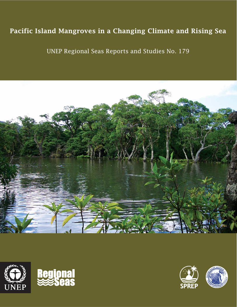
Pacific Island Mangroves in a Changing Climate and Rising Sea
UNEP Regional Seas Reports and Studies No. 179

This publication was prepared by UNEP in cooperation with the Secretariat of the Pacific Regional Environment Programme (SPREP) and Western Pacific Regional Fishery Management Council (WPRFMC). Financial support for the research on which the content of this publication is based has been generously provided by UNEP and WPRFMC. DISCLAIMER
The contents of this volume do not necessarily reflect the views of UNEP or contributory organisations. The designations employed and the presentations do not imply the expression of any opinion whatsoever on the part of UNEP or contributory organsations concerning the legal status of any country, territory, city or area in its authority, or concerning the delimitation of its frontiers or boundaries. © 2006 United Nations Environment Programme This publication may be reproduced in whole or in part and in any form for educational or non-profit purposes without special
permission from the copyright holder, provided acknowledgement of the source is made. UNEP would appreciate receiving a copy of any publication that uses this publication as a source. No use of this publication may be made for resale or for other commercial purpose whatsoever without the prior permission in writing from the United Nations Environment Programme. UNEP PO Box 30552
Nairobi, Kenya Tel: +254 20 7621234 Fax: +254 20 7623927 Email: [email protected] Web: www.unep.org
Printed on acid-free, archival paper made from 100% de-inked post-consumer waste.
For Bibliographic purposes, this document may be cited as:
Gilman, E., H. Van Lavieren, J. Ellison, V. Jungblut, L. Wilson, F. Areki, G. Brighouse, J. Bungitak, E. Dus, M. Henry, I. Sauni Jr., M. Kilman, E. Matthews, N. Teariki-Ruatu, S. Tukia, K. Yuknavage. 2006. Pacific Island Mangroves in a Changing Climate and Rising Sea. UNEP Regional Seas Reports and Studies No. 179. United Nations Environment Programme, Regional Seas Programme, Nairobi, KENYA. ISBN: 92-807-2741-9 Job Number: DEP/0857/NA
Pacific Island Mangroves in a Changing Climate and Rising Sea
UNEP Regional Seas Reports and Studies No. 179
2006
By:
Eric Gilman, Hanneke Van Lavieren, Joanna Ellison, Vainuupo Jungblut, Lisette Wilson, Francis Areki,
Genevieve Brighouse, John Bungitak, Eunice Dus, Marion Henry, Mandes Kilman, Elizabeth Matthews,
Ierupaala Sauni Jr., Nenenteiti Teariki-Ruatu, Sione Tukia, Kathy Yuknavage
UNEP 2006
Mangroves in a Changing Climate and Rising Sea
ii
Authors’ Affiliations Eric Gilman, University of Tasmania, School of Geography and Environmental Studies, and Blue Ocean Institute
([email protected], [email protected])
Hanneke Van Lavieren, United Nations Environment Programme, Regional Seas Programme
Joanna Ellison, University of Tasmania, School of Geography and Environmental Studies
Vainuupo Jungblut, Secretariat of the Pacific Regional Environment Programme
Lisette Wilson, WWF – South Pacific
Francis Areki, WWF – Fiji
Genevieve Brighouse and Ierupaala Sauni Jr., American Samoa Coastal Management Program
John Bungitak, Republic of the Marshall Islands Environmental Protection Authority
Eunice Dus, Wildlife Conservation Society Papua New Guinea Program
Marion Henry, Federated States of Micronesia Department of Economic Affairs
Mandes Kilman, Primary Resources Consulting Company, Vanuatu
Elizabeth Matthews, Palau Conservation Society
Nenenteiti Teariki-Ruatu, Republic of Kiribati, Ministry of Environment, Land, and Agricultural Development
Sione Tukia, Tonga Department of Environment
Kathy Yuknavage, Commonwealth of the Northern Mariana Islands Coastal Resources Management Office
Acknowledgements This project was made possible through financial support from the United Nations Environment Programme
Regional Seas Programme and Western Pacific Regional Fishery Management Council. The authors are grateful for information provided by Taakena Redfern and Aberee Bauro of the Republic of Kiribati Ministry of Environment, Land, and Agricultural Development; Frank Dayton of the U.S. Army Corps of Engineers; Laura
Williams of the CNMI Division of Fish and Wildlife; Dr. Leroy Heitz of the University of Guam Water and Environmental Research Institute; Kashgar Rengulbai of the Palau Bureau of Agriculture; Alma Ridep-Morris of the Palau Bureau of Marine Resources; Mike Aurelio of PALARIS; Tiare Holm and Anu Gupta of the Palau
Conservation Society; Yimnang Golbuu, Charlene Mersai and Steven Victor of the Palau International Coral Reef Center; Ann Kitalong of The Environment, Inc.; Umiich Sengebau of The Nature Conservancy; and Nancy Vandervelde of the Republic of the Marshall Islands Environmental Protection Agency. Ellik Adler of the UNEP Regional Seas Programme provided critical support for the project. We are grateful for review by
Dr. Roy R. Lewis III, Lewis Environmental Services, Inc., of the section on mangrove rehabilitation and permission to include his photographs. Catherine Bone produced an illustration of mangrove responses to sea level change scenarios. Professor Richard Coleman and Dr. Werner Hennecke of the University of
Tasmania, Australia, assisted with the design of the case studies and commented on drafts of this report. Serena Fortuna and Mette Loyche Wilkie, Forestry Department, Food and Agriculture Organization of the United Nations, assisted with identifying national focal points. Neil White, Commonwealth Scientific and
Industrial Research Organization Division of Marine and Atmospheric Research provided mean sea level rates through reconstructed analysis and regression analysis of monthly mean sea levels with tidal constituents removed for some of the countries and territories included in this assessment. Stefan Hain of the
United Nations Environment Programme Coral Reef Unit and Kristian Teleki of the International Coral Reef Action Network provided helpful comments on drafts of this report. Nikki Meith of Maximedia Ltd. provided assistance with the report layout and design.
Mangroves in a Changing Climate and Rising Sea
iii
Contents
CONTENTS……………………………………………………………………………………………………... iii
KEY MESSAGES AND NEXT STEPS……………………………………………………………………...... v INTRODUCTION………………………………………………………………………………………………... 1
PACIFIC ISLAND MANGROVES……………………………………………………………………………... 3 Status and Trends Distribution and Biodiversity
MANGROVE ECOSYSTEM VALUES………………………………………………………………………... 5 Ecosystem Values
Benefits as Measured by Market Prices Consequences of Mangrove Losses and Degradation
THREATS TO PACIFIC ISLAND MANGROVES……………………………………………………………. 9 Mangrove Responses to Changing Sea Level Global and Pacific Projections for Sea Level Rise Other Threats
CAPACITY-BUILDING PRIORITIES TO ADDRESS MANGROVE RESPONSES TO CLIMATE CHANGE EFFECTS…………………………………………………….……. 18
Analysis of Tide Gauge Data for Trends in Mean Sea Level and Extreme High Water Events
Information on Change in Sea Level Relative to Mangrove Surfaces
Analysis of Historical Imagery to Observe Changes in Mangrove Margin Positions Mangrove Boundary Delineation Map Products
Mangrove Monitoring and Assessment for Adaptive Management and Regional Mangrove Monitoring Network
Strengthen Management Frameworks Mangrove Rehabilitation
CONSIDERATIONS FOR DEVELOPING A COASTAL SITE PLANNING AND ADAPTATION STRATEGY……………………………………………………………………………… 28
Community-based Management Approaches Integrated Coastal Management and Site Planning Coastal and Marine Protected Areas
Increase Mangrove Resistance and Resilience by Reducing and Removing Stresses Mangrove Rehabilitation Mangrove Conservation Ethic though Outreach and Education
REGIONAL AND INTERNATIONAL INITIATIVES………………………………………………………….. 37
Beginning of International Attention to Threats to Small Island States from Global Climate Effects
United Nations Environment Programme Regional Seas Programme Secretariat of the Pacific Regional Environment Programme Western Pacific Regional Fishery Management Council
Intergovernmental Panel on Climate Change United Nations Framework Convention on Climate Change
Mangroves in a Changing Climate and Rising Sea
iv
Ramsar Convention on Wetlands Millennium Development Goals
Millennium Ecosystem Assessment Convention on Biological Diversity and World Summit on Sustainable Development
Biodiversity Targets
Convention on Biological Diversity Island Biodiversity Programme of Work Bali Strategic Plan Pacific Island Vulnerability Assessments Other Initiatives
REFERENCES………………………………………………………………………………………………….. 48
PROJECT, COUNTRY AND TERRITORY CONTACTS…………………………………………………… 56
Mangroves in a Changing Climate and Rising Sea
v
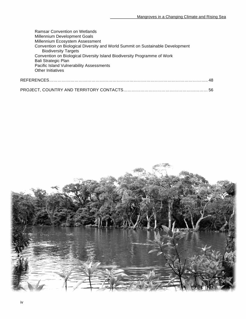
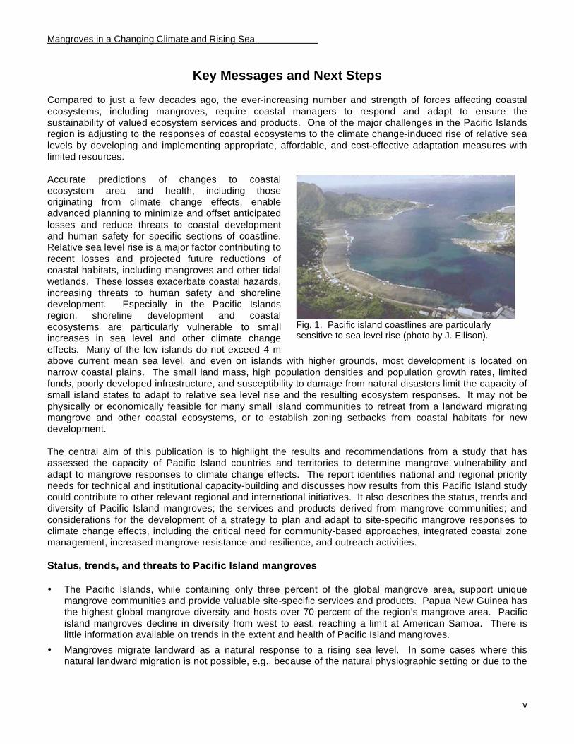
Fig. 1. Pacific island coastlines are particularly sensitive to sea level rise (photo by J. Ellison).
Key Messages and Next Steps Compared to just a few decades ago, the ever-increasing number and strength of forces affecting coastal
ecosystems, including mangroves, require coastal managers to respond and adapt to ensure the sustainability of valued ecosystem services and products. One of the major challenges in the Pacific Islands region is adjusting to the responses of coastal ecosystems to the climate change-induced rise of relative sea
levels by developing and implementing appropriate, affordable, and cost-effective adaptation measures with limited resources.
Accurate predictions of changes to coastal ecosystem area and health, including those originating from climate change effects, enable advanced planning to minimize and offset anticipated
losses and reduce threats to coastal development and human safety for specific sections of coastline. Relative sea level rise is a major factor contributing to
recent losses and projected future reductions of coastal habitats, including mangroves and other tidal wetlands. These losses exacerbate coastal hazards,
increasing threats to human safety and shoreline development. Especially in the Pacific Islands region, shoreline development and coastal
ecosystems are particularly vulnerable to small increases in sea level and other climate change effects. Many of the low islands do not exceed 4 m above current mean sea level, and even on islands with higher grounds, most development is located on
narrow coastal plains. The small land mass, high population densities and population growth rates, limited funds, poorly developed infrastructure, and susceptibility to damage from natural disasters limit the capacity of small island states to adapt to relative sea level rise and the resulting ecosystem responses. It may not be
physically or economically feasible for many small island communities to retreat from a landward migrating mangrove and other coastal ecosystems, or to establish zoning setbacks from coastal habitats for new development.
The central aim of this publication is to highlight the results and recommendations from a study that has assessed the capacity of Pacific Island countries and territories to determine mangrove vulnerability and
adapt to mangrove responses to climate change effects. The report identifies national and regional priority needs for technical and institutional capacity-building and discusses how results from this Pacific Island study could contribute to other relevant regional and international initiatives. It also describes the status, trends and diversity of Pacific Island mangroves; the services and products derived from mangrove communities; and
considerations for the development of a strategy to plan and adapt to site-specific mangrove responses to climate change effects, including the critical need for community-based approaches, integrated coastal zone management, increased mangrove resistance and resilience, and outreach activities.
Status, trends, and threats to Pacific Island mangroves
• The Pacific Islands, while containing only three percent of the global mangrove area, support unique
mangrove communities and provide valuable site-specific services and products. Papua New Guinea has the highest global mangrove diversity and hosts over 70 percent of the region’s mangrove area. Pacific
island mangroves decline in diversity from west to east, reaching a limit at American Samoa. There is little information available on trends in the extent and health of Pacific Island mangroves.
• Mangroves migrate landward as a natural response to a rising sea level. In some cases where this natural landward migration is not possible, e.g., because of the natural physiographic setting or due to the
Mangroves in a Changing Climate and Rising Sea
vi
presence of seawalls and other obstructing development, the mangrove area reduces over time. Global mean sea level is projected to rise 9 to 88 cm between 1990 and 2100. Some Pacific islands are
experiencing a rise in relative sea level while others are experiencing lowering. The ten countries and territories in the Pacific Islands region with native mangroves belonging to the former group have experienced an average rise in relative sea level of 2.0 mm per year over the past few decades.
Mangroves could experience serious problems due to rising sea level, and low island mangroves may already be under stress. By the year 2100, a reduction in area by as much as 13 percent of the current 524,369 ha of mangroves of the 16 Pacific Island countries and territories where mangroves are indigenous is possible.
• Increased frequency and levels of extreme high water events could affect the position and health of
coastal ecosystems and pose a hazard to coastal development and human safety. Extreme high water events are projected to increase over coming decades as a result of the same forces projected to cause global sea level rise, and possibly additional forces such as variations in regional climate and changes in storminess.
• The responses of mangrove wetlands and other coastal systems to global climate change effects other than sea level rise, such as increased air and sea-surface temperatures, changes in precipitation and salinity, and changes in storminess, are less certain and not well understood.
• In addition to climate change effects, mangroves and other coastal ecosystems face numerous other threats, ranging from logging and filling for development to disease outbreaks.
Services and products from Pacific Island mangrove ecosystems
• Pacific Islanders value mangroves as a resource for a wide range of goods and services, including their
role in supporting seafood important for their diets, protecting coastlines and development from coastal hazards, supporting good water quality, and providing natural materials used in traditional practices such as dye from mangrove bark used in tapa and to treat textiles, nets, and fish traps.
• The annual economic values of mangroves, estimated by the cost of the products and services they provide, have been estimated to be between USD 200,000 -- 900,000 per ha. The range of reported costs for mangrove restoration is USD 225 -- 216,000 per ha.
• The existence of functional links between coastal ecosystems, including mangroves, seagrass beds, and coral reefs, means that degradation of one habitat type will adversely affect the health of neighboring
habitats.
Capacity-building priorities to address mangrove responses to climate change effects
It is a priority to:
• Strengthen management frameworks that regulate coastal activities and develop a plan for adaptation to
mangrove responses to climate change effects. This requires developing the capacity to (i) conduct site-specific mangrove vulnerability assessments and incorporate this information into land-use and master planning; and (ii) increase resistance and resilience to climate change effects by reducing and eliminating
other stresses that degrade mangroves. Managers need the institutional capacity to plan for site-specific mangrove responses to climate change effects, such as instituting setbacks from mangroves for new development for appropriate sections of coastline.
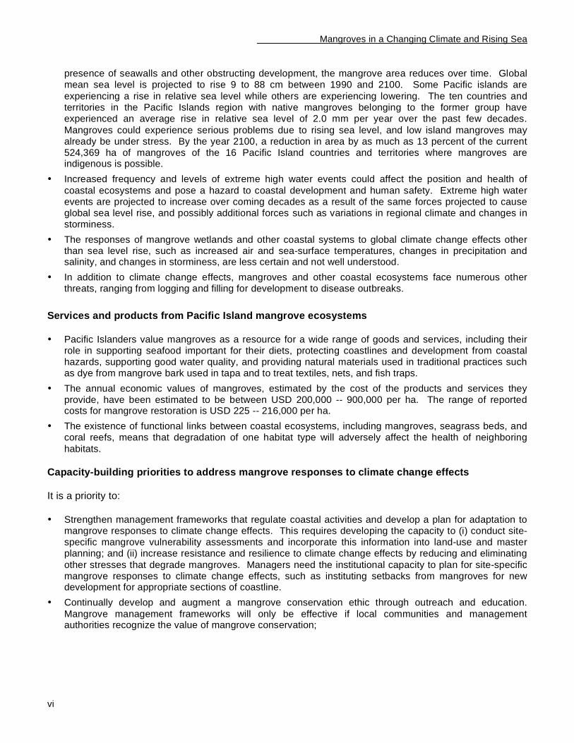
• Continually develop and augment a mangrove conservation ethic through outreach and education.
Mangrove management frameworks will only be effective if local communities and management authorities recognize the value of mangrove conservation;
Mangroves in a Changing Climate and Rising Sea
vii
Fig. 2. Instilling a mangrove conservation ethic in our next generation will help ensure that local communities and future leaders recognize the long-term benefits of mangrove conservation (photo by E. Gilman).
• Determine projections for trends in mean relative sea level and frequency and elevation of extreme
high water events. Incorporate this information into land-use planning processes;
• Measure trends in changes in the elevation of mangrove surfaces to determine how mean sea
level is changing relative to the elevation of mangrove surfaces. Use this information to assess site-specific mangrove vulnerability;
• Assess how the positions of mangrove margins have changed over past decades through
observations of a time series of historical imagery. Use this information to predict the future mangrove position and assess site-specific mangrove vulnerability;
• Provide training opportunities for in-country staff to conduct monitoring and assessment of relevant mangrove parameters, in part, to facilitate adaptive
management and to increase regional capacity to restore and enhance mangrove wetlands;
• Produce maps showing mangrove boundaries, topography and locations of coastal infrastructure and other development. Use these products to assess site-specific mangrove vulnerability to projected sea level rise; and
• Establish mangrove baselines and monitor gradual changes through regional networks using
standardized techniques in order to distinguish local and climate change effects on mangroves. Establishing a regional mangrove monitoring network may enable many of the identified capacity-building priorities to be fulfilled, and is one of the highest regional priorities. Participating countries and territories
could share technical and financial resources to maximize monitoring and conservation benefits due to economy of scale.
Considerations for developing a coastal site planning and adaptation strategy • Management authorities are encouraged to assess site-specific mangrove vulnerability to climate change
effects now and not wait for problems to become apparent when options for adaptation will be restricted.
Managers can incorporate the results of vulnerability assessments into coastal land-use policies to provide adequate lead-time to minimize social disruption and cost, reduce losses of valued coastal habitats, and maximize available options.
• Community-based approaches for managing natural resources, including managing the responses of
mangroves and other coastal ecosystems to climate change effects, are appropriate in many areas of the Pacific Islands region.
• The policy adopted to manage site-based shoreline response to rising sea level should be made as part of a broader integrated coastal management planning analysis, which includes an assessment of the cumulative effects of coastal activities. This analysis requires balancing multiple and often conflicting
objectives of sustaining the provision of ecological, economic, and cultural values; addressing priority threats to natural ecosystem functioning; maintaining ecological processes and biodiversity; achieving sustainable development; and fulfilling institutional, policy, and legal needs.
• Site planning for some sections of shoreline containing mangroves that are not highly developed may be
suitable for long-term managed retreat with relative sea level rise. Zoning rules for building setbacks can be used to reserve zones behind current mangroves for future mangrove habitat. However, for some

Mangroves in a Changing Climate and Rising Sea
viii
sections of highly developed coastline adjacent to mangroves, results of site planning may justify the use of shoreline erosion control measures. As a result, the mangroves’ natural landward migration will be prevented and the mangrove fronting the development will eventually be lost.
• Protected areas are one coastal resource management tool that can contribute to mitigating anticipated mangrove losses in response to climate change effects. When selecting sites and boundaries for individual protected areas, reviewing the effectiveness of existing protected areas, and designing
protected area systems, managers need to explicitly incorporate anticipated coastal ecosystem responses to climate change effects as well as the functional linkages between ecosystems. Networks of protected areas are needed to achieve ecological connectivity to permit the movement of species and exchange of genes. Protected areas established and managed through community-based approaches are more likely to be successful in most areas of the Pacific Islands region.
• Reducing and eliminating non climate-related stresses that are affecting mangroves will increase mangrove resistance and resilience to sea level rise and other climate change effects.
• Mangrove rehabilitation, the restoration of areas where mangroves previously existed, enhancing degraded mangroves by removing stresses that caused their decline, and creating new mangrove habitat
will contribute to offset the anticipated reductions in mangrove area and health, and increase their resilience to climate change effects. Determining the stress or stresses that caused a mangrove to decline is necessary to identify an effective restoration or enhancement method. Establishing optimal
hydrologic regime and protecting the site from disturbance typically will allow a mangrove to self-repair. Planting mangroves may not be successful or necessary in many cases where there is natural recruitment of mangrove seedlings.
• Local communities and leaders must recognize the long-term benefits of mangrove conservation if we are to reverse historical trends in loss of mangrove area. Outreach and education activities can help develop
or augment a mangrove conservation ethic.

Mangroves in a Changing Climate and Rising Sea
1
Introduction Accurate predictions of changes to coastal ecosystem position, area and health, including in response to
climate change effects such as relative sea level rise, enables advanced planning appropriate for specific sections of coastline to minimize and offset anticipated losses, and reduce threats to coastal development and human safety (Titus, 1991; Mullane and Suzuki, 1997; Ramsar Bureau, 1998; Hansen and Biringer, 2003;
Ellison, 2004; Gilman et al., 2005a). Relative sea level rise is a major factor contributing to recent losses and projected future reductions in the area of valued coastal habitats, including mangroves
1 and other tidal
wetlands, with concomitant increased threat to human safety and shoreline development from coastal hazards
(Gilman et al., 2005a). Global sea level rise is one of the more certain outcomes of global warming, 10-20 cm occurred during the last century, and several climate models project an accelerated rate of sea level rise over coming decades (Church et al., 2001 and 2004a; Cazenave and Nerem, 2004; Holgate and Woodworth, 2004; Thomas et al., 2004).
Over the past few decades, the average change in sea level of the ten countries and territories in the Pacific Islands region with native mangroves that are experiencing a rise in relative sea level is 2.0 mm a
-1. Based on
general estimates of mangrove sedimentation rates (Ellison and Stoddart, 1991), and the possibility that subsurface sediment subsidence from organic matter decomposition, sediment compaction, and fluctuations in sediment water storage and water table levels may result in substantially higher rates of sea level rise
relative to mangrove surfaces (Krauss et al., 2003), island mangroves could experience serious problems due to rising sea level, and low island mangroves may already be under stress. Gilman et al. (2005a) determine that American Samoa could experience a 50% loss in mangrove area and a 12% reduction is possible in the
Pacific Islands region due to mangrove responses to relative sea level rise when employing the Intergovernmental Panel on Climate Change’s upper projection for global sea level rise through the year 2100.
Shoreline development and coastal ecosystems in the Pacific Islands region are particularly vulnerable to small increases in sea level and other climate change effects. Many of the low islands do not exceed 4 m above current mean sea level, and even on high islands, most development is located on narrow coastal
plains. Small island states have limited capacity to adapt to relative sea level rise, including accommodating landward migration of mangroves and other coastal ecosystems. This is a result of their small land mass, high population densities and growth rates, limited funds, poorly developed infrastructure, and susceptibility to
damage from natural disasters (Nurse et al., 2001). It may not be physically or economically feasible for many small island state communities to retreat from a landward migrating mangrove and other coastal habitats, or to establish zoning setbacks from coastal habitats for new development.
Pacific Island governments have recognized the value of mangroves and the need to augment conservation efforts (e.g. South Pacific Regional Environment Programme, 1999a). The Pacific Islands contain roughly 3% of the global mangrove area, a small area in global terms, but each island group has a unique mangrove
community structure (Ellison, 2000) and mangroves provide site-specific functions and values (e.g., Gilman, 1998; Lewis, 1992). Reduced mangrove area and health will increase the threat to human safety and shoreline development from coastal hazards such as erosion, flooding, and storm waves and surges.
Mangrove loss will also decrease coastal water quality, reduce biodiversity, eliminate fish and crustacean nursery habitat, adversely affect adjacent coastal habitats, and eliminate a major resource for human communities that traditionally rely on mangroves for numerous products and services (Ewel, 1997; Ewel et al.,
1998; Mumby et al., 2004; Victor et al., 2004). Furthermore, mangrove destruction can release large quantities of stored carbon and exacerbate global warming trends (Kauppi et al., 2001; Ramsar Secretariat, 2001; Chmura et al., 2003).
1 The term ‘mangrove’ as used in this report refers to the mangrove habitat type, community, or mangal, as coined by MacNae
(1968) and further defined by Tomlinson (1986), and not the constituent plant species.
Mangroves in a Changing Climate and Rising Sea
2
Land-use planners can obtain information from assessments predicting shoreline responses to projected relative sea level rise and climate change over coming decades and use this information to mitigate habitat
degradation and damage to coastal development. This advanced planning will enable coastal managers to minimize social disruption and cost, minimize losses of valued coastal habitats, and maximize available options.
Here we assess the capacity of Pacific Island countries and territories to determine vulnerability and adapt to mangrove responses to sea level and climate change. Results highlight priority technical and institutional capacity-building needs nationally and regionally. We discuss how results from this study contribute to other
relevant regional and international initiatives. We also describe the status, trends, and diversity of Pacific Island mangroves; valued services and products derived from mangroves; and considerations for the development of a strategy to plan and adapt to site-specific mangrove responses to climate change effects,
including the critical need for community-based approaches, integrated coastal zone management, increased mangrove resistance and resilience, and outreach activities.

Mangroves in a Changing Climate and Rising Sea
3
Pacific Island Mangroves
Status and trends The cumulative effects of natural and anthropogenic pressures make mangrove wetlands one of the most threatened natural communities worldwide. Roughly 50% of the global area has been lost since 1900 and
35% of the global area has been lost in the past two decades, due primarily to human activities such as conversion for aquaculture (IUCN, 1989; Ramsar Secretariat, 1999; Valiela et al., 2001). Between 56 and 75% of different Asian mangroves have been lost during the 20
th century primarily due to overuse and
conversion for aquaculture (Primavera, 1997; Smith et al., 2001). There are roughly 17 million ha of mangroves worldwide (Valiela et al., 2001; FAO, 2003). Mangroves are declining in area worldwide. The global average annual rate of mangrove loss is about 2.1%, exceeding the rate of loss of tropical rainforests
(0.8%) (Valiela et al., 2001; Wells et al., 2006). The estimated area of mangroves in the Pacific Islands is 524,369 ha with largest areas in Papua New Guinea (372,770 ha), Solomon Islands (64,200 ha), Fiji (41,000 ha), and New Caledonia (20,250 ha). The
Pacific Islands contain roughly 3% of global mangrove area, a small area in global terms, but each island group has a unique mangrove community structure (Ellison, 2000) and mangroves provide site-specific functions and values (e.g., Gilman, 1998; Lewis, 1992). Also, while a mangrove species may have a wide
range, certain portions of its range may be genetically isolated resulting in unique varietal characteristics (Duke, 1992; Ellison, 2004). There is little available quantitative information on trends in area or health of Pacific Island mangroves due to limited monitoring, and many of the above area estimates are based on
dated primary sources.
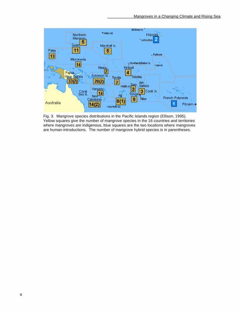
Distribution and biodiversity Fig. 3 shows the mangrove species distributions in the Pacific Islands region, constituting a total of 34 true mangrove species and 3 hybrids (Ellison, 1995). Pacific Island mangroves decline in diversity from west to
east across the Pacific, reaching a limit at American Samoa where there are an estimated 52 ha of mangroves remaining with three mangrove species (Gilman et al., In Press). Southern Papua New Guinea mangroves have the highest global mangrove diversity with 33 mangrove species and 2 mangrove hybrids,
located at the center of the Indo-Malayan mangrove center of diversity (Ellison, 2000). Mangroves do not naturally occur further east of American Samoa due to difficulty of propagule dispersal over such a large distance and historic loss of habitat during Holocene sea level changes (Ellison and Stoddart, 1991). In
addition, some islands may have lower number of mangrove species due to a lack of suitable intertidal habitat (Ellison, 2001). Mangroves are recent human introductions in Hawaii, USA and French Polynesia.
In Brief
• Roughly 50% of the global mangrove area has been lost since 1900 and 35% has been lost in the past two decades. Due to limited monitoring, there is little information available on trends in the area and health of Pacific Island mangroves.
• The Pacific Islands, while containing only 3% of the global mangrove area, support unique mangrove community structures and provide valuable site-specific services and products.
• Papua New Guinea has the highest global mangrove diversity and supports over 70% of the region’s
mangrove area. Pacific Island mangroves decline in diversity from west to east, reaching a limit at American Samoa.
Mangroves in a Changing Climate and Rising Sea
4
Fig. 3. Mangrove species distributions in the Pacific Islands region (Ellison, 1995). Yellow squares give the number of mangrove species in the 16 countries and territories where mangroves are indigenous, blue squares are the two locations where mangroves are human-introductions. The number of mangrove hybrid species is in parentheses.
Mangroves in a Changing Climate and Rising Sea
5
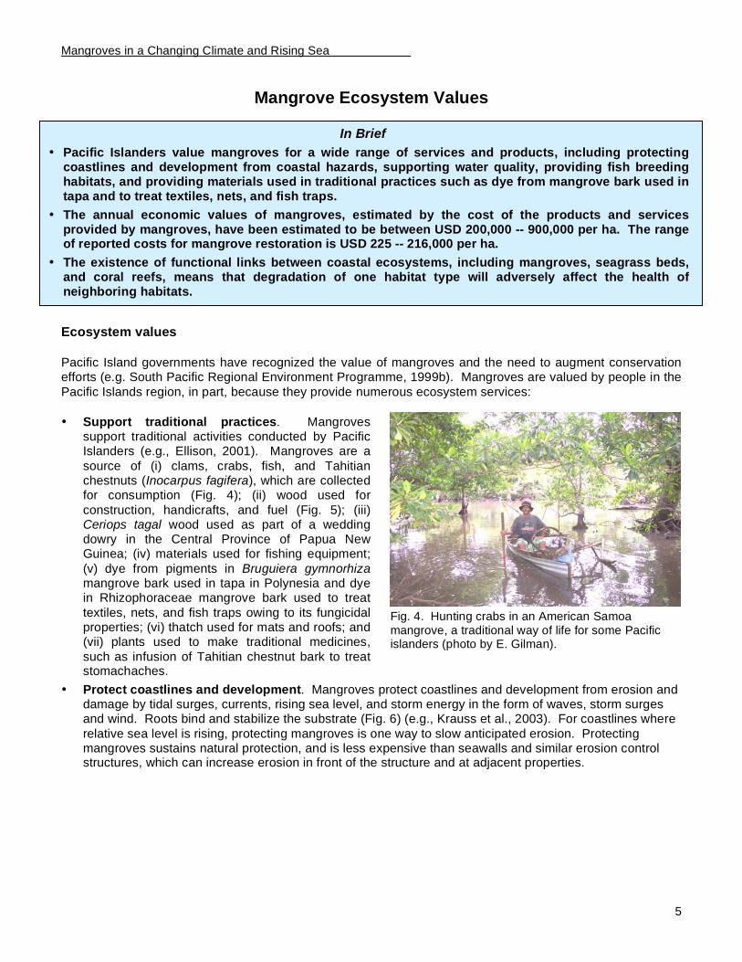
Fig. 4. Hunting crabs in an American Samoa mangrove, a traditional way of life for some Pacific islanders (photo by E. Gilman).
Mangrove Ecosystem Values
Ecosystem values
Pacific Island governments have recognized the value of mangroves and the need to augment conservation efforts (e.g. South Pacific Regional Environment Programme, 1999b). Mangroves are valued by people in the
Pacific Islands region, in part, because they provide numerous ecosystem services:
• Support traditional practices. Mangroves
support traditional activities conducted by Pacific Islanders (e.g., Ellison, 2001). Mangroves are a
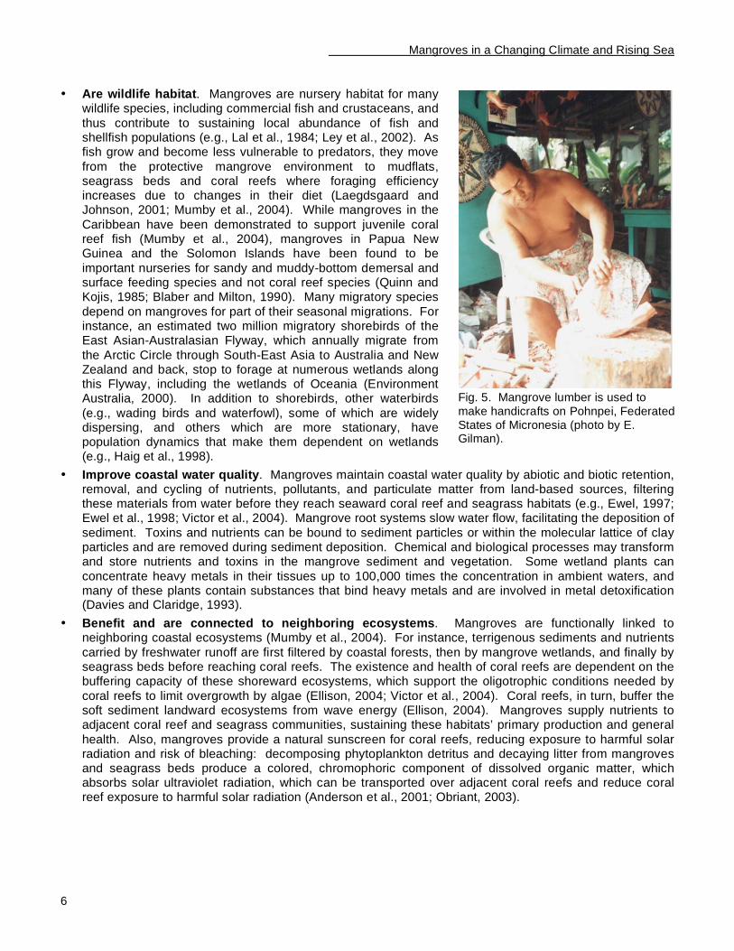
source of (i) clams, crabs, fish, and Tahitian chestnuts (Inocarpus fagifera), which are collected for consumption (Fig. 4); (ii) wood used for
construction, handicrafts, and fuel (Fig. 5); (iii) Ceriops tagal wood used as part of a wedding dowry in the Central Province of Papua New Guinea; (iv) materials used for fishing equipment;
(v) dye from pigments in Bruguiera gymnorhiza mangrove bark used in tapa in Polynesia and dye in Rhizophoraceae mangrove bark used to treat
textiles, nets, and fish traps owing to its fungicidal properties; (vi) thatch used for mats and roofs; and (vii) plants used to make traditional medicines,
such as infusion of Tahitian chestnut bark to treat stomachaches.
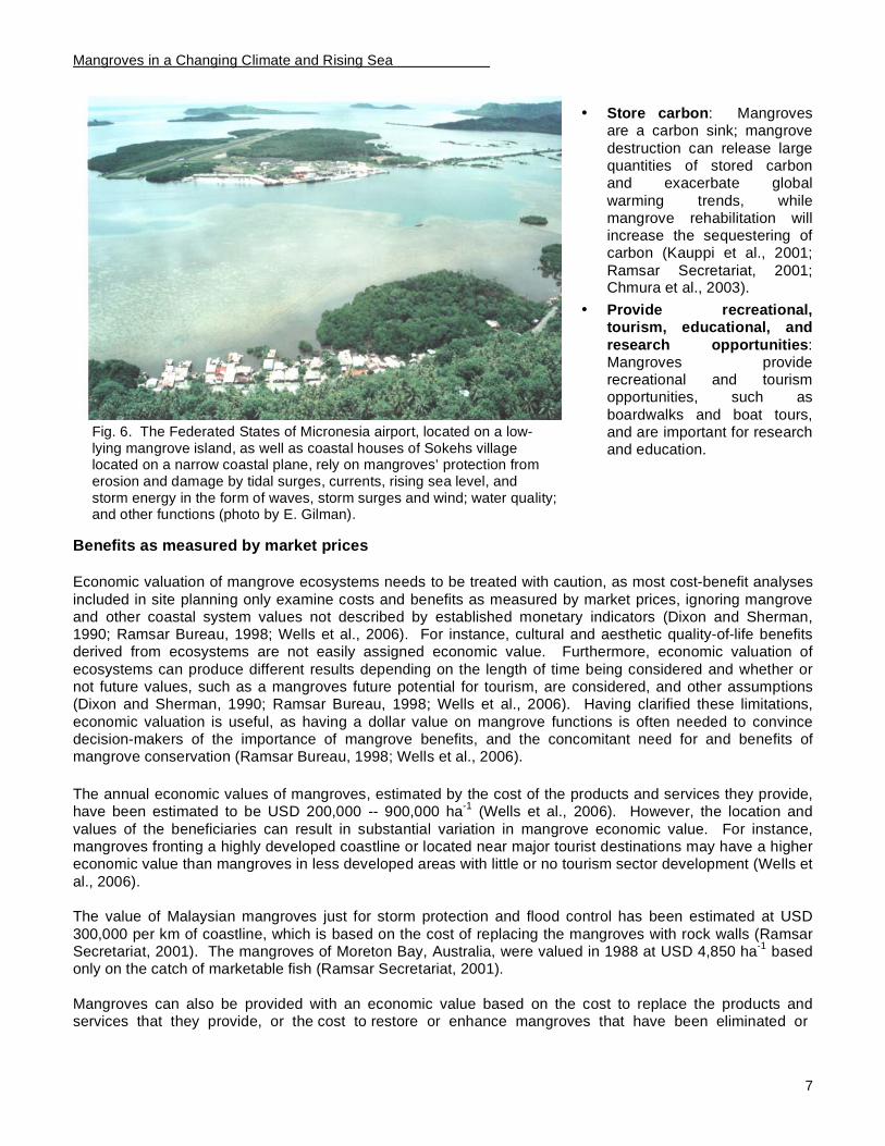
• Protect coastlines and development. Mangroves protect coastlines and development from erosion and damage by tidal surges, currents, rising sea level, and storm energy in the form of waves, storm surges and wind. Roots bind and stabilize the substrate (Fig. 6) (e.g., Krauss et al., 2003). For coastlines where
relative sea level is rising, protecting mangroves is one way to slow anticipated erosion. Protecting mangroves sustains natural protection, and is less expensive than seawalls and similar erosion control structures, which can increase erosion in front of the structure and at adjacent properties.
In Brief
• Pacific Islanders value mangroves for a wide range of services and products, including protecting coastlines and development from coastal hazards, supporting water quality, providing fish breeding habitats, and providing materials used in traditional practices such as dye from mangrove bark used in tapa and to treat textiles, nets, and fish traps.
• The annual economic values of mangroves, estimated by the cost of the products and services provided by mangroves, have been estimated to be between USD 200,000 -- 900,000 per ha. The range of reported costs for mangrove restoration is USD 225 -- 216,000 per ha.
• The existence of functional links between coastal ecosystems, including mangroves, seagrass beds, and coral reefs, means that degradation of one habitat type will adversely affect the health of neighboring habitats.
Mangroves in a Changing Climate and Rising Sea
6
Fig. 5. Mangrove lumber is used to make handicrafts on Pohnpei, Federated States of Micronesia (photo by E. Gilman).
• Are wildlife habitat. Mangroves are nursery habitat for many wildlife species, including commercial fish and crustaceans, and
thus contribute to sustaining local abundance of fish and shellfish populations (e.g., Lal et al., 1984; Ley et al., 2002). As fish grow and become less vulnerable to predators, they move
from the protective mangrove environment to mudflats, seagrass beds and coral reefs where foraging efficiency increases due to changes in their diet (Laegdsgaard and Johnson, 2001; Mumby et al., 2004). While mangroves in the
Caribbean have been demonstrated to support juvenile coral reef fish (Mumby et al., 2004), mangroves in Papua New Guinea and the Solomon Islands have been found to be
important nurseries for sandy and muddy-bottom demersal and surface feeding species and not coral reef species (Quinn and Kojis, 1985; Blaber and Milton, 1990). Many migratory species
depend on mangroves for part of their seasonal migrations. For instance, an estimated two million migratory shorebirds of the East Asian-Australasian Flyway, which annually migrate from
the Arctic Circle through South-East Asia to Australia and New Zealand and back, stop to forage at numerous wetlands along this Flyway, including the wetlands of Oceania (Environment Australia, 2000). In addition to shorebirds, other waterbirds
(e.g., wading birds and waterfowl), some of which are widely dispersing, and others which are more stationary, have population dynamics that make them dependent on wetlands (e.g., Haig et al., 1998).
• Improve coastal water quality. Mangroves maintain coastal water quality by abiotic and biotic retention, removal, and cycling of nutrients, pollutants, and particulate matter from land-based sources, filtering these materials from water before they reach seaward coral reef and seagrass habitats (e.g., Ewel, 1997; Ewel et al., 1998; Victor et al., 2004). Mangrove root systems slow water flow, facilitating the deposition of
sediment. Toxins and nutrients can be bound to sediment particles or within the molecular lattice of clay particles and are removed during sediment deposition. Chemical and biological processes may transform and store nutrients and toxins in the mangrove sediment and vegetation. Some wetland plants can
concentrate heavy metals in their tissues up to 100,000 times the concentration in ambient waters, and many of these plants contain substances that bind heavy metals and are involved in metal detoxification (Davies and Claridge, 1993).
• Benefit and are connected to neighboring ecosystems. Mangroves are functionally linked to neighboring coastal ecosystems (Mumby et al., 2004). For instance, terrigenous sediments and nutrients
carried by freshwater runoff are first filtered by coastal forests, then by mangrove wetlands, and finally by seagrass beds before reaching coral reefs. The existence and health of coral reefs are dependent on the buffering capacity of these shoreward ecosystems, which support the oligotrophic conditions needed by
coral reefs to limit overgrowth by algae (Ellison, 2004; Victor et al., 2004). Coral reefs, in turn, buffer the soft sediment landward ecosystems from wave energy (Ellison, 2004). Mangroves supply nutrients to adjacent coral reef and seagrass communities, sustaining these habitats’ primary production and general
health. Also, mangroves provide a natural sunscreen for coral reefs, reducing exposure to harmful solar radiation and risk of bleaching: decomposing phytoplankton detritus and decaying litter from mangroves and seagrass beds produce a colored, chromophoric component of dissolved organic matter, which absorbs solar ultraviolet radiation, which can be transported over adjacent coral reefs and reduce coral reef exposure to harmful solar radiation (Anderson et al., 2001; Obriant, 2003).
Mangroves in a Changing Climate and Rising Sea
7
Fig. 6. The Federated States of Micronesia airport, located on a low-lying mangrove island, as well as coastal houses of Sokehs village located on a narrow coastal plane, rely on mangroves’ protection from erosion and damage by tidal surges, currents, rising sea level, and storm energy in the form of waves, storm surges and wind; water quality; and other functions (photo by E. Gilman).
• Store carbon: Mangroves are a carbon sink; mangrove
destruction can release large quantities of stored carbon and exacerbate global
warming trends, while mangrove rehabilitation will increase the sequestering of carbon (Kauppi et al., 2001;
Ramsar Secretariat, 2001; Chmura et al., 2003).
• Provide recreational, tourism, educational, and
research opportunities: Mangroves provide recreational and tourism opportunities, such as
boardwalks and boat tours, and are important for research and education.
Benefits as measured by market prices
Economic valuation of mangrove ecosystems needs to be treated with caution, as most cost-benefit analyses
included in site planning only examine costs and benefits as measured by market prices, ignoring mangrove and other coastal system values not described by established monetary indicators (Dixon and Sherman, 1990; Ramsar Bureau, 1998; Wells et al., 2006). For instance, cultural and aesthetic quality-of-life benefits derived from ecosystems are not easily assigned economic value. Furthermore, economic valuation of
ecosystems can produce different results depending on the length of time being considered and whether or not future values, such as a mangroves future potential for tourism, are considered, and other assumptions (Dixon and Sherman, 1990; Ramsar Bureau, 1998; Wells et al., 2006). Having clarified these limitations,
economic valuation is useful, as having a dollar value on mangrove functions is often needed to convince decision-makers of the importance of mangrove benefits, and the concomitant need for and benefits of mangrove conservation (Ramsar Bureau, 1998; Wells et al., 2006).
The annual economic values of mangroves, estimated by the cost of the products and services they provide, have been estimated to be USD 200,000 -- 900,000 ha
-1 (Wells et al., 2006). However, the location and
values of the beneficiaries can result in substantial variation in mangrove economic value. For instance, mangroves fronting a highly developed coastline or located near major tourist destinations may have a higher economic value than mangroves in less developed areas with little or no tourism sector development (Wells et
al., 2006). The value of Malaysian mangroves just for storm protection and flood control has been estimated at USD
300,000 per km of coastline, which is based on the cost of replacing the mangroves with rock walls (Ramsar Secretariat, 2001). The mangroves of Moreton Bay, Australia, were valued in 1988 at USD 4,850 ha
-1 based
only on the catch of marketable fish (Ramsar Secretariat, 2001).
Mangroves can also be provided with an economic value based on the cost to replace the products and services that they provide, or the cost to restore or enhance mangroves that have been eliminated or
Mangroves in a Changing Climate and Rising Sea
8
degraded. The range of reported costs for mangrove restoration is USD 225 to USD 216,000 ha-1
, not including the cost of the land (Lewis, 2005). In Thailand, restoring mangroves is costing USD 946 ha
-1 while
the cost for protecting existing mangroves is only USD 189 ha-1
(Ramsar Secretariat, 2001).
Consequences of mangrove losses and degradation Reduced mangrove area and health will increase the threat to human safety and shoreline development from coastal hazards such as erosion, flooding, and storm waves and surges. Mangrove loss will also reduce
coastal water quality, reduce biodiversity, eliminate fish nursery habitat and fish catches, adversely affect adjacent coastal habitats (Mumby et al., 2004), and eliminate a major resource for human communities that traditionally rely on mangroves for numerous products and services (Satele, 2000; Ellison and Gilman, 2004).
In some locations, loss of mangroves might also result in reduced tourism revenue (Wells et al., 2006). Furthermore, degradation of one coastal habitat can result in reduced health of adjacent coastal habitats. Neighboring coastal ecosystems are functionally linked, although the functional links are not fully understood
(Mumby et al., 2004).
Mangroves in a Changing Climate and Rising Sea
9
Threats to Pacific Island Mangroves
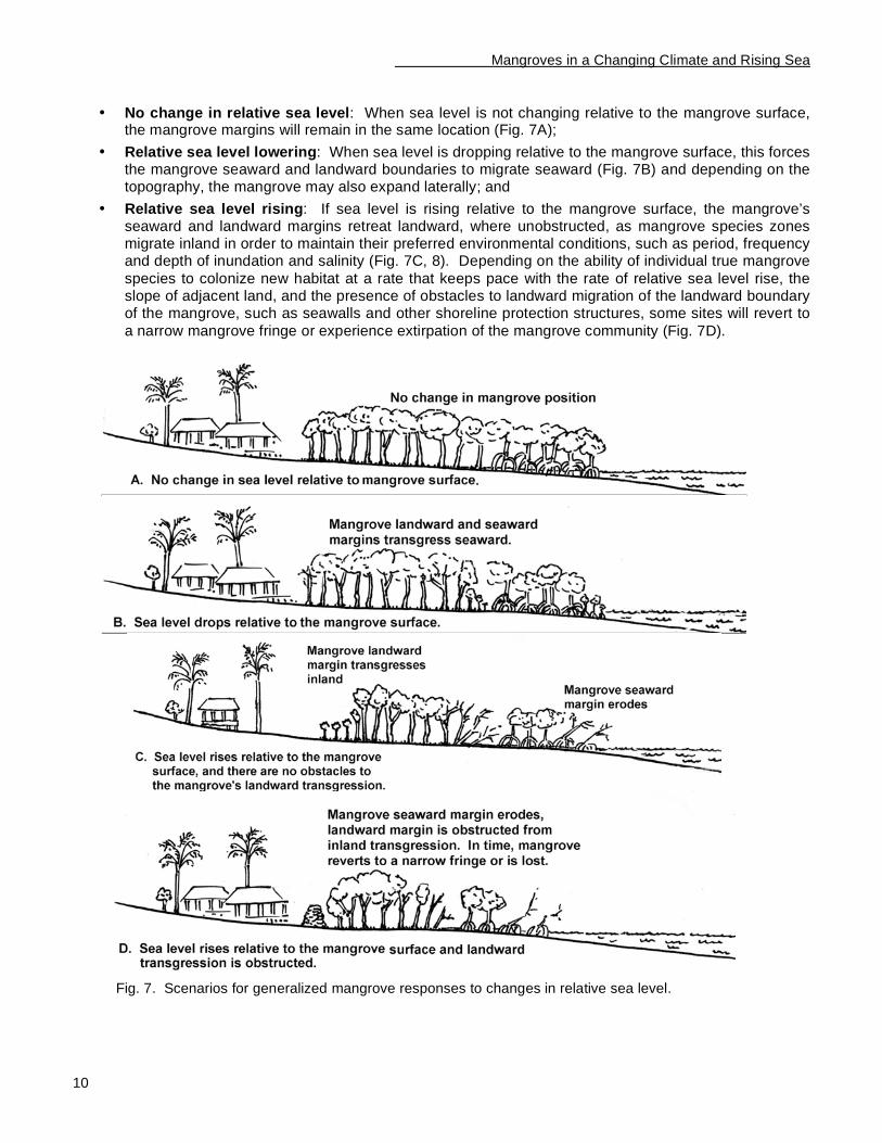
Mangrove responses to changing sea level When the force of relative sea level rise is the predominant force causing change in mangrove position, landscape-level response of mangroves to relative sea level rise, over a period of decades and longer, can be
predicted based on the reconstruction of paleoenvironmental mangrove response to past sea level fluctuations (Ellison and Stoddart, 1991; Woodroffe, 1995; Ellison, 1993, 2000; Gilman, 2004; Gilman et al., In Press). Landscape-level response of mangroves to relative sea level rise, over a period of decades and
longer, can be predicted based on (a) the sea level change rate relative to the mangrove surface, (b) the mangrove’s physiographic setting (slope of the land adjacent to the mangrove, slope of the mangrove, and presence of obstacles to landward migration), and (c) erosion or progradation rate of the mangrove seaward
margin (Ellison and Stoddart, 1991; Ellison, 1993, 2000, 2001; Woodroffe, 1995; Alleng, 1998; Lucas et al., 2002; Gilman, 2004). There are three general scenarios for mangrove response to relative sea level rise, given a landscape-level scale and time period of decades or longer (Fig. 7):
In Brief
• Stresses associated with rise in relative mean sea level, increase in the frequency and level of extreme high water events, and other effects from climate change present one set of threats to mangroves and other coastal ecosystems.
• Mangroves migrate landward as a natural response to rising sea level relative to the mangrove
surface. This landward migration can be obstructed by seawalls and other development, reducing the area of coastal ecosystems.
• Global sea level rise is one of the more certain outcomes of global warming, 10-20 cm occurred during the last century, and several climate models project an accelerated rate of sea level rise over coming decades. Global mean sea level is projected to rise by 0.09 to 0.88 m between 1990
and 2100 due primarily to thermal expansion of seawater and transfer of ice from glaciers and ice caps to water in the oceans, which are results of global warming.
• Some Pacific islands are experiencing a rise in relative sea level while others are experiencing lowering. Over the past few decades, the average change in relative sea level of the 10 countries and territories in the Pacific Islands region with native mangroves that are experiencing a rise in relative sea level is 2.0 mm a
-1.
• Mangroves could experience serious problems due to rising sea level, and low island mangroves
may already be under stress. Regionally, a reduction in area by 13% of the current 524,369 ha of mangroves of the sixteen Pacific Island Countries and territories where mangroves are indigenous is roughly predicted when employing an upper projection for global sea level rise through the year 2100.
• Increased frequency and levels of extreme high water events could affect the position and health of coastal ecosystems and pose a hazard to coastal development and human safety. Extreme high water events are projected to increase over coming decades as a result of the same forces projected to cause global sea level rise, and possibly additional forces such as variations in
regional climate and changes in storminess. An assessment of trends in extreme high water events has been conducted only for American Samoa in the Pacific Islands region.
• Outcomes from global climate change other than sea level rise, such as increased air and sea-surface temperatures, changes in precipitation, and changes in storminess, are less certain than
global change in sea level and the response of mangrove wetlands and other coastal systems to these changes are not well understood.
• In addition to climate change effects, mangroves and other coastal ecosystems face numerous other threats, ranging from filling for development to disease outbreaks.
Mangroves in a Changing Climate and Rising Sea
10
• No change in relative sea level: When sea level is not changing relative to the mangrove surface, the mangrove margins will remain in the same location (Fig. 7A);
• Relative sea level lowering: When sea level is dropping relative to the mangrove surface, this forces the mangrove seaward and landward boundaries to migrate seaward (Fig. 7B) and depending on the topography, the mangrove may also expand laterally; and
• Relative sea level rising: If sea level is rising relative to the mangrove surface, the mangrove’s seaward and landward margins retreat landward, where unobstructed, as mangrove species zones migrate inland in order to maintain their preferred environmental conditions, such as period, frequency and depth of inundation and salinity (Fig. 7C, 8). Depending on the ability of individual true mangrove
species to colonize new habitat at a rate that keeps pace with the rate of relative sea level rise, the slope of adjacent land, and the presence of obstacles to landward migration of the landward boundary of the mangrove, such as seawalls and other shoreline protection structures, some sites will revert to
a narrow mangrove fringe or experience extirpation of the mangrove community (Fig. 7D).
Fig. 7. Scenarios for generalized mangrove responses to changes in relative sea level.
Mangroves in a Changing Climate and Rising Sea
11
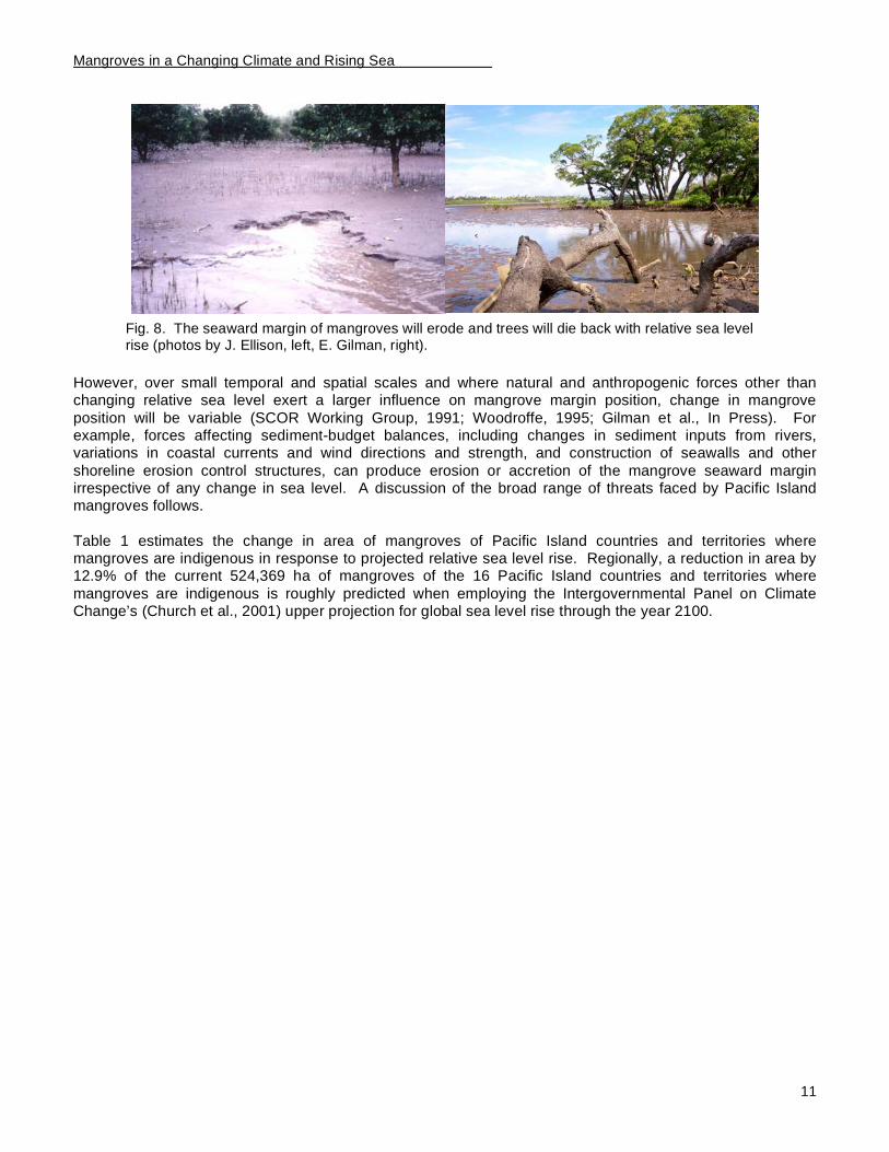
Fig. 8. The seaward margin of mangroves will erode and trees will die back with relative sea level rise (photos by J. Ellison, left, E. Gilman, right).
However, over small temporal and spatial scales and where natural and anthropogenic forces other than changing relative sea level exert a larger influence on mangrove margin position, change in mangrove
position will be variable (SCOR Working Group, 1991; Woodroffe, 1995; Gilman et al., In Press). For example, forces affecting sediment-budget balances, including changes in sediment inputs from rivers, variations in coastal currents and wind directions and strength, and construction of seawalls and other
shoreline erosion control structures, can produce erosion or accretion of the mangrove seaward margin irrespective of any change in sea level. A discussion of the broad range of threats faced by Pacific Island mangroves follows.
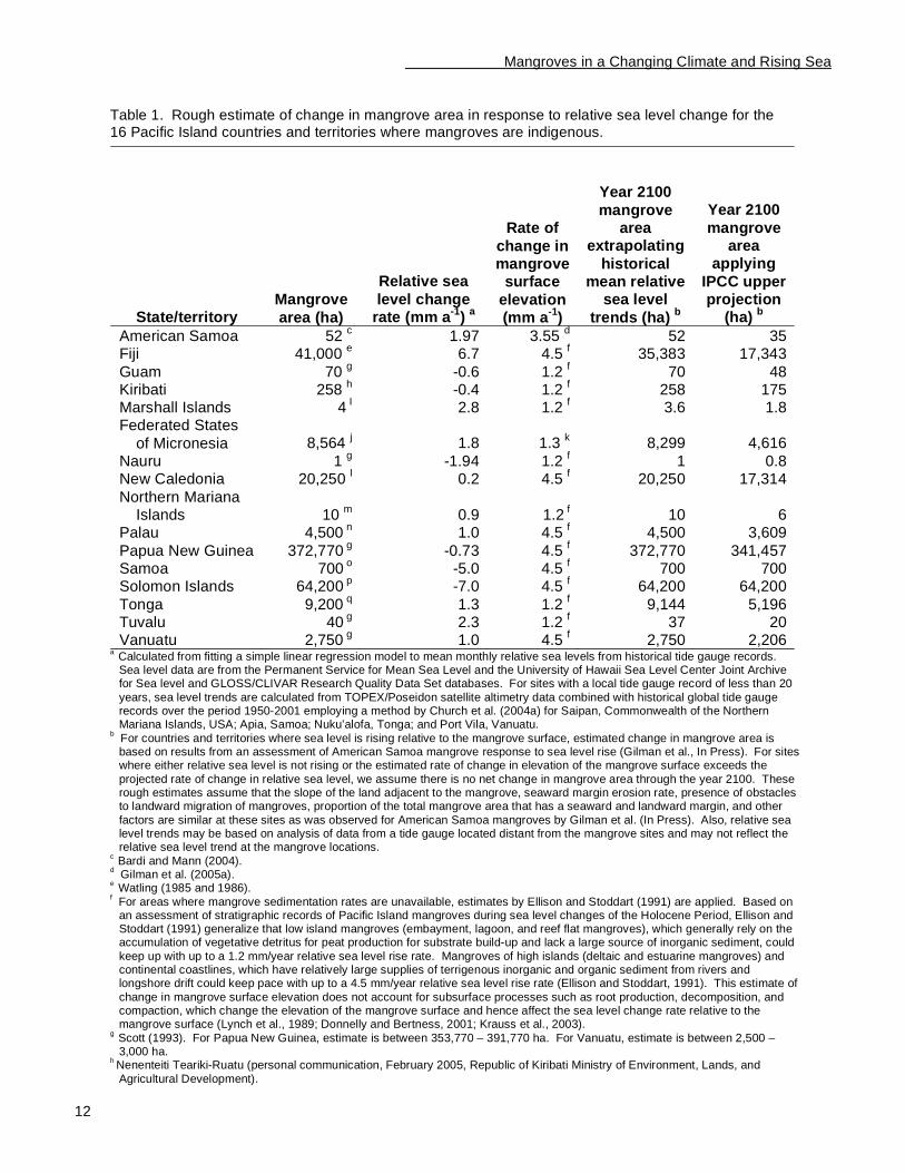
Table 1 estimates the change in area of mangroves of Pacific Island countries and territories where mangroves are indigenous in response to projected relative sea level rise. Regionally, a reduction in area by 12.9% of the current 524,369 ha of mangroves of the 16 Pacific Island countries and territories where
mangroves are indigenous is roughly predicted when employing the Intergovernmental Panel on Climate Change’s (Church et al., 2001) upper projection for global sea level rise through the year 2100.
Mangroves in a Changing Climate and Rising Sea
12
Table 1. Rough estimate of change in mangrove area in response to relative sea level change for the 16 Pacific Island countries and territories where mangroves are indigenous.
State/territory Mangrove
area (ha)
Relative sea
level change rate (mm a
-1)
a
Rate of
change in mangrove
surface
elevation (mm a
-1)
Year 2100
mangrove area
extrapolating
historical mean relative
sea level
trends (ha) b
Year 2100
mangrove area
applying
IPCC upper projection
(ha) b
American Samoa 52 c 1.97 3.55
d 52 35
Fiji 41,000 e 6.7 4.5
f 35,383 17,343
Guam 70 g -0.6 1.2
f 70 48
Kiribati 258 h -0.4 1.2
f 258 175
Marshall Islands 4 I 2.8 1.2
f 3.6 1.8
Federated States
of Micronesia 8,564 j 1.8 1.3
k 8,299 4,616
Nauru 1 g -1.94 1.2
f 1 0.8
New Caledonia 20,250 l 0.2 4.5
f 20,250 17,314
Northern Mariana Islands 10
m 0.9 1.2
f 10 6
Palau 4,500 n
1.0 4.5 f 4,500 3,609
Papua New Guinea 372,770 g
-0.73 4.5 f 372,770 341,457
Samoa 700 o
-5.0 4.5 f 700 700
Solomon Islands 64,200 p
-7.0 4.5 f 64,200 64,200
Tonga 9,200 q
1.3 1.2 f 9,144 5,196
Tuvalu 40 g
2.3 1.2 f 37 20
Vanuatu 2,750 g
1.0 4.5 f 2,750 2,206
a Calculated from fitting a simple linear regression model to mean monthly relative sea levels from historical tide gauge records. Sea level data are from the Permanent Service for Mean Sea Level and the University of Hawaii Sea Level Center Joint Archive for Sea level and GLOSS/CLIVAR Research Quality Data Set databases. For sites with a local tide gauge record of less than 20
years, sea level trends are calculated from TOPEX/Poseidon satellite altimetry data combined with historical global tide gauge records over the period 1950-2001 employing a method by Church et al. (2004a) for Saipan, Commonwealth of the Northern Mariana Islands, USA; Apia, Samoa; Nuku’alofa, Tonga; and Port Vila, Vanuatu.
b For countries and territories where sea level is rising relative to the mangrove surface, estimated change in mangrove area is based on results from an assessment of American Samoa mangrove response to sea level rise (Gilman et al., In Press). For sites where either relative sea level is not rising or the estimated rate of change in elevation of the mangrove surface exceeds the
projected rate of change in relative sea level, we assume there is no net change in mangrove area through the year 2100. These rough estimates assume that the slope of the land adjacent to the mangrove, seaward margin erosion rate, presence of obstacles to landward migration of mangroves, proportion of the total mangrove area that has a seaward and landward margin, and other
factors are similar at these sites as was observed for American Samoa mangroves by Gilman et al. (In Press). Also, relative sea level trends may be based on analysis of data from a tide gauge located distant from the mangrove sites and may not reflect the relative sea level trend at the mangrove locations.
c Bardi and Mann (2004).
d Gilman et al. (2005a).
e Watling (1985 and 1986).
f For areas where mangrove sedimentation rates are unavailable, estimates by Ellison and Stoddart (1991) are applied. Based on
an assessment of stratigraphic records of Pacific Island mangroves during sea level changes of the Holocene Period, Ellison and Stoddart (1991) generalize that low island mangroves (embayment, lagoon, and reef flat mangroves), which generally rely on the accumulation of vegetative detritus for peat production for substrate build-up and lack a large source of inorganic sediment, could
keep up with up to a 1.2 mm/year relative sea level rise rate. Mangroves of high islands (deltaic and estuarine mangroves) and continental coastlines, which have relatively large supplies of terrigenous inorganic and organic sediment from rivers and longshore drift could keep pace with up to a 4.5 mm/year relative sea level rise rate (Ellison and Stoddart, 1991). This estimate of
change in mangrove surface elevation does not account for subsurface processes such as root production, decomposition, and compaction, which change the elevation of the mangrove surface and hence affect the sea level change rate relative to the mangrove surface (Lynch et al., 1989; Donnelly and Bertness, 2001; Krauss et al., 2003).
g Scott (1993). For Papua New Guinea, estimate is between 353,770 – 391,770 ha. For Vanuatu, estimate is between 2,500 – 3,000 ha.
h Nenenteiti Teariki-Ruatu (personal communication, February 2005, Republic of Kiribati Ministry of Environment, Lands, and
Agricultural Development).
Mangroves in a Changing Climate and Rising Sea
13
i Estimate by John Bungitak, General Manager, Environmental Protection Agency, Republic of the Marshall Islands, August 2005. j MacLean et al. (1998), compilation of previous assessments interpreting aerial photography from 1976 combined with 1983
fieldwork. k Average of observed sedimentation rates from plots in Rhizophora spp., Sonneratia alba, and Bruguiera gymnorrhiza mangrove stands in the Enipoas River basin, Pohnpei, Federated States of Micronesia measured using stakes driven to a depth of 70 cm
observed over 2.5 years (Krauss et al., 2003). Does not account for subsurface processes occurring below 70 cm (Lynch et al., 1989; Donnelly and Bertness, 2001; Krauss et al., 2003).
l Thollot (1987).
m Gilman (1998, 1999a).
n Maragos (1994); Metz (2000).
o Pearsall and Whistler (1991).
p Hansell and Wall (1976) and Solomon Islands Government (2004).
q Aloua Ma’a Tonga Association (2001).
Global and Pacific projections for sea level rise
Changes in global mean climate over human time scales, on the order of decades, is primarily a result of
changes in the Earth’s output of radiation to space. The Earth absorbs radiation from the Sun primarily at the surface. This energy is distributed by the atmospheric and oceanic circulations and is radiated back to space as infrared radiation. Any change in the balance between incoming solar radiation and outgoing terrestrial
radiation, as well as alterations to the distribution of energy within the atmosphere, land, and ocean, can change the Earth’s climate (Houghton et al., 2001).
Human-induced climate change by the production of greenhouse gases and aerosols, such as the combustion of fossil fuels, biomass burning, and deforestation, affect the composition of the atmosphere and Earth’s radiative budget. An increase in atmospheric concentrations of greenhouse gases warms the Earth’s surface and lower atmosphere, and is thought to be the largest anthropogenic factor contributing to global
warming: Greenhouse gases absorb infrared radiation emitted by the Earth’s surface, the atmosphere, and clouds, and emit infrared radiation both upward and back towards the Earth’s surface, retaining heat within the atmosphere, tending to raise the temperature of the Earth’s surface and lower atmosphere (Baede et al.,
2001). Since the late 19th
century, the global average surface temperature has increased 0.6 (+/- 0.2 95% CI) degrees C (Houghton et al., 2001). Most of the observed warming over the last 50 years is likely to have been due to the increase in greenhouse gas atmospheric concentrations (Houghton et al., 2001). The
Intergovernmental Panel on Climate Change has developed a range including 35 climate projections based on several climate models. The full range of these 35 scenarios result in a projection that global averaged surface temperatures will increase by 1.4 to 5.8 degrees C from 1990 to 2100 (Houghton et al., 2001).
The Intergovernmental Panel on Climate Change’s best estimate of global average sea level change during the 20th century, based mainly on tide gauge observations, is 1.5 ± 0.5 mm a
-1 (Church et al., 2001), while
Church et al. (2004a) provide an estimate of 1.8 +/- 0.3 mm a-1
from 1950 – 2000. Global sea level rise
during the 20th
century has very likely been significantly influenced by global warming through thermal expansion of seawater and loss of land ice (Church et al., 2001).
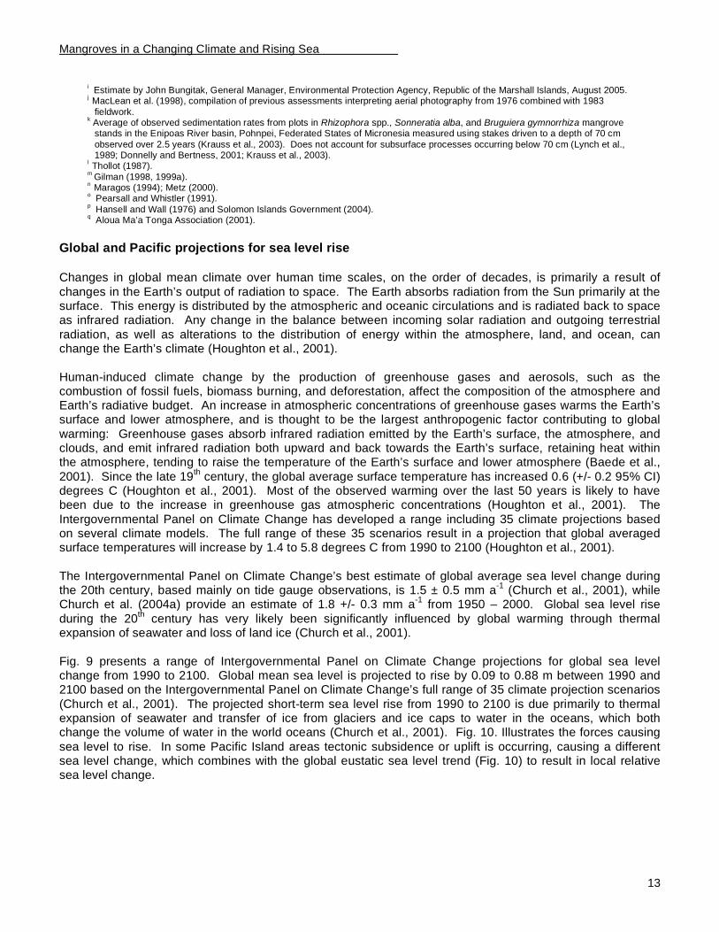
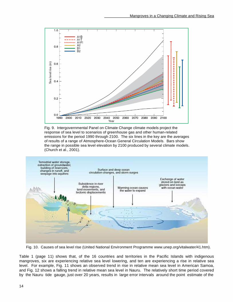
Fig. 9 presents a range of Intergovernmental Panel on Climate Change projections for global sea level change from 1990 to 2100. Global mean sea level is projected to rise by 0.09 to 0.88 m between 1990 and 2100 based on the Intergovernmental Panel on Climate Change’s full range of 35 climate projection scenarios
(Church et al., 2001). The projected short-term sea level rise from 1990 to 2100 is due primarily to thermal expansion of seawater and transfer of ice from glaciers and ice caps to water in the oceans, which both change the volume of water in the world oceans (Church et al., 2001). Fig. 10. Illustrates the forces causing
sea level to rise. In some Pacific Island areas tectonic subsidence or uplift is occurring, causing a different sea level change, which combines with the global eustatic sea level trend (Fig. 10) to result in local relative sea level change.
Mangroves in a Changing Climate and Rising Sea
14
Fig. 9. Intergovernmental Panel on Climate Change climate models project the response of sea level to scenarios of greenhouse gas and other human-related emissions for the period 1990 through 2100. The six lines in the key are the averages of results of a range of Atmosphere-Ocean General Circulation Models. Bars show the range in possible sea level elevation by 2100 produced by several climate models. (Church et al., 2001).
Fig. 10. Causes of sea level rise (United National Environment Programme www.unep.org/vitalwater/41.htm).
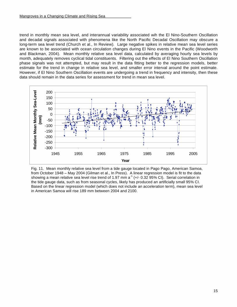
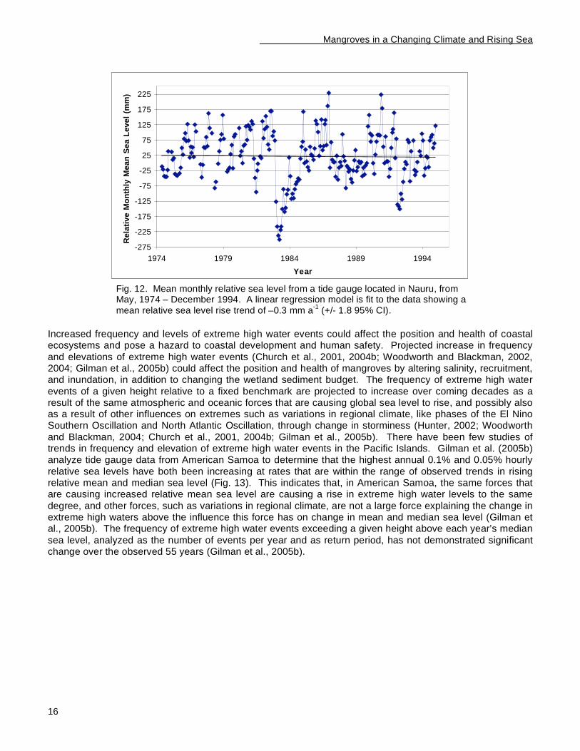
Table 1 (page 11) shows that, of the 16 countries and territories in the Pacific Islands with indigenous mangroves, six are experiencing relative sea level lowering, and ten are experiencing a rise in relative sea level. For example, Fig. 11 shows an observed trend in rise in relative mean sea level in American Samoa,
and Fig. 12 shows a falling trend in relative mean sea level in Nauru. The relatively short time period covered by the Nauru tide gauge, just over 20 years, results in large error intervals around the point estimate of the
Mangroves in a Changing Climate and Rising Sea
15
trend in monthly mean sea level, and interannual variability associated wih the El Nino-Southern Oscillation
and decadal signals associated with phenomena like the North Pacific Decadal Oscillation may obscure a long-term sea level trend (Church et al., In Review). Large negative spikes in relative mean sea level series are known to be associated with ocean circulation changes during El Nino events in the Pacific (Woodworth
and Blackman, 2004). Mean monthly relative sea level data, calculated by averaging hourly sea levels by month, adequately removes cyclical tidal constituents. Filtering out the effects of El Nino Southern Oscillation phase signals was not attempted, but may result in the data fitting better to the regression models, better estimate for the trend in change in relative sea level, and smaller error interval around the point estimate.
However, if El Nino Southern Oscillation events are undergoing a trend in frequency and intensity, then these data should remain in the data series for assessment for trend in mean sea level.
-300
-250
-200
-150
-100
-50
0
50
100
150
200
1945 1955 1965 1975 1985 1995 2005
Year
Rela
tive M
ean
Mo
nth
ly S
ea-L
evel
(mm
)
Fig. 11. Mean monthly relative sea level from a tide gauge located in Pago Pago, American Samoa, from October 1948 – May 2004 (Gilman et al., In Press). A linear regression model is fit to the data showing a mean relative sea level rise trend of 1.97 mm a
-1 (+/- 0.32 95% CI). Serial correlation in
the tide gauge data, such as from seasonal cycles, likely has produced an artificially small 95% CI. Based on the linear regression model (which does not include an acceleration term), mean sea level in American Samoa will rise 189 mm between 2004 and 2100.
Mangroves in a Changing Climate and Rising Sea
16
-275
-225
-175
-125
-75
-25
25
75
125
175
225
1974 1979 1984 1989 1994
Year
Re
lati
ve
Mo
nth
ly M
ea
n S
ea
Le
ve
l (m
m)
Fig. 12. Mean monthly relative sea level from a tide gauge located in Nauru, from May, 1974 – December 1994. A linear regression model is fit to the data showing a mean relative sea level rise trend of –0.3 mm a
-1 (+/- 1.8 95% CI).
Increased frequency and levels of extreme high water events could affect the position and health of coastal ecosystems and pose a hazard to coastal development and human safety. Projected increase in frequency
and elevations of extreme high water events (Church et al., 2001, 2004b; Woodworth and Blackman, 2002, 2004; Gilman et al., 2005b) could affect the position and health of mangroves by altering salinity, recruitment, and inundation, in addition to changing the wetland sediment budget. The frequency of extreme high water
events of a given height relative to a fixed benchmark are projected to increase over coming decades as a result of the same atmospheric and oceanic forces that are causing global sea level to rise, and possibly also as a result of other influences on extremes such as variations in regional climate, like phases of the El Nino Southern Oscillation and North Atlantic Oscillation, through change in storminess (Hunter, 2002; Woodworth
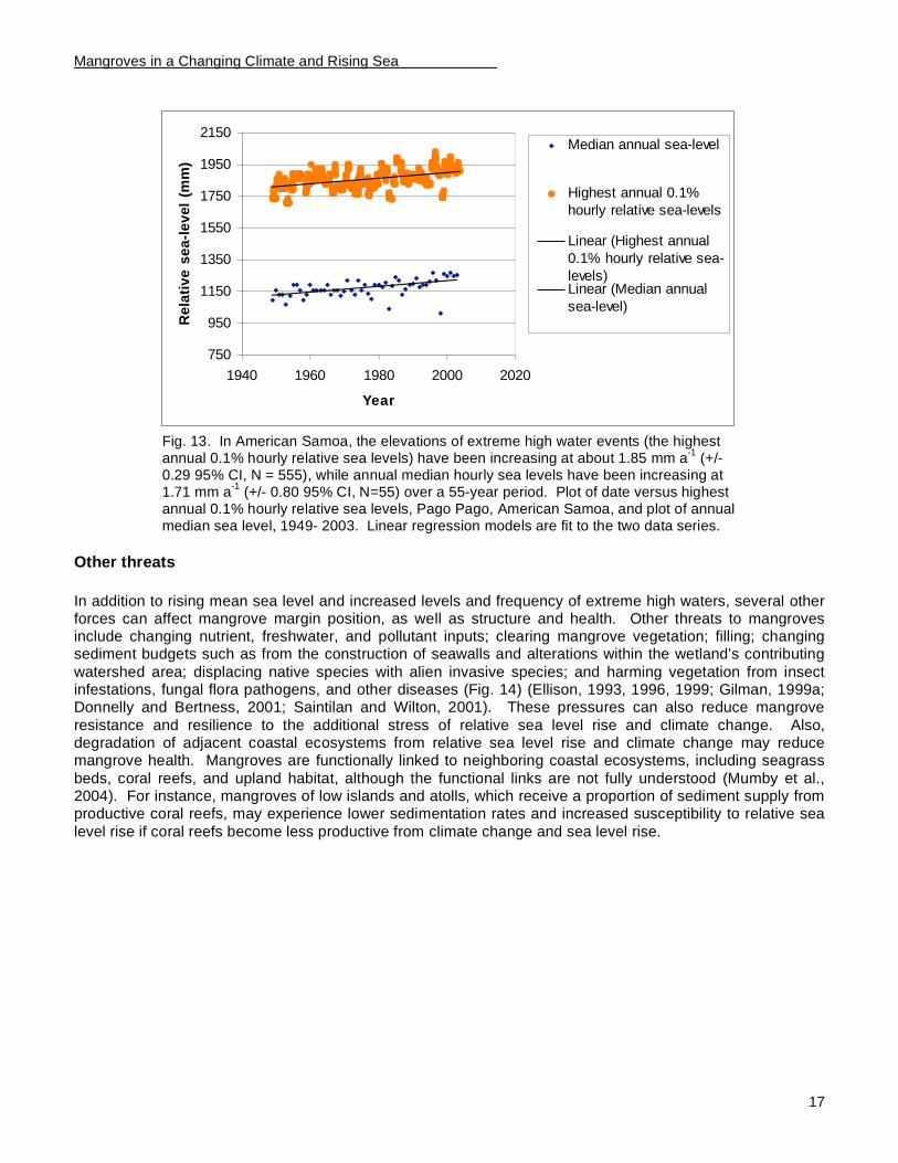
and Blackman, 2004; Church et al., 2001, 2004b; Gilman et al., 2005b). There have been few studies of trends in frequency and elevation of extreme high water events in the Pacific Islands. Gilman et al. (2005b) analyze tide gauge data from American Samoa to determine that the highest annual 0.1% and 0.05% hourly
relative sea levels have both been increasing at rates that are within the range of observed trends in rising relative mean and median sea level (Fig. 13). This indicates that, in American Samoa, the same forces that are causing increased relative mean sea level are causing a rise in extreme high water levels to the same
degree, and other forces, such as variations in regional climate, are not a large force explaining the change in extreme high waters above the influence this force has on change in mean and median sea level (Gilman et al., 2005b). The frequency of extreme high water events exceeding a given height above each year’s median
sea level, analyzed as the number of events per year and as return period, has not demonstrated significant change over the observed 55 years (Gilman et al., 2005b).
Mangroves in a Changing Climate and Rising Sea
17
750
950
1150
1350
1550
1750
1950
2150
1940 1960 1980 2000 2020
Year
Re
lati
ve
se
a-l
ev
el
(mm
)
Median annual sea-level
Highest annual 0.1%
hourly relative sea-levels
Linear (Highest annual
0.1% hourly relative sea-
levels)Linear (Median annual
sea-level)
Fig. 13. In American Samoa, the elevations of extreme high water events (the highest annual 0.1% hourly relative sea levels) have been increasing at about 1.85 mm a
-1 (+/-
0.29 95% CI, N = 555), while annual median hourly sea levels have been increasing at 1.71 mm a
-1 (+/- 0.80 95% CI, N=55) over a 55-year period. Plot of date versus highest
annual 0.1% hourly relative sea levels, Pago Pago, American Samoa, and plot of annual median sea level, 1949- 2003. Linear regression models are fit to the two data series.
Other threats
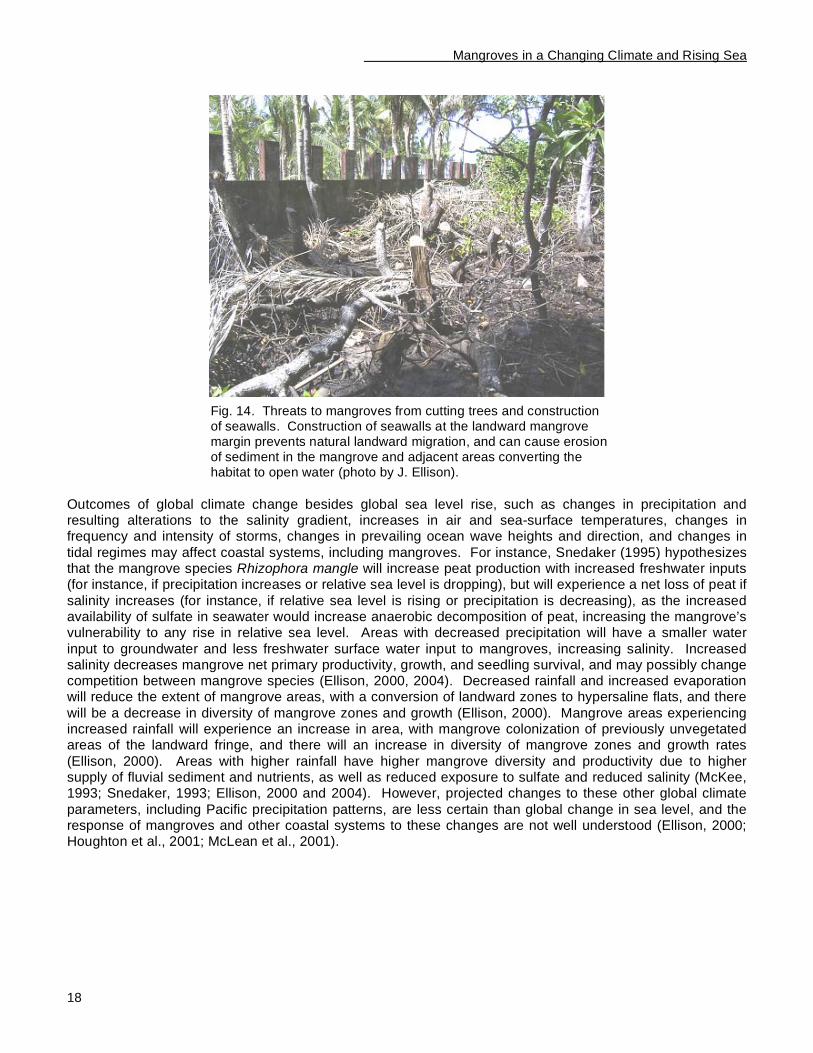
In addition to rising mean sea level and increased levels and frequency of extreme high waters, several other forces can affect mangrove margin position, as well as structure and health. Other threats to mangroves include changing nutrient, freshwater, and pollutant inputs; clearing mangrove vegetation; filling; changing sediment budgets such as from the construction of seawalls and alterations within the wetland’s contributing
watershed area; displacing native species with alien invasive species; and harming vegetation from insect infestations, fungal flora pathogens, and other diseases (Fig. 14) (Ellison, 1993, 1996, 1999; Gilman, 1999a; Donnelly and Bertness, 2001; Saintilan and Wilton, 2001). These pressures can also reduce mangrove
resistance and resilience to the additional stress of relative sea level rise and climate change. Also, degradation of adjacent coastal ecosystems from relative sea level rise and climate change may reduce mangrove health. Mangroves are functionally linked to neighboring coastal ecosystems, including seagrass
beds, coral reefs, and upland habitat, although the functional links are not fully understood (Mumby et al., 2004). For instance, mangroves of low islands and atolls, which receive a proportion of sediment supply from productive coral reefs, may experience lower sedimentation rates and increased susceptibility to relative sea
level rise if coral reefs become less productive from climate change and sea level rise.
Mangroves in a Changing Climate and Rising Sea
18
Fig. 14. Threats to mangroves from cutting trees and construction of seawalls. Construction of seawalls at the landward mangrove margin prevents natural landward migration, and can cause erosion of sediment in the mangrove and adjacent areas converting the habitat to open water (photo by J. Ellison).
Outcomes of global climate change besides global sea level rise, such as changes in precipitation and resulting alterations to the salinity gradient, increases in air and sea-surface temperatures, changes in frequency and intensity of storms, changes in prevailing ocean wave heights and direction, and changes in
tidal regimes may affect coastal systems, including mangroves. For instance, Snedaker (1995) hypothesizes that the mangrove species Rhizophora mangle will increase peat production with increased freshwater inputs (for instance, if precipitation increases or relative sea level is dropping), but will experience a net loss of peat if
salinity increases (for instance, if relative sea level is rising or precipitation is decreasing), as the increased availability of sulfate in seawater would increase anaerobic decomposition of peat, increasing the mangrove’s vulnerability to any rise in relative sea level. Areas with decreased precipitation will have a smaller water
input to groundwater and less freshwater surface water input to mangroves, increasing salinity. Increased salinity decreases mangrove net primary productivity, growth, and seedling survival, and may possibly change competition between mangrove species (Ellison, 2000, 2004). Decreased rainfall and increased evaporation will reduce the extent of mangrove areas, with a conversion of landward zones to hypersaline flats, and there
will be a decrease in diversity of mangrove zones and growth (Ellison, 2000). Mangrove areas experiencing increased rainfall will experience an increase in area, with mangrove colonization of previously unvegetated areas of the landward fringe, and there will an increase in diversity of mangrove zones and growth rates
(Ellison, 2000). Areas with higher rainfall have higher mangrove diversity and productivity due to higher supply of fluvial sediment and nutrients, as well as reduced exposure to sulfate and reduced salinity (McKee, 1993; Snedaker, 1993; Ellison, 2000 and 2004). However, projected changes to these other global climate
parameters, including Pacific precipitation patterns, are less certain than global change in sea level, and the response of mangroves and other coastal systems to these changes are not well understood (Ellison, 2000; Houghton et al., 2001; McLean et al., 2001).
Mangroves in a Changing Climate and Rising Sea
19
Capacity-Building Priorities to Address Mangrove Responses to Climate Change Effects
This section describes (i) the technical resources needed for the best possible prediction of how a mangrove wetland will respond to projected relative sea level rise and climate change over coming decades, (ii) the institutional resources needed to manage and adapt to these mangrove responses to climate change effects,
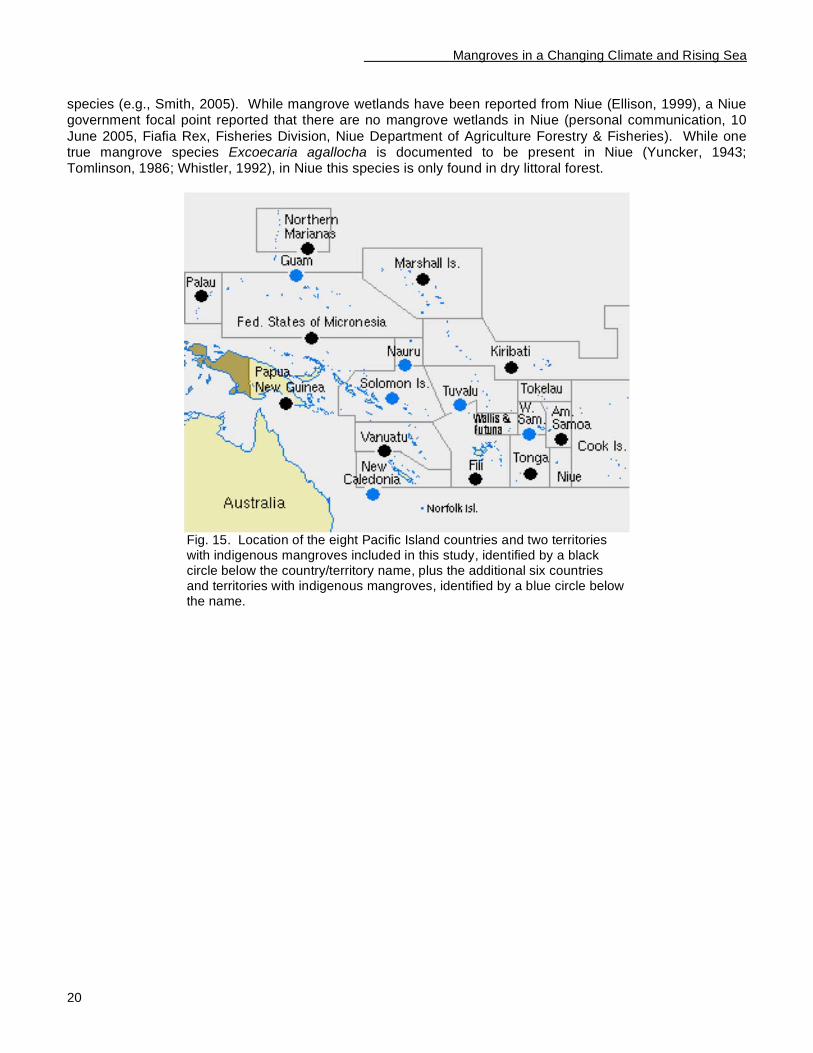
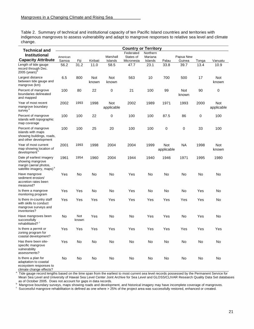
and (iii) the technical and institutional attributes that are in urgent need of strengthening in the Pacific Islands region. Case studies were contributed from 10 of the 16 Pacific Island countries and territories with indigenous mangroves (Fig. 15): American Samoa - USA, Republic of the Fiji Islands, Republic of Kiribati,
Republic of the Marshall Islands, Federated States of Micronesia, Commonwealth of the Northern Mariana Islands - USA, Republic of Palau, Independent State of Papua New Guinea, Kingdom of Tonga, and Republic of Vanuatu. These ten countries and territories contain 84% of the area of the region’s indigenous mangroves. Table 2 (page 20) provides a synthesis of the case study information.
Hawaii and Tahiti, where mangroves are human introductions (Allen 1998; Ellison, 1999), are not included in the assessment because management authorities in these areas may actively control the alien invasive
In Brief
The UNEP Regional Seas Programme, Secretariat of the Pacific Regional Environment Programme, and
Western Pacific Regional Fishery Management Council sponsored a study to assess the capacity of Pacific Island Countries and territories to assess mangrove vulnerability to climate change effects and to adapt to mangrove responses to these forces. Ten of the 16 countries and territories in the Pacific
Islands region where mangroves are native participated in the study. These ten countries and territories contain 84% of the area of the region’s indigenous mangroves. Results highlight the following seven technical and institutional capacity-building priorities:
• Strengthen management frameworks regulating coastal activities to develop a plan for adaptation to mangrove responses to climate change effects. This will require developing local capacity to (i)
conduct site-specific mangrove vulnerability assessments and incorporate this information into land-use and master planning; and (ii) reduce and eliminate stresses adversely affecting mangroves and other coastal ecosystems, in part, to increase resistance and resilience to climate change effects;
• Determine projections of trends in mean relative sea level and frequency and elevation of extreme high water events, and incorporate this information into land-use planning processes;
• Measure trends in changes in the elevation of mangrove surfaces to determine how mean sea level is changing relative to the elevation of mangrove surfaces, and use this information to assess site-specific mangrove vulnerability to projected relative sea level rise;
• Assess how the position of mangrove margins have changed over past decades through observations of a time series of historical remotely sensed imagery and use this information to predict the future mangrove position and assess site-specific mangrove vulnerability to projected relative sea level rise;
• Provide training opportunities for in-country staff. In-country staff with training, experience, and
motivation are needed to conduct monitoring and assessment of relevant mangrove parameters, in part, to facilitate adaptive management. Improved staff training and information-sharing is also needed to increase regional capacity to restore and enhance mangrove wetlands;
• Establish mangrove baselines and monitor gradual changes through regional networks using standardized techniques. This is needed to distinguish local and climate change effects on mangroves; and
• Produce maps showing mangrove boundaries, topographic information, and locations of coastal roads and development, and use these products to assess site-specific mangrove vulnerability to projected sea level rise.
Mangroves in a Changing Climate and Rising Sea
20
species (e.g., Smith, 2005). While mangrove wetlands have been reported from Niue (Ellison, 1999), a Niue government focal point reported that there are no mangrove wetlands in Niue (personal communication, 10
June 2005, Fiafia Rex, Fisheries Division, Niue Department of Agriculture Forestry & Fisheries). While one true mangrove species Excoecaria agallocha is documented to be present in Niue (Yuncker, 1943; Tomlinson, 1986; Whistler, 1992), in Niue this species is only found in dry littoral forest.
Fig. 15. Location of the eight Pacific Island countries and two territories with indigenous mangroves included in this study, identified by a black circle below the country/territory name, plus the additional six countries and territories with indigenous mangroves, identified by a blue circle below the name.
Mangroves in a Changing Climate and Rising Sea
21
Table 2. Summary of technical and institutional capacity of ten Pacific Island countries and territories with indigenous mangroves to assess vulnerability and adapt to mangrove responses to relative sea level and climate change.
Country or Territory Technical and Institutional
Capacity Attribute American Samoa Fiji Kiribati
Marshall
Islands
Federated
States of Micronesia
Northern
Mariana Islands Palau
Papua New
Guinea Tonga Vanuatu
Length of tide gauge
record through Dec. 2005 (years)
a
56.2 31.2 11.0 58.5 47.7 23.1 33.8 39.7 13.4 10.9
Largest distance between tide gauge and mangrove (km)
6.5 800 Not known
Not known
563 10 700 500 17 Not known
Percent of mangrove boundaries delineated and mapped
100 80 22 0 21 100 99 Not known
90 0
Year of most recent mangrove boundary survey
b
2002 1993 1998 Not applicable
2002 1989 1971 1993 2000 Not applicable
Percent of mangrove islands with topographic map coverage
100 100 22 0 100 100 87.5 86 0 100
Percent of mangrove islands with maps
showing buildings, roads, and other development
100 100 25 20 100 100 0 0 33 100
Year of most current map showing location of development
b
2001 1993 1998 2004 2004 1999 Not applicable
NA 1998 Not known
Date pf earliest imagery
showing mangrove margin (aerial photos, satellite imagery, maps)
b
1961 1954 1960 2004 1944 1940 1946 1971 1995 1980
Have mangrove sediment erosion/
accretion rates been measured?
Yes No No No Yes No No No No No
Is there a mangrove monitoring program
Yes Yes No No Yes No No No Yes No
Is there in-country staff with skills to conduct
mangrove surveys and inventories?
Yes Yes Yes Yes Yes Yes Yes Yes Yes No
Have mangroves been successfully rehabilitated?
c
No Not known
Yes No No Yes Yes No Yes No
Is there a permit or
zoning program for coastal development?
Yes Yes Yes Yes Yes Yes Yes Yes Yes Yes
Has there been site-specific mangrove
vulnerability assessments?
Yes No No No No No No No No No
Is there a plan for adaptation to coastal ecosystem responses to
climate change effects?
No No No No No No No No No No
a Tide gauge record lengths based on the time span from the earliest to most current sea level records possessed by the Permanent Service for Mean Sea Level and University of Hawaii Sea Level Center Joint Archive for Sea Level and GLOSS/CLIVAR Research Quality Data Set databases
as of October 2005. Does not account for gaps in data records. b Mangrove boundary surveys, maps showing roads and development, and historical imagery may have incomplete coverage of mangroves.
c Successful mangrove rehabilitation is defined as one where > 25% of the project area was successfully restored, enhanced or created.
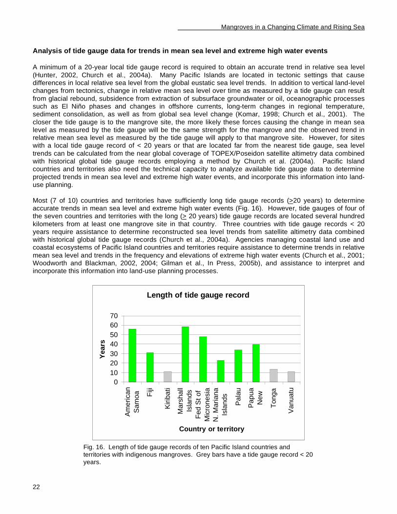
Mangroves in a Changing Climate and Rising Sea
22
Analysis of tide gauge data for trends in mean sea level and extreme high water events
A minimum of a 20-year local tide gauge record is required to obtain an accurate trend in relative sea level
(Hunter, 2002, Church et al., 2004a). Many Pacific Islands are located in tectonic settings that cause differences in local relative sea level from the global eustatic sea level trends. In addition to vertical land-level changes from tectonics, change in relative mean sea level over time as measured by a tide gauge can result
from glacial rebound, subsidence from extraction of subsurface groundwater or oil, oceanographic processes such as El Niño phases and changes in offshore currents, long-term changes in regional temperature, sediment consolidation, as well as from global sea level change (Komar, 1998; Church et al., 2001). The
closer the tide gauge is to the mangrove site, the more likely these forces causing the change in mean sea level as measured by the tide gauge will be the same strength for the mangrove and the observed trend in relative mean sea level as measured by the tide gauge will apply to that mangrove site. However, for sites with a local tide gauge record of < 20 years or that are located far from the nearest tide gauge, sea level
trends can be calculated from the near global coverage of TOPEX/Poseidon satellite altimetry data combined with historical global tide gauge records employing a method by Church et al. (2004a). Pacific Island countries and territories also need the technical capacity to analyze available tide gauge data to determine
projected trends in mean sea level and extreme high water events, and incorporate this information into land-use planning.
Most (7 of 10) countries and territories have sufficiently long tide gauge records (>20 years) to determine accurate trends in mean sea level and extreme high water events (Fig. 16). However, tide gauges of four of the seven countries and territories with the long (> 20 years) tide gauge records are located several hundred
kilometers from at least one mangrove site in that country. Three countries with tide gauge records < 20 years require assistance to determine reconstructed sea level trends from satellite altimetry data combined with historical global tide gauge records (Church et al., 2004a). Agencies managing coastal land use and coastal ecosystems of Pacific Island countries and territories require assistance to determine trends in relative
mean sea level and trends in the frequency and elevations of extreme high water events (Church et al., 2001; Woodworth and Blackman, 2002, 2004; Gilman et al., In Press, 2005b), and assistance to interpret and incorporate this information into land-use planning processes.
Length of tide gauge record
0
10
20
30
40
50
60
70
Am
erican
Sam
oa Fiji
Kirib
ati
Mars
hall
Isla
nds
Fed S
t of
Mic
ronesia
N.
Mariana
Isla
nds
Pala
u
Papua
New
Tonga
Vanuatu
Country or territory
Years
Fig. 16. Length of tide gauge records of ten Pacific Island countries and territories with indigenous mangroves. Grey bars have a tide gauge record < 20 years.
Mangroves in a Changing Climate and Rising Sea
23
Information on change in sea level relative to mangrove surfaces
Information on trends in the change in elevation of the mangrove surface over recent decades is needed to
determine how sea level has been changing in recent decades relative to the mangrove surface. The most precise method to obtain this information is to install an array of tide gauges throughout a site, but this is expensive, laborious, and a minimum of a 20-year local tide gauge record is required to obtain an accurate
trend in relative sea level (Church et al., 2004). Measurement of 137
Cs and excess 210
Pb activity in shallow sediment cores, observing sedimentation stakes, and using soil horizon markers can provide an accurate estimate of rates of change in mangrove surface elevation over recent decades (e.g., DeLaune et al., 1978;
Lee and Partridge, 1983; Lynch et al., 1989; Krauss et al., 2003; Gilman et al., In Press), which can then be compared to the relative sea level change rate as measured by the closest tide gauge. The measurement of radioisotope activity in mangrove sediment cores is expensive, especially if multiple cores are taken in an attempt to characterize an entire mangrove site, this method does not account for subsurface processes that
affect the elevation of the mangrove surface that occur below the depth of the cores, and there are several potential sources of error, including that the sediment profile can be disturbed from bioturbation as well as abiotic processes. Alternatively, precision surveying from a benchmark to points throughout a mangrove site
could provide information on trends in elevation of the mangrove surface (Cahoon et al., 2002), which could then be compared to the relative sea level change rate from a nearby tide gauge.
American Samoa and the Federated States of Micronesia have some information on mangrove sedimentation rates, obtained from monitoring the change in distance of the mangrove surface from the top of sedimentation stakes and from determining
137Cs and Excess
210Pb activity depth profiles from shallow sediment cores
(Krauss et al., 2003; Gilman et al, 2005a). This contributes to understanding how sea level has been changing in recent decades relative to the mangrove surface. Otherwise, regionally there is a lack of information on how sea level is changing relative to mangrove surfaces. The mangrove surface can change in elevation from sediment accretion or erosion and from subsurface processes, such as organic matter
decomposition, sediment compaction, fluctuations in sediment water storage and water table levels, and root production (Lynch et al., 1989; Donnelly and Bertness, 2001; Krauss et al., 2003; Gilman et al., In Press, 2005a; Rogers et al., 2005). Information on trends in change in the elevation of the mangrove surface over
recent decades is needed.
Analysis of historical imagery to observe changes in mangrove margin positions Analysis of a time series of recent historical remotely sensed imagery such as aerial photographs and satellite imagery, which show the positions of mangrove seaward margins, can be used to observe trends in
movement of the mangrove margins (erosion or seaward progression). This information can then be used to determine if the movement has been correlated with the observed trend in relative mean sea level, and predict the future position of the seaward margin. Extrapolation from observations of historical shoreline
movement will be more accurate the longer the time period covered by the available imagery. The extrapolation assumes that no new large forces, such as from future human alterations to the coastline’s sediment budget, will substantially change the trend from the recent observations.
Eight countries and territories have historical imagery > 25 years old (Fig. 17). Only American Samoa has analyzed available historical imagery to observe historical trends in changes in position of mangrove margins
(Gilman et al., In Press). An effort to identify additional historical aerial photographs, provide IKONOS and QuickBird space imaging to in-country GIS practitioners, and provide assistance to co-register available historical imagery to the georeferenced satellite imagery is needed. Some countries and territories may need assistance to establish or augment capacity of a GIS program.
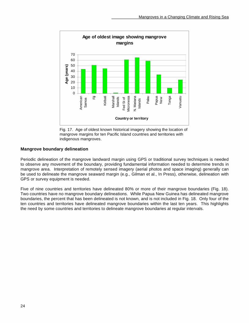
Mangroves in a Changing Climate and Rising Sea
24
Age of oldest image showing mangrove
margins
0
10
20
30
40
50
60
70
Am
erican
Sam
oa F
iji
Kirib
ati
Mars
hall
Isla
nds
Fed S
t of
Mic
ronesia
N. M
ariana
Isla
nds
Pala
u
Papua
Ne
w
Tonga
Vanuatu
Country or territory
Ag
e (
years
)
Fig. 17. Age of oldest known historical imagery showing the location of mangrove margins for ten Pacific Island countries and territories with indigenous mangroves.
Mangrove boundary delineation
Periodic delineation of the mangrove landward margin using GPS or traditional survey techniques is needed to observe any movement of the boundary, providing fundamental information needed to determine trends in mangrove area. Interpretation of remotely sensed imagery (aerial photos and space imaging) generally can
be used to delineate the mangrove seaward margin (e.g., Gilman et al., In Press), otherwise, delineation with GPS or survey equipment is needed.
Five of nine countries and territories have delineated 80% or more of their mangrove boundaries (Fig. 18). Two countries have no mangrove boundary delineations. While Papua New Guinea has delineated mangrove boundaries, the percent that has been delineated is not known, and is not included in Fig. 18. Only four of the
ten countries and territories have delineated mangrove boundaries within the last ten years. This highlights the need by some countries and territories to delineate mangrove boundaries at regular intervals.
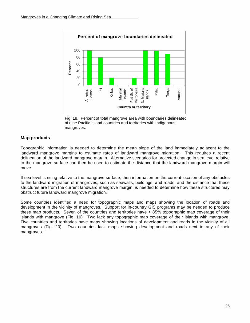
Mangroves in a Changing Climate and Rising Sea
25
Percent of mangrove boundaries delineated
0
20
40
60
80
100
Am
erican
Sam
oa F
iji
Kirib
ati
Mars
hall
Isla
nds
Fed S
t. o
f
Mic
ronesia
N. M
ariana
Isla
nds
Pala
u
Tonga
Vanuatu
Country or territory
Pe
rce
nt
Fig. 18. Percent of total mangrove area with boundaries delineated of nine Pacific Island countries and territories with indigenous mangroves.
Map products
Topographic information is needed to determine the mean slope of the land immediately adjacent to the
landward mangrove margins to estimate rates of landward mangrove migration. This requires a recent delineation of the landward mangrove margin. Alternative scenarios for projected change in sea level relative to the mangrove surface can then be used to estimate the distance that the landward mangrove margin will
move. If sea level is rising relative to the mangrove surface, then information on the current location of any obstacles
to the landward migration of mangroves, such as seawalls, buildings, and roads, and the distance that these structures are from the current landward mangrove margin, is needed to determine how these structures may obstruct future landward mangrove migration.
Some countries identified a need for topographic maps and maps showing the location of roads and development in the vicinity of mangroves. Support for in-country GIS programs may be needed to produce these map products. Seven of the countries and territories have > 85% topographic map coverage of their
islands with mangrove (Fig. 19). Two lack any topographic map coverage of their islands with mangrove. Five countries and territories have maps showing locations of development and roads in the vicinity of all mangroves (Fig. 20). Two countries lack maps showing development and roads next to any of their
mangroves.

Mangroves in a Changing Climate and Rising Sea
26
Percent of islands containing mangroves with
topographic map coverage
0102030405060708090
100
Am
eri
ca
n
Sam
oa Fiji
Kir
iba
ti
Mars
hall
Isla
nds
Fe
d S
t o
f
Mic
ron
esia
N. M
ariana
Isla
nds
Pala
u
Papua N
ew
Guin
ea
Tonga
Vanuatu
Country or territory
Pe
rce
nt
Fig. 19. Percent of the islands with mangroves that also have topographic map coverage, for ten Pacific Island countries and territories with indigenous mangroves.
Percent of islands containing mangroves with
maps of development and roads
0
10
20
30
40
50
60
70
80
90
100
Am
eri
ca
n
Sam
oa Fiji
Kir
iba
ti
Mars
hall
Isla
nds
Fe
d S
t o
f
Mic
ron
esia
N. M
ariana
Isla
nds
Pala
u
Papua N
ew
Guin
ea
Tonga
Vanuatu
Country or territory
Pe
rce
nt
Fig. 20. Percent of islands containing mangroves for which maps showing the location of development and roads are available, for ten Pacific Island countries and territories with indigenous mangroves.
Mangroves in a Changing Climate and Rising Sea
27
Mangrove monitoring and assessment for adaptive management and regional mangrove
monitoring network Given uncertainties about future climate change and responses of mangroves and other coastal ecosystems, we need to manage adaptively and proactively. In-country staff with training, experience, and motivation is
required to conduct monitoring and assessment of relevant mangrove parameters, in part, to facilitate adaptive management. Projections are available over coming decades for rising sea level and changes in climate and weather (Church et al., 2001; Houghton et al., 2001). These changes are expected to alter the
position, area, structure, species composition, and health of most coastal communities, including mangroves. Establishing mangrove baselines and monitoring gradual changes through regional networks using standardized techniques will enable the separation of site-based influences from global changes to provide a
better understanding of mangrove responses to sea level and global climate change, and alternatives for mitigating adverse effects (Ellison, 2000; Nurse et al., 2001). The monitoring system, while designed to distinguish climate change effects on mangroves, would also therefore show local effects, providing coastal
managers with information to abate these sources of degradation. Four countries and territories identify a strong need for training and capacity-building of in-country personnel in mangrove assessment and monitoring: Vanuatu, Kiribati, Northern Mariana Islands, and Palau. Other
countries (American Samoa, Tonga, Fiji, Marshall Islands, Papua New Guinea, and the Federated States of Micronesia) have some in-country capacity already, but identify information gaps. Fiji, Federated States of Micronesia and American Samoa conduct some monitoring of mangrove tree girth (diameter at breast height
or DBH), which allows quantitative assessment of mangrove ecosystem change in community structure and growth rates. Palau and Tonga have more limited monitoring, such as of birds or human impacts.
There has also been no coordination between the limited mangrove monitoring work that has been done. The countries and territories with a mangrove monitoring program do not employ standardized techniques to enable a meaningful comparison of results from the different programs. Other countries have no monitoring.
There is no Pacific Islands regional mangrove monitoring program in place. All countries indicate that they would be interested in participating in a regional network to monitor mangroves and assess mangrove response to sea level rise and climate change, if such a network were established.
Establishing a regional wetland monitoring network for the Pacific Islands region has been proposed in the Action Strategy for Nature Conservation in the Pacific Islands Region (South Pacific Regional Environment Programme, 1999a), and the Regional Wetlands Action Plan for the Pacific Islands (South Pacific Regional
Environment Programme, 1999b). This has not been implemented to date.
Strengthen management frameworks Governments need the institutional capacity to manage a land-use permit or zoning program to ensure coastal earthmoving and development activities are sustainable, including accounting for effects on
mangroves, and to plan for any landward mangrove migration. While existence of a coastal permit and zoning program does not necessarily mean that current legal and
management frameworks and political will are adequately preventing mangrove degradation, it indicates that the institution capacity needed to sustainably manage activities in mangroves and other sensitive coastal ecosystems exists. Given an existing coastal development permit or zoning program, if the political will exists,
it could be possible to establish zoning setbacks for new coastal development adjacent to mangroves along sections of coastline that are expected to migrate landward, adopt rules on where hard versus soft engineering erosion control structures can and cannot be constructed, and determine which sections of coastline would undergo managed retreat versus fortification.
All ten participating countries and territories report having some form of coastal permitting or zoning program that regulates coastal activities such as earthmoving and development activities. The existence of a
Mangroves in a Changing Climate and Rising Sea
28
framework to manage coastal activities is part of the requisite institutional capacity to sustainably manage activities in mangroves and other sensitive coastal ecosystems. However, this does not necessarily mean
that current legal and management frameworks and political will are adequately preventing mangrove degradation. There is a need to assess the efficacy of national management frameworks at preventing mangrove degradation to determine if this is an area in need of attention. For instance, despite the existence
of a permit program for coastal development activities, the wetlands management framework in the U.S. Commonwealth of the Northern Mariana Islands has not been preventing site-specific, island-wide, or cumulative losses of wetland functional performance or wetland area (Gilman, 1998, 1999a). And Palau’s state Public Land Authorities have been leasing and allowing the development of property containing
mangroves (Republic of Palau Office of Environmental Response and Coordination, 2002). Only American Samoa has assessed the site-specific vulnerability of mangroves to sea level and climate
change (Gilman et al., In Press). Information from the case studies and a review of National Communication Reports to the United Nations Framework Convention on Climate Change reveal that none of the ten countries and territories have developed a plan for adaptation to mangrove or other coastal ecosystem
responses to climate change effects. Technical assistance is needed to support conducting site-specific vulnerability assessments and to incorporate this information into land-use and master planning.
Mangrove rehabilitation
Capacity to rehabilitate mangroves (restore, enhance and create mangroves) will compliment other activities
taken by people to adapt to mangrove responses to sea level and climate change. Restoring areas where mangrove habitat previously existed, enhancing degraded mangroves by removing stresses that caused their decline, and creating new mangrove habitat will help to offset anticipated reductions in mangrove area and
increase resistance and resilience to climate change effects (Hansen and Biringer, 2003; Ellison, 2004). If successful mangrove rehabilitation has been achieved in the past, this indicates that it may be possible to replicate this success at other sites. However, failure to provide adequate training to coastal managers in the
basics of successful mangrove rehabilitation leads to project failures or projects that only partially achieve stated goals (Lewis, 2005). There has been limited activity in the region in rehabilitation of mangroves, with small-scale successful
projects only recorded from Kiribati, Northern Mariana Islands, Palau, and Tonga and two failed mangrove rehabilitation efforts in American Samoa and Papua New Guinea. The results of two additional rehabilitation efforts in Palau and Fiji are not known. This highlights the need for improved staff training, capacity building
and information sharing.
Mangroves in a Changing Climate and Rising Sea
29
Considerations for Developing a Coastal Site Planning and Adaptation Strategy
In Brief
• Management authorities, especially of small island countries and territories, are encouraged to assess
site-specific mangrove vulnerability to climate change effects now and not wait for problems to become apparent when options for adaptation will be restricted. Managers can then incorporate the results of these vulnerability assessments into coastal land-use policies to provide adequate lead-time to
minimize social disruption and cost, minimize losses of valued coastal habitats, and maximize available options.
• Community-based approaches to managing natural resources, including managing mangrove and other coastal ecosystem responses to climate change effects, are appropriate in many areas of the Pacific Islands region.
• The policy adopted to manage site-based shoreline response to rising sea level will be made as part a broader integrated coastal management planning analysis, which includes an assessment of the
cumulative effects of coastal activities. This analysis requires balancing multiple and often conflicting objectives of sustaining the provision of ecological, economic, and cultural values; addressing priority threats to natural ecosystem functioning; maintaining ecological processes and biodiversity; achieving sustainable development; and fulfilling institutional, policy, and legal needs.
• Site planning for some sections of shoreline containing mangroves that are not highly developed may
allow for long-term managed retreat with relative sea level rise. Zoning rules for building setbacks can be used to reserve zones behind current mangroves for future mangrove habitat. However, for some sections of highly developed coastline adjacent to mangroves, results of site planning may justify the
use of shoreline erosion control measures. As a result, the mangroves’ natural landward migration will be prevented and the mangrove fronting the development will eventually be lost.
• Protected areas are one tool that can contribute to mitigating anticipated mangrove losses in response to climate change effects. Managers selecting sites and boundaries for individual protected areas, reviewing the effectiveness of existing protected areas, and designing protected area systems need to
explicitly incorporate anticipated coastal ecosystem responses to climate change effects as well as the functional linkages between ecosystems. Networks of protected areas are needed to achieve ecological connectivity to permit the movement of species and exchange of genes. Protected areas established
and managed through community-based approaches are more likely to be successful in most areas of the Pacific Islands region.
• Reducing and eliminating non climate-related stresses that are affecting mangroves will increase mangrove resistance and resilience to sea level rise and other climate change effects.
• Mangrove rehabilitation, the restoration of areas where mangroves previously existed, enhancing degraded mangroves by removing stresses that caused their decline, and creating new mangrove
habitat will contribute to offsetting anticipated reductions in mangrove area and health, and increase resilience to climate change effects. Determining the stress or stresses that caused a mangrove to decline is necessary to identify the restoration or enhancement method to remove these stresses: planting mangroves may not be successful or necessary in many cases.
• Local communities and leaders must recognize the long-term benefits of mangrove conservation if we
are to reverse historical trends in loss of mangrove area. Outreach and education activities can help develop or augment a conservation ethic.
Mangroves in a Changing Climate and Rising Sea
30
Community-based management approaches
Customary management systems, although weakened, still continue to function at some level throughout the Pacific Islands region (Johannes, 1982; Huber and McGregor, 2001; Gilman, 2002). Community-based approaches, which capitalize on traditional knowledge and management systems, and catalyze stakeholder
support for requisite conservation measures, are suitable in some regions. Stakeholders will be more likely to comply with restrictions on their traditional resource use activities if they understand and support the rules, which can be accomplished through direct community participation in monitoring, planning, and management
decision-making. The rural conditions, including relatively small population size, high dependence of local communities on coastal and marine resources, social cohesion, customary tenure and traditional use of coastal and marine areas and resources, existence of strong and intact traditional authority, and low
conventional government management capacity of some sites make local community-based management through collaboration between local government and the local community (e.g. clans or individual villages) appropriate (White et al., 1994; Whyte, 2001). In more urban areas, the larger and more heterogeneous the
local community, more complicated and numerous the multiple resource uses and users are, more numerous external threats to the coastal and marine environment, less recognition of customary tenure and traditional governance, and generally the more complex the site is, there will be a larger need for central government management, where community-based management would be less effective (Huber and McGregor, 2001).
The optimal approach to manage adaptation to mangrove responses to climate change effects will depend on the local context.
Successful measures to manage natural resources were in use in the tropical Pacific centuries before they were conceived of in Western nations. Many of these traditional conservation systems declined after Western contact due in part to the introduction of money economies, the breakdown of traditional authority, and the
imposition of new, legal regimes (Johannes, 1982). But their "community based" approach has recently received acceptance among scientists and managers worldwide. Systems of traditional rights and taboos have successfully conserved island resources and are a deep part of some Pacific Islands' cultures. These
customary forms of management are not irrevocably fixed, but successfully evolve as conditions change (Ponter, 1982). The Western practice of conservation, when it conflicts with traditional rights, and neglects to catalyze community involvement and support, will meet with resistance, will require enormous investment in policing, and is unlikely to result in effective conservation (Carew-Reid, 1990; Gilman, 1997; IUCN and
European Commission, 1999). Therefore, if resource management rules are intended to change the behavior and values of resource users, it
is necessary for the local community and government to collaborate to coordinate planning and management activities. Attempts to establish restrictions on the use of resources in ways other than building on customary systems of management are not likely to be effective in certain regions. Employing community-based
management maximizes stakeholder support for sustainable biodiversity management by getting local communities directly involved in developing management measures so that the rules mesh with traditional management practices, and lets the community understand that rules benefit them, fostering a sense of
ownership by the community for management initiatives. Process tools are available to facilitate participatory resource management (Pretty, 1993; Chambers, 1994; Institute for Development Studies, 1996; de Negri et al., 1998). Participatory Learning and Action is a term
used to describe a group of community development methods and approaches where facilitators work with communities to help them analyze their needs, identify solutions to meet these needs, and develop and implement an action plan (de Negri et al., 1998). Participatory Rural Appraisal, an older term synonymous to
Participatory Learning and Action, also is used to describe methods to enable people to collaborate and interpret their local knowledge and situation (Chambers, 1994). Participatory Programme Development is the process of working in partnerships with communities to develop sustainable programs, and uses Participatory
Learning and Action methods (de Negri et al., 1998). These standardized participatory processes attempt to build community capacity and encourage stakeholder participation in targeted activities, and typically are initiated through workshops.
Mangroves in a Changing Climate and Rising Sea
31
Integrated coastal management and site planning
An integrated management approach manages all interrelated elements (natural resources, environmental processes, human activities, socioeconomic factors, and political factors) that affect a region or specific
natural resource under a single unifying approach, through the collaboration of all management authorities and stakeholders, to conserve biodiversity and protect ecological integrity, and to sustain the provision of valued services and products (Cicin-Sain, 1993; Czech and Krausman, 1997; Sorensen, 1997; Cicin-Sain and
Knecht, 1998; Gilman, 2002). An underlying principle of integrated management is that ecosystem functioning, anthropogenic forces, and the sustainability of human societies are interconnected and should be holistically managed through the collaboration of all groups. The Integrated Coastal Management approach is
recognized in the 12 guiding principles that were drawn up at a meeting in Cairo in February 2005 by the United Nations Environment Programme Asian Tsunami Disaster Task Force, in collaboration with the United Nations Environment Programme Coordination Office of the Global Programme of Action for the Protection of
the Marine Environment from Land-based Activities and other organizations, known as the Cairo Principles (United Nations Environment Programme Global Programme of Action, 2005). Individual, project-specific coastal development decisions are often made without considering the cumulative
effects of development activities (Gilman, 2002). Management of coastal and marine resources is typically the responsibility of independent sectors of government, with jurisdiction divided by resource use activities (e.g., fishing, agriculture, forestry, mining, tourism, seaport). This sectoral approach can be patchwork in
nature and lead to a lack of coordination and conflicting missions, legislation, and policies, with concomitant degradation of natural resources. For instance, this lack of integration can result in a lack of a single organization assuming the lead responsibility to conserve and manage a specific coastal habitat, where
agencies have piecemeal jurisdiction over activities that occur in overlapping coastal and marine areas, resulting in a lack of adequate protection for the coastal habitat (e.g., Gilman, 1998). Integrated ecosystem management is a governance structure or process that resolves this fragmentation inherent in single-sector
management approaches (Cicin-Sain and Knecht, 1998). An integrated coastal and marine resource management approach would involve coordinating legislation, policies, plans, programs, and activities, and directly involve all interest groups in planning and management, where all groups work towards a common goal, ensuring that decisions of all sectors and levels of government are harmonized and consistent with
overarching national policies (Cicin-Sain and Knecht, 1998). The management framework for coastal and marine natural resources should be as integrated as are the interconnected ecosystems and human forces.
Planning for the sustainable management of coastal and marine ecosystems of discrete sites, referred to as coastal and marine site-planning, is a process of reviewing past progress and assessing current and future issues, threats, and needs to develop a management strategy (Gilman, 2002). Site-planning identifies priority
management intervention activities that will allow managers and stakeholders to sustain the provision of ecological, economic, and cultural values; balance multiple and often competing objectives; address priority threats to natural ecosystem functioning; maintain ecological processes and biodiversity; achieve sustainable
development; and fulfill institutional, policy, and legal needs. Site-planning typically involves relatively short-term interventions to improve planning and management, and results in products and outcomes such as a monitoring program, legislation, national policy, site management plan, or other addition or improvement to a component of the management framework. The purpose of site-planning and management for local
communities and stakeholders will tend to focus on material benefits associated with sustainable development, such as fisheries optimal yield. External organizations may wish to focus on regional and global benefits, such as biodiversity conservation. Despite these groups' disparate desired outcomes, there is
typically an overlap in the objectives and activities for management intervention to achieve both groups' goals. Site planning for some sections of shoreline containing mangroves that are not highly developed may call for
abandonment and adaptation to manage long-term retreat with relative sea level rise (Dixon and Sherman, 1990; Mullane and Suzuki, 1997; Ramsar Bureau, 1998; Gilman, 2002). “Managed retreat” involves implementing land-use planning mechanisms before the effects of rising sea level become apparent, which
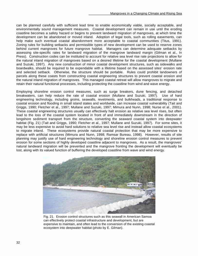
Mangroves in a Changing Climate and Rising Sea
32
can be planned carefully with sufficient lead time to enable economically viable, socially acceptable, and environmentally sound management measures. Coastal development can remain in use until the eroding
coastline becomes a safety hazard or begins to prevent landward migration of mangroves, at which time the development can be abandoned or moved inland. Adoption of legal tools, such as rolling easements, can help make such eventual coastal abandonment more acceptable to coastal communities (Titus, 1991).
Zoning rules for building setbacks and permissible types of new development can be used to reserve zones behind current mangroves for future mangrove habitat. Managers can determine adequate setbacks by assessing site-specific rates for landward migration of the mangrove landward margin (Gilman et al., In Press). Construction codes can be instituted to account for relative sea level rise rate projections to allow for
the natural inland migration of mangroves based on a desired lifetime for the coastal development (Mullane and Suzuki, 1997). Any new construction of minor coastal development structures, such as sidewalks and boardwalks, should be required to be expendable with a lifetime based on the assessed sites’ erosion rate
and selected setback. Otherwise, the structure should be portable. Rules could prohibit landowners of parcels along these coasts from constructing coastal engineering structures to prevent coastal erosion and the natural inland migration of mangroves. This managed coastal retreat will allow mangroves to migrate and
retain their natural functional processes, including protecting the coastline from wind and wave energy. Employing shoreline erosion control measures, such as surge breakers, dune fencing, and detached
breakwaters, can help reduce the rate of coastal erosion (Mullane and Suzuki, 1997). Use of hard engineering technology, including groins, seawalls, revetments, and bulkheads, a traditional response to coastal erosion and flooding in small island states and worldwide, can increase coastal vulnerability (Tait and Griggs, 1990; Fletcher et al., 1997; Mullane and Suzuki, 1997; Mimura and Nunn, 1998; Nurse et al., 2001).
These coastal engineering structures usually can effectively halt erosion as relative sea level rises, but often lead to the loss of the coastal system located in front of and immediately downstream in the direction of longshore sediment transport from the structure, converting the seaward coastal system into deepwater
habitat (Fig. 21) (Tait and Griggs, 1990; Fletcher et al., 1997; Mullane and Suzuki, 1997). For some sites, it may be less expensive to avoid hard solutions to relative sea level rise and instead allow coastal ecosystems to migrate inland. These ecosystems provide natural coastal protection that may be more expensive to
replace with artificial structures (Mimura and Nunn, 1998; Ramsar Bureau, 1998). However, results of site planning may justify use of hard engineering technology and shoreline erosion control measures to prevent erosion for some sections of highly developed coastline adjacent to mangroves. As a result, the mangroves’
natural landward migration will be prevented and the mangrove fronting the development will eventually be lost, along with its valued function of buffering the developed coastline from wave and wind energy.
Fig. 21. Erosion control structures such as this seawall in American Samoa can effectively protect coastal infrastructure and development, but are expensive to maintain, and often lead to the conversion of the existing coastal ecosystem into deepwater habitat (photo by E. Gilman).
Mangroves in a Changing Climate and Rising Sea
33
Most cost-benefit analyses included in site planning only examine costs and benefits as measured by market prices, ignoring mangrove and other coastal system values not described by established monetary indicators
(Dixon and Sherman, 1990; Ramsar Bureau, 1998). Site planning and cost-benefit analyses employed to determine if a section of coastline abutting a mangrove should be fortified or undergo managed retreat should account for the benefits of allowing mangroves to undergo natural landward migration under a rise in relative
sea level. These benefits include the continued provision of valued services and products, including consumptive benefits, education and research, aesthetic and cultural benefits, and future values such as a mangroves future potential for tourism (Dixon and Sherman, 1990; Ramsar Bureau, 1998).
Coastal and marine protected areas
Protected areas are one coastal resource management tool that can contribute to mitigating anticipated mangrove losses in response to climate change effects. Protected areas can range from areas completely closed to all human activities to zoned multiple-use areas, and may be established using local, national, or
international designations (Gilman, 2002). Purposes for placing an area in protected status include: protecting sites that support high biodiversity; maintaining, enhancing, or restoring the abundance, biomass, size, density, and species diversity of commercially important species and species used for subsistence; reducing user conflicts; conserving a site that is representative of a particular ecosystem type; protecting
areas of a community type that are resistant to climate change effects to serve as a refuge, in part, to be a source of seeds to re-colonize adjacent areas degraded by a disturbance; conserving a fragile, unique, or rare habitat type; enhancing tourism; and protecting cultural and historical resources (Kelleher, 1999; Gilman,
1997, 2002). There are about 685 protected areas worldwide containing mangroves, covering about 9% of the total mangrove area (Spalding et al., 1997). An assessment has not been conducted to assess the effectiveness of protected areas containing Pacific Island mangroves.
Managers selecting sites and boundaries for individual protected areas, reviewing the effectiveness of existing protected areas, and designing protected area systems need to explicitly incorporate anticipated coastal
ecosystem responses to climate change effects (Barber et al., 2004). For instance, planners need to account for the likely movements of habitat boundaries and species ranges over time under different sea level and climate change scenarios, as well as consider an areas’ resistance and resilience to projected sea level and climate changes and contributions to adaptation strategies. For instance, mature mangrove communities will
be more resilient to stresses, including those from climate change, than recently-established forests. Site-specific analysis of resistance and resilience to climate change when selecting areas to include in new protected areas should include, for example, how discrete coastal habitats might be blocked from natural
landward migration (Gilman et al., In Press), and how severe are threats not related to climate change in affecting the site’s health.
Networks of protected areas, covering large geographical areas, spaced at suitable distances from one another, and including a representative and replicated spectrum of habitats, are thought to provide the greatest conservation benefit (Roberts et al., 2001; Gilman, 2002). Networks of protected areas are needed
to achieve the biologically-necessary connectivity to permit the movement of species and exchange of genes. For instance, because eggs and larvae of certain marine species have a large dispersal distance, a small protected area will not ensure self-sustaining populations of these species unless the protected area is colonized by offspring produced in another protected area sufficiently close to exchange offspring (Roberts et
al., 2001). Also, some organisms require several habitats to be protected for various life history stages (Huber and McGregor, 2001; Wells et al., 2006).
As a part of the recommended policy of adaptation to mangrove responses to relative sea level rise, the selection of sites for protected areas should account for functional linkages between coastal ecosystems. For instance, protected areas designed to preserve biodiversity and relatively pristine habitats should incorporate
adjacent coastal forests, mangroves, seagrass beds, and coral reefs to ensure all functional links are maintained in a least disturbed state. Protected areas designed in this manner will have optimal resistance
Mangroves in a Changing Climate and Rising Sea
34
and resilience to global climate change, sea level rise, and other stresses. The existence of functional links between coastal systems means that degradation of one habitat type will adversely affect the health of
neighboring habitats. If a protected area encompassing a mangrove wetland does not include adjacent ecosystems, unsustainable activities occurring in the adjacent hinterland or offshore on adjacent coral reefs and seagrass beds could result in degradation of the mangrove (Barber et al., 2004; Ellison, 2004; Mumby et
al., 2004). The cultural context of most Pacific Islands makes it necessary to abandon the traditional concept of protected areas, where the aim is typically to provide recreational opportunities, protect aesthetics, or protect
nature from development by preventing people from inhabiting an area and restricting activities in and access to the area (Gilman, 1997). Protected area planning and management activities are most effective when all interest groups are fully involved. Protected area management conducted through the collaboration of the
local community, government agencies and other groups, is an appropriate approach in many areas of the Pacific Islands region (Gilman, 2002). When there is inadequate community involvement in decision-making to establish and manage protected areas, natural resources remain under a de facto open-access regime
because resource users do not support or possibly know about a protected area's rules concerning the use of natural resources, and the rules are not followed. Islands with contemporary pressures on their natural environment that do not employ community-based decision-making nor allow for multiple purposes when
establishing protected areas produce "paper parks" whose purposes are not achieved, and natural resources continue to degrade because enforcement measures are ineffective (Gilman, 1997). Conversely, protected areas established and management through community-based approaches are more likely to be successful because (Gilman, 1997):
• A perception of equity develops among interest groups, a basic tenet of conflict management.
Representatives of all interest groups have equal opportunity to raise issues important to their interest
group, and to make decisions. This helps achieve equity even though it may not have existed before the process began;
• The protected area selection and management processes are flexible, allowing the protected area to fit the needs of the local context;
• Decision-makers account for local ecological knowledge, the knowledge that comes from observing and using natural resources, in addition to information from technical experts and resource managers;
• Community-based decision-making enhances the communicability of results because interest group leaders disseminate information to the community;
• Decisions respect tenets of traditional management systems;
• Participation of all interest groups ensures that all issues are identified and addressed;
• Community-based coordination results in educated user groups who take credit and ownership for the protected area and its rules;
• Continual communication with interest groups allows protected area managers to evaluate the efficacy of the protected area and effectively adapt management measures;
• Community-based selection, management, and enforcement is more effective and economical in the long-term than continual policing; and
• Allowing the community to select multiple uses to be allowed in the area that are compatible with the goals of the protected area ensures all needs are considered, reducing the likelihood of conflict. A greater
number of interest groups will support a protected area that permits numerous, but appropriate uses than would support a single-purpose protected area. Also, the community will more likely support a protected area if their interest group representatives can select the major goals than if goals are predetermined.
Coastal and marine protected areas have potential limitations, which can be avoided and minimized through careful planning and management (Huber and McGregor, 2001; Gilman, 2002; Gilman et al., 2006):
Mangroves in a Changing Climate and Rising Sea
35
• The resource use restrictions of a protected area may displace effort to adjacent and potentially more sensitive and valuable areas, where weaker management frameworks may be in place;
• Local communities may have a limited area available for exploiting natural resources, and may have limited resources for managing a protected area, which results in only a small area of coastal and marine
habitats being able to be practicably set aside as a no-take zone of a protected area, limiting the ecological value of the protected area due to its small size;
• Protected areas can disproportionately affect certain sectors of the local community; and
• Existence of a protected area may promote the misconception that the protected area is a panacea to rescue troubled fish stocks, and could cause managers to disregard the need to employ additional management techniques to achieve sustainable fisheries.
Increase mangrove resistance and resilience by reducing and removing stresses
Promoting overall mangrove ecosystem health by reducing and eliminating non climate-related stresses, such as filling and pollution, will increase resistance and resilience to sea level and climate change. The value of wetlands conservation is often underestimated, especially in less developed countries with high population
growth and substantial development pressure, where short-term economic gains that result from activities that adversely affect wetlands are often preferred over the less-tangible long-term benefits that accrue from sustainably using wetlands. The status of mangrove wetlands as one of the most threatened natural
communities worldwide, of which roughly 50% of the global area has been lost since 1900 (Ramsar Secretariat, 1999), supports this observation. Stresses associated with relative sea level rise and other effects from climate change present one set of threats to mangroves and other coastal ecosystems. Mangroves experiencing stress from other anthropogenic activities such as clearing trees and dumping of
pollutants will be less resilient to these additional climate-related stresses. Local communities and leaders must recognize the long-term benefits of mangrove conservation if we are to reverse historical trends in loss of mangrove area, maximize mangrove resistance and resilience to climate change, and where sea level is
projected to rise relative to mangrove surfaces, enable unobstructed natural landward migration wherever possible.
Mangrove rehabilitation
In addition to enhancing degraded mangroves by removing stresses that caused their decline, restoring areas
where mangrove habitat previously existed and creating new mangrove habitat will also contribute to offseting anticipated reductions in mangrove area and health and increase resistance and resilience to climate change effects (Hansen and Biringer, 2003; Ellison, 2004). Determining the stress or stresses that caused a
mangrove to decline is necessary to identify the restoration or enhancement method to remove these stresses (Lewis, 2005). Too often the approach taken to restore or enhance a mangrove site is to plant mangroves, without first identifying if some stress that is inhibiting natural regeneration is still present, which usually
results in low or no survival of the planted mangroves (Lewis and Streever, 2000; Lewis, 2005). Only when the availability of waterborne seedlings of mangroves from adjacent stands is blocked is planting mangroves necessary to restore a degraded mangrove site (Fig. 22). Mangrove wetlands can self-repair over a period of
15-30 years if hydrologic functions are intact and natural recruitment of mangrove seedlings occurs (Lewis, 2005), although planting mangroves after removing causes of decline can help expedite this recovery. Rehabilitation sites must meet the environmental conditions (wave energy, substrate conditions, salinity regime, soil and water pH, sediment composition and stability, nutrient concentrations, elevation, slope,
inundation, etc.) required for mangroves. While it may be feasible to establish mangrove vegetation at new sites where they had not previously existed (habitat conversion) (Choudhuri 1994), rehabilitation may be more successful and appropriate if mangrove wetlands are restored at sites where mangrove wetlands historically
existed (Gilman 1998, Kusler and Kentula 1990, U.S. Environmental Protection Agency 1993, U.S. Department of Defense et al. 1995, Weems and Canter 1995). Restoring the full suite of functions performed by a natural, healthy, relatively undisturbed mangrove community likely requires a long time period and might
require active management, for instance, to prevent the establishment of alien invasive species.
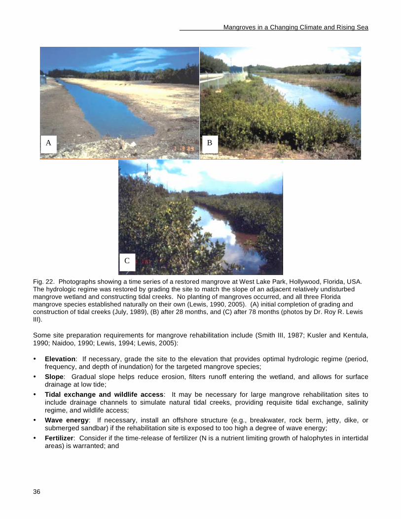
Mangroves in a Changing Climate and Rising Sea
36
Fig. 22. Photographs showing a time series of a restored mangrove at West Lake Park, Hollywood, Florida, USA. The hydrologic regime was restored by grading the site to match the slope of an adjacent relatively undisturbed mangrove wetland and constructing tidal creeks. No planting of mangroves occurred, and all three Florida mangrove species established naturally on their own (Lewis, 1990, 2005). (A) initial completion of grading and construction of tidal creeks (July, 1989), (B) after 28 months, and (C) after 78 months (photos by Dr. Roy R. Lewis III).
Some site preparation requirements for mangrove rehabilitation include (Smith III, 1987; Kusler and Kentula, 1990; Naidoo, 1990; Lewis, 1994; Lewis, 2005):
• Elevation: If necessary, grade the site to the elevation that provides optimal hydrologic regime (period, frequency, and depth of inundation) for the targeted mangrove species;
• Slope: Gradual slope helps reduce erosion, filters runoff entering the wetland, and allows for surface drainage at low tide;
• Tidal exchange and wildlife access: It may be necessary for large mangrove rehabilitation sites to include drainage channels to simulate natural tidal creeks, providing requisite tidal exchange, salinity regime, and wildlife access;
• Wave energy: If necessary, install an offshore structure (e.g., breakwater, rock berm, jetty, dike, or submerged sandbar) if the rehabilitation site is exposed to too high a degree of wave energy;
• Fertilizer: Consider if the time-release of fertilizer (N is a nutrient limiting growth of halophytes in intertidal areas) is warranted; and
A B
C
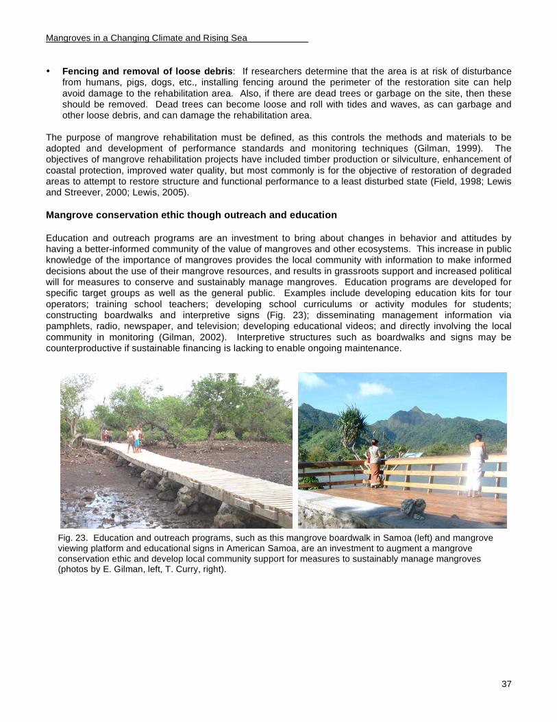
Mangroves in a Changing Climate and Rising Sea
37
• Fencing and removal of loose debris: If researchers determine that the area is at risk of disturbance from humans, pigs, dogs, etc., installing fencing around the perimeter of the restoration site can help
avoid damage to the rehabilitation area. Also, if there are dead trees or garbage on the site, then these should be removed. Dead trees can become loose and roll with tides and waves, as can garbage and other loose debris, and can damage the rehabilitation area.
The purpose of mangrove rehabilitation must be defined, as this controls the methods and materials to be adopted and development of performance standards and monitoring techniques (Gilman, 1999). The objectives of mangrove rehabilitation projects have included timber production or silviculture, enhancement of
coastal protection, improved water quality, but most commonly is for the objective of restoration of degraded areas to attempt to restore structure and functional performance to a least disturbed state (Field, 1998; Lewis and Streever, 2000; Lewis, 2005).
Mangrove conservation ethic though outreach and education
Education and outreach programs are an investment to bring about changes in behavior and attitudes by having a better-informed community of the value of mangroves and other ecosystems. This increase in public knowledge of the importance of mangroves provides the local community with information to make informed
decisions about the use of their mangrove resources, and results in grassroots support and increased political will for measures to conserve and sustainably manage mangroves. Education programs are developed for specific target groups as well as the general public. Examples include developing education kits for tour
operators; training school teachers; developing school curriculums or activity modules for students; constructing boardwalks and interpretive signs (Fig. 23); disseminating management information via pamphlets, radio, newspaper, and television; developing educational videos; and directly involving the local
community in monitoring (Gilman, 2002). Interpretive structures such as boardwalks and signs may be counterproductive if sustainable financing is lacking to enable ongoing maintenance.
Fig. 23. Education and outreach programs, such as this mangrove boardwalk in Samoa (left) and mangrove viewing platform and educational signs in American Samoa, are an investment to augment a mangrove conservation ethic and develop local community support for measures to sustainably manage mangroves (photos by E. Gilman, left, T. Curry, right).
Mangroves in a Changing Climate and Rising Sea
38
Regional and International Initiatives
Beginning of international attention to threats to small island states from global climate effects
The First World Climate Conference in 1979 recognized the threat posed by climate change (Acosta et al., 1999). Concern about the impacts of climate change and sea level rise on Small Island States first received
In Brief
The study of the capacity of the Pacific Islands region to assess the vulnerability of mangroves and adapt to mangrove responses to climate change effects contribute to several other regional and international initiatives.
• The United Nations Environment Programme Regional Seas Programme sponsored this study to contribute to implementing the Regional Seas Strategic Directions for 2004-2007. This calls for the use of Regional Seas as a platform for developing common regional objectives, promoting synergies and coordinated regional implementation of relevant Multilateral Environmental Agreements, global and
regional initiatives and other international actors, as a contribution to the sustainable management of the coastal and marine environment.
• The Secretariat of the Pacific Regional Environmental Programme sponsored this study, in part, to contribute to implementing its Regional Wetlands Action Plan for the Pacific Islands, which identifies priority management, capacity-building, and research and monitoring regional activities for mangroves.
• The Western Pacific Regional Fishery Management Council sponsored this study as results and recommendations are contributing to the development of new integrated, place-based Fishery Ecosystem Plans.
• Results support the development of National Communication Reports to the United Nations Framework Climate Change Convention (UNFCCC), development and implementation of plans for National
Adaptation Programmes of Action, and preparation of subsequent Assessment Reports by the Intergovernmental Panel on Climate Change. Pacific Island governments’ National Communication reports to UNFCCC highlight that there is a gap in information on anticipated site-specific responses of
mangroves and other coastal ecosystems to climate change effects, on identifying sections of coastline and areas of sensitive coastal ecosystems that are especially vulnerable to these forces, and how to plan to adapt to these forces to minimize social disruption and minimize and offset anticipated losses of coastal ecosystems.
• This study advances the Ramsar Convention on Wetlands’ (i) Resolution on climate change and wetlands, (ii) Wise Use guidelines, and (iii) Management Planning Guidelines.
• This study contributes to attaining the Millennium Development Goals, adopted at the United Nations Millennium Summit in 2000, including ensuring environmental sustainability.
• This study contributes to the United Nation’s Millennium Ecosystem Assessment, which inventories global ecosystem services, assesses how changes in ecosystem services have affected human wellbeing, considers how ecosystem changes may affect people in future decades, and identifies alternative management responses.
• Results contribute to meeting the Convention on Biological Diversity and World Summit on
Sustainable Development Biodiversity Targets, to achieve by 2010 a significant reduction of the current rate of biodiversity loss at the global, regional and national levels as a contribution to poverty alleviation and to the benefit of all life on earth.
• The study can contribute to the Convention on Biological Diversity’s programme of work on Island Biodiversity.
• Results support objectives of the Bali Strategic Plan to meet capacity building needs in the Pacific Islands region.
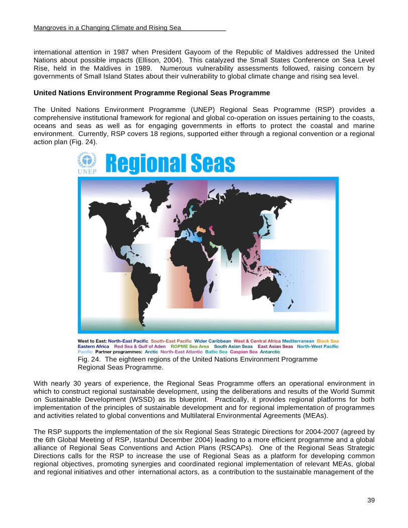
Mangroves in a Changing Climate and Rising Sea
39
international attention in 1987 when President Gayoom of the Republic of Maldives addressed the United Nations about possible impacts (Ellison, 2004). This catalyzed the Small States Conference on Sea Level
Rise, held in the Maldives in 1989. Numerous vulnerability assessments followed, raising concern by governments of Small Island States about their vulnerability to global climate change and rising sea level.
United Nations Environment Programme Regional Seas Programme
The United Nations Environment Programme (UNEP) Regional Seas Programme (RSP) provides a
comprehensive institutional framework for regional and global co-operation on issues pertaining to the coasts, oceans and seas as well as for engaging governments in efforts to protect the coastal and marine environment. Currently, RSP covers 18 regions, supported either through a regional convention or a regional
action plan (Fig. 24).
Fig. 24. The eighteen regions of the United Nations Environment Programme Regional Seas Programme.
With nearly 30 years of experience, the Regional Seas Programme offers an operational environment in which to construct regional sustainable development, using the deliberations and results of the World Summit on Sustainable Development (WSSD) as its blueprint. Practically, it provides regional platforms for both
implementation of the principles of sustainable development and for regional implementation of programmes and activities related to global conventions and Multilateral Environmental Agreements (MEAs).
The RSP supports the implementation of the six Regional Seas Strategic Directions for 2004-2007 (agreed by the 6th Global Meeting of RSP, Istanbul December 2004) leading to a more efficient programme and a global alliance of Regional Seas Conventions and Action Plans (RSCAPs). One of the Regional Seas Strategic
Directions calls for the RSP to increase the use of Regional Seas as a platform for developing common regional objectives, promoting synergies and coordinated regional implementation of relevant MEAs, global and regional initiatives and other international actors, as a contribution to the sustainable management of the

Mangroves in a Changing Climate and Rising Sea
40
coastal and marine environment. It is within this context that RSP has cooperated with SPREP and the Western Pacific Regional Fishery Management Council on the issue mangrove responses to sea level and
climate change. One of the priority areas for the RSP is the conservation and management of marine and coastal ecosystems.
The overarching goal of ecosystem-based management is to protect and restore natural functioning to ensure the provision of ecosystem services. Marine ecosystem-based management is important, for example, for fisheries management and for maintaining important habitats for endangered sea turtles and marine mammals. Marine ecosystems around the globe are experiencing unprecedented change. Human activities,
including aquaculture, coastal development, fisheries, and introduction of invasive species, present a cumulative threat to our oceans. Coral reefs are among the most productive and diverse of all natural ecosystems but recent decades have seen 10 percent of the world’s reefs degraded beyond recovery, with
another 30 percent in decline. In addition, biologically rich coastal wetlands, including mangrove forests and salt marshes, are favorite sites for dredging and filling by industry, farmers and home builders and are threatened by global warming and rising sea levels.
The RSP is trying to help countries to work together to protect mangrove ecosystems, recognizing that success involves transboundary action, regional cooperation and clear demonstration of successful
approaches. Establishing effective protected areas is one approach to provide a measure of protection to coastal and marine ecosystems. Efforts to protect mangroves and other wetland habitats are underway in the RSP, through programmes of Integrated Coastal Zone Management and establishment of Specially-Protected Areas.
The Small Islands Developing States' Programme of Action (SIDS/POA) explicitly identifies coastal and marine resources as requiring urgent action. It calls for the establishment and strengthening of programmes
within the framework of the GPA and the Regional Seas programmes, to assess the impact of planning and development on the coastal environment, including coastal communities, wetlands, coral reefs and areas under the national jurisdiction of SIDS, and to implement the POA.
As a group, SIDS have special needs if they are to develop in a sustainable way. They share characteristics that make them economically, environmentally and socially vulnerable to forces over which they exercise little
or no control, placing them at a distinct disadvantage in comparison with larger countries. The marine and coastal environments of SIDS represent a vital resource for socio-economic development. The ecosystems of SIDS are much more fragile than those of countries with larger landmasses. Since the ecosystems of SIDS are already under stress, they are consequently more vulnerable to the negative impacts of climate change
and sea level rise. The sensitivity and excessive fragility of the ecosystems of SIDS are partly a function of the population’s management practices and increasing demands for resources. The coastal areas of SIDS contain some of the worlds most diverse and productive ecosystems, including mangrove forests, coral reefs,
and sea grasses. Low-lying deltas, coral atolls and reefs are particularly sensitive to changes in the frequency and intensity of rainfall and storms. The biological diversity of SIDS – the source of enormous environmental, economic, and cultural value – will be threatened by rapid climate change.
The Regional Seas Programme provides an important globally coordinated, region-wide mechanism to implement all relevant global environmental conventions and agreements. Though SIDS predominate in
mainly two regions; the Wider Caribbean and the Pacific, all SIDS are part of a Regional Seas programme. The international Meeting for the Ten-Year Review of the Barbados Programme of Action (BPOA) for the sustainable development of SIDS resulted in the Mauritius Strategy for the further implementation of the
Programme of Action for the Sustainable Development of SIDS. UNEP has prepared a workplan to internalize the Mauritius Strategy in alignment with the BPOA. A Memorandum of Understanding covering the annual programme of work to renew cooperation with the Secretariat of the Pacific Regional Environment
Programme was signed in May 2005.
Mangroves in a Changing Climate and Rising Sea
41
As part of its support to Small Island Developing States, UNEP is supporting workshops and training courses to build capacities of SIDS to develop and implement strategies for sustainable development and
management of their marine and coastal areas. Also, in 2005, UNEP/RSP supported the Government of Samoa to increase awareness on mangroves by printing the booklet “Mangroves of Samoa: Status and Conservation”. The booklet is a means of conveying the message that the problem of mangrove ecosystem
degradation is quite serious in Samoa and remedial action needs to be taken immediately to ensure that the future generations of Samoa benefit from services and products provided by mangroves.
Secretariat of the Pacific Regional Environment Programme
The Secretariat of the Pacific Regional Environment Programme (SPREP), a regional intergovernmental
organization based in Apia, Samoa, was established in 1982 through the UNEP Regional Seas Programme as a programme of the South Pacific Commission to confront threats to the marine and coastal environment. SPREP is the primary regional organization concerned with environmental management in the Pacific, and
serves as the Secretariat for three regional Conventions. It was previously known as the South Pacific Regional Environment Programme. The 1986 Noumea (or SPREP) Convention for the Protection of the Natural Resources and Environment of the South Pacific Region entered into force in 1990. The 1976 Convention on the Conservation of Nature in the South Pacific, known as the Apia Convention, entered into
force in 1990. It deals with protected areas, representative samples of natural ecosystems, geological formations, and sites of aesthetic, historic cultural or scientific value. The 1995 Convention to Ban the Importation into Forum Island Countries of Hazardous and Radioactive Wastes and to Control the
Transboundary Movement and Management of Hazardous Wastes within the South Pacific Region (Waigani Convention) entered into force in 2001. SPREP member States and territories are American Samoa, Australia, Commonwealth of the Northern Mariana Islands, Cook Islands, Federated States of Micronesia, Fiji,
France, French Polynesia, Guam, Kiribati, Marshall Islands, Nauru, New Caledonia, New Zealand, Niue, Palau, Papua New Guinea, Samoa, Solomon Islands, Tonga, Tuvalu, United Kingdom, United States of America, Vanuatu, and Wallis and Futuna.
SPREP’s activities are guided by the Action Plan for Managing the Environment of the Pacific Islands Region as well as the SPREP Convention. The development and implementation of the Action Plan is the responsibility of the 25 countries and territories that make up the region (all 21 Pacific Island countries and
territories, and four developed countries with direct interests in the region: Australia, France, New Zealand, and the United States of America). SPREP has been assisting countries to comply with Conventions and Agreements on marine conservation and sustainable development, by targeting five main areas: education
and awareness; monitoring, assessment and research; capacity building; legislation; and the creation of networks and sharing of experiences between communities and amongst programmes. The current Action Plan (2005-2009) identifies natural resources management, pollution prevention, climate change and
variability, sea level rise and stratospheric ozone depletion, along with a number of cross cutting issues, as broad focus areas for the region.
In 2004 UNEP/RSP and SPREP signed a framework Memorandum of Understanding, which provides the platform for developing joint activities. Within this context, UNEP/RSP supported SPREP and the Basel Convention to develop preliminary elements for an Integrated Waste Management Strategy for Pacific Island States. The purpose of this paper was to describe the state of problems encountered by Pacific Island
countries in managing hazardous waste and explore possible improvements through the integrated management of solid and hazardous wastes. The paper also raised awareness in the international community and Pacific Island region of benefits from an integrated waste management approach.
In 2004 SPREP moved from a project-based approach to a more coordinated approach through managing activities under two overarching programmes. SPREP’s switch to this new structure was made to enable a
more systematic and longer-term approach to addressing environmental issues, and occurred in parallel with programme funding becoming available from SPREP’s major donors. The two new programmes are:
Mangroves in a Changing Climate and Rising Sea
42
• Island Ecosystems: The Islands Ecosystems Programme focuses on sustainably managing and conserving terrestrial, coastal and marine ecosystems of Pacific Islands. It works to conserve priority
threatened species and reduce the impact of alien, invasive species and living modified organisms. It also has a crosscutting capacity-building component.
• Pacific Futures: The Pacific Futures Programme focuses on sustainable development policies for improved environmental governance; capacity to monitor and report on environmental performance and socioeconomic pressures on the environment; capacity to respond to climate change, climate variability
and sea level rise; management and response to marine pollution, hazardous waste, solid waste, sewerage and other land-based sources of pollution; and integrated assessment and planning. It also features the coordination and development of partnership mechanisms that provide new and improved
collaboration, coordination and effective implementation as well as leveraging and use of resources. Pacific Futures has an element related to the development, support and implementation of integrated regional strategies for environmental management and sustainable development.
SPREP’s nine components under these two programmes are (i) Terrestrial Island Ecosystems, (ii) Coastal and Marine Ecosystems, (iii) Species of Special Interest, (iv) People & Institutions, (v) Managing Multilateral Environment Agreements & Regional Coordination Mechanisms, (vi) Environment Monitoring & Reporting,
(vii) Climate Change, Climate Variability, Sea Level Rise & Stratospheric Ozone Depletion, (viii) Waste Management & Pollution Control, and (ix) Environment Policy & Planning.
SPREP’s Pacific Islands Climate Change Assistance Programme was a three-year initiative funded by the Global Environment Facility from 1997-2000 to assist ten Pacific Island countries that signed and ratified the United Nations Framework Climate Change Convention with their reporting, training and capacity-building
under the convention, including assessing their vulnerability to climate change. Participants from 12 countries (Papua New Guinea was the one participating country with indigenous mangroves) received training on assessing climate change vulnerability and adaptation requirements during a six-month training course in
1998. Under this program, SPREP produced a document, “Adapting to Climate Change: Incorporating Climate Change Adaptation into Development Activities in Pacific Island Countries: A Set of Guidelines for Policymakers and Development Planners,” (South Pacific Regional Environment Programme, 2000). The document presents general guidelines for Pacific Island governments to incorporate considerations of sea
level and climate change into new development planning. The Regional Wetlands Action Plan for the Pacific Islands (South Pacific Regional Environment Programme,
1999b) specifies regional actions to monitor mangroves. Action 3.3.1 calls for the development of a regional monitoring program to assess the status of mangroves in the region, evaluate the success of management and conservation actions and develop more effective management practices. Furthermore, Action 3.3.5
identifies that mangroves, particularly those of low islands, are likely to be sensitive to rise in sea level. It promotes the development of a mangrove-monitoring network for identification of changes.
SPREP implemented the progamme, “Capacity Building for the Development of Adaptation Measures in Pacific Island Countries,” in the Cook Islands, Fiji, Samoa, and Vanuatu from 2002-2005. The project’s aim was to build capacity of communities of these four countries to adapt to climate change, including incorporation of climate change adaptation considerations into national and sectoral planning and budgeting.
The project focused on socioeconomic effects and policy development, and did not address coastal ecosystem responses to sea level and climate change forces. As part of this programme, SPREP conducted seminars for senior government officials from the four participating countries and produced and distributed
briefing papers and educational materials to raise awareness of climate change effects and adaptation (Secretariat of the Pacific Regional Environment Programme, 2003).
Western Pacific Regional Fishery Management Council
In 1976, the U.S. established jurisdiction over fisheries in federal waters through the Magnuson Fishery
Conservation and Management Act, which created eight quasi-federal regional councils to oversee fisheries in
Mangroves in a Changing Climate and Rising Sea
43
their respective areas. Under the Magnuson-Stevens Act, the Western Pacific Regional Fishery Management Council is the policy-making organization for the management of fisheries in the Exclusive Economic Zone
surrounding the U.S. insular possessions in the tropical western Pacific. The Western Pacific Council makes policy for the management of fisheries in the EEZs adjacent to the Territory of American Samoa, Territory of Guam, State of Hawaii, the Commonwealth of the Northern Mariana Islands, and U.S. Pacific Island
possessions of Jarvis Island, Howland and Baker Islands, Palmyra Island, Kingman Reef, Johnston Island, and Wake Island. This constitutes an area of over 5.1 million km
2, the largest EEZ management area of the
U.S. regional fishery management councils, representing about half of the total EEZ waters under U.S. jurisdiction.
The main task of the Council is to protect fishery resources while maintaining opportunities for domestic fishing at sustainable levels of effort and yield. To accomplish this, the Council monitors fisheries within its
region and prepares and modifies fishery management plans as needed. The Council develops fishery management plans by following the management principles and scientific requirements of the Magnuson Stevens Fishery Conservation and Management Act and by being guided by the social, cultural, and
economic values and realities of our island communities. The Western Pacific Council’s interest in mangroves is due to mangrove wetlands’ functional links with other
Pacific Island coastal ecosystems and the important contribution of mangroves to nearshore fisheries production. Moreover, the Council has recently begun to replace its existing suite of Fishery Management Plans (FMPs) with integrated ecosystem-based plans for each island archipelago. The results and recommendations stemming from this study are contributing to the development of these new place-based
Fishery Ecosystem Plans.
Intergovernmental Panel on Climate Change The Intergovernmental Panel on Climate Change (IPCC) was established in 1988 by the United Nations
Environment Programme and the World Meteorological Organization. It was given a mandate to assess the state of knowledge on the climate system and climate change, impacts of climate change, and strategies for response to climate change (Acosta et al., 1999). Since the first release in 1999 of the IPCC’s assessment report on the scientific basis for climate change and projected impacts, it is no longer a hypothesis but
accepted as fact that humans have induced climate change and increased the rate of global sea level rise over human time scales from the emissions of greenhouse gases and aerosols (Houghton et al., 2001; McCarthy et al., 2001).
United Nations Framework Convention on Climate Change
The United Nations Framework Convention on Climate Change (UNFCCC) was adopted in 1992 one month before the 1992 Rio Earth Summit and entered into force in 1994 (Acosta et al., 1999). The UNFCCC’s mission is to stabilize, “greenhouse gas concentrations in the atmosphere at a level that would prevent
dangerous anthropogenic interference with the climate system,” (Climate Change Secretariat, 2004). At the Third Conference of the Parties of the UNFCCC in 1997, the parties adopted by consensus the Kyoto Protocol, which creates a legally binding commitment for developed, industrialized countries to reduce their
collective emissions of six key greenhouse gases by at least 5% compared to 1990 levels by the period 2008-2012 (Acosta et al., 1999). The Kyoto Protocol was opened for signatures in 1998, and required ratification by at least 55 Parties to the UNFCCC, with developed countries representing at least 55% of the total 1990
carbon dioxide emissions from this group (Acosta et al., 1999). The Kyoto Protocol entered into force on 16 February 2005. As of this date, there were 128 Contracting Parties to the Kyoto Protocol, including 30 industrialized countries. Only four industrialized countries have not ratified the Kyoto Protocol: they are Australia, Liechtenstein, Monaco, and the United States. Australia and the United States account for over one
third of the greenhouse gases emitted by industrialized countries.
Mangroves in a Changing Climate and Rising Sea
44
A central feature of the UNFCCC and Kyoto Protocol is to provide developed countries with flexible means to meet requirements to reduce greenhouse gas emissions. The Clean Development Mechanism is a financial
mechanism that enables developed countries to offset reduction targets through contributing to development projects that contribute to reducing greenhouse gas emissions in developing countries (Campbell, 2000). Article 12, Paragraph 8 of the Kyoto Protocol states that, “a share of the proceeds from certified project
activities (funds generated by the Clean Development Mechanism) [will be] used…to assist developing country Parties that are particularly vulnerable to the adverse effects of climate change to meet the costs of adaptation” (Campbell, 2000). The UNFCCC identifies small island countries as being among the most vulnerable.
All twelve Pacific Island countries with indigenous mangroves are Parties to UNFCCC. Of these, eleven countries (Kiribati, Marshall Islands, Federated States of Micronesia, Nauru, Palau, Papua New Guinea,
Samoa, Solomon Islands, Tonga, Tuvalu, and Vanuatu) have submitted an initial National Communication to the UNFCCC. Fiji has not yet submitted a National Communication. The eleven initial National Communications discuss general considerations and guidelines related to coastal ecosystem vulnerability and
adaptation to future sea level and climate change (Federated States of Micronesia, 1997; Government of Samoa, 1999; Government of Tuvalu, 1999; Kiribati Government, 1999; Republic of Nauru, 1999; Republic of Vanuatu, 1999; Papua New Guinea Government, 2000; Republic of the Marshall Islands Environmental
Protection Authority, 2000; Republic of Palau Office of Environmental Response and Coordination, 2002; Solomon Islands Government, 2004; Kingdom of Tonga, 2005). The reports do not discuss results of any assessments of the vulnerability of coastal habitats to sea level or climate change or discuss site-specific strategies for adaptation. The National Communication reports highlight that there is a gap in information on
anticipated site-specific responses of mangroves and other coastal ecosystems to changes in climate and relative sea level, on identifying sections of coastline and areas of sensitive coastal ecosystems that are especially vulnerable to these forces, and how to plan to adapt to these changes in order to minimize social
disruption and minimize and offset anticipated losses of coastal ecosystems. Examples of some of the general adaptation strategies to manage the response of mangroves and other coastal areas to sea level and climate change identified in the National Communication reports follow. These examples are representative
of the level of specificity in the National Communication reports to assess the vulnerability of and adapt to coastal ecosystem response to sea level and climate change.
• Establish zoning rules for setbacks of new development from mangroves (Republic of Palau Office of Environmental Response and Coordination, 2002; Solomon Islands Government, 2004);
• Retreat to higher ground or off-island for appropriate sections of coastline as a last resort option (Kiribati Government, 1999; Republic of the Marshall Islands Environmental Protection Authority, 2000; Republic of Palau Office of Environmental Response and Coordination, 2002; Solomon Islands Government, 2004);
• Fortify relevant sections of developed coastline. Promote the use of soft coastal erosion
protection measures such as revegetation and other traditional coastal erosion control methods over hard measures such as seawalls (Federated States of Micronesia, 1997; Government of Samoa, 1999; Kiribati Government, 1999; Papua New Guinea Government, 2000; Republic of the
Marshall Islands Environmental Protection Authority, 2000; Republic of Palau Office of Environmental Response and Coordination, 2002);
• Identify sections of coastal areas vulnerable to flooding and inundation to guide future development and incorporate projected relative sea level rise scenarios into master planning (Federated States of Micronesia, 1997; Republic of Vanuatu, 1999; Papua New Guinea Government, 2000; Republic of Palau Office of Environmental Response and Coordination, 2002);
• Rehabilitate mangroves (Federated States of Micronesia, 1997; Republic of Palau Office of Environmental Response and Coordination, 2002);
• Re-vegetate the coastal strand to reduce erosion (Republic of Nauru, 1999; Government of Samoa, 1999; Republic of Palau Office of Environmental Response and Coordination, 2002; Solomon Islands Government, 2004; Kingdom of Tonga, 2005);
Mangroves in a Changing Climate and Rising Sea
45
• Prevent unsustainable cutting and clearing of mangrove trees, discharge of pollutants, and reduce and eliminate other anthropogenic stresses on mangroves, to increase resilience to sea level and
climate change (Federated States of Micronesia, 1997; Republic of Vanuatu, 1999; Republic of Palau Office of Environmental Response and Coordination, 2002; Solomon Islands Government, 2004);
• Discourage reclamation (filling of mangroves and other coastal habitats for development) and government leasing of mangroves for development (Government of Samoa, 1999; Republic of Palau Office of Environmental Response and Coordination, 2002);
• Institute integrated coastal zone management, including improved institutional coordination for coastal management (Government of Samoa, 1999; Papua New Guinea Government, 2000); and
• Raise public awareness of problems and strategies to adapt to sea level and climate change and the value of mangroves (Government of Samoa, 1999; Government of Tuvalu, 1999; Republic of Nauru, 1999; Republic of Palau Office of Environmental Response and Coordination, 2002; Solomon Islands Government, 2004); and
• Raise institutional capacity to plan and implement adaptation strategies, and develop appropriate
legislation (Republic of Nauru, 1999; Papua New Guinea Government, 2000; Republic of the Marshall Islands Environmental Protection Authority, 2000; Solomon Islands Government, 2004).
Ramsar Convention on Wetlands The Convention on Wetlands of International Importance especially as Waterfowl Habitat, an intergovernmental treaty adopted in 1971 in the Iranian city of Ramsar, came into force in 1975, and has
come to be known as the Ramsar Convention. The Ramsar Convention provides the framework for national action and international cooperation for the conservation and wise use of wetlands and their resources. As of May 2006, 152 States have become Contracting Parties to the Convention, and these Contracting Parties have designated 1,596 sites for inclusion on the Ramsar List of Wetlands of International Importance,
covering over 134 million hectares. The Ramsar Convention recognizes the importance of wetlands as key elements of inland waterways and coastal systems. The Convention espouses the “wise use” of wetlands, managing these areas to retain their ability to provide valued services for future generations. The Ramsar
Convention created the List of Wetlands of International Importance, or the “Ramsar List,” which includes sites identified by the Contracting Parties as meeting the Convention criteria. The Ramsar Convention assists countries to develop and implement national policy and legislative frameworks, education and outreach
programs, inventory projects, research efforts, and training projects. The Ramsar Convention also provides a vehicle for regional and international collaboration between countries for the management of shared wetland systems and species.
The study of the capacity of Pacific Island countries and territories to assess the vulnerability of their mangrove resources to climate change effects and to adapt to mangrove responses to these forces advances
the Ramsar Convention’s Resolution VIII.3 on climate change and wetlands, which highlights the need for advanced land-use planning, adaptation, and mitigation to prepare for the effects on wetlands from climate and sea level change. The study also advances the Ramsar Convention’s Wise Use guidelines (Recommendation 4.10 and Resolution 5.6) and Management Planning Guidelines (Resolution 5.7). Millennium Development Goals
At the United Nations Millennium Summit held in September 2000, 147 Heads of State adopted eight Millennium Development Goals (MDGs), which set targets to reduce poverty, hunger, disease, illiteracy, environmental degradation and discrimination against women by 2015 (United Nations Development
Programme, 2005). One of the eight MDGs is to ensure environmental sustainability, meeting human needs without undermining the capacity of the planet’s ecological systems to support life over the long term. The three targets of this goal are to:
Mangroves in a Changing Climate and Rising Sea
46
• Integrate the principles of sustainable development into country policies and programmes and reverse the loss of environmental resources;
• Reduce by half the proportion of people without sustainable access to safe drinking water; and
• Achieve significant improvement in lives of at least 100 million slum dwellers, by 2020.
MDGs are a framework for sustainable development, setting social equity goals and targets that contribute to economic development while ensuring environmental sustainability.
Millennium Ecosystem Assessment
The Millennium Ecosystem Assessment (MEA) is an international work program designed to meet the needs
of decision makers and the public for scientific information concerning the consequences of ecosystem change for human wellbeing and options for responding to those changes. MEA has conducted a global inventory of the state of ecosystems, quantifies the effect that human activities are having on ecosystems and
makes suggestions for future actions. MEA was launched by the United Nations Secretary - General in June 2001 and was completed in March 2005. It is designed, in part, to help meet assessment needs of the Convention on Biological Diversity, Convention to Combat Desertification, the Ramsar Convention on Wetlands, and the Convention on Migratory Species. MEA focuses on ecosystem services, how changes in
ecosystem services have affected human wellbeing, how ecosystem changes may affect people in future decades, and alternative responses that can be taken at local, national, or global scales to improve ecosystem management. One of MEA’s reports, Ecosystems and Human Well-being: Wetlands and Water
Synthesis, was designed for the Ramsar Convention to meet the need for information about the consequences of ecosystem change for human wellbeing and sought to strengthen the link between scientific knowledge and decision-making for the conservation and wise use of wetlands. Integrated assessments may
be repeated every 5– 10 years and ecosystem assessments may be regularly conducted at national or sub-national scales.
Convention on Biological Diversity and World Summit on Sustainable Development Biodiversity
Targets
To address global biodiversity loss, in 2002 the Conference of the Parties to the Convention on Biological Diversity adopted a Strategic Plan to implement the convention. In its mission statement, Parties committed themselves to a more effective and coherent implementation of the three objectives of the Convention, to
achieve by 2010 a significant reduction of the current rate of biodiversity loss at global, regional and national levels as a contribution to poverty alleviation and to benefit all life on earth. This target was subsequently endorsed by the 2002 World Summit on Sustainable Development (Earth Summit II or Rio + 10). The
Conference of the Parties identified seven focal areas and agreed on a limited number of trial indicators, to assess progress at the global level towards the 2010 target, and to effectively communicate trends in biodiversity related to the three objectives of the Convention. For each of the seven focal areas, goals and
sub-targets and indicators have been identified (http://www.biodiv.org/2010-target/default.asp).
Convention on Biological Diversity Island Biodiversity Programme of Work
In 2004 at its seventh meeting the Conference of the Parties to the Convention on Biological Diversity established a new thematic programme of work on Island Biodiversity. This thematic programme establishes a vision for, and basic principles to guide, future work; sets out key issues for consideration; identifies
potential outputs; and suggests a timetable and means for achieving these outputs. The convention secretariat is in the process of establishing an Ad Hoc Technical Expert Group on Island Biodiversity (http://www.biodiv.org/programmes/areas/island/).
Mangroves in a Changing Climate and Rising Sea
47
Bali Strategic Plan Capacity building is increasingly an explicit priority for UNEP. The 2002 UNEP Governing Council/Global Ministerial Environment Forum’s (GC/GMEF) review of international environmental governance identified the
need for an Intergovernmental Strategic Plan for Technology Support and Capacity Building to improve the effectiveness of capacity building and to address the gaps identified by assessments of existing activities and needs. The Bali Strategic Plan for Technology Support and Capacity-building was adopted by the High-level
Open-ended Intergovernmental Working Group on an Intergovernmental Strategic Plan for Technology Support and Capacity-building at its third session in Bali, Indonesia in 2004. The Bali Strategic Plan is an intergovernmental agreed approach to strengthening technology support and capacity building in developing countries and countries with economies in transition. It stresses that capacity building should respond to
needs and priorities of countries in a holistic approach and be in line with regional and sub-regional environmental initiatives. The capacity needs of the Pacific Islands identified in this report are in line with the Bali Strategic Plan objectives.
Pacific Island vulnerability assessments
Due to anticipated effects of sea level and climate change in the Pacific Islands region, several international
and regional initiatives discuss the severity of this threat and provide general guidelines for planning. However, there have been few site-based vulnerability assessments or identification of alternatives for site-based management of mangrove and other coastal ecosystems’ responses to sea level and climate change.
There have been several national or island-scale vulnerability assessments in Pacific Island countries and territories that provide qualitative assessments to describe the anticipated response of coastal systems to
projected sea level and climate change and concomitant threats to developed portions of the coastal zone. For example, Phillips (2000) describes the vulnerability of Vanuatu’s coastal villages to sea level rise, where the population is concentrated on narrow coastal plains of high volcanic islands, referencing global sea level
rise models produced by the Intergovernmental Panel on Climate Change and other projected global climate change parameters (temperature and precipitation), as a basis for hypothesizing possible environmental, social, and economic effects. Other vulnerability assessments have established the locations and elevations of coastal habitats and development and use global or relative sea level change projections to make rough
predictions of the sections of coastline that will be affected. For example, Solomon et al. (1997) create a GIS of a developed stretch of the coastline of Viti Levu, Fiji using existing topographic maps to identify the locations and elevations of coastal development, including sea walls, revetments, and other shoreline
protection structures. They then use this GIS to assess the vulnerability of the coastline to inundation from four sea level rise scenarios and storm surges. This latter approach to conducting a vulnerability assessment does not incorporate natural coastal ecosystem responses to changes in sea level and climate. Other initiatives
The “South Pacific Sea Level and Climate Monitoring Project” was initiated in 1991 to establish stations in
eleven Pacific Island countries to measure the relative motions of land and sea at each station (South Pacific Sea Level and Climate Monitoring Project, 2001). The project is funded by AusAID and managed by the National Tidal Facility, based at the Flinders University of South Australia. These data will assist in long-term
calibration of satellite altimetry and radio astronomy and provide a measure of regional vertical control, and exchange information and data with national, regional and international climate change centers.
The South Pacific Applied Geoscience Commission (SOPAC) has developed an environmental vulnerability index for application at national scales to provide a quick and inexpensive method to characterize the vulnerability of natural systems at large scales. It is not designed for site-based vulnerability assessments
(South Pacific Applied Geoscience Commission, 2003). SOPAC produced a report, Towards Managing Environmental Vulnerability in Small Island Developing States ( SIDS ) ( Kaly et al., 2002 ), which includes a
Mangroves in a Changing Climate and Rising Sea
48
general discussion of possible hazards to small island developing states resulting from sea level and climate change.
The World Bank report, Cities, Seas, and Storms: Managing Change in Pacific Island Economies, includes a general, broad discussion of the importance of planning to adapt to climate change and general guidelines for
adapting by Pacific Islands (World Bank, 2000).

Mangroves in a Changing Climate and Rising Sea
49
References Acosta, R., M. Allen, A. Cherian, S. Granich, I. Mintzer, A. Suarez, D. von Hippel. 1999. Climate Change
Information Sheets. United Nations Environment Programme, Information Unit for Conventions: Chatelaine, Switzerland.
Allen, J.A.. 1998. Mangroves as alien species: the case of Hawaii. Global Ecology and Biogeography Letters,
7:61-71. Alleng, G. 1998. Historical development of the Port Royal mangrove wetland, Jamaica. Journal of Coastal
Research 14(3): 951-959.
Aloua Ma’a Tonga Association. 2001. Mangrove rehabilitation programme photographic report, 1 March – 30 Sept. 2001. Nuku’alofa, Tonga.
Anderson, S., R. Zepp, J. Machula, D. Santavy, L. Hansen, F. Mueller. 2001. Indicators of UV Exposure in Corals and their Relevance to Global Climate Change and Coral Bleaching. Human and Ecological Risk
Assessment 7(5): 1271-1282. Baede, A., E. Ahlonsou, Y. Ding, D. Schimel. 2001. Chapter 1. The Climate System: An Overview. Pp. 85-
98 IN Houghton, J., Y, Ding, D. Griggs, M. Noguer, P. van der Linden, X. Dai, K. Maskell, C. Johnson,
eds. Climate Change 2001: The Scientific Basis. Published for the Intergovernmental Panel on Climate Change. Cambridge University Press, Cambridge, United Kingdom, and New York, NY, USA, 881 pp.
Barber, C.V., K. Miller, M. Boness (Eds.). 2004. Securing Protected Areas in the Face of Global Change:
Issues and Strategies. IUCN, Gland, Switzerland, 234 pp. Bardi, E., S. Mann. 2004. Mangrove Inventory and Assessment Project in American Samoa. Phase 1:
Mangrove Delineation and Preliminary Assessment. Technical Report 45. American Samoa Community
College, Pago Pago, American Samoa. Blaber, S.J., D.A. Milton. 1990. Species composition, community structure and zoogeography of fishes of
mangrove estuaries in the Solomon Islands. Marine Biology 105(2): 259-267. Cahoon, D. R., J. C. Lynch, P. Hensel , R. Boumans, B. C. Perez, B. Segura, and J. W. Day, Jr. 2002a. A
device for high precision measurement of wetland sediment elevation: I. Recent improvements to the sedimentation-erosion table. Journal of Sedimentary Research. Vol. 72, No. 5. pp 730-733.
Cahoon, D. R., J. C. Lynch, B. C. Perez, B. Segura, R. Holland, C. Stelly, G. Stephenson, and P. Hensel.
2002b. A device for high precision measurement of wetland sediment elevation: II. The rod surface elevation table. Journal of Sedimentary Research. Vol. 72, No. 5. pp. 734-739.
Campbell, J. 2000. Adapting to Climate Change. Incorporating Climate Change Adaptation into
Development Activities in Pacific Island Countries: A Set of Guidelines for Policymakers and Development Planners. South Pacific Regional Environment Programme, Apia, Samoa.
Carew-Reid J. 1990. Conservation and protected areas on South-Pacific Islands: The importance of
tradition. Environmental Conservation 17(1):29-38. Cazenave, A., R. Nerem. 2004. Present-day sea level change: Observations and causes. Reviews of
Geophysics 42: 20 pp. Chambers R. 1994. The origins and practice of participatory rural appraisal. World Development 22(7):953-
969. Chmura, G.L., S.C. Anisfeld, D.R. Cahoon, J.C. Lynch. 2003. Global carbon sequestration in tidal, saline
wetland soils. Global Biogeochemical Cycles 17(4): 1111-121.
Choudhuri, P.K.R. 1994. Preliminary observation on control of slumping through mangrove aforestation at Nayachara, West Bengal (India) – A case study. Indian Forester 120:395-399.
Church, J., White, N., Hunter, J. In Review. Sea level rise ion the tropical Pacific and Indian Ocean islands.
Church, J., White, N., Coleman, R., Lambeck, K., and Mitrovica, J. 2004a. Estimates of the regional distribution of sea level rise over the 1950 to 2000 period. Journal of Climate 17: 2609-2625.
Church, J., Hunter, J., McInnes, K., White, N. 2004b. Sea level rise and the frequency of extreme events
around the Australian coastline. IN Coast to Coast '04 – Conference Proceedings, Australia's National Coastal Conference, Hobart, 19-23 April 2004. 8 pp.
Church, J., J. Gregory, P. Huybrechts, M. Kuhn, K. Lambeck, M. Nhuan, D. Qin, P. Woodworth. 2001. Chapter 11. Changes in Sea Level. Pp. 639-693 IN Houghton, J., Y, Ding, D. Griggs, M. Noguer, P. van
der Linden, X. Dai, K. Maskell, C. Johnson, eds. Climate Change 2001: The Scientific Basis. Published
Mangroves in a Changing Climate and Rising Sea
50
for the Intergovernmental Panel on Climate Change. Cambridge University Press, Cambridge, United Kingdom, and New York, NY, USA, 881 pp.
Cicin-Sain B, Knecht RW. 1998. Integrated Coastal and Ocean Management: Concepts and Practices. Washington, D.C., USA: Island Press.
Cicin-Sain B. 1993. Sustainable development and integrated coastal management. Ocean and Coastal
Management 21:11-43. Climate Change Secretariat. 2004. The United Nations Framework Convention on Climate Change and its
Secretariat. United Nations Framework Convention on Climate Change: Bonn, Germany. Czech B, Krausman PR. 1997. Implications of an ecosystem management literature review. Wildlife Society
Bulletin 25:667-675. Davies, J., G. Claridge (editors). 1993. Wetland Benefits: The Potential for Wetlands to Support and
Maintain Development. Asian Wetland Bureau, International Waterfowl and Wetlands Research Bureau,
and Wetlands for the Americas: Kuala Lumpur, Malaysia. de Negri B, Thomas E, Ilinigumugabo A, Muvandi I, Lewis G. 1998. Empowering Communities: Participatory
Techniques for Community-Based Programme Development. Volume 1: Trainer's Manual. Nairobi: The
Centre for African Family Studies. DeLaune, R., Patrick Jr., W., Buresh, R. 1978. Sedimentation rates determined by
137Cs dating in a rapidly
accreting salt marsh. Nature 275: 532-533.
Dixon, J.A., P.B. Sherman. 1990. Economics of Protected Areas. A New Look at Benefits and Costs. Island Press: Washington, D.C., USA.
Donnelly, J., Bertness, M. 2001. Rapid shoreward encroachment of salt marsh cordgrass in response to accelerated sea level rise. PNAS 98(25): 14218-14223.
Duke, N. C. 1992. Mangrove floristics and biogeography. Pp. 63-100 In Tropical Mangrove Ecosystems, A. I. Robertson and D. M. Alongi (eds.). Washington, D.C., USA: American Geophysical Union.
Ellison, J., Gilman, E. 2004. Manual for American Samoa Community-Based Mangrove Monitoring.
Monitoring Changes in Mangrove Community Structure and Response to Relative Sea Level Rise. Pago Pago: American Samoa Coastal Management Program, Department of Commerce.
Ellison, J. 2004. Vulnerability of Fiji’s Mangroves and Associated Coral Reefs to Climate Change. Review
for the World Wildlife Fund. Launceston, Australia: University of Tasmania. Ellison, J. 2001. Possible impacts of predicted sea level rise on South Pacific mangroves. Pp. 289-301 IN
Noye, B., M. Grzechnik (eds.). Sea level Changes and their Effects. Singapore: World Scientific
Publishing Company. Ellison, J. C. 2000. How South Pacific mangroves may respond to predicted climate change and sea level
rise. Chapter 15, pages 289-301 IN A. Gillespie and W.Burns, eds. Climate Change in the South Pacific: Impacts and Responses in Australia, New Zealand, and Small Islands States. Kluwer Academic
Publishers, Dordrecht, Netherlands. Ellison, J. 1999. Status report on Pacific island mangroves. Pp. 3-19 IN L. G. Eldredge, J. E. Maragos, P. L.
Holthus, eds. Marine and Coastal Biodiversity in the Tropical Island Pacific Region: Volume 2.
Population, Development and Conservation Priorities. Pacific Science Association and East West Center, Honolulu.
Ellison, J. 1996. Potential impacts of predicted climate change on mangroves: Implications for marine parks.
Parks, 6(2), 14-24. International Journal for Protected Area Management (IUCN). Ellison, J. 1995. Systematics and distributions of Pacific Island mangroves. Pp. 59-74 IN Maragos, J.E.,
Peterson, M.N.A., Eldredge, L.G., Bardach, J.E., Takeuchi, H.F. (eds.), Marine and Coastal Biodiversity in
the Tropical Island Pacific Region, Vol. 1, Species Systematics and Information Management Priorities. East-West Center, Honolulu, HI, USA.
Ellison, J. 1993. Mangrove retreat with rising sea level, Bermuda. Estuarine Coastal and Shelf Sciences 37: 75-87.
Ellison, J., Stoddart, D. 1991. Mangrove ecosystem collapse during predicted sea level rise: Holocene analogues and implications. Journal of Coastal Research 7(1): 151-165.
Environment Australia. 2000. Migratory Birds, Let’s Ensure Their Future. Wetlands, Waterways and
Waterbirds Unit, Environment Australia, Canberra, Australia. Ewel, K.C. 1997. Water quality improvement by wetlands, pp. 329-344 In Nature’s Services: Societal
Dependence on Natural Ecosystems. Ed. G.C. Daily. Island Press: Washington, D.C., USA.
Mangroves in a Changing Climate and Rising Sea
51
Ewel, K.C., J. Bourgeois, T. Cole, S. Zheng. 1998. Variation in environmental characteristics and vegetation in high-rainfall mangrove forests, Kosrae, Micronesia. Global Ecology and Biogeography Letters 7: 49-56.
FAO. 2003. New Global Mangrove Estimate. Food and Agriculture Organization of the United Nations, Rome, Italy.
Federated States of Micronesia. 1997. 1997 Climate Change National Communication. FSM National
Government, Climate Change Program, Palikir, Pohnpei, FSM. Field, C.D. 1998. Rehabilitation of mangrove ecosystems: An overview. Marine Pollution Bulletin 37: 383-
392. Fletcher, C.H., R.A. Mullane, B. Richmond. 1997. Beach loss along armored shorelines of Oahu, Hawaiian
Islands. Journal of Coastal Research 13: 209-215. Gilman, E., J. Ellison, R. Coleman. In Press. Assessment of mangrove response to projected relative sea
level rise and recent historical reconstruction of shoreline position. Environmental Monitoring and
Assessment. Gilman, E, E. Zollett, S. Beverly, H, Nakano, D. Shiode, K. Davis, P. Dalzell, I. Kinan. 2006. Reducing sea
turtle bycatch in pelagic longline gear. Fish and Fisheries 7: 2-23.
Gilman, E., Ellison, J., Sauni, I., McMurtry, G. 2005a. Accretion in American Samoa Mangroves Based on 137
Cs and Excess 210
Pb Activity Depth Profiles: Implications for Mangrove Vulnerability to Relative Sea level Rise. American Samoa Coastal Management Program, Pago Pago, American Samoa.
Gilman, E., Coleman, R., Hunter, J. 2005b. Trends in Frequency and Elevation of Extreme High Water Events and Causes, American Samoa. University of Tasmania and American Samoa Coastal Management Program, Hobart, Australia and Pago Pago, American Samoa.
Gilman, E. 2004. Assessing and Managing Coastal Ecosystem Response to Sea level and Climate Change.
UNESCO World Heritage Central Pacific Project Planning Workshop, 5-9 October 2004, Kiritimati Island, Republic of Kiribati.
Gilman, E.L. 2002. Guidelines for coastal and marine site-planning and examples of planning and
management intervention tools. Ocean and Coastal Management 45(6-7): 377-404. Gilman, E.L. 1999a. Chapter 1. Compensatory wetland mitigation in the CNMI: An incipient discipline. Pp.
3-17 In: An International Perspective on Wetland Rehabilitation, ed. W. Streever. Kluwer Academic
Publishers, New York, USA. Gilman, E.L. 1999b. Choosing appropriate instruments from the wetlands management toolbox: A planning
process for wetlands conservation. Wetland Journal 11(3):15-22.
Gilman, E.L. 1998. Nationwide permit program: Unknown adverse impacts on the Commonwealth of the Northern Mariana Islands’ wetlands. Coastal Management 26(4):253-277.
Gilman EL. 1997. Community-based and multiple purpose protected areas: A model to select and manage protected areas with lessons from the Pacific Islands. Coastal Management 25(1): 59-91.
Government of Samoa. 1999. Government of Samoa First National Communication Report to the UNFCCC. Government of Samoa, Department of Lands, Survey and Environment, Apia, Samoa.
Government of Tuvalu. 1999. Tuvalu Initial National Communication Under the United Nations Framework
Convention on Climate Change. Funafuti, Tuvalu. Haig, S.M., D.W. Mehlman, L.W. Oring. 1998. Avian movements and wetland connectivity in landscape
conservation. Conservation Biology 12(4): 749-758.
Hansell, J., Wall, J. 1976. Land Resources of the Solomon Islands. Volume 1: Introduction and Recommendations. Land Resources Division, Ministry of Overseas Development. Surbiton, Surrey, UK. 148 pp.
Hansen, L.J., Biringer, J. 2003. Building resistance and resilience to climate change. Pages 9-14 IN L.J. Hansen, J.L. Biringer, J.R. Hoffmann (eds.). Buying Time: A User's Manual for Building Resistance and Resilience to Climate Change in Natural Systems. Martin Hiller.
Holgate, S.J., Woodworth, P.L. 2004. Evidence for enhanced coastal sea level rise during the 1990s.
Geophysical Research Letters 31: L07305, doi:10.1029/2004GL019626. Houghton, J., Y, Ding, D. Griggs, M. Noguer, P. van der Linden, X. Dai, K. Maskell, C. Johnson, eds. 2001.
Climate Change 2001: The Scientific Basis. Published for the Intergovernmental Panel on Climate
Change. Cambridge University Press, Cambridge, United Kingdom, and New York, NY, USA, 881 pp.
Mangroves in a Changing Climate and Rising Sea
52
Huber ME, McGregor KR. 2001. A Synopsis of Information Relating to Marine Protected Areas in the Pacific Islands Region. Report to the South Pacific Regional Environment Programme, International Waters
Programme. Apia, Samoa: South Pacific Regional Environment Programme. Hunter, J. 2002. A Note on Relative Sea Level Change at Funafuti, Tuvalu. Hobart: Antarctic Cooperative
Research Centre.
Institute for Development Studies. 1996. PRA Tools and Techniques. Brighton, England: University of Sussex.
IUCN and European Commission. 1999. Parks for Biodiversity: Policy Guidance Based on Experience in ACP Countries. Brussels, Belgium and Cambridge, UK: European Commission/IUCN.
IUCN. 1989. The Impact of Climatic Change and Sea Level Rise on Ecosystems. Report for the Commonwealth Secretariat, London, 27 pp.
Johannes RE. 1982. Traditional conservation methods and protected marine areas in Oceania. Ambio
11(5):258-261. Kaly, U., C. Pratt, R. Howorth. 2002. Towards Managing Environmental Vulnerability in Small Island
Developing States (SIDS). South Pacific Applied Geoscience Commission. SOPAC Miscellaneous
Report 461, SOPAC Secretariat, Suva, Fiji. Kauppi, P., R. Sedjo, M. Apps, C. Cerri, T. Fujimori, H. Janzen, O. Krankina, W. Makundi, G. Marland, O.
Masera, G. Nabuurs, W. Razali, N. Ravindranath. 2001. Technological and economic potential of options
to enhance, maintain, and manage biological carbon reservoirs and geo-engineering. Chapter 4. IN Intergovernmental Panel on Climate Change. Climate Change 2001: Mitigation. A report of Working Group III of the Intergovernmental Panel on Climate Change. Geneva.
Kelleher G. 1999. Guidelines for Marine Protected Areas. Gland, Switzerland: IUCN. 107 pp.
Kingdom of Tonga. 2005. Initial National Communication in Response to its Commitment under the United Nations Framework Convention on Climate Change. Kingdom of Tonga.
Kiribati Government. 1999. Kiribati Government Initial Communication Under the Convention. Kiribati
Ministry of Environment and Social Development, Tarawa. Komar, P.: 1998, Beach Processes and Sedimentation. Second Edition. Prentice Hall: Upper Saddle River,
NJ, USA.
Krauss, K.W., Allen, J.A., Cahoon, D.R. 2003. Differential rates of vertical accretion and elevation changes among aerial root types in Micronesian mangrove forests. Estuarine, Coastal and Shelf Sciences 54: 251-259.
Kusler, J.A., and M.E. Kentula (eds.) 1990. Wetland Creation and Restoration: The Status of the Science. Island Press, Washington, D.C., USA.
Laegdsgaard, P., C. Johnson. 2001. Why do juvenile fish utilize mangrove habitats? J. Exp. Mar. Biol. Ecol. 257: 229-253.
Lal, P.N., K. Swamy, and P. Singh. 1984. Mangrove Ecosystem: Fisheries Associated with Mangroves and their Management. Mangrove Fishes in Wairiki Creek and their Implications on the Management of Resources in Fiji. In Productivity and Processes in Island Marine Ecosystems. UNESCO Report on
Marine Science. Paris, France. Lee, W., T. Partridge. 1983. Rates of spread of Spartina anglica and sediment accretion in the New River
Estuary, Invercargill, New Zealand. New Zealand Journal of Botany 21: 231-236.
Ley, J.A., I.A. Halliday, A.J. Tobin, R.N. Garrett, N.A. Gribble. 2002. Ecosystem effects of fishing closures in mangrove estuaries of tropical Australia. Marine Ecology Progress Series 245: 223-238.
Lewis III, R.R. 2005. Ecological engineering for successful management and restoration of mangrove
forests. Ecological Engineering 24: 403-418. Lewis III, RR., Streever, B. 2000. Restoration of Mangrove Habitat. WRP Technical Notes Collection, ERDC
TN-WRP-VN-RS-3.2. U.S. Army Engineer Research and Development Center, Vicksburg, MS, USA. Lewis III, R.R. 1994. Enhancement, restoration and creation of coastal wetlands. In Applied Wetlands
Science and Technology, D.M. Kent, ed., pp. 167-191. Tokyo: Lewis Publishers. Lewis III, R.R. 1992. Scientific perspectives on on-site/off-site, in-kind/out-of-kind mitigation. Pp. 101-106. In
J.A. Kusler and C. Lassonde (eds.). Effective Mitigation: Mitigation Banks and Joint Projects in the
Context of Wetland Management Plans. Proceedings of the National Wetland Symposium, 24-27 June 1992. Palm Beach Gardens, FL, USA.
Mangroves in a Changing Climate and Rising Sea
53
Lewis III, R.R. 1990. Creation and restoration of coastal plain wetlands in Florida. Pp. 73-101 IN Kusler, J.A. and Kentula, M.E. (Eds.), Wetland Creation and Restoration: The Status of the Science. Island Press,
Washington, D.C., USA. Lucas, R.M., Ellison, J.C., Mitchell, A., Donnelly, B., Finlayson, M., Milne, A.K. 2002. Use of stereo aerial
photography for quantifying changes in the extent and height of mangroves in tropical Australia. Wetlands
Ecology and Management 10: 161-175. Lynch, J., Meriwether, J., McKee, B. Vera-Herrera, F. Twilley, R. 1989. Recent accretion in mangrove
ecosystems based on 137
Cs and 210
Pb. Estuaries 12(4): 284-299. MacLean, C.D., Cole, T.G., Whitesell, C.D., Falanruw, M.C., and Ambacher, A.H. 1998. Vegetation Survey
of Kosrae, Pohnpei, Truk, and Yap Federated States of Micronesia. Resource Bulletin PSW. Pacific Southwest Forest and Range Experiment Station, Forest Service, U.S. Department of Agriculture, Berkeley, CA, USA.
MacNae, W. 1968. A general account of the fauna and flora of mangrove swamps and forests in the Indo-West Pacific region. Advances in Marine Biology 6: 73-270.
Maragos, J. 1994. Marine and Coastal Areas Survey. Parts 1 and 2. Rapid Ecological Assessment,
CORIAL, The Nature Conservancy, Honolulu, Hawaii, USA. McCarthy, J., O. Canziani, N. Leary, D. Dokken, K. White (eds.). 2001. Climate Change 2001: Impacts,
Adaptation, and Vulnerability. Published for the Intergovernmental Panel on Climate Change. Cambridge
University Press, Cambridge, United Kingdom, and New York, NY, USA. McLean, R., A. Tsyban, V. Burkett, J. Codignotto, D. Forbes, N. Mimura, R. Beamish, V. Ittekkot. 2001.
Chapter 6. Coastal Zones and Marine Ecosystems. Pp. 343-378 IN McCarthy, J., O. Canziani, N. Leary, D. Dokken, K. White, eds. Climate Change 2001: Impacts, Adaptation, and Vulnerability. Published for
the Intergovernmental Panel on Climate Change. Cambridge University Press, Cambridge, United Kingdom, and New York, NY, USA.
Millenium Ecosystem Assessment. 2005. Ecosystems and Human Well-being: Synthesis. Island Press,
Washington, DC. 137 pp. Mimura, N., P. Nunn. 1998. Trends of beach erosion and shoreline protection in rural Fiji. Journal of Coastal
Research 14(1): 37-46.
Mullane, R., D. Suzuki. 1997. Beach Management Plan for Maui. University of Hawaii Sea Grant Extension Service and County of Maui Planning Department, Maui, HI, USA, 41 p.
Mumby, P., Edwards, A., Arlas-Gonzalez, J., Lindeman, K., Blackwell, P., Gall, A., Gorczynska, M., Harbone,
A., Pescod, C., Renken, H., Wabnitz, C., and Llewellyn, G. 2004. Mangroves enhance the biomass of coral reef fish communities in the Caribbean. Nature 427: 533-536.
Naidoo, G. 1990. Effects of nitrate, ammonium and salinity on growth of the mangrove Bruguiera gymnorrhiza (L.) Lam. Aquatic Botany 38: 209-219.
Nurse, L., Sem, G., Hay, J., Suarez, A., Wong, P., Briguglio, L., and Ragoonaden, S. 2001. Chapter 17. Small Island States. Pp. 843-875 IN McCarthy, J., O. Canziani, N. Leary, D. Dokken, K. White, eds. Climate Change 2001: Impacts, Adaptation, and Vulnerability. Published for the Intergovernmental Panel
on Climate Change. Cambridge University Press, Cambridge, United Kingdom, and New York, NY, USA. Obriant, M.P. 2003. UV Exposure of Coral Assemblages in the Florida Keys. U.S. Environmental Protection
Agency. EIMS Record ID 75671.
Papua New Guinea Government. 2000. Papua New Guinea Initial National Communication Under the United Nations Framework Convention on Climate Change. Government of Papua New Guinea.
Pearsall, S., and Whistler, A. 1991. Terrestrial Ecosystem Mapping for Western Samoa. Prepared for the
Government of Western Samoa. South Pacific Regional Environment Programme, Noumea, New Caledonia, and East-West Center, Honolulu, HI, USA.
Phillips, B. 2000. Vanuatu vulnerability assessment: An approach to integrated regional assessment. IN N. Mimura, H. Yokoki, eds., Proceedings of the APN/SURVAS/LOICZ Joint Conference on Coastal Impacts
of Climate Change and Adaption in the Asia-Pacific Region. Kobe, Japan, 14-16 November 2000. Ponter B. 1980. Loosening the chains: Social constraints on development planning. In The Pacific Way:
Social Issues in National Development. Fiji: South Pacific Social Sciences Association. p. 112-138.
Pretty J. 1993. Participatory Learning and Action: A Trainer's Guide. London: International Institute for Environment and Development.
Mangroves in a Changing Climate and Rising Sea
54
Primavera, J. 1997. Socio-economic impacts of shrimp culture. Aquaculture Resources 28: 815-827. Quinn, N., B. Kojis. 1985. Does the presence of coral reefs in proximity to a tropical estuary affect the
estuarine fish assemblage? Proceedings of the Fifth International Coral Reef Congress, Tahiti, Vol. 5, pp. 445-450.
Ramsasr Bureau. 1998. Economic Valuation of Wetlands. Ramsar Information Paper No. 12. Gland,
Switzerland. Ramsar Secretariat. 1999. Global Review of Wetland Resources and Priorities for Wetland Inventory.
Meeting of the Conference of the Contracting Parties to the Convention on Wetlands, Ramsar COP7 DOC.19.3. Gland, Switzerland
Ramsar Secretariat. 2001. Wetland Values and Functions. Gland, Switzerland. Republic of the Marshall Islands Environmental Protection Authority. 2000. Initial Communication Under the
United Nations Framework Convention on Climate Change. Majuro, Marshall Islands.
Republic of Nauru. 1999. Climate Change Response. Republic of Nauru First National Communication under the United Nations Framework Convention on Climate Change. Yaren District, Nauru.
Republic of Palau Office of Environmental Response and Coordination. 2002. Republic of Palau First
Communication to the United Nations Framework Convention on Climate Change. Koror, Republic of Palau.
Republic of Vanuatu. 1999. Vanuatu National Communication to the Conference of the Parties to the United
Nations Framework Convention on Climate Change. Port Vila, Vanuatu. Roberts C, Halpern B, Palumbi S, Warner R. 2001. Designing Marine Reserve Networks: Why small,
isolated protected areas are not enough. Conservation Biology in Practice: 2(3):10-17. Rogers, K., Saintilan, N., and Heijnis, H. 2005. Mangrove encroachment of salt marsh in Western Port Bay,
Victoria: The role of sedimentation, subsidence, and sea level rise. Estuaries 28(4): 551-559. Saintilan, N., and Wilton, K. 2001. Changes in the distribution of mangroves and saltmarshes in Jervis Bay,
Australia. Wetlands Ecology and Management 9: 409-420.
Satele, F. 2000. Wetlands Summer Intern 2000. American Samoa Department of Commerce, Pago Pago, American Samoa.
SCOR Working Group. 1991. The response of beaches to sea level changes: A review of predictive models.
Journal of Coastal Research 7(3): 895-921. Scott, D.A. 1993. A Directory of Wetlands in Oceania. The International Waterfowl and Wetlands Research
Bureau, Slimbridge, U.K. and Asian Wetland Bureau, Kuala Lumpur, Malaysia. 444 pp.
Secretariat of the Pacific Regional Environment Programme. 2003. Capacity Building for the Development of Adaptation Measures ni Pacific Island Countries Project. Biannual Report Covering the Period April 1
st
2003 – September 30th
2003. Apia, Samoa. Smith, C.R. 2005. Recolonization and Succession of Wetland Communities Following Mangrove Removal.
University of Hawaii Department of Oceanography, Honolulu, HI, USA. Smith, J., H. Schellinhuber, M. Mirza. 2001. Chapter 19. Vulnerability to climate change and reasons for
concern: a synthesis. Pp. 913-967 IN McCarthy, J., O. Canziani, N. Leary, D. Dokken, K. White, eds.
Climate Change 2001: Impacts, Adaptation, and Vulnerability. Published for the Intergovernmental Panel on Climate Change. Cambridge University Press, Cambridge, United Kingdom, and New York, NY, USA.
Smith III, T.J. 1987. Effects of light and intertidal position on seedling survival and growth in tropical tidal
forests. Journal of Experimental Marine Biology and Ecology 110:133-146. Snedaker, S. 1995. Mangroves and climate change in the Florida and Caribbean region: scenarios and
hypotheses. Hydrobiologia 295:43-49.
Solomon Islands Government. 2004. Solomon Islands Initial National Communications Under the United Nations Framework Convention on Climate Change. Solomon Islands Government.
Solomon, S., J. Kruger, D. Forbes. 1997. An approach to the analysis of storm-surge and sea level vulnerability using GIS: Suva, Fiji, South Pacific. IN Proceedings of the 1997 Canadian Coastal
Conference, 21-24 May 1997. Canadian Coastal Science and Engineering Association, Ottawa, Canada. Sorensen J. 1997. National and international efforts at Integrated Coastal Management: Definitions,
achievements, and lessons. Coastal Management 25: 3-41.
South Pacific Applied Geoscience Commission. 2003. Future Directions for the Environmental Vulnerability Index (EVI) Project. SOPAC Secretariat, Suva, Fiji.

Mangroves in a Changing Climate and Rising Sea
55
South Pacific Regional Environment Programme. 2000. Adapting to Climate Change: Incorporating Climate Change Adaptation into Development Activities in Pacific Island Countries: A Set of Guidelines for
Policymakers and Development Planners. Apia, Samoa. South Pacific Regional Environment Programme. 1999a. Action Strategy for Nature Conservation in the Pacific
Islands Region 1999-2002. Apia, Samoa. 44 pp.
South Pacific Regional Environment Programme. 1999b. Regional Wetlands Action Plan for the Pacific Islands. Apia, Samoa. 25 pp.
South Pacific Sea Level and Climate Monitoring Project. 2001. Precision Monitoring with the Coontinuous Global Positioning System (CGPS). Australian Marine Science & Technology Ltd, Curtin, Australia. 2 pp.
Spalding, M., Blasco, F., Field, C. (Eds.). 1997. World Mangrove Atlas. The International Society for Mangrove Ecosystems, Okinawa, Japan, 178 pp.
Tait, J.F., G. Griggs. 1990. Beach response to the presence of a seawall. Shore and Beach 58: 11-28.
Thollot, P. 1987. Importance de la mangrove pour l’icthyofaune du lagon de Nouvelle-Caledonie. Diplome d’etude approfondie en Oceanologie. Centre d’Oceanologie de Marseille. ORSTOM, Noumea, New Caledonie.
Thomas, R., Rignot, E., Casassa, G., Kanagaratnam, P., Acuna, C., Akins, T., Brecher, H., Frederick, E., Gogineni, P., Krabill, W., Manizade, S.. Ramamoorthy, H., Rivera, A., Russell, R., Sonntag, J., Swift, R., Yungel, J., and Zwally, J. 2004. Accelerated sea level rise from West Antarctica. Science 306: 255-258.
Titus, J.G. 1991. Greenhouse effect and coastal wetland policy: How Americans could abandon an area the size of Massachusetts at minimum cost. Environmental Management 15(1): 39-58.
Tomlinson, P.B. 1986. The Botany of Mangroves. Cambridge, Cambridge University Press. United Nations Development Programme. 2005. Monitoring Country Progress Towards MDG7: Ensuring
Environmental Sustainability. UNDP Practice Note. 31 pp. United Nations Environment Programme Global Programme of Action. 2005. Action Plan to Operationalize
the Guiding Principles on Coastal Reconstruction in the Tsunami Affected Countries. 3 pp.
U.S. Department of Defense, U.S. Environmental Protection Agency, U.S. Department of Agriculture, U.S. Department of the Interior, and National Oceanic and Atmospheric Administration. 1995. Federal Guidance for the Establishment, Use and Operation of Mitigation Banks; Memorandum to the Field.
Federal Register, Vol. 60, No. 228, pp. 58605-58614. U.S. Environmental Protection Agency. 1993. Guidance Specifying Management Measures for Sources of
Nonpoint Pollution in Coastal Waters. EPA Publication No. 840-B-92-002. U.S. Environmental Protection
Agency, Washington, D.C., USA. Valiela, I., J. Bowen, J. York. 2001. Mangrove forests: One of the world’s threatened major tropical
environments. Bioscience 51: 807-815. Victor, S., Y. Golbuu, E. Wolanski, RH Richmond. 2004. Fine sediment trapping in two mangrove-fringed
estuaries exposed to contrasting land-use intensity, Palau, Micronesia. Wetlands Ecol. and Mgmt. 12: 277-283.
Watling, D. 1985. A Mangrove Management Plan for Fiji Phase I. Fiji Government Press, Suva.
Watling, D. 1986. A Mangrove Management Plan for Fiji Phase II. Fiji Government Press, Suva. Weems, W.A., and L.W. Canter. 1995. Planning and operational guidelines for mitigation banking for wetland
impacts. Environmental Impact Assessment Review 15:197-218.
Wells ,S., C. Ravilous, E. Corcoran. 2006. In the Front Line: Shoreline Protection and Other Ecosystem Services from Mangroves and Coral Reefs. United Nations Environment Programme World Conservation Monitoring Centre, Cambridge, UK, 33 pp.
Whistler, W.A. 1992. Flowers of the Pacific Island Seashore. Hawaii: Isle Botanica. White A, Hale L, Renard Y, Cortesi L, editors. 1994. Collaborative and Community-Based Management of
Coral Reefs: Lessons from Experience. West Hartford, Connecticut: Kumarian Press. Whyte J. 2001. Lessons Learned and Best Practices for Integrated Coastal Watershed Conservation and
Management Initiatives in the Pacific Islands Region. Provisional Report to the South Pacific Regional Environment Programme International Waters Programme. Apia, Samoa: South Pacific Regional Environment Programme.
Woodroffe, C.D. 1995. Response of tide-dominated mangrove shorelines in Northern Australia to anticipated sea level rise. Earth Surface Processes and Landforms 20: 65-85.
Mangroves in a Changing Climate and Rising Sea
56
Woodworth, P.L., D.L. Blackman. 2002. Changes in extreme high water at Liverpool since 1768. Int. J. Climatol., 22, 697-714.
Woodworth, P.L., D.L. Blackman. 2004. Evidence for systematic changes in extreme high waters since the mid-1970s. Journal of Climate, 17(6), 1190-1197.
World Bank. 2000. Cities, Seas, and Storms: Managing Change in Pacific Island Economies. Washington,
D.C., USA. Yuncker, T.G. 1943. The flora of Niue Island. Bernice P. Bishop Museum Bulletin 178: 1-126.
Mangroves in a Changing Climate and Rising Sea
57
Project, Country and Territory Contacts Project managers Mr. Eric Gilman University of Tasmania
School of Geography and Environmental Studies Current address: 2718 Napuaa Place Honolulu, Hawaii 96822 USA
Phone: +1.808.988.1976 Fax: +1.808.988.1440 Email: [email protected]
Ms. Hanneke Van Lavieren
and Dr. Ellik Adler
United Nations Environment Programme – Regional Seas Programme
P.O. Box 30552 Room T-232 Nairobi KENYA Phone: +254 20 624033
Fax: +254 20 624618 Email: [email protected], [email protected]
Mr. Vainuupo Jungblut Secretariat of the Pacific Regional Environment
Programme P.O. Box 240 Apia SAMOA Phone: +685 21929 x 282
Fax + 685 20231 Email: [email protected]
Ms. Lisette Wilson WWF-South Pacific Programme Office Bismarck Solomon Seas Coordinator
PO Box 8280 Boroko, NCD PAPUA NEW GUINEA
Phone: (675) 323 9855 Fax: (675) 325 3224 Email: [email protected]
American Samoa, USA Ms. Genevieve Brighouse Manager
American Samoa Coastal Management Program Utulei Executive Office Building Pago Pago, American Samoa 96799, USA
Phone: +1. 684-633-5155 Fax: +1.684.633.4195 Email: [email protected]
Republic of the Fiji Islands Mr. Francis Areki Sustainable Forests Project Officer
WWF- Fiji 4 Ma’afu Street, Private Mail Bag Suva FIJI
Phone: (679) 3315533 Fax: (679) 3315410 Email: [email protected]
Republic of Kiribati Ms. Nenenteiti Teariki-Ruatu Ag. Biodiversity and Conservation Officer
Ministry of Environment, Lands, and Agricultural Development (MELAD) P.O. Box 234, Bikenibeu Tarawa, KIRIBATI
(Central Pacific) Phone: 686 28000/ 28593/ 28211 Fax: 686 28334
Email: [email protected] Republic of the Marshall Islands
Mr. John Bungitak General Manager Environmental Protection Authority P.O. Box 1322
Majuro, MH 96960 RMI Phone: 692-625-3035 Fax: 692-625-5202
Email: [email protected] Federated States of Micronesia
Mr. Marion Henry Assistant Secretary FSM Department of Economic Affairs
PO Box PS12 Palikir, Pohnpei, FM 96941 Phone: (691) 320-2646/5133/2620 Fax: (691) 320-5854/2097
Email: [email protected]
Commonwealth of the Northern Mariana
Islands, USA Ms. Kathy Yuknavage Natural Resources Planner
CNMI Coastal Resources Management Office PO Box 10007 Saipan MP 96950 USA
Phone: 670-664-8311 Fax: 670-664-8315 Email: [email protected]
Mangroves in a Changing Climate and Rising Sea
58
Republic of Palau
Ms. Elizabeth Matthews Senior Research Officer Palau Conservation Society
Box 1811 Koror, PW 96940 PALAU Phone: 680-488-3993 Fax: 680-488-3990
Email: [email protected] Papua New Guinea
Ms. Eunice Dus Wildlife Conservation Society Papua New Guinea Program
P O Box 277 Goroka, Eastern Highlands Province PAPUA NEW GUINEA
Phone: (675) 732 3836 Fax: (675) 732 3837 Email: [email protected]
Kingdom of Tonga
Mr. Sione Tukia Conservation Officer Department of Environment
P.O. Box 917 Nuku’alofa, TONGA Phone: +676-25050 Fax: +676-25051
Email: [email protected] Republic of Vanuatu
Mr. Mandes Kilman Forestry Officer Primary Resources Consultancy Company
P O Box 1691 Port Vila, VANUATU Phone: (678) 42132
Email: [email protected]


ISBN: 92-807-2741-9Job Number: DEP/0857/NA