Embed Size (px)
Citation preview

Overview of Unconventional Energy Resources of
Oklahoma
By Brian J. Cardott(Oklahoma Geological Survey)
Presented at OGS Conference on �Unconventional Energy Resources in the Southern Midcontinent� in Oklahoma City on March 9, 2004

Unconventional Energy Resources of Oklahoma
!Coalbed Methane!Gas Shales!Oil Shales!Tight Gas and Ultra-Deep
Reservoirs!Oil (Tar) Sands

Coalbed methane, gas shales, and tight gas reservoirs are commonly referred to as continuous gas accumulations because they are regionally pervasive and generally not buoyancy-driven accumulations, commonly independent of structural and stratigraphic traps

Non-conventional (or unconventional) fuels that were eligible for tax credits under the Internal Revenue Service
Code Section 29 from 1980�2002o oil from shale o oil from tar sands o natural gas from geopressured brine, coal
seams, Devonian shale, or tight sands o liquid, gaseous, or solid synthetic fuel, including
petrochemical feedstocks, (other than alcohol) from coal liquefaction or gasification facilities

Non-conventional (or unconventional) fuels that were eligible for tax credits under the Internal Revenue Service
Code Section 29 from 1980�2002
o gas from biomass (including wood)o steam from solid agricultural by-products o qualifying processed solid wood fuels

Coalbed Methane
See �Coalbed-Methane Activity in Oklahoma, 2004 Update�
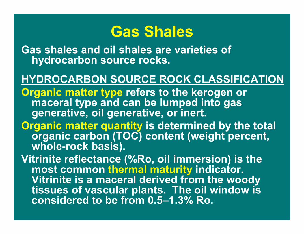
Gas ShalesGas shales and oil shales are varieties of
hydrocarbon source rocks.
HYDROCARBON SOURCE ROCK CLASSIFICATIONOrganic matter type refers to the kerogen or
maceral type and can be lumped into gas generative, oil generative, or inert.
Organic matter quantity is determined by the total organic carbon (TOC) content (weight percent, whole-rock basis).
Vitrinite reflectance (%Ro, oil immersion) is the most common thermal maturity indicator. Vitrinite is a maceral derived from the woody tissues of vascular plants. The oil window is considered to be from 0.5�1.3% Ro.

Gas ShalesDefinition: Gas shales are organic-rich, fine-grained sedimentary rocks (shale to siltstone) containing a minimum of 0.5 wt % TOC. Gas shales may be thermally marginally-mature (0.4�0.6% Ro) to mature (0.6�2.0% Ro) and contain biogenic to thermogenic methane. Gas is generated and stored in situ in gas shales as both sorbed (on organic matter) and free gas (in fractures and pores), similar to natural gas in coals. As such, gas shales are self-sourced reservoirs. Low-permeable shales require extensive natural fractures to produce commercial quantities of gas.

Gas Shales of the United States
Hill and Nelson, 2000

Hydrocarbon Source Rocks of Oklahoma
Johnson and Cardott, 1992

Van Krevelen Diagram
Burruss and Hatch, 1989

<1-14Woodford Shale
2.02-5.4Caney Shale
1-17Excello Shale(black shale lithofacies)
TOC (WT %)FORMATION
Potential Gas Shales of Oklahoma

Woodford Shale
Stratigraphy


0 50 M iles
0 50 Kilometers
2.0
2.0
1.3
1.3
ChoctawFault
1.32.0
Map of Mature Woodford Shale
Adapted from Carr (1987), Cardott (1989, 2001a, 2001b), and Comer (1992)

Woodford-Only Oil & Gas Leases
Map of oil and gas lease production was generated by Scott March with Geo Information Systems from Natural Resources Information System (NRIS) data files
24 Woodford-only gas leases
48 Woodford-only oil leases (oil and associated gas)

Woodford Gas Wells
27.1 Bcf gas was produced from 19 Woodford-only wells at 1,400�12,702 ft from June 1961 to November 2003
Gas production data supplied by Petroleum Information/DwightsLLC dba IHS Energy Group © 2004

Caney Shale members are differentiated based on paleontology rather than lithology
Sutherland, 1981

�False� Caney
Andrews, 2003

�False� Caney
Andrews, 2003

�False� Caney
Andrews, 2003

Caney Shale TOC Content
• 2.02-4.04% in the Arkoma Basin (16 samples; Hendrick, 1992)
• 4.4-5.4% in the Ouachita Mountains (3 samples; Cardott, 1994)
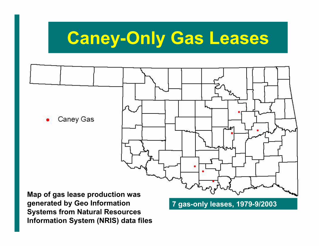
Caney-Only Gas Leases
Map of gas lease production was generated by Geo Information Systems from Natural Resources Information System (NRIS) data files
7 gas-only leases, 1979-9/2003

Caney Gas Wells
701 MMcf gas was produced from 4 Caney-only wells at 2,668�3,872 ft from February 1998 to August 2003
Gas production data supplied by Petroleum Information/DwightsLLC dba IHS Energy Group © 2004
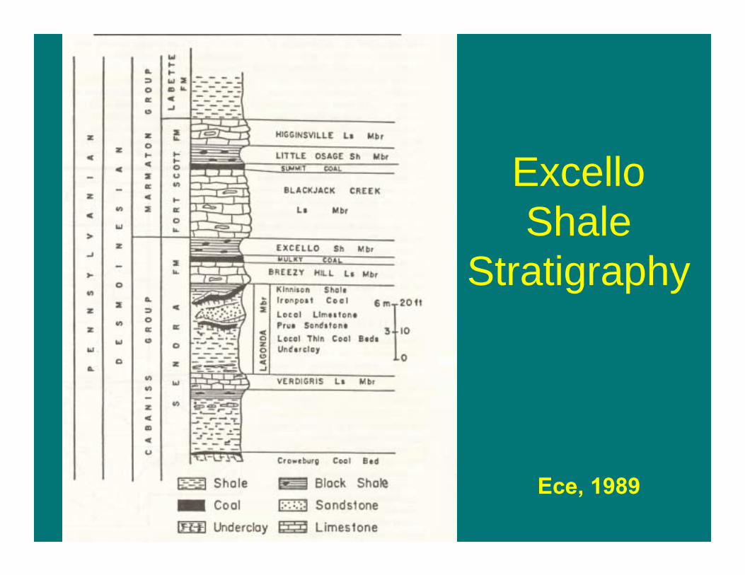
ExcelloShale
Stratigraphy
Ece, 1989

● OK Outcrop samples
■ OK Core samples from
western OK (5,560-
9,541 ft)
Ece, 1989
Black shale lithofacies have 1.1�16.8% TOC, ave. @10%

Excello Shale Thermal Maturity
Ece, 1989
0.51-0.63% Ro along outcrop
0.61-1.44% Ro from cores includes recycled vitrinite

Excello Shale gas production is included with
Mulky coalbed-methane production

�any shallow rock yielding oil in commercial amount upon pyrolysis is considered to be an oil shale�
Oil Shales
Tissot and Welte, 1984

Oil Shales!Mudstone, siltstone, marlstone,
or carbonate!Cambrian to Tertiary in age!Thermally immature to mature!Organic�rich (minimum of 5
volume percent types I and II kerogen; not related to TOC)
!Near surface

Hunton Quarry
Hycrude (1986) hydroretorting assay test
Woodford Shale in Arbuckle Mountains

!Marginally mature
!Surface exposure
!Type II kerogen
! 9.5 wt% TOC
Woodford Shale Pit

Hycrude (1986) hydroretortingassay test
• Hydroretorting is the heating (>540ºC) of shale in a retort under a hydrogen-rich atmosphere at elevated pressures (@1,000 psi).
• Evaluated 90 pounds of Woodford Shale

Hycrude (1986) Results
• Fischer Assay oil yield, 8.4 gal/ton• Raw Shale hydroretorting assay oil
yield, 22.9 gal/tonHighgraded for 120 minutes
• Highgraded Fischer Assay oil yield, 20.3 gal/ton
• Highgraded hydroretorting assay oil yield, 46.8 gal/ton

Tight Gas and Ultra-Deep Reservoirs
“Tight gas sands are low-permeability gas-bearing reservoirs (in a variety of rock types) that have an in situ permeability to gas of less than 0.1 md, exclusive of natural fracture permeability. The reservoirs are areally extensive, usually abnormally pressured, and often (but not always) found in basin-center settings”
(Kuuskraa and Bank, 2003)

Tight Gas in the United States
Law, 2002

Tight Gas in Oklahoma
Anadarko BasinRed ForkClevelandGranite Wash
Arkoma BasinAtoka

Prouty, 2001

Tight Gas in Oklahoma
The Red Fork play has an average EUR of 2,200-8,800 MMcf/well at a depth of 9,000-13,000 ft, net pay of 7-200 ft, porosity of 1-18%, permeability of 0.1-20 md, and estimated ultimate recoverable of 2,890.6 Bcf.
Prouty, 2001
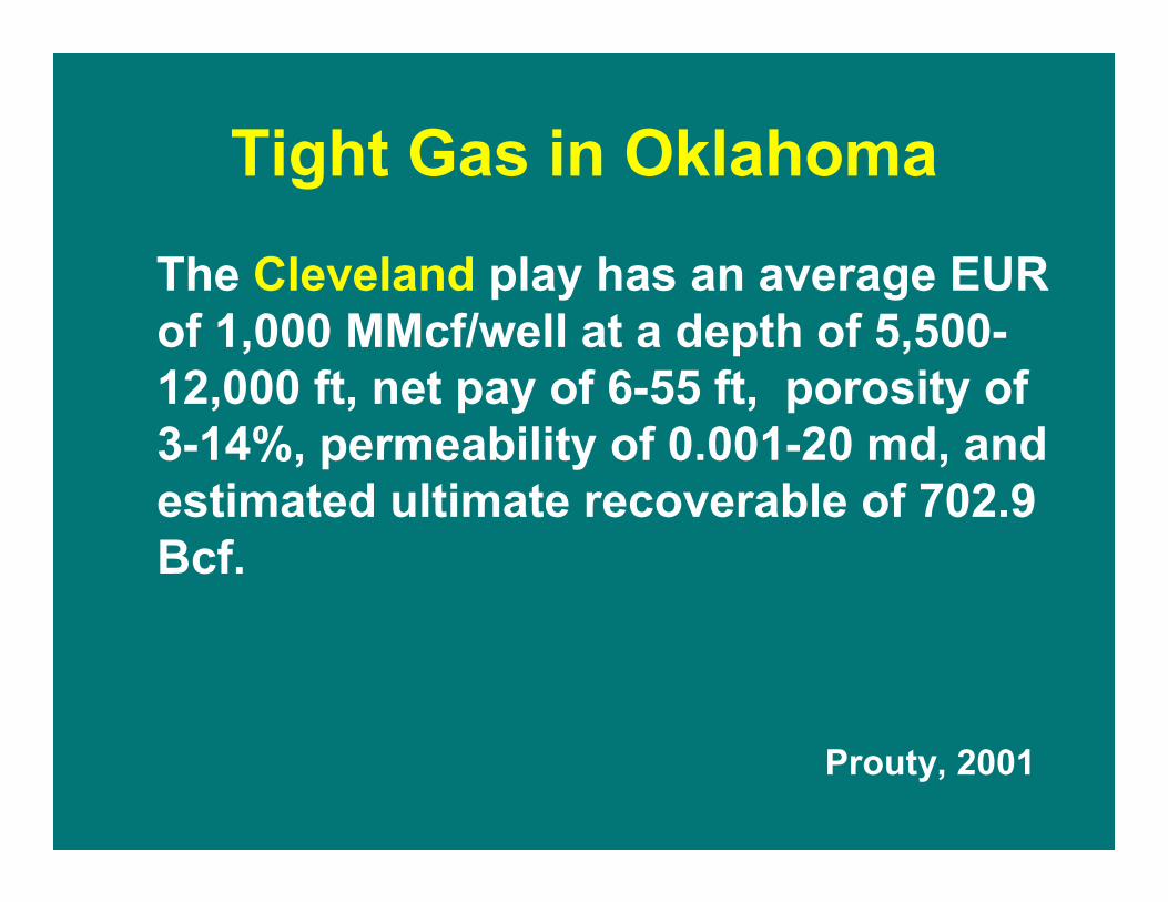
Tight Gas in Oklahoma
The Cleveland play has an average EUR of 1,000 MMcf/well at a depth of 5,500-12,000 ft, net pay of 6-55 ft, porosity of 3-14%, permeability of 0.001-20 md, and estimated ultimate recoverable of 702.9 Bcf.
Prouty, 2001

Tight Gas in Oklahoma
The Granite Wash play has an average EUR of 1,500 MMcf/well at a depth of 6,500-11,500 ft, net pay of 10-60 ft, porosity of 4-12%, permeability of 0.0009-1.4 md, and estimated ultimate recoverable of 349 Bcf.
Prouty, 2001

Oil (Tar) Sands
�Oil sands (also called tar sands in the U.S.) are sandstones or carbonate strata containing bitumen or other hydrocarbons of such high viscosity as to be immobile under normal reservoir temperatures.�
Rottenfusser, 2003

Oil (Tar) Sands
�In order to be utilized, the hydrocarbons must be mined or extracted in situ from the rock by the use of heat or solvents.�
Rottenfusser, 2003

Petroleum-Impregnated Rocks of Oklahoma
Adapted from Jordan (1964)

Dougherty Asphalt Quarry
Cardott and Chaplin (1993)
Asphalt-saturated Viola Group limestone
In-Place Bitumen Resource of 3.6 million barrels
Production of bitumen-impregnated limestone > 1 million short tons from 1890 to 1960

Sulfur Asphalt Quarry
Cardott and Chaplin (1993)
White silica veins in asphalt- saturated Oil Creek Formation sandstone
In-Place Bitumen Resource of 46.4 million barrels
Production of bitumen-bearing sandstone > 1.5 million short tons from 1890 to 1962

Bitumen-impregnated rock was quarried from the Dougherty and
Sulphur districts and taken by truck to the crushing, screening, and
mixing plant near Dougherty. The blended asphalt product was used as road-paving material. Synthetic crude oil has never been a product of the Oklahoma asphalt deposits.

Geologists with Suncor Energy Inc. (Canada) evaluated the Sulphur oil sand deposit in 1998 as part of a worldwide exploration for oil sand reserves. Brian McKinstry (formerly with Suncor Energy; personal communication June 2003) indicated that the Oklahoma deposits were structurally complex (dipping at steep angles) and had limited bitumen resources for an economic oil sand operation.