Embed Size (px)
Citation preview
Overview of Shared Surface Water Resources in Western Asia
Building Capacity for Accessing Disruptive Technologies for Improved Water Resources
Management under Climate Change, Beirut, 14-15 January 2020
Joelle Comair
Programme Associate
Water Resources Section
SDPD, ESCWA
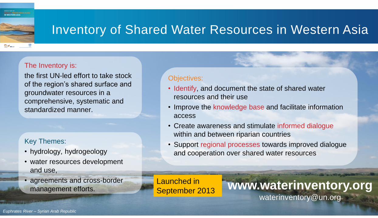
Inventory of Shared Water Resources in Western Asia
Euphrates River – Syrian Arab Republic
The Inventory is:
the first UN-led effort to take stock
of the region’s shared surface and
groundwater resources in a
comprehensive, systematic and
standardized manner.
Key Themes:
• hydrology, hydrogeology
• water resources development
and use,
• agreements and cross-border
management efforts.
Objectives:
• Identify, and document the state of shared water
resources and their use
• Improve the knowledge base and facilitate information
access
• Create awareness and stimulate informed dialogue
within and between riparian countries
• Support regional processes towards improved dialogue
and cooperation over shared water resources
Launched in
September 2013www.waterinventory.org

Work Process & Methodology Overview
Compilation of information
• Pre-screening and compilation of the existing literature: ESCWA reports, regional literature, scientific publications, country
papers, media reports, national statistics, national and regional maps, satellite imagery, etc to document and provide a
comprehensive, descriptive analysis
• Consultation with regional and international experts and involvement of ESCWA member countries through focal points
for reviews and requests for data
Coverage area
• Focus was placed exclusively on shared resources included in the Western Asia geographic sub-region covered by
ESCWA, as no comprehensive study of shared drainage basins and aquifer systems in this sub-region and there was a
clear mandate to examine water resources management within a regional context.
• Water resources located on the African continent, as well as in the northern part of Western Asia outside the
ESCWA region were excluded, as extensively covered in other studies
• A river “basin” hydrologically consists of an area of land in which all surface water drained by the river system is
conveyed to the same outlet; topography is the key element affecting the boundary of the basin.
• Surface water basin delineation was made using the topographical database HydroSHEDS.

Work Process- Main Challenges
• Data and information available to the public often outdated, obsolete, contradictory or of different
nature and scale.
• Some information (especially recent data) classified in national databases and unpublished reports
• Country submissions varied significantly in terms of scope, level of detail and format
• Difficulties in receiving country data in a timely manner, modifications were directly incorporated on
layouted version
Where differing or contradictory information was obtained from different sources, the different datasets and
arguments were all included to reflect a range of findings and viewpoints

Overview: Shared River Basins in the Inventory
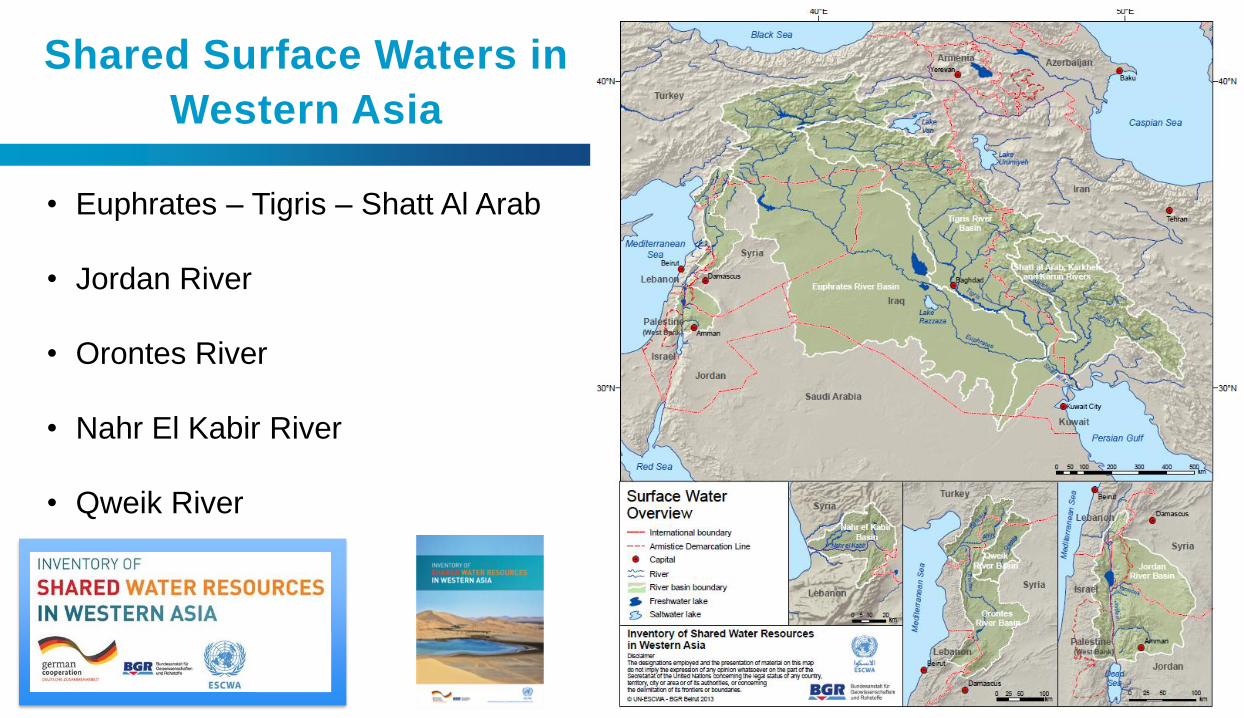
Shared Surface Waters in
Western Asia
• Euphrates – Tigris – Shatt Al Arab
• Jordan River
• Orontes River
• Nahr El Kabir River
• Qweik River

Euphrates River Basin
BASIN FACTS
RIPARIAN
COUNTRIES
Iraq, Syria, Turkey
RIVER
LENGTH
2,786 km
BASIN AREA 440,000 km2
MEAN ANNUAL
FLOW VOLUME
At Jarablus (Syrian-Turkish
border):
• (1930-1973) ~30 BCM
• (1974-2010) ~25 BCM
• The river originates in the mountains of
eastern Turkey and flows through Syria and
Iraq.
• It is joined by three tributaries in Syria (Sajur,
Balikh and Khabour rivers).
• With construction of large water engineering
structures in the upstream region, the river’s
flow regime has shifted over the years.

Euphrates River Basin
• Water use in the basin focuses on irrigation, hydropower
and drinking water supply, with agriculture consuming the
most (>70%).
• Water use increased sharply in the second half of the 20th
century, resulting in a significant reduction in stream-
flows and changes to the natural hydrological regime
of the river.
• The highly variable climate results in variable water
availability. Under the current water management regime,
droughts form a major natural hazard that affect water
supplies in the basin.
• Water quality: pollution from agricultural and domestic
sources seriously affects water quality and the river suffers
from severe salinity that increases along its course.
• Recent conflicts in the region
KEY CONCERNS
• Bilateral agreements and MoUs signed over the years
• No comprehensive or long-term treaty between Turkey,
Syria and Iraq
RIPARIAN COOPERATION

Tigris River Basin
BASIN FACTS
RIPARIAN
COUNTRIES
Turkey, Syria, Iraq, Iran
RIVER
LENGTH
1,800 km
BASIN AREA 221,000 km2
MEAN
ANNUAL
FLOW
VOLUME
At Kut:
• (1931-1973) ~32 BCM
• (1974-2005) ~16.7 BCM
• The river originates in the Taurus
mountains and flows south-east along a
stretch of the Syrian-Turkish border before
entering Iraq
• A number of tributaries shared by
Iraq/Turkey or Iran/Iraq contribute to its
flow

Tigris River Basin
• Water use for irrigation and hydropower production is constantly
increasing, with numerous operational and planned projects along the
river’s main course and its tributaries placing pressure on flow
regimes in the basin.
• Periodic droughts affect water supply and may impact water
allocation to different sectors in the future.
• Water quality: rising pollution from domestic and industrial sources,
salinity are a cause of concern.
• Ecosystem concerns (e.g. Ilisu dam and Tigris valley ecosystem, Iraqi
Marshlands)
KEY CONCERNS
• Bilateral agreements Iraq/Syria, Syria/Turkey
• No basin-wide agreement between all riparians
RIPARIAN COOPERATION


Jordan River Basin
BASIN FACTS
RIPARIAN
COUNTRIES
Lebanon, Palestine, Syria, Jordan, Israel
RIVER LENGTH 223 km
BASIN AREA 18,285 km2 (excluding the Dead Sea)
MEAN ANNUAL
FLOW VOLUME
At the outlet (Dead Sea):
• 1,300 MCM (1950s)
• 20-200 MCM (more recent estimates)
• The Jordan River originates in the Anti-Lebanon and Jabal el Sheikh
mountain ranges and flows to the point of discharge into the Dead
Sea.
• Tributaries of the river include the Hasbani, the Liddan, and Banias
rivers, which converge and flow into Lake Tiberias.
• As the flow leaves Lake Tiberias, it receives the waters of the
Yarmouk River (longest tributary in the basin)
• The river is further joined by the Zarqa River in Jordan as well as
several eastern and western side wadis in its lower course.
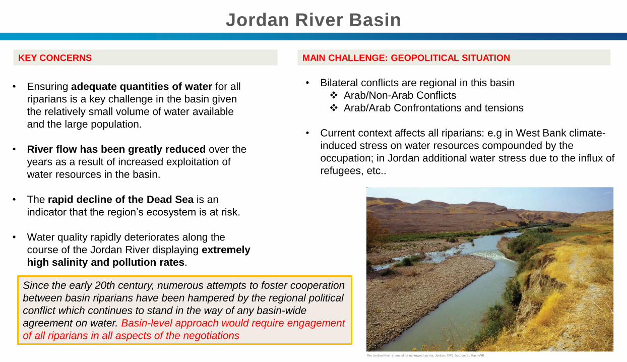
Jordan River Basin
• Ensuring adequate quantities of water for all
riparians is a key challenge in the basin given
the relatively small volume of water available
and the large population.
• River flow has been greatly reduced over the
years as a result of increased exploitation of
water resources in the basin.
• The rapid decline of the Dead Sea is an
indicator that the region’s ecosystem is at risk.
• Water quality rapidly deteriorates along the
course of the Jordan River displaying extremely
high salinity and pollution rates.
KEY CONCERNS
• Bilateral conflicts are regional in this basin
❖ Arab/Non-Arab Conflicts
❖ Arab/Arab Confrontations and tensions
• Current context affects all riparians: e.g in West Bank climate-
induced stress on water resources compounded by the
occupation; in Jordan additional water stress due to the influx of
refugees, etc..
MAIN CHALLENGE: GEOPOLITICAL SITUATION
Since the early 20th century, numerous attempts to foster cooperation
between basin riparians have been hampered by the regional political
conflict which continues to stand in the way of any basin-wide
agreement on water. Basin-level approach would require engagement
of all riparians in all aspects of the negotiations

Orontes River Basin
BASIN FACTS
RIPARIAN
COUNTRIES
Lebanon, Syria, Turkey
RIVER LENGTH 404 km
BASIN AREA 26,530 km2
MEAN ANNUAL
FLOW VOLUME
• Hermel, Lebanon 0.4 BCM (1931-2011)
• Al Omeiry, Syria 0.2 BCM (1974-2011)
• Darkosh, Syria/Turkey border 0.9-1.4 BCM
(1964-2011)
• “Assi” River, flowing north from Lebanon to Syria and Turkey and
draining west into the Mediterranean Sea.
• Sources in Lebanon are karstic springs (Al-Labweh, Ain Zarka and
Daffash) at an altitude of 690 m in the Bekaa Valley.
• River mainly fed by groundwater, groundwater recharge depends
on the snow cover in Mount Lebanon and the Anti-Lebanon
Mountains.
• Flows contributed in Syria (small streams and springs, Ghab Valley)
and from Afrin and Karasu tributaries contribute to flow in Turkey

Orontes River Basin
• Water quantity: intensification of water use in the basin
by all riparians mainly for agriculture, and projected
developments raises the question of long-term water
sustainability.
• Water quality: heavily polluted with untreated effluents
discharged into the river.
KEY CONCERNS
• A number of bilateral water agreements involving Turkey,
Syria or Lebanon on issues such as water allocation
(Lebanon-Syria) and the joint construction of infrastructure
(Syria-Turkey).
• No agreement involving all three riparians to date.
RIPARIAN COOPERATION

Nahr el Kabir Basin
BASIN FACTS
RIPARIAN
COUNTRIES
Lebanon, Syria
RIVER LENGTH 78 km
BASIN AREA 954 km2
MEAN ANNUAL
FLOW VOLUME
Hekr el dahri (outlet) 337 MCM
(1969-2011)
• “Nahr el Kabir al Janoubi” River, forms the north-south
border between Lebanon and Syria.
• Rises from numerous karstic springs and wadis in the
northern part of the Lebanon Mountain range
• 3 dams in Syria, planned construction of Noura al
Tahta/Idlin Dam to mainly support irrigation in both
riparians through Joint Lebanese-Syrian Project

Nahr el Kabir Basin
• Recurrent flash floods causing losses and damage in
both riparians
• Water quality: Spread of the invasive Water Hyacinth
‘Zahret el Nil’, clogging waterways throughout the river
course over a long distance.
• Continuous joint efforts ongoing to manage and
control the invasive plant.
KEY CONCERNS
• 2002 agreement between Lebanon and Syria to share
the water of the Nahr el Kabir and build a joint dam on
the river course
• Lebanese-Syrian joint committee for the river
management (infrastructure and water quality) regularly
meet
RIPARIAN COOPERATION

Qweik River Basin
BASIN FACTS
RIPARIAN
COUNTRIES
Syria, Turkey
RIVER LENGTH 167 km
BASIN AREA 6,941 km2
• Rises in Turkey and discharges in Syria,
“closed drainage basin”
• Main source of freshwater to Aleppo before the
1950s, currently flows intermittently due to
rising demand and river exploitation
• Severe pollution with direct wastewater and
industrial waste discharges into to river, risk to
contaminate groundwater
• No recent cooperation agreement, latest one in
1921 “The Franklin-Bouillon Agreement” with
mention to meet Aleppo’s water needs.

Pressures and Concerns for Sustainable Development of
Shared Water resources❖ Climate Change & Extreme Events
❖ Population Growth
❖ Unemployment
❖ Food Security
❖ Rural to Urban Migration
❖ Conflict, crisis, occupation and insecurity
❖ Water Security
❖ Freshwater Scarcity
❖ Water Quality and Ecosystems
❖ Groundwater linkages
❖ Water resource use & efficiency for sustainable resource management
❖ Despite assessment, more joint monitoring & management needed
❖ Different considerations for renewable & non-renewable resources when considering over-
extraction of non-renewable groundwater resources
❖ Water is shared between countries and communities.
Water-stress and growing socio-economic
development and environmental pressures
makes progress towards sustainable
development a greater challenge.

Thank You
www.waterinventory.org
www.unescwa.org/our-work/water
www.unescwa.org/publications/inventory-shared-water-
resources-western-asia