Embed Size (px)
Citation preview

1
Deformation monitoring and analysis using regional GPS permanent
tracking station networks
Youjian Hu[1], Kefei Zhang[2] and Gang-jun Liu [2]
1. China University of Geosciences (CUG),China
2. RMIT University (RMIT), Melbourne, Australia
CUG RMITCUG RMIT
Outline
� Rationale
� Geo-hazard and its monitoring � Continuously operating reference stations (CORS) network
in Victoria – GPSnet� Deformation analysis procedures
� Selection of test areas, solution convergence
� Statistical testing
� Data analysis � Conclusions
CUG RMITRationale
� CORS - continuously operating reference stations � Permanent GPS tracking stations
� CORS networks play increasingly important roles as a vital geospatial infrastructure, eg� Internationally well established as a “ground” augmentation of
GPS to improve positioning capability
�High-precision reference frames, network RTK� ubiquitous positioning and LBS
� The questions are “how reliable of our CORS stations?”� Relative and absolute terms (micro- to macro- scales)
� changes with time
� Temperature, wind, setting-up, geo-hazard events, etc.
CUG RMITGeo-hazard and its monitoring
� Natural disasters are of a problem of global concern and may cause significant social, environmental and human losses
� Natural hazards are estimated at an average annual cost of Aus$1.25 billion in Australia� This includes earthquakes, landslides, floods, storm
surges, severe winds, bushfire etc. � Victoria (Australia) is one of the regions where
earthquake epicentres are relatively concentrated. There are potential risks of earthquake in this region.
� Landslide is another considerable geological hazard in Australia and south-eastern Victoria is an active landslide area.
� In addition, the Earth’s surface deformation due to human activities may also cause hazards� eg mining
CUG RMIT
Earthquake History
1994
1995
1996 1997 1998
http://www.seis.com.au/
CUG RMITGeo-hazard and its monitoring
� The ability to analyse and predict natural and non-natural hazards is of great importance � Such ability depends heavily on precise & reliable deformation info
� Deformation information can be acquired through �monitoring and analysis of the Earth’s surface displacement, the
movement of faults, landslide and some other deformations.
� GPSnet CORS stations provide a critical geospatial infrastructure, � high precision deformation information can be potentially obtained
� lots of expenditure required for establishing dedicated deformation monitoring networks in this area can also be saved.
� It is of vital importance to investigate the feasibility to use GPSnet to monitor and analyse regional deformation

2
CUG RMITGPSnet
� GPSnet is a cooperative GPS base station network coordinated by Land Victoria� Victorian government initiative
�Land Victoria, a division of the Department of Natural Resources and Environment,
� an integral part of the new geodetic strategy for Victoria
� Established in partnership with industry and academia� GPSnet currently consists of 22 operating base stations
� The average spacing of base stations is approximately 50km in the greater Melbourne region and 160km in rural Victoria.
� Records, distributes and archives GPS data for post processed, accurate position determination only
CUG RMITMajor milestones
� Perceived in early 1990s� state wide geodetic infrastructure
� economic benefit to reduce establishment cost
� July 1994 � first single frequency pilot site at Ballarat started data recording
(~80km from Melbourne)
� December 1995 and early 1996 � dual frequency, public access
� additional two sites established, Melbourne and Bendigo
� 1997 � network design project conducted by RMIT
� accuracy, sources of error, baseline length/density, site selection, potential radio interference, multipath effects etc.
CUG RMITMajor milestones
� 1999-2004 many stations established� currently consists of 22 operating base stations and will contain 24 stations
upon completion by 2005.
� Seven stations broadcasting RTK signal�For mining activities, Ski site surveying
�For FORMULA I, Grand Prix
� RMIT proposed NRTK concept in 2000
� RMIT led a research team & won an ARC project in 2004� Australia Research council – ARC
� Through regional/local atmospheric studies
� $1.36 million project
� RMIT, UNSW and UoM, Land Victoria and Dept of Lands/NSW
� CRC-SI established 2004� DGPS + LBS
� CRC – cooperative research centre of spatial information
CUG RMITGPSnet goals
� GPSnet primary goals:� enhance the Victorian geodetic framework
� provide easy access to accurate positioning information for a wide user community across the State
� provide a mechanism for centimetre-positioning relative to the National Spatial Reference Systems.
� GPSnet secondary goals � From BBS to Web-based direct access
� support both post and real-time surveying� real time transmission of GPSnet data
�Multiple modal positioning support
� NRTK, DGPS and Location-based services (LBS)
�will enable near instantaneous centimetre-level accuracy positioning by a single GPS receiver in the field.
CUG RMIT
Locations of current GPSnet Base Stations Providing Coverage in Rural and Regional Victoria With Indicative 100 Km Radius
Circles of Coverage
across the State of Victoria
CUG RMIT
Locations for Permanent GPS Base Stations in the Melbourne Region With Indicative 50 Km Radius Circles of Coverage
Melbourne Metro

3
CUG RMITVictorian GPSnet
� The GPSnet uses a variety of receivers including Trimble, Leica dual-frequency receivers
� Record C/A code, L1/L2 carrier phase and Doppler data in the RINEX format at all sites
� The GPSnet has been widely used, including � Surveying, mapping, GIS, navigation,
� open pit coal mining, Location based services � Agriculture, etc.
� Measurements interval as high as 1 second, � 24/7�Web-based “near real-time” access
CUG RMIT
Earthquake, fault movement, mineral mining, landslide, distribution of base stations, other geological and geophysical data, Relevant technical standard, etc
GPS data collection, quality check, analysis of precision and stability of
subnet solution
Normal?
Reference frame transformation, baseline processing, adjustment of GPS
subnet, precision analysis
Selection of deformation analysis datum, formation of analysis subnet, GPS data
processing strategy
No
Displacement calculation + significance test
Analysis and conclusions
Antenna stability, Multipath, satellite status, cycle slip, base station relocation, solar activities, GPS technical specifications, etc
No
Transformation parameters of ITRF, GDA, MGA grid, and IGS precise ephemeris,
Further investigation and solution
Check and analysis of GPS data quality (data snooping and deletion of invalid data, detection and repair of cycle slips)
Normal?
Deformation Analysis process flow chart
CUG RMIT
� Solution convergence tests�How much data should be used
� Precision of solution vs the length of data� An experimental subnet is chosen
� Chronological development �History of stations
� Formation of sub-net for different purposes of investigations
� Velocity and displacement computation
� Statistical test � The correlation of the amount data used and precision � Deformation detected significant or not
� Relation between geo-hazard points of interests and stns
CUG RMITSolution convergence
� An experimental network is used to � investigate the relation between the precision of the solution and the
amount of GPSnet data used
� It consists of two stations in the GPSnet and three IGS stations� The longest baseline in the GPSnet (735 kilometers)
Irymple
STR1 (IGS)
Cann River
HOB2 (IGS)
TIDB (IGS)
IGS station
CUG RMIT
(b) The station “Irymple
0
10
20
30
40
50
60
70
1 2 4 6 8 10 12
GPSnet data used (hour)
Coo
rdin
ate
pre
cisi
on
(mm
)
14 16 18 20 22 24
(a) The station “Cann River”
0
10
20
30
40
50
60
1 2 4 6 8 10 12 14 16 18 20 22 24
GPSnet data used (hour)
Coo
rdin
ate
pre
cisi
on
(mm
)
sx sy sz
Solution convergence
The relation between the RMS error of coordinates in ITRF2000 and the amount of data used to generate the experimental network solution
CUG RMIT
dx dy dz
-60
-50
-40
-30
-20
-10
0
10
20
30
2 4 6 8 10 12 14 18 20 22 24
-100
-80
-60
-10
-20
0
20
40
60
80
1 42 6 8 1810 14 201612 22
Coo
rdin
ate
dif
fere
nce(
mm
)
24
amount of data (hour)
Coo
rdin
ate
dif
fere
nce(
mm
)
1 16
(b) The station “Irymple(a) The station “Cann River”amount of data (hour)
Solution convergence
Differences between the coordinates derived from different amount of GPSnet data and the solution from 24 hours GPSnet data (ITRF2000)
4
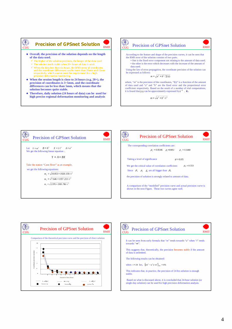
CUG RMITPrecision of GPSnet Solution
� Overall, the precision of the solution depends on the length of the data used. � The higher of the solution precision, the longer of the data used � The solution tends stable when 20+ hours of data is used�When the data less than six hours, the RMS error of coordinates
and the coordinate differences can be more than 20mm and 15mm respectively, which cannot meet the requirement for a high precision deformation monitoring.
� When the session length is close to 24 hours (e.g, 20+), the precision of coordinates is 3~5mm, and the coordinate differences can be less than 5mm, which means that the solution becomes quite stable.
� Therefore, daily solution (24 hours of data) can be used for high precise regional deformation monitoring and analysis
CUG RMITPrecision of GPSnet Solution
According to the feature and shape of the precision curves, it can be seen that the RMS error of the solution consists of two parts.
• One is the fixed error component not relating to the amount of data used;• the other is the error which decreases with the increase of the amount of data used.
Using the law of error propagation, the coordinate precision of the solution can be expressed as follows:
)(22 tfbam ⋅+=
where, “m” is the precision of the coordinates, “f(t)” is a function of the amount of data used and “a” and ”b” are the fixed error and the proportional error coefficient respectively. Based on the result of a number of trial computations, it is found that can be approximately expressed by ,ie.)(tf
3−t
322 / tbam +=
CUG RMITPrecision of GPSnet Solution
LetWe get the following linear equation:
2mY = 2aA =2bB = 3/1 tX =
BXAY +=
Take the station “Cann River” as an example,
we get the following equations: 3/159.1920853.19 tmx +=
3/786.2585978.2 tmy +=
3/213.1357646.7 tmz +=
CUG RMIT
Taking a level of significance 05.0=α
We get the critical value of correlation coefficient:
Since
553.00 =ρ
the precision of solution is strongly related to amount of data.
are all bigger than 0ρzρxρ
yρ
A comparison of the “modelled” precision curve and actual precision curve is shown in the next Figure. These two curves agree well.
Precision of GPSnet Solution
The corresponding correlation coefficients are:
8146.0=xρ 9054.0=yρ 6468.0=zρ
CUG RMIT
Curve mx-t Curve my-tCurve mz-t
Precision mx Precision my precision mz
0
10
20
30
40
50
60
1 2 4 6 8 10 12 14 16 18 20 22 24
Coo
rdin
ate
pre
cisi
on
m (
mm
)
Amount of data (hour)
Precision of GPSnet Solution
Comparison of the theoretical precision curve and the precision of direct solution
CUG RMIT
It can be seen from early formula that “m” tends towards “a” when “t” tends towards “ ”.
This suggests that, theoretically, the precision becomes stable if the amount of data is unlimited.
The following results can be obtained:
when hrs,
This indicates that, in practice, the precision of 24 hrs solution is enough stable.
Based on what is discussed above, it is concluded that 24-hour solution (or single-day solution) can be used for high precision deformation analysis.
∞
{ } %6/)( max222 <− mam24=t
Precision of GPSnet Solution

5
CUG RMIT
Spatial relationship between GPSnet stations and geo-hazard points of interest
CUG RMIT
� The relations between GPSnet stations and geological features
� There are more than 10 relatively large faults within Victoria and some stations are close to faults and/landslide sites
CUG RMITDeformation Analysis
� A subnet of Victorian GPSnet is chosen
� Only seven base stations
� Two-year data from 14 April 2002 to 14 April 2004 are used for local deformation analysis, due to various reasons � e.g, some data files are not available,
� bad data format and
� chronological data availability due to relocation of some stations.
� Lots of data pre-processing effort
CUG RMIT
Chronological developments of the Victorian GPSnet
stations
1 (19)2004Albury (11/02)
2 (18)2003Clayton (12/02)Bairnsdale (31/10)
2 (16)2002Cann River (01/09)Melb obs (IGS station) (18/11)
6 (14)2001
Swan hill (05/03)Hamilton (19/03)Shepparton (06/04)Walpeup (14/05)Horsham (02/06)Yalllourn (21/06) (relocated in 2003)
2 (8)2000Colac (30/10)Mt Buller (19/12)
2 (6)1999Benalla (13/07)Irymple (relocated in 2003) (26/01)
1 (4)1998Geelong (03/09)
2 (3)1996Epsom (01/07) (relocated in 2002)Melbourne RMIT (01/08)
1 (1)1995Ballarat (01/12)
No of Stations (Total)Year of operationGPSnet stations (date of operation)
CUG RMIT
Walpeup
Horsham
Colac
HamiltonMelbourne
Ballarat
Swan Hill
Deformation Analysis CUG RMIT
station
Absolute displacement (mm) and velocity
(mm/yr)
relative horizontal
displacement (mm)
dE dN dU V V/2significance test
dEr
dNr
significance test
Melbourne 21 124 32 130 65 √ -6 -5 ×
Ballarat 24 121 25 125 62 √ -3 -8×
Colac 32 125 18 128 64 √ 5 -4 ×
Hamilton 35 128 16 134 67 √ 8 -1×
Horsham 20 135 34 139 70 √ -7 6 ×
Walpeup 33 138 47 148 74 √ 7 9×
Swan Hill 27 131 45 142 71 √ 0 2×
•Absolute and relative displacements of the GPSnet subnet stations•Significance test of absolute and relative displacements
Deformation Analysis

6
CUG RMITDeformation Analysis
� The results of significance test show that � the relative horizontal displacements of all the subnet points are not
significant
� The relative horizontal positions of the subnet points are not notably affected from local geological features
� It can be inferred that currently, the faults and/or landslide body near these base stations are relatively stable
� However, the stability of the faults and landslide body still needs to be continuously analysed in the future
CUG RMIT
Both the magnitude and direction of the absolute displacement of all the base stations in the subnet agree well with the velocity of approximately 7cm/year and direction of current Australia tectonic motion derived from other IGS measurements (Geoscience Australia, 2004)
Walpeup
Horsham
Colac
HamiltonMelbourne
Ballarat
N
Swan Hill
50mm/yr
50mm/yr
Victoria
Results from the method put forward in this paper Results from other IGS measurements
Deformation Analysis
CUG RMITConclusive Remarks
� This paper investigates the feasibility to use local CORS network for geo-hazard monitoring purposes
� A number of critical issues associated with the suitability, geological stability, data quality of the GPS networks system, the precision and stability of the GPSnet solutions are investigated using geological information.
� For high precise positioning, it is recommended that � the minimum length of the data used to generate solutions is 12
hours
� The precision of 3-D coordinates derived from daily solution (24 hours data) is 3~5mm � the solution is quite stable and can meet the requirements of high
precision deformation analysis
CUG RMITConclusive Remarks
� Currently, the faults and/or landslide body near GPSnetbase stations in the deformation analysis subnet are relatively stable
� The methodology of data processing and deformation analysis used in the paper seems feasible and effective.
� It is recommended that geological information needs to be taken into account when any new CORS stations are established.
� It is concluded that high-precision continuous tracking data from GPSnet is a very valuable asset and can provide a technically-advanced and cost-effective geoscientific infrastructure for deformation monitoring analysis
� Several relevant issues are under investigation
CUG RMITAcknowledgements
� The authors would like to thank M Hale, P. Oates, J Millner, E.Retimana and Peter Ramm from the Department of Sustainability and Environment, Victoria for their consistent support and access to the GPSnet data.
� Financial support (“211” academic exchange fund program) awarded to the author from China University of Geosciences is gratefully acknowledged.