Embed Size (px)
Citation preview

Outfall
NumberDrainage Area Description
Runoff
Coefficient
Outfalls highlighted white discharge storm water not associated with
industrial activity
Outfalls highlighted yellow discharge storm water associated with
industrial activity
Outfalls highlighted pink indicate individually permitted outfalls
93
Outfall 93 supports drainage from DPS Station 6 (711 Regent Blvd.)
Storm water structural controls associated with this outfall include one
storm water treatment device. This outfall drains into an unlined ditch that
discharges to Cottonwood Creek.
0.70
11
Outfall 11 Outfall 11 supports drainage from curb inlets off Nash Street,
S. Main Street, Municipal Way, and Dallas Road in Grapevine, Texas.
Outfall 11 drains into an unlined ditch into Cottonwood Creek.
0.70
001
Outfall 001 is an individually permitted outfall covered under DFW
Airport's Individual Wastewater Permit No. 01441. This outfall
discharges treated storm water meeting effluent limitations into Bear
Creek.
14a
Outfall 14a drains the central portion of runway 13R and 31L, the Verizon
Place Office Campus and the Allied Aviation Bulk Fuel Storage facility.
Activities include aircraft taxi, takeoff and landings, loading/unloading
operations, light vehicle maintenance, and bulk fuel storage. Storm
water structural controls associated with this outfall include one fuel
separator associated with Allied Aviation Bulk Fuel Storage facility. This
outfall drains into a tributary of Big Bear Creek, which flows into Bear
Creek.
0.95/0.80
14b
Outfall 14b drains the central portion of runway 13R and 31L, a small
portion of the West Cargo ramp area, and warehouse facilities along W.
Airfield Drive. Activities include aircraft taxi, takeoff and landings,
loading/unloading operations, and light vehicle/aircraft maintenance.
Storm water structural controls associated with this outfall include two
fuel separator associated with former Emery Air Freight facility, one fuel
separator associated with Kitty Hawk and Caris aircraft hangars, and
Type D storm water inlets supporting the West Cargo ramp. This outfall
drains into a tributary of Big Bear Creek, which flows into Bear Creek.
0.95/0.80
OUTFALL CHARACTERIZATION CHART
Page 1 of 21 Updated January 2016

Outfall
NumberDrainage Area Description
Runoff
Coefficient
Outfalls highlighted white discharge storm water not associated with
industrial activity
Outfalls highlighted yellow discharge storm water associated with
industrial activity
Outfalls highlighted pink indicate individually permitted outfalls
OUTFALL CHARACTERIZATION CHART
19
Outfall 19 drains large portions of runways 36L and 36R, associated
taxiways, the public parking side of Terminal B, the southern ramp area
of Terminal B, the entire Terminal D ramp, and the express parking area.
Activities conducted in this drainage area include aircraft taxi, takeoff and
landings, aircraft/runway deicing, aircraft/vehicle fueling, aircraft/vehicle
parking, and ground support equipment operation, light aircraft/vehicle
maintenance. Storm water structural controls associated with this outfall
include storm water valve systems associated with deicing activities on
the SW Hold Pad, Terminal D, and Whiskey Kilo. In addition, five fuel
separators and Type D storm water inlets are associated with the SW
Hold Pad, the General Aviation facility, and Terminal B; and two storm
water retention tanks support with the Terminal D ramp. This outfall
drains into a tributary of Big Bear Creek, which flows into Bear Creek.
0.95/0.80
19a
Outfall 19a drains the public portions of Terminal D. Activities conducted
in this drainage area include vehicle parking and loading/unloading
operations. This outfall is located in a tributary of Big Bear Creek, which
flows into Bear Creek.
0.95
019
Outfall 019 is authorized under DFW Airport's Individual Wastewater
Permit No. 01441. This outfall authorizes discharges from all upstream
outfalls (including outfalls 19 and 19a). Outfall 019 drains into a tributary
of Big Bear Creek, which flows into Bear Creek.
Page 2 of 21 Updated January 2016

Outfall
NumberDrainage Area Description
Runoff
Coefficient
Outfalls highlighted white discharge storm water not associated with
industrial activity
Outfalls highlighted yellow discharge storm water associated with
industrial activity
Outfalls highlighted pink indicate individually permitted outfalls
OUTFALL CHARACTERIZATION CHART
25
Outfall 25 drains the southeast portion of runway 31L and the eastern
portion of the west cargo area, which includes the aircraft hangars and
warehouse facilities. Activities include aircraft taxi, takeoff and landings,
vehicle and aircraft parking, ground support equipment operation, both
vehicle and aircraft loading/unloading operations, fueling activities,
aircraft and GSE maintenance. Storm water structural controls
associated with this outfall include seven fuel separators, Type D storm
water inlets, and Type B-1 storm water inlets supporting the West Cargo
ramp areas. This outfall drains into a tributary of Big Bear Creek, which
flows into Bear Creek.
0.80
44
Outfall 44 supports drainage from rampside operations from Kitty Hawk
(1515 W. 20th Street.), Caris (1481 W. 20th St.), and curb inlets along
portions of W. Airfield Drive. Outfall 44 drains into an unlined ditch, which
then flows into Outfall 14b and Bear Creek.
0.95
46
Outfall 46 drains sheet flow from undeveloped areas north of S. Airfield
Drive. This outfall drains into a tributary of Big Bear Creek, which flows
into Bear Creek.
0.22
47
Outfall 47 drains a small section of airfield operations area south of
runway 36R. Activities include aircraft taxi, takeoff and landings. This
outfall drains into a tributary of Big Bear Creek, which flows into Bear
Creek.
0.95
48
Outfall 48 drains the west portion of the United States Postal Service mail
facility. Activities are limited to vehicle/equipment storage, and
loading/unloading operations. Storm water structural controls associated
with this outfall include one fuel separator supporting the US Postal
Service equipment staging area. This outfall drains into a tributary of Big
Bear Creek, which flows into Bear Creek.
0.95
Page 3 of 21 Updated January 2016

Outfall
NumberDrainage Area Description
Runoff
Coefficient
Outfalls highlighted white discharge storm water not associated with
industrial activity
Outfalls highlighted yellow discharge storm water associated with
industrial activity
Outfalls highlighted pink indicate individually permitted outfalls
OUTFALL CHARACTERIZATION CHART
50
Outfall 50 drains mostly sheet flow from the southwest portion of runway
36L. Activities are limited to aircraft taxi, takeoff, and landings. This
outfall drains into a tributary of Big Bear Creek, which flows into Bear
Creek.
0.95
51
Outfall 51 drains aircraft taxiways areas. Activities are limited to aircraft
taxi. This outfall drains into a tributary of Big Bear Creek, which flows
into Bear Creek.
0.95
52
Outfall 52 drains undeveloped areas south of 27th Street and portions of
DPS Station 4. Activities are limited to vehicle parking. This outfall
drains into a tributary of Big Bear Creek, which flows into Bear Creek.
0.70
53
Outfall 53 drains the southeast portion of runway 31L. Activities are
limited to aircraft takeoff and landings. This outfall drains into a tributary
of Big Bear Creek, which flows into Bear Creek.
0.95
54
Outfall 54 drains the southeast portion of runway 31L. Activities are
limited to aircraft takeoff and landings. This outfall drains into a tributary
of Big Bear Creek, which flows into Bear Creek.
0.95
55
Outfall 55 drains the central portion of runway 13R and 31L. Activities
are limited to aircraft takeoff and landings. This outfall drains into a
tributary of Big Bear Creek, which flows into Bear Creek.
0.95
56
Outfall 56 drains the northwest portion of runway 13R. Activities are
limited to aircraft takeoff and landings. This outfall drains into a tributary
of Big Bear Creek, which flows into Bear Creek.
0.95
Page 4 of 21 Updated January 2016
Outfall
NumberDrainage Area Description
Runoff
Coefficient
Outfalls highlighted white discharge storm water not associated with
industrial activity
Outfalls highlighted yellow discharge storm water associated with
industrial activity
Outfalls highlighted pink indicate individually permitted outfalls
OUTFALL CHARACTERIZATION CHART
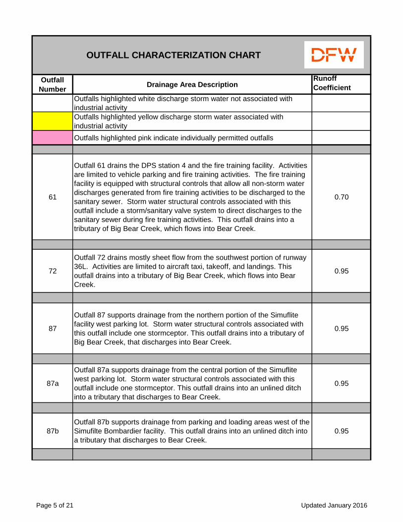
61
Outfall 61 drains the DPS station 4 and the fire training facility. Activities
are limited to vehicle parking and fire training activities. The fire training
facility is equipped with structural controls that allow all non-storm water
discharges generated from fire training activities to be discharged to the
sanitary sewer. Storm water structural controls associated with this
outfall include a storm/sanitary valve system to direct discharges to the
sanitary sewer during fire training activities. This outfall drains into a
tributary of Big Bear Creek, which flows into Bear Creek.
0.70
72
Outfall 72 drains mostly sheet flow from the southwest portion of runway
36L. Activities are limited to aircraft taxi, takeoff, and landings. This
outfall drains into a tributary of Big Bear Creek, which flows into Bear
Creek.
0.95
87
Outfall 87 supports drainage from the northern portion of the Simuflite
facility west parking lot. Storm water structural controls associated with
this outfall include one stormceptor. This outfall drains into a tributary of
Big Bear Creek, that discharges into Bear Creek.
0.95
87a
Outfall 87a supports drainage from the central portion of the Simuflite
west parking lot. Storm water structural controls associated with this
outfall include one stormceptor. This outfall drains into an unlined ditch
into a tributary that discharges to Bear Creek.
0.95
87b
Outfall 87b supports drainage from parking and loading areas west of the
Simufilte Bombardier facility. This outfall drains into an unlined ditch into
a tributary that discharges to Bear Creek.
0.95
Page 5 of 21 Updated January 2016

Outfall
NumberDrainage Area Description
Runoff
Coefficient
Outfalls highlighted white discharge storm water not associated with
industrial activity
Outfalls highlighted yellow discharge storm water associated with
industrial activity
Outfalls highlighted pink indicate individually permitted outfalls
OUTFALL CHARACTERIZATION CHART
88
Outfall 88 supports drainage from the north and eastern portions of the
GE Lighting facility (1717 W. Airfield Drive). This outfall drains into a
tributary of Big Bear Creek, that discharges into Bear Creek.
0.95
89
Outfall 89 supports drainage from the north central portions of the GE
Lighting facility parking lots (1717 W. Airfield Dr.). This outfalls drains
into a tributary of Big Bear Creek, that discharges into Bear Creek.
0.95
90
Outfall 90 supports drainage from the western portions of the GE Lighting
facility parking lots (1717 W. Airfield Drive). This outfall drains into a
tributary of Big Bear Creek, that discharges into Bear Creek.
0.95
91
Outfall 91 supports drainage from the Composite Technology/Sikorsky
facility (1727 S. Main Street). Storm water structural controls associated
with this facility include two storm water treatment devices and one
oil/water separator. This outfall drains into a tributary of Big Bear Creek,
which discharges into Bear Creek.
0.80
92
Outfall 92 supports drainage from the CEVA Logistics facility (1901 W.
Airfield Drive). This outfalls drains into a tributary of Big Bear Creek,
which discharges into Bear Creek. Storm water structural controls
associated with this facility include one oil/water separator.
0.95
96
Outfall 96 supports drainage from areas off DFW Airport property north
of Mustang Drive. This outfall drains into a concrete lined channel into a
tributary that discharges to Bear Creek.
0.95
Page 6 of 21 Updated January 2016

Outfall
NumberDrainage Area Description
Runoff
Coefficient
Outfalls highlighted white discharge storm water not associated with
industrial activity
Outfalls highlighted yellow discharge storm water associated with
industrial activity
Outfalls highlighted pink indicate individually permitted outfalls
OUTFALL CHARACTERIZATION CHART
97
Outfall 97 supports drainage from the public side west of the American
Airlines Warehouse, AA Hangar 2 , AA Hangar 3, and AA Hangar 4.
This outfall drains into an unlined ditch into a tributary that discharges to
Bear Creek.
0.95
98
Outfall 98 supports drainage from AA Hangar 4 newly re-routed roof
drains as a result of the hangar drain project. Velocity dissipaters are
present at the mouth of the outfall. This outfall drains into an unlined
ditch into a tributary that discharges to Bear Creek.
0.95
98a
Outfall 98a supports drainage from AA Hangar 4 newly re-routed roof
drains as a result of the hangar drain project. Velocity dissipaters are
present at the mouth of the outfall. This outfall drains into an unlined
ditch into a tributary that discharges to Bear Creek.
0.95
12
Outfall 12 drains the UPS cargo facility. Activities include aircraft taxi,
vehicle and aircraft fueling, light vehicle/aircraft maintenance activities,
GSE operations, loading/unloading operations, and aircraft deicing
activities. Storm water structural controls associated with this outfall
include storm water valve systems associated with the Taxiway Charlie
Deicing Pad. In addition, one fuel separator, Type D storm water inlets,
and Type B-1 storm water inlets support portions of the UPS ramp areas.
Outfall 12 drains into a storm water channel that discharges to Grapevine
Creek.
0.80
15
Outfall 15 drains employee-parking areas. Activities are limited to visitor
and employee vehicle parking. Outfall 15 drains into a storm water
channel that discharges to Grapevine Creek.
0.95
Page 7 of 21 Updated January 2016
Outfall
NumberDrainage Area Description
Runoff
Coefficient
Outfalls highlighted white discharge storm water not associated with
industrial activity
Outfalls highlighted yellow discharge storm water associated with
industrial activity
Outfalls highlighted pink indicate individually permitted outfalls
OUTFALL CHARACTERIZATION CHART
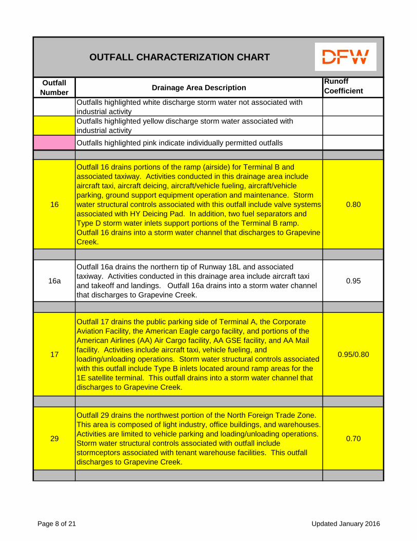
16
Outfall 16 drains portions of the ramp (airside) for Terminal B and
associated taxiway. Activities conducted in this drainage area include
aircraft taxi, aircraft deicing, aircraft/vehicle fueling, aircraft/vehicle
parking, ground support equipment operation and maintenance. Storm
water structural controls associated with this outfall include valve systems
associated with HY Deicing Pad. In addition, two fuel separators and
Type D storm water inlets support portions of the Terminal B ramp.
Outfall 16 drains into a storm water channel that discharges to Grapevine
Creek.
0.80
16a
Outfall 16a drains the northern tip of Runway 18L and associated
taxiway. Activities conducted in this drainage area include aircraft taxi
and takeoff and landings. Outfall 16a drains into a storm water channel
that discharges to Grapevine Creek.
0.95
17
Outfall 17 drains the public parking side of Terminal A, the Corporate
Aviation Facility, the American Eagle cargo facility, and portions of the
American Airlines (AA) Air Cargo facility, AA GSE facility, and AA Mail
facility. Activities include aircraft taxi, vehicle fueling, and
loading/unloading operations. Storm water structural controls associated
with this outfall include Type B inlets located around ramp areas for the
1E satellite terminal. This outfall drains into a storm water channel that
discharges to Grapevine Creek.
0.95/0.80
29
Outfall 29 drains the northwest portion of the North Foreign Trade Zone.
This area is composed of light industry, office buildings, and warehouses.
Activities are limited to vehicle parking and loading/unloading operations.
Storm water structural controls associated with outfall include
stormceptors associated with tenant warehouse facilities. This outfall
discharges to Grapevine Creek.
0.70
Page 8 of 21 Updated January 2016

Outfall
NumberDrainage Area Description
Runoff
Coefficient
Outfalls highlighted white discharge storm water not associated with
industrial activity
Outfalls highlighted yellow discharge storm water associated with
industrial activity
Outfalls highlighted pink indicate individually permitted outfalls
OUTFALL CHARACTERIZATION CHART
30
Outfall 30 drains the south parking areas of Nippon Express (located at
1100 N. 28th Avenue) and the north parking area of the DFW Foreign
Trade Center 1 located at (1205 Royal Lane). This area is composed of
light industry, office buildings, and warehouses. Activities are limited to
vehicle parking and loading/unloading operations. This outfall discharges
to Grapevine Creek.
0.70
31
Outfall 31 drains the northwest portion of the ICP area including facilities
off N. 28th Avenue (Hillwood Network Logistics, Nippon Express,
Trammel Crow Building 8, eastern portions of Siemens, XPEDX, NEC
America, and Avail. A small portion of Esters Boulevard (XPEDX). This
area is composed of light industry, office buildings, and warehouses.
Activities are limited to vehicle parking and loading/unloading operations.
This outfall discharges to Grapevine Creek.
0.7
32
Outfall 32 drains the southwest portion of the ICP area (DFW Education
Center, Multicam, Allflex, and Paragon Foothill LLC facilities). This area
is composed of light industry, office buildings, and warehouses. Activities
are limited to vehicle parking and loading/unloading operations. This
outfall discharges into the city of Irving MS4 (to Grapevine Creek).
0.70
33
Outfall 33 drains the east side of the Multicam facility located at 1315
Royal Lane. Activities are limited to vehicle parking and
loading/unloading operations. This outfall discharges into the city of
Irving MS4 (to Grapevine Creek).
0.70
57
Outfall 57 drains sheet flow originating from undeveloped areas south of
N. Airfield Drive. Outfall 57 drains into a storm water channel that
discharges to Grapevine Creek.
0.22
Page 9 of 21 Updated January 2016

Outfall
NumberDrainage Area Description
Runoff
Coefficient
Outfalls highlighted white discharge storm water not associated with
industrial activity
Outfalls highlighted yellow discharge storm water associated with
industrial activity
Outfalls highlighted pink indicate individually permitted outfalls
OUTFALL CHARACTERIZATION CHART
58
Outfall 58 drains the northwest side of runway 17R. Activities conducted
in this drainage area include aircraft taxi, takeoff and landings. This
outfall drains to a storm water channel that flows to Grapevine Creek.
0.95
59
Outfall 59 drains the central portion of runway 17R. Activities conducted
in this drainage area include aircraft deicing, aircraft taxi, takeoff and
landings. Storm water structural controls associated with this outfall
include storm water valve systems to control discharges associated with
deicing activities on the North Hold Pad. This outfall drains to a storm
water channel that flows to Grapevine Creek.
0.22
059
Outfall 059 is authorized under DFW Airport's Individual Wastewater
Permit No. 01441. This outfall authorizes discharges from all upstream
outfalls (including outfalls 12, 16, 63, 17, 65, and 59). Outfall 059 is
located in a storm water channel that flows to Grapevine Creek.
63
Outfall 63 drains areas along N. International Pkwy including the SkyLink
train maintenance facility. Activities include loading/unloading operations
and train maintenance. Storm water structural controls associated with
this outfall include one stormceptor supporting the SkyLink maintenance
facility. Outfall 63 drains into a storm water channel that discharges to
Grapevine Creek.
0.70
64Outfall 64 drains areas along of N. International Pkwy. Outfall 64 drains
into a storm water channel that discharges to Grapevine Creek.0.95
Page 10 of 21 Updated January 2016
Outfall
NumberDrainage Area Description
Runoff
Coefficient
Outfalls highlighted white discharge storm water not associated with
industrial activity
Outfalls highlighted yellow discharge storm water associated with
industrial activity
Outfalls highlighted pink indicate individually permitted outfalls
OUTFALL CHARACTERIZATION CHART
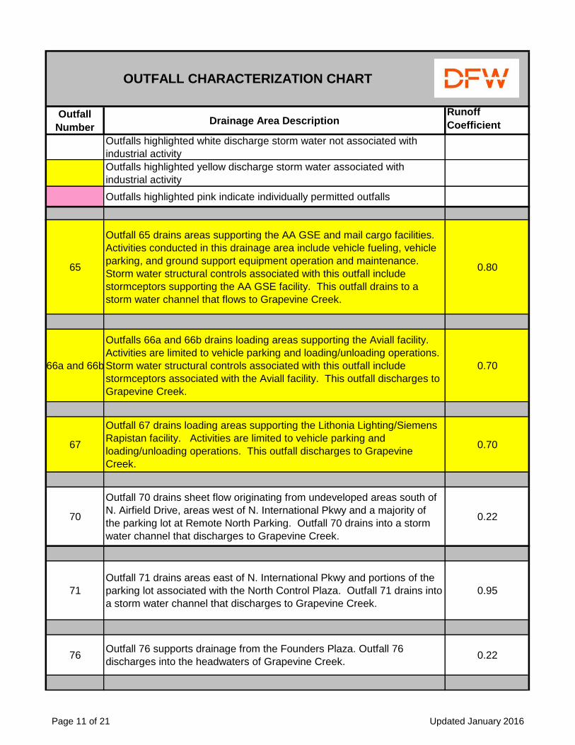
65
Outfall 65 drains areas supporting the AA GSE and mail cargo facilities.
Activities conducted in this drainage area include vehicle fueling, vehicle
parking, and ground support equipment operation and maintenance.
Storm water structural controls associated with this outfall include
stormceptors supporting the AA GSE facility. This outfall drains to a
storm water channel that flows to Grapevine Creek.
0.80
66a and 66b
Outfalls 66a and 66b drains loading areas supporting the Aviall facility.
Activities are limited to vehicle parking and loading/unloading operations.
Storm water structural controls associated with this outfall include
stormceptors associated with the Aviall facility. This outfall discharges to
Grapevine Creek.
0.70
67
Outfall 67 drains loading areas supporting the Lithonia Lighting/Siemens
Rapistan facility. Activities are limited to vehicle parking and
loading/unloading operations. This outfall discharges to Grapevine
Creek.
0.70
70
Outfall 70 drains sheet flow originating from undeveloped areas south of
N. Airfield Drive, areas west of N. International Pkwy and a majority of
the parking lot at Remote North Parking. Outfall 70 drains into a storm
water channel that discharges to Grapevine Creek.
0.22
71
Outfall 71 drains areas east of N. International Pkwy and portions of the
parking lot associated with the North Control Plaza. Outfall 71 drains into
a storm water channel that discharges to Grapevine Creek.
0.95
76Outfall 76 supports drainage from the Founders Plaza. Outfall 76
discharges into the headwaters of Grapevine Creek.0.22
Page 11 of 21 Updated January 2016

Outfall
NumberDrainage Area Description
Runoff
Coefficient
Outfalls highlighted white discharge storm water not associated with
industrial activity
Outfalls highlighted yellow discharge storm water associated with
industrial activity
Outfalls highlighted pink indicate individually permitted outfalls
OUTFALL CHARACTERIZATION CHART
77*
Outfall 77 supports drainage from the southern parking areas at the
Trammel Crow Trade Centers 3, 4, and 5 facilities located in the ICP
area. Activities are limited to warehousing, light industry, and
loading/unloading activities. This outfall drains into Grapevine Creek.
0.70
78*
Outfall 78 drains loading areas supporting the Siemens Warehouse
facility (1011 N. 28th Avenue) in the ICP area. Activities are limited to
vehicle parking and loading/unloading operations. This outfall contains a
rubber check valve backflow device inserted prior to the mouth of the
pipe and discharges into Grapevine Creek.
0.70
79
Outfall 79a supports drainage from the western portion of the Trans-
Trade Inc./Broder Bros. Facility in the ICP area. This outfall contains a
rubber check valve backflow device at the mouth of the pipe designed to
discharge first flush storm water once the detention pond reaches
capacity. Activities are limited to warehousing, light industry, and
loading/unloading activities. This outfall drains into a concrete lined
channel that discharges to Grapevine Creek.
0.70
80*
Outfall 80 supports drainage from the southern portion of the Aviall
facility. Activities are limited to vehicle parking and loading/unloading
operations. Storm water structural controls associated with this outfall
include stormceptors supporting the Aviall facility. This outfall discharges
to a concrete lined channel and flows into Grapevine Creek.
0.70
Page 12 of 21 Updated January 2016

Outfall
NumberDrainage Area Description
Runoff
Coefficient
Outfalls highlighted white discharge storm water not associated with
industrial activity
Outfalls highlighted yellow discharge storm water associated with
industrial activity
Outfalls highlighted pink indicate individually permitted outfalls
OUTFALL CHARACTERIZATION CHART
81
Outfall 81a supports drainage from the eastern portion of the Trans-
Trade Inc./Broder Bros. Facility in the ICP area. This outfall contains a
rubber check valve backflow device at the mouth of the pipe designed to
discharge first flush storm water once the detention pond reaches
capacity. Activities are limited to warehousing, light industry, and
loading/unloading activities. This outfall drains into a concrete lined
channel that discharges to Grapevine Creek.
0.70
82*
Outfall 82 supports drainage from the facility located at 2701 Regent
Boulevard in the ICP area. Activities are limited to vehicle parking, light
industry, and loading/unloading operations. Storm water structural
controls associated with outfall include oil/water separators (storm
troopers) and detention ponds. This outfall is designed to support high
flow conditions that bypass the detention pond and storm trooper and
flow directly to this outfall. This outfall drains into and unlined ditch and
flows to Grapevine Creek.
0.70
83*
Outfall 83 supports drainage from the facility located at 2701 Regent
Boulevard in the ICP area. Activities are limited to vehicle parking, light
industry and loading/unloading operations. This outfall drains into and
unlined ditch and flows to Grapevine Creek.
0.70
84*
Outfall 84 supports drainage from the Twinrose Regent I (2611 Regent
Blvd.) and Twinrose Regent II (2555 Regent Blvd.) facilities located in the
ICP area. Activities are limited to vehicle parking and loading/unloading
operations. Two detention ponds and two stormceptors are associated
with this outfall. This outfall drains into an unlined ditch and flows to
Grapevine Creek.
0.70
Page 13 of 21 Updated January 2016

Outfall
NumberDrainage Area Description
Runoff
Coefficient
Outfalls highlighted white discharge storm water not associated with
industrial activity
Outfalls highlighted yellow discharge storm water associated with
industrial activity
Outfalls highlighted pink indicate individually permitted outfalls
OUTFALL CHARACTERIZATION CHART
85*
Outfall 85 supports drainage from Esters Boulevard which includes the
northern parking areas at Trammel Crow Trade Centers 3,4,5 and Perot
Bax Global (2400 & 2402 Esters Boulevard). Activities are limited to
warehousing, light industry, vehicle parking, and loading/unloading
operations. This outfall discharges into Grapevine Creek.
0.70
86*
Outfall 86 supports drainage from the Trammel Crow Trade Center 2
facilities, Amazon.com warehouse, and the LifeScience Logistics facility.
Activities are limited to vehicle parking and loading/unloading operations.
Structural controls associated with the outfall include a stormceptor
supporting the Trammel Crow Trade Center 2 facility and detention
ponds located upstream that discharge to Grapevine Creek.
0.70
95
Outfall 95 supports drainage from the TwinRose Regent II facility (2555
Regent Blvd). Storm water structural controls associated with this outfall
include two oil/water separators. This outfall drains into an unlined ditch
into a tributary that discharges to Grapevine Creek.
0.70
26
Outfall 26 drains the northern portion of the Northeast Cargo facility.
Activities occurring in this area include aircraft taxi, loading/unloading
operations, aircraft fueling, ground support equipment operation, and
light vehicle/aircraft maintenance. Storm water structural controls
associated with this outfall include one fuel separator and Type D inlets
supporting portions of the NE Cargo ramp. This outfall drains to a storm
water channel discharging to Hackberry Creek.
0.80
Page 14 of 21 Updated January 2016

Outfall
NumberDrainage Area Description
Runoff
Coefficient
Outfalls highlighted white discharge storm water not associated with
industrial activity
Outfalls highlighted yellow discharge storm water associated with
industrial activity
Outfalls highlighted pink indicate individually permitted outfalls
OUTFALL CHARACTERIZATION CHART
27
Outfall 27 drains the middle portion of the Northeast Cargo facility.
Activities occurring in this area include aircraft taxi, loading/unloading
operations, aircraft fueling, ground support equipment operation, and
light vehicle/aircraft maintenance. Storm water structural controls
associated with this outfall include one fuel separator and Type D inlets
supporting portions of the NE Cargo ramp. This outfall drains to a storm
water channel discharging to Hackberry Creek.
0.80
28
Outfall 28 drains portions of the DFW Airport Pavements and Grounds
maintenance facility and sections of runway 35R. Activities include
aircraft taxi and landings, vehicle/equipment storage, vehicle fueling,
vehicle/equipment maintenance. One diversion box is located in this
area. This outfall drains to South Forth Hackberry Creek.
0.80
35
Outfall 35 drains the northern portion of runway 13L. Activities
conducted in this drainage area include aircraft taxi, takeoff and landings.
This outfall drains to a storm water channel that flows to Hackberry
Creek.
0.95
39
Outfall 39 drains the southern portion of runway 31R. Activities
conducted in this drainage area include aircraft taxi, takeoff and landings.
This outfall drains to a storm water channel that flows to Hackberry
Creek.
0.95
43
Outfall 43 supports drainage from the hotels and office buildings, Esters
114 Business Center, Parking Spot, and Smart Start facilities located off
Plaza Drive, O'Hare Drive, and Esters Blvd. in Irving, TX (off Airport
property). This outfall drains into Hackberry Creek.
0.95
Page 15 of 21 Updated January 2016

Outfall
NumberDrainage Area Description
Runoff
Coefficient
Outfalls highlighted white discharge storm water not associated with
industrial activity
Outfalls highlighted yellow discharge storm water associated with
industrial activity
Outfalls highlighted pink indicate individually permitted outfalls
OUTFALL CHARACTERIZATION CHART
60
Outfall 60 drains the southern portion of the Northeast Cargo facility.
Activities occurring in this area include aircraft taxi, loading/unloading
operations, aircraft fueling, and ground support equipment operation.
Storm water structural controls associated with this outfall include two
fuel separator and Type D inlets supporting portions of the NE Cargo
ramp and DPS 3. A storm water valve system associated with NE Cargo
sump is located adjacent to DPS 3 and can be used to contain accidental
spills or releases from the NE Cargo ramp. This outfall drains to a storm
water channel discharging to Hackberry Creek.
0.80
69
Outfall 69 drains the northeast portion of runway 17C and associated
taxiways. Activities are limited to aircraft taxi, takeoff and landings. This
outfall drains into a storm water channel discharging to Hackberry Creek.
0.95
20
Outfall 20 drains the ramp side area of Terminal A. Activities conducted
in this drainage area include aircraft taxi, takeoff and landings, aircraft
deicing, aircraft/vehicle fueling, aircraft/vehicle parking, ground support
equipment operation and maintenance. Storm water structural controls
associated with this outfall include nine fuel separators and Type D inlets
supporting portions of the Terminal A and Terminal C ramp. Storm water
valve systems to direct discharges associated with deicing activities at
the Taxiway Zulu and Echo-Kilo Deicing Pads are also associated with
this outfall. This outfall drains into a storm water channel that discharges
to Mud Springs Creek.
0.80
020
Outfall 020 is authorized under DFW Airport's Individual Wastewater
Permit No. 01441. This outfall authorizes discharges from all upstream
outfalls (including outfalls 21, 20, 27, 24, and 43). Outfall 020 is located
in a storm water channel that flows to Mud Springs Creek.
Page 16 of 21 Updated January 2016

Outfall
NumberDrainage Area Description
Runoff
Coefficient
Outfalls highlighted white discharge storm water not associated with
industrial activity
Outfalls highlighted yellow discharge storm water associated with
industrial activity
Outfalls highlighted pink indicate individually permitted outfalls
OUTFALL CHARACTERIZATION CHART
21
Outfall 21 drains the central portion of runways 35L, 35C, and 17R.
Activities conducted in this drainage area include aircraft taxi, takeoff and
landings. This outfall drains into a storm water channel that discharges
to Mud Springs Creek.
0.95
24
Outfall 24 drains the American Airlines Hangar #5, the DFW Airport DPS
1 Station facility, areas along E. Airfield Drive. Activities conducted in this
area include aircraft taxi, aircraft maintenance, and vehicle fueling.
Storm water structural controls associated with this outfall include one
fuel separator and Type D inlets supporting portions of the East Hangar
ramp. This outfall drains into a storm water channel that discharges to
Mud Springs Creek.
0.8
24b
Outfall 24b drains areas supporting the airport vehicle and bus
maintenance facility and discharges sheet flow originating from
undeveloped areas east of E. Airfield Drive. Activities conducted in this
area include vehicle/equipment maintenance, and vehicle parking. Storm
water structural controls associated with this outfall include one fuel
separator and Type D inlets supporting portions of the DFW Airport
Maintenance facility. Outfall 24b drains into a storm water channel that
discharges to Mud Springs Creek.
0.80
36Outfall 36 drains areas associated with Taxiway Q. Outfall 36 drains into
a storm water channel that discharges to Mud Springs Creek.0.95
37
Outfall 37 drains sheet flow originating from undeveloped areas west of
E. Airfield Drive, the Solid Waste facility and the Hazmat yard and
supports drainage from Outfall I-7. Outfall 37 drains into a storm water
channel that discharges to Mud Springs Creek.
0.22/0.5
Page 17 of 21 Updated January 2016

Outfall
NumberDrainage Area Description
Runoff
Coefficient
Outfalls highlighted white discharge storm water not associated with
industrial activity
Outfalls highlighted yellow discharge storm water associated with
industrial activity
Outfalls highlighted pink indicate individually permitted outfalls
OUTFALL CHARACTERIZATION CHART
38
Outfall 38 drains sheet flow originating from undeveloped areas west of
E. Airfield Drive. Outfall 38 drains into a storm water channel that
discharges to Mud Springs Creek.
0.22
40
Outfall 40 drains sheet flow originating from undeveloped areas west of
E. Airfield Drive. Outfall 40 drains into a storm water channel that
discharges to Mud Springs Creek.
0.22
41
Outfall 41 drains sheet flow originating from undeveloped areas west of
E. Airfield Drive. Outfall 41 drains into a storm water channel that
discharges to Mud Springs Creek.
0.22
42
Outfall 42 drains undeveloped areas west of runway 35 R and the DFW
Airport Salvage Yard. Activities in this area are limited to vehicle and
equipment storage. This outfall drains sheet flow to a storm water
channel that flows to Mud Springs Creek.
0.95/0.50
I-7
Outfall I-7 drains first flush storm water discharging to fuel separators
located at airport vehicle and bus maintenance, pavements and grounds,
and the East hangar. Storm water structural controls associated with this
outfall include two storm water treatment systems with a shutoff valve to
divert flows to the IW line in the event of a major release. This outfall
drains into an unlined ditch that discharges to Mud Springs Creek.
0.80
68
Outfall 68 drains sheet flow originating from undeveloped areas east of
Runway 35R. Outfall 68 drains into an unlined ditch into Cottonwood
Branch Creek.
0.22
Page 18 of 21 Updated January 2016

Outfall
NumberDrainage Area Description
Runoff
Coefficient
Outfalls highlighted white discharge storm water not associated with
industrial activity
Outfalls highlighted yellow discharge storm water associated with
industrial activity
Outfalls highlighted pink indicate individually permitted outfalls
OUTFALL CHARACTERIZATION CHART
75*Outfall 75 drains undeveloped areas east of runway 35R. Outfall 75
drains into an unlined ditch that flows into Cottonwood Branch Creek.0.22
18
Outfall 18 drains the eastern portion of the United States Postal Service
mail facility, the former airport train maintenance facility (currently
vacant), Sky Chefs, Host Marriott, and the Gate Gourmet food
preparation facilities. Activities include vehicle maintenance, vehicle
fueling, and loading/unloading operations. Outfall 18 discharges into a
storm water channel discharging into the north end of Trigg Lake.
0.95
22
Outfall 22 drains ramp areas associated with Terminals C and E.
Activities conducted in this drainage area include aircraft taxi, takeoff and
landings, aircraft deicing, aircraft/vehicle fueling, aircraft/vehicle parking,
ground support equipment operation and maintenance. Storm water
structural controls associated with this outfall include eight fuel
separators and Type D inlets supporting portions of the Terminal C,
Terminal E, and 5E ramp. A storm water lift station is also located east
of the 4E satellite terminal, and pumps storm water discharges to the
main trunk line. This outfall drains into a storm water channel
discharging to Trigg Lake.
0.80
23
Outfall 23 drains the Delta 5E complex and public parking areas
associated with Terminals C and E. Activities conducted in this drainage
area include vehicle fueling, vehicle parking, ground support equipment
operation and maintenance. This outfall drains into a storm water
channel discharging to Trigg Lake.
0.80
023
Outfall 023 is authorized under DFW Airport's Individual Wastewater
Permit No. 01441. This outfall authorizes discharges from all upstream
outfalls (including outfalls 45, 22, and 23). Outfall 023 is located in a
storm water channel that flows discharges to Trigg Lake.
Page 19 of 21 Updated January 2016

Outfall
NumberDrainage Area Description
Runoff
Coefficient
Outfalls highlighted white discharge storm water not associated with
industrial activity
Outfalls highlighted yellow discharge storm water associated with
industrial activity
Outfalls highlighted pink indicate individually permitted outfalls
OUTFALL CHARACTERIZATION CHART
34
Outfall 34 supports drainage from S. Airfield Drive and International
Parkway Instersection and N/S Service Road access loops. This outfall
drains down an approximate 50' concrete channel to Trigg Lake.
0.95
45
Outfall 45 drains the southern portion of runways 35L and 35C. Activities
include aircraft taxi, takeoff and landings, and aircraft deicing. Storm
water structural controls associated with this outfall include valve systems
to direct discharges associated with deicing activities on the Southeast
Hold Pad. This outfall drains into a storm water channel discharging to
Trigg Lake.
0.95
62
Outfall 62 drains the southern portions of runway 35L and associated
taxiways. This outfall drains to a storm water channel that discharges to
Trigg Lake.
0.95
73
Outfall 73 drains areas along the southern portions of International Pkwy.
Activities are limited to vehicle traffic, parking, and loading/unloading.
Outfall 73 discharges into a storm water channel which flows into Trigg
Lake.
0.95
106a
Outfall 106a drains portions of International Parkway west ofand at the
entrance to DFW Airport Headquarters. This outfall drains to a storm
water channel that discharges to Trigg Lake.
0.95
106b
Outfall 106a drains portions of International Parkway west of and storm
drains along the west entrance to the Rental Car Facility. This outfall
drains to a storm water channel that discharges to Trigg Lake.
0.95
Page 20 of 21 Updated January 2016

Outfall
NumberDrainage Area Description
Runoff
Coefficient
Outfalls highlighted white discharge storm water not associated with
industrial activity
Outfalls highlighted yellow discharge storm water associated with
industrial activity
Outfalls highlighted pink indicate individually permitted outfalls
OUTFALL CHARACTERIZATION CHART
R1
R1 supports drainage for the entire RAC complex. Approximately ten
storm water outfalls drain the rental car facilities and vehicle parking
areas. These outfalls all drain into the same storm water channel that
finally discharges to R1. Activities in this area include vehicle parking,
fueling, maintenance, and washing from predominantly rental car
agencies. The car rental facilities in this area are not required to obtain
an TPDES general permit. Outfall R1 discharges into an unlined ditch
discharging to Black Draw Creek.
0.80
R2
R2 supports drainage from the new bus maintenance facility. Activities in
this area include vehicle parking, fueling, maintenance, and washing.
Outfall R2 discharges into an unlined ditch discharging to Black Draw
Creek.
0.80
10
Outfall 10 drains storm water discharge from the west side of E. Airfield
Dr and includes the eastern parking drainage from the Flight Safety
International facility and sheet flow from the headwaters of Estelle Creek.
0.95
74*
Outfall 74 drains storm water from Flight Safety International operations
which flow directly to a bioretention basin located west of Flight Safety
International. This outfall drains into the headwaters of Estelle Creek.
0.95
74a*
Outfall 74a supports drainage from the northern portion of the Flight
Safety International facility expansion (3201 E. Airfield Dr). Storm water
structural controls associated with this outfall include one storm trooper.
0.95
Runoff Coefficients estimated using Recommended Runoff Coefficient Values Table 1.6 in the
iSWM Technical Manual provided on the North Central Texas Council of Government website
(copy of table attached)
Page 21 of 21 Updated January 2016