Embed Size (px)
Citation preview
April 20191 of 10 | Otway Offshore Project Information Sheet
Otway Offshore ProjectSeabed Assessment and Drilling Program 2019 – 2021Information Sheet | April 2019
Project overview
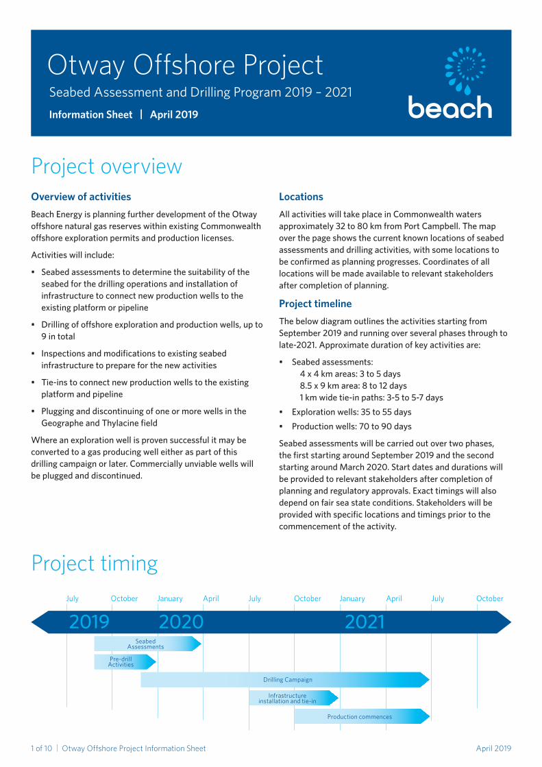
Project timing
Overview of activitiesBeach Energy is planning further development of the Otway offshore natural gas reserves within existing Commonwealth offshore exploration permits and production licenses.
Activities will include:
• Seabedassessmentstodeterminethesuitabilityoftheseabedforthedrillingoperationsandinstallationofinfrastructure to connect new production wells to the existing platform or pipeline
• Drillingofoffshoreexplorationandproductionwells,upto9 in total
• Inspectionsandmodificationstoexistingseabedinfrastructure to prepare for the new activities
• Tie-instoconnectnewproductionwellstotheexistingplatform and pipeline
• PlugginganddiscontinuingofoneormorewellsintheGeographeandThylacinefield
Whereanexplorationwellisprovensuccessfulitmaybeconverted to a gas producing well either as part of this drillingcampaignorlater.Commerciallyunviablewellswillbepluggedanddiscontinued.
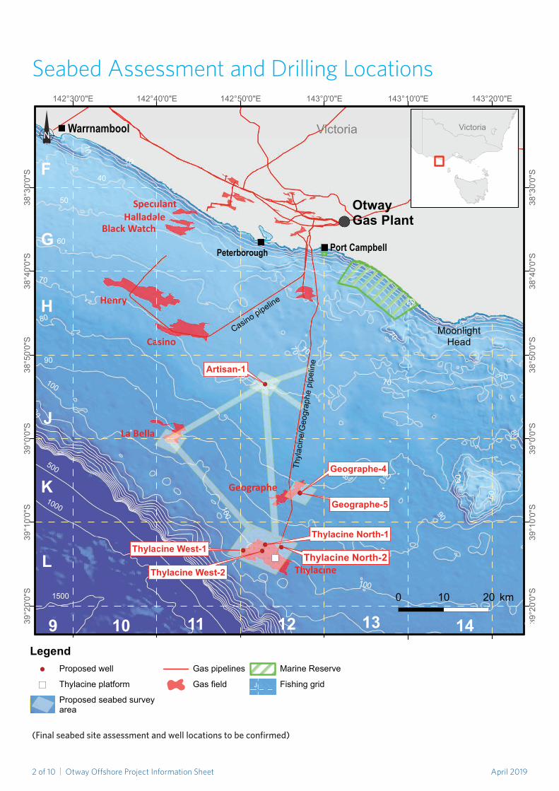
LocationsAll activities will take place in Commonwealth waters approximately32to80kmfromPortCampbell.Themapoverthepageshowsthecurrentknownlocationsofseabedassessmentsanddrillingactivities,withsomelocationstobeconfirmedasplanningprogresses.Coordinatesofalllocationswillbemadeavailabletorelevantstakeholdersafter completion of planning.
Project timelineThebelowdiagramoutlinestheactivitiesstartingfromSeptember2019andrunningoverseveralphasesthroughtolate-2021.Approximatedurationofkeyactivitiesare:
• Seabedassessments: 4 x 4 km areas: 3 to 5 days 8.5x9kmarea:8to12days 1kmwidetie-inpaths:3-5to5-7days• Explorationwells:35to55days• Productionwells:70to90days
Seabedassessmentswillbecarriedoutovertwophases,thefirststartingaroundSeptember2019andthesecondstartingaroundMarch2020.Startdatesanddurationswillbeprovidedtorelevantstakeholdersaftercompletionofplanning and regulatory approvals. Exact timings will also dependonfairseastateconditions.Stakeholderswillbeprovided with specific locations and timings prior to the commencement of the activity.
2019 2020 2021July October January April July October January April July October
Production commences
Infrastructure installation and tie-in
Seabed Assessments
Pre-drill Activities
Drilling Campaign
April 20192 of 10 | Otway Offshore Project Information Sheet
Seabed Assessment and Drilling Locations
(Finalseabedsiteassessmentandwelllocationstobeconfirmed)
")!(!(
!(!(
!(
!(!(
Peterborough
Warrnambool
Port Campbell
Henry
Thylacine
Casino
La Bella
Geographe
HalladaleSpeculant
Black Watch
Artisan-1
Geographe-4
Geographe-5
Thylacine West-1
Thylacine West-2
Thylacine North-1
60
40
20
10
10
100
100
100
500
130
1000
1500
70
60
80
50
70 70
80
70
70
90
70
50
90
70
80
80
143°20'0"E143°10'0"E143°0'0"E142°50'0"E142°40'0"E142°30'0"E
38°3
0'0"
S
38°3
0'0"
S
38°4
0'0"
S
38°4
0'0"
S
38°5
0'0"
S
38°5
0'0"
S
39°0
'0"S
39°0
'0"S
39°1
0'0"
S
39°1
0'0"
S
39°2
0'0"
S
39°2
0'0"
S
OT19-0018
Victoria
OtwayGas Plant
F
G
H
J
K
L
9 10 11 12 13 14 15Legend
!( Proposed well
") Thylacine platform
Proposed seabed surveyarea
Gas pipelines
Gas field
Marine Reserve
Fishing grid
Casino pipelineTh
ylac
ine/
Geo
grap
he p
ipel
ine
0 10 20 km
MoonlightHead
Thylacine North-2
(Final seabed site assessment and well locations to be confirmed)March 2019
Victoria
April 20193 of 10 | Otway Offshore Project Information Sheet
TheuniquegeologicalcharacteristicsoftheOtwayBasinmeanitisanabundantsourceofnaturalgaswhichhasbeenproducedintheregionformanyyears.Furtheractivities,includingoffshoredrilling,arebeingplannedfortheOtwayOffshoreProjectandthisinformationsheetprovidesanoverviewoftheproposedactivities,theregulatoryframeworkforsafetyandenvironmentprotection,potentialimpactsandrisksincarryingouttheseactivities,andmeasurestoreduceandmanagethem,inaccordancewithCommonwealth regulations.
TheOtwayOffshoreProjectincludesexisting:
• offshoregasfields
• anoffshoreplatform,wellsandsubseainfrastructure
• seabedandonshorerawgasburiedpipeline
• andagasprocessingplantnearPortCampbell
Thedevelopmentcommencedin2004byWoodsidePetroleumLtdunderajointventurearrangementwithfirstgasproducedinmid-2007.InMarch2010,OriginEnergyResourcesLtdcommencedoperatorshipofthejointventure(laterchangingitsnametoLatticeEnergy).InJanuary2018,BeachEnergyacquiredLattice,whichincludedtheOtwayOffshoreProject.
Beach Energy is planning to carry out further activities in the Otway Basin to ensure continued production at the Otway GasPlant,whichwillhelpensurenaturalgassupplyforVictorianhouseholdsandbusinesses.
Todate,threedevelopmentphaseshavebeencompletedtoenableproductionattheOtwayGasPlant:constructionofthegasplant;constructionoftheThylacineoffshoreplatform; and the development of the currently producing gaswells.Tomaintainnaturalgasproduction,furtherphasestodevelopadditionaloffshorewellsarebeingplanned.
Gas Development in Victoria’s Otway Basin
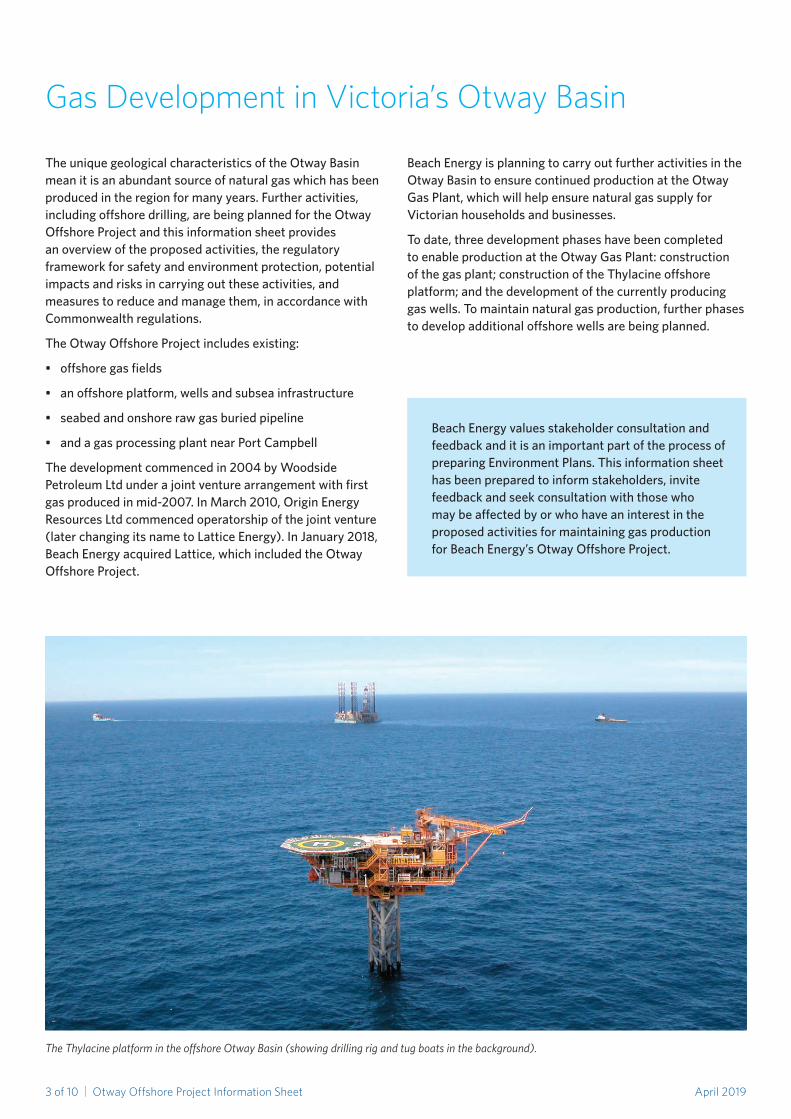
The Thylacine platform in the offshore Otway Basin (showing drilling rig and tug boats in the background).
Beach Energy values stakeholder consultation and feedbackanditisanimportantpartoftheprocessofpreparingEnvironmentPlans.Thisinformationsheethasbeenpreparedtoinformstakeholders,invitefeedbackandseekconsultationwiththosewhomaybeaffectedbyorwhohaveaninterestintheproposed activities for maintaining gas production forBeachEnergy’sOtwayOffshoreProject.
April 20194 of 10 | Otway Offshore Project Information Sheet
Environment protectionBeachEnergyrecognisestheenvironmental,heritage,socialand economic values in the areas in which we operate.
Theenvironmentinwhichtheactivitieswillbeconductedischaracterisedby:
• Waterdepthsrangingfrom60to200metres• Avarietyofmarinefaunaincludingthepotential
presence of:• Blue,humpbackandfinwhales,particularlyduring
the summer months• Southernrightandminkewhales,particularly
during the winter months• Commondolphinsandsharksspeciesthroughout
the year• NewZealandandAustralianfursealsthroughout
the year• Loggerhead,greenturtleandleatherbackturtles
throughout the year• Commonwealthmanagedfisheries,including:
southern and eastern scalefish and shark; and southernsquidjigfishery
• Victorianmanagedfisheries,including:rocklobsterandgiantcrab
• Commercialshippingactivity
TheAustralianMarineParks,ApolloandZeehan,andStateMarineProtectedAreas,TwelveApostlesMarineNationalParkandTheArchesMarineSanctuary,areoutsidetheproposed activity areas at a minimum distance of 20km.
BeachisintheprocessofdevelopingEnvironmentPlansfortheproposedactivitieswhichmustbeacceptedbytheNationalOffshorePetroleumSafetyandEnvironmentalManagementAuthority(NOPSEMA)beforeanyactivitycancommence.
ActivitieswillbecarriedoutinaccordancewithrelevantCommonwealthandStatesafetyandenvironmentallegislation.
TheEnvironmentPlanswillbecomprehensiveanddetailtheenvironmentthatmaybeaffectedbytheactivitiesandhowBeach will conduct the activities to ensure that potential impactsandanyresidualrisksarereducedto“AsLowAsReasonablyPracticable”(ALARP)andofanacceptablelevel.
IndevelopingtheEnvironmentPlans,relevantup-todatetechnicalandscientificstudieswillbetakenintoconsideration,alongwithstakeholderfeedback.
Whenconductingoffshoreactivities,thereisanunlikelyriskofreleaseofhydrocarbons(whichareprimarilygas)oraspill from vessels in the event of an accident. Beach Energy willreviewitsexistingOilPollutionEmergencyPlan(OPEP)to ensure it includes potential spill risks associated with the
proposedactivities.TheOPEPformspartoftheEnvironmentPlansrequiredtobeacceptedbyNOPSEMAforeachactivity.
PreparinganOPEPinvolvesusinghydrocarbonsspillmodelling information for the local area using the most conservativecrediblecasescenario.Themodellingcalculatesthetransport,spreading,entrainmentandevaporationofspilledhydrocarbonsovertime,basedontheprevailing wind and current conditions and the volume and physicalandchemicalpropertiesofpossiblespillsevent.TheplansalsoassessthelikelihoodandconsequencesofanyoilspillwhichmustbereducedtoALARPthrougharangeofcontrol measures and include detailed response plans.
FurtherinformationontheenvironmentalrequirementsforoffshorepetroleumactivitiesmaybefoundonNOPSEMA’swebsite:www.nopsema.gov.au.
Maritime safetySafetyisparamount.ThemarinevesselsanddrillrigcontractedbyBeachEnergywilloperateinaccordancewithAustralianMaritimeStandards,regulatedbytheAustralianMaritimeSafetyAuthority(AMSA)andwillhavetheirspecificsafetycasesreviewedandacceptedbyNOPSEMA.Thisincludesadherencetothefollowingprotocolsatsea:
• NotificationstoAMSAwillbeissuedbythevesselcontractoranddrillingrigoperatorbeforetheymobilisetothepermitareas,andbeforedemobilisation
• Communicationwithothervesselsandmarineuserswilloccur using standard maritime protocols
• Safeoperatingdistanceswillbemaintainedaroundallvessels and drilling rig at all times
Exclusion zonesTheactivitieswilloccuramongcommercialshippingroutesanddesignatedCommonwealthandStatefisherieswhichcovervastareas,whereastheseabedassessmentsonlyrequireaccesstorelativelysmallareasforshortperiodsoftime.
Duringdrilling,allvesselswillberequiredtoavoidadeclaredexclusionzoneof500metresaroundthedrillingrig.Thisformalexclusionzonewillbecommunicatedviaa‘NoticetoMariners’placedwithAustralianHydrographicOffice(AHO)outlining the exclusion zone and timeframe for the activities. Theexclusionzonewillbemonitoredbysupportingvesselsoncethedrillingrigisanchoredintoposition.Toavoidentanglementandsafetyrisks,fishingnets,linesorpotsshouldnotbeplacednearseabedassessmentareasordrilling exclusion zones.
We are committed to minimising the impact of our activities and will consult with commercial fishers on arrangements toensureeachother’soperationalplansareunderstood,helping to minimise any impacts to fishing activities and to Beach’s offshore development program.
April 20195 of 10 | Otway Offshore Project Information Sheet
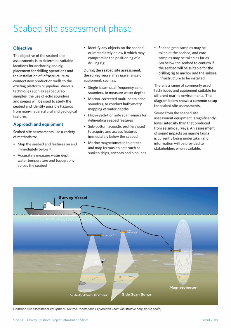
Common site assessment equipment. Source: Innerspace Exploration Team (Illustrative only, not to scale)
Seabed site assessment phase
ObjectiveTheobjectiveoftheseabedsiteassessmentsistodeterminesuitablelocations for anchoring and rig placement for drilling operations and the installation of infrastructure to connect new production wells to the existing platform or pipeline. Various techniquessuchasseabedgrabsamples,theuseofechosoundersandsonarswillbeusedtostudytheseabedandidentifypossiblehazardsfromman-made,naturalandgeologicalfeatures.
Approach and equipmentSeabedsiteassessmentsuseavarietyof methods to:
• Maptheseabedandfeaturesonandimmediatelybelowit
• Accuratelymeasurewaterdepth,water temperature and topography acrosstheseabed
• Identifyanyobjectsontheseabedorimmediatelybelowitwhichmaycompromise the positioning of a drilling rig
Duringtheseabedsiteassessment,the survey vessel may use a range of equipment,suchas:
• Single-beamdual-frequencyechosounders,tomeasurewaterdepths
• Motion-correctedmulti-beamechosounders,toconductbathymetrymapping of water depths
• High-resolutionsidescansonarsfordelineatingseabedfeatures
• Sub-bottomacousticprofilersusedtoacquireandassessfeaturesimmediatelybelowtheseabed
• Marinemagnetometer,todetectandmapferrousobjectssuchassunkenships,anchorsandpipelines
• Seabedgrabsamplesmaybetakenattheseabed,andcoresamplesmaybetakenasfaras6mbelowtheseabedtoconfirmiftheseabedwillbesuitableforthedrillingrigtoanchorandthesubseainfrastructuretobeinstalled
Thereisarangeofcommonlyusedtechniquesandequipmentsuitablefordifferentmarineenvironments.Thediagrambelowshowsacommonsetupforseabedsiteassessments.
Soundfromtheseabedsiteassessmentequipmentissignificantlylower intensity than that produced from seismic surveys. An assessment of sound impacts on marine fauna iscurrentlybeingundertakenandinformationwillbeprovidedtostakeholderswhenavailable.
April 20196 of 10 | Otway Offshore Project Information Sheet
TheoffshoreOtwayBasingasexploration and development program may drill up to 9 wells using a contractedsemi-submersibledrillrig,over a twelve to eighteen month period.
Additionalseabedinfrastructurewillalsobeinstalledtotie-innewwellsafter the drilling phase.
Twodifferenttypesofwellsareproposed as part of the drilling program:
• Explorationwell
Thefirstwelldrilledintoaprospective gas reservoir to prove if hydrocarbonsexist.
• Productionwell
A well that has successfully reached a proven reserve and will supply raw gasforprocessing.Atie-inwouldbeconstructedfromthewelltotheexistingseabedpipeline,whichcrosses the shore at the rifle range nearPortCampbellandconnectstotheonshoregaspipeline(PL250)throughtotheOtwayGasPlant.
Approach and equipmentAsemi-submersibledrillingrigwillbeusedtodrilleachwell.Broadly,thestepsinvolvedinmobilisingthedrillingrig and drilling a well include:
• Usinguptotwotugstotowtheriginto place using designated shipping channelswherepossible
• Anchoringtherigtotheseabedatsites that are environmentally and physicallysuitable,determinedfromtheseabedsiteassessment
• Anchorsmaybepre-laidatlocationspriortodrillrigmobilisation
• Drillingthewelltoaccessthegasreservoirbeneaththeseabed
• Movingtherigfromonewelltothenext at the completion of drilling and repeating the anchoring and drilling process
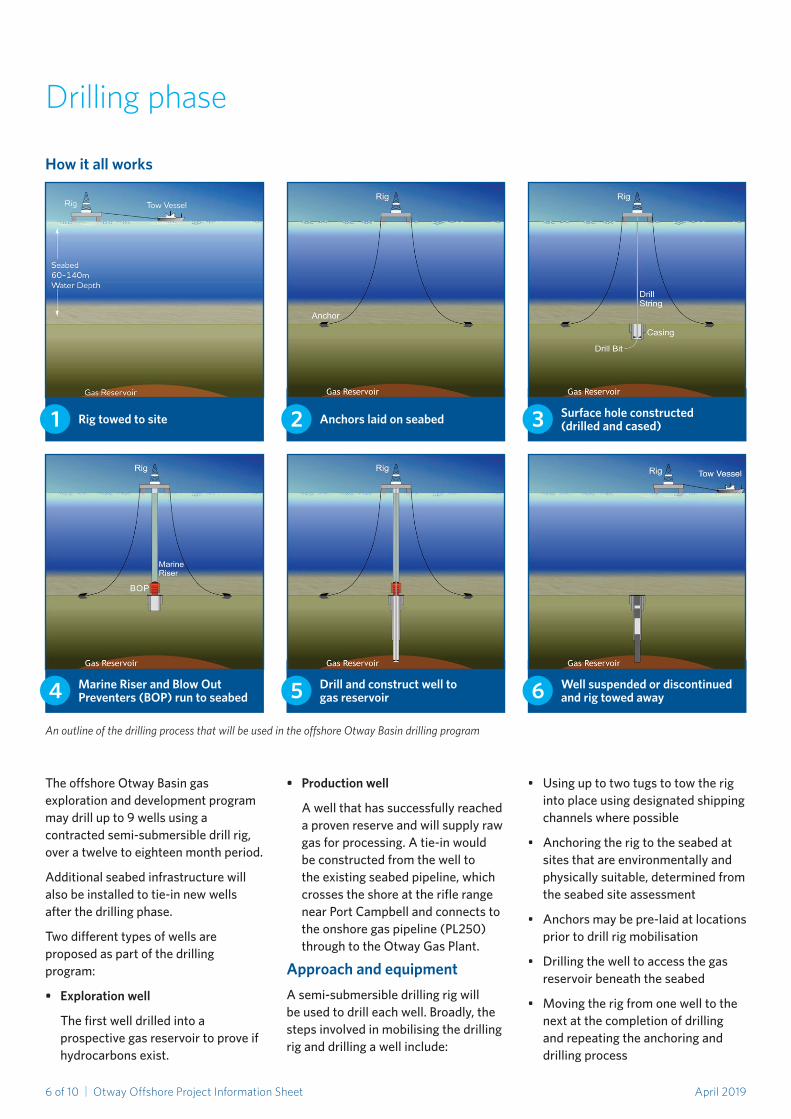
Drilling phase
How it all works
1
4
2
5
3
6
Rig towed to site
Marine Riser and Blow Out Preventers (BOP) run to seabed
Anchors laid on seabed
Drill and construct well to gas reservoir
Surface hole constructed (drilled and cased)
Well suspended or discontinued and rig towed away
An outline of the drilling process that will be used in the offshore Otway Basin drilling program

April 20197 of 10 | Otway Offshore Project Information Sheet
Why was this area chosen for gas exploration and development?
Beach Energy holds offshore exploration permitsandisrequiredtocompleteexploration activities within timeframes setbytheCommonwealthNationalOffshorePermitTitlesAdministrator(NOPTA).BeachEnergyalsohasexisting production permits and offshore gas facilities in the area already extractinghydrocarbonsandoperatesagasprocessingplantnearPortCampbellproducingnaturalgasfromthesereservoirs.TheproposedactivitieswillenableongoinggassupplyfortheVictorian market.
Are seabed assessments or VSP the same as a seismic survey? What is the difference?
No,theseactivitiesarenotthesameasa seismic survey which uses different technology to map the geology several kilometresbelowtheseabed.Theseabedsiteassessmentsonlymapthesurfaceandimmediatelybelowthesurface,usingechosounders,sonarsandasub-bottomprofilerwhichoperateatamuchlowerenergy(intensity)andmediumtohigherfrequencycomparedto those used in seismic surveys.
What is an Environment Plan and who will assess it?
AnEnvironmentPlanisrequiredunder the Commonwealth Offshore PetroleumandGreenhouseGasStorage(Environment)Regulations2009(theRegulations)toconductpetroleumactivities in Commonwealth waters.
ThecontentsofanEnvironmentPlanare set out in the Regulations and must include a description of the existing environmentandtheproposedactivity,an evaluation of the impacts and risksassociatedwiththeactivities,environmental performance outcomes andstandards,implementationstrategy,andreportingrequirements.
Questions and Answers
• Towingtherigtoanagreeddemobilisationpointonceallwellshavebeendrilledsafelyandsuccessfully
VerticalSeismicProfiling(VSP)isanevaluationmethodthatmaybeusedto validate one of the exploration wells after it is drilled.
Asthenamesuggests,thistechnologyproduces a high resolution seismic profilealongthewell,andenableswelldatatobecorrelatedwiththesurrounding conventional seismic surveys.Thetechnologyworksbyusing a small seismic energy source at surface near the well and receivers inthewellborethatrecordthesignal.IfaVSPisrequired,soundlevelswillbeassessedtoenableanimpactassessment and any mitigation plans thatmayberequired.
Drilling operationsOffshore drilling operations typically usebothwaterbasedandsyntheticbasedfluidstolubricateandstabilisethewellboresineachsection,aswellasto remove material produced through drilling called cuttings via circulation.
Waterbasedmudwillbeusedintheupper drilling sections to remove extracts of sedimentary layers called cuttings.Thesecuttingswillnotrequireanytreatmentandwillbedepositedontotheseabed.
Syntheticbasedfluidwillbeusedinthe lower drilling section and produces cuttingsthatwillrequiretreatmentto recover the fluid from the cuttings. Thecuttingswillbeprocessedonthedrillingrigbeforetheyaredischargedoverboardwheretheywillsettlerapidlyontheseaflooraroundthewellsite.Thecuttingswillcontainsmalllevelsofbasefluid,whichwillquicklybiodegrade.ThisisstandardindustrypracticeinAustralia.
Offshoredrillingalsorequirestheinstallation of some specialised equipmenttoensureintegrityofthewell and safety of the personnel post drilling of the surface hole.
Equipmentsuchasamarineriserandblowoutpreventers(BOP)willbeinstalled in order to prepare for drilling the reservoir.
Once the drilling of a well is complete,ifsuccessful,thewellwillbecommissionedandbroughtonline to produce gas (a production well),orsuspendedforfutureaccess(explorationwell).Commerciallyunviablewellswillbepluggedanddiscontinued.
The Diamond Ocean Onyx drill rig. This rig will be used in Beach Energy’s offshore drilling program in the Otway Basin. Source: Diamond Offshore Drilling, 2018.
April 20198 of 10 | Otway Offshore Project Information Sheet
AnEnvironmentPlanmustalsoincludeanOilPollutionEmergencyPlan(OPEP)formanaginganyhydrocarbonrelease.EnvironmentPlansareassessedbytheCommonwealthNationalOffshorePetroleumSafetyandEnvironmentalManagementAuthority(NOPSEMA).
What is ALARP?
ALARPstandsfor“AsLowAsReasonablyPracticable”.Itisanassessment principle commonly used in the oil and gas industry to assess and reduce potential risks and impacts that cannotbecompletelyeliminated.ForinformationonhowNOPSEMAassessesALARPsee:https://www.nopsema.gov.au/about/our-regulatory-activities/
What does an Oil Pollution Emergency Plan cover?
AnOilPollutionEmergencyPlandescribesthearrangementsforresponding to and monitoring any releaseofhydrocarbonandincludes:
• Thecontrolmeasuresnecessaryforrapid response
• Responsearrangementsandcapabilityinplacetoensurerapidimplementation and provide for the ongoingmaintenanceofcapability
• Responsearrangementsandcapabilityinplaceformonitoringoil pollution to inform response activities as well as monitoring the effectiveness of these activities
Thesearrangementsarebasedontheworse case spill event associated with the proposed activities to ensure that Beach Energy has the appropriate level ofresponsearrangementandcapability.
Will an exclusion zone exist?
Theworkwilloccuramongcommercialshipping routes and designated CommonwealthandStatefisheries.Eachfisherycoversavastarea,whereastheseabedassessmentswillonlyrequireaccesstorelativelysmallareasas follows:
• 4x4kmareas:3to5daysatatime• 8.5x9kmarea:8to12days
• 1kmwidetie-inpaths:3-5to5-7daysatatime,dependingonthelength of the path
Toavoidentanglementandsafetyrisks,fishingnets,linesorpotsshouldnotbeplacednearaseabedsiteassessment.
Duringdrilling,allvesselswillberequiredtoavoidadeclaredexclusionzone of 500 metres around the drilling rig.Thisformalexclusionzonewillbecommunicatedviaa‘NoticetoMariners’placed with Australian Hydrographic Office(AHO)outliningtheexclusionzone and timeframe for the activities. Theexclusionzonewillbemonitoredbysupporting vessels that will remain in the area once the drilling rig is anchored into position.
Beach Energy is committed to minimising the impact of its activities and will consult with commercial fishers on arrangements to ensure each other’s operationalplansareunderstood,helping to minimise any impacts to fishing activities and to Beach’s offshore development program.
How will you reduce the risk of collision with other vessels?
Themarinevesselsinvolvedintheactivities will operate in accordance withAustralianMaritimeStandardsandensuresafeoperationsby:
• Havingoperationalandnavigationlighting on all vessels
• Maintaininga24-hourshippingradarwatch
• Ensuringvesselshaveacrewtomaintain24-hourvisual,radioandradar watch for other vessels
• Equippingvesselswithnavigationlighting and movements that comply with maritime standards
• Monitoringandmanagingsafetyandexclusion zones
Will the activities affect whales and dolphins?
Anyimpactisexpectedtobelowand only in the area around each well site.Duetotheslowmovements
of the vessels within each well site area and the noise generated from thevessels,marinefaunaarelikelytoheartheequipmentandvesselsandavoidit.Theseabedassessmentequipmentoperatesathighfrequenciesgenerally outside the hearing range of whales.Dolphinsmayhearthehigherfrequencysounds.However,giventhelow intensity downward direction of theequipment’sbeam,anyimpacttodolphinsisexpectedtobelowduringthe assessment activity.
Avoidance of whales and dolphins will beundertakeninaccordancewiththeEnvironmentProtectionandBiodiversityConservation(EPBC)Regulations(2000),includingadherencetospeedanddistancerequirements.
What about rock lobsters?
Soundfromtheseabedsiteassessmentequipmentwillbeasignificantlylowerintensity than seismic surveys and sound modelling identified that sound levels will not reach the impact level referredtointheDayetalReport1 at the seafloor and therefore impacts on rock lobsterarenotpredicted.
Therewillbeminimalimpactfromdrilling activities given the wells are usuallyonflatseabedandavoidtypicalrocklobsterhabitat.
Will the site assessments or drilling impact upon commercial fishing?
Theseabedsiteassessmentswillbelocated within existing designated CommonwealthandStatefisheriesthatmaybeusedbycommercialfishers.Eachfisherycoversavastarea,whereastheseabedassessmentswillonlyrequireaccesstorelativelysmallareasas follows:
• 4x4kmareas:3to5daysatatime• 8.5x9kmarea:8to12days• 1kmwidetie-inpaths:3-5to5-7
daysatatime,dependingonthelength of the path
ThewellsitesarelocatedwithinexistingdesignatedCommonwealthandState
1: Day, R.D., McCauley, R.M. Fitzgibbon, Q.P., Hartmann, K., Semmens, J.M., Institute for Marine and Antarctic Studies, 2016, Assessing the impact of marine seismic surveys on southeast Australian scallop and lobster fisheries, University of Tasmania, Hobart, October. CC BY 3.0.\
April 20199 of 10 | Otway Offshore Project Information Sheet
fisheriesthatmaycurrentlybeusedbycommercial fishers.
Duringdrilling,adeclared500metreexclusionzonewillbeinplaceandwillbecommunicatedtoallfishingstakeholders.Toavoidentanglementandsafetyrisks,nets,linesorpotsshouldnotbeplacednearseabedassessment areas or drilling exclusion zones.
We are committed to minimising the impact of our activities and will consult with commercial fishers on arrangements to ensure each other’s operationalplansareunderstood,helping to minimise any impacts to fishing activities and to Beach Energy’s activities.
Will the drilling impact shipwrecks?
Thedrillingprogramwillnotimpactanyknownshipwrecks.Priortoanydrillingcommencing,BeachEnergywillhaveconductedaseabedsiteassessment process to ensure a detailed understanding of the marine environment of each well site. Any new informationconfirmedwillbeprovidedto relevant authorities.
How does the drilling rig work?
Beach Energy will use a typical semisubmersibledrillingrigthatisusedinAustralianwaters.Itcanoperateinwatersupto3,000mdeep,drillforgasatupto10,000mdeepandcanaccommodatearound150crew.
Once the drilling rig is in position and anchoredatthewellsite,thedrillingprocess is expected to use four or five stagesofdrilling,startingwitha36-inchdrillhead.Drillingwillthenreducein diameter to consecutively smaller sizes until it reaches the end target depth.
Foreachsection,acasingwillbeplacedintheholeandcemented,thenasmallerdrillwillberunthroughthecasingtodrill a smaller hole to the next target depth and the process repeated until the wellboreiscompleted.
How is the drilling rig secured?
Oncethedrillingrighasbeentowedtothewellsite,supportedbyan‘anchor
handlingvessel’,thetugboatswillrunout eight anchoring lines which may extendtoakilometre.Specificallydesignedmarineanchors,around15–20tonneseach,willbeusedtomoorthedrillrig.Positioningoftheanchorswillbedeterminedbyarigorousmooringanalysis,basedontheresultsoftheseabedsiteassessmentandyear-roundweather data for the area.
How long will drilling take and when will you start?
Itisexpectedthateachexplorationwellwilltakebetween35to55days.Eachproductionwellwilltakebetween70to90days.Drillingisexpectedtostartaroundlate-2019toearly-2020,dependingonfinalprojectplanningdecisions,regulatoryapprovals,andfairseastateconditions.Theentiredrillingprogramwilltakearound12to18months.
What happens after the wells are drilled?
After the proposed productions well aredrilledandcommissioned,thehydrocarbonswithinthereserveswillflow through the pipeline via a small tie-intobeconstructedfromthewelltoanexistingseabedpipeline,totheOtwayGasPlantforprocessing.Thesereserves are expected to produce for several years. Other wells in this drilling programwillbesuspendedforfutureuse,byplacingastandardwellheadofaround one to two metres high from theseabed.PositionsofwellheadswillbenotifiedtoAustralianHydrographicServiceandrecordedonseacharts.Ifawellistobepluggedanddiscontinuedduetolimitedgasprospectivity,multiplecementplugswillbeinstalledwithinthewelltoisolatebothwaterandgaszones and permanently seal the well. Acementplugwillbeinstalledattheseabedandallcasingswillbecutatleast2mbelowmudline,toensurethattheseabedisreturnedtothesamecondition prior to drilling.
Will the drilling rig be visible from land?
Thedrillingrigandsupportvessels,willhavelowvisibilityfromthelandandmay appear similar to other shipping
activity.Gasflaringwillberequiredforthe proposed production wells. Given thesignificantdistancefromshore,theflaringisnotlikelynotbevisible.Flaringis a common and necessary part of the gasproductionprocess,carriedouttosafelycombustexcessgases.
How many people will work on the drilling rig?
Therewillbeupto150crewonthedrillingrigatanyonetime.Thecrewwillbetransportedtoandfromtherigviahelicopter.Thehelicopterwilltake a direct path to the drilling rig and will fly at an altitude unlikely to cause disturbancetoactivitiesonthegroundor sea surface.
What are drill cuttings? How are they dealt with?
Drillcuttingsaretheextractsofsedimentary layers that emerge from the drilling process and will range from very fine to coarse sizes. Cuttings will notrequireanytreatmentduringthetopholesectiondrillingandcanbedepositedontotheseabed.
Cuttings that will contain synthetic baseddrillingfluidswillbeprocessedonthedrillingrigbeforethecuttingsare discharged to settle rapidly on the seafloor. Marine mammals and fish maytransitthroughtheseareasbutwillusuallyavoidthedisturbance.Anyexposuretosuspendedsedimentbeforeitsettlesontheseabedwouldbehighlylocalised and temporary due to high dilution and fast dispersal in the water column.
What will Beach Energy do to ensure safety is maintained on the drilling rig?
BeachEnergyiscommittedtobestpractice safety standards. All drilling rigoperationswillbemanagedinaccordancewiththededicatedSafetyCaseforthedrillingrig,tobeacceptedbytheregulatorNOPSEMA,aspertherequirementsoftheOffshorePetroleumandGreenhouseGasStorage(Safety)Regulations2009(OPGGS).
FormoreinformationonSafetyCasessee:https://www.nopsema.gov.au/safety/safety-case/
April 201910 of 10 | Otway Offshore Project Information Sheet
Pleasebeadvisedthatallstakeholderfeedback,recordsofconsultation,copiesofcorrespondence,includingemails,willbecommunicatedtoNOPSEMAinthepreparationoftheEnvironmentPlansasrequiredbylegislation.
Ifyouareseekingfurtherinformationaboutthisprojectspecifictoyourfunctions,interestsoractivities,orwishtoprovidefeedback,pleasecontactus.BeachEnergyinvitesconsultationwithstakeholderspotentiallyaffectedbythesurveyorthedrilling,includingthosestakeholderswithspecificlocalknowledgeoraninterestintheenvironmentalperformanceofthisproject.FeedbackandconsultationwillinformthedevelopmentoftheEnvironmentPlans.
For further information please contact:
Contact us
1800 797 011
www.beachenergy.com.au/vic-otway-basin/
BeachEnergyvaluesstakeholderconsultationandfeedback,anditisanimportantpartofpreparingourEnvironmentPlansforacceptance.Thepurposeofconsultationistounderstandhowdifferentstakeholders’functions,interestsandactivitiesmaybeaffectedbytheseabedsiteassessments,drillingprogramandassociatedactivities.
BeachEnergywillconsiderallfeedback,includinganyconcernsandobjections.Measureswillbeexploredtoreduceanyimpactsandrisks,andresponseswillbeprovidedtostakeholders.AllfeedbackwillbeconsideredalongsidetechnicalandenvironmentalassessmentsastheEnvironmentPlansarepreparedforsubmissiontoNOPSEMA.
From25April2019,allEnvironmentPlanswillbepubliclyavailableontheNOPSEMAwebsite:https://www.nopsema.gov.au/withexploratorydrillingEnvironmentPlansrelevanttotheactivitiesdescribedinthisinformationsheetavailableforpubliccommentforaperiodof30daysaftertheyaresubmittedtoNOPSEMAforassessment.
Consultation