Embed Size (px)
Citation preview
PlanVIC 9000 ENV PLN
CDN/ID 17275058
Integrated Gas
OFFSHORE ENVIRONMENT PLAN SUMMARYOtway
Review Record
Rev Date Reason for Issue Prepared Checked Approved
0 13/11/2014 Issued for use TH SC/PD JM
1 09/01/2015 Reissued after NOPSEMA comment
JB TH JM
2 27/11/2017 Final – issued to NOPSEMA and DEDJTR for acceptance KH SC JM
3 14/02/2018 Final - Reissued to NOPSEMA and DEDJTR for acceptance SD KH MS
THE THREEWHATSWhat can go wrong?What could cause it to go wrong?What can I do to prevent it?
Once printed, this is an uncontrolled document unless issued and stamped Controlled Copy or issued under a transmittal.
PlanVIC 9000 ENV PLN
CDN/ID 17275058
Contents
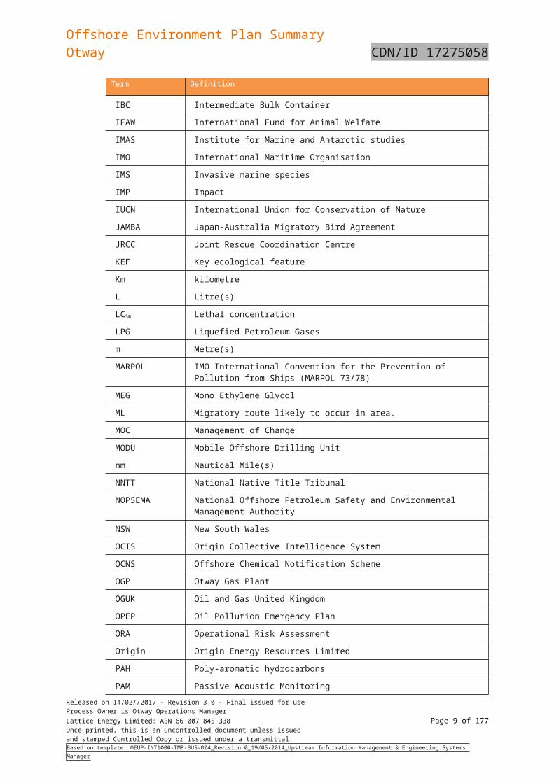
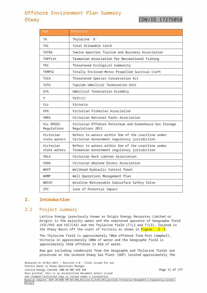
1. Definitions/Abbreviations
2. Introduction
2.1 Project summary2.2 The operator and nominated contact details2.3 Objectives of the EP Summary
3. Stakeholder Consultation
3.1 Stakeholder identification and classification3.2 Engagement methodology3.3 Stakeholder consultation summary and key topics
3.3.1 Commercial fisheries3.3.2 Community stakeholders3.3.3 Government departments and regulatory agencies3.3.4 Commonwealth and state elected members of parliament3.3.5 Infrastructure and utilities3.3.6 Media3.3.7 Agencies that support oil spill response
3.4 Further consultation as a result of revised oil spill modelling3.4.1 Identification of stakeholders for further consultation3.4.2 Summary of further consultation
3.5 Additional Consultation for Fishers in ZPI3.5.1 Timing of Consultation3.5.2 Consultation Summary - Tasmanian Fishing Industry Stakeholders3.5.3 Consultation Summary - Tasmanian State Government stakeholders3.5.4 Summary
3.6 Ongoing consultation and incident consultation process
4. Activity Description
4.1 Overview of major components4.2 Routine operations4.3 Logistics
4.3.1 Helicopters4.3.2 Vessels4.3.3 Fuel bunkering
4.4 Non-routine operations4.4.1 Well intervention4.4.2 Pipeline repressurisation and depressurisation4.4.3 Pipeline repairs4.4.4 Replacement of Geographe SVS and coolers
4.5 Major shutdown campaigns4.6 Planned discharges4.7 Worst case spill scenarios
4.7.1 Loss of well control4.7.2 Diesel Spill Scenario4.7.3 Pipeline spill scenario
5. Existing Environment
Released on 27/11//2017 – Revision 2.0 – Final issued for useProcess Owner is Otway Operations ManagerLattice Energy Limited: ABN 66 007 845 338 Page 2 of 122Once printed, this is an uncontrolled document unless issuedand stamped Controlled Copy or issued under a transmittal.Based on template: OEUP-INT1000-TMP-BUS-004_Revision 0_19/05/2014_Upstream Information Management & Engineering Systems Manager
PlanVIC 9000 ENV PLN
CDN/ID 172750585.1 Defining the ZPI5.2 Conservation values and sensitivities
5.2.1 Commonwealth marine reserves5.2.2 Commonwealth heritage places5.2.3 World heritage properties5.2.4 National Heritage Places5.2.5 Wetlands of international importance5.2.6 Victorian protected areas - Marine5.2.7 Victorian protected areas – Terrestrial5.2.8 Tasmanian protected areas – Marine5.2.9 Tasmanian protected areas – Terrestrial5.2.10 Key ecological features
5.3 Physical environment5.3.1 Otway assessments and surveys5.3.2 Geomorphology, geology, bathymetry and surficial sediments5.3.3 Metocean conditions5.3.4 Ambient sound levels
5.4 Biological environment5.4.1 Threatened ecological communities5.4.2 Threatened and migratory species5.4.3 Invasive/introduced marine species5.4.4 Benthic habitats and species assemblages
5.5 Socio-economic environment5.5.1 Victorian Coastal settlements5.5.2 Tasmanian Coastal settlements5.5.3 Shipping5.5.4 Petroleum exploration and production5.5.5 Commonwealth managed fisheries5.5.6 Victorian managed fisheries5.5.7 Tasmanian Managed Fisheries5.5.8 Tourism5.5.9 Recreational diving5.5.10 Recreational fishing
5.6 Cultural environment5.6.1 Maritime archaeological heritage5.6.2 Aboriginal heritage5.6.3 Native title
6. Environmental Impact and Risk Assessment Methodology
6.1 Definitions6.2 Zone of potential impact6.3 Impact and risk evaluation and assessment process6.4 Summary of risk
7. Implementation Strategy
7.1 Audit and review7.1.1 Audit7.1.2 Management of non-compliance7.1.3 Management of change
7.2 Incident management, emergency response and preparedness7.2.1 Oil pollution emergency7.2.2 Response Levels to Hydrocarbon Spills7.2.3 Post Spill Monitoring
Released on 27/11//2017 – Revision 2.0 – Final issued for useProcess Owner is Otway Operations ManagerLattice Energy Limited: ABN 66 007 845 338 Page 3 of 122Once printed, this is an uncontrolled document unless issuedand stamped Controlled Copy or issued under a transmittal.Based on template: OEUP-INT1000-TMP-BUS-004_Revision 0_19/05/2014_Upstream Information Management & Engineering Systems Manager
PlanVIC 9000 ENV PLN
CDN/ID 172750587.2.4 Environmental emergency response manual7.2.5 Relief well planning7.2.6 Emergency response exercises7.2.7 Oil spill response training
7.3 Performance measurement and reporting7.4 Monitoring
8. References
9. Document Information and History
Table of Figures
Figure 2-1: Otway Gas Development Locality 15
Figure 2-2: Otway Gas Development Schematic 16
Figure 5-1: Otway Basin: Historical Studies Woodside Bathymetry and Video Footage 45
Figure 5-2: Casino pipeline video survey 47
Figure 5-3: Map of the main shipping lanes in the Bass Strait 79
Figure 6-1: Origin’s risk assessment process 87
List of Tables
Table 2-1: Otway Operations Area Locality 10
Table 2-2: Otway offshore permits and environmental jurisdictions 11
Table 3-1: Stakeholders Identified 14
Table 3-2: Summary of consultation with Seafood Industry Victoria 16
Table 3-3: Summary of consultation with Tasmanian Fishing Industry Stakeholders 17
Table 3-4: Government and Regulatory Agencies 17
Table 3-5: Summary of further consultation with Seafood Industry Victoria and Victorian Rock Lobster Association19
Table 4-1: Major Components 29
Table 4-2: Planned emissions and discharges 34
Table 5-1: Terms and definitions used in listed threatened species tables 44
Table 5-2: Listed bird species that may be present in the ZPI 45
Table 5-3: Listed fish species that may occur in the ZPI 57
Table 5-4: Listed cetacean species that may occur in the ZPI 59
Table 5-5: Observed Cetaceans in Otway Basin 62
Table 5-6: Listed pinniped species that may occur in the ZPI 64
Table 5-7: Listed turtle species that may occur in the ZPI 65
Table 5-8: Coastal Settlement Population Estimates and Employment Figures 67
Table 5-9: Commonwealth Managed Fisheries within the ZPI 69
Table 5-10: State (Victorian) Managed Fisheries within the ZPI 70
Released on 27/11//2017 – Revision 2.0 – Final issued for useProcess Owner is Otway Operations ManagerLattice Energy Limited: ABN 66 007 845 338 Page 4 of 122Once printed, this is an uncontrolled document unless issuedand stamped Controlled Copy or issued under a transmittal.Based on template: OEUP-INT1000-TMP-BUS-004_Revision 0_19/05/2014_Upstream Information Management & Engineering Systems Manager
PlanVIC 9000 ENV PLN
CDN/ID 17275058Table 5-11: State (Tasmanian) Managed Fisheries within the ZPI 71
Table 5-12: Recreational Fisheries within the ZPI 74
Table 6-1: Control effectiveness 77
Table 6-2: Origin’s consequence ratings and management action matrix 77
Table 6-3: Risk assessment matrix (July 2010) 78
Table 6-4: Summary of the environmental risks for events associated with Otway offshore operations activity 79
Table 6-5: Summary of environmental impacts, risks and control measures for planned events of the Otway Offshore Operations 80
Table 6-6: Summary of environmental impacts, risks and control measures for unplanned events of the Otway Offshore Operations 85
Table 6-7: Summary of Potential Impacts of a Hydrocarbon Spill on Environmental Sensitivities 93
Table 6-8: Summary of environmental impacts, risks and control measures for oil spill response 104
Table 7-1: Level 1 Spill Control Agencies 108
Released on 27/11//2017 – Revision 2.0 – Final issued for useProcess Owner is Otway Operations ManagerLattice Energy Limited: ABN 66 007 845 338 Page 5 of 122Once printed, this is an uncontrolled document unless issuedand stamped Controlled Copy or issued under a transmittal.Based on template: OEUP-INT1000-TMP-BUS-004_Revision 0_19/05/2014_Upstream Information Management & Engineering Systems Manager

Offshore Environment Plan SummaryOtway CDN/ID 17275058
1. Definitions/Abbreviations
Term Definition
°C Degrees Celsius
µg Microgram(s)
µPa Micropascal(s)
AFMA Australian Fisheries Management Authority
AHR Aboriginal Heritage Register
AHS Australian Hydrographic Service
ALARP As Low As Reasonably Practicable
AMOSC Australian Marine Oil Spill Centre
AMSA Australian Maritime Safety Authority
APPEA Australian Petroleum Production and Exploration Association
AVG Abalone Viral Ganglioneuritis
BIA Biologically important areas
BL Breeding likely to occur in area
BK Breeding known to occur in area
BOD Basis of Design
CAMBA China-Australia Migratory Bird Agreement
CFA Country Fire Authority
CFT Critical Function Testing
CHARM Chemical Hazard and Risk Management
CMMS Computerised Maintenance Management System
CMR Commonwealth Marine Reserve
CO2 Carbon dioxide
CPUE Catch Per Unit Effort
Cth Commonwealth
Cth OPGGS (E) Regulations
Commonwealth Offshore Petroleum and Greenhouse Gas Storage (Environment) Regulations 2009
dB Decibels
DC Direct current
DCS Distributed Control System
DEDJTR Victorian Department of Economic Development, Jobs, Transport and Resources
DELWP Victorian Department of Environment, Land, Water and Planning
DN Nominal diameter
DNV Det Norske Veritas
DoD Department of Defence
DoEE Department of the Environment and Energy
DP Dynamic Positioning
Released on 14/02//2017 – Revision 3.0 – Final issued for useProcess Owner is Otway Operations ManagerLattice Energy Limited: ABN 66 007 845 338 Page 6 of 122Once printed, this is an uncontrolled document unless issuedand stamped Controlled Copy or issued under a transmittal.Based on template: OEUP-INT1000-TMP-BUS-004_Revision 0_19/05/2014_Upstream Information Management & Engineering Systems Manager
Offshore Environment Plan SummaryOtway CDN/ID 17275058
Term Definition
DPIPWE Department of Primary Industries, Parks, Water and Environment
EMAC Eastern Maar Aboriginal Corporation
EMD Emergency Management Department
EP Environment Plan
EPA Environmental Protection Authority
EPBC Act Commonwealth Environment Protection and Biodiversity Conservation Act
ERP Emergency Response Plan
ESD Emergency Shutdown
ESDV Emergency Shutdown Valve
FFG Act Flora and Fauna Guarantee Act
FK Foraging, feeding or related behaviour known to occur within area.
FL Foraging, feeding or related behaviour likely to occur within area.
GEO Geographe
GESAMP Joint Group of Experts on the Scientific Aspects of Marine Environmental Protection
GRT Gross Tonnes
GVI General Visual Inspection
h hour
HDD Horizontal Directionally Drilled
HFL Hydraulic Flying Lead
HPU Hydraulic Power Unit
HSE Health Safety and Environment
HSEMS Health, Safety and Environment Management System
HVAC Heating, ventilation and air-conditioning
IALA International Association of Lighthouse Authorities
IBC Intermediate Bulk Container
IFAW International Fund for Animal Welfare
IMAS Institute for Marine and Antarctic studies
IMO International Maritime Organisation
IMS Invasive marine species
IMP Impact
IUCN International Union for Conservation of Nature
JAMBA Japan-Australia Migratory Bird Agreement
JRCC Joint Rescue Coordination Centre
KEF Key ecological feature
Km kilometre
L Litre(s)
LC50 Lethal concentration
LPG Liquefied Petroleum Gases
Released on 14/02//2017 – Revision 3.0 – Final issued for useProcess Owner is Otway Operations ManagerLattice Energy Limited: ABN 66 007 845 338 Page 7 of 122Once printed, this is an uncontrolled document unless issuedand stamped Controlled Copy or issued under a transmittal.Based on template: OEUP-INT1000-TMP-BUS-004_Revision 0_19/05/2014_Upstream Information Management & Engineering Systems Manager
Offshore Environment Plan SummaryOtway CDN/ID 17275058
Term Definition
m Metre(s)
MARPOL IMO International Convention for the Prevention of Pollution from Ships (MARPOL 73/78)
MEG Mono Ethylene Glycol
ML Migratory route likely to occur in area.
MOC Management of Change
MODU Mobile Offshore Drilling Unit
nm Nautical Mile(s)
NNTT National Native Title Tribunal
NOPSEMA National Offshore Petroleum Safety and Environmental Management Authority
NSW New South Wales
OCIS Origin Collective Intelligence System
OCNS Offshore Chemical Notification Scheme
OGP Otway Gas Plant
OGUK Oil and Gas United Kingdom
OPEP Oil Pollution Emergency Plan
ORA Operational Risk Assessment
Origin Origin Energy Resources Limited
PAH Poly-aromatic hydrocarbons
PAM Passive Acoustic Monitoring
PCS Process Control System
PMST Protected Matters Search Tool
PMV Production Master Valve
ppb Parts per billion
ppm Parts per million
PSZ Petroleum Safety Zone
PCPFA Port Campbell Professional Fishermans’ Association
PCSLSC Port Campbell Surf Life Saving
PWV Production Wing Valve
RACON Radar beacon
RBI Risk Based Inspection
RESDV Riser Emergency Shutdown Valve
RO Reverse Osmosis
ROKAMBA Republic of Korea–Australia Migratory Birds Agreement
ROV Remotely Operated Vehicle
RSK Risk
s Second(s)
SCM Subsea Control Module
SCSSV Surface Controlled Subsurface Safety Valve
Released on 14/02//2017 – Revision 3.0 – Final issued for useProcess Owner is Otway Operations ManagerLattice Energy Limited: ABN 66 007 845 338 Page 8 of 122Once printed, this is an uncontrolled document unless issuedand stamped Controlled Copy or issued under a transmittal.Based on template: OEUP-INT1000-TMP-BUS-004_Revision 0_19/05/2014_Upstream Information Management & Engineering Systems Manager
Offshore Environment Plan SummaryOtway CDN/ID 17275058
Term Definition
SDU Subsea Distribution Unit
SES State Emergency Service
SESSF Southern and Eastern Scalefish and Shark Fishery
SHK Species or habitat known to occur in the area
SHL Species or species habitat likely to occur within area.
SHM Species or habitat may occur in the area
SHX Subsea Heat Exchanger
SIV Seafood Industry Victoria
SMC Subsea Manifold Cooler
SOPEP Shipboard Oil Pollution Emergency Plan
SSSV Sub-Surface Shutdown Valves
State waters Refers to Victorian state waters and Tasmanian state waters
SVS Subsea Valve Skid
t Tonne(s)
TA Thylacine ‘A’
TAC Total Allowable Catch
TATBA Twelve Apostles Tourism and Business Association
TARfish Tasmanian Association for Recreational Fishing
TEC Threatened Ecological Community
TEMPSC Totally Enclosed Motor Propelled Survival Craft
TSCA Threatened Species Conservation Act
TUTU Topside Umbilical Termination Unit
UTA Umbilical Termination Assembly
V Volt(s)
Vic Victoria
VFA Victorian Fisheries Association
VNPA Victorian National Parks Association
Vic OPGGS Regulations
Victorian Offshore Petroleum and Greenhouse Gas Storage Regulations 2011
Victorian state waters
Refers to waters within 3nm of the coastline under Victorian Government regulatory jurisdiction
Victorian state waters
Refers to waters within 3nm of the coastline under Tasmanian Government regulatory jurisdiction
VRLA Victorian Rock Lobster Association
VADA Victorian Abalone Divers Association
WHCP Wellhead Hydraulic Control Panel
WOMP Well Operations Management Plan
WRSSV Wireline Retrievable Subsurface Safety Valve
ZPI Zone of Potential Impact
Released on 14/02//2017 – Revision 3.0 – Final issued for useProcess Owner is Otway Operations ManagerLattice Energy Limited: ABN 66 007 845 338 Page 9 of 122Once printed, this is an uncontrolled document unless issuedand stamped Controlled Copy or issued under a transmittal.Based on template: OEUP-INT1000-TMP-BUS-004_Revision 0_19/05/2014_Upstream Information Management & Engineering Systems Manager
Offshore Environment Plan SummaryOtway CDN/ID 17275058
2. Introduction
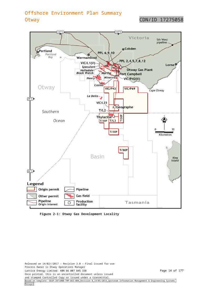
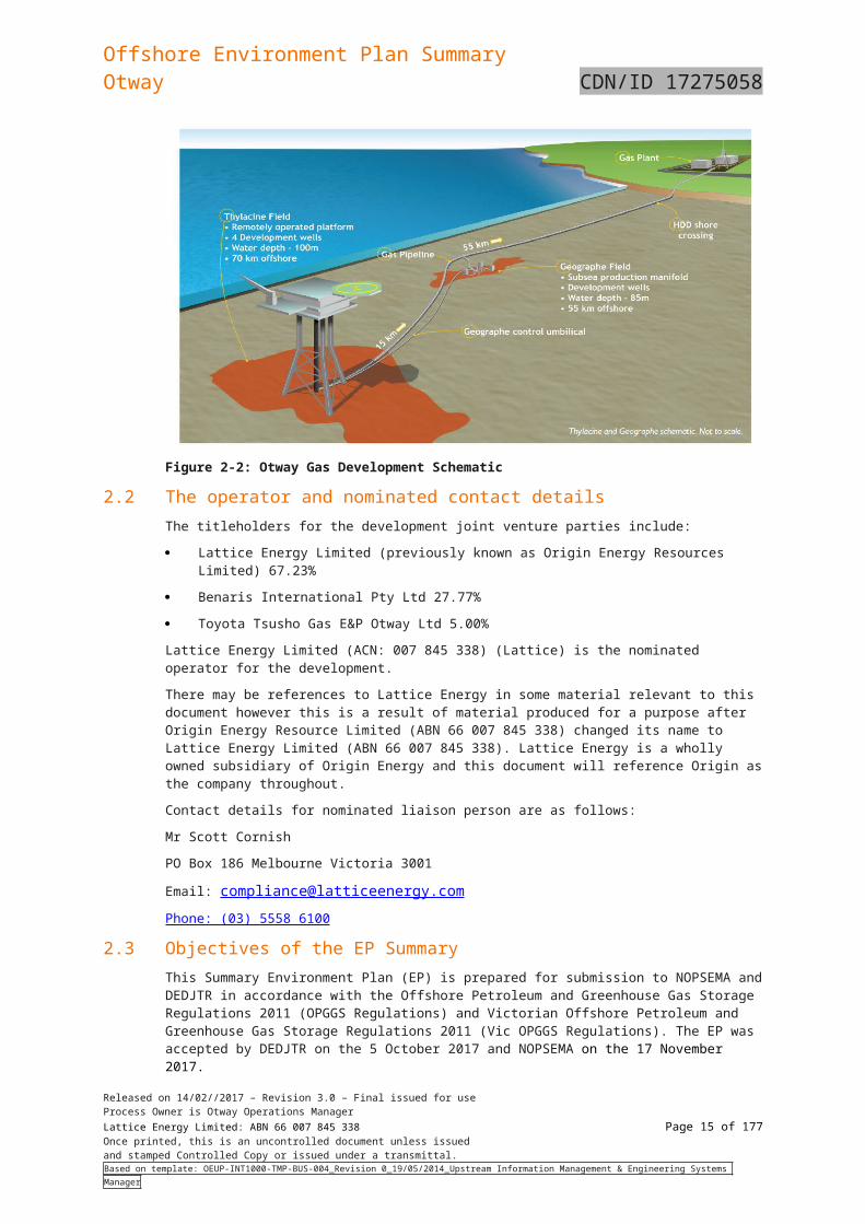
2.1 Project summary Lattice Energy (previously known as Origin Energy Resources Limited or Origin) is the majority owner and the nominated operator of Geographe field (VIC/P43 and VIC/L43) and the Thylacine field (T/L2 and T/L3), located in the Otway Basin off the coast of Victoria as shown in Figure 2-1.
The Thylacine field is approximately 70km offshore from Port Campbell, Victoria in approximately 100m of water and the Geographe field is approximately 55km offshore in 85m of water.
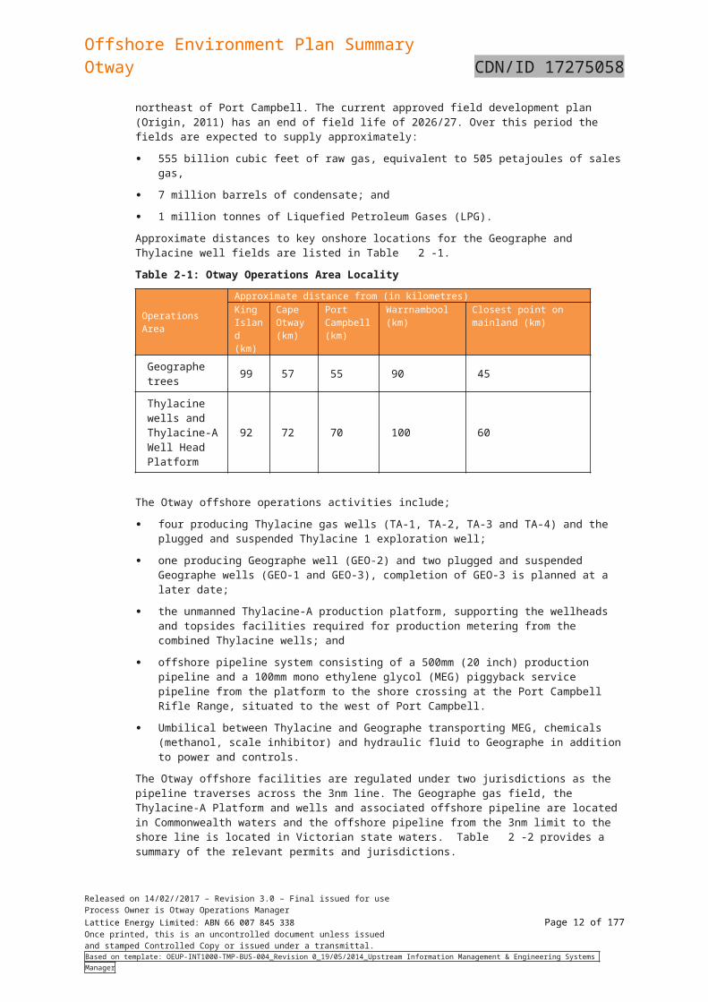
Raw gas including condensate from the Geographe and Thylacine fields are processed at the onshore Otway Gas Plant (OGP) located approximately 7km northeast of Port Campbell. The current approved field development plan (Origin, 2011) has an end of field life of 2026/27. Over this period the fields are expected to supply approximately:
555 billion cubic feet of raw gas, equivalent to 505 petajoules of sales gas,
7 million barrels of condensate; and
1 million tonnes of Liquefied Petroleum Gases (LPG).
Approximate distances to key onshore locations for the Geographe and Thylacine well fields are listed in Table 2-1.
Table 2-1: Otway Operations Area Locality
Operations Area
Approximate distance from (in kilometres)King Island (km)
Cape Otway (km)
Port Campbell (km)
Warrnambool (km)
Closest point on mainland (km)
Geographe trees 99 57 55 90 45
Thylacine wells and Thylacine-A Well Head Platform
92 72 70 100 60
The Otway offshore operations activities include;
four producing Thylacine gas wells (TA-1, TA-2, TA-3 and TA-4) and the plugged and suspended Thylacine 1 exploration well;
one producing Geographe well (GEO-2) and two plugged and suspended Geographe wells (GEO-1 and GEO-3), completion of GEO-3 is planned at a later date;
the unmanned Thylacine-A production platform, supporting the wellheads and topsides facilities required for production metering from the combined Thylacine wells; and
offshore pipeline system consisting of a 500mm (20 inch) production pipeline and a 100mm mono ethylene glycol (MEG) piggyback service pipeline from the platform to the shore crossing at the Port Campbell Rifle Range, situated to the west of Port Campbell.
Umbilical between Thylacine and Geographe transporting MEG, chemicals (methanol, scale inhibitor) and hydraulic fluid to Geographe in addition to power and controls.
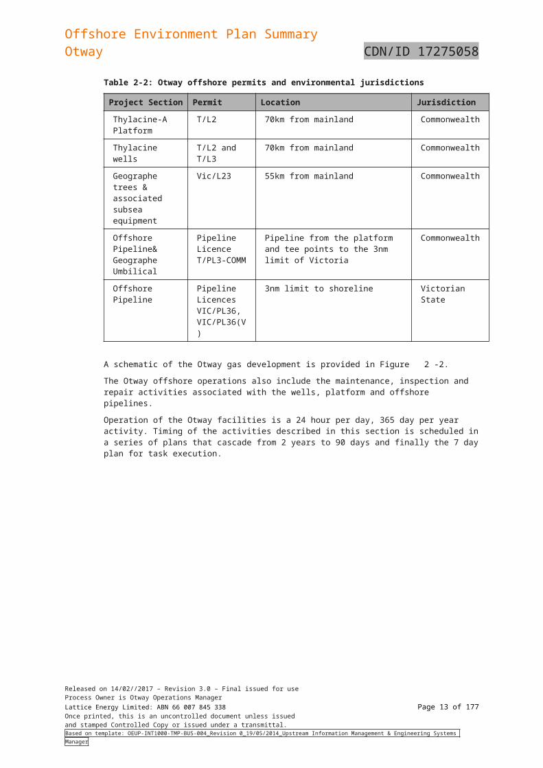
The Otway offshore facilities are regulated under two jurisdictions as the pipeline traverses across the 3nm line. The Geographe gas field, the Thylacine-A Platform and wells and associated offshore pipeline are located in Commonwealth waters and the offshore pipeline from the 3nm limit to the shore line is located in Victorian state waters. Table 2-2 provides a summary of the relevant permits and jurisdictions.
Released on 14/02//2017 – Revision 3.0 – Final issued for useProcess Owner is Otway Operations ManagerLattice Energy Limited: ABN 66 007 845 338 Page 10 of 122Once printed, this is an uncontrolled document unless issuedand stamped Controlled Copy or issued under a transmittal.Based on template: OEUP-INT1000-TMP-BUS-004_Revision 0_19/05/2014_Upstream Information Management & Engineering Systems Manager
Offshore Environment Plan SummaryOtway CDN/ID 17275058
Table 2-2: Otway offshore permits and environmental jurisdictions
Project Section Permit Location Jurisdiction
Thylacine-A Platform
T/L2 70km from mainland Commonwealth
Thylacine wells T/L2 and T/L3 70km from mainland Commonwealth
Geographe trees & associated subsea equipment
Vic/L23 55km from mainland Commonwealth
Offshore Pipeline& Geographe Umbilical
Pipeline Licence T/PL3-COMM
Pipeline from the platform and tee points to the 3nm limit of Victoria
Commonwealth
Offshore Pipeline Pipeline Licences VIC/PL36, VIC/PL36(V)
3nm limit to shoreline Victorian State
A schematic of the Otway gas development is provided in Figure 2-2.
The Otway offshore operations also include the maintenance, inspection and repair activities associated with the wells, platform and offshore pipelines.
Operation of the Otway facilities is a 24 hour per day, 365 day per year activity. Timing of the activities described in this section is scheduled in a series of plans that cascade from 2 years to 90 days and finally the 7 day plan for task execution.
Released on 14/02//2017 – Revision 3.0 – Final issued for useProcess Owner is Otway Operations ManagerLattice Energy Limited: ABN 66 007 845 338 Page 11 of 122Once printed, this is an uncontrolled document unless issuedand stamped Controlled Copy or issued under a transmittal.Based on template: OEUP-INT1000-TMP-BUS-004_Revision 0_19/05/2014_Upstream Information Management & Engineering Systems Manager
Offshore Environment Plan SummaryOtway CDN/ID 17275058
Figure 2-1: Otway Gas Development Locality
Released on 14/02//2017 – Revision 3.0 – Final issued for useProcess Owner is Otway Operations ManagerLattice Energy Limited: ABN 66 007 845 338 Page 12 of 122Once printed, this is an uncontrolled document unless issuedand stamped Controlled Copy or issued under a transmittal.Based on template: OEUP-INT1000-TMP-BUS-004_Revision 0_19/05/2014_Upstream Information Management & Engineering Systems Manager
Offshore Environment Plan SummaryOtway CDN/ID 17275058
Figure 2-2: Otway Gas Development Schematic
2.2 The operator and nominated contact detailsThe titleholders for the development joint venture parties include:
Lattice Energy Limited (previously known as Origin Energy Resources Limited) 67.23%
Benaris International Pty Ltd 27.77%
Toyota Tsusho Gas E&P Otway Ltd 5.00%
Lattice Energy Limited (ACN: 007 845 338) (Lattice) is the nominated operator for the development.
There may be references to Lattice Energy in some material relevant to this document however this is a result of material produced for a purpose after Origin Energy Resource Limited (ABN 66 007 845 338) changed its name to Lattice Energy Limited (ABN 66 007 845 338). Lattice Energy is a wholly owned subsidiary of Origin Energy and this document will reference Origin as the company throughout.
Contact details for nominated liaison person are as follows:
Mr Scott Cornish
PO Box 186 Melbourne Victoria 3001
Email: [email protected]
Phone: (03) 5558 6100
2.3 Objectives of the EP SummaryThis Summary Environment Plan (EP) is prepared for submission to NOPSEMA and DEDJTR in accordance with the Offshore Petroleum and Greenhouse Gas Storage Regulations 2011 (OPGGS Regulations) and Victorian Offshore Petroleum and Greenhouse Gas Storage Regulations 2011 (Vic OPGGS Regulations). The EP was accepted by DEDJTR on the 5 October 2017 and NOPSEMA on the 17 November 2017.
Released on 14/02//2017 – Revision 3.0 – Final issued for useProcess Owner is Otway Operations ManagerLattice Energy Limited: ABN 66 007 845 338 Page 13 of 122Once printed, this is an uncontrolled document unless issuedand stamped Controlled Copy or issued under a transmittal.Based on template: OEUP-INT1000-TMP-BUS-004_Revision 0_19/05/2014_Upstream Information Management & Engineering Systems Manager
Offshore Environment Plan SummaryOtway CDN/ID 17275058
3. Stakeholder Consultation
Stakeholder consultation for the EP was undertaken in line with current NOPSEMA guidelines on consultation requirements under the OPGGS (E) Regulations.
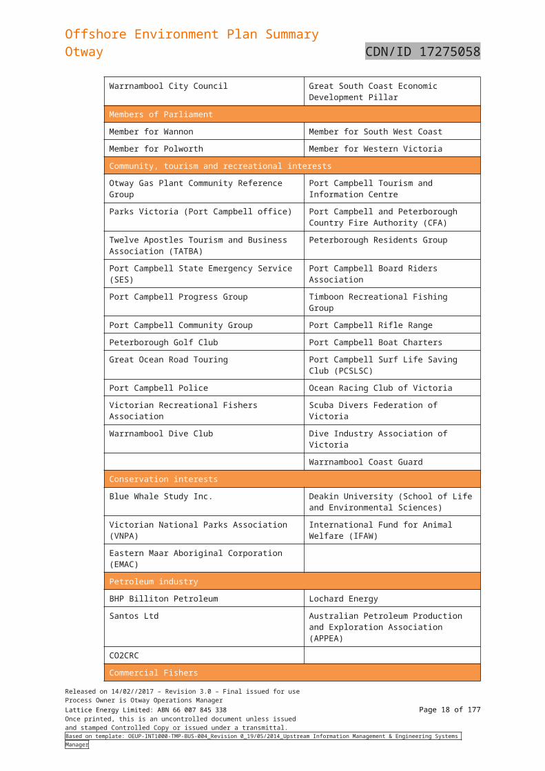
3.1 Stakeholder identification and classificationOrigin has had ongoing production activities in the Otway basin since 2010 and has undertaken regular and extensive consultation with offshore and onshore stakeholders in relation to its Otway Basin activities over this period. For the purpose of stakeholder consultation to support the EP, Origin has identified and consulted with “relevant persons whose functions, interests or activities may be affected by the activities to be carried out under the EP”.
Table 3-3 lists the stakeholders consulted during the process of revising the EP.
Table 3-3: Stakeholders Identified
Commonwealth Government
Department of the Environment and Energy (DoEE) Australian Maritime Safety Authority (AMSA)
Department of Immigration and Border Protection Australian Hydrographic Service (AHS)
Department of Defence (DoD) Australian Fisheries Management Authority (AFMA)
State Government
DEDJTR – Stakeholder Relations and Strategy; Emergency Management Division; Earth Resources Division
National Parks Advisory Council
Department of Environment, Land, Water and Planning (DELWP)
Office of the Premier
Office of the Minister for Energy, Environment and Climate Change
Office of the Minister for Resources
Parks Victoria Transport Safety Victoria (Marine Safety)
Fisheries Victoria Tourism Victoria
Regional Development Victoria Agriculture Victoria
Mineral Resources Tasmania Department of Primary Industry, Parks, Water and Environment (EPA Division), Tasmania
Local Government and other agencies
Moyne Shire Council Corangamite Shire Council
Wannon Water Southern Rural Water
Warrnambool City Council Great South Coast Economic Development Pillar
Members of Parliament
Member for Wannon Member for South West Coast
Member for Polworth Member for Western Victoria
Community, tourism and recreational interests
Otway Gas Plant Community Reference Group Port Campbell Tourism and Information Centre
Parks Victoria (Port Campbell office) Port Campbell and Peterborough Country Fire Authority (CFA)
Twelve Apostles Tourism and Business Association (TATBA)
Peterborough Residents Group
Released on 14/02//2017 – Revision 3.0 – Final issued for useProcess Owner is Otway Operations ManagerLattice Energy Limited: ABN 66 007 845 338 Page 14 of 122Once printed, this is an uncontrolled document unless issuedand stamped Controlled Copy or issued under a transmittal.Based on template: OEUP-INT1000-TMP-BUS-004_Revision 0_19/05/2014_Upstream Information Management & Engineering Systems Manager
Offshore Environment Plan SummaryOtway CDN/ID 17275058
Port Campbell State Emergency Service (SES) Port Campbell Board Riders Association
Port Campbell Progress Group Timboon Recreational Fishing Group
Port Campbell Community Group Port Campbell Rifle Range
Peterborough Golf Club Port Campbell Boat Charters
Great Ocean Road Touring Port Campbell Surf Life Saving Club (PCSLSC)
Port Campbell Police Ocean Racing Club of Victoria
Victorian Recreational Fishers Association Scuba Divers Federation of Victoria
Warrnambool Dive Club Dive Industry Association of Victoria
Warrnambool Coast Guard
Conservation interests
Blue Whale Study Inc. Deakin University (School of Life and Environmental Sciences)
Victorian National Parks Association (VNPA) International Fund for Animal Welfare (IFAW)
Eastern Maar Aboriginal Corporation (EMAC)
Petroleum industry
BHP Billiton Petroleum Lochard Energy
Santos Ltd Australian Petroleum Production and Exploration Association (APPEA)
CO2CRC
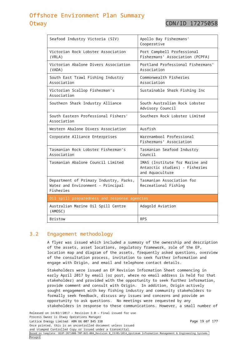
Commercial Fishers
Seafood Industry Victoria (SIV) Apollo Bay Fishermans’ Cooperative
Victorian Rock Lobster Association (VRLA) Port Campbell Professional Fishermans’ Association (PCPFA)
Victorian Abalone Divers Association (VADA) Portland Professional Fishermans’ Association
South East Trawl Fishing Industry Association Commonwealth Fisheries Association
Victorian Scallop Fisherman’s Association Sustainable Shark Fishing Inc
Southern Shark Industry Alliance South Australian Rock Lobster Advisory Council
South Eastern Professional Fishers’ Association Southern Rock Lobster Limited
Western Abalone Divers Association Ausfish
Corporate Alliance Enterprises Warrnambool Professional Fishermans’ Association
Tasmanian Rock Lobster Fisherman’s Association Tasmanian Seafood Industry Council
Tasmanian Abalone Council Limited IMAS (Institute for Marine and Antarctic studies) - Fisheries and Aquaculture
Department of Primary Industry, Parks, Water and Environment - Principal Fisheries
Tasmanian Association for Recreational Fishing
Oil spill preparedness and response agencies
Australian Marine Oil Spill Centre (AMOSC) Adagold Aviation
Bristow RPS
Released on 14/02//2017 – Revision 3.0 – Final issued for useProcess Owner is Otway Operations ManagerLattice Energy Limited: ABN 66 007 845 338 Page 15 of 122Once printed, this is an uncontrolled document unless issuedand stamped Controlled Copy or issued under a transmittal.Based on template: OEUP-INT1000-TMP-BUS-004_Revision 0_19/05/2014_Upstream Information Management & Engineering Systems Manager

Offshore Environment Plan SummaryOtway CDN/ID 17275058
3.2 Engagement methodology A flyer was issued which included a summary of the ownership and description of the assets, asset locations, regulatory framework, role of the EP, location map and diagram of the assets, frequently asked questions, overview of the consultation process, invitation to seek further information and engage with Origin, and email and telephone contact details.
Stakeholders were issued an EP Revision Information Sheet commencing in early April 2017 by email (or post, where no email address is held for that stakeholder) and provided with the opportunity to seek further information, provide comment and consult with Origin. In addition, Origin actively sought engagement with key fishing industry and community stakeholders to formally seek feedback, discuss any issues and concerns and provide an opportunity to ask questions. No meetings were requested by any stakeholders in response to these communications. However, a small number of responses were received and have been summarised in Section 3.3. Stakeholder consultation summary and key topics, email correspondence with stakeholders and the stakeholder consultation log is attached in the full EP.
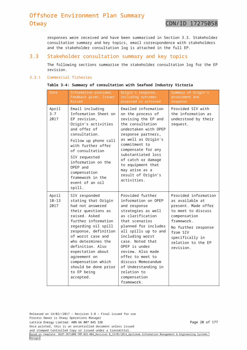
3.3 Stakeholder consultation summary and key topicsThe following sections summarise the stakeholder consultation log for the EP revision.
3.3.1 Commercial fisheries
Table 3-4: Summary of consultation with Seafood Industry Victoria
Date Information provided, Feedback given, Issues Raised
Origin’s response, including outcomes proposed or achieved
Summary of Origin’s assessment and response
April 3-7 2017
Email including Information Sheet on EP revision, Origin’s activities and offer of consultation. Follow up phone call with further offer of consultationSIV requested information on the OPEP and compensation framework in the event of an oil spill.
Emailed information on the process of revising the EP and the consultation undertaken with OPEP response partners, as well as Origin's commitment to compensate for any substantiated loss of catch or damage to equipment that may arise as a result of Origin’s activities.
Provided SIV with the information as understood by their request.
April 10-13 2017
SIV responded stating that Origin had not answered their questions as raised. Asked further information regarding oil spill response, definition of worst case and who determines the definition. Also expectation about agreement on compensation which should be done prior to EP being accepted.
Provided further information on OPEP and response strategies as well as clarification that scenarios planned for includes all spills up to and including worst case. Noted that OPEP is under review. Also made offer to meet to discuss Memorandum of Understanding in relation to compensation framework.
Provided information as available at present. Made offer to meet to discuss compensation framework.No further response from SIV specifically in relation to the EP revision.
Released on 14/02//2017 – Revision 3.0 – Final issued for useProcess Owner is Otway Operations ManagerLattice Energy Limited: ABN 66 007 845 338 Page 16 of 122Once printed, this is an uncontrolled document unless issuedand stamped Controlled Copy or issued under a transmittal.Based on template: OEUP-INT1000-TMP-BUS-004_Revision 0_19/05/2014_Upstream Information Management & Engineering Systems Manager
Offshore Environment Plan SummaryOtway CDN/ID 17275058
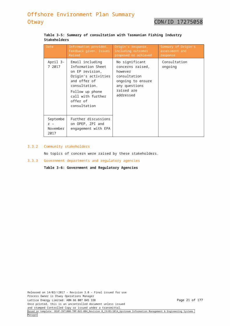
Table 3-5: Summary of consultation with Tasmanian Fishing Industry Stakeholders
Date Information provided, Feedback given, Issues Raised
Origin’s response, including outcomes proposed or achieved
Summary of Origin’s assessment and response
April 3-7 2017
Email including Information Sheet on EP revision, Origin’s activities and offer of consultation. Follow up phone call with further offer of consultation
No significant concerns raised, however consultation ongoing to ensure any questions raised are addressed
Consultation ongoing
September – November 2017
Further discussions on OPEP, ZPI and engagement with EPA
3.3.2 Community stakeholders
No topics of concern were raised by these stakeholders.
3.3.3 Government departments and regulatory agencies
Table 3-6: Government and Regulatory Agencies
Date Information provided, Feedback given, Issues Raised
Origin’s response, including outcomes proposed or achieved
Summary of Origin’s assessment and response
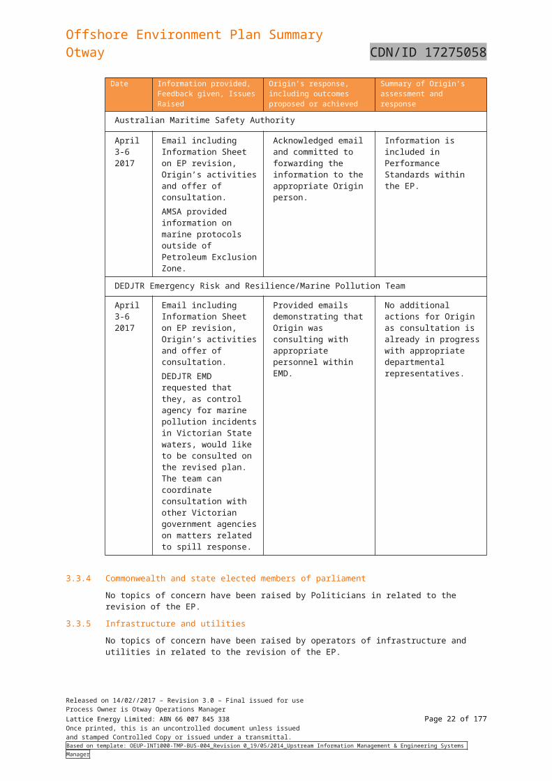
Australian Maritime Safety Authority
April 3-6 2017
Email including Information Sheet on EP revision, Origin’s activities and offer of consultation. AMSA provided information on marine protocols outside of Petroleum Exclusion Zone.
Acknowledged email and committed to forwarding the information to the appropriate Origin person.
Information is included in Performance Standards within the EP.
DEDJTR Emergency Risk and Resilience/Marine Pollution Team
April 3-6 2017
Email including Information Sheet on EP revision, Origin’s activities and offer of consultation. DEDJTR EMD requested that they, as control agency for marine pollution incidents in Victorian State waters, would like to be consulted on the revised plan. The team can coordinate consultation with other Victorian government agencies on matters related to spill response.
Provided emails demonstrating that Origin was consulting with appropriate personnel within EMD.
No additional actions for Origin as consultation is already in progress with appropriate departmental representatives.
Released on 14/02//2017 – Revision 3.0 – Final issued for useProcess Owner is Otway Operations ManagerLattice Energy Limited: ABN 66 007 845 338 Page 17 of 122Once printed, this is an uncontrolled document unless issuedand stamped Controlled Copy or issued under a transmittal.Based on template: OEUP-INT1000-TMP-BUS-004_Revision 0_19/05/2014_Upstream Information Management & Engineering Systems Manager
Offshore Environment Plan SummaryOtway CDN/ID 17275058
3.3.4 Commonwealth and state elected members of parliament
No topics of concern have been raised by Politicians in related to the revision of the EP.
3.3.5 Infrastructure and utilities
No topics of concern have been raised by operators of infrastructure and utilities in related to the revision of the EP.
3.3.6 Media
Origin has not received any media requests in relation to the Otway offshore operations since the last revision of the EP in 2014.
3.3.7 Agencies that support oil spill response
Origin has engaged with government and non-government organisations who have been identified as response partners within the OPEP.
All agreements that are in place with companies supporting a potential emergency situation for the Otway Operations are ongoing.
3.4 Further consultation as a result of revised oil spill modellingOrigin has undertaken additional oil spill modelling including the scenario of a potential loss of containment at a point 3 nm from the coastline. This revised modelling required further consultation with relevant stakeholders to ensure they had sufficient information in order to assess the risks and impacts to their activities, functions and/or interests.
3.4.1 Identification of stakeholders for further consultation
Origin reviewed the stakeholders who had previously been identified and consulted as part of the revision of the EP undertaken earlier in 2017 in order to identify any additional stakeholders that should be included and those that should be engaged in further consultation.
3.4.2 Summary of further consultation
Once Origin had identified the relevant stakeholders to engage following revision of the oil spill modelling, the following information was provided in addition to that which had already been included in the EP Revision Information Sheet issued in April 2017:
- Types and characteristics of the relevant hydrocarbons
- Control measures to minimise the risk of loss of containment
- Purpose and scope of the OPEP and the process undertaken to develop it, including:
o potential spill scenarios and definition of ‘worst case’ scenarios
o oil spill modelling for the scenario of the potential loss of containment of hydrocarbons at a location 3nm from the coastline
o development of appropriate response strategies
o identification of equipment/resources and actions for each viable response strategy
- Response actions in the event of a spill, including modelling for the actual spill scenario and planned response strategies
- Roles of government agencies in relation to notifications to marine users
- Origin’s monitoring activities, including scientific monitoring, if required, in the event of a spill
- Contact details for Origin should further consultation be required.
Engagement was undertaken with stakeholders as follows:
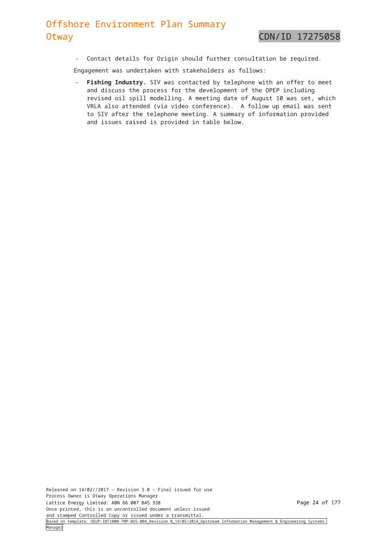
- Fishing Industry. SIV was contacted by telephone with an offer to meet and discuss the process for the development of the OPEP including revised oil spill modelling. A meeting date of August 10 was set, which VRLA also attended (via video conference). A follow up email was sent to SIV after the telephone meeting. A summary of information provided and issues raised is provided in table below.
Released on 14/02//2017 – Revision 3.0 – Final issued for useProcess Owner is Otway Operations ManagerLattice Energy Limited: ABN 66 007 845 338 Page 18 of 122Once printed, this is an uncontrolled document unless issuedand stamped Controlled Copy or issued under a transmittal.Based on template: OEUP-INT1000-TMP-BUS-004_Revision 0_19/05/2014_Upstream Information Management & Engineering Systems Manager
Offshore Environment Plan SummaryOtway CDN/ID 17275058
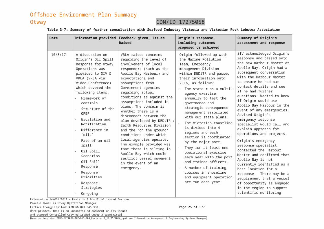
Table 3-7: Summary of further consultation with Seafood Industry Victoria and Victorian Rock Lobster Association
Date Information provided Feedback given, Issues Raised Origin’s response, including outcomes proposed or achieved
Summary of Origin’s assessment and response
10/8/17 A discussion on Origin’s Oil Spill Response for Otway Operations was provided to SIV & VRLA (VRLA via Video Conference) which covered the following items:
- Framework of controls- Structure of the OPEP- Escalation and
Notification- Difference in ‘oils’- Fate of an oil spill- Oil Spill Scenarios- Oil Spill Response- Response Priorities- Response Strategies- On-going monitoring
VRLA raised concerns regarding the level of involvement of local responders (such as the Apollo Bay Harbour) and expectations and assumptions from Government agencies regarding actual conditions as against the assumptions included in plans. The concern is whether there is a disconnect between the plan developed by DEDJTR / Earth Resources Division and the ‘on the ground' conditions under which local agencies operate. The example provided was that there is silting in Apollo Bay which could restrict vessel movement in the event of an emergency.
Origin followed up with the Marine Pollution Team, Emergency management Division within DEDJTR and passed their information onto VRLA, as follows:
- The state runs a multi-agency exercise annually to test the governance and strategic consequence management associated with our state plans.
- The Victorian coastline is divided into 4 regions and each section is coordinated by the major port.
- They run at least one operational exercise each year with the port and trained officers.
- A number of training courses in shoreline and equipment operation are run each year.
SIV acknowledged Origin’s response and passed onto the new Harbour Master at Apollo Bay. Origin had a subsequent conversation with the Harbour Master to ensure he had our contact details and see if he had further questions. Wanted to know if Origin would use Apollo Bay Harbour in the event of any emergencies. Advised Origin’s emergency response specialist would call and explain approach for operations and projects.
Origin’s emergency response specialist contacted the Harbour Master and confirmed that Apollo Bay is not currently identified as a base location for a response. There may be a requirement that a vessel of opportunity is engaged in the region to support scientific monitoring.
Released on 14/02//2017 – Revision 3.0 – Final issued for useProcess Owner is Otway Operations ManagerLattice Energy Limited: ABN 66 007 845 338 Page 19 of 122Once printed, this is an uncontrolled document unless issuedand stamped Controlled Copy or issued under a transmittal.Based on template: OEUP-INT1000-TMP-BUS-004_Revision 0_19/05/2014_Upstream Information Management & Engineering Systems Manager
Offshore Environment Plan SummaryOtway CDN/ID 17275058
Date Information provided Feedback given, Issues Raised Origin’s response, including outcomes proposed or achieved
Summary of Origin’s assessment and response
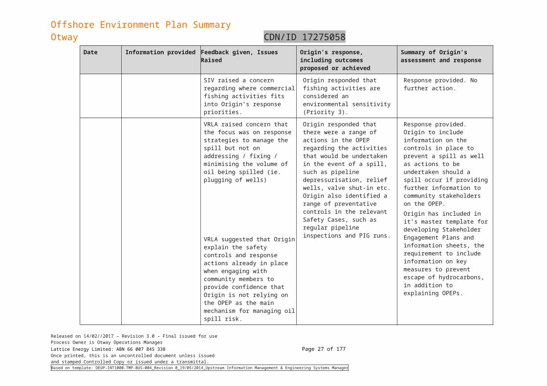
VRLA questioned whether the OPEP also covered spills other than oil spills, such as potential loss of containment of chemicals during a drilling campaign.
Origin responded that each activity (such as drilling) will have its own EP and the risks associated with that activity are included in the specific EP.
Each EP also has its own OPEP EP will address oil spills for that activity and other spill scenarios, such as chemical spills, are covered in the EP itself.
Response provided. No further action.
SIV raised a concern regarding where commercial fishing activities fits into Origin’s response priorities.
Origin responded that fishing activities are considered an environmental sensitivity (Priority 3).
Response provided. No further action.
VRLA raised concern that the focus was on response strategies to manage the spill but not on addressing / fixing / minimising the volume of oil being spilled (ie. plugging of wells)
VRLA suggested that Origin explain the safety controls and response actions already in place when engaging with community members to provide confidence that Origin is not relying on the OPEP as the main mechanism for managing oil spill risk.
Origin responded that there were a range of actions in the OPEP regarding the activities that would be undertaken in the event of a spill, such as pipeline depressurisation, relief wells, valve shut-in etc. Origin also identified a range of preventative controls in the relevant Safety Cases, such as regular pipeline inspections and PIG runs.
Response provided. Origin to include information on the controls in place to prevent a spill as well as actions to be undertaken should a spill occur if providing further information to community stakeholders on the OPEP.Origin has included in it’s master template for developing Stakeholder Engagement Plans and information sheets, the requirement to include information on key measures to prevent escape of hydrocarbons, in addition to explaining OPEPs.
Released on 14/02//2017 – Revision 3.0 – Final issued for useProcess Owner is Otway Operations ManagerLattice Energy Limited: ABN 66 007 845 338 Page 20 of 122Once printed, this is an uncontrolled document unless issuedand stamped Controlled Copy or issued under a transmittal.Based on template: OEUP-INT1000-TMP-BUS-004_Revision 0_19/05/2014_Upstream Information Management & Engineering Systems Manager
Offshore Environment Plan SummaryOtway CDN/ID 17275058
Date Information provided Feedback given, Issues Raised Origin’s response, including outcomes proposed or achieved
Summary of Origin’s assessment and response
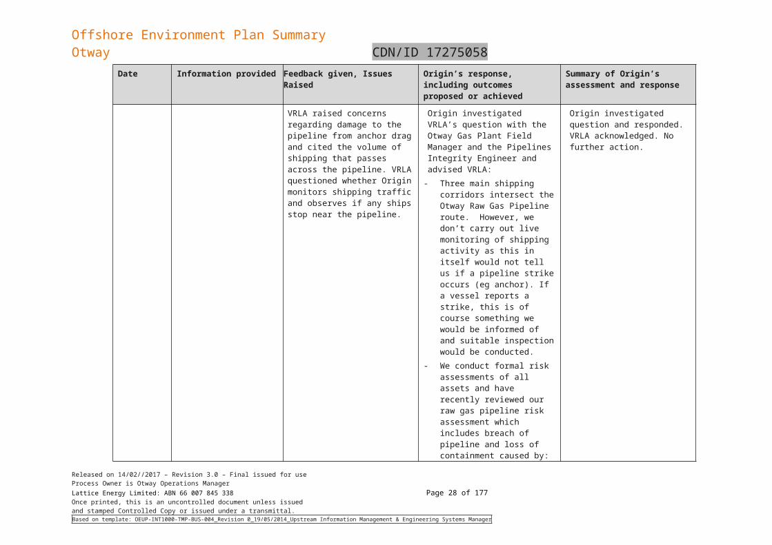
VRLA raised concerns regarding damage to the pipeline from anchor drag and cited the volume of shipping that passes across the pipeline. VRLA questioned whether Origin monitors shipping traffic and observes if any ships stop near the pipeline.
Origin investigated VRLA’s question with the Otway Gas Plant Field Manager and the Pipelines Integrity Engineer and advised VRLA:
- Three main shipping corridors intersect the Otway Raw Gas Pipeline route. However, we don’t carry out live monitoring of shipping activity as this in itself would not tell us if a pipeline strike occurs (eg anchor). If a vessel reports a strike, this is of course something we would be informed of and suitable inspection would be conducted.
- We conduct formal risk assessments of all assets and have recently reviewed our raw gas pipeline risk assessment which includes breach of pipeline and loss of containment caused by: vessel impact; anchor damage; construction / drilling activities; and dropped objects.
- The risk assessment process (for pipelines and platforms) includes identifying controls for mitigating risks (along with the ordinary assessment of likelihood and consequences). These include: Otway pipeline, Thylacine
Platform and associated Geographe facilities are marked on marine charts
Origin investigated question and responded. VRLA acknowledged. No further action.
Released on 14/02//2017 – Revision 3.0 – Final issued for useProcess Owner is Otway Operations ManagerLattice Energy Limited: ABN 66 007 845 338 Page 21 of 122Once printed, this is an uncontrolled document unless issuedand stamped Controlled Copy or issued under a transmittal.Based on template: OEUP-INT1000-TMP-BUS-004_Revision 0_19/05/2014_Upstream Information Management & Engineering Systems Manager
Offshore Environment Plan SummaryOtway CDN/ID 17275058
Date Information provided Feedback given, Issues Raised Origin’s response, including outcomes proposed or achieved
Summary of Origin’s assessment and response
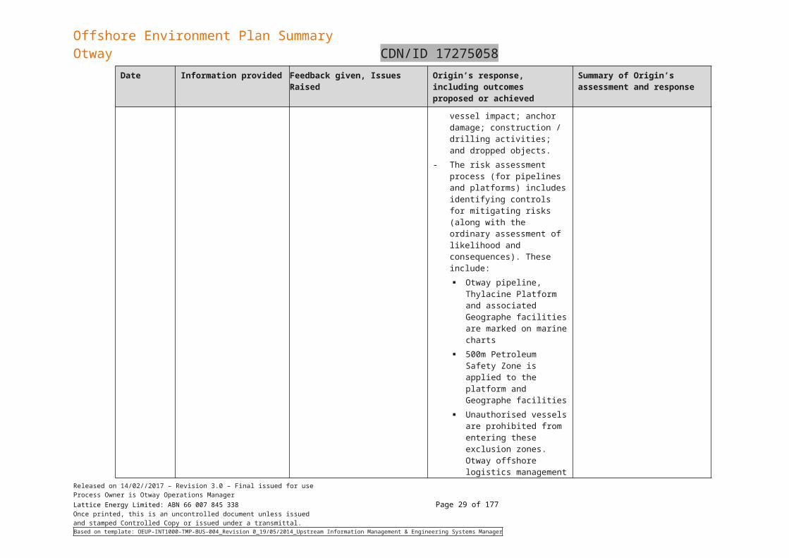
500m Petroleum Safety Zone is applied to the platform and Geographe facilities
Unauthorised vessels are prohibited from entering these exclusion zones. Otway offshore logistics management procedures are applied for all activities in these exclusion zones
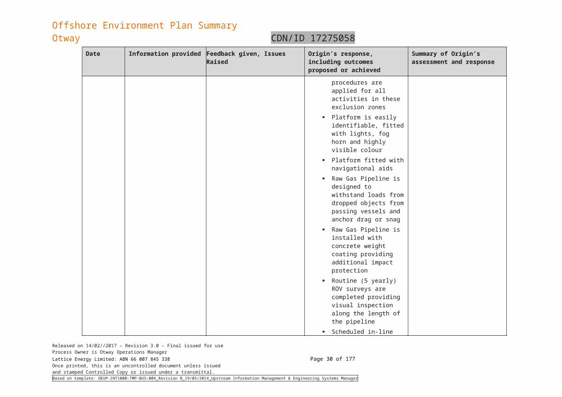
Platform is easily identifiable, fitted with lights, fog horn and highly visible colour
Platform fitted with navigational aids
Raw Gas Pipeline is designed to withstand loads from dropped objects from passing vessels and anchor drag or snag
Raw Gas Pipeline is installed with concrete weight coating providing additional impact protection
Routine (5 yearly) ROV surveys are completed providing visual inspection along the length of the pipeline
Scheduled in-line pipeline inspection completed to identify damage to the pipeline
Live pressure monitoring
Released on 14/02//2017 – Revision 3.0 – Final issued for useProcess Owner is Otway Operations ManagerLattice Energy Limited: ABN 66 007 845 338 Page 22 of 122Once printed, this is an uncontrolled document unless issuedand stamped Controlled Copy or issued under a transmittal.Based on template: OEUP-INT1000-TMP-BUS-004_Revision 0_19/05/2014_Upstream Information Management & Engineering Systems Manager
Offshore Environment Plan SummaryOtway CDN/ID 17275058
Date Information provided Feedback given, Issues Raised Origin’s response, including outcomes proposed or achieved
Summary of Origin’s assessment and response
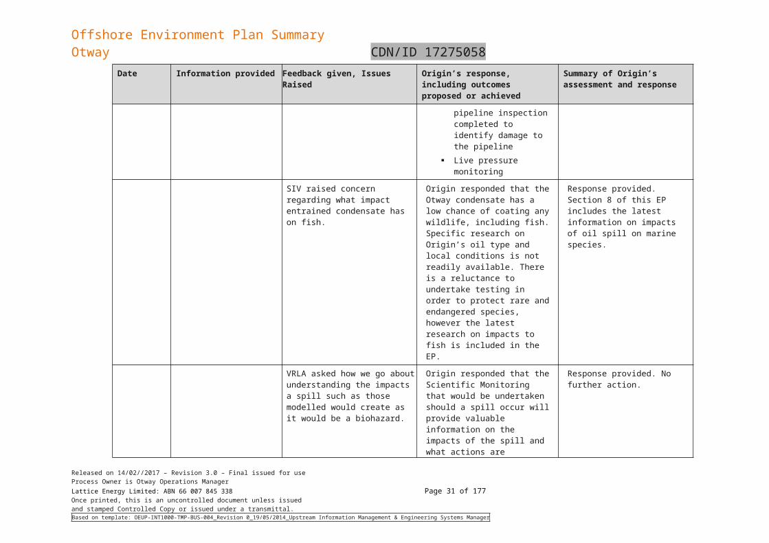
SIV raised concern regarding what impact entrained condensate has on fish.
Origin responded that the Otway condensate has a low chance of coating any wildlife, including fish. Specific research on Origin’s oil type and local conditions is not readily available. There is a reluctance to undertake testing in order to protect rare and endangered species, however the latest research on impacts to fish is included in the EP.
Response provided. Section 8 of this EP includes the latest information on impacts of oil spill on marine species.
VRLA asked how we go about understanding the impacts a spill such as those modelled would create as it would be a biohazard.
Origin responded that the Scientific Monitoring that would be undertaken should a spill occur will provide valuable information on the impacts of the spill and what actions are required, such as the closure of a fishery and / or economic impacts.
Response provided. No further action.
Released on 14/02//2017 – Revision 3.0 – Final issued for useProcess Owner is Otway Operations ManagerLattice Energy Limited: ABN 66 007 845 338 Page 23 of 122Once printed, this is an uncontrolled document unless issuedand stamped Controlled Copy or issued under a transmittal.Based on template: OEUP-INT1000-TMP-BUS-004_Revision 0_19/05/2014_Upstream Information Management & Engineering Systems Manager
Offshore Environment Plan SummaryOtway CDN/ID 17275058
- Fishing Industry (Continued). Following on from the briefing with SIV and VRLA, and in line with Fishing Industry protocols regarding engaging with peak bodies prior to engaging other fishing stakeholders, an offer of further consultation was made to the Victorian Abalone Divers’ Association and the Port Campbell Profession Fishers’ Association. Both stakeholders were contacted by phone and the OPEP, as well as the updated oil spill modelling for a potential loss of containment at a location 3nm from the coastline were discussed. No further consultation was requested and no concerns were raised. A follow up email, as had been issued to SIV and Community & Recreation and Conservation stakeholders was also provided.
- Community and Recreation. Each stakeholder identified as requiring further consultation was contacted by telephone and an overview of the OPEP development process and revised oil spill modelling was discussed. Face to face consultation was offered in order to further explain the OPEP and answer any questions. No concerns were raised and no stakeholders accepted the offer of further consultation but instead preferred to table the information with the remainder of the group they represent and stated they would contact Origin if further consultation was required. A follow up email was sent to each stakeholder outlining points discussed during the telephone calls. At the time of submission of the EP, no Community or Recreation Stakeholders have requested further consultation.
- Conservation. An email was issued to these stakeholders outlining the process used to develop the OPEP and revised oil spill modelling. The email also continued an offer of further consultation, should the stakeholder require this.
- Government and Regulatory Agencies. An email was issued to the identified stakeholders in this category which outlined the revision to the OPEP to cover the oil spill modelling scenario at a location 3 nm from the coastline, including an offer of further consultation. No request for further information have been received.
Following on from the meeting with SIV and VRLA on August 10, a phone call was made to VFA to make them aware of the concerns raised by these stakeholders regarding impacts of a potential oil spill on fish stocks. Origin’s approach to assessment of an oil spill, including scientific monitoring (as detailed in the OPEP) was discussed. VFA asked for further information regarding Origin’s engagement with DEDJTR (Earth Resources Division) and DELWP, which was provided. VFA will also consider Origin’s offer of further consultation and a meeting with Origin’s oil spill response specialist.
VFA was contacted to request additional information on fishing activity in order to provide further data for use in preparing the EP.
- Oil Spill Response partners. These stakeholders were consulted regarding the update to the OPEP. An email was issued to them on August 8th containing the updated OPEP, and a summary of the changes as follows:
o Update of ER framework with removal of Duty Operations Manager, update of GEMT number and update of GEMT structure to reflect current state including responsibility for actions
o Modification to Post Spill Scientific Monitoring Studies S1-S5 and addition of new study S6 for monitoring social, economic and cultural features.
o Update of AMSA to RPS Australia West as the support for oil spill modelling
o Updated Oil spill modelling for pipeline rupture and diesel at 3nm
o Update of contact details with Tasmanian DPIPWE and Department of the Environment and Energy
o Addition of missing shoreline segment map #1 in appendixes
3.5 Additional Consultation for Fishers in ZPIDuring September 2017, Origin reviewed the Commonwealth and State fishers who had already been consulted regarding a review of the EP and the update to the OPEP in relation to the additional stakeholders who were identified as being within the ZPI from a worst case spill scenario.
A review of the Commonwealth and Victoria fisheries confirmed that all relevant fishing associations, government departments and individual fishers had been previously identified, information provided and consultation offered. Origin actively updates its list of agencies and fishers on a regular basis and has an ongoing relationship with key fishing industry representatives.
Released on 14/02//2017 – Revision 3.0 – Final issued for useProcess Owner is Otway Operations ManagerLattice Energy Limited: ABN 66 007 845 338 Page 24 of 122Once printed, this is an uncontrolled document unless issuedand stamped Controlled Copy or issued under a transmittal.Based on template: OEUP-INT1000-TMP-BUS-004_Revision 0_19/05/2014_Upstream Information Management & Engineering Systems Manager
Offshore Environment Plan SummaryOtway CDN/ID 17275058
The Tasmanian fishers had previously been consulted through the Tasmanian Seafood Industry Council, Tasmanian Rock Lobster Fisherman’s Association and with a small number (4) of individual fishers who fish in Tasmanian waters being directly consulted. In order to ensure that all relevant persons have been consulted Origin has now identified additional Tasmanian State Departments and Fishing Industry associations who may operate in the ZPI and has undertaken consultation with them. In order to ensure currency of consultation and so the associations can provide context for their members Origin re-issued the information sheet and an updated covering email to the Tasmanian Seafood Industry Council and Tasmanian Rock Lobster Fisherman’s Association.
The Tasmanian Fishing stakeholders who were consulted during this stage of engagement are:
Tasmanian Seafood Industry Council Tasmanian Rock Lobster Fisherman's Association Tasmanian Abalone Council Limited IMAS (Institute for Marine and Antarctic studies) - Fisheries and Acquaculture Tasmanian Association for Recreational Fishing Department of Primary Industry, Parks, Water and Environment - Principal Fisheries
- Principal Fisheries Management Officer, Abalone- Wild Fisheries Management- Fisheries Management Officer (Crustacean)- Fisheries Management Officer (Scalefish)- Fisheries Management Officer (Seaweed & Shellfish)
The Tasmanian Department of Primary Industry, Parks, Water and Environment - EPA Division had previously been engaged and consulted.
Released on 14/02//2017 – Revision 3.0 – Final issued for useProcess Owner is Otway Operations ManagerLattice Energy Limited: ABN 66 007 845 338 Page 25 of 122Once printed, this is an uncontrolled document unless issuedand stamped Controlled Copy or issued under a transmittal.Based on template: OEUP-INT1000-TMP-BUS-004_Revision 0_19/05/2014_Upstream Information Management & Engineering Systems Manager
Offshore Environment Plan SummaryOtway CDN/ID 17275058
3.5.1 Timing of Consultation
The Tasmanian Fishing stakeholders that were either newly identified as being a ‘relevant person’ plus those who were re-issued communications were emailed information required on September 21, 2017. Phone contact was attempted the following week (September 25-27) to offer further consultation, if required. Where contact could not be made further contact was attempted on October 5, by which time the stakeholders had been in possession of the information for two weeks. Further contact was made with Tasmanian Rock Lobster Fisherman’s Association in the week commencing October 23 and no further consultation was required after this time. Origin is comfortable that sufficient time has been provided to the stakeholders to allow them to assess the information and whether they are impacted by the activities.
Contact was made with the Tasmanian Seafood Industry Council and Tasmanian Abalone Council in the week commencing October 30, 2017. Neither stakeholder had reviewed the information in detail. Origin has followed up with these stakeholders in January 2018 and will undertake further consultation where required.
A summary of the consultation undertaken including any information provided, feedback given and issues raised is documented below.
3.5.2 Consultation Summary - Tasmanian Fishing Industry Stakeholders
Stakeholder Date Information provided, Feedback given, Issues Raised
Origin’s response, including outcomes proposed or achieved
Summary of Origin’s assessment and response
Tasmanian Seafood Industry Council
The Tasmanian Seafood Industry Council (TSIC) is the peak body representing the interests of wild capture fishers, marine farmers and seafood processors in Tasmania.
03/04/2017
21/09/2017
26/09/2017 & 05/10/2017
30/10/2017 & 31/10/2017
Information Sheet and covering email
Email and information sheet on revision of EP and update to OPEP
Phone calls to offer further consultation. CEO unavailable until after 23/10 due to leave and travel commitments
Phone call to follow up on previous emails. Stakeholder could not recall seeing emails and has been having IT issues restricting access to email since returning from leave on 23/10. Origin committed to re-issuing email on Tue 31/10, allowing time for email issues to be resolved.
Called to follow up on email sent on 31/10. Julian Harrington is out of the office for the afternoon. Origin left contact details and asked for a return call. TSIC confirmed that
Further consultation required to answer questions or concerns the Stakeholder may have
Released on 14/02//2017 – Revision 3.0 – Final issued for useProcess Owner is Otway Operations ManagerLattice Energy Limited: ABN 66 007 845 338 Page 26 of 122Once printed, this is an uncontrolled document unless issuedand stamped Controlled Copy or issued under a transmittal.Based on template: OEUP-INT1000-TMP-BUS-004_Revision 0_19/05/2014_Upstream Information Management & Engineering Systems Manager
Offshore Environment Plan SummaryOtway CDN/ID 17275058
Stakeholder Date Information provided, Feedback given, Issues Raised
Origin’s response, including outcomes proposed or achieved
Summary of Origin’s assessment and response
01/11/2017 email of 31/10 had been forward to his inbox.
Tasmanian Abalone Council Limited
The Tasmanian Abalone Council (TAC) is the voice of the fishery, representing divers, non-diving quota-holders, processors and exporters.
21/09/2017
27/09/2017 & 30/10/17
01/11/2017
Email and information sheet on revision of EP and update to OPEP
Follow up call and emailed copy of information to CEO. Phoned again in October and left a message.
Called CEO of Tasmanian Abalone Council: - CEO apologised for not getting back to us but he has been away - He noted that the information had been sent through - He had forwarded the emails to his Abalone colleagues in Victoria - As we had not had a response from them CEO’s view was they would not be concerned - He will re-contact his colleagues in Victoria - Origin explained the OPEP and that some Tasmanian fisheries are in the ZPI - CEO committed to reviewing the materials and will get back to Origin early next week.
Once stakeholders have reviewed the information Origin will undertake any further consultation required to answer their questions or concerns.
Tasmanian Rock Lobster Fisherman's Association
The Tasmanian Rock Lobster Fishermen’s
03/04/2017
21/09/2017
Information Sheet and covering email
Email and information sheet on revision of EP and update to OPEP
Explained engagement with EPA and offered to make contact should any questions arise from the Board or members.
No further action required
Released on 14/02//2017 – Revision 3.0 – Final issued for useProcess Owner is Otway Operations ManagerLattice Energy Limited: ABN 66 007 845 338 Page 27 of 122Once printed, this is an uncontrolled document unless issuedand stamped Controlled Copy or issued under a transmittal.Based on template: OEUP-INT1000-TMP-BUS-004_Revision 0_19/05/2014_Upstream Information Management & Engineering Systems Manager
Offshore Environment Plan SummaryOtway CDN/ID 17275058
Stakeholder Date Information provided, Feedback given, Issues Raised
Origin’s response, including outcomes proposed or achieved
Summary of Origin’s assessment and response
Association (TRLFA) is the peak commercial fishing body recognised under the Act for the rock lobster fishery. 23/10/2017
Follow up phone call. Explained the offshore platform and the update to the EP and the OPEP, including that, should a loss of containment occur that Tasmania fisheries are within the ZPI. Also, explained the engagement with EPA regarding the OPEP.
Stakeholder informed Lattice that the information had been issued to the Board who had not raised any concerns. Stakeholder suggested that no loss of containment was the preferred position.
IMAS (Institute for Marine and Antarctic studies) - Fisheries and Acquaculture
The Institute for Marine and Antarctic Studies (IMAS) was created by the University of Tasmania in 2010 to encourage collaborative research in marine and Antarctic science between various parts of the University, CSIRO Marine and Atmospheric Research, the Australian Antarctic Division and other agencies. IMAS is both a teaching and research organisation.
21/09/2017 Email and information sheet on revision of EP and update to OPEP
No feedback received from stakeholder
No further action required
Released on 14/02//2017 – Revision 3.0 – Final issued for useProcess Owner is Otway Operations ManagerLattice Energy Limited: ABN 66 007 845 338 Page 28 of 122Once printed, this is an uncontrolled document unless issuedand stamped Controlled Copy or issued under a transmittal.Based on template: OEUP-INT1000-TMP-BUS-004_Revision 0_19/05/2014_Upstream Information Management & Engineering Systems Manager
Offshore Environment Plan SummaryOtway CDN/ID 17275058
Stakeholder Date Information provided, Feedback given, Issues Raised
Origin’s response, including outcomes proposed or achieved
Summary of Origin’s assessment and response
Tasmanian Association for Recreational Fishing.
TARFish is the fully independent peak body representing the interests of recreational marine fishers in Tasmania
21/09/2017 (email)26/09/2017 (phone call)
Email and information sheet on revision of EP and update to OPEP.
Stakeholder advised that due to distance of platform from shore they would not expect there is much impact to Tasmanian Recreational Fishers.
Origin explained the potential for loss of containment scenarios to travel into Tasmanian waters. Stakeholder explained that TARFish have an ongoing relationship with EPA and would be engaged by EPA if an incident occurred.Stakeholder advised that TARFish members rely on the association to review information and only pass on what is deemed relevant. Stakeholder expects that Origin would communicate to TARFish members in the event of an incident as part of Origin's communications with general public (i.e., rather than directly to members).
Origin suggested that, after TARFish have fully reviewed the information provided, if there was a need to undertake further consultation with members please to contact us.
Continue to engage with Tasmanian EPA as primary contact point in relation to OPEP and potential loss of containment.
3.5.3 Consultation Summary - Tasmanian State Government stakeholders
Stakeholder Date Information provided, Feedback given, Issues Raised
Origin’s response, including outcomes proposed or achieved
Summary of Origin’s assessment and response
Dept of Primary Industry, Parks, Water and Environment - Principal Fisheries
- Principal Fisheries
21/9/2017 – 25/9/2017
Email and information sheet on revision of EP and update to OPEP.
Stakeholders confirmed that EPA are the correct stakeholder for information. Also, provided contact details for Tasmanian
Origin confirmed that we consult with EPA as part of the development and update to the OPEP.
Origin confirmed it would contact the Tasmanian
Continue to consult with Tasmanian EPA.
Continue to consult with Tasmanian Seafood Industry Council.
Released on 14/02//2017 – Revision 3.0 – Final issued for useProcess Owner is Otway Operations ManagerLattice Energy Limited: ABN 66 007 845 338 Page 29 of 122Once printed, this is an uncontrolled document unless issuedand stamped Controlled Copy or issued under a transmittal.Based on template: OEUP-INT1000-TMP-BUS-004_Revision 0_19/05/2014_Upstream Information Management & Engineering Systems Manager
Offshore Environment Plan SummaryOtway CDN/ID 17275058
Stakeholder Date Information provided, Feedback given, Issues Raised
Origin’s response, including outcomes proposed or achieved
Summary of Origin’s assessment and response
Management Officer, Abalone
- Wild Fisheries Management
- Fisheries Management Officer (Crustacean)
- Fisheries Management Officer (Scalefish)
- Fisheries Management Officer (Seaweed & Shellfish)
Seafood Industry Council and suggested Origin contact them also.
Seafood Industry Council.
3.5.4 Summary
On the basis of the initial consultation undertaken in April 2017 and the additional consultation to existing and new stakeholders Origin is confident that all relevant stakeholders have been identified and provided with sufficient information to allow them to determine any impacts to themselves. Origin has confirmed with these stakeholders that engagement with the Tasmanian EPA was completed as part of the development and updating of the OPEP.
The majority of stakeholders have had sufficient time to review the information and raise any concerns they may have. For the two stakeholders who have not yet reviewed the information, Origin will continue to consult with them to address any questions or concerns.
3.6 Ongoing consultation and incident consultation processOrigin will continue its community engagement strategy and channels to ensure future questions, feedback or concerns regarding its offshore operations, and the OPEP in particular, are responded to and managed effectively.
In the unlikely event that a loss of containment does occur, Origin will assess the severity of the spill and communicate with community stakeholders based on the resultant or predicted impacts. Primary communication will be undertaken by the relevant government agency who will alert marine users to any exclusion zone and / or restrictions on fishing or other marine activities. Origin, via its GEMT process will identify relevant stakeholders (fishing industry, community and recreation and conservation, media) and undertake engagement as appropriate based on the incident that has occurred.
Released on 14/02//2017 – Revision 3.0 – Final issued for useProcess Owner is Otway Operations ManagerLattice Energy Limited: ABN 66 007 845 338 Page 30 of 122Once printed, this is an uncontrolled document unless issuedand stamped Controlled Copy or issued under a transmittal.Based on template: OEUP-INT1000-TMP-BUS-004_Revision 0_19/05/2014_Upstream Information Management & Engineering Systems Manager
Offshore Environment Plan SummaryOtway CDN/ID 17275058
4. Activity Description
4.1 Overview of major componentsMajor components of the Otway offshore facilities are listed in Table 4-8 and associated activities are discussed in the following sections.
Table 4-8: Major Components
Component Area Consists Of
Thylacine Wells
Sub surface
Four producing wells with surface wellheads, TA-1 (THA01), TA-2 (THA02), TA-3 (THA03) and TA-4 (THA04) located at the Thylacine-A platform
Three fail-safe surface controlled subsea safety valve (SCSSV) are installed in the production tubing of TA-1, 2 and 4
The SCSSV for TA-3 failed the leak test criteria and a Wireline Retrievable Subsurface Safety Valve (WRSSV) was fitted early in 2012. The WRSSV is also a surface controlled valve
One plugged and suspended exploration well, Thylacine 1
Surface Four surface trees. TA-2, 3 and 4 have 5 inch trees and TA-1 has a 7 inch tree
Thylacine-A Platform
Main Deck
Helideck Vent tip Gas engine generators Platform crane and wireline equipment lay down area Navaids
Mezzanine Deck
Wellhead Hydraulic Control Panel (WHCP) and Hydraulic Power Unit (HPU) with hydraulic fluid storage tanks (2 x 2500L storage tanks plus a 500L return tank)
Production Pipeline Pig Launcher Fresh water feed tank Navaids 24 volt (V) direct current (DC) distribution board Main 415V switchboard Navaids rectifier Navaids battery pack Process control system (PCS) 3rd party equipment cabinet Microwave communications Crane engine Carbon dioxide (CO2) vent snuffing package Load bank
Cellar Deck Fuel gas conditioning skid Rectifier Emergency shutdown (ESD) combined system Communications system Sand collection vessel (transit) Marshalling cabinet(s) Power distribution system Battery packs 24V direct current (DC) distribution board
Released on 14/02//2017 – Revision 3.0 – Final issued for useProcess Owner is Otway Operations ManagerLattice Energy Limited: ABN 66 007 845 338 Page 31 of 122Once printed, this is an uncontrolled document unless issuedand stamped Controlled Copy or issued under a transmittal.Based on template: OEUP-INT1000-TMP-BUS-004_Revision 0_19/05/2014_Upstream Information Management & Engineering Systems Manager
Offshore Environment Plan SummaryOtway CDN/ID 17275058
Component Area Consists Of
Weather shelter Portable toilet Weather monitoring equipment Totally Enclosed Motor Propelled Survival Craft
(TEMPSC) Microwave communications Navaids Geographe Equipment Room with annex containing
distribution boards and ESD system with heating, ventilation and air-conditioning (HVAC) system on the roof
Methanol storage tank (4,600L double skinned storage tank) on the roof of the Equipment Room with access from Mezzanine Deck.
Sub-Cellar Deck
Drain vessel drain pump and methanol injection pump Subsea hydraulic topside umbilical termination units
(TUTUs) Subsea electrical TUTUs and J Tubes sand removal skid (installed through Mezzanine and Cellar
decks)
Geographe well field
Well field
Two subsea wellheads, GEO-2 (WH9210-GEO02/ G2) and GEO-3 (WH9210-GEO03/ G3) located at the Geographe well site. As discussed previously G3 has been suspended and will be completed at a later date
Plugged and suspended exploration well GEO-1 Two Subsea Control Modules (SCM) (one on each tree) Two wet gas meters (one downstream of each subsea
tree), 2J2001 and 2J2002 One Subsea Distribution Unit (SDU-500) One Umbilical Termination Assembly (UTA-500T) for
connecting main umbilical from Thylacine-A Platform to SDU
Two subsea Coolers, Subsea Manifold Cooler (SMC) (2E-2010/HE-100) and Subsea Heat Exchanger (SHX) (2E-2011/HE-200), arranged in series and connected by a DN250 (10inch) Cooler tie-in spool
Cooler 2E-2010 is the tie-in point for production fluids from the two wells via two DN200 (8”) wellhead tie-in spools. Provision is made for tie-in of a third well at 2E-2010
Electrical and hydraulic flying leads (HFL) A 1.82km flexible flowline of 11inch (275mm) internal
diameter from the Cooler 2E-2011/ HE-200 to the subsea valve skid (SVS) 600
A 1.895km in field umbilical (2-AU-50-02) between the SDU and the UTA-600M at the SVS. All hydraulic and chemical tubing in the umbilicals are manufactured in super duplex steel
The major subsea components are all manufactured in corrosion resistant duplex stainless steel
Tee at pipeline
One Subsea Valve Skid (SVS-600) One Umbilical Termination Assembly (UTA-600M) for
connecting in field umbilical from SVS
Production Production Riser Emergency Shutdown Valve (RESDV) is located at
Released on 14/02//2017 – Revision 3.0 – Final issued for useProcess Owner is Otway Operations ManagerLattice Energy Limited: ABN 66 007 845 338 Page 32 of 122Once printed, this is an uncontrolled document unless issuedand stamped Controlled Copy or issued under a transmittal.Based on template: OEUP-INT1000-TMP-BUS-004_Revision 0_19/05/2014_Upstream Information Management & Engineering Systems Manager
Offshore Environment Plan SummaryOtway CDN/ID 17275058
Component Area Consists Of
Pipeline and MEG Pipeline
Pipeline
sub cellar deck on the Thylacine-A Platform Fuel Gas riser Emergency Shutdown at the subsea cellar
deck on the Thylacine-A Platform A duplex stainless steel riser and tie-in spool and cooling
section at the Thylacine-A Platform A carbon steel pipeline section to the Geographe in-line
tee A duplex stainless steel tie-in Geographe barred tee (DN
250) A duplex stainless steel pipeline, cooling/mixing section
downstream of the Geographe in-line tee A further carbon steel pipeline section to the future hot-tap
tee locations Two duplex stainless steel hot-tap tees (DN 250) for the
future tie-in A further carbon steel pipeline section up to and through to
the Horizontal Directionally Drilled (HDD) section A further carbon steel pipeline section up to and through to
the onshore Emergency Shutdown Valve (ESDV)
MEG Pipeline
An ESDV, carbon steel riser and tie-in spool at the Thylacine-A Platform
Tie-in hub at the base of the Thylacine jacket A carbon steel pipeline section to the Geographe in-line
tee An in-line tee at Geographe for tie-in to the Geographe
cluster manifold A further carbon steel pipeline section up to the future tie-
in prospects including associated valving A carbon steel tie-in spool up to the HDD section A carbon steel HDD section A further carbon steel pipeline section up to and through to
onshore ESDV Tie-in piping and isolation valve connection from MEG
supply at the OGP
Interconnections Between Geographe Wells & Thylacine-A Platform
A 15.885km main umbilical (2-AU-50-03) from Thylacine-A Platform to the UTA - 500T with breakout box near Thylacine-A Platform. All hydraulic and chemical tubing in the umbilicals are manufactured in super duplex steel
The major subsea components are all manufactured in corrosion resistant duplex stainless steel
4.2 Routine operationsThe Otway offshore wells are controlled from the onshore OGP with typical operational activities including: cold start-up, start-up and shutdown of wells (i.e. operation of valves and methanol/MEG injection) these are covered by specific operational procedures (Origin, 2014a; Origin, 2014b; Origin, 2017f).
Operation of the umbilical for supply of the following to the Geographe wellheads and production facilities:
Electric power
Hydraulic power
Methanol
Released on 14/02//2017 – Revision 3.0 – Final issued for useProcess Owner is Otway Operations ManagerLattice Energy Limited: ABN 66 007 845 338 Page 33 of 122Once printed, this is an uncontrolled document unless issuedand stamped Controlled Copy or issued under a transmittal.Based on template: OEUP-INT1000-TMP-BUS-004_Revision 0_19/05/2014_Upstream Information Management & Engineering Systems Manager
Offshore Environment Plan SummaryOtway CDN/ID 17275058
MEG and chemicals
Pressure and flow control via choke changes
Hydrate prevention and control (including technical monitoring)
Monitoring and depressurisation of the well annulus.
Offshore gas, liquid/condensate and water flow metering is required to satisfy reporting, reservoir monitoring and operational requirements. Metering has been designed in accordance with the Offshore Facilities Gas Metering System Basis of Design (BOD) Datasheet.
Inspection and maintenance of equipment for the Otway facilities is controlled by means of the Computerised Maintenance Management System (CMMS). Maintenance plans and procedures are designed to:
Ensure a consistent, cost effective and efficient system of maintenance management.
Provide optimum levels of inspection and maintenance to ensure that equipment and the facilities remain fit for purpose over the life of the operation.
Condition monitoring of critical equipment is provided and used as input to the maintenance plan and management system. A Risk Based Inspection (RBI) program is in place to determine maintenance and inspection frequencies based on the level of risk associated with the equipment. Typical inspection and maintenance activities are covered in the Otway pipeline safety case (Origin, 2017h) and the Thylacine-A wellhead platform safety case (Origin, 2017), and include:
Inspection
Pigging
ROV surveys conducted from a ROV support vessel
Safety equipment and pressure control maintenance
Routine planned maintenance and Critical Function Testing (CFT) of equipment (e.g. shutdown valves, safety critical SIS instrumentation, etc.) (Origin, 2014a)
Geographe and Thylacine well Sub-Surface Shutdown Valves (SSSV) passing/leakage testing (Origin, 2014b)
Routing passing/leakage testing of the Thylacine wellhead and topside valves
Inspection and maintenance activities are designed to ensure the continued safe and reliable operation of the Otway offshore facilities.
4.3 LogisticsThe Thylacine-A Platform is normally unmanned with all normal operations remotely controlled from the onshore Gas Plant Control Room. The platform is manned for approximately 5 days per month during daylight hours, sometimes more often for specific maintenance activities. The normal size of the visiting crew will vary depending on the nature of the visit but can involve up to ten personnel in total. The types of activities undertaken during the regular visits to the platform are routine operational checks inspection and maintenance including instrument/mechanical maintenance, shutdown resets, corrosion monitoring and chemical replenishment.
Other activities that may be undertaken as part of the regular visits while the platform is fully operational include well intervention operations, pigging and minor project work.
Operations on-board the platform generally take place during daylight hours, there are no planned overnight stays permitted under normal operations. However, to accommodate potential unforeseen emergencies, incidents (e.g. helicopter failure or sudden change of weather) or repairs, facilities are provided for emergency overnight stays should it be necessary.
4.3.1 Helicopters
A helicopter appropriate to the nature and scale of the activity is utilised to support the platform. There are no helicopter refuelling facilities on the platform, helicopters carry enough fuel to travel to the platform and return. Approximate flight time (one way) between the helicopter base at Warrnambool (Victoria) and the Thylacine-A Platform is 25 minutes.
4.3.2 Vessels
A supply vessel appropriate to the nature and scale of the activity is utilised to support the platform. The supply vessel attends the platform for operational and maintenance requirements such as to
Released on 14/02//2017 – Revision 3.0 – Final issued for useProcess Owner is Otway Operations ManagerLattice Energy Limited: ABN 66 007 845 338 Page 34 of 122Once printed, this is an uncontrolled document unless issuedand stamped Controlled Copy or issued under a transmittal.Based on template: OEUP-INT1000-TMP-BUS-004_Revision 0_19/05/2014_Upstream Information Management & Engineering Systems Manager
Offshore Environment Plan SummaryOtway CDN/ID 17275058
supply freshwater, fuel, chemicals, replacement parts or in the future to remove the sand collection tanks (when one tank is full). Based on current platform operations the supply vessel visits approximately once per month. The platform pedestal crane, located at the south east corner of the platform Main Deck, offloads and backloads the support vessel and any other vessel as required.
In addition to the supply vessel, certain operational activities will require additional marine support, examples include but are not limited to:
Standby vessels – for higher risk activities, such as work over water, heavy lifts, and well intervention.
ROV support vessels - for routine asset integrity inspections of the Platform and pipeline.
Diving support vessels – for asset integrity inspections that cannot be completed with a ROV.
Vessels may also be required in responding to a hydrocarbon spill, including operational and scientific monitoring.
Certain discharges from vessels such as food wastes, grey water, sewage, bilge water and deck drainage are considered normal marine practice and will be managed in accordance with MARPOL requirements.
4.3.3 Fuel bunkering
Vessels are typically refuelled at the shore base and fuel bunkering is not normally undertaken offshore. However, in certain situations when it is necessary to have a vessel on location for an extended period, fuel bunkering may be required.
Diesel fuel is typically transferred to the platform from a supply vessel in 205L steel drums or via 4,000L chemical tanks.
4.4 Non-routine operations4.4.1 Well intervention
Thylacine-A Platform has been designed to facilitate access to each of the wells for both slick line and electric line well intervention. The platform has also been designed to accommodate all of the anticipated intervention equipment without compromising safe access and egress.
A well intervention may be needed to repair a faulty SCSSV, install a storm choke, remediate well integrity failures, fish lost tools, perforate new production intervals, operate sliding sleeves, install tubing plugs to isolate production intervals or perform well surveillance (pressure or production logs).
Well interventions will be managed by Origin, using specialist well intervention contractors as necessary. Selection and management of specialist contractors for well intervention activities will be undertaken in accordance with the HSEMS, with work completed in accordance with an approved Well Operations Management Plan (WOMP) and safety case.
Well intervention duration could range from 5 to 40 days subject to scope of work necessary. A SCSSV repair program duration is typically 5 to 10 days, with more complex interventions (such as logging, perforating and deployment of plugs) spanning 30 to 40 days (or longer).
Well intervention operations are generally conducted on a 12 hour shift during daylight hours, however may be undertaken at night in the event it be deemed necessary to maintain safe operation of the development. Well intervention personnel will travel to and from the platform via helicopter and will be accommodated on shore. A well intervention crew typically comprises of 8 personnel.
4.4.2 Pipeline repressurisation and depressurisation
Depressurisation of the production pipeline may be required during operation of the facilities.
It is expected that pipeline depressurisation would be a very infrequent occurring less than five times during the operating life of the pipeline.
4.4.3 Pipeline repairs
Pipeline free-span remediation – where excessive pipeline span(s) may require placement of support mattress. Polypropylene bags of varied size are used for placement under the pipeline and once in position are inflated by grout. Grout is prepared on the support vessel back deck in a mixing bowl and delivered to the mattress by hose. Minimal amounts of excess grout exit vents on the mattress once it is fully inflated.
Installation of a single or multiple repair clamps at specific locations on the carbon steel section of the production pipeline may be required.
Released on 14/02//2017 – Revision 3.0 – Final issued for useProcess Owner is Otway Operations ManagerLattice Energy Limited: ABN 66 007 845 338 Page 35 of 122Once printed, this is an uncontrolled document unless issuedand stamped Controlled Copy or issued under a transmittal.Based on template: OEUP-INT1000-TMP-BUS-004_Revision 0_19/05/2014_Upstream Information Management & Engineering Systems Manager
Offshore Environment Plan SummaryOtway CDN/ID 17275058
4.4.4 Replacement of Geographe SVS and coolers
Non routine activities for the subsea Geographe and Thylacine facilities utilising ROVs include repair and replacement of subsea infrastructure. To carry out these activities would require the use of support vessels and the use of ROV.
The Geographe field may be shut down during repair activities and a vessel (e.g. installation vessel) will be used to remove, replace or repair the equipment. This would be supported by a hyperbaric support vessel.
If complete removal of structures is required to affect repair, the structures would be removed leaving the foundation ‘mudmat’ in place. Replacement structures can then be lowered into position using the guideposts on the foundations. Installation and connection will be diverless with the use of an ROV. Disturbance to the sea bed is expected to be limited due to the foundations remaining in place.
4.5 Major shutdown campaignsMajor shutdown campaigns are scheduled in accordance with the maintenance management system and relevant integrity management plans. They are periodically undertaken to ensure essential plant and equipment maintenance, repair and/or replacement is undertaken to maintain safe and efficient operation. Major shutdown campaigns could involve activities such as (but not limited to) painting and fabric maintenance, diving, ROV operation, pigging and venting, testing and inspection, as described throughout this section. Where an activity is necessary that is not adequately described in the EP, Origin will undertake a review of the EP and risk register in accordance with section 7 and if necessary a bridging document or revision to the EP will be submitted to NOPSEMA and/or DEDJTR (as appropriate) for acceptance prior to undertaking the activity in accordance with the applicable Regulations.
4.6 Planned dischargesPlanned discharges are summarised in Table 4-9.
Table 4-9: Planned emissions and discharges
Facility component Source Description
Thylacine-A Platform
Personnel Sewage and grey water
Bird pump Sea water
Deck washing Freshwater, occasionally an approved cleaning chemical may be used
Safety showers Fresh water
Gas fired generator Gas combustion products discharged to atmosphere
Diesel powered standby generator, crane and lifeboat testing
Diesel combustion products discharged to atmosphere
Venting Continuous gas purge and venting for maintenance activities
Platform, pipelines and subsea facilities
Cleaning for inspection and/or maintenance.
Grit blasting material, removed marine growth, scale and/or paint
Pipeline free-span repairs Excess grout exiting mattress vents when fully inflated
Hydraulic control system
Actuation of subsea valves, subsea maintenance activities and fugitive emissions
Discharge of HW443 hydraulic fluid
Vessels Personnel Food scraps, sewage and grey water
Bilge water Discharge of bilge water treated to contain <15ppm oil in water
Engine cooling Uncontaminated engine cooling water
Deck washing Water and approved cleaning chemical
Released on 14/02//2017 – Revision 3.0 – Final issued for useProcess Owner is Otway Operations ManagerLattice Energy Limited: ABN 66 007 845 338 Page 36 of 122Once printed, this is an uncontrolled document unless issuedand stamped Controlled Copy or issued under a transmittal.Based on template: OEUP-INT1000-TMP-BUS-004_Revision 0_19/05/2014_Upstream Information Management & Engineering Systems Manager
Offshore Environment Plan SummaryOtway CDN/ID 17275058
Facility component Source Description
Engines Fuel combustion products discharged to atmosphere
Helicopters Engines Fuel combustion products discharged to atmosphere
4.7 Worst case spill scenariosOrigin commissioned RPS to conduct quantitative spill modelling to estimate the potential exposure to surrounding waters and shorelines of four worst case uncontrolled hydrocarbon release scenarios:
a 64,500 bbl (750 bbl/d) subsea release of condensate over 86 days in the event of a loss of well control from the Geographe well location
a 86,860 bbl (1,010 bbl/d) subsea release of crude over 86 days in the event of a loss of well control from the Thylacine well location
a 300 m3 surface release of diesel over 6 hours in the event of a containment loss from a vessel; and
a 1,175 bbl subsea release of condensate over 0.135 hours (~14 minutes) in the event of a pipeline rupture
4.7.1 Loss of well control
Loss of well control from the Thylacine or Geographe wells is a remote scenario that could potentially occur whilst wells are suspended, producing or during well intervention. The worst case loss of well control scenarios are:
a 64,500 bbl (750 bbl/d) subsea release of condensate over 86 days from the Geographe well location
a 86,860 bbl (1,010 bbl/d) subsea release of crude over 86 days from the Thylacine well location
A loss of well control could result from damage to well head equipment, failure of process equipment, loss of well integrity or in an extreme case the collapse of the Thylacine-A platform from collision or an extreme storm event.
When producing, loss of well control may result due to failure of a SCSSV to shut following flow line rupture, an annulus leak, a control system failure, or leakage of crown plugs, amongst other scenarios. Leak rates from a producing well would vary depending on the scenario. In the event of a small scale leak on the GEO-2 well a ROV intervention may be feasible, for example to manipulate subsea tree valves. In the case of a significant uncontrolled release, relief well drilling is considered to be the most likely action to be implemented.
For plugged and suspended exploration wells (GEO-1 and Thylacine-1), the likelihood of a loss of well control event is remote given both wells have cement plugs in place that prevent the flow of fluid from the reservoir to the surface. Any loss of well integrity is expected to present as a small scale leak and would be identified during routine general visual inspections (GVIs). In the case of slow / low volume leak it is possible that a mobile offshore drilling unit (MODU) may be able to re-establish itself on the well and an intervention carried out. In the case of a significant flow, it is likely that a relief well will be necessary.
If a loss of well control occurred during well intervention then use of the MODU undertaking the intervention to control the leak may not be feasible due to the risk of gas ignition. Therefore, relief well drilling is also the most likely response action in this scenario.
The response period for relief well drilling is based on sourcing (approximately 14 days) and mobilising (approximately 35 days) a MODU to the Thylacine gas field from the North West shelf. Once a MODU is on location it is estimated that drilling a relief well will take approximately 30 days dependent on the intersection point and homing in method selected. Mobilising vessels from within Australian waters has the advantage of holding current regulatory approvals (e.g. NOPSEMA accepted safety case) however Origin will consider other options (should it be required) with NOPSEMA.
4.7.2 Diesel Spill Scenario
Marine diesel fuel is used in offshore vessels. The following activities have the potential to result in a spill of fuel:
A collision between an Origin contracted vessel and the platform or third-party vessel.
Released on 14/02//2017 – Revision 3.0 – Final issued for useProcess Owner is Otway Operations ManagerLattice Energy Limited: ABN 66 007 845 338 Page 37 of 122Once printed, this is an uncontrolled document unless issuedand stamped Controlled Copy or issued under a transmittal.Based on template: OEUP-INT1000-TMP-BUS-004_Revision 0_19/05/2014_Upstream Information Management & Engineering Systems Manager
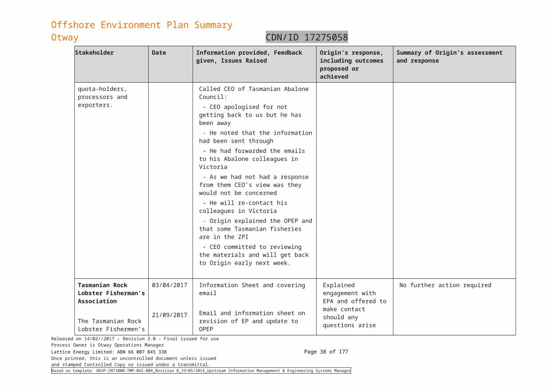
Offshore Environment Plan SummaryOtway CDN/ID 17275058
Refuelling of vessels.
The worst credible spill is associated with a vessel collision causing loss of containment of a single fuel tank. A maximum spill volume of 300 m3 was based on the vessel’s largest tank. The release was modelled over a 6-hour duration
The release of diesel from vessels to the marine environment could result in a temporary and localised reduction of water quality leading to direct and indirect effects on marine fauna and flora. The risk level was assessed as Low based on a Remote occurrence and Serious consequence (see RSK-.05 Section 6.4). Table 6-26 presents the environmental impacts, risks and control measure relating to a worst case diesel spill scenario.
4.7.3 Pipeline spill scenario
During the operation of the pipeline there is the risk that there could be an uncontrolled release of hydrocarbons as a result of:
Pipeline failure through internal or external corrosion
Unsupported pipeline span due to erosion and causing metal fatigue
Dropped objects (while carrying out platform crane lifts etc)
Vessel anchor drag/trailer net drag
Extreme weather
Human error
Sabotage.
A maximum credible spill of 1,175 bbl subsea release of condensate over 0.135 hours (~14 minutes) is considered the worst case credible spill, from a vessel anchor drag causing pipeline rupture. Two locations were considered for this pipeline rupture case being the intersection of the pipeline at the northern edge of the major shipping lane (RPS 2017a) and at 3nm from the coast of Victoria (RPS 2017b).
The uncontrolled release of hydrocarbons from the pipeline could potentially result in injury or death of marine life, loss of commercial fisheries income and/or loss of visual amenity. The assessed level of risk is Medium, based on a Remote likelihood and Major consequence (refer RSK-02 Section 6.4).
The pipeline has been designed for the transportation of gas and condensate. The design has taken into consideration the environment it is operating in, it is abrasive resistant and designed to withstand dropped objects and physical impact. Isolation valves are designed to fail safe.
Design and installation was in compliance with the Pipeline safety case accepted by NOPSEMA. This included independent validation of installation procedures (appropriateness of standards, codes, Basis of design and the installation loads), QA and QC inspections during fabrication and third-party equipment verification.
Table 6-26 presents the environmental impacts, risks and control measure relating to a worst case pipeline spill scenario.
Released on 14/02//2017 – Revision 3.0 – Final issued for useProcess Owner is Otway Operations ManagerLattice Energy Limited: ABN 66 007 845 338 Page 38 of 122Once printed, this is an uncontrolled document unless issuedand stamped Controlled Copy or issued under a transmittal.Based on template: OEUP-INT1000-TMP-BUS-004_Revision 0_19/05/2014_Upstream Information Management & Engineering Systems Manager
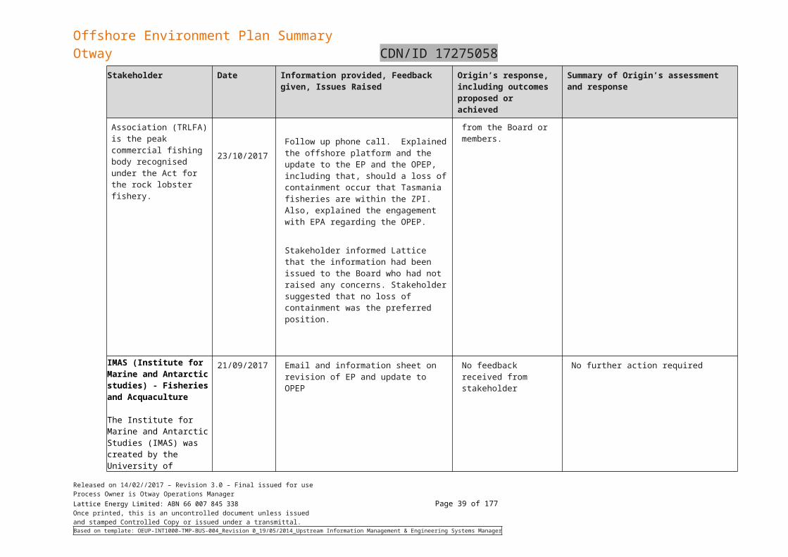
Offshore Environment Plan SummaryOtway CDN/ID 17275058
5. Existing Environment
The physical, biological and socio-economic environment in and around the zone of potential impact (ZPI) due to planned and unplanned activities (e.g. a loss of well control) are described in this section, together with the values and sensitivities of the region.
5.1 Defining the ZPIThe Zone of Potential Impact (ZPI) was derived from stochastic analyses (99% confidence intervals) of the oil spill modelling and comprised the combined footprint of hydrocarbon dispersion for all scenarios. The scenarios were: blowouts at Thylacine and Geographe, pipeline rupture near the coastal waters boundary and diesel spill from vessels, in all seasons, with spill trajectories tracked to the following minimum thresholds:
Visible sea surface oil (0.5 g/m2)
Shoreline oil contact (10 g/m2)
Dissolved aromatics (576 ppb.hrs)
Entrained hydrocarbons (67,200 ppb.hrs).
The thresholds for dissolved aromatics and entrained hydrocarbons are based on 99% species protection levels (derived from ANZECC guidelines). The footprints for dissolved aromatic and entrained hydrocarbons include the results from all depths modelled (0-10 m, 10-20 m, and 20-30 m). The inner areas show the combined stochastic results (99% CI) for shoreline contact and sea surface slicks above the minimum thresholds. The outer area encompasses surface, dissolved aromatic and entrained hydrocarbons. The maximum extent of the ZPI is generally determined by dissolved aromatics from a pipeline rupture due to their greater propensity to persist and therefore disperse. Note that these combined stochastic results show the widest possible extent of potentially affected values; it is not expected that any single oil spill could affect the entire ZPI.
5.2 Conservation values and sensitivitiesA search of the EPBC Protected Matters Search Tool (PMST) was undertaken on the 2 August 2017 to identify the conservation values within the ZPI. The PMST report is included in the full EP and key information is discussed in sections below. Listed species and conservation areas in Victoria and Tasmania within the ZPI have also been identified and discussed in 5.4.2. Terrestrial areas and species which are not at risk of adverse impacts, but are included in the PMST report due to the buffer zone overlap with terrestrial areas, have been excluded from the description herein.
5.2.1 Commonwealth marine reserves
Five Commonwealth Marine Reserves (CMRs) are located within the ZPI:
Apollo Commonwealth Marine Reserve
Beagle Commonwealth Marine Reserve
Franklin Commonwealth Marine Reserve
Nelson Commonwealth Marine Reserve
Zeehan Commonwealth Marine Reserve.
All of the reserves, in whole or part, are classified as IUCN VI – Multiple Use Zones, in which a wide range of sustainable activities are allowed as long as they do not significantly impact on benthic (seafloor) habitats, or have an unacceptable impact on the values of the area.
The Zeehan Commonwealth Marine Reserve also has an IUCN VI - Special Purpose Zone, which allows for limited mining and low-level extraction of natural resources. Permitted activities are similar to Multiple Use Zones; however, commercial fishing is not permitted.
5.2.2 Commonwealth heritage places
The PMST Report identified three Commonwealth Heritage Places in the ZPI, all of which are historic heritage places located on land and therefore are outside the ZPI.
5.2.3 World heritage properties
There are no marine or coastal World Heritage Areas in the vicinity of the ZPI, as described in the PMST Report.
Released on 14/02//2017 – Revision 3.0 – Final issued for useProcess Owner is Otway Operations ManagerLattice Energy Limited: ABN 66 007 845 338 Page 39 of 122Once printed, this is an uncontrolled document unless issuedand stamped Controlled Copy or issued under a transmittal.Based on template: OEUP-INT1000-TMP-BUS-004_Revision 0_19/05/2014_Upstream Information Management & Engineering Systems Manager
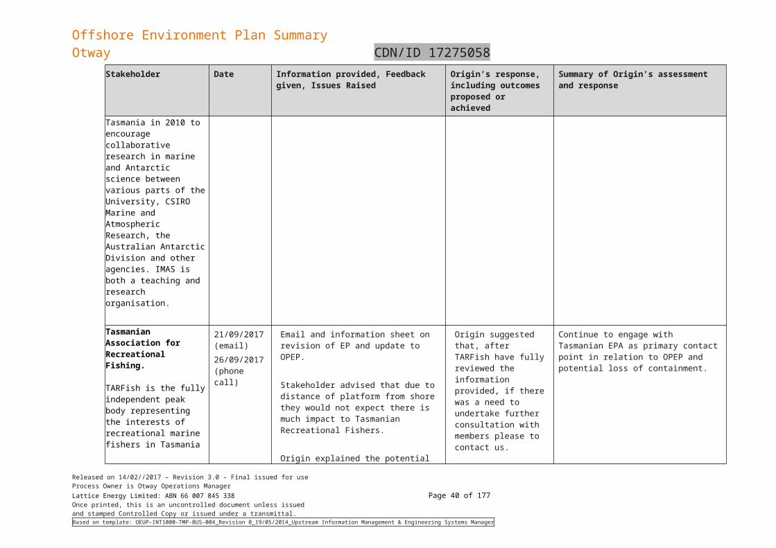
Offshore Environment Plan SummaryOtway CDN/ID 17275058
5.2.4 National Heritage Places
The places of National Heritage that were identified by the PMST Report are located onshore; outside the ZPI and do not have marine or coastal components.
5.2.5 Wetlands of international importance
There are four marine or coastal Wetlands of International Importance (Ramsar-listed wetlands) in the ZPI including Corner Inlet, Lavinia on King Island, Port Phillip Bay (western shoreline) and Bellarine Peninsula and Western Port.
5.2.6 Victorian protected areas - Marine
Victoria has a representative system of 13 Marine National Parks and 11 Marine Sanctuaries established under the National Parks Act 1975 (Vic). Five of these Marine National Parks and seven of the marine sanctuaries are located within the ZPI, including:
The Bunurong Marine National Park and Bunurong Marine Park
Discovery Bay Marine National Park
Point Addis Marine National Park
Twelve Apostles Marine National Park
Wilsons Promontory Marine National Park
Marengo Reefs Marine Sanctuary
The Arches Marine Sanctuary
Barwon Bluff Marine Sanctuary
Eagle Rock Marine Sanctuary
Merri Marine Sanctuary
Mushroom Reef Marine Sanctuary
Point Danger Marine Sanctuary
5.2.7 Victorian protected areas – Terrestrial
There are twelve National Parks and Coastal Parks that are present in the ZPI. These National Parks and Coastal Parks include:
Port Campbell National Park
Bay of Islands Coastal Park
Great Otway National Park
Mornington Peninsula National Park
Wilsons Promontory National Park
Cape Liptrap Coastal Park
Discovery Bay Coastal Park
Lady Julia Percy Island Wildlife Reserve
Lake Connewarre Wildlife Reserve
Lawrence Rocks Wildlife Reserve
Phillip Island Nature Park
Seal Islands Wildlife Reserve
5.2.8 Tasmanian protected areas – Marine
Three Tasmanian marine protected areas are overlapping with the ZPI. These include Cataraqui Point Conservation Area, Kent Group Marine Reserve and Porky Beach Conservation Area.
5.2.9 Tasmanian protected areas – Terrestrial
The PMST report identifies 18 Tasmanian Terrestrial protected areas that are present within the ZPI. These include:
Released on 14/02//2017 – Revision 3.0 – Final issued for useProcess Owner is Otway Operations ManagerLattice Energy Limited: ABN 66 007 845 338 Page 40 of 122Once printed, this is an uncontrolled document unless issuedand stamped Controlled Copy or issued under a transmittal.Based on template: OEUP-INT1000-TMP-BUS-004_Revision 0_19/05/2014_Upstream Information Management & Engineering Systems Manager
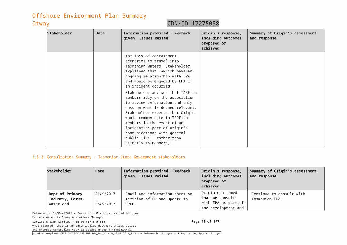
Offshore Environment Plan SummaryOtway CDN/ID 17275058
Cape Wickham Conservation Area
Christmas Island Nature Reserve
City of Melbourne Bay Conservation Area
Cone Islet Conservation Area
Curtis Island Nature Reserve
Devils Tower Nature Reserve
Disappointment Bay State Reserve
East Moncoeur Island Conservation Area
Hogan Group Conservation Area
Kent Group National Park
Lavinia State Reserve
New Year Island Game Reserve
North East Islet Nature Reserve
Red Hut Point Conservation Area
Rodondo Island Nature Reserve
Seal Rocks State Reserve
Stokes Point Conservation Area
West Moncoeur Island Nature Reserve
5.2.10 Key ecological features
The PMST Report identified three Key Ecological Features (KEF) within the ZPI.
KEFs are elements of the marine environment, based on current scientific understanding, are considered to be of regional importance for either the region's biodiversity or ecosystem function and integrity of a Commonwealth Marine Area.
The KEFs in the ZPI are:
the Bonney Coast Upwelling
the West Tasmanian Marine Canyons
Shelf rocky reefs and hard substrates.
5.3 Physical environmentThe physical marine environment of the Otway region is characterised by very steep to moderate offshore gradients, high wave energy and temperate waters subject to upwelling events.
5.3.1 Otway assessments and surveys
In 2002, 2003 and 2004, Fugro undertook a number of bathymetric surveys of the two proposed pipeline rights of way: one constructed for the Thylacine Geographe pipeline and one extending from the completed Geographe A well to Flaxman’s Hill (Figure 5-3).
A review of the available geotechnical data was carried out in March 2011 for the Geographe location (Advanced Geomatics, 2011). Overall, the seabed in the Otway operational area slopes to the south at a gentle average gradient of less than 1. However, the local topography is predominantly irregular in nature, varying from gently undulating and locally smooth in areas of increased sediment deposition, to areas of outcropping cemented calcrete features that are from smooth to jagged relief. These areas are covered in marine growth. A recent ROV video survey confirmed the presence of a shallow hard underlying substrate at a depth of 50 mm below the sediment in areas of marine growth (JP Kenny, 2012).
Released on 14/02//2017 – Revision 3.0 – Final issued for useProcess Owner is Otway Operations ManagerLattice Energy Limited: ABN 66 007 845 338 Page 41 of 122Once printed, this is an uncontrolled document unless issuedand stamped Controlled Copy or issued under a transmittal.Based on template: OEUP-INT1000-TMP-BUS-004_Revision 0_19/05/2014_Upstream Information Management & Engineering Systems Manager
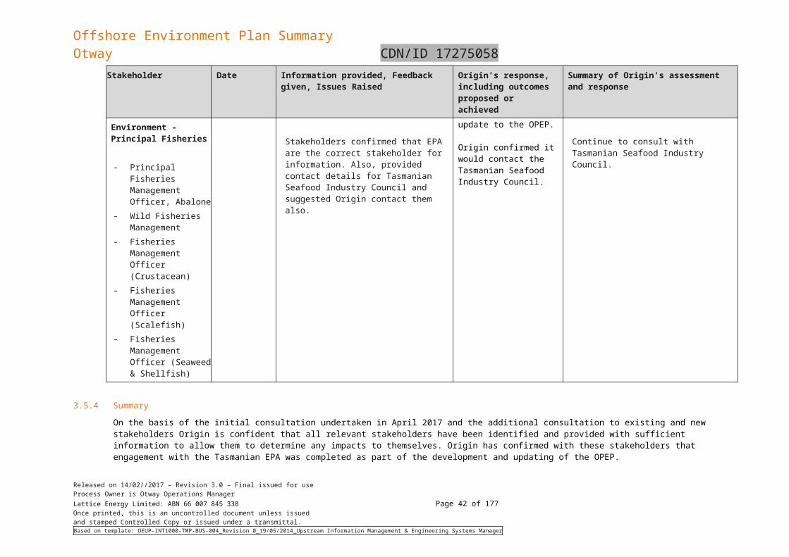
Offshore Environment Plan SummaryOtway CDN/ID 17275058
Figure 5-3: Otway Basin: Historical Studies Woodside Bathymetry and Video Footage
The Casino pipeline, which transects the 70 m and 60 m isobaths in the mid shelf of the Otway Basin, was also assessed using underwater video footage (the northern half of the Thistle drilling area is a 70 m to 65m bathymetric contour in the middle shelf). The video validates the assertions of Boreen et al. (1993) concerning the subsea features and biological communities found there. The Casino gas field environmental report states that large tracts of open sand with little or no epifauna characterise the deep environment of the project area: infaunal communities and bivalves, polychaetes and crustaceans probably dominate in the open sand habitat. The video survey transect of the Casino Environmental report (Santos, 2004) is shown in Figure 5-4.
5.3.2 Geomorphology, geology, bathymetry and surficial sediments
A video survey of the seabed at selected sites along proposed offshore pipeline routes for the Otway Gas Project was undertaken by BBG during 2003.
The survey found that the substrate in water depths that predominate in the operational area (between 82 and 66 m) area was predominantly low profile limestone with an incomplete sand veneer that
Released on 14/02//2017 – Revision 3.0 – Final issued for useProcess Owner is Otway Operations ManagerLattice Energy Limited: ABN 66 007 845 338 Page 42 of 122Once printed, this is an uncontrolled document unless issuedand stamped Controlled Copy or issued under a transmittal.Based on template: OEUP-INT1000-TMP-BUS-004_Revision 0_19/05/2014_Upstream Information Management & Engineering Systems Manager
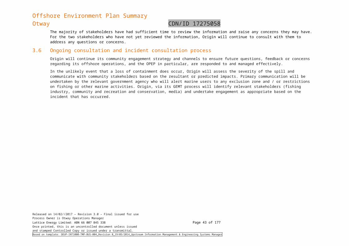
Offshore Environment Plan SummaryOtway CDN/ID 17275058
supported a low to medium density, sponge dominated filter feeding community. Fish and other motile organisms were uncommon.
In shallower depths of between 63 and 30 m, the video surveys showed a rippled, sand or sand/pebble substrate with minor sponge dominated benthic communities. The epibenthic organisms were generally attached to outcropping or sub-outcropping limestone pavements. Only in waters shallower than approximately 20 m, was an area of significant, high profile reef and associated high density macroalgae dominated epibenthos encountered.
The Casino gas field environmental report indicates that the seabed along the pipeline route is comprised of large tracts of open sand with little or no epifauna, and that infaunal communities of bivalves, polychaetes and crustaceans probably dominate in the open sand habitat (Figure 5-4).
The sampling data from the BSS survey and video surveys for the Casino and Otway projects broadly support the findings of Boreen et al. (1993) concerning the subsea features and biological communities likely to dominate the operational area. In summary the seabed of the ZPI can be characterised as a carbonate mid shelf and deeper sections (60 – 70 m) of the inner shelf with surficial sediments of carbonate rich coarse to medium sands with areas of exposed limestone substrate. The epifauna is dominated by low density, sessile sponge assemblages. Six basalt rises occur in the eastern and south-eastern section of the operational area, the largest of which is the ‘Big Reef’.
Released on 14/02//2017 – Revision 3.0 – Final issued for useProcess Owner is Otway Operations ManagerLattice Energy Limited: ABN 66 007 845 338 Page 43 of 122Once printed, this is an uncontrolled document unless issuedand stamped Controlled Copy or issued under a transmittal.Based on template: OEUP-INT1000-TMP-BUS-004_Revision 0_19/05/2014_Upstream Information Management & Engineering Systems Manager
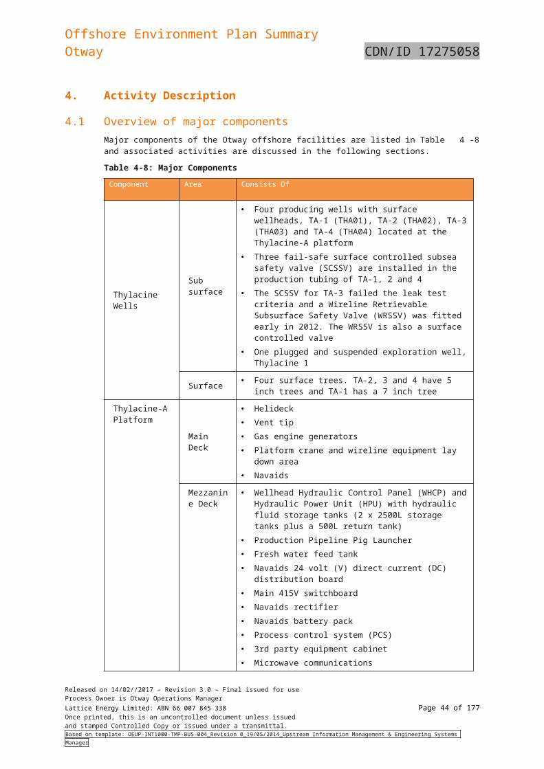
Offshore Environment Plan SummaryOtway CDN/ID 17275058
Figure 5-4: Casino pipeline video survey
Released on 14/02//2017 – Revision 3.0 – Final issued for useProcess Owner is Otway Operations ManagerLattice Energy Limited: ABN 66 007 845 338 Page 44 of 122Once printed, this is an uncontrolled document unless issuedand stamped Controlled Copy or issued under a transmittal.Based on template: OEUP-INT1000-TMP-BUS-004_Revision 0_19/05/2014_Upstream Information Management & Engineering Systems Manager
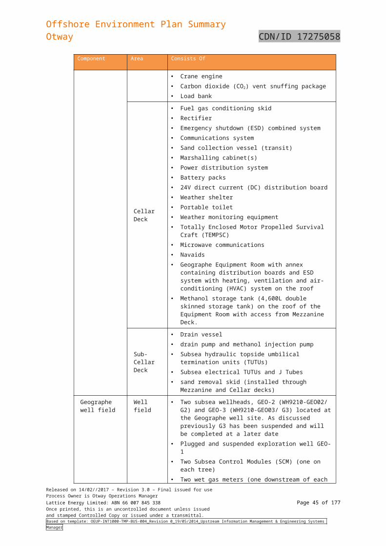
Offshore Environment Plan SummaryOtway CDN/ID 17275058
5.3.3 Metocean conditions
5.3.3.1 Climate
The area is typical of a cool temperate region with cold, wet winters and warm dry summers. The regional climate is dominated by sub-tropical high pressure systems in summer and sub-polar low pressure systems in winter. The low pressure systems are accompanied by strong westerly winds and rain-bearing cold fronts that move from south-west to north-east across the region, producing strong winds from the west, north-west and south-west.
The day-to-day variation in weather conditions is caused by the continual movement of the highs from west to east across the Australian continent roughly once every 10 days.
5.3.3.2 Winds
Bass Strait is located on the northern edge of the westerly wind belt known as the Roaring Forties. In winter, when the subtropical ridge moves northwards over the Australian continent, cold fronts generally create sustained west to south-westerly winds and frequent rainfall in the region (McInnes & Hubbert 2003). In summer, frontal systems are often more shallow and occur between two ridges of high pressure, bringing more variable winds and rainfall.
Winds in this section of the Otway basin and western Bass Strait generally exceed 13 knots (23.4 km/h) for 50% of the time. Winds contribute to the predominant moderate to high wave-energy environment of area and are predominantly south-westerly cycling to north-westerly. September is the windiest month, with average wind speeds of 29 km/h.
5.3.3.3 Tides
Tides are semi-diurnal with some diurnal inequalities (Jones & Padman 1983), generating tidal currents along a north-east/south-west axis, with speeds generally ranging from 0.1 to 2.5 m/s (Fandry, 1983). The maximum range of spring tides in western Bass Strait is approximately 1.2 m. Sea level variation in the area can arise from storm surges and wave set up (Santos, 2004).
5.3.3.4 Ocean currents
Ocean currents in Bass Strait are primarily driven by tides, winds and density-driven flows. During winter, the South Australian current moves dense, salty warmer water eastward from the Great Australian Bight into the western margin of the Bass Straight. In winter and spring, waters within the straight are well mixed with no obvious stratification, while during summer the central regions of the straight become stratified.
Surface currents within the permit area have been modelled by combining the HYDROMAP tidal currents and HYCOM ocean currents for 2009 – 2013 inclusive to produce monthly surface currents. These show a rotational aspect because of inflow and outflow to Bass Strait. Although unimodal the currents are stronger from the west in all months excepting February when the currents from the east are the strongest. Minimum currents have been derived as 0.2-0.4 m/s and maximum currents as 0.8-2.0 m/s, with the strongest currents during the months July to October.
5.3.3.5 Waves
There are two principal sources of wave energy in the Otway Basin:
From the westerly swell from the Great Australian Bight and Southern Ocean; and
From locally generated winds, generally from the west and east.
The Otway area is fully exposed to long period 13 second average south-westerly swell from the Southern Ocean as well as periodic shorter 8 second average period waves from the east. Wave heights from these winds generally range from 1.5 m to 2 m, although waves heights to 10 m can occur during storm events and a combination of wind forcing against tidal currents can cause greater turbulence. The largest waves are associated with eastward-moving low pressure and frontal systems that cross the site every 4 to 6 days in winter.
5.3.3.6 Sea temperature
The waters have average surface temperatures ranging from 14°C in winter to 21°C in summer. However, subductions of cooler nutrient-rich water (upwellings) occur along the seafloor during mid to late summer, though this is usually masked in satellite images by a warmer surface layer.
During winter and spring onshore winds cycling from the southwest to northwest mound the surface layer against the land and cause a south-easterly flow along the coast that fills the shelf
Released on 14/02//2017 – Revision 3.0 – Final issued for useProcess Owner is Otway Operations ManagerLattice Energy Limited: ABN 66 007 845 338 Page 45 of 122Once printed, this is an uncontrolled document unless issuedand stamped Controlled Copy or issued under a transmittal.Based on template: OEUP-INT1000-TMP-BUS-004_Revision 0_19/05/2014_Upstream Information Management & Engineering Systems Manager
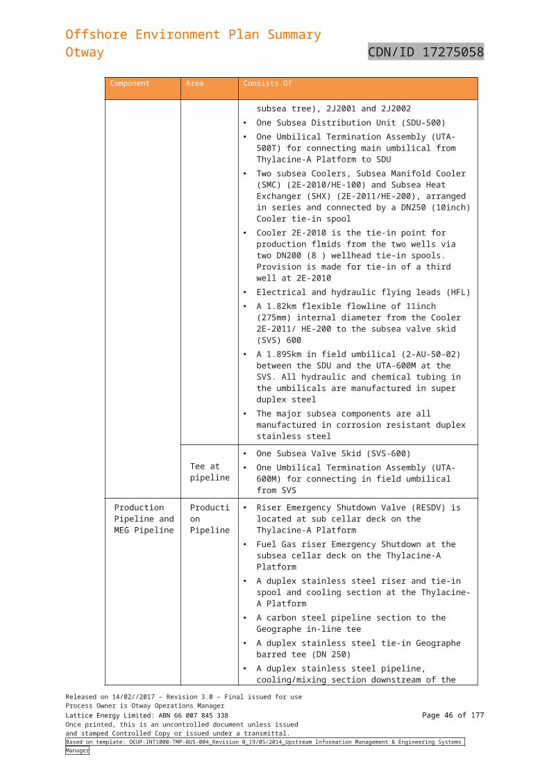
Offshore Environment Plan SummaryOtway CDN/ID 17275058
from the shore outwards to a depth of 500 m deep. Shelf water temperatures at these times range from between 18°C to 14°C with seafloor temperatures warmer in winter than in summer.
5.3.4 Ambient sound levels
McCauley and Duncan (2001) undertook a desk-top review of natural and man-made sea sound sources likely to be encountered in the Otway Basin. They concluded that natural sea sound sources are dominated by wind noise, but also include rain noise, biological noise and the sporadic noise of earthquakes. Man-made underwater sound sources in the region comprise shipping and small vessel traffic, petroleum-production and exploration-drilling activities and sporadic petroleum seismic surveys.
Ambient sound levels in the Otway Basin have been measured as part of impact assessment activities for the petroleum industry. Acoustic monitoring prior to the development of the Thylacine wells and platform, recorded broadband underwater sound of 93 to 97 decibels dB re 1 μPa (Santos, 2004). An acoustic monitoring program was also undertaken during exploratory drilling of the Casino 3 well in the ZPI. A sound logger located 28.03 km from the drill site did not detect drilling noise and recorded ambient noise that ranged between 90 and 110 dB re 1 μPa (McCauley, 2004). Passive acoustic monitoring commissioned by Origin from April 2012 to January 2013, 5 km offshore from the coastline east of Warrnambool, identified that ambient underwater noise in coastal areas are generally higher than further offshore, with a mean of 110 dB re 1 µPa and maximum of 161 dB re 1 µPa( Duncan et al, 2013).
5.4 Biological environment 5.4.1 Threatened ecological communities
Threatened Ecological Communities (TECs) provide wildlife corridors or refugia for many plant and animal species, and listing a TEC provides a form of landscape or systems-level conservation (including threatened species). The following TECs were identified as potentially occurring in the ZPI:
Giant Kelp Marine Forests of South East Australia
Grassy Eucalypt Woodland of the Victorian Volcanic Plain
Natural Damp Grassland of the Victorian Coastal Plains
Natural Temperate Grassland of the Victorian Volcanic Plain
Subtropical and Temperate Coastal Saltmarsh
White Box-Yellow Box-Blakely's Red Gum Grassy Woodland and Derived Native Grassland.
Of the TECs listed above, only the giant kelp marine forests of South East Australia and the Subtropical and Temperate Coastal Saltmarsh Vulnerable Community have potential to be impacted by an oil spill associated with the development, as the rest are terrestrial listings.
5.4.2 Threatened and migratory species
The EPBC PMST report identified the threatened and migratory species that may be present in the ZPI. The report is contained in the full EP.
A total of 101 threatened species and 69 migratory species were identified in the PMST report as potentially occurring within the ZPI. There were also 123 marine species and 31 cetaceans listed under the Act that were identified as potentially occurring within the ZPI. Species that are terrestrial and are unlikely to be present in the ZPI have not been included in the following sections.
Terms and definitions used in listed threatened species tables are summarised in table below.
Table 5-10: Terms and definitions used in listed threatened species tables
Terms Definitions
SHM Species or species habitat may occur within area.
SHK Species or species habitat known to occur within area.
SHL Species or species habitat likely to occur within area.
FK Foraging, feeding or related behaviour known to occur within area.
FL Foraging, feeding or related behaviour likely to occur within area.
ML Migratory route likely to occur in area.
Released on 14/02//2017 – Revision 3.0 – Final issued for useProcess Owner is Otway Operations ManagerLattice Energy Limited: ABN 66 007 845 338 Page 46 of 122Once printed, this is an uncontrolled document unless issuedand stamped Controlled Copy or issued under a transmittal.Based on template: OEUP-INT1000-TMP-BUS-004_Revision 0_19/05/2014_Upstream Information Management & Engineering Systems Manager
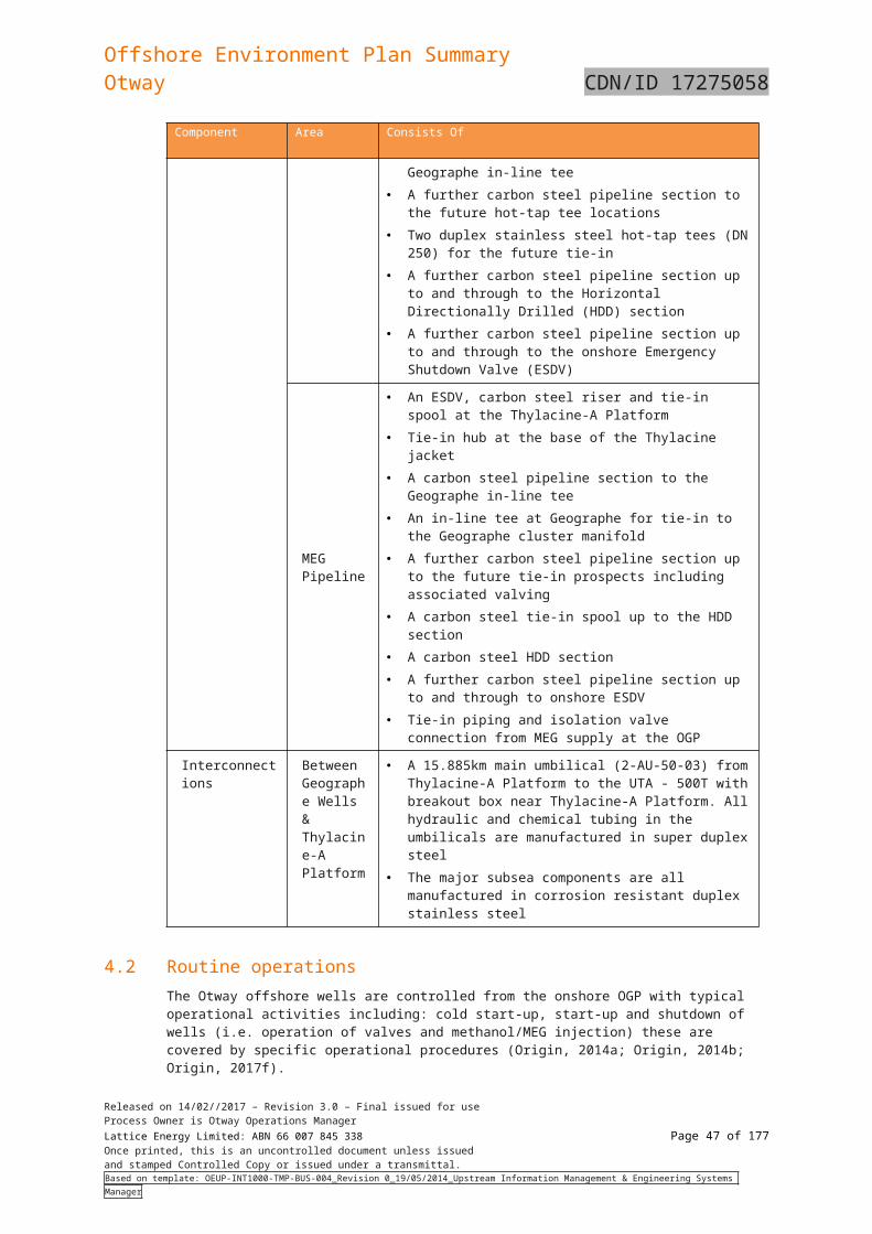
Offshore Environment Plan SummaryOtway CDN/ID 17275058
Terms Definitions
BL Breeding likely to occur in area
BK Breeding known to occur in area
Listed threatened species
A native species listed (L) Commonwealth EPBC Act (Section 178).(VU) Vulnerable, (EN) Endangered, (CE) Critically Endangered
Listed migratory species:
A native species that from time to time are included in the appendices to the Bonn Convention and the annexes of JAMBA, CAMBA and ROKAMBA, as listed in Section 209 of the EPBC Act.
Listed marine species:
As listed in Section 248 of the EPBC Act.
FFG Act Status A native species listed as threatened (T) under the FFG Act (Vic)
TSCA Act Status A native listed species under the TSC Act (Tas) (e) Endangered, (v) Vulnerable, (r) Rare
5.4.2.1 Birds
A diverse array of seabirds and terrestrial birds utilise the Otway region and may potentially forage within or fly over the ZPI, resting on islands during their migration. Infrequently and often associated with storm events, birds that do not normally cross the ocean are sometimes observed over the Otway shelf, suggesting the birds have been blown off their normal course or are migrating.
Bird species listed by the EPBC Act PMST, the FFG Act and the DELWP Advisory List of Threatened Vertebrate Fauna in Victoria (DELWP, 2017b) and those listed as threatened under the Tasmanian Threatened Species Conservation Act (1995) (TSC Act) as possibly or known to be occurring in ZPI (this includes species or species habitat), are shown in Table 5-11. The section below describes threated listed bird species only.
Table 5-11: Listed bird species that may be present in the ZPI
Common name Species name
EPBC Act statusLikely
presenceFFG Act Status
TSC Act Status
Listed threatened
Listed migrator
y
Listed marine
Common sandpiper
Actitius hypoleucos M L SHK
Common noddy
Anous stolidus M SHL
Magpie goose
Anseranas semipalmata L SHM
Fork-tailed swift
Apus pacificus - M L SHL -
Great egret Ardea alba L BK T
Cattle egret Ardea ibis L SHM
Flesh-footed shearwater
Ardenna carneipes (Puffinus carneipes in marine listing)
M L SHK
Short-tailed shearwater
Ardenna tenuirostris (Puffinus tenuirostris in marine listing)
M L BK
Ruddy turnstone
Arenaria interpres M L RK V
Released on 14/02//2017 – Revision 3.0 – Final issued for useProcess Owner is Otway Operations ManagerLattice Energy Limited: ABN 66 007 845 338 Page 47 of 122Once printed, this is an uncontrolled document unless issuedand stamped Controlled Copy or issued under a transmittal.Based on template: OEUP-INT1000-TMP-BUS-004_Revision 0_19/05/2014_Upstream Information Management & Engineering Systems Manager
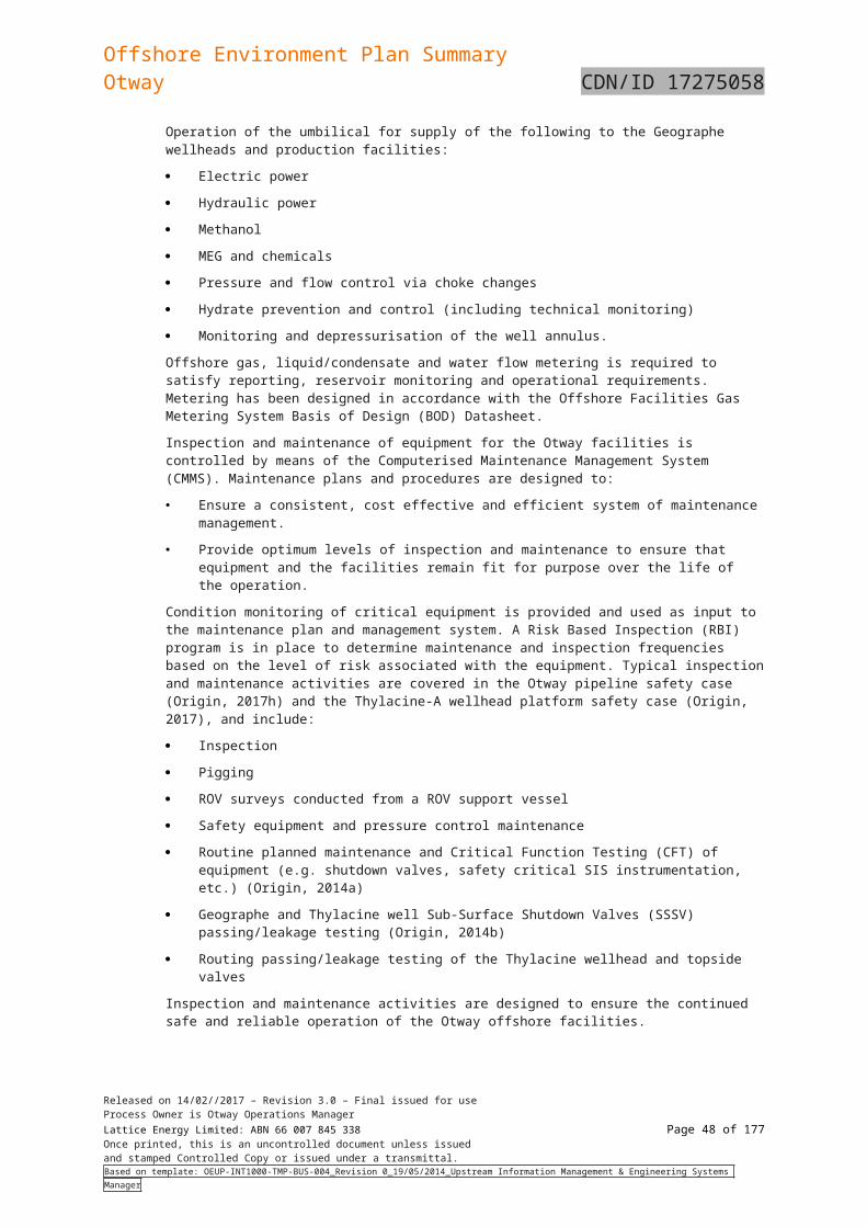
Offshore Environment Plan SummaryOtway CDN/ID 17275058
Common name Species name
EPBC Act statusLikely
presenceFFG Act Status
TSC Act Status
Listed threatened
Listed migrator
y
Listed marine
Australasian bittern
Botaurus poiciloptilus E - - SHK T
Sharp-tailed sandpiper
Calidris acuminata M L RK
Sanderling Calidris alba M L RK
Red knot Calidris canutus EN M L SHK
Curlew sandpiper
Calidris ferruginea CE M L SHK T
Pectoral sandpiper
Calidris melanotos M L SHK
Red-necked stint
Calidris ruficollis M L RK
Great knot Calidris tenuirostris CE M L RK T
Great skua Catharacta skua - - L SHM -
Double-banded plover
Charadrius bicinctus M
LRK
Lesser sand plover
Charadrius mongolus EN L RK
Red-capped plover
Charadrius ruficapillus
L RK
Antipodean albatross
Diomedea antipodensis V M L FL -
Gibson’s albatross
Diomedea antipodensis gibsoni
V M L FL -
Southern royal albatross
Diomedea epomophora V M L FL T
Wandering albatross
Diomedea exulans V M L FL T e
Northern royal albatross
Diomedea sanfordi E M L FL -
Little penguin
Eudyptula minor - - L BK -
White-bellied storm-petrel
Fregetta grallaria grallaria VU SHL T
Latham’s snipe
Gallinago hardwickii M L RK
Swinhoe’s snipe
Gallinago megala M L RK
Pin-tailed snipe
Gallinago stenura M L RK
Gull-billed tern
Gleochelidon nilotica macrotarsa
- - - X T
Released on 14/02//2017 – Revision 3.0 – Final issued for useProcess Owner is Otway Operations ManagerLattice Energy Limited: ABN 66 007 845 338 Page 48 of 122Once printed, this is an uncontrolled document unless issuedand stamped Controlled Copy or issued under a transmittal.Based on template: OEUP-INT1000-TMP-BUS-004_Revision 0_19/05/2014_Upstream Information Management & Engineering Systems Manager
Offshore Environment Plan SummaryOtway CDN/ID 17275058
Common name Species name
EPBC Act statusLikely
presenceFFG Act Status
TSC Act Status
Listed threatened
Listed migrator
y
Listed marine
White-bellied sea eagle
Haliaeetus leucogaster - - L BK T
Blue petrel Halobaena caerulea V - L SHM - v
Grey-tailed tattler
Heteroscelus brevipes L RK T
Wandering tattler
Heteroscelus incanus L FK
Black-winged stilt
Himantopus himantopus L RK
Kelp gull Larus dominaicanus L
BK
Silver gull Larus novaehollandiae L BK
Pacific gull Larus pacificus L BK
Swift parrot Lathamus discolour CE L SHK T e
Broad-billed sandpiper
Limicola falcinellus M L RK
Black-tailed godwit
Limosalimosa
M L RK
Bar-tailed godwit (baueri)
Limosa lapponica V - L SHM -
Bar-tailed godwit (menzbeieri)
Limosa lapponica menzbieri
CE - - SHM -
Southern giant-petrel
Macronectes giganteus E M L FL T v
Northern giant-petrel
Macronectes halli V M L SHM T r
Black-faced monarch
Monarcha melanopsis L SHK
Cape gannet
Morus capensis L BK
Australasian gannet
Morus serrator - L BK -
Yellow wagtail
Motacila falva L SHM
Satin flycatcher
Myiagra cyanoleuca L BK
Orange-bellied parrot
Neophema chrysogaster CE - L MK T e
Eastern curlew
Numenius madagacariensis
CE M L SHK T e
Little curlew Numenius minutus M L RL
Released on 14/02//2017 – Revision 3.0 – Final issued for useProcess Owner is Otway Operations ManagerLattice Energy Limited: ABN 66 007 845 338 Page 49 of 122Once printed, this is an uncontrolled document unless issuedand stamped Controlled Copy or issued under a transmittal.Based on template: OEUP-INT1000-TMP-BUS-004_Revision 0_19/05/2014_Upstream Information Management & Engineering Systems Manager
Offshore Environment Plan SummaryOtway CDN/ID 17275058
Common name Species name
EPBC Act statusLikely
presenceFFG Act Status
TSC Act Status
Listed threatened
Listed migrator
y
Listed marine
Whimbrel Numenius phaeopus M L RK
Fairy prion Pachyptila turtur subantactica V - L SHK V e
Osprey Pandion haliaetus - M L SHM -
Common diving-petrel
Pelecanoides urinatris L BK
Black-faced cormorant
Phalacrocorax fuscescens - - L BK NT
Red-necked phalarope
Phalaropus lobatus M L RK
Sooty albatross
Phoebetris fusca V M L SHL T r
Pacific golden plover
Pluvialis fulvaM L RK
Grey plover Pluvialis squatarola - M L RK E
Gould's petrel
Pterodroma leucoptera E - - SHM -
Soft-plumaged petrel
Pterodroma mollis V - L SHM - e
Red-necked avocet
Recurvirostra novaehollandiae L RK
Rufous fantail
Rhipidura rufifrons L SHK
Australian Painted Snipe
Rostratula australis E L SHL T
Little tern Sterna albifrons - M L BK T
Australian fairy tern
Sternula nereis V - L BL T v
Buller's albatross
Thalassarche bulleri V M L FL T
Northern Buller’s albatross
Thalassarche bulleri platei V FL
Shy albatross
Thalassarche cauta cauta V M L FL T v
White-capped albatross
Thalassarche cauti steadi V M L FL -
Grey-headed albatross
Thalassarche chrysostoma E M L SHM T e
Campbell albatross
Thalassarche impavida V M L FL -
Released on 14/02//2017 – Revision 3.0 – Final issued for useProcess Owner is Otway Operations ManagerLattice Energy Limited: ABN 66 007 845 338 Page 50 of 122Once printed, this is an uncontrolled document unless issuedand stamped Controlled Copy or issued under a transmittal.Based on template: OEUP-INT1000-TMP-BUS-004_Revision 0_19/05/2014_Upstream Information Management & Engineering Systems Manager
Offshore Environment Plan SummaryOtway CDN/ID 17275058
Common name Species name
EPBC Act statusLikely
presenceFFG Act Status
TSC Act Status
Listed threatened
Listed migrator
y
Listed marine
Black-browed albatross
Thalassarche melanophris V M L FL - e
Salvin's albatross
Thalassarche salvini V M L FL -
Crested tern Thalasseus bergii M BK
Hooded plover
Thinornis rubicollus L SHK T
Hooded plover (eastern)
Thinornis rubicollus rubricollis
V L SHK
Grey-tailed tattler
Tringa brevipes - M - RK C
Wood sandpiper
Tringa glareola M RK
Common greenshank
Tringa nebularia - M L SHK V
Marsh sandpiper
Tringa stagnatilis M RK
Terek sandpiper
Xenus stagnatilis M RK T
Albatrosses and giant-petrels are among the most dispersive and oceanic of all birds, spending more than 95% of their time foraging at sea in search of prey and usually only returning to land (remote islands) to breed. The National Recovery Plan for threatened albatross and giant petrels (DESWPAC, 2011). Only seven species of albatross and the southern and northern giant petrel are known to breed within Australia. Breeding within Australian territory occurs on the isolated islands of Antarctica (Giganteus Island, Hawker Island and Frazier islands) and the Southern Ocean (Heard Island, McDonald Island, Macquarie Island, Bishop and Clerk Islands), as well as islands off the south coast of Tasmania and Albatross Island off the north-west coast of Tasmania in Bass Strait (DSEWPaC, 2011b). There are no islands with colonies of threatened marine seabirds within the ZPI. Albatross Island, supporting a breeding population of approximately 5,000 shy albatross (Thallassarche cauta), is the closest breeding colony of threatened seabird to the ZPI.
Albatross and giant petrel species exhibit a broad range of diets and foraging behaviours, and hence their at-sea distributions are diverse. Combined with their ability to cover vast oceanic distances, all waters within Australian jurisdiction can be considered foraging habitat, however the most critical foraging habitat is considered to be those waters south of 25 degrees where most species spend the majority of their foraging time. The wandering albatross, antipodean albatross, Buller’s albatross, shy albatross, black-browed albatross and Campbell albatross have BIAs for foraging that overlap the ZPI. This BIA is either most or all of the South-East Marine Region (Commonwealth of Australia, 2015). Therefore, it is likely that these will be present and forage in the ZPI.
Orange-bellied parrot (Neophema chrysogaster) (listed as critically endangered under the FFG Act and EPBC Act) breeds in Tasmania during summer, migrates north across Bass Strait in autumn and spends winters on the mainland. The migration route includes the west coast of Tasmania and King Island. Birds depart the mainland for Tasmania from September to November (Green, 1969). The southward migration is rapid (Stephenson, 1991), so there are few migration records. The northward migration across western Bass Strait is more prolonged (Higgins and Davies, 1996).
The orange-bellied parrot is protected under the National Recovery Plan for the Orange-bellied Parrot (DELWP, 2016). The parrot’s breeding habitat is restricted to south-west Tasmania, where breeding occurs from November to mid-January mainly within 30 km of the coast. The species forage on the ground or in low vegetation (Brown and Wilson, 1980; Loyn et alet al, 1986). During winter, on mainland Australia, orange-bellied parrots are found mostly within 3 km of the coast. In Victoria, they mostly occur in sheltered coastal habitats, such as bays, lagoons and estuaries. They are also found in
Released on 14/02//2017 – Revision 3.0 – Final issued for useProcess Owner is Otway Operations ManagerLattice Energy Limited: ABN 66 007 845 338 Page 51 of 122Once printed, this is an uncontrolled document unless issuedand stamped Controlled Copy or issued under a transmittal.Based on template: OEUP-INT1000-TMP-BUS-004_Revision 0_19/05/2014_Upstream Information Management & Engineering Systems Manager
Offshore Environment Plan SummaryOtway CDN/ID 17275058
low samphire herbland dominated by beaded glasswort (Sarcocornia quinqueflora), sea heath (Frankenia pauciflora) or sea-blite (Suaeda australis), and in taller shrubland dominated by shrubby glasswort (Sclerostegia arbuscula). (DoE, 2016d). There are also non-breeding orange-bellied parrots on mainland Australia, between Goolwa in Australia and Corner Inlet in Victoria.
The orange bellied parrot may overfly the coastal waters of the ZPI however the west coast of King Islands and coastal Victoria has been identified as resting and feeding areas.
Short-tailed shearwater (Puffinus tenuirostris) is listed as a migratory seabird and is known to occur and breed in western Bass Strait. It is Australia’s most abundant seabird, with millions of birds converging on small offshore islands along the southern Australia’s coast during their summer breeding season, with Bass Strait being their stronghold (Birdlife International, 2016). It breeds in Australia and winter in the North Pacific, and returns to southern Australia in summer to breed. The species has a bi-modal feeding strategy while breeding, alternating short foraging trips to local waters with long foraging trips (up to 17 days). The species feeds on krill, small fish and other marine creatures, mostly feeding on the water surface (Lindsey, 1986).
The BIA for the short-tailed shearwater identifies Wilsons Promontory and surrounding islands and King Island within the ZPI as breeding areas, with likely foraging. The birds are known to use this area between September and May and there is a high level of use. Although not a recognised BIA, a colony of approximately 12,000 short-tailed shearwaters nests on Mutton Bird in Victorian State waters from September through to April. The Bay of Islands Coastal Park also contains shearwater habitat. Therefore, this species may overfly and forage within the ZPI.
A number of species listed in Table 6-11 use coastal shoreline habitats. These species are commonly found on coastal shores including beaches and rocky shores and either feed at low tide on worms, crustaceans and molluscs or fish species or feed on aquatic biota (Parks Victoria, 2016). . Coastal species listed in Table 6-11 that may have a presence within the ZPI are described below.
Flesh-footed shearwater is a trans-equatorial migrant widely distributed across the south-western Pacific during breeding season (early September to early May) and is a common visitor to the waters of the continental shelf/slope and occasionally inshore waters. The species breeds in burrows on sloping ground in coastal forest, scrubland, shrubland or grassland. Thirty-nine of the 41 islands on which the species breeds lie off the coast of southern Western Australia, with the remaining two islands being Smith Island (SA) and Lord Howe Island. The flesh-footed shearwater feeds on small fish, cephalopod molluscs (squid, cuttlefish, nautilus and argonauts), crustaceans (barnacles and shrimp), other soft-bodied invertebrates (such as Velella) and offal. The species forages almost entirely at sea and very rarely on land. It obtains most of its food by surface plunging or pursuit plunging. It also regularly forages by settling on the surface of the ocean and snatching prey from the surface ('surface seizing'), momentarily submerging onto prey beneath the surface ('surface diving') or diving and pursuing prey beneath the surface by swimming ('pursuit diving'). Birds have also been observed flying low over the ocean and pattering the water with their feet while picking food items from the surface (termed 'pattering') (DoE, 2016b). This species is likely to be an uncommon visitor to the ZPI.
Australian fairy tern occurs along the coasts of Victoria, Tasmania, South Australia and Western Australia. It is a fish-eating bird and nests on sheltered sandy beaches, spits and banks above the high tide mark and below shoreline vegetation where the substrate is sandy and the vegetation sparse. The fairy tern is an aerial diver for bait-sized fish in shallow, inshore waters often observed near the shoreline and is rarely found out of the sight of land. The species forages by working against the tidal flow in estuaries, periodically hovering 5-15 m above the water surface (Pulham & Wilson, 2013). The species can also feed on plant material, molluscs and crustaceans in inshore waters and undergoes long distance movements within Australia. It is reported that there are only a few pairs in Victoria (Birdlife International, 2016). The species breeds between October to February and is very vulnerable to extreme weather events such as storms, floods, high-tide or wind-blown events (DoE, 2016c). While no specific locations have been identified in the ZPI, this species may be present along and within sandy embayments on the coastline of the ZPI.
Hooded plovers are sedentary and inhabit sandy ocean beaches feeding on tiny invertebrates (insects, sand-hoppers, small bivalves and soldier crabs) from the sand near the water’s edge. The species lays their eggs in shallow scrapes in the sand either on the upper beach (above high tide mark) or adjacent backing sand dune. The highest densities of hooded plover occur on broad, flat and wide wave-washed zone with large amounts of beach-washed seaweed. Densities are lowest on narrow steep beaches where there are few or no dunes (Birdlife Australia, 2016). The species captures its prey by running across the surface for marine worms, molluscs, crustaceans, insects, water plants and seeds. They nest in solitary pairs and defend their breeding territories (ranging from 400-1,800 m near the shoreline) from August to March (Barton et alet al., 2012). The Otway coastline contains recognised hooded plover habitats at Station Beach, Johanna Beach, Milanesian Beach, Princetown Beach, Clifton Beach, Loch Ard Gorge, Shelley Beach, London Bridge, Schomberg Rock, Crofts Bay
Released on 14/02//2017 – Revision 3.0 – Final issued for useProcess Owner is Otway Operations ManagerLattice Energy Limited: ABN 66 007 845 338 Page 52 of 122Once printed, this is an uncontrolled document unless issuedand stamped Controlled Copy or issued under a transmittal.Based on template: OEUP-INT1000-TMP-BUS-004_Revision 0_19/05/2014_Upstream Information Management & Engineering Systems Manager
Offshore Environment Plan SummaryOtway CDN/ID 17275058
and Bay of Islands Coastal Park. This species will be present along adjacent coastal sandy embayments in the ZPI.
Little terns are widespread, migratory and occur around the Australian coastline from Broome, around the northern coastline to south-eastern South Australia. They inhabit sheltered coastal environments (lagoons, estuaries, river mouths and deltas, exposed sand spits or sandbanks and exposed ocean beaches (least preferred)). Breeding occurs between September and February in a shallow scrape in the sand sometimes laced next to debris (driftwood, etc.) above the high-tide mark (DoE, 2016d). The species forages in shallow waters of estuaries, coastal lagoons and lakes and frequently over channels next to spits and banks or entrances on small fish crustaceans, insects and molluscs taken by plunge diving. They forage along open coasts, less often at sea and usually within 50 m of the shore. This species may be present along sandy embayments in the ZPI.
Fairy prion are often beach-cast on the south-eastern coast of Australia, and are commonly seen foraging offshore over the continental shelf and pelagic waters. The species is common along the entire Victorian coast. The species as a whole has been recorded breeding on subantarctic and cool temperate islands (Bass Strait islands, Tasmania, Macquarie Island) between September and early March. Fairy prions feed mostly on euphausiids and other small crustaceans, but also small quantities of fish and pteropods (free-swimming sea snails and slugs). The species flies just above the surface of the ocean hunting by surface-seizing, dipping, pattering or surface-plunging (DoE, 2016e). The species is expected to be present on the coastline in the ZPI.
White-bellied sea eagle is distributed along the coastline in coastal lowlands with breeding from Queensland to Victoria in coastal habitats and terrestrial wetlands in temperate regions. The breeding season is from June to January with nests built in tall trees, bushes, cliffs or rock outcrops. Breeding pairs are generally widely dispersed (DoE, 2016f). The species forages over open water (coastal and terrestrial) and feeds on fish, birds, reptiles, mammals and crustaceans and normally launches into a glide to snatch its prey, usually with one foot, from the ground or water surface. The species is widespread and makes long-distance movements (DoE, 2016f). This species may be present along the coastline of the ZPI.
Black-faced cormorant is Australia’s only cormorant that does not occur at terrestrial wetlands and is confined to inshore marine habitats. The species occurs along two sections of Australia’s southern coastline, Eden (NSW) to the Head of Bight (SA) including Tasmania and south-western Western Australia near Albany, where it breeds throughout the year in large colonies on dozens of rocky offshore islands. Nests are built from seaweed and driftwood on bare rock. The cormorants forage by diving to depths of up to 12 m in pursuit of small fish. They often roost in the company of other birds, especially gulls and other species of cormorants. Black-faced cormorants frequent coastal waters and are found in flocks in large bays, deep inlets, rocky headlands and islands. They seldom visit beaches (Birdlife Australia, 2016). A BIA for the black-faced cormorant is on Christmas Island, where breeding and foraging are known to occur. There the black-face cormorant is likely to be present in the ZPI.
Australasian gannet is common throughout inshore waters of eastern and southern Australia. Breeding colonies are usually located on islands or artificial structures such as beacons. Gannets forage by plunging headlong into the water from great heights to catch fish (pilchards, anchovies, jack mackerel) and squid in their bills (Birdlife Australia, 2016). The Australasian Gannet generally feeds over continental shelves or inshore waters, seldom far from land. Breeding is highly seasonal (October to May), nesting on the ground in small but dense colonies. Adults tend to stay within the vicinity of the colony after breeding with young birds dispersing significant distances (Birdlife International, 2016). BIA for this species have been identified in the ZPI at Point Danger at Portland and at Lawrence Rocks (in Port Phillip Bay), with a foraging area surrounding. This species is likely to be present in the ZPI.
Common diving-petrel is a listed marine species and is common throughout the south-east marine region. They forage mainly in the near shore areas around their breeding colonies. They use their winds to propel them underwater and catch most of their pray underwater. There is large BIA for breeding and foraging which is a buffer around all of Tasmania and Victorian coasts and the birds are present all year round, breeding from July to January (Commonwealth of Australia, 2015). This species is likely to be present in the ZPI.
Grey-tailed tattler is migratory wader and is protected under the Wildlife Conservation Plan for Migratory Shorebirds (DoE, 2015a). It is primarily found in northern coastal regions of Australia scattered along coastal waters. The species is rarely recorded in Victoria; the largest population in Victoria is at Corner Inlet, along with populations further west to Westernport and Port Phillip bays. Rare sightings have been recorded at Killarney, Port Fairy and Discovery Bay, along with Sperm Whale Head. In the Tasmanian region, the bird has been recorded at King Island and the Furneaux Group and is located mainly along the north coast, from Robbins Island to Cape Portland (DoE, 2016g). The species lives on sheltered coasts with reefs and rock platforms or with intertidal mudflats. They usually forage in shallow water, on hard intertidal substrates for polychaetes, molluscs,
Released on 14/02//2017 – Revision 3.0 – Final issued for useProcess Owner is Otway Operations ManagerLattice Energy Limited: ABN 66 007 845 338 Page 53 of 122Once printed, this is an uncontrolled document unless issuedand stamped Controlled Copy or issued under a transmittal.Based on template: OEUP-INT1000-TMP-BUS-004_Revision 0_19/05/2014_Upstream Information Management & Engineering Systems Manager
Offshore Environment Plan SummaryOtway CDN/ID 17275058
crustaceans, insects and occasionally fish. The species does not breed in Australia and is likely to be present from August to June. It is likely that the grey-tailed tattler will be present in the ZPI.
Pacific golden plover is migratory wader and is protected under the Wildlife Conservation Plan for Migratory Shorebirds (DoE, 2015a). Within Australia, it is widespread in coastal regions; however, there are observations of the species further inland. Most of the records in Victoria are along the coast between Sale and the Bellarine Peninsula (including Western Port and Port Phillip Bay). The species does not breed in Australia and is usually found in coastal habitats, such as beaches, mudflats and sandflats and is sometimes found on islands. They forage on sandy, muddy or rocky shores for molluscs, polychaete worms, insects and crustaceans (DoE, 2017g). It is likely that the pacific golden plover will be present in the ZPI.
Grey plover is migratory wader and is protected under the Wildlife Conservation Plan for Migratory Shorebirds (DoE, 2015a). It is found in all states along the coastline and in Victoria it is from three distinct areas (1) around Jack Smith Lake and Corner Inlet, (2) in Westernport and Port Phillip Bays, and (3) along the western coast, between Warrnambool and the South Australian border (DoE, 2017h). It is found almost entirely in coastal areas, where they usually inhabit sheltered embayment, estuaries and lagoons. Grey plovers forage on large areas of mudflats and sheltered coastal shores on molluscs, insects, crustaceans and polychaete worms. It is likely that the grey plover will be present in the ZPI.
Double-banded plover is migratory wader and is protected under the Wildlife Conservation Plan for Migratory Shorebirds (DoE, 2015a). It is found in both coastal and inland areas and it is most common in Victoria and Tasmania in the non-breeding season. It is found on littoral, estuarine and fresh or saline terrestrial wetlands and beaches, bays and inlets. The species eats molluscs, insects, worms and crustaceans. It is likely that the double-banded plover will be present in the ZPI.
Lesser sand-plover is migratory wader and is protected under the Wildlife Conservation Plan for Migratory Shorebirds (DoE, 2015a). It occurs in coastal regions throughout Australia. It occurs in coastal littoral and estuarine environments. It feeds on extensive, freshly exposed areas of intertidal sandflats and mudflats in estuaries or beaches on invertebrates and insects. It is likely that the lesser sand plover will be present in the ZPI.
Latham’s snipe is migratory wader and is protected under the Wildlife Conservation Plan for Migratory Shorebirds (DoE, 2015a). It occurs in south-eastern Australia and a migrant through northern Australia. It occurs in permeant and ephemeral wetlands, usually freshwater but can also occur in brackish water. The foraging areas are characterised by areas of mud and some form of cover. It is an omnivorous species that feeds on seeds and other plant material. It is unlikely that the Latham’s snipe will be present in the ZPI.
Swinhoe’s snipe is migratory wader and is protected under the Wildlife Conservation Plan for Migratory Shorebirds (DoE, 2015a). Few definite records for the species exist in Australia. It occurs at the edges of wetlands and grasslands. It is unlikely that the Swinhoe’s snipe will be present in the ZPI.
Pin-tailed snipe is migratory wader and is protected under the Wildlife Conservation Plan for Migratory Shorebirds (DoE, 2015a). The distribution within Australia is not well understood. It is found in shallow freshwater swamps, ponds and lakes; it is not normally in sale in inter-tidal wetlands (DoE, 2017i). It is unlikely that the pin-tailed snipe will be present in the ZPI.
Black-tailed godwit is a large migratory wader and is protected under the Wildlife Conservation Plan for Migratory Shorebirds (DoE, 2015a). It occurs throughout Australia but prefers the coastal regions (DoE, 2017j). It occurs primarily in the coastal habitat and feeds in wide intertidal mudflats and sandflats on annelids, crustaceans, arachnids and fish eggs and spawn. It is likely that the black-tailed godwit will be present in the ZPI.
Little curlew is migratory wader and is protected under the Wildlife Conservation Plan for Migratory Shorebirds (DoE, 2015a). It occurs in predominantly in the north but has widespread but scattered records in the east coast. It rarely occurs in Victoria but has been recorded east of Wilson's Promontory and at Lake Tyers, Lake Wellington and Shallow Inlet, around Port Phillip Bay, and from lakes in the western Victoria and in the region of Mystic Park (DoE, 2017k). It is commonly found feeding short, dry grassland and sedgeland but has been found in coastal swamps, mudflats and sandflats or beaches on sheltered coasts. It is likely that the little curlew will be present in the ZPI.
Whimbrel is migratory wader and is protected under the Wildlife Conservation Plan for Migratory Shorebirds (DoE, 2015a). It occurs throughout Australia however is more likely on the coast and in the north (DoE, 2017l). In Victoria, it is commonly found at Corner Inlet and in Westernport and Port Phillip Bays (DoE, 2017l). It is found on the intertidal mudflats of sheltered coasts and feeds on annelids, crustaceans and sometimes vertebrates. It is likely that the whimbrel will be present in the ZPI.
Terek sandpiper is migratory wader and is protected under the Wildlife Conservation Plan for Migratory Shorebirds (DoE, 2015a). It has primarily a coastal distribution and is more common in the
Released on 14/02//2017 – Revision 3.0 – Final issued for useProcess Owner is Otway Operations ManagerLattice Energy Limited: ABN 66 007 845 338 Page 54 of 122Once printed, this is an uncontrolled document unless issuedand stamped Controlled Copy or issued under a transmittal.Based on template: OEUP-INT1000-TMP-BUS-004_Revision 0_19/05/2014_Upstream Information Management & Engineering Systems Manager
Offshore Environment Plan SummaryOtway CDN/ID 17275058
north and east of Australia. In Victoria, the species has been recorded from Corner Inlet, Anderson Inlet, Westernport Bay and west Port Phillip Bay (DoE, 2017m). It feeds in open, soft wet intertidal mudflats or in sheltered estuaries on crustaceans, insects and seeds. It is likely that the Terek sandpiper will be present in the ZPI.
Common sandpiper is migratory wader and is protected under the Wildlife Conservation Plan for Migratory Shorebirds (DoE, 2015a). It is found along all coastlines of Australia and inland and utilises a wide range of coastal wetlands and some inland wetlands (DoE, 2017n). Generally, the species forages in shallow water and care soft mud at the edge of wetlands. It is likely that the common sandpiper will be present in the ZPI.
Common greenshank is migratory wader and is protected under the Wildlife Conservation Plan for Migratory Shorebirds (DoE, 2015a). It occurs in all types of wetlands and has the greatest distribution of any shorebird in Australia. In Victoria, it is widespread in coastal regions, manly between Gippsland and Port Phillip Bay. It is found in a variety of inland wetlands and sheltered coastal habitats of varying salinity. It forages at the edges of wetlands in soft mud on mudflats or in channels on molluscs, crustaceans, and insects. It is likely that the common greenshank will be present in the ZPI.
Marsh sandpiper is migratory wader and is protected under the Wildlife Conservation Plan for Migratory Shorebirds (DoE, 2015a). It is found on coastal and inlands wetlands throughout Australia. In Victoria, most are found in Port Phillip Bay, but also Gippsland, Westernport Bay and the Western Districts (DoE, 2017o) . It lives in permanent or ephemeral wetlands of varying salinity and intertidal mudflats. It forages in shallow water at the edge of wetlands and eats insects and molluscs. It is likely that the marsh sandpiper will be present in the ZPI. It is likely that the marsh sandpiper will be present in the ZPI.
Wood sandpiper is migratory wader and is protected under the Wildlife Conservation Plan for Migratory Shorebirds (DoE, 2015a). It occurs predominantly in northern Australia, with areas of national importance located in Western Australia (DoE, 2017p). In Victoria, most sightings occur around Port Phillip Bay and in the mid-Murray Valley from around Cohuna to Kooloonong. There are scattered records elsewhere include Corner Inlet, Portland, Heywood and the wetlands in the Northern and Wimmera Regions, and in the Mildura district (DoE, 2017p). The species is rarely seen in Tasmania. It forages on moist or dry med at the edge of wetlands, along shores and in open aquatic vegetation for insects and molluscs. It is likely that the wood sandpiper will be present in the ZPI.
Sanderling is migratory wader and is protected under the Wildlife Conservation Plan for Migratory Shorebirds (DoE, 2015a). It occurs in coastal areas around Australia and has been found between Venus Bay and the Bellarine Peninsula, west to Bremlea and as far west as Anglesea and Apollo Bay (DoE, 2017q). They also occur on King Island in Tasmania (DoE, 2017q). The species is almost always found on the coast and mostly on open sandy beaches and exposed sandbars and spits. It is likely that the sanderling will be present in the ZPI.
Red knot is migratory wader and is protected under the Wildlife Conservation Plan for Migratory Shorebirds (DoE, 2015a). It occurs around the coast in Australia, although it is less common in the south-west (DoE, 2017r). It inhabits intertidal mudflats, sandflats and sandy beaches of sheltered coastal and sometimes on sandy ocean beaches. It usually forages in soft substrate near the edge of water on intertidal mudflats or sandflats. It is likely that the red knot will be present in the ZPI.
Pectoral sandpiper is migratory wader and is protected under the Wildlife Conservation Plan for Migratory Shorebirds (DoE, 2015a). It occurs in Victoria in Port Phillip Bay and has also been recorded at Coronet Bay (in Westernport Bay) (DoE, 2017s). It prefers shallow fresh to saline wetlands and is usually found in coastal or near coastal habitat. It prefers wetlands that have open fringing mudflats and low, emergent or fringing vegetation, such as grass or samphire. It is likely that the pectoral sandpiper will be present in the ZPI.
Ruff is migratory wader and is protected under the Wildlife Conservation Plan for Migratory Shorebirds (DoE, 2015a). It is a rare but regular visitor to Australia and in Victoria it has been found around Port Philip Bay. Lake Murdeduke and Ryan’s Swamp (DoE, 2017t). It is generally found in, fresh, brackish or saline wetlands with exposed mudflats at the edges and occasionally on sheltered coasts. The ruff is omnivorous and there is no specific information on feeding information on the ruff in Australia. It is unlikely that the ruff will be present in the ZPI.
Red-necked phalarope is migratory wader and is protected under the Wildlife Conservation Plan for Migratory Shorebirds (DoE, 2015a). It has been sighted infrequently around Australia and in several locations in the south-east region but none of these are within the ZPI. There is little information known about the feeding habits of the species. It is unlikely that the red-necked phalarope will be present in the ZPI.
Released on 14/02//2017 – Revision 3.0 – Final issued for useProcess Owner is Otway Operations ManagerLattice Energy Limited: ABN 66 007 845 338 Page 55 of 122Once printed, this is an uncontrolled document unless issuedand stamped Controlled Copy or issued under a transmittal.Based on template: OEUP-INT1000-TMP-BUS-004_Revision 0_19/05/2014_Upstream Information Management & Engineering Systems Manager
Offshore Environment Plan SummaryOtway CDN/ID 17275058
Common noddy is a migratory bird that occurs mainly off the Queensland coast, but also occurs off the north-west and central Western Australian coast and two small areas on the Victorian and South Australian coastline (DoE, 2017u). The common noddy occurs on or near islands, rocky islets or on shoals of coral or sand and during the non-breeding zone it occurs through the pelagic zone. It feeds mainly on fish by dipping and has been found foraging in groups hundreds of kilometres from the coast. It is likely that the common noddy will be present in the ZPI.
Fork-tailed swift is a non-breeding visitor throughout Australia and is found widespread in Victoria and South Australia (DoE, 2017v). It is almost exclusively aerial and occurs mainly over inland plains but sometime in foothills or coastal areas. It is not known what it feeds on, however it is likely to be insectivorous. It is likely that the fork-tailed swift will be present in the ZPI.
Sharp-tailed sandpiper is widespread throughout southern-eastern Australia during the non-breeding season (DoE, 2017w). They prefer muddy edges of shallow fresh or brackish wetlands. They forage at the end of the water of wetlands or intertidal mudflats on seeds, worms, molluscs and insects and frost on edges of wetlands or occasionally on sandy beaches or on rocks in water. It is likely that the sharp-tailed sandpiper will be present in the ZPI.
Curlew sandpiper occurs around the coasts and is widespread and common in coastal bays in Victoria (DoE, 2017x). They mainly occur on intertidal mudflats or coastal areas where the forages on invertebrates. It is likely that the curlew sandpiper will be present in the ZPI.
Red-necked stint is found along most of the Australian coastline with large densities on the Victoria and Tasmanian coasts. It forages on bare wet mud on intertidal mudflats or sandflats and roosts on sheltered beaches, spits or islets. It is likely that the red-necked stint will be present in the ZPI.
Gull-billed tern occurs throughout Australia and is found on freshwater swamps, beaches, mudflats and rarely found over the ocean (Birdlife Australia, 2017a). It has a very varied diet and the breeding season is flexible, depending on the location. It is likely that the gull-billed tern will be present in the ZPI.
Black-winged stilt is a large wader that is common throughout Australia apart from Tasmania. It is found on freshwater and saltwater marshes, mudflats and along lakes and rivers. It feeds mainly on aquatic insects, molluscs and crustaceans. It is unlikely that the black-winged stilt will be present in the ZPI.
Broad-billed sandpiper is most common on the north and north-west coasts and is an annual visitor to the Victorian coast in small numbers. They occur in sheltered parts of the coast, preferentially in estuarine mudflats. They feed on wet mud and in shallow water for worms, molluscs, crustaceans and seeds. It is likely that the broad-billed sandpiper will be present in the ZPI.
Eastern curlew is the largest migratory shorebird in the world and is found along the coast of Australia, particularly in the north, east and south-east regions. In Victoria, the main populations are in Corner Inlet and Wester Port Bay (Threatened Species Scientific Committee, 2015 ) It is mainly associated with sheltered coasts, especially estuaries, bays, and coastal lagoons with large intertidal mudflats or sandflats. It forages on short sheltered intertidal mudflats or sandflats o crustaceans, molluscs and insects. It is likely that the eastern curlew will be present in the ZPI.
Eastern great egrets are widespread throughout Australia. It occurs in a wide range of wetlands habitats, which includes swamps and marshes (DoE, 2017y). It has a diverse diet that includes fish, insects, crustaceans and small birds and mammals. It is likely that the great egret will be present in the ZPI.
Australasian bittern occurs from south-east Queensland to south-east south Australia and Tasmania (Threatened Species Scientific Committee, 2011). Its preferred habitat is wetlands with tall dense vegetation where it forages in still, shallow water. It is unlikely that the Australasian bittern will be present in the ZPI.
Kelp gull is found along the Australian coastline, especially common in Tasmania (Birdlife Australia, 2017b). They prefer the sheltered part of coasts such as bays, islets and estuaries. It forages on land or in water on fish and crustaceans and bred in loose colonies or scattered single pairs on offshore islands. It is likely that the kelp gull will be present in the ZPI.
Silver gull is very common throughout Australia and is found at virtually any watered habitat and is rarely seen far from land (Birdlife Australia, 2017c). It is a successful scavenger and also feeds on worms, fish insects and crustaceans. They nest in large colonies on onshore islands. It is likely that the silver gull will be present in the ZPI.
Pacific gull is endemic to southern Australia and occurs mostly on the south and west coasts and in Tasmania (Birdlife Australia, 2017d). It prefers sandy or rocky coasts and beaches and forages along
Released on 14/02//2017 – Revision 3.0 – Final issued for useProcess Owner is Otway Operations ManagerLattice Energy Limited: ABN 66 007 845 338 Page 56 of 122Once printed, this is an uncontrolled document unless issuedand stamped Controlled Copy or issued under a transmittal.Based on template: OEUP-INT1000-TMP-BUS-004_Revision 0_19/05/2014_Upstream Information Management & Engineering Systems Manager
Offshore Environment Plan SummaryOtway CDN/ID 17275058
the coasts between high-water mark and shallow water on fish birds and other marine animals. It is likely that the pacific gull will be present in the ZPI.
Swift parrot breeds in Tasmania during the austral summer and migrates north to the mainland Australia for austral winter (Saunders and Tzaros, 2011). In Victoria, they are predominantly found in the dry forests and woodlands of the box-ironbark region on the inland slopes of the Great Dividing Range (Saunders and Tzaros, 2011). The Swift Parrot is protected by the National Recovery Plan for the Swift Parrot. It is unlikely that the swift parrot will be present in the ZPI.
Cape gannet inhabits two small areas in Australia, one in Port Phillip Bay and the other in Portland. It most often forages within 120km of the coast occasionally wanders further offshore over the continental shelf (DoE, 2017z). It feeds mainly on shoaling pelagic fish, as well as offal discarded by fishing boats including demersal fish. It is likely that the cape gannet will be present in the ZPI.
Satin flycatcher is widespread in eastern Australia (IUCN, 2017a). It inhabits heavily vegetated gullies in eucalypt-dominated forests and taller woodlands. They feed high in the canopy and subcanopy of trees on insects. It is unlikely that the satin flycatcher will be present in the ZPI.
Red-necked avocet is found through mainland Australia but breeds mainly in the south-west interior (Birdlife Australia, 2017e). It is found in wetlands and feeds on aquatic insects and their larvae, crustaceans and seeds. It is unlikely that the red-necked avocet will be present in the ZPI.
Rufous fantail occurs in coastal and near coastal regions of northern and eastern Australia andhas breeding populations from the South Australia-Victoria border through south and central Victoria (DoE, 2017aa). It mainly inhabits wet sclerophyll forests with a dense shrubby understorey. It is unlikely that the rufous fantail will be present in the ZPI.
Crested terns are very common on the Australian coastline. It shows a preference for nesting on offshore islands, low-lying coral reefs, sandy or rocky coastal islets, coastal spits, lagoon mudflats within 3 km of the coast (IUCN, 2017b). Its diet consists predominantly of pelagic fish although it will also take cephalopods, crustaceans and prawns, insects and hatchling turtles. It is likely that the crested tern will be present in the ZPI.
Little penguins breed throughout New Zealand and in southern Australia from Western Australia to New South Wales, including Bass Strait and Tasmania. Most little penguins stay at sea through autumn and winter, although some will return frequently to their burrows all year round. Little penguins breed from September through to May: nesting occurs from late September to about late October, and incubation through to mid-November, while chicks are reared over subsequent summer months (Arnould and Berlincourt, 2013 ).
Tracking studies of 93 penguins from the London Arch colony was investigated during 2011 and 2012 breeding seasons by Arnould and Berlincourt (2013). This study identified mean foraging trip durations ranged from 13.9 up to 15.2 hours, with birds travelling mean total distances of between 26.7 and 47.2 km and travelling from 12.2 up to 20.5 km from the colony. In general the birds returned to the colony each night, suggesting there is a high abundance of prey resources in close proximity to the colony. The birds predominantly travelled in a south-westerly direction directly offshore from the colony. Proportional habitat use by penguins from the colony was localised, with over 50% of the habitat use being in a narrow strip about 10 km long in a south-westerly direction from the colony (Arnould and Berlincourt, 2013 ).
Ruddy turnstone (Arenaria interpres) The ruddy turnstone is widespread within Australia during its non-breeding period of the year (Bamford et al. 2008), including from Tasmania in the south to Darwin in the north and many coastal areas in between. There are no sites of international importance within the ZPI. The ruddy turnstone populations in Victoria appear to be stable.
In Australasia, the ruddy turnstone is mainly found on coastal regions with exposed rock coast lines or coral reefs with occasional records of inland populations (Higgins & Davies 1996). It strongly prefers rocky shores or beaches where there are large deposits of seaweed wrack (C.D.T. Minton 2002, pers. comm.). It also lives near platforms and shelves, often with shallow tidal pools and rocky, shingle or gravel beaches. It can, however, be found on sand, coral or shell beaches, shoals, cays and dry ridges of sand or coral. It has occasionally been sighted in estuaries, harbours, bays and coastal lagoons, among low saltmarsh or on exposed beds of seagrass, around sewage ponds and on mudflats.
Australian painted snipe (Rostratula australis) The Australian painted snipe has been recorded at wetlands in all states of Australia (Barrett et al. 2003; Blakers et al. 1984; Hall 1910b). It is most common in eastern Australia, where it has been recorded at scattered locations throughout much of Queensland, NSW, Victoria and south-eastern South Australia. The Australian painted snipe generally inhabits shallow terrestrial freshwater (occasionally brackish) wetlands, including temporary and permanent lakes, swamps and clay pans. They also use inundated or waterlogged grassland or
Released on 14/02//2017 – Revision 3.0 – Final issued for useProcess Owner is Otway Operations ManagerLattice Energy Limited: ABN 66 007 845 338 Page 57 of 122Once printed, this is an uncontrolled document unless issuedand stamped Controlled Copy or issued under a transmittal.Based on template: OEUP-INT1000-TMP-BUS-004_Revision 0_19/05/2014_Upstream Information Management & Engineering Systems Manager
Offshore Environment Plan SummaryOtway CDN/ID 17275058
saltmarsh, dams, rice crops, sewage farms and bore drains. Typical sites include those with rank emergent tussocks of grass, sedges, rushes or reeds, or samphire.
Great knot (Calidris tenuirostris) The great knot has been recorded around the entirety of the Australian coast, with a few scattered records inland. The greatest numbers are found in northern Australia. The numbers of birds present in Victoria has shown a marked decline and this species is now largely absent from some sites along the south coast where it used to be a regular visitor (Garnett et al. 2011). This may reflect patterns of population abundance in the migrants that arrive in Australia, rather than habitat changes in Victoria (Wilson 2001a). In Australasia, the species typically prefers sheltered coastal habitats, with large intertidal mudflats or sandflats. This includes inlets, bays, harbours, estuaries and lagoons. They are occasionally found on exposed reefs or rock platforms, shorelines with mangrove vegetation, ponds in salt works, at swamps near the coast, salt lakes and non-tidal lagoons.
5.4.2.2 Plankton
The carrying capacity of marine ecosystems (the mass of fish resources) and recruitment of individual stocks is strongly related to plankton abundance, timing and composition (CSIRO, 2015). In the ZPI, the seasonal Bonney Coast upwelling is a productivity hotspot, with high densities of zooplankton and are important for fish and whales. Of particular importance in the region is the coastal krill, Nyctiphanes australis, which swarms throughout the water column of continental shelf waters primarily in summer and autumn, feeding on microalgae and providing an important link in the blue whale food chain. The fisheries in this region account for half of Australia’s total annual catch and the main fishery in the region is sardine, which feeds on plankton, which illustrates the interdependence of the fishing industry on plankton.
There have been relatively few studies of plankton populations in the Otway and Bass Strait regions, with most concentrating on zooplankton. Watson and Chaloupka (1982) reported a high diversity of zooplankton in eastern Bass Strait, with over 170 species recorded. However, Kimmerer and McKinnon (1984) reported only 80 species in their surveys of western and central Bass Strait.
Plankton distribution is dependent upon prevailing ocean currents including the East Australia Current, flows into and from Bass Strait and Southern Ocean water masses. Populations in the ZPI are expected to be highly variable both spatially and temporally and are likely to comprise characteristics of tropical, southern Australian, central Bass Strait and Tasman Sea populations.
5.4.2.3 Invertebrates
There is a very large number of marine invertebrates in deep waters around Australia. Our knowledge of the species in different habitats is extremely patchy; the number of deep water benthic fauna is large but almost unknown (DPIWE, 2016). Throughout the region, a variety of seabed habits support a range of animal communities such as sparse sponges to extensive ‘thickets” of lace corals and sponges, polychaete worms and filter feeders (Director of National Parks, 2013).
Large species of Crustacea, such as the lobster, prawn and crab, which are a significant commercial species in southern Australia, are well known. Mollusc species, such as oysters, scallops and abalone are also commercially fished and their biology and abundance is well known. In particular, major fisheries for the blacklip and to a lesser extent, greenlip abalone and scallops have been founded. The cooler waters of southern Australia also support the Maori octopus commercial fishery, which is one of the largest octopuses in Australia (with arm spans longer than 3 m and weighing more than 10 kg (DPIPWE, 2016). Other molluscs are abundant in southern Australia and Tasmania such as the sea-slug with more than 500 species. Volutes and cowries represent a relic fauna in southern Australia, with several species being very rare and can be highly sought after by collectors.
Echinoderms, such as sea stars, sea urchins and sea cucumbers are also an important fauna species of the southern Australian and Tasmanian waters, with several species at risk of extinction (DPIPWE, 2016)
Studies by the Museum of Victoria found that invertebrate diversity was high in southern Australian waters although the distribution of species was patchy, with little evidence of any distinct biogeographic regions (Wilson and Poore, 1987; Poore et al, 1985). Results of sampling in shallower inshore sediments reported high diversity and patchy distribution (Parry et al, 1990). In these areas crustaceans, polychaetes and molluscs were dominant.
5.4.2.4 Fish
Fish species present in the ZPI are either pelagic (living in the water column), or demersal (benthic) fish. Fish species inhabiting the region are largely cool temperate species, common within the South Eastern Marine Region.
Released on 14/02//2017 – Revision 3.0 – Final issued for useProcess Owner is Otway Operations ManagerLattice Energy Limited: ABN 66 007 845 338 Page 58 of 122Once printed, this is an uncontrolled document unless issuedand stamped Controlled Copy or issued under a transmittal.Based on template: OEUP-INT1000-TMP-BUS-004_Revision 0_19/05/2014_Upstream Information Management & Engineering Systems Manager

Offshore Environment Plan SummaryOtway CDN/ID 17275058
The PMST report identified 36 listed fish species that were potentially occurring in the ZPI. A search was also undertaken to determine which FFG Act and TSC Act species were also potentially present in the ZPI. Table 5-12 lists the threatened species that may be present in the ZPI.
Table 5-12: Listed fish species that may occur in the ZPI
Common name Species name
EPBC Act statusEPBC
Type of presence
FFG Act Status TSCA StatusListed
threatened
Listed migratory
Listed marine
Great white shark
Carcharodon carcharias V M - BK
T v
Shortfin mako
Isurus oxyrinchus M SHL
Porbeagle, mackerel shark
Lamna nasus - M - SHL-
Whale shark
Rhincodon typus V M SHM
Australian grayling
Prototroctes maraena V - - SHL T v
Dwarf galaxias
Galaxiella pusilla V SHL T v
Upside-down pipefish
Heraldia nocturna - - L SHM
-
Bigbelly seahorse
Hippocampus abdominalis - - L SHM -
Short-head seahorse,
Hippocampus breviceps - - L SHM
-
Bullneck seahorse
Hippsampus minotaur L SHM
Briggs' crested pipefish,
Histiogamphelus briggsii - - L SHM
-
Rhino pipefish,
Histiogamphelus cristatus - - L SHM -
Knife-snouted pipefish
Hypselognathus rostratus - - L SHM
-
Deep-bodied pipefish
Kaupus costatus - - L SHM
-
Trawl pipefish
Kimlaeus bassensis L SHM
Brushtail pipefish
Leptoichthys fistularius - - L SHM -
Australian smooth pipefish,
Lissocampus caudalis - - L SHM
-
Javelin pipefish
Lissocampus runa - - L SHM -
Sawtooth pipefish
Maroubra perserrata - - L SHM -
Half-banded pipefish
Mitotichthys semistriatus - - L SHM
-
Released on 14/02//2017 – Revision 3.0 – Final issued for useProcess Owner is Otway Operations ManagerLattice Energy Limited: ABN 66 007 845 338 Page 59 of 122Once printed, this is an uncontrolled document unless issuedand stamped Controlled Copy or issued under a transmittal.Based on template: OEUP-INT1000-TMP-BUS-004_Revision 0_19/05/2014_Upstream Information Management & Engineering Systems Manager
Offshore Environment Plan SummaryOtway CDN/ID 17275058
Common name Species name
EPBC Act statusEPBC
Type of presence
FFG Act Status TSCA StatusListed
threatened
Listed migratory
Listed marine
Mollison’s pipefish
Mitotichthys mollisoni - - L SHM -
Tucker's pipefish
Mitotichthys tuckeri - - L SHM -
Red pipefish
Notiocampus ruber - - L SHM -
Leafy seadragon
Phycodurus eques - - L SHM -
Common seadragon
Phyllopteryx taeniolatus - - L SHM -
Pug-nosed pipefish
Pugnaso curtirostris - - L SHM -
Robust pipehorse
Solegnathus robustus - - L SHM -
Spiny pipehorse,
Solegnathus spinosissimus - - L SHM -
Spotted pipefish
Stigmatopora argus - - L SHM -
Black pipefish
Stigmatopora nigra - - L SHM -
a pipefish Stigmatopora olivacea - - L SHM -
Ring-backed pipefish
Stipecampus cristatus - - L SHM
-
Hairy pipefish
Urocampus carinirostris - - L SHM
-
Mother-of-pearl pipefish
Vanacampus margaritifer - - L SHM
-
Port Phillip pipefish
Vanacampus phillipi - - L SHM -
Australian long-snout pipefish
Vanacampus poecilolaemus - - L SHM
-
White Shark
The white shark (Carcharodon carcharias) is widely distributed and located throughout temperate and sub-tropical waters with their known range in Australian waters including all coastal areas except the Northern Territory (DoE, 2015b). Studies of white sharks indicate that they are largely transient. However, individuals are known to return to feeding grounds on a seasonal basis (Klimley & Anderson, 1996). Observations of adult sharks are more frequent around fur seal and sea lion colonies, including Wilsons Promontory and the Skerries. Juveniles are known to congregate in certain key areas including the Ninety Mile Beach area (including Corner Inlet and Lakes Entrance) in eastern Victoria and the Portland area of western Victoria).
A number of BIAs for the white shark intersect the ZP. The known distribution is on the coastal shelf/upper slope waters out to 1000m and the more broad distribution where they are likely to occur is a large area from Barrow Island in WA to Yeppoon in NSW. They are more likely to be found between the 60 – 120 m depth contours, than in the deeper waters. There is a known nursery area at Corner Inlet and they are known to forage in waters off pinniped colonies through-out the South-east marine region. It is likely that great white sharks will be present in the ZPI.
Released on 14/02//2017 – Revision 3.0 – Final issued for useProcess Owner is Otway Operations ManagerLattice Energy Limited: ABN 66 007 845 338 Page 60 of 122Once printed, this is an uncontrolled document unless issuedand stamped Controlled Copy or issued under a transmittal.Based on template: OEUP-INT1000-TMP-BUS-004_Revision 0_19/05/2014_Upstream Information Management & Engineering Systems Manager
Offshore Environment Plan SummaryOtway CDN/ID 17275058
Shortfin mako shark
The shortfin mako shark (Isurus oxyrinchus) is a pelagic species with a circum-global oceanic distribution in tropical and temperate seas (Mollet et al., 2000). It is widespread in Australian waters, commonly found in water with temperatures greater than 16°C. Populations of the shortfin mako are considered to have undergone a substantial decline globally. These sharks are a common by-catch species of commercial fisheries (Mollet et al., 2000). Due to their widespread distribution in Australian waters, shortfin mako sharks are likely to be present in the ZPI in low numbers.
Porbeagle shark
The porbeagle shark (Lamna nasus) is widely distributed in the southern waters of Australia including Victorian and Tasmanian waters. The species preys on bony fishes and cephalopods, and is an opportunistic hunter that regularly moves up and down in the water column, catching prey in mid-water as well as at the seafloor. It is most commonly found over food-rich banks on the outer continental shelf, but does make occasional forays close to shore or into the open ocean, down to depths of approximately 1,300 m. It also conducts long-distance seasonal migrations, generally shifting between shallower and deeper water (Pade et al., 2009). The porbeagle shark is likely to be present in the ZPI in low numbers.
Australian grayling
The Australian grayling (Prototroctes maraena) is a dark brown to olive-green fish attaining 19 cm in length. The species typically inhabits the coastal streams of New South Wales, Victoria and Tasmania, migrating between streams and the ocean. Spawning occurs in freshwater, with timing dependant on many variables including latitude and temperature regimes. Most of its life is spent in fresh water, with parts of the larval or juvenile stages spent in coastal marine waters (Department of Sustainability and Environment, 2008a), though its precise marine habitat requirements remain unknown (DSE, 2008b). They are a short-lived species, usually dying after their second year soon after spawning (a small proportion may reach four or five years) (Department of Sustainability and Environment, 2008a).
Australian grayling has been recorded from the Gellibrand River (Department of Sustainability and Environment, 2008b), making it likely that it occurs in coastal within the ZPI. As marine waters are not part of the species’ spawning grounds, these waters are not likely to represent critical habitat for the species.
Whale Shark
The whale shark is most commonly seen in waters off Western Australia, Northern Territory and Queensland however is occasionally seen off Victoria and South Australia (DoE, 2017ab). It is generally found in areas where the surface temperature is 21–25 °C, preferably with cold water of 17 °C or less upwelling into it. It is generally observed singularly at the surface, but can occasionally be in schools or aggregations of up to hundreds of sharks (Compagno 1984). The whale shark is a suction filter feeder and feeds on a variety of planktonic and nektonic prey, including small crustaceans, small schooling fishes and, to a lesser extent, on small tuna and squid. The whale shark is protected under the Whale Shark (Rhincodon typus) Recovery Plan 2005–2010 (Department of the Environment and Heritage, 2005). The Whale Shark is not likely to occur in the ZPI.
5.4.2.5 Cetaceans
The PMST report identified a number of cetaceans that were potentially occurring in the ZPI. A search was also undertaken to determine which FFG Act and TSC Act species were also potentially present in the ZPI. Table 5-13 lists the species of cetaceans identified in as potentially occurring in the ZPI. Details of these cetaceans are discussed further in this section.
Table 5-13: Listed cetacean species that may occur in the ZPI
Common name Species name
EPBC Act statusEPBC
Type of presence
Listed threatened
Listed migrator
y
Listed marine
FFG Act Status
TSC Act Status
Whales
Antarctic minke whale
B. bonaerensis - M L --
Sei whale B. borealis V M L FK DD -
Blue whale B. musculus E M L FK T e
Released on 14/02//2017 – Revision 3.0 – Final issued for useProcess Owner is Otway Operations ManagerLattice Energy Limited: ABN 66 007 845 338 Page 61 of 122Once printed, this is an uncontrolled document unless issuedand stamped Controlled Copy or issued under a transmittal.Based on template: OEUP-INT1000-TMP-BUS-004_Revision 0_19/05/2014_Upstream Information Management & Engineering Systems Manager
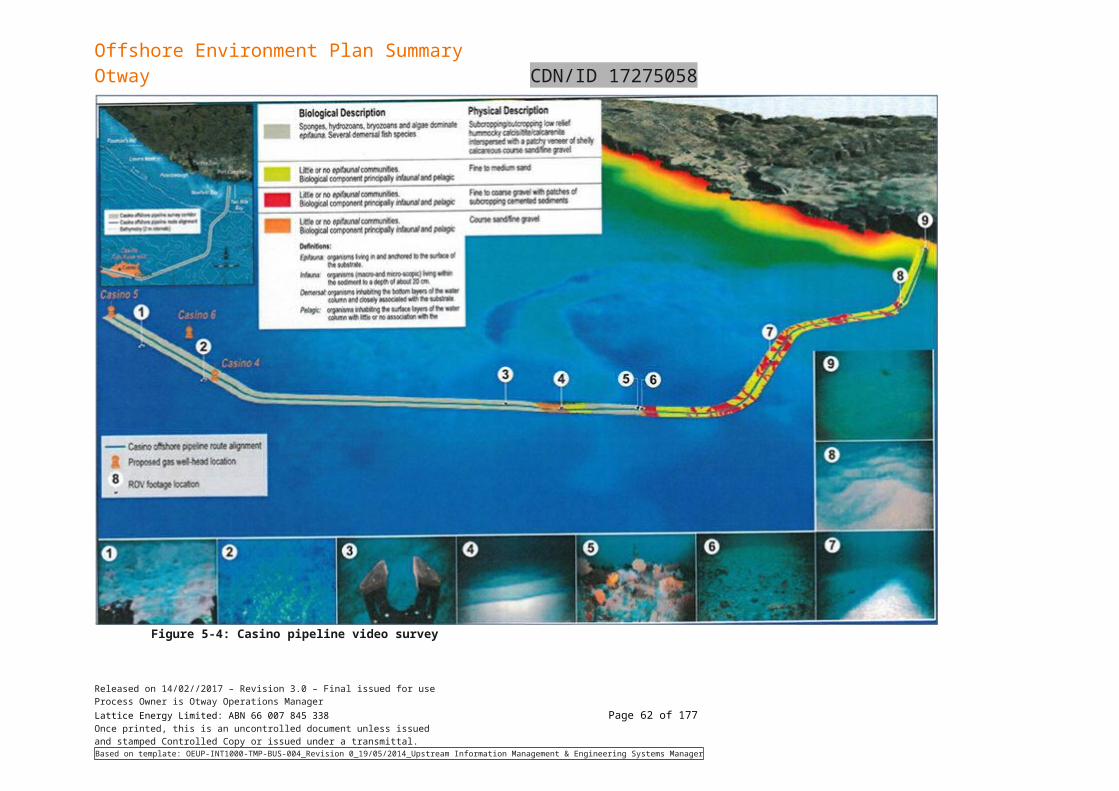
Offshore Environment Plan SummaryOtway CDN/ID 17275058
Common name Species name
EPBC Act statusEPBC
Type of presence
Listed threatened
Listed migrator
y
Listed marine
FFG Act Status
TSC Act Status
Bryde’s whale
Balaenoptera edeni L SHM DD
Fin whale B. physalus V M L FK DD v
Southern right whale
Balaena glacialis australis
E M L BKT e
Minke whale
Balaenoptera acutorostrata - L SHL -
Arnoux’s beaked whale
Berardius arnuxii L SHM
Pygmy right whale
Caperea marginata - M L FL -
Short-finned pilot whale
Globicephala macrorhynchus L SHM
Long-finned pilot whale
Globicephala melas - - L -
-
Southern bottlenose whale
Hyperoodon planifrons - - L -
-
Pygmy sperm whale
Kogia breviceps L SHM
Dwarf sperm whale
Kogia simus L SHM
Humpback whale
Megaptera novaeangliae V M L SHK T e
Andrew’s beaked whale
Mesoplodon bowdoini L SHM
Blainville’s beaked whale
Mesoplodon desirostris M SHM
Hector’s beaked whale
Mesoplodon hectori M SHM
Strap-toothed beaked whale
Mesoplodon layardii M SHM
True’s beaked whale
Mesoplodon mirus M SHM
Gray’s beaked whale
Mesopodon grayi M SHM
Sperm whale
Physeter macrocephalus - M L SHM -
False killer whale
Pseudorca crassidens L SHM
Released on 14/02//2017 – Revision 3.0 – Final issued for useProcess Owner is Otway Operations ManagerLattice Energy Limited: ABN 66 007 845 338 Page 62 of 122Once printed, this is an uncontrolled document unless issuedand stamped Controlled Copy or issued under a transmittal.Based on template: OEUP-INT1000-TMP-BUS-004_Revision 0_19/05/2014_Upstream Information Management & Engineering Systems Manager
Offshore Environment Plan SummaryOtway CDN/ID 17275058
Common name Species name
EPBC Act statusEPBC
Type of presence
Listed threatened
Listed migrator
y
Listed marine
FFG Act Status
TSC Act Status
Shepherd’s beaked whale
Tasmacetus shepherdi - - L SHM
-
Cuvier’s beaked whale
Ziphius cavirostris L SHM
Dolphins
Common dolphin
Delphinus delphis - - L SHM -
Risso’s dolphin
Grampus griseus - - L SHM -
Dusky dolphin
Lagenorhynchus obscures - M L SHL -
Southern right whale dolphin
Lissodelphis peronii - - L SHM
-
Killer whale, orca
Orcinus orca - M L SHL-
Indian Ocean bottlenose dolphin
Tursiops aduncus - - L SHL
-
Bottlenose dolphin
Tursiops truncates - - L SHM -
There were ten cetacean species within the operation area that are identified in the EPBC Act PMST Report as threatened or migratory. Two species, the blue whale (Balaenoptera musculus) and southern right whale (Eubalaena australis) are listed as endangered; and one, the humpback whale (Megaptera novaeangliae), as vulnerable. These latter species have been regularly sighted in recent aerial surveys. Three other whales, the fin (Balaenoptera physalus), sei (Balaenoptera borealis) and sperm (Physeter macrocephalus) are listed respectively as vulnerable and/or migratory, and have been observed in the Otway region during aerial surveys.
The Bass Strait and the Otway Basin is considered an important migratory path for humpback, blue, southern right, and to some extent the Fin and Sei whales. The whales use the Otway region to migrate to and from the north-eastern Australian coast and the sub-Antarctic. Of particular environmental importance in the Otway is the Bonney Upwelling, the eastward flow of cool nutrient rich water across the continental shelf of the southern coast of Australia that promotes blooms of krill, and attracts baleen whales during the summer months.
Origin Energy conducted a survey of the Otway basin focused on Origin operations and permit for Cetaceans from June 2012 through March of 2013. lists the species present in the area Origin observed.
Released on 14/02//2017 – Revision 3.0 – Final issued for useProcess Owner is Otway Operations ManagerLattice Energy Limited: ABN 66 007 845 338 Page 63 of 122Once printed, this is an uncontrolled document unless issuedand stamped Controlled Copy or issued under a transmittal.Based on template: OEUP-INT1000-TMP-BUS-004_Revision 0_19/05/2014_Upstream Information Management & Engineering Systems Manager
Offshore Environment Plan SummaryOtway CDN/ID 17275058
Table 5-14: Observed Cetaceans in Otway Basin
Note *September values averaged over two surveys on 1 and 11 September 2012. Totals include individuals from both September surveys
Blue whale
The blue whale (Balaenoptera musculus) is currently listed as an endangered species under the EPBC Act. There are two subspecies of blue whales that use Australian waters (including Australian Antarctic waters), the pygmy blue whale (B. m. brevicauda) and the Antarctic blue whale (B. m. intermedia). The Antarctic blue whale subspecies remains severely depleted from historic whaling and its numbers are recovering slowly. For the pygmy blue whale there is uncertainty in the numbers pre-exploitation, and their current numbers are not known. The blue whale has a recovery plan that identifies threats and establishes actions for assisting the recovery of blue whale populations using Australian waters. (Commonwealth of Australia, 2017)
Previous observations that the Otway region is an important migratory and feeding corridor for blue whales arriving from and departing to the east have been confirmed by passive acoustic monitoring (PAM) and aerial surveys.
Bass Strait is considered to be a migratory corridor for blue whales, as confirmed by PAM and aerial surveys conducted by Origin during its prior activities in the region. The migratory period for the blue whales into Bass Strait generally commences in November or December (EA, 2002; Gill et al, 2011). There had been fewer than 50 sightings of blue whales in Bass Strait up to the year 1999, but since that time feeding blue whales have been more regularly observed in the Discovery Bay area and more generally along the Bonney coast from Robe to Cape Otway.
The time and location of the appearance of blue whales in the east generally coincides with the upwelling of cold water in summer and autumn along this coast (the Bonney Upwelling) and the associated aggregations of krill that they feed on (EA, 2002; Gill and Morrice, 2003). The Bonney Upwelling generally starts in the eastern part of the Great Australian Bight in November or December and spreads eastwards to the Otway Basin around February as southward migration of the subtropical high pressure cell creates upwelling favourable winds.
The biologically important areas (BIAs) for the pygmy blue whale have been identified around Australia and a number intersect the ZPI. There are three known foraging areas in the ZPI, with the area between Cape Otway and Robe which includes the Bonney upwelling being identified as having high annual use due abundant food source/annual high use area (DoE, 2015a). There is also a distribution ZPI which extends along the south coast and up the west coast of Australia (DoE, 2015a).
The ZPI intersects a likely migration route (DoE, 2015a). Breeding occurs in low latitudes (including Indonesia) during the austral winter although there may be more than one breeding habitat given observed females with small calves recorded seasonally moving through Geographe Bay (WA) from September to December (DoE, 2015a).
Data indicate that, within the ZPI, blue whales are statistically most likely to first appear during December/January and reach peak number during February/March (Gill et al, 2011).
There were no confirmed sightings of blue whales during Origin’s Speculant 3DTSZZ undertaken during November and December 2010, the Astrolabe 3D seismic survey undertaken during early November 2013 (RPS, 2013) and the Enterprise 3D seismic survey undertaken during late October and early November 2014 (RPS, 2014).
Released on 14/02//2017 – Revision 3.0 – Final issued for useProcess Owner is Otway Operations ManagerLattice Energy Limited: ABN 66 007 845 338 Page 64 of 122Once printed, this is an uncontrolled document unless issuedand stamped Controlled Copy or issued under a transmittal.Based on template: OEUP-INT1000-TMP-BUS-004_Revision 0_19/05/2014_Upstream Information Management & Engineering Systems Manager
Species Jun Jul Aug Sep * Oct Nov Dec Jan Feb Mar Total
Blue whale 0 0 0 0 0 23 70 17 8 2 120
Southern right whale 2 0 12 13 0 0 0 0 0 0 39*
Humpback whale 3 2 0 1 0 1 0 0 0 0 7
Sperm whale 2 0 0 0 4 0 0 3 1 0 10
Pilot whale 0 0 0 0 0 70 0 0 55 0 125
Dolphins 13 298 0 33 54 620 80 672 1526 21 3317
Southern right whale 0 0 0 0 0 120 0 0 0 0 120
Offshore Environment Plan SummaryOtway CDN/ID 17275058
It is likely that blue whales will be present in the ZPI. The likelihood and extent of the interaction is dependent on broad scale environmental factors affecting the abundance and distribution of blue whale feeding resources.
Southern right whale
The southern right whale (Eubalaena australis) is listed as endangered under the EPBC Act because they have undergone a severe reduction in numbers as a result of commercial whaling. An initial recovery plan for southern right whales was developed for the period 2005 to 2010; however, a review found that occupancy and abundance are still lower than historic records. Currently the southern right whale has a recovery plan to prioritise research and better predict impacts (Commonwealth of Australia, 2012).
Major current breeding areas are nearshore off southern Australia, New Zealand (particularly Auckland Islands and Campbell Islands), Atlantic coast of South America (Argentina and Brazil), and southern Africa (mainly South Africa). Small numbers are also seen off central Chile, Peru, Tristan da Cunha (British Overseas Territory), and the east coast of Madagascar (IWC 2001, Rosenbaum et al. 2001). The species are regularly present on the Australian coast during winter and spring (Commonwealth of Australia, 2012).
Peak periods for mating in Australian coastal waters are from mid-July through August (Commonwealth of Australia, 2012). Pregnant females generally arrive during late May/early June and calving/nursery grounds are generally occupied until October (occasionally as early as April and as late as November), but not at other times. Calving takes place very close to the coast in Australia, usually in waters less than 10 metres deep.
In Australian coastal waters, southern right whales generally occur within two kilometres off shore and tend to be distinctly clumped in aggregation areas (Commonwealth of Australia, 2012).
A number of BIAs for the southern right whale intersect the ZPI. There is a migration and resting on migration BIA, connecting habitat around King Island and the known core range which extends from Sydney to Perth, including of Tasmania (Commonwealth of Australia, 2015). Of particular interest is the aggregation BIA, which is in Bridgewater Bay in Portland, which is a known breeding ground (Commonwealth of Australia, 2015).
Exactly where southern right whales approach and leave the Australian coast from, and to, offshore areas remain unknown (Gill et al. 2015). A defined near-shore coastal migration corridor is unlikely given the absence of any predictable directional movement of southern right whales such as that observed for humpback whales. A predominance of westward movements amongst long-range photo-identification re-sightings may indicate a seasonal westward movement in coastal habitat. More-or-less direct approaches and departures to the coast are also likely. Southern right whales are thought to be solitary during migration, or accompanied by a dependent calf or occasionally a yearling offspring.
Aerial surveys of western Bass Strait and eastern Great Australian Bight undertaken by Gill et al. (2015) detected southern right whales between May and September. A survey in early November 2010 did not observe any whales in the Warrnambool area and it was assumed that cows and calves had already left the calving and aggregation areas (M. Watson, pers. comm., 2010). No southern right whales were encountered during Origin’s Enterprise 3D seismic survey undertaken during November 2014 (RPS, 2014), or during spotter flights of the coastline undertaken prior to the survey in late October 2014.
Humpback whale
Humpback whales (Megaptera novaeangliae) are present around the Australian coast in winter and spring. Humpbacks undertake an annual migration between the summer feeding grounds in Antarctica to their winter breeding and calving grounds in northern tropical waters. Along the southeast coast of Australia, the northern migration starts in April and May while the southern migration peaks around November and December (DEH, 2005a). A discrete population of humpback whales have been observed to migrate along the west coast of Tasmania and through Bass Strait, and these animals may pass through the operational area. The exact timing of the migration period varies between years in accordance with variations in water temperature, extent of sea ice, abundance of prey, and location of feeding grounds (DEH, 2005a). Feeding occurs where there is a high krill density, and during the migration this primarily occurs in Southern Ocean waters south of 55°S (DEH 2005a).
The ZPI is not known feeding, resting or calving grounds for humpback whales in the ZPI, although feeding may occur opportunistically where sufficient krill density is present (Commonwealth of Australia, 2015). The nearest BIA which is important habitat for migrating humpback whales is Twofold Bay, a resting area off the NSW coast 310 km to the northeast of the ZPI (Commonwealth of Australia, 2015).
Released on 14/02//2017 – Revision 3.0 – Final issued for useProcess Owner is Otway Operations ManagerLattice Energy Limited: ABN 66 007 845 338 Page 65 of 122Once printed, this is an uncontrolled document unless issuedand stamped Controlled Copy or issued under a transmittal.Based on template: OEUP-INT1000-TMP-BUS-004_Revision 0_19/05/2014_Upstream Information Management & Engineering Systems Manager
Offshore Environment Plan SummaryOtway CDN/ID 17275058
During Origin’s Enterprise 3D seismic survey undertaken during early November 2014, 16 humpback whales were sighted (RPS, 2014).
Sei whale
Sei whales move between Australian waters and Antarctic feeding areas; subantarctic feeding areas (e.g. Subtropical Front); and tropical and subtropical breeding areas. The proportion of the global population in Australian waters is unknown as there are no estimates for sei whales in Australian waters.
Sei whales feed intensively between the Antarctic and subtropical convergences and mature animals may also feed in higher latitudes. Sei whales feed on planktonic crustaceans, in particular copepods and amphipods. Below the Antarctic convergence sei whales feed exclusively upon Antarctic krill (Euphausia superba).
Sei whales have been infrequently recorded in Australian waters. Sei whales have been sighted 20–60 km offshore on the continental shelf in the Bonney Upwelling (Miller et al. 2012) where opportunistic feeding has been observed between November and May (Gill et al. 2015). Sei whales were reported 200 nautical miles (nm) south-west of Port Lincoln in December 1995 and a concentration of sei whales were reported at the western end of Bass Strait (Kato et al. 1996). There are no known mating or calving areas in Australian waters. The Sei whale is likely to be an uncommon visitor to the ZPI.
The sei whale has been infrequently recorded between November and May (but not during April) during aerial surveys in the region (Gill et al. 2015). There are no known mating or calving areas in Australian waters.
Fin whale
There are stranding records of this species from most Australian states, but they are considered rare in Australian waters (Bannister et al., 1996). The fin whale has been infrequently recorded between November and Feb during aerial surveys in the region (Gill et al., 2015).
Fin whales have been sighted inshore in the proximity of the Bonney Upwelling, Victoria, along the continental shelf in summer and autumn months (Gill 2002). Fin whales in the Bonney Upwelling are sometimes seen in the vicinity of blue whales and sei whales.
Fin whales were sighted and feeding was observed between November-May (upwelling season) during aerial surveys conducted between 2002-2013 in South Australia (Gill et al., 2015). This is one of the first documented records these whales feeding in Australian waters, suggesting that the region may be used for opportunistic baleen whale feeding (Gill et al., 2015).
The sighting of a cow and calf in the Bonney Upwelling in April 2000 and the stranding of two fin whale calves in South Australia suggest that this area may be important to the species’ reproduction, perhaps as a provisioning area for cows with calves (Morrice et al., 2004). However, there are no defined mating or calving areas in Australia waters.
As there are no BIAs for the fin whale in the ZPI, they are likely to be uncommon visitors to the ZPI.
5.4.2.6 Pinnipeds
The PMST report identified two pinnipeds that were potentially occurring in the ZPI. A search was also undertaken to determine which FFG Act and TSC Act species were also potentially present in the ZPI. Table 5-15 lists the two pinniped species that may potentially occur in the ZPI.
Table 5-15: Listed pinniped species that may occur in the ZPI
Common name Species name
EPBC Act statusLikely
presenceFFG Act Status
TSC act StatusListed
threatenedListed
migratoryListed marine
New Zealand fur seal
Arctocephalus forsteri - - L SHM r
Australian fur seal A. pusillus - - L BK
New Zealand fur seal
New Zealand fur seals (Arctocephalus forsteri) are found in the coastal waters and offshore islands of South and Western Australia, Victoria, New South Wales and New Zealand. Population studies for New Zealand fur seals in Australia carried out in 1990 estimated an increasing population of about
Released on 14/02//2017 – Revision 3.0 – Final issued for useProcess Owner is Otway Operations ManagerLattice Energy Limited: ABN 66 007 845 338 Page 66 of 122Once printed, this is an uncontrolled document unless issuedand stamped Controlled Copy or issued under a transmittal.Based on template: OEUP-INT1000-TMP-BUS-004_Revision 0_19/05/2014_Upstream Information Management & Engineering Systems Manager
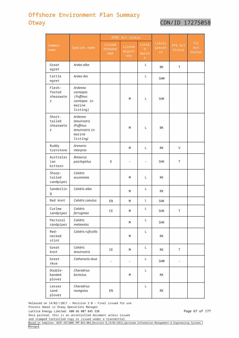
Offshore Environment Plan SummaryOtway CDN/ID 17275058
35,000. The species breeds in southern Australia at the Pages Islands and Kangaroo Island, which produces about 75% of the total pups in Australia. Small populations are established in Victorian coastal waters including at Cape Bridgewater near Portland, Lady Julia Percy Island near Port Fairy, Kanowna Island (near Wilsons Promontory) and The Skerries in eastern Victoria.
New Zealand fur seals breed in the ZPI and are likely to forage broadly around the colonies in the ZPI.
Australian fur seal
Australian fur seals (A. pusillus) breed on islands of the Bass Strait but range throughout waters off the coasts of South Australia, Tasmania, Victoria and New South Wales. Numbers of this species are believed to be increasing as the population recovers from historic hunting (Hofmeyr et al., 2008). The species is endemic to south-eastern Australian waters.
Research being undertaken at Lady Julia Percy Island indicates that adult females feed extensively in the waters between Portland and Cape Otway, out to the 200 m bathymetric contour. Seal numbers on the island reach a maximum during the breeding season in late October to late December. By early December, large numbers of lactating females are leaving for short feeding trips at sea and in late December there is an exodus of adult males. Thereafter, lactating females continue to alternate between feeding trips at sea and periods ashore to suckle their pups. Even after pups begin to venture to sea, the island remains a focus, and at any time during the year groups may be seen ashore resting (Robinson et al., 2008; Hume et al., 2004; Arnould & Kirkwood, 2007).
During the summer months, Australian fur seals travel between northern Bass Strait islands and southern Tasmania waters following the Tasmanian east coast, however, lactating female fur seals and some territorial males are restricted to foraging ranges within Bass Strait waters. Lactating female Australian fur seals forage primarily within the shallow continental shelf of Bass Strait and Otway on the benthos at depths of between 60 - 80 m and generally within 100 - 200 km of the breeding colony for up to five days at a time.
Male Australian fur seals are bound to colonies during the breeding season from late October to late December, and outside of this they time forage further afield (up to several hundred kilometres) and are away for long periods, even up to nine days (Kirkwood et al., 2009; Hume et al., 2004). The ZPI contains breeding, haul-out and feeding sites for the Australian fur seal.
5.4.2.7 Marine reptiles
The PMST report identified three marine turtle species that were potentially occurring in the ZPI. A search was also undertaken to determine which FFG Act and TSC Act species were also potentially present in the ZPI. Three threatened marine reptile species (turtles) may be present in in the ZPI (Table 5-16) and are described in this section. All three species of marine turtles are protected by the Recovery Plan for Marine Turtles in Australia (Commonwealth of Australia, 2017). The PMST report identifies that feeding is known to occur in the ZPI for all species. There are no identified BIAs for these reptiles in the ZPI.
Table 5-16: Listed turtle species that may occur in the ZPI
Common name Species name
EPBC Act Likely presenc
e
FFG Act Status
TSC Act StatusListed
threatenedListed
migratoryListed marine
Loggerhead turtle
Caretta caretta E M L FK e
Green turtle Chelonia mydas V M L FK v
Leatherback turtle
Dermochelys coriacea E M L FK T v
Loggerhead turtle
The loggerhead turtle (Caretta caretta) is globally distributed in tropical, sub-tropical waters and temperate waters. The loggerhead is a carnivorous turtle, feeding primarily on benthic invertebrates in habitat ranging from nearshore to 55 m depth (; Plotkin et al., 1993).
The main Australian breeding areas for loggerhead turtles are generally confined to southern Queensland and Western Australia (Cogger et al., 1993). Loggerhead turtles will migrate over distances in excess of 1,000 km, but show a strong fidelity to their feeding and breeding areas (Limpus, 2008). Loggerhead turtles forage in all coastal states and the Northern Territory, but are uncommon in
Released on 14/02//2017 – Revision 3.0 – Final issued for useProcess Owner is Otway Operations ManagerLattice Energy Limited: ABN 66 007 845 338 Page 67 of 122Once printed, this is an uncontrolled document unless issuedand stamped Controlled Copy or issued under a transmittal.Based on template: OEUP-INT1000-TMP-BUS-004_Revision 0_19/05/2014_Upstream Information Management & Engineering Systems Manager
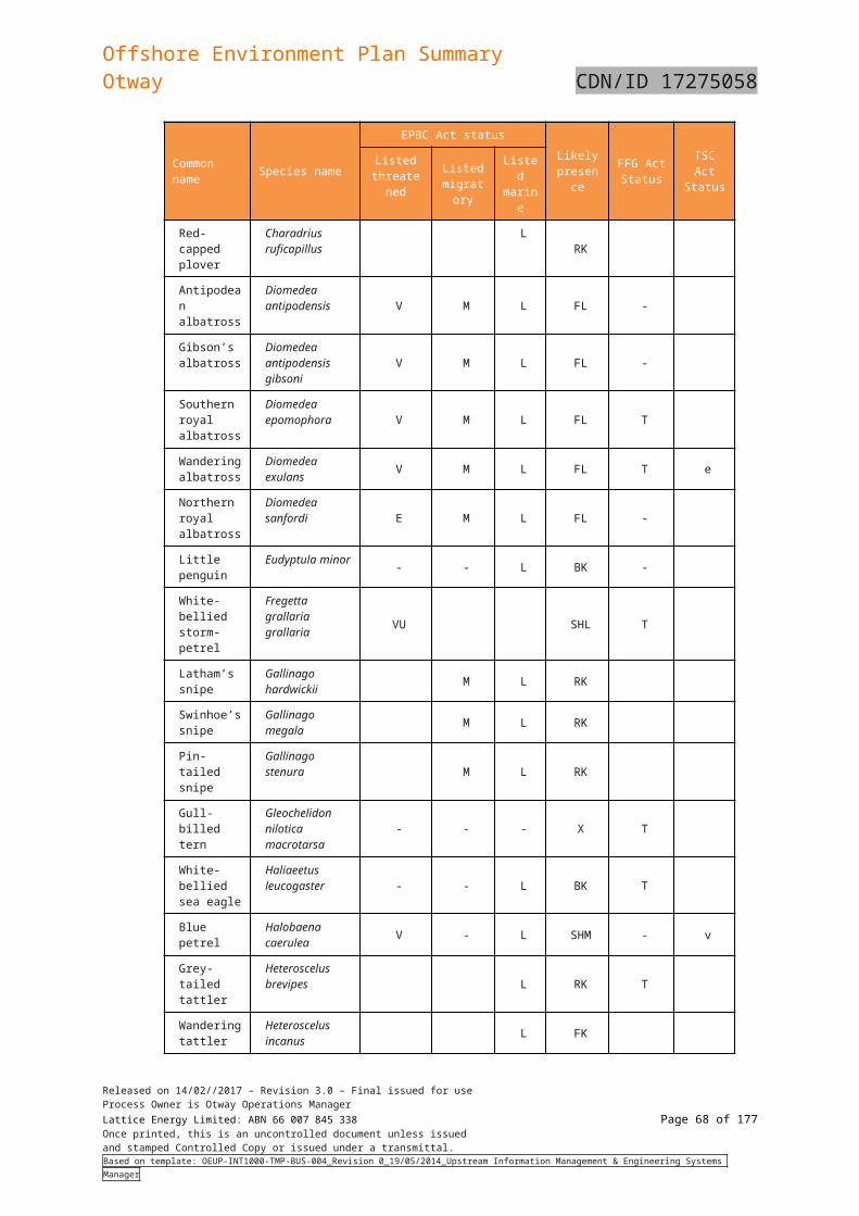
Offshore Environment Plan SummaryOtway CDN/ID 17275058
South Australia, Victoria and Tasmania (Commonwealth of Australia, 2017b). Therefore the green turtle is expected to be only an occasional visitor in the ZPI.
Leatherback turtle
The leatherback turtle (Dermochelys coriacea) is a pelagic feeder found in tropical, sub-tropical and temperate waters throughout the world. Unlike other marine turtles, the leatherback turtle utilises cold water foraging areas, with the species most commonly reported foraging in coastal waters between southern Queensland and central NSW, southeast Australia (Tasmania, Victoria and eastern SA), and southern WA (Commonwealth of Australia, 2017b)This species is an occasional visitor to the Otway shelf and has been sighted on a number of occasions during aerial surveys undertaken by the Blue Whale Study Group, particularly to the southwest of Cape Otway. It is mostly a pelagic species, and away from its feeding grounds is rarely found inshore (Commonwealth of Australia, 2017b).
No major nesting has been recorded in Australia, with isolated nesting recorded in Queensland and the Northern Territory. The leatherback turtle is expected to be only an occasional visitor in the ZPI.
Green turtle
Green turtles (Chelonia mydas) nest, forage and migrate across tropical northern Australia. They usually occur between the 20°C isotherms, although individuals can stray into temperate waters as vagrant visitors. Green turtles spend their first 5-10 years drifting on ocean currents. During this pelagic (ocean-going) phase, they are often found in association with drift lines and floating rafts of Sargassum. Green turtles are predominantly found in Australian waters off the Northern Territory, Queensland and Western Australian coastlines, with limited numbers in New South Wales, Victoria and South Australia. There are no known nesting or foraging grounds for green turtles offshore Victoria; they occur only as rare vagrants in these waters (EA, 2003), therefore it is expected they would only be occasional visitors in the ZPI.
5.4.3 Invasive/introduced marine species
Pest Species
Invasive marine species (IMS) are marine plants or animals that have been introduced into a region beyond their natural range and have the ability to survive, reproduce and establish. More than 200 non-indigenous marine species including fish, molluscs, worms and a toxic alga have been detected in Australian coastal waters.
It is widely recognised that IMS can become pests and cause significant impacts on economic, ecological, social and cultural values of marine environments. Impacts can include the introduction of new diseases, altering ecosystem processes and reducing biodiversity, causing major economic loss and disrupting human activities (Brusati and Grosholz, 2006).
In the South-east Marine Region, 115 marine pest species have been introduced and an additional 84 have been identified as possible introductions, or ‘cryptogenic’ species (NOO, 2002). Several introduced species have become pests either by displacing native species, dominating habitats or causing algal blooms.
Viruses
A virus, the Abalone Viral Ganglioneuritis (AVG), has been detected in wild abalone populations in southwest Victoria and has been responsible for mortalities between Discovery Bay and Cape Otway. (DEDJTR 2015a). The virus can be spread through direct contact, through the water column without contact, and in mucus that infected abalone produce before dying. The last confirmation of active disease in Victoria was from Cape Otway lighthouse in December 2009 (Victoria State Government, 2016).
Strict quarantine controls need to be observed with diving or fishing activities in south-west Victoria when the virus has been detected in the area. Given the lack of detected AVG in Victorian State waters, controls outlined in the Biosecurity Control Measures for AVG: A Code of Practice (Gavine et al., 2009) are not active.
5.4.4 Benthic habitats and species assemblages
The dominant benthic habitat throughout the area, as indicated by the sampling and video studies outlined in Section 5.3.1 is medium to coarse carbonate sands with areas of low relief exposed limestone. A series of basaltic rises occur in the south eastern corner of the operational area. The benthic species assemblages known or likely to be associated with these habitats include:
Carbonate sands and exposed limestone; and
Basalt rises
Released on 14/02//2017 – Revision 3.0 – Final issued for useProcess Owner is Otway Operations ManagerLattice Energy Limited: ABN 66 007 845 338 Page 68 of 122Once printed, this is an uncontrolled document unless issuedand stamped Controlled Copy or issued under a transmittal.Based on template: OEUP-INT1000-TMP-BUS-004_Revision 0_19/05/2014_Upstream Information Management & Engineering Systems Manager
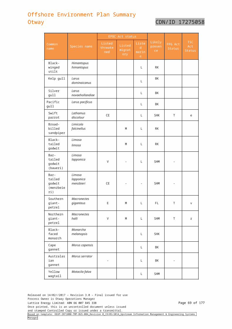
Offshore Environment Plan SummaryOtway CDN/ID 17275058
5.5 Socio-economic environmentThis section describes the socio-economic environment within the ZPI, including onshore aspects as relevant.
5.5.1 Victorian Coastal settlements
The coastal settlements that lie within the ZPI are (from west to east) Portland, Port Fairy, Warrnambool, Peterborough, Port Campbell, Princetown and Apollo Bay. These settlements are administered by the Glenelg Shire Council (Portland), Moyne Shire Council (Port Fairy, Peterborough), Warrnambool City Council, Shire of Corangamite (Port Campbell, Princetown) and the Shire of Colac Otway (Apollo Bay) (Table 5-17).
Table 5-17: Coastal Settlement Population Estimates and Employment Figures
Settlement Population1
% of employment in industries relevant to potential impacts2
Agriculture, forestry & fishing Accommodation & food services
Portland 9,712 2.8 8.8
Port Fairy 3,340 6.5 12.8
Warrnambool 29,661 2.1 9.1
Peterborough 247 6.7 13.3
Port Campbell 478 28.4 16.6
Princetown 241 59.3 10.5
Apollo Bay 1,598 3.6 27.91 Data from Australian Bureau of Statistics 2016 census, available at www.censusdata.abs.gov.au2 Data from Australian Bureau of Statistics 2011 census, available at www.censusdata.abs.gov.au (2016 data available in Oct 2017)
The coastal settlements within the ZPI all provide services to the commercial and recreational fishing industries in south-west Victoria and rely on fishing and tourism to contribute to their economies through income and employment.
5.5.2 Tasmanian Coastal settlements
Currie
Currie is the largest township on King Island and is the administrative centre for the island. In 2006, the population was 746. It lies on the west coast and has a sheltered boat harbour facing to the west.
Grassy
Grassy is a small coastal town on the south-east coast of the island and is the island’s main port. The port is sheltered from westerly winds and supports a local population of little penguins and a shearwater rookery.
5.5.3 Shipping
The south-east marine region is one of the busiest shipping regions in Australia and Bass Strait is one of Australia’s busiest shipping routes (Figure 5-5). Commercial vessels use the route when transiting between ports on the east, south and west coasts of Australia, and there are regular passenger and cargo services between mainland Australia and Tasmania (NOO, 2014).
Bass Strait is also transited by commercial vessels that may not call into ports on the south coast. There are also numerous minor shipping routes in the area, such as those that service King Island. Grassy is the main shipping port on King Island and is the destination for a weekly shipping service from Melbourne and Devonport.
Released on 14/02//2017 – Revision 3.0 – Final issued for useProcess Owner is Otway Operations ManagerLattice Energy Limited: ABN 66 007 845 338 Page 69 of 122Once printed, this is an uncontrolled document unless issuedand stamped Controlled Copy or issued under a transmittal.Based on template: OEUP-INT1000-TMP-BUS-004_Revision 0_19/05/2014_Upstream Information Management & Engineering Systems Manager
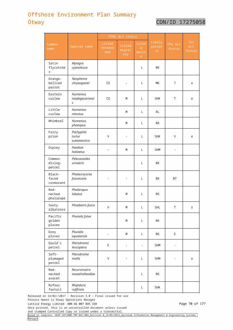
Offshore Environment Plan SummaryOtway CDN/ID 17275058
Figure 5-5: Map of the main shipping lanes in the Bass Strait
5.5.4 Petroleum exploration and production
There are a number of production assets located in the Otway Basin which include the following:
The Casino Gas Project developed by Santos.
The Minerva Gas Development is operated by BHP Billiton and commenced production in April 2005.
5.5.5 Commonwealth managed fisheries
The Commonwealth managed fisheries that occur within the ZPI are:
Bass Strait Central Zone Scallop Fishery (Bass Strait CZSF)
Eastern Tuna and Billfish Fishery (ETBF)
Released on 14/02//2017 – Revision 3.0 – Final issued for useProcess Owner is Otway Operations ManagerLattice Energy Limited: ABN 66 007 845 338 Page 70 of 122Once printed, this is an uncontrolled document unless issuedand stamped Controlled Copy or issued under a transmittal.Based on template: OEUP-INT1000-TMP-BUS-004_Revision 0_19/05/2014_Upstream Information Management & Engineering Systems Manager
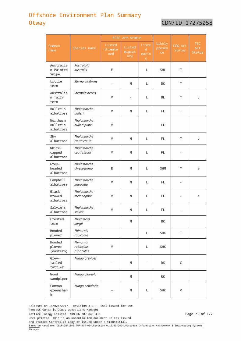
Offshore Environment Plan SummaryOtway CDN/ID 17275058
Skipjack Fishery
Small Pelagic Fishery (SPF)
Southern and Eastern Scalefish and Shark Fishery (SESSF)
Southern Bluefin Tuna Fishery (SBTF)
Southern Squid Jig Fishery.
Of these fisheries, the Bass Strait CZSF, SESSF and Southern Squid Jig Fishery are expected to be active within the ZPI (Table 5-18). Fishing activity in the ETBF, SPF and SBTF is unlikely to occur in the ZPI as fishing effort is generally located in other areas of these fisheries. The Skipjack Fishery is not currently active and management arrangements for the fishery are under review.
Information relating to the target species, fishing locations, landed catch, value and other relevant aspects of each fishery is included in Table 5-18.
Table 5-18: Commonwealth Managed Fisheries within the ZPI
Fishery Target species DescriptionFishing activity within ZPI?
Bass Strait Central Zone Scallop Fishery
Scallops Lies in the Bass Strait between the Victorian and Tasmanian state fisheries that extend 20 nm from their respective coastlines. Fishing effort is concentrated around King and Flinders Islands. Currently 11 active boats using towed dredges. Fishing season is 1 April to 31 December. Actual catch in 2016 was 2886 tonnes. In 2017, two areas will be closed to fishing under the Fisheries Management Act 1991. The major landing ports in Victoria are Apollo Bay and Queenscliff. Total fishery value in 2015 was A$2.8 million.
Yes
Eastern Tuna and Billfish Fishery
Albacore tuna Bigeye tunaYellowfin tunaBroadbill swordfish Striped marlin
A longline and minor line fishery that operates year-round. Fishery effort is concentrated along the NSW coast and southern Queensland coast. No Victorian ports are used. Actual catch in the 2015-16 season was 5408 tonnes. Total fishery value in 2015 was A$35 million.
Unlikely
Skipjack Fishery(Eastern)
Skipjack tuna There are no boats currently fishing this fishery. Management arrangements under review.
No
Small Pelagic Fishery (western sub-area)
Jack mackerel Blue mackerel RedbaitAustralian sardine
Fishers use midwater trawls and purse seine nets. Total retained catch of the four target species was 11439 tonnes in the 2015-16 season. Fishery effort generally concentrated in the near-shore Great Australian Bight to the west and south of Port Lincoln.
Unlikely
Southern and Eastern Scalefish and Shark Fishery (SESSF)(Commonwealth South East Trawl Sector [CTS] and Gillnet, Hook & Trap Sector [GHAT])
Blue grenadierTiger flatheadPink ling Silver warehou Gummy shark
A multi-sector, multi-species fishery that uses a range of gear year-round. Fishing in the CTS is generally concentrated along the 200 m bathymetric contour. For the GHAT, there is typically a low fishing intensity around Portland and west of Cape Otway. Much of the western portion of the ZPI is closed to shark hook and gillnet fishing, and nearly all of the ZPI is closed to scalefish auto longline fishing. In 2013-14, the fishery value was A$72.2 million.
Yes
Southern Bluefin Tuna Fishery
Southern bluefin tuna A pelagic longline and purse seine fishery that was worth $36.8 million in 2014-15 (actual catch was 5519 tonnes). The fishery operates year-round. Fishery effort is generally concentrated in the Great Australian Bight and off the southern NSW coast.
Unlikely
Southern Squid Jig Gould’s squid (arrow A single species fishery that operates Yes
Released on 14/02//2017 – Revision 3.0 – Final issued for useProcess Owner is Otway Operations ManagerLattice Energy Limited: ABN 66 007 845 338 Page 71 of 122Once printed, this is an uncontrolled document unless issuedand stamped Controlled Copy or issued under a transmittal.Based on template: OEUP-INT1000-TMP-BUS-004_Revision 0_19/05/2014_Upstream Information Management & Engineering Systems Manager
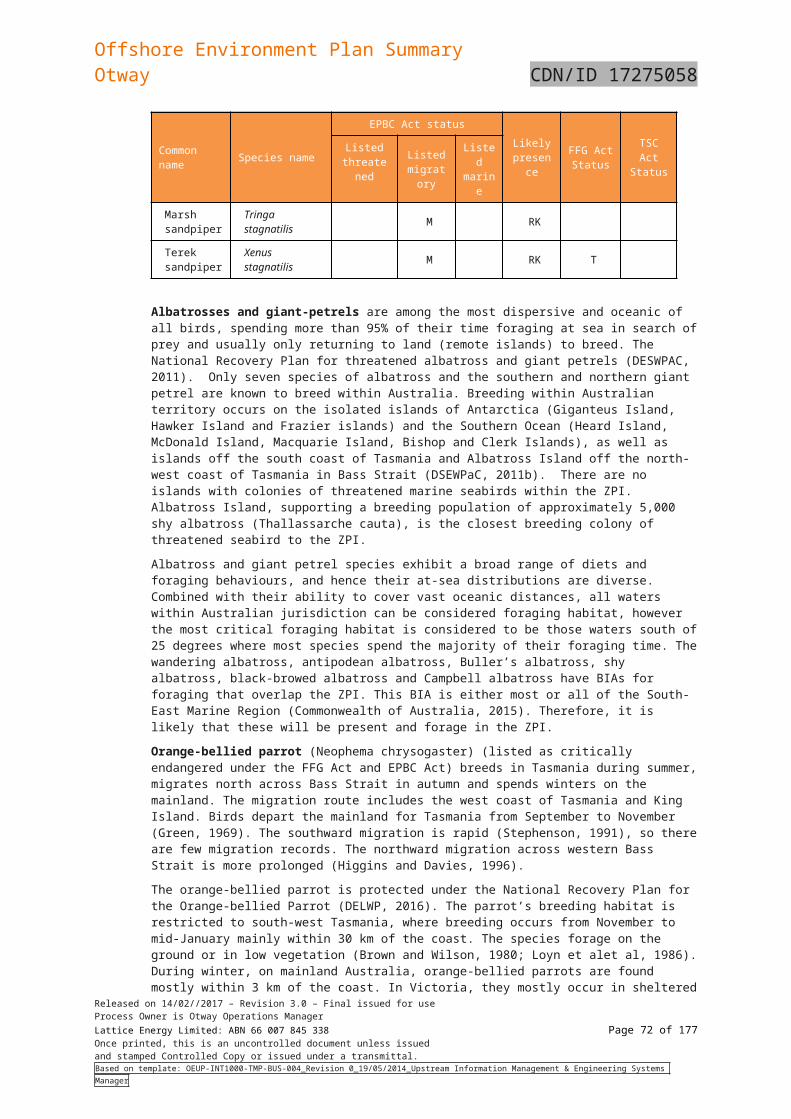
Offshore Environment Plan SummaryOtway CDN/ID 17275058
Fishery Target species DescriptionFishing activity within ZPI?
Fishery squid) year-round. Portland and Queenscliff are the major Victorian landing ports. Fishing effort is generally concentrated along the 200 m bathymetric contour with highest fishing intensity south of Portland and Warrnambool. In 2015, the actual catch of 330 tonnes was worth A$0.9 million.
1 Data/information sources: Australian Fisheries Management Authority (www.afma.gov.au), AFMA (2017a,b,c), Knuckey et al. (2017)
5.5.6 Victorian managed fisheries
There are six Victorian state-managed fisheries that occur within the ZPI:
Rock Lobster Fishery
Giant Crab Fishery
Abalone Fishery
Scallop (Ocean) Fishery
Wrasse (Ocean) Fishery
Snapper Fishery.
Of these fisheries, the Rock Lobster and Abalone Fisheries are the most economically important and both are expected to be active within the ZPI (Table 5-19). The Wrasse (Ocean) Fishery and the Snapper Fishery are smaller fisheries and are also expected to be active within the ZPI (Table 5-19). Fishing activity in the Scallop (Ocean) Fishery is unlikely to occur within the ZPI as fishing effort is concentrated around Lakes Entrance and Welshpool, to the east of the ZPI.
Table 5-19: State (Victorian) Managed Fisheries within the ZPI
Fishery Target species DescriptionFishing activity within ZPI?
Rock Lobster Fishery (western zone)
Predominantly southern rock lobster, along with small quantities of eastern rock lobster
Victoria’s second most valuable fishery. Landed catch in the western zone was 230 tonnes in 2015-16 and the value of the entire fishery was A$24 million in 2014-15. In the western zone, most catch is landed through Portland, Port Fairy, Warrnambool, Port Campbell and Apollo Bay. Closed seasons operate for male and female lobsters. Fishery effort is likely throughout the ZPI but expected to be concentrated over the ‘Big Reef’ adjacent to the south-east corner of the proposed acquisition area and near shore rocky reefs.
Yes
Giant Crab Fishery Giant crab A small fishery operating in western Victoria and closely linked with the Rock Lobster Fishery. Fishing effort is concentrated on continental shelf edge (~200 m deep). Total landed catch in 2015-16 was 10 tonnes.
Likely
Abalone Fishery (western zone)
Blacklip abalone Greenlip abalone
A highly valuable fishery (A$20 million in 2014-15) that operates along most of the Victorian shoreline, generally to 30 m depth. Abalone are harvested by divers. Total allowable commercial catch limits of blacklip abalone for the western zone are considerably less than the central and eastern zone (for 2017-18 season, 63.2 tonnes compared with 274.0 and 352.5 tonnes, respectively). There are 14 licences in the western zone.
Yes
Scallop (Ocean) Fishery
Scallops Extends the length of the Victorian coastline from high tide mark to 20 nm offshore. Fishers use a scallop dredge. Temporary closures occur when stocks are low to allow scallop beds to recover.
Unlikely
Released on 14/02//2017 – Revision 3.0 – Final issued for useProcess Owner is Otway Operations ManagerLattice Energy Limited: ABN 66 007 845 338 Page 72 of 122Once printed, this is an uncontrolled document unless issuedand stamped Controlled Copy or issued under a transmittal.Based on template: OEUP-INT1000-TMP-BUS-004_Revision 0_19/05/2014_Upstream Information Management & Engineering Systems Manager
Offshore Environment Plan SummaryOtway CDN/ID 17275058
Fishery Target species DescriptionFishing activity within ZPI?
Total allowable commercial catch for 2015-16 was set at 135 tonnes. Scallops are mostly fished from Lakes Entrance and Welshpool.
Wrasse (Ocean) Fishery
Bluethroat wrassePurple wrasseSmall catches of rosy wrasse, senator wrasse and southern Maori wrasse
Extends the length of the Victorian coastline from high tide mark to 20 nm offshore. Fishers mostly use hook and line. Limited entry fishery with 22 current licences. Total annual catches in 2014-15 and 2015-16 were ~30 tonnes.
Yes
Snapper Fishery(western stock) (Ocean fishery trawl (inshore) licence)
Snapper Snapper are caught using lines, nets and haul seine. Over 90% of the catch is from Port Phillip Bay, and around 5% from coastal waters. In 2014-15, 147 tonnes were landed at a value of A$1.38 million.
Yes
1 Data/information sources: Victorian Fisheries Authority (www.vfa.vic.gov.au), DPI (2015), State Govt of Victoria (2015a,b)
5.5.7 Tasmanian Managed Fisheries
There are eight Tasmanian state managed commercial fisheries that occur within the ZPI:
Abalone Fishery
Commercial Dive Fishery
Giant Crab Fishery
Rock Lobster Fishery
Scalefish Fishery
Scallop Fishery
Seaweed Fishery
Shellfish Fishery.
The jurisdiction of all eight Tasmanian state managed fisheries intersects with the ZPI. Historic catch assessments indicate that Commercial Dive, Scallop and Shellfish Fisheries activities are unlikely to occur in the ZPI, with fishing effort located in other areas of these fisheries. The Rock Lobster and Abalone Fisheries, which are by far the most productive and economically important Tasmanian fisheries accounting for 95% of the total value, are both expected to be active within the ZPI. Giant Crab, Scalefish, Scallop and Seaweed Fisheries are also likely to be active within the ZPI to varying degrees (Table 5-20).
Table 5-20: State (Tasmanian) Managed Fisheries within the ZPI
Fishery Target species DescriptionFishing activity within ZPI?
Abalone Fishery (Northern and Bass Strait Zones)
Black lip (Haliotisrubra) and greenlipabalone (H.laevigata).
Largest wild abalone fishery in the world (providing ~25% of global production) and a major contributor to the local economy. Abalone are hand-captured by divers in depths between 5-30 m. Blacklip abalone are collected around on rocky substrate around the Tasmanian shoreline and are the main focus of the fishery. Greenlip abalone are distributed along the north coast and around the Bass Strait islands and usually account for around 5% of the total wild harvest. Total landings were 1693.5 t in 2015/16, comprising 1559.6 t of blacklip and 133.9 t of greenlip abalone. Production value was $78 million or 44% of total Tasmanian fisheries value.The ZPI intersects the Northern Zone (waters around King Island) and Bass Strait Zone (waters in the Northern Bass Strait Region) of the Abalone Fishery.
Yes
Commercial Dive Fishery (Northern
White sea urchin (Heliocidaris
Dive capture fishery that targets several different species; the main species
Unlikely
Released on 14/02//2017 – Revision 3.0 – Final issued for useProcess Owner is Otway Operations ManagerLattice Energy Limited: ABN 66 007 845 338 Page 73 of 122Once printed, this is an uncontrolled document unless issuedand stamped Controlled Copy or issued under a transmittal.Based on template: OEUP-INT1000-TMP-BUS-004_Revision 0_19/05/2014_Upstream Information Management & Engineering Systems Manager
Offshore Environment Plan SummaryOtway CDN/ID 17275058
Fishery Target species DescriptionFishing activity within ZPI?
Zone) urethrograms), black sea urchin (Centrostephanus rodgersii) and periwinkles (Lunella undulate).
collected being sea urchins and periwinkles. In 2010-2011 (the most recent period for which information was available) approximately 100 t of sea urchins and 15 t of periwinkles were harvested and the fishery had a total commercial value of around $250,000. Sea urchins and periwinkles accounting for 63% and 37% of the total respectively. Jurisdiction encompasses all Tasmanian State waters (excluding protected and research areas), although licence holders largely operate out of small vessels (<10 m) and effort is concentrated on the south and east costs of Tasmania around ports. The ZPI intersects the Northern Zone of the Commercial Dive Fishery at King Island and in the northern Bass Strait. The Northern Zone of the fishery is defined as the area of Tasmanian State waters on the east coast bounded by the line of latitude 42°20'40"S in the south and extending north to the line of latitude 41°00'26"S (from the southern point of Cape Sonnerat to Red Rocks). There are no records of commercial catches in the ZPI between 2006 and 2013.
Giant Crab Fishery Giant crab (Pseudocarcinus gigas)
Crab trap fishery of relatively high value despite being comparatively small, with the value of the 25 t catch landed in the 2014/15 quota year estimated to be around $2 million. The area of the fishery includes waters surrounding the state of Tasmania generally south of 39º12′ out to 200 nm. Within the area of the fishery, most effort takes place on the edge of the continental slope in water depths between 140 m and 270 m. CPUE has declined continually since the inception of the fishery in the early 1990s indicating that it has been overfished. The TAC has been reduced to 20.7 t for 2017/18 to address the issue.
Yes
Rock Lobster Fishery Southern rock lobster (Jasus edwardsii)
Southern rock lobster are the other major wild-caught Tasmanian fishery. Rock lobster made up a volume of 1,047 t or 25% percent of total fisheries production in 2015/16. Production value was $89 million or 51% of total fisheries value in 2014/15 (up 7% from 2013/14). Southern rock lobsters are found to depths of 150 m with most of the catch coming from inshore waters less than 100 m deep throughout state waters. There are 209 vessels active in the fishery.
Yes
Scalefish Fishery(northwest coast)
Numerousspecies, but themajority of effort is on # species;
Complex multi-species fishery harvesting a range of scalefish, shark and cephalopod species. Fourteen different fishing methods are used. The total catch was around 270 t in 2014/15, a decline of 20 t compared to the previous season. The highest landings of finfish include wrasse (81 t), southern calamari (76 t), flathead (36 t), southern garfish (34 t), banded morwong (30 t) and Australian salmon (23 t).
Yes
Scallop Fishery Commercial scallop Fishery area extends 20 nm from the the Unlikely
Released on 14/02//2017 – Revision 3.0 – Final issued for useProcess Owner is Otway Operations ManagerLattice Energy Limited: ABN 66 007 845 338 Page 74 of 122Once printed, this is an uncontrolled document unless issuedand stamped Controlled Copy or issued under a transmittal.Based on template: OEUP-INT1000-TMP-BUS-004_Revision 0_19/05/2014_Upstream Information Management & Engineering Systems Manager
Offshore Environment Plan SummaryOtway CDN/ID 17275058
Fishery Target species DescriptionFishing activity within ZPI?
(Pecten fumatus) high water mark of Tasmanian State waters into Bass Strait and out to 200 nm offshore from the remainder of the Tasmanian coastline. Eight vessels are active in the fishery. Fishers use a scallop dredge. Scallop beds are generally found along the east coast and Bass Strait in depths between 10-20 m but may occur in water deeper than 40 m in the Bass Strait. Scallop habitat is protected through a ban on dredging in waters less than 20 m and a network of dredge-prohibited areas around the state. There is high variability in abundance, growth, mortality, meat yield and condition of scallop stock in the fishery and recruitment is sporadic and intermittent. Managed using an adaptable strategy where surveys are undertaken to estimate abundance and decision rules are used to open an area (or areas) to fishing. When open the scallop fishery contributes significantly to total fisheries production. In 2015 the scallop fishing season ran from July to October and the catch was 781 t. At present the Tasmanian Commercial Scallop fishery remains closed.
Seaweed Fishery Bull kelp (Durvillea Pototorum), Japanese kelp (Undaria pinnatifida)
Components of this fishery include collection of cast bull kelp and harvesting of Japanese kelp, an introduced species. The majority of cast bull kelp is collected from King Island. The right to harvest and process kelp on King Island was granted exclusively to Kelp Industries Pty Ltd in the mid-1970s. About 80 to 100 individuals collect cast bull kelp and transport it to the Kelp Industries plant in Currie. An average annual harvest above 3000 t (dried weight) has been produced in recent years, accounting for about 5% of the world production of alginates (i.e. the end product of dried bull kelp). The cast bull kelp harvesting on King Island generates about $2 million annually. Comparatively minor cast bull kelp collection also occurs at two centres of operation on Tasmania’s West Coast: around Bluff Hill Point and at Granville Harbour. Japanese kelp is harvested by divers only along Tasmania’s east coast where it is already well established.
Yes
Shellfish Fishery Katelysia cockles (Katelysiascalarina), Venerupis clam (Venerupislargillierti), native oyster (Ostrea angasi), Pacific oyster (Crassostrea gigas)
Comprises specific shellfish species hand captured by divers in defined locations on the east coast of Tasmania, namely Angasi oysters in Georges Bay, Venerupis clams in Georges Bay and Katelysia cockles in Ansons Bay. The taking of Pacific oysters, an invasive species, is also managed as part of the fishery but no zones apply. Pacific oysters can be collected throughout all State waters (which includes areas within the ZPI), as the aim of harvesting these animals is to deplete the wild population. The estimated total value of the shellfish fishery based on landings from 2001-2005 was $345,538.
No
Released on 14/02//2017 – Revision 3.0 – Final issued for useProcess Owner is Otway Operations ManagerLattice Energy Limited: ABN 66 007 845 338 Page 75 of 122Once printed, this is an uncontrolled document unless issuedand stamped Controlled Copy or issued under a transmittal.Based on template: OEUP-INT1000-TMP-BUS-004_Revision 0_19/05/2014_Upstream Information Management & Engineering Systems Manager
Offshore Environment Plan SummaryOtway CDN/ID 17275058
1 Data/information sources: Department of Primary Industries, Water and Environment (DPIPWE 2015#). Australian fisheries and aquaculture statistics 2014-15 (ABARES 2016), Department of the Environment and Energy (DotEE 2017#), Fish Research and Development Corporation (FRDC, 2017#)
5.5.8 Tourism
Consultation has identified that the key areas of tourism in the region include land-based sightseeing from the Great Ocean Road and lookouts along that road, helicopter sightseeing, private and chartered vessels touring into the Twelve Apostles Marine Park, diving and fishing. Land-based tourism in the region peaks over holiday periods and in 2011, Tourism Victoria reported a total of approximately 8 million visitors to the Great Ocean Road region.
Local vessels accessing the area generally launch from Boat Bay in the Bay of Islands or from Port Campbell. Given the available boat launching facilities in the area (Peterborough and Port Campbell), and the prevailing sea-state of the area, vessel-based tourism is limited.
5.5.9 Recreational diving
Recreational diving occurs along the Otway coastline. Popular diving sites near Peterborough include a number of shipwrecks such as the Newfield, which lies in 6 m of water and the Schomberg in 8 m of water. Peterborough provides a number of good shore dives at Wild Dog Cove, Massacre Bay, Crofts Bay and the Bay of Islands. In addition, there is the wreck of the Falls of Halladale (4-11 m of water) which can be accessed from shore or via boat.
Consultation with local vessel charterers and providers of SCUBA tank fills has confirmed that diving activity is generally concentrated around The Arches Marine Sanctuary and the wreck sites of the Loch Ard and sometimes at the Newfield and Schomberg shipwrecks.
Diving activity peaks during the rock lobster season with the bulk of recreational boats accessing the area launching from Boat Bay at the Bay of Islands or Port Campbell.
5.5.10 Recreational fishing
Recreational fishing is popular in Victoria and is largely centred within Port Phillip Bay and Western Port, although beach- and boat-based fishing occurs along much of the Victorian coastline.
The recreational fisheries that occur within the ZPI include rock lobster, finfish (multiple species are targeted, including sharks), abalone, scallops, squid and pipi.
Of these, active recreational fishing for rock lobster, abalone, finfish and sharks is likely to occur within the ZPI. Recreational scallop and squid fishing primarily occurs within Port Phillip Bay and Western Port and as such fishing for these species is unlikely within the ZPI. Pipi harvesting occurs in Venus Bay, in the eastern portion of the ZPI, but due to high levels of toxins in pipis at that location the public is currently advised that they are unsafe for human consumption. Recreational fisheries in the ZPI are shown in Table 5-21.
Table 5-21: Recreational Fisheries within the ZPI
Fishery Target species DescriptionFishing activity within ZPI?
Rock lobster Southern rock lobster Recreational catch is taken by hand from coastal inshore reefs in waters less than about 20 m deep. A daily bag limit of 2 lobster applies.
Yes
Finfish SnapperKing George whitingSalmonFlatheadBreamTunaSharks
Recreational fishing occurs along the Victorian coastline from beaches, jetties and vessels (privately owned and chartered). Artificial reefs have also been established in Port Phillip Bay and offshore from Torquay, to enhance recreational fishing opportunities.
Yes
Abalone Blacklip abalone Greenlip abalone
A permanent closure is in place for greenlip abalone in Port Phillip Bay, and for both green- and blacklip abalone from the intertidal to 2 m water depth in all of Victoria. The central zone (which overlaps with the ZPI) is open to recreational abalone take only on nominated days between November and April.
Yes
Scallops Commercial scallopsDoughboy scallops
Scallops are collected by hand by recreational fishers while diving. Most recreational catch occurs within Port Phillip Bay.
Unlikely
Released on 14/02//2017 – Revision 3.0 – Final issued for useProcess Owner is Otway Operations ManagerLattice Energy Limited: ABN 66 007 845 338 Page 76 of 122Once printed, this is an uncontrolled document unless issuedand stamped Controlled Copy or issued under a transmittal.Based on template: OEUP-INT1000-TMP-BUS-004_Revision 0_19/05/2014_Upstream Information Management & Engineering Systems Manager
Offshore Environment Plan SummaryOtway CDN/ID 17275058
Fishery Target species DescriptionFishing activity within ZPI?
Squid Gould’s squid Recreational squid fishing predominantly occurs in Port Phillip Bay and Western Port, but also in other sheltered waters such as at Portland. Fishing is generally from jetties such as at Queenscliff (Port Phillip Bay) and Flinders (Mornington Peninsula, Western Port) or from boats.
Unlikely
Pipi Pipi Pipi are harvested from the intertidal zone. Currently the only recreational harvest occurs in Venus Bay, although the Victorian Fisheries Authority has advised that high levels of toxins are present in pipis and advises that they are unsafe for human consumption.
Unlikely (due to toxins)
1 Data/information sources: Victorian Fisheries Authority (www.vfa.vic.gov.au), State Govt of Victoria (2015a,b)
5.6 Cultural environment5.6.1 Maritime archaeological heritage
Shipwrecks over 75 years old are protected within Commonwealth waters under the Historic Shipwrecks Act 1976 (Cth), in Victorian State waters under the Victorian Heritage Act 1995 (Vic) and in Tasmanian waters under the Historic Cultural Heritage Act 1995.
There are over 200 historic wrecks in the ZPI. Only one of these wrecks, the SS Alert, has a protection zone that is within the ZPI.
5.6.2 Aboriginal heritage
The Aboriginal Heritage Register (AHR), lists over 13,000 sites; however there is no searchable database to identify any sites in the ZPI. It must be assumed that sites will be scattered along the coast of King Island within the ZPI.
5.6.3 Native title
A search of the National Native Title Tribunal (NNTT) database identifies two claims have been accepted for registration over the adjacent coastal shoreline (and terrestrial component of the ZPI). One claim is by the Eastern Maar people (VC2012/001), registered in 2013, and extends seaward 100 m from the mean low-water mark of the coastline (NNTT, 2016). There is currently no determination registered over the area of the claim (still active) in the National Native Title Register. There is also a registered claim (2014/001) over Wilson’s Promontory by the Gunaikurnai People. There are no registered claims in Tasmania.
Released on 14/02//2017 – Revision 3.0 – Final issued for useProcess Owner is Otway Operations ManagerLattice Energy Limited: ABN 66 007 845 338 Page 77 of 122Once printed, this is an uncontrolled document unless issuedand stamped Controlled Copy or issued under a transmittal.Based on template: OEUP-INT1000-TMP-BUS-004_Revision 0_19/05/2014_Upstream Information Management & Engineering Systems Manager
Offshore Environment Plan SummaryOtway CDN/ID 17275058
6. Environmental Impact and Risk Assessment Methodology
6.1 DefinitionsFor this activity, Origin has determined that effects (or impacts) and risks, and the planned and unplanned events are defined as follows:
Impacts result from planned events (i.e., there will be consequences [known or unknown] associated with the event occurring). Impacts are an inherent part of the event. For example, there will be combustion emissions with associated impacts as a result of vessel activity. Impacts can be adverse or beneficial.
Risks result from unplanned events (i.e., there may be consequences if the unplanned event actually occurs). Risk is a combination of the consequences of an event and the associated likelihood of its occurrence. For example, a hydrocarbon spill may occur if a vessel’s fuel tank is punctured by a collision incident. The risk of this event is determined by multiplying the consequence of the impact (using factors such as the type and volume of fuel and the nature of the receiving environment) by the likelihood of this event happening (which may be determined objectively or subjectively, qualitatively or quantitatively).
6.2 Zone of potential impactThe zone of potential impact for the scope of the EP has been generated by overlying the operational area (i.e. the physical location of infrastructure including any relevant PSZs and cautionary zones) and the worst case extent of the modelled hydrocarbon loss of containment events.
6.3 Impact and risk evaluation and assessment processThe purpose of impact and risk evaluation (herein referred to simply as risk assessment) is to assist in making decisions, based on the outcomes of analysis, about the sorts of controls required to reduce an impact or risk to ALARP. Planned and unplanned events are subject to this step in the same manner.
Demonstrating ‘as low as reasonably practicable’ (ALARP) and acceptability are subject to rigorous assessment, the methodology for which are too detailed for inclusion in this summary.
Origin’s risk assessment process is provided in Figure 6-6.
Figure 6-6: Origin’s risk assessment process
Step A is outlined in the definition of each hazard.
Released on 14/02//2017 – Revision 3.0 – Final issued for useProcess Owner is Otway Operations ManagerLattice Energy Limited: ABN 66 007 845 338 Page 78 of 122Once printed, this is an uncontrolled document unless issuedand stamped Controlled Copy or issued under a transmittal.Based on template: OEUP-INT1000-TMP-BUS-004_Revision 0_19/05/2014_Upstream Information Management & Engineering Systems Manager
Offshore Environment Plan SummaryOtway CDN/ID 17275058
Step B involves determining the maximum credible impact on Origin (in the categories of impacts to the business or personnel, the natural environment, community/social/cultural heritage, financial, reputation and legal) arising from the impact or risk without regards for controls (Table 7-3). This determination is provided in the impact and risk assessment throughout section 8.
In Step C, controls are identified for each impact or risk, and the effectiveness of controls is assigned a level in accordance with Table 6-22.
Table 6-22: Control effectiveness
Once the controls are identified, Step D involves undertaking an assessment of the consequence of the impact or risk, corresponding to the maximum credible impact across the consequence categories (see Table 6-23) taking into account the controls identified and their effectiveness.
Step E involves identifying the likelihood of occurrence of those consequences, taking into account the controls identified and their effectiveness.
In Step F, the consequence and likelihood are multiplied to determine the overall consequence rating, as outlined in Table 6-23.
In Step G the level of escalation required for each impact or risk is dependent on the consequence rating and is shown in Table 6-23.
Table 6-23: Origin’s consequence ratings and management action matrix
Consequence rating
Action required Escalation and approval of treatment plans
Acceptance authority
Low No risk treatment required.
Risk reviewed annually by risk owner.
Site/Activity Manager Site/Activity Manager
Medium Risk treatment may be considered.
Risk reviewed annually by risk owner.
Group/Asset/Project Manager
Group/Asset/Project Manager
High Risk treatment must be considered.
Risk reviewed twice per year by risk owner.
General Manager General Manager
Severe Risk treatment must be considered.
Risk reviewed monthly by risk owner.
Executive General Manager
Executive General Manager
Extreme Risk treatment plan in place immediately.
Risk reviewed monthly by risk owner.
Managing Director Managing Director
Released on 14/02//2017 – Revision 3.0 – Final issued for useProcess Owner is Otway Operations ManagerLattice Energy Limited: ABN 66 007 845 338 Page 79 of 122Once printed, this is an uncontrolled document unless issuedand stamped Controlled Copy or issued under a transmittal.Based on template: OEUP-INT1000-TMP-BUS-004_Revision 0_19/05/2014_Upstream Information Management & Engineering Systems Manager
Offshore Environment Plan SummaryOtway CDN/ID 17275058
Table 6-24: Risk assessment matrix (July 2010)
Released on 14/02//2017 – Revision 3.0 – Final issued for useProcess Owner is Otway Operations ManagerLattice Energy Limited: ABN 66 007 845 338 Page 80 of 122Once printed, this is an uncontrolled document unless issuedand stamped Controlled Copy or issued under a transmittal.Based on template: OEUP-INT1000-TMP-BUS-004_Revision 0_19/05/2014_Upstream Information Management & Engineering Systems Manager
Offshore Environment Plan SummaryOtway CDN/ID 17275058
Released on 14/02//2017 – Revision 3.0 – Final issued for useProcess Owner is Otway Operations ManagerLattice Energy Limited: ABN 66 007 845 338 Page 81 of 122Once printed, this is an uncontrolled document unless issuedand stamped Controlled Copy or issued under a transmittal.Based on template: OEUP-INT1000-TMP-BUS-004_Revision 0_19/05/2014_Upstream Information Management & Engineering Systems Manager
Offshore Environment Plan SummaryOtway CDN/ID 17275058
6.4 Summary of riskTable 6-25 summarises the identified hazards and the final residual impact or risk for planned and unplanned events.
Table 6-26 and Table 6-27 discuss the potential impacts and proposed control and mitigation measures for all planned and unplanned events associated with Otway offshore operations.
Table 6-25: Summary of the environmental risks for events associated with Otway offshore operations activity
Aspect Residual impact or risk
Planned eventsIMP-01 Fisheries and marine users are impacted by the physical presence of offshore infrastructure and vessels
Low
IMP-02 Light emissions from the platform and vessels LowIMP-03 Noise and vibration levels from the platform, vessel and helicopter operations
Low
IMP-04 Planned and fugitive discharges of hydraulic fluid from operation and maintenance of the Geographe and Thylacine hydraulic control system
Low
IMP-05 Planned and fugitive marine discharges from the platform, pipeline and vessels.
Low
IMP-06 Emissions of atmospheric pollutants and greenhouse gases (GHG).
Low
Unplanned eventsRSK-01 Loss of containment (LOC) - uncontrolled hydrocarbon release from wells and production equipment.
Medium
RSK-02 Loss of containment (LOC) - uncontrolled hydrocarbon release from pipeline.
Medium
RSK-03 Loss of containment (LOC) - uncontrolled release from the Mono Ethylene Glycol (MEG) pipeline.
Low
RSK-04 Loss of containment (LOC) of chemicals from platform/vessels are directly or indirectly released to the marine environment.
Low
RSK-05 Loss of marine diesel from vessels LowRSK-06 Collision with cetaceans and pinnipeds LowRSK-07 Introduction of marine pests from vessels LowRSK-08 Disturbance to the benthic environment (seabed habitat and fauna).
Low
RSK-09 Bird control method for the platform helideck injures or kills birds
Low
RSK-10 OIL SPILL RESPONSE RISK: Shoreline assessment crew require access to shoreline
Low
RSK-11 OIL SPILL RESPONSE RISK: Oiled wildlife response (OWR).
Low
RSK-12 Mobilising a mobile offshore drill unit and drilling of a relief well
Low
Released on 14/02//2017 – Revision 3.0 – Final issued for useProcess Owner is Otway Operations ManagerLattice Energy Limited: ABN 66 007 845 338 Page 82 of 122Once printed, this is an uncontrolled document unless issuedand stamped Controlled Copy or issued under a transmittal.Based on template: OEUP-INT1000-TMP-BUS-004_Revision 0_19/05/2014_Upstream Information Management & Engineering Systems Manager
Offshore Environment Plan SummaryOtway CDN/ID 17275058
Table 6-26: Summary of environmental impacts, risks and control measures for planned events of the Otway Offshore Operations
Aspect Potential impacts Controls and mitigation measures
IMP-01 Fisheries and marine users are impacted by the physical presence of offshore infrastructure and vessels
The continuing physical presence of installed equipment is considered to provide additional habitat in the form of an artificial reef. Surveys of previous seabed disturbances from oil and gas activities indicate that recovery of benthic fauna in soft sediment substrates occurs within 6 to 12 months of cessation of the activity (BHP Petroleum, 1999). During the installation campaign for Geographe (Feb 2013) and recent ROV inspections (January 2017) marine growth was observed on the Geographe trees, with various fish species, cephalopods and crustaceans also observed. Sand can also be expected to build-up on the leeward side of the structures, but this is not expected to be significant.
The surface temperature of the subsea manifold cooler at Geographe will be approximately 70°C, with surface temperatures dropping down to ambient on the discharge side. This may result in increased marine growth (with water temperatures slightly higher than ambient) and an increase in fish activity in the area as a result.
A 500m petroleum safety zone (PSZ) has been gazetted around the platform; and the Geographe subsea infrastructure. The PSZ prohibits any unauthorised vessels from entering or being present in this area and is shown on navigational charts as a restricted area. This zone will restrict activities of third parties (e.g. fishing activities and shipping), which in turn may also present a positive impact through increased fish stocks and marine life.
Fisheries and marine users are aware of the presence of the Otway offshore infrastructure, PSZ and vessels.
Platform is provided with navigational lights, RACON and foghorn in accordance with International Association of Lighthouse Authorities (IALA) requirements.
Vessel navigational lighting and communication system managed in accordance with AMSA Marine Order Part 30, Part 21 and Part 27.
Ongoing stakeholder engagement undertaken in accordance with the EP.
All stakeholder complaints are recorded in OCIS and investigated.
All incidents of unauthorised entry into PSZ or spatial conflict with other marine users are recorded in OCIS and investigated.
AMSA’s Joint Rescue Coordination Centre (JRCC) notified of pipeline inspection and maintenance activities utilising a vessel outside of the PSZ.
IMP-02 Light emissions from the platform and vessels
The platform is typically unmanned, with inspection and maintenance activities planned for daylight hours (unless an emergency, incident or other situation dictate otherwise). Therefore, minimal night operational lighting is required. The platform is located greater than 70km from the closest shoreline and any lighting is not considered to pose a visual amenity impact nor impact to nesting birds and turtles.
During normal operations lighting from the platform, vessels or helicopters is not expected to disrupt the natural processes associated with marine fauna or bird migration. This impact is considered to be local and no greater than that experienced from other vessel operation in the region.
Platform is provided with navigational lights in accordance with International Association of Lighthouse Authorities (IALA) requirements.
Platform navigational lights maintained in accordance with the Maintenance Management System.
Vessel navigational lighting managed in accordance with AMSA Marine Order Part 30.
Released on 14/02//2017 – Revision 3.0 – Final issued for useProcess Owner is Otway Operations ManagerLattice Energy Limited: ABN 66 007 845 338 Page 83 of 122Once printed, this is an uncontrolled document unless issuedand stamped Controlled Copy or issued under a transmittal.Based on template: OEUP-INT1000-TMP-BUS-004_Revision 0_19/05/2014_Upstream Information Management & Engineering Systems Manager
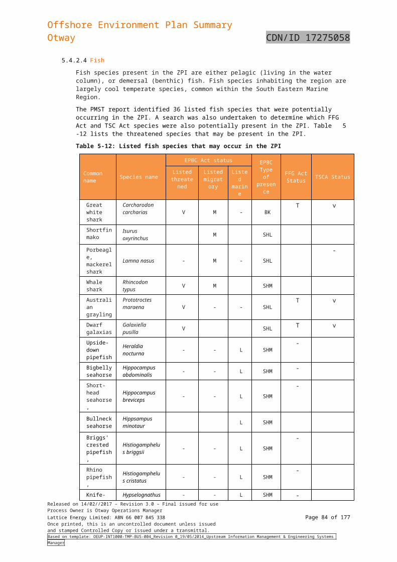
Offshore Environment Plan SummaryOtway CDN/ID 17275058
Aspect Potential impacts Controls and mitigation measures
Seabirds are likely to be attracted to the platform and vessel/s involved in activities supporting the Otway operations or platform. Migrating birds may be temporarily disorientated by the lights, thereby increasing the likelihood of injury or mortality though collision with infrastructure or mortality from starvation due to disrupted foraging at sea (DSEWPC, 2011).
The relatively small number and size of vessels (compared to large commercial ships in the area), limited helicopters flights and limited platform lighting means the impacts from lighting on marine fauna, seabirds and migrating birds is considered to be Minor.
Cetaceans predominantly utilise acoustic senses to monitor their environment rather than visual sources, so light is not considered to be a significant factor in cetacean behaviour or survival (WDCS, 2004).
IMP-03 Noise and vibration levels from the platform, vessel and helicopter operations
The Otway operations will create sound energy in addition to the anthropogenic noise produced by regular shipping traffic (i.e. commercial trade, fishing and existing oil and gas operations) and the natural ambient noise generated by atmospheric and oceanographic processes.
The assessed marine noise of Curtin University (McCauley et al 2003) showed that, within the Otway Basin, there are natural attenuation properties that reduce sound energy over distance.
The Otway operations activities will introduce temporary, intermittent and short duration anthropogenic noise to the marine environment.
The Otway Basin is frequented by commercial fishing and shipping, and hosts existing oil and gas industry activities. The continued presence of small mammals, fish, seabirds and whale species in the Otway Basin suggests that marine fauna have some degree of tolerance to, or are habituated to operational noise. There are not expected to be any negative impacts to commercial fishing or other marine users as a result of operational noise and vibration levels.
Inspection and maintenance of platform rotating equipment in accordance with the Maintenance Management System.
Vessels and helicopters comply with the relevant approach distances for activities within Commonwealth waters specified in the Australian National Guidelines for Whale and Dolphin Watching (DEH 2005) (or as amended), and EPBC Regulations 2000 (Part 8).
Vessels comply with the relevant approach distances for activities within Victorian State waters specified in Wildlife (Marine Mammal) Regulations 2009.
Vessel engines and thrusters are maintained in accordance with the vessel planned maintenance system.
IMP-04 Planned and fugitive discharges of hydraulic fluid from operation and maintenance of the Geographe and Thylacine
Calculations indicate that in calendar year 2016, approximately 4 tonnes of hydraulic fluid were discharged, the largest contributor being the production master valves in the Geographe tree.
The selected hydraulic fluid for the development is HW443, which
Hydraulic fluid that is categorised as either OCNS ‘D’ or ‘E’ is used in the hydraulic control system.
Discharge of planned and fugitive hydraulic fluid volumes are monitored and recorded.
Released on 14/02//2017 – Revision 3.0 – Final issued for useProcess Owner is Otway Operations ManagerLattice Energy Limited: ABN 66 007 845 338 Page 84 of 122Once printed, this is an uncontrolled document unless issuedand stamped Controlled Copy or issued under a transmittal.Based on template: OEUP-INT1000-TMP-BUS-004_Revision 0_19/05/2014_Upstream Information Management & Engineering Systems Manager
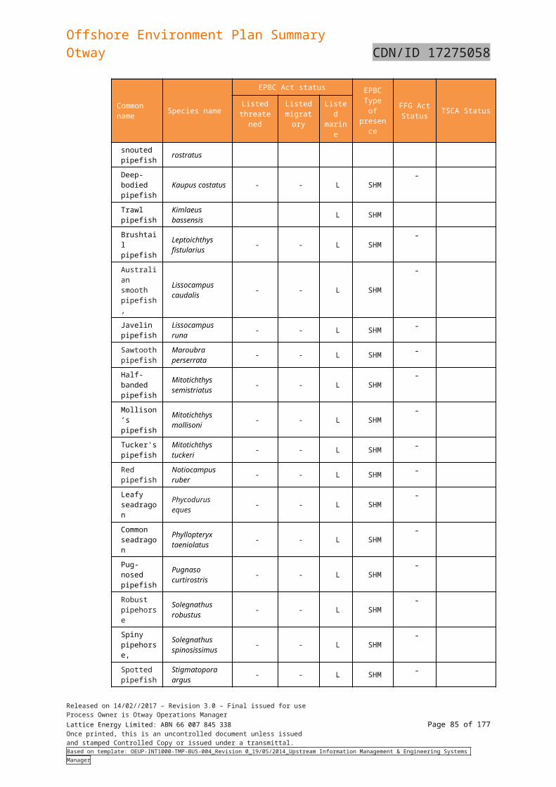
Offshore Environment Plan SummaryOtway CDN/ID 17275058
Aspect Potential impacts Controls and mitigation measures
hydraulic control system is ranked as a category ‘D’ Offshore Chemical Notification Scheme (OCNS) chemical, with low environmental impact. HW443 is a water based chemical with MEG and other additives to enhance lubrication properties, prevent temperature degradation concerns and prevent microbial growth that could lead to equipment blockages.
Given the small volume released, the relatively large water column and evidence of marine growth during recent ROV inspection, the impact is considered to be localised and short-term with no lasting effects. Therefore no impacts to commercial fishing or other marine users have been identified.
Hydraulic control system inventory levels monitored monthly. Hydraulic control system inspected and maintained in
accordance with the Maintenance Management System.
IMP-05 Planned and fugitive marine discharges from the platform, pipeline and vessels.
Putrescibles, sewage and greywater
Intermittent release of putrescible waste, untreated sewage and greywater will cause localised nutrient enrichment of the water column. This may in turn act as a food source for scavenging marine fauna and seabirds, whose numbers may temporarily increase as a result.
Sewage discharges from Otway operations are expected to be rapidly diluted in the surface layers of the water column and dispersed by currents. The biological oxygen demand of effluent is unlikely to lead to oxygen depletion of the receiving waters (Black et al, 1994), as surface currents will also assist with oxygenation of the discharge once it is released.
Given the rapid rate of mixing, large water column and distance offshore, negligible impact on the marine environment as a result of sewage and greywater discharge is expected.
Additionally, the rapid consumption of this food waste by scavenging fauna, and physical and microbial breakdown, ensures that the impacts of putrescible waste discharges are short-lived and insignificant.
Solid waste
Wastes generated on the platform are transported via vessel to shore for treatment. Solid wastes will not be discharged to the marine environment hence there should be no impact offshore.
Discharge of waste from platform in accordance with Otway Waste Management Plan (CDN/ID 8199521).
Platform/pipeline cleaning, maintenance and repair chemicals/materials that are discharged to the marine environment comply with the Hazardous Materials – Approval and Control Procedure (CDN/ID 3675133).
Discharges from vessels comply with MARPOL 73/78 Annex I, IV, V requirements.
Vessels maintain appropriate waste and pollution control devices.
Personnel are aware of waste management requirements.
Released on 14/02//2017 – Revision 3.0 – Final issued for useProcess Owner is Otway Operations ManagerLattice Energy Limited: ABN 66 007 845 338 Page 85 of 122Once printed, this is an uncontrolled document unless issuedand stamped Controlled Copy or issued under a transmittal.Based on template: OEUP-INT1000-TMP-BUS-004_Revision 0_19/05/2014_Upstream Information Management & Engineering Systems Manager
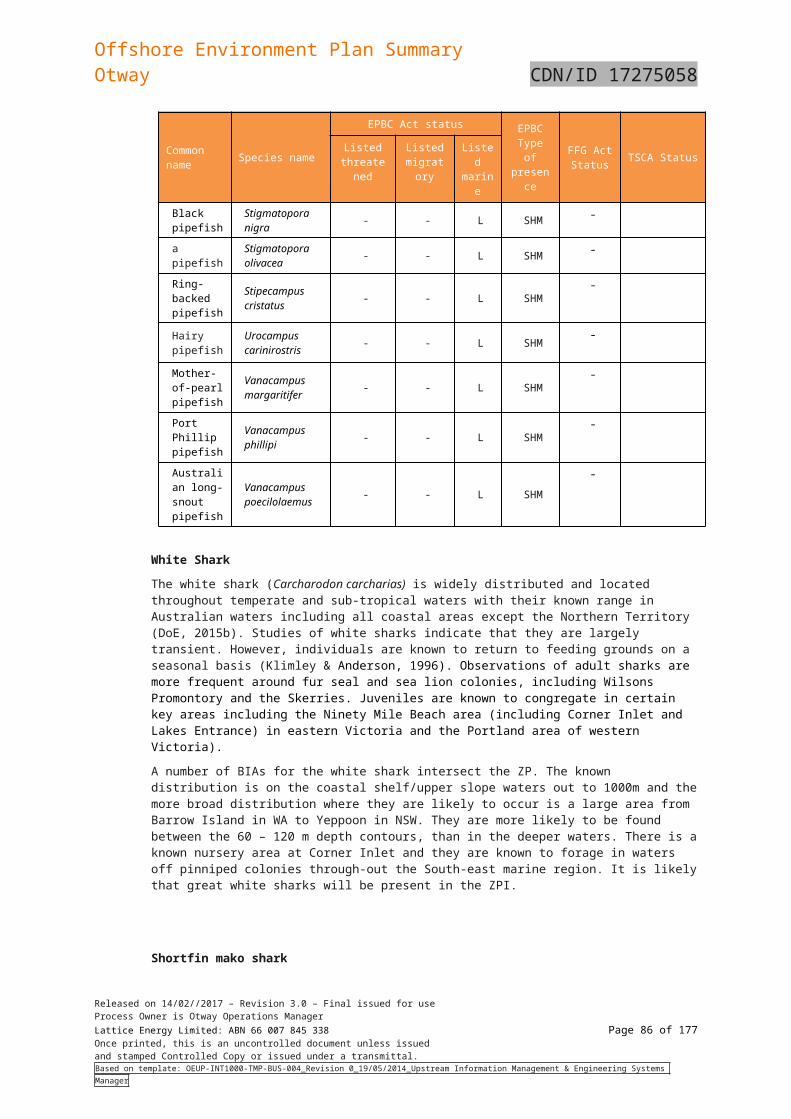
Offshore Environment Plan SummaryOtway CDN/ID 17275058
Aspect Potential impacts Controls and mitigation measures
Grit blasting of the platform and pipeline during maintenance and repair activities are unable to be completely captured and the resulting material (combination of grit blasting material and removed scale, marine growth and/or paint) is released to the environment. These activities are likely every few years for a relatively short period (1-8 weeks) depending on the nature of the work being undertaken. Given the small area impacted and short duration any impact to the environment is considered to be localised and short-term.
Cooling water, brine, ballast and bilge water from vessels
Temperature
The potential impacts of increased seawater temperatures downstream of the cooling water discharge are localised changes to the physiological processes of marine organisms (particularly plankton) including attraction or avoidance behaviour, stress or mortality.
Given that the temperature of the discharge is likely be only marginally higher than that of the receiving waters (as shown by modelling undertaken for other similar development and the receiving environment is subject to strong currents, the impacts of cooling water discharges are considered negligible and will be temporary and localised.
Salinity
Brine water (hyper saline water) may be created through the vessel’s desalination process that creates freshwater for drinking, showers, cooking etc. This is achieved through reverse osmosis (RO) or distillation resulting in the discharge of seawater with a slightly elevated salinity (~10% higher than seawater). The freshwater produced is then stored in tanks on board.
For smaller vessels and short duration works this may not be necessary. In these cases, drinking water will be supplied via onshore source.
Hydrocarbons and chemicals
With routine controls in place, only trace quantities of contaminants would be expected in deck drainage and bilge water discharge, and
Released on 14/02//2017 – Revision 3.0 – Final issued for useProcess Owner is Otway Operations ManagerLattice Energy Limited: ABN 66 007 845 338 Page 86 of 122Once printed, this is an uncontrolled document unless issuedand stamped Controlled Copy or issued under a transmittal.Based on template: OEUP-INT1000-TMP-BUS-004_Revision 0_19/05/2014_Upstream Information Management & Engineering Systems Manager
Offshore Environment Plan SummaryOtway CDN/ID 17275058
Aspect Potential impacts Controls and mitigation measures
these would be rapidly diluted and dispersed. Given the very small volumes of such chemicals or hydrocarbons (oil, grease) that may be released, the high rates of dilution and dispersion in the open ocean environment and the temporary presence of the vessels, it is not expected that marine fauna or plankton will be exposed to chemicals or hydrocarbons in quantities that would induce acute or chronic toxicity impacts due to routine deck cleaning or release of treated bilge water.
IMP-06 Emissions of atmospheric pollutants and greenhouse gases (GHG).
Otway offshore operational activities result in the release or emission of several greenhouse gases, notably CO2 (product of combustion from engine exhaust) and methane (venting and purging). Small quantities of other gases such as the hydrocarbons, propane and butane, and other products of fuel combustion are also released.
Engine exhaust emissions from Otway offshore operational activities are mainly generated from gas engines and operation of vessels, the life boat and the helicopter, whose frequency will be heavily dependent on inspection, maintenance and repair requirements.
Vented gas is generated from the continuous vent purge on the platform to prevent air ingress to the vent and drain system. There is no flare on the platform. The volume of gas to be vented will be between 21 tonnes and 52 tonnes.
Depressurisation of the production pipeline may be required for pipeline intervention work and hydrate remediation/removal. It is expected that pipeline depressurisation would be a very infrequent occurrence during the operating life of the pipeline (<5 times) and would result in approximately 2950 tonnes of gas being vented.
Reporting is undertaken in accordance with the National Greenhouse and Energy Reporting Act 2007.
Vessels comply with MARPOL Annex VI – Prevention of Air Pollution from Ships.
Inspection and maintenance of platform fuel burning equipment in accordance with the Maintenance Management System.
Inspection and maintenance of pipeline undertaken in accordance with Maintenance Management System.
All venting and/or flaring associated with planned pipeline depressurisation and/or repressurisation are monitored.
Otway RGP Pressurisation from Offshore - Critical Operating Procedure (CDN/ID 10842252) implemented to ensure that venting prior to RGP repressurisation is the minimum required to protect the pipeline
Released on 14/02//2017 – Revision 3.0 – Final issued for useProcess Owner is Otway Operations ManagerLattice Energy Limited: ABN 66 007 845 338 Page 87 of 122Once printed, this is an uncontrolled document unless issuedand stamped Controlled Copy or issued under a transmittal.Based on template: OEUP-INT1000-TMP-BUS-004_Revision 0_19/05/2014_Upstream Information Management & Engineering Systems Manager
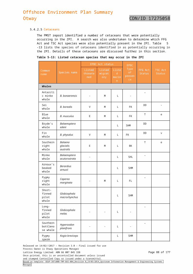
Offshore Environment Plan SummaryOtway CDN/ID 17275058
Table 6-27: Summary of environmental impacts, risks and control measures for unplanned events of the Otway Offshore Operations
Aspect Potential impacts Controls and mitigation measures
RSK-01 Loss of containment (LOC) - uncontrolled hydrocarbon release from wells and production equipment.
Descriptions of possible impacts from the credible spill scenarios are outlined in Table 6-7
In the event of a marine hydrocarbon spill, Origin will engage the appropriate supporting agencies to commence spill response in accordance with the OPEP immediately; by mitigating the impacts associated with the release at sea Origin will be able to mitigate the impacts associated with the sensitive areas.
Otway facilities designed consistent with the Otway safety cases (facilities and pipeline) and validated in accordance with the NOPSEMA scope of validation requirements.
Surface Controlled Sub-Surface Safety Valve (SCSSV) Leak off tests carried out in accordance with procedures (Thylacine Wells Leak Off Test (CDN/ID 3973964) and Geographe Wells SCSSV, PMV, PWV Leak Off Test (CDN/ID 3973969)).
Critical function tests (CFTs) conducted as per the plan and failed CFTs managed under an Operational Risk Assessment (ORA).
Otway operations personnel trained in line with the Otway training matrix requirements to operate and maintain the Otway offshore facilities.
Wells fitted with fail closed SCSSVs which initiate when activated to shut-in flow from production tubing.
Isolation valves at the facilities, initiate when activated during an ESD to isolate the pipeline.
All vessel interactions in the PSZ are managed in accordance with the Field Support Vessel Operations Procedure (CDN/ID 3974221).
An accepted and current safety case is in place for the Otway Pipeline System.
24 hour DCS availability and protocol for lost communication developed and implemented.
Access to facilities is restricted to authorised personnel only. All activities are undertaken in accordance with the Permit to
Work system. Critical lifts (e.g. lifting over live equipment) are conducted in
accordance with the Lifting and Load Safety Operations Procedure (CDN/ID 3674901).
Incidents of uncontrolled release of hydrocarbons from wells, production equipment and pipeline are reported and investigated.
RSK-02 Loss of containment (LOC) - uncontrolled hydrocarbon release from pipeline.
Released on 14/02//2017 – Revision 3.0 – Final issued for useProcess Owner is Otway Operations ManagerLattice Energy Limited: ABN 66 007 845 338 Page 88 of 122Once printed, this is an uncontrolled document unless issuedand stamped Controlled Copy or issued under a transmittal.Based on template: OEUP-INT1000-TMP-BUS-004_Revision 0_19/05/2014_Upstream Information Management & Engineering Systems Manager
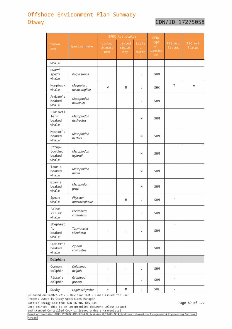
Offshore Environment Plan SummaryOtway CDN/ID 17275058
Aspect Potential impacts Controls and mitigation measures
Wells, production equipment and pipeline integrity maintained in accordance with an implemented integrity management plans.
NOPSEMA accepted Well Operations Management Plans (WOMPs) are implemented: o Operating Phase – Geographe Gas Field Geographe 2 and
Geographe 3 Well Operations (CDN/ID 4930635).o Thylacine Well Operations Management Plan (CDN/ID
4411890).o Geographe 1 and Thylacine 1 Well Operations
Management Plan (CDN/ID 14235732).RSK-03 Loss of containment (LOC) - uncontrolled release from the Mono Ethylene Glycol (MEG) pipeline.
MEG is a category ‘E’ OCNS chemical with no substitution warning and is readily biodegradable and has a low potential for bioaccumulation.
The minor additional MEG that would also be released at the same time as a hydrocarbon release is considered insignificant when compared to the potential release of hydrocarbons.
Inspection and maintenance of MEG shutdown system undertaken in accordance with the Maintenance Management System.
Incidents for uncontrolled release from MEG pipeline are reported and investigated.
New chemicals to be approved in accordance with the Hazardous Materials – Approval and Control Procedure (CDN/ID 3675133).
Otway operations personnel trained in line with the Otway training matrix requirements.
RSK-04 Loss of containment (LOC) of chemicals from platform/vessels are directly or indirectly released to the marine environment.
Methanol
Methanol is required to prevent hydrate formation during cold starts. There is approximately 5m3 of methanol stored on the platform and about 12m3 contained within the umbilicals.
There is a risk of methanol release if the main umbilical fails or is cut during operations or in the event of a subsea failure resulting in a loss of containment of hydrocarbons. The risk associated with a failure of the subsea facilities and a loss of hydrocarbons, the minor additional methanol that could be released at the same time is considered insignificant.
A dedicated double skinned stainless tank capable of storing 3,000L of methanol is located on top of the Equipment Room. The IBC is DNV rated and designed for crane loading operations.
Otway facilities designed consistent with the Otway safety case and validated in accordance with the NOPSEMA scope of validation requirements.
Bunding of hazardous materials, methanol pump, drains pump and HPU cabinet on TWHP.
Personal are trained and competent in handling, storage and transport (where appropriate) of chemicals and hazardous materials.
Critical lifts (e.g. lifting over live equipment) are conducted in accordance with the Lifting and Load Safety Operations Procedure (CDN/ID 3674901).
New chemicals to be approved in accordance with the Hazardous Materials – Approval and Control Procedure
Released on 14/02//2017 – Revision 3.0 – Final issued for useProcess Owner is Otway Operations ManagerLattice Energy Limited: ABN 66 007 845 338 Page 89 of 122Once printed, this is an uncontrolled document unless issuedand stamped Controlled Copy or issued under a transmittal.Based on template: OEUP-INT1000-TMP-BUS-004_Revision 0_19/05/2014_Upstream Information Management & Engineering Systems Manager
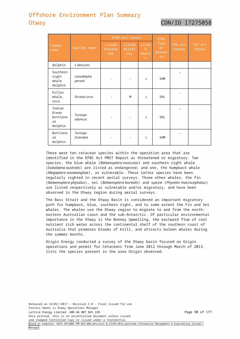
Offshore Environment Plan SummaryOtway CDN/ID 17275058
Aspect Potential impacts Controls and mitigation measures
The inadvertent release of methanol into the ocean is expected to have a minimal impact on the receiving environment. The ocean currents and depth of water (85 - 120m) will cause any methanol released to be dispersed quickly though the water column in the high energy environment of the Otway Basin.
Hydraulic fluid
There is a risk of hydraulic fluid (HW443, which is ranked as a category ‘D’ OCNS chemical) release if the main or infield umbilical fails or is cut. These are both unplanned events and are considered remote.
There are two hydraulic fluid storage tanks on the Thylacine-A platform that store 2500L of fluid each, there is also a 500L return tank. There is about 12m3 of hydraulic fluid contained within the umbilicals supplying the well fields in the low and high pressure lines. In the case of an umbilical rupture the Hydraulic fluid tank would be isolated from the umbilical and only the fluid in the line could potentially be released to the receiving environment although this would quickly equalise with the hydrostatic pressure of the sea and release volumes would be minimised.
Another potential source is a release of hydraulic fluid into the marine environment due to a hose rupture supplying the ROV or the platform crane. The quantities of hydraulic fluid are considered to be small (<800L). Any spills from these sources will have a very limited impact in terms given its small quantity and large water column.
Potentially contaminated water
Deck drainage on the vessels can become contaminated if in contact with spilt oil, cleaning chemicals, paint chips, cleaning solvents, surfactants, lubricating oils and other fluids on the deck floors.
In the event of a spill on deck the spill is directed to the vessel bilge system which can be isolated to prevent unplanned discharges to the marine environment.
Discharge of potentially contaminated and hazardous wastes to the ocean can have direct or indirect effects on marine organisms.
(CDN/ID 3675133). Spill response equipment is in place and maintained on the
platform. Vessels have an approved SOPEP in place. Use of DNV rated containers for vessel transport of chemicals
to platform. Vessels comply with MARPOL Annex I, II, and III
requirements. Incidents for uncontrolled release of chemicals to the marine
environment are reported and investigated. Corrosion inhibitor injection for V-jet pigging conducted in
accordance with the Raw Gas Pipeline Pigging Operations - Offshore (CA) Critical Operating Procedure (CDN/ID 3973972).
Corrosion inhibitor injection hoses are in service date
Released on 14/02//2017 – Revision 3.0 – Final issued for useProcess Owner is Otway Operations ManagerLattice Energy Limited: ABN 66 007 845 338 Page 90 of 122Once printed, this is an uncontrolled document unless issuedand stamped Controlled Copy or issued under a transmittal.Based on template: OEUP-INT1000-TMP-BUS-004_Revision 0_19/05/2014_Upstream Information Management & Engineering Systems Manager
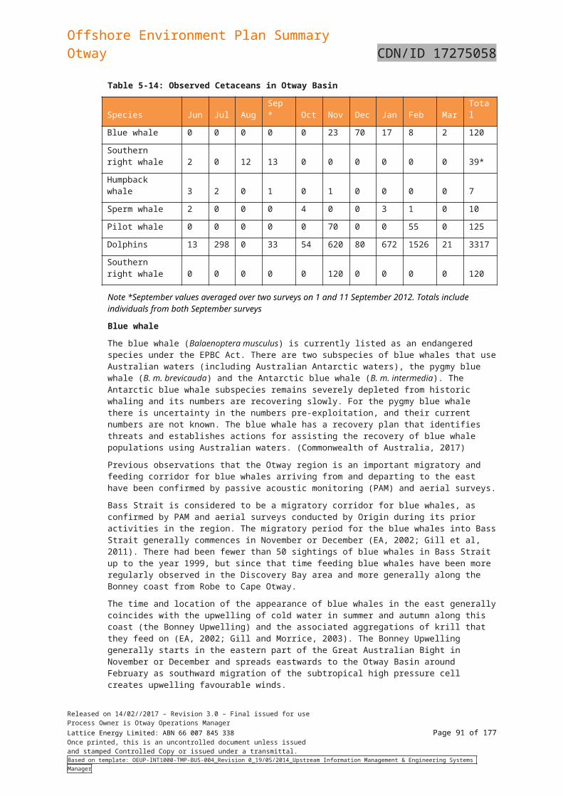
Offshore Environment Plan SummaryOtway CDN/ID 17275058
Aspect Potential impacts Controls and mitigation measures
Diesel
The platform could have up to 2m3 of diesel stored at any given point in time. Release of diesel to the marine environment could result in a temporary and localised reduction of water quality leading to direct and indirect effects on marine fauna and flora. However given the ocean currents, depth of water and high energy environment of the Otway Basin which will result in rapid and quick dispersion these impacts are considered to be short term, with no long lasting impacts.
Aviation fuel
Unplanned release of aviation fuel could occur as a result of a leak from a visiting helicopter while at the platform. Helicopter use is limited to transport of personnel to and from the platform, with generally one to two return trips occurring per month. Typically, the helicopters used hold less than 2000L of aviation fuel. There are no refuelling facilities available at the platform. Aviation fuel is toxic to marine fauna and if spilled is likely to float on the surface of the ocean. Aviation fuel is unlikely to persist in the environment and will quickly degrade. Given the small volume of fuel stored within the helicopter, limited trips to the platform and the high energy of the Otway basin marine environment any unplanned spills are expected to have a localised short term impact.
Corrosion inhibitor
An IBC (1,000 L) of corrosion inhibitor is stored on the platform in a steel portable bund, complete with sides and a lid. With controls in place, the likelihood of corrosion inhibitor release to the marine environment is remote.
RSK-05 Loss of marine diesel from vessels
Due to rapid and high levels of evaporation when spilt at sea, the environmental effects of diesel spills are generally short-term.
When spilt at sea, diesel will spread and thin out quickly and approximately half of the volume can be lost by evaporation within 12 hours depending upon sea temperature and winds.
Although evaporation reduces the level of hydrocarbons on the water surface, it increases the level of hydrocarbons in the atmosphere and able to be inhaled. This increased hydrocarbon vapour exposure can affect any air breathing animal including
Vessel navigational lighting and communication system managed in accordance with AMSA Marine Order Part 30, Part 21 and Part 27.
Ongoing stakeholder engagement undertaken in accordance with the EP.
All stakeholder complaints are recorded in OCIS and investigated.
All incidents of unauthorised entry into PSZ or spatial conflict
Released on 14/02//2017 – Revision 3.0 – Final issued for useProcess Owner is Otway Operations ManagerLattice Energy Limited: ABN 66 007 845 338 Page 91 of 122Once printed, this is an uncontrolled document unless issuedand stamped Controlled Copy or issued under a transmittal.Based on template: OEUP-INT1000-TMP-BUS-004_Revision 0_19/05/2014_Upstream Information Management & Engineering Systems Manager
Offshore Environment Plan SummaryOtway CDN/ID 17275058
Aspect Potential impacts Controls and mitigation measures
whales, dolphins, seals and turtles.
Diesel oils are considered to have a higher aquatic toxicity in comparison to many other crudes oils and condensates due to the types of hydrocarbons present and that dispersed droplets of diesel can be more bio-available to marine organisms.
Due to their higher solubility and ease of entrainment/ dispersion into the water column, diesel spills can have a greater ecological impact in comparison to other floating oil slicks and are known to taint seafood. According to the International Maritime Organisation (IMO), diesel oil has a GESAMP (Joint Group of Experts on the Scientific Aspects of Marine Environmental Protection) rating of 3 for acute toxicity (damage to living organisms) and 4 for bioaccumulation/tainting (4 = high potential to bioaccumulate, 5 is the highest).
Diesel in the water column can adhere to fine-grained suspended sediments that can settle out and result in oiled sediments being deposited on the seabed. Diesel spills that reach shorelines are usually still mobile residues and will penetrate shoreline sediments due to the low viscosity (i.e., easy spreadability) of the oil and have direct consequences on in-faunal organisms.
Table 6-28 for further details on environmental impacts of diesel spill on the environment.
with other marine users are recorded in OCIS. AMSA’s Joint Rescue Coordination Centre (JRCC) notified of
inspection and maintenance activities utilising a vessel outside of the PSZ.
Incidents for uncontrolled release of diesel to the marine environment are reported and investigated.
All vessels have appropriate pollution control equipment in place.
RSK-06 Collision with cetaceans and pinnipeds
The reaction of whales to the approach of a vessel is quite variable. Some species remain motionless when in the vicinity of a vessel (e.g., narwhals) while others are known to be curious and often approach ships that have stopped or are slow moving, although they generally do not approach, and sometimes avoid, faster moving ships (Richardson et al, 1995). Larger vessels moving in excess of 10 knots may cause fatal or severe injuries to cetaceans with the most severe injuries caused by vessels travelling faster than 14 knots.
When the vessels are stationary or slow moving, the risk of collision with cetaceans is extremely low, as the vessel’s size and underwater noise ‘footprint’ will alert cetaceans to its presence and thus illicit avoidance.
Vessel collision remains a potential risk to some marine mammal
Vessels within Commonwealth waters comply with the relevant approach distances specified in the Australian National Guidelines for Whale and Dolphin Watching (DEH 2005) and EPBC Regulations 2000 (Part 8).
Vessels within Victorian State waters comply with the relevant approach distances for activities within Victorian State waters specified in Wildlife (Marine Mammal) Regulations 2009.
Vessel collisions with threatened marine fauna are reported to the Cth Department of Energy and Environment within 2 hours of the incident, the Vic Department of Environment Land Water and Planning and recorded in OCIS.
All vessel strike incidents are reported in the National Ship Strike Database at
Released on 14/02//2017 – Revision 3.0 – Final issued for useProcess Owner is Otway Operations ManagerLattice Energy Limited: ABN 66 007 845 338 Page 92 of 122Once printed, this is an uncontrolled document unless issuedand stamped Controlled Copy or issued under a transmittal.Based on template: OEUP-INT1000-TMP-BUS-004_Revision 0_19/05/2014_Upstream Information Management & Engineering Systems Manager
Offshore Environment Plan SummaryOtway CDN/ID 17275058
Aspect Potential impacts Controls and mitigation measures
species that might occur in the area at the time of a vessel activity. Vessels working within and travelling to and from the Otway operations may present a potential physical hazard (e.g. animal displacement or vessel strike) to marine fauna. Those at higher risk are individuals that are resting and feeding, and to a lesser extent migrating. This may lead to short‐term behavioural changes or wounding and/or mortality in the event of a vessel strike.
https://data.marinemammals.gov.au/report/shipstrike
RSK-07 Introduction of marine pests from vessels
Introduced marine species or pathogens may become established where conditions are suitable, and these species may have impacts on local ecological and economic values. Establishment of introduced marine species is mostly likely to occur in shallow waters in areas where large numbers of vessels are present and are stationary for an extended period. The operational area does not present a location conducive to marine pest survival because it is located in deep waters with the majority of the operational area in water greater than 60m.
The Tek-Ocean Spirit has been used as the primary support vessel for the Otway development over the last few years and is based out of Port Anthony. As it has been based in local waters for a long period of time, the risk of translocating foreign species is minimised. The vessel may be required to leave the region for a period of time for example a third party charter or dry-docking. Other vessels may be chartered for specific short-term tasks. The selection of the vessel is dependent on the nature of the work it is required to support, timing and capability.
The Otway development’s infrastructure is located within or adjacent to principal shipping lanes, east to the ports of Geelong and Melbourne and west to the port of Perth, and are subject to significant transoceanic vessel traffic. The presence of vessel/s supporting Otway operations is not considered significantly different.
All vessels comply with:o Australian Ballast Water Management Guidelines (DAWR,
2016) o National Biofouling Management Guidance for the
Petroleum Production and Exploration Industryo Biosecurity Act 2015.
All vessels must ensure there is no discharge of ballast water into Victorian State waters (unless written authorisation to discharge has been received from the Authority) in accordance with the: o Victorian Environment Protection (Ships’ Ballast Water)
Regulations 2017o EPA Protocol for Environmental Management: Domestic
Ballast Water Management in Victorian Waters (Publication 949.7, 2017).
o All ships that intend to visit a Victorian port must send EPA Victorian ballast water report form.
Suspected or known introductions of invasive marine species will be reported to the DELWP immediately and recorded in OCIS.
RSK-08 Disturbance to the benthic environment (seabed habitat and fauna).
As described in section 5.1 there are few known or likely sensitive ecological seabed features within the operational area. Vessels will use thrusters to maintain position, in preference to anchors, unless in an emergency. In the event of anchoring, seabed disturbance will be created at the anchor location and there is likely to be some associated anchor chain drag.
Surveys of previous seabed disturbances from oil and gas activities indicate that recovery of benthic fauna in soft sediment
Vessels use DP where practicable (in preference to anchoring) when performing subsea equipment repair/replacement activities on facilities location
Trained and competent personnel used in ROV inspections. Grit blasting material to be approved in accordance with the
Hazardous Materials – Approval and Control Procedure (Origin, 2015).
Released on 14/02//2017 – Revision 3.0 – Final issued for useProcess Owner is Otway Operations ManagerLattice Energy Limited: ABN 66 007 845 338 Page 93 of 122Once printed, this is an uncontrolled document unless issuedand stamped Controlled Copy or issued under a transmittal.Based on template: OEUP-INT1000-TMP-BUS-004_Revision 0_19/05/2014_Upstream Information Management & Engineering Systems Manager
Offshore Environment Plan SummaryOtway CDN/ID 17275058
Aspect Potential impacts Controls and mitigation measures
substrates occurs within 6 to 12 months of cessation of the activity (URS, 2001).
Should anchoring be necessary, the depression created acts as a trap for marine detritus and sand, which quickly fills and is recolonised by benthic organisms (Currie and Issacs, 2004). The area impacted by single anchor points is extremely small and will not pose a threat to seabed habitats or fauna communities.
Objects that may be dropped into the ocean include equipment and containerised deck equipment. Loss overboard may be caused when items roll off the deck in poor ocean conditions (e.g. storms) or due to human error when equipment is deployed over the edge of the vessel by the vessel-mounted crane (or equivalent). Dropped objects would have the impact of temporarily smothering benthic habitat and fauna. Impacts from the loss of equipment overboard (assuming no buoyancy) would be the localised loss of a small area of benthic habitat.
The operational area is well known and traversed, and unmarked subsea obstructions (such as unknown shipwrecks) are unlikely to occur. This, combined with the use of DP, in preference to anchoring, ensure that vessels do not come into contact with the seabed or other features.
Activities associated with cleaning of the platform, wells and pipeline may result in grit blasting material and removed scale to settle on seabed. Recovery of grit blasting material is not practical and inert material such as garnet is used to ensure minimal impact to fauna.
Pipeline repair/maintenance activities undertaken in accordance with project specific procedures and the Risk Management Plan (Origin, 2017i)
RSK-09 Bird control method for the platform helideck injuries or kills birds
The bird deterrents (primary and secondary methods) are designed to scare birds, rather than injure them to ensure safety risks associated with helicopter operations are adequately managed. The water sprinkler is used daily (when birds are present), even when helicopter flights are not scheduled. This prevents birds from habituating to an inactive helideck, reducing the numbers and hence lowering the risk of being harmed.
Given the impacts to birds as a result of operation of the bird deterrents will impact a small number of individuals.
The water sprinkler is used daily (when birds are present), even when helicopter flights are not scheduled. This prevents birds from habituating to an inactive helideck, reducing the numbers and hence lowering the risk of being harmed.
All bird injuries/deaths resulting from operation of the bird control system are reported in OCIS
RSK-10 OIL SPILL Refer to Table 6.8 for oil spill response for potential impacts Refer to Table 6.8 for oil spill response for controls and mitigation.
Released on 14/02//2017 – Revision 3.0 – Final issued for useProcess Owner is Otway Operations ManagerLattice Energy Limited: ABN 66 007 845 338 Page 94 of 122Once printed, this is an uncontrolled document unless issuedand stamped Controlled Copy or issued under a transmittal.Based on template: OEUP-INT1000-TMP-BUS-004_Revision 0_19/05/2014_Upstream Information Management & Engineering Systems Manager
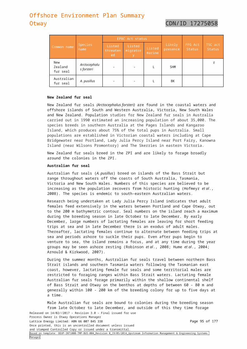
Offshore Environment Plan SummaryOtway CDN/ID 17275058
Aspect Potential impacts Controls and mitigation measures
RESPONSE RISK: Shoreline assessment crew require access to shorelineRSK-11 OIL SPILL RESPONSE RISK: Oiled wildlife response (OWR).RSK-12 Mobilisation of a MODU and drilling of a relief well
Released on 14/02//2017 – Revision 3.0 – Final issued for useProcess Owner is Otway Operations ManagerLattice Energy Limited: ABN 66 007 845 338 Page 95 of 122Once printed, this is an uncontrolled document unless issuedand stamped Controlled Copy or issued under a transmittal.Based on template: OEUP-INT1000-TMP-BUS-004_Revision 0_19/05/2014_Upstream Information Management & Engineering Systems Manager

Offshore Environment Plan SummaryOtway CDN/ID 17275058
Table 6-28: Summary of Potential Impacts of a Hydrocarbon Spill on Environmental Sensitivities
Environmental Sensitivity
Spill Scenario Description of Impact
Offshore Pelagic Environment
Blowout
Pipeline rupture
Diesel spill
Aside from sensitive receivers such as marine mammals, seabirds, marine reptiles, plankton and larval fishes, fish and sharks, benthic habitats and other users (described elsewhere in this table), the offshore pelagic environment is not expected to be significantly impacted in the event of a hydrocarbon spill. Offshore pelagic habitat is very broadly represented throughout the region and the habitat within the area does not constitute a unique environmental value. Modelling identifies that hydrocarbons are unlikely to persist at high concentrations in this environment for a prolonged period due to dispersion, dilution, evaporation, other natural degradation mechanisms, and transfer to adjacent habitats (e.g. benthos or intertidal environments).
Fisheries Blowout
Pipeline rupture
Diesel spill
Commercial fishers operating in the area may be subject to oiling of gear and/or loss of fishing effort associated with avoidance of spill, or gear clean-up and associated costs. The market value/demand for fish may also be impacted due to actual or perceived tainting of catches and closure of fishing grounds could also impact operations. Fish monitoring studies conducted following the Montara release in 2011 did not identify any significant differences attributable to the oil spill between fish species sampled at either impact or reference sites (Gagnon, 2012). Commercial (and recreational) fisheries will be subject to a fisheries closure following a spill. This may benefit unimpacted populations due to reduced impacts from fisheries activities. In the Gulf of Mexico, following the 2010 Macondo well incident, studies in shallow inshore seagrass beds have found no effects of the oil on numbers of juveniles except for some indications that they may have benefited from the fishery closure. In this incident, the effectiveness of the subsea and offshore response is likely to have made a significant contribution to the protection of fish populations in the shallow inshore waters (IPIECA-IOGP, 2015).Modelling indicated that the distribution of low and moderate thresholds were restricted to the upper- or mid-waters (e.g. < 50 m water depth in areas of >90 m water depth). Therefore direct impacts to demersal fisheries from dissolved hydrocarbons are highly unlikely. It is therefore unlikely that commercial fisheries will be significantly affected in the event of a hydrocarbon spill.Scientific monitoring would provide robust assessment of potential impact to fisheries and fisheries resources, and Origin would compensate fishers for loss of income. There is potential for recovery from impacts to fisheries resources from nearby/transitory fish populations in the broader region.
Intertidal Habitats Blowout
Pipeline rupture
A spill of a large quantity of highly persistent oil (such as crude oil) has the potential to cause widespread damage in the intertidal zones of shorelines through smothering. However, toxic effects are less likely for crude oil, or other highly viscous oil that has low water solubility, as the chemical components of the oil have a low biological availability. Exposure to the scouring effects of wave action and tidal currents means that rocky and sandy shores are the most resilient to the effects of a spill. This scouring also usually enables natural and rapid self-cleaning to take place. Surface or entrained hydrocarbons reaching shoreline or intertidal habitat may have serious impacts on fauna utilising these habitats, such as seabirds and invertebrates. Inter-tidal habitats within the wider area may be oiled by surface and entrained hydrocarbons. This would affect species that rely upon such habitat, which may include marine turtles, fishes, sharks, invertebrates, seabirds and migratory birds. Key intertidal habitats, such as mangroves, saltmarshes and samphires, are sensitive to exposure from hydrocarbons. The accumulation of surface hydrocarbons in these habitats is of particular risk, as they retain hydrocarbons, gradually releasing hydrocarbons back into adjacent habitats
Released on 14/02//2017 – Revision 3.0 – Final issued for useProcess Owner is Otway Operations ManagerLattice Energy Limited: ABN 66 007 845 338 Page 96 of 122Once printed, this is an uncontrolled document unless issuedand stamped Controlled Copy or issued under a transmittal.Based on template: OEUP-INT1000-TMP-BUS-004_Revision 0_19/05/2014_Upstream Information Management & Engineering Systems Manager
Offshore Environment Plan SummaryOtway CDN/ID 17275058
Environmental Sensitivity
Spill Scenario Description of Impact
over an extended period of time. The impact of an oil spill on saltmarshes however depends on the time of year relative to periods of plant growth. A single event is unlikely to cause more than temporary effects but longer term damage, possibly over several years, can be inflicted by aggressive clean-up activity, such as trampling, the use of heavy equipment or removal of contaminated substrate. Two common saltmarsh species (Sarcocornia quinqueflora and Sporobolus virginicus) died rapidly after experimental contamination with crude oil and diesel (Clarke and Ward 1993). Recolonisation of S. virginicus from rhizomes outside of the plots occurred, but growth was inhibited; and there was no colonisation of the plots by seedlings of any species during the 17 month study (Clarke and Ward 1993). Regrowth from roots will occur soon after death of the aboveground portions of the plants. If sediments are heavily contaminated by oil, then production of new shoots is problematic and plant recovery can be diminished.Mangrove root systems (including pneumatophores) are sensitive to physical oiling. There is the potential for stands of mangroves on the mainland coast to be impacted by surface slicks of oil and also potentially by accumulated stranded hydrocarbons. Heavy oil inundation of the root systems may block this oxygen supply and may cause the mangroves to die. However, in open aerated sediments, which allow relatively free water exchange, the root systems draw oxygen from seawater and so have a higher tolerance to smothering by oil. If contact occurred it would be expected to be at low concentrations and for short duration and significant impacts (mortality of trees) are not expected. Mangrove seedlings are significantly more vulnerable than mature trees (Grant et al. 1993). Exposure to crude and bunker oils resulted in mortality of Avicennia marina seedlings within 1 – 2 months; whilst surviving trees showed a significant reduction in canopy biomass (density) between 2 and 22 months after exposure (Duke and Burns 1999); exposure to crude oils resulting in significant defoliation of Avicennia marina was also reported by Wardrop et al. (1987). Mature trees exposed to crude and bunker oils have been shown to recover (Duke et al. 1997; Wardrop et al. 1998).
Diesel spill Inter-tidal contact may affect habitat such as corals, macroalgae, bare substrate and seagrass. Lighter and more refined oils such as diesel oil are extremely toxic to smooth cordgrass (Spartina alterniflora). Marine diesel oil has the potential to interfere with infaunal organisms that inhabit these areas either by modifying the habitat or smothering the feeding respiratory and/ or locomotory structures of these organisms. The toxic components of in light refined products such as diesel can interfere with mangrove plants’ systems for maintaining the salt balance, thereby affecting their ability to tolerate salt water and can result in localised loss of tree cover. The release of 450 t of fuel oil from the bulk ore carrier Sir Alexander Glen in 1988, led to heavy oiling of mangroves at Cape Lambert, Western Australia, but no deforestation or death of mangroves resulted (Duke and Burns 1999).Hydrocarbons may contact the intertidal shores as the tide ebbs, but it would be expected that this would be flushed with each flood tide. Natural flushing is more likely to reduce impacts in exposed areas of shoreline.
Subtidal habitats BlowoutPipeline rupture
Subsea blowouts may have higher potential for seabed impacts in deep water. Seabed communities in the deep sea are also characterised by long-lived species, and may take a long time to recover from the impacts of a spill. Studies in the Gulf of Mexico following the 2010 Macondo well incident identified areas of sediment contamination in the vicinity of the well head in the first year after the event, together with reduced diversity of sediment communities in those areas at that time and a small number of cold water corals in poor condition. Macondo studies have shown
Released on 14/02//2017 – Revision 3.0 – Final issued for useProcess Owner is Otway Operations ManagerLattice Energy Limited: ABN 66 007 845 338 Page 97 of 122Once printed, this is an uncontrolled document unless issuedand stamped Controlled Copy or issued under a transmittal.Based on template: OEUP-INT1000-TMP-BUS-004_Revision 0_19/05/2014_Upstream Information Management & Engineering Systems Manager
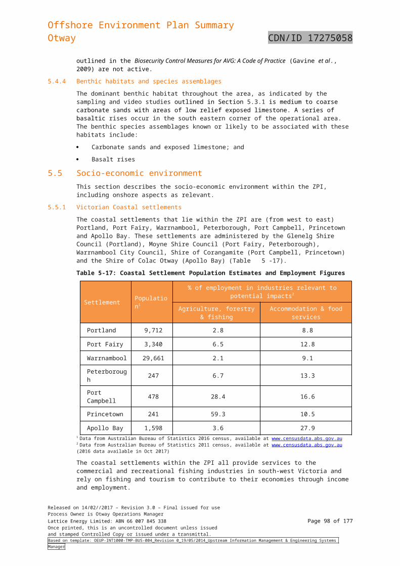
Offshore Environment Plan SummaryOtway CDN/ID 17275058
Environmental Sensitivity
Spill Scenario Description of Impact
dispersed oil concentrations were low; extensive monitoring of the subsea plume found levels of volatile hydrocarbons at a maximum of 1.2 ppm (parts per million) just over 1 km from the well head, and levels of <0.1 ppm at distances greater than 20 km. The equivalent figures for semi-volatiles were <0.5 ppm maximum and <0.01 ppm at distances greater than 10 km. In the unlikely event that elevated concentrations of oil in water do reach the seabed, any organisms that are directly exposed to the water column will be vulnerable, including epibiota, and any burrowing animals that actively pull water into their burrows or tissues for feeding or irrigation. Most other animals that live in the sediment will be partially protected unless oil becomes significantly incorporated into the sediment. Many sessile invertebrates, even some that feed by filtering or capturing particles from the water column and therefore take up oil droplets readily, like sponges and sea-squirts, will also survive apparently unaffected by high concentrations.Shallow water seabed epibiota may be vulnerable to concentrations of oil close to the bottom, but many will be relatively insensitive to even high concentrations because the duration of exposure is typically short. Direct contract with surface and entrained hydrocarbons from a spill could lead to chemical toxicity, possibly leading to coral bleaching and colony death. Instead of acute mortality, it is more likely that hydrocarbon effects would be sub-lethal; resulting in reduced photosynthesis, growth or reproduction (NOAA, 2014).Smothering, fouling and asphyxiation are some of the physical effects that have been documented from oil contamination in marine plants (Blumer 1971; Cintron et al. 1981). The effect of hydrocarbons however is largely dependent on the degree of direct exposure, and the presence of morphological features (e.g. a mucilage layer and/or fine ‘hairs’) will directly influence the amount of hydrocarbon that will adhere to the algae. Generally the effects of oil on macroalgae, such as kelp and many other species which dominate hard substrata in shallow waters is small due to their mucilaginous coating that resists oil absorption. Long-term changes in percent cover of Fucus from oiled shores was indistinguishable from those from unoiled shores in Prince William Sound two years after the Exxon Valdez oil spill (Hoff and Shigenaka, 1999).Exposure to in-water hydrocarbons would pose the greatest threat to macroalgae, specifically the Giant Kelp Forests TEC, that grows on rocky reefs from the sea floor 8 m below sea level and deeper. The largest extent of this TEC is in Tasmanian coastal waters, although, some patches are also found in Victorian waters.Seagrass may be exposed to both surface and sub-surface hydrocarbons by direct contact (i.e. smothering) and by uptake by rhizomes through contaminated sediments. Exposure also can take place via uptake of hydrocarbons through plant membranes and seeds may be affected by contact with oil contained within sediments (NRDA 2012). When seagrass leaves are exposed to petroleum oil, sub-lethal quantities of the soluble fraction can be incorporated into the tissue, causing a reduction in tolerance to other stress factors (Zieman et al. 1984). The toxic components of petroleum oils are thought to be the PAH, which are lipophilic and therefore able to pass through lipid membranes and tend to accumulate in the thylakoid membranes of chloroplasts (Ren et al. 1994). Susceptibility of seagrasses to hydrocarbon spills will depend largely on distribution, with deeper communities protected from oiling under all but the most extreme weather conditions. Shallow seagrasses are more likely to be affected by dispersed oil droplets or, in the case of emergent seagrasses, direct oiling. Long-term monitoring carried out following the Montara spill recorded a decline in coverage in most benthic biota – and a corresponding increase in coverage of macroalgae, sand/silt and rubble – at broad scales across the three sub-sea shoals surveyed compared to previous surveys. The seagrass loss noted at Vulcan Shoal in 2011 had not
Released on 14/02//2017 – Revision 3.0 – Final issued for useProcess Owner is Otway Operations ManagerLattice Energy Limited: ABN 66 007 845 338 Page 98 of 122Once printed, this is an uncontrolled document unless issuedand stamped Controlled Copy or issued under a transmittal.Based on template: OEUP-INT1000-TMP-BUS-004_Revision 0_19/05/2014_Upstream Information Management & Engineering Systems Manager
Offshore Environment Plan SummaryOtway CDN/ID 17275058
Environmental Sensitivity
Spill Scenario Description of Impact
recovered. In addition, an unusual soft-coral community at Barracouta East Shoal that was noted in 2010 and 2011 was absent in 2013. However, the study concludes that the broad scale of these general and specific declines indicate that the area has been subject to a major scouring event (possibly a large storm), and that analysis of long term trends highlight that benthic assemblages on these shoals are subject to high natural variability.Recovery of subtidal communities impacted by oil spills usually takes a little longer since sublittoral habitats are generally contaminated by sedimentation of oiled particulate material for which there is no practical clean up. A fine sand community of the bivalve, Abra alba in the Bay of Morlaix, Brittany was severely affected by the Amoco Cadiz oil spill. The region was sampled immediately after the spill and has been continuously monitored ever since (Dauvin 1998). Biomass values for the sand community fell immediately after the spill in 1978, but recovered to pre-spill levels within two years.Sub-tidal resources, such as fish and crustaceans, marine plants and other marine fauna, are unlikely to be at risk from a surface slick of marine diesel of condensate, and would only be at risk in very shallow water where wave action mixed oil into the water column to a sufficient depth.
Diesel spill As diesel undergoes rapid dispersion and evaporation, concentrations reaching subtidal habitats are predicted to be low and significant impacts are unlikely. Contact with entrained hydrocarbons is possible, however rapid dispersion following entrainment from the surface would lead to rapid dilution and reduced toxicity and significant impacts are unlikely
Benthic invertebrates
BlowoutPipeline rupture
Sedentary benthic animals are more likely to be directly impacted if they are exposed to toxic concentrations of fuels than motile organisms. High concentrations of hydrocarbons in the sediment are likely to cause mortality of benthic infaunal communities. Crude and bunker oils caused mass mortality of epi- and infauna within 2 days of exposure, with crustacean such as amphipods, crabs, mud lobsters and prawns being notably vulnerable (Gesteira and Dauvin 2005; Duke and Burns 1999; Dauvin 1998; Dauvin 1989; Dauvin 1988). Concentrations of crude oil exceeding 500 ppm resulted in mortality of oysters (Crassostrea gigas) (Daka and Ekweozor 2004).Modelling shows that low and moderate dissolved hydrocarbon thresholds are likely to extend up to around 50 m water depth (or greater). However, this is in an area with water depth of >90 m. Offshore benthic communities are therefore unlikely to be exposed.Shallow water communities (0-20 m) are more likely to be exposed to dissolved hydrocarbons at low or moderate thresholds, which may result in impacts. However, it is considered from the modelling (RPS, 2017), that the risk is low due to low risk of exposure to KEFs and the distribution of benthic invertebrate communities throughout the region.
Diesel spill Exposure to hydrocarbons from a diesel spill is generally limited to the surface and upper 10 m of the water column (RPS, 2017). Therefore benthic invertebrates are unlikely to be exposed at low or moderate threshold levels for an extended period. It is unlikely, therefore, that they will be impacted by a surface diesel spill.
Plankton and larval fish
BlowoutPipeline ruptureDiesel spill
Impacts would predominantly result from exposure to dissolved fractions, as larval fish and plankton are pelagic, and are moved by seawater currents. Potential impacts would largely be restricted to planktonic communities, which would be expected to recover rapidly following a hydrocarbon spill.Recent studies have indicated that the high-energy water accommodated fraction of weathered Deepwater Horizon crude oil had significant impacts to the pelagic larval phase of coral reef fishes (Pomacentridae and Lethrinidae) even
Released on 14/02//2017 – Revision 3.0 – Final issued for useProcess Owner is Otway Operations ManagerLattice Energy Limited: ABN 66 007 845 338 Page 99 of 122Once printed, this is an uncontrolled document unless issuedand stamped Controlled Copy or issued under a transmittal.Based on template: OEUP-INT1000-TMP-BUS-004_Revision 0_19/05/2014_Upstream Information Management & Engineering Systems Manager
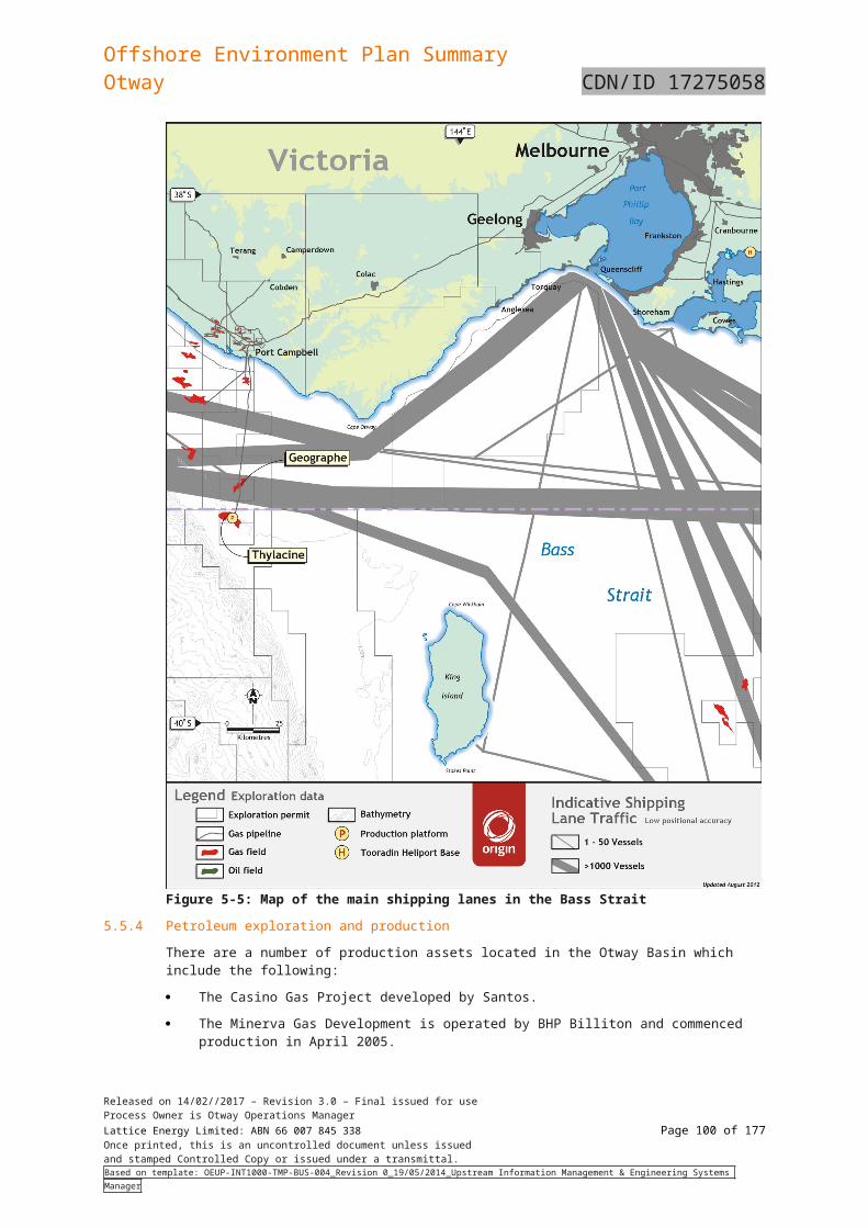
Offshore Environment Plan SummaryOtway CDN/ID 17275058
Environmental Sensitivity
Spill Scenario Description of Impact
at very low concentrations and period of exposure (5.7 µg/l and, to a lesser extent for some species, 2.5 µg/l over a 24 hour exposure period). Although direct and immediate impacts on survivability were noted, Johansen et al. (2017) identified long-term effects of exposure of pre-settlement stages on subsequent life history stages, namely settlement (habitat selection), avoidance of predation (anti-predator behaviours) and growth/survivability. Impacts were considered due to physiological and cognitive impairment, resulting in poor choices that increased pre- and post-settlement mortality (e.g. through increased predation, potential latent impacts on health such as possible cardiovascular injury). The concentrations and periods of exposure (60 ppb.hrs and 136.8 ppb.hrs based on 2.5 and 5.7 µg/l over a 24 hour exposure period, respectively) were much lower than those considered as a low level of exposure based on 99% species protection levels (576 ppb.hrs base on 6 ppb (= µg/l) over a 96 hour exposure period). This suggests that significant long-term impacts to reef fish populations may be occurring at or less than LC50 concentrations (6 ppb), but at much shorter periods of exposure (24 hours as opposed to 96 hours). The detection of these impacts on a day-to-day basis is not practicable – however, this information is valuable in informing the development of scientific monitoring of water quality (Study S1) and fish (Study S2) in the event of a hydrocarbon release.
Released on 14/02//2017 – Revision 3.0 – Final issued for useProcess Owner is Otway Operations ManagerLattice Energy Limited: ABN 66 007 845 338 Page 100 of 122Once printed, this is an uncontrolled document unless issuedand stamped Controlled Copy or issued under a transmittal.Based on template: OEUP-INT1000-TMP-BUS-004_Revision 0_19/05/2014_Upstream Information Management & Engineering Systems Manager
Offshore Environment Plan SummaryOtway CDN/ID 17275058
Environmental Sensitivity
Spill Scenario Description of Impact
Heritage (Maritime, Aboriginal)
BlowoutPipeline ruptureDiesel spill
Submerged shipwrecks may be exposed to dissolved aromatic or entrained oil in the event of a spill. However, this is unlikely to cause any damage to the wrecks. Partially exposed wrecks may be encountered by sea surface oil. Clean-up may then be required.Coastal Aboriginal heritage sites include mostly shell middens, some stone artefacts, a few staircases cut into the coastal cliffs, and at least one burial site. The various shell middens within the Port Campbell National Park and Bay of Islands Costal Park are close to coastal access points that are, in some cases, now visitor access points (Parks Victoria, 2006b). Shoreline contact with these sites could cause impacts. Rapid mobilisation would be required to prevent damage (see Table 10.2 of Part 2 of the OPEP.
Shorelines Blowout Pipeline rupture
Surface or entrained hydrocarbons reaching shorelines may have serious impacts on fauna utilising these habitats, such as seabirds and invertebrates. Such contact may impact the breeding success of these species and lead to oiling of individual animals. Food resources for shorebirds (i.e. intertidal benthic infaunal communities) may be impacted by the spill or as a result of shoreline clean-up operations, resulting in potential for indirect impacts to shorebird health and breeding success. While fine sediments are not as readily impacted as other substrates, oil can become incorporated through flocculation with sediment stirred up by storm activity or penetration through worm burrows and open plant stems. Pollutants that do penetrate fine sediments can persist for many years, increasing the likelihood of longer-term effects. This can have implications for species associated with these habitats as often they support large populations of migrating birds and indigenous sediment dwelling invertebrates, including bivalves, and are also nursery areas for some species.Shoreline sediments are capable of retaining oil contaminants for the greatest period of time, from several months to over 20 years (Baker 1999; Burns et al. 1994). Visible oil may disappear long before sediments are depleted of toxic hydrocarbons (Burns and Yelle 1992). Once incorporated into the sediment, the degradation of oil is significantly slowed (Nicodem et al. 1997). Anaerobic conditions further slow the degradation process (Burns et al. 2000).In general, exposed shores recover more quickly than sheltered shores. This is because strong wave action promotes the removal of contamination and the animals and plants of exposed shores tend to be more ephemeral and thus better able to recolonize an impacted shore quickly. Sell et al. (1999) reviewed 27 oil spill case histories in which studies on the recovery rate of rocky shores had been made and found that in only four cases was recovery delayed beyond three years. Recovery times have been suggested by authors as ranging from 3 to 4 years for an exposed rocky shore to over 12 for a sheltered shore such as a badly damaged salt marsh (Baker 1991; Sell et al. 1999).
Diesel spill Shoreline contact for dissolved hydrocarbons is possible, however once exposed to the atmosphere the dissolved hydrocarbon fraction would dissipate rapidly. Inter-tidal contact may affect habitat such as corals, macroalgae, bare substrate and seagrass.
Cetaceans BlowoutPipeline rupture
Whales and dolphins surface to breathe air and are therefore vulnerable to exposure to a hydrocarbon slick on the sea surface where they may inhale hydrocarbon vapours or be directly exposed to dermal contact with hydrocarbon products. Direct contact with oil can result in direct impacts to the animal, due to toxic effects if ingested, damage to lungs when inhaled at the surface, and damage to the skin and associated functions such as thermoregulation (AMSA 2010).Small doses of hydrocarbons, when aspirated, can cause damage to lung tissues. Studies on effects of petroleum
Released on 14/02//2017 – Revision 3.0 – Final issued for useProcess Owner is Otway Operations ManagerLattice Energy Limited: ABN 66 007 845 338 Page 101 of 122Once printed, this is an uncontrolled document unless issuedand stamped Controlled Copy or issued under a transmittal.Based on template: OEUP-INT1000-TMP-BUS-004_Revision 0_19/05/2014_Upstream Information Management & Engineering Systems Manager
Offshore Environment Plan SummaryOtway CDN/ID 17275058
Environmental Sensitivity
Spill Scenario Description of Impact
vapours on terrestrial mammals and seals show that, in cases of prolonged exposures and high concentrations, hydrocarbons are absorbed in organs and other tissues, causing damage to the brain and central nervous system. Short-term inhalation of petroleum vapours at concentrations similar to those found in oceanic spills may not necessarily be detrimental, either to tissue or to respiration. Ingested hydrocarbons, particularly the lighter fractions, can remain within the gastrointestinal tract and be absorbed into the bloodstream, irritating and/or destroying epithelial cells in the stomach and intestine [5].However, the predicted rapid evaporation and limited areas where surface slick thickness exceeds even the very low threshold from a spill associated with the project would limit the potential for harm from inhalation to very near the spill area and during or immediately following the release. Extended exposure is therefore considered highly unlikely. Hydrocarbon content in prey is unlikely to be present in sufficient quantities to be toxic to a cetacean, and most would be metabolised quickly. Some PAHs can accumulate in tissues of whales before they are eventually metabolised, however the likelihood that a cetacean would receive a sufficient dose to result in a toxic impact is low. Literature suggests whales and dolphins, which are highly mobile, are considered to have some ability to detect and avoid oil slicks. Numerous studies have been conducted on dolphins regarding their detection abilities, and in all instances, the representative test animals were able to identify the presence of the pollutant and actively avoided contact with surface slicks [212163]. Experiments on bottlenose dolphins, common throughout the GAB region, found that this species was able to detect and actively avoid a surface slick after a few brief contacts and that there were no observed adverse effects of the brief contacts with surface slick [104]. Daily aerial and vessel-based surveillance observed dolphins in the vicinity of the Montara oil spill, however there were no confirmed reports of impacts.Extensive studies [162] determined that direct surface fouling may pose little problem to these cetaceans due to their extraordinarily thick epidermal layer which is highly effective as a barrier to the toxic, penetrating substances found in petroleum. As for the risks from inhalation, the very small areas where surface oiling would exceed even low thresholds, and the rapid weathering of lighter (more toxic, components from condensate or light marine fuel oils, would limit the risk of exposure of cetaceans to direct dermal contact or potential ingestion of hydrocarbons. Cetaceans migrate through the area of the operation. Southern right whales frequent the area from May to October and use the area for breeding. Adult female/calf pairs would be more vulnerable due to the greater amount of time spent at the surface than the adults, increasing the likelihood of inhalation or ingestion. While generally the risk to cetaceans from a marine oil spill associated with the project is considered to be very low, a spill during the southern right whale breeding season would present the greatest risk to cetaceans. In the unlikely event of a spill, it will be monitored via aerial surveys to identify potential and actual exposure of cetaceans.
Diesel spill In the event of a spill, cetaceans within the area may come into contact with surface and entrained oil when surfacing to breathe or in surface waters. The effects of such contact would be expected to consist of irritation to the eyes. Volatile aromatic hydrocarbons evaporating from the spill may be inhaled by marine mammals, which would be most prevalent in the early stage of a spill. Such inhalation may result in injury, but it would not be expected to cause mortality. As cetaceans are air breathing and possess relatively impermeable skins, dissolved hydrocarbons would not be expected to result in measurable impacts.
Seals and sea lions BlowoutPipeline rupture
As described in Section 5, both the New Zealand fur-seal and the Australian fur-seal are listed marine species with both habitat and breeding known to occur within the ZPI. Seals present in areas affected by surface or entrained
Released on 14/02//2017 – Revision 3.0 – Final issued for useProcess Owner is Otway Operations ManagerLattice Energy Limited: ABN 66 007 845 338 Page 102 of 122Once printed, this is an uncontrolled document unless issuedand stamped Controlled Copy or issued under a transmittal.Based on template: OEUP-INT1000-TMP-BUS-004_Revision 0_19/05/2014_Upstream Information Management & Engineering Systems Manager
Offshore Environment Plan SummaryOtway CDN/ID 17275058
Environmental Sensitivity
Spill Scenario Description of Impact
Diesel spill hydrocarbons may potentially be oiled, which may result in illness or mortality. Pinnipeds are vulnerable to sea surface exposures in particular given they spend much of their time on or near the surface of the water, as they need to surface every few minutes to breathe, and regularly haul out on to beaches. As a result of exposure to surface oils, pinnipeds, with their relatively large, protruding, eyes are particularly vulnerable to effects such as irritation to mucous membranes that surround the eyes and line the oral cavity, respiratory surfaces, and anal and urogenital orifices. The potential for indirect impacts as a result of ingestion of contaminated fish and other prey is considered low given that the consequence to fish is considered to be localised and minor as mobile fauna may avoid harmful concentrations of dissolved hydrocarbons.Pinnipeds are also sensitive as they will stay near established colonies and haul-out areas, meaning they are less likely to practice avoidance behaviours. The Long Term Environmental Impact and Recovery report for the Iron Barren oil spill concluded that the number of pups born at Tenth Island in 1995 was reduced when compared to previous years, and that there was a strong relationship between the productivity of the seal colonies and the proximity of the islands to the oil spill, where islands close to the spill showed reduced pup production and islands more distant to the oil spill did not (Tasmanian SMPC 1999).Exposure to the low concentrations of surface or entrained hydrocarbons predicted by modelling of a worst feasible case spill is considered unlikely to result in significant impacts on seals or sea lions. Seals are noted to travel great distances for food and this may bring them into contact with the ZPI. Generally, there is the potential for pinnipeds throughout the area to be exposed to surface oil and shoreline exposures in haul out locations.
Released on 14/02//2017 – Revision 3.0 – Final issued for useProcess Owner is Otway Operations ManagerLattice Energy Limited: ABN 66 007 845 338 Page 103 of 122Once printed, this is an uncontrolled document unless issuedand stamped Controlled Copy or issued under a transmittal.Based on template: OEUP-INT1000-TMP-BUS-004_Revision 0_19/05/2014_Upstream Information Management & Engineering Systems Manager
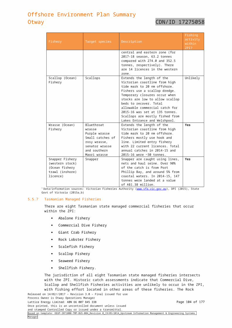
Offshore Environment Plan SummaryOtway CDN/ID 17275058
Environmental Sensitivity
Spill Scenario Description of Impact
Birds BlowoutPipeline ruptureDiesel spill
Birds may be affected by oil in several ways:
Oiling of feathers can cause the seabirds to lose buoyancy, sink and drown because of increased weight or lack of air trapped in the feathers.
Oil-coated birds’ may lose the ability to fly or feed resulting in starvation, dehydration, and, and becoming easy prey.
Contact with oil can cause feathers to collapse and matt and change the insulation properties leading to hypothermia.
Direct contact with oil can result in irritation or ulceration of the skin, eyes, mouth, or nasal cavities.
Ingestion of oil when preening or via their prey if their food chain becomes contaminated which can be sub-lethal or acute and will depend to a large extent on the type of oil, its weathering stage and inherent toxicity.
Birds foraging at sea have the potential to directly interact with oil on the sea surface some considerable distance from breeding sites in the course of normal foraging activities. Species most at risk include those that readily rest on the sea surface (such as shearwaters) and surface plunging species such as terns. As seabirds are top order predators, any impact on other marine life (e.g., fish kills) may disrupt and limit food supply both for the maintenance of adults and the provisioning of young.Although hydrocarbons ingested by birds during preening may be lethal, the most common cause of death is from drowning, loss of body heat and starvation following damage to the plumage by oil. Birds rely on the air trapped within their feathers to provide insulation and buoyancy. Feathers and down matted with oil lose their waterproofing and insulating properties and lead to death by drowning or hypothermia. Any spills of diesel or condensate would be rapidly lost from the sea surface, therefore minimising the potential for significant impact on seabirds.
In the case of seabirds, direct contact with hydrocarbons is likely to foul feathers, which may result in hypothermia due to a reduction in the ability of the bird to thermo-regulate and impair water-proofing. Direct contact with surface hydrocarbons may also result in dehydration, drowning and starvation (DSEWPC, 2011b; AMSA, 2015b). The greatest vulnerability in this case occurs when birds are feeding or resting at the sea surface (Peakall et al., 1987).Toxic effects of hydrocarbons on birds may result where the product is ingested as the bird attempts to preen its feathers. Whether this toxicity ultimately results in mortality will depend on the amount of hydrocarbons consumed and other factors relating to the health and sensitivity of the bird. Birds that are coated in oil also suffer from damage to external tissues including skin and eyes, as well as internal tissue irritation in their lungs and stomachs. Engelhardt (1983), Clark (1984), Geraci & St Aubin (1988) and Jenssen (1994) indicated that the threshold thickness of oil that could impart a lethal dose to some intersecting wildlife individual is 10 μm (~10 g/m2). Scholten et al (1996) indicates that a layer 25 μm thick would be harmful for most birds that contact the slick.Shorebirds are likely to be exposed to oil when it directly impacts the intertidal zone and onshore due to their feeding habitats. Shorebird species foraging for invertebrates on exposed sand and mud flats at lower tides will be at potential risk of both direct impacts through contamination of individual birds (ingestion or soiling of feathers) and indirect impacts through the contamination of foraging areas that may result in a reduction in available prey items (Clarke,
Released on 14/02//2017 – Revision 3.0 – Final issued for useProcess Owner is Otway Operations ManagerLattice Energy Limited: ABN 66 007 845 338 Page 104 of 122Once printed, this is an uncontrolled document unless issuedand stamped Controlled Copy or issued under a transmittal.Based on template: OEUP-INT1000-TMP-BUS-004_Revision 0_19/05/2014_Upstream Information Management & Engineering Systems Manager
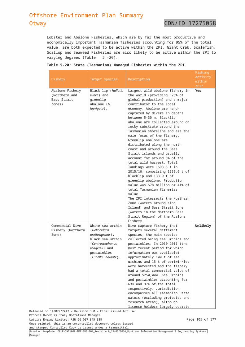
Offshore Environment Plan SummaryOtway CDN/ID 17275058
Environmental Sensitivity
Spill Scenario Description of Impact
2010).There is no direct impact mechanism of entrained or dissolved hydrocarbons on seabirds. Dissolved hydrocarbons may affect the distribution and abundance of prey species for seabirds, however given the restricted spatial extent modelled for the dissolved fraction at higher thresholds, such an effect would be negligible.Areas of importance for many seabirds occur around the Otway Basin. Nesting sites for many sea birds such as the Little Penguin (Eudyptula minor), Short-tailed Shearwater (Puffinustenuirostris) and Fairy Prion (Pachyptilaturtur) occur within inshore areas. There are reportedly six colonies of Little Penguin along the coast between Warrnambool and Port Campbell. These are considered to be significant as there are few mainland colonies.
Marine Reptiles BlowoutPipeline ruptureDiesel spill
Marine turtles are vulnerable to the effects of hydrocarbon spills at all life stages (eggs, post hatchlings, juveniles and adults) whilst in the water or onshore. Marine turtles are in frequent contact with the sea surface and they may also feed at or below the water surface or rest at the surface. It is possible that marine turtles may experience range of physical and/or toxic effects from exposure to hydrocarbons (NOAA, 2010):• Irritation and injury to airways or lungs, eyes and mucous membranes of the mouth, nasal or other cavities• Irritation and injury to skin• Ingestion of hydrocarbons through contaminated food or tar balls (injuring the salt-gland, digestive tract or other
organs with potentially lethal effects).Although the PMST report identified three marine turtle species that could potentially be present, there are no identified BIAs or nesting/feeding locations within the ZPI; therefore turtles are expected to be present as transient individuals only. In the unlikely event of a spill, individuals transiting through the area could come into contact with surface and entrained oil when surfacing to breathe. Volatile aromatic hydrocarbons evaporating from the spill may be inhaled, which would be most prevalent in the early stage of a spill; however it would not be expected to cause mortality.As marine reptiles are air breathing and possess relatively impermeable skins, dissolved hydrocarbons would not be expected to result in measurable impacts.
Fishes and Sharks BlowoutPipeline ruptureDiesel spill
Fish may be adversely affected if the oil coats their gills, reducing respiratory efficiency and increasing the incidence of irritation and infection. Impairment of feeding mechanisms, growth rates, development rates, energetics, reproductive output, recruitment rates and increased susceptibility to disease and other histopathological disorders are some examples of the types of sub-lethal effects that may occur with exposure to petroleum hydrocarbons (Capuzzo 1987).The dissolved component of a hydrocarbon spill may be toxic to fishes and sharks and this component may be absorbed by the gills or through the skin, or ingested/bioaccumulated from contaminated food resources. Monitoring studies conducted on demersal fish of the Timor Sea following the Montara oil spill did not detect any significant differences attributable to the spill between fish species sampled at either impact or reference sites for biomarker levels, including liver detoxification enzymes and DNA damage (Gagnon, 2012). Reproductive health of fish species was also found to be normal. The toxicity of dissolved hydrocarbons and dispersed oil to fish species has been the subject of many laboratory studies. Generally, concentrations in the range of 0.1 to 0.4μg/L have been shown to cause fish deaths in laboratory experiments (96 hour LC50), while a range of sub-lethal responses have been illustrated at concentrations down to
Released on 14/02//2017 – Revision 3.0 – Final issued for useProcess Owner is Otway Operations ManagerLattice Energy Limited: ABN 66 007 845 338 Page 105 of 122Once printed, this is an uncontrolled document unless issuedand stamped Controlled Copy or issued under a transmittal.Based on template: OEUP-INT1000-TMP-BUS-004_Revision 0_19/05/2014_Upstream Information Management & Engineering Systems Manager
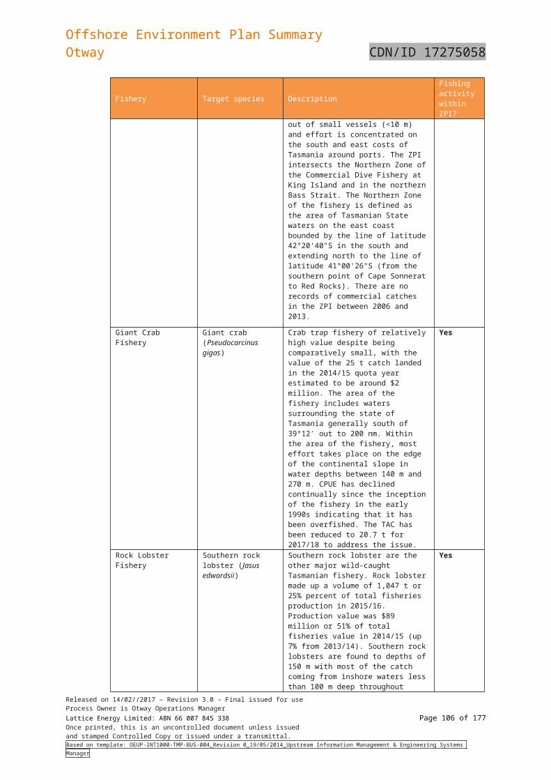
Offshore Environment Plan SummaryOtway CDN/ID 17275058
Environmental Sensitivity
Spill Scenario Description of Impact
about 0.01μg/L [5]. However, large scale fish mortalities are rarely observed to occur as a result of oil spills. This has generally been attributed to the possibility that pelagic fishes are able to detect and avoid direct contact with oil and move away from oil spills and that the exposure of elevated hydrocarbons at harmful concentrations is generally of a very short duration in open water environments. Many fish species have a planktonic larval stage, and larval and juvenile fish and crustaceans are considered to be more sensitive to hydrocarbon contamination as well as lacking the ability to move away from areas where hydrocarbons are detected in the water. Demersal fish and crustacean species, including southern rock lobster, are unlikely to be exposed to hydrocarbon concentrations that would cause impacts unless the spill were to occur in shallow, near shore areas. Given the restricted spatial area and depth limitations of any potential spill, impacts to fishes and sharks would be expected to be localised and minor as mobile fauna may avoid harmful concentrations of dissolved hydrocarbons.The potential risk of dissolved hydrocarbons to fish nurseries is considered possible where they occur in the 0-40 m depth range, but considered low due to the area of potential impact and duration of exposure relative to the potential nursery areas in the ZPI.
Other Users BlowoutPipeline ruptureDiesel spill
Other activities in the area include coastal communities, recreational fishing, tourism, oil and gas activities and commercial shipping. Other users would primarily be impacted by being displaced by the surface slick. As such, commercial and recreational fishing effort would be expected to be moved outside the area of the impact of the slick. In the event of oil stranding on a public use beach, there would likely be temporary disruption to public access if the oil was of a sufficient quantity to warrant shoreline cleaning. In any marine oil spill, public concern about risks is always a significant element. For example, even where there is absolutely no risk of contamination of seafood or harm to human health, it is likely that local fisheries will be temporarily impacted until clearance can be given through scientific testing. Beaches may be closed if oil sheens are observed in the vicinity.The area between Cape Otway and Port Campbell is frequented by tourists and there is a walking track following the cliffs and beaches of the area. It is a remote stretch of coast line dominated by cliffs with remote beaches subject to the high energy wave action. All beaches are described as highly hazardous. The main beaches along this stretch of coastline are Station Beach, Castle Cove, Johanna Beach, Milanesia Beach, Wreck Beach and beaches in the area of the Twelve Apostles Marine National Park. Road access to the shoreline is from Aire River campground, Castle Cove, Johanna Beach, The Gables lookout, Wreck Beach and the Twelve Apostles Marine Park. Access to the entire coastline is via a 7 to 8 day walking track from Apollo Bay ending at the Twelve Apostles.Recreation is also linked to the presence of marine fauna and direct impacts to marine fauna such as whales, birds, and pinnipeds can result in indirect impacts to recreational values. It is important to note that the impact from a public perception perspective may be even more conservative. This may deter tourists and locals from undertaking recreational activities. If this occurs, the attraction is temporarily closed, economic losses to the business are likely to eventuate. The extent of these losses would be dependent on how long the attraction remains closedModelling identifies accumulation of hydrocarbons on shorelines from Peterborough to Cape Otway. Recreational users of these shorelines may be impacted by the effect on visual amenity and restrictions on access and recreation fishing. There may also be potential for impacts to heritage and native title. Given the rapid weathering of any potential spill and low persistent fraction, impacts on other users would be expected to be minor.
Released on 14/02//2017 – Revision 3.0 – Final issued for useProcess Owner is Otway Operations ManagerLattice Energy Limited: ABN 66 007 845 338 Page 106 of 122Once printed, this is an uncontrolled document unless issuedand stamped Controlled Copy or issued under a transmittal.Based on template: OEUP-INT1000-TMP-BUS-004_Revision 0_19/05/2014_Upstream Information Management & Engineering Systems Manager
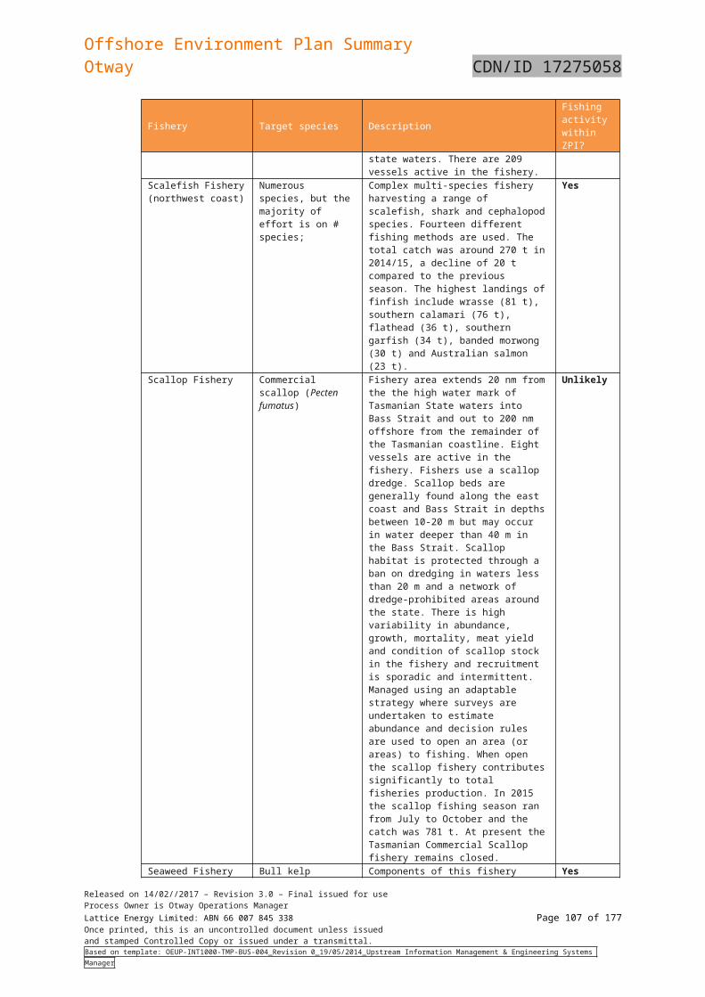
Offshore Environment Plan SummaryOtway CDN/ID 17275058
Table 6-29: Summary of environmental impacts, risks and control measures for oil spill response
Aspect Potential impacts Controls and mitigation measures
Oil spill response (RSK-9, 10, 11)
Spill modelling indicates very low probability of shoreline contact. Of all the hydrocarbon release scenarios considered, the scenarios involving a pipeline release (at or less than 3nm from the shoreline) and marine diesel spill from a vessel, is likely to reach the shore. Much of the shoreline (where modelling predicts spills to reach) comprises sheer rocky cliffs, interspersed with sandy beaches. Access to rocky cliffs too dangerous for clean-up purposes, and they are considered self-cleaning. Therefore, no secondary contamination or waste impacts were considered in the risk assessment. Access would only be to areas with safe access, such as sandy beaches to undertake shoreline assessment only.
If access at this location is not controlled it is possible that sensitive coastal vegetation, fauna habitat and aboriginal cultural heritage items could be damaged as a result of personnel and vehicle access.
Environmental impacts associated with mobilising the drilling rig to respond to an oil spill are similar to those of vessel/ drilling rig operations during normal operations, i.e. physical presence, light and noise, discharge of drilling muds and cuttings, etc.
Completion of annual emergency drills and exercises in accordance with OPEP.
Key emergency response personnel are trained and competent in accordance with OPEP.
Spill equipment and resources are immediately accessible Consultation undertaken with oil spill response stakeholders and
spill equipment and resource providers in accordance with the OPEP
OPEP is reviewed and updated at least annually Basic relief well plan (T-5100-35-MP-005) is developed and
maintained up to date. Operational scientific monitoring plan is developed and maintained
up to date. All vessels have an approved SOPEP in place. Emergency response plan contains specific response actions for
environmental emergencies and is maintained up to date SOPEP training for vessel marine crews is undertaken to schedule. Selection of helicopter service provider undertaken in accordance
with Origin’s procurement process which includes review of contractors HSE; and maintenance and integrity systems
Selection of drilling and cementing products with the lowest environmental risk ranking practicable, based on CHARM and OCNS, whilst meeting operational requirements
Solids control equipment, as defined in the Drilling Program, in place and operating for duration of drilling activity
Synthetic based muds are not discharged in bulk to the marine environment
Approved MODU safety case and environment plan in place in event drilling of a relief well is necessary
Stakeholder engagement and consultation conducted in accordance with the ERP and OPEP
Hydrocarbon spill incidents are escalated and managed in
Released on 14/02//2017 – Revision 3.0 – Final issued for useProcess Owner is Otway Operations ManagerLattice Energy Limited: ABN 66 007 845 338 Page 107 of 122Once printed, this is an uncontrolled document unless issuedand stamped Controlled Copy or issued under a transmittal.Based on template: OEUP-INT1000-TMP-BUS-004_Revision 0_19/05/2014_Upstream Information Management & Engineering Systems Manager
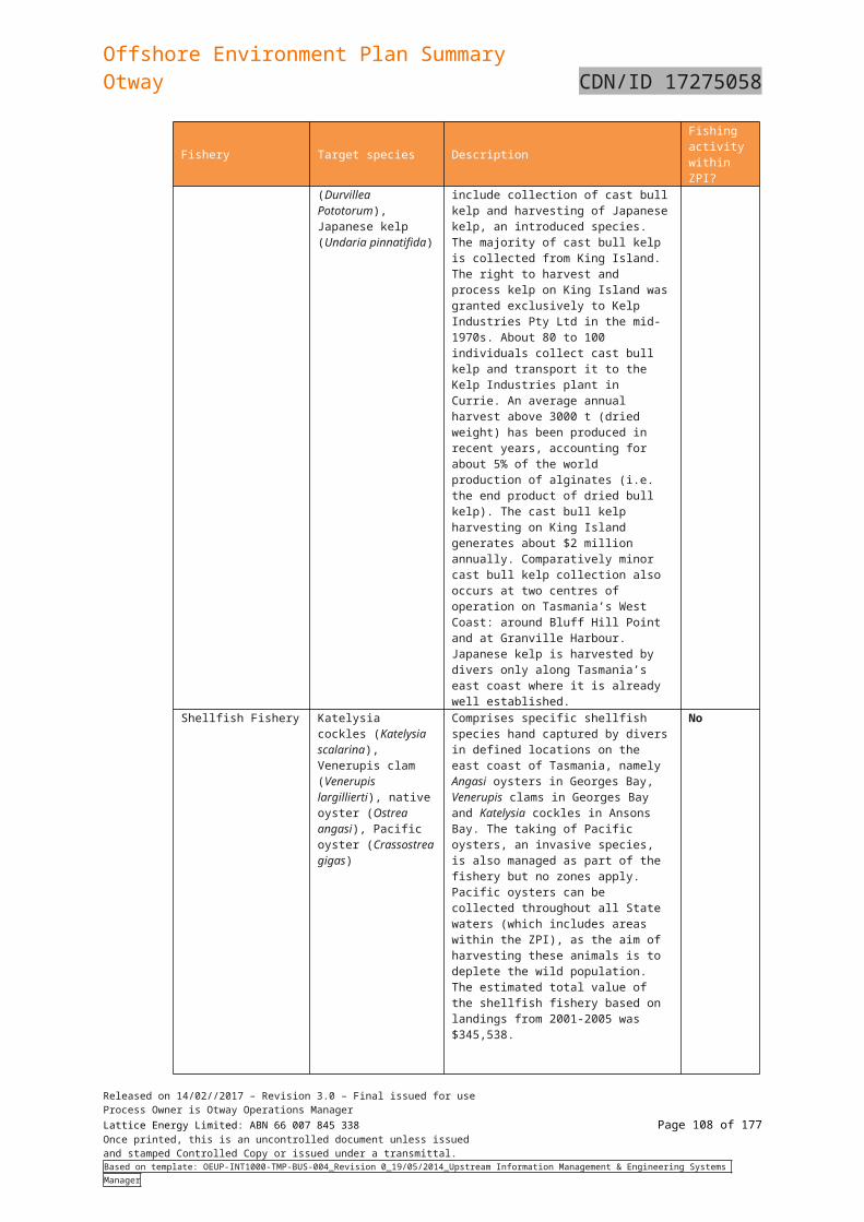
Offshore Environment Plan SummaryOtway CDN/ID 17275058
Aspect Potential impacts Controls and mitigation measures
accordance with the emergency response framework). Individuals undertake oil spill response actions in accordance with
the Otway Offshore Operations OPEP Part 2 –Appendix D– Individual Action.
Relief well plan is executed for well control incidents. Monitoring and evaluation activities undertaken in accordance with
the Otway Offshore Operations OPEP – Part 2, Section 5.2 and Section 6.2.
Any oiled wildlife is reported to the relevant oiled wildlife response agency, with support provided by emergency control agency only as directed.
Task specific HSE risk assessment undertaken for any shoreline assessment activities.
Operational scientific monitoring is executed in accordance with the Scientific Monitoring Implementation Plan.
Vessel master authorises actions in accordance with the vessel approved SOPEP to limit hydrocarbon spills.
The Australian Hydrographic Service (AHS) advised of the drilling of the relief well (location, timing) for issue of a Notice to Mariners.
Released on 14/02//2017 – Revision 3.0 – Final issued for useProcess Owner is Otway Operations ManagerLattice Energy Limited: ABN 66 007 845 338 Page 108 of 122Once printed, this is an uncontrolled document unless issuedand stamped Controlled Copy or issued under a transmittal.Based on template: OEUP-INT1000-TMP-BUS-004_Revision 0_19/05/2014_Upstream Information Management & Engineering Systems Manager
Offshore Environment Plan SummaryOtway CDN/ID 17275058
7. Implementation Strategy
7.1 Audit and review7.1.1 Audit
Environmental performance of the activity will be reviewed in a number of ways in line with the Origin Health, Safety, Environment Management System (HSEMS) Standard 20, which relates to audits, assessment and review. These reviews are undertaken to ensure that:
Environmental performance standards to achieve the environmental performance objectives are being implemented, reviewed and where necessary amended
Potential non-compliances and opportunities for continuous improvement are identified
All environmental monitoring requirements have been met.
An annual environmental performance audit will be undertaken to determine compliance of the development against the environmental performance outcomes and standards. The results of this audit will form part of the annual report submitted to the relevant regulator.
7.1.2 Management of non-compliance
Any non-compliance with the environmental performance standards outlined in the EP will be subject to investigation and follow-up action will be assigned as appropriate.
The findings and recommendations of inspections and audits will be documented and distributed to relevant personnel for comments. Any opportunities for improvement or non-compliances noted will be communicated to the Origin personnel at the time of the audit to ensure adequate time to implement corrective actions.
Tracking of non-compliances and audit actions will be undertaken using Origin’s incident management system (OCIS or similar).
Non-compliances are communicated to the offshore crew during daily toolbox meetings before each shift and at weekly HSE meetings.
7.1.3 Management of change
Changes to equipment, systems and documentation is in accordance with the Management of Change (MOC) Procedure to ensure that all proposed changes are adequately defined, implemented, reviewed and documented by suitably competent persons. This process provides assurance that all engineering and regulatory requirements have both been considered and met before any change is operational. The MOC process includes not just plant and equipment changes but also documented procedures where there is an HSE impact and organisational changes that impact personnel in safety critical roles.
The MOC process also includes the requirement for risk assessments depending on the level of risk associated with the proposed change. Identified hazards and control measures are added to the site risk register as part of the change.
Origin will undertake a review of the EP to ensure that any changes to legislation, science, stakeholder requirements or other management requirements are fully accounted for and assessed during EP reviews and prior to commencement of any new activities. This review will also ensure that the environmental impacts and risks of the activity continue to be identified and reduced to a level that is ALARP.
Origin has a subscription to Commonwealth Marine Reserves and considers published peer reviewed, scientific findings directly relevant to the environmental impacts of the offshore Otway operations. Relevant impacts and risks will be reassessed in light of the new findings and will be adjusted accordingly if required. If new information indicates a new environmental impact or risk, or an increase to an existing environmental impact or risk, an assessment of the significance of new or increased risk will be undertaken using the Origin impact and risk assessment process.
7.2 Incident management, emergency response and preparedness 7.2.1 Oil pollution emergency
In addition to the site Emergency Response Plan (ERP), Origin has prepared an activity specific Oil Pollution Emergency Plan (OPEP), which addresses specific hydrocarbon loss of containment risk events. The OPEP demonstrates that Origin is prepared to respond to an oil spill emergency through implementation of the OPEP. The OPEP describes the arrangements in place to facilitate an
Released on 14/02//2017 – Revision 3.0 – Final issued for useProcess Owner is Otway Operations ManagerLattice Energy Limited: ABN 66 007 845 338 Page 109 of 122Once printed, this is an uncontrolled document unless issuedand stamped Controlled Copy or issued under a transmittal.Based on template: OEUP-INT1000-TMP-BUS-004_Revision 0_19/05/2014_Upstream Information Management & Engineering Systems Manager
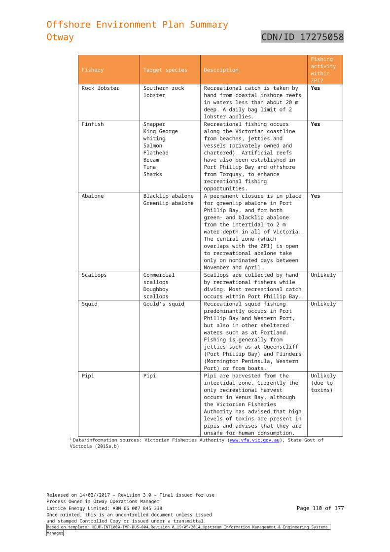
Offshore Environment Plan SummaryOtway CDN/ID 17275058
appropriate and effective response to worst case hydrocarbon spills that may occur during the operation of the Otway facilities. The OPEP should be read in conjunction with the Otway ERP and/or vessel’s Shipboard Oil Pollution Emergency Plan (SOPEP) as applicable, and the EP, which describes in detail the environmental and socio-economic values within the Zone of Potential Impact (ZPI) for a marine hydrocarbon spill. The OPEP includes a post spill environmental monitoring program. The following spill response measures will be implemented in the event of a loss of hydrocarbons.
Response Strategy
(in order of hierarchy)Description Response viable for identified scenarios
& hydrocarbon type?
Condensate (Well or pipeline loss of containment)
Marine Diesel (Vessel operation)
Monitor & Evaluate Actively monitor trajectory and natural weathering predictions via calculations, tracking buoys, aerial/vessel surveillance and shoreline assessment
Yes Yes
Assisted Natural Dispersion
Mechanical agitation of hydrocarbon
No Yes
Chemical Dispersants Application of chemicals to assist in natural dispersion and degradation of hydrocarbons
No No
Containment and Recovery
Collection of hydrocarbons using skimmers
No No
Protection and Deflection
Use of booms to re-direct hydrocarbon to a less environmental sensitive area
No No
Shoreline Assessment Identification of key shoreline characteristics, sensitivities and any observed hydrocarbon
Yes Yes
Shoreline Cleanup Manual cleanup and recovery using excavation, water washing, blasting, etc
No Yes
Scientific Monitoring Monitoring and evaluating environmental impacts
Yes Yes
7.2.2 Response Levels to Hydrocarbon Spills
7.2.2.1 Level 1 Spill
A Level 1 spill is defined as a spill with no further discharge possible and is within the response capabilities of the platform, or support vessel resources.
In terms of control agency:
Origin will remain in control of the response for Level 1 spills from the platform, subsea wells, pipeline or vessels conducting activity within the 500m platform exclusion zone
The vessel owner will be in control of Level 1 spills from the vessels outside of the 500m platform exclusion zone
Released on 14/02//2017 – Revision 3.0 – Final issued for useProcess Owner is Otway Operations ManagerLattice Energy Limited: ABN 66 007 845 338 Page 110 of 122Once printed, this is an uncontrolled document unless issuedand stamped Controlled Copy or issued under a transmittal.Based on template: OEUP-INT1000-TMP-BUS-004_Revision 0_19/05/2014_Upstream Information Management & Engineering Systems Manager
Offshore Environment Plan SummaryOtway CDN/ID 17275058
A summary of Level 1 control agencies is below.
Table 7-30: Level 1 Spill Control Agencies
Spill Scenarios Control Agency
Condensate release from platform, sub-sea installation or pipeline
Origin
Vessel loss of containment while conducting activity within the 500m platform exclusion zone
Vessel loss of containment not within the 500m platform exclusion zone
Vessel Owner
Level 1 response structure is as per the below:
In the event of any spill occurring where response is considered to be beyond the capability of Origin or the vessel’s resources, the response must be escalated immediately to the next Level.
7.2.2.2 Level 2 Spill
A Level 2 spill is defined as a spill that is beyond the capabilities of Origin and their on-site contractors on the platform or vessels.
In terms of control agency:
Origin will remain in control of the response for Level 2 spills in commonwealth waters from the platform, subsea wells or pipeline
Control of level 2 condensate and vessel spills within state waters will be handed to the relevant state government with continued support by Origin
Control of level 2 vessel spills within commonwealth waters will be handed to AMSA with continued support by Origin
For a Level 2 Spill, Origin will activate the Group Emergency Management Team (GEMT), which reflects the Australasian Inter-service Incident Management System (AIIMS) structure and who will ensure adequate response support/coordination is allocated.
A summary of Level 2 control agencies is below:
Table 7-2: Level 1 Spill Control Agencies
Spill Scenarios Control Agency
Condensate release from platform, sub-sea installation or pipeline impacting commonwealth waters (>3nm)
Origin
Released on 14/02//2017 – Revision 3.0 – Final issued for useProcess Owner is Otway Operations ManagerLattice Energy Limited: ABN 66 007 845 338 Page 111 of 122Once printed, this is an uncontrolled document unless issuedand stamped Controlled Copy or issued under a transmittal.Based on template: OEUP-INT1000-TMP-BUS-004_Revision 0_19/05/2014_Upstream Information Management & Engineering Systems Manager
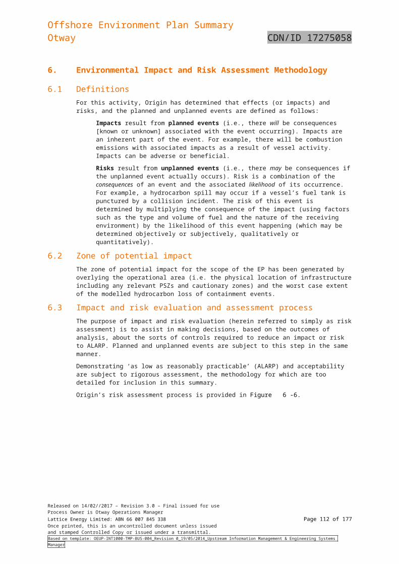
Offshore Environment Plan SummaryOtway CDN/ID 17275058
Condensate release from platform, sub-sea installation or pipeline impacting state waters (<3nm)pill Scenarios
Control Agency
Vessel spills impacting commonwealth waters (>3Nm)
AMSA
Vessel spills impacting state waters(<3Nm) Vic DEDJTR
Tas DPIPWE
In the event of a Level 2 spill, resources and personnel will be requested via the Australian Marine Oil Spill Centre (AMOSC) in Geelong, with whom Origin has an existing arrangement to provide spill response support. AMOSC will respond in accordance with AMOSPlan arrangements and will co-ordinate the deployment of the core group members and required resources, while also providing technical support. Members of the National Response Team can also be utilised through AMSA as necessary.
Level 2 / 3 response structure is as per the below:
Notes: 1. If AMOSC/OSRL personnel and resources are requested they will be incorporated into the Origin response structure.
Released on 14/02//2017 – Revision 3.0 – Final issued for useProcess Owner is Otway Operations ManagerLattice Energy Limited: ABN 66 007 845 338 Page 112 of 122Once printed, this is an uncontrolled document unless issuedand stamped Controlled Copy or issued under a transmittal.Based on template: OEUP-INT1000-TMP-BUS-004_Revision 0_19/05/2014_Upstream Information Management & Engineering Systems Manager
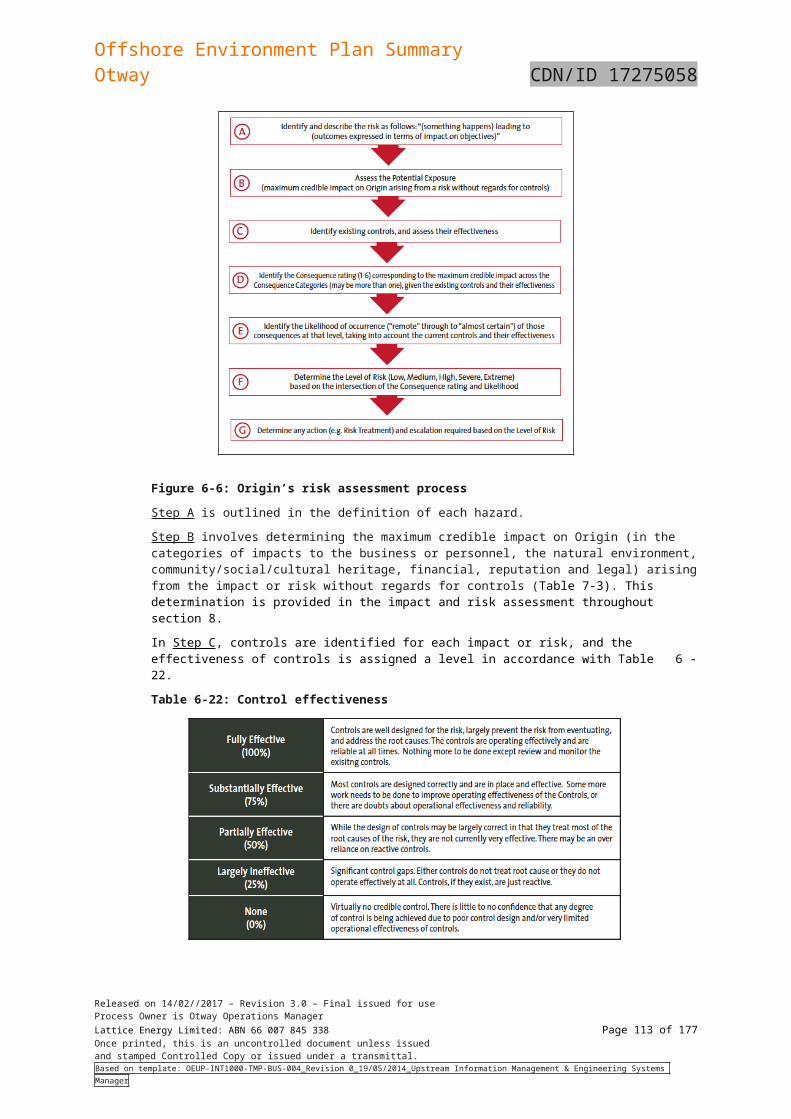
Offshore Environment Plan SummaryOtway CDN/ID 17275058
7.2.2.3 Level 3 Spill
A Level 3 spill is defined as a spill where the response is beyond the resources and capabilities of Origin and its national support agencies and international assistance is required to support the Level 2 response capacity. Control Agency responsibilities are as for Level 2 spills. Response structure for a Level 3 spill is the same as Level 2.
Origin can access international resources such as Oil Spill Response Limited (OSRL) through engagement at time of need to provide equipment and specialist resources to a Level 3 hydrocarbon spill if required.
7.2.3 Post Spill Monitoring
In the event of a spill, data from post-spill environmental monitoring studies will form a basis on which to develop restoration plans and inform the requirement for any subsequent detailed scientific studies required to assess long-term effects. Monitoring activities will continue until it is demonstrated that residual constituents do not pose a significant risk to human or ecological health.
Origin has a current Master Service Agreement in place with a reputable environmental consultant. Annual reviews of contracts and service providers are completed by Origin to confirm they still meet the required standards and are able to provide the contracted services. If any existing contractors are deemed unsuitable, a like service provider will be appointed. Should it be required, the environmental consultant will undertake scientific sampling and analysis to fulfil the requirements of the monitoring program. Detailed descriptions of how these plans would be implemented are developed within the Operational & Scientific Monitoring Plan Implementation Plan (OSMPIP).
7.2.4 Environmental emergency response manual
Origin’s environmental emergency manual is comprised of a suite of documents including: the Site Emergency Response Plan (ERP); Group Emergency Management Plan; and Crisis Management Plan.
7.2.5 Relief well planning
Drilling of a relief well is the most likely source control option for managing a well loss of control incident. The OPEP identifies in the response flowcharts when and how relief well planning is commenced in the event of an emergency. A basic relief well plan, (Relief Well Plan T-5100-35-MP-005), has been developed in line with OGUK guidance and ensures that Origin has considered the response requirements. The relief well plan is reviewed every 5 years, or in the event of a new well is drilled for the development. The OPEP includes the trigger for executing the relief well plan within the initial response arrangements.
7.2.6 Emergency response exercises
All personnel on site are informed of key elements of the Emergency Response Plan applicable to that site during induction and are notified of any changes as part of toolbox meetings. Visitors receive a modified version of this training as a part of their visitor induction.
A schedule of exercises and drills has been developed and is managed through the maintenance management system. Exercises and drills will be debriefed to capture learnings and opportunities for improvement and follow-up actions are captured via Origin’s electronic enterprise database (OCIS).
7.2.7 Oil spill response training
Regular (quarterly) training of vessel crew in SOPEP procedures is a MARPOL requirement for vessels over 400 GRT. During its contractor selection process, Origin will ensure that the chosen contractor has been implementing this requirement. This is linked to Origin Health, Safety, Environment Management System (HSEMS) Standard 13, which relates to the selection and management (including training) of contractors, suppliers, partners and visitors.
The OPEP will be tested when a significant modification to the plan has occurred or a new activity site is added. Exercises will be undertaken on at least an annual basis (section 7.2 of the OPEP). A summary of the training requirements is provided in section 7.4 of the OPEP.
7.3 Performance measurement and reportingIn accordance with the OPGGS (E) Regulations 14(2) and Vic OPGGS Regulations 16(2), Origin will submit a report on the environmental performance of the Otway offshore facilities to NOPSEMA and DEDJTR. Performance will be measured against the Environmental Performance Outcomes and Standards described in the EP. The report will be submitted not more than 3 months after the anniversary date of the EP acceptance by NOPSEMA. The interval between reports will not be more than 1 year.
Released on 14/02//2017 – Revision 3.0 – Final issued for useProcess Owner is Otway Operations ManagerLattice Energy Limited: ABN 66 007 845 338 Page 113 of 122Once printed, this is an uncontrolled document unless issuedand stamped Controlled Copy or issued under a transmittal.Based on template: OEUP-INT1000-TMP-BUS-004_Revision 0_19/05/2014_Upstream Information Management & Engineering Systems Manager
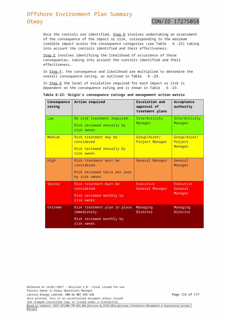
Offshore Environment Plan SummaryOtway CDN/ID 17275058
7.4 MonitoringOrigin will maintain a quantitative record of emissions and discharges as required under Regulation 14(7) of the OPGGS(E) and in line with HSEMS Standard 18 (Environmental effects and management).
Released on 14/02//2017 – Revision 3.0 – Final issued for useProcess Owner is Otway Operations ManagerLattice Energy Limited: ABN 66 007 845 338 Page 114 of 122Once printed, this is an uncontrolled document unless issuedand stamped Controlled Copy or issued under a transmittal.Based on template: OEUP-INT1000-TMP-BUS-004_Revision 0_19/05/2014_Upstream Information Management & Engineering Systems Manager
Offshore Environment Plan SummaryOtway CDN/ID 17275058
8. References
Advanced Geomechanics (2011) Technical Note Origin Doc No. S4200-RU-700699.
AFMA (2017a) Bass Strait Central Zone Scallop Fishery (Closure) Direction 2017. Authorised Version F2017L00873 registered 04/07/2017. Australian Fisheries Management Authority, Canberra, Australian Capital Territory
AFMA (2017b) Eastern Tuna and Billfish Fishery: Management Arrangements Booklet 2017/18. Australian Fisheries Management Authority, Canberra, Australian Capital Territory
AFMA (2017c) Southern and Eastern Scalefish and Shark Fishery: Management Arrangements Booklet 2017. Australian Fisheries Management Authority, Canberra, Australian Capital Territory
AMSA 2010, ‘The effects of maritime oil spills on wildlife including non-avian marine life’.
AMSA. 2015b. The effects of maritime oil spills on wildlife including non-avian marine life. A WWW database accessed at: http://www.amsa.gov.au/Marine_Environment_Protection/National_plan/General_Information/Oiled_Wildlife/Oil_Spill_Eff ects_on_Wildlife_and_Non-Avian_Marine_Life.asp. Australian Maritime Safety Authority. Canberra.
APASA (2017) Otway Basin Operations: Geographe and Thylacine– Quantitative Oil Spill Modelling prepared by RPS Australia West Pty Ltd, Revision 5.0 (MAQ0532J)
Arnould J.P.Y. & Kirkwood R. (2007). Habitat selection by female Australian fur seals (Arctocephalus pusillus doriferus). Aquatic Conservation: Marine and Freshwater Ecosystems. Vol. 17, suppl. 1, pp. S53
Baker, 1991. Guidelines on the biological impact of oil pollution. IPEICA Report Series, 1 (1991), pp. 1-15 Baker 1999, ‘Ecological effectiveness of oil spill countermeasures: how clean is clean?’, Pure Applied Chemistry, 71(1): 135-151.
Baker (1999) Ecological effectiveness of oil spill countermeasures: how clean is clean?, Pure Applied Chemistry, 71(1): 135-151.
Bannister, J.L., C.M. Kemper, and R.M. Warneke (1996). The Action Plan for Australian Cetaceans. Canberra: Australian Nature Conservation Agency. Available from: http://www.environment.gov.au/coasts/publications/cetaceans-action-plan/pubs/whaleplan.pdf
Barton, J, Pope, A and Howe, S (2012) Marine protected areas of the Otway bioregion Parks Victoria, Melbourne, Vic.
BHP Petroleum (1999). Minerva Gas Field development : Environmental Impact Statement and Environment Effects Statement
Black, K.P., Brand, G.W., Grynberg, H., Gwyther, D., Hammond, L.S., Mourtikas, S., Richardson, B.J., and Wardrop, J.A. (1994) Production facilities. In: Environmental implications of offshore oil and gas development in Australia – the findings of an independent scientific review. Swan, J.M., Neff, J.M. and Young, P.C. (eds) Australian Petroleum Exploration Association. Sydney. Pp 209-407.
Blakers, M.; Davies, S.J.J.F. & Reilly, P.N. (1984). The Atlas of Australian Birds. Carlton: Melbourne University Press. ISBN 0-522-84285-2.
Blumer, M. 1971. Scientific aspects of the oil spill problem. Environmental Affairs 1:54–73.
Boreen, T., James, N., Silson, C., Heggi, D (1993). Surfical cool-water carbonate sediments on the Otway continental margin, Southeastern Australia. Elsevier Science Publishers BV., Marine geology, 112 (1993) 35-56.
Brown, P.B. and Wilson, R.I. (1980) A Survey of the Orange-bellied Parrot Neophema chrysogaster in Tasmania, Victoria and South Australia. Tasmanian National Parks & Wildlife Service, Hobart.
Brusati ED, Grosholz ED (2006). Native and introduced eco-system engineers produce contrasting effects on estuarineinfaunal communities. BiolInv 8:683–695.
Burns, K. A. & Yelle, L. 1992, ‘The Galelta Oil Spill V: Relationship between sediment and organism hydrocarbon loads’, Estuarine Coastal Shelf Science.
Released on 14/02//2017 – Revision 3.0 – Final issued for useProcess Owner is Otway Operations ManagerLattice Energy Limited: ABN 66 007 845 338 Page 115 of 122Once printed, this is an uncontrolled document unless issuedand stamped Controlled Copy or issued under a transmittal.Based on template: OEUP-INT1000-TMP-BUS-004_Revision 0_19/05/2014_Upstream Information Management & Engineering Systems Manager
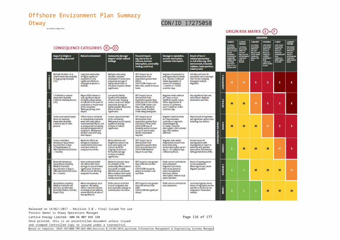
Offshore Environment Plan SummaryOtway CDN/ID 17275058
Burns, K. A., Codi, S. & Duke, N. C. 2000, ‘Gladstone, Australia field studies: Weather and degradation of hydrocarbons in oiled mangrove and salt marsh sediments with and without the application of an experimental bioremediation protocol’, Marine Pollution Bulletin, 41(7-12): 392-402.
Burns, K. A., Garrity, S. D., Jorissen, D., MacPherson, J., Stoelting, M., Tierney, J., and yelle-Simmons, L. 1994, ‘The Galeta oil spill. II. Unexpected persistence of oil trapped in mangrove sediments’, Estuarine, Coastal and Shelf Science, 38, 349- 364.
Capuzzo, J. M. 1987. Biological effects of petroleum hydrocarbons: Assessments from experimental results. In: Long-term Environmental Effects of Offshore Oil and Gas Development. D. F. Boesch, editor; and N. N. Rabalais, editor. [eds.]. Elsevier Applied Science, London, pp.343-410
Cintron, G., Lugo, A.E., Marinez, R., Cintron, B.B., Encarnacion, L. 1981. Impact of oil in the tropical marine environment. Prepared by Division of Marine Research, Department of Natural Resources. Puerto Rico.
Clark, R.B. 1984. Impact of oil pollution on seabirds. Environmental Pollution (Series A) 33:1–22
Cogger, H.G., E.E. Cameron, R.A. Sadlier, and P. Eggler. (1993). The Action Plan for Australian Reptiles. Canberra, ACT: Australian Nature Conservation Agency. Available from: http://www.environment.gov.au/biodiversity/threatened/action/reptiles/index.html
Commonwealth of Australia (2012) Conservation Management Plan for the Southern Right Whale. Available at http://www.environment.gov.au/system/files/resources/4b8c7f35-e132-401c-85be-6a34c61471dc/files/e-australis-2011-2021.pdf
Commonwealth of Australia (2015) National Conservation Values Atlas. Commonwealth of Ausralia, Canberra, viewed 1 August 2017, http://www.environment.gov.au/webgis-framework/apps/ncva/ncva.jsf
Commonwealth of Australia (2017) Conservation Management Plan for the Blue Whale. Available from https://www.environment.gov.au/system/files/resources/9c058c02-afd1-4e5d-abff-11cac2ebc486/files/blue-whale-conservation-management-plan.pdf
Commonwealth of Australia (2017b) Recovery for Marine Turtles in Australia. Available at http://www.environment.gov.au/system/files/resources/46eedcfc-204b-43de-99c5-4d6f6e72704f/files/recovery-plan-marine-turtles-2017.pdf
Compagno, L.J.V. (1984). Part 1 - Hexanchiformes to Lamniformes. FAO Species Catalogue, Vol. 4., Sharks of the World. An Annotated and Illustrated Catalogue of Sharks Known to Date. FAO Fisheries Synopsis. 4(1):1-249.
Currie, D.R., Isaacs, L.R. (2004). Impact of exploratory offshore drilling on bentic communities in the Minerva gas field, Port Campbell, Australia.
Daka, E. R., & Ekweozor, I. K. E. 2004, ‘Effects of size on the acute toxicity of crude oil to the mangrove oyster, Carasostrea gasar’, Journal of Applied Sciences & Environmental Management, 8(2): 19-22.
Dauvin, 1998. The fine sand Abra alba community of the Bay of Morlaix twenty years after the Amoco Cadiz oil spill. Marine Poll. Bull., 36 (1998), pp. 669-676
Dauvin, J.C. 1988 ‘Life-cycle, dynamics, and productivity of crustacea-amphipoda from the Western English-Channel 4. Ampelisca Armoricana Bellan-Santini-Et-Dauvin’ Journal of Experimental Marine Biology and Ecology, 123(3), 235-252.
Dauvin, J.C. 1989 ‘Life-cycle, dynamics and productivity of crustacea-amphipoda from the Western English-Channel 5. Ampelisca sarsi Chevreux’ Journal of Experimental Marine Biology and Ecology, 128(1), 31-56.
DEH (2005) Australian National Guidelines for Whale and Dolphin Watching. Department of Environment and Heritage
DEH (2005) Blue, Fin and Sei Whale Recovery Plan 2005–2010. Department of the Environment and Heritage, May 2005
DEH (2005) Humpback Whale Recovery Plan 2005–2010. Department of the Environment and Heritage, May 2005
DEH (2005) Whale Shark (Rhincodon typus) Recovery Plan 2005–2010. Department of the Environment and Heritage, May 2005
Released on 14/02//2017 – Revision 3.0 – Final issued for useProcess Owner is Otway Operations ManagerLattice Energy Limited: ABN 66 007 845 338 Page 116 of 122Once printed, this is an uncontrolled document unless issuedand stamped Controlled Copy or issued under a transmittal.Based on template: OEUP-INT1000-TMP-BUS-004_Revision 0_19/05/2014_Upstream Information Management & Engineering Systems Manager
Offshore Environment Plan SummaryOtway CDN/ID 17275058
DELWP (2016) National Recovery Plan for the Orange-bellied Parrot, Neophema chrysogaster. Department of Environment, Land, Water and Planning, 2016
Department of Environment (2015a). Wildlife Conservation Plan for Migratory Shorebirds. Canberra, ACT: Department of the Environment, viewed 1 August 2017, http://www.environment.gov.au/biodiversity/publications/wildlife-conservation-plan-migratory-shorebirds
Department of Environment (2015b) Sharks in Australian waters. A WWW database accessed at http://www.environment.gov.au/coasts/species/sharks/greatwhite/index.html. Department of the Environment. Canberra.
Department of Environment (2016c) SPRAT Profile (Fairy Tern). A WWW database accessed in July 2016 at http://www.environment.gov.au/cgi-bin/sprat/public/publicspecies.pl?taxon_id=82950
Department of Environment (2016d) SPRAT Database (Little Tern). A WWW database accessed in July 2016 at http://www.environment.gov.au/cgi-bin/sprat/public/publicspecies.pl?taxon_id=813
Department of Environment (2016e) SPRAT Database (Fairy Prion). A WWW database accessed in July 2016 at http://www.environment.gov.au/cgi-bin/sprat/public/publicspecies.pl?taxon_id=64445
Department of Environment (2017ab). Rhincodon typus in Species Profile and Threats Database, Department of the Environment, Canberra. Available from: http://www.environment.gov.au/sprat. Accessed Wed, 2 Aug 2017 16:28:50 +1000.
Department of Environment (2017r). Calidris canutus in Species Profile and Threats Database, Department of the Environment, Canberra. Available from: http://www.environment.gov.au/sprat. Accessed Thu, 27 Jul 2017 16:44:17 +1000.
Department of Environment (2017x). Calidris ferruginea in Species Profile and Threats Database, Department of the Environment, Canberra. Available from: http://www.environment.gov.au/sprat. Accessed Mon, 31 Jul 2017 10:59:16 +1000.
Department of Primary Industries (2015) Fisheries Victoria Commercial Fish Production Information Bulletin 2015. Department of Primary Industries, Fisheries Victoria, Queenscliff, Victoria
Department of Primary Industries, Water and Environment (DPIPWE 2015#). Australian fisheries and aquaculture statistics 2014-15 (ABARES 2016), Department of the Environment and Energy (DotEE 2017#), Fish Research and Development Corporation (FRDC, 2017#)
Department of Sustainability and Environment (2008a). Background and Implementation Information for the Australian Grayling Prototroctes maraena National Recovery Plan. State of Victoria Department of Sustainability and Environment. East Melbourne.
Department of Sustainability and Environment (2008b). National Recovery Plan for the Australian Grayling Prototroctes maraena. State of Victoria Department of Sustainability and Environment. East Melbourne.
Director of National Parks (2013). South-East Commonwealth Marine Reserves Network Management Plan 2013–23. Department of Environment Canberra, viewed 28 July 2017, http://www.environment.gov.au/system/files/pages/de2de49a-7eed-4a70-bfbb-463f8d00f2ca/files/se-networkmanagement-plan2013-23.pdf
DSEWPaC (2011) Corner Inlet Ramsar site Ecological Character Description. Department of Sustainability, Environment, Water, Population and Communities, 2011
DSEWPaC (2011b) National Recovery Plan for Threatened Albatrosses and Giant Petrels 2011–2016
Duncan, A.J., Gavrilov, A.N., McCauley, R.D., Parnum, I.M. and Collis, J.M (2013). Characteristics of sound propagation in shallow water over an elastic seabed with a thin cap-rock layer. J. Acoust. Soc. Am:134, pp. 207-215.
Engelhardt, F.R. 1983. Petroleum Effects on Marine Mammals. Aquatic Toxicology. 4: 199–217.
Fandry, C. B (1983). Model for the three-dimensional structure of winddriven and tidal circulation in Bass Strait, Aust. J. Mar. Freshwater Res., 34, 121–141.Fandry 1983
Gagnon, M.M. and Rawson, C., 2012. Montara Well Release, Monitoring Study S4A Phase IV – Assessments of Effects on Timor Sea Fish. Curtin University, Perth, Western Australia. 66pp.
Released on 14/02//2017 – Revision 3.0 – Final issued for useProcess Owner is Otway Operations ManagerLattice Energy Limited: ABN 66 007 845 338 Page 117 of 122Once printed, this is an uncontrolled document unless issuedand stamped Controlled Copy or issued under a transmittal.Based on template: OEUP-INT1000-TMP-BUS-004_Revision 0_19/05/2014_Upstream Information Management & Engineering Systems Manager
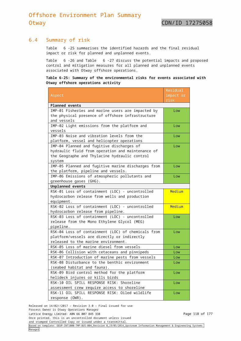
Offshore Environment Plan SummaryOtway CDN/ID 17275058
Gavine, F. M., Ingram, B. A., Hardy-Smith, P., and Doroudi, M. (2009). Biosecurity Control Measures for Abalone Viral Ganglioneuritis: A Code of Practice. Prepared as part of FRDC Project No. 2006/243.
Geraci, J.R. and St. Aubin, D.J. 1988. Synthesis of Effects of Oil on Marine Mammals. Report to US Department of the Interior, Minerals Management Service, Atlantic OCS Region, OCS Study. Ventura, California.
Gesteira, J.L.G., J.C. Dauvin 2005 ‘Impact of the Aegean Sea oil spill on the subtidal fine sand macrobenthic community of the Ares-Betanzos Ria (Northwest Spain)’ Marine Environmental Research, 60(3), 289-316.
Gill, P. and M. Morrice (2003). Cetacean Observations. Blue Whale Compliance Aerial Surveys. Santos Ltd Seismic Survey Program Vic/P51 and P52. November – December 2002. Report to Santos Ltd.
Gill, P.C., M.G. Morrice, B. Page, R. Pirzl, A.H. Levings and M. Coyne (2011). Blue whale habitat selection and within-season distribution in a regional upwelling system off southern Australia. Marine Ecology Progress Series, 421: 243–263. Available from: http://www.int-res.com/articles/meps_oa/m421p243.pdf
Gill, P.C., R. Pirzl, M.G. Morrice & K. Lawton (2015). Cetacean diversity of the continental shelf and slope off southern Australia. The Journal of Wildlife Management.
Higgins, P.J. & S.J.J.F. Davies, eds (1996). Handbook of Australian, New Zealand and Antarctic Birds. Volume Three - Snipe to Pigeons. Melbourne, Victoria: Oxford University Press.
Hoff, R.Z., Shigenaka, G., 1999. Lessons from 10 years of post-Exxon Valdez monitoring of intertidal shorelines. Proceedings of the 1999 International Oil Spill Conference, Seattle, Washington, USA. Publication of the American Petroleum Institute, pp. 111–117
Hofmeyr, G. and Gales, N. (2008) Arctocephalus pusillus. In: IUCN 2011. IUCN Red List of Threatened Species.Version 2011.2
Hume F., Hindell M.A., Pemberton D. & Gales R. (2004). Spatial and temporal variation in the diet of a high trophic level predator, the Australian fur seal (Arctocephalus pusillus doriferus). Marine biology. Vol. 144, no. 3, pp. 407-415.
Hutchinson, N., Hunt, T. and Morris, L. (2010). Seagrass and Reef Program for Port Phillip Bay: Temperate Reefs Literature Review. Fisheries Victoria Technical Report No.11. Department of Primary Industries. Victoria.
IPIECA-IOGP, 2015. Impacts of oil spills on marine ecology.: Good practice guidelines for incident management and emergency response personnel. IPIECA-IOGP, 52pp.
Jenssen, B.M. 1994. Effects of Oil Pollution, Chemically Treated Oil, and Cleaning on the Thermal Balance of Birds. Environmental Pollution, 86:207–215.
Jones, ISF and Padman, L (1983). Semidiurnal internal tides in eastern Bass Strait. Australian Journal of Marine and Freshwater Research 34 , 159–171.
JP Kenny (2012) Otway Phase 3 Rock Bolting Installation Procedure. SapuraClough Doc no. 12300-50-G-0001.
Kato, H. J. Bannister, C. Burton, D. Ljungblad, K. Matsuoka & H. Shimada (1996). Report on the Japan/IWC Blue Whale Cruise 1995-96 off the Southern Coast of Australia. Paper SC/48/SH9 presented to the IWC Scientific Committee. Unpublished
Keough and Butler (1996) as cited in Hutchinson (2010). Kimmerer W.J. & McKinnon A.D. (1984). Zooplankton Abundances in Bass Strait and WesteEnsco 102 Tasmanian Shelf Waters, March 1983.
Kirkwood, R., Warneke, R.M., Arnould. J.P. 2009. Recolonization of Bass Strait, Australia, by the New Zealand fur seal, Arctocephalus forsteri. Marine Mammal Science 25(2): 441–449.
Klimey, A.P. and Anderson, S.D. 1996. Residency patterns of White Sharks at the South Farrallone Islands, California. In: Great White Sharks: The biology of Carcharodon carcharias. Edited by A.P. Klimley & D.G. Ainley. Academic Press, New York USA.
Knuckey I, Koopman M, Hudson R, Davis M, Sullivan A (2017) Bass Strait and Central Zone Scallop Fishery – 2017 Survey. AFMA Project 2016/0806. Fishwell Consulting, Queenscliff, Victoria
Released on 14/02//2017 – Revision 3.0 – Final issued for useProcess Owner is Otway Operations ManagerLattice Energy Limited: ABN 66 007 845 338 Page 118 of 122Once printed, this is an uncontrolled document unless issuedand stamped Controlled Copy or issued under a transmittal.Based on template: OEUP-INT1000-TMP-BUS-004_Revision 0_19/05/2014_Upstream Information Management & Engineering Systems Manager
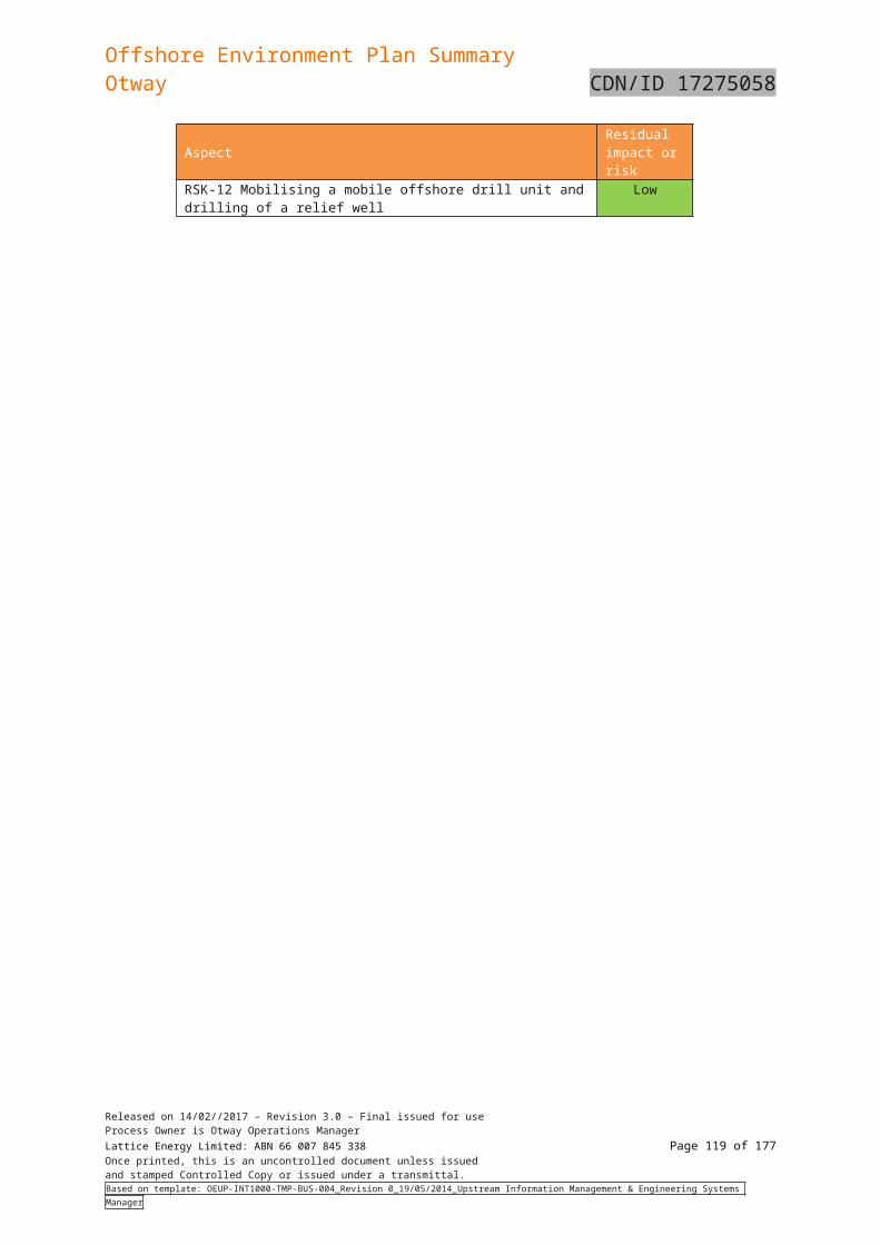
Offshore Environment Plan SummaryOtway CDN/ID 17275058
Limpus, C.J. (2008). A biological review of Australian Marine Turtles. 1. Loggerhead Turtle Carettacaretta (Linneaus). Queensland Environment Protection Agency. Available from: http://www.epa.qld.gov.au/publications/p02785aa.pdf/A_Biological_Review_Of_Australian_Marine_Turtles_1_Loggerhead_Turtle_emCaretta_Caretta/em_Linnaeus.pdf.
Loyn, R.H., Lane, B.A., Chandler, C and Carr, G.W. (1986) Ecology of Orange-bellied Parrots Neophema chrysogaster at their main remnant wintering site. Emu. 86:195-206.
McCauley and Duncan (2001). Marine Acoustic Effects Study, Blue Whale Feeding Aggregations, Otway Basin, Bass Strait Victoria, Centre for Marine Science and Technology, Curtin University March 2001 For Ecos Consulting.
McCauley, R.D., Fewtrell, J., Duncan, A.J., Jenner, C., Jenner, M.N., Penrose, J.D., Prince, R.I.T., Adhitya, A., Murdoch, J., and McCabe, K (2003). Marine Seismic Surveys: Analysis and propagation of air-gun signals; and effects of air-gun exposure on humpback whales, sea turtles, fish and squid. In APPEA Environmental implications of offshore oil and gas development in Australia: further research.
McInnes, K. L. and Hubbert, G. D (2003). A numerical modelling study of storm surges in Bass Strait. Australian Meteorological Magazine 52(3).
Miller, B.S., N. Kelly, M.C. Double, S.J. Childerhouse, S. Laverick & N. Gales (2012). Cruise report on SORP 2012 blue whale voyages: development of acoustic methods. Paper SC/64/SH11 presented to the IWC Scientific Committee.
Mollet, H.F., Cliff, G., Pratt Jr, H.L. and Stevens, J.D. 2000. Reproductive Biology of the female shortfin mako, Isurus oxyrinchus Rafinesque, 1820, with comments on the embryonic development of lamnoids. Fish. Bull. 98: 299-318.
Morrice, M.G, P.C. Gill, J. Hughes & A.H. Levings (2004). Summary of aerial surveys conducted for the Santos Ltd EPP32 seismic survey, 2-13 December 2003. Report # WEG-SP 02/2004, Whale Ecology Group-Southern Ocean, Deakin University. unpublished.
National Oceanic and Atmospheric Administration (NOAA) (2010). Oil and Sea Turtles: biology planning and response, US Department of Commerce, National Oceanic and Atmospheric Administration, National Ocean Service, Office of Response and Restoration, 116 pp.
Nicodem, D. E., Fernandes, M. C. Z., Guedes, C. L. B. & Correa, R. J. 1997, ‘Photochemical processes and the environmental impact of petroleum spills’, Biogeochemistry, 39: 121-138.
NOO (2002). Ecosystems – Nature’s diversity: The South-east Regional Marine Plan Assessment Reports. National Oceans Office. Hobart.
NRDA. 2012. April 2012 Status Update for the Deepwater Horizon Oil Spill. A WWW publication Available online at: http://www.gulfspillrestoration.noaa.gov. Natural Resource Damage Assessment.
Origin (2011). Otway Gas Project Field Development Plan Revision VIC/L23, T/L2 and T/L3 (S4000-RB-701448), Revision 0
Origin (2014a). Geographe Wells Annulus Operation and Monitoring (CDN/ID 3974143)
Origin (2014b). Geographe Wells Methanol Injection (CDN/ID 3974144)
Origin (2015). Hazardous Materials – Approval and Control (CDN/ID 3675133)
Origin (2017a). Otway Development Thylacine-A Platform safety case Part 1 Summary and
Origin (2017f). Otway development – Otway pipeline system safety case – Part 4: Formal safety assessment (CDN/ID 5214703), Revision 3
Origin (2017h). Otway Development Otway pipeline systems safety case Part 1 Summary and introduction (CDN/ID 5214700)
Origin (2017i). Risk Management Plan. (CDN/ID 3674818)
Pade, N.G., N. Queiroza, N.E. Humphries, M.J. Witt, C.S. Jones, L.R. Noble, and D.W. Sims (2009). “First results from satellite-linked archival tagging of porbeagle shark, Lamnanasus: Area fidelity, wider-scale movements and plasticity in diel depth changes”. Journal of Experimental Marine Biology and Ecology, 370 (1–2): 64–74.
Parks Victoria (2006b) . Twelve Apostles Marine National Park and The Arches Marine Sanctuary Management Plan. Parks Victoria, Melbourne, viewed 1 August 2017, http://parkweb.vic.gov.au/__data/assets/pdf_file/0020/313445/Twelve-Apostles-Marine-
Released on 14/02//2017 – Revision 3.0 – Final issued for useProcess Owner is Otway Operations ManagerLattice Energy Limited: ABN 66 007 845 338 Page 119 of 122Once printed, this is an uncontrolled document unless issuedand stamped Controlled Copy or issued under a transmittal.Based on template: OEUP-INT1000-TMP-BUS-004_Revision 0_19/05/2014_Upstream Information Management & Engineering Systems Manager
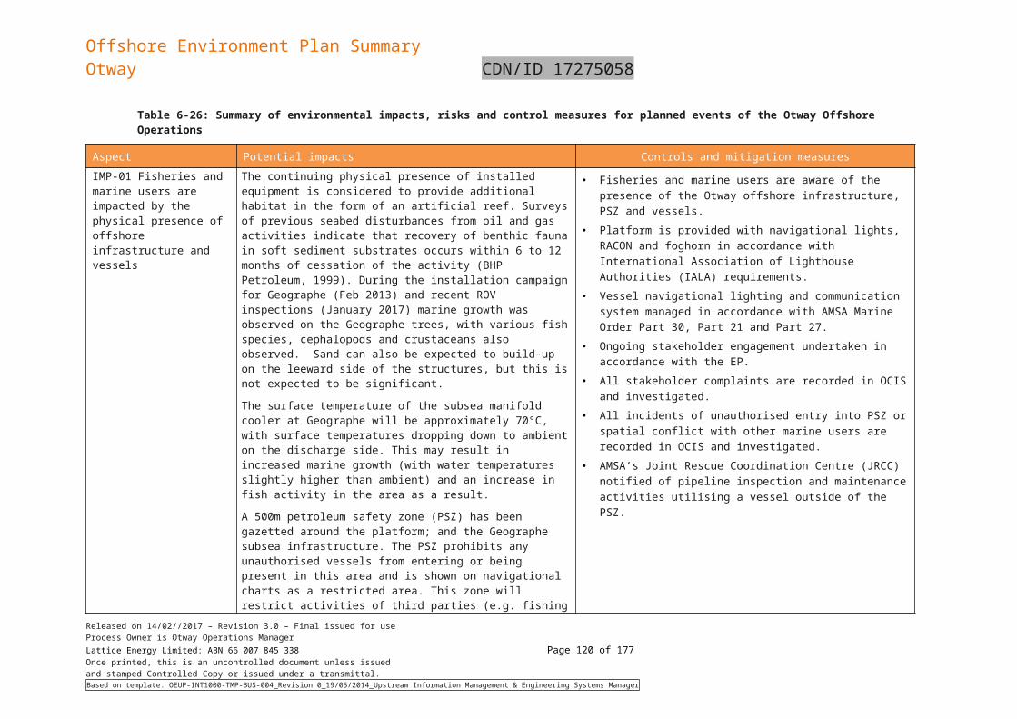
Offshore Environment Plan SummaryOtway CDN/ID 17275058
Parry, G.D., Campbell, S.J., and Hobday, D.K. (1990) Marine resources off East Gippsland, Southeastern Australia. Technical Report No. 72, Marine Science Laboratories. Queenscliff, Victoria.
Peakall, D.B., Wells, P.G. and Mackay, D. 1987. A Hazard Assessment of Chemically Dispersed Oil Spills and Seabirds. Marine Environmental Research, 22(2): 91–106.
Plotkin, P.T., M.K. Wicksten, and A.F. Amos (1993). Feeding ecology of the loggerhead sea turtle Carettacaretta in the northwestern Gulf of Mexico. Marine Biology, 115(1):1.
Poore, G.C.B., Wilson, R.S., Gomon, M., and Lu, C.C. (1985) Museum of Victoria Bass Strait Survey, 1979-1984.Museum of Victoria: Melbourne.
Ren, L., Huang, X-D., McConkey, B.J., Dixon, D.G. and Greenberg, B.M. 1994. Photoinduced toxicity of three polycyclic aromatic hydrocarbons (Fluoranthene, Pyrene and Napthalene) to the duckweed Lemna gibba. Ecotoxicology and Environmental Safety 28:160–170.
Richardson, W.J., C. Greene Jr., C.I. Malme, and D.H. Thomas (1995). Marine mammals and noise. Academic Press, San Diego, California.
Robinson S., Gales R., Terauds A. & Greenwood M. (2008). Movements of fur seals following relocation from fish farms. Aquatic Conservation: Marine and Freshwater Ecosystems. Vol. 18, no. 7, pp. 1189-1199
Santos (2004). Casino Gas Field Development Environment Report. Prepared by Enesar Consulting Pty Ltd. Hawthorn East, Victoria
Saunders, D.L. & C.L. Tzaros (2011). National Recovery Plan for the Swift Parrot (Lathamus discolor). Birds Australia, Melbourne. Available from: http://www.environment.gov.au/biodiversity/threatened/publications/recovery/lathamus-discolor.html. In effect under the EPBC Act from 10-Feb-2012.
State Govt of Victoria (2015a) Victorian Wild Harvest Abalone Fishery Management Plan. State of Victoria, Department of Economic Development, Jobs, Transport and Resources. Melbourne, Victoria
State Govt of Victoria (2015b) The Victorian Scallop (Ocean) Fishery: Information to inform assessment of the Victorian Scallop (Ocean) Fishery under the Environment Protection and Biodiversity Conservation Act 1999. State of Victoria, Department of Economic Development, Jobs, Transport and Resources. Melbourne, Victoria.
Threatened Species Scientific Committee (2011) Botaurus poiciloptilus (Australasian Bittern) Conservation Advice. Threatened Species Scientific Committee 2011
Threatened Species Scientific Committee (2011). Commonwealth Conservation Advice on Botaurus poiciloptilus (Australasian Bittern). Department of Sustainability, Environment, Water, Population and Communities. Canberra, ACT: Department of Sustainability, Environment, Water, Population and Communities. Available from: http://www.environment.gov.au/biodiversity/threatened/species/pubs/1001-conservation-advice.pdf. In effect under the EPBC Act from 03-Mar-2011.
Threatened Species Scientific Committee (2011)Sternula nereis nereis (Fairy Tern) Conservation Advice.
Threatened Species Scientific Committee (2015) Halobaena caerulea (blue petrel) conservation
URS (2001). Review of Environmental Impacts of Petroleum Exploration and Appraisal Activities in Commonwealth Waters. Report prepared for the Department of Science & Resources
Victorian Government 2016. Marine Pests and Disease, Abalone Disease, Background and Impact downloaded on July 3 2016 at http://agriculture.vic.gov.au/fisheries/policy-and-planning/marine-pests-and-diseases/abalone-disease/background-and-impact
Watson C.F.&Chaloupka M.Y. (1982). Zooplankton of Bass Strait: Species Composition, Systematics and Artificial key to Species.Tasmanian Institute of Marine Science Technical Report No. 1.
WDCS (2004). Oceans of Noise. A WWW publication accessed at http://www.wdcs.org. Whales and Dolphin Conservation Society. United Kingdom.
Wilson R.S. & Poore G.C.B. (1987). The Bass Strait Survey: Biological Sampling Stations, 1979- 1984.
Released on 14/02//2017 – Revision 3.0 – Final issued for useProcess Owner is Otway Operations ManagerLattice Energy Limited: ABN 66 007 845 338 Page 120 of 122Once printed, this is an uncontrolled document unless issuedand stamped Controlled Copy or issued under a transmittal.Based on template: OEUP-INT1000-TMP-BUS-004_Revision 0_19/05/2014_Upstream Information Management & Engineering Systems Manager
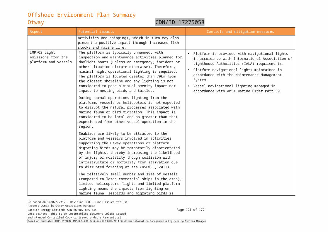
Offshore Environment Plan SummaryOtway CDN/ID 17275058
Zieman, J.C., Orth, R., Phillips, R.C., Thayer, G.W. and Thorhaug, A. 1984. The effects of oil on seagrass ecosystems. In: Cairns J, J., Buikema J, A.L. (eds) Restoration of Habitats Impacted by Oil Spills. Butterworth, London.
Released on 14/02//2017 – Revision 3.0 – Final issued for useProcess Owner is Otway Operations ManagerLattice Energy Limited: ABN 66 007 845 338 Page 121 of 122Once printed, this is an uncontrolled document unless issuedand stamped Controlled Copy or issued under a transmittal.Based on template: OEUP-INT1000-TMP-BUS-004_Revision 0_19/05/2014_Upstream Information Management & Engineering Systems Manager
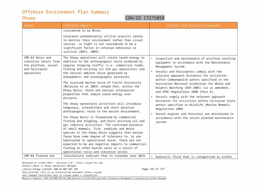
Offshore Environment Plan SummaryOtway CDN/ID 17275058
9. Document Information and History
DOCUMENT CUSTODIAN
Position Name
Otway Operations Manager Mark Sanford
PROCESS MAINTAINER
Position Name
Environmental Advisor Shane Reynolds
DOCUMENT HISTORY
Rev Date Detailed Changes made in Document
Prepared Checked Approved
A 12/11/2014 Draft issued for internal review JB TH
0 13/11/2014 Issued for use TH SC/PD JM
1 09/01/2015 Reissued after NOPSEMA comment
JB TH JM
1.1 22/11/2017 Draft – Issued for internal review based on DEDJTR and NOPSEMA approved EP revision 7
S2V Consulting
KH
2.0 27/11/2017 Final – Issued to DEDJTR and NOPSEMA for acceptance
KH SC JM
3.0 14/02/2018 Final – Reissued to DEDJTR and NOPSEMA for acceptance
SD KH MS
Released on 14/02//2017 – Revision 3.0 – Final issued for useProcess Owner is Otway Operations ManagerLattice Energy Limited: ABN 66 007 845 338 Page 122 of 122Once printed, this is an uncontrolled document unless issuedand stamped Controlled Copy or issued under a transmittal.Based on template: OEUP-INT1000-TMP-BUS-004_Revision 0_19/05/2014_Upstream Information Management & Engineering Systems Manager