Embed Size (px)
Citation preview
Central New York Regional Planning and Development Board
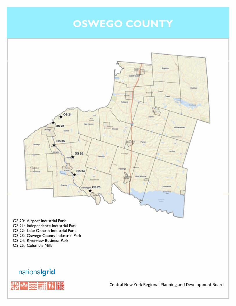
OSWEGO COUNTY
OS 20: Airport Industrial Park OS 21: Independence Industrial Park OS 22: Lake Ontario Industrial Park OS 23: Oswego County Industrial Park OS 24: Riverview Business Park OS 25: Columbia Mills
1
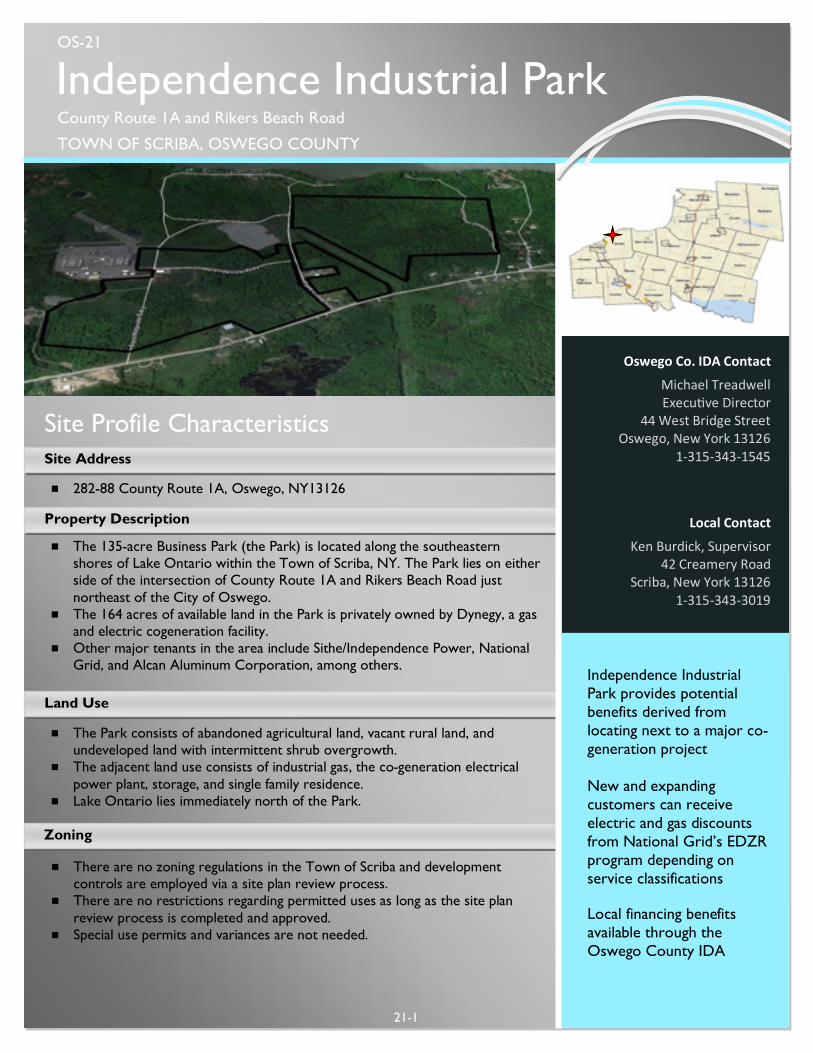
Site Profile Characteristics
Land Use
21-1
Local Contact
Ken Burdick, Supervisor 42 Creamery Road
Scriba, New York 13126 1-315-343-3019
Independence Industrial Park provides potential benefits derived from locating next to a major co-generation project New and expanding customers can receive electric and gas discounts from National Grid’s EDZR program depending on service classifications Local financing benefits available through the Oswego County IDA
Property Description
¾ 282-88 County Route 1A, Oswego, NY13126
¾ The 135-acre Business Park (the Park) is located along the southeastern shores of Lake Ontario within the Town of Scriba, NY. The Park lies on either side of the intersection of County Route 1A and Rikers Beach Road just northeast of the City of Oswego.
¾ The 164 acres of available land in the Park is privately owned by Dynegy, a gas and electric cogeneration facility.
¾ Other major tenants in the area include Sithe/Independence Power, National Grid, and Alcan Aluminum Corporation, among others.
Site Address
Zoning
¾ There are no zoning regulations in the Town of Scriba and development controls are employed via a site plan review process.
¾ There are no restrictions regarding permitted uses as long as the site plan review process is completed and approved.
¾ Special use permits and variances are not needed.
¾ The Park consists of abandoned agricultural land, vacant rural land, and undeveloped land with intermittent shrub overgrowth.
¾ The adjacent land use consists of industrial gas, the co-generation electrical power plant, storage, and single family residence.
¾ Lake Ontario lies immediately north of the Park.
Oswego Co. IDA Contact
Michael Treadwell Execu ve Director
44 West Bridge Street Oswego, New York 13126
1-315-343-1545
Independence Industrial Park County Route 1A and Rikers Beach Road
TOWN OF SCRIBA, OSWEGO COUNTY
OS-21
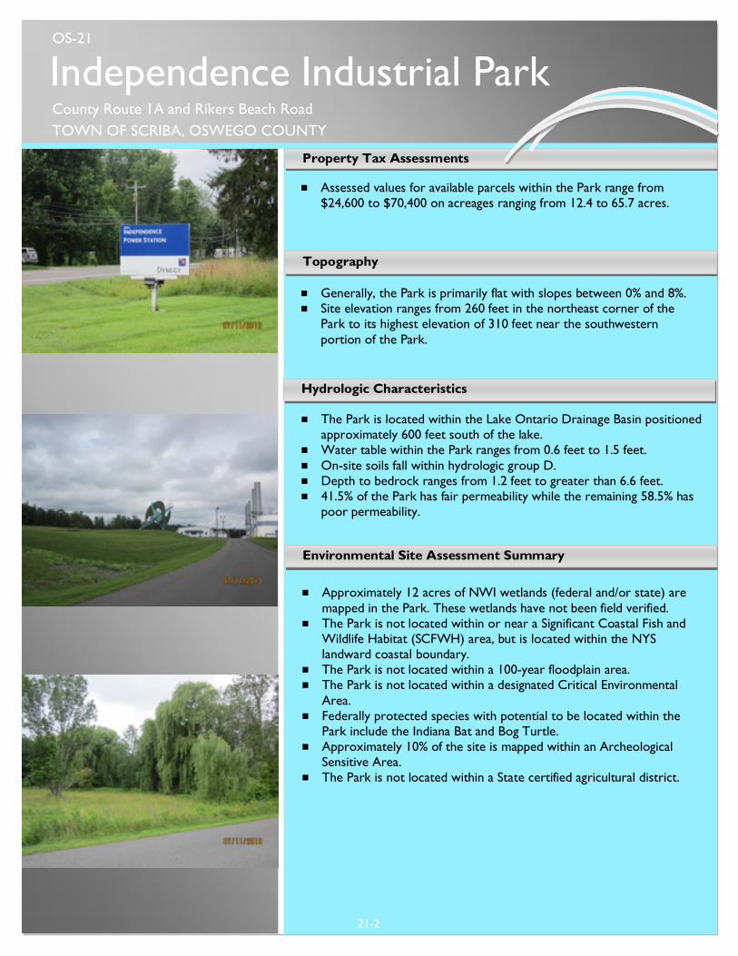
¾ Assessed values for available parcels within the Park range from $24,600 to $70,400 on acreages ranging from 12.4 to 65.7 acres.
Property Tax Assessments
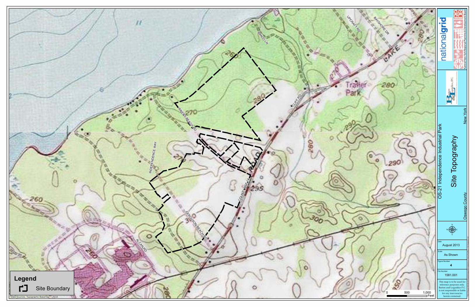
¾ Generally, the Park is primarily flat with slopes between 0% and 8%. ¾ Site elevation ranges from 260 feet in the northeast corner of the
Park to its highest elevation of 310 feet near the southwestern portion of the Park.
Topography
21-2
Hydrologic Characteristics
¾ The Park is located within the Lake Ontario Drainage Basin positioned approximately 600 feet south of the lake.
¾ Water table within the Park ranges from 0.6 feet to 1.5 feet. ¾ On-site soils fall within hydrologic group D. ¾ Depth to bedrock ranges from 1.2 feet to greater than 6.6 feet. ¾ 41.5% of the Park has fair permeability while the remaining 58.5% has
poor permeability.
¾ Approximately 12 acres of NWI wetlands (federal and/or state) are
mapped in the Park. These wetlands have not been field verified. ¾ The Park is not located within or near a Significant Coastal Fish and
Wildlife Habitat (SCFWH) area, but is located within the NYS landward coastal boundary.
¾ The Park is not located within a 100-year floodplain area. ¾ The Park is not located within a designated Critical Environmental
Area. ¾ Federally protected species with potential to be located within the
Park include the Indiana Bat and Bog Turtle. ¾ Approximately 10% of the site is mapped within an Archeological
Sensitive Area. ¾ The Park is not located within a State certified agricultural district.
Environmental Site Assessment Summary
Independence Industrial Park County Route 1A and Rikers Beach Road TOWN OF SCRIBA, OSWEGO COUNTY
OS-21
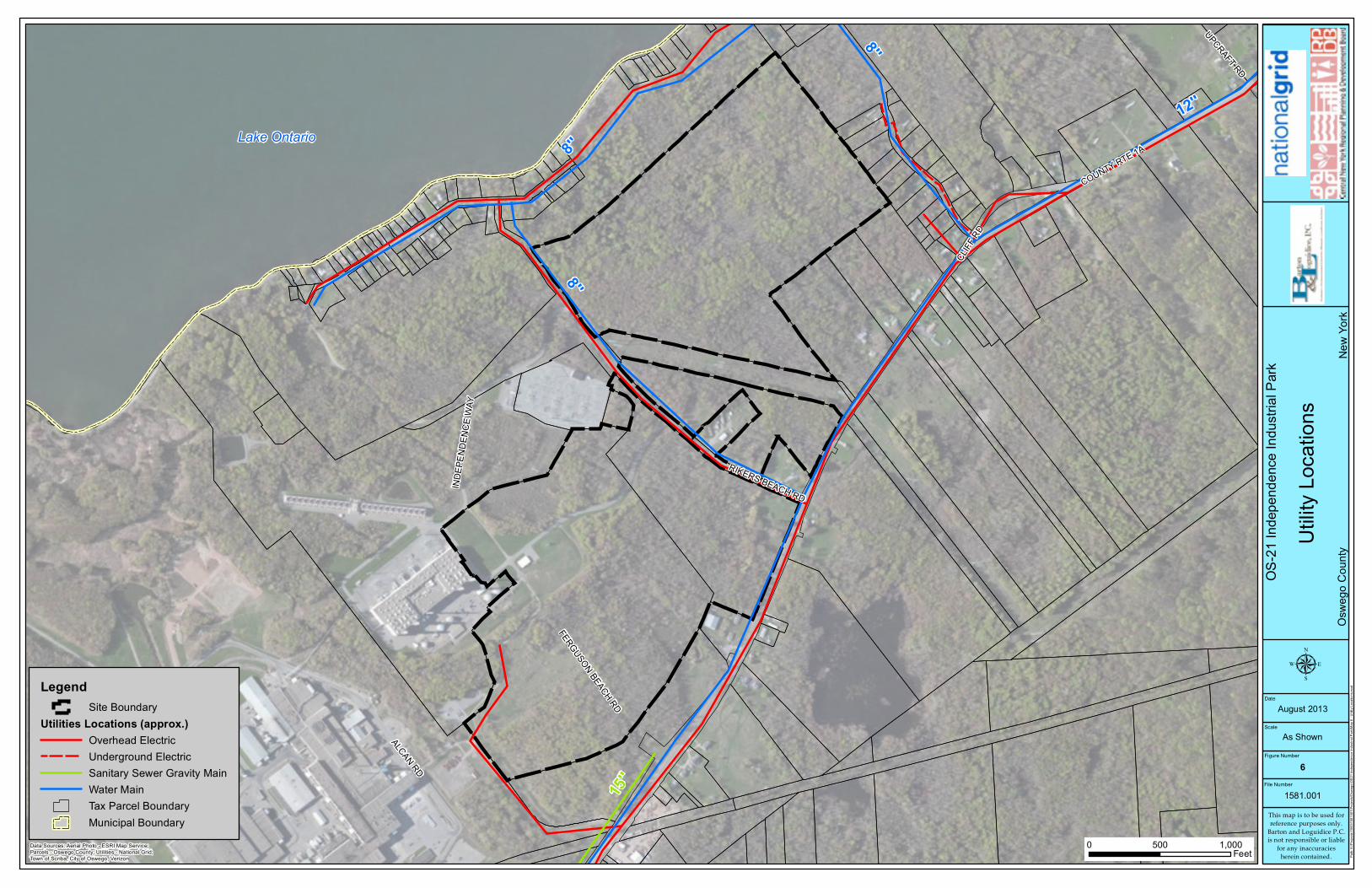
Municipal Water Supply ¾ Public water supply is provided from the City of Oswego via 8” and
12” water mains along County Route 1A and Rikers Beach Rd. A 36” main is also available from the City of Oswego in proximity to the Park.
¾ The water system has a capacity of 6 million gallons per day. Municipal Sewer ¾ Public sewer services are available adjacent to the Park via a 15”
gravity main along County Route 1A. Sewage is treated at the City of Oswego East Side Wastewater Treatment Plant (WWTP)
¾ The WWTP is functioning well meeting SPDES permit parameters with the exception of maximum daily settleable solids. This could potentially restrict the WWTP’s ability to accept high solid waste content from the Park. The WWTP available capacity is 3.35 million gallons per day.
¾ Storm sewers are not available at the Park. Electric Service ¾ National Grid provides 13.2 kV electric services directly to the Park
via overhead lines along County Route 1A and Rikers Beach Road. ¾ There are multiple 115kV lines within 2 miles of the Park to the
west. Natural Gas ¾ National Grid provides natural gas services adjacent to the Park via a
26” gas main line. Telecommunications ¾ Verizon provides telephone services while Verizon and Time Warner
Cable provide internet services directly to the Park.
Utilities
21-3
¾ Access to the industrial park from County Route 1A is provided by Rikers Beach Road as well as Independence Way.
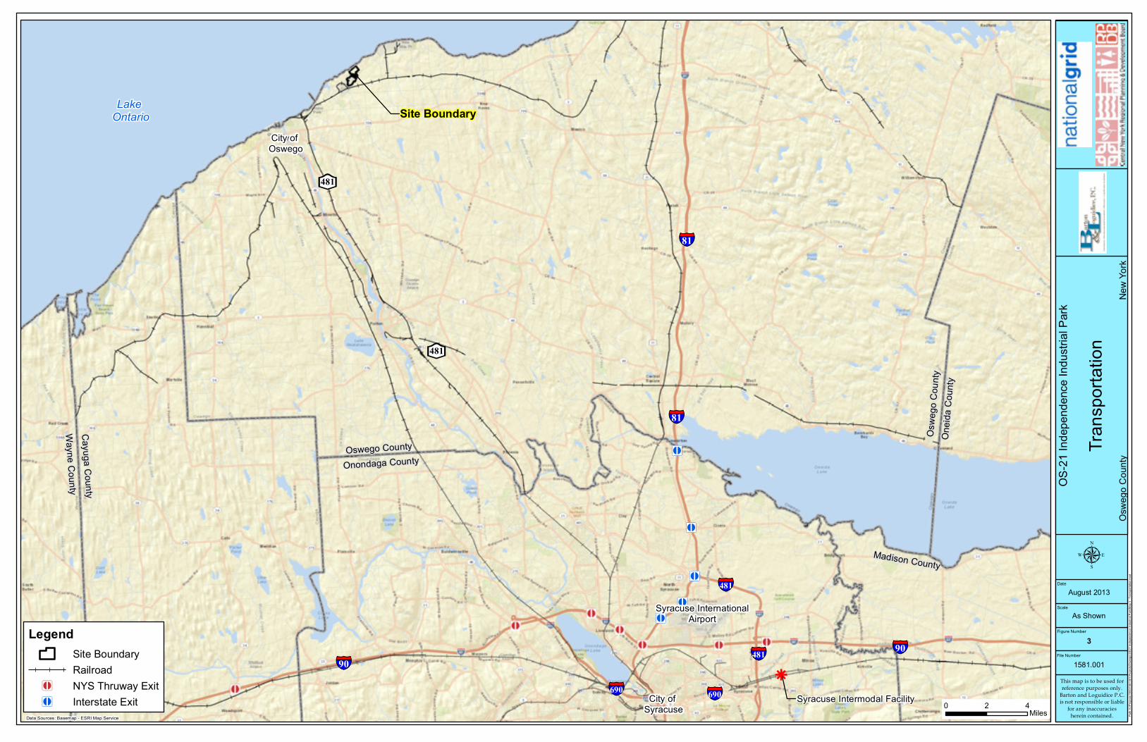
¾ Interstate access to I-81 is available through Exit 34 (Mexico) located approximately 19 miles east of the Park along NYS Route 104. I-81 southbound from Exit 34 can also provide access to I-90.
¾ Interstate access to I-481 is located approximately 17 miles south of the Park along NYS Route 481S.
¾ Interstate access to I-90 is also available through Exit 40 (Weedsport) located approximately 35 miles south of the Park along NYS Route 34.
¾ CSX operates a north-south rail mainline which provides service directly to the Park.
¾ The Syracuse Rail Yard and Intermodal Terminal is located 46 miles southeast of the Park in Syracuse, NY.
¾ Port of Oswego is approximately 4 miles west of the Park along the southern shore of Lake Ontario in the City of Oswego.
¾ Oswego County Airport is located 13 miles to the southeast of the Park.
¾ Syracuse Hancock International Airport is approximately 40 miles to the southeast, centrally located in Onondaga County.
Transportation and Site Access
Independence Industrial Park County Route 1A and Rikers Beach Road TOWN OF SCRIBA, OSWEGO COUNTY
OS-21
Site OS 21: Independence Industrial Park Site Layout Plan
¨ Various sites available totaling over 164 acres
¨ Town of Scriba currently has no zoning
requirements; all development is subject to
review and approval by the Planning Board on
a case by case basis
¨ Situated along Lake Ontario and near the gas-fired co-generation plant called Independence Station
¨ Site access off of County Route 1A
¨ Utility and roadway infrastructure allows flexible development opportunities
¨ Within 5 miles of NYS 481 and access to Interstate 81
¨ Port of Oswego located 4 miles to the west
¨ CSX/Conrail borders southwest corner of site
¨ Up to 100% of site may be utilized
¨ Development scenarios include manufacturing, industrial, processing, energy research and
development, profession service, office, retail,
support businesses
164.88 Acres OFFICE/INDUSTRIAL
MANUFACTURING/PROCESSING
Existing Access
Proposed Access
Existing Wetlands
Existing Wetlands
Site Layout Features
INDEPENDENCE STATION
COUNTY ROUTE 1A
Existing Wetlands
LAKE ONTARIO
RIKER
S BEA
CH RD.
CSX RAIL
")CR1A
CSXT RR
LegendSite Boundary
OS-21
Inde
pend
ence
Indu
strial
Park
Area
Loca
tion M
apOs
wego
Cou
nty
New
York
File Number
1581.001
Figure Number
1
Scale
DateAugust 2013
µAs Shown
Data Sources: Topographic Basemap - USGS
0 4,0002,000Feet Pa
th: K
:\Proj
ects\
1500
\1581
001\P
rojec
ts\Os
wego
\OS2
1 Ind
epen
denc
e Ind
ustria
l Park
\Map
1 - A
rea Lo
catio
n Map
.mxd
Site Location - Town of ScribaOswego County
282-8
8 Cou
nty R
oute
1A, O
sweg
o, NY
1312
6
This map is to be used forreference purposes only.
Barton and Loguidice P.C.is not responsible or liable
for any inaccuraciesherein contained.
Dynegy, Inc.094.00-01-31.1
36.60 acres
Dynegy, Inc.094.00-01-31.07
22.6 acres
Dynegy, Inc.094.00-01-3.02
65.24 acres
Dynegy, Inc.094.00-01-31.1
12.28 acres
COUN
TY RT
E 1A
BANJO LN
RIKERS BEACH RDFERGUSON BEACH RD
UPCRAFT RD
CLIFF
RD
ALCAN RD
BAYSHORE DR
INDE
PEND
ENCE
WAY
LegendSite BoundaryTax Parcel Boundary
OS-21
Inde
pend
ence
Indu
strial
Park
Site L
ocati
on M
apOs
wego
Cou
nty
New
York
File Number
1581.001
Figure Number
2
Scale
DateAugust 2013
µ
As Shown
Data Sources: Aerial Photo - ESRI Map Service (Bing Maps)Parcels - Oswego County
0 1,000500Feet Pa
th: K
:\Proj
ects\
1500
\1581
001\P
rojec
ts\Os
wego
\OS2
1 Ind
epen
denc
e Ind
ustria
l Park
\Map
2 - S
ite Lo
catio
n Map
.mxd
This map is to be used forreference purposes only.
Barton and Loguidice P.C.is not responsible or liable
for any inaccuraciesherein contained.
Jy
Jy
Jy
Jy
Jy
Jy
Syracuse InternationalAirport
City of Syracuse
Madison CountyOnondaga County
§̈¦90§̈¦90
§̈¦90
Site Boundary
§̈¦81
§̈¦481
§̈¦481
§̈¦690
§̈¦81
§̈¦690
§̈¦481
k
Syracuse Intermodal Facility
Exit 3 - NYS 5 & NYS 92
Exit 16 - I-81 & I-481
Exit 17 - I-81 & Brighton Ave
BE481
BE481
City of Oswego
Oswego CountyOnondaga County
Cayuga CountyWayne County
Oswe
go C
ounty
Oneid
a Cou
nty
Madison County
Lake Ontario
OS-21
Inde
pend
ence
Indu
strial
Park
Trans
porta
tion
Oswe
go C
ounty
Ne
w Yo
rk
File Number
1581.001
Figure Number
3
Scale
DateAugust 2013
µ
As Shown
Data Sources: Basemap - ESRI Map Service
0 42Miles Pa
th: K
:\Proj
ects\
1500
\1581
001\P
rojec
ts\Os
wego
\OS2
1 Ind
epen
denc
e Ind
ustria
l Park
\Map
3 - T
ransp
ortati
on.m
xd
LegendSite BoundaryRailroad
Jy NYS Thruway ExitJy Interstate Exit
This map is to be used forreference purposes only.
Barton and Loguidice P.C.is not responsible or liable
for any inaccuraciesherein contained.
COUN
TY RT
E 1A
BANJO LN
RIKERS BEACH RD
FERGUSON BEACH RD
UPCRAFT RD
CLIFF
RD
ALCAN RD
BAYSHORE DR
INDE
PEND
ENCE
WAY
LegendSite Boundary
OS-21
Inde
pend
ence
Indu
strial
Park
Site T
opog
raphy
Oswe
go C
ounty
Ne
w Yo
rk
File Number
1581.001
Figure Number
4
Scale
DateAugust 2013
µ
As Shown
Data Sources: Topographic Basemap - USGS0 1,000500
Feet Path:
K:\P
rojec
ts\15
00\15
8100
1\Proj
ects\
Oswe
go\O
S21 I
ndep
ende
nce I
ndus
trial P
ark\M
ap 4
- Site
Topo
graph
y.mxd
This map is to be used forreference purposes only.
Barton and Loguidice P.C.is not responsible or liable
for any inaccuraciesherein contained.
ScB
IUD
IrB
IUD
IUD
ScB
SDB
IUD
Pa
SDB
SDB
IrB
ScB
IsC
ScB
IUD
COUNTY RTE 1A
BANJO LN
ALCAN RD
RIKERS BEACH RD
FERGUSON BEACH RD
CLIFF
RD
UPCRAFT RD
INDEP
ENDENCE WA Y
LOCKHAVEN BEACH RD
ALCAN RD
LegendSite Boundary
Soil ClassificationsIUD, Ira and Sodus very stony soils; moderately steepIrB, Ira gravelly fine sandy loam; 3 to 8 percent slopesIsC, Ira-Sodus gravelly fine sandy loams; rollingPa, Palms muckSDB, Scriba very stony soils; gently slopingScB, Scriba gravelly fine sandy loam; 0 to 8 percent slopesTax Parcel Boundary
OS-21
Inde
pend
ence
Indu
strial
Park
Soil C
lassif
icatio
nsOs
wego
Cou
nty
New
York
This map is to be used forreference purposes only.
Barton and Loguidice P.C.is not responsible or liable
for any inaccuraciesherein contained.
File Number
1581.001
Figure Number
5
Scale
DateAugust 2013
µ
As Shown
Data Sources: Aerial Photo - ESRI Map Service (Bing Maps);Parcels - Oswego County; Soils - NRCS
0 500250Feet Pa
th: K
:\Proj
ects\
1500
\1581
001\P
rojec
ts\Os
wego
\OS2
1 Ind
epen
denc
e Ind
ustria
l Park
\Map
5 - S
oil C
lassif
icatio
ns.m
xd
Lake Ontario
COUNTY RTE 1A
RIKERS BEACH RD
FERGUSON BEACH RD
ALCAN RDCL
IFF RD
INDE
PEND
ENCE
WAY
UPCRAFT RD
15''
12''
8''
8''
8''
LegendSite Boundary
Utilities Locations (approx.)Overhead ElectricUnderground ElectricSanitary Sewer Gravity MainWater MainTax Parcel BoundaryMunicipal Boundary
OS-21
Inde
pend
ence
Indu
strial
Park
Utility
Loca
tions
Oswe
go C
ounty
Ne
w Yo
rk
File Number
1581.001
Figure Number
6
Scale
DateAugust 2013
µ
As Shown
Data Sources: Aerial Photo - ESRI Map Service;Parcels - Oswego County; Utilities - National Grid;Town of Scriba, City of Oswego, Verizon
0 1,000500Feet Pa
th: K
:\Proj
ects\
1500
\1581
001\P
rojec
ts\Os
wego
\OS2
1 Ind
epen
denc
e Ind
ustria
l Park
\Map
6 - U
tility
Loca
tions
.mxd
This map is to be used forreference purposes only.
Barton and Loguidice P.C.is not responsible or liable
for any inaccuraciesherein contained.
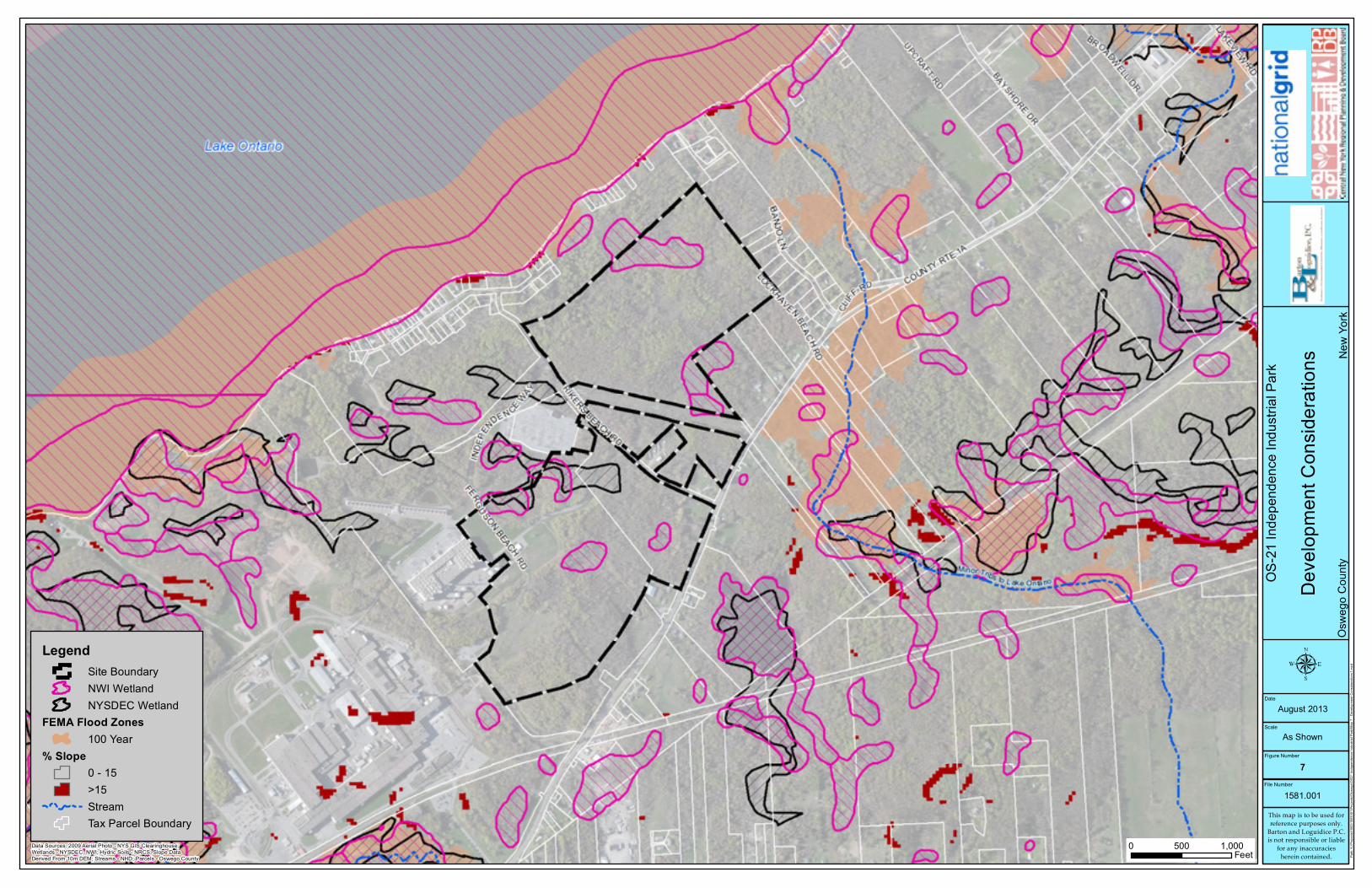
LegendSite BoundaryNWI WetlandNYSDEC Wetland
FEMA Flood Zones100 Year
% Slope0 - 15>15StreamTax Parcel Boundary
OS-21
Inde
pend
ence
Indu
strial
Park
Deve
lopme
nt Co
nside
ration
sOs
wego
Cou
nty
New
York
This map is to be used forreference purposes only.
Barton and Loguidice P.C.is not responsible or liable
for any inaccuraciesherein contained.
File Number
1581.001
Figure Number
7
Scale
DateAugust 2013
As Shown
Data Sources: 2009 Aerial Photo - NYS GIS Clearinghouse;Wetlands - NYSDEC, NWI; Hydric Soils - NRCS; Slope DataDerived From 10m DEM; Streams - NHD; Parcels - Oswego County
0 1,000500Feet Pa
th: K
:\Proj
ects\
1500
\1581
001\P
rojec
ts\Os
wego
\OS2
1 Ind
epen
denc
e Ind
ustria
l Park
\Map
7 - D
evelo
pmen
t Con
sidera
tions
1.mxd
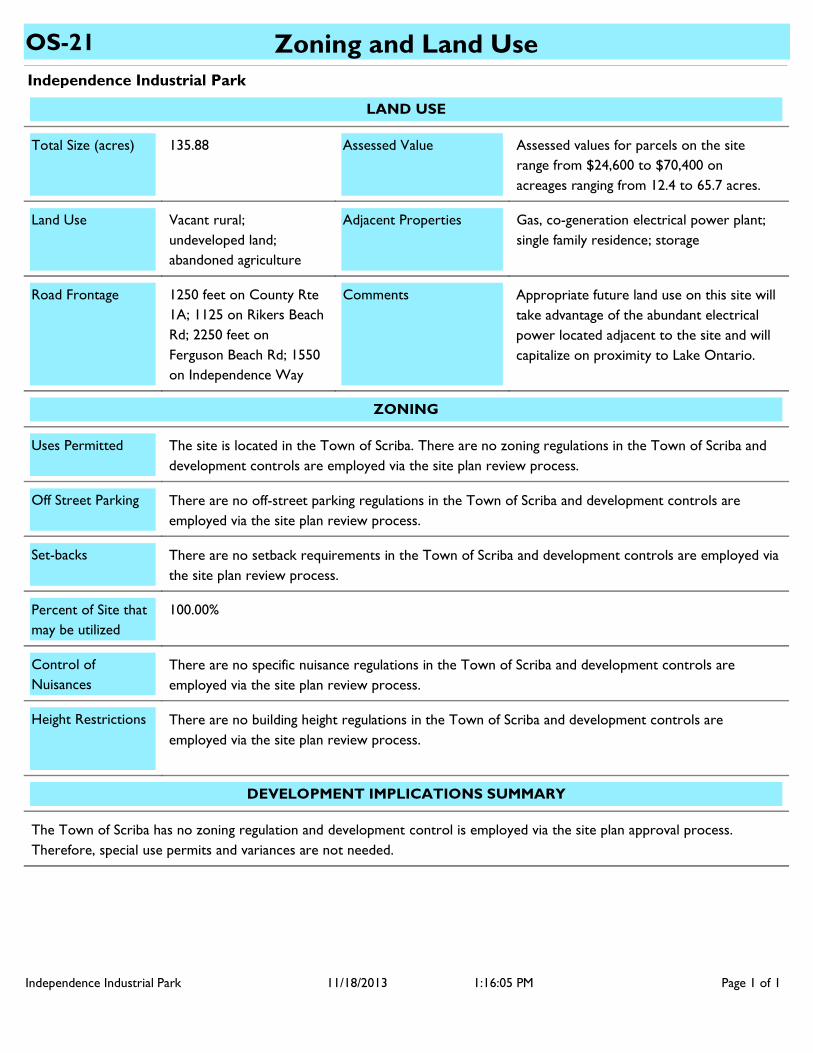
Independence Industrial Park
Zoning and Land UseOS-21
LAND USE
Gas, co-generation electrical power plant; single family residence; storage
Appropriate future land use on this site will take advantage of the abundant electrical power located adjacent to the site and will capitalize on proximity to Lake Ontario.
Vacant rural; undeveloped land; abandoned agriculture
1250 feet on County Rte 1A; 1125 on Rikers Beach Rd; 2250 feet on Ferguson Beach Rd; 1550 on Independence Way
Land Use
Road Frontage Comments
Adjacent Properties
Assessed values for parcels on the site range from $24,600 to $70,400 on acreages ranging from 12.4 to 65.7 acres.
135.88 Total Size (acres) Assessed Value
ZONING
The site is located in the Town of Scriba. There are no zoning regulations in the Town of Scriba and development controls are employed via the site plan review process.
There are no off-street parking regulations in the Town of Scriba and development controls are employed via the site plan review process.
There are no setback requirements in the Town of Scriba and development controls are employed via the site plan review process.
100.00%
There are no specific nuisance regulations in the Town of Scriba and development controls are employed via the site plan review process.
There are no building height regulations in the Town of Scriba and development controls are employed via the site plan review process.
Uses Permitted
Off Street Parking
Set-backs
Percent of Site that may be utilized
Height Restrictions
Control of Nuisances
DEVELOPMENT IMPLICATIONS SUMMARY
The Town of Scriba has no zoning regulation and development control is employed via the site plan approval process. Therefore, special use permits and variances are not needed.
Independence Industrial Park Page 1 of 111/18/2013 1:16:05 PM
Independence Industrial Park
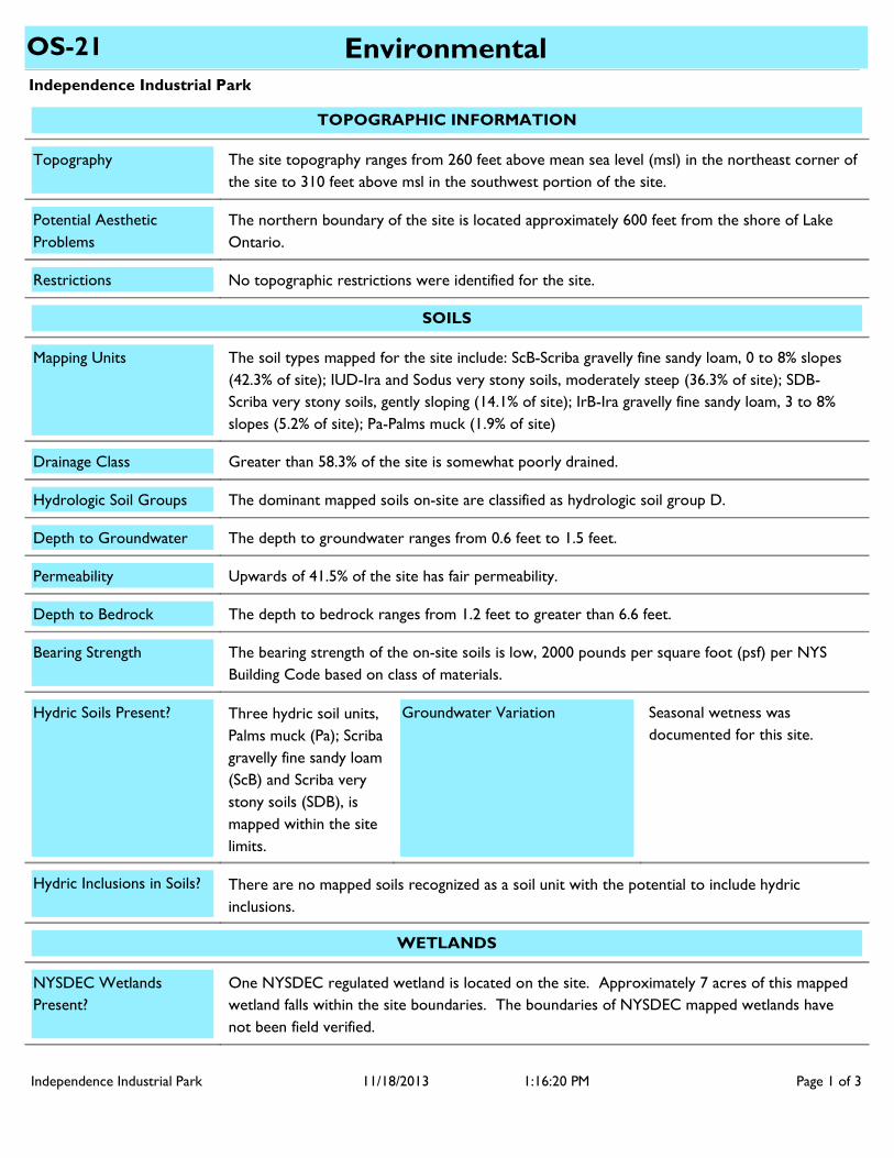
EnvironmentalOS-21
TOPOGRAPHIC INFORMATION
The northern boundary of the site is located approximately 600 feet from the shore of Lake Ontario.
No topographic restrictions were identified for the site.
Topography
Potential Aesthetic Problems
Restrictions
The site topography ranges from 260 feet above mean sea level (msl) in the northeast corner of the site to 310 feet above msl in the southwest portion of the site.
WETLANDS
One NYSDEC regulated wetland is located on the site. Approximately 7 acres of this mapped wetland falls within the site boundaries. The boundaries of NYSDEC mapped wetlands have not been field verified.
NYSDEC Wetlands Present?
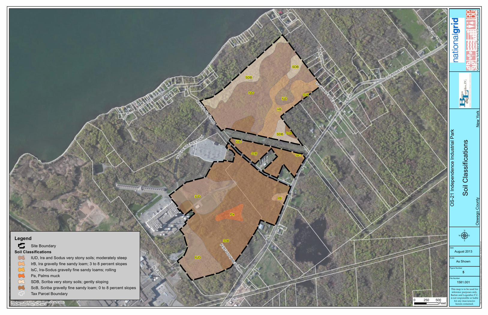
SOILS
The soil types mapped for the site include: ScB-Scriba gravelly fine sandy loam, 0 to 8% slopes (42.3% of site); IUD-Ira and Sodus very stony soils, moderately steep (36.3% of site); SDB-Scriba very stony soils, gently sloping (14.1% of site); IrB-Ira gravelly fine sandy loam, 3 to 8% slopes (5.2% of site); Pa-Palms muck (1.9% of site)
Greater than 58.3% of the site is somewhat poorly drained.
The dominant mapped soils on-site are classified as hydrologic soil group D.
Upwards of 41.5% of the site has fair permeability.
The bearing strength of the on-site soils is low, 2000 pounds per square foot (psf) per NYS Building Code based on class of materials.
There are no mapped soils recognized as a soil unit with the potential to include hydric inclusions.
The depth to bedrock ranges from 1.2 feet to greater than 6.6 feet.
Mapping Units
Drainage Class
Hydrologic Soil Groups
Permeability
Bearing Strength
Hydric Soils Present?
Hydric Inclusions in Soils?
Seasonal wetness was documented for this site.
Groundwater Variation
Depth to Bedrock
The depth to groundwater ranges from 0.6 feet to 1.5 feet.Depth to Groundwater
Three hydric soil units, Palms muck (Pa); Scriba gravelly fine sandy loam (ScB) and Scriba very stony soils (SDB), is mapped within the site limits.
Independence Industrial Park Page 1 of 311/18/2013 1:16:20 PM
Independence Industrial Park
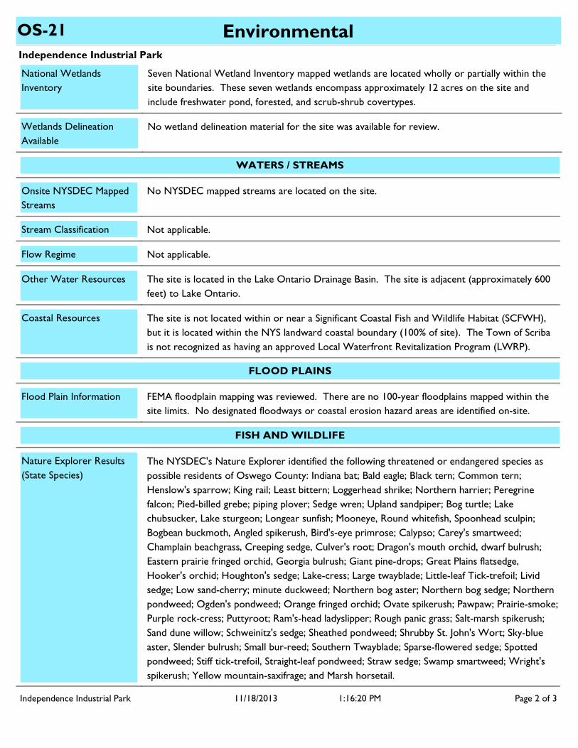
EnvironmentalOS-21
National Wetlands Inventory
Seven National Wetland Inventory mapped wetlands are located wholly or partially within the site boundaries. These seven wetlands encompass approximately 12 acres on the site and include freshwater pond, forested, and scrub-shrub covertypes.
No wetland delineation material for the site was available for review. Wetlands Delineation Available
No NYSDEC mapped streams are located on the site.
WATERS / STREAMS
Onsite NYSDEC Mapped Streams
Not applicable.Stream Classification
Not applicable.
The site is located in the Lake Ontario Drainage Basin. The site is adjacent (approximately 600 feet) to Lake Ontario.
Flow Regime
Other Water Resources
Coastal Resources The site is not located within or near a Significant Coastal Fish and Wildlife Habitat (SCFWH), but it is located within the NYS landward coastal boundary (100% of site). The Town of Scriba is not recognized as having an approved Local Waterfront Revitalization Program (LWRP).
FLOOD PLAINS
Flood Plain Information FEMA floodplain mapping was reviewed. There are no 100-year floodplains mapped within the site limits. No designated floodways or coastal erosion hazard areas are identified on-site.
FISH AND WILDLIFE
Nature Explorer Results (State Species)
The NYSDEC's Nature Explorer identified the following threatened or endangered species as possible residents of Oswego County: Indiana bat; Bald eagle; Black tern; Common tern; Henslow's sparrow; King rail; Least bittern; Loggerhead shrike; Northern harrier; Peregrine falcon; Pied-billed grebe; piping plover; Sedge wren; Upland sandpiper; Bog turtle; Lake chubsucker, Lake sturgeon; Longear sunfish; Mooneye, Round whitefish, Spoonhead sculpin; Bogbean buckmoth, Angled spikerush, Bird's-eye primrose; Calypso; Carey's smartweed; Champlain beachgrass, Creeping sedge, Culver's root; Dragon's mouth orchid, dwarf bulrush; Eastern prairie fringed orchid, Georgia bulrush; Giant pine-drops; Great Plains flatsedge, Hooker's orchid; Houghton's sedge; Lake-cress; Large twayblade; Little-leaf Tick-trefoil; Livid sedge; Low sand-cherry; minute duckweed; Northern bog aster; Northern bog sedge; Northern pondweed; Ogden's pondweed; Orange fringed orchid; Ovate spikerush; Pawpaw; Prairie-smoke; Purple rock-cress; Puttyroot; Ram's-head ladyslipper; Rough panic grass; Salt-marsh spikerush; Sand dune willow; Schweinitz's sedge; Sheathed pondweed; Shrubby St. John's Wort; Sky-blue aster, Slender bulrush; Small bur-reed; Southern Twayblade; Sparse-flowered sedge; Spotted pondweed; Stiff tick-trefoil, Straight-leaf pondweed; Straw sedge; Swamp smartweed; Wright's spikerush; Yellow mountain-saxifrage; and Marsh horsetail.
Independence Industrial Park Page 2 of 311/18/2013 1:16:20 PM
Independence Industrial Park
EnvironmentalOS-21
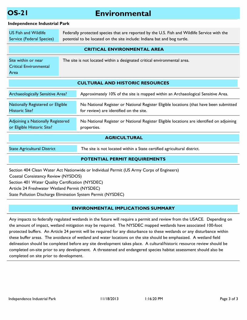
CRITICAL ENVIRONMENTAL AREA
Site within or near Critical Environmental Area
The site is not located within a designated critical environmental area.
US Fish and Wildlife Service (Federal Species)
Federally protected species that are reported by the U.S. Fish and Wildlife Service with the potential to be located on the site include: Indiana bat and bog turtle.
CULTURAL AND HISTORIC RESOURCES
Approximately 10% of the site is mapped within an Archaeological Sensitive Area.Archaeologically Sensitive Area?
No National Register or National Register Eligible locations (that have been submitted for review) are identified on the site.
Nationally Registered or Eligible Historic Site?
No National Register or National Register Eligible locations are identified on adjoining properties.
Adjoining a Nationally Registered or Eligible Historic Site?
AGRICULTURAL
State Agricultural District The site is not located within a State certified agricultural district.
POTENTIAL PERMIT REQUIREMENTS
Section 404 Clean Water Act Nationwide or Individual Permit (US Army Corps of Engineers)Coastal Consistency Review (NYSDOS)Section 401 Water Quality Certification (NYSDEC)Article 24 Freshwater Wetland Permit (NYSDEC)State Pollution Discharge Elimination System Permit (NYSDEC)
ENVIRONMENTAL IMPLICATIONS SUMMARY
Any impacts to federally regulated wetlands in the future will require a permit and review from the USACE. Depending on the amount of impact, wetland mitigation may be required. The NYSDEC mapped wetlands have associated 100-foot protected buffers. An Article 24 permit will be required for any disturbance to these wetlands or any disturbance within these buffer areas. The avoidance of wetland and water locations on the site should be emphasized. A wetland field delineation should be completed before any site development takes place. A cultural/historic resource review should be completed on-site prior to any development. A threatened and endangered species habitat assessment should also be completed on site prior to development.
Independence Industrial Park Page 3 of 311/18/2013 1:16:20 PM
Independence Industrial Park
TransportationOS-21
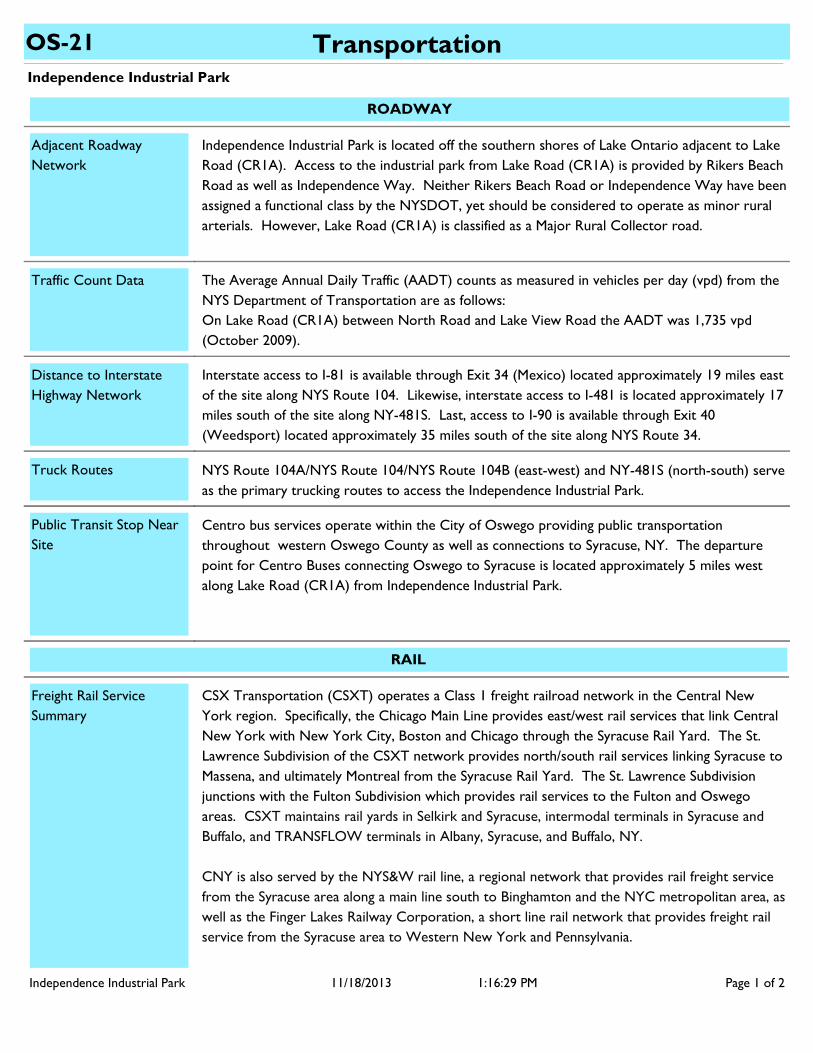
ROADWAY
Centro bus services operate within the City of Oswego providing public transportation throughout western Oswego County as well as connections to Syracuse, NY. The departure point for Centro Buses connecting Oswego to Syracuse is located approximately 5 miles west along Lake Road (CR1A) from Independence Industrial Park.
Independence Industrial Park is located off the southern shores of Lake Ontario adjacent to Lake Road (CR1A). Access to the industrial park from Lake Road (CR1A) is provided by Rikers Beach Road as well as Independence Way. Neither Rikers Beach Road or Independence Way have been assigned a functional class by the NYSDOT, yet should be considered to operate as minor rural arterials. However, Lake Road (CR1A) is classified as a Major Rural Collector road.
The Average Annual Daily Traffic (AADT) counts as measured in vehicles per day (vpd) from the NYS Department of Transportation are as follows:On Lake Road (CR1A) between North Road and Lake View Road the AADT was 1,735 vpd (October 2009).
Adjacent Roadway Network
Traffic Count Data
Public Transit Stop Near Site
Distance to Interstate Highway Network
Interstate access to I-81 is available through Exit 34 (Mexico) located approximately 19 miles east of the site along NYS Route 104. Likewise, interstate access to I-481 is located approximately 17 miles south of the site along NY-481S. Last, access to I-90 is available through Exit 40 (Weedsport) located approximately 35 miles south of the site along NYS Route 34.
NYS Route 104A/NYS Route 104/NYS Route 104B (east-west) and NY-481S (north-south) serve as the primary trucking routes to access the Independence Industrial Park.
Truck Routes
RAIL
Freight Rail Service Summary
CSX Transportation (CSXT) operates a Class 1 freight railroad network in the Central New York region. Specifically, the Chicago Main Line provides east/west rail services that link Central New York with New York City, Boston and Chicago through the Syracuse Rail Yard. The St. Lawrence Subdivision of the CSXT network provides north/south rail services linking Syracuse to Massena, and ultimately Montreal from the Syracuse Rail Yard. The St. Lawrence Subdivision junctions with the Fulton Subdivision which provides rail services to the Fulton and Oswego areas. CSXT maintains rail yards in Selkirk and Syracuse, intermodal terminals in Syracuse and Buffalo, and TRANSFLOW terminals in Albany, Syracuse, and Buffalo, NY.
CNY is also served by the NYS&W rail line, a regional network that provides rail freight service from the Syracuse area along a main line south to Binghamton and the NYC metropolitan area, as well as the Finger Lakes Railway Corporation, a short line rail network that provides freight rail service from the Syracuse area to Western New York and Pennsylvania.
Independence Industrial Park Page 1 of 211/18/2013 1:16:29 PM
Independence Industrial Park
TransportationOS-21
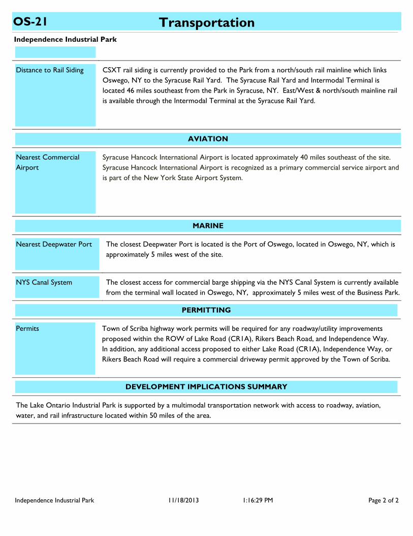
CSXT rail siding is currently provided to the Park from a north/south rail mainline which links Oswego, NY to the Syracuse Rail Yard. The Syracuse Rail Yard and Intermodal Terminal is located 46 miles southeast from the Park in Syracuse, NY. East/West & north/south mainline rail is available through the Intermodal Terminal at the Syracuse Rail Yard.
Distance to Rail Siding
AVIATION
Syracuse Hancock International Airport is located approximately 40 miles southeast of the site. Syracuse Hancock International Airport is recognized as a primary commercial service airport and is part of the New York State Airport System.
Nearest Commercial Airport
MARINE
The closest Deepwater Port is located is the Port of Oswego, located in Oswego, NY, which is approximately 5 miles west of the site.
Nearest Deepwater Port
The closest access for commercial barge shipping via the NYS Canal System is currently available from the terminal wall located in Oswego, NY, approximately 5 miles west of the Business Park.
NYS Canal System
PERMITTING
Town of Scriba highway work permits will be required for any roadway/utility improvements proposed within the ROW of Lake Road (CR1A), Rikers Beach Road, and Independence Way. In addition, any additional access proposed to either Lake Road (CR1A), Independence Way, or Rikers Beach Road will require a commercial driveway permit approved by the Town of Scriba.
Permits
The Lake Ontario Industrial Park is supported by a multimodal transportation network with access to roadway, aviation, water, and rail infrastructure located within 50 miles of the area.
DEVELOPMENT IMPLICATIONS SUMMARY
Independence Industrial Park Page 2 of 211/18/2013 1:16:29 PM
Independence Industrial Park
UtilitiesOS-21
WATER SUPPLY
8
Town of Scriba
Lake Ontario via the City of Oswego
Owner
Source of Supply
Size of water main at site (in)
Public Water Supply Available at Site?
Available Capacity at site (gpd) Data Not Available
Yes
The system serves both the City of Oswego and Town of Scriba. Peak demand for the systems leave little excess capacity.
There is a bottleneck at the City of Oswego Water Treatment Plant with their filtration system.
Capacity “Bottlenecks”
10,000,000
16,000,000
Data Not Available
None
Town of Scriba Consolidated District
Transmission fee: $3.09/1,000 gallons. Water Rates: Tier 1 - $22.48 for the first
There is a 1 million gallon water storage tank in the Town of Scriba and a 10 million gallons water storage tank (Eastern Reservoir) in the the City of Oswego.
System Capacity (gpd)
System Average Daily Demand (gpd)
Pressure at site (psi)
Method of Treatment
Storage
Treatment General Comments
Have any flow tests been performed near site recently?
Is Site in Existing Water District
User charges and water rates
Filtration, Chlorination, Coagulation, Sedimentation, Fluoridation
Yes
Yes
System Information
System Capacity
Site Specific Details
Other Details
16,000,000System Peak Daily Demand (gpd)
Distance From Site (mi.) N/A
6,000,000Available System Capacity (gpd)
Independence Industrial Park Page 1 of 512/3/2013 11:22:01 AM
Independence Industrial Park
UtilitiesOS-21
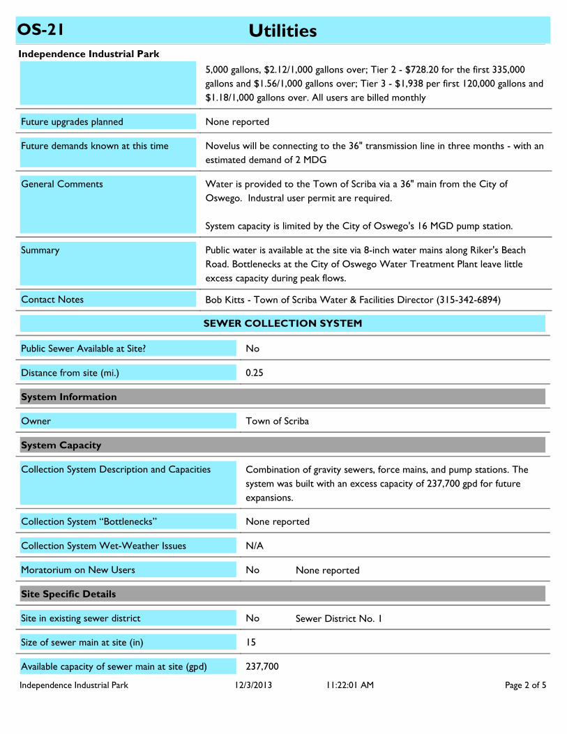
Water is provided to the Town of Scriba via a 36" main from the City of Oswego. Industral user permit are required.
System capacity is limited by the City of Oswego's 16 MGD pump station.
5,000 gallons, $2.12/1,000 gallons over; Tier 2 - $728.20 for the first 335,000 gallons and $1.56/1,000 gallons over; Tier 3 - $1,938 per first 120,000 gallons and $1.18/1,000 gallons over. All users are billed monthly
None reported
Novelus will be connecting to the 36" transmission line in three months - with an estimated demand of 2 MDG
Public water is available at the site via 8-inch water mains along Riker's Beach Road. Bottlenecks at the City of Oswego Water Treatment Plant leave little excess capacity during peak flows.
General Comments
Future upgrades planned
Summary
Future demands known at this time
Bob Kitts - Town of Scriba Water & Facilities Director (315-342-6894)Contact Notes
SEWER COLLECTION SYSTEM
Town of Scriba
15
237,700
Owner
Size of sewer main at site (in)
Available capacity of sewer main at site (gpd)
Public Sewer Available at Site? No
NoMoratorium on New Users None reported
NoSite in existing sewer district Sewer District No. 1
None reportedCollection System “Bottlenecks”
N/ACollection System Wet-Weather Issues
System Capacity
Site Specific Details
System Information
Combination of gravity sewers, force mains, and pump stations. The system was built with an excess capacity of 237,700 gpd for future expansions.
Collection System Description and Capacities
0.25Distance from site (mi.)
Independence Industrial Park Page 2 of 512/3/2013 11:22:01 AM
Independence Industrial Park
UtilitiesOS-21
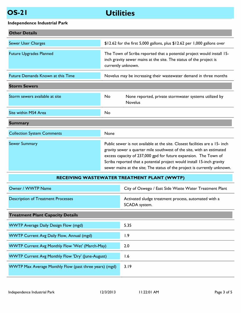
NoneCollection System Comments
NoStorm sewers available at site None reported, private stormwater systems utilized by Novelus
NoSite within MS4 Area
Public sewer is not available at the site. Closest facilities are a 15- inch gravity sewer a quarter mile southwest of the site, with an estimated excess capacity of 237,000 gpd for future expansion. The Town of Scriba reported that a potential project would install 15-inch gravity sewer mains at the site; The status of the project is currently unknown.
Sewer Summary
$12.62 for the first 5,000 gallons, plus $12.62 per 1,000 gallons overSewer User Charges
Storm Sewers
Other Details
Novelus may be increasing their wastewater demand in three monthsFuture Demands Known at this Time
The Town of Scriba reported that a potential project would install 15-inch gravity sewer mains at the site. The status of the project is currently unknown.
Future Upgrades Planned
Summary
RECEIVING WASTEWATER TREATMENT PLANT (WWTP)
City of Oswego / East Side Waste Water Treatment PlantOwner / WWTP Name
1.6WWTP Current Avg Monthly Flow 'Dry' (June-August)
2.0WWTP Current Avg Monthly Flow 'Wet' (March-May)
5.35WWTP Average Daily Design Flow (mgd)
Description of Treatment Processes
1.9WWTP Current Avg Daily Flow, Annual (mgd)
3.19WWTP Max Average Monthly Flow (past three years) (mgd)
Treatment Plant Capacity Details
Activated sludge treatment process, automated with a SCADA system.
Independence Industrial Park Page 3 of 512/3/2013 11:22:01 AM
Independence Industrial Park
UtilitiesOS-21
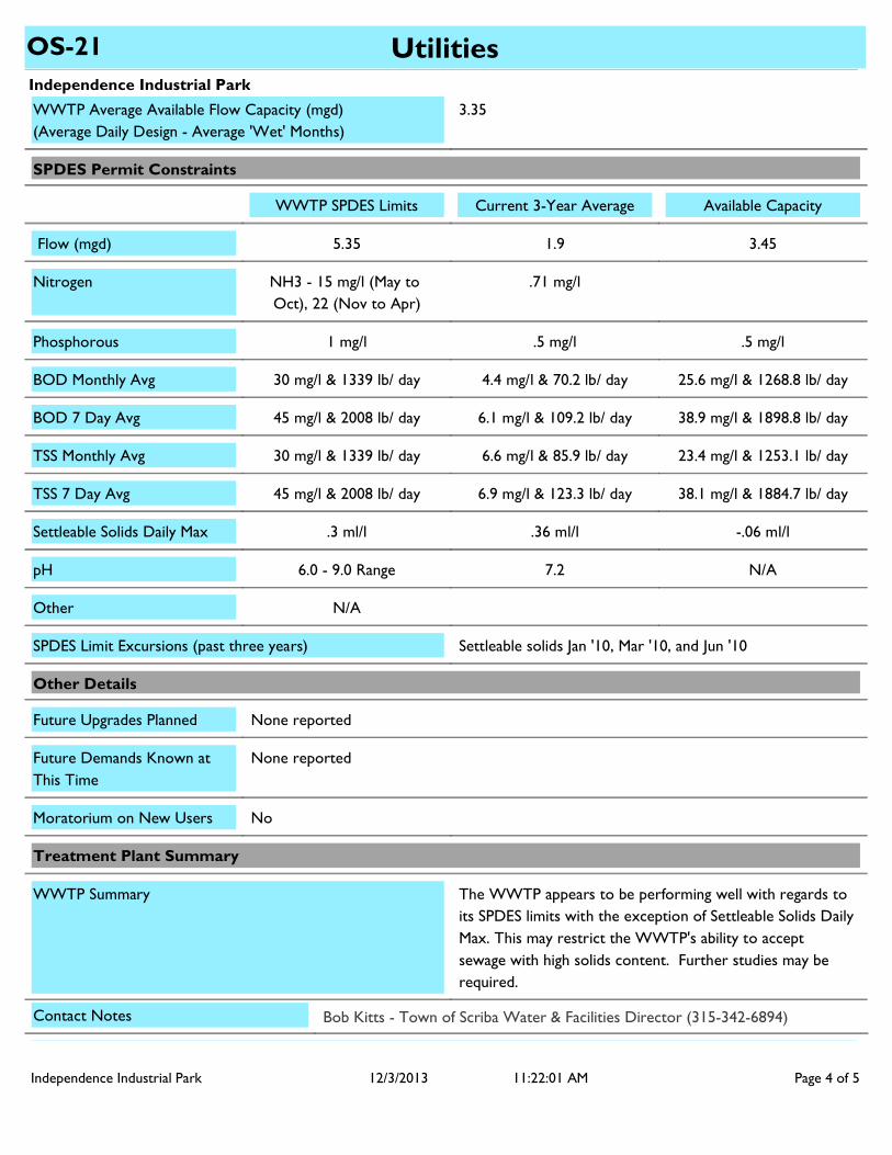
None reported
None reported
3.35
5.35
NH3 - 15 mg/l (May to Oct), 22 (Nov to Apr)
1 mg/l
N/A
Future Demands Known at This Time
Future Upgrades Planned
WWTP Average Available Flow Capacity (mgd)(Average Daily Design - Average 'Wet' Months)
WWTP SPDES Limits Current 3-Year Average Available Capacity
Other
Phosphorous
Nitrogen
Flow (mgd)
1.9
.71 mg/l
.5 mg/l
3.45
.5 mg/l
Settleable solids Jan '10, Mar '10, and Jun '10SPDES Limit Excursions (past three years)
The WWTP appears to be performing well with regards to its SPDES limits with the exception of Settleable Solids Daily Max. This may restrict the WWTP's ability to accept sewage with high solids content. Further studies may be required.
WWTP Summary
SPDES Permit Constraints
Other Details
NoMoratorium on New Users
Treatment Plant Summary
30 mg/l & 1339 lb/ dayBOD Monthly Avg 4.4 mg/l & 70.2 lb/ day 25.6 mg/l & 1268.8 lb/ day
45 mg/l & 2008 lb/ dayBOD 7 Day Avg 6.1 mg/l & 109.2 lb/ day 38.9 mg/l & 1898.8 lb/ day
30 mg/l & 1339 lb/ dayTSS Monthly Avg 6.6 mg/l & 85.9 lb/ day 23.4 mg/l & 1253.1 lb/ day
45 mg/l & 2008 lb/ dayTSS 7 Day Avg 6.9 mg/l & 123.3 lb/ day 38.1 mg/l & 1884.7 lb/ day
.3 ml/lSettleable Solids Daily Max .36 ml/l -.06 ml/l
6.0 - 9.0 RangepH 7.2 N/A
Bob Kitts - Town of Scriba Water & Facilities Director (315-342-6894)Contact Notes
Independence Industrial Park Page 4 of 512/3/2013 11:22:01 AM
Independence Industrial Park
UtilitiesOS-21
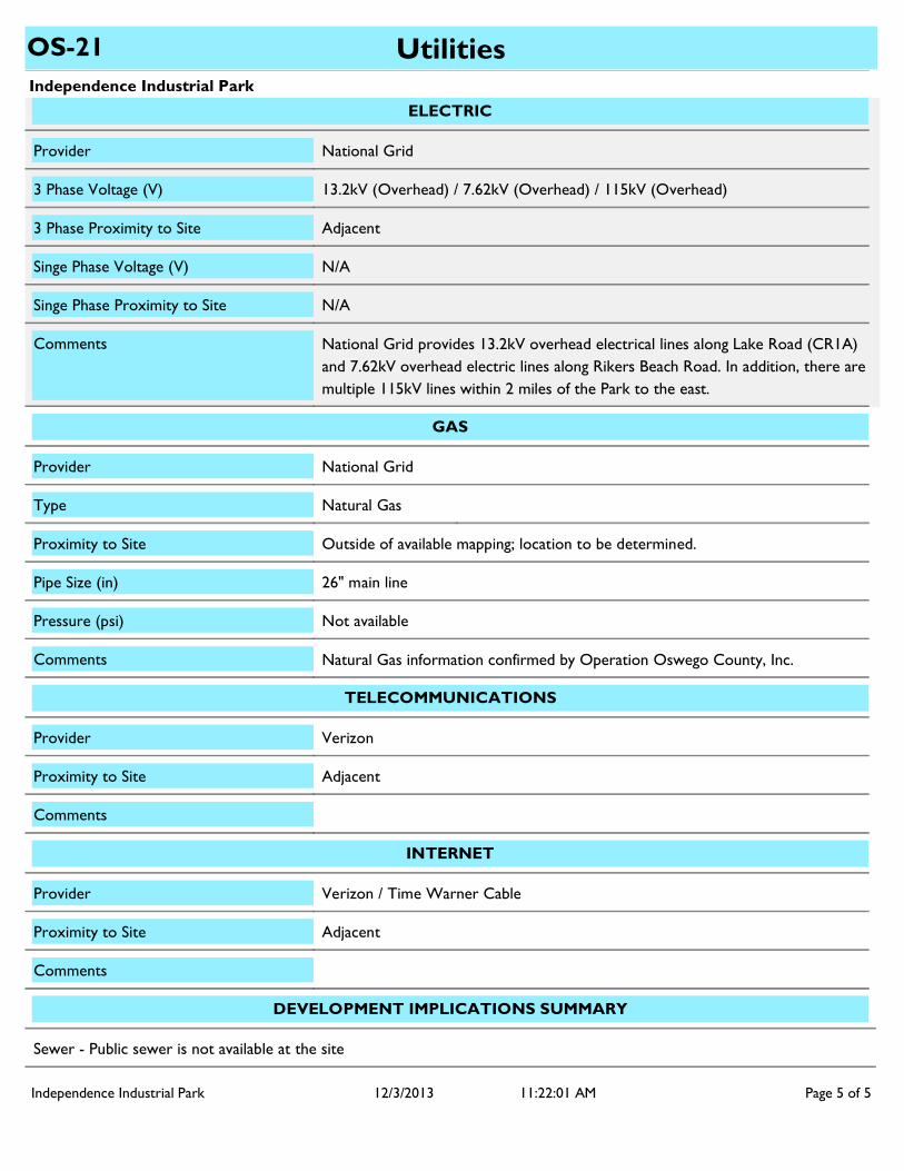
National Grid provides 13.2kV overhead electrical lines along Lake Road (CR1A) and 7.62kV overhead electric lines along Rikers Beach Road. In addition, there are multiple 115kV lines within 2 miles of the Park to the east.
Comments
Singe Phase Proximity to Site N/A
Singe Phase Voltage (V) N/A
3 Phase Voltage (V)
3 Phase Proximity to Site Adjacent
13.2kV (Overhead) / 7.62kV (Overhead) / 115kV (Overhead)
Provider
ELECTRIC
National Grid
Natural Gas information confirmed by Operation Oswego County, Inc.Comments
Proximity to Site Outside of available mapping; location to be determined.
GAS
Natural GasType
Not availablePressure (psi)
26" main linePipe Size (in)
National GridProvider
Comments
Proximity to Site Adjacent
VerizonProvider
TELECOMMUNICATIONS
INTERNET
Provider Verizon / Time Warner Cable
Comments
Proximity to Site Adjacent
DEVELOPMENT IMPLICATIONS SUMMARY
Sewer - Public sewer is not available at the site
Independence Industrial Park Page 5 of 512/3/2013 11:22:01 AM