Embed Size (px)
Citation preview

Orman House Historic State Park
APPROVED Unit Management Plan
STATE OF FLORIDA DEPARTMENT OF ENVIRONMENTAL
PROTECTION
Division of Recreation and Parks July 7, 2014

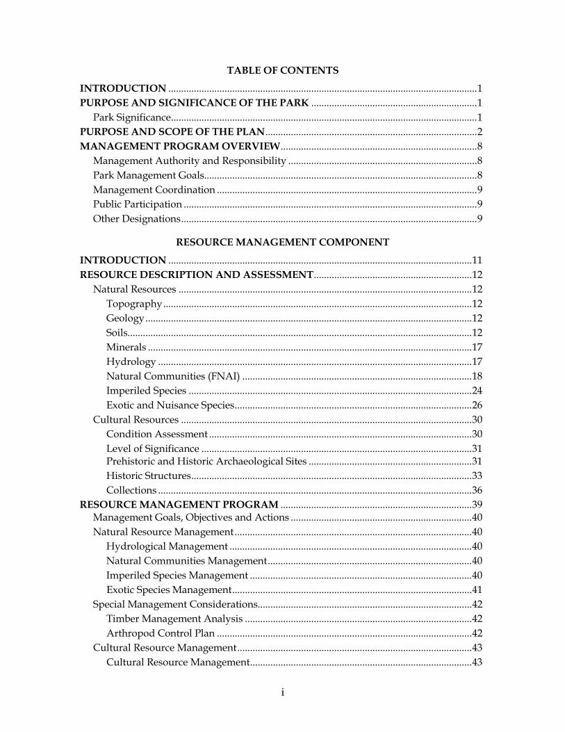
TABLE OF CONTENTS
INTRODUCTION ......................................................................................................................... 1 PURPOSE AND SIGNIFICANCE OF THE PARK ................................................................. 1 Park Significance ........................................................................................................................ 1 PURPOSE AND SCOPE OF THE PLAN ................................................................................... 2 MANAGEMENT PROGRAM OVERVIEW ............................................................................. 8 Management Authority and Responsibility .......................................................................... 8 Park Management Goals........................................................................................................... 8 Management Coordination ...................................................................................................... 9 Public Participation ................................................................................................................... 9 Other Designations .................................................................................................................... 9
RESOURCE MANAGEMENT COMPONENT
INTRODUCTION ....................................................................................................................... 11 RESOURCE DESCRIPTION AND ASSESSMENT .............................................................. 12 Natural Resources ................................................................................................................... 12 Topography ......................................................................................................................... 12 Geology ................................................................................................................................ 12 Soils....................................................................................................................................... 12 Minerals ............................................................................................................................... 17 Hydrology ........................................................................................................................... 17 Natural Communities (FNAI) .......................................................................................... 18 Imperiled Species ............................................................................................................... 24 Exotic and Nuisance Species ............................................................................................. 26 Cultural Resources .................................................................................................................. 30 Condition Assessment ....................................................................................................... 30 Level of Significance .......................................................................................................... 31 Prehistoric and Historic Archaeological Sites ................................................................ 31 Historic Structures .............................................................................................................. 33 Collections ........................................................................................................................... 36 RESOURCE MANAGEMENT PROGRAM ........................................................................... 39 Management Goals, Objectives and Actions ....................................................................... 40 Natural Resource Management ............................................................................................. 40 Hydrological Management ............................................................................................... 40 Natural Communities Management ................................................................................ 40 Imperiled Species Management ....................................................................................... 40 Exotic Species Management .............................................................................................. 41 Special Management Considerations.................................................................................... 42 Timber Management Analysis ......................................................................................... 42 Arthropod Control Plan .................................................................................................... 42 Cultural Resource Management ............................................................................................ 43 Cultural Resource Management ....................................................................................... 43
i
Resource Management Schedule ........................................................................................... 45 Land Management Review .................................................................................................... 45
LAND USE COMPONENT
INTRODUCTION ....................................................................................................................... 47 EXTERNAL CONDITIONS ....................................................................................................... 47 Existing Use of Adjacent Lands ............................................................................................. 48 Planned Use of Adjacent Lands ............................................................................................. 48 PROPERTY ANALYSIS ............................................................................................................. 49 Recreation Resource Elements ............................................................................................... 49 Land Area ............................................................................................................................ 49 Natural Scenery .................................................................................................................. 49 Significant Wildlife Habitat .............................................................................................. 49 Natural features .................................................................................................................. 49 Archaeological and Historic Features ............................................................................. 50 Assessment of Use ................................................................................................................... 50 Past Uses .............................................................................................................................. 50 Future Land Use and Zoning............................................................................................ 50 Current Recreation Use and Visitor Programs ............................................................... 50 Other Uses ........................................................................................................................... 51 Protected Zones .................................................................................................................. 51 Existing Facilities ..................................................................................................................... 51 Recreation Facilities ................................................................................................................. 51 Support Facilities ................................................................................................................ 51 CONCEPTUAL LAND USE PLAN .......................................................................................... 52 Potential Uses ........................................................................................................................... 55 Public Access and Recreational Opportunities .............................................................. 55 Proposed Facilities ................................................................................................................... 56 Capital Facilities and Infrastructure ................................................................................ 56 Facilities Development ............................................................................................................ 59 Recreational Carrying Capacity ............................................................................................. 60 Optimum Boundary ................................................................................................................ 61
IMPLEMENTATION COMPONENT
MANAGEMENT PROGRESS .................................................................................................. 65 Acquisition................................................................................................................................ 65 Park Administration and Operations .......................................................................65 Resource Management ...............................................................................................66 Natural Resources ..............................................................................................66 Cultural Resources .............................................................................................66 Recreation and Visitor Services .................................................................................66 Park Facilities ...............................................................................................................67
ii
MANAGEMENT PLAN IMPLEMENTATION ..................................................................... 67
TABLES
TABLE 1 – Orman House Historic State Park Management Zones ...................................... 12 TABLE 2 – Imperiled Species Inventory ................................................................................... 25 TABLE 3 – Inventory of FLEPPC Category I and II Exotic Plant Species ............................ 28 TABLE 4 – Cultural Sites Listed in the Florida Master Site File ............................................ 39 TABLE 5 – Recreational Carrying Capacity.............................................................................. 60 TABLE 6 – Implementation Schedule and Cost Estimates ..................................................... 69
MAPS
Vicinity Map .................................................................................................................................... 3 Reference Map ................................................................................................................................. 5 Management Zones Map ............................................................................................................. 13 Soils Map ........................................................................................................................................ 15 Natural Communities Map ......................................................................................................... 21 Base Map ........................................................................................................................................ 53 Conceptual Land Use Plan .......................................................................................................... 57 Optimum Boundary Map ............................................................................................................ 63
LIST OF ADDENDA
ADDENDUM 1 Acquisition History ........................................................................................................... A 1 - 1 ADDENDUM 2 Advisory Group Members and Report ........................................................................... A 2 - 1 ADDENDUM 3 References Cited ................................................................................................................. A 3 - 1 ADDENDUM 4 Soil Descriptions ................................................................................................................ A 4 - 1 ADDENDUM 5 Plant and Animal List ....................................................................................................... A 5 - 1 ADDENDUM 6 Cultural Information ......................................................................................................... A 6 - 1 ADDENDUM 7 Plant Species Originally Described by Alvan Chapman .............................................. A 7 - 1
iii


1
INTRODUCTION
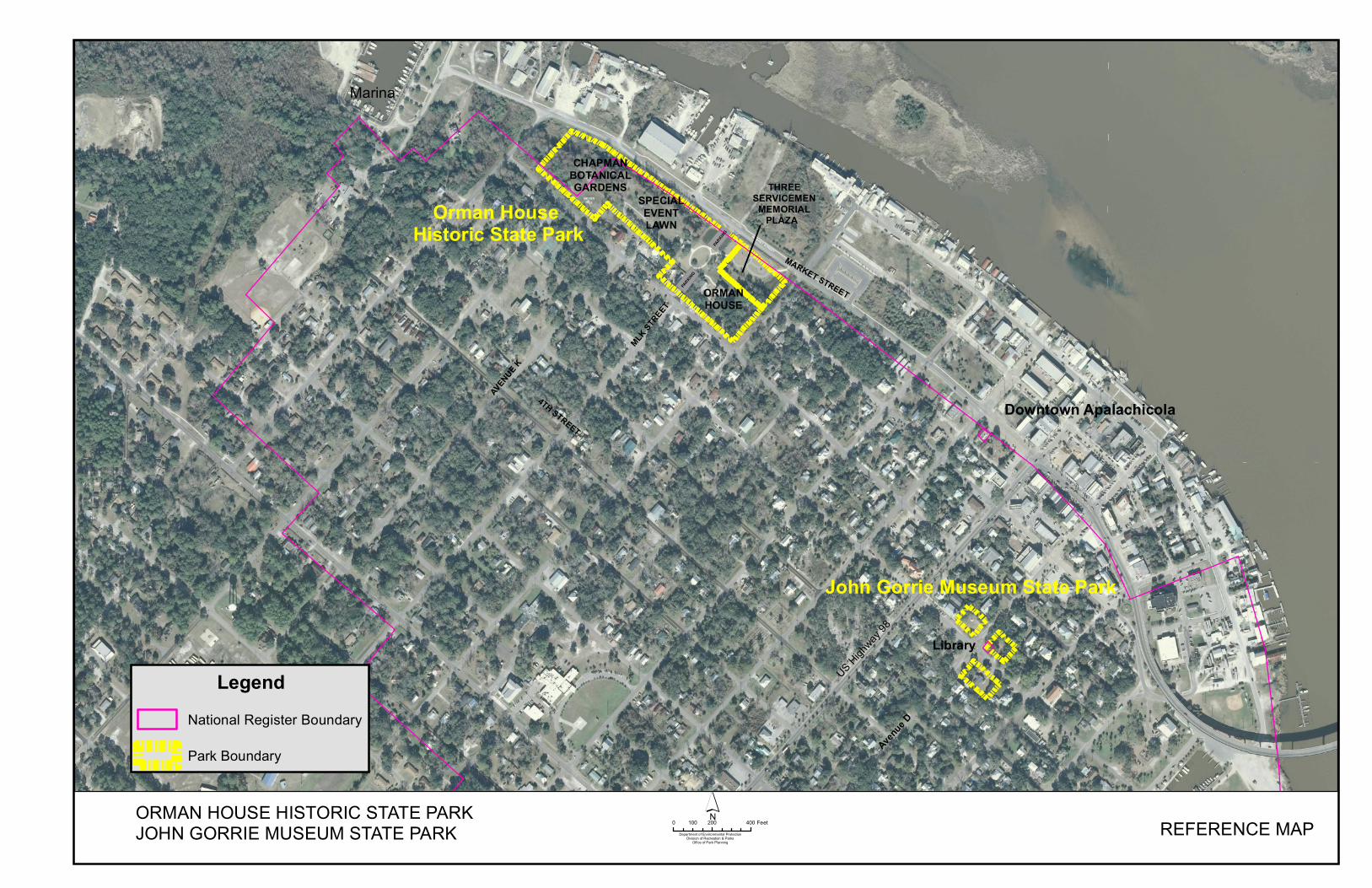
Orman House Historic State Park is located in Franklin County (see Vicinity Map). Access to the park is from Market Street, which is accessed from U.S. Highway 98 (see Reference Map). The Vicinity Map also reflects significant land and water resources existing near the park. The park was acquired in 2001 using Preservation 2000 (P-2000) funds (see Addendum 1). In 2008, an additional 6.89 acres known as the Chapman Botanical Gardens was leased from the City of Apalachicola. Currently, the park comprises 10.26 acres, as reflected on the current Properties under Jurisdiction of the Division of Recreation and Parks (Division) Report 2014. The Division of Recreation and Parks also monitors and maintains the adjacent Three Servicemen Veterans Memorial Plaza under a management agreement with the City of Apalachicola. The Three Servicemen Veterans Memorial Plaza was constructed by local benefactors and the City of Apalachicola in 2008. At Orman House Historic State Park, public outdoor recreation and conservation is the designated single use of the property. There are no legislative or executive directives that constrain the use of this property.
PURPOSE AND SIGNIFICANCE OF THE PARK
The purpose of Orman House Historic State Park is to provide for the perpetual preservation of a significant example of the Greek revival style of American architecture from Florida’s antebellum period. Situated on a high bluff overlooking the Apalachicola River, the Orman House was the home of one of Apalachicola’s most important merchant class families of the nineteenth and twentieth century. The park protects a representative portion of the historic landscape of Apalachicola, an important Civil War-era port city. Park Significance
The house is associated with Thomas G. Orman a prominent cotton merchant, planter and Apalachicola businessman who built the house in 1838 from locally cut heavy cypress timbers and pre-milled components most likely shipped from New York State.
Orman’s son, William T. Orman, was a civil war officer, a State Representative,
Senator and a leading merchant and lumberman in the late nineteenth and early twentieth century.
The house was continually occupied by Orman descendants until 1994.
2
Notable historical figures were frequent guests at the house, including Dr. John Gorrie, inventor of the procedure for the manufacture of ice, Dr. Alvin Chapman and Dr. Asa Grey, renowned botanists, and George Raney, the first native Floridian appointed as Chief Justice of the Florida Supreme Court.
Orman House Historic State Park is classified as a “State Special Feature Site” in the DRP’s unit classification system. A special feature is a discrete and well-defined object or condition that attracts public interest and provides recreational enjoyment through visitation, observation and study. A state special feature site is an area which contains such a feature, and which is set aside for controlled public enjoyment. Special feature sites for the most part are either historical or archaeological by type, but they may also have a geological, botanical, zoological, or other basis. State special feature sites must be of unusual or exceptional character, or have statewide or broad regional significance. Management of special feature sites places primary emphasis on protection and maintenance of the special feature for long-term public enjoyment. Permitted uses are almost exclusively passive in nature and program emphasis is on interpretation of the special feature. Development at special feature sites is focused on protection and maintenance of the site, public access, safety and the convenience of the user. PURPOSE AND SCOPE OF THE PLAN This plan serves as the basic statement of policy and direction for the management of Orman House Historic State Park as a unit of Florida's state park system. It identifies the goals, objectives, actions and criteria or standards that guide each aspect of park administration, and sets forth the specific measures that will be implemented to meet management objectives and provide balanced public utilization. The plan is intended to meet the requirements of Sections 253.034 and 259.032, Florida Statutes, Chapter 18-2, Florida Administrative Code, and is intended to be consistent with the State Lands Management Plan. Upon approval, this management plan will replace the 2003 approved plan. The plan consists of three interrelated components: the Resource Management Component, the Land Use Component and the Implementation Component. The Resource Management Component provides a detailed inventory and assessment of the natural and cultural resources of the park. Resource management problems and needs are identified, and measurable management objectives are established for each of the park’s management goals and resource types. This component provides guidance on the application of such measures as prescribed burning, exotic species removal, imperiled species management, cultural resource management and restoration of natural conditions.
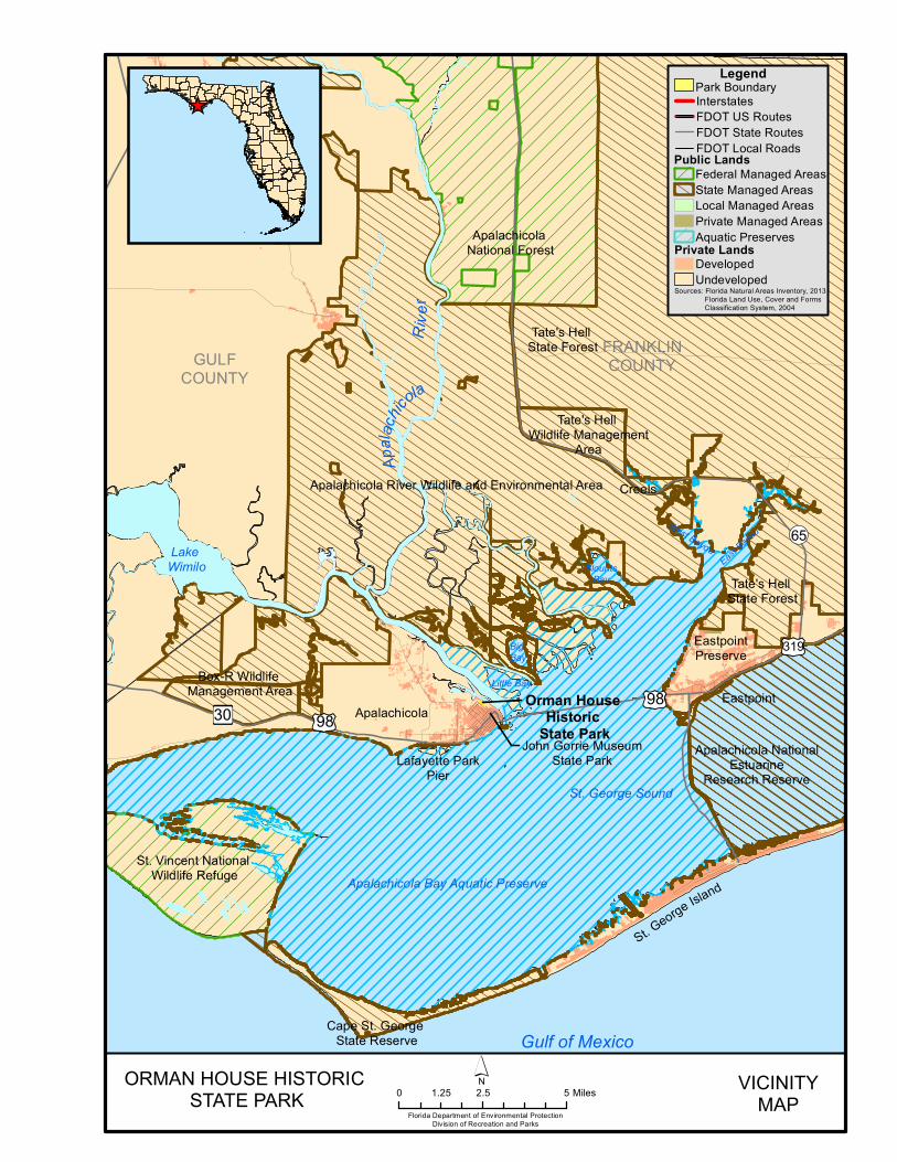
Apalachicola NationalEstuarine
Research Reserve
Cape St. George State Reserve
Box-R Wildlife Management Area
Apalachicola River Wildlife and Environmental Area
Tate's Hell State Forest
St. Vincent National Wildlife Refuge
EastpointPreserve
Orman House Historic
State Park
FRANKLINCOUNTYGULF
COUNTY
Apalachicola
Creels
Eastpoint
St. George Island
St. George Sound
£¤98Æÿ30
!(65
£¤319
£¤98
Lake Wimilo
Tate's Hell Wildlife Management
Area
Tate's Hell State Forest
Gulf of Mexico
Apalachicola National Forest
Big Bay
Little Bay
BlountsBay
West BayouEast
Bayou
John Gorrie MuseumState ParkLafayette Park
Pier
Apalachicola Bay Aquatic Preserve
Apala
chicola
River
_̂
ORMAN HOUSE HISTORIC STATE PARK
Florida Department of Environmental ProtectionDivision of Recreation and Parks
VICINITYMAP0 2.5 51.25 Miles
´
Sources: Florida Natural Areas Inventory, 2013 Florida Land Use, Cover and Forms Classification System, 2004
LegendInterstatesFDOT US RoutesFDOT State RoutesFDOT Local Roads
Park Boundary
Private LandsDevelopedUndeveloped
Public LandsFederal Managed Areas
Local Managed AreasPrivate Managed AreasAquatic Preserves
State Managed Areas

4
4TH STREET
MLK STR
EET
AVENUE K
ORMANHOUSE
THREESERVICEMEN
MEMORIALPLAZA
CHAPMANBOTANICALGARDENS
MARKET STREET
5TH STREET
Orman House Historic State Park
MEYERHILL SPECIAL
EVENTLAWN
PARKING
PARKING
MARKET STREET
US Highway
98
Marina
Downtown Apalachicola
Avenue D
John Gorrie Museum State Park
Library
ORMAN HOUSE HISTORIC STATE PARKJOHN GORRIE MUSEUM STATE PARK REFERENCE MAP´0 200 400100 Feet
Department of Environmental ProtectionDivision of Recreation & Parks
Office of Park Planning
LegendNational Register Boundary
Park Boundary

7
The Land Use Component is the recreational resource allocation plan for the park. Based on considerations such as access, population, adjacent land uses, the natural and cultural resource base of the park, current public uses and existing development, measurable objectives are set to achieve the desired allocation of the physical space of the park. These objectives locate use areas and propose the types of facilities and programs and the volume of public use to be provided. The Implementation Component consolidates the measurable objectives and actions for each of the park’s management goals. An implementation schedule and cost estimates are included for each objective and action. Included in this table are (1) measures that will be used to evaluate the DRP’s implementation progress, (2) timeframes for completing actions and objectives, (3) estimated costs to complete each action and objective. All development and resource alteration proposed in this plan is subject to the granting of appropriate permits, easements, licenses, and other required legal instruments. Approval of the management plan does not constitute an exemption from complying with the appropriate local, state or federal agencies. In the development of this plan, the potential of the park to accommodate secondary management purposes was analyzed. These secondary purposes were considered within the context of the DRP’s statutory responsibilities and the resource needs and values of the park. This analysis considered the park’s natural and cultural resources, management needs, aesthetic values, and visitation and visitor experience. For this park, it was determined that no secondary purposes could be accommodated in a manner that would not interfere with the primary purpose of resource-based outdoor recreation and conservation. Uses such as water resource development projects, water supply projects, stormwater management projects, linear facilities and sustainable agriculture and forestry (other than those forest management activities specifically identified in this plan) are not consistent with this plan. The potential for generating revenue to enhance management was also analyzed. Visitor fees and charges are the principal source of revenue generated by the park. It was determined that multiple-use management activities would not be appropriate as a means of generating revenues for land management. Instead, techniques such as entrance fees, concessions and similar measures will be employed on a case-by-case basis as a means of supplementing park management funding. The DRP may provide the services and facilities outlined in this plan either with its own funds and staff or through an outsourcing contract. Private contractors may provide assistance with natural resource management and restoration activities or a Visitor Service Provider (VSP) may provide services to park visitors in order to enhance the visitor experience. For example, a VSP could be authorized to sell merchandise and
8
food and to rent recreational equipment for use in the park. A VSP may also be authorized to provide specialized services, such as interpretive tours, or overnight accommodations when the required capital investment exceeds that which the DRP can elect to incur. Decisions regarding outsourcing, contracting with the private sector, the use of VSPs, etc. are made on a case-by-case basis in accordance with the policies set forth in the DRP’s Operations Manual (OM).
MANAGEMENT PROGRAM OVERVIEW Management Authority and Responsibility In accordance with Chapter 258, Florida Statutes, and Chapter 62D-2, Florida Administrative Code, the Division of Recreation and Parks (Division) is charged with the responsibility of developing and operating Florida's recreation and parks system. These are administered in accordance with the following policy: It shall be the policy of the Division of Recreation and Parks to promote the state park system for the use, enjoyment, and benefit of the people of Florida and visitors; to acquire typical portions of the original domain of the state which will be accessible to all of the people, and of such character as to emblemize the state's natural values; conserve these natural values for all time; administer the development, use and maintenance of these lands and render such public service in so doing, in such a manner as to enable the people of Florida and visitors to enjoy these values without depleting them; to contribute materially to the development of a strong mental, moral, and physical fiber in the people; to provide for perpetual preservation of historic sites and memorials of statewide significance and interpretation of their history to the people; to contribute to the tourist appeal of Florida. Many operating procedures are standard system-wide and are set by internal direction. These procedures are outlined in the DRP’s Operations Manual (OM) that covers such areas as personnel management, uniforms and personal appearance, training, signs, communications, fiscal procedures, interpretation, concessions, public use regulations, resource management, law enforcement, protection, safety and maintenance. Park Management Goals The following park goals express DRP’s long-term intent in managing the state park: Provide administrative support for all park functions. Protect water quality and quantity in the park, restore hydrology to the extent
feasible and maintain the restored condition. Restore and maintain the natural communities/habitats of the park. Maintain, improve or restore imperiled species populations and habitats in the park.
9
Remove exotic and invasive plants and animals from the park and conduct needed maintenance-control.
Protect, preserve and maintain the cultural resources of the park. Provide public access and recreational opportunities in the park. Develop and maintain the capital facilities and infrastructure necessary to meet the
goals and objectives of this management plan.
Management Coordination The park is managed in accordance with all applicable laws and administrative rules. Agencies having a major or direct role in the management of the park are discussed in this plan.
Public Participation DRP provided an opportunity for public input by conducting a public workshop and an Advisory Group meeting to present the draft management plan to the public. These meetings were held on March 18 and 19, 2014, respectively. Meeting notices were published in the Florida Administrative Register, Volume 40/Issue 47, included on the Department Internet Calendar, posted in clear view at the park, and promoted locally. The purpose of the Advisory Group meeting is to provide the Advisory Group members an opportunity to discuss the draft management plan (see Addendum 2).
Other Designations Orman House Historic State Park is within an Area of Critical State Concern as defined in Section 380.05, Florida Statutes. The Park is located within the City of Apalachicola which has been a designated Area of Critical State Concern since 1989. The park is a designated component of the Florida Greenways and Trails system, administered by the Department’s Office of Greenways and Trails; as well as being a part of the Big Bend Scenic Byway.

10
11
RESOURCE MANAGEMENT COMPONENT
INTRODUCTION
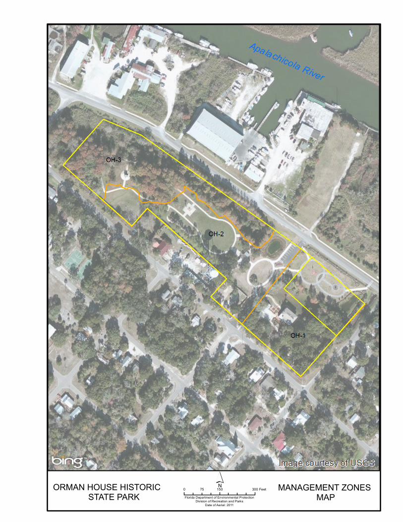
In accordance with Chapter 258, Florida Statutes, the Division of Recreation and Parks has implemented resource management programs for preserving for all time the representative examples of natural and cultural resources of statewide significance under its administration. This component of the unit plan describes the natural and cultural resources of the park and identifies the methods that will be used to manage them. The management measures expressed in this plan is consistent with the Department’s overall mission in ecosystem management. Cited references are contained in Addendum 2. The Division’s philosophy of resource management is natural systems management. Primary emphasis is placed on restoring and maintaining, to the degree possible, the natural processes that shaped the structure, function and species composition of Florida’s diverse natural communities as they occurred in the original domain. Single species management for imperiled species may be implemented when the recovery or persistence of a species is problematic, provided that this approach is compatible with natural systems management. The Division’s management goal for cultural resources is to preserve sites and objects that represent Florida’s cultural periods, significant historic events or persons. This goal often entails active measures to stabilize, reconstruct or restore resources, or to rehabilitate them for appropriate public use. Because park units are often components of larger ecosystems, their proper management can be affected by conditions and events that occur beyond park boundaries. Ecosystem management is implemented through a resource management evaluation program that assesses resource conditions, evaluates management activities refines management actions, and reviews local comprehensive plans and development permit applications for park/ecosystem impacts. The entire park is divided into management zones which delineate areas on the ground that are used to reference management activities (see Management Zones Map). The shape and size of each zone may be based on natural community types, burn zones, and the location of existing roads and natural fire breaks. It is important to note that all burn zones are management zones; however, not all management zones include fire-dependent natural communities.
12
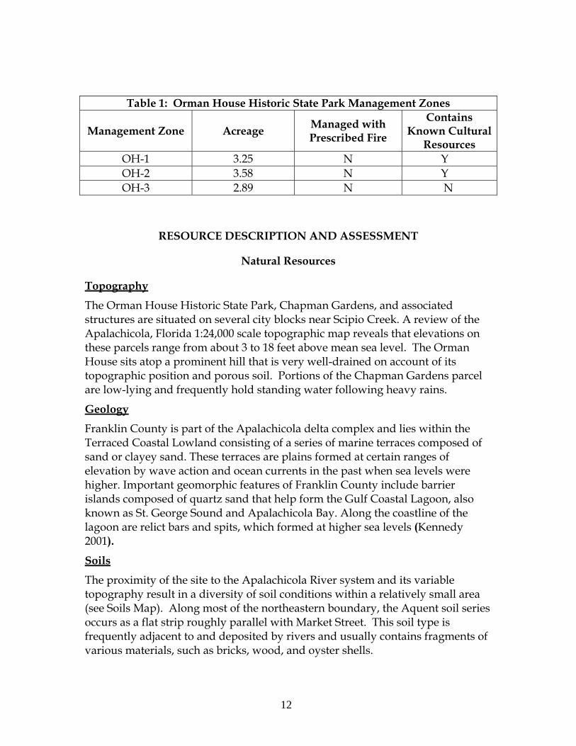
Table 1: Orman House Historic State Park Management Zones
Management Zone Acreage Managed with Prescribed Fire
Contains Known Cultural
Resources OH-1 3.25 N Y OH-2 3.58 N Y OH-3 2.89 N N
RESOURCE DESCRIPTION AND ASSESSMENT
Natural Resources
Topography
The Orman House Historic State Park, Chapman Gardens, and associated structures are situated on several city blocks near Scipio Creek. A review of the Apalachicola, Florida 1:24,000 scale topographic map reveals that elevations on these parcels range from about 3 to 18 feet above mean sea level. The Orman House sits atop a prominent hill that is very well-drained on account of its topographic position and porous soil. Portions of the Chapman Gardens parcel are low-lying and frequently hold standing water following heavy rains.
Geology
Franklin County is part of the Apalachicola delta complex and lies within the Terraced Coastal Lowland consisting of a series of marine terraces composed of sand or clayey sand. These terraces are plains formed at certain ranges of elevation by wave action and ocean currents in the past when sea levels were higher. Important geomorphic features of Franklin County include barrier islands composed of quartz sand that help form the Gulf Coastal Lagoon, also known as St. George Sound and Apalachicola Bay. Along the coastline of the lagoon are relict bars and spits, which formed at higher sea levels (Kennedy 2001).
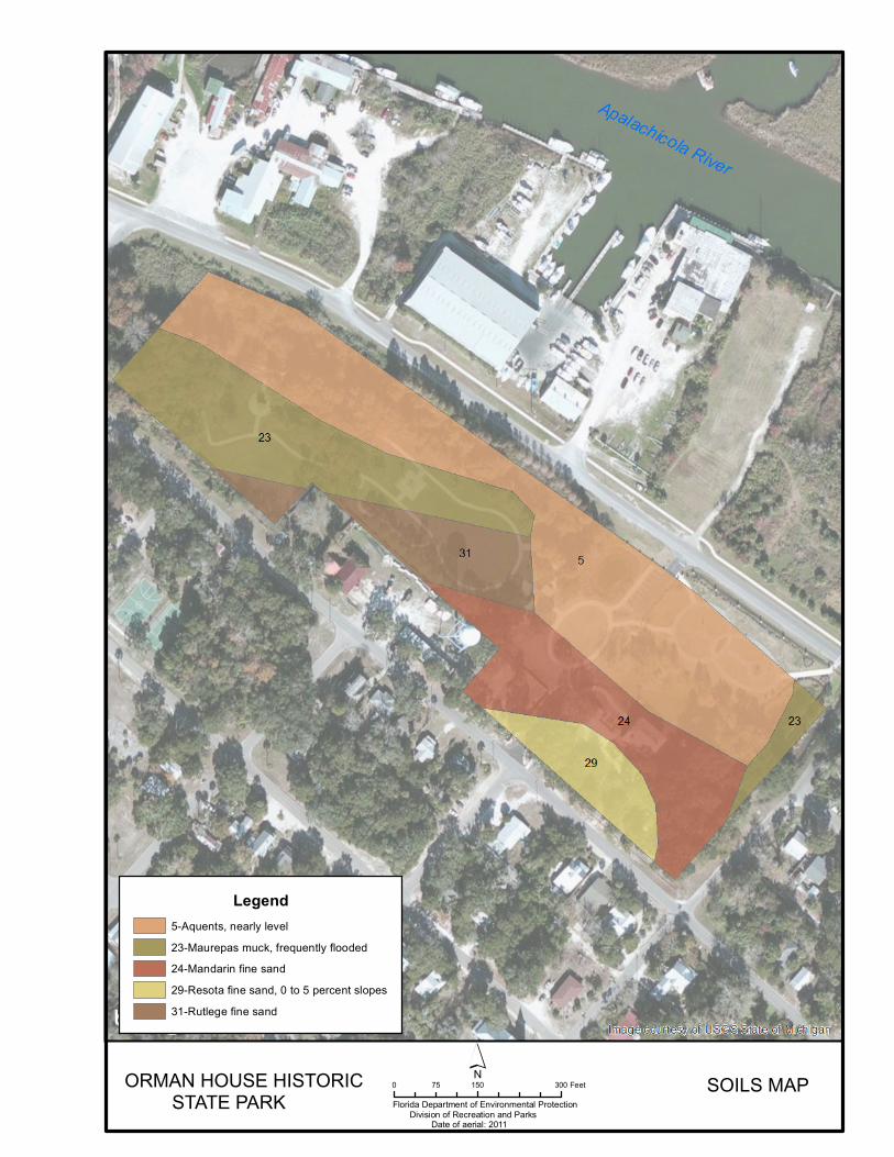
Soils
The proximity of the site to the Apalachicola River system and its variable topography result in a diversity of soil conditions within a relatively small area (see Soils Map). Along most of the northeastern boundary, the Aquent soil series occurs as a flat strip roughly parallel with Market Street. This soil type is frequently adjacent to and deposited by rivers and usually contains fragments of various materials, such as bricks, wood, and oyster shells.
Florida Department of Environmental ProtectionDivision of Recreation and Parks
Date of Aerial: 2011
0 150 30075 FeetORMAN HOUSE HISTORIC STATE PARK
MANAGEMENT ZONES MAP

14
SOILS MAPORMAN HOUSE HISTORIC STATE PARK
0 150 30075 Feet
Florida Department of Environmental Protection Division of Recreation and Parks Date of aerial: 2011
Legend5-Aquents, nearly level23-Maurepas muck, frequently flooded24-Mandarin fine sand29-Resota fine sand, 0 to 5 percent slopes31-Rutlege fine sand

16
17
The Maurepas muck series lies adjacent to the Aquents in the northerly portion of the Chapman Gardens. This soil type is nearly flat, is dominated by organic matter, and generally supports somewhat brackish, and tidally-influenced wetlands in its natural condition. South of the Maurepas muck lies the Rutledge fine sand series, which is also nearly level and supports wetland vegetation when undisturbed. While the organic component occurs at a considerable depth in the former soil type, only the fine sand of the Rutledge series’ surface layer contains an appreciable proportion of organic matter. Both soils are highly permeable, though unlike the Maurepas muck, available water capacity in the Rutledge fine sand is low. The hilltop under the Orman House is underlain by the extremely permeable Resota fine sand series, which is typical of remnant dunes and coastal ridges. Water drains from this soil type very quickly, resulting in a water table that can exceed 60 inches in depth during drier periods. Low fertility, organic matter content, and water capacity make this soil poorly-suited for agriculture, but effective drainage makes it favorable for home sites. As expected, the depth to the water table for the Mandarin fine sand occurring in the north-facing hill slope is intermediate between the extremes of the adjacent soils. Surface layers are highly permeable to percolation while the subsoil is moderately porous. More detailed descriptions of soil types may be found in Addendum 4. This site is well-established and adequately vegetated so that soil erosion does not appear to be a problem. Management measures should be undertaken to arrest erosion if it is observed, including the erection of barriers against quick surface flow and/or revegetation using native species.
Minerals
There are no known minerals of commercial value found within the property.
Hydrology
Stormwater runoff from the Orman House property (OH-1) enters drainage ditches located to the northeast, southeast, and northwest of the structure. The northwest ditch is shallow, grassy, and usually dry; it serves to direct water toward the Apalachicola River but does not retain runoff. The northeast and southeast ditches, on the other hand, are usually filled with standing water and often support emergent aquatic vegetation. The ditch northeast of the house lies between the hill slope and the Veterans Memorial Plaza, draining both areas. A small pond, created during the 20th century, also collects water from the hill slope but has no aboveground connection to the drainage canal. The City of Apalachicola manages a separate drainage canal running along Market Street and also frequently holds standing water and aquatic vegetation. The low-lying, forested portions of the Chapman Gardens parcel (OH-3) hold standing water

18
following heavy rains and function as wetlands. The raised, grassy developed area of Chapman Gardens (OH-2) consists of fill material capping a former landfill site, which was covered over in 1988. Improvements to the site, completed several years ago, closed off Avenue J from through-travel, creating two separate parking lots on either end of the block as well as a small retention pond along Market Street. Since the easternmost, low-lying portions of the park occur within the 100-year floodplain of the Apalachicola River (Kennedy 2001), these areas would be vulnerable to hurricane or tropical storm induced water surges if the area sustained a direct hit from such systems. An abandoned well dating from the 19th century occurs just southwest of the house. As this open well may potentially serve as a point source of groundwater contamination, it was covered with an affixed wooden box upon state acquisition of the property and remains so to this day. Natural Communities This section of the management plan describes and assesses each of the natural communities found in the state park. It also describes of the desired future condition (DFC) of each natural community and identifies the actions that will be required to bring the community to its desired future condition. Specific management objectives and actions for natural community management, exotic species management, and imperiled species management are discussed in the Resource Management Program section of this component. The system of classifying natural communities employed in this plan was developed by the Florida Natural Areas Inventory (FNAI). The premise of this system is that physical factors such as climate, geology, soil, hydrology, and fire frequency generally determine the species composition of an area, and that areas which are similar with respect to those factors will tend to have natural communities with similar species compositions. Obvious differences in species composition can occur, however, despite similar physical conditions. In other instances, physical factors are substantially different, yet the species compositions are quite similar. For example, coastal strand and scrub--two communities with similar species compositions--generally have quite different climatic environments, and these necessitate different management programs. Some physical influences, such as fire frequency, may vary from FNAI’s descriptions for certain natural communities in this plan. When a natural community within a park reaches the desired future condition, it is considered to be in a “maintenance condition.” Required actions for sustaining a community’s maintenance condition may include, maintaining optimal fire return intervals for fire-dependent communities, ongoing control of non-native
19
plant and animal species, maintaining natural hydrological functions (including historic water flows and water quality), preserving a community’s biodiversity and vegetative structure, protecting viable populations of plant and animal species (including those that are imperiled or endemic), and preserving intact ecotones linking natural communities across the landscape. The park contains two distinct natural communities, floodplain forest and floodplain swamp, as well as developed areas (see Natural Communities Map). A list of plants and animals occurring in the park is contained in Addendum 5. ALLUVIAL FOREST Desired Future Condition: This community consists of a seasonally flooded, generally closed canopy hardwood forest with typical overstory trees that may include water hickory (Carya aquatica), American elm (Ulmus americana), diamond-leaved oak (Quercus laurifolia), green ash (Fraxinus pennsylvanica), water locust (Gleditsia aquatica), and red maple (Acer rubrum). Understory species may include swamp dogwood (Cornus foemina), willow species (Salix spp.), and American hornbeam (Carpinus caroliniana).Presence of groundcover is variable. Various shade tolerant herbaceous species may be present. This community occurs within river floodplains and often alternates with floodplain swamps occupying lower topographic positions. Standing water is typically present on the site for one to four months of the year, depending on precipitation amounts. Length of hydroperiod is instrumental in influencing species composition as plant species vary according to their tolerance of inundation. Description and Assessment: Soils for this community are often saturated after heavy rains and support a number of trees, shrubs, and herbs. In contrast to the park’s floodplain swamp with an interior dominated by large cypress trees (Taxodium distichum), woody vegetation here is generally more diverse and structurally variable. Some common species found here include sugarberry (Celtis laevigata), red maple, cabbage palm (Sabal palmetto), swamp chestnut oak (Quercus michauxii), southern magnolia (Magnolia grandiflora), elderberry (Sambucus nigra canadensis), beautyberry (Callicarpa americana), pokeweed (Phytolacca americana), woodbine (Parthenocissus quinquefolia), and trumpet vine (Campsis radicans). While some trees closer to the cypress stand are very large, younger age classes are well represented throughout this stand. Higher light penetration through the canopy supports a dense layering of midstory and understory flora in some locations. In several small areas adjacent to Market Street, the relatively sparse canopy cover supports a thick groundcover of saw-grass (Cladium jamaicense). While the natural condition is for river floodwaters to periodically inundate this forest, either scouring the surface or depositing sediment depending on local conditions and flood characteristics, this stand is
20
isolated surface connections to the river system by Market Street and one block of development along the shoreline. Thus, its inundation primarily results from surface flows from higher elevations or drainage into this patch. Also, given this parcel’s past history as a dump site, partially evinced through occasional glimpses of discarded materials buried in the soil, disturbance pressures have contributed to the vegetative and substrate structure over the long term. Additionally, given the anecdotal accounts of the river once being positioned closer to the base of the Orman House’s hill, this patch appears to be in the latter stages of a gradual succession from marsh to denser canopy woodland. A wooden walkway and sidewalk give visitors an opportunity to view the forest interior. General Management Measures: The main management imperative for this community remains the treatment of invasive exotic plants as they are encountered. Enormous strides have been made since this parcel was first incorporated into the park in reducing extensive infestations down to infrequent scattered individuals, and this area is now in maintenance condition. Park staff has removed the accessible litter and debris from this community over the past several years so that it is not commonly seen. They should continue to remove targets of opportunity as they may become apparent over time, though it is not advisable to actively excavate submerged objects from the soil and create new disturbances. FLOODPLAIN SWAMP Desired Future Condition: The floodplain swamp is a frequently-flooded closed canopy forest located in proximity to river channels or in depressions in the midst of floodplains or oxbows. The soils consist of a mixture of sand, organics, and alluvial materials. The closed canopy is dominated by bald cypress but may also include tupelo species (Nyssa spp.), water hickory, or red maple. The tree bases are typically buttressed and the understory and groundcover is typically sparse, potentially consisting of lizard’s tail (Saururus cernuus), bog hemp (Boehmeria cylindrica), royal fern (Osmunda regalis), smartweed (Polygonum spp.), and string-lily (Crinum americanum). Under the existing canopy, inundation is generally long enough to eliminate most significant plant growth so that most of the substrate is open or coated with leaf litter. While these communities are usually located in a topographic position to receive floodwaters directly from river channels, they may also be isolated from these systems by riverbank levees or other obstructions.
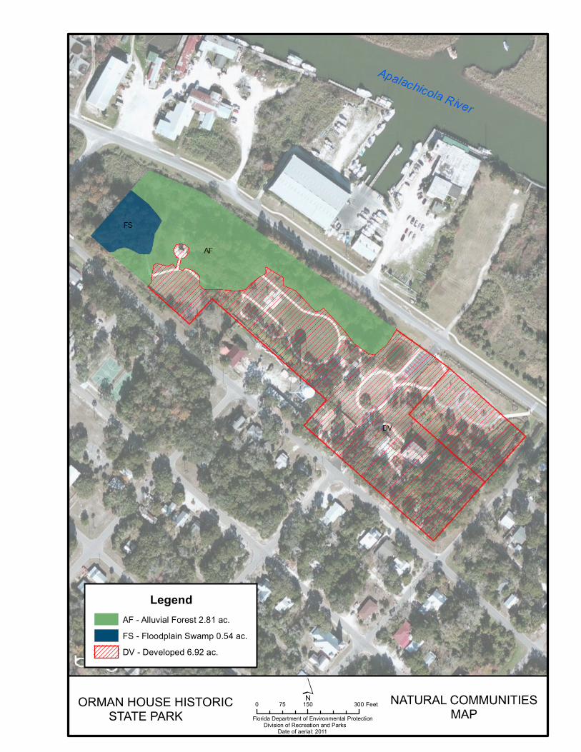
NATURAL COMMUNITIESMAP
ORMAN HOUSE HISTORIC STATE PARK
LegendAF - Alluvial Forest 2.81 ac.FS - Floodplain Swamp 0.54 ac.DV - Developed 6.92 ac.
Florida Department of Environmental Protection Division of Recreation and Parks Date of aerial: 2011
0 150 30075 Feet

22
23
Description and Assessment: This community type may be observed along the extreme western corner of the Chapman Gardens. Its vegetation is dominated by a stand of mature bald cypress trees. Their tall, robust trunks support a dense canopy which intercepts most of the incoming sunlight. As a result, the ground-level environment is heavily shaded. The mid-story is predominantly cabbage palms generally not exceeding eight to ten feet in height. There are few understory plants. Despite its proximity to the Apalachicola River system, this swamp no longer has a surface connection to the river, which is blocked by Market Street and several developed properties along Scipio Creek. While the cypress trees have survived to grow to impressive dimensions, this tract has been subject to smaller scale disturbances and stressors over the years. However, royal fern has been able to persist in this stand in spite of the nearby landfill, now submerged below the grass covered landscape of the gardens. When the property was first acquired by the state, thick air potato vines (Dioscorea bulbifera) were draped from the lofty branches of the bald cypresses. After extensive control efforts by park staff, these vines are no longer present and other exotic vegetation is not regularly observed in this stand. Camphor trees (Cinnamomum camphora) and Chinese tallows (Sapium sebiferum) occasionally recruit to this area from adjacent areas, but they are treated or removed when encountered and no mature individuals occur on park property. General Management Measures: While the mature cypress trees are robust, the inundation frequency of this site appears to have decreased over the years. The edge of the Apalachicola River once flowed near the base of the hill on which the Orman House stands. No management measures are necessary to reverse this trend as the present circumstance reflects the natural migration of the river system as well as surrounding developmental changes in the town. The main management imperative for this community remains the treatment of exotic plants as they are encountered. Visitors should be discouraged from walking into this stand under the cypresses in order to preserve the herbaceous understory vegetation; the wooden walkway enables visitors to look into the stand from its edge without disturbing the soils. DEVELOPED Desired Future Condition: The developed areas are now maintained within their desired future condition as an attractive set of amenities that park visitors may visit in order to learn about the local history, view some of the adjacent natural areas, and enjoy a sense of serenity from the grounds. Description and Assessment: The park property has been developed and has had various uses since the 1830s. There are no longer any portions of zone 1 that can be accurately described as a natural ecological community. Nevertheless, the
24
unit does possess natural elements. The property’s low-lying fringe along the northeast boundary provides potential habitat for turtles and frogs. The area southwest of the house is rather shaded by large oaks that support habitat for grey squirrels (Sciurus caroliniensis). Several common birds, such as mockingbirds (Mimus polyglottos), blue jays (Cyanocitta cristata), and northern cardinals (Cardinalis cardinalis), frequent the property year round. Additionally, the property’s tree cover provides refuge for various migratory birds during the spring and fall. The majority of zone OH-1 consists of the main house, a Servant’s Quarters, a mule barn, and landscaped grounds. Now buried, the brick foundation of a building (the “Charity House”) which has had varied uses as a Civil War-era infirmary, schoolhouse and convent, is located near the eastern corner of the property. An ornamental garden is located outside the kitchen door, and several small plots between the house and barn are seasonally planted with fruit and vegetable plants. The main entrance of the Chapman Gardens, facing the Orman House, consists of a large gate structure; a system of sidewalks connects these two main features of the park. The gardens area is dominated by a lawn area dotted with a scattering of ornamental trees and various beds planted with flowers, an orchard area known as Johnny Meyer Hill for the man who lead the clean-up effort of the gardens and other attractive plants. While this area had fallen into disrepair prior to state acquisition, it is now an aesthetically- pleasing landscape with intact lighting fixtures and fences. General Management Measures: The developed areas within the park will be managed to minimize the effect of these areas on adjacent natural areas. Priority invasive plant species Florida Exotic Pest Plant Council (FLEPPC) Category I and II species) will be removed from all developed areas. Other management measures include proper stormwater management and monitoring for problematic erosive areas should they be identified. Imperiled Species Imperiled species are those that are (1) tracked by FNAI as critically imperiled or imperiled; or (2) listed by the U.S. Fish and Wildlife Service (USFWS), Florida Fish and Wildlife Conservation Commission (FWC) or the Florida Department of Agriculture and Consumer Services (FDACS) as endangered, threatened or of special concern. Known imperiled species encountered in the park consist of three species of wading birds that pass over or wander through the property (see Table 2 below). As their name implies, they are primarily seen scouting along the canals or the couple retention ponds on the property. As long as these habitats are preserved
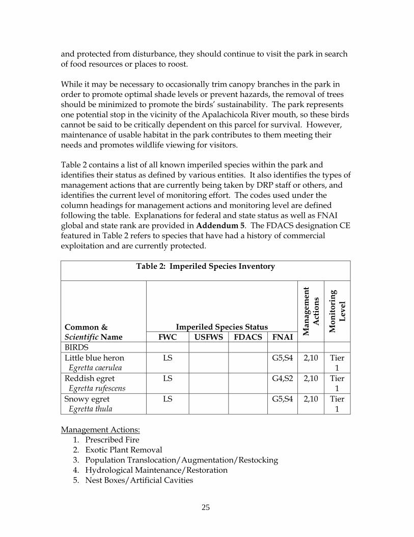
25
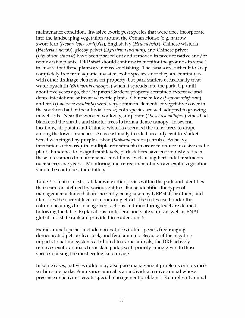
and protected from disturbance, they should continue to visit the park in search of food resources or places to roost. While it may be necessary to occasionally trim canopy branches in the park in order to promote optimal shade levels or prevent hazards, the removal of trees should be minimized to promote the birds’ sustainability. The park represents one potential stop in the vicinity of the Apalachicola River mouth, so these birds cannot be said to be critically dependent on this parcel for survival. However, maintenance of usable habitat in the park contributes to them meeting their needs and promotes wildlife viewing for visitors. Table 2 contains a list of all known imperiled species within the park and identifies their status as defined by various entities. It also identifies the types of management actions that are currently being taken by DRP staff or others, and identifies the current level of monitoring effort. The codes used under the column headings for management actions and monitoring level are defined following the table. Explanations for federal and state status as well as FNAI global and state rank are provided in Addendum 5. The FDACS designation CE featured in Table 2 refers to species that have had a history of commercial exploitation and are currently protected.
Table 2: Imperiled Species Inventory
Common & Scientific Name
Imperiled Species Status
Man
agem
ent
Act
ion
s
Mon
itor
ing
Lev
el
FWC USFWS FDACS FNAI BIRDS Little blue heron Egretta caerulea
LS G5,S4 2,10 Tier 1
Reddish egret Egretta rufescens
LS G4,S2 2,10 Tier 1
Snowy egret Egretta thula
LS G5,S4 2,10 Tier 1
Management Actions:
1. Prescribed Fire 2. Exotic Plant Removal 3. Population Translocation/Augmentation/Restocking 4. Hydrological Maintenance/Restoration 5. Nest Boxes/Artificial Cavities
26
6. Hardwood Removal 7. Mechanical Treatment 8. Predator Control 9. Erosion Control 10. Protection from visitor impacts (establish buffers)/law enforcement 11. Decoys (shorebirds) 12. Vegetation planting 13. Outreach & Education 14. Other
Monitoring Level: Tier 1. Non-Targeted Observation/Documentation: includes documentation of
species presence through casual/passive observation during routine park activities (i.e. not conducting species specific searches). Documentation may be in the form of Wildlife Observation Forms, or other district specific methods used to communicate observations.
Tier 2. Targeted Presence/Absence: includes monitoring methods/activities that are specifically intended to document presence/absence of a particular species or suite of species.
Tier 3. Population Estimate/Index: an approximation of the true population size or population index based on a widely accepted method of sampling.
Tier 4. Population Census: A complete count of an entire population with demographic analysis, including mortality, reproduction, emigration, and immigration.
Tier 5. Other: may include habitat assessments for a particular species or suite of species or any other specific methods used as indicators to gather information about a particular species.
Detailed management goals, objectives and actions for imperiled species in this park are discussed in the Resource Management Program section of this component and the Implementation Component of this plan.
Exotic and Nuisance Species
Exotic species are plants or animals not native to Florida. Invasive exotic species are able to out-compete, displace or destroy native species and their habitats often because they have been released from the natural controls of their native range, such as diseases, predatory insects, etc. If left unchecked, invasive exotic plants and animals alter the character, productivity, and conservation values of the natural areas they invade. When all parcels were acquired by the State of Florida, invasive exotic plant infestations were quite advanced. In the course of the intervening years, DRP staff has worked very hard to treat these pest plants and contain the infestations so that the park can be described to be in
27
maintenance condition. Invasive exotic pest species that were once incorporate into the landscaping vegetation around the Orman House (e.g. narrow swordfern (Nephrolepis cordifolia), English ivy (Hedera helix), Chinese wisteria (Wisteria sinensis), glossy privet (Ligustrum lucidum), and Chinese privet (Ligustrum sinense) have been phased out and removed in favor of native and/or noninvasive plants. DRP staff should continue to monitor the grounds in zone 1 to ensure that these plants are not reestablishing. The canals are difficult to keep completely free from aquatic invasive exotic species since they are continuous with other drainage elements off property, but park staffers occasionally treat water hyacinth (Eichhornia crassipes) when it spreads into the park. Up until about five years ago, the Chapman Gardens property contained extensive and dense infestations of invasive exotic plants. Chinese tallow (Sapium sebiferum) and taro (Colocasia esculenta) were very common elements of vegetative cover in the southern half of the alluvial forest; both species are well adapted to growing in wet soils. Near the wooden walkway, air potato (Dioscorea bulbifera) vines had blanketed the shrubs and shorter trees to form a dense canopy. In several locations, air potato and Chinese wisteria ascended the taller trees to drape among the lower branches. An occasionally flooded area adjacent to Market Street was ringed by purple sesban (Sesbania punicea) shrubs. As heavy infestations often require multiple retreatments in order to reduce invasive exotic plant abundance to insignificant levels, park staffers have enormously reduced these infestations to maintenance conditions levels using herbicidal treatments over successive years. Monitoring and retreatment of invasive exotic vegetation should be continued indefinitely. Table 3 contains a list of all known exotic species within the park and identifies their status as defined by various entities. It also identifies the types of management actions that are currently being taken by DRP staff or others, and identifies the current level of monitoring effort. The codes used under the column headings for management actions and monitoring level are defined following the table. Explanations for federal and state status as well as FNAI global and state rank are provided in Addendum 5. Exotic animal species include non-native wildlife species, free-ranging domesticated pets or livestock, and feral animals. Because of the negative impacts to natural systems attributed to exotic animals, the DRP actively removes exotic animals from state parks, with priority being given to those species causing the most ecological damage. In some cases, native wildlife may also pose management problems or nuisances within state parks. A nuisance animal is an individual native animal whose presence or activities create special management problems. Examples of animal
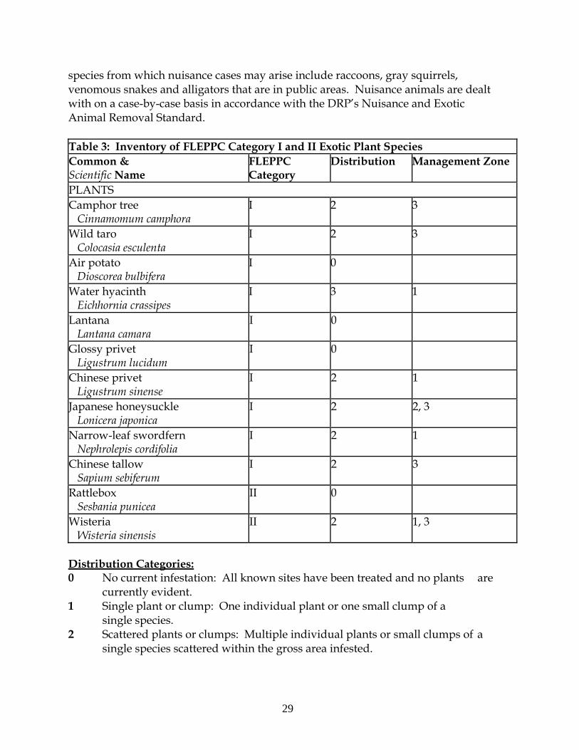
29
species from which nuisance cases may arise include raccoons, gray squirrels, venomous snakes and alligators that are in public areas. Nuisance animals are dealt with on a case-by-case basis in accordance with the DRP’s Nuisance and Exotic Animal Removal Standard. Table 3: Inventory of FLEPPC Category I and II Exotic Plant Species Common & Scientific Name
FLEPPC Category
Distribution Management Zone
PLANTS Camphor tree Cinnamomum camphora
I 2 3
Wild taro Colocasia esculenta
I 2 3
Air potato Dioscorea bulbifera
I 0
Water hyacinth Eichhornia crassipes
I 3 1
Lantana Lantana camara
I 0
Glossy privet Ligustrum lucidum
I 0
Chinese privet Ligustrum sinense
I 2 1
Japanese honeysuckle Lonicera japonica
I 2 2, 3
Narrow-leaf swordfern Nephrolepis cordifolia
I 2 1
Chinese tallow Sapium sebiferum
I 2 3
Rattlebox Sesbania punicea
II 0
Wisteria Wisteria sinensis
II 2 1, 3
Distribution Categories: 0 No current infestation: All known sites have been treated and no plants are currently evident. 1 Single plant or clump: One individual plant or one small clump of a single species. 2 Scattered plants or clumps: Multiple individual plants or small clumps of a single species scattered within the gross area infested.
30
3 Scattered dense patches: Dense patches of a single species scattered within the gross area infested. 4 Dominant cover: Multiple plants or clumps of a single species that occupy a
majority of the gross area infested. 5 Dense monoculture: Generally, a dense stand of a single dominant species
that not only occupies more than a majority of the gross area infested, but also covers/excludes other plants.
6 Linearly scattered: Plants or clumps of a single species generally scattered along a linear feature, such as a road, trail, property line, ditch, ridge, slough, etc. within the gross area infested.
Feral cats are currently the only animals that act as a nuisance at the park. Occasionally, they will seek shelter under the Orman House and prey upon some of the smaller animals found at the site. When the need arises, the DRP staff contacts the local Animal Control officer to capture and remove the cats. Other exotic animals are not regularly observed at the park. Detailed management goals, objectives and actions for management of invasive exotic plants and exotic and nuisance animals are discussed in the Resource Management Program section of this component.
Cultural Resources
This section addresses the cultural resources present in Orman House State Park which may include archaeological sites, historic buildings and structures, cultural landscapes and collections. The Florida Department of State (FDOS) maintains the master inventory of such resources through the Florida Master Site File (FMSF). State law requires that all state agencies locate, inventory and evaluate cultural resources that appear to be eligible for listing in the National Register of Historic Places. Addendum 7 contains the FDOS, Division of Historical Resources (DHR) management procedures for archaeological and historical sites and properties on state-owned or controlled properties; the criteria used for evaluating eligibility for listing in the National Register of Historic Places, and the Secretary of Interior’s definitions for the various preservation treatments (restoration, rehabilitation, stabilization and preservation). For the purposes of this plan, significant archaeological site, significant structure and significant landscape means those cultural resources listed or eligible for listing in the National Register of Historic Places. The terms archaeological site, historic structure or historic landscape refer to all resources that will become 50 years old during the term of this plan.
Condition Assessment
Evaluating the condition of cultural resources is accomplished using a three-part evaluation scale, expressed as good, fair and poor. These terms describe the present condition, rather than comparing what exists to the ideal condition. Good describes

31
a condition of structural stability and physical wholeness, where no obvious deterioration other than normal occurs. Fair describes a condition in which there is a discernible decline in condition between inspections, and the wholeness or physical integrity is and continues to be threatened by factors other than normal wear. A fair assessment is usually a cause for concern. Poor describes an unstable condition where there is palpable, accelerating decline, and physical integrity is being compromised quickly. A resource in poor condition suffers obvious declines in physical integrity from year to year. A poor condition suggests immediate action is needed to reestablish physical stability.
Level of Significance
Applying the criteria for listing in the National Register of Historic Places involves the use of contexts as well as an evaluation of integrity of the site. A cultural resource’s significance derives from its historical, architectural, ethnographic or archaeological context. Evaluation of cultural resources will result in a designation of NRL (National Register or National Landmark Listed or located in an NR district), NR (National Register eligible), NE (not evaluated) or NS (not significant) as indicated in the table at the end of this section. There are no criteria for use in determining the significance of collections or archival material. Usually, significance of a collection is based on what or whom it may represent. For instance, a collection of furniture from a single family and a particular era in connection with a significant historic site would be considered highly significant. In the same way, a high quality collection of artifacts from a significant archaeological site would be of important significance. A large herbarium collected from a specific park over many decades could be valuable to resource management efforts. Archival records are most significant as a research source. Any records depicting critical events in the park’s history, including construction and resource management efforts, would all be significant. The following is a summary of the FMSF inventory. In addition, this inventory contains the evaluation of significance. Prehistoric and Historic Archaeological Sites Desired Future Condition: All significant archaeological sites within the park that represent Florida’s cultural periods or significant historic events or persons are preserved in good condition in perpetuity, protected from physical threats and interpreted to the public. Description: There are two archaeological sites located in the park which are recorded in the FMSF. North Ridge (8FR00073) is a deteriorated prehistoric shell
32
midden, believed to be associated with the Weeden Island (C.E. 450-1000) or Fort Walton (C.E. 1000-1500) cultural period. The Orman House State Park (8FR00922) describes the soil substrate comprising the hill top where the Orman House stands and includes any historic or archaeological elements buried therein. A small brick building once stood on the parcel’s east corner during the 19th century. This structure was called the “Charity House” and had been used as a convent, schoolhouse, and a Civil War-era hospital. The buried foundation is now all that remains. A family burial plot once existed on the site, but the remains were previously relocated to the city cemetery. Anecdotal reports indicate that the site once contained one or more detached kitchen structures, slave cabins, a second well, an ice house and a cistern, though these features were not located by a phase I level archeological survey conducted by SouthArc, Inc. in 2003 (Wayne and Dickinson 2003). Subsequent archeological investigations by Garlick and Associates in 2008 and the Florida Public Archaeology Network (FPAN) in 2010 noted the presence of a number of early antebellum artifacts in the areas around the historic structures on the property (Earnest 2009; Lees 2010). In addition, the survey conducted by FPAN, which was concentrated on the area in and around the Servant’s Quarters, located a number of prehistoric artifacts and a potential prehistoric feature. An archaeological resource sensitivity model (predictive model) was completed for the park in 2012 by the University of South Florida, Alliance of Integrated Spatial Technologies (AIST). The model identifies areas of high, medium and low cultural sensitivity in the park and can be used as a planning tool, along with other archaeological methods, to target survey areas and assist in land use planning (Collins et al. 2012). Condition Assessment: The Orman House State Park Property (8FR00922) is in good condition. North Ridge (8FR00073) was in poor condition at the time it was originally recorded to the FMSF (Carr 1975). The site was recently reassessed and it was noted that the site appeared to be more fill material than cultural material (Collins et al. 2012). Level of Significance: The Orman House State Park (8FR00922) has been determined as potentially eligible for the National Register of Historic Places by the State Historic Preservation Officer (SHPO) due to the site’s potential to yield information in regard to prehistoric use and mid-19th and 20th century occupation of the property. North Ridge (8FR00073) has not been formally evaluated by the SHPO, but archaeologists who have surveyed the site believe it to be ineligible for the National Register due to its poor condition and limited archaeological research potential (Carr 1975; Collins et al., 2012).

33
General Management Measures: The Orman House State Park (8FR00922) will be managed using preservation as the treatment since the site is currently in good condition. North Ridge is in poor condition and believed to be ineligible for the National Register. However, until North Ridge (8FR00073) has been formally evaluated by the SHPO, preservation is the preferred treatment for the site. Preservation includes protection from damage from resource management, natural causes, construction or human damage including looting. Historic Structures Desired Future Condition: All significant historic structures and landscapes that represent Florida’s cultural periods or significant historic events or persons are preserved in good condition in perpetuity, protected from physical threats and interpreted to the public. Description: As the park name suggests, the most prominent structure at this location is the main house, originally owned and constructed by Thomas Orman. The Thomas Orman House (8FR000396) was designed in a regional variation of the Greek Revival style popular in the antebellum South. Some of the lumber used in its construction was measured and cut to specification in Syracuse, New York and transported by sea to the Port of Apalachicola. A two-story gallery and an outer fringing row of columns extended across the front and southeastern side of the house. Latter modifications enclosed a portion of the gallery at the northern corner to create a new room with bay windows facing the Apalachicola River. The original design displayed a symmetry between and within the first and second story floor plans that is typical of the Greek Revival style. Entry through the front door leads one into a central corridor with a staircase rising to the second story; entry into the two large dining and living chambers flank on the immediate right and left. The second story floor plan consists of two large bedrooms connected by the central corridor. Another staircase rises to a third landing and entry to the attic space. The original design featured a separate kitchen structure behind the house, which was a common practice at the time. Subsequent alterations between 1892 and 1902 added a kitchen and parlor room on the southwestern side within a first floor addition. A brick-constructed circular well is located south of the main house and is recorded as an ancillary feature of the Thomas Orman House (8FR000396). It rises 1 ½ feet off the ground, has a water level about 20 feet below the surface, and is currently capped with a plywood box to prevent safety problems. The Mule Barn (8FR01263) is located northwest of the house; this building is of board-and-batten design with a metal roof and large double doors opening toward 5th Street. The mule barn has undergone an extensive rehabilitation effort and is
34
currently used as the shop building for the park, housing the tools, landscaping equipment and other miscellanea used to maintain the structures and grounds. The Servant’s Quarters (8FR01264) is located southwest of the mule barn. It is a shotgun-style structure with board-and-batten design and a metal roof. It is oriented with its long axis parallel to 5th Street, which is a few yards away. In the past, the Servant Quarters was believed to be a slave cabin; recent architectural analysis has concluded that it is more likely a late 19th century outbuilding in which earlier materials may have been reused (Hammond and Marder 2011). Condition Assessment: Upon acquisition by the DRP, the Orman House, ancillary structures and associated grounds were in an advanced state of disrepair. Subsequent efforts have significantly improved most of the park’s cultural features. The main house has been extensively restored, was subject to an analysis resulting in a Historic Structures Report (Marshall and Hall 2003), and is currently one of Apalachicola’s top historical sites, having educated many visitors about the Orman family and the rich local history. The existing exterior paint was tested and found to possess quantities of lead; the lead paint was abated and replaced with fresh coats of white lead-free paint. There have been issues with roof leakage, especially at the junction of the original structure and the rearward addition, and repair work was undertaken in the past year to correct this situation. A ramp was installed this year along the southeastern deck to facilitate access by visitors with disabilities. The second story is not currently included in the house tour, which is partially due to the difficulty in providing equal access to all visitors. The stairs are steep and difficult to climb for some people. There is also no adequate space within the central corridor to accommodate a wheelchair lift for access to the disabled; such an elevator would have to be erected along the house exterior and would detract from the historical appearance of the structure. Storm shutters were recently installed to protect the house’s interior in the event a hurricane or tropical storm impacts the area. The Orman House is currently in good condition and regular management measures will continue to be taken to preserve this state. The other features on the property are in varied states of repair. The mule barn was subject to a rehabilitation effort that stabilized the building and improved its outward appearance in a way that remained faithful to its historic status. It remains a utilitarian feature as tools and other equipment are stored inside it and the interior walls are constructed of drywall, which is readily visible. The mule barn and well are in good condition. The Servant’s quarters, on the other hand, is in poor condition. It has been braced by wooden beams for temporary support and is blocked from public entrance, however, the condition of the building continues to decline due to further deterioration of its original wood construction. A recent evaluation of the structure
35
by preservation architects have determined that restoration of the structure would not be prudent as much of the original fabric of the building has disappeared or has been damaged beyond repair by termites and other insects (Hammond and Marder 2011). Level of Significance: The Thomas Orman House (8FR00396) is listed on the National Register of Historic Places as a contributing structure to the Apalachicola Historic District (FR00350), and is considered as potentially eligible for the National Register as an individual property. The 2003 Historic Structures Report for the Orman House State Park describes four principal reasons that the house and its associated structures are historically significant. First, this property has been intimately associated with people (i.e., the Thomas Orman family and descendants, the botanist Alvan Chapman and the inventor John Gorrie) who were integral in influencing the development of political and scientific thought in 19th century Florida. Second, since the site was owned by a single family for about 156 years, its features characterize a valuable and consistent record of the progression of southern domestic life over this time. Third, the Orman House represents an outstanding example of domestic antebellum architecture in the Deep South, specifically a regional variation of the Greek revival style. Last, its significance is enhanced by the construction materials and the mode of transport used to bring them to the site: pre-milled components were shipped overseas from New York to Apalachicola. General Management Measures: The Thomas Orman House will be managed by utilizing preservation as a treatment approach. The main measures promoting the preservation of the Orman House include steps to prevent structural damage or deterioration. Cyclic inspection and subsequent treatment of any pest infestation found is a high priority. Despite the recent roof repairs, rain leakage, albeit much reduced, continues to be an issue that should be addressed in the near future. A quarterly inspection concerning safety and maintenance issues is also conducted during which roofing, decking, and other structural features are monitored. The mule barn will be managed utilizing rehabilitation as its treatment approach. Its interior was changed in order to stabilize the building and adapt it for modern use, while its exterior retains much of its original material and features which convey its historic use. Permanent management measures for the Servant’s quarters (8FR01264) have yet to be determined. Although the building is blocked off from public entrance and supported by braces, these measures are only temporary and do not address the continuing deterioration of the building. As noted in the Condition Assessment section above, much of the original fabric of the building has disappeared or has been damaged beyond repair (Hammond and Marder 2011). As the park would like to continue to interpret the presence of workers on the Orman Property, an alternate
36
proposal has been made that the original building be thoroughly documented and removed, and a replica be reconstructed on site along with an interpretive display explaining the role that slaves and subsequent workers played in the property’s history. A written cyclical maintenance plan will be developed regarding building and grounds maintenance. The major risks to preservation of the Orman House and other buildings include hurricane or tropical storms and insect or rodent infestations. Collections Desired Future Condition: All historic, natural history and archaeological objects within the park that represent Florida’s cultural periods, significant historic events or persons, or natural history specimens are preserved in good condition in perpetuity, protected from physical threats and interpreted to the public. Description: There are a variety of historical documents stored within the Orman House’s archives corresponding to different owners of the property from the mid-19th to the mid-20th centuries. Most of these documents are on loan from the Orman family and are called the Thomas Orman Papers. This archive contains land transaction records covering properties across this region of Florida (purchases and rentals), tax receipts, banking records, bond receipts, wills, birth and death certificates, marriage licenses, personal correspondence, newspaper clippings, handwritten notes, historical photographs and other varied documents. A few of these items are on display in the house, but most are stored on shelving within a closet that is approximately six feet tall, three feet wide, and two feet deep. A two-year project to digitize the Thomas Orman Papers was successfully completed in 2012 and the electronic copies are located at the Orman House. The house contains a variety of historic furniture and other items that are owned by the state as well as on loan to the park for display. There are two pieces of furniture original to the Orman House: a (circa 1830) “Federal into Empire” mahogany high post bedstead and a walnut wardrobe cabinet. There are also a few objects that belonged to Sadie Orman, Thomas Orman’s granddaughter: an art easel and a chair. Other items are domestic in nature, dating from the mid-nineteenth to mid-twentieth century, and include sofas, armchairs, desks, wall mirrors, chests, a grand piano, tables, beds, clothing, books, china dishware, framed pictures and other knickknacks. There is also a curio cabinet displaying small items original to Thomas Orman, his son William Orman, Williams’s daughter Sadie Orman and Ion Andrews the last of the family to live in the house in 1994. These items include epaulettes belonging to William Orman from his service in the Civil War, buttons, spectacles and the Orman family bible.
37
Condition Assessment: The collections at the Orman House are in fairly good and stable condition. There are some items that could use minor conservation repairs, but overall the objects and archives in the house are dutifully monitored and cared for. All Orman House collections are either on display in the house or stored in the house. The biggest threat facing the Orman House collections might be the UV rays that enter through the large windows. The textiles near windows have been severely bleached by their regular exposure to sunlight. This damage is irreversible. Future bleaching could be prevented by applying UV-filtering film to the windows of the Orman House, and by putting the more vulnerable textiles on a rotation schedule which provides for a “resting period” out of harm’s way. The unreliable heating, ventilation and air conditioning (HVAC) system is another threat. Though every effort is made to maintain a stable temperature and relative humidity, the inefficient and irregular HVAC system makes this impossible. Whenever it breaks down there are drastic changes in the environmental conditions inside the house; these fluctuations put stress on the collections and invite bigger problems (such as mold, mildew and insect infestation). Upgrading or otherwise improving the HVAC system would greatly extend the life of the Orman House collections. Pests are kept at a minimum due to regular housekeeping and guidelines barring guests from bringing food or drinks inside. The house is armed by a security system whenever unoccupied and there have been no attempts to break-in over the past ten years. Level of Significance: The most significant Orman House collections items are the few that are original to the Orman Family. As stated previously, these include: Thomas Orman’s “Federal into Empire” mahogany high post bedstead (c. 1830), walnut wardrobe cabinet (c. 1830), and small keepsakes such as epaulettes and buttons that are on display in the study’s curio cabinet; both the Thomas Orman Papers (on loan to the park) and the e-Thomas Orman Papers (the digitized versions of the originals); and Sadie Orman’s art easel and chair. These objects and archives, as well as the house itself, represent a direct connection to the history the park interprets. For a state park of less than ten acres, the Orman House tells an incredible and inclusive story that spans over 150 of America’s most formative years. The Orman family was pivotally involved in local, state, and national events. It is through the experiences of Thomas Orman and his son William Thomas Orman that the park is able to interpret every level of politics, slavery, cotton shipping, the turpentine industry and naval stores, the lumber industry, the seafood and sponge industries, steamboats, the Seminole Wars, the American Civil War and how it all contributed to the ethnic diversity of the city of Apalachicola.
38
The collections items not original to the Orman family are not necessarily insignificant. Many of the antiques decorating the Orman House are authentic and highly valued. The pieces that are not authentic are period-appropriate reproductions (except for a bed in one of the upstairs bedrooms, which will soon be replaced thanks to a generous donation of an authentic suite of bedroom furniture rumored to be original to the Kingsley Plantation). All collections objects, large and small, work together to restore the ambiance of 1800-early 1900s Apalachicola. The Orman House and its collections are valuable as research resources, as well. More about this can be read in works such as “Restoration of the historic Orman House of Apalachicola: Unique residential link with cotton trading, sailing vessels, steamboats, Civil War, and one hundred and fifty years of Florida tradition” by Senior Judge John G. Hodges; and “Apalachicola before 1861,” a doctoral thesis by Harry Owers, PhD, which attests the Thomas Orman Papers are the most complete set of antebellum business records in the South. There was also a historic structures report done by AIA Associated Architects in December 2003, and a cultural resources survey titled “A view of the river” by SouthArc, Inc. in August 2003. General Management Measures: The Orman House is finalizing its Scope of Collections (SOCS) draft with the Collections Administrator at this time. The collections are formally tracked – but in an informal inventory. The need to build a formal, collections inventory from this informal catalog has been discussed with the Collections Administrator. There are housekeeping, recordkeeping, climate control, pest control, and security systems in place. Though, as stated previously, the HVAC unit is not reliable and could use upgrading/replacing. There is only one DRP staff person assigned to the Orman House, who is an exceptional value to both the park and the local community. This current staff person has succeeded where no one else has; most notably in forging a relationship with the surviving Orman family members and raising annual visitation over tenfold. The collections management assessments for the Orman House have been informal. The Collections Administrator has visited the Orman House and worked with park staff to address some of the park’s needs, though others remain outstanding. The outstanding needs include: reduction of UV rays, improved HVAC reliability, finalized SOCS, formalized collections inventory, and additional staff support. Finalizing the SOCS is in progress, and formalizing the collections inventory has been discussed and will be initiated soon for completion within the year. Successful projects include the digitization of the Thomas Orman Papers and the ongoing refurbishment of the house’s décor. Detailed management goals, objectives and actions for the management of cultural resources in this park are discussed in the Cultural Resource Management Program section of this component. Table 4 contains the name, reference number, culture or
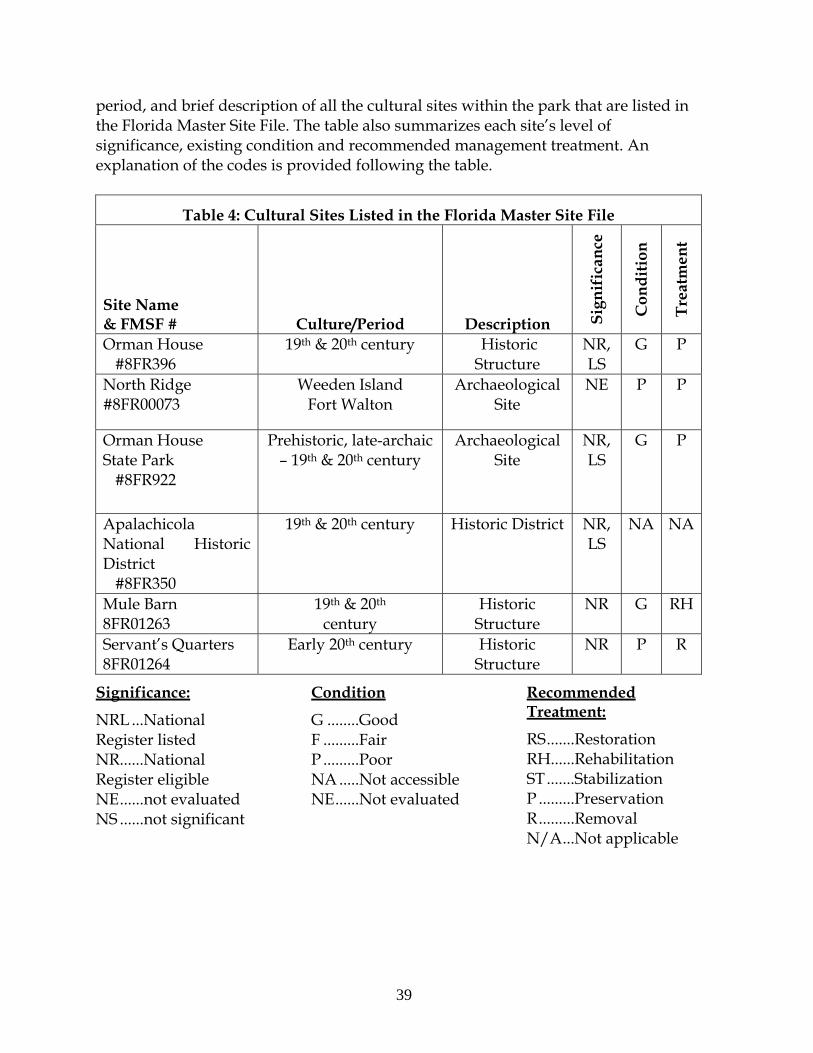
39
period, and brief description of all the cultural sites within the park that are listed in the Florida Master Site File. The table also summarizes each site’s level of significance, existing condition and recommended management treatment. An explanation of the codes is provided following the table.
Table 4: Cultural Sites Listed in the Florida Master Site File
Site Name & FMSF # Culture/Period Description S
ign
ific
ance
Con
dit
ion
Tre
atm
ent
Orman House #8FR396
19th & 20th century Historic Structure
NR, LS
G P
North Ridge #8FR00073
Weeden Island Fort Walton
Archaeological Site
NE P P
Orman House State Park #8FR922
Prehistoric, late-archaic – 19th & 20th century
Archaeological Site
NR, LS
G P
Apalachicola National Historic District #8FR350
19th & 20th century Historic District NR, LS
NA NA
Mule Barn 8FR01263
19th & 20th century
Historic Structure
NR G RH
Servant’s Quarters 8FR01264
Early 20th century Historic Structure
NR P R
Significance:
NRL ...National Register listed NR......National Register eligible NE ......not evaluated NS ......not significant
Condition
G ........Good F .........Fair P .........Poor NA .....Not accessible NE ......Not evaluated
Recommended Treatment:
RS .......Restoration RH......Rehabilitation ST .......Stabilization P .........Preservation R .........Removal N/A ...Not applicable
39
RESOURCE MANAGEMENT PROGRAM
Management Goals, Objectives and Actions
Measurable objectives and actions have been identified for each of the Division’s management goals for Orman House Historic State Park. Please refer to the Implementation Schedule and Cost Estimates in the Implementation Component of this plan for a consolidated spreadsheet of the recommended actions, measures of progress, target year for completion and estimated costs to fulfill the management goals and objectives of this park plan. While, the DRP utilizes the ten-year management plan to serve as the basic statement of policy and future direction for each park, a number of annual work plans provide more specific guidance for DRP staff to accomplish many of the resource management goals and objectives of the park. Where such detailed planning is appropriate to the character and scale of the park’s natural resources, annual work plans are developed for prescribed fire management, exotic plant management and imperiled species management. Annual or longer- term work plans are developed for natural community restoration and hydrological restoration. The work plans provide the DRP with crucial flexibility in its efforts to generate and implement adaptive resource management practices in the state park system. The work plans are reviewed and updated annually. Through this process, the DRP’s resource management strategies are systematically evaluated to determine their effectiveness. The process and the information collected is used to refine techniques, methodologies and strategies, and ensures that each park’s prescribed management actions are monitored and reported as required by Sections 253.034 and 259.037, Florida Statutes. The goals, objectives and actions identified in this management plan will serve as the basis for developing annual work plans for the park. The ten-year management plan is based on conditions that exist at the time the plan is developed, and the annual work provide the flexibility needed to adapt to future conditions as they change during the ten-year management planning cycle. As the park’s annual work plans are implemented through the ten-year cycle, it may become necessary to adjust the management plan’s priority schedules and cost estimates to reflect these changing conditions.
Natural Resource Management
Hydrological Management
Goal: Protect water quality and quantity in the park, restore hydrology to the extent feasible and maintain the restored condition.
40
There are no significant hydrological management measures for the Orman House property. As mentioned previously, the original well for the house is a possible point source for ground water contamination and should remain covered. Current stormwater runoff flows from the Orman House property through drainage ditches located along the three of the parcel’s boundaries. The Chapman Gardens’ grassy field area is a higher elevation area that adequately drains into the natural floodplain communities. All surface water eventually flows east into a drainage ditch located along Market Street and thereafter into the Apalachicola River. Drainage problems are not anticipated over most of this well elevated site, however, the extreme eastern portion of the property lies within the 100-year flood zone.
Natural Community Management
Goal: Restore and maintain the natural communities/habitats of the park. As discussed above, DRP practices natural systems management. In most cases, this entails returning fire to its natural role in fire-dependent natural communities. Other methods to implement this goal include large-scale restoration projects as well as smaller scale natural communities’ improvements. Natural community management activity at this small, mostly developed cultural site is limited to invasive exotic species control. There is no need for natural community restoration or improvement measures and prescribed fire is neither appropriate nor necessary for this small site.
Imperiled Species Management
Goal: Maintain, improve or restore imperiled species populations and habitats in the park. The DRP strives to maintain and restore viable populations of imperiled plant and animal species primarily by implementing effective management of natural systems. Single species management is appropriate in state parks when the maintenance, recovery or restoration of a species or population is complicated due to constraints associated with long-term restoration efforts, unnaturally high mortality or insufficient habitat. Single species management should be compatible with the maintenance and restoration of natural processes, and should not imperil other native species or seriously compromise park values. In the preparation of this management plan, DRP staff consulted with staff of the FWC’s Imperiled Species Management or that agency’s Regional Biologist and other appropriate federal, state and local agencies for assistance in developing imperiled animal species management objectives and actions. Likewise, for imperiled plant species, DRP staff consulted with FDACS. Data collected by the USFWS, FWC,
41
FDACS and FNAI as part of their ongoing research and monitoring programs will be reviewed by park staff periodically to inform management of decisions that may have an impact on imperiled species at the park. Ongoing inventory and monitoring of imperiled species in the state park system is necessary to meet the DRP’s mission. Long-term monitoring is also essential to ensure the effectiveness of resource management programs. Monitoring efforts must be prioritized so that the data collected provides information that can be used to improve or confirm the effectiveness of management actions on conservation priorities. Monitoring intensity must at least be at a level that provides the minimum data needed to make informed decisions to meet conservation goals. Not all imperiled species require intensive monitoring efforts on a regular interval. Priority must be given to those species that can provide valuable data to guide adaptive management practices. Those species selected for specific management action and those that will provide management guidance through regular monitoring are addressed in the objectives below.
Objective: Develop and update baseline imperiled species occurrence inventory lists for plants and animals as needed.
Plant and animal species within the park have been observed on multiple occasions in preparation for the species lists included in this plan. However, there remains a need to survey the property for all species present throughout the annual cycle. DRP staff will continue to update the baseline imperiled species occurrence inventory for plants and animals as resource management activities are conducted. Imperiled animal species will be monitored and documented at a Tier 1 (Non-Targeted Observation/Documentation) level as they are encountered at the park.
Exotic and Nuisance Species Management
Goal: Remove exotic and invasive plants and animals from the park and conduct needed maintenance control. The DRP actively removes invasive exotic species from state parks, with priority being given to those causing the ecological damage. Removal techniques may include mechanical treatment, herbicides or biocontrol agents.
Objective: Annually treat 2.5 acres of invasive exotic plant species in the park. The natural communities in zone OH 3 should be surveyed and treated for invasive exotic plants during the growing season. While the infestations were extensive when the state acquired the property, diligent work by DRP staff in recent years has succeeded in significantly reducing abundances of these pest species down to maintenance levels. Continued treatment of these pest plants as encountered will
42
prevent their reestablishment. DRP staff will also treat invasive exotic plants as they are encountered in all other portions of the park as they disperse from adjacent properties.
Objective: Implement control measures on one exotic animal species in the park as needed.
Feral cats are currently the only problematic exotic animals that occasionally enter the park. The local animal control service should be called in to remove the cats (or other animals) that may prove to be a nuisance as they are encountered
Special Management Considerations
Timber Management Analysis
Chapters 253 and 259, Florida Statutes, require an assessment of the feasibility of managing timber in land management plans for parcels greater than 1,000 acres if the lead agency determines that timber management is not in conflict with the primary management objectives of the land. The feasibility of harvesting timber at this park during the period covered by this plan was considered in context of the Division’s statutory responsibilities and an analysis of the park’s resource needs and values. The long-term management goal for forest communities in the state park system is to maintain or re-establish old-growth characteristics to the degree practicable, with the exception of early successional communities such as sand pine scrub and coastal strand. A timber management analysis was not conducted for this park since its total acreage is below the 1,000-acre threshold established by statute.
Arthropod Control Plan
All DRP lands are designated as “environmentally sensitive and biologically highly productive” in accordance with Ch. 388 and Ch. 388.4111 Florida Statutes. If a local mosquito control district proposes a treatment plan, the DRP works with the local mosquito control district to achieve consensus. By policy of DEP since 1987, aerial adulticiding is not allowed, but larviciding and ground adulticiding (truck spraying in public use areas) is typically allowed. The DRP does not authorize new physical alterations of marshes through ditching or water control structures. Mosquito control plans temporarily may be set aside under declared threats to public or animal health, or during a Governor’s Emergency Proclamation. There is not currently a park-specific Arthropod Control Plan.
43
Cultural Resource Management
Cultural Resource Management
Cultural resources are individually unique, and collectively, very challenging for the public land manager whose goal is to preserve and protect them in perpetuity. The DRP is implementing the following goals, objectives and actions, as funding becomes available, to preserve the cultural resources found in Orman House State Park. Goal: Protect, preserve and maintain the cultural resources of the park. The management of cultural resources is often complicated because these resources are irreplaceable and extremely vulnerable to disturbances. The advice of historical and archaeological experts is required in this effort. All activities related to land clearing, ground disturbing activities, major repairs or additions to historic structures listed or eligible for listing in the National Register of Historic Places must be submitted to the FDOS, Division of Historical Resources (DHR) for review and comment prior to undertaking the proposed project. Recommendations may include, but are not limited to concurrence with the project as submitted, pre-testing of the project site by a certified archaeological monitor, cultural resource assessment survey by a qualified professional archaeologist, modifications to the proposed project to avoid or mitigate potential adverse effect. In addition, any demolition or substantial alteration to any historic structure or resource must be submitted to DHR for consultation and the DRP must demonstrate that there is no feasible alternative to removal and must provide a strategy for documentation or salvage of the resource. Florida law further requires that the DRP consider the reuse of historic buildings in the park in lieu of new construction and must undertake a cost comparison of new development versus rehabilitation of a building before electing to construct a new or replacement building. This comparison must be accomplished with the assistance of the DHR.
Objective: Assess and evaluate 5 of 5 cultural resources in the park.
The Orman House itself was subject to a detailed Historic Structures Report in 2003. Multiple actions have been undertaken to restore and preserve this building. Cyclic inspection and subsequent treatment of any pest infestation found is a high priority. Any roof leakage still occurring should be repaired and inspections undertaken to ensure that water damage is not progressing. Periodic inspections against any deterioration of this house should be regularly performed to preserve the house’s structural and historical integrity. Photo points should be taken at intervals with the priority and frequency determined by the risk or apparent decline of structural features. Since the Servant’s Quarters is most prone to progressive deterioration, it should be monitored through inspections and photo documentation most
44
frequently, at least twice per year. The mule barn and well should be assessed annually. The foundation of the Charity House is currently buried and cannot be directly observed, but any significant erosion at this location should be documented and remedied as necessary. Permanent management measures for the Servant’s quarters need to be developed. A recent evaluation of the structure by a preservation architect has determined that restoration of the structure would not be prudent as much of the original fabric of the building has disappeared or has been damaged beyond repair by termites and other insects. As the park would like to continue to interpret the presence of workers on the Orman property, an alternate proposal has been made that the original building be thoroughly documented and removed, and a replica be reconstructed on site along with an interpretive display explaining the role that slaves and subsequent workers played in the property’s history. An assessment of the possibilities should be carried out and a final plan developed for future implementation.
Objective: Compile reliable documentation for all recorded historic and archaeological sites.
A level one archaeological survey was undertaken in 2003 in which small pits were excavated according to a grid system and adjacent to several significant structures. The park staff plans to take a variety of steps to enhance the historic interpretation of the park’s cultural features. Historical research will continue and opportunities taken to augment collections items and add informative kiosks and signs on the grounds surrounding the house. While the mule barn is currently used to store maintenance equipment, the staff is interested in constructing a separate shed to be used as the shop area. This will enable the interior of the mule barn to be restored to a historic appearance; they will also seek to acquire antique tools in order to create a workshop area suitable for exhibition to the public. While the landscaping is in good condition, the park staff will research its evolution over the years for possible changes in the future that would be more historically accurate. Landscape improvements will reflect the character of the original gardens through the maximum use of native plants and non-invasive ornamentals in attractive formalized groupings; as well as the use of plants from Dr. Chapman’s list in developing a plan for Chapman Gardens. The tree canopy branches should be periodically pruned to adequately balance the light levels reaching the ground surface; otherwise, the shade may increase so that groundcover plants could not be sustained. Staff at the Orman house is finalizing the Scope of Collections Statement with the assistance of the Collections Administrator. Historical research in terms of literature
45
reviews and interviews has been ongoing and continues. The Historic Structures Report from 2003 provided a valuable summary of the site’s history.
Objective: Maintain 3 of 5 recorded cultural resource in good condition.
The three cultural resources which include the Thomas Orman House, Orman House State Park Archeological site and the mule barn are currently considered to be in good condition and should be maintained in this condition. The current use of the park as a historical house museum site will continue; the house’s use as a small-scale meeting center would likely stress the flooring and structural integrity, as mentioned in the Historic Structures Report, and should not be considered as a general use for the structure. The HVAC unit in the House is unreliable and needs to be upgraded or replaced. The sunlight (UV rays) that enters the house can severely bleach textiles that are on display. A plan to better filter sunlight or rotate the textiles will prevent further deterioration. Storm shutters recently added to the building would prevent interior damage to the building or its contents; a storm plan has also been implemented by the park staff to minimize their risks. While the leaded exterior paint was removed, it is currently unknown whether the interior paint also contains lead; it should be tested and replaced with lead-free paint if necessary. In order to prevent infestations, a service contract has been instituted for pest control stipulating monthly treatments and regular termite inspections. Since the well is a historic feature of the property, it should be featured as part of the tour, receive an interpretive sign, and be covered with a clear barrier (e.g. acrylic) to prevent accidents. As the North Ridge (8FR00073) site has been irreparably damaged by past development activities, it cannot be returned to a “good” condition. Likewise, due to the advanced deterioration of the Servant’s Quarters (8FR01264), it cannot be brought into good condition as a historic structure.
Resource Management Schedule
A priority schedule for conducting all management activities that is based on the purposes for which these lands were acquired, and to enhance the resource values, is located in the Implementation Component of this management plan.
Land Management Review
Section 259.036, Florida Statutes, established land management review teams to determine whether conservation, preservation and recreation lands titled in the name of the Board of Trustees are being managed for the purposes for which they were acquired and in accordance with their approved land management plans. The managing agency shall consider the findings and recommendations of the land management review team in finalizing the required update of its management plan. There has not been a land management review undertaken for the Orman House Historic State Park.

46
47
LAND USE COMPONENT
INTRODUCTION
Land use planning and park development decisions for the state park system are based on the dual responsibilities of the Division of Recreation and Parks. These responsibilities are to preserve representative examples of original natural Florida and its cultural resources, and to provide outdoor recreation opportunities for Florida's citizens and visitors. The general planning and design process begins with an analysis of the natural and cultural resources of the unit, and then proceeds through the creation of a conceptual land use plan that culminates in the actual design and construction of park facilities. Input to the plan is provided by experts in environmental sciences, cultural resources, park operation and management, through public workshops, and environmental groups. With this approach, the Division objective is to provide quality development for resource-based recreation throughout the state with a high level of sensitivity to the natural and cultural resources at each park. This component of the unit plan includes a brief inventory of the external conditions and the recreational potential of the unit. Existing uses, facilities, special conditions on use, and specific areas within the park that will be given special protection, are identified. The land use component then summarizes the current conceptual land use plan for the park, identifying the existing or proposed activities suited to the resource base of the park. Any new facilities needed to support the proposed activities are described and located in general terms.
EXTERNAL CONDITIONS
An assessment of the conditions that exist beyond the boundaries of the unit can identify any special development problems or opportunities that exist because of the unit's unique setting or environment. This also provides an opportunity to deal systematically with various planning issues such as location, regional demographics, adjacent land uses and park interaction with other facilities. The Orman House is located approximately 90 miles southwest of Tallahassee and 60 miles southeast of Panama City within the historic district of Apalachicola, the largest incorporated area of Franklin County. According to the 2010 Census, the city’s 2,231 residents represent a 4 percent decrease over year 2000 population levels. The city’s historic character, coastal location and strategic position on scenic US 98, serves as a draw for increasing numbers of visitors along the Big Bend area of the Gulf coast. Franklin County has experienced a past growth rate similar the counties in the region and remains one of the least populated counties in the region with a 2010 population of

48
11,549, the County is projected to lose population over the next few years. Currently the Bureau of Economic and Business Research projects a population loss from 11,549 in 2010 to 11,530 in 2012. There are a number of resource-based recreation opportunities and museums in proximity to the Orman House Historic State Park. These include John Gorrie Museum State Park, within walking distance of the Orman House, which offers an informative look at the history of Apalachicola and one of its most famous citizens, Dr. John Gorrie, the inventor of the ice machine. Dr. Julian G. Bruce St George Island State Park and Cape St. George State Reserve offer picnicking, swimming, fishing, paddling, camping, birding and hiking, while areas such as St. Vincent National Wildlife Refuge, Apalachicola River Wildlife and Environmental Area, and Tate’s Hell State Forest and the offer many of these same opportunities in addition to hunting, and in some instances trails for Off-Highway Vehicle (OHV) use. The Apalachicola National Estuarine Research Reserve offers excellent educational opportunities and the Big Bend Scenic Byway offers a scenic drive through forested and natural areas on State Road 65 and U.S. Highway 98. The Orman House Historic State Park is noted as a destination on the Big Bend Scenic Byway.
Existing Use of Adjacent Lands
The property is located west of downtown Apalachicola approximately 800 feet southwest of Scipio Creek, a tributary of the Apalachicola River. Portions of the property to the east of the park and between the park and the waterfront are currently undeveloped. The remaining portion contains the Water Street Hotel and Marina, a condominium-hotel with thirty condominium suites and a twenty slip marina. Along the remainder of the waterfront vacant parcels are interspersed with commercial uses in both directions and commercial activity increases as one moves south toward the center of downtown. Adjacent lands west, south and southwest are primarily single-family residential. The property is bound on the south by Avenue 1, with the northern boundary falling between Avenue L and M. The city waterworks facility is adjacent to the park’s western boundary.
Planned Use of Adjacent Lands
The park property is currently designated Recreation on the future land use map in the City of Apalachicola’s Comprehensive Land Use Plan. Parcels to the north and east along 4th Street and Market Street are designated Commercial on the City’s future land use plan and zoning code. As the city develops, additional commercial activity is likely to occur in this area with the potential to obstruct the historic vista towards the Apalachicola River. The surrounding residential neighborhood is largely built out with no significant changes anticipated in the future. The park is within walking distance of the downtown area of the City of Apalachicola which is a designated Main Street Community, Waterfronts Community and has a Community Redevelopment Agency (CRA) that work to promoted heritage tourism, preservation and economic viability.
49
PROPERTY ANALYSIS
Effective planning requires a thorough understanding of the unit's natural and cultural resources. This section describes the resource characteristics and existing uses of the property. The unit's recreation resource elements are examined to identify the opportunities and constraints they present for recreational development. Past and present uses are assessed for their effects on the property, compatibility with the site, and relation to the unit's classification.
Recreation Resource Elements
This section assesses the unit’s recreation resource elements those physical qualities that, either singly or in certain combinations, supports the various resource-based recreation activities. Breaking down the property into such elements provides a means for measuring the property's capability to support individual recreation activities. This process also analyzes the existing spatial factors that either favor or limit the provision of each activity.
Land Area
Orman House Historic State Park is located within the historic district of Apalachicola. The park landscape is dominated by areas of open lawn, large canopy trees and ornamental plantings characteristic of a historic urban residential setting. A portion of the property contains small disturbed remnants of floodplain forest and floodplain swamp associated with Scipio Creek and the Apalachicola River. This particular combination of topography, large canopy trees, native floodplain communities, and dramatic views creates a picturesque quality to the overall landscape. The park provides an opportunity for passive recreation, visiting the historic structures, garden walks and access to the veteran’s memorial.
Natural Scenery
The rolling front lawn and large canopy trees that frame the Orman House create a picturesque landscape of scenic quality. The house sits atop the highest point in Apalachicola and offers excellent views of the Apalachicola River and the city’s working waterfront. Progress is being made in reestablishing these historic view sheds that will continue to improve the scenic quality of the park.
Significant Habitat
The southern portion of the property is heavily shaded by large oaks and cypress trees occur along the low swampy fringe. The park’s mosaic of habitats attracts wildlife and provides ample opportunities for observing nature. There is no significant wildlife habitat located at this park.
Natural Features
The house sites on a large hill that is the highest point in the City of Apalachicola.
50
Archaeological and Historical Features
The most significant feature of the site is the Orman House and associated structures such as the mule barn, Servants quarters and old cistern. These historic elements provide unique opportunities to interpret the Orman family history as well as the significance of Apalachicola to the region and nation’s history.
Assessment of Use
All legal boundaries, significant natural features, structures, facilities, roads and trails existing in the unit are delineated on the base map (see Base Map). Specific uses made of the unit are briefly described in the following sections.
Past Uses
The Orman House has served as a residence and a bed and breakfast. Associated outbuildings are reported to have been used as slave quarters, a Civil War infirmary and convent. Native American use of the lands surrounding the mouth of the Apalachicola is well known, although evidence of use of the Orman House site has not been documented.
Future Land Use and Zoning
The Division works with local governments to establish designations that provide both consistency between comprehensive plans and zoning codes and permit typical state park uses and facilities necessary for the provision of resource-based recreation opportunities. The current future land use category for this park is Recreation. The City recently made a change to the future land use map in the comprehensive plan. The change to the future land use category better reflects the actual use of the property. The current zoning is Commercial, C-1 according to City staff. The zoning is in the process of being changed to a zoning category that will be consistent with the new land use category.
Current Recreational Use and Visitor Programs
Historic interpretation is the primary recreational use at the Orman House. The grounds are also utilized for small, special events and functions. The Chapman Botanical Gardens is currently used for passive recreation such as walking and picnicking. Orman House Historic State Park recorded approximately 6,159 visitors to the park in Fiscal Year 2012-2013. By Division estimates, the FY 2012/2013 visitors contributed over $300,000 thousand dollars in direct economic impact and the equivalent of five jobs to the local economy (Florida Department of Environmental Protection 2013).

51
Other Uses The Three Servicemen Memorial Plaza is also managed by the park based on a three-party management agreement between Division, the City of Apalachicola, and The Three Servicemen Statue South, Inc. The Three Servicemen Statue South, Inc., owns the statue and the city is a fee-simple owner of the site where the state is located. The park manages the grounds and access to the Three Servicemen Memorial Plaza.
Protected Zones
A protected zone is an area of high sensitivity or outstanding character from which most types of development are excluded as a protective measure. Generally, facilities requiring extensive land alteration or resulting in intensive resource use, such as parking lots, camping areas, shops or maintenance areas, are not permitted in protected zones. Facilities with minimal resource impacts, such as trails, interpretive signs and boardwalks are generally allowed. All decisions involving the use of protected zones are made on a case-by-case basis after careful site planning and analysis. At Orman House Historic State Park, the entire grounds surrounding the house and associated outbuildings have been designated as a protected zone. Facility development should be limited to that essential for improved access or recreation designed to enhance use of the house and grounds.
Existing Facilities
Recreation Facilities Existing recreational facilities include the Orman House and grounds, Chapman Botanical Gardens, and the Three Servicemen Plaza Memorial. The house is open to the public and guided tours are available. The Chapman Botanical Gardens have been replanted and revitalized by staff and volunteers and provide a pleasant place to walk and view the various plantings and flowers that are in bloom. A future landscape plan with additional garden areas including gardens based on Alvan Chapman’s plant lists will add to the experience. There is a nature walk area and gazebo that provide a comfortable place to sit and enjoy the gardens and native plants. Orman House Chapman Botanical Gardens
Servants quarters Three Servicemen Memorial Plaza Cistern
Support Facilities Parking is provided in the new parking lot adjacent to Chapman Botanical Gardens. Two picnic tables are available at the entrance to Chapman Botanical Gardens. The old mule barn is currently used for storage.
52
Paved parking area Mule barn-adaptive reuse as shop/storage Picnic tables (2)
CONCEPTUAL LAND USE PLAN The following narrative represents the current conceptual land use proposal for this park. As new information is provided regarding the environment of the park, cultural resources, recreational use, and as new land is acquired, the conceptual land use plan may be amended to address the new conditions (see Conceptual Land Use Plan). A detailed development plan for the park and a site plan for specific facilities will be developed based on this conceptual land use plan, as funding becomes available. During the development of the management plan, the Division assessed potential impacts of proposed uses or development on the park resources and applied that analysis to decisions on the future physical plan of the park as well as the scale and character of proposed development. Potential impacts are more thoroughly identified and assessed as part of the site planning process once funding is available for facility development. At that stage, design elements (such as existing topography and vegetation, sewage disposal and stormwater management) and design constraints (such as imperiled species or cultural site locations) are more thoroughly investigated. Municipal sewer connections, advanced wastewater treatment or best available technology systems are applied for on-site sewage disposal. Stormwater management systems are designed to minimize impervious surfaces to the greatest extent feasible, and all facilities are designed and constructed using best management practices to avoid impacts and to mitigate those that cannot be avoided. Federal, state and local permit and regulatory requirements are met by the final design of the projects. This includes the design of all new park facilities consistent with the universal access requirements of the Americans with Disabilities Act (ADA). After new facilities are constructed, the park staff monitors conditions to ensure that impacts remain within acceptable levels. Orman House Historic State Park has the potential to become a premier historic house museum that enhances the nature and heritage based tourism opportunities of the area. The site is one of many properties highlighted in the City’s Historic Tour of Homes and Buildings and is a contributing element on the Apalachicola National Register of Historic Places District. The nearby John Gorrie Museum State Park provides an additional opportunity for learning about the area’s natural and cultural history. The Orman House’s proximity to the Apalachicola River affords opportunities to link with historic boat tours, should the site be connected to the waterfront in the future. An abundance of archaeological sites and significant land and water resources in the region provide a setting rich in resource-based recreational opportunities.
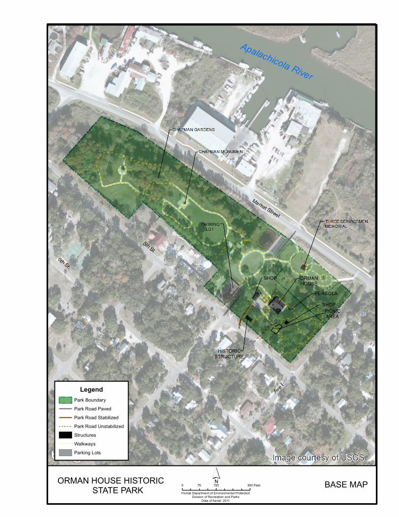
Florida Department of Environmental ProtectionDivision of Recreation and Parks
Date of Aerial: 2011
´0 150 30075 FeetORMAN HOUSE HISTORIC
STATE PARK BASE MAP
LegendPark BoundaryPark Road PavedPark Road StabilizedPark Road UnstabilizedStructuresWalkwaysParking Lots

54
55
Realization of the full potential of the Orman House and other nature and heritage based tourism sites will require visionary planning and active promotion. The Division supports local efforts to develop Apalachicola and the surrounding region as a popular destination for visitors seeking to learn more about local and regional history, culture and natural resources.
Potential Uses
Public Access and Recreational Opportunities Goal: Provide public access and recreational opportunities in the park. The existing recreational activities and programs of this state park are appropriate to the natural and cultural resources contained in the park and should be continued. New and improved activities and programs are also recommended and discussed below. Objective: Maintain the park’s current recreational carrying capacity of 336 users per day. Historic interpretation is the primary recreational use at the Orman House Historic State Park. The Orman House, Chapman Botanical Gardens and the Three Servicemen Plaza provide interpretation of historical resources, recreation and the quiet reflection of a memorial, all activities suited to the resources in the Orman House Historic State Park Objective: Expand the park’s recreational carrying capacity by 24 users per day.
The addition of an interpretive trial/boardwalk though the flood plain forest will afford visitors an additional recreational opportunity as well as an educational opportunity to learn about the natural area at the park.
Objective: Continue to provide the current repertoire of 1 interpretive, educational and recreational program on a regular basis. The plan recommends various upgrades to the experience of touring the Orman House as well as management of the collections and the interpretive experience. Objective: Develop 3 new interpretive, educational and recreational programs. The plan recommends the restoration of the mule barn to its historical use, the replacement and interpretation with onsite information of the servant’s quarters and additional programs/events, as well as additional plantings (native and historically accurate) in the Chapman Botanical Gardens. A future landscape plan
56
will be developed for Chapman Gardens that respects the existing landscaped areas (such as Johnny Meyer Hill) as much as possible, while adding garden areas, including gardens based on Alvan Chapman’s plant lists. Permanent management measures for the Servant’s quarters (8FR01264) have yet to be determined. A recent evaluation of the structure by preservation architects has determined that restoration of the structure would not be prudent; as much of the original fabric of the building has disappeared or has been damaged beyond repair by termites and other insects (Hammond and Marder 2011). Since the park would like to continue to interpret the presence of workers on the Orman Property, an alternate proposal has been made that the original building be thoroughly documented and removed, and a replica be reconstructed on site along with an interpretive display explaining the role that slaves and subsequent workers played in the property’s history.
Proposed Facilities
Capital Facilities and Infrastructure Goal: Develop and maintain the capital facilities and infrastructure necessary to implement the recommendations of the management plan. The existing facilities of this state park are appropriate to the natural and cultural resources contained in the park and should be maintained. New construction, as discussed further below, is recommended to improve the quality and safety of the recreational opportunities that visitors enjoy while in the park, to improve the protection of park resources, and to streamline the efficiency of park operations. The following is a summary of improved renovated and new facilities needed to implement the conceptual land use plan for Orman House Historic State Park.
Objective: Maintain all public and support facilities in the park. All capital facilities, trails and roads within the park will be kept in proper condition through the daily or regular work of park staff and/or contracted help.
Objective: Improve/repair 1 existing facility. Despite the recent roof repairs, rain leakage, albeit much reduced, continues to be an issue; the park staff is pursuing follow up work by the roofing contractor. Repairs to the roof should be made in order to prevent structural damage or deterioration, which is the focus of the management approach to preserving the house. Major repair projects for park facilities may be accomplished within the ten year term of this management plan, if funding is made available. These include the modification of existing park facilities to bring them into compliance with the Americans with Disabilities Act (a top priority for all facilities maintained by the Division).
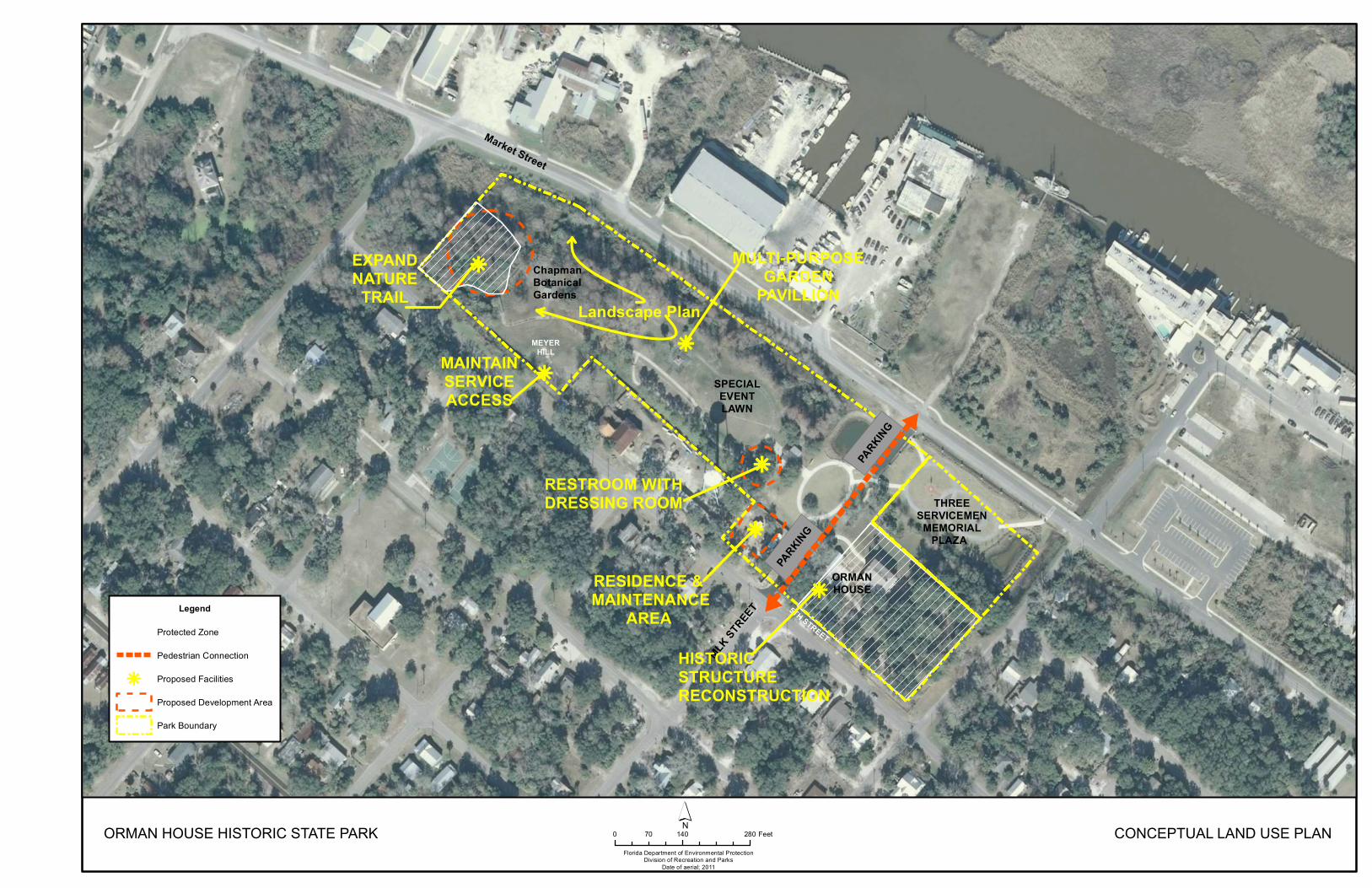
k
k
k
kk
MLK STR
EET
AVENUE K
ORMANHOUSE
THREESERVICEMEN
MEMORIALPLAZA
5TH STREET
RESTROOM WITHDRESSING ROOM
RESIDENCE & MAINTENANCE
AREA
MULTI-PURPOSEGARDEN
PAVILLION
MEYERHILLMAINTAIN
SERVICEACCESS
EXPANDNATURE
TRAIL
SPECIALEVENTLAWN
PARKING
PARKING
k
k
#
#
HISTORIC STRUCTURE RECONSTRUCTION
Market Street
Chapman Botanical Gardens
Landscape Plan
ORMAN HOUSE HISTORIC STATE PARKFlorida Department of Environmental Protection
Division of Recreation and ParksDate of aerial; 2011
0 140 28070 Feet´ CONCEPTUAL LAND USE PLAN
Legend
Protected Zone
Pedestrian Connection
k Proposed Facilities
Proposed Development Area
Park Boundary

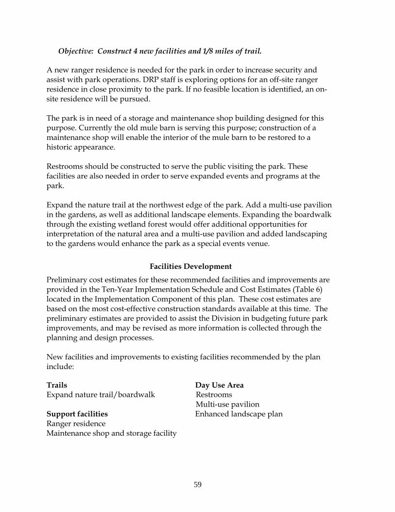
59
Objective: Construct 4 new facilities and 1/8 miles of trail.
A new ranger residence is needed for the park in order to increase security and assist with park operations. DRP staff is exploring options for an off-site ranger residence in close proximity to the park. If no feasible location is identified, an on-site residence will be pursued.
The park is in need of a storage and maintenance shop building designed for this purpose. Currently the old mule barn is serving this purpose; construction of a maintenance shop will enable the interior of the mule barn to be restored to a historic appearance.
Restrooms should be constructed to serve the public visiting the park. These facilities are also needed in order to serve expanded events and programs at the park.
Expand the nature trail at the northwest edge of the park. Add a multi-use pavilion in the gardens, as well as additional landscape elements. Expanding the boardwalk through the existing wetland forest would offer additional opportunities for interpretation of the natural area and a multi-use pavilion and added landscaping to the gardens would enhance the park as a special events venue.
Facilities Development
Preliminary cost estimates for these recommended facilities and improvements are provided in the Ten-Year Implementation Schedule and Cost Estimates (Table 6) located in the Implementation Component of this plan. These cost estimates are based on the most cost-effective construction standards available at this time. The preliminary estimates are provided to assist the Division in budgeting future park improvements, and may be revised as more information is collected through the planning and design processes. New facilities and improvements to existing facilities recommended by the plan include: Trails Day Use Area Expand nature trail/boardwalk Restrooms Multi-use pavilion Support facilities Enhanced landscape planRanger residence Maintenance shop and storage facility
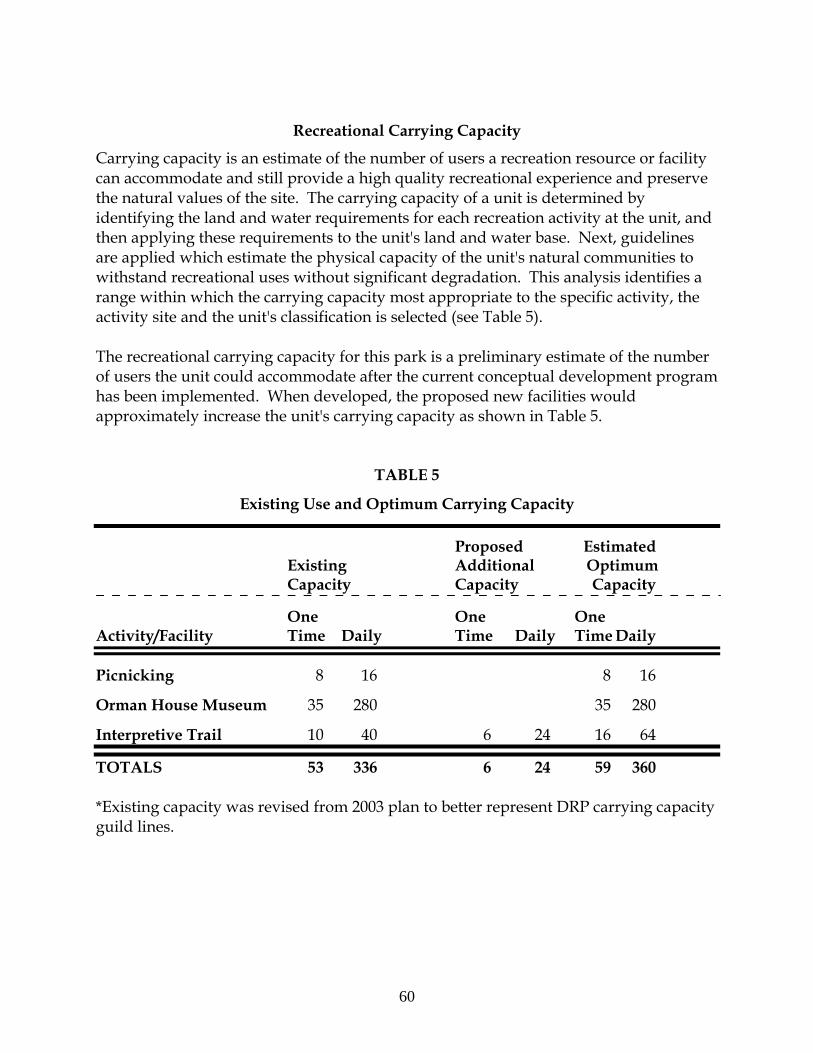
60
Recreational Carrying Capacity
Carrying capacity is an estimate of the number of users a recreation resource or facility can accommodate and still provide a high quality recreational experience and preserve the natural values of the site. The carrying capacity of a unit is determined by identifying the land and water requirements for each recreation activity at the unit, and then applying these requirements to the unit's land and water base. Next, guidelines are applied which estimate the physical capacity of the unit's natural communities to withstand recreational uses without significant degradation. This analysis identifies a range within which the carrying capacity most appropriate to the specific activity, the activity site and the unit's classification is selected (see Table 5). The recreational carrying capacity for this park is a preliminary estimate of the number of users the unit could accommodate after the current conceptual development program has been implemented. When developed, the proposed new facilities would approximately increase the unit's carrying capacity as shown in Table 5.
TABLE 5
Existing Use and Optimum Carrying Capacity
Proposed Estimated Existing Additional Optimum Capacity Capacity Capacity One One One Activity/Facility Time Daily Time Daily Time Daily Picnicking 8 16 8 16 Orman House Museum 35 280 35 280 Interpretive Trail 10 40 6 24 16 64
TOTALS 53 336 6 24 59 360 *Existing capacity was revised from 2003 plan to better represent DRP carrying capacity guild lines.
61
Optimum Boundary
As additional needs are identified through park use, development, research, and as adjacent land uses change on private properties, modification of the unit's optimum boundary may occur for the enhancement of natural and cultural resources, recreational values and management efficiency. Identification of lands on the optimum boundary map is solely for planning purposes and not for regulatory purposes. A property’s identification on the optimum boundary map is not for use by any party or other government body to reduce or restrict the lawful right of private landowners. Identification on the map does not empower or require any government entity to impose additional or more restrictive environmental land use or zoning regulations. Identification is not to be used as the basis for permit denial or the imposition of permit conditions. The optimum boundary map reflects lands identified for direct management by the Division as part of the park. These parcels may include public as well as privately owned lands that improve the continuity of existing park lands, provide additional natural and cultural resource protection, and/or allow for future expansion of recreational activities. At this time, no lands are considered surplus to the needs of the park. There is a small parcel of land at the northern edge of the park, it adjoins the current nature trail area. The acquisition of this parcel would allow further expansion of the nature trail and allow additional opportunities for interpretation of the remnant Flood Plain Swamp Natural Community (see Optimum Boundary Map).

62
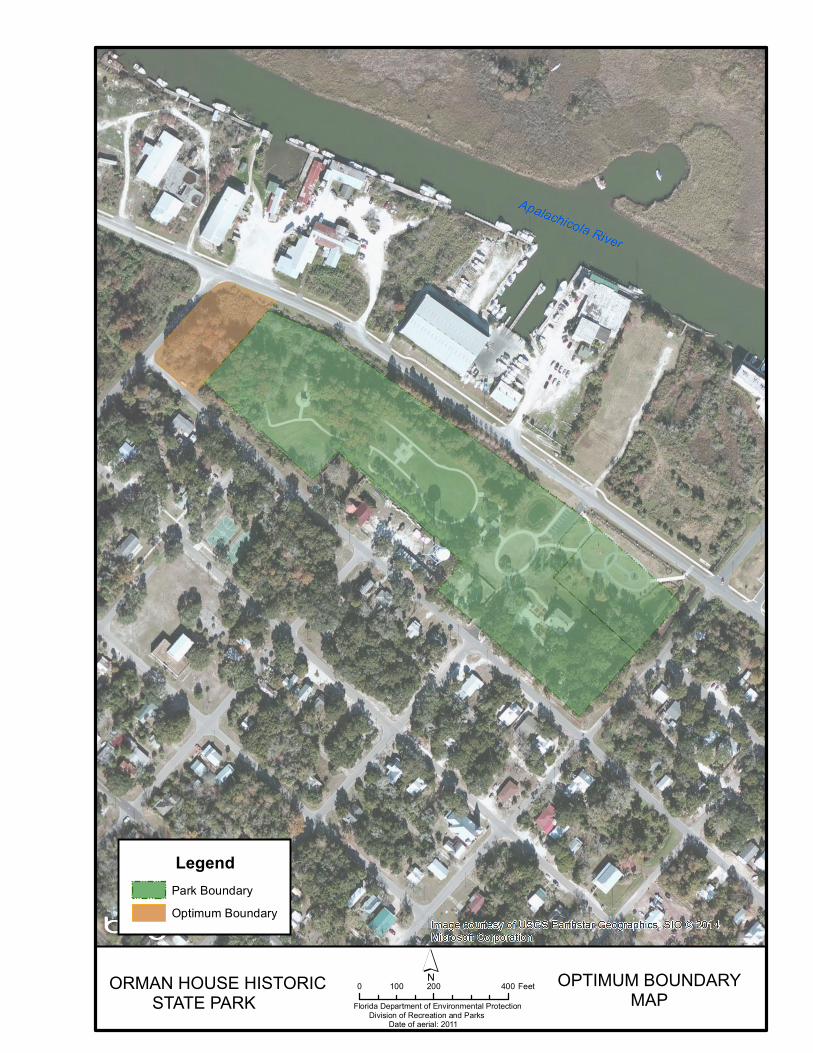
OPTIMUM BOUNDARYMAP
ORMAN HOUSE HISTORIC STATE PARK
Legend
!!
!! ! ! ! !
!!
!!!!!!
Park BoundaryOptimum Boundary
´Florida Department of Environmental Protection Division of Recreation and Parks Date of aerial: 2011
0 200 400100 Feet

64
65
IMPLEMENTATION COMPONENT
The resource management and land use components of this management plan provide a thorough inventory of the park’s natural, cultural and recreational resources. They outline the park’s management needs and problems, and recommend both short and long-term objectives and actions to meet those needs. The implementation component addresses the administrative goal for the park and reports on the Division of Recreation and Parks (DRP) progress toward achieving resource management, operational and capital improvement goals and objectives since approval of the previous management plan for this park. This component also compiles the management goals, objectives and actions expressed in the separate parts of this management plan for easy review. Estimated costs for the ten-year period of this plan are provided for each action and objective, and the costs are summarized under standard categories of land management activities.
MANAGEMENT PROGRESS
Since the approval of the last management plan for Orman House Historic State Park in 2003, significant work has been accomplished and progress made towards meeting the DRP’s management objectives for the park. These accomplishments fall within three of the five general categories that encompass the mission of the park and the DRP.
Acquisition
In 2008, State of Florida Department of Environmental Protection’s Division of Recreation and Parks leased the Chapman Botanical Gardens from the City of Apalachicola to be managed as part of the Orman House Historic State Park and on the same date entered into a three party agreement with the City and the Three Servicemen Statute South, Inc., to manage the area where the statue is located.
In 2009, the Division of Recreation and Parks entered into a 50 year management agreement/lease with the City of Apalachicola for the Chapman Botanical Gardens and the Three Servicemen Memorial Plaza. These parcels were added to the Orman House Historic State Park to be managed as part of the park by the Division of Recreation and Parks.
The current lease/management agreement for the three parcels that constitute the park expires in 2051.
Park Administration and Operations
The Park continues to actively work with organizations and members of the public that wish to volunteer their time.
66
The Park has an active citizen’s support organization (CSO) and maintains an ongoing relationship with the local historical preservation society and City of Apalachicola.
Resource Management
Natural Resources
Park staff has worked to maintain the remnant natural communities, Floodplain forest and Floodplain swamp at the eastern edge of the park by removing exotic plants and removing trash and discarded items.
There is also a small number of royal fern (Osmunda regalis), a listed species that are monitored by staff.
Cultural Resources
A phase I level archeological survey was conducted by South Arc, Inc. in 2003.
A subsequent archeological investigation was done at the Servants quarters site by Garlick and Associates and the Florida Public Archeology Network in 2010.
An archaeological sensitivity model (predictive model) was completed by the University of South Florida in 2012.
The mule barn underwent extensive rehabilitation and is currently used for storage and a shop building.
The main house has been extensively restored and was the subject of a Historic Structures Report in 2003 by Marshall and Hall
The exterior paint was found to contained lead and was abated and replaced with lead free paint.
DRP staff has accomplished the digitization of the Thomas Orman Papers which helps tell the local, state, and national story that spans over 150 of America’s most formative years.
Park staff has worked toward the accurate refurbishment of the house’s décor.
Recreation and Visitor Services
Park staff has worked with local volunteers to rejuvenate, add plantings and landscaping elements to Chapman Botanical Gardens.
Picnic tables have been added to the entrance area of Chapman Botanical Gardens.
Privacy fencing has been added along the western boundary of the gardens. Access from the parking lot to the house, as well as a ramp has been installed
at the house to facilitate better access by visitors, including visitors with disabilities.
67
Park Facilities
Additional parking has been added between Chapman Gardens and the Orman House.
The mule barn underwent extensive rehabilitation for adaptive use and serves as the shop and storage for the park.
MANAGEMENT PLAN IMPLEMENTATION
This management plan is written for a timeframe of ten years, as required by Section 253.034 Florida Statutes. The Ten-Year Implementation Schedule and Cost Estimates (Table 6) summarizes the management goals, objectives and actions that are recommended for implementation over this period, and beyond. Measures are identified for assessing progress toward completing each objective and action. A time frame for completing each objective and action is provided. Preliminary cost estimates for each action are provided and the estimated total costs to complete each objective are computed. Finally, all costs are consolidated under the following five standard land management categories: Resource Management, Administration and Support, Capital Improvements, Recreation Visitor Services and Law Enforcement. Many of the actions identified in the plan can be implemented using existing staff and funding. However, a number of continuing activities and new activities with measurable quantity targets and projected completion dates are identified that cannot be completed during the life of this plan unless additional resources for these purposes are provided. The plan’s recommended actions, time frames and cost estimates will guide the DRP’s planning and budgeting activities over the period of this plan. It must be noted that these recommendations are based on the information that exists at the time the plan was prepared. A high degree of adaptability and flexibility must be built into this process to ensure that the DRP can adjust to changes in the availability of funds, improved understanding of the park’s natural and cultural resources, and changes in statewide land management issues, priorities and policies. Statewide priorities for all aspects of land management are evaluated each year as part of the process for developing the DRP’s annual legislative budget requests. When preparing these annual requests, the DRP considers the needs and priorities of the entire state park system and the projected availability of funding from all sources during the upcoming fiscal year. In addition to annual legislative appropriations, the DRP pursues supplemental sources of funds and staff resources wherever possible, including grants, volunteers and partnerships with other entities. The DRP’s ability to accomplish the specific actions identified in the plan will be determined largely by the availability of funds and staff for these purposes, which may vary from year to year. Consequently, the target schedules and estimated costs identified in Table 6 may need to be adjusted during the ten-year management planning cycle.

68

Table 6Orman House Historic State Park
Ten-Year Implementation Schedule and Cost EstimatesSheet 1 of 5
DRAFTOHHSP_ICSprdsheet_REVISED_EE_20140225.xlsm
MeasurePlanning
Period
Estimated Manpower and Expense Cost* (10-
years)Objective A Continue day-to-day administrative support at current levels. Administrative support
ongoingC $39,790
Objective B Expand administrative support as new lands are acquired, new facilities are developed, or as other needs arise. Administrative support expanded
C $2,832
MeasurePlanning
PeriodNo hyrologic management needs $0
MeasurePlanning
Period
Estimated Manpower and Expense Cost* (10-
years)No restoration management needs $0
MeasurePlanning
Period
Estimated Manpower and Expense Cost*
(10years)Objective A Update baseline imperiled species occurrence inventory lists for plants and animals, as needed. Species lists updated as
neededC $2,500
MeasurePlanning
Period
Estimated Manpower and Expense Cost* (10-
years)Objective A Annually treat 2.5 acres of exotic plant species in the park. # Acres treated C $7,000
Action 1 Annually update exotic plant management work plan. Plan developed/updated C $1,000
Action 2 Implement annual work plan by treating 2.5 acres in park, annually as needed. # of acres treated C $6,000
Objective B Implement control measures on exotic and nuisance animal species in the park. # Species for which control measures implemented
C $500
Action 1 Continue to work with local animal control to remove feral cats as needed. # of calls to animal control C $500
Goal V: Remove exotic and invasive plants and animals from the park and conduct needed maintenance-control.
Goal II: Protect water quality and quantity in the park, restore hydrology to the extent feasible, and maintain the restored condition.
Goal III: Restore and maintain the natural communities/habitats of the park.
Goal I: Provide administrative support for all park functions.
Goal IV: Maintain, improve or restore imperiled species populations and habitats in the park.
NOTE: THE DIVISION'S ABILITY TO COMPLETE THE OBJECTIVES OUTLINED BY THE MANAGEMENT PLAN IS CONTINGENT ON THE AVAILABILITY OF FUNDING AND OTHER RESOURCES FOR THESE PURPOSES.
* 2013 DollarsST = actions within 2 years
LT = actions within 10 yearsC = long term or short term actions that are continuous or cyclical
UFN = currently unfunded need

Table 6Orman House Historic State Park
Ten-Year Implementation Schedule and Cost EstimatesSheet 2 of 5
DRAFTOHHSP_ICSprdsheet_REVISED_EE_20140225.xlsm
NOTE: THE DIVISION'S ABILITY TO COMPLETE THE OBJECTIVES OUTLINED BY THE MANAGEMENT PLAN IS CONTINGENT ON THE AVAILABILITY OF FUNDING AND OTHER RESOURCES FOR THESE PURPOSES.
MeasurePlanning
Period
Estimated Manpower and Expense Cost* (10-
years)Objective A Assess and evaluate 5 of 5 recorded cultural resources in the park. Documentation complete LT $30,000
Action 1 Staff will continue the quarterly inspection for any signs of deterioration of the house, including water damage, roof repair needs, and possible pest infestations as high priority items. Photo points should be taken at intervals determined appropriate for documenting features of the house.
Inspections completed C $4,000
Action 2 Other historic features ( mule barn, well, Charity house site) should be monitored annually for maintenance needs and possible deterioration. The Servants quarters should be monitored twice a year until long term plan is adopted.
Inspections/monitoring completed
C $1,000
Action 3 Develop long term management measures for Servant's quarters (to address demolition, documentation of the current structure, and construction of a replica).
Management measures developed
UFN $25,000
Objective B Compile reliable documentation for all recorded historic and archaeological sites. Documentation complete LT $40,000
Action 1 Continue historical research such as literature reviews and interviews to increase the knowledge of the site. NRHP nomination submitted LT $10,000
Action 2 Research the evolution of the landscaping for the Orman House and develop an appropriate landscape plan. Research and landscape plan completed
LT $30,000
Objective C Bring 3 of 5 recorded cultural resources in good condition. # Sites in good condition LT $178,000
Action 1 Fix or replace HVAC for Orman House,test interior paintfor lead and repaint if neededadd UV protection to house windows.
Upgrades completed ST $76,000
Action 2 Upgrade well amenities so it can be incorporated into the interpretive tour. Upgrades completed ST $2,000
Action 3 Develop and implement a plan to restore the interior of the mule barn to its historic appearance suitable for public exhibition and seek appropriate cultural artifacts to display in its interior.
Restoration completed LT $100,000
Goal VI: Protect, preserve and maintain the cultural resources of the park.
* 2013 DollarsST = actions within 2 years
LT = actions within 10 yearsC = long term or short term actions that are continuous or cyclical
UFN = currently unfunded need


Table 6Orman House Historic State Park
Ten-Year Implementation Schedule and Cost EstimatesSheet 3 of 5
DRAFTOHHSP_ICSprdsheet_REVISED_EE_20140225.xlsm
NOTE: THE DIVISION'S ABILITY TO COMPLETE THE OBJECTIVES OUTLINED BY THE MANAGEMENT PLAN IS CONTINGENT ON THE AVAILABILITY OF FUNDING AND OTHER RESOURCES FOR THESE PURPOSES.
MeasurePlanning
Period
Estimated Manpower and Expense Cost* (10-
years)Objective A Maintain the park's current recreational carrying capacity of 336 users per day. # Recreation/visitor
opportunities per dayC $100,000
Objective B Expand the park's recreational carrying capacity by 24 users per day. # Recreation/visitor opportunities per day
LT $7,200
Objective C Continue to provide the current repertoire of 1 interpretive, educational and recreational programs on a regular basis.(house tour) .
# Interpretive/education programs
C $200,000
Objective D Develop 3 new interpretive, educational and recreational programs. # Interpretive/education programs
LT $16,700
Goal VII: Provide public access and recreational opportunities in the park.
* 2013 DollarsST = actions within 2 years
LT = actions within 10 yearsC = long term or short term actions that are continuous or cyclical
UFN = currently unfunded need

Table 6Orman House Historic State Park
Ten-Year Implementation Schedule and Cost EstimatesSheet 4 of 5
DRAFTOHHSP_ICSprdsheet_REVISED_EE_20140225.xlsm
NOTE: THE DIVISION'S ABILITY TO COMPLETE THE OBJECTIVES OUTLINED BY THE MANAGEMENT PLAN IS CONTINGENT ON THE AVAILABILITY OF FUNDING AND OTHER RESOURCES FOR THESE PURPOSES.
MeasurePlanning
Period
Estimated Manpower and Expense Cost* (10-
years)Objective A Maintain all public and support facilities in the park. Facilities maintained C $66,000
Objective B Continue to implement the park's transition plan to ensure facilities are accessible in accordance with the American with Disabilities Act of 1990.
Plan implemented LT $2,000
Objective C Improve and/or repair 1 existing facilites and 0 mile of trail and 0 miles of roads as identified in the Land Use Component (Orman House Roof).
Roof repaired LT $20,000
Objective D Construct 3 new facilities, 1/8 mile of trail and 0 miles of road as indentified in the Land Use Component. # Facilities/Miles of Trail UFN $759,400
Objective E Expand maintenance activities as existing facilities are improved and new facilities are developed. Facilities maintained C $4,700
Goal VIII: Develop and maintain the capital facilities and infrastructure necessary to meet the goals and objectives of this management plan.
* 2013 DollarsST = actions within 2 years
LT = actions within 10 yearsC = long term or short term actions that are continuous or cyclical
UFN = currently unfunded need

Table 6Orman House Historic State Park
Ten-Year Implementation Schedule and Cost EstimatesSheet 5 of 5
DRAFTOHHSP_ICSprdsheet_REVISED_EE_20140225.xlsm
NOTE: THE DIVISION'S ABILITY TO COMPLETE THE OBJECTIVES OUTLINED BY THE MANAGEMENT PLAN IS CONTINGENT ON THE AVAILABILITY OF FUNDING AND OTHER RESOURCES FOR THESE PURPOSES.
Total Estimated Manpower and Expense
Cost* (10-years)
$258,000
$42,622
$781,400
$394,600
Administration and Support
Capital Improvements
Recreation Visitor Services
Law Enforcement Activities1
1Law enforcement activities in Florida State Parks are conducted by the FWC Division of Law Enforcement and by local law enforcement agencies.
Management Categories
Summary of Estimated Costs
Resource Management
* 2013 DollarsST = actions within 2 years
LT = actions within 10 yearsC = long term or short term actions that are continuous or cyclical
UFN = currently unfunded need


Addendum 1—Acquisition History

Orman House Historic State Park Acquisition History
A 1-1
Purpose of Acquisition The Board of Trustees of the Internal Improvement Fund (Trustees) of the State of Florida purchased the initial area of Orman House Museum State Park for the use and benefit of the Outdoor Recreational Development Council of the State of Florida. Sequence of Acquisition On February 2, 2001, the Board of Trustees of the Internal Improvement Trust Fund of the State of Florida (Trustees) purchased a 163-year old two-story Orman House in Franklin county, Florida, located on a 1.50-acre land, which later became Orman House Historic State Park. The Trustees purchased the property from Annegret E. Gaidry and Douglas W. Gaidry for $810,000. This purchase was funded under the Preservation 2000 (P-2000) program.
On July 12, 2008, State of Florida Department of Environmental Protection’s Division of Recreation and Parks (DRP), which manages Orman House Historic State Park, leased a 6.89-acre Chapman Botanical Gardens from the City of Apalachicola to manage it as part of Orman House Historic State Park. On the same day, the DRP entered into a three-party management agreement with the City of Apalachicola and Three Servicemen Statue South, Inc. to manage a 1.21-acre site containing a partial replica of The Three Servicemen Statue, this site became part of the park for management purposes. The Three Servicemen Statue South, Inc. owns the replica statue and the city is the fee simple owner of the site where the statue is located.
The 2001 Trustees’ purchase, the 6.89-acre DRP leased from the city Apalachicola, and 1.21-acre replica site constitute the current area of Orman House Historic State Park, which is 9.60 acres. Title Interest: The Trustees and the City of Apalachicola have fee simple title to portions of Orman House Historic State Park. Lease Agreement: On March 29, 2001, the Trustees leased Orman House Historic State Park to the DRP under a fifty-year lease, Lease No. 4324. This lease will expire on March 28, 2051.
According to Lease No. 4324, DRP manages Orman House Historic State Park only for the establishment and operation of natural resource based public outdoor recreation, which is compatible with the conservation and protection of this property.
The term of the City of Apalachicola’s lease agreement with DRP for the 6.89-acre property is coterminous with the term of Lease No. 4324. If Lease No. 4324 is renewed upon expiration on
Orman House Historic State Park Acquisition History
A 1-2
March 29, 2051, DRP’S Lease Agreement with the city shall be automatically renewed for the same period as Lease No. 4324.
The three-party management agreement between the DRP, the City of Apalachicola, and The Three Servicemen Statue South, Inc. will terminate either if (or when) The Three Servicemen Statue South, Inc. looses the right to display the replica, or if (or when) any one of the three parties breaches the terms of the agreement and anyone of the non-defaulting party decides to terminate the agreement because of the breach of the terms, or if (when) agreement between the city and DRP expires or terminates. Special Conditions on Use: Orman House Historic State Park is designated as a single-use property to provide resource-based public outdoor recreation and other park related uses. Uses such as water resource development projects, water supply projects, storm-water management projects, and linear facilities and sustainable agriculture and forestry are not consistent with the purposes for which DRP manages this park. Outstanding Reservations: Following is a listing of outstanding encumbrance that applies to the Orman House State Historic Park. Instrument: Encroachment/Variance Agreement Grantor: City of Apalachicola Grantee: The Trustees Beginning Date: January 11, 2001 Ending Date: When the structure is destroyed by 50% or more Encumbrance According to this agreement, once the structure to which
the encroachment is connected is destroyed by 50% or more, as determined by the City Building Inspector, the variance and agreement shall cease and the encroachment shall be removed.

Addendum 2—Advisory Group Members and Report

Orman House Historic State Park and John Gorrie Museum State Park
Advisory Group Members
A 2 - 1
Local Government Representatives The Honorable Cheryl K. Sanders, Chair Franklin County Board of County Commissioners 33 Market Street, Suite 203 Apalachicola, Florida 32320 The Honorable Van Johnson, Mayor City of Apalachicola 1 Avenue E Apalachicola Florida, 32320 Ms. Betty Webb Administrator, City of Apalachicola 1 Avenue E Apalachicola, FL 32320 Ms. Leslie Cox, Member Franklin Soil and Water Conservation District 17413 NW Leonard Street Blountstown, Florida 32424 Agency Representatives Mr. Josh Hodson, Park Manager Orman House Historic State Park John Gorrie Museum State Park 1900 East Gulf Beach Drive St. George Island, FL 32328 Mr. Lee Edmiston Apalachicola National Estuarine Research Reserve (ANERR) 108 Island Drive East Point Florida,32328 Mr. Mike Wisenbaker Archeology Supervisor Bureau of Archeological Research 1001 De Soto Park Drive Tallahassee, Florida 32301
Tourism/Economic Development Representatives Ms. Anita Grove, Executive Director Apalachicola Bay Chamber 122 Commerce Street Apalachicola, Florida 32320 Mr. Curt Blair Franklin County Tourist Development Council P O Box 819 Apalachicola Florida 32329 Historical Resource Representative Mr. Mark Curenton Historian Apalachicola Area Historical Society 34 Forbes Street, Suite 1 Apalachicola, Florida, 32320 Mr. Jimmy Mosconis, President, Board of Directors of Three Servicemen Statue South, Inc. P.O. Box 172 Apalachicola, Florida 32329 Environmental and Conservation Representatives Mr. Ted Ruffner Florida Native Plant Society 246 Gramercy Plantation Blvd. Eastpoint, Florida 32328 Mr. Sean McGlynn Apalachee Audubon Society North Florida Chapter of the National Audubon Society P O Box 1237 Tallahassee, Florida 323020-1237

Orman House Historic State Park and John Gorrie Museum State Park
Advisory Group Members
A 2 - 2
Citizens Support Organization Representatives Mr. Tom Daly President, Friends of Franklin County State Parks 107 17th Street Apalachicola, Florida 32320 Adjacent Land Owner Ms. Susan Clemenston, Representative of Trinity Episcopal Church P O Box 338 Apalachicola, Fl. 32329
Orman House Historic State Park and John Gorrie Museum State Park Advisory Group Staff Report
3
The Advisory Group meeting to review the proposed land management plan for Orman House Historic State Park and John Gorrie Museum State Park was held at the City of Apalachicola on Wednesday, March 19, 2014, at 9:00 AM. Roy Ogles represented Lee Edmiston. County Commissioner Cheryl K. Sanders, Curt Blair, and Sean McGlynn were not in attendance. Mike Weisenbaker from the Division of Historic Resources (DHR) and Lesley Cox (Franklin County Soil and Water Conservation District ) did not attend but provided written comments. All other appointed Advisory Group members were present. Attending staff were Tony Tindell, Arthur Stiles, Joshua Hodson, Bob Soderholm, Michael Kinnett and Enid Ehrbar. Ms. Ehrbar began the meeting by explaining the purpose of the Advisory Group and reviewing the meeting agenda. Ms. Ehrbar summarized the comments received during the previous evening’s public workshop. Ms. Ehrbar then asked each member of the Advisory Group to express his or her comments on the draft plan. Summary of Advisory Group Comments Jimmy Mosconis (Three Servicemen Statue South, Inc.) stated the statue project started 13 years ago, and it took a great deal of negotiating between the City, state, and their group to get all three parts of the park into the management agreement. In July it will be 6 years since the park was dedicated. He sees the need for volunteers as the number one priority for the park. Mr. Mosconis noted that the City of Apalachicola was one of the founding members of the US Chamber of Commerce. All concurred that the City had been very important in state and national history. Mark Currenton (Apalachicola Area Historic Society) noted that he had already sent staff comments by e-mail (they are summarized below). He also stated that the Historical Society had documents that relate to the Gorrie Museum, and they would be happy to provide copies to the museum. Tom Daly (Friends of Franklin County State Parks) stated the Citizens Support Organization (CSO) works hand in hand with the parks. The CSO has raised money and has done a number of projects at the Orman House such as providing books for the staff to sell to visitors. Mr. Daly questioned if it might be better to consolidate the Orman and Gorrie parks since the John Gorrie Museum does not get that many visitors. He also asked if the old brick cistern and the City water works could be saved. There was rumor that the structure was a Frank Lloyd Wright building. The City was historically an important place and the focus should be on preserving the City’s history. Mr. Daly also noted that a private citizen was restoring the Alvan Chapman house using her own funds. Everyone agreed that the historic community should embrace her efforts. Susan Clemenston (Trinity Episcopal Church) discussed the Church’s willingness to help with the landscaping for Gorrie Square, especially the portion that adjoins the Church. They have lots of members willing to help; she always appreciates the staff for allowing the Church to use the adjoining park space for their special events. DRP staff explained that once the hardscape/walkways were in and the landscape plan was finished, the park would welcome the church’s help. She also questioned if it might be a good idea to work to get a historic marker placed on the site of John Gorrie’s house, which was located where the Armory is today. DRP staff explained that the DRP was not in charge of historical markers, but could assist the
Orman House Historic State Park and John Gorrie Museum State Park Advisory Group Staff Report
4
city/historical society by putting them in touch with the agency that handles the placement of historical markers. Ms. Clemenston also stated that historic tourism is growing; people love the self-guided tour maps provide by the Chamber. Roy Olges (Apalachicola National Estuarine Research Reserve (ANERR)) stated he reviewed the plans and they adequately address exotic plant and animal species, the preservation of existing natural communities; as well as restricted use of chemicals or sprays. He stated that no one is better than the park service at doing plans for the parks. He stated that the plans addressed all of the ANERR issues. Mayor Van Johnson (City of Apalachicola) referenced some items that were part of the discussion when the DRP signed the management agreement for Chapman Gardens and Veterans Memorial Park. He asked about the status of the proposed ranger residence and the out parcel where the City water works is located. DRP staff explained that the ranger residence was included in the draft plan as a needed facility. The location needed to be determined. Staff stated the DRP was aware of the current discussions regarding the parcel where the water tower and City water works were located. In the past there was concern about liability related to the condition of the parcel; but staff now understands the City is looking to improve the site and would be glad to discuss options with the City if they would submit a written proposal to the DRP. DRP staff stated they would work with the City Manager regarding who to address the proposal to. Mayor Johnson also asked about the parks interest in the waterfront parcel across from the Orman House. Other advisory group members noted how important the river and the waterfront were to the history of the park/house. DRP staff stated that at this time the plan did not include this parcel as part of the optimum boundary; like everyone, the DRP has limited funds and staff, and this parcel was not currently part of the optimum boundary in the plan. Betty Webb (City Manager, City of Apalachicola) explained that the City would approach the state regarding the water works property after the Public Works and Water Department staff and their equipment was moved. There was discussion and questions by the group about the DRP getting the structure evaluated; regarding the feasibility of possibly saving the structure. DRP staff noted this type of work was usually contracted out. DRP staff said the park staff were thinking about an alternative idea; possibly use the bricks in a walkway within the park and have an interpretive panel about the old water works. Ms. Webb noted that discussions at the time of the lease agreement with the state included the retention of Johnny Meyer Hill, which was planted as an orchard. Mr. Meyer was instrumental in the landfill being cleaned up and turned into Chapman Gardens. She would like to see a reference to this in the plan. She discussed two stormwater projects that were currently underway, to be completed by 2015; neither of these projects are noted in either plan. These may resolve the stormwater issues discussed in the plan. She questioned “boilerplate” language regarding visitor services, food services and lodging and noted the park is not zoned for this. DRP staff explained this was general enabling language related to concessions that are in some state parks. Staff stated that the park would not knowingly do anything inconsistent with local ordinances. Ms. Webb also noted that when discussing other parks and recreational areas, the plan does not refer to other local museums. Ms. Webb also noted only the Orman House is on the Big Bend Scenic Byway, the Gorrie Museum is contributing. She stated that there is no mention of the servant’s quarters being located in the floodplain; she hopes parts of the structure can be salvaged and displayed. She noted there was no discussion about tree protection in the plan related to the large trees in
Orman House Historic State Park and John Gorrie Museum State Park Advisory Group Staff Report
5
the park. Ms. Webb would also like to discuss partnering with the DRP regarding the Gorrie Museum landscape plan so the traffic circle can be included in the plan, maybe the library too. She also noted that the water tower at Gorrie Square fell during Hurricane Kate in 1985. Anita Grove (Apalachicola Bay Chamber) stated how helpful park personnel are. She noted the Chamber sends people to the Orman House and they are disappointed with the Chapman Gardens because they are expecting a botanical garden as the name implies. The Advisory Group members discussed this issue; staff explained that a landscape plan for the gardens was underway and the gardens are a work in progress. Advisory Group members suggested perhaps a name change to Chapman Gardens; all expressed how much better the garden looks since it became part of the park. Ms. Grove suggested more interpretive signage and that including a copy of the landscape plan might help. In reference to the discussion of Chapman Gardens and native plants, she cautioned we should be careful not to eliminate the historic landscape of the house; lots of historic landscapes may not be native, but they are important to the history of a site. Ted Ruffner (Florida Native Plant Society) noted a number of references in the plan to exotic species or exotic plants where the reference should probably be limited to invasive exotic species and plants. He discussed the difference in non-native plants that are being planted in the garden verses exotic invasive species. He suggested that a change in language might be needed in order to convey exactly what is intended regarding future plantings in Chapman Gardens. There was further discussion among the group about planting only plants native to the areas verses attractive plants normally seen in the area; many non-native plants do well in the Florida climate, and they have been planted throughout the southeast. Mr. Ruffner suggested several places where native plants were available, as well as several books and lists of plants. He also noted the Native Plant Society would be willing to help the Park if they would like. Mr. Ruffner opined that the budget in the plan did not appear to adequately reflect the discussion in the plan regarding the landscape plan or future plantings. He also suggested a landscape committee could be a valuable conduit for determining the plan for the gardens. The CSO could coordinate and include other interested groups. Everyone discussed the need to balance the desire to maintain the historic landscape, existing Chapman Garden plantings, and the desire to plant native species in the garden. Summary of Written Comments Mike Wisenbaker (Division of Historical Resources (DHR)) reviewed the cultural section of the plan and addendums and noted that the Orman House was purchased with P-2000 funds, not CARL funds, agreed the roof needed to be fixed immediately; and there was not much need for further archeological surveys based on the amount of site disturbance. He stated that the park staff had a good handle on the culture resources in the park and were doing a good job protecting and maintaining the resources of the park. Mark Curenton (Apalachicola Area Historical Society) reviewed both the plans and had several comments on both the Orman House Historic State Park and John Gorrie Museum State Park. John Gorrie Museum State Park:
Orman House Historic State Park and John Gorrie Museum State Park Advisory Group Staff Report
6
He stated that the current grave site is the third resting place for Dr. Gorrie. He noted that the historical society has documents relating to Dr. Gorrie and will give copies to the museum if they would like them. He suggested a language change to say the museum is located in the Apalachicola Historic District; leave out the reference to which part of the Historic District. The Gorrie monument was dedicated on April 30, 1900 not in 1899. Mr. Curenton questioned a reference in Addendum 3. Orman House Historic State Park: The plan notes that the original Thomas Orman papers and the electronic copy are stored at the house; Mr. Curenton suggested it might be wise to store them in 2 different places in case something happens to one of the storage places. He stated that the plan notes that the house has a security system, but it is not currently monitored; he suggested this is probably information that should not be shared in a public document. He said the street description regarding the location of the Orman House is not correct and the reference to the “Hill” is more a neighborhood reference than a topographic one. Lesley Cox (Franklin County Soil and Water Conservation District) reviewed the Orman House Historic State Park Plan and stated that as a member of the Franklin County Soil and Water Conservation District Board of Supervisors, she appreciated the opportunity to review and comment on the Orman House draft plan. She stated she read the document and agreed with the Natural Resources Management Goals. Staff Recommendations The staff recommends approval of the proposed management plans for Orman House Historic State Park and John Gorrie Museum State Park as presented, with the following changes:
Amend the plan to show the Orman House was purchased with Preservation 2000 funds.
Make changes to the Orman House Historic State Park plan regarding the house security system, street location of the park, the reference to the “Hill,” and remove the reference to the alarm system.
Clarify the intent in the Orman House Historic State Park plan regarding elimination of exotic invasive plant species in the park. Landscape improvements will reflect the character of the original gardens through the maximum use of native plants and non-invasive ornamentals in attractive formalized groupings; as well as the use of plants from Dr. Chapman’s list in developing a plan for Chapman Gardens.
Reference the importance of Johnny Meyer Hill as it relates to Chapman Gardens. Make changes to the Gorrie Museum State Park plan regarding Dr. Gorrie’s grave being
the third burial site, change the reference to the museum’s location in the Apalachicola Historic District, and the monument dedication in 1900.
Reference the current City stormwater projects in regard to flooding issues at the Gorrie Museum.
Reference the City’s willingness to partner with the park regarding the future landscape plan for the Gorrie Museum and other City property at Gorrie Square.
Revise the reference to the John Gorrie Museum regarding the Big Bend Scenic Byway.
Orman House Historic State Park and John Gorrie Museum State Park Advisory Group Staff Report
7
Additional revisions were made throughout the document to address editorial corrections, consistency of spellings and notations, and other minor corrections. Notes on Composition of the Advisory Group Florida Statutes Chapter 259.032 Paragraph 10(b) establishes a requirement that all state land management plans for properties greater than 160 acres will be reviewed by an advisory group: “Individual management plans required by s. 253.034(5), for parcels over 160 acres, shall be developed with input from an advisory group. Members of this advisory group shall include, at a minimum, representatives of the lead land managing agency, co-managing entities, local private property owners, the appropriate soil and water conservation district, a local conservation organization, and a local elected official.” Advisory groups that are composed in compliance with these requirements complete the review of State park management plans. Additional members may be appointed to the groups, such as a representative of the park’s Citizen Support Organization (if one exists), representatives of the recreational activities that exist in or are planned for the park, or representatives of any agency with an ownership interest in the property. Special issues or conditions that require a broader representation for adequate review of the management plan may require the appointment of additional members. The DRP’s intent in making these appointments is to create a group that represents a balanced cross-section of the park’s stakeholders. Decisions on appointments are made on a case-by-case basis by DRP staff.

Orman House Historic State Park and John Gorrie Museum State Park Advisory Group Staff Report
8
Addendum 3: Orman House State Park References Cited


Orman House Historic State Park References Cited
A 3-1
Carr, Robert S. 1975. An Archaeological Survey of the City of Apalachicola. Bureau of
Historic Sites and Properties, Division of Archives, History and Records Management, Florida Department of State, Tallahassee.
Collins, L.D., S. Fernandez, J. DuVernay, K. Driscoll, and T. Doering. 2012. Archaeological resource sensitivity modeling in Florida State Parks District 1: the Northwest Florida region. Alliance for Integrated Spatial Technologies report (DEP contract number RP733), University of South Florida.
City of Apalachicola City Commission 1990. City of Apalachicola Comprehensive Plan. Accessed July 2013.
FDEP, DRP. 2012. Florida State Park System Economic Impact Assessment for Fiscal Year 2012-2013. Tallahassee, Florida.
Earnest, Tray G. 2008. Archaeological Investigations at the Orman House Property in
Apalachicola, Franklin County, Florida. Garlick Environmental Associates, Inc. Prepared for E & D Contracting Services, Inc., Savannah. GEA Project No. 08-135.
Earnest, Tray G. 2009. A Cultural Resource Reconnaissance of the Proposed Orman
House State Park Expansion. Garlick Environmental Associates, Inc. Prepared for Florida Department of Environmental Protection, Bureau of Design and Construction. GEA Project No. 09-016.
Hammond, Bret and Marder, Walter. 2011. An Analysis of an Outbuilding at the
Orman House Historic State Park, Apalachicola, Florida. Draft report submitted to Mark Knapke, Park Manager, Orman House Historic State Park, March 7, 2011.
Hodges, John G. 1956. Restoration of the historic Orman House of Apalachicola:
unique residential link with cotton trading, sailing vessels, steamboats, Civil War, and one hundred and fifty years of Florida tradition. Tampa Tribune.
Kennedy, Thomas L. 2001. Phase I Environmental Site Assessment, Pierce Mound /
Gaidry House. Harding ESE. Tallahassee, Florida. Lees, William B. 2010. Status of archaeological investigations, Orman House Historic
State Park (9FR, Archaeological Research Permit 1011.031.) Correspondence to Mark Knapke, Park Manager, Orman House Historic State Park, December 31, 2010.
Orman House Historic State Park References Cited
A 3-2
Marshall, Willoughby and Gregory A. Hall, Associated Architects. 2003. Thomas Orman House, Orman House State Park, Apalachicola, Florida. Historic Structures Report. Report for the Florida Department of Environmental Protection.
Owens, Harry. 1966. Apalachicola before 1861. Doctoral thesis. Florida State
University. Wayne, Lucy B. and Martin F. Dickinson. 2003. A View of the River: Cultural Resources
Survey and Assessment of the Orman House State Park, Apalachicola, Florida. South Arc, Inc. Report for the Florida Department of Environmental Protection.

Addendum 4—Soil Descriptions

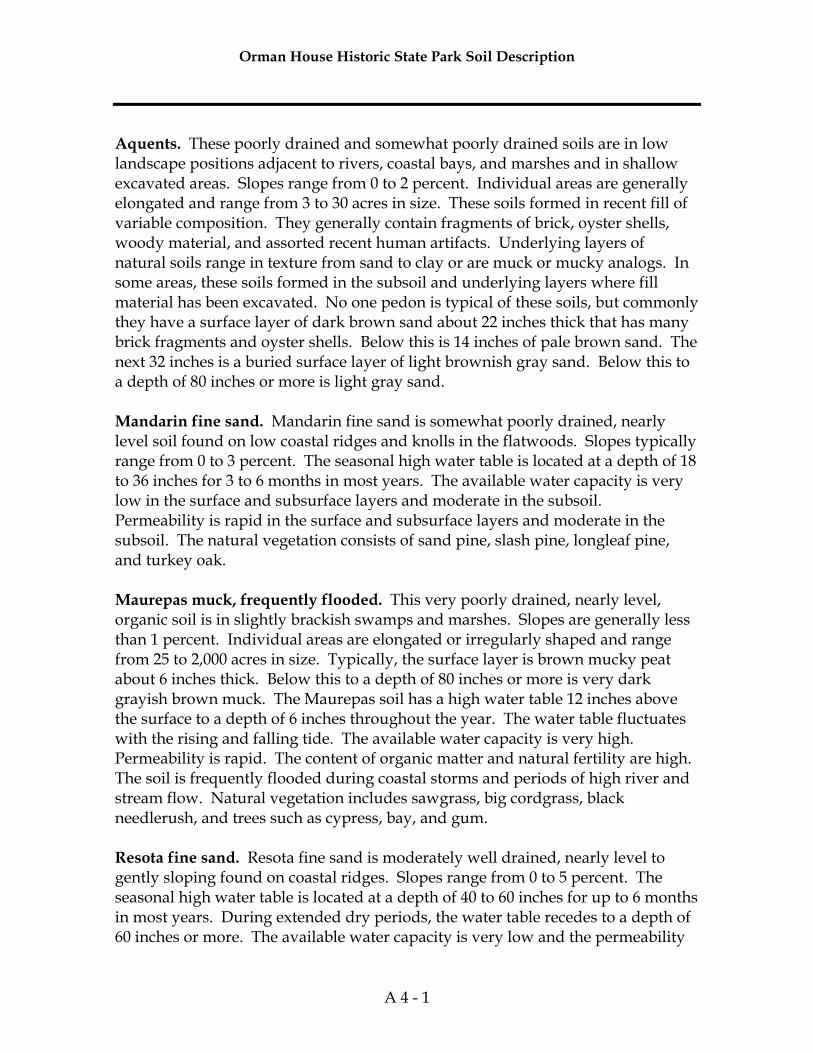
Orman House Historic State Park Soil Description
A 4 - 1
Aquents. These poorly drained and somewhat poorly drained soils are in low landscape positions adjacent to rivers, coastal bays, and marshes and in shallow excavated areas. Slopes range from 0 to 2 percent. Individual areas are generally elongated and range from 3 to 30 acres in size. These soils formed in recent fill of variable composition. They generally contain fragments of brick, oyster shells, woody material, and assorted recent human artifacts. Underlying layers of natural soils range in texture from sand to clay or are muck or mucky analogs. In some areas, these soils formed in the subsoil and underlying layers where fill material has been excavated. No one pedon is typical of these soils, but commonly they have a surface layer of dark brown sand about 22 inches thick that has many brick fragments and oyster shells. Below this is 14 inches of pale brown sand. The next 32 inches is a buried surface layer of light brownish gray sand. Below this to a depth of 80 inches or more is light gray sand. Mandarin fine sand. Mandarin fine sand is somewhat poorly drained, nearly level soil found on low coastal ridges and knolls in the flatwoods. Slopes typically range from 0 to 3 percent. The seasonal high water table is located at a depth of 18 to 36 inches for 3 to 6 months in most years. The available water capacity is very low in the surface and subsurface layers and moderate in the subsoil. Permeability is rapid in the surface and subsurface layers and moderate in the subsoil. The natural vegetation consists of sand pine, slash pine, longleaf pine, and turkey oak. Maurepas muck, frequently flooded. This very poorly drained, nearly level, organic soil is in slightly brackish swamps and marshes. Slopes are generally less than 1 percent. Individual areas are elongated or irregularly shaped and range from 25 to 2,000 acres in size. Typically, the surface layer is brown mucky peat about 6 inches thick. Below this to a depth of 80 inches or more is very dark grayish brown muck. The Maurepas soil has a high water table 12 inches above the surface to a depth of 6 inches throughout the year. The water table fluctuates with the rising and falling tide. The available water capacity is very high. Permeability is rapid. The content of organic matter and natural fertility are high. The soil is frequently flooded during coastal storms and periods of high river and stream flow. Natural vegetation includes sawgrass, big cordgrass, black needlerush, and trees such as cypress, bay, and gum. Resota fine sand. Resota fine sand is moderately well drained, nearly level to gently sloping found on coastal ridges. Slopes range from 0 to 5 percent. The seasonal high water table is located at a depth of 40 to 60 inches for up to 6 months in most years. During extended dry periods, the water table recedes to a depth of 60 inches or more. The available water capacity is very low and the permeability
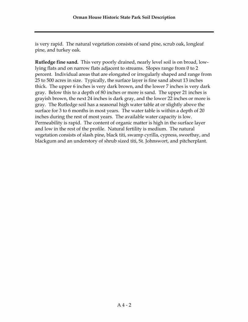
Orman House Historic State Park Soil Description
A 4 - 2
is very rapid. The natural vegetation consists of sand pine, scrub oak, longleaf pine, and turkey oak. Rutledge fine sand. This very poorly drained, nearly level soil is on broad, low-lying flats and on narrow flats adjacent to streams. Slopes range from 0 to 2 percent. Individual areas that are elongated or irregularly shaped and range from 25 to 500 acres in size. Typically, the surface layer is fine sand about 13 inches thick. The upper 6 inches is very dark brown, and the lower 7 inches is very dark gray. Below this to a depth of 80 inches or more is sand. The upper 21 inches is grayish brown, the next 24 inches is dark gray, and the lower 22 inches or more is gray. The Rutledge soil has a seasonal high water table at or slightly above the surface for 3 to 6 months in most years. The water table is within a depth of 20 inches during the rest of most years. The available water capacity is low. Permeability is rapid. The content of organic matter is high in the surface layer and low in the rest of the profile. Natural fertility is medium. The natural vegetation consists of slash pine, black titi, swamp cyrilla, cypress, sweetbay, and blackgum and an understory of shrub sized titi, St. Johnswort, and pitcherplant.

Addendum 5—Plant and Animal List

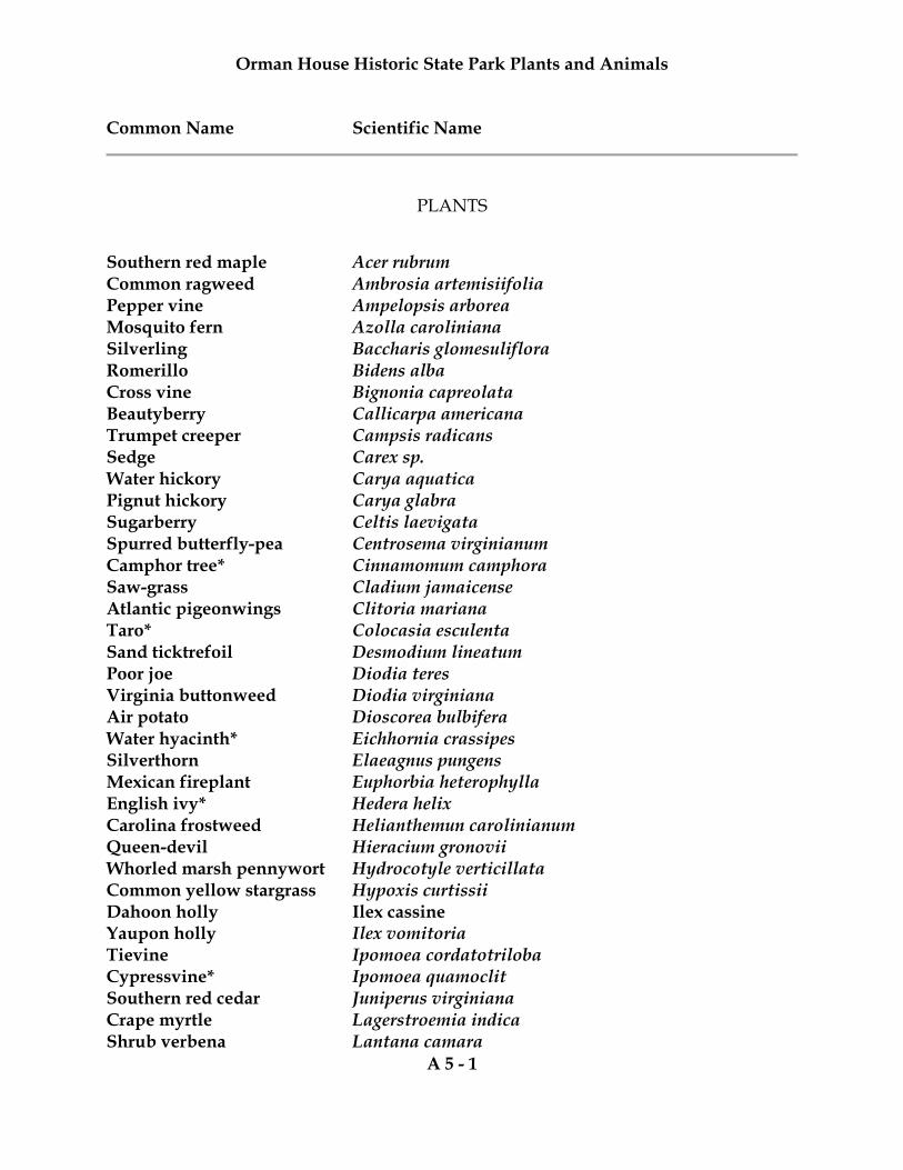
Orman House Historic State Park Plants and Animals Common Name Scientific Name
A 5 - 1
PLANTS
Southern red maple Acer rubrum Common ragweed Ambrosia artemisiifolia Pepper vine Ampelopsis arborea Mosquito fern Azolla caroliniana Silverling Baccharis glomesuliflora Romerillo Bidens alba Cross vine Bignonia capreolata Beautyberry Callicarpa americana Trumpet creeper Campsis radicans Sedge Carex sp. Water hickory Carya aquatica Pignut hickory Carya glabra Sugarberry Celtis laevigata Spurred butterfly-pea Centrosema virginianum Camphor tree* Cinnamomum camphora Saw-grass Cladium jamaicense Atlantic pigeonwings Clitoria mariana Taro* Colocasia esculenta Sand ticktrefoil Desmodium lineatum Poor joe Diodia teres Virginia buttonweed Diodia virginiana Air potato Dioscorea bulbifera Water hyacinth* Eichhornia crassipes Silverthorn Elaeagnus pungens Mexican fireplant Euphorbia heterophylla English ivy* Hedera helix Carolina frostweed Helianthemun carolinianum Queen-devil Hieracium gronovii Whorled marsh pennywort Hydrocotyle verticillata Common yellow stargrass Hypoxis curtissii Dahoon holly Ilex cassine Yaupon holly Ilex vomitoria Tievine Ipomoea cordatotriloba Cypressvine* Ipomoea quamoclit Southern red cedar Juniperus virginiana Crape myrtle Lagerstroemia indica Shrub verbena Lantana camara
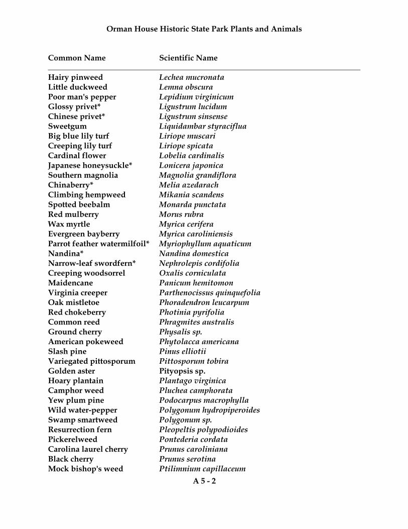
Orman House Historic State Park Plants and Animals Common Name Scientific Name
A 5 - 2
Hairy pinweed Lechea mucronata Little duckweed Lemna obscura Poor man's pepper Lepidium virginicum Glossy privet* Ligustrum lucidum Chinese privet* Ligustrum sinsense Sweetgum Liquidambar styraciflua Big blue lily turf Liriope muscari Creeping lily turf Liriope spicata Cardinal flower Lobelia cardinalis Japanese honeysuckle* Lonicera japonica Southern magnolia Magnolia grandiflora Chinaberry* Melia azedarach Climbing hempweed Mikania scandens Spotted beebalm Monarda punctata Red mulberry Morus rubra Wax myrtle Myrica cerifera Evergreen bayberry Myrica caroliniensis Parrot feather watermilfoil* Myriophyllum aquaticum Nandina* Nandina domestica Narrow-leaf swordfern* Nephrolepis cordifolia Creeping woodsorrel Oxalis corniculata Maidencane Panicum hemitomon Virginia creeper Parthenocissus quinquefolia Oak mistletoe Phoradendron leucarpum Red chokeberry Photinia pyrifolia Common reed Phragmites australis Ground cherry Physalis sp. American pokeweed Phytolacca americana Slash pine Pinus elliotii Variegated pittosporum Pittosporum tobira Golden aster Pityopsis sp. Hoary plantain Plantago virginica Camphor weed Pluchea camphorata Yew plum pine Podocarpus macrophylla Wild water-pepper Polygonum hydropiperoides Swamp smartweed Polygonum sp. Resurrection fern Pleopeltis polypodioides Pickerelweed Pontederia cordata Carolina laurel cherry Prunus caroliniana Black cherry Prunus serotina Mock bishop's weed Ptilimnium capillaceum
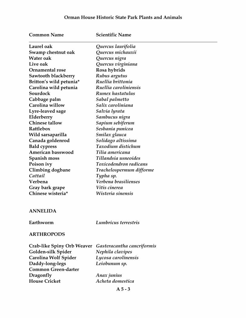
Orman House Historic State Park Plants and Animals Common Name Scientific Name
A 5 - 3
Laurel oak Quercus laurifolia Swamp chestnut oak Quercus michauxii Water oak Quercus nigra Live oak Quercus virginiana Ornamental rose Rosa hybrids Sawtooth blackberry Rubus argutus Britton’s wild petunia* Ruellia brittonia Carolina wild petunia Ruellia caroliniensis Sourdock Rumex hastatulus Cabbage palm Sabal palmetto Carolina willow Salix caroliniana Lyre-leaved sage Salvia lyrata Elderberry Sambucus nigra Chinese tallow Sapium sebiferum Rattlebox Sesbania punicea Wild sarsaparilla Smilax glauca Canada goldenrod Solidago altissima Bald cypress Taxodium distichum American basswood Tilia americana Spanish moss Tillandsia usneoides Poison ivy Toxicodendron radicans Climbing dogbane Trachelospermum difforme Cattail Typha sp. Verbena Verbena brasilienses Gray bark grape Vitis cinerea Chinese wisteria* Wisteria sinensis ANNELIDA Earthworm Lumbricus terrestris ARTHROPODS Crab-like Spiny Orb Weaver Gasteracantha cancriformis Golden-silk Spider Nephila clavipes Carolina Wolf Spider Lycosa carolinensis Daddy-long-legs Leiobunum sp. Common Green-darter Dragonfly Anax junius House Cricket Acheta domestica
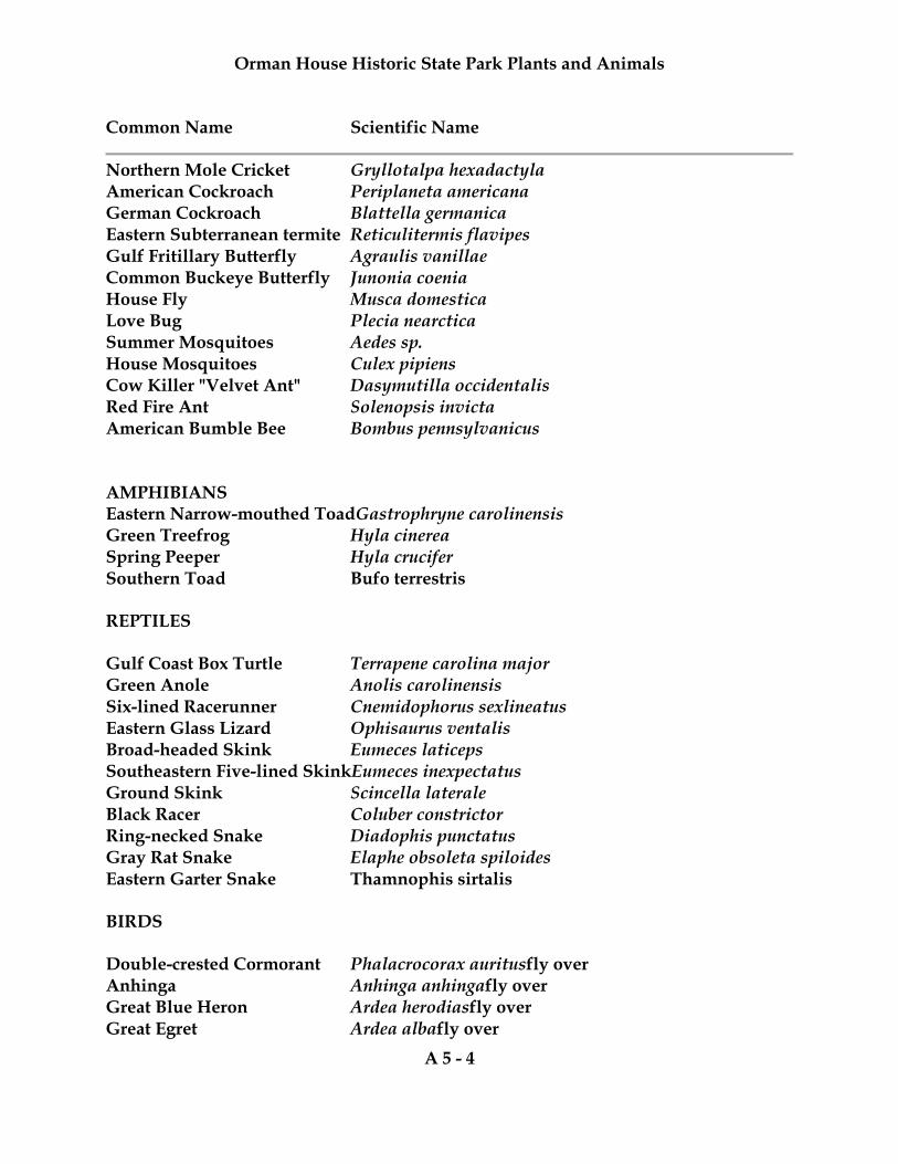
Orman House Historic State Park Plants and Animals Common Name Scientific Name
A 5 - 4
Northern Mole Cricket Gryllotalpa hexadactyla American Cockroach Periplaneta americana German Cockroach Blattella germanica Eastern Subterranean termite Reticulitermis flavipes Gulf Fritillary Butterfly Agraulis vanillae Common Buckeye Butterfly Junonia coenia House Fly Musca domestica Love Bug Plecia nearctica Summer Mosquitoes Aedes sp. House Mosquitoes Culex pipiens Cow Killer "Velvet Ant" Dasymutilla occidentalis Red Fire Ant Solenopsis invicta American Bumble Bee Bombus pennsylvanicus AMPHIBIANS Eastern Narrow-mouthed ToadGastrophryne carolinensis Green Treefrog Hyla cinerea Spring Peeper Hyla crucifer Southern Toad Bufo terrestris REPTILES Gulf Coast Box Turtle Terrapene carolina major Green Anole Anolis carolinensis Six-lined Racerunner Cnemidophorus sexlineatus Eastern Glass Lizard Ophisaurus ventalis Broad-headed Skink Eumeces laticeps Southeastern Five-lined SkinkEumeces inexpectatus Ground Skink Scincella laterale Black Racer Coluber constrictor Ring-necked Snake Diadophis punctatus Gray Rat Snake Elaphe obsoleta spiloides Eastern Garter Snake Thamnophis sirtalis BIRDS Double-crested Cormorant Phalacrocorax auritusfly over Anhinga Anhinga anhinga fly over Great Blue Heron Ardea herodiasfly over Great Egret Ardea albafly over
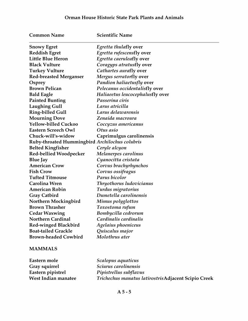
Orman House Historic State Park Plants and Animals Common Name Scientific Name
A 5 - 5
Snowy Egret Egretta thulafly over Reddish Egret Egretta rufescensfly over Little Blue Heron Egretta caeruleafly over Black Vulture Coragyps atratusfly over Turkey Vulture Cathartes aurafly over Red-breasted Merganser Mergus serratorfly over Osprey Pandion haliaetus fly over Brown Pelican Pelecanus occidentalisfly over Bald Eagle Haliaeetus leucocephalusfly over Painted Bunting Passerina ciris Laughing Gull Larus atricilla Ring-billed Gull Larus delawarensis Mourning Dove Zenaida macroura Yellow-billed Cuckoo Coccyzus americanus Eastern Screech Owl Otus asio Chuck-will's-widow Caprimulgus carolinensis Ruby-throated Hummingbird Archilochus colubris Belted Kingfisher Ceryle alcyon Red-bellied Woodpecker Melanerpes carolinus Blue Jay Cyanocitta cristata American Crow Corvus brachyrhynchos Fish Crow Corvus ossifragus Tufted Titmouse Parus bicolor Carolina Wren Thryothorus ludovicianus American Robin Turdus migratorius Gray Catbird Dumetella carolinensis Northern Mockingbird Mimus polyglottos Brown Thrasher Toxostoma rufum Cedar Waxwing Bombycilla cedrorum Northern Cardinal Cardinalis cardinalis Red-winged Blackbird Agelaius phoeniceus Boat-tailed Grackle Quiscalus major Brown-headed Cowbird Molothrus ater MAMMALS Eastern mole Scalopus aquaticus Gray squirrel Sciurus carolinensis Eastern pipistrel Pipistrellus subflavus West Indian manatee Trichechus manatus latirostris Adjacent Scipio Creek

Orman House Historic State Park Plants and Animals Common Name Scientific Name
A 5 - 6

Addendum 6—Cultural Information

Management Procedures for Archaeological and Historical Sites and Properties on State-Owned or Controlled Properties (revised March 2013)
A 6 - 1
These procedures apply to state agencies, local governments, and non-profits that manage state-owned properties. A. General Discussion Historic resources are both archaeological sites and historic structures. Per Chapter 267, Florida Statutes, ‘Historic property’ or ‘historic resource’ means any prehistoric district, site, building, object, or other real or personal property of historical, architectural, or archaeological value, and folklife resources. These properties or resources may include, but are not limited to, monuments, memorials, Indian habitations, ceremonial sites, abandoned settlements, sunken or abandoned ships, engineering works, treasure trove, artifacts, or other objects with intrinsic historical or archaeological value, or any part thereof, relating to the history, government, and culture of the state.” B. Agency Responsibilities Per State Policy relative to historic properties, state agencies of the executive branch must allow the Division of Historical Resources (Division) the opportunity to comment on any undertakings, whether these undertakings directly involve the state agency, i.e., land management responsibilities, or the state agency has indirect jurisdiction, i.e. permitting authority, grants, etc. No state funds should be expended on the undertaking until the Division has the opportunity to review and comment on the project, permit, grant, etc. State agencies shall preserve the historic resources which are owned or controlled by the agency. Regarding proposed demolition or substantial alterations of historic properties, consultation with the Division must occur, and alternatives to demolition must be considered. State agencies must consult with Division to establish a program to location, inventory and evaluate all historic properties under ownership or controlled by the agency. C. Statutory Authority Statutory Authority and more in depth information can be found at: http://www.flheritage.com/preservation/compliance/guidelines.cfm
Management Procedures for Archaeological and Historical Sites and Properties on State-Owned or Controlled Properties (revised March 2013)
A 6 - 2
D. Management Implementation Even though the Division sits on the Acquisition and Restoration Council and approves land management plans, these plans are conceptual. Specific information regarding individual projects must be submitted to the Division for review and recommendations. Managers of state lands must coordinate any land clearing or ground disturbing activities with the Division to allow for review and comment on the proposed project. Recommendations may include, but are not limited to: approval of the project as submitted, cultural resource assessment survey by a qualified professional archaeologist, modifications to the proposed project to avoid or mitigate potential adverse effects. Projects such as additions, exterior alteration, or related new construction regarding historic structures must also be submitted to the Division of Historical Resources for review and comment by the Division’s architects. Projects involving structures fifty years of age or older, must be submitted to this agency for a significance determination. In rare cases, structures under fifty years of age may be deemed historically significant. These must be evaluated on a case by case basis. Adverse impacts to significant sites, either archaeological sites or historic buildings, must be avoided. Furthermore, managers of state property should make preparations for locating and evaluating historic resources, both archaeological sites and historic structures. E. Minimum Review Documentation Requirements In order to have a proposed project reviewed by the Division, certain information must be submitted for comments and recommendations. The minimum review documentation requirements can be found at: http://www.flheritage.com/preservation/compliance/docs/minimum_review_documentation_requirements.pdf .
* * *
Management Procedures for Archaeological and Historical Sites and Properties on State-Owned or Controlled Properties (revised March 2013)
A 6 - 3
Questions relating to the treatment of archaeological and historic resources on state lands should be directed to: Deena S. Woodward Division of Historical Resources Bureau of Historic Preservation Compliance and Review Section R. A. Gray Building 500 South Bronough Street Tallahassee, FL 32399-0250 Phone: (850) 245-6425 Toll Free: (800) 847-7278 Fax: (850) 245-6435
Eligibility Criteria for National Register of Historic Places
A 6 - 4
The criteria to be used for evaluating eligibility for listing in the National Register of Historic Places are as follows: 1) Districts, sites, buildings, structures, and objects may be considered to have
significance in American history, architecture, archaeology, engineering, and/or culture if they possess integrity of location, design, setting, materials, workmanship, feeling, and association, and:
a) are associated with events that have made a significant contribution to the
broad patterns of our history; and/or b) are associated with the lives of persons significant in our past; and/or c) embody the distinctive characteristics of type, period, or method of
construction, or that represent the work of a master, or that possess high artistic values, or that represent a significant and distinguishable entity whose components may lack individual distinction; and/or
d) have yielded, or may be likely to yield, information important in prehistory or history.
2) Ordinarily cemeteries, birthplaces, or graves of historical figures; properties
owned by religious institutions or used for religious purposes; structures that have been moved from their original locations; reconstructed historic buildings; properties primarily commemorative in nature; and properties that have achieved significance within the past 50 years shall not be considered eligible for the National Register. However, such properties will qualify if they are integral parts of districts that do meet the criteria or if they fall within the following categories:
a) a religious property deriving its primary significance from architectural or
artistic distinction or historical importance; or b) a building or structure removed from its original location but which is
significant primarily for architectural value, or which is the surviving structure most importantly associated with a historic person or event; or
c) a birthplace or grave of an historical figure of outstanding importance if there is no appropriate site or building directly associated with his productive life; or
d) a cemetery which derives its primary significance from graves of persons of transcendent importance, from age, distinctive design features, or association with historic events; or
Eligibility Criteria for National Register of Historic Places
A 6 - 5
e) a reconstructed building, when it is accurately executed in a suitable environment and presented in a dignified manner as part of a restoration master plan, and no other building or structure with the same association has survived; or a property primarily commemorative in intent, if design, age, tradition, or symbolic value has invested it with its own exceptional significance; or
f) a property achieving significance within the past 50 years, if it is of exceptional importance.
Preservation Treatments as Defined by Secretary of Interior’s Standards and Guidelines
A 6 - 6
Restoration is defined as the act or process of accurately depicting the form, features, and character of a property as it appeared at a particular period of time by means of the removal of features from other periods in its history and reconstruction of missing features from the restoration period. The limited and sensitive upgrading of mechanical, electrical and plumbing systems and other code-required work to make properties functional is appropriate within a restoration project. Rehabilitation is defined as the act or process of making possible a compatible use for a property through repair, alterations and additions while preserving those portions or features that convey its historical, cultural or architectural values. Stabilization is defined as the act or process of applying measures designed to reestablish a weather resistant enclosure and the structural stability of an unsafe or deteriorated property while maintaining the essential form as it exists at present. Preservation is defined as the act or process of applying measures necessary to sustain the existing form, integrity and materials of an historic property. Work, including preliminary measures to protect and stabilize the property, generally focuses upon the ongoing maintenance and repair of historic materials and features rather than extensive replacement and new construction. New exterior additions are not within the scope of this treatment; however, the limited and sensitive upgrading of mechanical, electrical and plumbing systems and other code-required work to make properties functional is appropriate within a preservation project.
Addendum 7—Plant Species Associated with Alvan Chapman

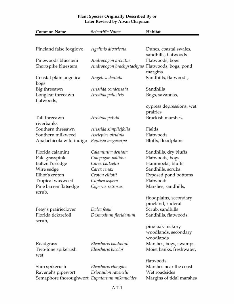
Plant Species Originally Described By or Later Revised by Alvan Chapman
Common Name Scientific Name Habitat
A 7-1
Pineland false foxglove Agalinis divaricata Dunes, coastal swales, sandhills, flatwoods Pinewoods bluestem Andropogon arctatus Flatwoods, bogs Shortspike bluestem Andropogon brachystachyus Flatwoods, bogs, pond margins Coastal plain angelica Angelica dentata Sandhills, flatwoods, bogs Big threeawn Aristida condensata Sandhills Longleaf threeawn Aristida palustris Bogs, savannas, flatwoods, cypress depressions, wet prairies Tall threeawn Aristida patula Brackish marshes, riverbanks Southern threeawn Aristida simplicifolia Fields Southern milkweed Asclepias viridula Flatwoods Apalachicola wild indigo Baptisia megacarpa Bluffs, floodplains Florida calamint Calamintha dentata Sandhills, dry bluffs Pale grasspink Calopogon pallidus Flatwoods, bogs Baltzell’s sedge Carex baltzellii Hammocks, bluffs Wire sedge Carex tenax Sandhills, scrubs Elliot’s croton Croton elliotii Exposed pond bottoms Tropical waxweed Cuphea aspera Flatwoods Pine barren flatsedge Cyperus retrorus Marshes, sandhills, scrub, floodplains, secondary pineland, ruderal Feay’s prairieclover Dalea feayi Scrub, sandhills Florida ticktrefoil Desmodium floridanum Sandhills, flatwoods, scrub, pine-oak-hickory woodlands, secondary woodlands Roadgrass Eleocharis baldwinii Marshes, bogs, swamps Two-tone spikerush Eleocharis bicolor Moist banks, freshwater, wet flatwoods Slim spikerush Eleocharis elongata Marshes near the coast Ravenel’s pipewort Eriocaulon ravenelii Wet roadsides Semaphore thoroughwort Eupatorium mikanioides Margins of tidal marshes

Plant Species Originally Described By or Later Revised by Alvan Chapman
Common Name Scientific Name Habitat
A 7-2
Curtis’ spurge Euphorbia curtisii Sandhills, flatwoods, gum pond margins Summer spurge Euphorbia discoidalis Sandhills, dry margins of sinks Greater Florida spurge Euphorbia floridana Sandhills, scrub Florida pineland spurge Euphorbia inundata Flatwoods, bogs Telephus spurge Euphorbia telephioides Flatwoods Apalachicola aster Eurybia spinulosa Flatwoods Twospike fingergrass Eustachys floridana Sandhills, long leaf pinelands, bluffs Saltmarsh fingergrass Eustachys glauca Flatwoods, bluffs Littleleaf milkpea Galactia microphylla Dunes, scrub, sandhills, secondary woodlands Mock pennyroyal Hedeoma graveolens Sandhills, flatwoods, pond margins Coastal sand frostweed Helianthemum arenicola Sandhills, scrub, dunes Georgia frostweed Helianthemum georgianum Sandhills, dunes Florida sunflower Helianthus floridanus Wet flatwoods, wet prairies, edges of titi or bay swamps Stiff yellow stargrass Hypoxis rigida Bogs, flatwoods Large gallberry Ilex coriacea Titi swamps, bogs Annual rush Juncus abortivus Marshes, coastal swales Thickleaf water-willow Justicia crassifolia Wet flatwoods, bogs, cypress swamps Small’s bogbutton Lachnocaulon minus Marshes, flatwoods, bogs Corkwood Leitneria floridana Brackish marshes, coastal hammocks Apalachicola toadflax Linaria floridana Sandhills, dunes, scrub, ruderal Florida lobelia Lobelia floridana Riverbanks, bogs, cypress swamps Southern club-moss Lycopodiella appressa Bogs, moist flatwoods White birds-in-a-nest Macbridea alba Flatwoods, bogs
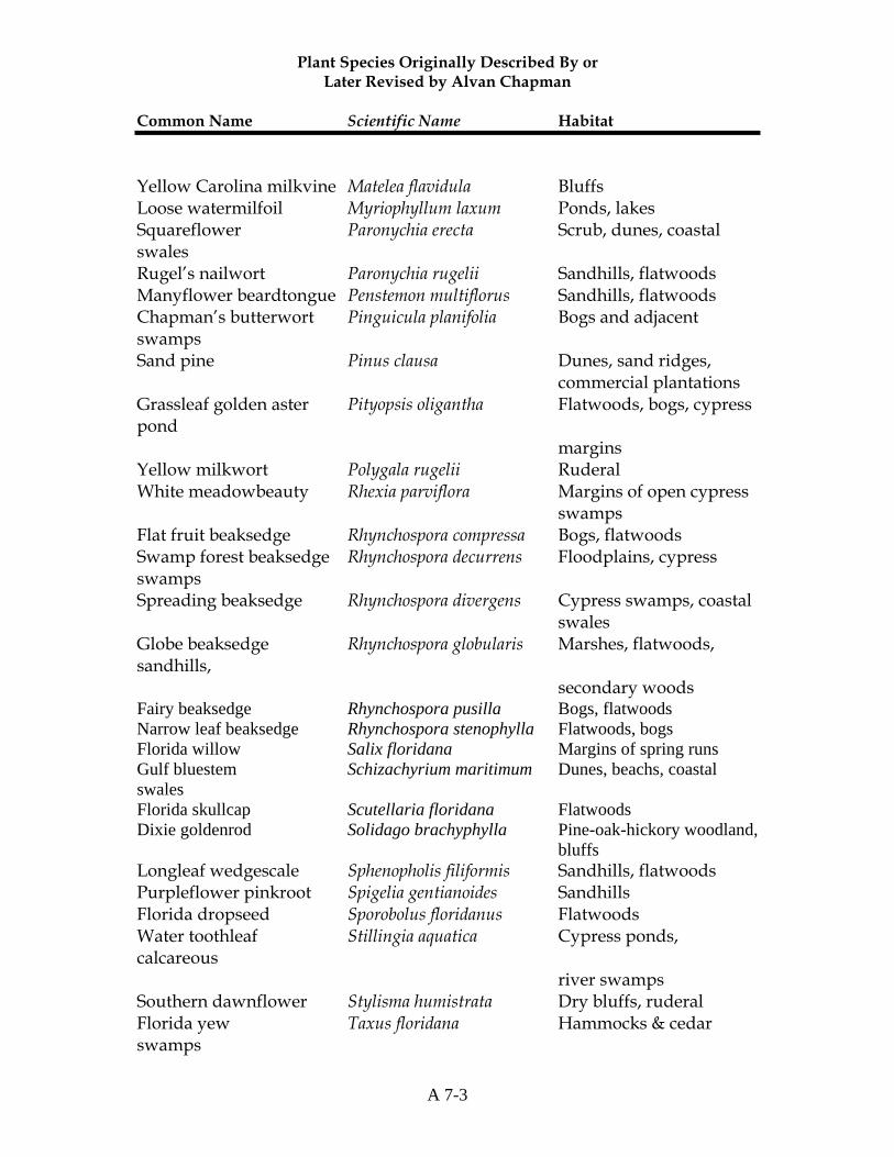
Plant Species Originally Described By or Later Revised by Alvan Chapman
Common Name Scientific Name Habitat
A 7-3
Yellow Carolina milkvine Matelea flavidula Bluffs Loose watermilfoil Myriophyllum laxum Ponds, lakes Squareflower Paronychia erecta Scrub, dunes, coastal swales Rugel’s nailwort Paronychia rugelii Sandhills, flatwoods Manyflower beardtongue Penstemon multiflorus Sandhills, flatwoods Chapman’s butterwort Pinguicula planifolia Bogs and adjacent swamps Sand pine Pinus clausa Dunes, sand ridges, commercial plantations Grassleaf golden aster Pityopsis oligantha Flatwoods, bogs, cypress pond margins Yellow milkwort Polygala rugelii Ruderal White meadowbeauty Rhexia parviflora Margins of open cypress swamps Flat fruit beaksedge Rhynchospora compressa Bogs, flatwoods Swamp forest beaksedge Rhynchospora decurrens Floodplains, cypress swamps Spreading beaksedge Rhynchospora divergens Cypress swamps, coastal swales Globe beaksedge Rhynchospora globularis Marshes, flatwoods, sandhills, secondary woods Fairy beaksedge Rhynchospora pusilla Bogs, flatwoods Narrow leaf beaksedge Rhynchospora stenophylla Flatwoods, bogs Florida willow Salix floridana Margins of spring runs Gulf bluestem Schizachyrium maritimum Dunes, beachs, coastal swales Florida skullcap Scutellaria floridana Flatwoods Dixie goldenrod Solidago brachyphylla Pine-oak-hickory woodland, bluffs Longleaf wedgescale Sphenopholis filiformis Sandhills, flatwoods Purpleflower pinkroot Spigelia gentianoides Sandhills Florida dropseed Sporobolus floridanus Flatwoods Water toothleaf Stillingia aquatica Cypress ponds, calcareous river swamps Southern dawnflower Stylisma humistrata Dry bluffs, ruderal Florida yew Taxus floridana Hammocks & cedar swamps
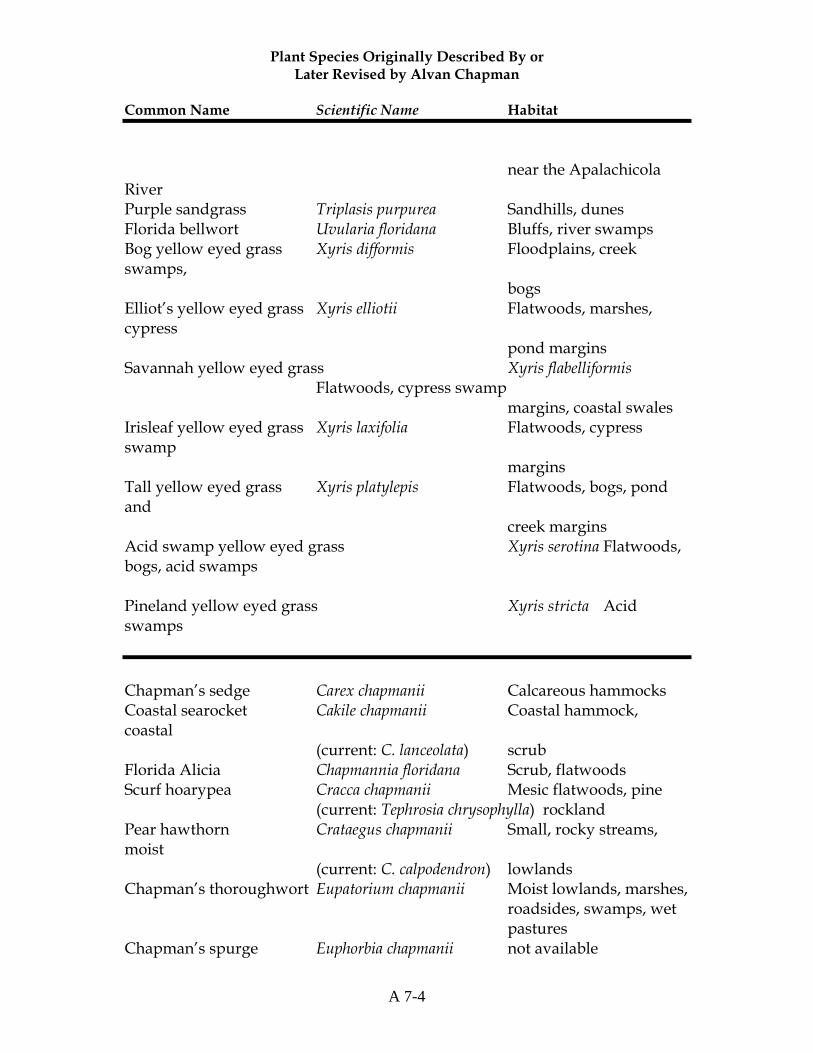
Plant Species Originally Described By or Later Revised by Alvan Chapman
Common Name Scientific Name Habitat
A 7-4
near the Apalachicola River Purple sandgrass Triplasis purpurea Sandhills, dunes Florida bellwort Uvularia floridana Bluffs, river swamps Bog yellow eyed grass Xyris difformis Floodplains, creek swamps, bogs Elliot’s yellow eyed grass Xyris elliotii Flatwoods, marshes, cypress pond margins Savannah yellow eyed grass Xyris flabelliformis Flatwoods, cypress swamp margins, coastal swales Irisleaf yellow eyed grass Xyris laxifolia Flatwoods, cypress swamp margins Tall yellow eyed grass Xyris platylepis Flatwoods, bogs, pond and creek margins Acid swamp yellow eyed grass Xyris serotina Flatwoods, bogs, acid swamps Pineland yellow eyed grass Xyris stricta Acid swamps
Chapman’s sedge Carex chapmanii Calcareous hammocks Coastal searocket Cakile chapmanii Coastal hammock, coastal (current: C. lanceolata) scrub Florida Alicia Chapmannia floridana Scrub, flatwoods Scurf hoarypea Cracca chapmanii Mesic flatwoods, pine (current: Tephrosia chrysophylla) rockland Pear hawthorn Crataegus chapmanii Small, rocky streams, moist (current: C. calpodendron) lowlands Chapman’s thoroughwort Eupatorium chapmanii Moist lowlands, marshes, roadsides, swamps, wet pastures Chapman’s spurge Euphorbia chapmanii not available
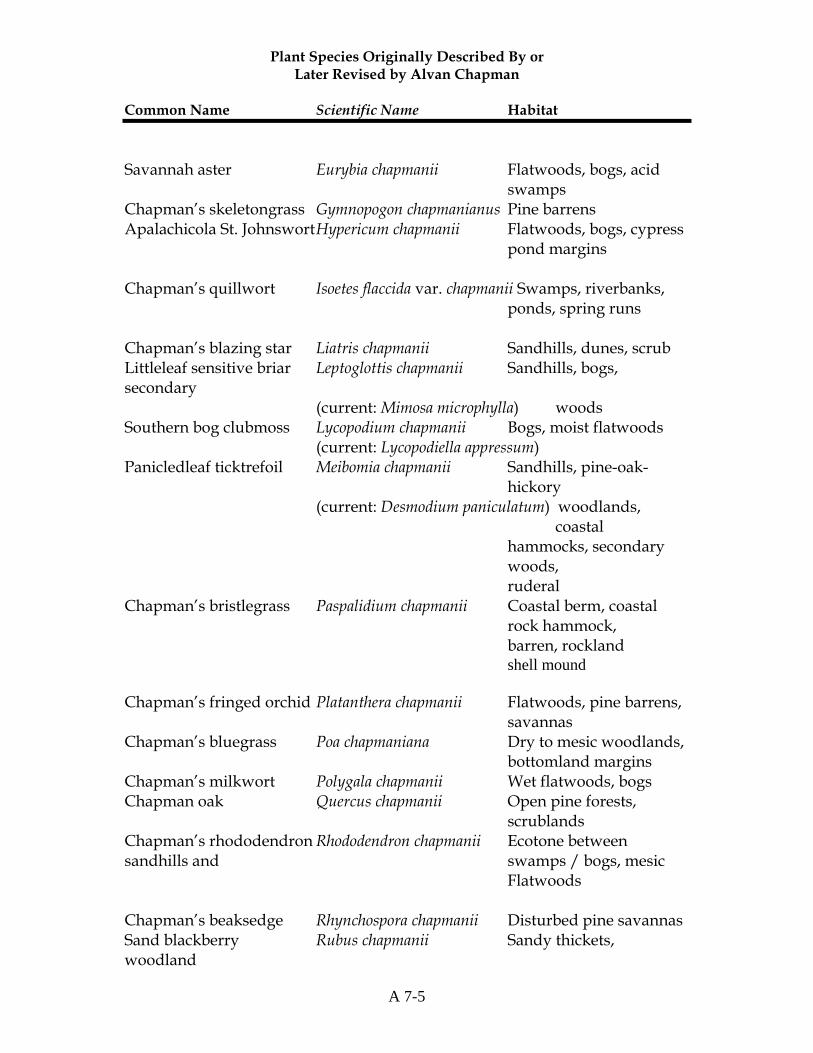
Plant Species Originally Described By or Later Revised by Alvan Chapman
Common Name Scientific Name Habitat
A 7-5
Savannah aster Eurybia chapmanii Flatwoods, bogs, acid swamps Chapman’s skeletongrass Gymnopogon chapmanianus Pine barrens Apalachicola St. Johnswort Hypericum chapmanii Flatwoods, bogs, cypress pond margins Chapman’s quillwort Isoetes flaccida var. chapmanii Swamps, riverbanks, ponds, spring runs Chapman’s blazing star Liatris chapmanii Sandhills, dunes, scrub Littleleaf sensitive briar Leptoglottis chapmanii Sandhills, bogs, secondary (current: Mimosa microphylla) woods Southern bog clubmoss Lycopodium chapmanii Bogs, moist flatwoods (current: Lycopodiella appressum) Panicledleaf ticktrefoil Meibomia chapmanii Sandhills, pine-oak- hickory (current: Desmodium paniculatum) woodlands, coastal hammocks, secondary woods, ruderal Chapman’s bristlegrass Paspalidium chapmanii Coastal berm, coastal rock hammock, barren, rockland shell mound Chapman’s fringed orchid Platanthera chapmanii Flatwoods, pine barrens, savannas Chapman’s bluegrass Poa chapmaniana Dry to mesic woodlands, bottomland margins Chapman’s milkwort Polygala chapmanii Wet flatwoods, bogs Chapman oak Quercus chapmanii Open pine forests, scrublands Chapman’s rhododendron Rhododendron chapmanii Ecotone between sandhills and swamps / bogs, mesic Flatwoods Chapman’s beaksedge Rhynchospora chapmanii Disturbed pine savannas Sand blackberry Rubus chapmanii Sandy thickets, woodland
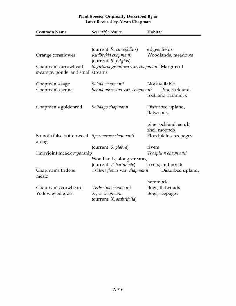
Plant Species Originally Described By or Later Revised by Alvan Chapman
Common Name Scientific Name Habitat
A 7-6
(current: R. cuneifolius) edges, fields Orange coneflower Rudbeckia chapmanii Woodlands, meadows (current: R. fulgida) Chapman’s arrowhead Sagittaria graminea var. chapmanii Margins of swamps, ponds, and small streams Chapman’s sage Salvia chapmanii Not available Chapman’s senna Senna mexicana var. chapmanii Pine rockland, rockland hammock Chapman’s goldenrod Solidago chapmanii Disturbed upland, flatwoods, pine rockland, scrub, shell mounds Smooth false buttonweed Spermacoce chapmanii Floodplains, seepages along (current: S. glabra) rivers Hairyjoint meadowparsnip Thaspium chapmanii Woodlands; along streams, (current: T. barbinode) rivers, and ponds Chapman’s tridens Tridens flavus var. chapmanii Disturbed upland, mesic hammock Chapman’s crowbeard Verbesina chapmanii Bogs, flatwoods Yellow eyed grass Xyris chapmanii Bogs, seepages (current: X. scabrifolia)