Embed Size (px)
Citation preview
The Streets of Leichhardt
Origin of the Names of the Streets of Leichhardt Page 1
Origins of the Names of the Streets of Leichhardt
Preface 1 Acknowledgements 1 1 Introduction. 2 2 Leichhardt 2 3 Street Names 2 4 Allotment Size 2 5 Lanes 3 6 Reference Documents 4 7 The Origin of the Names of the Streets of Leichhardt 5 Appendix 1 Changed Street Names 13 Appendix 2 Width of Streets and Lanes Act of 1881 14 Appendix 3 What is a Road? 15 Preface. This report was prepared under a Leichhardt Municipal Council Local History Grant of 2010. The grant application, dated Wednesday, 10 March 2010, was presented to and approved at the Council Meeting of 23 March 2010. The origins of The Street Names of Leichhardt have not previously been published; Grellis and Zar (2010) give detail of some Leichhardt streets. Street Names usually provide an overview of the people, places and events current at the time the streets were named; thus the whole period of Leichhardt’s history from the first estates (about 1800) until say, 1920. There are about 110 streets in Leichhardt; the number varies because, for example, some streets are in two precincts and are counted twice. This Report lists 135 streets; included are old, new, obsolete and recycled street names. In a few instances, about a dozen lanes and streets, the origin of the names is not know at this stage. Acknowledgements. This work is based on many sources and resources, including (but not limited to): Australian Trove; the digitised newspaper project of the National Library of Australia; Family History websites; Internet searches; Leichhardt Estate and Subdivision Plans; Leichhardt Historical Journal; Leichhardt Municipal Council library; Leichhardt Municipal Council website;
The Streets of Leichhardt
Origin of the Names of the Streets of Leichhardt Page 2
Map of Leichhardt precinct and list of streets suppled by Julie Leslie, GIS Coordinator, Leichhardt Council;
Maps and street directories; Mitchell Library; NSW Registry of Births Deaths & Marriages, Historical Indexes; Sands Directories; State Library of New South Wales; The Ryerson Index and Grellis, Alison and Zar, Amie (2010) Place and Street Names: Leichhardt Municipality; If I have forgotten someone please forgive me. I claim total ownership of all the faults, errors and omissions. Patrick James 29 January 2012
The Streets of Leichhardt
Origin of the Names of the Streets of Leichhardt Page 3
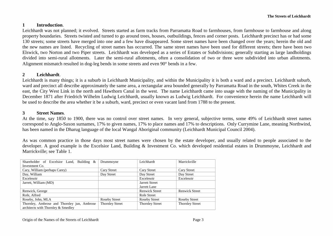
1 Introduction. Leichhardt was not planned; it evolved. Streets started as farm tracks from Parramatta Road to farmhouses, from farmhouse to farmhouse and along property boundaries. Streets twisted and turned to go around trees, houses, outbuildings, fences and corner posts. Leichhardt precinct has or had some 130 streets; some streets have merged into one and a few have disappeared. Some street names have been changed over the years; herein the old and the new names are listed. Recycling of street names has occurred. The same street names have been used for different streets; there have been two Elswick, two Norton and two Piper streets. Leichhardt was developed as a series of Estates or Subdivisions; generally starting as large landholdings divided into semi-rural allotments. Later the semi-rural allotments, often a consolidation of two or three were subdivided into urban allotments. Alignment mismatch resulted in dog-leg bends in some streets and even 90° bends in a few. 2 Leichhardt. Leichhardt is many things; it is a suburb in Leichhardt Municipality, and within the Municipality it is both a ward and a precinct. Leichhardt suburb, ward and precinct all describe approximately the same area, a rectangular area bounded generally by Parramatta Road in the south, Whites Creek in the east, the City West Link in the north and Hawthorn Canal in the west. The name Leichhardt came into usage with the naming of the Municipality in December 1871 after Friedrich Wilhelm Ludwig Leichhardt, usually known as Ludwig Leichhardt. For convenience herein the name Leichhardt will be used to describe the area whether it be a suburb, ward, precinct or even vacant land from 1788 to the present. 3 Street Names. At the time, say 1850 to 1900, there was no control over street names. In very general, subjective terms, some 49% of Leichhardt street names correspond to Anglo-Saxon surnames, 17% to given names, 17% to place names and 17% to descriptions. Only Currymine Lane, meaning Northwind, has been named in the Dharug language of the local Wangal Aboriginal community (Leichhardt Municipal Council 2004). As was common practice in those days most street names were chosen by the estate developer, and usually related to people associated to the developer. A good example is the Excelsior Land, Building & Investment Co. which developed residential estates in Drummoyne, Leichhardt and Marrickville; see Table 1. Shareholder of Excelsior Land, Building & Investment Co.
Drummoyne Leichhardt Marrickville
Cary, William (perhaps Carey) Cary Street Cary Street Cary Street Day, William Day Street Day Street Day Street Excelesoir Excelesoir Excelesoir Jarrett, William (MD) Jarrett Street
Jarrett Lane
Renwick, George Renwick Street Renwick Street Rofe, Alfred Rofe Street Roseby, John, MLA Roseby Street Roseby Street Roseby Street Thornley, Ambrose and Thornley jun, Ambrose architects with Thornley & Smedley
Thornley Street Thornley Street Thornley Street
The Streets of Leichhardt
Origin of the Names of the Streets of Leichhardt Page 4
4 Allotment Size.
Allotment size was determined by market forces, usually but with some exceptions the maximum number of allotments the developers (vendor) could squeeze into the space available. This arrangement both minimised the cost to the purchaser and maximised the cash flow to the developer. Until 20 December 1881, streets and lanes could be any width, whatever the market would allow. On 20 December 1881 the Width of Streets and Lanes Act of 1881 came into effect. The Act specified the minimum width of lanes to be 6.1 metres and of streets to be 20.1 metres. In Imperial measurement streets were one chain wide. This Act immediately affected the anticipated profit of estates “under construction”.
5 Lanes. Generally lanes have gone unnamed in the subdivision plans of Leichhardt estates. The purpose of lanes in the nineteenth centaury was to provide access to the rear of premises for the collection of nightsoil. Night soil is a euphemism for human excrement collected from privies1 by a contractor to the local council. Obviously collection via the front door was not desired; similarly bumping into the collector2 laden with his load was to be avoided hence lanes (and side passages) were provided for this essential service.
Lanes were unnamed. To associate one’s name with a lane used to haul nightsoil probably was not considered appropriate. In all the subdivision plans, about 200 or so, only one lane is named; Mangrove Lane, between Athol and Lyall Streets. The name refers to mangroves present before the land was reclaimed from Long Cove. Mangrove Lane was later absorbed into Darley Road.
Named lanes are Albion, Chancery, Dot, Edith, Ivory, Jarrett, Moore and Renwick. Of these the origin of Chancery, Dot and Ivory are (presently) unknown.
Dot Lane is a cul-de-sac with entrance off Balmain Road located along the southern boundary of the Italian Forum and once described3 as a narrow, ill-lit dead-end (lane) behind a hotel. The land on both sides of Dot Lane was owned by various members of the Hearn family. The only Dot in the Hearn family was Dorothea M Lorentzen wife of Lawrence Joseph Hearn, married4 on 13 June 1928. Dorothea Hearn could have given her name to the Lane however the short period of her marriage5 suggests otherwise.
Chancery Lane is behind the Bald Faced Stag Hotel within land once owned by J. Rochester.
Leichhardt Municipal Council in recent times (2004) has gone through the current process of naming lanes (see Appendix 3). One of the three lanes named was Currymine Lane. The action taken by Council was: 1 Usually a small structure separate (outhouse) from a main building which contained a pail closet. A pail closet contained a seat, underneath which a portable receptacle (pail) was placed. This pail, into which the user would defecate, was removed and emptied by the local Council on a regular basis (from Wikipedia). 2 Collectors were formally called nightsoil men. This seems to be a male only occupation. 3 Sydney Morning Herald, Saturday, 1 July 1933, page 13. 4 NSW Registry of Births Deaths and Marriages; Marriage Reg. No. 10311/1928. 5 HEARN V HEARN: Dorothea Mavis Hearn (formerly Lorentzen) petitioned for a divorce from Lawrence Joseph Hearn on the ground of his adultery between June 1 1929 and March 3 1930 with a woman unknown at Sydney and other places. The marriage took place on June 13 1928 at Sydney according to the Presbyterian rite. A decree nisi was granted in favour of petitioner for whom Mr G M Stafford appeared. There was no appearance on behalf of respondent.
The Streets of Leichhardt
Origin of the Names of the Streets of Leichhardt Page 5
1 The Aboriginal Consultative Committee minutes of the 17 June 2004 meeting resolved that Alex Gallegahan and Robert Webb were to visit the said laneway and forward appropriate names to … pass to the next Council meeting.
2 Leichhardt Municipal Council resolution of 27 July 2004 adopted the minutes of the Aboriginal Consultative Committee held on Thursday 17 June 2004 that the laneway to the rear of Marion Street between Elswick Street and Marlborough Street, Leichhardt be called Currymine Lane, meaning Northwind in the Dharug language of the local Wangal Aboriginal community.
3 The name Currymine Lane was gazetted on 19 November 2004, following a Leichhardt Municipal Council resolution of 27 July 2004 pursuant to section 162 of the Roads Act 1993. New South Wales Government Gazette No. 183, 19 November 2004, folio 8539-8540 .
From about 1890 the Metropolitan Water Sewage and Drainage Board began to install the sewerage system in Leichhardt. Thus residential estates with installed sewers from about this date did not require rear access lanes. Perhaps with the introduction of the sewer the association of lanes with nightsoil decreased or even disappeared and it became acceptable to give lanes a name.
The Streets of Leichhardt
Origin of the Names of the Streets of Leichhardt Page 6
6 Reference Documents Appleton, Richard and Appleton, Barbara (1992) The Cambridge Dictionary of Australian Places , Cambridge University Press, Cambridge, UK, State Library of New South Wales Call No. 919.4003/3B Australian Dictionary of Biography (ADB) http://adb.anu.edu.au/
Australian Trove; the digitised newspaper project of the National Library of Australia; http://trove.nla.gov.au/ndp/del/search?adv=y
Grellis, Alison and Zar, Amie (2010) Place and Street Names: Leichhardt Municipality, Leichhardt Library, Local History Collection.
Included here are legislation, specific references and (typically) internet search location.
Legislation, Local Government Act 1993, Dictionary
Legislation, Municipalities Act, 1867
Legislation, Roads (General) Regulation 2000, under the Roads Act, 1993
Legislation, Roads Act, 1993, Dictionary
Leichhardt Historical Journal, a treasure trove of information, first issue 1971.
Leichhardt Library, Local History Collection; Estate and Subdivision Plans;
Leichhardt Local Environmental Plan 2000, Schedule 2 Heritage Items (includes list of streets), NSW Government Gazette No. 168 of 22 December 2000, page 13714
Leichhardt Municipal Council (2004) Naming of Currymine Lane, New South Wales Government Gazette No. 183, 19 November 2004, folio 8539-8540, public notice
Leslie, Julie (2010) Map of Leichhardt Precinct and list of streets , GIS Coordinator, Leichhardt Council;
LPMA (2009a) Glossary of designation values in the Geographical Names Register , Land and Property Management Authority, Queens Square, Sydney NSW 2000, document (B) P09/21/004.
LPMA (2009b) Guidelines for the naming of roads , Land and Property Management Authority, Queens Square, Sydney NSW 2000, document (B) P09/21/008
Map of Leichhardt (ca, 1929), LMC website given as published in 1880s but actually dated post 1929
McCarthy, Frederick David (1963) New South Wales Aboriginal place names and euphonious words, with their meanings, The Australian Museum, Sydney, based on the original compilation of William Walford Thorpe, first edition, 1921. Mitchell Library, Plan LX294 of 1859. Sketch showing proposed road leading from Hugh Piper’s 270 acres through William Thomas’ grant of 38 acres to Parramatta Road, Parish of Petersham, County of Cumberland. Primarily notified on 8 August 1859, confirmation on 5 October 1859, folio 2198. Road one chain wide, proclaimed. The proposed road corresponds to Norton Street.
The Streets of Leichhardt
Origin of the Names of the Streets of Leichhardt Page 7
Mitchell Library, Plan of Piperton suburban allotments dated 1842 shows Parramatta Road, Balmain Road, Derbyshire Road, Hay Street, Hill Street (now Catherine Street), Piper Street, Styles Street.
Mitchell Library, Subdivision plan LX226, a plan attached to the Will of Charles Hearn (died 1890) shows the land around Chancery Lane being owned by Mary Anne Blackman (died 1874) (north side) and W Wheeler and H McNamara (south side).
Mitchell Library; various estate plans, maps and street directories
NSW Registry of Births Deaths & Marriages, Historical Indexes; http://www.bdm.nsw.gov.au/familyHistory/searchHistoricalRecords.htm
Sands Directories, 1858 to 1932/33. The Sands Directories of 1867, 1868 and 1869 unfortunately group the people of Annandale, Broughton, Garryowen, Leichhardt and Petersham together under the main heading of Petersham. The directories are very flexible and inconsistent with spelling and locations making interpretation of some directory entries necessary and sometimes impossible. The Sands Directories of 1867, 1868 and 1869 have 97, 92 and 143 entries respectively for Petersham.
The Ryerson Index; http://www.ryersonindex.org/
The Streets of Leichhardt
Origin of the Names of the Streets of Leichhardt Page 8
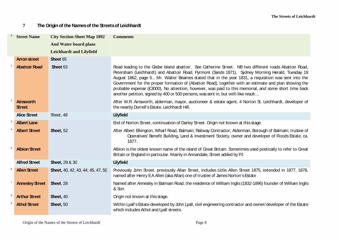
7 The Origin of the Names of the Streets of Leichhardt
0 Street Name City Section Sheet Map 1892
And Water board plans
Leichhardt and Lilyfield
Comments
Arron street Sheet 65 1 Abattoir Road Sheet 63 Road leading to the Glebe Island abattoir. See Catherine Street. NB two different roads Abattoir Road,
Petersham (Leichhardt) and Abattoir Road, Pyrmont (Sands 1871). Sydney Morning Herald, Tuesday 19 August 1862, page 5… Mr. Walter Beames stated that in the year 1831, a requisition was sent into the Government for the proper formation of (Abattoir Road), together with an estimate and plan showing the probable expense (£3000). No attention, however, was paid to this memorial, and some short time back another petition, signed by 400 or 500 persons, was sent in, but with like result…
2 Ainsworth Street
After W.R. Ainsworth, alderman, mayor, auctioneer & estate agent, 4 Norton St. Leichhardt, developer of the nearby Durrell's Estate, Leichhardt Hill.
Alice Street Sheet, 48 Lilyfield 3 Albert Lane End of Norton Street, continuation of Darley Street. Origin not known at this stage. 4 Albert Street Sheet, 52 After Albert Elkington, Wharf Road, Balmain; Railway Contractor; Alderman, Borough of Balmain; trustee of
Operatives' Benefit Building, Land & Investment Society, owner and developer of Floods Estate, ca. 1877.
5 Albion Street Albion is the oldest known name of the island of Great Britain. Sometimes used poetically to refer to Great Britain or England in particular. Mainly in Annandale, Street added by PJ
Alfred Street Sheet, 29 & 30 Lilyfield 6 Allen Street Sheet, 40, 42, 43, 44, 45, 47, 50 Previously John Street, previously Allan Street, includes Little Allen Street 1875, extended in 1877, 1878,
named after Henry E A Allen (aka Allan) one of trustee of James Norton’s Estate 7 Annesley Street Sheet, 28 Named after Annesley in Balmain Road, the residence of William Inglis (1832-1896) founder of William Inglis
& Son. 8 Arthur Street Sheet, 40 Origin not known at this stage. 9 Athol Street Sheet, 50 Within Lyall's Estate developed by John Lyall, civil engineering contractor and owner/developer of the Estate
which includes Athol and Lyall streets.
The Streets of Leichhardt
Origin of the Names of the Streets of Leichhardt Page 9
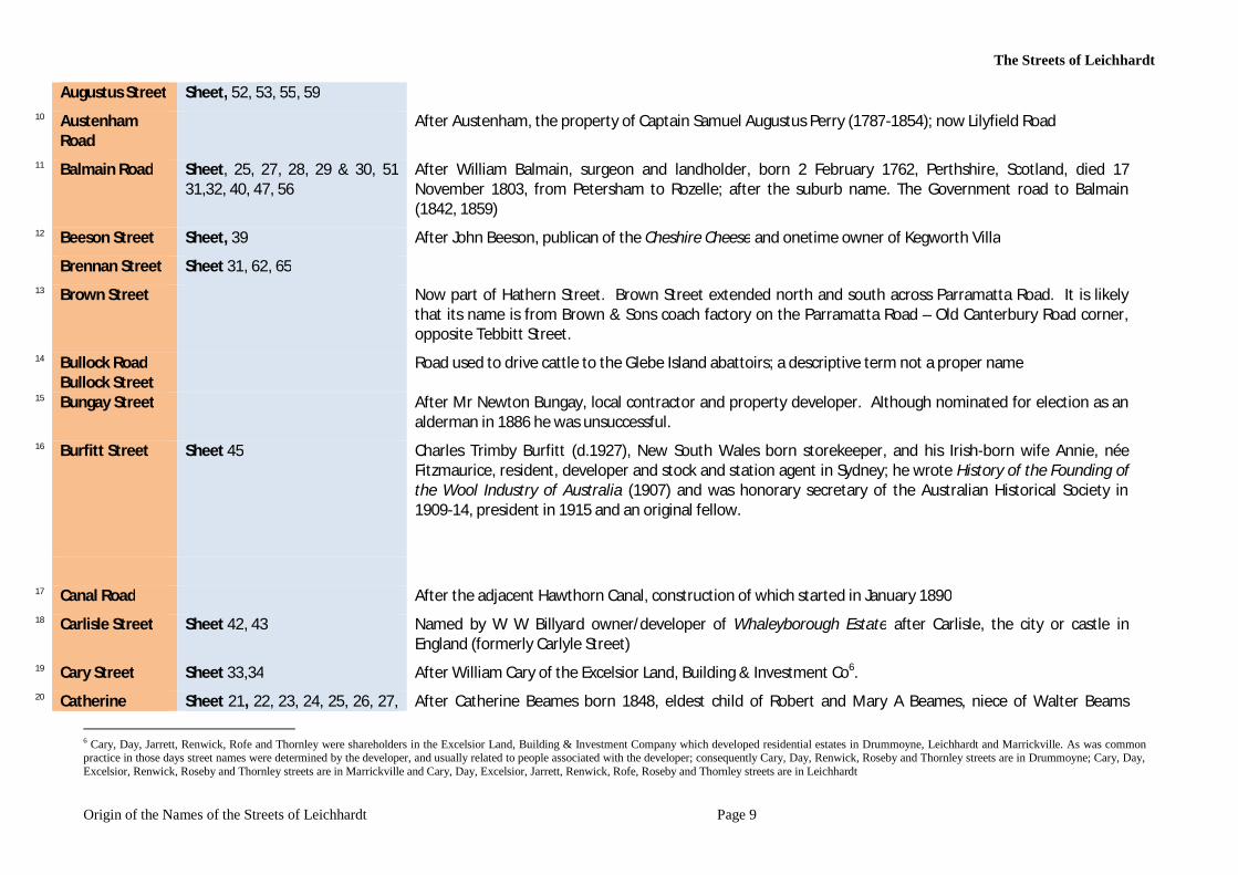
Augustus Street Sheet, 52, 53, 55, 59 10 Austenham
Road After Austenham, the property of Captain Samuel Augustus Perry (1787-1854); now Lilyfield Road
11 Balmain Road Sheet, 25, 27, 28, 29 & 30, 51 31,32, 40, 47, 56
After William Balmain, surgeon and landholder, born 2 February 1762, Perthshire, Scotland, died 17 November 1803, from Petersham to Rozelle; after the suburb name. The Government road to Balmain (1842, 1859)
12 Beeson Street Sheet, 39 After John Beeson, publican of the Cheshire Cheese and onetime owner of Kegworth Villa Brennan Street Sheet 31, 62, 65
13 Brown Street Now part of Hathern Street. Brown Street extended north and south across Parramatta Road. It is likely that its name is from Brown & Sons coach factory on the Parramatta Road – Old Canterbury Road corner, opposite Tebbitt Street.
14 Bullock Road Bullock Street
Road used to drive cattle to the Glebe Island abattoirs; a descriptive term not a proper name
15 Bungay Street After Mr Newton Bungay, local contractor and property developer. Although nominated for election as an alderman in 1886 he was unsuccessful.
16 Burfitt Street Sheet 45 Charles Trimby Burfitt (d.1927), New South Wales born storekeeper, and his Irish-born wife Annie, née Fitzmaurice, resident, developer and stock and station agent in Sydney; he wrote History of the Founding of the Wool Industry of Australia (1907) and was honorary secretary of the Australian Historical Society in 1909-14, president in 1915 and an original fellow.
17 Canal Road After the adjacent Hawthorn Canal, construction of which started in January 1890 18 Carlisle Street Sheet 42, 43 Named by W W Billyard owner/developer of Whaleyborough Estate after Carlisle, the city or castle in
England (formerly Carlyle Street) 19 Cary Street Sheet 33,34 After William Cary of the Excelsior Land, Building & Investment Co6. 20 Catherine Sheet 21, 22, 23, 24, 25, 26, 27, After Catherine Beames born 1848, eldest child of Robert and Mary A Beames, niece of Walter Beams
6 Cary, Day, Jarrett, Renwick, Rofe and Thornley were shareholders in the Excelsior Land, Building & Investment Company which developed residential estates in Drummoyne, Leichhardt and Marrickville. As was common practice in those days street names were determined by the developer, and usually related to people associated with the developer; consequently Cary, Day, Renwick, Roseby and Thornley streets are in Drummoyne; Cary, Day, Excelsior, Renwick, Roseby and Thornley streets are in Marrickville and Cary, Day, Excelsior, Jarrett, Renwick, Rofe, Roseby and Thornley streets are in Leichhardt
The Streets of Leichhardt
Origin of the Names of the Streets of Leichhardt Page 10
Street 28,29, 30, 31, 62, 64 (developed of Elswich Estate). Catherine Street, from Parramatta Road to Lilyfield Road, led to the Glebe Island abattoirs operational 1830s to 1915. The road has been called Abattoir Road (Sands 1873), Bullock Road, Bullock Street, Glebe Island Road, High Street (1842) and Lilyfield Road.
21 Centre Street Descriptive name for the road in the centre of Redmonds Estate, which bisects the Estate into two, and gives access to Redmond Street from Catherine Street.
22 Chancery Lane First listed in Sands Directory in 1910. Behind Bald Faced Stag, Hotel between Hay street and Balmain Road. Origin not known at this stage.
Chapel Street Sheet, 58, Lilyfield 23 Charles Street Sheet, 55 After Charles C. Skarratt, director of Anglo-Australian Investment & Finance Company Limited which
developed the Helsarmel Estate. Charles Street now bisected by City West Link. 24 Church Street
North & Church Street South
Sheet, 57, 59 Previous names for Treadgold Street which see. The two streets are north and south of a parcel of land reserved for a church; hence the name.
25 City West Link Road
Named for its function, City West Link Road is an arterial, link road in Sydney between Leichhardt, Haberfield and Five Dock and provides an alternative route to Parramatta Road into Sydney's CBD from the Inner-Western suburbs. City West Link Road effectively divides Lilyfield from Leichhardt.
26 Coleridge Street Sheet, 26 After English poet Samuel Taylor Coleridge (1772-1834), street intersects with Coleridge Street, which see. The north-south part of Fowler Street incorporated into Coleridge Street.
Commercial Rd Sheet, 59 Lilyfield 27 Cromwell Street Sheet 42, 43 Named by W W Billyard owner/developer of Whaleyborough Estate after Oliver Cromwell 28 Currymine Lane From Currymine meaning north wind in Dharug language of the local Wangal Aboriginal community. Name
proposed by LMC Aboriginal Consultative Committee 2004; see New South Wales Government Gazette No. 183, 19 November 2004, folio 8539-8540 (LMC 2004)
29 Daniel Street Sheet 46 After Daniel Wetherill (b 1866) first son of John Wetherill who developed the Estate. 30 Darley Road After Sir Frederick Matthew Darley (1830-1910), chief justice and lieutenant-governor of New South Wales.
Darley Road, a Department of Public Works project, was formed on land reclaimed from Long Cove and was extended to include Long Cove Parade and Park Road (1889) and ended at the intersection with James Street.
31 Day Street Sheet, 35 After William Day of the Excelsior Land, Building & Investment Co.
The Streets of Leichhardt
Origin of the Names of the Streets of Leichhardt Page 11
32 Davies Street Sheet, 39 After Simon Davies, builder and local resident at Bron-Avon, 2 Thornley Street, on the corner with Jarrett Street, Leichhardt; Simon Davies died on 16 June 1885.
32 Derbyshire Road
Sheet, 40, 47,51, 52 Considered to be a misspelling of Darbyshire after James Darbyshire who was granted 30 acres in 1819; Derbyshire Road gives assess to his landholding. Bisected by City West Link, Site of Leichhardt Tramways Depot, opposite Charlotte and Alfred Streets.
33 Dot Lane Off Balmain Road. Not listed in Sands Directory in 1900 to 1932. Origin not known at this stage. 34 Drayton Street After nearby Drayton House; early name for the part of Wetherill Street between Balmain Road and
Mackenzie Street. Drayton Estate 28 April 1906 35 Easter Street Origin not known at this stage. 36 Edith Street Sheet, 37, 44 After Edith Lucy Doust, eldest child of Isaac Doust landowner and developer of Doust’s Subdivision. 37 Elswick Lane As for Elswick Street 38 Elswick Street
#1 became Hill Street
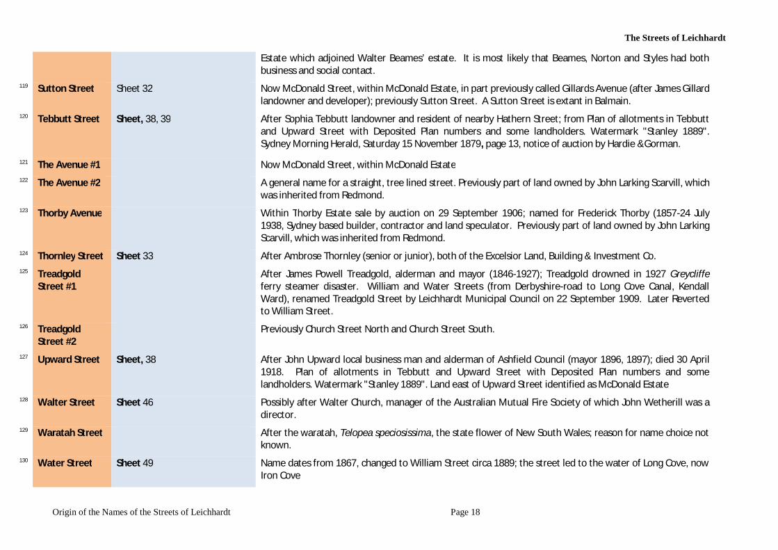
39 Elswick Street #2
Sheet, 34,35,36,37,43,44,49,54, After Elswick Estate, one of the largest estates in Leichhardt (eventually subdivided into hundreds of blocks of land) owned by James Norton from 1834 to 1862. Extended in 1889.
40 Elswick Street north
As for Elswick Street
41 Emily Street Origin not known at this stage. 42 Emma Street Sheet, 21 Origin not known at this stage. 43 Excelsior Street Sheet, 34 Sheet 32 Now McDonald
landowner and developer); previously Sutton Street. A Sutton Street is extant in Balmain.44 Falls Street Possibly after Francis Flynn Falls an alderman with Leichhardt Council in 1895 45 Flat Street Origin not known at this stage. 46 Flood Street Sheet, 36 38, 40, 43, 49, 50 After Edward Flood (Flood’s Estate) of Edward Flood & Company wool brokers and stock agents, landowners
at this location. Previously called Piper Road. 47 Forster Street Previously name for Foster Street 48 Foster Lane See Foster Street
The Streets of Leichhardt
Origin of the Names of the Streets of Leichhardt Page 12
49 Foster Street Sheet, 40, 45, 46 Possibly after James Foster. Previously called Forster Street 50 Fowler Street Sheet, 26 Within Annan View Estate, the north-south part of Fowler Street incorporated into Coleridge Street; east-
west part incorporated into Wetherill Street. Annan View Estate contains Stehr and Rose Cottage both with frontage to Fowler Street.
Enoch Fowler established a pottery near rich clay beds at Blackwattle Swamp in 1837 and rough hand-made bricks were being produced nearby. He moved from Glebe in 1855 to establish a large pottery and brickworks at Camperdown; Fowler’s Pottery & Firebrick Works, Parramatta Road Camperdown.
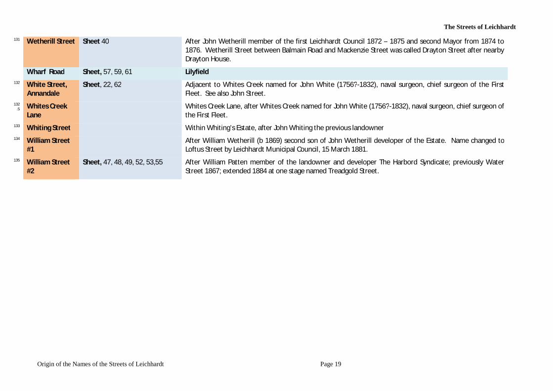
16 September 1842, Sydney Morning Herald, page 4, Enoch Fowler is listed, for rating purposes, as a citizen residing in a house in Parramatta Street (Road) in Philip’s Ward in the City of Sydney, in January 1870 living in Australia Street, Camperdown. Enoch Fowler died on 20 April 1879, aged 72, SMH 21 April 1879.
51 Francis Street Sheet, 49,53, 55 After Francis Patten, member of the landowner and developer The Harbord Syndicate. Now bisected by City West Link
53 Frazer Street Sheet 59 Previously called John Street. Named after John Frazer, an engineer and land speculator. 54 George Street Sheet, 38 Origin not known at this stage. 55 55 Gillards Avenue Now McDonald Street, within McDonald Estate, in part previously called Gillards Avenue (after James Gillard
landowner and developer) and Sutton Street. Glover Street Sheet, 57, 58, Lilyfield Grove Street Sheet 58, 64, Lilyfield Halloran Street Sheet 58, 64 Lilyfield Hathern Street Sheet, 39 In Kegworth Estate, after Hathern a village and civil parish in the Charnwood district of Leicestershire,
England. The village itself is located in the north of the district, and is just north of Loughborough. Nearby places are Dishley, Kegworth, Long Whatton, and Zouch, over the border in Nottinghamshire. Associated with John Beeson and/or his spouse Sophia Hughes.
Ha Hathern Street Sheet, 39 Lilyfield 56 Hawthorne
Street Sheet, 38, 46 After John Stuart Hawthorne MLA who first agitated in parliament in 1890 for the construction of
Hawthorne Canal, later named in his honour. 57 Hay Street After Hay Hill Estate, an estate developed by Mr Abraham Hearn, landowner and publican of The Bald Faced
The Streets of Leichhardt
Origin of the Names of the Streets of Leichhardt Page 13
Stag, the second hotel in Leichhardt. 58 Hearn Street After Mr Abraham Hearn, landowner and publican of The Bald Faced Stag, the second hotel in Leichhardt,
owner of the Hay Hill estate. 59 Henry Street Sheet, 52 After Henry Gorman director of Anglo-Australian Investment & Finance Company Limited which developed
the Helsarmel Estate. Henry Street now bisected by City West Link. 60 Hill Street Sheet, 21, 26, 27, 28 Hill Street previously called Elswick Street. Name from Leichhardt Hill Estate, an estate located where Hill
Street and Allen Street would intersect. 61 Hubert Street Sheet, 53,55 After J Hubert Newman, director of Anglo-Australian Investment & Finance Company Limited which
developed the Helsarmel Estate. Hubert Street now bisected by City West Link. 62 Ivory Lane &
Ivory Street Perhaps a connection with Sir Henry Parkes (1815-1896) who had a business in Hunter Street as an ivory
turner and importer of fancy goods. http://adb.anu.edu.au/biography/parkes-sir-henry-4366 63 James Street #1 Sheet, 52, 53 Now Jarrett Street 64 James Street #2 Sheet, 48 Between Catherine Street and White Creek, near Parramatta Road, renamed Macquarie Street 66 James Street #3 Sheet, 48, 52 After James Martyn Combes, landowner and developer, member of the Harbord Syndicate; Street extended
in 1886; now bisected by City West Link; ALTERNATIVE 67 Jarrett Lane See Jarrett Street 68 Jarrett Street Sheet 33,34 Was James Street #1. After William Jarrett, manager of Excelsior Land, Building & Investment Company,
previously licensee of the Tradesman’s Arms Hotel in Leichhardt, 1860 to 1870; 1873 manager Industrial & Provident Permanent Benefit Building Society.
69 John Street Sheet, 20,21 Adjacent to Whites Creek named for John White (1756?-1832), naval surgeon, chief surgeon of the First Fleet. See also White Street. Renamed Frazer Street
Joseph Street Sheet 65 70 Junior Street Sheet, 34 After Ferdinand Hamilton Reuss Junior (1845-1927), licenced surveyor and architect, acting for the Excelsior
Land, Building & Investment Company. Justin Street Sheet, 64 Lilyfield
71 Kalgoorlie Street
Within Peoples Park Estate. After http://www.westaustralianvista.com/Kalgoorlie-boulder.htmlKalgoorlie, city in the Eastern Goldfields region of Western Australia 596 km north-east of Perth. On 17 June 1893 Paddy Hannan discovered gold at Mt Charlotte which started the biggest goldrush in
The Streets of Leichhardt
Origin of the Names of the Streets of Leichhardt Page 14
Western Australia's history; within days over 700 men were prospecting the area. In 1894, the area known by locals as Hannan's Find, was declared the townsite Kalgoorlie. Reason for the name not known.
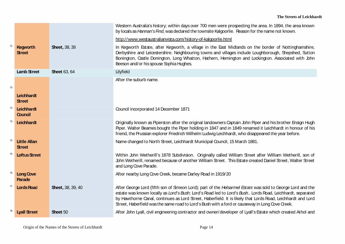
http://www.westaustralianvista.com/history-of-kalgoorlie.html 72 Kegworth
Street Sheet, 38, 39 In Kegworth Estate, after Kegworth, a village in the East Midlands on the border of Nottinghamshire,
Derbyshire and Leicestershire. Neighbouring towns and villages include Loughborough, Shepshed, Sutton Bonington, Castle Donington, Long Whatton, Hathern, Hemington and Lockington. Associated with John Beeson and/or his spouse Sophia Hughes.
Lamb Street Sheet 63, 64 Lilyfield
73
Leichhardt Street
After the suburb name.
73 Leichhardt Council
Council incorporated 14 December 1871
73 Leichhardt Originally known as Piperston after the original landowners Captain John Piper and his brother Ensign Hugh Piper. Walter Beames bought the Piper holding in 1847 and in 1849 renamed it Leichhardt in honour of his friend, the Prussian explorer Friedrich Wilhelm Ludwig Leichhardt, who disappeared the year before.
74 Little Allan Street
Name changed to North Street, Leichhardt Municipal Council, 15 March 1881.
75 Loftus Street Within John Wetherill’s 1878 Subdivision. Originally called William Street after William Wetherill, son of John Wetherill, renamed because of another William Street. This Estate created Daniel Street, Walter Street and Long Cove Parade.
76 Long Cove Parade
After nearby Long Cove Creek, became Darley Road in 1919/20
77 Lords Road Sheet, 38, 39, 40 After George Lord (fifth son of Simeon Lord); part of the Helsarmel Estate was sold to George Lord and the estate was known locally as Lord’s Bush; Lord’s Road led to Lord’s Bush.. Lords Road, Leichhardt, separated by Hawthorne Canal, continues as Lord Street, Haberfield. It is likely that Lords Road, Leichhardt and Lord Street, Haberfield was the same road to Lord’s Bush with a ford or causeway in Long Cove Creek.
78 Lyall Street Sheet 50 After John Lyall, civil engineering contractor and owner/developer of Lyall's Estate which created Athol and
The Streets of Leichhardt
Origin of the Names of the Streets of Leichhardt Page 15
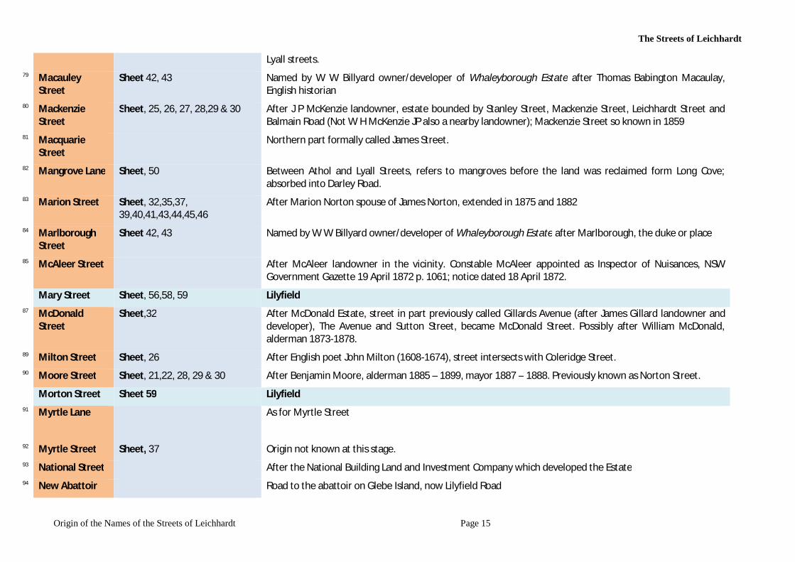
Lyall streets. 79 Macauley
Street Sheet 42, 43 Named by W W Billyard owner/developer of Whaleyborough Estate after Thomas Babington Macaulay,
English historian 80 Mackenzie
Street Sheet, 25, 26, 27, 28,29 & 30 After J P McKenzie landowner, estate bounded by Stanley Street, Mackenzie Street, Leichhardt Street and
Balmain Road (Not W H McKenzie JP also a nearby landowner); Mackenzie Street so known in 1859 81 Macquarie
Street Northern part formally called James Street.
82 Mangrove Lane Sheet, 50 Between Athol and Lyall Streets, refers to mangroves before the land was reclaimed form Long Cove; absorbed into Darley Road.
83 Marion Street Sheet, 32,35,37, 39,40,41,43,44,45,46
After Marion Norton spouse of James Norton, extended in 1875 and 1882
84 Marlborough Street
Sheet 42, 43 Named by W W Billyard owner/developer of Whaleyborough Estate after Marlborough, the duke or place
85 McAleer Street After McAleer landowner in the vicinity. Constable McAleer appointed as Inspector of Nuisances, NSW Government Gazette 19 April 1872 p. 1061; notice dated 18 April 1872.
Mary Street Sheet, 56,58, 59 Lilyfield 87 McDonald
Street Sheet,32 After McDonald Estate, street in part previously called Gillards Avenue (after James Gillard landowner and
developer), The Avenue and Sutton Street, became McDonald Street. Possibly after William McDonald, alderman 1873-1878.
89 Milton Street Sheet, 26 After English poet John Milton (1608-1674), street intersects with Coleridge Street. 90 Moore Street Sheet, 21,22, 28, 29 & 30 After Benjamin Moore, alderman 1885 – 1899, mayor 1887 – 1888. Previously known as Norton Street.
Morton Street Sheet 59 Lilyfield 91 Myrtle Lane As for Myrtle Street
92 Myrtle Street Sheet, 37 Origin not known at this stage. 93 National Street After the National Building Land and Investment Company which developed the Estate 94 New Abattoir Road to the abattoir on Glebe Island, now Lilyfield Road
The Streets of Leichhardt
Origin of the Names of the Streets of Leichhardt Page 16
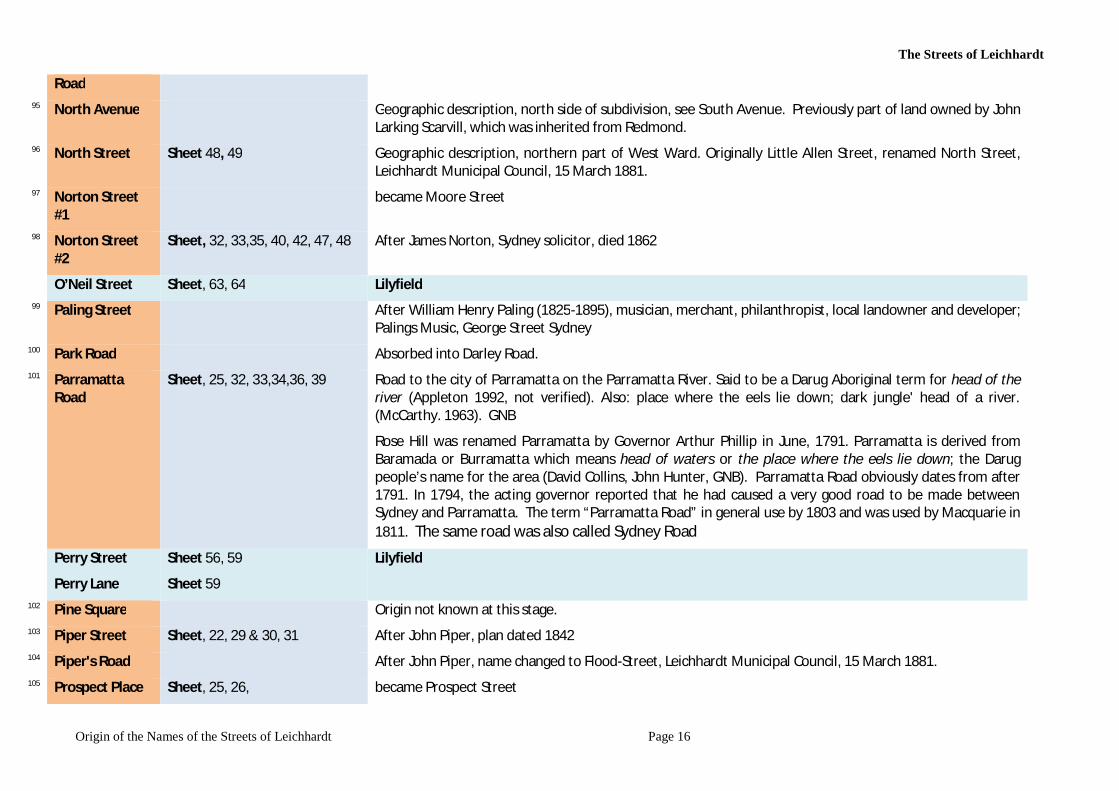
Road 95 North Avenue Geographic description, north side of subdivision, see South Avenue. Previously part of land owned by John
Larking Scarvill, which was inherited from Redmond. 96 North Street Sheet 48, 49 Geographic description, northern part of West Ward. Originally Little Allen Street, renamed North Street,
Leichhardt Municipal Council, 15 March 1881. 97 Norton Street
#1 became Moore Street
98 Norton Street #2
Sheet, 32, 33,35, 40, 42, 47, 48 After James Norton, Sydney solicitor, died 1862
O’Neil Street Sheet, 63, 64 Lilyfield 99 Paling Street After William Henry Paling (1825-1895), musician, merchant, philanthropist, local landowner and developer;
Palings Music, George Street Sydney 100 Park Road Absorbed into Darley Road. 101 Parramatta
Road Sheet, 25, 32, 33,34,36, 39 Road to the city of Parramatta on the Parramatta River. Said to be a Darug Aboriginal term for head of the
river (Appleton 1992, not verified). Also: place where the eels lie down; dark jungle' head of a river. (McCarthy. 1963). GNB
Rose Hill was renamed Parramatta by Governor Arthur Phillip in June, 1791. Parramatta is derived from Baramada or Burramatta which means head of waters or the place where the eels lie down; the Darug people’s name for the area (David Collins, John Hunter, GNB). Parramatta Road obviously dates from after 1791. In 1794, the acting governor reported that he had caused a very good road to be made between Sydney and Parramatta. The term “Parramatta Road” in general use by 1803 and was used by Macquarie in 1811. The same road was also called Sydney Road
Perry Street
Perry Lane
Sheet 56, 59
Sheet 59
Lilyfield
102 Pine Square Origin not known at this stage. 103 Piper Street Sheet, 22, 29 & 30, 31 After John Piper, plan dated 1842 104 Piper's Road After John Piper, name changed to Flood-Street, Leichhardt Municipal Council, 15 March 1881. 105 Prospect Place Sheet, 25, 26, became Prospect Street
The Streets of Leichhardt
Origin of the Names of the Streets of Leichhardt Page 17
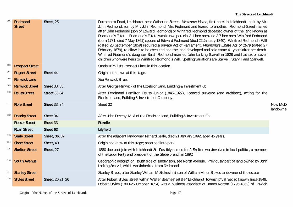
106 Redmond Street
Sheet, 25 Parramatta Road, Leichhardt near Catherine Street. Welcome Home, first hotel in Leichhardt, built by Mr. John Redmond, run by Mr. John Redmond, Mrs Redmond and leased to another. Redmond Street named after John Redmond (son of Edward Redmond) or Winifred Redmond deceased owner of the land known as Redmond's Estate. Redmond's Estate was in two parcels, 3.1 hectares and 3.7 hectares. Winifred Redmond (born 1781, died 7 May 1861) spouse of Edward Redmond (died 22 January 1840). Winifred Redmond’s Will (dated 20 September 1859) required a private Act of Parliament, Redmond's Estate Act of 1879 (dated 27 February 1879), to allow it to be executed and the land developed and sold some 41 years after her death. Winifred Redmond’s daughter Sarah Redmond married John Larking Scarvill in 1828 and had six or seven children who were heirs to Winifred Redmond’s Will. Spelling variations are Scarvell, Scarvill and Scarwell.
106 Prospect Street Sands 1875 lists Prospect Place in this location 107 Regent Street Sheet 44 Origin not known at this stage. 108 Renwick Lane See Renwick Street 109 Renwick Street Sheet 33, 35 After George Renwick of the Excelsior Land, Building & Investment Co. 110 Reuss Street Street 33,34 After Ferdinand Hamilton Reuss Junior (1845-1927), licenced surveyor (and architect), acting for the
Excelsior Land, Building & Investment Company. 111 Rofe Street Sheet 33, 34 Sheet 32 Now McDonald Street, w
landowner and developer); previously Sutton Street. A Sutton Street is extant in Balmain.112 Roseby Street Sheet 34 After John Roseby, MLA of the Excelsior Land, Building & Investment Co.
Rosser Street Sheet 33 Rozelle Ryan Street Sheet 63 Lilyfield
113 Seale Street Sheet, 36, 37 After the adjacent landowner Richard Seale, died 21 January 1892, aged 45 years. 114 Short Street Sheet, 40 Origin not know at this stage; absorbed into park. 115 Skelton Street Sheet, 27 1880 does not join with Leichhardt St. Possibly named for J. Skelton was involved in local politics, a member
of the Labor Party and president of the Glebe branch in 1892 116 South Avenue Geographic description, south side of subdivision, see North Avenue. Previously part of land owned by John
Larking Scarvill, which was inherited from Redmond. 117 Stanley Street Stanley Street, after Stanley William M Stokes first son of William Miller Stokes landowner of the estate 118 Styles Street Sheet, 20,21, 26 After Robert Styles; street within Walter Beames’ estate “Leichhardt Township”, street so known since 1849.
Robert Styles (1800-25 October 1854) was a business associate of James Norton (1795-1862) of Elswick
The Streets of Leichhardt
Origin of the Names of the Streets of Leichhardt Page 18
Estate which adjoined Walter Beames’ estate. It is most likely that Beames, Norton and Styles had both business and social contact.
119 Sutton Street Sheet 32 Now McDonald Street, within McDonald Estate, in part previously called Gillards Avenue (after James Gillard landowner and developer); previously Sutton Street. A Sutton Street is extant in Balmain.
120 Tebbutt Street Sheet, 38, 39 After Sophia Tebbutt landowner and resident of nearby Hathern Street; from Plan of allotments in Tebbutt and Upward Street with Deposited Plan numbers and some landholders. Watermark "Stanley 1889". Sydney Morning Herald, Saturday 15 November 1879, page 13, notice of auction by Hardie &Gorman.
121 The Avenue #1 Now McDonald Street, within McDonald Estate 122 The Avenue #2 A general name for a straight, tree lined street. Previously part of land owned by John Larking Scarvill, which
was inherited from Redmond. 123 Thorby Avenue Within Thorby Estate sale by auction on 29 September 1906; named for Frederick Thorby (1857-24 July
1938, Sydney based builder, contractor and land speculator. Previously part of land owned by John Larking Scarvill, which was inherited from Redmond.
124 Thornley Street Sheet 33 After Ambrose Thornley (senior or junior), both of the Excelsior Land, Building & Investment Co. 125 Treadgold
Street #1 After James Powell Treadgold, alderman and mayor (1846-1927); Treadgold drowned in 1927 Greycliffe
ferry steamer disaster. William and Water Streets (from Derbyshire-road to Long Cove Canal, Kendall Ward), renamed Treadgold Street by Leichhardt Municipal Council on 22 September 1909. Later Reverted to William Street.
126 Treadgold Street #2
Previously Church Street North and Church Street South.
127 Upward Street Sheet, 38 After John Upward local business man and alderman of Ashfield Council (mayor 1896, 1897); died 30 April 1918. Plan of allotments in Tebbutt and Upward Street with Deposited Plan numbers and some landholders. Watermark "Stanley 1889". Land east of Upward Street identified as McDonald Estate
128 Walter Street Sheet 46 Possibly after Walter Church, manager of the Australian Mutual Fire Society of which John Wetherill was a director.
129 Waratah Street After the waratah, Telopea speciosissima, the state flower of New South Wales; reason for name choice not known.
130 Water Street Sheet 49 Name dates from 1867, changed to William Street circa 1889; the street led to the water of Long Cove, now Iron Cove
The Streets of Leichhardt
Origin of the Names of the Streets of Leichhardt Page 19
131 Wetherill Street Sheet 40 After John Wetherill member of the first Leichhardt Council 1872 – 1875 and second Mayor from 1874 to 1876. Wetherill Street between Balmain Road and Mackenzie Street was called Drayton Street after nearby Drayton House.
Wharf Road Sheet, 57, 59, 61 Lilyfield 132 White Street,
Annandale Sheet, 22, 62 Adjacent to Whites Creek named for John White (1756?-1832), naval surgeon, chief surgeon of the First
Fleet. See also John Street. 132
.5 Whites Creek Lane
Whites Creek Lane, after Whites Creek named for John White (1756?-1832), naval surgeon, chief surgeon of the First Fleet.
133 Whiting Street Within Whiting’s Estate, after John Whiting the previous landowner 134 William Street
#1 After William Wetherill (b 1869) second son of John Wetherill developer of the Estate. Name changed to
Loftus Street by Leichhardt Municipal Council, 15 March 1881. 135 William Street
#2 Sheet, 47, 48, 49, 52, 53,55 After William Patten member of the landowner and developer The Harbord Syndicate; previously Water
Street 1867; extended 1884 at one stage named Treadgold Street.
The Streets of Leichhardt
Origin of the Names of the Streets of Leichhardt Page 20
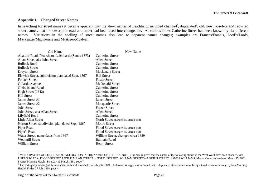
Appendix 1. Changed Street Names.
In searching for street names it became apparent that the street names of Leichhardt included changed7, duplicated8, old, new, obsolete and recycled street names, that the descriptor road and street had been used interchangeable. At various times Catherine Street has been known by six different names. Variations in the spelling of street names also lead to apparent names changes; examples are Frances/Francis, Lord’s/Lords, Mackenzie/MacKenzie and McAleer/Mcaleer.
Old Name New Name
Abattoir Road, Petersham, Leichhardt (Sands 1873) Catherine Street Allan Street, aka John Street Allen Street Bullock Road Catherine Street Bullock Street Catherine Street Drayton Street Mackenzie Street Elswick Street, subdivision plan dated Sept. 1867 Hill Street Forster Street Foster Street Gillards Avenue McDonald Street Glebe Island Road Catherine Street High Street (1842) Catherine Street Hill Street Catherine Street James Street #1 Jarrett Street James Street #2 Macquarie Street John Street Frazer Street John Street, aka Allan Street Allen Street Lilyfield Road Catherine Street Little Allan Street North Street changed 15 March 1881 Norton Street, subdivision plan dated Sept. 1867 Moore Street Piper Road Flood Street changed 15 March 1881 Piper's Road Flood Street changed 15 March 1881 Water Street, name dates from 1867 William Street, changed circa 1889 Wetherill Street Balmain Road William Street Hearn Street
7 MUNICIPATITY OF LEICHHARDT, ALTERATION IN THE NAMES OF STREETS. NOTICE is hereby given that the names of the following streets in the West Ward have been changed, viz: PIPER'S ROAD to FLOOD STREET; LITTLE ALLAN STREET to NORTH STREET; WILLIAM STREET to LOFTUS STREET. JAMES WILLIAMS, Mayor. Council-chambers. March 15, 1881. Sydney Morning Herald, Saturday 19 March 1881, page 7 8 The fortnightly meeting of this council (Leichhardt) was held on July 23 (1888)…Alderman Wragge was informed that… duplicated street names were being altered where necessary. Sydney Morning Herald, Friday 27 July 1888, page 4.
The Streets of Leichhardt
Origin of the Names of the Streets of Leichhardt Page 21
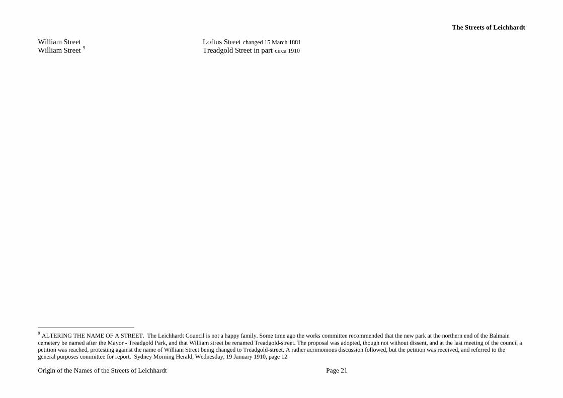
William Street Loftus Street changed 15 March 1881 William Street 9 Treadgold Street in part circa 1910
9 ALTERING THE NAME OF A STREET. The Leichhardt Council is not a happy family. Some time ago the works committee recommended that the new park at the northern end of the Balmain cemetery be named after the Mayor - Treadgold Park, and that William street be renamed Treadgold-street. The proposal was adopted, though not without dissent, and at the last meeting of the council a petition was reached, protesting against the name of William Street being changed to Treadgold-street. A rather acrimonious discussion followed, but the petition was received, and referred to the general purposes committee for report. Sydney Morning Herald, Wednesday, 19 January 1910, page 12
The Streets of Leichhardt
Origin of the Names of the Streets of Leichhardt Page 22
Appendix 2. Width of Streets and Lanes Act, 1881.
On 20 December 1881 the Width of Streets and Lanes Act of 1881 came into effect. The Act specified the minimum width of lanes to be 6.1 metres and of streets to be 20.1 metres. In Imperial measurement streets were one chain wide. This 1881Act was replaced with the Width of Streets and Lanes Act, 1902 , Act No. 39, of 20 August, 1902. The 1902 Act was similar but included the provision of a twenty three feet (7.01 metres) setback between a house and a lane.
All lanes and streets narrower than 6.1 metres and 20.1 metres respectively date from before 20 December 1881. Lanes and streets equal to or wider than the dimension specified in the Act may date from before or after 20 December 1881.
Width of Streets and Lanes Act
An Act to regulate the Width of Streets and Lanes and for certain other purposes. 20 December 1881.
BE it enacted by the Queen's Most Excellent Majesty by and with the advice and consent of the Legislative Council and Legislative Assembly of New South Wales in Parliament assembled and by the authority of the same as follows :—
1. Every street laid out or defined after the passing of this Act shall be sixty-six feet wide at least and every lane laid out or defined after the passing of this Act shall be twenty feet wide at least.
2. Any land sold transferred leased or built upon in violation of the provisions of the foregoing section shall when necessary to make the width of any such street or lane equal to the requirements of this Act be deemed to that extent to form part of every such street or lane Provided that when it is necessary to define the width of any street or lane under this Act the necessary width may be determined by measuring from the centre of such street or lane.
3. Except in the case of allotments having water frontage it shall not be lawful to build any dwelling-house fronting any lane within the operation of this Act unless such house and its appurtenances be twenty-three feet at the least from such lane And any premises built as a dwelling-house or occupied or inhabited as such although such premises or any part thereof are occupied or used for other purposes at the same time shall if built in contravention of this section be deemed to be an encroachment and if within the City of Sydney may be dealt with by the proper authority as an encroachment under the provisions of the "Sydney Corporation Act of 1879" and if within any Municipality shall be deemed to be a nuisance within the meaning of the one hundred and thirty-second section of the " Municipalities Act of 1867."
4. Nothing herein contained shall be deemed to affect any street or lane or any frontage to any street or lane or any continuation of any street or lane defined or built upon or any building commenced or building agreement entered into before the passing of this Act or any Law or regulation not repugnant to the provisions of this Act provided that no such continuation as hereinbefore mentioned shall extend beyond the next intersecting street.
5. This Act shall be styled and may be cited as the "Width of Streets and Lanes Act of 1881."
The Streets of Leichhardt
Origin of the Names of the Streets of Leichhardt Page 23
The Streets of Leichhardt
Origin of the Names of the Streets of Leichhardt Page 24
Appendix 3. What is a Road.
What is a road, or street or lane? To control and manage such infrastructure a name is required. The Roads & Streets Act, 1833, an Act for making altering and improving the Roads throughout the Colony of New South Wales and for opening and improving the Streets in the Towns thereof, did not deal with the naming of streets, define the width of streets, or specifically mention lanes. Section 117 of the Municipalities Act, 1867 recognised but did not define main roads, public roads, public streets, and lanes. The width of Streets and Lanes was haphazard and unregulated until the Width of Streets and Lanes Act of 20 December 1881. The follow-up Width of Streets and Lanes Act of 1902 filled the loopholes of the first Act. It was not until the Local Government Act 1919 (Section 249) that Municipal Councils were able to name or alter the name of any public road. By 1881 many of the streets of Leichhardt had been formed if not made, and by 1919 almost all of the streets of Leichhardt had been named; some by then even had been re-named!
Current Road Naming Procedure.
The current road naming procedure is legislated under the Roads Act 1993. This Act empowers the authority in charge of the road with the rights to name it. In the case of a state highway, for example, the relevant authority would be the Roads and Maritime Services (previously Roads and Traffic Authority, RTA). Local roads or streets would fall under the jurisdiction of the local council that administers the area. To name an un-named road or rename a previously named road they must follow the process outlined in the Roads (General) Regulation 2000, see LPMA 2009b. The Geographical Names Board (GNB) is required to be notified of all road naming proposals in New South Wales in order to maintain standard and consistent names and naming procedures.
The Table below gives relevant definitions and details. Avenue A broad roadway, usually planted on each side with trees; an open ended street. (LPMA 2009b) Cul-de-Sac A street or road with only one entrance and exit. It is essential that a ‘No Through Road’ sign
be erected. (LPMA 2009b) Lane A narrow way between walls, buildings etc. a narrow country or city roadway. Either a cul-de-
sac or an open ended street. (LPMA 2009b) Laneway A narrow street or alley running between or behind urban buildings especially houses or stores.
(LPMA 2009b) Leichhardt Within Leichhardt four road types are used; avenue, lane, road and street. Open ended street A street or road with entrance/exit at both ends. Road 1 An open way, usually surfaced with tarmac or concrete, providing passage from one place to
another. (LPMA 2009a) Road 2 A place where one may ride, an open way or public passage for vehicles, persons and animals, a
roadway forming a means of communication between one place and another; an open ended street. (LPMA 2009b)
Road 3 Includes: (a) the airspace above the surface of the road, and (b) the soil beneath the surface of the road, and (c) any bridge, tunnel, causeway, road-ferry, ford or other work or structure
The Streets of Leichhardt
Origin of the Names of the Streets of Leichhardt Page 25
forming part of the road. (Dictionary, Roads Act, 1993) Road 4 Includes: (a) highway, street, lane, pathway, footpath, cycleway, thoroughfare, bridge, culvert,
causeway, road-ferry, ford, crossing, by-pass and trackway, whether temporary or permanent, and (b) any part of a road and any part of any thing referred to in paragraph (a), and c) anything forming part of a road or any thing forming part of any thing referred to in paragraph (a). (Dictionary, Local Government Act 1993)
Road, Crown road Means a public road that is declared to be a Crown road for the purposes of this Act. (Dictionary, Roads Act, 1993)
Road, Public Road Means a road which the public are entitled to use. (Dictionary, Local Government Act 1993) Roads, naming For the naming of roads Section 162 of the Roads Act 1993, provides the authority and the
Roads (General) Regulation 2000, under the Act, 1993, Part 2, Division 2 sets out the procedure Street A public roadway in a town, city or urban area, especially a paved thoroughfare with footpaths
and buildings along one or both sides; an open ended street. (LPMA 2009b)