Embed Size (px)
Citation preview
Originator: Andrew Crates Tel: 0113 222 4409
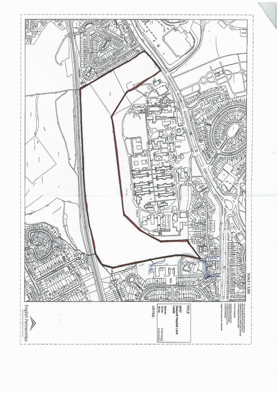
Report of the Chief Planning Officer PLANS PANEL EAST Date: 12th July 2012 Subject: Pre-application presentation for the laying out of access and erection of circa 600 houses on land to the rear of Seacroft Hospital, York Road, Leeds 600 houses on land to the rear of Seacroft Hospital, York Road, Leeds
Specific Implications For: Equality and Diversity Community Cohesion Narrowing the Gap
Electoral Wards Affected: Killingbeck and Seacroft
Ward Members consulted (referred to in report) Yes
RECOMMENDATION: RECOMMENDATION: For Members to note the content of the report and presentation and tocomments on the proposals. For Members to note the content of the report and presentation and tocomments on the proposals. 1.0 INTRODUCTION: 1.1 Under Policy H3-2A.4 of the Leeds Unitary Development Plan (UD
17.42 hectares of land is allocated for housing purposes at theHospital. The application is on a Phase 2 allocated greenfield siteurban area. The site is also affected by other policy constraints, incland southernmost part of the site being designated as Urban GreePolicy N8. York Road (A64), to the north of the site is recognised asstrategic highway network under Policy T18. Policy T7 also plots thecycle routes through the Wyke Beck Valley, located to the west and s
1.2 The applicant, the Homes and Communities Agency (HCA), is pre application in order to facilitate the marketing of the site as part of initiative to dispose of and develop surplus public land. 2.0 PROPOSAL: 2.1 The proposal entails the provision of two accesses - a primary a
Road, at the north west corner of the site and a secondary access th
provide any provide any
P) Review 2006, rear of Seacroft , within the main uding the western n Corridor under being part of the potential for new outh of the site.
paring a planning the Government's
ccess from York rough the hospital
site, also from York Road. This proposal is to develop the site for up to 600 houses and provide open space.
2.2 It is anticipated that an outline planning application will be submitted, with all matters
reserved, except for access, but will be accompanied by an illustrative masterplan and plans that show how the site could be developed in conjunction with surplus land at Seacroft Hospital, which is owned by Leeds Teaching Hospitals Trust (LTHT).
3.0 SITE AND SURROUNDINGS: 3.1 The site is essentially a wide ‘U’ shaped piece of land, to the rear (south) of the
existing Seacroft Hospital complex. The site is undulating, but broadly falls to the south on a gradual slope, with the lowest point being in the south-west corner. The hospital complex sits in a relatively prominent position above the site. The site is currently mainly mown grass, although there are a number of mature trees, with particular groups in the north-west corner and around the site boundaries. Other single and small groups of trees exist in a scattered fashion in the central southern area of the site. It is evident that there are a number of well used paths across the site, particularly around the boundaries of the site and crossing two railway footbridges.
3.2 The site has a frontage to York Road (A64), to the north-west corner of the site. To
the north of York Road is a retail / office park, residential development (including that on the former Killingbeck Hospital site) and a cemetery. The area immediately north of the site is occupied by the hospital complex and contains a relatively dense development of buildings of various ages, all predominantly two to three storeys in height. The area to the north-east and east of the site is predominantly residential in character, although Cross Gates Primary School and Cross Gates Community Centre are immediately adjacent to the site boundary. The residential properties comprise terraces and semi-detached dwellings of a variety of ages. Some properties in Poole Mount and Poole Square have rear garden areas backing onto the site. Two pedestrian access points exist, providing links to Maryfield Avenue and Poole Square. The southern boundary of the site is formed by the Leeds to York railway line, which is in a shallow cut at this point. There is pedestrian access available over the two railway footbridges in the south-eastern and south-western corners of the site, providing links to the Primrose Valley Park / Halton Deans green space which extends to the north of Halton. The area to the west of the site is predominantly residential in character, mainly comprising two-storey terraced properties. The houses on Watson Road and Rye Place have rear garden areas backing onto the site and a further two pedestrian accesses provide links to these streets.
4.0 RELEVANT PLANNING HISTORY: 4.1 Application 34/385/98/OT – Outline application to erect a residential development.
The application was withdrawn as it was considered to be premature at the time. 5.0 HISTORY OF NEGOTIATIONS: 5.1 The applicant has been engaged in pre-application discussions with the applicant
since mid 2011. 6.0 PLANNING POLICIES: 6.1 The development plan includes the Regional Spatial Strategy to 2026 (RSS) and the
adopted Leeds Unitary Development Plan (Review 2006) (UDP) along with relevant
supplementary planning guidance and documents. The Local Development Framework will eventually replace the UDP but at the moment this is still undergoing production with the Core Strategy still being at the draft stage. The RSS was issued in May 2008 and includes a broad development strategy for the region, setting out regional priorities in terms of location and scale of development including housing. The site is allocated for housing purposes under policy H3-2A.04 of the UDP, which states that:
‘…17.42 ha of land is allocated for housing at the rear of Seacroft Hospital
subject to: i. Provision of acceptable off-site highway works following the construction of
the M1 motorway; ii. Laying out as part of the development of a linear park as part of an urban
green corridor running north/south through the site to link Halton Deans to Wyke Beck Valley Park.’
6.2 Regional Spatial Strategy (RSS) (adopted May 2008):
H1: annual average additions to housing stock and previously developed target. H2: Sequential approach to allocation of land. H3: managed release of housing land. H4: affordable housing. YH1: Spatial pattern of development and core approach. YH2: Sustainable development. YH4: focus development on regional cities. YH5: Focus development on principal towns. YH7: location of development. LCR1: Leeds city region sub area policy. LCR2: regionally significant investment priorities, Leeds city region.
6.3 Leeds Unitary Development Plan (UDP) Review:
GP5: General planning considerations. GP7: Use of planning obligations. GP11: Sustainable development. N2/N4: Greenspace provision/contributions. N10: Protection of existing public rights of way. N8: Urban Green Corridor N12/N13: Urban design principles. N23/N25: Landscape design and boundary treatment. N24: Development proposals abutting the Green Belt. N29: Archaeology. N38 (a and b): Prevention of flooding and Flood Risk Assessments. N39a: Sustainable drainage. BD5: Design considerations for new build. T2 (b, c, d): Accessibility issues. T5: Consideration of pedestrian and cyclists needs. T7/T7A: Cycle routes and parking. T18: Strategic highway network. T24: Parking guidelines. H1: Provision for completion of the annual average housing requirement identified in the RSS. H2: Monitoring of annual completions for dwellings. H3: Delivery of housing on allocated sites. H3-2A.04: Allocates the application site for housing.
H11/H12/H13: Affordable housing. LD1: Landscape schemes.
6.4 Supplementary Planning Guidance / Documents: Neighbourhoods for Living – A Guide for Residential Design in Leeds Street Design Guide 6.5 National Planning Guidance:
National Planning Policy Framework 7.0 MAIN ISSUES
1. Principle of development 2. Comprehensive approach to development 3. Policy Issues 4. Urban Design issues 5. Landscape issues 6. Housing issues 7. Highway issues 8. Drainage issues 9. Other matters
Principle of development
7.1 The site is identified in the UDP Review (2006) as a Phase 2 site suitable for residential development. The first issue is whether it is appropriate for this greenfield site to be released. The implications that flow from the Grimes Dyke appeal decision, which was reported to Plans Panel on 14th July 2011, have been the subject of reports to Executive Board on 22nd June and the Joint Plans Panel of 30th June 2011. In the light of the Inspectors and the Secretary of State’s findings, Executive Board agreed in principle to release all phase 2 and 3 housing sites for development and as this site is allocated for housing in Phase 2, no objections in principle are raised.
Comprehensive approach to development
7.2 In considering the proposals for the site, it is also necessary to consider the wider context of the hospital. Separate from the HCA’s land, the operational hospital site to the north, is also undergoing change. The western half of the hospital site, owned by LTHT, is in use and there is potential for some further healthcare development by service providers. However, much of the eastern half of the hospital site (land owned by LTHT) is vacant. Whilst there has been no confirmation that the vacant land is to be disposed of, it is highly likely that this site may be developed in the future. Given the current uncertainty, continued healthcare uses, together with potential further healthcare development on the western site, have been factored in for the purposes of assessing highway impact (as these uses have a greater highway impact than a residential use, for example, thereby demonstrating a ‘worse case scenario’). The proposed secondary access from York Road will pass north to south through the hospital site, therefore providing access to the HCA’s land, as well as opening up access any redundant LTHT land. It is also noted that the Health Protection Agency (HPA) owns a small vacant parcel of land to the north of the hospital site. The Blood and Transplant Service also owns a parcel of land at the eastern end of the hospital site and is to continue in active use.
Planning Policy issues
7.3 The proposal accords with the housing allocation set out under saved UDP Policy H3-2A.4 in that it would provide approximately 600 new houses.
7.4 The western and southern portions of the site are also washed over by Urban Green Corridor, under Policy N8 of the UDP, which states that:
‘The strategic network of urban green corridors links the main urban area with
the countryside. These corridors provide or have the potential to provide for informal recreation and also contribute to visual amenity and nature conservation. Within these corridors, development proposals should ensure that:
i. Any existing corridor function of the land is retained, enhanced or replaced; and ii. Where there is potential to create a link between existing greenspaces, provision is made for one or more corridor function.’
7.5 In considering the implications of Policy N8, it will be important to consider how any
proposals for development address the existing landscape, trees, ecology and biodiversity, as well as the existing pedestrian desire lines across the site and how these tie into the wider network of paths and greenspaces in the locality. In particular, the Wyke Beck Way provides links from the north-east to the south of the city, within which this site has the ability to provide a potentially crucial link.
Urban Design issues
7.6 Whilst the application is likely to be in outline only, except for means of access, it is important to consider how the indicative masterplan for the site works, taking into account good design practice, the topography of the site, views into and out of the site, retention of trees, provision of greenspaces, provision of and enhancement of routes across the site and the urban green corridor functions. The masterplan has been evolving over time as a result of community consultation and feedback from officers. Essentially, the scheme provides for a series of connected loops of streets with development arranged in a series of perimeter blocks (blocks formed by houses fronting streets with secure interlocking rear garden areas).
7.7 Design workshops have been held with officers and the scheme has been discussed
at Design Review. Officer advice has been that the scheme must provide at least two main accesses, provide for a connected layout, linking into to the existing urban fabric and open spaces – utilising existing established links. It has also been suggested that the indicative layout should better reflect the topography of the site and make optimum use of existing views to tree groups, as well as to the hospital clock tower, which is a Grade II Listed Building. It is also considered that the scheme needs to provide generous amounts of space to provide for the ‘green links’ and footway/cycleway connections across the site in order to address the Urban Green Corridor functions. With regard to the new vehicular accesses, these need to create interesting spaces in their own right, as well as fulfilling their function. The primary access should therefore have regard to the mature trees and its soft landscape setting. The secondary access through the hospital site will open up views of existing buildings in relatively close proximity and it is felt that sufficient distance, as well as tree planting and soft landscaping is required to mitigate the appearance of large unrelieved buildings.
7.8 What are Members thoughts on the approach to the indicative masterplan for
the site?
Landscape issues 7.9 As already mentioned, there are key groups of trees on site, particularly in the north-
west corner, around the boundaries and in small clusters around the central southern part of the site. Unfortunately, given the limited scope for access, some trees will need to be lost from the north-west corner of the site in order to facilitate the principal access. However, the proposed masterplan indicates that a significant amount of the trees in this area would remain. With regard to the secondary access through the hospital site, it is apparent that this is likely to affect some trees around the junction of York Road and Bridle Path and the implications of this need to be explored further. Elsewhere on site, it is highly desirable that as many trees as possible are retained, not least because they provide immediate landscape structure to some of the proposed greenspaces.
7.10 In terms of public spaces, the current masterplan seeks to provide areas of
greenspace around the north-west corner of the site (in the area with the greatest tree cover), a series of smaller overlooked parkland areas between blocks of housing and a linear park along the southern boundary to the railway. Given that the lowest part of the site is along the southern boundary, this is also where a number of swales are proposed to assist in dealing with surface water drainage. The swales have the potential to offer habitat areas and could benefit the biodiversity of the area. Given the quantum of development, there will also be a requirement for playing pitch provision. Given that pitches exist in close proximity, to the south of the site, in Primrose Valley Park / Halton Deans, there is a potential opportunity to consider enhancement of these pitches and the links over the railway to them, rather than seek on-site provision.
7.11 A key question is to what extent the indicative masterplan addresses the Urban Green
Corridor policy – to what degree are the nature and extent of greenspaces able to provide for the corridor functions with regard to informal recreation, visual amenity, nature conservation and providing links. Additionally, it is also important to consider how these spaces and links tie into the wider area – the Wyke Beck Valley to the north of York Road and Primrose Valley Park / Halton Deans and beyond, to the south, noting the established desire lines across the site and existing footbridge links over the railway Iine.
7.12 What are Members thoughts on the nature and location of greenspaces on site
and how these link into the wider strategic green links across this part of the city?
7.13 What are Members views on the approach to open space and the potential for
playing pitch needs to be provided for through links to and enhancement of pitches to the south of the site?
Housing issues 7.14 The site is significant in terms of its size and context within east Leeds and has the
potential to offer a range of housing, including Affordable Housing. The applicant has been asked to undertake a Housing Needs Assessment and to plan for a scheme to reflect its findings. It is noted that there is a particular desire to provide accommodation for older people, specifically bungalows, on the site and this is something that the applicant has been asked to consider. With regard to Affordable Housing, the Council’s policy is to secure 15% Affordable Housing in this part of the city. It is noted that there may be opportunities to consider how this scheme helps to deliver Affordable Housing and other regeneration benefits in the surrounding east Leeds area and this is something which needs to be explored further.
7.15 What are Members views on the nature and type of housing provision on site?
Highway issues 7.16 The proposed development will take a principal access from York Road, at the north-
west corner of the site. Given the geometry of York Road and the otherwise land locked nature of the site, there is limited scope for any alternative principal access. A secondary access is also proposed through the existing hospital site, essentially splitting it in two. As discussed in paragraph 7.7, it is considered that both of the new accesses must be designed with quality of place in mind, as well as the functional requirements. Other non-vehicular accesses also exist around the boundary of the site, providing links to Watson Road and Rye Place to the west and Maryfield Avenue and Poole Square to the east. Additionally, there is a potential link through to Cross Gates Primary School and it is noted that a gate has existed here historically. There is also pedestrian access available over the two railway footbridges in the south-eastern and south-western corners of the site.
7.17 The highway impact of the proposal and what it means in terms of traffic generation
on the local highway network, particularly York Road, is under consideration by the applicant and highway officers. Whilst the HCA's application relates solely to the housing allocation in the UDP, it is also important to note the wider context of the development, as described in paragraph 7.2. As noted, the scheme will need to take account of the comprehensive development of the hospital site, including potential development. For the purposes of the Transport Assessment, healthcare reuses have been assumed for the vacant areas of the site in order to robustly test the highway impact of the proposals.
Drainage issues 7.18 Through the public consultation exercise carried out by the applicant, it is apparent
that there are concerns from local residents in the Dunhills (located to the south-west of Primrose Valley Park and accessed from Selby Road) about drainage. Residents in this part of the city have experienced flooding problems in the past, associated with Wyke Beck. It is understood that the applicant is currently making endeavours to meet with the Dunhills residents group to discuss their concerns. The applicant will need to submit a Flood Risk Assessment and drainage strategy for the site to ensure that the proposed development does not exceed the existing greenfield rates of run off and does not exacerbate drainage problems in the surrounding area.
Other Matters 7.19 In addition to the issues discussed above, officers have also commenced dialogue
with Education and Health colleagues. Given the quantum of development, this is likely to generate a significant demand for school places and a financial contribution is anticipated in order to help address this. Discussions with health colleagues are ongoing in order to ascertain what primary healthcare requirements may be needed as a result of the scheme, as well as looking in detail at the residential environment likely to be created from a public health point of view – considering greenspaces, links, speed limits and street/place creation etc. It is also noted that the development is likely to create a significant amount of jobs in the construction phase and it would be expected that training and employment initiatives are included as an obligation in the S106 agreement, focussed on the east Leeds area.
7.20 Are there any other issues Members would like to raise?
8.0 CONCLUSION 8.1 Members are asked to note the contents of the report and the presentation, and are
invited to provide feedback on the issues outlined below:
• What are Members thoughts on the approach to the indicative masterplan for the site?
• What are Members thoughts on the nature and location of greenspaces on site and how these link into the wider strategic green links across this part of the city?
• What are Members views on the approach to open space and the potential for playing pitch needs to be provided for through links to and enhancement of pitches to the south of the site?
• What are Members views on the nature and type of housing provision on site?
• Are there any other issues Members would like to raise?