Embed Size (px)
Citation preview
University of Nebraska - LincolnDigitalCommons@University of Nebraska - Lincoln
USGS Staff -- Published Research US Geological Survey
2013
Origin of the Sinai-Negev erg, Egypt and Israel:mineralogical and geochemical evidence for theimportance of the Nile and sea level historyDaniel R. MuhsU.S. Geological Survey, [email protected]
Joel RoskinBen-Gurion University of the Negev
Haim TsoarBen-Gurion University of the Negev
Gary SkippU.S. Geological Survey, [email protected]
James BudahnU.S. Geological Survey
See next page for additional authors
Follow this and additional works at: https://digitalcommons.unl.edu/usgsstaffpub
Part of the Geology Commons, Oceanography and Atmospheric Sciences and MeteorologyCommons, Other Earth Sciences Commons, and the Other Environmental Sciences Commons
This Article is brought to you for free and open access by the US Geological Survey at DigitalCommons@University of Nebraska - Lincoln. It has beenaccepted for inclusion in USGS Staff -- Published Research by an authorized administrator of DigitalCommons@University of Nebraska - Lincoln.
Muhs, Daniel R.; Roskin, Joel; Tsoar, Haim; Skipp, Gary; Budahn, James; Sneh, Amihai; Porat, Naomi; Stanley, Jean-Daniel; Katra,Itzhak; and Blumberg, Dan G., "Origin of the Sinai-Negev erg, Egypt and Israel: mineralogical and geochemical evidence for theimportance of the Nile and sea level history" (2013). USGS Staff -- Published Research. 931.https://digitalcommons.unl.edu/usgsstaffpub/931

AuthorsDaniel R. Muhs, Joel Roskin, Haim Tsoar, Gary Skipp, James Budahn, Amihai Sneh, Naomi Porat, Jean-DanielStanley, Itzhak Katra, and Dan G. Blumberg
This article is available at DigitalCommons@University of Nebraska - Lincoln: https://digitalcommons.unl.edu/usgsstaffpub/931
Origin of the SinaieNegev erg, Egypt and Israel: mineralogical and geochemicalevidence for the importance of the Nile and sea level history
Daniel R. Muhs a,*, Joel Roskin b, Haim Tsoar b, Gary Skipp a, James R. Budahn a, Amihai Sneh c,Naomi Porat c, Jean-Daniel Stanley d, Itzhak Katra b, Dan G. Blumberg b
aU.S. Geological Survey, MS 980, Box 25046, Federal Center, Denver, CO 80225, USAbDept. of Geography and Environmental Development, Ben-Gurion University of the Negev, P.O.B. 653, Beer-Sheva 84105, IsraelcGeological Survey of Israel, 30 Malkhe Israel St., Jerusalem 95501, IsraeldGeoarchaeology-Paleobiology Department, E-205 NMNH, MRC-121, Smithsonian Institution, Washington, DC 20013, USA
a r t i c l e i n f o
Article history:Received 22 November 2012Received in revised form12 February 2013Accepted 20 February 2013Available online 30 March 2013
Keywords:SinaieNegev ergDunesAeolianMineralogyGeochemistryMineralogical maturityNileSea levelHolocenePleistoceneIsraelEgypt
a b s t r a c t
The SinaieNegev erg occupies an area of 13,000 km2 in the deserts of Egypt and Israel. Aeolian sand ofthis erg has been proposed to be derived from the Nile Delta, but empirical data supporting this vieware lacking. An alternative source sediment is sand from the large Wadi El Arish drainage system incentral and northern Sinai. Mineralogy of the Negev and Sinai dunes shows that they are high in quartz,with much smaller amounts of K-feldspar and plagioclase. Both Nile Delta sands and Sinai wadi sands,upstream of the dunes, also have high amounts of quartz relative to K-feldspar and plagioclase.However, Sinai wadi sands have abundant calcite, whereas Nile Delta sands have little or no calcite.Overall, the mineralogical data suggest that the dunes are derived dominantly from the Nile Delta, withSinai wadi sands being a minor contributor. Geochemical data that proxy for both the light mineralfraction (SiO2/10eAl2O3 þ Na2O þ K2OeCaO) and heavy mineral fraction (Fe2O3eMgOeTiO2) alsoindicate a dominant Nile Delta source for the dunes. Thus, we report here the first empirical evidencethat the SinaieNegev dunes are derived dominantly from the Nile Delta. Linkage of the SinaieNegev ergto the Nile Delta as a source is consistent with the distribution of OSL ages of Negev dunes in recentstudies. Stratigraphic studies show that during the Last Glacial period, when dune incursions in theSinaieNegev erg began, what is now the Nile Delta area was characterized by a broad, sandy, minimallyvegetated plain, with seasonally dry anastomosing channels. Such conditions were ideal for providing aready source of sand for aeolian transport under what were probably much stronger glacial-age winds.With the post-glacial rise in sea level, the Nile River began to aggrade. Post-glacial sedimentation hasbeen dominated by fine-grained silts and clays. Thus, sea level, along with favorable climatic conditions,emerges as a major influence on the timing of dune activity in the SinaieNegev erg, through its controlon the supply of sand from the Nile Delta. The mineralogy of the SinaieNegev dunes is also consistentwith a proposed hypothesis that these sediments are an important source of loess in Israel.
Published by Elsevier Ltd.
1. Introduction
Many of the world’s largest ergs, or aeolian sand seas, are foundover a vast area of the subtropical zones of the Sahara Desert ofAfrica and the Arabian Peninsula, with a total dunefield area wellin excess of 3 million km2 (Pye and Tsoar, 2009). Dunefields overthis region have tremendous importance for paleoclimate studies,as the presence of dunes indicates strong winds or low precipi-tation (<100 mm) either at present or in the past, as well as an
availability of source sediments and lack of stabilizing vegetationin the source area. Furthermore, the orientation of inactive dunesgives important clues for paleowind directions in the past. Thus,dune geomorphology constitutes one of the most robust, directrecords of past atmospheric circulation, aridity, wind strength andpaleohydrology.
The advent of optically stimulated luminescence (OSL) dating(see review in Singhvi and Porat, 2008) has revolutionized paleo-climatic studies of dunes, as the only requirement is the presence ofquartz, which is rarely an issue with aeolian sand. Recent studies ofthe dunefields in the Sahara, the SinaieNegev erg, and the ArabianPeninsula, with good OSL geochronology, have yielded importantpaleoclimatic information in Mauritania (Lancaster et al., 2002),
* Corresponding author. Tel.: þ1 303 236 7919.E-mail address: [email protected] (D.R. Muhs).
Contents lists available at SciVerse ScienceDirect
Quaternary Science Reviews
journal homepage: www.elsevier .com/locate/quascirev
0277-3791/$ e see front matter Published by Elsevier Ltd.http://dx.doi.org/10.1016/j.quascirev.2013.02.022
Quaternary Science Reviews 69 (2013) 28e48

Egypt and Sudan (Bubenzer et al., 2007), Israel (Roskin et al., 2011a,2011b) and Arabia (Goudie et al., 2000; Preusser et al., 2002, 2005;Atkinson et al., 2011, 2012), as well as regional syntheses (Swezy,2001; Glennie and Singhvi, 2002; Lancaster, 2007, 2008; Singhviand Porat, 2008). One conclusion common to these studies is thatdunes over a wide region were very active during the Last GlacialMaximum (LGM), but dune activity diminished at the close of theLast Glacial period, a concept articulated earlier by Sarnthein(1978). During the post-LGM period and in the late Holocene,dune activity resumed in many of these regions.
More than one forcing mechanism is possible for the shift fromintense Last Glacial and post-glacial dune activity followed byearly-to mid-Holocene dune stability in the Sahara and ArabianPeninsula. Increased moisture at the beginning of the Holocenecould have been supplied by insolation-forced northward migra-tion of the intertropical convergence zone, or ITCZ (Bernhardt et al.,2012). This has been referred to as the African Humid Period(w15 kae5.5 ka) and is well established as a period of diminisheddust accumulation in the early-to mid-Holocene, based on studiesof marine cores off Africa in both the Atlantic (DeMenocal et al.,2000) and the Mediterranean (Hamann et al., 2008, 2009). Dur-ing such a humid period, sand supplies to dunes in some parts ofthe regionmay have been cut off by the growth of Holocene lakes inbasins that previously provided sediment (ultimately from fluvialsources) to active dunes (Lancaster, 2008). In coastal regions, suchas the southern part of the Wahiba Sand Sea of Oman, sea levelhistory may have played a role in diminishing sand supply by post-glacial sea level rise (Radies et al., 2004; Preusser et al., 2005).Whether sediment supplies to feed actively migrating dunes are afunction of climate in the source area, regional hydrology, or sealevel fluctuations requires identification of the source sediment ofthe dunefield, but few studies in the Sahara Desert or ArabianPeninsula have been undertaken to determine provenance of dunesands.
Sand dunes and their histories have significance in other aspectsof sedimentation history and landscape evolution. Although abra-sion of sand grains and size reduction due to ballistic impacts havebeen recognized for a long time as a possible source of loess andfiner grained dust (see reviews in Muhs and Bettis, 2003; Muhs,2013), there has been considerable emphasis on the importanceof this process in subtropical deserts in recent years (Crouvi et al.,2008, 2010, 2012; Enzel et al., 2008, 2010; Amit et al., 2011). Inthese latter studies, the SinaieNegev erg is proposed to be at least apartial source of loess in Israel, downwind of the dunefield.
In this study, we examine the composition of dune sands fromthe Negev Desert of Israel and the Sinai Desert of adjacent Egypt,situated between the vast deserts of the Sahara and Arabia (Fig. 1).As pointed out by Tsoar et al. (2008) these two dunefields (Sinai andNegev) are geomorphically part of the same sand sea; their divisioninto two landscape entities is due solely to the political boundarythat separates them. Studies by Goring-Morris and Goldberg(1990), using archeology and radiocarbon dating, and by Enzelet al. (2010) and Roskin et al. (2011a, 2011b), using OSL geochro-nology, show that dunes of the SinaieNegev erg, like other dune-fields in the Sahara Desert-Arabian Peninsula region, were activeduring the Last Glacial period, the post-glacial period and the latestHolocene, but show little evidence of activity during the early-tomid-Holocene.
Determination of the source of sand in the SinaieNegev erg is amajor goal of our study. To the best of our knowledge, one sedi-ment source alone has been proposed for the SinaieNegev erg,sand from the Nile Delta. Emery and Neev (1960) inferred a Nilesource for the non-carbonate component of beach sands on theMediterranean coast of Israel and Pomerancblum (1966) reportedthat continental shelf sands off this coast were Nile-derived as
well. Nachmias (1969) reported a Nile source for Tertiary SaqiyeGroup sediments found in Israel. All these studies inferred Nileorigins using heavy mineral analyses. Davis et al. (2012) proposethat the Nile has been a major source for aeolian sediments inIsrael for the pastw2.5 million years, based on cosmogenic isotopeevidence from quartz. Nevertheless, identification of the Nile as asource for the SinaieNegev erg sands seems to have been both aworking assumption and an untested hypothesis (Neev et al., 1987;Goring-Morris and Goldberg, 1990; Pye and Tsoar, 2009; Amitet al., 2011; Roskin et al., 2011b, 2012). The best argument for aNile Delta source is the simple lack of evidence for other likelysources (Tsoar et al., 2008). Nevertheless, the lack of an alternativesource does not actually prove a Nile Delta source. Further, theinference of derivation of quartz-rich dunes from what seems atfirst glance to be an obvious Nile Delta source is problematic. Snehand Weissbrod (1983) report that dune sand in Sinai is composedof w95% or more quartz, and Roskin et al. (2011b) present pre-liminary data showing that dunes in the Negev part of the erg arealso quartz-rich. However, recent petrographic and isotopic datashow that Nile River sands are, at present, derived primarily fromtwo major tributaries in the upper part of the drainage basin, theBlue Nile and Wadi Atbara. The White Nile contributes at mostw3% (Garzanti et al., 2006; Padoan et al., 2011). Both the Blue Nileand Wadi Atbara drain rocks of the Ethiopian Plateau that aredominated by Cenozoic basalts (Pik et al., 1998), rocks that do notcontain quartz. Thus, in this study, we also examine the compo-sition of probable late Pleistocene age, dune-sand-sized sedimentsof the Nile Delta.
Other possible quartz-rich sources for the SinaieNegev erg arevery limited. Areas in central Sinai within the Wadi El Arishdrainage basin have bedrock dominated by Cretaceous or Eocenerocks. Although these rocks are composed mostly of carbonatefacies, Bartov (1990) reports that sandstone facies are also presentin two of the Cretaceous units. These rocks are situated in the upperdrainage basin area ofWadi El Arish (Figs.1 and 2) and thus providea source that is upstream and upwind of much of the SinaieNegeverg. Farther north, in north-central Sinai, Lower Cretaceous sand-stones, now part of what is called the Kurnub Group (Bartov, 1990),were formerly referred to as “Nubian Sandstone.” These rocks aredownwind of many of the dunes in the erg, however, so at mostthey constitute a potential source for only part of the erg. To test thecompeting hypotheses of the Nile Delta versus local rocks in Sinaifor the source of the SinaieNegev erg, we conducted studies of themineralogy of the dune sands and these possible source sediments.
Study of the SinaieNegev erg mineralogy also allows us to testthe hypothesis that abrasion of sand-sized particles is the source forloess in Israel that is found downwind of the SinaieNegev erg(Fig. 1). Crouvi et al. (2008, 2010, 2012), Enzel et al. (2008, 2010),and Amit et al. (2011) have emphasized the importance of thisdunefield in supplying silt-sized quartz, generated by aeolianabrasion of sand-sized quartz, to loess downwind. If reduction ofsand-sized quartz to silt size by aeolian abrasion has occurred, thenother minerals in the SinaieNegev erg should also be affected bythis process. Experimental work by Kuenen (1960) and Dutta et al.(1993) shows that aeolian abrasion and ballistic impacts can effi-ciently reduce sand-sized feldspars to silt sizes. Kuenen’s (1960)studies show that both sand-sized feldspars and carbonate min-erals abrade to finer sized particles much more quickly than doesquartz. Thus, if dune sands of the SinaieNegev erg provide some ofthe particles to the loess bodies downwind of the dunefield byaeolian abrasion of quartz, they should also contribute a propor-tionally greater amount of feldspar and calcite, because these latterminerals are less resistant to aeolian abrasion. The evidence for thisshould be a dunefield whose mineralogy is measurably morequartz-rich than that of the loess found downwind.
D.R. Muhs et al. / Quaternary Science Reviews 69 (2013) 28e48 29
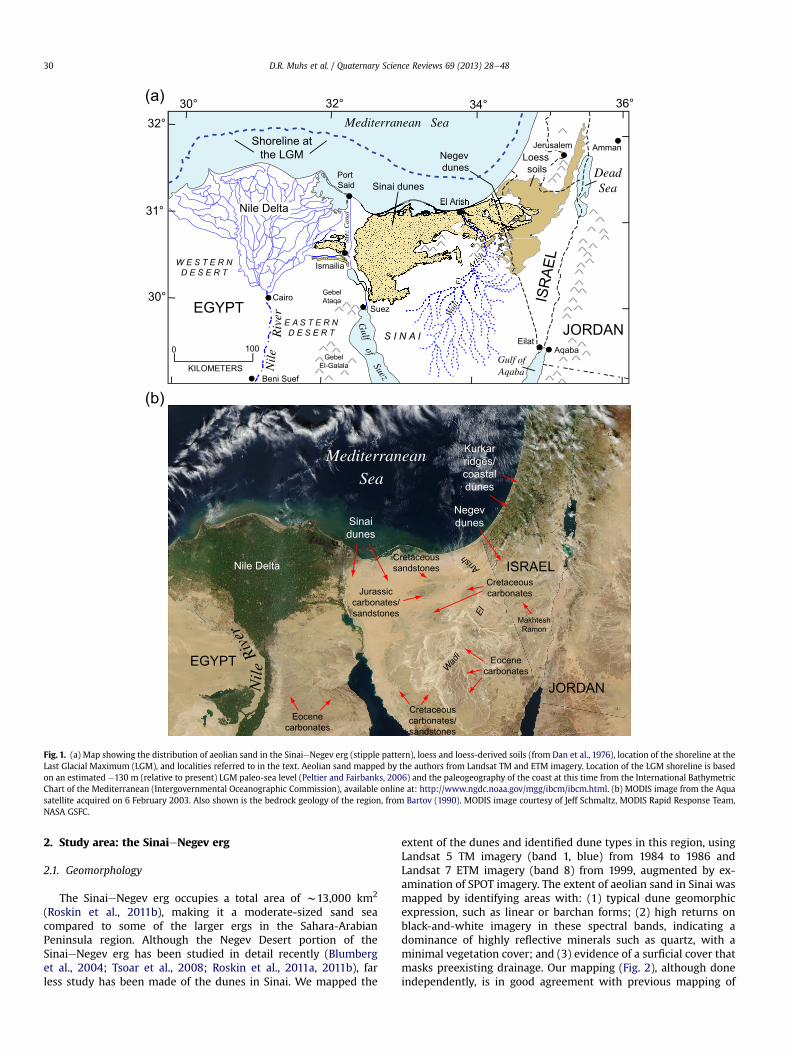
2. Study area: the SinaieNegev erg
2.1. Geomorphology
The SinaieNegev erg occupies a total area of w13,000 km2
(Roskin et al., 2011b), making it a moderate-sized sand seacompared to some of the larger ergs in the Sahara-ArabianPeninsula region. Although the Negev Desert portion of theSinaieNegev erg has been studied in detail recently (Blumberget al., 2004; Tsoar et al., 2008; Roskin et al., 2011a, 2011b), farless study has been made of the dunes in Sinai. We mapped the
extent of the dunes and identified dune types in this region, usingLandsat 5 TM imagery (band 1, blue) from 1984 to 1986 andLandsat 7 ETM imagery (band 8) from 1999, augmented by ex-amination of SPOT imagery. The extent of aeolian sand in Sinai wasmapped by identifying areas with: (1) typical dune geomorphicexpression, such as linear or barchan forms; (2) high returns onblack-and-white imagery in these spectral bands, indicating adominance of highly reflective minerals such as quartz, with aminimal vegetation cover; and (3) evidence of a surficial cover thatmasks preexisting drainage. Our mapping (Fig. 2), although doneindependently, is in good agreement with previous mapping of
Eocenecarbonates
Cretaceouscarbonates/sandstones
Eocenecarbonates
CretaceoussandstonesNile Delta
Sinaidunes
Negevdunes
EGYPT
ISRAEL
JORDAN
Kurkarridges/coastaldunes
Jurassiccarbonates/sandstones
MakhteshRamon
Arish
El
Wadi
Cretaceouscarbonates
MediterraneanSea
Nil
eRi
ver
VV V
V
VV
V
V
V
VV
V
VVVVV
V V
V
VV V
V
VV V
V
V VV
V
V
VVV
V
VV V
V
V
VV
V
VV
VVV
V
ISR
AEL
JORDANEGYPT
Mediterranean Sea
Gulf
ofSuez
Gulf ofAqabaN
ile
Riv
er
S I N A I
W E S T E R N
D E S E R T
E A S T E R N
D E S E R T
Cairo
Port Said
Suez
Amman
DeadSea
Ismailia
EilatAqaba
GebelAtaqa
GebelEl-Galala
Wad
iE
l
Arish
JerusalemShoreline atthe LGM
Beni Suef
Nile Delta
Sinai dunes
Loess soils
El Arish
Negev dunes
0 100
KILOMETERS
Suez
Can
al
(a)
(b)
30°
32°30° 32° 34° 36°
31°
Fig. 1. (a) Map showing the distribution of aeolian sand in the SinaieNegev erg (stipple pattern), loess and loess-derived soils (from Dan et al., 1976), location of the shoreline at theLast Glacial Maximum (LGM), and localities referred to in the text. Aeolian sand mapped by the authors from Landsat TM and ETM imagery. Location of the LGM shoreline is basedon an estimated �130 m (relative to present) LGM paleo-sea level (Peltier and Fairbanks, 2006) and the paleogeography of the coast at this time from the International BathymetricChart of the Mediterranean (Intergovernmental Oceanographic Commission), available online at: http://www.ngdc.noaa.gov/mgg/ibcm/ibcm.html. (b) MODIS image from the Aquasatellite acquired on 6 February 2003. Also shown is the bedrock geology of the region, from Bartov (1990). MODIS image courtesy of Jeff Schmaltz, MODIS Rapid Response Team,NASA GSFC.
D.R. Muhs et al. / Quaternary Science Reviews 69 (2013) 28e4830
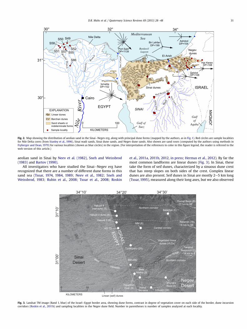
aeolian sand in Sinai by Neev et al. (1982), Sneh and Weissbrod(1983) and Bartov (1990).
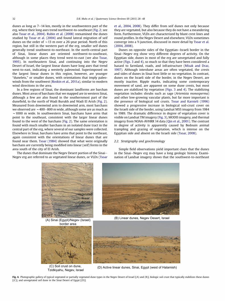
All investigators who have studied the SinaieNegev erg haverecognized that there are a number of different dune forms in thissand sea (Tsoar, 1974, 1984, 1989; Neev et al., 1982; Sneh andWeissbrod, 1983; Rubin et al., 2008; Tsoar et al., 2008; Roskin
et al., 2011a, 2011b, 2012, in press; Hermas et al., 2012). By far themost common landforms are linear dunes (Fig. 3). In Sinai, thesetake the form of seif dunes, characterized by a sinuous dune crestthat has steep slopes on both sides of the crest. Complex lineardunes are also present. Seif dunes in Sinai are mostly 2e5 km long(Tsoar, 1995), measured along their long axes, but we also observed
Northern corridor
Central corridor
Southern corridor
0 10
KILOMETERS
Haluzit 4 dune (8)
Tzidkiyahu (25)
BM (44)
ShuneraWest (5)
BeerMalka (2)
HalamishEast (9)
Mitvakh (28)
Baladiya (6)
EGYPT
ISRAEL
MM (6)
31°0
0’31
°10’
34°20’ 34°30’34°10’
SinaiDesert
NegevDesert
Retamin (18),~6 km to SE
Ramat Beqa (6),~20 km to SE
Haluzit 1 (6)
Haluzit 4 interdune (3)
Linear (seif) dunes
Vegetated lineardunes (VLDs)
Nahal
Nizzana
Wadi
KD 73
Hareidin
TahanutNesyonot (2),~14 km to E
Qeren Ridge
Fig. 3. Landsat TM image (Band 1, blue) of the IsraeleEgypt border area, showing dune forms, contrast in degree of vegetation cover on each side of the border, dune incursioncorridors (Roskin et al., 2011b) and sampling localities in the Negev dune field. Number in parentheses is number of samples analyzed at each locality.
30°
32° 34°
31°
30°
DP=1139Port Said
IsmailiaDP=152
DP=104Ashdod
DP=199Bir Lahfan
Har KerenDP=168
DP=108Qetziot
RosettaB
ranch
Dam
iett
a
Branc
h
ISRAEL
Mediterranean SeaNile Delta
Wad
iE
l
Arish
EGYPT
Sinai dunes
Negev dunes
Gulfof
Aqaba JOR
DAN
Gulf of Suez
Wad
i Nat
ila
Wadi Burukh
Wadi Aqaba
S86
S49
S52S55S57S51
S58S50
Nile
Riv
er
Bardawil Lagoon
SINAI
Cairo
El Arish
0 100
KILOMETERS
Suez
Can
al
EXPLANATIONLinear dunes
Barchan dunesSand sheets orindeterminate formsSample locality
Fig. 2. Map showing the distribution of aeolian sand in the SinaieNegev erg, along with principal dune forms (mapped by the authors, as in Fig. 1). Red circles are sample localitiesfor Nile Delta cores (from Stanley et al., 1996), Sinai wadi sands, Sinai dune sands, and Negev dune sands. Also shown are sand roses (computed by the authors using methods inFryberger and Dean, 1979) for various localities (shown as blue circles) in the region. (For interpretation of the references to color in this figure legend, the reader is referred to theweb version of this article.)
D.R. Muhs et al. / Quaternary Science Reviews 69 (2013) 28e48 31
dunes as long as 7e14 km, mostly in the southwestern part of theerg, where their long axes trend northwest-to-southeast (Fig. 2; seealso Tsoar et al., 2004). Rubin et al. (2008) reexamined the dunesstudied by Tsoar et al. (2004) and found lateral migration of seifdunes on the order of w13 m over a 26-year period. North of thisregion, but still in the western part of the erg, smaller seif dunesgenerally trend southwest-to-northeast. In the north-central partof Sinai, linear dunes are oriented northwest-to-southeast,although in some places they trend west-to-east (see also Tsoar,1995). In northeastern Sinai, and continuing into the NegevDesert of Israel, the largest linear dunes have long axes that trendwest-to-east, indicating a westerly paleowind. Superimposed onthe largest linear dunes in this region, however, are younger“dunelets,” or smaller dunes, with orientations that imply paleo-winds from the southwest (Roskin et al., 2011a), similar to modernwind directions in the area.
In a few regions of Sinai, the dominant landforms are barchandunes. Most areas of barchans that wemapped are inwestern Sinai,although a few are also found in the southernmost part of thedunefield, to the north of Wadi Burukh and Wadi El Arish (Fig. 2).Measured from downwind arm to downwind arm, most barchanswe observed arew400e800mwide, although some are as much asw1000 m wide. In southwestern Sinai, barchans have arms thatpoint to the southeast, consistent with the larger linear dunesfound to the west of the barchans (Fig. 2). The same orientation isfound with much smaller barchans in an isolated dune tract in thecentral part of the erg, where several of our samples were collected.Elsewhere in Sinai, barchans have arms that point to the northeast,again consistent with the orientations of linear dunes that arefound near them. Tsoar (1984) showed that what were originallybarchans are currently being modified into linear (seif) forms in thearea south of the city of El Arish.
The dunes that dominate the Negev Desert portion of the SinaieNegev erg are referred to as vegetated linear dunes, or VLDs (Tsoar
et al., 2004, 2008). They differ from seif dunes not only becausethey are vegetated, but also because they do not have ameanderingform. Furthermore, VLDs are characterized by blunt crest lines andround profiles. In the Negev Desert and elsewhere, VLDs sometimesconverge into a Y-junction, discussed in more detail by Tsoar et al.(2004, 2008).
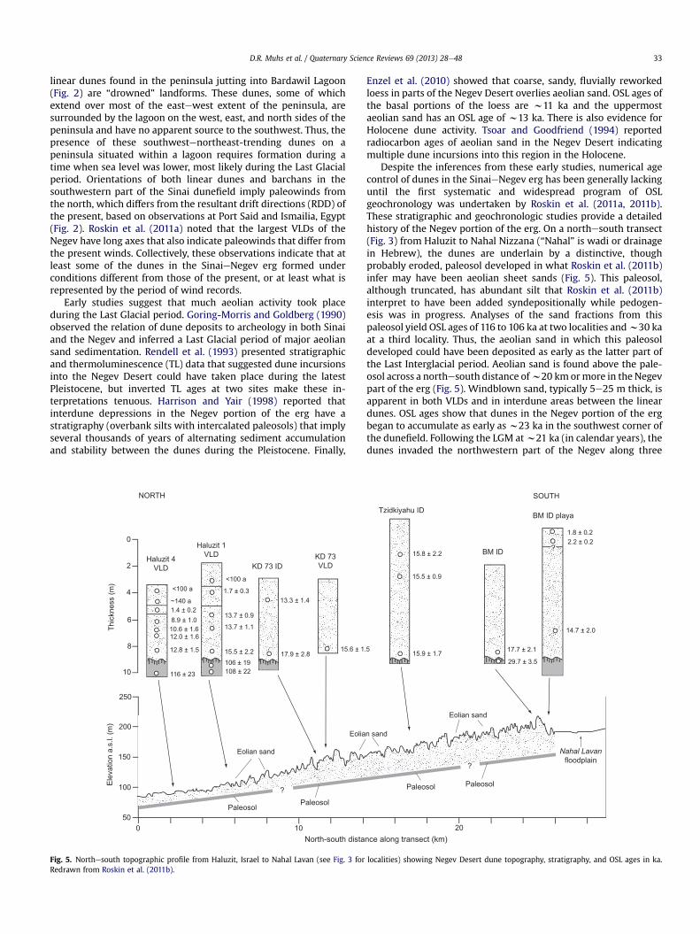
Dunes on opposite sides of the EgyptianeIsraeli border in theSinaieNegev erg show very different degrees of activity. On theEgyptian side, dunes in most of the erg are unvegetated and fullyactive (Figs. 3 and 4), so much so that they have been considered ahazard to farmland, roads, and infrastructure (Misak and Draz,1997). Although interdune areas are often vegetated, the crestsand sides of dunes in Sinai host little or no vegetation. In contrast,dunes on the Israeli side of the border, in the Negev Desert, aremostly inactive. Ripple marks, indicating some contemporarymovement of sand, are apparent on some dune crests, but mostdunes are stabilized by vegetation (Figs. 3 and 4). The stabilizingvegetation includes shrubs such as sage (Artemisia monosperma)and other low-growing vascular plants, but far more important isthe presence of biological soil crusts. Tsoar and Karnieli (1996)showed a progressive increase in biological soil-crust cover onthe Israeli side of the border, using Landsat MSS imagery from 1984to 1989. The dramatic difference in degree of vegetation cover isvisible on Landsat TM imagery (Fig. 3), MODIS imagery, and thermalimagery from NOAA-AVHRR 14 data (Qin et al., 2001). The contrastin degree of activity is apparently caused by Bedouin animaltrampling and grazing of vegetation, which is intense on theEgyptian side and absent on the Israeli side (Tsoar, 2008).
2.2. Stratigraphy and geochronology
Simple field observations yield important clues that the dunesin the SinaieNegev erg may have a long geologic history. Exami-nation of Landsat imagery shows that the southwest-to-northeast
(B) Linear dunes, Negev Desert, Israel(A) Sinai (Egypt)/Negev (Israel)border area
(C) Soil crust on dune, Tzidkiyahu, Negev, Israel
(D) Active linear dunes, Sinai, Egypt (west of Halamish)
ISRAELEGYPT
Vegetated lineardunes
Fig. 4. Photographic gallery of typical vegetated or partially vegetated dune types in the Negev Desert of Israel [(A) and (B)], biologic soil crust that typically stabilizes these dunes[(C)], and unvegetated seif dune in the Sinai Desert of Egypt [(D)].
D.R. Muhs et al. / Quaternary Science Reviews 69 (2013) 28e4832
linear dunes found in the peninsula jutting into Bardawil Lagoon(Fig. 2) are “drowned” landforms. These dunes, some of whichextend over most of the eastewest extent of the peninsula, aresurrounded by the lagoon on the west, east, and north sides of thepeninsula and have no apparent source to the southwest. Thus, thepresence of these southwestenortheast-trending dunes on apeninsula situated within a lagoon requires formation during atime when sea level was lower, most likely during the Last Glacialperiod. Orientations of both linear dunes and barchans in thesouthwestern part of the Sinai dunefield imply paleowinds fromthe north, which differs from the resultant drift directions (RDD) ofthe present, based on observations at Port Said and Ismailia, Egypt(Fig. 2). Roskin et al. (2011a) noted that the largest VLDs of theNegev have long axes that also indicate paleowinds that differ fromthe present winds. Collectively, these observations indicate that atleast some of the dunes in the SinaieNegev erg formed underconditions different from those of the present, or at least what isrepresented by the period of wind records.
Early studies suggest that much aeolian activity took placeduring the Last Glacial period. Goring-Morris and Goldberg (1990)observed the relation of dune deposits to archeology in both Sinaiand the Negev and inferred a Last Glacial period of major aeoliansand sedimentation. Rendell et al. (1993) presented stratigraphicand thermoluminescence (TL) data that suggested dune incursionsinto the Negev Desert could have taken place during the latestPleistocene, but inverted TL ages at two sites make these in-terpretations tenuous. Harrison and Yair (1998) reported thatinterdune depressions in the Negev portion of the erg have astratigraphy (overbank silts with intercalated paleosols) that implyseveral thousands of years of alternating sediment accumulationand stability between the dunes during the Pleistocene. Finally,
Enzel et al. (2010) showed that coarse, sandy, fluvially reworkedloess in parts of the Negev Desert overlies aeolian sand. OSL ages ofthe basal portions of the loess are w11 ka and the uppermostaeolian sand has an OSL age of w13 ka. There is also evidence forHolocene dune activity. Tsoar and Goodfriend (1994) reportedradiocarbon ages of aeolian sand in the Negev Desert indicatingmultiple dune incursions into this region in the Holocene.
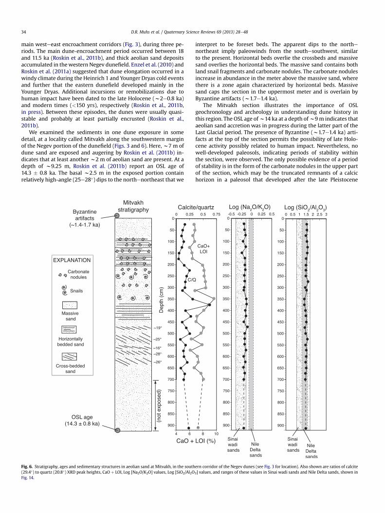
Despite the inferences from these early studies, numerical agecontrol of dunes in the SinaieNegev erg has been generally lackinguntil the first systematic and widespread program of OSLgeochronology was undertaken by Roskin et al. (2011a, 2011b).These stratigraphic and geochronologic studies provide a detailedhistory of the Negev portion of the erg. On a northesouth transect(Fig. 3) from Haluzit to Nahal Nizzana (“Nahal” is wadi or drainagein Hebrew), the dunes are underlain by a distinctive, thoughprobably eroded, paleosol developed in what Roskin et al. (2011b)infer may have been aeolian sheet sands (Fig. 5). This paleosol,although truncated, has abundant silt that Roskin et al. (2011b)interpret to have been added syndepositionally while pedogen-esis was in progress. Analyses of the sand fractions from thispaleosol yield OSL ages of 116 to 106 ka at two localities andw30 kaat a third locality. Thus, the aeolian sand in which this paleosoldeveloped could have been deposited as early as the latter part ofthe Last Interglacial period. Aeolian sand is found above the pale-osol across a northesouth distance ofw20 km ormore in the Negevpart of the erg (Fig. 5). Windblown sand, typically 5e25 m thick, isapparent in both VLDs and in interdune areas between the lineardunes. OSL ages show that dunes in the Negev portion of the ergbegan to accumulate as early as w23 ka in the southwest corner ofthe dunefield. Following the LGM atw21 ka (in calendar years), thedunes invaded the northwestern part of the Negev along three
?
?
Nahal Lavan
floodplain
Paleosol
Paleosol
250
200
150
100
50
Elev
atio
n a.
s.l.
(m)
0 10 20
Eolian sand
Eolian sand
Eolian sand
North-south distance along transect (km)
Paleosol
Paleosol
1.8 ± 0.22.2 ± 0.2
?
14.7 ± 2.0
17.7 ± 2.1
29.7 ± 3.5
15.8 ± 2.2
15.5 ± 0.9
15.9 ± 1.715.6 ± 1.5
13.3 ± 1.4
17.9 ± 2.8
<100 a
1.7 ± 0.3
13.7 ± 0.9
13.7 ± 1.1
15.5 ± 2.2106 ± 19108 ± 22
<100 a
~140 a1.4 ± 0.28.9 ± 1.010.6 ± 1.612.0 ± 1.6
12.8 ± 1.5
116 ± 23
0
2
4
6
8
10
Thic
knes
s (m
)
Haluzit 4VLD
Haluzit 1VLD
KD 73 IDKD 73VLD
Tzidkiyahu ID
BM ID
BM ID playa
NORTH SOUTH
Fig. 5. Northesouth topographic profile from Haluzit, Israel to Nahal Lavan (see Fig. 3 for localities) showing Negev Desert dune topography, stratigraphy, and OSL ages in ka.Redrawn from Roskin et al. (2011b).
D.R. Muhs et al. / Quaternary Science Reviews 69 (2013) 28e48 33
main westeeast encroachment corridors (Fig. 3), during three pe-riods. The main dune-encroachment period occurred between 18and 11.5 ka (Roskin et al., 2011b), and thick aeolian sand depositsaccumulated in thewestern Negev dunefield. Enzel et al. (2010) andRoskin et al. (2011a) suggested that dune elongation occurred in awindy climate during the Heinrich 1 and Younger Dryas cold eventsand further that the eastern dunefield developed mainly in theYounger Dryas. Additional incursions or remobilizations due tohuman impact have been dated to the late Holocene (w2e0.8 ka)and modern times (<150 yrs), respectively (Roskin et al., 2011b,in press). Between these episodes, the dunes were usually quasi-stable and probably at least partially encrusted (Roskin et al.,2011b).
We examined the sediments in one dune exposure in somedetail, at a locality called Mitvakh along the southwestern marginof the Negev portion of the dunefield (Figs. 3 and 6). Here,w7 m ofdune sand are exposed and augering by Roskin et al. (2011b) in-dicates that at least another w2 m of aeolian sand are present. At adepth of w9.25 m, Roskin et al. (2011b) report an OSL age of14.3 � 0.8 ka. The basal w2.5 m in the exposed portion containrelatively high-angle (25e28�) dips to the northenortheast that we
interpret to be foreset beds. The apparent dips to the northenortheast imply paleowinds from the southesouthwest, similarto the present. Horizontal beds overlie the crossbeds and massivesand overlies the horizontal beds. The massive sand contains bothland snail fragments and carbonate nodules. The carbonate nodulesincrease in abundance in the meter above the massive sand, wherethere is a zone again characterized by horizontal beds. Massivesand caps the section in the uppermost meter and is overlain byByzantine artifacts (w1.7e1.4 ka).
The Mitvakh section illustrates the importance of OSLgeochronology and archeology in understanding dune history inthis region. The OSL age ofw14 ka at a depth ofw9m indicates thataeolian sand accretion was in progress during the latter part of theLast Glacial period. The presence of Byzantine (w1.7e1.4 ka) arti-facts at the top of the section permits the possibility of late Holo-cene activity possibly related to human impact. Nevertheless, nowell-developed paleosols, indicating periods of stability withinthe section, were observed. The only possible evidence of a periodof stability is in the form of the carbonate nodules in the upper partof the section, which may be the truncated remnants of a calcichorizon in a paleosol that developed after the late Pleistocene
Fig. 6. Stratigraphy, ages and sedimentary structures in aeolian sand at Mitvakh, in the southern corridor of the Negev dunes (see Fig. 3 for location). Also shown are ratios of calcite(29.4�) to quartz (20.8�) XRD peak heights, CaO þ LOI, Log [Na2O/K2O] values, Log [SiO2/Al2O3] values, and ranges of these values in Sinai wadi sands and Nile Delta sands, shown inFig. 14.
D.R. Muhs et al. / Quaternary Science Reviews 69 (2013) 28e4834

period of dune formation. If so, then the unbedded sand in theupper meter of the section may have been deposited in the lateHolocene, just prior to Byzantine occupation. Many of the sectionsshown in Fig. 5 illustrate a similar situation, where OSL ages indi-cate that late Holocene active sand (due to human impact) overlieslate Pleistocene sand, but a paleosol representing an early-to mid-Holocene period of stability is not apparent. Such paleosols, ifpresent at one time, apparently were eroded during the late Ho-locene periods of dune activity.
3. Sampling and mineralogical and geochemical methods
Samples from the Negev portion of the dunefield (Figs. 2 and 3)consist of aeolian sands of both Holocene and Pleistocene ages, asoutlined in Roskin et al. (2011a). Sands were also collected in moredetail from the Mitvakh section in the southern Negev(N30�53057.200; E34�27036.500). Altogether, 138 samples from theNegev were analyzed for mineralogy and of these, 99 wereanalyzed for major element chemistry (29 from Mitvakh and 70from elsewhere). Aeolian sands (20 samples) from the Sinai portionof the erg (Fig. 2), collected in the 1970’s, were all analyzed for bothmineralogy and major element chemistry. In addition, we analyzed13 samples of fluvial sediments (wadi sands) from Sinai (alsocollected in the 1970’s) for both mineralogy and major elementchemistry. We limited our analyses of fluvial sediments in Sinai tothose samples that are upstream and upwind of the SinaieNegeverg, in the Wadi El Arish drainage system (Fig. 2). In this fashion,we avoid the problem of sediment recycling (from dunes into wadichannels). For the Nile Delta, we used Holocene and Pleistocenesediments from 8 cores (Fig. 7) collected by Stanley et al. (1996) andarchived in the Smithsonian Institution, Washington, D.C. This
collection consists ofw90 individual samples, mostly of Last Glacialage (Fig. 7), all of which were analyzed for mineralogy and 28 ofwhich were analyzed for major element chemistry. For comparisonwith the SinaieNegev erg sands, we also collected 12 samples oflate Pleistocene aeolianite, or “kurkar” (Ramat Gan and Dor units)from a cliff section exposed on the Israeli Mediterranean coast atGaash (Fig. 8), w14 km north of Tel Aviv, studied by Porat et al.(2004). In order to make comparisons with what has been calledthe “Nubian Sandstone”, we collected Lower Cretaceous-agesandstones of the Kurnub Group, probably correlative to theNubian Sandstone (Sneh et al., 1998), from exposures in MakhteshRamon (or crater; also referred to locally as an erosional cirque) insouthern Israel (N30�37018.9300; E34�49003.0400). Correlation of therocks we collected in Makhtesh Ramon with “Nubian”-type sand-stones found in northern Sinai is based on mapping of both as theKurnub Group (Bartov, 1990), location of both on the same tectonicblock, and similar thicknesses and mineralogy (Bartov et al., 1980;Weissbrod et al., 1994; Kolodner et al., 2009).
All aeolian sands and bedrock samples in this study wereanalyzed as bulk powders, with pulverization to a uniform particlesize being the only pretreatment. Sinai wadi sands and Nile Deltasands were pretreated by removal of organic matter with H2O2 anddispersion of clays using Na-pyrophosphate. After pretreatments,silts and clays (<53 mm) and coarse sands (>500 mm)were removedby wet sieving in order to produce a particle size distributionsimilar to that found in aeolian sands; these separates were thenpulverized to powders for both mineralogical and chemical ana-lyses. Mineralogy was determined semiquantitatively by X-raydiffractometry. Relative abundances of quartz (20.8� 2q), K-feldspar(27.4� 2q), plagioclase (27.8� 2q) and calcite (29.4� 2q) were deter-mined by measuring X-ray diffractogram peak heights on bulk
Dep
th (m
)
0
5
10
15
20
25
30
35
40
3.2
4.1
5.6
8.3
4.1
6.7
7.5
3.0
7.5
8.8
12.9
3.9
7.2
15.9
2.5
3.6
4.7
16.5
3.4
6.2
8.0
1.6
3.5
5.5
12.4
1.6
5.6
7.3
7.4
W1
W2
W3
W4
W5 W6
W12
W13W14
W15
W16
W17
W1
W2
W3
W4
W5
W7
W8
W9W10
W11
W18
W6
W12W13
W1
W2
W3
W5
W7
W8
W9
W10W11
W1
W2
W3
W6
W1
W2
W3
W4
W5
W7
W6
W12
W13
W14
W15W16
W17
W1
W2
W3
W5
W19
W7
W8
W9
W10W11
W18
W20
W21
W22
W12
W13
W14
W15
W16
W17
W4
W19
W8
W9
W10
W11
W18
W6
W12
W13W14
W1
W2
W3
W4
W5
W7
W8
W9
W10
W11
S58 S51 S50 S57 S55 S49 S52 S86
Calibratedradiocarbon age
Sedimentsample
Silt or clay
Sand
EXPLANATION
WEST EAST SOUTH
Fig. 7. Stratigraphy of Nile Delta cores (see Fig. 2 for locations), from Stanley et al. (1996). Open circles are calibrated radiocarbon ages in thousands of years, or ka (data from Stanleyet al., 1996). Calibration of radiocarbon ages was done by the authors using the program in Fairbanks et al. (2005). Also shown (filled circles) are samples analyzed for mineralogyand geochemistry in the present study.
D.R. Muhs et al. / Quaternary Science Reviews 69 (2013) 28e48 35

aeolian sands or fluvial sands. We note that these data give relativeabundances of the major minerals, as given on ternary diagrams,but are not weight-percentages. Major element concentrationswere determined by wavelength-dispersive X-ray fluorescence andvalues given are weight-percentages.
4. Results
4.1. Mineralogy and geochemistry of sands in the SinaieNegev erg
Consistent with previous studies (Sneh and Weissbrod, 1983;Roskin et al., 2011b), our analyses indicate that dunes of theSinaieNegev erg are characterized by a relatively simple miner-alogy. The main minerals found in all dunes are, in decreasingorder of abundance, quartz, plagioclase and K-feldspar. Ternarydiagrams based on relative abundances as measured by XRD peakheights display the quartz dominance in both the Negev and Sinaidunes (Fig. 9). Major element geochemistry supports these
interpretations. Negev dunes have SiO2 contents ranging fromw80 to 95%, whereas Na2O (reflecting plagioclase) contents rangefrom 0.24 to 0.83% and K2O contents (reflecting K-feldspar) rangefrom 0.50 to 0.93%. Sinai dunes show a similar composition, withSiO2 contents ranging from w76 to 98%, Na2O contents rangingfrom 0.09 to 0.79% and K2O contents ranging from 0.14 to 0.91%.Collectively, the XRD and geochemical data indicate that Negevand Sinai dunes sands do not differ significantly in composition.
Quartz-rich (compared to feldspar) sand dunes are not expectedto have significant amounts of calcite, because calcite is usuallyabraded to finer grain sizes at least as rapidly as feldspar (Kuenen,1960). Thus, we were surprised to find measurable amounts ofcalcite in both the Negev and Sinai dunes. Not all dunes containcalcite, and the abundances of this mineral vary considerably, whencompared to quartz and total feldspar (K-feldspar þ plagioclase) onternary diagrams (Fig. 10). Major element compositions, plotted asSiO2/10eAl2O3 þ Na2O þ K2OeCaO to mimic the quartzefeldsparecalcite XRD diagrams, support this interpretation (Fig. 11). At least
EXPLANATION
Aeolianite (kurkar)
Aeolian sand
Contact
Soil or paleosol
Rhizoliths
Land snails
OSL age
Sediment sample
0.2 ± 0.02
2.0 ± 0.2
5.3 ± 0.3
13.4 ± 1.5
41.2 ± 2.0
50.7 ± 4.2
52.0 ± 3.3
49.6 ± 3.0
53.0 ± 3.8
57.3 ± 3.0
56.9 ± 3.0
57.6 ± 2.7
62.2 ± 6.8
55.6 ± 5.1
45.5 ± 4.5
Ramat-Gan Kurkar
Nahsholim Sands
Dor Kurkar
Netanya Hamra
Tel Aviv Kurkar
Ta’Arukha Sands
40
30
20
10
0
MET
ERS
IRSL ages(ka)
Gaashstratigraphy
Geologic units
Fig. 8. Stratigraphy of the cliff section with aeolianite units and paleosols at Gaash, Israel, OSL ages (open circles), and sediment samples (filled squares). Stratigraphy and IRSL agesare from Porat et al. (2004).
D.R. Muhs et al. / Quaternary Science Reviews 69 (2013) 28e4836

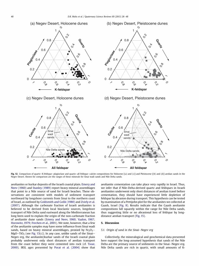
some of the variability in calcite content appears to be related toage and geography. Stratigraphic relations and the OSL geochro-nology of Roskin et al. (2011b) allow a comparison of the compo-sitions of late Pleistocene and late Holocene dunes, at least in theNegev portion of the erg. On quartzeK-feldspareplagioclaseternary diagrams, there is no significant difference between thetwo age groups of aeolian sands (Fig. 12). On quartzefeldsparecalcite diagrams, however, there are several late Pleistocene sandsamples that have significantly higher amounts of calcite than thelate Holocene sands. As mentioned earlier, Roskin et al. (2011b)identified three eastewest trending dune-incursion corridors inthe Negev portion of the dunefield (Fig. 3). All of the higher calcitePleistocene sands from the Negev are from either the southernincursion corridor, or the southern portion of the central incursioncorridor. Deposition of relatively carbonate-rich aeolian sand ap-pears to have occurred fairly consistently in the late Quaternary inthe southern corridor of the Negev dunes. At the Mitvakh locality,situated in the southern corridor, calcite is detectable in the entiresection (Fig. 6). Using CaO þ LOI as a proxy for total carbonatecontent, calcite abundances range from 6 to 10% throughout thesection at Mitvakh, from the late Pleistocene (marked by an OSL ageof w14 ka at a depth of w9 m) up to the late Holocene (marked byByzantine artifacts 1.7e1.4 ka, at the top of the section).
The mineralogy of potential source sediments, sands of the NileDelta and sands of the Wadi El Arish drainage system of Sinai, are
distinct from one another. Nile Delta sands consist mostly of quartz,followed by plagioclase and K-feldspar (Fig. 9). Calcite is present inonly a few Nile samples and in very small amounts (Fig. 10). Majorelement geochemistry is consistent with this mineralogy (Fig. 11),with Nile Delta sands showing SiO2 contents of 85e95%, Na2O con-tents of 0.45e1.2%, andK2O contents of 0.42e1.1%. In contrast, almostall Sinai wadi sands have calcite (Fig. 10). Based on CaO þ LOI as anestimate of mineral abundance, carbonate contents vary widely,however, fromw14 to w91%. In Sinai wadi sands, SiO2 contents areinversely related to carbonate content and vary from w6 to w82%,with Na2O ranging from 0.05 to 0.35%, and K2O ranging from 0.11 to0.58%. Thus, although theWadi El Arish drainage system is certainlydominated by carbonate rocks (Sneh, 1982; Bartov, 1990), silicateminerals are also present within the alluvium derived from theserocks, sometimes in substantial amounts.
Nile Delta sands and Sinai wadi sands can also be distinguishedfrom one another by the use of geochemical indicators of heavymineral assemblages. There is a long tradition of using heavymineral suites to determine sediment origins. Some of these min-erals are resistant to mechanical breakdown and can be distinctivefor different source rocks (Blatt et al., 1972; Pettijohn et al., 1972).An alternative approach is possible based on studies that haveshown that, in the absence of clay minerals or intergranularcement, heavy mineral assemblages are proxied by geochemicalindicators, specifically Fe2O3, MgO and TiO2 contents (e.g., Nesbitt
Fig. 9. Ternary diagrams showing relative abundance of quartz, K-feldspar, and plagioclase, based on XRD peak heights (20.8� for quartz; 27.4� for K-feldspar, and 27.8� forplagioclase) for (a) Negev dunes, (b) Sinai dunes, (c) aeolianite at Gaash, and (d) Sinai wadi sands and Nile Delta sands.
D.R. Muhs et al. / Quaternary Science Reviews 69 (2013) 28e48 37
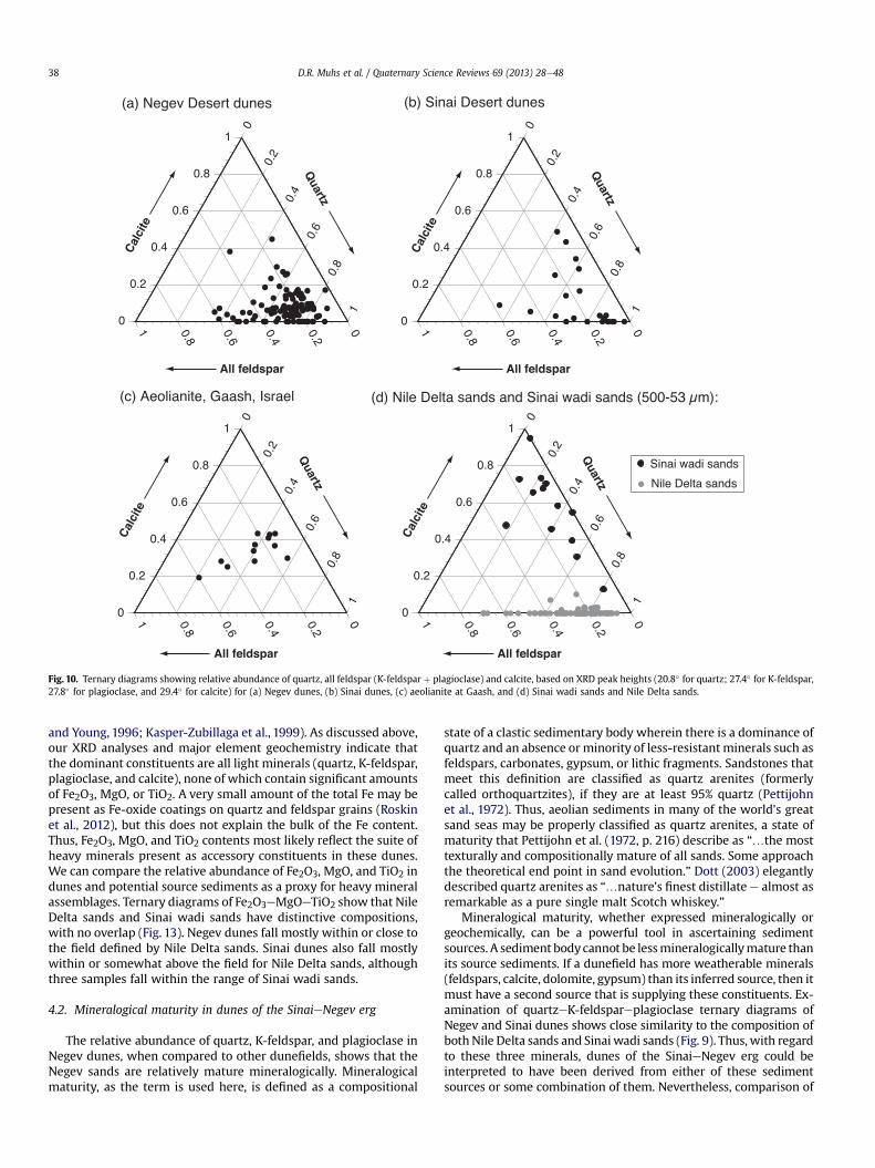
and Young, 1996; Kasper-Zubillaga et al., 1999). As discussed above,our XRD analyses and major element geochemistry indicate thatthe dominant constituents are all light minerals (quartz, K-feldspar,plagioclase, and calcite), none of which contain significant amountsof Fe2O3, MgO, or TiO2. A very small amount of the total Fe may bepresent as Fe-oxide coatings on quartz and feldspar grains (Roskinet al., 2012), but this does not explain the bulk of the Fe content.Thus, Fe2O3, MgO, and TiO2 contents most likely reflect the suite ofheavy minerals present as accessory constituents in these dunes.We can compare the relative abundance of Fe2O3, MgO, and TiO2 indunes and potential source sediments as a proxy for heavy mineralassemblages. Ternary diagrams of Fe2O3eMgOeTiO2 show that NileDelta sands and Sinai wadi sands have distinctive compositions,with no overlap (Fig. 13). Negev dunes fall mostly within or close tothe field defined by Nile Delta sands. Sinai dunes also fall mostlywithin or somewhat above the field for Nile Delta sands, althoughthree samples fall within the range of Sinai wadi sands.
4.2. Mineralogical maturity in dunes of the SinaieNegev erg
The relative abundance of quartz, K-feldspar, and plagioclase inNegev dunes, when compared to other dunefields, shows that theNegev sands are relatively mature mineralogically. Mineralogicalmaturity, as the term is used here, is defined as a compositional
state of a clastic sedimentary body wherein there is a dominance ofquartz and an absence orminority of less-resistant minerals such asfeldspars, carbonates, gypsum, or lithic fragments. Sandstones thatmeet this definition are classified as quartz arenites (formerlycalled orthoquartzites), if they are at least 95% quartz (Pettijohnet al., 1972). Thus, aeolian sediments in many of the world’s greatsand seas may be properly classified as quartz arenites, a state ofmaturity that Pettijohn et al. (1972, p. 216) describe as “.the mosttexturally and compositionally mature of all sands. Some approachthe theoretical end point in sand evolution.” Dott (2003) elegantlydescribed quartz arenites as “.nature’s finest distillatee almost asremarkable as a pure single malt Scotch whiskey.”
Mineralogical maturity, whether expressed mineralogically orgeochemically, can be a powerful tool in ascertaining sedimentsources. A sediment bodycannot be lessmineralogicallymature thanits source sediments. If a dunefield has more weatherable minerals(feldspars, calcite, dolomite, gypsum) than its inferred source, then itmust have a second source that is supplying these constituents. Ex-amination of quartzeK-feldspareplagioclase ternary diagrams ofNegev and Sinai dunes shows close similarity to the composition ofbothNile Delta sands and Sinai wadi sands (Fig. 9). Thus, with regardto these three minerals, dunes of the SinaieNegev erg could beinterpreted to have been derived from either of these sedimentsources or some combination of them. Nevertheless, comparison of
Fig. 10. Ternary diagrams showing relative abundance of quartz, all feldspar (K-feldspar þ plagioclase) and calcite, based on XRD peak heights (20.8� for quartz; 27.4� for K-feldspar,27.8� for plagioclase, and 29.4� for calcite) for (a) Negev dunes, (b) Sinai dunes, (c) aeolianite at Gaash, and (d) Sinai wadi sands and Nile Delta sands.
D.R. Muhs et al. / Quaternary Science Reviews 69 (2013) 28e4838
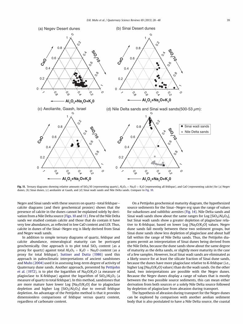
Negev and Sinai sands with these sources on quartzetotal feldsparecalcite diagrams (and their geochemical proxies) shows that thepresence of calcite in the dunes cannot be explained solely by deri-vation from aNile Delta source (Figs.10 and 11). Fewof theNile Deltasands we studied contain calcite and those that do contain it havevery low abundances, as reflected in low CaO content and LOI. Thus,calcite in dunes of the SinaieNegev erg is likely derived from Sinaiand Negev wadi sands.
In addition to simple ternary diagrams of quartz, feldspar andcalcite abundance, mineralogical maturity can be portrayedgeochemically. One approach is to plot total SiO2 content (as aproxy for quartz) against total Al2O3 þ K2O þ Na2O content (as aproxy for total feldspar). Suttner and Dutta (1986) used thisapproach in paleoclimatic interpretations of ancient sandstonesandMuhs (2004) used it in assessing long-term degree of activity ofQuaternary dune sands. Another approach, presented by Pettijohnet al. (1972), is to plot the logarithm of Na2O/K2O (a measure ofplagioclase to K-feldspar) against the logarithm of SiO2/Al2O3 (ameasure of quartz to total feldspar). In this method, sandstones thatare more mature have lower Log [Na2O/K2O] due to plagioclasedepletion and higher Log [SiO2/Al2O3] due to overall feldspardepletion. An advantage of the Pettijohn method is that it providesdimensionless comparisons of feldspar versus quartz content,regardless of carbonate content.
On a Pettijohn geochemical maturity diagram, the hypothesizedsource sediments for the SinaieNegev erg span the range of valuesfor subarkoses and sublithic arenites (Fig. 14). Nile Delta sands andSinai wadi sands show about the same ranges for Log [SiO2/Al2O3],but Sinai wadi sands show a greater depletion of plagioclase rela-tive to K-feldspar, based on lower Log [Na2O/K2O] values. Negevdune sands fall mostly between these two sediment groups, butSinai dune sands show less depletion of plagioclase and about halffall within the range of Nile Delta sands. Thus, the Pettijohn dia-grams permit an interpretation of Sinai dunes being derived fromthe Nile Delta, because the dune sands show about the same degreeof maturity as the delta sands, or slightly more maturity in the caseof a few samples. However, local Sinai wadi sands are eliminated asa likely source for at least the silicate fraction of Sinai dune sands,because the dunes have more plagioclase relative to K-feldspar (i.e.,higher Log [Na2O/K2O] values) than do thewadi sands. On the otherhand, two interpretations are possible with the Negev dunes.Because the Negev dunes display a range of values that is mostlybetween the two possible source sediments, this can mean eitherderivation from both sources or a solely Nile Delta source followedby depletion of plagioclase from abrasion during transport.
The hypothesis of abrasion during transport for the Negev dunescan be explored by comparison with another aeolian sedimentbody that is also postulated to have a Nile Delta source, the coastal
Fig. 11. Ternary diagrams showing relative amounts of SiO2/10 (representing quartz), Al2O3 þ Na2O þ K2O (representing all feldspar), and CaO (representing calcite) for (a) Negevdunes, (b) Sinai dunes, (c) aeolianite at Gaash, and (d) Sinai wadi sands and Nile Delta sands. Compare to Fig. 10.
D.R. Muhs et al. / Quaternary Science Reviews 69 (2013) 28e48 39
aeolianites or kurkar deposits of the Israeli coastal plain. Emery andNeev (1960) and Stanley (1989) report heavy mineral assemblagesthat point to a Nile source of sand for Israeli beaches. These ob-servations are consistent with models of sediment transportnorthward by longshore currents from Sinai to the northern coastof Israel, as outlined by Goldsmith and Golik (1980) and Zviely et al.(2007). Although the carbonate fraction of Israeli aeolianites isbelieved to be derived from local bioclastic sources, longshoretransport of Nile Delta sand eastward along the Mediterranean haslong been used to explain the origin of the non-carbonate fractionof aeolianite dune sands (Emery and Neev, 1960; Yaalon, 1967;Horowitz, 1979; Frechen et al., 2001). We note, however, that a fewof the aeolianite samples may have some influence from Sinai wadisands, based on heavy mineral assemblages, proxied by Fe2O3e
MgOeTiO2 (see Fig. 13(c)). In any case, unlike sands of the SinaieNegev erg, the aeolianite/kurkar sands of the Israeli coastal plainprobably underwent only short distances of aeolian transportfrom the coast before they were cemented into rock (cf. Tsoar,2000). IRSL ages presented by Porat et al. (2004) show that
aeolianite cementation can take place very rapidly in Israel. Thus,we infer that if Nile-Delta-derived quartz and feldspars in Israeliaeolianites underwent only short distances of aeolian travel beforecementation, they should have experienced little depletion offeldspar by abrasion during transport. This hypothesis can be testedby examination of a Pettijohn plot for the aeolianites we collected atGaash, Israel (Fig. 8). Results indicate that the Gaash aeolianitecompositions fall squarely within the range for Nile Delta sands,thus suggesting little or no abrasional loss of feldspar by long-distance aeolian transport (Fig. 15).
5. Discussion
5.1. Origin of sand in the SinaieNegev erg
Collectively, the mineralogical and geochemical data presentedhere support the long-assumed hypothesis that sands of the NileDelta are the primary source of sediments in the SinaieNegev erg.Nile Delta sands are rich in quartz, with small amounts of K-
Fig. 12. Comparison of quartzeK-feldspareplagioclase and quartzeall feldsparecalcite compositions for Holocene [(a) and (c)] and Pleistocene [(b) and (d)] aeolian sands in theNegev Desert. Shown for comparison are the ranges of these minerals for Sinai wadi sands and Nile Delta sands.
D.R. Muhs et al. / Quaternary Science Reviews 69 (2013) 28e4840

feldspar and plagioclase, in proportions similar to what is found insands of the SinaieNegev erg. Pettijohn-style geochemical plots ofmineralogical maturity that measure feldspar depletion relative toquartz show that Sinai dune sands have compositions (with respectto quartz and feldspars) very similar to Nile Delta sands. A numberof samples of Negev dune sands and a few Sinai dune sands showsomewhat greater mineralogical maturity than Nile Delta sands.This does not rule out a Nile Delta source, however, as some feld-spar loss is expected during aeolian sand transport. Importantly,neither Sinai nor Negev dune sands show a lower degree ofmineralogical maturity than Nile Delta sands. If this were the case,then a more feldspar-rich source would have to be invoked at leastas a partial source.
Geochemical indicators that proxy for heavy minerals alsosupport a Nile Delta source for the SinaieNegev erg. Mineralogicalcompositions, as determined by XRD, show that Fe2O3, MgO andTiO2 likely reside in the trace quantities of heavy minerals in bothNile Delta and Sinai wadi sands, the two candidate source sedi-ments. Thus, Fe2O3eMgOeTiO2 ternary plots provide a means ofassessing the heavy mineral composition of the source sediments.Fields defined by the composition of Nile Delta and Sinai wadisands on these plots do not overlap. Both Sinai and Negev dunesands fall mainly within the field defined by Nile Delta sands,consistent with the mineralogical and geochemical data for thelight mineral fraction.
Although the bulk of mineralogical and geochemical datasupport a Nile Delta source for the SinaieNegev erg, othermineralogical data show that a second source is required. Most
Sinai dunes and many Negev dunes (dominantly in the southerndune incursion corridor) contain measurable amounts of calcite.Based on CaO contents and LOI, the amount of calcite in Sinaidunes ranges from 1 to 19%, with Negev dunes having calcitecontents of 1e11%. Calcite is present in small amounts in only afew Nile Delta sands we examined; most delta samples contain nomeasurable calcite at all. In contrast, fluvial sands from the upperpart of the Wadi El Arish drainage basin of Sinai have abundantcalcite. This calcite is likely derived from Jurassic, Cretaceous, andEocene carbonate rocks that constitute the dominant bedrock incentral and northern Sinai (Bartov, 1990). Based on both XRD andgeochemistry, carbonate contents of these Sinai wadi sands rangefrom 14 to 90% and average w64%. Thus, a smaller but significantamount of sediment in the SinaieNegev erg is not derived fromthe Nile Delta, but fromwadi sands of Sinai. Analyses of samples ina thick aeolian sand section at Mitvakh, in the southern duneincursion corridor of the Negev Desert, show that inputs of calcitefrom Sinai or Negev wadis have been important through the wholeperiod of sedimentation recorded at this locality, which dates fromthe late Pleistocene to the late Holocene. Furthermore, other lo-calities in the Negev dunes that show significant amounts ofcalcite are, like the Mitvakh section, all located within the south-ern dune-incursion corridor. Thus, aeolian inputs of calcite fromcalcareous Sinai wadi sands appear to be directed mainly towardthe southern part of the Negev dunes in Israel. Another possibilityis that Nahal Nizzana, a local source for dunes of the southernincursion corridor, provided sediment inputs, as sands in thisdrainage are carbonate-rich.
Fig. 13. Ternary diagrams showing relative amounts of Fe2O3, MgO, and TiO2, representing heavy minerals for (a) Negev dunes; (b) Negev dunes, showing an enlarged portion of (a);(c) Sinai dunes; and (d) aeolianite at Gaash. Shown for comparison are ranges of these values in Sinai wadi sands (stipple pattern) and Nile Delta sands (gray shading).
D.R. Muhs et al. / Quaternary Science Reviews 69 (2013) 28e48 41

5.2. Paleoenvironmental conditions favorable to the formation ofthe SinaieNegev erg
The Nile Delta is currently cultivated and has been utilized forthis purpose for millennia. Part of the reason that agriculture ispossible on the delta is that it hosts fine-grained soils that areproductive if there is sufficient moisture. A question that followsfrom this is how Nile Delta sands could be entrained to form duneswhen the present sediment cover is so fine grained. We infer thatthe answer lies in the changing conditions of the Nile Delta over theLast Glacial period and into the Holocene. Stratigraphic studies byStanley et al. (1996; see also Fig. 7 herein) and reconstruction of thelate Pleistocene-to-historic-period paleogeography of the region byStanley andWarne (1993) show that during the Last Glacial period,w35 ka to w13 ka (in calibrated radiocarbon years), the Nile Deltawas characterized by a series of broad, braided or anastomosingchannels that were seasonally dry. The dominant sediments in the
delta at this time were quartz-rich sands, as shown by the stra-tigraphy in Stanley et al. (1996) and Fig. 7. Sea level was as much asw130 m below present, and the shoreline lay farther north (Fig. 1),based on the Barbados sea-level record (Peltier and Fairbanks,2006). Fine-grained floodplain sediments likely were found onlynear what is now the shoreline, in limited areas compared to thepresent size of the delta (Fig. 16). Seasonally dry, braided or anas-tomosing channels were separated by dry, sandy plains over mostof what is now the main part of the Nile Delta. We suggest that thisbroad, dry, sandy plain, which would have been extensive, set thestage for the growth of the SinaieNegev erg.
Concurrent with a readily available source of sand, there wasprobably an increase in the frequency of high-velocity winds duringthe Last Glacial period. Wind strength is one of the major controlson dune activity (Tsoar, 2005). Under reasoned scenarios of LastGlacial synoptic climatology, it is likely that there were higher ve-locity, and more frequent, west-to-east winds over the area nowoccupied by the SinaieNegev erg, due to more frequent easternMediterranean cyclonic systems (see discussion in Enzel et al.,2008). With an abundant sand supply from the Nile Delta, high-velocity winds would have brought about optimal conditions forinitiation and growth of the SinaieNegev erg during the Last Glacialperiod, a favorable combination of conditions also outlined byRoskin et al. (2012).
Fig. 14. Geochemical plots of mineralogical maturity using method of Pettijohn et al.(1972) for the Negev dunes (upper) and Sinai dunes (lower) compared to Nile Deltasands and Sinai wadi sands. All data from this study.
Fig. 15. Upper: Geochemical plots of mineralogical maturity using method of Pettijohnet al. (1972) for the Gaash aeolianites of Israel (this study) and Negev dunes comparedto Nile Delta sands. Lower: Geochemical plots of mineralogical maturity using methodof Pettijohn et al. (1972) for the Negev dunes (upper) and compared to Nile Delta sandsand Sinai wadi sands. Shown for comparison are compositions for Nubian-typesandstones, collected in Makhtesh Ramon, Israel and Cenozoic basalts from the Ethi-opian Highlands. All data from this study except basalt data, which are from Pik et al.(1998).
D.R. Muhs et al. / Quaternary Science Reviews 69 (2013) 28e4842
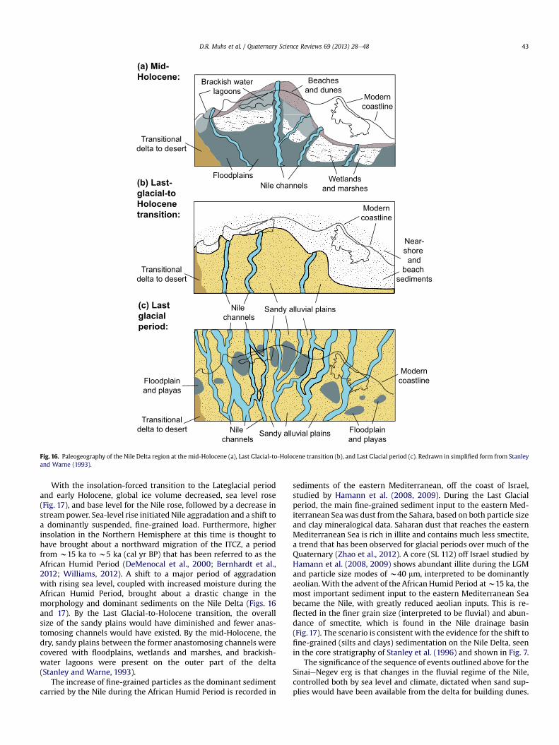
With the insolation-forced transition to the Lateglacial periodand early Holocene, global ice volume decreased, sea level rose(Fig. 17), and base level for the Nile rose, followed by a decrease instream power. Sea-level rise initiated Nile aggradation and a shift toa dominantly suspended, fine-grained load. Furthermore, higherinsolation in the Northern Hemisphere at this time is thought tohave brought about a northward migration of the ITCZ, a periodfrom w15 ka to w5 ka (cal yr BP) that has been referred to as theAfrican Humid Period (DeMenocal et al., 2000; Bernhardt et al.,2012; Williams, 2012). A shift to a major period of aggradationwith rising sea level, coupled with increased moisture during theAfrican Humid Period, brought about a drastic change in themorphology and dominant sediments on the Nile Delta (Figs. 16and 17). By the Last Glacial-to-Holocene transition, the overallsize of the sandy plains would have diminished and fewer anas-tomosing channels would have existed. By the mid-Holocene, thedry, sandy plains between the former anastomosing channels werecovered with floodplains, wetlands and marshes, and brackish-water lagoons were present on the outer part of the delta(Stanley and Warne, 1993).
The increase of fine-grained particles as the dominant sedimentcarried by the Nile during the African Humid Period is recorded in
sediments of the eastern Mediterranean, off the coast of Israel,studied by Hamann et al. (2008, 2009). During the Last Glacialperiod, the main fine-grained sediment input to the eastern Med-iterranean Seawas dust from the Sahara, based on both particle sizeand clay mineralogical data. Saharan dust that reaches the easternMediterranean Sea is rich in illite and contains much less smectite,a trend that has been observed for glacial periods over much of theQuaternary (Zhao et al., 2012). A core (SL 112) off Israel studied byHamann et al. (2008, 2009) shows abundant illite during the LGMand particle size modes of w40 mm, interpreted to be dominantlyaeolian.With the advent of the African Humid Period atw15 ka, themost important sediment input to the eastern Mediterranean Seabecame the Nile, with greatly reduced aeolian inputs. This is re-flected in the finer grain size (interpreted to be fluvial) and abun-dance of smectite, which is found in the Nile drainage basin(Fig. 17). The scenario is consistent with the evidence for the shift tofine-grained (silts and clays) sedimentation on the Nile Delta, seenin the core stratigraphy of Stanley et al. (1996) and shown in Fig. 7.
The significance of the sequence of events outlined above for theSinaieNegev erg is that changes in the fluvial regime of the Nile,controlled both by sea level and climate, dictated when sand sup-plies would have been available from the delta for building dunes.
Sandy alluvial plains
Moderncoastline
Moderncoastline
Moderncoastline
Beachesand dunes
Nile channels
Nile channels
Floodplainand playas
Floodplains
Brackish waterlagoons
Wetlandsand marshes
Floodplainand playas
Transitionaldelta to desert
Transitionaldelta to desert
Transitionaldelta to desert
(a) Mid-
Holocene:
(b) Last-
glacial-to
Holocene
transition:
(c) Last
glacial
period:
Sandy alluvial plainsNile channels
Near-shore and
beach sediments
Fig. 16. Paleogeography of the Nile Delta region at the mid-Holocene (a), Last Glacial-to-Holocene transition (b), and Last Glacial period (c). Redrawn in simplified form from Stanleyand Warne (1993).
D.R. Muhs et al. / Quaternary Science Reviews 69 (2013) 28e48 43

During the Last Glacial period, when broad, dry, sandy plains withseasonally dry channels typified what is now the Nile Delta region(Fig. 16c), sand supplies were abundant and initial dune incursionsto the SinaieNegev erg began (Fig. 17). Dune building continuedinto the Lateglacial, but diminished sometime after sea level beganto rise in the Holocene and the African Humid Period began. Adecrease in dune building activity in the SinaieNegev erg at thistime is consistent with a diminution in sand supplies, caused byaggradation of the Nile and a shift to finer grained sedimentationonwhat is now the Nile Delta. Williams (2012) points out that finergrained sedimentation (as opposed to sand and gravel deposition)also occurred in the upper reaches of the Nile at this time. Little orno dune building occurred during the early-to-mid-Holocenebecause of a lack of sand supply, but dune building began again inthe late Holocene, after the African Humid Period had ended(Fig. 17). Similar compositions of Holocene and Pleistocene dunes,except for calcite (Fig. 12), permit the possibility that some of theHolocene aeolian sand could have been reworked from Pleistocenedunes. A recent study shows that much or all of this late Holocenedune activity is due to anthropogenic causes, namely destruction ofbiological soil crusts (from grazing) or removal of vascular vege-tation (from grazing or fuel collection) as well as possible briefperiods of increased wind strength (Roskin et al., in press).
5.3. Origin of quartz in the Nile Delta
Earlier, we pointed out that recently computed sediment bud-gets, based on both petrography and isotopic compositions, indi-cate that the largest contributors to the Nile are tributaries, such asthe Blue Nile and Wadi Atbara, that drain the Ethiopian Highlands.The Ethiopian Highlands are dominated by basalts of Cenozoic age,
rocks that lack quartz. Nevertheless, our studies show that NileDelta sands, at least those of Late-Last-Glacial age (Fig. 7) are veryrich in quartz and in fact qualify as subarkoses or sublithic arenites(Fig. 14). This leads to the question of what the source of quartz wasfor the Nile Delta during the Last Glacial period. One possibility thatmust be considered is simple aeolian transport of sand from theWestern Desert of Egypt (Fig. 1), where the Great Sand Sea, a largedunefield, is situated (Fig.18). El-Baz et al. (1979) analyzed a limitednumber of samples from this sand sea, but their data indicate thatthe dunes are indeed quartz-rich (>90%). Bubenzer et al. (2007)show that dunes in this sand sea were active during the LastGlacial period and, at least in the northern part of region, paleo-winds could have been from the west. Nevertheless, the extent ofthis sand sea does not reach the Nile drainage basin (Fig. 18).Although it is possible that small amounts of quartz sand couldhave reached the Nile from this source, it is unlikely that such tinyadditions can explain the dominance of quartz in Nile Delta sedi-ments that date to the Last Glacial period.
Farther south in the Sudan, however, there is abundant aeoliansand that could have been delivered by wind transport to the Niledrainage basin. We note that much of this aeolian sand overlieswhat has been mapped as Cretaceous “Nubian Sandstone,” a quartzarenite. Given the similar spatial distribution of both aeolian sandand Nubian Sandstone in northern Sudan (Fig. 18), we suspect thatthis Cretaceous bedrock is the likely source of the dunes and sandsheets in this region. This hypothesis requires testing, but it leads tothe possibility that quartz in the Nile system, whether delivered byfluvial or aeolian processes, ultimately could be derived from theNubian Sandstone. Indeed, Williams (2012) notes that during thePleistocene, dunes migrated across a dry White Nile river bed.Butzer and Gladfelter (1968) studied Pleistocene fluvial sediments
Fig. 17. (A) July insolation at the top of the atmosphere at 15�N (data from Berger and Loutre, 1991); (B) sea level history from the Last Glacial period to present, based on data fromBarbados, the Florida Keys and the Bahamas (compiled by the authors from Bard et al., 1990; Toscano and Lundberg, 1998; Toscano and Macintyre, 2003; Peltier and Fairbanks,2006); (C) particle size data, expressed as fractions of 1 for fluvial (EM3) sediment and (D) clay mineralogy in eastern Mediterranean Sea core SL 112 and inferred dominantsediment sources (data from Hamann et al. (2008, 2009)); and (E) periods of dune activity in the Negev Desert of Israel, based on OSL ages (Roskin et al., 2011b).
D.R. Muhs et al. / Quaternary Science Reviews 69 (2013) 28e4844

of the Nile along numerous reaches in the Sahara, including seg-ments that are now flooded because of the construction of theAswan High Dam. They document very high quartz contents in Nilesands and infer that Nubian Sandstone is the source of this mineral.Although the present sediment budget of the Nile seems to bedominated by basalt-derived inputs from the Ethiopian Highlands(Padoan et al., 2011; Williams, 2012), Garzanti et al. (2006) pointout that this is partly a function of high sediment yields fromanthropogenic erosion due to deforestation and land use in theupper part of the drainage basin. Indeed, Garzanti et al. (2006)caution that their sediment budget probably cannot be extrapo-lated very far into the past. Furthermore, it is clear from detailedgeomorphic and stratigraphic studies by Butzer and Hansen (1968)that Nubian Sandstone was an important contributor to fluvialsands in downstream reaches of the Nile during Pleistocene time.We did not have access to samples of the Nubian Sandstone inEgypt, but the correlative rocks of the Kurnub Group (Cretaceous)we collected from Makhtesh Ramon confirm that they are verymature mineralogically, consistent with studies done on theNubian Sandstone itself in Egypt (El-Hinnawi et al., 1973). Exami-nation of a Pettijohn geochemical plot of mineralogical maturity
shows that the composition of Pleistocene Nile Delta sands can beexplained by a mix of feldspar-rich basalts from the EthiopianHighlands and quartz-rich sources derived from the Nubian Sand-stone (Fig. 15).
5.4. Implications for the origin of loess from aeolian sand in theSinaieNegev erg
As alluded to earlier, a number of recent studies (Crouvi et al.,2008, 2010, 2012; Enzel et al., 2008, 2010; Amit et al., 2011) haveconcluded that dunefields, and the SinaieNegev erg in particular,are important generators of silt-sized quartz that constitute a majorpart of “desert” (i.e., non-glaciogenic) loess. The main mechanismenvisioned in this process is reduction of sand-sized quartz to silt-sized quartz by abrasion during aeolian transport. The mechanismhas intuitive appeal, based on the geography of the SinaieNegeverg located upwind of the main loess body in Israel (Fig. 1). Inaddition, experimental work by Kuenen (1960), Dutta et al. (1993),Wright et al. (1998) and Wright (2001a, 2001b) have shown thatboth aeolian abrasion and ballistic impacts are surprisingly effec-tive processes for reduction of sand-sized quartz, feldspars, andcalcite to smaller sizes, including particle sizes that fall within therange of loess sediments.
Nevertheless, a geographic association of a dunefield and a loessbody need not be due to a genetic relationship. In China, forexample, the Loess Plateau is downwind of several desert basinswith dunefields, but Sun (2002) concludes that the silt is producedby glacial and periglacial processes in the mountains surroundingthe basins and that the dunefields occupying the desert basins aretemporary storage areas for silt-sized sediment, not the location ofsilt particle genesis. In the Great Plains region of North America,loess in Nebraska is immediately downwind of the Nebraska SandHills, the largest dunefield on the continent. Mineralogic,geochemical, and isotopic studies by Aleinikoff et al. (2008) andMuhs et al. (2008) show, however, that while an active NebraskaSand Hills dunefield probably played an important role in trans-porting silt to the loess bodies downwind, sand-sized particles inthe dunefield itself apparently did not generate a significantamount of loess by abrasion of dune sand.
The data we present here can be used to provide a partial test ofthe importance of the SinaieNegev erg to the origin of loess inIsrael. The classical aeolian experimental studies conducted byKuenen (1960) documented aeolian abrasional loss, using variousparticle sizes, surfaces of transport, wind velocities, and mineralspecies. Under similar conditions (particle size, transport surfaces,wind velocity), the greatest amount of mass loss per unit oftransport distance was from calcite and feldspar, not quartz.Although it is important to keep in mind that experimental resultssuch as these may not always be applicable to field settings,Kuenen’s (1960) results are consistent with the greater hardness ofquartz (7) compared to feldspar (6) or calcite (3). Thus, if the SinaieNegev erg is contributing coarse-silt-sized quartz particles to theloess of Israel, the erg should also be generating a relatively greateramount of silt-sized calcite and feldspar. This hypothesis requires,therefore, that calcite and feldspars should be enriched in loess(relative to quartz) when compared to sands in the SinaieNegeverg. Crouvi et al. (2009) and Enzel et al. (2010) reported percent-ages of quartz, K-feldspar, plagioclase, and calcite in loess down-wind of the SinaieNegev erg. They calculated percentages of thesemineral species using a method by Dr. Amir Sandler of theGeological Survey of Israel (written communication, 9 August2012), wherein the following factors are applied to XRD peakheights at two-theta, summed, and calculated as percentages:quartz, 26.6�, �1.0; K-feldspar, 27.4�, �3.0; plagioclase, 27.8�, �3.5;and calcite, 29.4�, �1.1. We followed this protocol with our XRD
26° 30° 34°
28°
24°
20°
16°
Mediterranean
Red
Sea
EGYPT ISR
AEL
SUDAN
Cairo
Khartoum
Aswan
Nile
NileN
ileB
lue
White
Sea
Sinai
Niledrainage
basin
Nile drainage
basin
Wadi Howar Atbara
Wadi
el
Melk
NileR
iver
GreatSandSea
Nile drainage
basin
Rive
r
Fig. 18. Map of portions of Egypt and Sudan, showing parts of the Nile drainage basin(gray shade) and areas of occurrence of aeolian sand (stipple pattern) and CretaceousNubian Sandstone (green). Nile drainage basin from Woodward et al. (2007) andWilliams (2012); aeolian sand and Nubian Sandstone geology from Egyptian GeologicalSurvey and Mining Authority (1981) for Egypt and Geological and Mineral ResourcesDepartment (1981) for the Sudan. (For interpretation of the references to colour co-lor in this figure legend, the reader is referred to the web version of this article.)
D.R. Muhs et al. / Quaternary Science Reviews 69 (2013) 28e48 45

data in order to make direct comparisons with the loess mineral-ogical compositions reported by Crouvi et al. (2009) and Enzel et al.(2010). Mineral percentages calculated in this manner are consis-tent with major element chemistry. Comparison with the Israeliloess mineralogy indicates that, for the most part, loess at HarKeren (Enzel et al., 2010) and elsewhere in Israel (Crouvi et al.,2009) is enriched in K-feldspar, plagioclase, and calcite, relative toquartz, when compared to these minerals in the Negev dunes(Fig. 19). Thus, our feldspar and calcite results support the hy-pothesis of Crouvi et al. (2008, 2010, 2012), Enzel et al. (2008, 2010),and Amit et al. (2011) that the SinaieNegev erg could be at least apartial source for loess in Israel. It is important to point out, how-ever, that loess in Israel, at least in places, contains significantamounts of very fine-grained particles that are unlikely to be pro-duced by abrasion in the SinaieNegev erg. For example, in theRuhama badlands area, in the northern part of the loess area shownin Fig. 1, Wieder et al. (2008) studied a 15-m-thick sequence of loessand loess-derived paleosols. Clay (<2 mm) contents in the loessand/or the loess-derived buried soils range from w25% to w55%,which are significant amounts of the loess particle-size population.It is likely that these fine-grained particles owe their origins tolong-range-transported dust from Sinai or the Sahara (Dan andYaalon, 1971), rather than genesis by abrasion of sand-sized parti-cles in the SinaieNegev erg.
6. Conclusions
Based on our studies of the SinaieNegev erg sands and potentialsource sediments, we reach the following conclusions:
(1) Mineralogical and geochemical data indicate that the primarysource of sand in the SinaieNegev erg is the Nile Delta. Aeoliansand of the SinaieNegev erg has long been inferred to be
derived from this source, but previous studies have beenlargely hypothetical. Our examination of dated cores from thedelta shows that there are thick deposits of well-sorted sand,dating to the Last Glacial period, that are quartz rich, as are thedunes in the SinaieNegev erg. A minor source is sand from thelarge Wadi El Arish drainage system in central and northernSinai. This drainage basin is situated in carbonate-rock terrainand likely contributes calcite particles that are found in someSinai dunes and dunes in the southern incursion corridor of theNegev.
(2) Sea level exerts a major influence on dune supplies in theSinaieNegev erg through its role as a control on base level forthe Nile. Stratigraphic studies show that during the Last Glacialperiod, when dune incursions in the SinaieNegev erg began,what is now the Nile Delta area was characterized by a broad,sandy, minimally vegetated plain with seasonally dry, braidedor anastomosing channels. Such conditions were ideal forproviding a ready source of sand for aeolian transport underwhat were probably much stronger glacial-age winds. With thepost-glacial rise in sea level, the Nile began to aggrade andsedimentation was dominated by fine-grained silts and clays,as documented in the stratigraphic record of the delta and inMediterranean cores. Thus, sea level emerges as a major in-fluence on the timing of dune activity in the SinaieNegev erg,through its control on the supply of sand from the Nile Delta.
(3) Recent studies proposing that the SinaieNegev erg is a partialsource of loess in Israel are supported by our studies. Theproposed mechanism is abrasional reduction of aeolian sand,primarily quartz, to silt sizes, with transport downwind fromthe SinaieNegev erg. Under this scenario, minerals less resis-tant to abrasion, feldspars and calcite, should be relativelyenriched in the downwind loess compared to the upwinddunefield. Our mineralogical data for the SinaieNegev erg,
Fig. 19. Plots showing abundance of quartz versus K-feldspar, plagioclase, and calcite in the Negev dunes (this study) compared to loess at Har Keren (data from Enzel et al., 2010)and elsewhere in the Negev Desert of Israel (data from Crouvi et al., 2009).
D.R. Muhs et al. / Quaternary Science Reviews 69 (2013) 28e4846
when compared to Israeli loess, support this mechanism,although clays in Israeli loess are likely derived from distantsources by long-range transport.
Acknowledgments
This study was supported by the United States-Israel BinationalScience Foundation (Jerusalem) and the U.S. Geological Survey’sClimate and Land Use Change Program.We appreciate the efforts ofKristi Zellman and DeAnna Laurel of the USGS for their able assis-tance in the laboratory. We thank Dr. Amir Sandler for providing hisXRD calibration method. Two anonymous reviewers and Jeff Pigati,Janet Slate, Tom Judkins, and Gene Ellis (U.S. Geological Survey)read an earlier version of this manuscript and made helpful com-ments for its improvement.
References
Aleinikoff, J.N., Muhs, D.R., Bettis III, E.A., Johnson, W.C., Fanning, C.M., Benton, R.,2008. Isotopic evidence for the diversity of late Quaternary loess in Nebraska:glaciogenic and non-glaciogenic sources. Geological Society of America Bulletin120, 1362e1377.
Amit, R., Enzel, Y., Crouvi, O., Simhai, O., Matmon, A., Porat, N., McDonald, E.,Gillespie, A.R., 2011. The role of the Nile in initiating a massive dust influx to theNegev late in the middle Pleistocene. Geological Society of America Bulletin123, 873e889.
Atkinson, O.A.C., Thomas, D.S.G., Goudie, A.S., Bailey, R.M., 2011. Late Quaternarychronology of major dune ridge development in the northeast Rub’ al-Khali,United Arab Emirates. Quaternary Research 76, 93e105.
Atkinson, O.A.C., Thomas, D.S.G., Goudie, A.S., Parker, A.G., 2012. Holocene devel-opment of multiple dune generations in the northeast Rub’ al-Khali, UnitedArab Emirates. The Holocene 22, 179e189.
Bard, E., Hamelin, B., Fairbanks, R.G., Zindler, A., 1990. Calibration of the 14C time-scale over the past 30,000 years using mass spectrometric UeTh ages fromBarbados corals. Nature 345, 405e410.
Bartov, Y., 1990. Geological Photomap of Israel & Adjacent Areas. Geological Surveyof Israel, Jerusalem. Scale 1:750,000.
Bartov, Y., Lewy, Z., Steinitz, G., Zak, I., 1980. Mesozoic and Tertiary stratigraphy,paleogeography and structural history of the Gebel Areif en Naqa area, easternSinai. Israel Journal of Earth Sciences 29, 114e139.
Berger, A., Loutre, M.F., 1991. Insolation values for the climate of the last 10 millionyears. Quaternary Science Reviews 10, 297e317.
Bernhardt, C.E., Horton, B.P., Stanley, J.-D., 2012. Nile Delta vegetation response toHolocene climate variability. Geology 40, 615e618.
Blatt, H., Middleton, G., Murray, R., 1972. Origin of Sedimentary Rocks. Prentice-Hall,Inc, Englewood Cliffs, NJ.
Blumberg, D.G., Neta, T., Margalit, N., Lazar, M., Freilikher, V., 2004. Mappingexposed and buried drainage systems using remote sensing in the NegevDesert, Israel. Geomorphology 61, 239e250.
Bubenzer, O., Besler, H., Hilgers, A., 2007. Filling the gap: OSL data expanding 14Cchronologies of Late Quaternary environmental change in the Libyan Desert.Quaternary International 175, 41e52.
Butzer, K.W., Gladfelter, B.G., 1968. Quartz-grain micromorphology. In: Butzer, K.W.,Hansen, C.L. (Eds.), Desert and River in Nubia. University of Wisconsin Press,Madison, Wisconsin, pp. 473e481.
Butzer, K.W., Hansen, C.L., 1968. Desert and River in Nubia. University of WisconsinPress, Madison, Wisconsin, 562 pp.
Crouvi, O., Amit, R., Enzel, Y., Porat, N., Sandler, A., 2008. Sand dunes as a majorproximal dust source for late Pleistocene loess in the Negev Desert, Israel.Quaternary Research 70, 275e282.
Crouvi, O., Amit, R., Porat, N., Gillespie, A.R., McDonald, E.V., Enzel, Y., 2009. Sig-nificance of primary hilltop loess in reconstructing dust chronology, accretionrates, and sources: an example from the Negev Desert, Israel. Journal ofGeophysical Research 114, F02017. http://dx.doi.org/10.1029/2008JF001083.
Crouvi, O., Amit, R., Enzel, Y., Gillespie, A.R., 2010. Active sand seas and the for-mation of desert loess. Quaternary Science Reviews 29, 2087e2098.
Crouvi, O., Schepanski, K., Amit, R., Gillespie, A.R., Enzel, Y., 2012. Multiple dustsources in the Sahara Desert: the importance of sand dunes. GeophysicalResearch Letters 39, L13401. http://dx.doi.org/10.1029/2012GL052145.
Dan, J., Yaalon, D.H., 1971. On the origin and nature of the paleopedological for-mations in the coastal desert fringe areas of Israel. In: Yaalon, D.H. (Ed.), Pale-opedology: Origin, Nature and Dating of Paleosols. Israel Universities Press,Jerusalem, pp. 245e260.
Dan, J., Yaalon, D.H., Koyumdjisky, H., Raz, Z., 1976. The Soils of Israel (with Map 1:500,000). TheVolcani Center, Divisionof Scientific Publications, Bet Dagan, Israel.
Davis, M., Matmon, A., Rood, D.H., Avnaim-Katav, S., 2012. Constant cosmogenicnuclide concentrations in sand supplied from the Nile River over the past2.5 m.y. Geology 40, 359e362.
DeMenocal, P., Ortiz, J., Guilderson, T., Adkins, J., Sarnthein, M., Baker, L.,Yarusinsky, M., 2000. Abrupt onset and termination of the African HumidPeriod: rapid climate responses to gradual insolation forcing. Quaternary Sci-ence Reviews 19, 347e361.
Dott Jr., R.H., 2003. The importance of eolian abrasion in supermature quartzsandstones and the paradox of weathering on vegetation-free landscapes.Journal of Geology 111, 387e405.
Dutta, P.K., Zhou, Z., dos Santos, P.R., 1993. A theoretical study of mineralogicalmaturation of eolian sand. Geological Society of America Special Paper 284,203e209.
Egyptian Geological Survey and Mining Authority, 1981. Geologic Map of Egypt.Scale 1: 2,000,000, Cairo, Egypt.
El-Baz, F., Slezak, M.H., Maxwell, T.A., 1979. Preliminary Analysis of Color Variationsof Sand Deposits in the Western Desert of Egypt. In: Apollo-Soyuz Survey Sci-ence Report 2. NASA, Washington, D.C.. pp. 237e262.
El-Hinnawi, E., Kabesh, M.L., Zahran, I., 1973. Mineralogy and chemistry of Nubiansandstones from the central Eastern Desert of Egypt. Neues Jahrbuch für Min-eralogie Abhandlungen 118, 211e234.
Emery, K.O., Neev, D., 1960. Mediterranean beaches of Israel. Bulletin of theGeological Survey of Israel 26, 1e22.
Enzel, Y., Amit, R., Crouvi, O., Porat, N., 2010. Abrasion-derived sediments underintensified winds at the latest Pleistocene leading edge of the advancing SinaieNegev erg. Quaternary Research 74, 121e131.
Enzel, Y., Amit, R., Dayan, U., Crouvi, O., Kahana, R., Ziv, B., Sharon, D., 2008. Theclimatic and physiographic controls of the eastern Mediterranean over the latePleistocene climates in the southern Levant and its neighboring deserts. Globaland Planetary Change 60, 165e192.
Fairbanks, R.G., Mortlock, R.A., Chiu, T.-C., Cao, L., Kaplan, A., Guilderson, T.P.,Fairbanks, T.W., Bloom, A.L., Grootes, P.M., Nadeau, M.-J., 2005. Radiocarboncalibration curve spanning 0 to 50,000 years BP based on paired230Th/234U/238U and 14C dates on pristine corals. Quaternary Science Reviews24, 1781e1796.
Frechen, M., Dermann, B., Boenigk, W., Ronen, A., 2001. Luminescence chronology ofaeolianites from the section at Givat OlgaeCoastal Plain of Israel. QuaternaryScience Reviews 20, 805e809.
Fryberger, S.G., Dean, G., 1979. Dune forms and wind regime. In: McKee, E.D. (Ed.),A Study of Global Sand Seas: U.S. Geological Survey Professional Paper 1052,pp. 137e169.
Garzanti, E., Andò, S., Vezzoli, G., Megid, A.A.A., El Kammar, A., 2006. Petrology ofNile River sands (Ethiopia and Sudan): sediment budgets and erosion patterns.Earth and Planetary Science Letters 252, 327e341.
Geological and Mineral Resources Department (G.M.R.D., Khartoum, Sudan), 1981.Geological Map of the Sudan. Scale 1: 2,000,000.
Glennie, K.W., Singhvi, A.K., 2002. Event stratigraphy, paleoenvironment andchronology of SE Arabian deserts. Quaternary Science Reviews 21, 853e869.
Goldsmith, V., Golik, A., 1980. Sediment transport model of the southeasternMediterranean coast. Marine Geology 37, 147e175.
Goring-Morris, A.N., Goldberg, P., 1990. Late Quaternary dune incursions in thesouthern Levant: archaeology, chronology and palaeoenvironments. Quater-nary International 5, 115e137.
Goudie, A.S., Colls, A., Stokes, S., Parker, A., White, K., Al-Farraj, A., 2000. LatestPleistocene and Holocene dune construction at the north-eastern edge of theRub Al Khali, United Arab Emirates. Sedimentology 47, 1011e1021.
Hamann, Y., Ehrmann, W., Schmiedl, G., Kuhnt, T., 2009. Modern and late Quater-nary clay mineral distribution in the area of the SE Mediterranean Sea. Qua-ternary Research 71, 453e464.
Hamann, Y., Ehrmann, W., Schmiedl, G., Krüger, S., Stuut, J.-B., Kuhnt, T., 2008.Sedimentation processes in the Eastern Mediterranean Sea during the LateGlacial and Holocene revealed by end-member modelling of the terrigenousfraction in marine sediments. Marine Geology 248, 97e114.
Harrison, J.B.J., Yair, A., 1998. Late Pleistocene aeolian and fluvial interactions in thedevelopment of the Nizzana dunefield, Negev Desert, Israel. Sedimentology 45,507e518.
Hermas, E.S., Leprince, S., El-Magd, I.A., 2012. Retrieving sand dune movementsusing sub-pixel correlation of multi-temporal optical remote sensing imagery,northwest Sinai Peninsula, Egypt. Remote Sensing of Environment 121, 51e60.
Horowitz, A., 1979. The Quaternary of Israel. Academic Press, New York, 394 pp.Kasper-Zubillaga, J.J., Carranza-Edwards, A., Rosales-Hoz, L., 1999. Petrography and
geochemistry of Holocene sands in the western Gulf of Mexico: implications forprovenance and tectonic setting. Journal of Sedimentary Research 69, 1003e1010.
Kolodner, K., Avigad, D., Ireland, T.R., Garfunkel, Z., 2009. Origin of Lower Cretaceous(‘Nubian’) sandstones of north-east Africa and Arabia from detrital zircon UePbSHRIMP dating. Sedimentology 56, 2010e2023.
Kuenen, Ph.H., 1960. Experimental abrasion 4: eolian action. Journal of Geology 68,427e449.
Lancaster, N., 2007. Low latitudes. In: Elias, S. (Ed.), Encyclopedia of QuaternarySciences. Elsevier, Amsterdam, pp. 626e642.
Lancaster, N., 2008. Desert dune dynamics and development: insights from lumi-nescence dating. Boreas 37, 559e573.
Lancaster, N., Kocurek, G., Singhvi, A., Pandey, V., Deynoux, M., Ghienne, J.-F., Lô, K.,2002. Late Pleistocene and Holocene dune activity and wind regimes in thewestern Sahara Desert of Mauritania. Geology 30, 991e994.
Misak, R.F., Draz, M.Y., 1997. Sand drift control of selected coastal and desert dunesin Egypt: case studies. Journal of Arid Environments 35, 17e28.
D.R. Muhs et al. / Quaternary Science Reviews 69 (2013) 28e48 47

Muhs, D.R., 2004. Mineralogical maturity in dunefields of North America, Africa andAustralia. Geomorphology 59, 247e269.
Muhs, D.R., 2013. Loess and its geomorphic, stratigraphic and paleoclimatic signifi-cance. In: Shroder, J. (Editor in Chief), Lancaster, N., Sherman, D.J., Baas, A.C.W.(Eds.), Treatise on Geomorphology. Aeolian Geomorphology, vol. 11. AcademicPress, San Diego, CA, pp. 149e183.
Muhs, D.R., Bettis III, E.A., 2003. Quaternary loess-paleosol sequences as examplesof climate-driven sedimentary extremes. Geological Society of America SpecialPaper 370, 53e74.
Muhs, D.R., Bettis III, E.A., Aleinikoff, J., McGeehin, J.P., Beann, J., Skipp, G.,Marshall, B.D., Roberts, H.M., Johnson, W.C., Benton, R., 2008. Origin and pa-leoclimatic significance of late Quaternary loess in Nebraska: evidence fromstratigraphy, chronology, sedimentology, and geochemistry. Geological Societyof America Bulletin 120, 1378e1407.
Nachmias, J., 1969. Source rocks of the Saqiye Group sediments in the Coastal Plainof Israel e A heavy mineral study. Israel Journal of Earth Sciences 18, 1e16.
Neev, D., Hall, J.K., Saul, J.M., 1982. The Pelusium megashear system across Africaand associated lineament swarms. Journal of Geophysical Research 87, 1015e1030.
Neev, D., Bakler, N., Emery, K.O., 1987. Mediterranean Coasts of Israel and Sinai.Taylor & Francis, New York, 130 pp.
Nesbitt, H.W., Young, G.M., 1996. Petrogenesis of sediments in the absence ofchemical weathering: effects of abrasion and sorting on bulk composition andmineralogy. Sedimentology 43, 341e358.
Padoan, M., Garzanti, E., Harlavan, Y., Maria Villa, I., 2011. Tracing Nile sedimentsources by Sr and Nd isotope signatures (Uganda, Ethiopia, Sudan). Geochimicaet Cosmochimica Acta 75, 3627e3644.
Peltier, W.R., Fairbanks, R.G., 2006. Global glacial ice volume and Last GlacialMaximum duration from an extended Barbados sea level record. QuaternaryScience Reviews 25, 3322e3337.
Pettijohn, F.J., Potter, P.E., Siever, R., 1972. Sand and Sandstone. Springer-Verlag, NewYork, 618 pp.
Pik, R., Deniel, C., Coulon, C., Yirgu, G., Hofmann, C., Ayalew, D., 1998. The north-western Ethiopian Plateau flood basalts: classification and spatial distributionof magma types. Journal of Volcanology and Geothermal Research 81, 91e111.
Pomerancblum, M., 1966. The distribution of heavy minerals and their hydraulicequivalents in sediments of the Mediterranean continental shelf of Israel.Journal of Sedimentary Petrology 36, 162e174.
Porat, N., Wintle, A.G., Ritte, M., 2004. Mode and timing of kurkar and hamra for-mation, central coastal plain, Israel. Israel Journal of Earth Sciences 53, 13e25.
Preusser, F., Radies, D., Matter, A., 2002. A 160,000-year record of dune develop-ment and atmospheric circulation in southern Arabia. Science 296, 2018e2020.
Preusser, F., Radies, D., Driehorst, F., Matter, A., 2005. Late Quaternary history of thecoastal Wahiba Sands, Sultanate of Oman. Journal of Quaternary Science 20,395e405.
Pye, K., Tsoar, H., 2009. Aeolian Sand and Sand Dunes. Springer-Verlag, Berlin, 458pp.
Qin, Z., Karnieli, A., Berliner, P., 2001. Thermal variation in the Israel-Sinai (Egypt)peninsula region. International Journal of Remote Sensing 22, 915e919.
Radies, D., Preusser, F., Matter, A., Mange, M., 2004. Eustatic and climatic controls onthe development of the Wahiba Sand Sea, Sultanate of Oman. Sedimentology51, 1359e1385.
Rendell, H.M., Yair, A., Tsoar, H., 1993. Thermoluminescence dating of periods ofsand movement and linear dune formation in the northern Negev, Israel. In:Pye, K. (Ed.), The Dynamics and Environmental Context of Aeolian SedimentarySystems. Geological Society Special Publication No. 72, pp. 69e74.
Roskin, J., Tsoar, H., Porat, N., Blumberg, D.G., 2011a. Palaeoclimate interpretations ofLate Pleistocene vegetated linear dune mobilization episodes: evidence fromthe northwestern Negev dunefield, Israel. Quaternary Science Reviews 30,3364e3380.
Roskin, J., Porat, N., Tsoar, H., Blumberg, D.G., Zander, A.M., 2011b. Age, origin andclimatic controls on vegetated linear dunes in the northwestern Negev Desert(Israel). Quaternary Science Reviews 30, 1649e1674.
Roskin, J., Blumberg, D.G., Porat, N., Tsoar, H., Rozenstein, O., 2012. Do dune sandsredden with age? the case of the northwestern Negev dunefield, Israel. AeolianResearch 5, 63e75.
Roskin, J., Katra, I., Blumberg, D.G. Late Holocene dune mobilizations in the north-western Negev dunefield, Israel: a response to combined anthropogenic activityand short-term intensified windiness. Quaternary International, in press.
Rubin, D.M., Tsoar, H., Blumberg, D.G., 2008. A second look at western Sinai seifdunes and their lateral migration. Geomorphology 93, 335e342.
Sarnthein, M., 1978. Sand deserts during glacial maximum and climatic optimum.Nature 272, 43e46.
Singhvi, A.K., Porat, N., 2008. Impact of luminescence dating on geomorphologicaland palaeoclimate research in drylands. Boreas 37, 536e558.
Sneh, A., 1982. Drainage systems of the Quaternary in northern Sinai with emphasison Wadi El Arish. Zeitschrift für Geomorphologie 26, 179e195.
Sneh, A., Weissbrod, T., 1983. Size-frequency distribution of longitudinal dunerippled flank sands compared to that of slipface sands of various dune types.Sedimentology 30, 717e725.
Sneh, A., Bartov, Y., Weissbrod, T., Rosensaft, M., 1998. Geological Map of Israel.Geological Survey of Israel, Jerusalem. Scale, 1:200,000.
Stanley, D.J., 1989. Sediment transport on the coast and shelf between the Nile Deltaand the Israeli margin as determined by heavy minerals. Journal of CoastalResearch 5, 813e828.
Stanley, D.J., Warne, A.G., 1993. Nile Delta: recent geological evolution and humanimpact. Science 260, 628e634.
Stanley, D.J., McRea Jr., J.E., Waldron, J.C., 1996. Nile Delta Drill Core and SampleDatabase for 1985e1994: Mediterranean Basin (MEDIBA) Program. SmithsonianInstitution Press, Washington, D.C., 428 pp.
Sun, J., 2002. Provenance of loess material and formation of loess deposits on theChinese Loess Plateau. Earth and Planetary Science Letters 203, 845e859.
Suttner, L.J., Dutta, P.K., 1986. Alluvial sandstone composition and paleoclimate, I.Framework mineralogy. Journal of Sedimentary Petrology 56, 329e345.
Swezy, C., 2001. Eolian sediment responses to late Quaternary climate changes:temporal and spatial patterns in the Sahara. Palaeogeography, Palae-oclimatology, Palaeoecology 167, 119e155.
Toscano, M.A., Lundberg, J., 1998. Early Holocene sea-level record from submergedfossil reefs on the southeast Florida margin. Geology 26, 255e258.
Toscano, M.A., Macintyre, I.G., 2003. Corrected western Atlantic sea-level curve forthe last 11,000 years based on calibrated 14C dates from Acropora palmataframework and intertidal mangrove peat. Coral Reefs 22, 257e270.
Tsoar, H., 1974. Desert dunes morphology and dynamics, El Arish (northern Sinai).Zeitschrift für Geomorphologie 20 (Suppl.), 41e61.
Tsoar, H., 1984. The formation of seif dunes from barchans e a discussion. Zeitschriftfür Geomorphologie 28, 99e103.
Tsoar, H., 1989. Linear dunes e forms and formation. Progress in Physical Geography13, 507e528.
Tsoar, H., 1995. Desertification in northern Sinai in the eighteenth century. ClimaticChange 29, 429e438.
Tsoar, H., 2000. Geomorphology and paleogeography of sand dunes that haveformed the kurkar ridges in the coastal plain of Israel. Israel Journal of EarthSciences 49, 189e196.
Tsoar, H., 2005. Sand dunes mobility and stability in relation to climate. Physica A357, 50e56.
Tsoar, H., 2008. Land use and its effect on the mobilization and stabilization of thenorth-western Negev sand dunes. In: Breckle, S.-W., Yair, A., Veste, M. (Eds.),Arid Dune Ecosystems: the Nizzana Sands in the Negev Desert. Springer, Berlin,pp. 79e89.
Tsoar, H., Karnieli, A., 1996. What determines the spectral reflectance of the NegeveSinai sand dunes. International Journal of Remote Sensing 17, 513e525.
Tsoar, H., Goodfriend, G.A., 1994. Chronology and palaeoenvironmental interpre-tation of Holocene aeolian sands at the inland edge of the SinaieNegev erg. TheHolocene 4, 244e250.
Tsoar, H., Blumberg, D.G., Stoler, Y., 2004. Elongation and migration of sand dunes.Geomorphology 57, 293e302.
Tsoar, H., Blumberg, D.G., Wenkart, R., 2008. Formation and geomorphology of thenorth-western Negev sand dunes. In: Breckle, S.-W., Yair, A., Veste, M. (Eds.),Arid Dune Ecosystems: the Nizzana Sands in the Negev Desert. Springer, Berlin,pp. 25e48.
Weissbrod, T., Gvirtzman, G., Conway, B.H., 1994. The early Cretaceous sequence ofthe Sinaf 1 borehole (southern Negev) and its stratigraphic implications.Geological Survey of Israel Current Research 9, 67e72.
Wieder, M., Gvirtzman, G., Porat, N., Dassa, M., 2008. Paleosols of the southerncoastal plain of Israel. Journal of Plant Nutrition and Soil Science 171, 533e541.
Williams, M., 2012. River sediments. Philosophical Transactions of the Royal Societyof Australia 370, 2093e2122.
Woodward, J.C., Macklin, M.G., Krom, M.D., Williams, M.A.J., 2007. The Nile: evo-lution, Quaternary river environments and material fluxes. In: Gupta, A. (Ed.),Large Rivers: Geomorphology and Management. John Wiley and Sons, pp. 261e292.
Wright, J.S., 2001a. “Desert” loess versus “glacial” loess: quartz silt formation,source areas and sediment pathways in the formation of loess deposits. Geo-morphology 36, 231e256.
Wright, J., 2001b. Making loess-sized quartz silt: data from laboratory simula-tions and implications for sediment transport pathways and the formation of‘desert’ loess deposits associated with the Sahara. Quaternary International76/77, 7e19.
Wright, J., Smith, B., Whalley, B., 1998. Mechanisms of loess-sized quartz silt pro-duction and their relative effectiveness: laboratory simulations. Geo-morphology 23, 15e34.
Yaalon, D.H., 1967. Factors affecting the lithification of eolianite and interpretationof its environmental significance in the coastal plain of Israel. Journal of Sedi-mentary Petrology 37, 1189e1199.
Zhao, Y., Colin, C., Liu, Z., Paterne, M., Siani, G., Xie, X., 2012. Reconstructing pre-cipitation changes in northeastern Africa during the Quaternary by claymineralogical and geochemical investigations of Nile deep-sea fan sediments.Quaternary Science Reviews 57, 58e70.
Zviely, D., Kit, E., Klein, M., 2007. Longshore sand transport estimates along theMediterranean coast of Israel in the Holocene. Marine Geology 238, 61e73.
D.R. Muhs et al. / Quaternary Science Reviews 69 (2013) 28e4848