Embed Size (px)
Citation preview
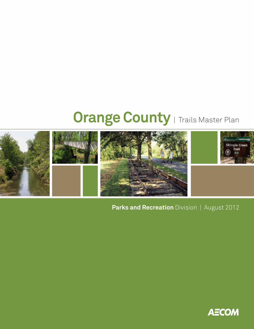
Orange County | Trails Master Plan
Parks and Recreation Division | August 2012
Orange County | Trails Master Plan UpdateAECOM
Parks and Recreation Division | 2012
1
Table of Contents
Acknowledgements
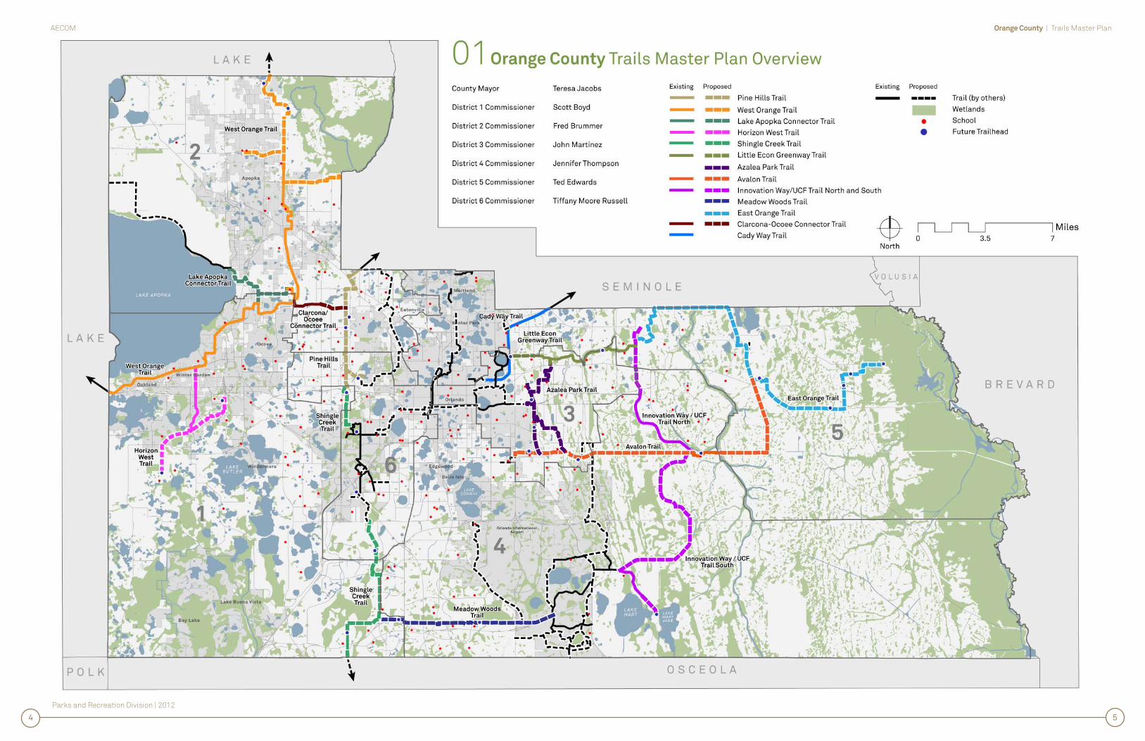
01 County-wide Trails System Executive Summary and Map
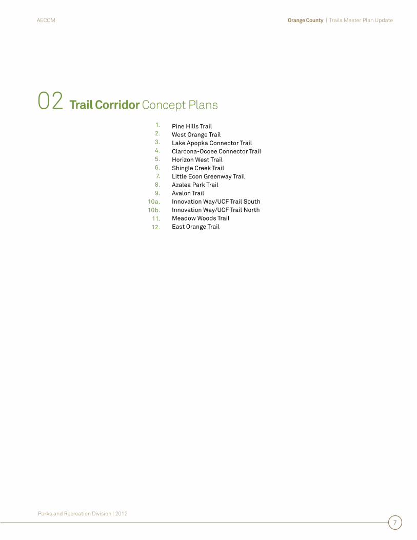
02 Trail Corridor Concept Plans
Pine Hills Trail
West Orange Trail
Lake Apopka Connector Trail
Clarcona-Ocoee Connector Trail
Horizon West Trail
Shingle Creek Trail
Little Econ Greenway Trail
Azalea Park Trail
Avalon Trail
Innovation Way/UCF Trail South
Innovation Way/UCF Trail North
Meadow Woods Trail
East Orange Trail
03 Implementation and Management Plan
Design and Construction Costs
Funding Assessment
Operations and Maintenance Program
04 Appendices
Corridor Evaluation Matrix
Existing/Proposed Trail Mileage
1.2.3.4.5.6.7.8.9.
10a.10b.
11.12.
1.2.3.
1.2.

Orange County | Trails Master Plan UpdateAECOM
Parks and Recreation Division | 2012
2
Acknowledgements
We would like to thank the Orange County Board of County Commissioners, Administration, Staff and Consulting Team for this update to the Orange County Trails Master Plan:
County Mayor Teresa Jacobs
District 1 Commissioner S. Scott Boyd
District 2 Commissioner Frederick C. Brummer
District 3 Commissioner John M. Martinez
District 4 Commissioner Jennifer Thompson
District 5 Commissioner Ted B. Edwards
District 6 Commissioner Tiffany Moore Russell
County Administrator Ajit Lalchandani
Orange County Parks and Recreation Division
Matt Suedmeyer, Manager
Bill Thomas, Planner III
AECOM Design + Planning
Bruce Hall, RLA, Project Manager
Kathy O’Sullivan, GIS Technician
David Barth, ASLA, AICP, CPRP, Principal Planner
Derek Baker, Graphic Designer

01
Co
un
ty-W
ide
Trails
Sy
ste
m E
xec
utive
Su
mm
ary

Orange County | Trails Master PlanAECOM
Parks and Recreation Division | 2012
Orange County | Trails Master PlanAECOM
Parks and Recreation Division | 2012
Imagine a system of nearly 170 miles of wide, paved, multi-purpose trails throughout Orange County, connecting residents and visitors to neighborhoods, parks, schools, offi ces, shopping, natural areas and attractions. Imagine families and individuals of all ages and abilities walking, running, bicycling and skating for both recreation and alternative means of transportation, just as they do today on Orange County’s West Orange Trail and Little-Econ Greenway Trail. And imagine new opportunities for economic development, social interaction and environmental protection and enhancement along the Trail corridors. This is the Vision behind the Orange County Trails Master Plan, a long range plan updated in 2012 by the Orange County Parks and Recreation Division.
The Orange County Trails Master Plan focuses only on the proposed system of wide, paved, multi-purpose trails that will form the “backbone” of the County’s bikeways and trails system vision. Other facilities such as sidewalks, bike lanes, hiking trails and “sharrows” (shared streets) are not included in the Plan, as they are generally being constructed throughout the County to provide the “fi ne grain” of facilities needed to connect to the Trails System and complete the bicycle/pedestrian network.
01 County-Wide Trails System Executive Summary
The Trails Master Plan focuses on the conceptual design of twelve (12) multi-use corridors:
Pine Hills Trail West Orange Trail Lake Apopka Connector Trail Clarcona-Ocoee Connector Trail Horizon West Trail Shingle Creek Trail Little Econ Greenway Trail Azalea Park Trail Avalon Trail Innovation Way/UCF Trail South Innovation Way/UCF Trail North Meadow Woods Trail East Orange Trail
During the Master Planning process, each trail corridor was visited and evaluated for suitability as a multi-purpose trail corridor and for the feasibility of implementation. Proposed trail routes were photographed and mapped, and previous construction estimates were reviewed and updated. The corridors were then evaluated, scored and ranked based on defi ned criteria. Finally, a maintenance and management strategy was developed to guide the operations of the Trails System.
Trail Corridor Ranking
Ranking Criteria
Population and Density
Public Ownership
Scenic/Aesthetic Value
Transportation Value
Estimated Construction Cost per Mile
Catalyst for Economic Development
Promotes Urban Infi ll
Lack of other Bicycle/Pedestrian Facilities
Connected to other Trail Corridors
Available Grant Funding
Project Rankings (based on Criteria)
1 Shingle Creek Trail - 78 Points
2 Little Econ Greenway Phase 3 - 68 Points
3 Pine Hills Trail - 65 Points
4 Innovation Way/UCF Trail (North and South) - 59 Points
5 Lake Apopka Connector Trail - 58 Points
6 Horizon West Trail - 57 Points
7 (Tied) Avalon Trail - 56 Points
7 (Tied) Meadow Woods Trail - 56 Points
9 Azalea Park Trail - 55 Points
10 East Orange Trail - 52 Points
11 (Tied) West Orange Trail Phase 4 - 51 Points
11 (Tied) Clarcona-Ocoee Connector Trail - 51 Points
1.2.3.4.5.6.7.8.9.
10a.10b.
11.12.
36
Parks and Recreation Division | 2012
Orange County | Trails Master PlanAECOM
54

02
Trail C
orrid
or C
on
ce
pt P
lan
s
Orange County | Trails Master Plan UpdateAECOM
Parks and Recreation Division | 2012
7
02 Trail Corridor Concept Plans
Pine Hills Trail West Orange Trail Lake Apopka Connector Trail Clarcona-Ocoee Connector Trail Horizon West Trail Shingle Creek Trail Little Econ Greenway Trail Azalea Park Trail Avalon Trail Innovation Way/UCF Trail South Innovation Way/UCF Trail North Meadow Woods Trail East Orange Trail
1.2.3.4.5.6.7.8.9.
10a.10b.
11.12.

1. P
ine
Hills
Trail
Orange County | Trails Master PlanAECOM
Parks and Recreation Division | 2012
Orange County | Trails Master PlanAECOM
Parks and Recreation Division | 2012
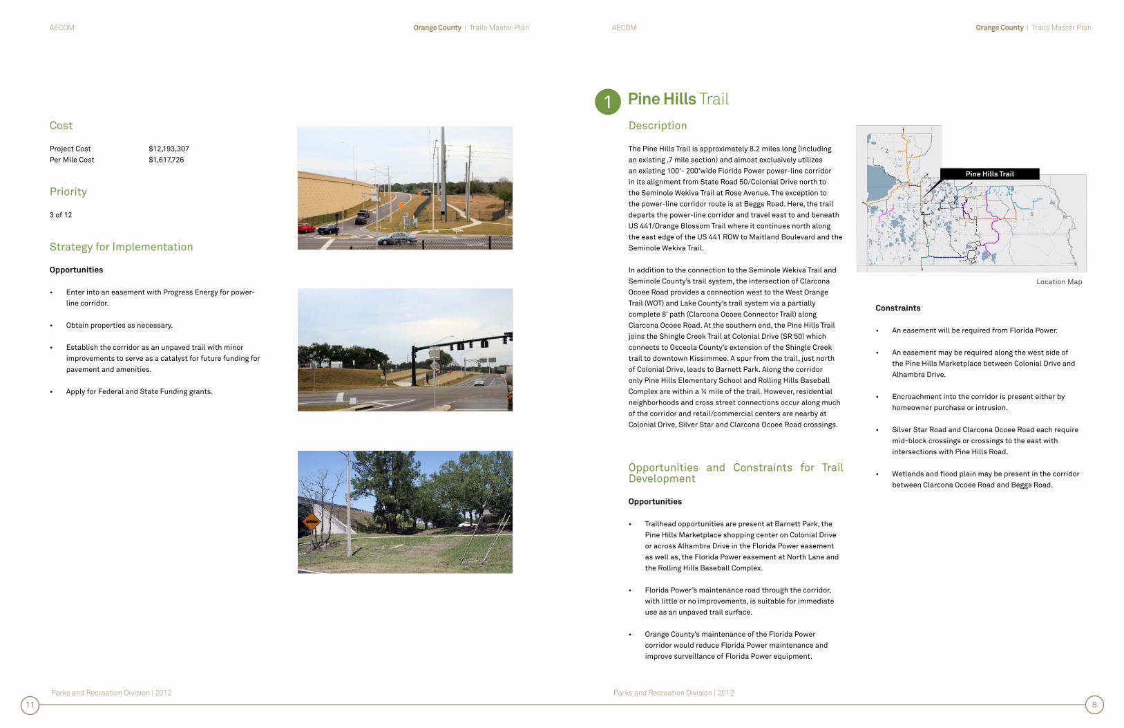
Pine Hills Trail
Description
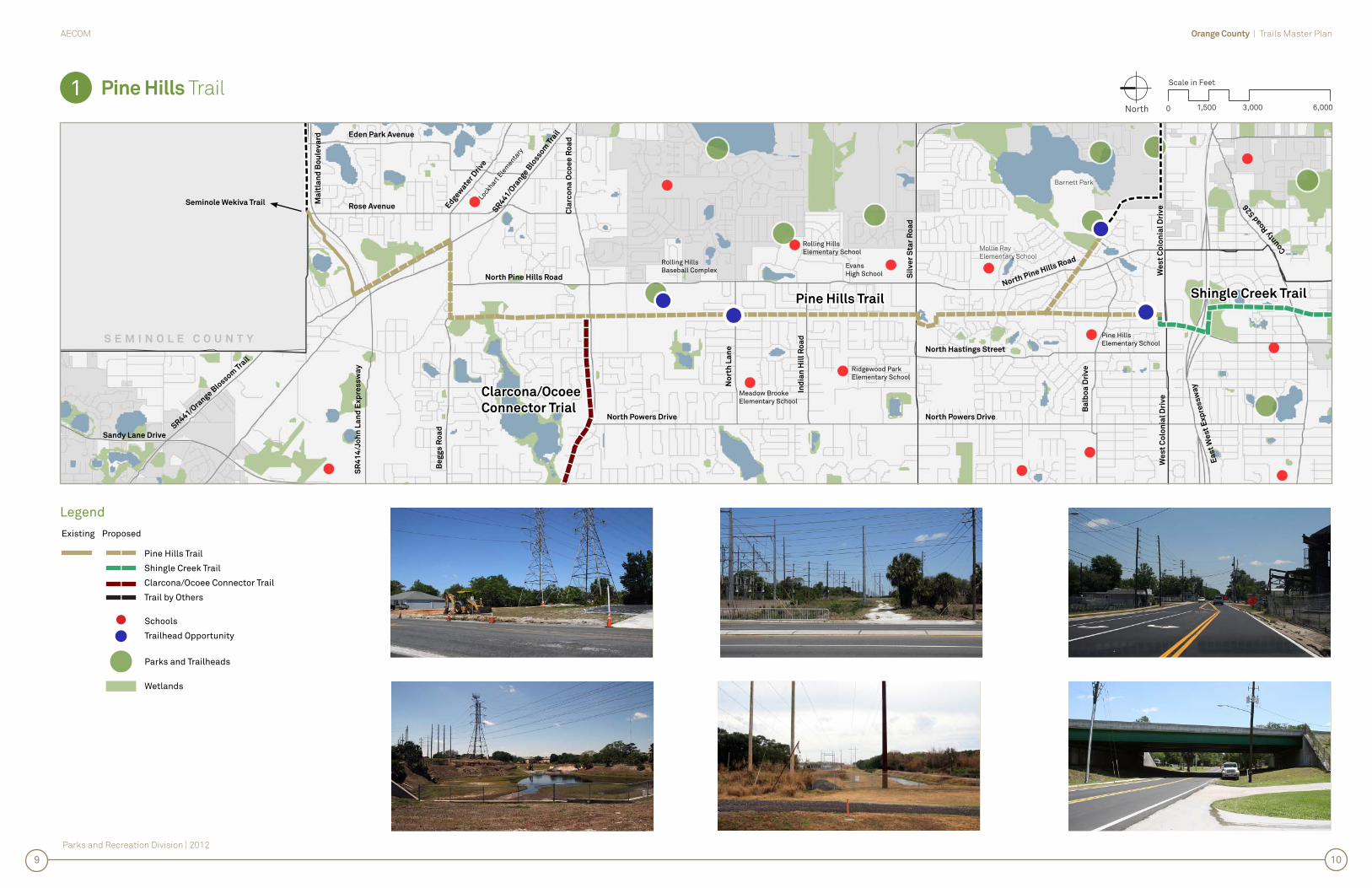
The Pine Hills Trail is approximately 8.2 miles long (including an existing .7 mile section) and almost exclusively utilizes an existing 100’- 200’wide Florida Power power-line corridor in its alignment from State Road 50/Colonial Drive north to the Seminole Wekiva Trail at Rose Avenue. The exception to the power-line corridor route is at Beggs Road. Here, the trail departs the power-line corridor and travel east to and beneath US 441/Orange Blossom Trail where it continues north along the east edge of the US 441 ROW to Maitland Boulevard and the Seminole Wekiva Trail.
In addition to the connection to the Seminole Wekiva Trail and Seminole County’s trail system, the intersection of Clarcona Ocoee Road provides a connection west to the West Orange Trail (WOT) and Lake County’s trail system via a partially complete 8’ path (Clarcona Ocoee Connector Trail) along Clarcona Ocoee Road. At the southern end, the Pine Hills Trail joins the Shingle Creek Trail at Colonial Drive (SR 50) which connects to Osceola County’s extension of the Shingle Creek trail to downtown Kissimmee. A spur from the trail, just north of Colonial Drive, leads to Barnett Park. Along the corridor only Pine Hills Elementary School and Rolling Hills Baseball Complex are within a ¼ mile of the trail. However, residential neighborhoods and cross street connections occur along much of the corridor and retail/commercial centers are nearby at Colonial Drive, Silver Star and Clarcona Ocoee Road crossings.
Opportunities and Constraints for Trail Development
Opportunities
• Trailhead opportunities are present at Barnett Park, the Pine Hills Marketplace shopping center on Colonial Drive or across Alhambra Drive in the Florida Power easement as well as, the Florida Power easement at North Lane and the Rolling Hills Baseball Complex.
• Florida Power’s maintenance road through the corridor, with little or no improvements, is suitable for immediate use as an unpaved trail surface.
• Orange County’s maintenance of the Florida Power corridor would reduce Florida Power maintenance and improve surveillance of Florida Power equipment.
Constraints
• An easement will be required from Florida Power.
• An easement may be required along the west side of the Pine Hills Marketplace between Colonial Drive and Alhambra Drive.
• Encroachment into the corridor is present either by homeowner purchase or intrusion.
• Silver Star Road and Clarcona Ocoee Road each require mid-block crossings or crossings to the east with intersections with Pine Hills Road.
• Wetlands and fl ood plain may be present in the corridor between Clarcona Ocoee Road and Beggs Road.
Cost
Project Cost $12,193,307Per Mile Cost $1,617,726
Priority
3 of 12
Strategy for Implementation
Opportunities
• Enter into an easement with Progress Energy for power-line corridor.
• Obtain properties as necessary.
• Establish the corridor as an unpaved trail with minor improvements to serve as a catalyst for future funding for pavement and amenities.
• Apply for Federal and State Funding grants.
1
Location Map
Pine Hills Trail
811
Parks and Recreation Division | 2012
Orange County | Trails Master PlanAECOM
Pine Hills Trail
Legend
1 North 0
Scale in Feet
3,0001,500 6,000
Pine Hills Trail
Shingle Creek Trail
Clarcona/Ocoee Connector Trail
Trail by Others
Schools
Trailhead Opportunity
Parks and Trailheads
Wetlands
Existing Proposed
109
Pine Hills TrailPine Hills Trail
North Pine Hills Road
No
rth
La
ne
Ind
ian
Hil
l R
oa
d
Sil
ve
r S
tar
Ro
ad
S E M I N O L E C O U N T Y
North Powers Drive
Shingle Creek TrailShingle Creek Trail
Ea
st
We
st
Ex
pre
ss
wa
y
North Hastings Street
Cla
rco
na
Oc
oe
e R
oa
d
Be
gg
s R
oa
d
SR
441/Ora
nge Blo
ssom T
rail
Rose Avenue
We
st
Co
lon
ial
Dri
ve
We
st
Co
lon
ial
Dri
ve
County
Road 5
26
SR441/Ora
nge Blo
ssom Tra
il
North Powers Drive
North Pine Hills Road
Sandy Lane Drive
Edgew
ater D
rive
Eden Park Avenue
Ba
lbo
a D
riv
e
Seminole Wekiva Trail
Clarcona/OcoeeClarcona/Ocoee
Connector TrialConnector Trial
Ma
itla
nd
Bo
ule
va
rd
SR
41
4/J
oh
n L
an
d E
xp
res
sw
ay
Lock
hart Ele
menta
ry
Rolling HillsElementary School
EvansHigh School
Mollie Ray
Elementary School
Meadow BrookeElementary School
Ridgewood ParkElementary School
Rolling HillsBaseball Complex
Pine HillsElementary School
Barnett Park

2.
We
st O
ran
ge
Trail
Orange County | Trails Master PlanAECOM
Parks and Recreation Division | 2012
Orange County | Trails Master PlanAECOM
Parks and Recreation Division | 2012
West Orange Trail
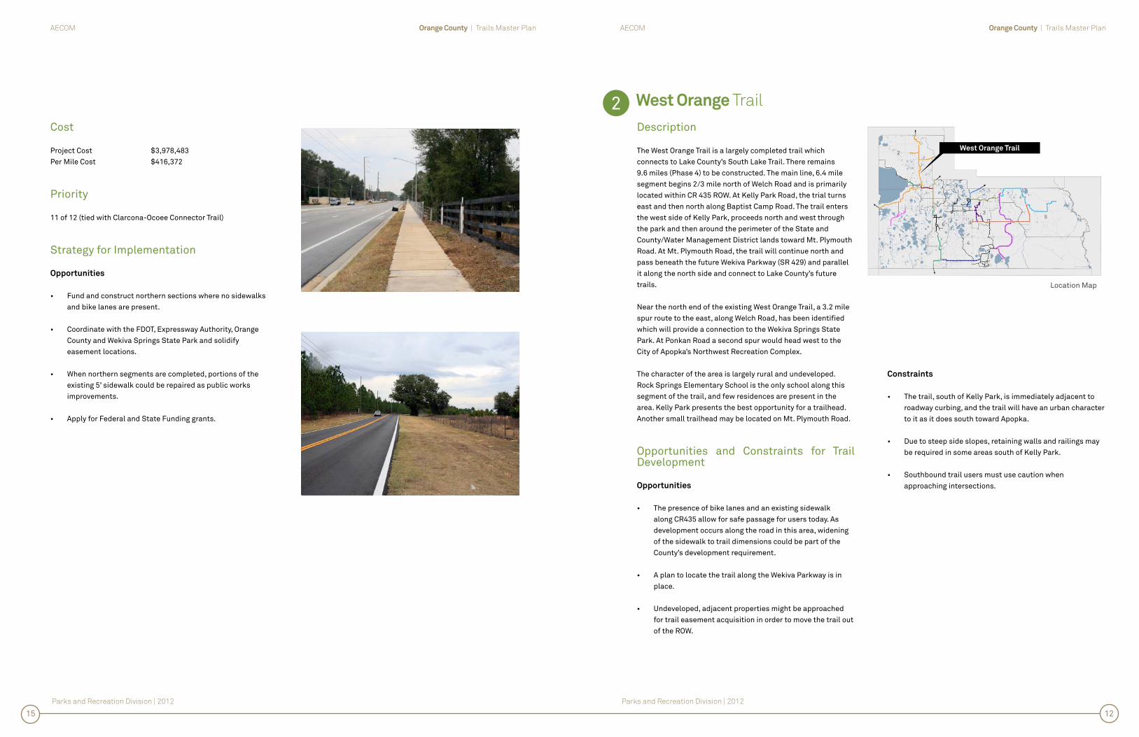
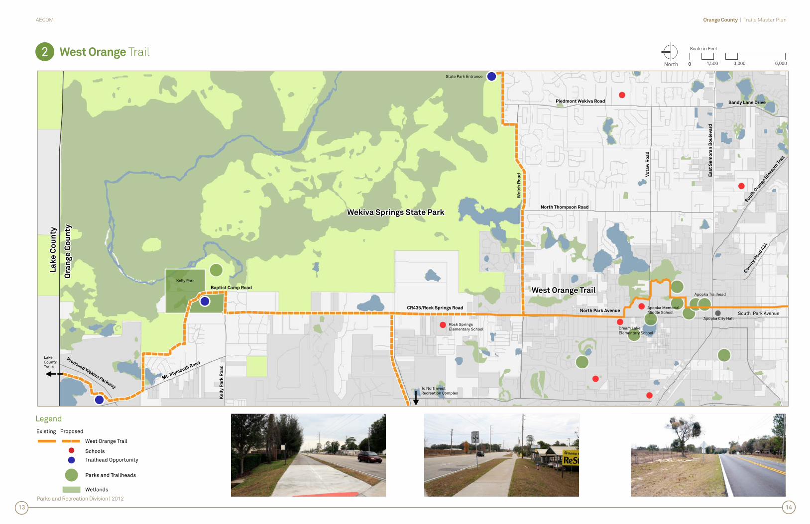
Description
The West Orange Trail is a largely completed trail which connects to Lake County’s South Lake Trail. There remains 9.6 miles (Phase 4) to be constructed. The main line, 6.4 mile segment begins 2/3 mile north of Welch Road and is primarily located within CR 435 ROW. At Kelly Park Road, the trial turns east and then north along Baptist Camp Road. The trail enters the west side of Kelly Park, proceeds north and west through the park and then around the perimeter of the State and County/Water Management District lands toward Mt. Plymouth Road. At Mt. Plymouth Road, the trail will continue north and pass beneath the future Wekiva Parkway (SR 429) and parallel it along the north side and connect to Lake County’s future trails.
Near the north end of the existing West Orange Trail, a 3.2 mile spur route to the east, along Welch Road, has been identifi ed which will provide a connection to the Wekiva Springs State Park. At Ponkan Road a second spur would head west to the City of Apopka’s Northwest Recreation Complex.
The character of the area is largely rural and undeveloped. Rock Springs Elementary School is the only school along this segment of the trail, and few residences are present in the area. Kelly Park presents the best opportunity for a trailhead. Another small trailhead may be located on Mt. Plymouth Road.
Opportunities and Constraints for Trail Development
Opportunities
• The presence of bike lanes and an existing sidewalk along CR435 allow for safe passage for users today. As development occurs along the road in this area, widening of the sidewalk to trail dimensions could be part of the County’s development requirement.
• A plan to locate the trail along the Wekiva Parkway is in place.
• Undeveloped, adjacent properties might be approached for trail easement acquisition in order to move the trail out of the ROW.
Constraints
• The trail, south of Kelly Park, is immediately adjacent to roadway curbing, and the trail will have an urban character to it as it does south toward Apopka.
• Due to steep side slopes, retaining walls and railings may be required in some areas south of Kelly Park.
• Southbound trail users must use caution when approaching intersections.
Cost
Project Cost $3,978,483Per Mile Cost $416,372
Priority
11 of 12 (tied with Clarcona-Ocoee Connector Trail)
Strategy for Implementation
Opportunities
• Fund and construct northern sections where no sidewalks and bike lanes are present.
• Coordinate with the FDOT, Expressway Authority, Orange County and Wekiva Springs State Park and solidify easement locations.
• When northern segments are completed, portions of the existing 5’ sidewalk could be repaired as public works improvements.
• Apply for Federal and State Funding grants.
2
Location Map
West Orange Trail
1215
Parks and Recreation Division | 2012
Orange County | Trails Master PlanAECOM
Parks and Recreation Division | 2012
West Orange Trail1 North 0
Scale in Feet
3,0001,500 6,000
Parks and Recreation Division | 2012
2 0
Legend
West Orange Trail
Existing Proposed
Schools
Trailhead Opportunity
Parks and Trailheads
Wetlands
To NorthwestRecreation Complex
1413
West Orange TrailWest Orange Trail
CR435/Rock Springs RoadNorth Park Avenue
Ea
st
Se
mo
ran
Bo
ule
va
rd
South
Ora
nge Blo
ssom T
rail
South Park Avenue
Vo
taw
Ro
ad
North Thompson Road
Piedmont Wekiva Road
County
Road
424
Sandy Lane Drive
Wekiva Springs State ParkWekiva Springs State Park
La
ke
Co
un
tyL
ak
e C
ou
nty
Ora
ng
e C
ou
nty
Ora
ng
e C
ou
nty
Kelly Park
Rock SpringsElementary School Dream Lake
Elementary School
Apopka MemorialMiddle School
Apopka City Hall
LakeCountyTrails
Baptist Camp Road
Proposed Wekiva Parkway
Ke
lly
Pa
rk R
oa
d
Mt. Plymouth Road
We
lch
Ro
ad
State Park Entrance
Apopka Trailhead

3.
La
ke
Ap
op
ka
Co
nn
ec
tor Tra
il

Orange County | Trails Master PlanAECOM
Parks and Recreation Division | 2012
Orange County | Trails Master PlanAECOM
Parks and Recreation Division | 2012
Lake Apopka Connector Trail
Description
The Lake Apopka Connector Trail is approximately 5.4 miles long (including an existing .6 mile section north of Magnolia Park) and links the West Orange Trail to the SJRWMD Lake Apopka Loop Trail. The trail has two routes which connect to the West Orange Trail and will meet the needs of trail users. The east/west segment begins on Damon Road at Clarcona’s Horseman Park Trailhead and travels south to McCormick Road where it continues west to the Orange County Reclamation Property. The reclamation facility is the point where the two routes meet and the north/south route travels south on Ingram Road to the West Orange Trail. On the west side of the reclamation facility, the Connector joins an abandoned segment of roadway adjacent to SR 429/Western Beltway, travels north to CR 437A, and then south to Binion Road, then along Binion Road to Magnolia Park (on the shore of Lake Apopka), which will serve as a trailhead prior to the existing trail segment connecting to the SJRWMD Lake Apopka Loop Trail.
The corridor travels through a rural section of Orange County and directly serves only a small amount of residences and no retail/commercial stores. However, the trail will provide a connection to Clarcona Elementary School for area residents and ties into the existing SJRWMD north of Magnolia Park.
Opportunities and Constraints for Trail Development
Opportunities
• The trail is an important connection between Orange County’s trails system and those of SJRWMD and Lake County.
• A sidewalk is present in the north half of the Ingram Road section and an inexpensive, but narrow, connection to the West Orange Trail could easily be constructed.
Constraints
• The east/west connection along McCormick Road is longer and more expensive to construct but would require less acquisition than the connection south along Ingram Road.
• ROW constraints on Ingram Road would require acquisition to construct a wider trail.
Cost
Project Cost $4,079,880Per Mile Cost $842,726
Priority
5 of 12
Strategy for Implementation
Opportunities
• Orange County’s property comprise the majority of the route. However, the entire project will need to be constructed at one time to be of use.
• Apply for Federal and State Funding grants.
3
Location Map
Lake Apopka Connector Trail
1619

Parks and Recreation Division | 2012
Orange County | Trails Master PlanAECOM
Lake Apopka Connector Trail1 North 0
Scale in Feet
3,0001,500 6,000
3
Legend
Lake Apopka Connector Trail
West Orange Trail
Clarcona/Ocoee Connector Trail
Pine Hills Trail
Trail (by others)
Existing Proposed
Schools
Trailhead Opportunity
Parks and Trailheads
Wetlands
1817
West Orange TrailWest Orange Trail
Beggs Road
Lake ApopkaLake Apopka
Connector TrailConnector Trail
Co
un
ty R
oa
d 4
37
/Oc
oe
e A
po
pk
a R
oa
d Ro
ute
42
9 To
ll Ro
ad
Co
un
ty Ro
ad
43
7
Clarcona Ocoee Road
County Road 424
Cla
rco
na
Ro
ad
L A K E A P O P K A
Clarcona/OcoeeClarcona/Ocoee
Connector TrailConnector Trail
Pine Hills TrailPine Hills TrailMcCormick Road
Magnolia Park
Binson Road
Ing
ram
Ro
ad
ClarconaHorseman’s Park
ClarconaElementary School
ClarconaCommunity Center
Apopka VinelandOutpost
Da
mo
n R
oa
d

4.
Cla
rco
na
-Oc
oe
e C
on
ne
cto
r Trail

Orange County | Trails Master PlanAECOM
Parks and Recreation Division | 2012
Orange County | Trails Master PlanAECOM
Parks and Recreation Division | 2012
Clarcona-Ocoee
Connector Trail
Description
The Clarcona-Ocoee Connector Trail is approximately 3.3 miles long (including an existing 1.7 mile section) and connects the Pine Hills Trail to the West Orange Trail via Clarcona-Ocoee Road. An existing 5’ sidewalk is already present from the Pine Hills Trail west to Hiawassee Road. To the west, new roadway construction to Apopka Vineland Road has included a 10’ trail and a sidewalk is parallel to Apopka Vineland, north to the West Orange Trail. A short segment of sidewalk and railroad crossing exists along Apopka-Vineland Road.
No schools are present within a ¼ mile, and only the Clarcona Community Center is served by the trail. However, residents along Clarcona-Ocoee Road will be served by the development of this connector trail, and at a larger scale, the connector will help to link the regional trail system. Connections to the Pine Hills Trail and the West Orange Trail will complete direct connections to Seminole County, Lake County, and further south, Osceola County via the Shingle Creek Trail.
Opportunities and Constraints for Trail Development
Opportunities
• The existing sidewalks, despite the varying widths, allow this connector trail to be operational as soon as the Pine Hills Trail is constructed.
• Space is available in the ROW for sections of the 5’ sidewalk to be widened as funding permits.
Constraints
• No constraints were identifi ed.
Cost
Project Cost $572,454Per Mile Cost $356,013
Priority
11 of 12 (tied with West Orange Trail Phase 4)
Strategy for Implementation
• Enter into an agreement with Florida Central Railroad for a wider crossing on Apopka-Vineland in the future.
• Fund and construct Apopka-Vineland section fi rst.
• Construct Pine Hills Trail to Hiawassee Section as funding permits or as part of roadway improvements.
• Apply for Federal and State Funding grants.
4
Location Map
Clarcona/Ocoee Connector Trail
2023

Parks and Recreation Division | 2012
Orange County | Trails Master PlanAECOM
Clarcona-Ocoee Connector Trail4 North 0
Scale in Feet
3,0001,500 6,000
East Orange TrailEast Orange Trail
South Tanner Road
Innovation Way / UCFInnovation Way / UCF
Trail NorthTrail North
Nor
th T
anne
r R
oad
FL 420
Northwest Christmas Road
East Colonial Drive
Nor
th A
lafa
ya T
rail
University Boulevard
Rou
se R
oad
East West Expressway (Toll Road)
Chul
uota
Roa
d
Orlando Wetlands Park
McCulloch Road
Little EconLittle Econ
Greenway TrailGreenway Trail
Legend
Clarcona/Ocoee Connector Trail
Lake Apopka Connector Trail
West Orange Trail
Pine Hills Trail
Trail (by others)
Existing Proposed
Schools
Trailhead Opportunity
Parks and Trailheads
Wetlands
2221
Clarcona-Ocoee Connector TrailClarcona-Ocoee Connector Trail
Pine HillsPine Hills
TrailTrail
West Orange TrailWest Orange Trail
Lake Apopka Connector TrailLake Apopka Connector Trail
McCormick Road
Apopka VinelandOutpost
ClarconaElementary School
ClarconaHorseman’s Park
Clarcona-Ocoee Road
Hia
wa
ss
ee
Ro
ad
Ap
op
ka
Vin
ela
nd
Ro
ad
North Lane
Po
we
rs D
riv
e
Rolling Hills BaseballComplex
Beggs Road
SR441/Orange Blossom Trail

5.
Ho
rizon
We
st Tra
il

Orange County | Trails Master PlanAECOM
Parks and Recreation Division | 2012
Orange County | Trails Master PlanAECOM
Parks and Recreation Division | 2012
Horizon West Trail
Description
The undeveloped portion of the Horizon West Trail is approximately 4.4 miles long along its primary route and includes a 3 mile spur connection to Orange County’s West Orange Park. Approximately 50% of the combined trail and spur route are located in the SR 419/Western Beltway dedicated trail corridor. The southern limit of the trail is Orange County’s Horizon West Sports Complex site, and the northern end is the West Orange Trail in Downtown Winter Garden. The trail travels north along Tiny Road ROW to Tilden Road where it joins the SR 419 ROW easement north to Daniels Road/CR 535. At CR 535, private development and roadway widening within the City of Winter Garden have enabled the trail to be completed to Colonial Drive/SR 50. North of SR 50, the corridor continues to Plant Street where the Horizon West Trail connects to an existing segment of the West Orange Trail and the Winter Garden Station trailhead. The spur route of the Horizon West Trail extends to the northeast from Daniels Road/CR 535, again in dedicated SR 419 trail corridor, to West Orange Park.
Along the Horizon West Trail Corridor Whispering Oak Elementary School, Dillard Street Elementary School and West Orange High School are each within a ¼ mile of the corridor. Residential communities, retail/commercial centers and Downtown Winter Garden all line the corridor, allowing both businesses and residents to benefi t from further development of the trail. Completion of this trail will tie the County trail system into the developer built system in Horizon West.
Opportunities and Constraints for Trail Development
Opportunities
• The segment of the trail between SR 50 and Plant Street could be integrated as part of a Dillard Street streetscape project.
• The entire route from Tilden Road to West Orange Park is within a dedicated corridor and available for implementation immediately with no acquisition required.
• Implementation of the trail in the SR 429 corridor segment serves a large residential population and connects them to retail and the regional trail system via the West Orange Trail, the South Lake Trail, the Apopka Loop Trail, Clarcona-Ocoee Connector Trail, Pine Hills Trail and the Seminole Wekiva Trail.
Constraints
• The Dillard Street segment ROW contains sidewalks; however, it is constrained by multiple driveway cuts, utility poles and limited opportunity for widening beyond the existing 5’ sidewalk width. Sidewalk/trail improvements could be integrated into a City initiated streetscape improvement which may accommodate a wider sidewalk.
Cost
Project Cost $6,284,451Per Mile Cost $845,248
Priority
6 of 12
Strategy for Implementation
Opportunities
• Construct the Dillard Street improvements as part of an overall streetscape renovation project with the City of Winter Garden.
• Construct the SR 429 frontage prior to any other portion as this is the simplest to construct and will link the most residents to one another and to retail/shopping.
• Apply for Federal and State Funding grants.
5
Location Map
Horizon West Trail
2427

Parks and Recreation Division | 2012
Orange County | Trails Master PlanAECOM
Horizon West Trail1 North 0
Scale in Feet
3,0001,500 6,000
5
Legend
Horizons West Trail
West Orange Trail
Existing Proposed
Schools
Trailhead Opportunity
Parks and Trailheads
Wetlands
2625
County Road 535
Horizon West TrailHorizon West Trail
West Orange TrailWest Orange Trail
Flo
rid
a’s
Tu
rnp
ike
To
ll R
oa
d
We
st
Co
lon
ial
Dri
ve
We
st
Sto
ry R
oa
d
Ea
st P
lan
t Stre
et
Ea
st
Sto
ry R
oa
d
Beulah Road
Wa
rrio
r R
oa
d
County Road 535
Stoneybrook W
est Parkway
Avalon Road
Til
de
n R
oa
d
La
ke
Bu
tle
r B
ou
lev
ard
County
Road 5
35
Ficq
ue
tte R
oa
d
L A K E A P O P K A
B L A C KL A K E
L A K ER O B E R T S
L A K EC R E S C E N T
L A K E B U T L E R
L A K E S P E E R
Dillard StreetElementary Street
Winter GardenRecreation Department
Winter GardenStation Trailhead
Irrgan Park
West OrangeHigh School
West Orange Park
Whispering OakElementary School
Horizon WestSports Complex
BridgewaterMiddle School
SR
42
9
SR 429

6.
Sh
ing
le C
ree
k Tra
il
Orange County | Trails Master PlanAECOM
Parks and Recreation Division | 2012
Orange County | Trails Master PlanAECOM
Parks and Recreation Division | 2012
Shingle Creek Trail
Description
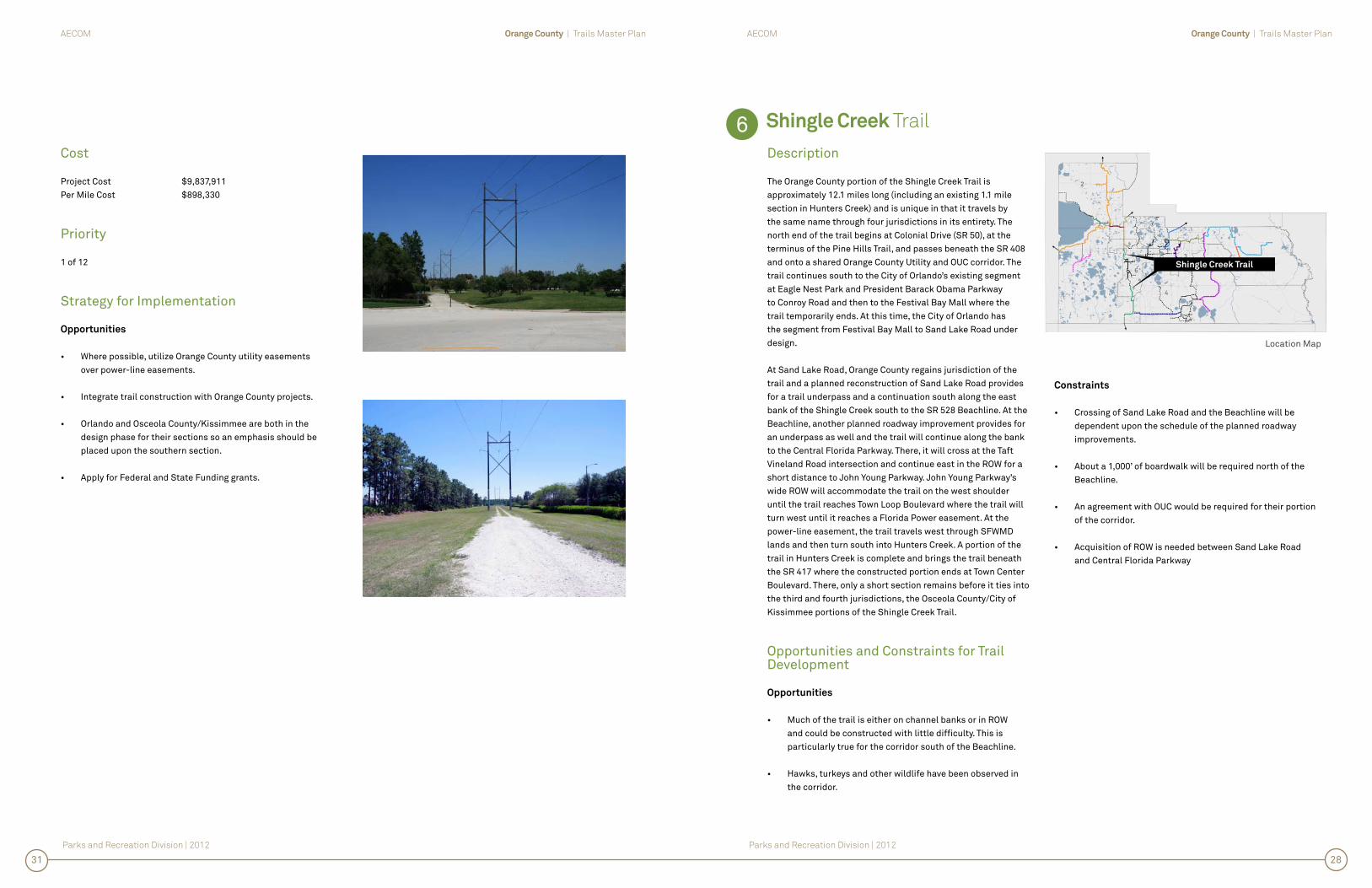
The Orange County portion of the Shingle Creek Trail is approximately 12.1 miles long (including an existing 1.1 mile section in Hunters Creek) and is unique in that it travels by the same name through four jurisdictions in its entirety. The north end of the trail begins at Colonial Drive (SR 50), at the terminus of the Pine Hills Trail, and passes beneath the SR 408 and onto a shared Orange County Utility and OUC corridor. The trail continues south to the City of Orlando’s existing segment at Eagle Nest Park and President Barack Obama Parkway to Conroy Road and then to the Festival Bay Mall where the trail temporarily ends. At this time, the City of Orlando has the segment from Festival Bay Mall to Sand Lake Road under design.
At Sand Lake Road, Orange County regains jurisdiction of the trail and a planned reconstruction of Sand Lake Road provides for a trail underpass and a continuation south along the east bank of the Shingle Creek south to the SR 528 Beachline. At the Beachline, another planned roadway improvement provides for an underpass as well and the trail will continue along the bank to the Central Florida Parkway. There, it will cross at the Taft Vineland Road intersection and continue east in the ROW for a short distance to John Young Parkway. John Young Parkway’s wide ROW will accommodate the trail on the west shoulder until the trail reaches Town Loop Boulevard where the trail will turn west until it reaches a Florida Power easement. At the power-line easement, the trail travels west through SFWMD lands and then turn south into Hunters Creek. A portion of the trail in Hunters Creek is complete and brings the trail beneath the SR 417 where the constructed portion ends at Town Center Boulevard. There, only a short section remains before it ties into the third and fourth jurisdictions, the Osceola County/City of Kissimmee portions of the Shingle Creek Trail.
Opportunities and Constraints for Trail Development
Opportunities
• Much of the trail is either on channel banks or in ROW and could be constructed with little diffi culty. This is particularly true for the corridor south of the Beachline.
• Hawks, turkeys and other wildlife have been observed in the corridor.
Constraints
• Crossing of Sand Lake Road and the Beachline will be dependent upon the schedule of the planned roadway improvements.
• About a 1,000’ of boardwalk will be required north of the Beachline.
• An agreement with OUC would be required for their portion of the corridor.
• Acquisition of ROW is needed between Sand Lake Road and Central Florida Parkway
Cost
Project Cost $9,837,911Per Mile Cost $898,330
Priority
1 of 12
Strategy for Implementation
Opportunities
• Where possible, utilize Orange County utility easements over power-line easements.
• Integrate trail construction with Orange County projects.
• Orlando and Osceola County/Kissimmee are both in the design phase for their sections so an emphasis should be placed upon the southern section.
• Apply for Federal and State Funding grants.
6
Location Map
Shingle Creek Trail
2831

Parks and Recreation Division | 2012
Orange County | Trails Master PlanAECOM
Shingle Creek TrailNorth 0
Scale in Feet
6,0003,000 12,000
6
Central F
lori
da
Gre
en
ew
ay
41
7
Legend
Shingle Creek Trail
Pine Hills Trail
Meadow Woods Trail
Trail (by others)
Existing Proposed
Schools
Trailhead Opportunity
Parks and Trailheads
Wetlands
3029
Shingle Creek TrailShingle Creek Trail
Florid
a’s Turnpike Toll
Road
Shingle Creek TrailShingle Creek Trail
Pine Hills TrailPine Hills Trail
Meadow Woods TrailMeadow Woods Trail
Vin
ela
nd
Ro
ad
South Kirkman Road
LB
Mc
Cle
od
Ro
ad
Sil
ve
r S
tar
Ro
ad
North Hastings Street
North Powers Drive
North Hiawassee Road
Ea
st
We
st
Ex
pre
ss
wa
y
Ind
ian
Hil
l R
oa
d
No
rth
La
ne
Interstate 4
John Young Parkway
South Orange Blossom Trail
Interstate 4
De
sti
na
tio
n P
ark
wa
y
Inte
rnatio
nal Driv
e
Un
ive
rsa
l B
ou
lev
ard
Ce
ntr
al
Flo
rid
a P
ark
wa
y
North Kirkman Road
Co
nro
y R
oa
d
Tow
n C
en
ter
Bo
ule
vard
Orlo VistaElementary School
Eagle’s NestElementary School
Poppy Head Park
EcclestonElementary School
CarverMiddle School
Ravenwall Park
Will Mays Park
Richmond HeightsElementary School
Oa
k R
idg
e R
oa
d
MilleniaElementary School
WaterbridgeElementary School John Young
Elementary School
Hunter’s CreekMiddle School
West CreekElementary School
SR
50
Co
lon
ial
Dri
ve
Eagle’s NestPark
Sa
nd
La
ke
Ro
ad
SR
48
2
Osceola/Kissimmee Trail

7. L
ittle E
co
n G
ree
nw
ay
Trail

Orange County | Trails Master PlanAECOM
Parks and Recreation Division | 2012
Orange County | Trails Master PlanAECOM
Parks and Recreation Division | 2012
Little Econ Greenway Trail Phase 3
Description
The Little Econ Greenway Trail is approximately 8.5 miles long and is almost entirely completed along Orange County stormwater banks from Alafaya Trail to SR 436/Semoran Boulevard. The remaining segment to be constructed (Phase 3) is approximately 1 mile long and spans from Forsyth Road to Semoran Boulevard with a bridge over Semoran Boulevard. Construction of this short segment is the only impediment to completing the trail which will connect to the Cady Way Trail and then north to the Cross-Seminole Trail, creating a network of trails 21 miles long.
The County has submitted to MetroPlan Orlando for an Enhancement Grant of the remaining Little Econ Greenway (Phase 3).
Opportunities and Constraints for Trail Development
Opportunities
• Upon obtaining ownership or easement, the trail could be opened immediately as an unpaved connection.
• Approximately 1,000’ of the corridor is parallel to Partridge Lane which is single loaded with industrial/warehouse use which could easily be modifi ed to a “sharrow” design.
• The County owns a parcel at the intersection of the Little Greenway and Cady Way Trail that will be developed as a trailhead.
Constraints
• Connection to the Cady Way Trail across Semoran Boulevard should be made with an overhead pedestrian structure due to a wide roadway crossing and the intersection’s presence in a curve.
• Property acquisition/easements will be required.
Cost
Project Cost $8,117,222Per Mile Cost $8,341,560
Priority
2 of 12
Strategy for Implementation
• Establish the corridor as an unpaved trail with minor improvements to serve as a catalyst for future funding for pavement and amenities.
• Public and Private partnerships with the Orange County School Board, commercial centers and neighborhoods for trailhead development and/or connections.
• Obtain support for the trail corridor with organizations such as the Florida National Scenic Trail, the Florida Fish and Wildlife Conservation Commission, the St Johns Water Management District, FDOT, neighborhood homeowners associations and bicycle advocacy groups.
• Apply for federal and state funding grants.
7
Location Map
Little Econ Greenway Trail
3235

Parks and Recreation Division | 2012
Orange County | Trails Master PlanAECOM
Little Econ Greenway Trail Phase 37 North 0
Scale in Feet
3,0001,500 6,000
Legend
Little Econ Greenway Trail
Azalea Park Trail
Innovation Way/UCF Trail North
East Orange Trail
Cady Way Trail
Trail (by others)
Existing Proposed
Schools
Trailhead Opportunity
Parks and Trailheads
Wetlands
3433
Little Econ Greenway TrailLittle Econ Greenway Trail
So
uth
Se
mo
ran
Bo
ule
va
rd
Azalea Park TrailAzalea Park Trail
Innovation Way / Innovation Way /
UCF Trail North UCF Trail North
East Orange TrailEast Orange Trail
No
rth
Fo
rsy
th R
oa
d
Hanging Moss Road
East Colonial Drive
Old Cheney Highway
No
rth
Go
lde
nro
d R
oa
d
Ce
ntr
al
Flo
rid
a G
ree
ne
wa
y 4
17
(To
ll R
oa
d)
No
rth
Ec
on
loc
kh
atc
he
e T
rail
No
rth
De
an
Ro
ad
Ro
us
e R
oa
d
No
rth
Ala
fay
a T
rail
East Colonial Drive
Wo
od
bu
ry R
oa
d
FL
42
0
L A K EB A L D W I N
Cady Way TrailCady Way Trail
CheneyElementary School
Union ParkMiddle School
Blanchard Park
RiverdaleElementary School
UniversityHigh School
Arcadia Acres Park

8.
Az
ale
a P
ark
Trail

Orange County | Trails Master PlanAECOM
Parks and Recreation Division | 2012
Orange County | Trails Master PlanAECOM
Parks and Recreation Division | 2012
Azalea Park Trail
Description
The Azalea Park Trail is approximately 7.5 miles long and connects the Avalon Trail to the Little Econ Greenway Trail. The alignment utilizes a combination of OUC power-line and Orange County drainage banks. In the southern ½ of the trail, between the Avalon Trail and Lake Underhill Road, there are two alternative routes. Alternative Route A utilizes an OUC easement; whereas, Alternative Route B utilizes an Orange County drainage way corridor. At Lake Underhill Road, Alternative A utilizes roadway ROW to reach an underpass of the SR 408 at Oxalis Avenue and then continues north toward the Little Econ Greenway Trail via OUC drainage banks. A short spur route connects Colonial High School to the trail corridor.
The trail corridor is an important part of the Orange County trail system because it is one of the eastern alignments through the County, which enables a north south connection to the Seminole County and Osceola County trail systems and further develops the regional system. For Orange County residents, the Azalea Park Trail helps to provide a link to reach downtown Orlando from as far east as the residential community of Wedgefi eld and Lake Nona to the south. Along the corridor, Liberty Middle School, Chickasaw Elementary School, Colonial High School and Colonial 9th Grade Center are each within a ¼ mile. Multiple residential communities and several retail/commercial centers are present, and two parks are connected. Trailheads can be placed at Liberty Middle School, Englewood Park, Capehart Park, Yucatan Neighborhood Park and Little Econ Greenway/SR 50 Trail.
Opportunities and Constraints for Trail Development
Opportunities
• OUC’s and Orange County’s maintenance roads through the corridor, with little or no improvements, are suitable for immediate use as an unpaved trail surface.
• There is a large population in this area of Orange County, along with a great number of schools which could be reached via a safer route than roadway ROW.
Constraints
• An agreement with OUC will be required.
• A portion of the Alternative A route abuts a golf course which may require buffering and screening for the safety of trail users since it is on the “slice” side of the fairways.
• On Alternative A, a wetland boardwalk will be required just north of the Avalon Trail since no power-line easement is present at the southernmost end.
• Both alternative routes require a crossing of Curry Ford Road at either mid-block locations or at signalized intersection approximately 800’ away.
• Alternate Route B crosses Goldenrod Road at one of two unsignalized intersections of which both are located in the same curve.
Cost
Project Cost $9,248,253Per Mile Cost $1,226,010
Priority
9 of 12
Strategy for Implementation
Opportunities
• Consider Alternate B as the priority route since it is in Orange County ownership or easement.
• Partnership with the City of Orlando for City served sections could expedite construction and reduce costs.
• Apply for federal and state funding grants.
8
Location Map
Azalea Park Trail
3639

Parks and Recreation Division | 2012
Orange County | Trails Master PlanAECOM
Azalea Park Trail8 North 0
Scale in Feet
3,0001,500 6,000
Legend
Azalea Park Trail
Avalon Trail
Little Econ Greenway Trail
Trail (by others)
Existing Proposed
Schools
Trailhead Opportunity
Parks and Trailheads
Wetlands
3837
Azalea Park TrailAzalea Park Trail
North Goldenrod Road
Avalon TrailAvalon Trail
Little EconLittle Econ
Greenway TrailGreenway Trail
Ea
st
Co
lon
ial
Dri
ve
Old
Ch
en
ey
Hig
hw
ay
North Chickasaw Trail
North Forsyth Road
Un
ive
rsit
y B
ou
lev
ard
Hall
Road
Central Florida Greeneway 417 (Toll Road)
La
ke
Un
de
rhil
l R
oa
d
Va
len
cia
Co
lle
ge
La
ne
Cu
rry
Ford R
oad
South Chickasaw Trail
Pe
rsh
ing
Av
en
ue
South Goldenrod Road
Co
un
ty R
oa
d 1
5
Alternate Route AAlternate Route A
Alternate Route BAlternate Route B
Colonial9th Grade Center
ColonialHigh School
Yucatan Neighborhood Park
Capeheart Park
Englewood Park
ChickasawElementary School
Leroy Hoquist Park
PinarElementary School
LibertyElementary School
VenturaElementary School
Valencia CommunityCollege

9.
Av
alo
n Tra
il

Orange County | Trails Master PlanAECOM
Parks and Recreation Division | 2012
Orange County | Trails Master PlanAECOM
Parks and Recreation Division | 2012
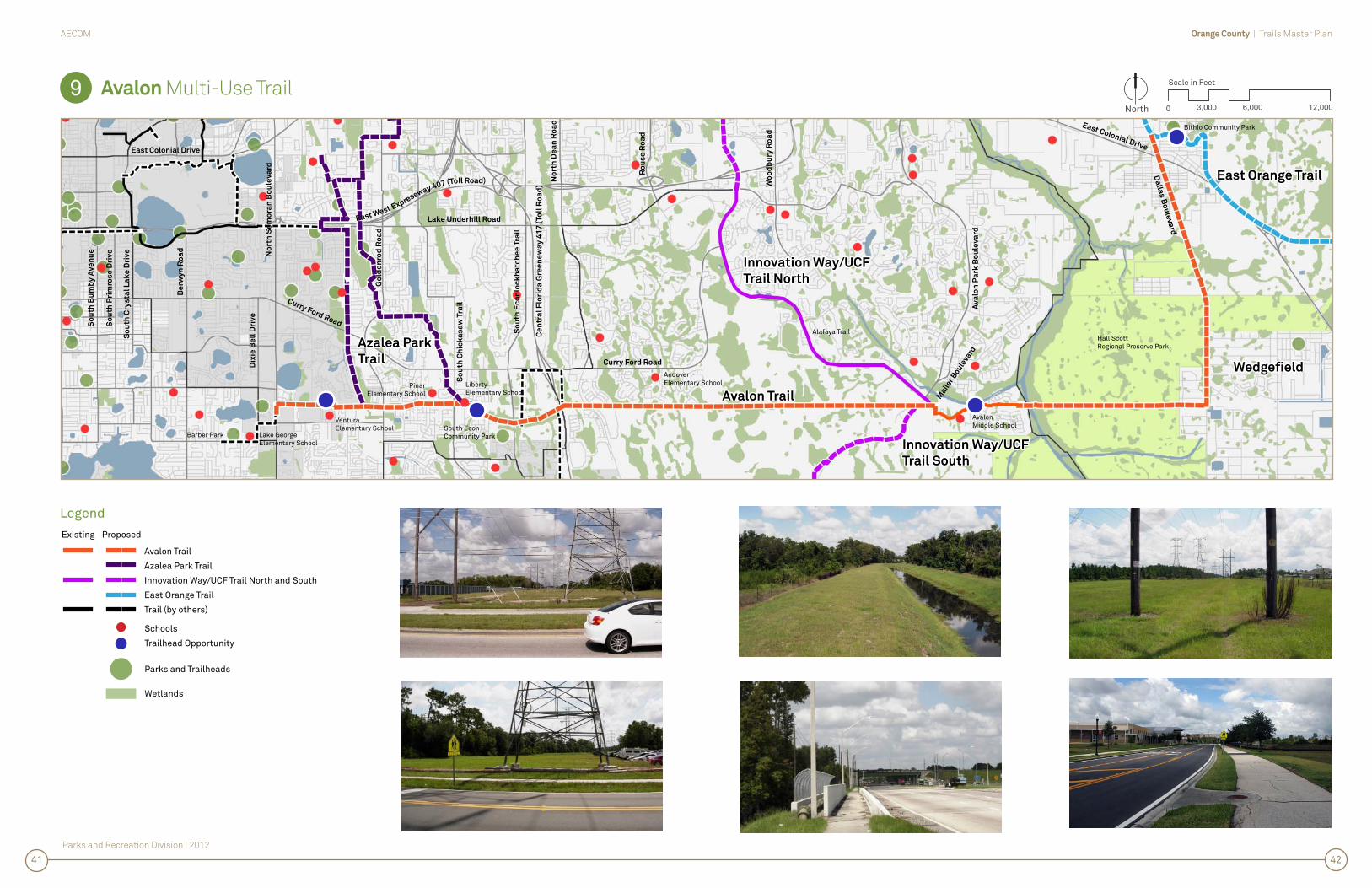
Avalon Trail
Description
The proposed portion of the Avalon Trail is approximately 16.3 miles long and is comprised of two legs. The longest leg, approximately 12.4 miles in length, is an east/west alignment within an OUC Power-line corridor extending from the community of Wedgefi eld, west to SR 436/Semoran Boulevard. The second leg, approximately 3.9 miles in length is a north/south alignment from the power-line corridor north to Bithlo Park in the Dallas Boulevard/CR13 ROW.
Within Orange County, the Avalon Trail connects directly to the Azalea Park Trail, the Innovation Way/UCF Trail and the East Orange Trail. These connections provide linkages to Orange County’s western trails, such as the Shingle Creek Trail and the West Orange Trail as well as the trails systems of Lake, Seminole and Osceola Counties. Along the Avalon Trail Corridor, Avalon Middle School, Andover Elementary School, Liberty Middle School, Pinar Elementary School and Ventura Elementary School are all within a ¼ mile distance. Bithlo Park, South Econ Community Park and Barber Park are all within a ¼ mile of the corridor as well. In addition to schools and parks, the communities of Bithlo, Wedgfi eld, Avalon, Union Park and Azalea Park are connected to one another along with several retail/commercial centers. A trailhead has recently been constructed in Avalon Park and each of the parks as well as some of the schools present opportunities for trailhead development as well.
Opportunities and Constraints for Trail Development
Opportunities
• OUC’s maintenance road through the corridor, with little or no improvements, is suitable for immediate use as an unpaved trail surface.
• An extension of the trail east, beyond Dallas Boulevard/County Road 13 and residential populations, can connect the trail to the St Johns River via already established segments of the Florida Scenic Trail. A representative of the Florida Fish and Wildlife Conservation Commission has expressed interest in this connection and in providing support for utilizing the development of this trail alignment. This extended access will further connect Wedgefi eld, SR 520 and the Canaveral Marshes Conservation Area to Orange County’s trail system.
• The existing “Bailey Bridge” crossing the Econlockhatchee River, just east of Avalon Park, appears to be in structurally good shape and is just in need of new decking.
• Hawks, turkeys, deer and other wildlife have been observed in the corridor as far east as the Econlockhatchee and Dean Road corridor crossings.
Constraints
• Much of the corridor appears that it may be within the 100 year fl ood plain.
• The power-lines at the SR 417 pose an impediment to the bridging the roadway within the corridor. However, acquiring easement on the south side of the corridor, on the back slope of an existing stormwater pond, could allow a crossing of the SR 417 to occur clear of the power-lines. An alternate, at grade route in the power-line corridor north to Curry Ford Road and east to the channelized Little Econlockhatchee River Bank, could also allow for a route “around” the SR 417.
• Much of the Dallas Boulevard segment is undeveloped shoulder and will require substantial clearing, fi ll and some bridging/boardwalk construction.
• An agreement with OUC would be required.
Cost
Project Cost $15,682,430Per Mile Cost $964,476
Priority
7 of 12 (tied with Meadow Woods Trail)
Strategy for Implementation
Opportunities
• Enter into an agreement with OUC to utilize the corridor.
• Establish the corridor as an unpaved trail with minor improvements to serve as a catalyst for future funding for pavement and amenities.
• Public and Private partnerships with the Orange County School Board, commercial centers and neighborhoods for trailhead development and/or connections.
• Obtain support for the trail corridor with organizations such as the Florida National Scenic Trail, the Florida Fish and Wildlife Conservation Commission, the St Johns Water Management District, FDOT, neighborhood homeowners associations and bicycle advocacy groups.
• Apply for federal and state funding grants.
9
Location Map
Avalon Trail
4043
Parks and Recreation Division | 2012
Orange County | Trails Master PlanAECOM
Avalon Multi-Use Trail9 North 0
Scale in Feet
6,0003,000 12,000
Legend
Avalon Trail
Azalea Park Trail
Innovation Way/UCF Trail North and South
East Orange Trail
Trail (by others)
Existing Proposed
Schools
Trailhead Opportunity
Parks and Trailheads
Wetlands
4241
Avalon TrailAvalon Trail
Curry Ford Road
So
uth
Cry
sta
l L
ak
e D
riv
e
So
uth
Pri
mro
se
Dri
ve
So
uth
Bu
mb
y A
ve
nu
e
Be
rwy
n R
oa
d
No
rth
Se
mo
ran
Bo
ule
va
rd
Dix
ie B
ell
Dri
ve
East Colonial Drive
East West Expressway 407 (Toll Road)
Ce
ntr
al
Flo
rid
a G
ree
ne
wa
y 4
17
(To
ll R
oa
d)
No
rth
De
an
Ro
ad
Lake Underhill Road
Ro
us
e R
oa
d
Curry Ford Road
Wo
od
bu
ry R
oa
d
Av
alo
n P
ark
Bo
ule
va
rd
Go
lde
nro
d R
oa
d
So
uth
Ch
ick
as
aw
Tra
il
So
uth
Ec
on
loc
kh
atc
he
e T
rail
East Colonial Drive
Azalea ParkAzalea Park
TrailTrail
Innovation Way/UCFInnovation Way/UCF
Trail NorthTrail North
Wedgefi eldWedgefi eld
Innovation Way/UCFInnovation Way/UCF
Trail SouthTrail South
East Orange TrailEast Orange Trail
Barber Park Lake GeorgeElementary School
VenturaElementary School
PinarElementary School
LibertyElementary School
AndoverElementary School
South EconCommunity Park
AvalonMiddle School
Hall ScottRegional Preserve Park
Alafaya Trail
Bithlo Community Park
Da
llas
Bo
ule
va
rd
er B
oule
vard

10
a.
Inn
ov
atio
n W
ay
/ UC
F Tra
il So
uth
Orange County | Trails Master PlanAECOM
Parks and Recreation Division | 2012
Orange County | Trails Master PlanAECOM
Parks and Recreation Division | 2012
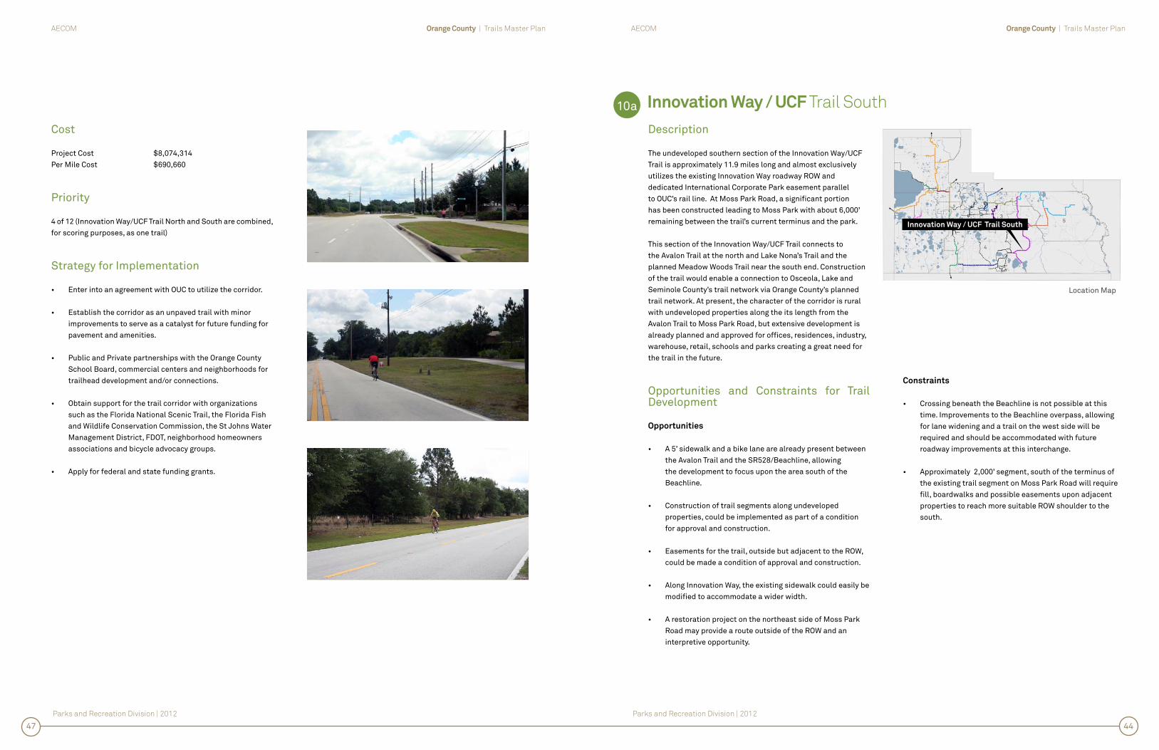
Innovation Way / UCF Trail South
Description
The undeveloped southern section of the Innovation Way/UCF Trail is approximately 11.9 miles long and almost exclusively utilizes the existing Innovation Way roadway ROW and dedicated International Corporate Park easement parallel to OUC’s rail line. At Moss Park Road, a signifi cant portion has been constructed leading to Moss Park with about 6,000’ remaining between the trail’s current terminus and the park.
This section of the Innovation Way/UCF Trail connects to the Avalon Trail at the north and Lake Nona’s Trail and the planned Meadow Woods Trail near the south end. Construction of the trail would enable a connection to Osceola, Lake and Seminole County’s trail network via Orange County’s planned trail network. At present, the character of the corridor is rural with undeveloped properties along the its length from the Avalon Trail to Moss Park Road, but extensive development is already planned and approved for offi ces, residences, industry, warehouse, retail, schools and parks creating a great need for the trail in the future.
Opportunities and Constraints for Trail Development
Opportunities
• A 5’ sidewalk and a bike lane are already present between the Avalon Trail and the SR528/Beachline, allowing the development to focus upon the area south of the Beachline.
• Construction of trail segments along undeveloped properties, could be implemented as part of a condition for approval and construction.
• Easements for the trail, outside but adjacent to the ROW, could be made a condition of approval and construction.
• Along Innovation Way, the existing sidewalk could easily be modifi ed to accommodate a wider width.
• A restoration project on the northeast side of Moss Park Road may provide a route outside of the ROW and an interpretive opportunity.
Constraints
• Crossing beneath the Beachline is not possible at this time. Improvements to the Beachline overpass, allowing for lane widening and a trail on the west side will be required and should be accommodated with future roadway improvements at this interchange.
• Approximately 2,000’ segment, south of the terminus of the existing trail segment on Moss Park Road will require fi ll, boardwalks and possible easements upon adjacent properties to reach more suitable ROW shoulder to the south.
Cost
Project Cost $8,074,314Per Mile Cost $690,660
Priority
4 of 12 (Innovation Way/UCF Trail North and South are combined, for scoring purposes, as one trail)
Strategy for Implementation
• Enter into an agreement with OUC to utilize the corridor.
• Establish the corridor as an unpaved trail with minor improvements to serve as a catalyst for future funding for pavement and amenities.
• Public and Private partnerships with the Orange County School Board, commercial centers and neighborhoods for trailhead development and/or connections.
• Obtain support for the trail corridor with organizations such as the Florida National Scenic Trail, the Florida Fish and Wildlife Conservation Commission, the St Johns Water Management District, FDOT, neighborhood homeowners associations and bicycle advocacy groups.
• Apply for federal and state funding grants.
10a
Location Map
Innovation Way / UCF Trail South
4447
Parks and Recreation Division | 2012
Orange County | Trails Master PlanAECOM
Innovation Way / UCF Multi-Use Trail South10a North 0
Scale in Feet
3,0001,500 6,000
Legend
Innovation Way/UCF Trail South
Avalon Trail
Existing Proposed
Schools
Trailhead Opportunity
Parks and Trailheads
Wetlands
4645
Avalon TrailAvalon Trail
Innovation Way / UCF Innovation Way / UCF
Trail SouthTrail South
Flo
rid
a 5
28
To
ll R
oa
d
L A K E H A R T
L A K E M A R YJ A N E
International Corporate Park
Wycliff
Campus Crusade
Innovation Way
Inn
ov
ati
on
Wa
y
OU
C R
ailr
oad
RO
W
Moss P
ark R
oad
Moss ParkElementary School
Moss Park
Connection toInnovation Way/UCF Trail North
Connection toMeadow Woods Trail

10
b.
Inn
ov
atio
n W
ay
/ UC
F Tra
il No
rth

Orange County | Trails Master PlanAECOM
Parks and Recreation Division | 2012
Orange County | Trails Master PlanAECOM
Parks and Recreation Division | 2012
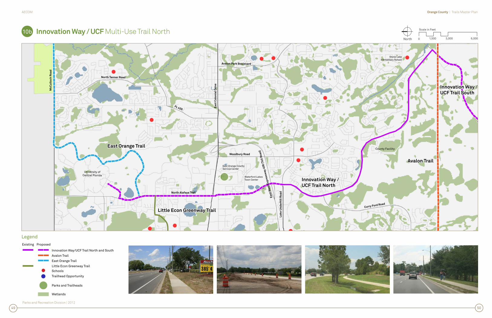
Innovation Way / UCF Multi-Use Trail North
Description
The undeveloped northern section of Innovation Way/UCF Trail North is approximately 3.7 miles long and exclusively located in east side of the Alafaya Trail ROW. The overall trail extends from the Avalon Trail and Innovation Way Trail at the southern end, north to the University of Central Florida (UCF) campus. Near UCF, it connects to the Little Econ Greenway Trail and within the UCF campus it connects to the East Orange Trail via the campus perimeter road.
At present, the southern portion between Innovation Way and Lake Underhill Road is either fully constructed or under construction as part of a roadway widening project, and should be available for use in 2012. North of Lake Underhill Road, ample space and an existing sidewalk are present past the Waterford Lakes Town Center to St. Joseph’s Catholic Church, just short of Colonial Drive/SR 50. At the church, just short of SR 50/East Colonial Drive, the existing sidewalk continues, but space is limited for widening. North of Colonial Drive, sidewalks and bike lanes are present and the ROW becomes an urban section with curb and gutter and many driveway crossings.
North of Colonial/SR 50, the Innovation Way/UCF Trail North will serve some adjacent residences, businesses and offi ces, but the primary users will be UCF students commuting to school or businesses from the campus and off campus apartments. In the south, the primary users will be residents and families accessing businesses, shopping, the Waterford Town Lakes Center and the many surrounding retail centers along the corridor. Trailhead opportunities are not necessary as points to connect to the trail since the majority of the user will be adjacent to, or near the corridor.
Opportunities and Constraints for Trail Development
Opportunities
• The trail is easily implementable in large or small segments with each portion immediately serving residents and students. Near UCF, the trail could be implemented in an intersection to intersection phasing.
• Both the Innovation Way/UCF Trail and the East Orange Trail are intended to meet on UCF’s campus via the university’s roadway network. However, ample space does exist to have each trail intersect of Alafaya Trail and McCulloch Road.
• FDOT is planning a multi-modal redesign of Alafaya Trail north SR50 that could incorporate the future trail.
Constraints
• There are many driveway crossings and side streets along the corridor with the opportunity for distracted motorist not to see trail users. Southbound trail users are particularly susceptible to right turn movements.
• The crossing of SR 50 includes 7-lanes of traffi c, dual left turn movements and large curb radii.
Cost
Project Cost $4,756,594Per Mile Cost $1,292,912
Priority
4 of 12 (Innovation Way/UCF Trail North and South are combined, for scoring purposes, as one trail)
Strategy for Implementation
• Enter into an agreement with OUC to utilize the corridor.
• Establish the corridor as an unpaved trail with minor improvements to serve as a catalyst for future funding for pavement and amenities.
• Public and Private partnerships with the Orange County School Board, commercial centers and neighborhoods for trailhead development and/or connections.
• Obtain support for the trail corridor with organizations such as the Florida National Scenic Trail, the Florida Fish and Wildlife Conservation Commission, the St Johns Water Management District, FDOT, neighborhood homeowners associations and bicycle advocacy groups.
• Apply for federal and state funding grants.
• Work with FDOT’s multi-modal re-design of Alafaya Trail north of SR50.
10b
Location Map
Innovation Way / UCF Trail North
4851
Parks and Recreation Division | 2012
Orange County | Trails Master PlanAECOM
Innovation Way / UCF Multi-Use Trail North10b North 0
Scale in Feet
3,0001,500 6,000
Legend
Innovation Way/UCF Trail North and South
Avalon Trail
East Orange Trail
Little Econ Greenway Trail
Existing Proposed
Schools
Trailhead Opportunity
Parks and Trailheads
Wetlands
5049
Avalon TrailAvalon Trail
Innovation Way /Innovation Way /
UCF Trail SouthUCF Trail South
Innovation Way /Innovation Way /
UCF Trail NorthUCF Trail North
East Orange TrailEast Orange Trail
Curry Ford Road
Woodbury Road
FL 420
North Tanner Road
Avalon Park Boulevard
Ea
st
Co
lon
ial
Dri
ve
North Alafaya Trail
County Facility
Ea
st
We
st
Ex
pre
ss
wa
y 4
08
(To
ll R
oa
d)
La
ke
Un
de
rhil
l R
oa
d
University ofCentral Florida
Mc
Cu
llo
ch
Ro
ad
East Orange CountyService Center
Waterford LakesTown Center
Stone LakeElementary School
Little Econ Greenway TrailLittle Econ Greenway Trail

11.
Me
ad
ow
Wo
od
s Tra
il

Orange County | Trails Master PlanAECOM
Parks and Recreation Division | 2012
Orange County | Trails Master PlanAECOM
Parks and Recreation Division | 2012
Meadow Woods Trail
Description
The Meadow Woods Trail is approximately 9.5 miles long and primarily utilizes an existing OUC Powerline corridor which includes Orange County Utility water and reclaimed water lines along much of the way. The corridor extends from Lake Nona Boulevard west to the John Young Parkway and links to the Shingle Creek Trail. With the exception of a segment at the westernmost end, at US 441, where the corridor shifts north to pass through a future County park, the corridor is approximately 200’ wide.
The east/west alignment facilitates a large trail loop through Orange County and a connection to Osceola County’s segment of the Shingle Creek Trail. Within Orange County, the Meadow Woods Trail connects to Lake Nona’s trail system and the Innovation Way/UCF Trail. Along the trail corridor Meadow Woods Middle School, Meadow Woods Elementary School, Cypress Creek High School, John Young Elementary School and Hunter’s Creek Elementary School are all within a ¼ mile of the trail. Orange County’s proposed park site, just east of Orange Blossom Trail would serve as a trailhead. Multiple residential communities and several retail/commercial centers would be linked to each of the trails.
Opportunities and Constraints for Trail Development
Opportunities
• Orange County plans for the addition of a new water and reclaimed water line in the corridor, which will cause signifi cant impact to the existing grade and provide an opportunity to construct the trail as part of the project.
• Portions of the corridor are within Orlando city limits and provide an opportunity to share funding/implementation.
• OUC’s maintenance road through the corridor, with little or no improvements, is suitable for immediate use as an unpaved trail surface.
• Trailhead opportunities are present at Meadow Woods Middle School and the new County park site west of Orange Blossom Trail.
Constraints
• An agreement with from OUC will be required.
• Much of the corridor appears that it may be within the 100 year fl ood plain.
• About a mile of the corridor is parallel to OUC’s rail line, which may require fencing or a barrier of some sort.
• Power-lines at the crossing of the Florida Turnpike pose an impediment to bridging the roadway. However, acquiring easement on the north side of the corridor could allow a crossing of the Florida Turnpike to occur, clear of the powerlines, on the shoulder of one existing and one planned retention ponds. The proposed retention pond is part of a planned widening in this area in 2015.
• The route requires fi ve 4-lane roadway crossings and one mainline railroad crossing.
Cost
Project Cost $17,151,869Per Mile Cost $1,804,129
Priority
7 of 12 (tied with Avalon Trail)
Strategy for Implementation
• Enter into an agreement with OUC to utilize the corridor.
• Establish the corridor as an unpaved trail with minor improvements to serve as a catalyst for future funding for pavement and amenities.
• Public and Private partnerships with the Orange County School Board, commercial centers and neighborhoods for trailhead development and/or connections.
• Obtain support for the trail corridor with organizations such as the Florida National Scenic Trail, the Florida Fish and Wildlife Conservation Commission, the St Johns Water Management District, FDOT, neighborhood homeowners associations and bicycle advocacy groups.
• Apply for federal and state funding grants.
• Enter into a partnership with the City of Orlando to share development of the trail as a part of the Orange County water and reuse line project.
11
Location Map
Meadow Woods Trail
5255

Parks and Recreation Division | 2012
Orange County | Trails Master PlanAECOM
Meadow Woods Trail11 North 0
Scale in Feet
6,0003,000 12,000
Legend
Meadow Woods Trail
Shingle Creek Trail
Innovation Way/UCF Trail North and South
Trail (by others)
Existing Proposed
Schools
Trailhead Opportunity
Parks and Trailheads
Wetlands
5453
Meadow Woods TrailMeadow Woods Trail
County Road 530
Central Florida Greeneway 417 (Toll Road)
Bo
gg
y C
ree
k R
oa
d
East Wetherbee Road
West Taft Vineland Road
Tradeport Drive
Flo
rida’s
Turn
pik
e (To
ll Ro
ad
)
Na
rco
os
se
e R
oa
d
International Drive
Central Florida Parkway
Inte
rsta
te 4
Palm
Park
way
So
uth
Ora
ng
e B
los
so
m T
rail
West Wetherbee Road
Central Florida Greeneway 417 (Toll Road)
Co
un
ty R
oa
d 4
23
Town Center Boulevard
Co
un
ty R
oa
d 5
27
Florida 528 (Toll Road)
Shingle CreekShingle Creek
TrailTrail
Innovation Way/UCFInnovation Way/UCF
Trail SouthTrail South
Orlando internationalAirport
West CreekElementary School
Hunter’s CreekElementary School
John YoungElementary School
Cypress CreekHigh School
Meadow WoodsElementary School
Meadow Woods Middle School
Meadow Woods Recreational Center
Bear Creek Park
OUC Railroad ROW
Lake Nona Boulevard
Moss ParkElementary School

12
. Ea
st O
ran
ge
Trail
Orange County | Trails Master PlanAECOM
Parks and Recreation Division | 2012
Orange County | Trails Master PlanAECOM
Parks and Recreation Division | 2012
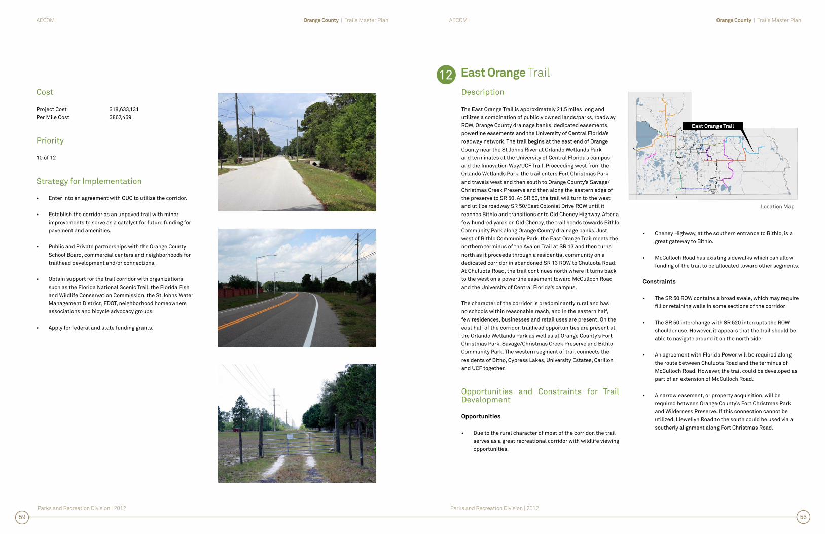
East Orange Trail
Description
The East Orange Trail is approximately 21.5 miles long and utilizes a combination of publicly owned lands/parks, roadway ROW, Orange County drainage banks, dedicated easements, powerline easements and the University of Central Florida’s roadway network. The trail begins at the east end of Orange County near the St Johns River at Orlando Wetlands Park and terminates at the University of Central Florida’s campus and the Innovation Way/UCF Trail. Proceeding west from the Orlando Wetlands Park, the trail enters Fort Christmas Park and travels west and then south to Orange County’s Savage/Christmas Creek Preserve and then along the eastern edge of the preserve to SR 50. At SR 50, the trail will turn to the west and utilize roadway SR 50/East Colonial Drive ROW until it reaches Bithlo and transitions onto Old Cheney Highway. After a few hundred yards on Old Cheney, the trail heads towards Bithlo Community Park along Orange County drainage banks. Just west of Bithlo Community Park, the East Orange Trail meets the northern terminus of the Avalon Trail at SR 13 and then turns north as it proceeds through a residential community on a dedicated corridor in abandoned SR 13 ROW to Chuluota Road. At Chuluota Road, the trail continues north where it turns back to the west on a powerline easement toward McCulloch Road and the University of Central Florida’s campus.
The character of the corridor is predominantly rural and has no schools within reasonable reach, and in the eastern half, few residences, businesses and retail uses are present. On the east half of the corridor, trailhead opportunities are present at the Orlando Wetlands Park as well as at Orange County’s Fort Christmas Park, Savage/Christmas Creek Preserve and Bithlo Community Park. The western segment of trail connects the residents of Bitho, Cypress Lakes, University Estates, Carillon and UCF together.
Opportunities and Constraints for Trail Development
Opportunities
• Due to the rural character of most of the corridor, the trail serves as a great recreational corridor with wildlife viewing opportunities.
• Cheney Highway, at the southern entrance to Bithlo, is a great gateway to Bithlo.
• McCulloch Road has existing sidewalks which can allow funding of the trail to be allocated toward other segments.
Constraints
• The SR 50 ROW contains a broad swale, which may require fi ll or retaining walls in some sections of the corridor
• The SR 50 interchange with SR 520 interrupts the ROW shoulder use. However, it appears that the trail should be able to navigate around it on the north side.
• An agreement with Florida Power will be required along the route between Chuluota Road and the terminus of McCulloch Road. However, the trail could be developed as part of an extension of McCulloch Road.
• A narrow easement, or property acquisition, will be required between Orange County’s Fort Christmas Park and Wilderness Preserve. If this connection cannot be utilized, Llewellyn Road to the south could be used via a southerly alignment along Fort Christmas Road.
Cost
Project Cost $18,633,131Per Mile Cost $867,459
Priority
10 of 12
Strategy for Implementation
• Enter into an agreement with OUC to utilize the corridor.
• Establish the corridor as an unpaved trail with minor improvements to serve as a catalyst for future funding for pavement and amenities.
• Public and Private partnerships with the Orange County School Board, commercial centers and neighborhoods for trailhead development and/or connections.
• Obtain support for the trail corridor with organizations such as the Florida National Scenic Trail, the Florida Fish and Wildlife Conservation Commission, the St Johns Water Management District, FDOT, neighborhood homeowners associations and bicycle advocacy groups.
• Apply for federal and state funding grants.
12
Location Map
East Orange Trail
5659

Parks and Recreation Division | 2012
Orange County | Trails Master PlanAECOM
East Orange Trail12 North 0
Scale in Feet
6,0003,000 12,000
Legend
East Orange Trail
Little Econ Greenway Trail
Innovation Way/UCF Trail North
Avalon Trail
Trail (by others)
Existing Proposed
Schools
Trailhead Opportunity
Parks and Trailheads
Wetlands
5857
East Orange TrailEast Orange Trail
So
uth
Tan
ne
r Ro
ad
Innovation Way / UCFInnovation Way / UCF
Trail NorthTrail North
Avalon TrailAvalon Trail
No
rth
Ta
nn
er
Ro
ad
FL 420
Northw
est Christmas R
oad
East Colonial Drive
East Colonial Drive
No
rth
Ala
fay
a T
rail
University Boulevard
Ro
us
e R
oa
d
Wo
od
bu
ry R
oa
d
East West Expressway (Toll Road)Avalon Park Bou
lev
ard
Ch
ulu
ota
Ro
ad
Orlando Wetlands Park
McCulloch Road
Little EconLittle Econ
Greenway TrailGreenway Trail
University ofCentral Florida
Bithlo Park
Savage/Christmas CreekPreserve
Christmas HistoricalPark
Llewellyn Road

03
Imp
lem
en
tatio
n a
nd
Ma
na
ge
me
nt P
lan

Orange County | Trails Master Plan UpdateAECOM
Parks and Recreation Division | 2012
60
03 Implementation and Management Plan
Detailed Corridor Construction Costs Funding Assessment Operations and Maintenance Program
1.2.3.
Orange County | Trails Master Plan UpdateAECOM
Parks and Recreation Division | 2012
61
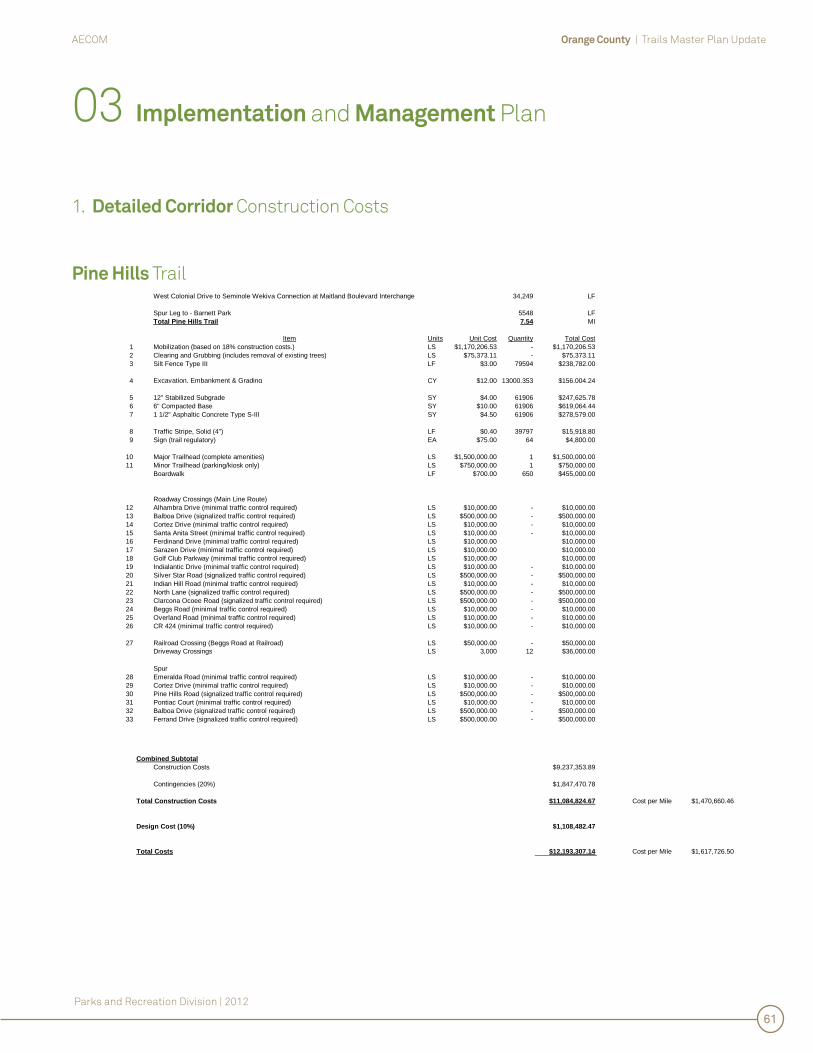
West Colonial Drive to Seminole Wekiva Connection at Maitland Boulevard Interchange 34,249 LF
Spur Leg to - Barnett Park 5548 LFTotal Pine Hills Trail 7.54 MI
Item Units Unit Cost Quantity Total Cost1 Mobilization (based on 18% construction costs.) LS $1,170,206.53 - $1,170,206.532 Clearing and Grubbing (includes removal of existing trees) LS $75,373.11 - $75,373.113 Silt Fence Type III LF $3.00 79594 $238,782.00
4 Excavation, Embankment & Grading - include 441 side slope CY $12.00 13000.353 $156,004.24
5 12" Stabilized Subgrade SY $4.00 61906 $247,625.786 6" Compacted Base SY $10.00 61906 $619,064.447 1 1/2" Asphaltic Concrete Type S-III SY $4.50 61906 $278,579.00
8 Traffic Stripe, Solid (4") LF $0.40 39797 $15,918.809 Sign (trail regulatory) EA $75.00 64 $4,800.00
10 Major Trailhead (complete amenities) LS $1,500,000.00 1 $1,500,000.0011 Minor Trailhead (parking/kiosk only) LS $750,000.00 1 $750,000.00
Boardwalk LF $700.00 650 $455,000.00
Roadway Crossings (Main Line Route)12 Alhambra Drive (minimal traffic control required) LS $10,000.00 - $10,000.0013 Balboa Drive (signalized traffic control required) LS $500,000.00 - $500,000.0014 Cortez Drive (minimal traffic control required) LS $10,000.00 - $10,000.0015 Santa Anita Street (minimal traffic control required) LS $10,000.00 - $10,000.0016 Ferdinand Drive (minimal traffic control required) LS $10,000.00 $10,000.0017 Sarazen Drive (minimal traffic control required) LS $10,000.00 $10,000.0018 Golf Club Parkway (minimal traffic control required) LS $10,000.00 $10,000.0019 Indialantic Drive (minimal traffic control required) LS $10,000.00 - $10,000.0020 Silver Star Road (signalized traffic control required) LS $500,000.00 - $500,000.0021 Indian Hill Road (minimal traffic control required) LS $10,000.00 - $10,000.0022 North Lane (signalized traffic control required) LS $500,000.00 - $500,000.0023 Clarcona Ocoee Road (signalized traffic control required) LS $500,000.00 - $500,000.0024 Beggs Road (minimal traffic control required) LS $10,000.00 - $10,000.0025 Overland Road (minimal traffic control required) LS $10,000.00 - $10,000.0026 CR 424 (minimal traffic control required) LS $10,000.00 - $10,000.00
27 Railroad Crossing (Beggs Road at Railroad) LS $50,000.00 - $50,000.00Driveway Crossings LS 3,000 12 $36,000.00
Spur28 Emeralda Road (minimal traffic control required) LS $10,000.00 - $10,000.0029 Cortez Drive (minimal traffic control required) LS $10,000.00 - $10,000.0030 Pine Hills Road (signalized traffic control required) LS $500,000.00 - $500,000.0031 Pontiac Court (minimal traffic control required) LS $10,000.00 - $10,000.0032 Balboa Drive (signalized traffic control required) LS $500,000.00 - $500,000.0033 Ferrand Drive (signalized traffic control required) LS $500,000.00 - $500,000.00
Combined SubtotalConstruction Costs $9,237,353.89
Contingencies (20%) $1,847,470.78
$11,084,824.67 Cost per Mile $1,470,660.46
Design Cost (10%) $1,108,482.47
Total Costs $12,193,307.14 Cost per Mile $1,617,726.50
Total Construction Costs
03 Implementation and Management Plan
1. Detailed Corridor Construction Costs
Pine Hills Trail
Orange County | Trails Master Plan UpdateAECOM
Parks and Recreation Division | 2012
62
West Orange Trail (Phase 4)
03 Implementation and Management Plan
1. Detailed Corridor Construction Costs
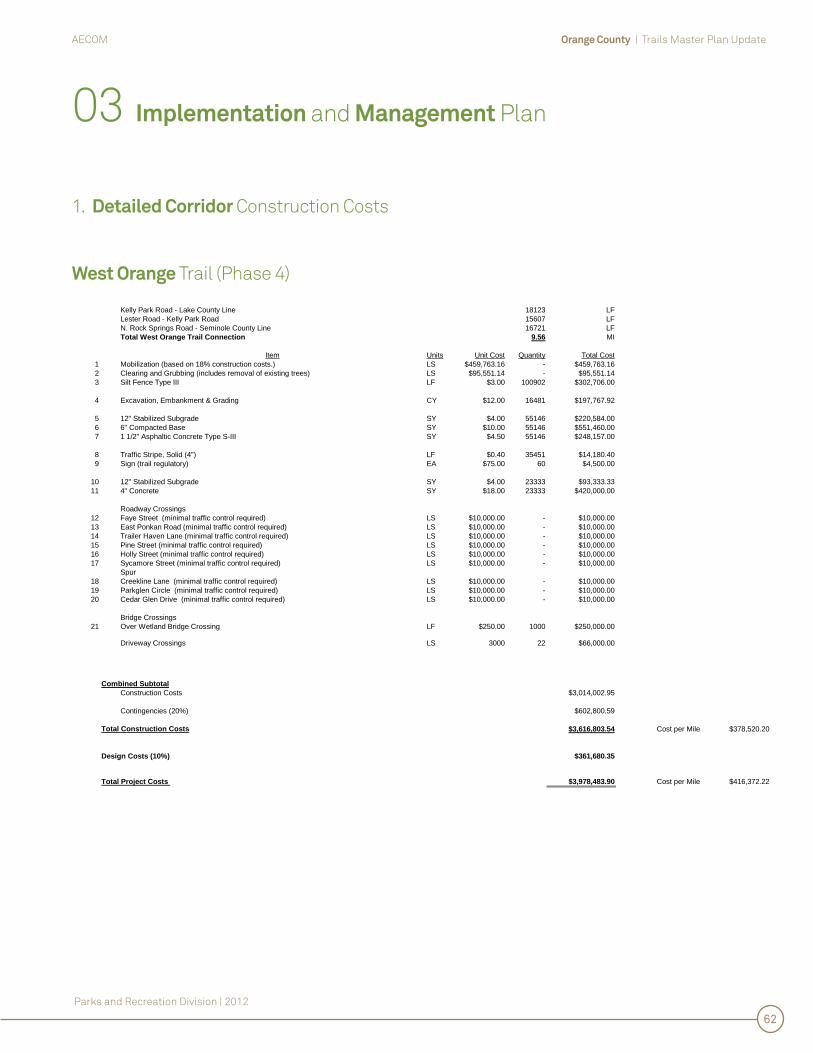
Kelly Park Road - Lake County Line 18123 LFLester Road - Kelly Park Road 15607 LFN. Rock Springs Road - Seminole County Line 16721 LFTotal West Orange Trail Connection 9.56 MI
Item Units Unit Cost Quantity Total Cost1 Mobilization (based on 18% construction costs.) LS $459,763.16 - $459,763.162 Clearing and Grubbing (includes removal of existing trees) LS $95,551.14 - $95,551.143 Silt Fence Type III LF $3.00 100902 $302,706.00
4 Excavation, Embankment & Grading CY $12.00 16481 $197,767.92
5 12" Stabilized Subgrade SY $4.00 55146 $220,584.006 6" Compacted Base SY $10.00 55146 $551,460.007 1 1/2" Asphaltic Concrete Type S-III SY $4.50 55146 $248,157.00
8 Traffic Stripe, Solid (4") LF $0.40 35451 $14,180.409 Sign (trail regulatory) EA $75.00 60 $4,500.00
10 12" Stabilized Subgrade SY $4.00 23333 $93,333.3311 4" Concrete SY $18.00 23333 $420,000.00
Roadway Crossings12 Faye Street (minimal traffic control required) LS $10,000.00 - $10,000.0013 East Ponkan Road (minimal traffic control required) LS $10,000.00 - $10,000.0014 Trailer Haven Lane (minimal traffic control required) LS $10,000.00 - $10,000.0015 Pine Street (minimal traffic control required) LS $10,000.00 - $10,000.0016 Holly Street (minimal traffic control required) LS $10,000.00 - $10,000.0017 Sycamore Street (minimal traffic control required) LS $10,000.00 - $10,000.00
Spur18 Creekline Lane (minimal traffic control required) LS $10,000.00 - $10,000.0019 Parkglen Circle (minimal traffic control required) LS $10,000.00 - $10,000.0020 Cedar Glen Drive (minimal traffic control required) LS $10,000.00 - $10,000.00
Bridge Crossings21 Over Wetland Bridge Crossing LF $250.00 1000 $250,000.00
Driveway Crossings LS 3000 22 $66,000.00
Combined SubtotalConstruction Costs $3,014,002.95
Contingencies (20%) $602,800.59
$3,616,803.54 Cost per Mile $378,520.20
Design Costs (10%) $361,680.35
Total Project Costs $3,978,483.90 Cost per Mile $416,372.22
Total Construction Costs

Orange County | Trails Master Plan UpdateAECOM
Parks and Recreation Division | 2012
63
Lake Apopka Connector Trail
Magnolia Park West to WOT 14,791 LFN/AIngram Road & McCormick Road - South to Existing West Orange Trail 10771 LFN/ATotal Lake Apopka Connector Trail 4.84 MI
No. Item Units Unit Cost Quantity Total CostMulti-useTrail
1 Mobilization (based on 18% construction costs.) LS $471,480.85 - $471,480.852 Clearing and Grubbing (includes removal of existing trees) LS $48,412.88 - $48,412.883 Silt Fence Type III LF $3.00 51124 $153,372.00
4 Excavation, Embankment & Grading CY $12.00 8350 $100,203.04
5 12" Stabilized Subgrade SY $4.00 37741 $150,963.566 6" Compacted Base SY $10.00 37741 $377,408.897 1 1/2" Asphaltic Concrete Type S-III SY $4.50 37741 $169,834.00
8 Traffic Stripe, Solid (4") LF $0.40 24262 $9,704.809 Sign (trail regulatory) EA $75.00 26 $1,950.00
10 12" Stabilized Subgrade SY $4.00 2022 $8,088.8911 4" Concrete SY $18.00 2022 $36,400.00
Roadway Crossings12 Binion Road (minimal traffic control required) LS $10,000.00 - $10,000.0013 Park Shore Lane (minimal traffic control required) LS $10,000.00 - $10,000.0014 Damon Road (minimal traffic control required) LS $10,000.00 - $10,000.0015 McCormmick Woods Road (minimal traffic control required) LS $10,000.00 - $10,000.0016 Orlando Memorial Woods Road (minimal traffic control required) LS $10,000.00 - $10,000.0017 McCormick Road (signalized traffic control required) LS $500,000.00 2 $1,000,000.0018 Ocoee-Apopka Road (signalized traffic control required) LS $500,000.00 - $500,000.00
Bridge Crossings19 Under Western Expressway Bridge on Ocoee-Apopka Road LS $5,000.00 - $5,000.0020 Under Western Expressway Bridge on McCormick Road LS $5,000.00 - $5,000.00
Driveway Crossings LS 3000 1 $3,000.00
Combined SubtotalConstruction Costs $3,090,818.90
Contingencies (20%) $618,163.78
Total Construction Costs $3,708,982.68 Cost per Mile $766,114.88
Design Costs (10%) $370,898.27
Total Project Costs $4,079,880.95 Cost per Mile $842,726.37
03 Implementation and Management Plan
1. Detailed Corridor Construction Costs

Orange County | Trails Master Plan UpdateAECOM
Parks and Recreation Division | 2012
64
Clarcona-Ocoee Connector Trail
Pine Hills Trail - Hiawassee Road 6954 LFClarcona Ocoee Road - WOT 1536 LFClarcona Ocoee Connector Trail 1.61 MI
No. Item Units Unit Cost Quantity Total Cost1 Mobilization (based on 18% construction costs.) LS $58,374.53 - $58,374.532 Clearing and Grubbing (includes removal of existing trees) LS $16,079.55 - $16,079.553 Silt Fence Type III LF $3.00 13908 $41,724.00
4 Excavation, Embankment & Grading CY $12.00 162.26 $1,947.12
5 12" Stabilized Subgrade SY $4.00 10817 $43,269.336 6" Compacted Base SY $10.00 10817 $108,173.337 1 1/2" Asphaltic Concrete Type S-III SY $4.50 10817 $48,678.00
8 Traffic Stripe, Solid (4") LF $0.40 6954 $2,781.609 Sign (trail regulatory) EA $75.00 22 $1,650.00
Roadway Crossings10 Gilliam Road (minimal traffic control required) LS $10,000.00 - $10,000.0011 Wekiva Drive (minimal traffic control required) LS $10,000.00 - $10,000.0012 Long Lake Hills Blvd (minimal traffic control required) LS $10,000.00 - $10,000.0013 Long Lake Drive (minimal traffic control required) LS $10,000.00 - $10,000.0014 Lake Sparling Road (minimal traffic control required) LS $10,000.00 - $10,000.0015 Red Bone Lane (minimal traffic control required) LS $10,000.00 - $10,000.00
16 Driveway Crossing LS $3,000.00 17 $51,000.00
Combined SubtotalConstruction Costs $433,677.46
Contingencies (20%) $86,735.49
Total Construction Costs $520,412.95 Cost per Mile $323,649.04
Design Costs (10%) $52,041.30
Total Project Costs $572,454.25 Cost per Mile $356,013.95
03 Implementation and Management Plan
1. Detailed Corridor Construction Costs
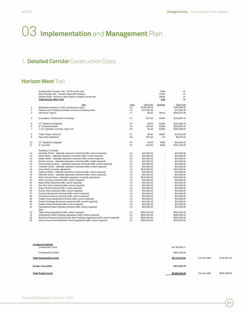
Orange County | Trails Master Plan UpdateAECOM
Parks and Recreation Division | 2012
65
Horizon West Trail
Existing West Orange Trail - SR 50 (north end) 5469 LFWest Orange Park - Daniels Road (SR 429spur) 15784 LFDaniels Road - Horizon's West Sports Complex (south end 18004 LFTotal Horizon West Trail 7.44 MI
Item Units Unit Cost Quantity Total Cost1 Mobilization (based on 18% construction costs.) LS $726,246.33 - $726,246.332 Clearing and Grubbing (includes removal of existing trees) LS $74,350.38 - $74,350.383 Silt Fence Type III LF $3.00 78514 $235,542.00
4 Excavation, Embankment & Grading CY $12.00 12824 $153,887.44
5 12" Stabilized Subgrade SY $4.00 52666 $210,665.786 6" Compacted Base SY $10.00 52666 $526,664.447 1 1/2" Asphaltic Concrete Type S-III SY $4.50 52666 $236,999.00
8 Traffic Stripe, Solid (4") LF $0.40 33857 $13,542.809 Sign (trail regulatory) EA $75.00 110 $8,250.00
10 12" Stabilized Subgrade SY $4.00 8400 $33,600.0011 4" Concrete SY $18.00 8400 $151,200.00
Roadway Crossings12 East Bay Street - sidewalk expansion (minimal traffic control required) LS $10,000.00 - $10,000.0013 Smith Street - sidewalk expansion (minimal traffic control required) LS $10,000.00 - $10,000.0014 Maple Street - sidewalk expansion (minimal traffic control required) LS $10,000.00 - $10,000.0015 Florida Avenue - sidewalk expansion (minimal traffic control required) LS $10,000.00 - $10,000.0016 Pennsylvania Avenue - sidewalk expansion (minimal traffic control required) LS $10,000.00 - $10,000.0017 Charlotte Street - sidewalk expansion (minimal traffic control required) LS $10,000.00 - $10,000.0018 Story Road (currently signalized) LS $100,000.00 - $100,000.0019 Cypress Street - sidewalk expansion (minimal traffic control required) LS $10,000.00 - $10,000.0020 Palmetto Street - sidewalk expansion (minimal traffic control required) LS $10,000.00 - $10,000.0021 West Colonial Drive - sidewalk expansion (currently signalized) LS $100,000.00 - $100,000.0022 Palm Crossing (minimal traffic control required) LS $10,000.00 - $10,000.0023 Beard Road (minimal traffic control required) LS $10,000.00 - $10,000.0024 Doe Run Drive (minimal traffic control required) LS $10,000.00 - $10,000.0025 Roper Road (minimal traffic control required) LS $10,000.00 - $10,000.0026 Scenic Drive (minimal traffic control required) LS $10,000.00 - $10,000.0027 Foxcrest Boulevard (minimal traffic control required) LS $10,000.00 - $10,000.0028 Grovehurst Avenue (minimal traffic control required) LS $10,000.00 - $10,000.0029 Fowler Grove Boulevard (minimal traffic control required) LS $10,000.00 - $10,000.0030 Fowler Exchange Boulevard (minimal traffic control required) LS $10,000.00 - $10,000.0031 Daniels Road (minimal traffic control required) LS $10,000.00 - $10,000.0032 Stoneybrook West Parkway (minimal traffic control required) LS $10,000.00 $10,000.00
Spur33 Tilden Road (signalized traffic control required) LS $500,000.00 - $500,000.0034 Stoneybrook West Parkway (signalized traffic control required) LS $500,000.00 - $500,000.0035 Robinson Road and Stoneybrook West Parkway (signalized traffic control required) LS $500,000.00 - $500,000.0036 Warrior Road and Windemere Road (signalized traffic control required) LS $500,000.00 - $500,000.00
Combined SubtotalConstruction Costs $4,760,948.17
Contingencies (20%) $952,189.63
$5,713,137.81 Cost per Mile $768,407.36
Design Cost (10%) $571,313.78
Total Project Costs $6,284,451.59 Cost per Mile $845,248.09
Total Construction Costs
03 Implementation and Management Plan
1. Detailed Corridor Construction Costs
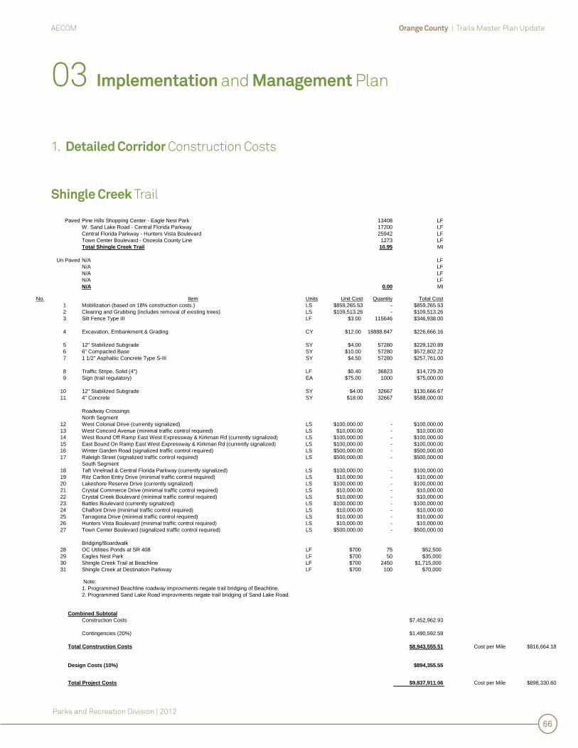
Orange County | Trails Master Plan UpdateAECOM
Parks and Recreation Division | 2012
66
Shingle Creek Trail
Pine Hills Shopping Center - Eagle Nest Park 13408 LFW. Sand Lake Road - Central Florida Parkway 17200 LFCentral Florida Parkway - Hunters Vista Boulevard 25942 LFTown Center Boulevard - Osceola County Line 1273 LFTotal Shingle Creek Trail 10.95 MI
N/A LFN/A LFN/A LFN/A LFN/A 0.00 MI
No. Item Units Unit Cost Quantity Total Cost1 Mobilization (based on 18% construction costs.) LS $859,265.53 - $859,265.532 Clearing and Grubbing (includes removal of existing trees) LS $109,513.26 - $109,513.263 Silt Fence Type III LF $3.00 115646 $346,938.00
4 Excavation, Embankment & Grading CY $12.00 18888.847 $226,666.16
5 12" Stabilized Subgrade SY $4.00 57280 $229,120.896 6" Compacted Base SY $10.00 57280 $572,802.227 1 1/2" Asphaltic Concrete Type S-III SY $4.50 57280 $257,761.00
8 Traffic Stripe, Solid (4") LF $0.40 36823 $14,729.209 Sign (trail regulatory) EA $75.00 1000 $75,000.00
10 12" Stabilized Subgrade SY $4.00 32667 $130,666.6711 4" Concrete SY $18.00 32667 $588,000.00
Roadway CrossingsNorth Segment
12 West Colonial Drive (currently signalized) LS $100,000.00 - $100,000.0013 West Concord Avenue (minimal traffic control required) LS $10,000.00 - $10,000.0014 West Bound Off Ramp East West Expressway & Kirkman Rd (currently signalized) LS $100,000.00 - $100,000.0015 East Bound On Ramp East West Expressway & Kirkman Rd (currently signalized) LS $100,000.00 - $100,000.0016 Winter Garden Road (signalized traffic control required) LS $500,000.00 - $500,000.0017 Raleigh Street (signalized traffic control required) LS $500,000.00 - $500,000.00
South Segment18 Taft Vinelnad & Central Florida Parkway (currently signalized) LS $100,000.00 - $100,000.0019 Ritz Carlton Entry Drive (minimal traffic control required) LS $10,000.00 - $10,000.0020 Lakeshore Reserve Drive (currently signalized) LS $100,000.00 - $100,000.0021 Crystal Commerce Drive (minimal traffic control required) LS $10,000.00 - $10,000.0022 Crystal Creek Boulevard (minimal traffic control required) LS $10,000.00 - $10,000.0023 Battles Boulevard (currently signalized) LS $100,000.00 - $100,000.0024 Chalfont Drive (minimal traffic control required) LS $10,000.00 - $10,000.0025 Tarragona Drive (minimal traffic control required) LS $10,000.00 - $10,000.0026 Hunters Vista Boulevard (minimal traffic control required) LS $10,000.00 - $10,000.0027 Town Center Boulevard (signalized traffic control required) LS $500,000.00 - $500,000.00
Bridging/Boardwalk28 OC Utilities Ponds at SR 408 LF $700 75 $52,50029 Eagles Nest Park LF $700 50 $35,00030 Shingle Creek Trail at Beachline LF $700 2450 $1,715,00031 Shingle Creek at Destination Parkway LF $700 100 $70,000
Note: 1. Programmed Beachline roadway improvments negate trail bridging of Beachline.2. Programmed Sand Lake Road improvments negate trail bridging of Sand Lake Road.
Combined SubtotalConstruction Costs $7,452,962.93
Contingencies (20%) $1,490,592.59
$8,943,555.51 Cost per Mile $816,664.18
Design Costs (10%) $894,355.55
Total Project Costs $9,837,911.06 Cost per Mile $898,330.60
Paved
Un Paved
Total Construction Costs
03 Implementation and Management Plan
1. Detailed Corridor Construction Costs

Orange County | Trails Master Plan UpdateAECOM
Parks and Recreation Division | 2012
67
Little Econ Greenway Trail (Phase 3)
Existing Little Econ Greenway Trail - SR 436/Semoran Boulevard 5138 LFTotal Little Econ Greenway Trail 0.97 MI
No. Item Units Unit Cost Quantity Total Cost1 Mobilization (based on 18% construction costs.) LS $938,045.78 - $938,045.782 Clearing and Grubbing (includes removal of existing trees) LS $9,731.06 - $9,731.063 Silt Fence Type III LF $3.00 10276 $30,828.00
4 Excavation, Embankment & Grading CY $12.00 1678.4133 $20,140.96
5 12" Stabilized Subgrade SY $4.00 7992 $31,969.786 6" Compacted Base SY $10.00 7992 $79,924.447 1 1/2" Asphaltic Concrete Type S-III SY $4.50 7992 $35,966.00
8 Traffic Stripe, Solid (4") LF $0.40 5138 $2,055.209 Sign (trail regulatory) EA $75.00 10 $750.00
Roadway Crossings10 SR 436/Semoran Boulevard Bridge LF $20,000.00 250 $5,000,000.00
Combined SubtotalConstruction Costs $6,149,411.22
Contingencies (20%) $1,229,882.24
Total Construction Costs $7,379,293.47 Cost per Mile $7,583,236.57
Design Cost (10%) $737,929.35
Total Project Cost $8,117,222.81 Cost per Mile $8,341,560.23
03 Implementation and Management Plan
1. Detailed Corridor Construction Costs
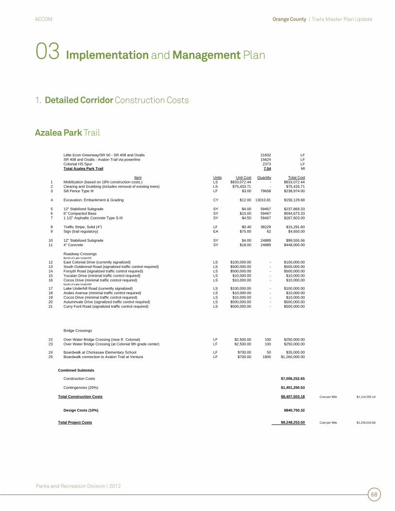
Orange County | Trails Master Plan UpdateAECOM
Parks and Recreation Division | 2012
68
Azalea Park Trail
Little Econ Greenway/SR 50 - SR 408 and Oxalis 21832 LFSR 408 and Oxalis - Avalon Trail via powerline 15624 LFColonial HS Spur 2373 LFTotal Azalea Park Trail 7.54 MI
Item Units Unit Cost Quantity Total Cost1 Mobilization (based on 18% construction costs.) LS $833,072.44 - $833,072.442 Clearing and Grubbing (includes removal of existing trees) LS $75,433.71 - $75,433.713 Silt Fence Type III LF $3.00 79658 $238,974.00
4 Excavation, Embankment & Grading CY $12.00 13010.81 $156,129.68
5 12" Stabilized Subgrade SY $4.00 59467 $237,869.336 6" Compacted Base SY $10.00 59467 $594,673.337 1 1/2" Asphaltic Concrete Type S-III SY $4.50 59467 $267,603.00
8 Traffic Stripe, Solid (4") LF $0.40 38229 $15,291.609 Sign (trail regulatory) EA $75.00 62 $4,650.00
10 12" Stabilized Subgrade SY $4.00 24889 $99,555.5611 4" Concrete SY $18.00 24889 $448,000.00
Roadway CrossingsNorth of Lake Underhill
12 East Colonial Drive (currently signalized) LS $100,000.00 - $100,000.0013 South Goldenrod Road (signalized traffic control required) LS $500,000.00 - $500,000.0014 Forsyth Road (signalized traffic control required) LS $500,000.00 - $500,000.0015 Yucatan Drive (minimal traffic control required) LS $10,000.00 - $10,000.0016 Cocos Drive (minimal traffic control required) LS $10,000.00 - $10,000.00
South of Lake Underhill
17 Lake Underhill Road (currently signalized) LS $100,000.00 - $100,000.0018 Andes Avenue (minimal traffic control required) LS $10,000.00 - $10,000.0019 Cocos Drive (minimal traffic control required) LS $10,000.00 - $10,000.0020 Autumnvale Drive (signalized traffic control required) LS $500,000.00 - $500,000.0021 Curry Ford Road (signalized traffic control required) LS $500,000.00 - $500,000.00
Bridge Crossings
22 Over Water Bridge Crossing (near E. Colonial) LF $2,500.00 100 $250,000.0023 Over Water Bridge Crossing (at Colonial 9th grade center) LF $2,500.00 100 $250,000.00
24 Boardwalk at Chickasaw Elementary School LF $700.00 50 $35,000.0025 Boardwalk connection to Avalon Trail at Ventura LF $700.00 1800 $1,260,000.00
Combined Subtotals
Construction Costs $7,006,252.65
Contingencies (20%) $1,401,250.53
Total Construction Costs $8,407,503.18 Cost per Mile $1,114,555.14
Design Costs (10%) $840,750.32
Total Project Costs $9,248,253.50 Cost per Mile $1,226,010.66
03 Implementation and Management Plan
1. Detailed Corridor Construction Costs
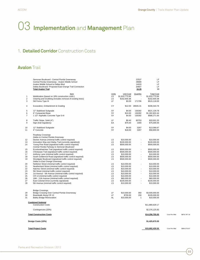
Orange County | Trails Master Plan UpdateAECOM
Parks and Recreation Division | 2012
69
Avalon Trail
Semoran Boulevard - Central Florida Greeneway 22537 LFCentral Florida Greeneway - Avalon Middle School 28689 LFAvalon Middle School to Dallas Blvd. 14020 LFDallas Boulevard -Proposed East Orange Trail Connection 20607 LFTotal Avalon Trail 16.26 MI
Item Units Unit Cost Quantity Total Cost1 Mobilization (based on 18% construction costs.) LS $1,810,773.94 - $1,810,773.942 Clearing and Grubbing (includes removal of existing trees) LS $162,600.38 - $162,600.383 Silt Fence Type III LF $3.00 171706 $515,118.00
4 Excavation, Embankment & Grading CY $12.00 28045.31 $336,543.76
5 12" Stabilized Subgrade SY $4.00 130282 $521,129.786 6" Compacted Base SY $10.00 130282 $1,302,824.447 1 1/2" Asphaltic Concrete Type S-III SY $4.50 130282 $586,271.00
8 Traffic Stripe, Solid (4") LF $0.40 83753 $33,501.209 Sign (trail regulatory) EA $75.00 1000 $75,000.00
10 12" Stabilized Subgrade SY $4.00 3267 $13,066.6711 4" Concrete SY $18.00 3267 $58,800.00
Roadway CrossingsDallas to Central Florida Greenway
12 Decker Avenue (minimal traffic control required) LS $10,000.00 - $10,000.0013 Innovation Way and Alafay Trail (currently signalized) LS $100,000.00 - $100,000.0014 Young Pine Road (signalized traffic control required) LS $500,000.00 - $500,000.00
Central Florida Parkway to Semoran Boulevard15 Econlockhatchee Trail (signalized traffic control required) LS $500,000.00 - $500,000.0016 Chickasaw Trail (signalized traffic control required) LS $500,000.00 - $500,000.0017 Anthony Lane (minimal traffic control required) LS $10,000.00 - $10,000.0018 South Goldenrod Road (signalized traffic control required) LS $500,000.00 - $500,000.0019 Woodgate Boulevard (signalized traffic control required) LS $500,000.00 - $500,000.00
Dallas to East Orange Greenway20 Nettleton Street (minimal traffic control required) LS $10,000.00 - $10,000.0021 Neatherland Street (minimal traffic control required) LS $10,000.00 $10,000.0022 Natchez Street (minimal traffic control required) LS $10,000.00 - $10,000.0023 5th Street (minimal traffic control required) LS $10,000.00 - $10,000.0024 1st Avenue - 5th Avenue (minimal traffic control required) LS $10,000.00 - $10,000.0025 CR 13 (minimal traffic control required) LS $10,000.00 $10,000.0026 16th - 11th Avenue (minimal traffic control required) LS $60,000.00 - $60,000.0027 East Colonial Drive (currently signalized) LS $100,000.00 - $100,000.0028 5th Avenue (minimal traffic control required) LS $10,000.00 - $10,000.00
Bridge Crossings29 Bridge Crossing Over Central Florida Greeneway LF $10,000.00 350 $3,500,000.0030 Boardwalk Along CR 13 LF $700.00 150 $105,000.0031 Bailey Bridge Rennovation AL $10,000.00 1 $10,000.00
Combined SubtotalConstruction Costs $11,880,629.17
Contingencies (20%) $2,376,125.83
$14,256,755.00 Cost Per Mile $876,797.16
Design Costs (10%) $1,425,675.50
Total Project Costs $15,682,430.50 Cost Per Mile $964,476.87
Total Construction Costs
03 Implementation and Management Plan
1. Detailed Corridor Construction Costs
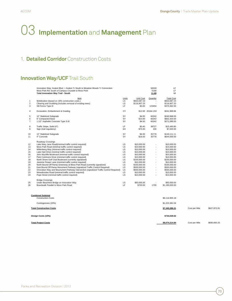
Orange County | Trails Master Plan UpdateAECOM
Parks and Recreation Division | 2012
70
Innovation Way/UCF Trail South
Innovation Way: Avalon Blvd. + Avalon Tr South to Meadow Woods Tr Connection 56559 LFMoss Park Rd: South of Campus Crusade to Moss Park 5168 LFTotal Innovation Way Trail - South 11.69 MI
Item Units Unit Cost Quantity Total Cost1 Mobilization (based on 18% construction costs.) LS $933,087.23 - $933,087.232 Clearing and Grubbing (includes removal of existing trees) LS $116,907.20 - $116,907.203 Silt Fence Type III LF $3.00 123454 $370,362.00
4 Excavation, Embankment & Grading CY $12.00 20164.153 $241,969.84
5 12" Stabilized Subgrade SY $4.00 60242 $240,968.006 6" Compacted Base SY $10.00 60242 $602,420.007 1 1/2" Asphaltic Concrete Type S-III SY $4.50 60242 $271,089.00
8 Traffic Stripe, Solid (4") LF $0.40 38727 $15,490.809 Sign (trail regulatory) EA $75.00 100 $7,500.00
10 12" Stabilized Subgrade SY $4.00 35778 $143,111.1111 4" Concrete SY $18.00 35778 $644,000.00
Roadway Crossings12 Lake Mary Jane Road(minimal traffic control required) LS $10,000.00 - $10,000.0013 Moss Park Road (minimal traffic control required) LS $10,000.00 - $10,000.0014 Wittenberg Way (minimal traffic control required) LS $10,000.00 - $10,000.0015 Lake Hart Drive (minimal traffic control required) LS $10,000.00 - $10,000.0016 John Wycliffe Boulevard (minimal traffic control required) LS $10,000.00 - $10,000.0017 Park Commons Drive (minimal traffic control required) LS $10,000.00 - $10,000.0018 North Shore Golf Club Boulevard (currently signalized) LS $100,000.00 - $100,000.0019 Jasmine Flower Lane (minimal traffic control required) LS $10,000.00 - $10,000.0020 North Bound Off Ramp Greenway at Moss Park Road (currently signalized) LS $100,000.00 - $100,000.0021 East Bound Off Ramp Monument Parkway (signalized Traffic Control Required) LS $500,000.00 - $500,000.0022 Innovation Way and Mounument Parkway Intersection (signalized Traffic Control Required) LS $500,000.00 - $500,000.0023 Wewahootee Road (minimal traffic control required) LS $10,000.00 - $10,000.0024 Pope Street (minimal traffic control required) LS $10,000.00 - $10,000.00
Bridge Crossings25 Under Beachline Bridge on Innovation Way LS $50,000.00 - $50,000.0026 Boardwalk Parallel to Moss Park Road LF $700.00 1700 $1,190,000.00
Combined SubtotalConstruction Costs $6,116,905.18
Contingencies (20%) $1,223,381.04
$7,340,286.21 Cost per Mile $627,872.91
Design Costs (10%) $734,028.62
Total Project Costs $8,074,314.84 Cost per Mile $690,660.20
Total Construction Costs
03 Implementation and Management Plan
1. Detailed Corridor Construction Costs
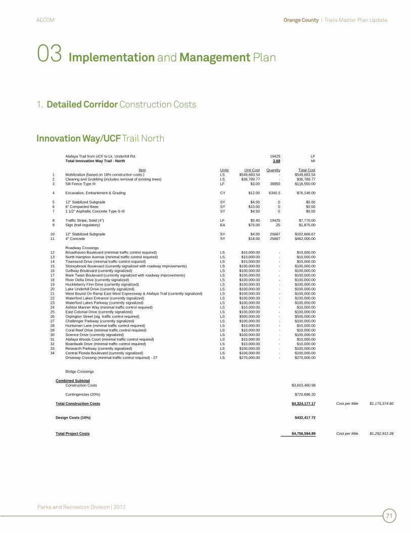
Orange County | Trails Master Plan UpdateAECOM
Parks and Recreation Division | 2012
71
Innovation Way/UCF Trail North
Alafaya Trail from UCF to Lk. Underhill Rd. 19425 LFTotal Innovation Way Trail - North 3.68 MI
Item Units Unit Cost Quantity Total Cost1 Mobilization (based on 18% construction costs.) LS $549,683.54 - $549,683.542 Clearing and Grubbing (includes removal of existing trees) LS $36,789.77 - $36,789.773 Silt Fence Type III LF $3.00 38850 $116,550.00
4 Excavation, Embankment & Grading CY $12.00 6345.5 $76,146.00
5 12" Stabilized Subgrade SY $4.00 0 $0.006 6" Compacted Base SY $10.00 0 $0.007 1 1/2" Asphaltic Concrete Type S-III SY $4.50 0 $0.00
8 Traffic Stripe, Solid (4") LF $0.40 19425 $7,770.009 Sign (trail regulatory) EA $75.00 25 $1,875.00
10 12" Stabilized Subgrade SY $4.00 25667 $102,666.6711 4" Concrete SY $18.00 25667 $462,000.00
Roadway Crossings12 Broadhaven Boulevard (minimal traffic control required) LS $10,000.00 - $10,000.0013 North Hampton Avenue (minimal traffic control required) LS $10,000.00 - $10,000.0014 Townsend Drive (minimal traffic control required) LS $10,000.00 - $10,000.0015 Stoneybrook Boulevard (currently signalized with roadway improvements) LS $100,000.00 - $100,000.0016 Golfway Boulevard (currently signalized) LS $100,000.00 - $100,000.0017 Mark Twain Boulevard (currently signalized with roadway improvements) LS $100,000.00 - $100,000.0018 River Delta Drive (currently signalized) LS $100,000.00 - $100,000.0019 Huckleberry Finn Drive (currently signalized) LS $100,000.00 - $100,000.0020 Lake Underhill Drive (currently signalized) LS $100,000.00 - $100,000.0021 West Bound On Ramp East West Expressway & Alafaya Trail (currently signalized) LS $100,000.00 - $100,000.0022 Waterford Lakes Entrance (currently signalized) LS $100,000.00 - $100,000.0023 Waterford Lakes Parkway (currently signalized) LS $100,000.00 - $100,000.0024 Ashton Manner Way (minimal traffic control required) LS $10,000.00 - $10,000.0025 East Colonial Drive (currently signalized) LS $100,000.00 - $100,000.0026 Orpington Street (sig. traffic control required) LS $500,000.00 - $500,000.0027 Challenger Parkway (currently signalized) LS $100,000.00 - $100,000.0028 Huntsman Lane (minimal traffic control required) LS $10,000.00 - $10,000.0029 Coral Reef Drive (minimal traffic control required) LS $10,000.00 - $10,000.0030 Science Drive (currently signalized) LS $100,000.00 - $100,000.0031 Alafaya Woods Court (minimal traffic control required) LS $10,000.00 - $10,000.0032 Boardwalk Drive (minimal traffic control required) LS $10,000.00 - $10,000.0033 Research Parkway (currently signalized) LS $100,000.00 - $100,000.0034 Central Florida Boulevard (currently signalized) LS $100,000.00 - $100,000.00
Driveway Crossing (minimal traffic control required) - 27 LS $270,000.00 - $270,000.00
Bridge Crossings
Combined SubtotalConstruction Costs $3,603,480.98
Contingencies (20%) $720,696.20
$4,324,177.17 Cost per Mile $1,175,374.80
Design Costs (10%) $432,417.72
$4,756,594.89 Cost per Mile $1,292,912.28
Total Construction Costs
Total Project Costs
03 Implementation and Management Plan
1. Detailed Corridor Construction Costs

Orange County | Trails Master Plan UpdateAECOM
Parks and Recreation Division | 2012
72
Meadow Woods Trail
Lake Nona Boulevard - John Young Parkway 50197 LFTotal Meadow Woods Trail 9.51 MI
Item Units Unit Cost Quantity Total Cost1 Mobilization (based on 18% construction costs.) LS $1,980,585.82 - $1,980,585.822 Clearing and Grubbing (includes removal of existing trees) LS $95,070.08 - $95,070.083 Silt Fence Type III LF $3.00 100394 $301,182.00
4 Excavation, Embankment & Grading CY $12.00 16397.687 $196,772.24
5 12" Stabilized Subgrade SY $4.00 74818 $299,270.226 6" Compacted Base SY $10.00 74818 $748,175.567 1 1/2" Asphaltic Concrete Type S-III SY $4.50 74818 $336,679.00
8 Traffic Stripe, Solid (4") LF $0.40 48097 $19,238.809 Sign (trail regulatory) EA $75.00 1000 $75,000.00
10 12" Stabilized Subgrade SY $4.00 3267 $13,066.6711 4" Concrete SY $18.00 3267 $58,800.00
Roadway Crossings12 Boggy Creek Road & J Lawson Boulevard (signalized traffic control required) LS $500,000.00 - $500,000.0013 Carey Glen Circle (minimal traffic control required) LS $10,000.00 - $10,000.0014 Salem Woods Lane (minimal traffic control required) LS $10,000.00 - $10,000.0015 Virginia Woods Lane (minimal traffic control required) - 2 LS $20,000.00 - $20,000.0016 Landstar Boulevard (currently signalized) LS $100,000.00 - $100,000.0017 Martin Brower Road (minimal traffic control required) LS $10,000.00 - $10,000.0018 Orange Avenue (signalized traffic control required) LS $500,000.00 - $500,000.0019 Prairie Meadows Drive (minimal traffic control required) LS $10,000.00 - $10,000.0020 Balcombe Road (signalized traffic control required) LS $500,000.00 - $500,000.0021 Orange Blossom Trail at West Bound Central FL Grwy Ramp (currently signalized) LS $100,000.00 - $100,000.0022 John Young Parkway and Town Loop Boulevard (currently signalized) LS $100,000.00 - $100,000.00
Bridge Crossings23 Bridge Crossing Over CSX Tracks at Central Florida Parkway LF $10,000.00 350 $3,500,000.0024 Bridge Crossing Over Florida Turnpike LF $10,000.00 350 $3,500,000.0025 Existing OUC Bridge Rennovation AL $10,000.00 1 $10,000.00
Combined SubtotalConstruction Costs $12,993,840.38
Contingencies (20%) $2,598,768.08
$15,592,608.46 Cost per Mile $1,640,117.39
Design Costs (10%) $1,559,260.85
Total Project Costs $17,151,869.30 Cost per Mile $1,804,129.13
Total Construction Costs
03 Implementation and Management Plan
1. Detailed Corridor Construction Costs

Orange County | Trails Master Plan UpdateAECOM
Parks and Recreation Division | 2012
73
East Orange Trail
McCulloch Road - Alayfaya Trail (via Gemini Boulevard) 16614 LFChuluota Road - Orion Boulevard 20270 LFBithlo Park Trail Head -McCulloch Rd/OUC Corridor at Chuluota Road 23765 LFSavage/Chistmas Creek Preserve - Bithlo Park 27401 LFOrlando Wetlands Park - Savage/Chistmas Creek Preserve 25365 LFTotal East Orange Trail 21.48 MI
Item Units Unit Cost Quantity Total Cost1 Mobilization (based on 18% construction costs.) LS $2,153,289.51 - $2,153,289.512 Clearing and Grubbing (includes removal of existing trees) LS $214,801.14 - $214,801.143 Silt Fence Type III LF $3.00 226830 $680,490.00
4 Excavation, Embankment & Grading CY $12.00 37048.9 $444,586.80
5 12" Stabilized Subgrade SY $4.00 128512 $514,048.896 6" Compacted Base SY $10.00 128512 $1,285,122.227 1 1/2" Asphaltic Concrete Type S-III SY $4.50 128512 $578,305.00
8 Traffic Stripe, Solid (4") LF $0.40 82615 $33,046.009 Sign (trail regulatory) EA $75.00 177 $13,275.00
10 12" Stabilized Subgrade SY $4.00 47911 $191,644.4411 4" Concrete SY $18.00 47911 $862,400.00
Roadway Crossings12 North Fort Christmas Road (minimal traffic control required) LS $10,000.00 - $10,000.0013 Christmas Road (minimal traffic control required) LS $10,000.00 - $10,000.0014 Washington Avenue (minimal traffic control required) LS $10,000.00 - $10,000.0015 6th. Street (signalized traffic control required) LS $500,000.00 - $500,000.0016 Belvedere Road (minimal traffic control required) LS $10,000.00 - $10,000.0017 Cypress Preserve Parkway (minimal traffic control required) LS $10,000.00 - $10,000.0018 Lake Pickett Road (minimal traffic control required) LS $10,000.00 - $10,000.0019 Lake Pickett Court (minimal traffic control required) LS $10,000.00 - $10,000.0020 Picketts Cove Road (minimal traffic control required) LS $10,000.00 - $10,000.0021 Chuluota Road (signalized traffic control required) LS $500,000.00 - $500,000.0022 Native Dancer Lane (minimal traffic control required) LS $10,000.00 - $10,000.0023 North Tanner Road (signalized traffic control required) LS $500,000.00 - $500,000.0024 Wochester Drive (minimal traffic control required) - 2 LS $20,000.00 - $20,000.00
Bridge Crossings25 Old Chenney Highway Bridge Creek Crossing LF $700.00 50 $35,000.0026 River Crossing (Econ River) 1000 FT LF $5,000.00 100 $500,000.0027 Over Wetland Bridge Crossing LF $250.00 20000 $5,000,000.00
Combined SubtotalConstruction Costs $14,116,009.00
Contingencies (20%) $2,823,201.80
$16,939,210.80 Cost per Mile $788,599.68
Design Costs (10%) $1,693,921.08
Total Project Costs $18,633,131.88 Cost per Mile $867,459.65
Total Construction Costs
03 Implementation and Management Plan
1. Detailed Corridor Construction Costs

Orange County | Trails Master Plan UpdateAECOM
Parks and Recreation Division | 2012
74
2. Funding Assessment
Following are potential funding sources for implementation of the Orange County Trails System.
State
Transportation Enhancement Program FundsFunded by the Federal Highway Administration (FHWA) through the Safe, Accountable, Flexible, Effi cient Transportation Equity Act (SAFETEA-LU). The program is for projects that are transportation related but reach beyond what is required for normal mitigation or routinely provided facilities. Projects are undertaken by sponsor and eligible costs are reimbursed. Projects must have statewide signifi cance or be part of a network and be sponsored by either a state or federal agency.
Contact: Mariano BerriosTransportation Enhancement CoordinatorEnvironmental Management Offi ce MS-37Florida Department of Transportation605 Suwannee StreetTallahassee, Florida 32399-0450email: [email protected] .us
Florida Offi ce of Greenways and Trails: Land Acquisition and Designation.To be eligible for state funds for land acquisition, a trail must be located within or adjacent to the state-determined Recreation Prioritization lands, have at least 80% of owners willing to sell, and have a management entity.
Contact: Cindy RadfordOffi ce of Greenways and TrailsDepartment of Environmental Protection3900 Commonwealth Blvd., MS 795Tallahassee, Florida 32399-3000Ph: 850-245-2052Fax: 850-245-2083email: [email protected] .us
Florida Offi ce of Greenways and Trails Recreational Trails GrantsA federally funded, competitive grant program administered by the state. Offers fi nancial assistance to agencies of city, county, state or federal government and organizations approved by the State for the development of recreational trails, trailheads and trailside facilities.
Contact: Alexandra WeissOffi ce of Greenways and TrailsDepartment of Environmental Protection3900 Commonwealth Blvd., MS 795Tallahassee, Florida 32399-3000Ph: 850-245-2052Fax: 850-245-2083email: [email protected] .us
Florida Department of State Division of Historical Resources Historic Preservation GrantsA state-funded grants program for the identifi cation, protection, or rehabilitation of historic and archeological sites and the provision of the public information about these sites. Projects are evaluated on the criteria of historic signifi cance, endangerment, and appropriateness of preservation effort, administrative capability, economic benefi ts, adequacy of technical and fi nancial resources, educational potential, and public good resulting from the project.
Contact: Crista HosmerFlorida Division of Historical ResourcesHistoric Preservation500 S. Bronough StreetTallahassee, Florida 32399-0250Ph: 850-245-6333email: [email protected] orida.com
03 Implementation and Management Plan

Orange County | Trails Master Plan UpdateAECOM
Parks and Recreation Division | 2012
75
State (continued)
Florida Department of Environmental Protection: Florida Recreation Development Assistance Program (FRDAP)Administered by DEP, the Florida Recreation Development Assistance Program is a competitive grant program providing funds to local communities for public outdoor recreation.
Contact: Department of Environmental Protection Division of Recreation and ParksOffi ce of Information and Recreation Services3900 Commonwealth Blvd., Mail Station #585Tallahassee, Florida 32399-3000Ph: 850-245-2011
Federal
Land and Water Conservation FundsProvides matching grants to states and local governments for the acquisition and development of public outdoor recreation areas and facilities. The intent is to create and maintain a nationwide legacy of high quality recreation areas and facilities and to stimulate investment of non-federal dollars into these projects. In Florida, this program works in conjunction with the Florida Recreation Development Assistance Program (FRDAP) in the Department of Environmental Protection.
Contact: Bureau of Design and Recreation Services3900 Commonwealth Blvd., Mail Station #585Tallahassee, Florida 32399-3000Ph: 850-245-2501Fax: 850-245-3038
2. Funding Assessment (continued)
03 Implementation and Management Plan

Orange County | Trails Master Plan UpdateAECOM
Parks and Recreation Division | 2012
76
3. Operations and Maintenance Program
03 Implementation and Management Plan
Following is a summary of Orange County’s typical Trail Operations and Maintenance Program.
General
Maintenance activities fall into three primary categories:
1. Routine or Preventative Maintenance2. Work Orders3. Staff Repairs/Maintenance
Routine / preventative maintenance is scheduled and budgeted annually, and includes items such as inspections, mowing, roof replacement and trail re-surfacing. The majority of the work is accomplished through annual maintenance contracts administered by the Parks and Recreation Department, or through the Orange County Facilities Department’s Preventative Maintenance (PM) Program.
Work Orders are used in response to specifi c maintenance problems such as repair and/or replacement of broken plumbing fi xtures, site furnishings or pavement. These needs are identifi ed through the County’s inspection program, as outlined in the next section.
Staff Repairs/Maintenance is used to supplement or fi ll in the gaps between the other two maintenance techniques, especially for items that need immediate attention. This might include sweeping after a major storm; fi xing bathroom plumbing problems; or fi lling potholes. Staff maintenance is not intended as a substitute for Routine/Preventative Maintenance or Work Orders.
Inspections
Five (5) different types of inspections are used to identify existing or potential maintenance problems along Orange County’s Trails:
1. Playground Inspections, conducted weekly by Orange County staff
2. Quality Assurance Landscape Report, conducted monthly by Site Supervisors
3. Site Inspection report, conducted monthly by Site Supervisors
4. Building Inspections (structural/roofi ng components, heating/ventilation/air conditioning (HVAC), and mechanical/electrical/plumbing (ME)), conducted monthly by Orange County Facilities Department
5. Bridge Inspections, proposed to be conducted annually through an annual contract with a licensed Structural Engineer.
Mowing and Growth ControlThe County contracts annually with a licensed Landscape Maintenance company to provide mowing, sweeping, tree trimming, fertilization, and herbicide/pesticide services.
Patching and Resurfacing (including trails and parking areas)Pavement repairs (potholes, erosion, etc.) are conducted on an as-needed basis in response to problems identifi ed during inspections. Routine/Preventative pavement maintenance includes rolling, sealing and/or resurfacing, as shown in Table 1, Operations and Maintenance Summary. All pavement repairs, other than small potholes, are conducted through Work Orders under an annual Pavement Repair contract.

Orange County | Trails Master Plan UpdateAECOM
Parks and Recreation Division | 2012
77
3. Operations and Maintenance Program (continued)
03 Implementation and Management Plan
Litter ManagementTrash receptacles at the trailheads and along the trails are emptied once or twice/ week by the Landscape Maintenance Contractor in accordance with the terms of their contract. Litter is picked up by Orange County staff, the Landscape Maintenance Contractor, participants in the County's Quest Program, and Community Service volunteers.
Building Maintenance and RepairsPreventative maintenance is conducted monthly by the Orange County Facilities Department, and major repairs are accomplished through Work Orders. Minor and/or emergency repairs are conducted by the Orange County Parks and Rec-reation Department. Generally buildings are repainted every fi ve (5) years.
Site Furnishings, Amenity Maintenance and RepairsWhile playgrounds should be replaced every ten (10) years, other amenities (including benches, trash receptacles, fences, signs, water fountains, handrails, bollards, lighting, etc) should be repaired or replaced on an as-needed basis in response to site inspections.
Maintenance Vehicles/ EquipmentOn average, one (1) golf cart needs to be replaced each year for every eight - ten (8 - 10) miles of trail (currently averaging approximately 4 carts/ year). One new blower is also required annually for each trail corridor. Other vehicle repair is con-ducted on an as-needed basis.
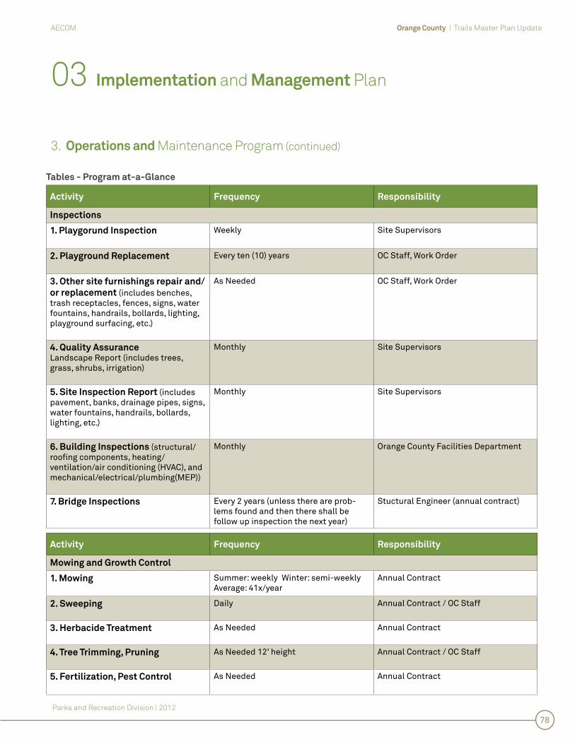
Orange County | Trails Master Plan UpdateAECOM
Parks and Recreation Division | 2012
78
3. Operations and Maintenance Program (continued)
03 Implementation and Management Plan
Activity Frequency Responsibility
Inspections
1. Playgorund Inspection Weekly Site Supervisors
2. Playground Replacement Every ten (10) years OC Staff, Work Order
3. Other site furnishings repair and/
or replacement (includes benches, trash receptacles, fences, signs, water fountains, handrails, bollards, lighting, playground surfacing, etc.)
As Needed OC Staff, Work Order
4. Quality AssuranceLandscape Report (includes trees, grass, shrubs, irrigation)
Monthly Site Supervisors
5. Site Inspection Report (includes pavement, banks, drainage pipes, signs, water fountains, handrails, bollards, lighting, etc.)
Monthly Site Supervisors
6. Building Inspections (structural/roofi ng components, heating/ventilation/air conditioning (HVAC), and mechanical/electrical/plumbing(MEP))
Monthly Orange County Facilities Department
7. Bridge Inspections Every 2 years (unless there are prob-lems found and then there shall be follow up inspection the next year)
Stuctural Engineer (annual contract)
Tables - Program at-a-Glance
Activity Frequency Responsibility
Mowing and Growth Control
1. Mowing Summer: weekly Winter: semi-weekly Average: 41x/year
Annual Contract
2. Sweeping Daily Annual Contract / OC Staff
3. Herbacide Treatment As Needed Annual Contract
4. Tree Trimming, Pruning As Needed 12’ height Annual Contract / OC Staff
5. Fertilization, Pest Control As Needed Annual Contract

Orange County | Trails Master Plan UpdateAECOM
Parks and Recreation Division | 2012
79
3. Operations and Maintenance Program (continued)
03 Implementation and Management Plan
Activity Frequency Responsibility
Pavement Patching and Resurfacing
1. Repair of Potholes
Cracking, surface wearing, graffi tiAs Needed OC Staff, Work Order
2. Repair of shoulder/swale/bank
erosion
As Needed OC Staff, Work Order
3. Concrete Repair As Needed Work Order
4. Rolling Annually Annual Contract
5. Resealing Every fi ve (5) years Annual Contract
5. Resurfacing Every ten (10) years Annual Contract
Activity Frequency Responsibility
Litter Management
1. Litter Pick-up Weekly / Bi-weekly Landscape contractor / OC Staff / QUEST / Community Service
2. Trash Collection Weekly / Bi-weekly Landscape contractor
Activity Frequency Responsibility
Building Maintenance and Repairs
1. Painting Every fi ve (5) years OC Facilities Department
2. Graffi ti As Needed OC Staff, Work Order
3. Repairs / Replacement As Needed OC Facilities Department
Vehicles / Equipment
1. Maintenance Repair (trucks, golf carts, blowers, etc.)
As Needed OC Fleet Maintenance
Tables - Program at-a-Glance

04
Ap
pe
nd
ice
s

Orange County | Trails Master Plan UpdateAECOM
Parks and Recreation Division | 2012
80
04 Appendices
Corridor Evaluation Matrix Existing/ Proposed Trail Mileage
1.2.

Orange County | Trails Master Plan UpdateAECOM
Parks and Recreation Division | 2012
82
2. Existing/Proposed Trail Mileage
Existing Trail Miles
Existing Avalon Trail 1.3
Existing Cady Way Trail 6.2
Existing Clarcona-Ocoee Connector Trail 1.7
Existing Horizon West Trail 2.4
Existing Innovation Way/UCF Trail North 5.0
Existing Innovation/UCF Trail South 2.0
Existing Lake Apopka Connector Trail 0.6
Existing Little Econ Greenway Trail 7.5
Existing Pine Hills Trail 0.7
Existing Shingle Creek Trail 1.1
Existing West Orange Trail 22.6
Total 51.0
04 Appendices
Proposed Trail Miles
Proposed Avalon Trail 16.3
Proposed Azalea Park Trail 7.5
Proposed Clarcona-Ocoee Connector Trail 1.6
Proposed East Orange Trail 21.5
Proposed Horizon West Trail 7.4
Proposed Innovation/UCF Trail North 3.7
Proposed Innovation/UCF Trail South 11.9
Proposed Lake Apopka Connector Trail 4.8
Proposed Little Econ Greenway Trail 1.0
Proposed Meadow Woods Trail 9.5
Proposed Pine Hills Trail 7.5
Proposed Shingle Creek Trail 11.0
Proposed West Orange Trail 9.6
Total 113.3
* This table does not include “Trails by Others” or equestrian trails. Cady Way Trail is included.
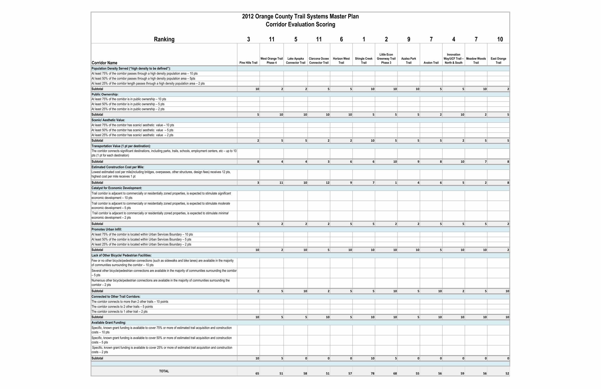
Ranking 3 11 5 11 6 1 2 9 7 4 7 10
Corridor Name Pine Hills TrailWest Orange Trail
Phase 4Lake Apopka
Connector Trail Clarcona Ocoee Connector Trail
Horizon West Trail
Shingle Creek Trail
Little Econ Greenway Trail
Phase 3Azalea Park
Trail Avalon Trail
Innovation Way/UCF Trail – North & South
Meadow Woods Trail
East Orange Trail
Population Density Served (“high density to be defined”):At least 75% of the corridor passes through a high density population area – 10 ptsAt least 50% of the corridor passes through a high density population area – 5ptsAt least 25% of the corridor length passes through a high density population area – 2 ptsSubtotal 10 2 2 5 5 10 10 10 5 5 10 2
At least 75% of the corridor is in public ownership – 10 ptsAt least 50% of the corridor is in public ownership – 5 ptsAt least 25% of the corridor is in public ownership – 2 ptsSubtotal 5 10 10 10 10 5 5 5 2 10 2 5
At least 75% of the corridor has scenic/ aesthetic value – 10 ptsAt least 50% of the corridor has scenic/ aesthetic value – 5 ptsAt least 25% of the corridor has scenic/ aesthetic value – 2 ptsSubtotal 2 5 5 2 2 10 5 5 5 2 5 5
The corridor connects significant destinations, including parks, trails, schools, employment centers, etc – up to 10 pts (1 pt for each destination)
Subtotal 8 4 4 3 6 6 10 9 8 10 7 8
Lowest estimated cost per mile(including bridges, overpasses, other structures, design fees) receives 12 pts, highest cost per mile receives 1 pt
Subtotal 3 11 10 12 9 7 1 4 6 5 2 8
Trail corridor is adjacent to commercially or residentially zoned properties, is expected to stimulate significant economic development – 10 ptsTrail corridor is adjacent to commercially or residentially zoned properties, is expected to stimulate moderate economic development – 5 ptsTrail corridor is adjacent to commercially or residentially zoned properties, is expected to stimulate minimal economic development – 2 pts
Subtotal 5 2 2 2 5 5 2 2 5 5 5 2
At least 75% of the corridor is located within Urban Services Boundary – 10 ptsAt least 50% of the corridor is located within Urban Services Boundary – 5 ptsAt least 25% of the corridor is located within Urban Services Boundary – 2 ptsSubtotal 10 2 10 5 10 10 10 10 5 10 10 2
Few or no other bicycle/pedestrian connections (such as sidewalks and bike lanes) are available in the majority of communities surrounding the corridor – 10 ptsSeveral other bicycle/pedestrian connections are available in the majority of communities surrounding the corridor – 5 ptsNumerous other bicycle/pedestrian connections are available in the majority of communities surrounding the corridor – 2 pts
Subtotal 2 5 10 2 5 5 10 5 10 2 5 10
The corridor connects to more than 2 other trails – 10 pointsThe corridor connects to 2 other trails – 5 pointsThe corridor connects to 1 other trail – 2 ptsSubtotal 10 5 5 10 5 10 10 5 10 10 10 10
Specific, known grant funding is available to cover 75% or more of estimated trail acquisition and construction costs – 10 ptsSpecific, known grant funding is available to cover 50% or more of estimated trail acquisition and construction costs – 5 ptsSpecific, known grant funding is available to cover 25% or more of estimated trail acquisition and construction costs – 2 pts
Subtotal 10 5 0 0 0 10 5 0 0 0 0 0
TOTAL65 51 58 51 57 78 68 55 56 59 56 52
Connected to Other Trail Corridors:
Available Grant Funding:
Scenic/ Aesthetic Value:
Transportation Value (1 pt per destination):
Estimated Construction Cost per Mile:
Catalyst for Economic Development:
Promotes Urban Infill:
2012 Orange County Trail Systems Master PlanCorridor Evaluation Scoring
Public Ownership:
Lack of Other Bicycle/ Pedestrian Facilities: