Embed Size (px)
Citation preview
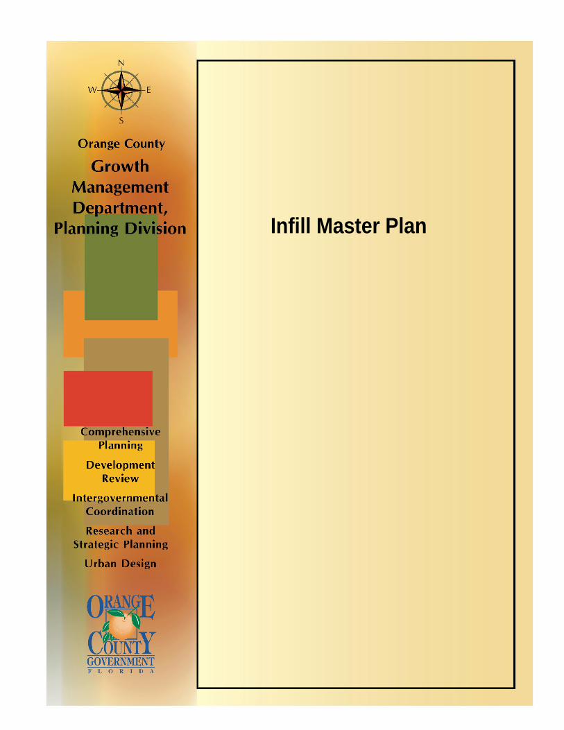
Infill Master Plan


Orange County Planning Division Infill Master Plan
Orange County Planning Division Infill Master Plan
April 14, 2008
Orange County Planning Division Infill Master Plan
1
Acknowledgements
Infill Master Plan Authors Susan E. Caswell, AICP, Manager, Planning Division
Althea Jefferson, AICP, Chief Planner, Planning Division Janna Souvorova, Senior Planner, Planning Division
Daniel Kilponen, AICP, Principal Planner, Transportation Planning Luis Nieves-Ruiz, AICP, Senior Planner, Planning Division
Akosua Cook, AICP, Senior Planner, Planning Division Chenicqua Williams, AICP, Principal Planner, Planning Division
Jennifer Bryla, AICP, Principal Planner, Planning Division Michelle Owens, Principal Planner, Neighborhood Services Division
Linda Larkin, Sr. Housing Development Assistant, Housing & Community Development Division Renee Parker, Environmental Program Supervisor, Environmental Protection Division
Marketing and Incentives Committee Michelle Owens, Principal Planner, Neighborhood Services Division
Linda Larkin, Sr. Housing Development Assistant, Housing & Community Development Division Carol Hossfield, Chief Planner, Zoning Division
Mary Bauer, Senior Management and Budget Analyst, Office of Management and Budget Renee Parker, Environmental Program Supervisor, Environmental Protection Division
Luis Nieves-Ruiz, AICP, Senior Planner, Planning Division Anita McNamara, AICP, Principal Planner, Planning Division
Janna Souvorova, Senior Planner, Planning Division
Design Committee Linda Larkin, Sr. Housing Development Assistant, Housing and Community Development Division
Michelle Owens, Principal Planner, Neighborhood Services Division Daniel Kilponen, AICP, Principal Planner, Transportation Planning
Akosua Cook, AICP, Senior Planner, Planning Division Jennifer Bryla, AICP, Principal Planner, Planning Division Kirsten Warren, Planner III Parks and Recreation Division
Infrastructure Committee Elizabeth O'Reilly, Staff Engineer, Orange County Utilities Engineering Division
Susan McCune, AICP, Project Manager, Transportation Planning Dina Crenshaw Becraft, Project Coordinator, Growth Management Fiscal and Admin Services Mary Bauer, Senior Management and Budget Analyst, Office of Management and Budget
Chenicqua Williams, AICP, Principal Planner, Planning Division
LDC and Zoning Regulations Committee Carol Hossfield, Chief Planner, Zoning Division
David Moon, AICP, Senior Administrator, Orange County Public Schools Althea Jefferson, AICP, Chief Planner, Planning Division
Orange County Planning Division Infill Master Plan
2
Contents
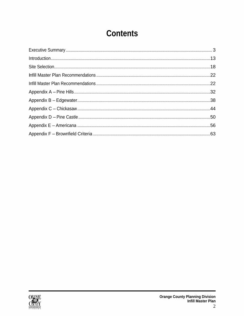
Executive Summary ........................................................................................................................................... 3
Introduction.......................................................................................................................................................13
Site Selection....................................................................................................................................................18
Infill Master Plan Recommendations ............................................................................................................22
Infill Master Plan Recommendations ............................................................................................................22
Appendix A – Pine Hills .................................................................................................................................32
Appendix B – Edgewater..............................................................................................................................38
Appendix C – Chickasaw..............................................................................................................................44
Appendix D – Pine Castle .............................................................................................................................50
Appendix E – Americana ..............................................................................................................................56
Appendix F – Brownfield Criteria ...............................................................................................................63
Orange County Planning Division Infill Master Plan
3
Executive Summary Orange County’s population is projected to increase by nearly 700,000 between now and 2030. Although the County’s Urban Service Area (USA) boundary has been a valuable tool for directing urban growth to areas where services such as central water and sewer are provided, pressure to expand the USA will escalate with increasing population. To preserve the USA boundary and use central facilities and services more efficiently, the County must find innovative ways to accommodate its projected growth, including strategies such as infill and redevelopment, activity centers and mixed use corridors.
Infill development increasingly is recognized as an effective way to achieve a variety of goals, including making better use of existing infrastructure; locating community services, jobs and shopping in close proximity to neighborhoods; stabilizing and enhancing existing neighborhoods; providing affordable housing; providing alternatives to auto trips by supporting walking, biking, and transit; and cleaning up environmentally contaminated sites. To successfully facilitate infill development, redevelopment and reuse of vacant and underutilized parcels within the county, a progressive infill and redevelopment strategy is necessary.
The Orange County Infill Master Plan (IMP) was prepared by the County’s Planning Division in coordination with the Stormwater Management, Utilities, Zoning, Transportation Planning, Environmental Protection, Neighborhood Services, Parks and Recreation, and Housing and Community Development divisions. The Plan describes the process used to identify vacant and underutilized land in the county and formulates three strategies for encouraging development and redevelopment of these areas. The Plan’s primary goal is to promote infill development, rehabilitation and reuse that contribute positively to infill and redevelopment areas. The Plan also was developed to assist in meeting other County goals, including improving the rate of homeownership, preserving the environment and promoting good design.
The Plan assesses infill development-related issues in potential infill corridors, evaluates the regulatory processes related to development, provides focused incentives for development and redevelopment of infill sites, and recommends revisions to the Comprehensive Policy Plan and zoning ordinance to support infill development goals. Four committees – Infrastructure, Zoning and Land Development Codes, Incentives and Marketing, and Housing and Design – explored infill-related issues and established objectives and recommendations for the IMP. In addition, the committees conducted mini-analyses for five proposed “infill corridors” in the county.
This report is divided into four sections: Executive Summary, Introduction, Site Selection and IMP Implementation. Appendices containing mini-analyses of the proposed infill corridors also are included. The Executive Summary outlines the recommendations for infill and redevelopment in Orange County in the context of three infill strategies: Smart Growth, Green Building, and Economic Prosperity. The Introduction discusses the need for infill in Orange County and briefly covers the benefits and barriers to infill. The Site Selection section provides the method and approach used to identify vacant and underutilized lands in Orange County, while the IMP Implementation section lists the next steps of the infill master planning process.
Orange County Planning Division Infill Master Plan
4
Introduction “Communities across the country increasingly are recognizing that sprawling patterns of growth – which have shaped American communities for the past several decades – cannot be sustained. Problems of increased traffic congestion, overstretched public facilities, increased infrastructure costs, loss of open space and other valued community resources, and even reduced physical activity and community health typically are associated with such patterns. Instead, an increased emphasis on developing passed-over parcels within developed areas, and on maximizing use of existing public facilities is needed.”1
Between 1990 and 2000, Orange County’s population increased by nearly one-third, making it the fastest growing among Florida counties with population over 500,000. About 75 percent of the County’s growth in this timeframe was within the unincorporated area. Based on the moderate growth projection for 2030, Orange County is projected to have 26 percent growth per decade, resulting in the addition of approximately 900,000 people between 2000 and 2030. This growth likely will result in increased pressure to expand the County’s Urban Service Area (USA). In order to maximize public facilities and services and minimize encroachment into environmentally sensitive lands outside the USA, the County will need to find innovative means for accommodating its growth.
As developable lands become scarce, we must learn to grow “up” rather than “out.” Essentially, this means finding mechanisms for accommodating growth that are less likely to have an impact on environmental resources, transportation networks and overall quality of life. The Infill Master Plan will provide a means for reducing growth pressure to the outlying areas of the County by identifying appropriate land uses and intensities within the urban service area.
Definition of Infill Infill is defined as the development of vacant or underutilized land within the Urban Service Area (USA) where restoration or rehabilitation of existing structures or infrastructure maintains the continuity of the original community fabric. Infill development can provide many advantages, including diverse housing stock, accessibility to existing infrastructure and heightened design standards.
Why Infill? There are four compelling arguments to advocate a more focused strategy for infill and redevelopment. First, infill and redevelopment are supported by smart growth principles. Smart growth recognizes connections between development and quality of life, and leverages new growth to improve the community. Second, infill helps to reconnect neighbors and neighborhoods. The very nature of infill and redevelopment requires collaboration and community involvement. The IMP will facilitate a more cohesive appearance, likely resulting in improved identity and community connection. Third, in a residential capacity study recently completed by the Planning Division, it is estimated that the County will fall short of projected housing needs for its 2030 population. Infill could help contribute to the supply of available residences and decrease the projected deficit. Fourth, infill has unlimited potential to contribute to the County’s thriving economy. According to the “Orange County and the Creative Economy” report published by the East Central Florida Regional Planning Council, the creative class has the potential to transform our local economy. Infill
Orange County Planning Division Infill Master Plan
5
and redevelopment is a basis for attracting highly educated, talented and economically powerful individuals, because it fits the criteria often sought by this group.
Smart Growth Redevelopment of vacant and underutilized properties supports many smart growth principles. A range of housing opportunities can be created, a mix of land uses will be provided, community and stakeholder collaboration in development decisions will be encouraged, and communities with a strong sense of place will be created.
In 2004, the Orange County Planning Division participated in Smart Growth America’s Smart Growth Leadership Institute (SGLI) to obtain technical assistance on revising the County’s Comprehensive Policy Plan to better implement smart growth principles. The SGLI recommended that Orange County prepare an Infill Master Plan, which already was called for in the Future Land Use Element.
Another recent initiative sponsored by the Florida Institute of Government (at the University of Central Florida) gathered local planners, stakeholders, and community leaders to address community challenges in Orange County. Participants addressed issues related to the livability of the County and its neighborhoods. The initiative included a process that identified key areas for re-assessment, including the built environment and smart growth. The final report, published in April 2006, strongly encouraged infill and redevelopment, using smart growth principles.
Community Revitalization If done right, infill and redevelopment can stimulate revitalization efforts in surrounding neighborhoods. Mixed-use developments often will create more walkable communities. If designed well, these developments will be visually appealing and accessible by a variety of transportation choices. Surrounding areas will want the same “look” for their community. They will want development patterns that make them feel more close knit and cohesive. With focused reinvestment and land reuse efforts, older core areas that could deteriorate into unwelcoming areas with unattractive and even hazardous conditions can transform into areas with increased real estate values and tax bases. Revitalization offers additional benefits to preserving neighborhoods and communities throughout the county. By continuing the significant revitalization work already underway in Orange County, implementation of the IMP can keep our neighborhoods and core community areas economically successful and culturally vibrant.
In addition, infill development and redevelopment potentially can add a new vibrancy to neglected neighborhoods. It is important, however, to involve existing and potential residents in the infill and redevelopment process in order to keep a sense of neighborhood identity and to better implement a future vision of the area developed by the existing residents and businesses. Involving existing residents who will continue to live in the area once it is redeveloped is important, as they can become future employees or owners of newly established businesses in the area. Potential infill corridors, which are meant to connect activity centers of different scales (neighborhood, community and regional), will provide closer places to live and work in established neighborhoods, as well as provide services to existing and new communities.
Working with neighborhood and community organizations to identify their needs and establish development priorities is a significant element of the IMP. There are a few areas within Orange County
Orange County Planning Division Infill Master Plan
6
that are beginning to show signs of neighborhood decline. The IMP could serve as an impetus for revitalization of these areas.
The IMP seeks to maximize the use of vacant and underutilized land while generating new economic and housing activity. The trend around the nation indicates that mixed-use residential is becoming a popular housing choice. The key is to develop mixed-use projects that are compatible with existing neighborhoods and communities. Adding this new perspective to our community is an exciting prospect for the County’s future. The IMP recommends strategies that dedicate additional time and resources into Orange County’s older communities.
Meeting Housing Needs The Residential Capacity Analysis completed in 2006 by the Research and Strategic Planning Section of the Orange County Planning Division states that, “Orange County has over 900 square miles of land area and a population of just over 1 million persons, making it the most populous county in Central Florida and the largest non-coastal county in the state. Between 2000 and 2005, Orange County added 120,726 residents. With an average of 25,000 new residents annually … the location and configuration of new residential development will greatly influence the future quality of life and character of Orange County. Based on projected growth, unincorporated Orange County will need to add 222,729 housing units by 2030.” The report estimates that the County will fall short of this projected need by approximately 35,000 units.
Based on the results of this analysis, the approximate residential build-out date for the County is 2025. It should be noted that an infill and redevelopment rate of 5 percent was incorporated into the Residential Capacity Analysis. Implementation of the Infill Master Plan and the incentives recommended in the Plan – such as increased densities and intensities – could increase the estimated infill and redevelopment rate to accommodate more residential units through infill projects.
Whereas suburban development tends to create single-family homes, infill development can result in a variety of housing types. Urban infill housing construction generally contains a range of residential uses, including single-family houses, town homes, apartments, lofts and condominiums. By providing a wider range of housing types, infill could help to meet the County’s workforce housing needs.
The Orange County Workforce Housing Task Force Report, completed in 2007, includes infill strategies that encourage the construction of affordable units as a condition for infill. The inclusion of such strategies speaks volumes for the County’s effort to ensure that problems like gentrification and segregation are avoided. In fact, this strategy would increase the diversity of affordable housing, making the home-buying experience more equitable across the board, with offerings of detached, attached, suburban and urban homes.
Attracting the Creative Class According to the “Orange County and the Creative Economy” Report published by the East Central Florida Regional Planning Council in 2005, the nation currently is undergoing an economic shift from an industrial-based economy into a creative-based one. Creative jobs, as described by Dr. Richard Florida in The Rise of the Creative Class (2002), comprise a higher percentage of total employment than ever before. For
Orange County Planning Division Infill Master Plan
7
instance, in Orange County the creative class ranks second after the service group, with 25.8 percent of the jobs. While growth in the Central Florida region might come in many forms, it is the quality of this growth with which we should be concerned. Not only employment numbers, but wage and income should be taken into the account when economic growth of the region is evaluated. This is when the creative class – educated and talented young professionals – becomes important.
The creative class can serve as a boost for the regional economy. This class of workers is attracted by two factors: employment opportunities and attractive places. Dr. Florida divided the creative class into a Super Creative Core, people employed in arts, education, and social sciences; and Creative Professionals, such as business managers, health professionals, etc. The Super Creative Core likely would be attracted to downtown arts and mixed-use college towns, while Creative Professionals are likely to look for corporate offices, scientific towns, and medical centers.
It is important to note, however, that availability of employment is not the only factor that drives the creative class. The results of a survey published by the Wall Street Journal in 2002 indicate that when looking for a job, people look for attractive places first and then look for jobs in those places. The practical implication of this finding is the necessity to create places to which creative class workers would be attracted. The kinds of places they likely would choose include mixed-use downtown or college areas, and “activity centers” with a high concentration of consulting companies, cultural and educational facilities, and research institutions. The design, density, and smart growth aspects of the IMP will yield infill and redevelopment products that result in such places.
As Dr. Florida mentions in his report, the creative class seeks ownership opportunities beyond suburban master-planned community options. The County’s IMP will offer attractive and diverse housing stock options to appeal to the creative class. Mixed-use developments will be the preferred infill approach for Orange County’s larger underutilized parcels, design issues will be included, and amenities will be strongly encouraged. Most importantly, affordable units will be constructed within these mixed-use developments, making it more accessible for the creative class.
The creative class seeks a specific type of living environment – one in which cultural, technological and economic activity flourishes.2 With the addition of the UCF Medical School, the Burnham Institute and other regional-scale economic and educational venues, Orange County increasingly is becoming a magnet for the creative class. The IMP will provide a means to ensure that the County is prepared to welcome this talented segment of the workforce.
Benefits and Barriers to Infill and Redevelopment
Benefits of infill and redevelopment Revitalization efforts such as infill and redevelopment can keep our cities, neighborhoods and community centers economically successful and culturally vibrant. Current development patterns affect many aspects of our lives including traffic, air quality, loss of open space, energy consumption and more. Revitalization allows reinvestment in our existing communities and neighborhoods, and provides the following benefits:
Infill contributes to a more compact form of development, which is less consumptive of land and resources. Low-density development and sprawl consume land at a much faster rate than population growth.
Orange County Planning Division Infill Master Plan
8
Infill development offers increased mobility for those who cannot drive or prefer not to drive, and it therefore has the potential to lessen traffic congestion. To the extent that more people live closer to jobs, shopping and other activities, the number and length of vehicle trips can be reduced, and individuals could benefit from reduced transportation costs.
Infill development benefits the budget by putting underutilized vacant land back on the tax rolls. Fully utilizing existing facilities and services before considering costly service extensions to outlying areas also offers savings for the county budget. Distributing facility operation and maintenance costs among more residents and businesses ultimately will reduce costs for individual taxpayers.
Infill development reduces growth pressure to outlying areas. Although developers provide most of the water, sewer and street infrastructure for development in outlying locations, county government typically is responsible for long-term maintenance of these extended systems. Services such as police and fire protection also add costs when the service area is extended.
Infill development can increase the variety of housing types to better meet the needs and purchasing power of today’s households. An increased supply of smaller housing units can offer more affordable and lower maintenance housing choices.
Infill and redevelopment is vital to the overall economic health of a community. Infill development brings increased numbers of residents to support commercial centers that in turn provide employment opportunities to area residents. Businesses in infill areas potentially could represent an important segment of the local economy, ensure money will be spent locally, and account for a significant share of a community’s tax base.
Energy savings and environmental preservation are valuable by-products of infill development. Compact development can reduce automobile travel, which lowers gas consumption. Also, infill takes development pressure off of sensitive lands, which have important functions such as wetlands and wildlife habitat.
Barriers to infill Parcels that have remained underdeveloped over time generally are vacant for good reason. Infill parcels present a unique type of development situation that involves greater risk and challenge to developers and is of great sensitivity to surrounding neighbors and county officials.
Many vacant parcels in built-up areas suffer from site constraints that have inhibited their development:
A variety of environmental constraints can restrict development of a parcel. Environmental pollution from prior uses can be a deterrent to redevelopment. It also might make the cost of redevelopment relatively high, when compared to other projects.
The size, width or shape of a parcel may make it difficult to develop in a manner that meets current land use regulations. Vacant infill properties often are constrained by the need to assemble parcels to form a suitably sized development site. That means that infill development can be more complex than a typical development. Also, regulations related to parking, landscaping or drainage may cause difficulties when applied to pre-existing lots.
Orange County Planning Division Infill Master Plan
9
Requirements or exactions for infrastructure improvements may make it prohibitive to develop land that already is expensive. Aging and outdated infrastructure also can represent a major expense for infill and redevelopment.
Neighborhood opposition can arise, particularly if proposed development is different in appearance or scale. Residents of surrounding areas may see infill as contributing to traffic problems or crowded facilities. Neighborhood resistance can be especially strong when redevelopment is proposed in areas that have not seen significant change for some time.
Fortunately, the IMP includes recommendations that address these barriers. With extensive neighborhood involvement, streamlined processes, design guidelines and intergovernmental coordination, infill and redevelopment in Orange County can be successful.
Orange County Planning Division Infill Master Plan
10
Site Selection
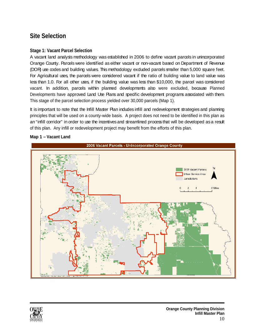
Stage 1: Vacant Parcel Selection A vacant land analysis methodology was established in 2006 to define vacant parcels in unincorporated Orange County. Parcels were identified as either vacant or non-vacant based on Department of Revenue (DOR) use codes and building values. This methodology excluded parcels smaller than 5,000 square feet. For Agricultural uses, the parcels were considered vacant if the ratio of building value to land value was less than 1.0. For all other uses, if the building value was less than $10,000, the parcel was considered vacant. In addition, parcels within planned developments also were excluded, because Planned Developments have approved Land Use Plans and specific development programs associated with them. This stage of the parcel selection process yielded over 30,000 parcels (Map 1).
It is important to note that the Infill Master Plan includes infill and redevelopment strategies and planning principles that will be used on a county-wide basis. A project does not need to be identified in this plan as an “infill corridor” in order to use the incentives and streamlined process that will be developed as a result of this plan. Any infill or redevelopment project may benefit from the efforts of this plan.
Map 1 – Vacant Land
Orange County Planning Division Infill Master Plan
11
To make the selection more concise and within the realm of the infill definition, additional criteria were applied. The next step began with applying location criteria to parcels within unincorporated Orange County. The parcel location criteria were:
Within the Urban Service Area;
Not within any Joint Planning Area;
Within a quarter-mile of major streets; and
Within a quarter-mile of Lynx bus routes.
Parcels resulting from these criteria reflect areas of the County where significant public investment has been made (USA), are less likely to be annexed into a municipality (JPA), and are highly accessible (major streets and bus routes). This analysis helped to refine the vacant parcel selection to accommodate the infill definition mentioned in the Introduction section of this report, which considers parcels located only in the USA.
Stage 2: Underutilized Parcels Identification of potential infill areas was based on the location of vacant and underutilized parcels. For non-vacant parcels, criteria were established to designate the parcel as underutilized and therefore having redevelopment potential. A review of other jurisdictions’ methodologies showed various criteria were used to define underutilized parcels, but most methodologies used combinations of parcel size and land and improvement values. In this analysis, residential non-vacant parcels were called underutilized if the parcel size was 2.5 times or greater the minimum size required for the zoning district. Non-residential, non-vacant parcels were deemed underutilized if the building value equaled half or less the land value. Refinements to the selected non-vacant parcels excluded those with buildings constructed after 1970. Newer buildings are less likely than older buildings to redevelop through demolition and reconstruction.
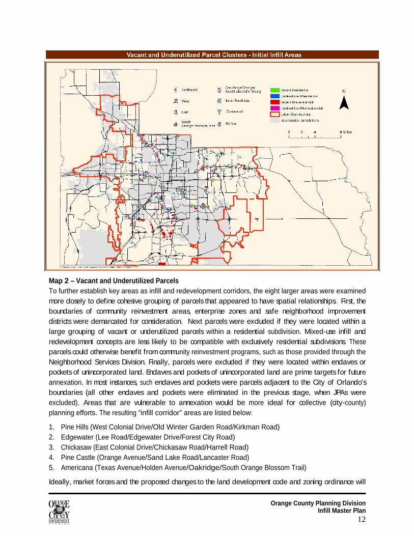
This analysis identified 2,084 vacant residential parcels, 1,250 vacant non-residential parcels, 2,799 underutilized residential and 392 underutilized non-residential parcels using the criteria described above. The geographic distribution of these parcels defined potential infill areas. Clusters of underutilized and vacant parcels defined eight (8) initial infill areas (Map 2):
1. Northwest (North Orange Blossom Trail/Edgewater/Lee/Silver Star) 2. West (West Colonial Drive/Old Winter Garden Road/Kirkman Road) 3. East (East Colonial Drive/University Avenue/Semoran Boulevard/Goldenrod Road/Dean Road/Rouse
Road/Alafaya Trail) 4. South Central (South Orange Blossom Trail/ Rio Grande Avenue/Kaley Avenue/Michigan
Avenue/Holden Avenue/ Americana Boulevard) 5. Central (Oak Ridge Road/Orange Avenue/Sand Lake Road/John Young Parkway) 6. Inner Southeast (Curry Ford Road/Michigan Avenue/Conway Road) 7. Goldenrod (Lake Underhill to Pershing) 8. Hoffner (Conway to Goldenrod)
Orange County Planning Division Infill Master Plan
12
Map 2 – Vacant and Underutilized Parcels To further establish key areas as infill and redevelopment corridors, the eight larger areas were examined more closely to define cohesive grouping of parcels that appeared to have spatial relationships. First, the boundaries of community reinvestment areas, enterprise zones and safe neighborhood improvement districts were demarcated for consideration. Next parcels were excluded if they were located within a large grouping of vacant or underutilized parcels within a residential subdivision. Mixed-use infill and redevelopment concepts are less likely to be compatible with exclusively residential subdivisions. These parcels could otherwise benefit from community reinvestment programs, such as those provided through the Neighborhood Services Division. Finally, parcels were excluded if they were located within enclaves or pockets of unincorporated land. Enclaves and pockets of unincorporated land are prime targets for future annexation. In most instances, such enclaves and pockets were parcels adjacent to the City of Orlando’s boundaries (all other enclaves and pockets were eliminated in the previous stage, when JPAs were excluded). Areas that are vulnerable to annexation would be more ideal for collective (city-county) planning efforts. The resulting “infill corridor” areas are listed below:
1. Pine Hills (West Colonial Drive/Old Winter Garden Road/Kirkman Road) 2. Edgewater (Lee Road/Edgewater Drive/Forest City Road) 3. Chickasaw (East Colonial Drive/Chickasaw Road/Harrell Road) 4. Pine Castle (Orange Avenue/Sand Lake Road/Lancaster Road) 5. Americana (Texas Avenue/Holden Avenue/Oakridge/South Orange Blossom Trail)
Ideally, market forces and the proposed changes to the land development code and zoning ordinance will
Orange County Planning Division Infill Master Plan
13
serve as an impetus for increased activity for infill and redevelopment. Should the market fail to respond to the code and ordinance changes, the five infill corridor areas will be used to develop a more coordinated strategy in implementing the plan.
It is important to note that the Infill Master Plan includes infill and redevelopment strategies and planning principles that will be used on a county-wide basis. A project does not need to be identified in this plan as an “infill corridor” in order to use the incentives and streamlined process that will be developed as a result of this plan. Any infill or redevelopment project may benefit from the efforts of this plan.
Mini Analyses Each infill corridor received an individual mini analysis conducted by the IMP committees. (The mini-analyses are included as Appendices A through E.) Each analysis involved an assessment of existing conditions, community characteristics, infrastructure conditions and potential incentives. At the beginning of each analysis, a summary of the vacant and underutilized parcels is provided along with land use and zoning information. In addition, the level of neighborhood involvement is depicted in a table format to give the reader an opportunity to assess the type of interaction the community shares with Orange County. Although the mini analyses provide essential data to gain a better understanding of the areas, more information will be assessed at a later date (to include crime statistics, neighborhood surveys, visioning, and a complete land use inventory).
The Design Subcommittee developed a Design Scorecard for each of the infill corridors. The scorecards summarized critical elements of smart growth principles within each of the infill areas, including location, density, mixture of uses, housing diversity, transportation and connectivity, community character and environmental protection. By adding all of these components together, the total score could be 100 points, indicating the area had achieved an excellent integration of smart growth concepts within its boundaries. The criteria used to evaluate each item were based purely on what was currently present on the site and not on the potential for development. A higher design score indicates existing smart growth principles on site; therefore, requiring less capital investment. Each attribute was scaled with a poor, fair, good or excellent grade. An excellent rating indicates that the criterion presented itself in 100% of the site. A good rating was presented in at least 75% of the site and so forth. Occasionally items were presented as bonus items. Those items are considered above and beyond what is recognized as the norm and serve only to enhance the overall quality of the neighborhood, but are not essential. The scores for the five study areas ranged from 45 points for the Colonial Drive Area to 69 points in the Edgewater Drive Area.
Transportation concurrency issues were considered for each of the study areas. However, the complexity of calculating concurrency for an entire study area was not deemed feasible or necessary for this stage of the analysis. Transportation concurrency and the number of trips for which a development is vested will be determined for potential infill projects as development applications are submitted. In the future, the County also will consider the practicability of implementing transportation concurrency exception areas for infill development.
It is important to note that the Infill Master Plan includes county-wide provisions. The selected infill corridors will be a coordinated means for implementing the IMP; however, the “market” will determine the timing and rate at which redevelopment actually occurs.
Orange County Planning Division Infill Master Plan
14
Recommendations
The goal for infill and redevelopment is to accommodate a greater percentage of the county's residential growth in the existing urban area, as well as to promote mixed-use commercial and office development in older areas to better serve well established, mature neighborhoods. By adopting the three-pronged strategy of Smart Growth, Green Building and Economic Prosperity, Orange County can implement an approach that truly embraces sustainability.
Four committees – Infrastructure, Zoning and Land Development Codes, Incentives and Marketing, and Housing and Design – explored redevelopment and infill-related issues to establish objectives and recommendations for the IMP.
Incentives and Marketing Committee Currently vacant and underutilized parcels stay vacant for a reason. Unless growth pressure is very strong and land costs are high, developers prefer vacant parcels of land. Therefore, it is necessary to provide a sufficient incentive package to the development community in order to intensify infill and redevelopment efforts. Upon completion of the Infill Master Plan, the County should have a number of marketing strategies in place to introduce the Plan and to educate members of the development and residential communities about redevelopment opportunities.
The Incentives and Marketing Committee comprised representatives from the Office of Management and Budget, Concurrency Management, Zoning, Neighborhood Services, and Housing and Community Development. This Committee evaluated current incentives available at the local, state and federal level in the proposed infill study areas and recommended several potential revisions to existing regulations. Such revisions would help promote and encourage infill and redevelopment projects in Orange County. The Committee’s recommendations are presented below.
Strategy: Build Smarter (Smart Growth)
Objective 1 Develop strategies to promote reuse of abandoned urban lands and greyfields. Recommendations:
Identify transportation concurrency opportunities and constraints in infill corridors containing potential greyfield and brownfield sites.
Identify local/ regional developers with capacity and expertise in developing greyfield and brownfield sites.
Objective 2 Provide a wide range of housing types within infill and redevelopment areas to accommodate projected residential growth. Recommendations:
The following types of developments with residential components should be promoted: mixed-use planed developments; vertical mixed-use projects; accessory structures.
Objective 3 Encourage higher density and mixed-use development to ensure a better use of land and
Orange County Planning Division Infill Master Plan
15
allow for distributing costs among a larger number of units. Recommendations:
Use the workforce housing density bonus for residential and mixed-use infill projects.
Promote the establishment and utilization of mixed-use land use categories that call for higher densities through vertical and horizontal mixed-use.
Encourage higher percentages for residential components in mixed-use infill projects.
Objective 4 Use existing impact fee subsidies by including workforce housing in infill projects Recommendations:
Use the proposed 25-75% impact fee subsidy for workforce rental units.
Use the proposed 50-75% impact fee subsidy for workforce for-sale units.
Strategy: Build Greener (Green Building)
Objective 1 Minimize development of open space and natural areas through reuse of existing properties. Recommendations:
Address limitations on expansions of the Urban Service Area (USA) boundary through the Comprehensive Policy Plan.
Evaluate transportation capacity and transportation concurrency issues that large-scale infill projects potentially can face.
Objective 2 Include “green building” standards in the infill certification process for mixed-use, residential and commercial projects. Recommendations:
Include “green building standard” designations of the Florida Green Building Coalition as an optional part of the infill certification process. “Green building standard” designations for Orange County infill classifications are as follows:
Green Home Standard for residential and transitional residential infill lots; Green Commercial Building Standard for transitional commercial infill lots and
infill and redevelopment corridors; Green Development Standard for infill and redevelopment corridors with high
concentration of mixed uses.
Create a Green Standards List incorporating green building requirements that could be used in infill and redevelopment projects.
Objective 3 Use federal grants by promoting inclusion of various green building standards into infill and redevelopment projects. Recommendations:
As a tool to potential redevelopers, create a list of federal exemptions and grant opportunities available for incorporating green building standards into infill projects.
Establish a market strategy to increase general awareness in the development community of green building standards and requirements.
Include information on federal grants and incentives offered for incorporating green building standards into infill projects as a part of an incentive package.
Orange County Planning Division Infill Master Plan
16
Strategy: Build Richer (Economic Prosperity)
Objective 1 Promote redevelopment and revitalization of neighborhoods by identifying potential brownfield sites. Recommendation:
Coordinate with Orange County Environmental Protection Division on potential establishment of brownfield sites in identified infill corridors.
Objective 2 Streamline the development review process to help developers avoid holding costs. Recommendations:
Develop criteria, requirements and a checklist for an infill certification process.
Incorporate infill project criteria as part of the Growth Management Department administrative regulations.
Develop an expedited review process for certified infill projects to be incorporated into Growth Management Department administrative regulations.
Inform and encourage other County divisions and departments to incorporate smart growth principles in the review process.
Perform a cost-effectiveness comparison of infill development to conventional development.
Objective 3 Use available economic incentives to promote nonresidential and mixed-uses. Recommendations:
Reformulate the following programs administered by Orange County Neighborhood Services Division to address objectives of the Infill Master Plan.
ReNew program; Crime Prevention Fund program.
Explore opportunities for utilizing HUB Zone and Community Development Block Grant (CDBG) programs to address objectives of the Infill Master Plan.
Infrastructure Committee Promoting the use of infill to accommodate growth where infrastructure already is in place is a more efficient use of land, and it helps reduce development costs. The Infrastructure Committee consisted of representatives from Stormwater Management, the Office of Management and Budget, Concurrency Management, Utilities Engineering and Transportation.
Committee members evaluated current infrastructure conditions in the proposed infill study areas, and they suggested revisions and alternatives to existing regulations to further encourage infill development, smart growth and sustainability. The Committee’s recommendations are listed below and organized based on overall strategies and objectives.
Strategy: Build Smarter (Smart Growth)
Objective 1 Provide alternative requirements or flexible regulations that are conducive to infill development. Recommendations:
Explore opportunities, long-term costs and benefits of alternative regulations.
Orange County Planning Division Infill Master Plan
17
Identify regulations and best management practices that are most appropriate for infill sites within Orange County.
Examine feasibility of land development regulations and fee schedules designed specifically for infill projects
Objective 2 Time development with requisite capital improvement projects. Recommendations:
Use strategies to minimize development at or beyond the urban fringe.
Ensure that adequate, efficient services are in place to accommodate and promote residential, commercial or mixed-use projects.
Develop large-scale infill or redevelopment projects in phases based on infrastructure capacity to minimize impacts on the existing infrastructure.
Develop an infrastructure strategy that supports infill and redevelopment.
Strategy: Build Greener (Green Building)
Objective 1 Design new development that can access or enhance existing infrastructure in an effort to limit sprawl. Recommendations:
Implement policies that guide the location of development to areas with existing infrastructure that has the capacity to handle infill development.
Require and incorporate green building strategies in the land development regulations and Comprehensive Policy Plan.
Encourage development in locations that provide transportation choices or otherwise reduce motor vehicle use.
Objective 2 Continue consistent maintenance of existing infrastructure to protect the environment. Recommendations:
Use environmentally safe methods and technologies for maintenance when feasible.
Amend the stormwater management plan to include practices that should be employed for infill development (e.g. permeable pavements, green roofs).
Objective 3 Provide information to builders, developers and residents regarding designs and building materials that allow for a more sustainable environment. Recommendations:
Implement policies that incorporate sustainable development principles that encourage the reduction of water usage
Encourage water reuse.
When upgrading existing infrastructure, consider the feasibility of purchasing advanced technological equipment related to stormwater systems.
Encourage infrastructure energy efficiency (street lights, water and wastewater pumps, and treatment systems).
Encourage the purchase/use of Energy Star appliances in new developments.
Orange County Planning Division Infill Master Plan
18
Objective 4 Encourage the development community to adopt practices that minimize the amount of pollutants contained in stormwater runoff and use alternative water sources. Recommendations:
Work with EPD and Stormwater Management to provide a guidebook on simple cost efficient strategies, techniques and tools that can be used to minimize the amount of contaminants found in runoff.
Increase awareness and public knowledge of opportunities to use alternative water sources.
Strategy: Build Richer (Economic Prosperity)
Objective 1 Create a more efficient use of infrastructure that will benefit service providers and residents. Recommendations:
Maximize the use of infrastructure in an efficient and effective manner that will not compromise the adopted level of service (e.g. collocation or joint use of accessory facilities such as parking or retention ponds).
Increase communication and cooperation among jurisdictions when infrastructure is being provided along or near jurisdictional boundaries.
Objective 2 Maintain and update logs/ records of areas with deficient infrastructure and advocate for these projects in areas where infill development is encouraged. Recommendations:
Use maintenance logs and deficiency records to prioritize capital improvement projects.
Explore the use of special assessments for continued maintenance, enhancements and improvements.
Design Committee The IMP can be used to promote innovative design solutions for revitalizing older suburban neighborhoods and strip malls. Innovative design creates spaces where people want to be, thus adding to the aesthetic quality of the entire community. The primary focus was to find design alternatives for encouraging desirable development, rather than regulating poor design. In addition, the Design Committee had the opportunity to conduct a design “charrette” for one of the selected areas that resulted in a conceptual redevelopment plan for the area. The charrette graphic is shown in Appendix B.
The Design Committee consisted of representatives from Urban Design, Growth Management, Parks and Recreation, Neighborhood Services, and Housing and Community Development. Committee members conducted field visits to assess the use of space and the integration of land uses in the proposed infill corridors. Using the overall IMP strategies, the recommendations of the Design Committee are outlined below.
Strategy: Build Smarter (Smart Growth)
Objective 1 Encourage Smart Growth principles in infill and redevelopment projects. Recommendations:
Develop infill and reuse area design guidelines.
Orange County Planning Division Infill Master Plan
19
Create “pre-approved” house plans for various lot and density types.
Set recommended density transects for each area of infill and redevelopment.
Objective 2 Support housing needs of a diverse and changing population. Recommendations:
Infill areas should provide a range of housing opportunities and choices.
Infill areas should provide a mixture of land uses in the community and allow for integration of commercial and office uses adjacent to residential.
Objective 3 Provide flexible recreational uses within infill and redevelopment areas. Recommendations:
Infill development should include optimum quality, suitably located, and well designed recreation and public open spaces.
Infill projects should be developed with alternatives that would create pedestrian connectivity to existing projects.
Objective 4 Involve the community in the planning for infill and redevelopment. Recommendations:
Engage the community early and often concerning the program elements and land uses anticipated for infill and redevelopment areas.
Develop ways that an infill project can create a sense of ownership throughout the community through gateways and iconic elements.
Create an Infill Community Participation Brochure to outline key steps for public participation in the infill process.
Objective 5 Infill corridors should encourage infill development that blends seamlessly with established areas. Recommendations:
Large-scale infill and redevelopment projects that involve the consolidation of multiple blocks can have a significant visual and physical impact on an area’s character. Consideration should be given to projects of this magnitude to ensure they are designed to incorporate clear pedestrian connections to the surrounding area, to establish strong relationships between buildings and the street, and to minimize the impacts of parking on primary street frontages.
Use design guidelines to ensure compatibility with surrounding uses.
Strategy: Build Greener (Green Building)
Objective 1 Promote “Green Building” practices within infill projects. Recommendations:
Develop a Green Standards List that includes site planning and vertical construction.
Encourage developers to meet the green building standard criteria of the Florida Green Building Coalition through a variety of incentives.
Encourage project design that incorporate high levels of internal connectivity and encourage project location in existing communities in order to conserve land, promote multi-modal transportation and promote public health through increased physical
Orange County Planning Division Infill Master Plan
20
activity.
Objective 2 Encourage the incorporation of Green Building practices in neighborhood patterns and design. Recommendations:
Establish and use a design scorecard to define sustainable building criteria for areas of redevelopment and infill.
Develop a carbon footprint impact analysis that supports the County’s Green Place program.
Design appealing and comfortable pedestrian street environments.
Provide benefits to builders using Green Building standards and recycled materials.
Objective 3 Incorporate recreation facilities in areas of infill. Recommendation:
Encourage the use of remnant and interstitial spaces for recreational opportunities.
Develop criteria for integrating recreational amenities in areas of infill.
Objective 4 Create safer, more livable communities through the use of infill and redevelopment. Recommendation:
Reinforce and encourage Crime Prevention Through Environmental Design (CPTED) principles that can be implemented.
Encourage cluster development to provide more opportunities for neighborhood interaction.
Provide live/work units and multigenerational units within infill areas. Objective 5 Create opportunities for maximum energy savings within infill and redevelopment projects.
Recommendations:
Encourage the use of site design techniques that promote energy efficiency for infill and redevelopment projects.
Encourage xeriscaping principles and the use of plant species indigenous to the Central Florida region.
Encourage the incorporation of new or preservation of existing shade trees to lower ambient heat.
Strategy: Build Richer (Economic Prosperity)
Objective 1 Establish neighborhood patterns that enable residents from a wide range of economic levels and age groups to live within one community. Recommendation:
Encourage balanced communities with a diversity of uses and employment opportunities.
Provide connectivity between land uses that would allow pedestrian movement.
Provide retail uses that will support the neighborhood within areas of redevelopment and infill.
Objective 2 Provide housing opportunities to growing workforce population by encouraging mixed-use and residential infill.
Orange County Planning Division Infill Master Plan
21
Recommendation:
Support Workforce Housing Task Force recommendations by allowing residential uses in non-residential areas such as retail, office and other uses and by studying the feasibility of allowing accessory dwelling units in residential areas.
LDC and Zoning Regulations Committee While infill and redevelopment offers a multitude of advantages, it comes along with a unique set of challenges as it relates to conventional zoning. The LDC and Zoning Regulations Committee reviewed the Orange County Comprehensive Policy Plan, existing County overlays and neighborhood districts to determine if there is a need to amend the zoning ordinance and land development code to accomplish the objectives of the IMP.
The LDC and Zoning Regulations Committee consisted of Planning, Zoning, Concurrency Management, and Orange County Public Schools. The recommendations of the group are noted below.
Strategy: Build Smarter (Smart Growth)
Objective 1 Ensure that infill and redevelopment is of a scale and character that is compatible with and enhances the surrounding areas. Recommendations:
This may be accomplished through the use of appropriate height and density transitions, similar setbacks and lot coverage, garage and loading area location and configuration, connectivity to surrounding development, and other neighborhood-specific design considerations.
Establish design guidelines that may be used for infill and redevelopment projects.
Objective 2 Promote infill development by establishing standards that are tailored to specific types of neighborhood land uses. Recommendation:
Examine the feasibility of incorporating changes in the zoning ordinance as it relates to infill and the integration of land uses, particularly concerning:
Accessory dwellings Duplexes Neighborhood Office/Commercial Urban mixed-use corridors
Objective 3 Coordinate IMP strategies and activity centers to maximize connectivity and appropriate allocation of uses. Recommendations:
Establish a hierarchy of mixed-use activity centers to serve the community.
Establish how activity centers potentially could be used within the context of existing development patterns and underutilized lots.
Define relationships between activity centers of different scale and infill redevelopment corridors.
Promote land assemblage to accommodate better site design and increase compatibility with surrounding development.
Orange County Planning Division Infill Master Plan
22
Objective 4 Orange County will find creative ways to balance the interests of schools while increasing density within infill areas. Recommendations:
Orange County BCC and Orange County Public Schools shall continue to coordinate issues regarding concurrency and capacity enhancement.
Review the school siting ordinance to consider the possibility of reducing acreage requirements for schools in infill areas.
When appropriate/ possible, encourage infill development in areas with existing school capacity.
Objective 5 Address existing zoning barriers to infill development. Recommendations:
Conduct an audit of the Land Development Code to determine what changes are necessary to accomplish the strategies of the Infill Master Plan.
Consider the addition of a newly created district for substandard lots with a future land use designation of office or commercial (to be called Neighborhood Office Commercial District).
Objective 6 Small infill lots should encourage compatibility with scale and character of surrounding uses. Recommendations:
Lot considerations: mid-block vacant lots; vacant corner lots; long, flag, shallow, and narrow lots.
Revise existing or create new mixed-use zoning districts that are consistent with residential land use designations. These districts shall encourage a mix of uses that are in scale with existing development.
Objective 7 Incorporate flexible zoning regulations to allow development of smaller substandard lots and make infill development practical. Recommendations:
Propose changes to the Land Development Code incorporating flexible zoning regulations for certified infill projects.
Specifically, Article VIII Sec. 2-282 relating to the infill affordable housing program and Article XI Sec. 30-36 relating to urban infill and vested rights.
Develop a set of flexible zoning requirements for non-certified infill sites (infill parcels database is available through Planning Division).
Revise and expand on existing Future Land Use Element policies 3.3.1, 3.3.2. 3.3.3, and 3.4.3, which are designed to encourage infill, and also Sec. 30-503(4)(b) to include the evaluation of infill development by the Concurrency Review Committee.
Strategy: Build Greener (Green Building)
Objective 1 Support countywide green building initiatives through infill and redevelopment. Recommendation:
Use the land development code and design guidelines to encourage the incorporation of green building standards into infill and redevelopment projects.
Orange County Planning Division Infill Master Plan
23
Strategy: Build Richer (Economic Prosperity)
Objective 1 Use infill and redevelopment to reinvest in older communities. Recommendations:
Promote recommended changes to the Comprehensive Policy Plan and land development code to revitalize older neighborhoods.
Assess proposed infill and redevelopment projects in older neighborhoods based on potential benefits and impacts to neighborhood fabric, connectivity and aesthetics.
Distribute a property owner’s survey to underutilized businesses to gauge perceptions and needs related to redevelopment.
Objective 2 Ensure the efficient processing of development applications and building permits to minimize development costs. Recommendation:
When permitted or appropriate, allow small-scale land use plan amendments and rezoning applications for certified infill projects to be processed concurrently.
Orange County Planning Division Infill Master Plan
24
IMP Implementation Recommendations brought forth by the four Committees of the IMP planning group include six primary strategies:
Develop infrastructure strategies that support infill;
Adopt infill and redevelopment design guidelines;
Administer a survey of owners of underutilized parcels (businesses only);
Propose amendments the Comprehensive Policy Plan, zoning ordinance and land development regulations that encourage infill/redevelopment;
Create of an infill/redevelopment project certification program; and
Establish an infill/redevelopment incentive program.
This section will provide information about implementing these recommendations and will provide details about Phase 2 of the IMP planning process. Actions in Phase 2 will include stakeholder group meetings, a redevelopment conference and selection of a pilot infill/redevelopment area.
Infrastructure Strategies That Support Infill One of the attractions of infill sites is the general availability of existing infrastructure. However, these sites also may lack some elements of basic infrastructure, including direct road access to the site. In other cases, infrastructure may be undersized by current standards or densities, or may be deteriorated, requiring replacement, particularly for a larger infill project. Considering these factors, it will be necessary for Orange County to re-examine its priorities as it relates to the maintenance, upgrade and expansion of infrastructure. The age and capacity of existing infrastructure will be a key factor influencing the potential to develop high density, mixed-use projects. Orange County Planning will coordinate with Utilities, OMB, Public Works, and Parks and Recreation to establish a smart growth infill strategy for infrastructure.
Infill/Redevelopment Design Guidelines The IMP can be used to promote innovative design solutions for revitalizing older suburban areas and strip malls. Innovative design creates places where people want to be, thus adding to the aesthetic quality of the entire community. Orange County has an opportunity to provide solutions to a variety of design-related issues. The range of priorities to be considered includes:
Accommodating greater density while respecting the existing neighborhood character;
Encouraging quality design while facilitating affordable housing;
Providing for automobile parking while contributing to pedestrian-friendly street frontages;
Increasing density while providing usable open space; and,
Allowing the new while respecting the old.
An emphasis of the new design guidelines: find ways to encourage desirable development, rather than simply regulating against poor design.
Survey Owners of Underutilized Property Upon completion of the Infill Master Plan, a survey will be developed and distributed to business owners of underutilized properties that were identified through the site selection process. The survey’s goal will be to
Orange County Planning Division Infill Master Plan
25
collect diverse views about redevelopment of the properties, including possible objectives of redevelopment, potential constraints to it, and proposed changes that may improve redevelopment potential.
Survey results will provide a more detailed picture of redevelopment of underutilized commercial property: what forces and factors drive the process, create barriers to it or otherwise influence it. Results of the survey also could shape future policies related to redevelopment of underutilized properties. This information will be used to develop a better understanding of past successes and remaining challenges in redeveloping these properties.
Amendments to the Comprehensive Policy Plan, Zoning Ordinance and Land Development Code The Comprehensive Policy Plan, zoning ordinance and land development code will need to be revised to address key challenges that come along with infill and redevelopment. All three documents are outdated in this respect.
Comprehensive Policy Plan Amendments regarding infill and redevelopment will be included as part of the CPP Update, which is scheduled to be adopted in September 2008. The definition of infill in the CPP will be changed to match the one developed for this report. (Infill is defined as the development of vacant or underutilized land within the USA where restoration or rehabilitation of existing structures or infrastructure maintains the continuity of the original community fabric. Infill development provides many advantages, including diverse housing stock, accessibility to existing infrastructure, and heightened design standards.) In addition, identified infill corridors will be tied more closely to activity centers, mixed-use corridors and traditional neighborhood developments.
Zoning Ordinance and Land Development Code The zoning ordinance and land development code will be amended to accommodate infill and redevelopment efforts. The existing code and ordinance are out-dated; therefore, a team approach will be used to include several departments and divisions in the update process. Proposed changes will encourage and support mixed use development, site design, and form-based principles. The following details related to small lots and infill corridors should be considered as the new regulations are developed.
Small lots Infill sites tend to be scattered lots that were passed over during the course of previous development activities. Infill on smaller lots is classified into two categories: residential infill lots and transitional infill lots. A residential infill lot is characterized as a mid-block or interior lot located within a predominantly single family residential area. Plans for residential infill lots within existing neighborhoods should seek to consider the larger context of how the neighborhood looks and functions as a whole. Appeal to new residents and acceptance by existing residents will be enhanced if new development fits in with the existing context.
Transitional infill lots are characterized as corner lots located within or near a predominantly residential area, on which neighborhood-related uses would be ideal. Plans for transitional infill lots also should seek

Orange County Planning Division Infill Master Plan
26
to consider the larger context of how the neighborhood looks and functions as a whole; however, the primary emphasis would include slightly higher intensities and densities than surrounding residential development. Good design will be essential to successfully providing more intense uses. The more intense uses should maintain the substantial character of the surrounding neighborhood, and likely will include uses such as neighborhood markets, professional office and florists, bakeries and ice cream shops.
Increased density for transitional infill lots may make a marginal project more feasible or provide greater incentive for a developer to undertake infill development. The increase in density should be a subtle one. For instance, carefully designed and located duplexes and accessory units can provide increased density without altering the basic single family character of a neighborhood. In this situation, exceptional design often is more important than density in gaining neighborhood acceptance. In addition, prescriptive standards can be used to separate land uses, which typically have different types of impacts, to ensure compatibility.
Infill/Redevelopment Corridors Infill/ Redevelopment Corridors are characterized by commercial and office uses located along major roadways, near major transit corridors. These infill areas will be processed as planned developments (PD). PD provisions will help to emphasize purposes such as a unified approach to neighborhood development; more flexible development standards; a greater mixing of housing types and land uses including more affordable types of housing and convenience services; a more efficient arrangement of structures, streets, utility networks or other public improvements; and in general, a more creative and aesthetic approach to land development.
Table 1: Orange County Infill Classifications
Classification Characteristics Intensity
Residential Infill Lot A mid-block or interior lot that sets within a predominantly single family residential area
Low intensity residential use; reflects residential surroundings
Transitional Infill Lot Corner lot located within or near a predominantly residential area in which neighborhood-related uses would be ideal
Moderate intensity; reflects residential surroundings, with modest increase in scale and use (e.g. duplex, or neighborhood store)
Infill/Redevelopment Corridor
Commercial and office uses located along major roadways
High intensity; characterized by concentrations of mixed uses
Incentives for Infill Productive reuse of urban land helps prevent the unnecessary development of open space and natural areas, and reduces the public cost for installing new infrastructure. The reuse of property is integral to smart growth; but while reuse is a sound land use policy there are factors that can make that option appear less desirable. Incentives are often necessary to encourage infill development and redevelopment.
The recommendations outlined in the Executive Summary included the adoption of incentives that support infill and redevelopment. Incentives can be costly; however, the IMP planning group looked first to existing programs offered by Orange County for use as infill incentives. With the exception of the proposed
Orange County Planning Division Infill Master Plan
27
streamlined development process, all other potential infill/ redevelopment incentives currently exist through other Orange County Departments and Divisions.
Incentives help make infill and redevelopment an attractive and feasible alternative for the development community. Orange County’s proposed incentives are focused on brownfields, housing, streamlining the development review process, and finance-based programs. Each alternative is discussed briefly in this section. A comprehensive marketing plan will be the primary key to establishing a link between infill, redevelopment, and the existing incentive programs; therefore, this section includes a brief description of the proposed infill/redevelopment marketing plan as well.
Brownfields One disincentive to redevelopment is real or perceived environmental contamination on a piece of property. Often such property is abandoned, vacant or underutilized. In most instances, these properties are considered brownfields.
A brownfield site is property that has actual or perceived environmental contamination, which complicates expansion, redevelopment or reuse of the property. (Appendix F provides greater details about the designation of Brownfields.) In order to overcome barriers to redevelopment of contaminated sites, brownfields programs at the federal, state and local level have been developed to accomplish the following general objectives: 1. Offer financial incentives to developers to encourage them to take on the costs and risks associated
with redevelopment of a contaminated site; 2. Provide liability protection to those who successfully remediate sites to agreed upon standards, which
extends to their tenants and to successor owners; 3. Offer a streamlined process to facilitate redevelopment of brownfield sites.
Successful brownfields programs address each of these objectives and are offered as part of a larger, well-coordinated effort to revitalize an urban area. The key U.S. EPA brownfields programs are:
Brownfield Assessment Demonstration Pilot Program
Targeted Brownfield Assessment Program
Brownfield Cleanup Revolving Loan Fund Pilot Program
Brownfield Tax Incentives
Housing Impact Fee Subsidies for Workforce Housing. On May 22, 2007, Orange County’s Workforce Housing Task Force released its recommendations, which were unanimously approved by the Board of County Commissioners. One recommendation, which will soon become County policy, is the Impact Fee Subsidy program. This program provides strong financial incentives for development of workforce housing units. The Impact Fee Subsidy program will provide a countywide impact fee subsidy in proportion to the following sales price of for-sale workforce housing units:
Orange County Planning Division Infill Master Plan
28
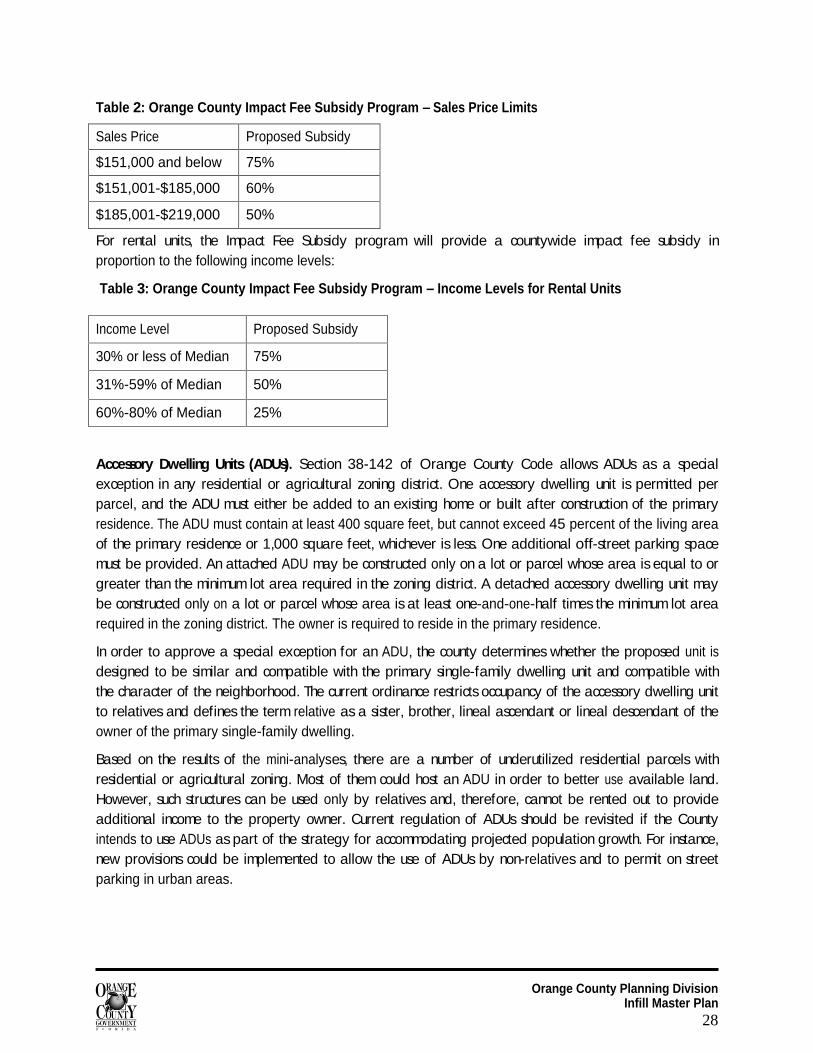
Table 2: Orange County Impact Fee Subsidy Program – Sales Price Limits
Sales Price Proposed Subsidy
$151,000 and below 75%
$151,001-$185,000 60%
$185,001-$219,000 50%
For rental units, the Impact Fee Subsidy program will provide a countywide impact fee subsidy in proportion to the following income levels:
Table 3: Orange County Impact Fee Subsidy Program – Income Levels for Rental Units
Accessory Dwelling Units (ADUs). Section 38-142 of Orange County Code allows ADUs as a special exception in any residential or agricultural zoning district. One accessory dwelling unit is permitted per parcel, and the ADU must either be added to an existing home or built after construction of the primary residence. The ADU must contain at least 400 square feet, but cannot exceed 45 percent of the living area of the primary residence or 1,000 square feet, whichever is less. One additional off-street parking space must be provided. An attached ADU may be constructed only on a lot or parcel whose area is equal to or greater than the minimum lot area required in the zoning district. A detached accessory dwelling unit may be constructed only on a lot or parcel whose area is at least one-and-one-half times the minimum lot area required in the zoning district. The owner is required to reside in the primary residence.
In order to approve a special exception for an ADU, the county determines whether the proposed unit is designed to be similar and compatible with the primary single-family dwelling unit and compatible with the character of the neighborhood. The current ordinance restricts occupancy of the accessory dwelling unit to relatives and defines the term relative as a sister, brother, lineal ascendant or lineal descendant of the owner of the primary single-family dwelling.
Based on the results of the mini-analyses, there are a number of underutilized residential parcels with residential or agricultural zoning. Most of them could host an ADU in order to better use available land. However, such structures can be used only by relatives and, therefore, cannot be rented out to provide additional income to the property owner. Current regulation of ADUs should be revisited if the County intends to use ADUs as part of the strategy for accommodating projected population growth. For instance, new provisions could be implemented to allow the use of ADUs by non-relatives and to permit on street parking in urban areas.
Income Level Proposed Subsidy
30% or less of Median 75%
31%-59% of Median 50%
60%-80% of Median 25%
Orange County Planning Division Infill Master Plan
29
Infill Certification and Streamlining Infill Certification. The Planning Division will develop a process for infill certification, which will serve as entry into the streamlined development review process. Several factors will be considered in developing the certification process, and the proposed smart growth committee will assist with developing the process to ensure that it is seamless.
Streamlined Review Process. An expedited review process is recommended to encourage infill and redevelopment projects. The process should include certification of infill and redevelopment projects, follow-up during the preliminary subdivision and construction plans, and implementation of time saving measures for infill projects. Formation of the process can be developed further in Phase 2 of the IMP, and should include an oversight group of county staff. In addition, the land development regulations should reflect changes that accommodate the County’s revised focus on infill and redevelopment. Such changes should make approval of infill and redevelopment projects less time consuming and less costly for the developer (e.g., allowing certain uses by right, or amending setbacks and lot size requirements for infill sites).
Financial Incentives A number of programs administered by the Neighborhood Services Division offer financial incentives for infill and redevelopment projects. These programs include ReNEW, Safe Neighborhoods and the Crime Prevention Fund. In addition, an impact fee grant for non-profit organizations offered by Orange County could be used when such businesses as day care facilities, religious institutions, community centers, etc. are created as a result of redevelopment.
ReNEW. The ReNEW (Resident and Neighborhoods Empowered to Win) Program provides direct funding to support and assist residents and organizations in improving the physical and social qualities of neighborhoods. Grants are available to help organizations revitalize and preserve their neighborhoods. The grants are open to neighborhood organizations and homeowners associations in Orange County. ReNEW grants could be used to finance residential infill and redevelopment efforts.
Three types of grants are available under the ReNEW program:
Neighborhood planning (enhancement) grants are available for development and implementation of small area or neighborhood strategic plans.
Capital project grants are open to neighborhood organizations, homeowners associations, councils, civic organizations and non-profit agencies.
Wall repair grants provide 100% reimbursement to neighborhood organizations and individual property owners intending to make repairs to subdivision walls.
Crime Prevention Fund. The Orange County Board of County Commissioners established the Crime Prevention Fund to address crime affecting residential safety in Orange County communities. Crime Prevention Funds are generated from fines assessed on convicted criminals ($50 for felonies and $20 for misdemeanors). Neighborhoods have access to Crime Prevention Funds in two ways. The first is through the Safe Neighborhood Program, in which target areas receive automatic allocations from the county each year. The other is the Crime Prevention Grant Program open to neighborhood associations countywide.
Orange County Planning Division Infill Master Plan
30
The Safe Neighborhood Program was created by the Board in June of 2000. Ten areas were designated to receive funding for crime prevention projects. Nine of these areas are administered by the Neighborhood Services Division, and the tenth is administered by the Orange Blossom Trail Development Board. Each area was required to establish a Safe Neighborhood organization that would serve as a community voice to identify projects that would address crime most effectively within that community. From 2000 to 2006, more than $1.6 million has been awarded to the nine Safe Neighborhood groups administered by Neighborhood Services. Another $875,000 has been allocated to the Orange Blossom Trail Development Board for its Safe Neighborhood. There is at least one Safe Neighborhood organization active in each of the five Infill Target Areas.
To assist neighborhood associations that were not included in a Safe Neighborhood Target area, the county also created the Crime Prevention Grant Program to provide funding to individual neighborhood organizations for projects designed to enhance safety and security in their communities. Several associations in each of the Infill areas have received ReNEW and/ or Crime Prevention funds. In addition, many organizations on the periphery of these Infill Areas also have received grant funds. The next section shows which neighborhood organizations are present in the Infill Areas and the amount of funding they have received.
Impact Fee Grants for Non-Profit Organizations. Another type of financial incentive includes impact fee grants. Currently impact fees grants are provided to non-profit organizations, while impact fee subsidies are provided to workforce housing projects (discussed in the previous section). Impact fee grants of up to $15,000 are available for non-profit organizations that provide community services and qualify under Section 501(c)(3) of the I.R.S. Code. The grants can contribute toward the cost of transportation, sheriff and fire impact fees incurred by new construction projects in unincorporated Orange County. Examples of approved projects include day care facilities, family life centers, recreational facilities, dependency treatment centers and youth service centers. This grant serves as an infill incentive to qualifying non-profit organizations in Orange County.
Marketing Infill and Redevelopment
Marketing Strategy Marketing of the Infill Master Plan and related strategies will be done via web site development, brochures, community involvement, outreach and education. The IMP web site will be established to provide updates and information on the County’s progress toward amending the land development code and zoning ordinance. Once the infill development certification process has been established, applications will be available in a PDF format for customer convenience. Details of the streamlined development review process and eligible incentives will be accessible online as well. Outreach and education will begin with stakeholder focus group meetings, and will continue with community participation as the infill corridor projects move forward. Ideally, Orange County will work closely with other local jurisdictions to create a collective vision for infill that will foster a positive regional impact on connectivity, transportation, and the environment.
Orange County Planning Division Infill Master Plan
31
Phase Two
Stakeholder Group Meetings The Planning Division would host two stakeholder groups to discuss the recommendations of the Infill Master Plan. The first group would represent the construction, real estate and financing sectors. Prior to the meeting, this group would complete a survey. The objective is to learn some of the barriers that may discourage infill and redevelopment in Orange County. This Focus Group would also generate ideas related to proposed incentives and offer suggestions to make infill and redevelopment an attractive alternative to urban sprawl.
The second focus group would consist of regional agencies such as LYNX, MetroPlan Orlando, Orange County Public Schools, Orange County Library System and adjacent jurisdictions. The goal would be to determine the locations of future facilities, and discuss the IMP in the context of anticipated population growth and its effect on public services. Information provided by this group would be used to further refine the proposed strategies and recommendations of the IMP.
Redevelopment Conference On March 27, 2008, Orange County will be hosting a Redevelopment Conference at the Orange County Convention Center. The day-long event will comprise a series of workshops related to financing, density, design, sustainability and smart growth. The audience is anticipated to include elected officials, property owners, planners, architects, financiers, investors and developers.
Pilot Community Selection Ideally, the market will respond positively once the land development code and zoning ordinance have been amended to accommodate infill and redevelopment projects. In the unlikely event that the market does not respond, the County will continue to promote redevelopment by selecting a pilot infill corridor. To select the pilot, a priority model will be established. The model will include a combination of information resources, including data collected from the mini analyses and the stakeholder groups. Further analysis using Geographic information System (GIS) also will be used. GIS spatial analyst will be used to apply weighted factors to each infill corridor area. The top ranked community will serve as the pilot community. Once the pilot is selected, an action plan will be outlined to determine what is required for the County to “stimulate” the market within the pilot area on its own. Such measures may include infrastructure improvements, land assembly, or additional incentives.
Orange County Planning Division Infill Master Plan
32
Sources 1. http://www.mrsc.org/Subjects/Planning/infilldev.aspx#intro. 2. Orange County and the Creative Community: An Analysis of the Impacts of the Creative Class on the
County’s Economy, East Central Florida Regional Planning Council, July 2005. 3. US Department of Agriculture, Smart Growth Score Card; Municipal Review, 2002 4. 2006 Vacant Land Analysis 5. Sacramento County, CA, County General Plan Update, August 2004 6. City/ Borough of Juneau, Alaska, Comprehensive Plan Update Buildable Sites Analysis and Findings,
January, 2007 7. Clark County, Washington, Determining Developable Vacant Lands through a Growth Management
Process 8. City of Orlando, FL, Crime Prevention through Environmental Design, Your Guide to Creating a Safe
Environment

Orange County Planning Division Infill Master Plan
33
Appendices
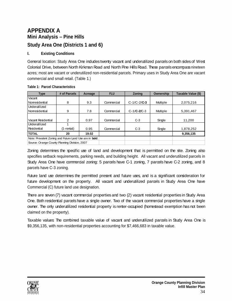
Orange County Planning Division Infill Master Plan
34
APPENDIX A Mini Analysis – Pine Hills
Study Area One (Districts 1 and 6)
I. Existing Conditions
General location: Study Area One includes twenty vacant and underutilized parcels on both sides of West Colonial Drive, between North Kirkman Road and North Pine Hills Road. These parcels encompass nineteen acres; most are vacant or underutilized non-residential parcels. Primary uses in Study Area One are vacant commercial and small retail. (Table 1.)
Table 1: Parcel Characteristics
Type # of Parcels Acreage FLU Zoning Ownership Taxable Value ($)Vacant Nonresidential 8 9.3 Commercial C-1/C-2/C-3 Multiple 2,075,216Underutilized Nonresidential 9 7.8 Commercial C-1/C-2/C-3 Multiple 5,391,467
Vacant Residential 2 0.97 Commercial C-3 Single 11,200Underutilized Residential
1 (1-rental) 0.95 Commercial C-3 Single 1,878,252
TOTAL 20 19.02 9,356,135Note: Prevalent Zoning and Future Land Use are in bold.
Source: Orange County Planning Division, 2007
Zoning determines the specific use of land and development that is permitted on the site. Zoning also specifies setback requirements, parking needs, and building height. All vacant and underutilized parcels in Study Area One have commercial zoning: 5 parcels have C-1 zoning, 7 parcels have C-2 zoning, and 8 parcels have C-3 zoning.
Future land use determines the permitted present and future uses, and is a significant consideration for future development on the property. All vacant and underutilized parcels in Study Area One have Commercial (C) future land use designation.
There are seven (7) vacant commercial properties and two (2) vacant residential properties in Study Area One. Both residential parcels have a single owner. Two of the vacant commercial properties have a single owner. The only underutilized residential property is renter-occupied (homestead exemption has not been claimed on the property).
Taxable values: The combined taxable value of vacant and underutilized parcels in Study Area One is $9,356,135, with non-residential properties accounting for $7,466,683 in taxable value.
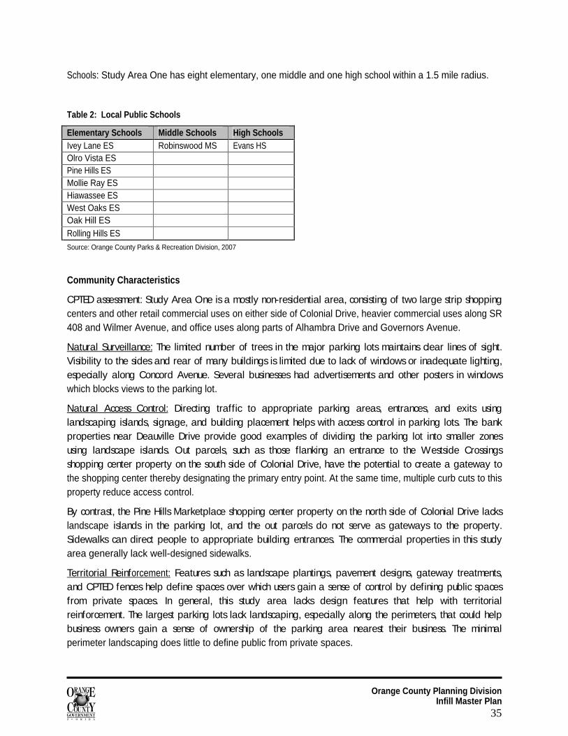
Orange County Planning Division Infill Master Plan
35
Schools: Study Area One has eight elementary, one middle and one high school within a 1.5 mile radius.
Table 2: Local Public Schools
Elementary Schools Middle Schools High Schools Ivey Lane ES Robinswood MS Evans HS Olro Vista ES Pine Hills ES Mollie Ray ES Hiawassee ES West Oaks ES Oak Hill ES Rolling Hills ES Source: Orange County Parks & Recreation Division, 2007
Community Characteristics
CPTED assessment: Study Area One is a mostly non-residential area, consisting of two large strip shopping centers and other retail commercial uses on either side of Colonial Drive, heavier commercial uses along SR 408 and Wilmer Avenue, and office uses along parts of Alhambra Drive and Governors Avenue.
Natural Surveillance:
The limited number of trees in the major parking lots maintains clear lines of sight. Visibility to the sides and rear of many buildings is limited due to lack of windows or inadequate lighting, especially along Concord Avenue. Several businesses had advertisements and other posters in windows which blocks views to the parking lot.
Natural Access Control:
Directing traffic to appropriate parking areas, entrances, and exits using landscaping islands, signage, and building placement helps with access control in parking lots. The bank properties near Deauville Drive provide good examples of dividing the parking lot into smaller zones using landscape islands. Out parcels, such as those flanking an entrance to the Westside Crossings shopping center property on the south side of Colonial Drive, have the potential to create a gateway to the shopping center thereby designating the primary entry point. At the same time, multiple curb cuts to this property reduce access control.
By contrast, the Pine Hills Marketplace shopping center property on the north side of Colonial Drive lacks landscape islands in the parking lot, and the out parcels do not serve as gateways to the property. Sidewalks can direct people to appropriate building entrances. The commercial properties in this study area generally lack well-designed sidewalks.
Territorial Reinforcement:
Features such as landscape plantings, pavement designs, gateway treatments, and CPTED fences help define spaces over which users gain a sense of control by defining public spaces from private spaces. In general, this study area lacks design features that help with territorial reinforcement. The largest parking lots lack landscaping, especially along the perimeters, that could help business owners gain a sense of ownership of the parking area nearest their business. The minimal perimeter landscaping does little to define public from private spaces.
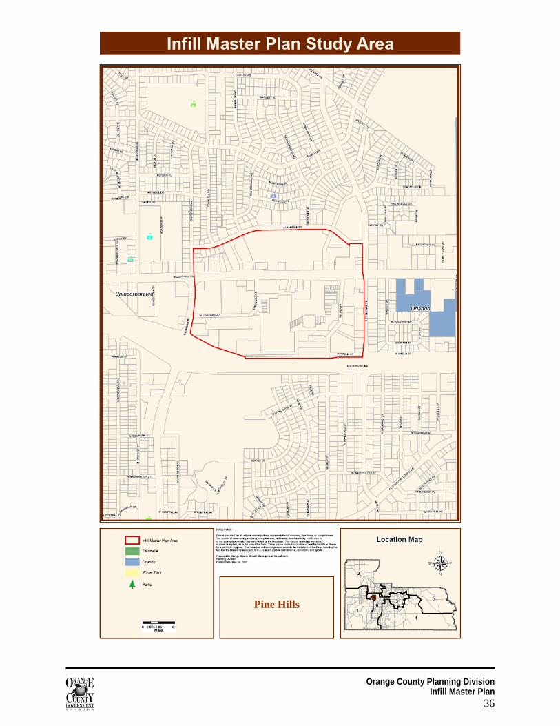
Orange County Planning Division Infill Master Plan
36
Pine Hills
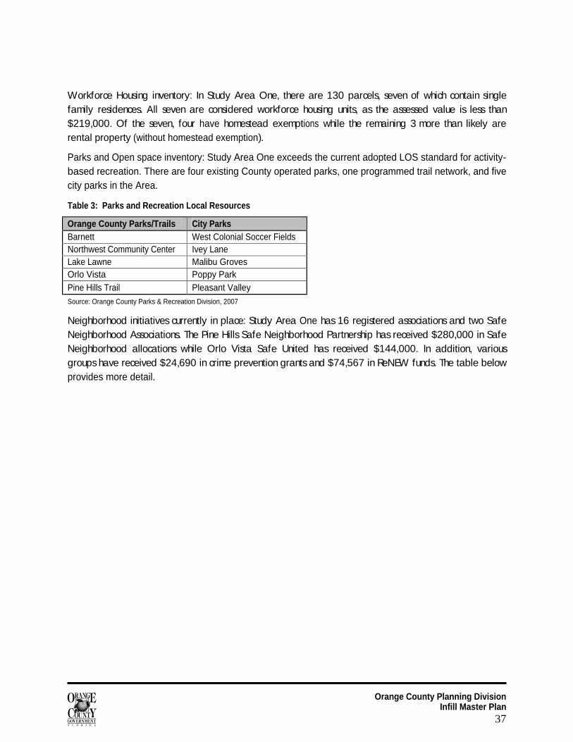
Orange County Planning Division Infill Master Plan
37
Workforce Housing inventory: In Study Area One, there are 130 parcels, seven of which contain single family residences. All seven are considered workforce housing units, as the assessed value is less than $219,000. Of the seven, four have homestead exemptions while the remaining 3 more than likely are rental property (without homestead exemption).
Parks and Open space inventory: Study Area One exceeds the current adopted LOS standard for activity-based recreation. There are four existing County operated parks, one programmed trail network, and five city parks in the Area.
Table 3: Parks and Recreation Local Resources
Orange County Parks/Trails City Parks Barnett West Colonial Soccer Fields Northwest Community Center Ivey Lane Lake Lawne Malibu Groves Orlo Vista Poppy Park Pine Hills Trail Pleasant Valley Source: Orange County Parks & Recreation Division, 2007
Neighborhood initiatives currently in place: Study Area One has 16 registered associations and two Safe Neighborhood Associations. The Pine Hills Safe Neighborhood Partnership has received $280,000 in Safe Neighborhood allocations while Orlo Vista Safe United has received $144,000. In addition, various groups have received $24,690 in crime prevention grants and $74,567 in ReNEW funds. The table below provides more detail.
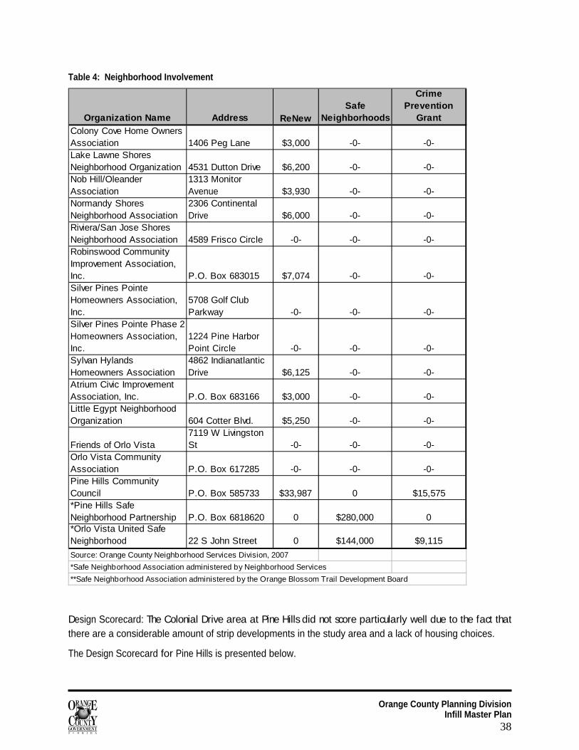
Orange County Planning Division Infill Master Plan
38
Table 4: Neighborhood Involvement
Organization Name Address ReNewSafe
Neighborhoods
Crime Prevention
GrantColony Cove Home Owners Association 1406 Peg Lane $3,000 -0- -0-Lake Lawne Shores Neighborhood Organization 4531 Dutton Drive $6,200 -0- -0-Nob Hill/Oleander Association
1313 Monitor Avenue $3,930 -0- -0-
Normandy Shores Neighborhood Association
2306 Continental Drive $6,000 -0- -0-
Riviera/San Jose Shores Neighborhood Association 4589 Frisco Circle -0- -0- -0-Robinswood Community Improvement Association, Inc. P.O. Box 683015 $7,074 -0- -0-Silver Pines Pointe Homeowners Association, Inc.
5708 Golf Club Parkway -0- -0- -0-
Silver Pines Pointe Phase 2 Homeowners Association, Inc.
1224 Pine Harbor Point Circle -0- -0- -0-
Sylvan Hylands Homeowners Association
4862 Indianatlantic Drive $6,125 -0- -0-
Atrium Civic Improvement Association, Inc. P.O. Box 683166 $3,000 -0- -0-Little Egypt Neighborhood Organization 604 Cotter Blvd. $5,250 -0- -0-
Friends of Orlo Vista7119 W Livingston St -0- -0- -0-
Orlo Vista Community Association P.O. Box 617285 -0- -0- -0-Pine Hills Community Council P.O. Box 585733 $33,987 0 $15,575 *Pine Hills Safe Neighborhood Partnership P.O. Box 6818620 0 $280,000 0*Orlo Vista United Safe Neighborhood 22 S John Street 0 $144,000 $9,115
Source: Orange County Neighborhood Services Division, 2007
*Safe Neighborhood Association administered by Neighborhood Services
**Safe Neighborhood Association administered by the Orange Blossom Trail Development Board
Design Scorecard: The Colonial Drive area at Pine Hills did not score particularly well due to the fact that there are a considerable amount of strip developments in the study area and a lack of housing choices.
The Design Scorecard for Pine Hills is presented below.
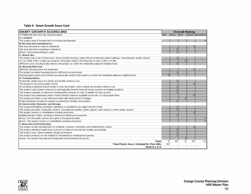
Orange County Planning Division Infill Master Plan
39
Table 5: Smart Growth Score Card
SMART GROWTH SCORECARDATTRIBUTES N/A Poor Fair Good Excellent N/A Poor Fair Good ExcellentA. LocationThe project area is located next to existing development 4B. Density and compactness:Site area devoted to roads is minimized. 3Site area devoted to parking is minimized. 1Bonus: Structured parking is used. 1C. Mixed UseThe project has a mix of land uses. (Uses include housing, retail, off ice/commercial, public buildings, entertainment, public space) 1Or, for small, infill or single use projects, the project adds to the diversity of uses w ithin 1/4 mile 2Diffferent uses are physically mixed in the project or w ithin the immediate adjacent neighborhood 1D. Housing Diversity Different housing types are proposed. 3The project provides housing priced to different income levels. 1Housing types and/or price levels are physically mixed in the project or w ithin the immediate adjacent neighborhood 0D. Transportation:Frequently visited uses are safely accessible w ithout a car. 1The project is served by public transit. 3An existing or planned transit facility is near the project, and is safely accessible w ithout a car. 1The project road system connects to and logically extends external street systems at multiple locations 1The project expands or improves transportation choices on-site, in addition to auto access 1The project has pedestrian and/or transit friendly features available at the site, or w ill provide them. 3The project provides or has improved sidew alks along street frontages 2Project parking is located to support a pedestrian friendly environment. 1E. Community Character and DesignThe proposed building orientation maintains or establishes an edge from the street. 1The project provides community centers, recreational facilities, parks, plazas, open space or other public spaces. 1The project reuses or rehabilitates existing structures 3
Building designs follow existing or desired architectural vernacular 1Bonus: On-site public spaces are open to the general public. 4Bonus: The project reuses or rehabilitates existing structures. 4F. Environmental ProtectionThe project avoids development on w etlands, streams, shorelines and related buffer areas. 3The project minimizes impervious surfaces to improve stormw ater quality and quantity. 1The project uses "green building" design techniques. 1The project protects on-site habitat for threatened or endangered species. 1Bonus: The project has improved degraded environmental resources. 2
Total 0 16 6 18 12Total Points Area 1 Colonial Dr. Pine Hills 52
District 1 & 6
Overall Rating

Orange County Planning Division Infill Master Plan
40
II. Current Infrastructure Conditions
Stormwater/ drainage regulations: Orange County has established regulations and guidelines to control stormwater runoff and provide adequate drainage for developed parcels. These codes play an integral role in protecting the County’s ground water sources as well as preventing or minimizing flooding. A review of the stormwater master plan has been performed and provides a general overview of the drainage conditions in each of the study areas.
Study Area One is located in the Shingle Creek basin. Based on information contained in the Stormwater Master Plan, it does not appear that this area has any major drainage issues.
Availability of public utilities: Orange County Utilities is coordinating with the Florida Department of Transportation (FDOT) in the West Colonial Drive and Kirkman Road area to install gravity sewer and upgrade potable water mains. These upgrades will occur in conjunction with FDOT’s road improvements on West Colonial. The project is currently in the design stage. The FDOT anticipates bidding the project in September 2008, but a construction schedule has not been determined.
III. Potential Incentives for Infill and Redevelopment
Designation of brownfields: Each site has been evaluated for potential environmental hazards that could become a solid ground for establishing a brownfield site in the future. Information on environmental constraints for Study Area One is summarized in the table below.
Table 6: Potential Environmental Hazards
# of Parcels Possible Environmental Hazards 1 Petroleum Site
1 Burnt Down Restaurant Business Vacant Nonresidential
1 Drycleaner
3 Car Repair Underutilized Nonresidential
1 Petroleum Site
Vacant Residential 2 Wrecker Service/Junk Yard Underutilized Residential 0
Other 0
TOTAL 9
Source: Orange County Environmental Protection Division, 2007
Allocation of affordable and workforce housing: Study Area One has seven (7) housing units: four owner-occupied and three renter-occupied. All units are single-family units with a market value of less than $219,000, which is the established workforce housing price ceiling. This area could potentially benefit from any kind of residential development.
Allocation of accessory dwelling units: Accessory dwelling units (ADUs) are allowed by special exception in any residential or agricultural zoning district. Attached ADUs can be constructed on lots/ parcels that are equal to or greater than the minimum lot area required in the zoning district. Detached ADUs can be constructed on lots/ parcels that have an area at least 1.5 times larger than the minimum lot area required in the zoning district. It should be noted that accessory dwelling units can only be used by relatives and specifically defined family members.
Orange County Planning Division Infill Master Plan
41
There is only one residentially zoned parcel in Study Area One, which, based on its size in relation to minimum zoning requirements, could be used to construct either attached or detached accessory structure on the property. There are no agriculturally zoned properties in Study Area One.
Impact fee analysis: All of the single family residential in Study Area One currently qualifies as workforce housing. Because this study area lacks a strong demand for workforce housing, there is little likelihood that it will use and therefore benefit from the impact fee subsidy incentive.
Recent County initiatives/ programs in the area: CRA, CDD, Enterprise Zone: Part of Study Area One is located in an Orange County Enterprise Zone. This area is located at the northern point of West Colonial Drive, between Governors Way and Pine Hills Road.
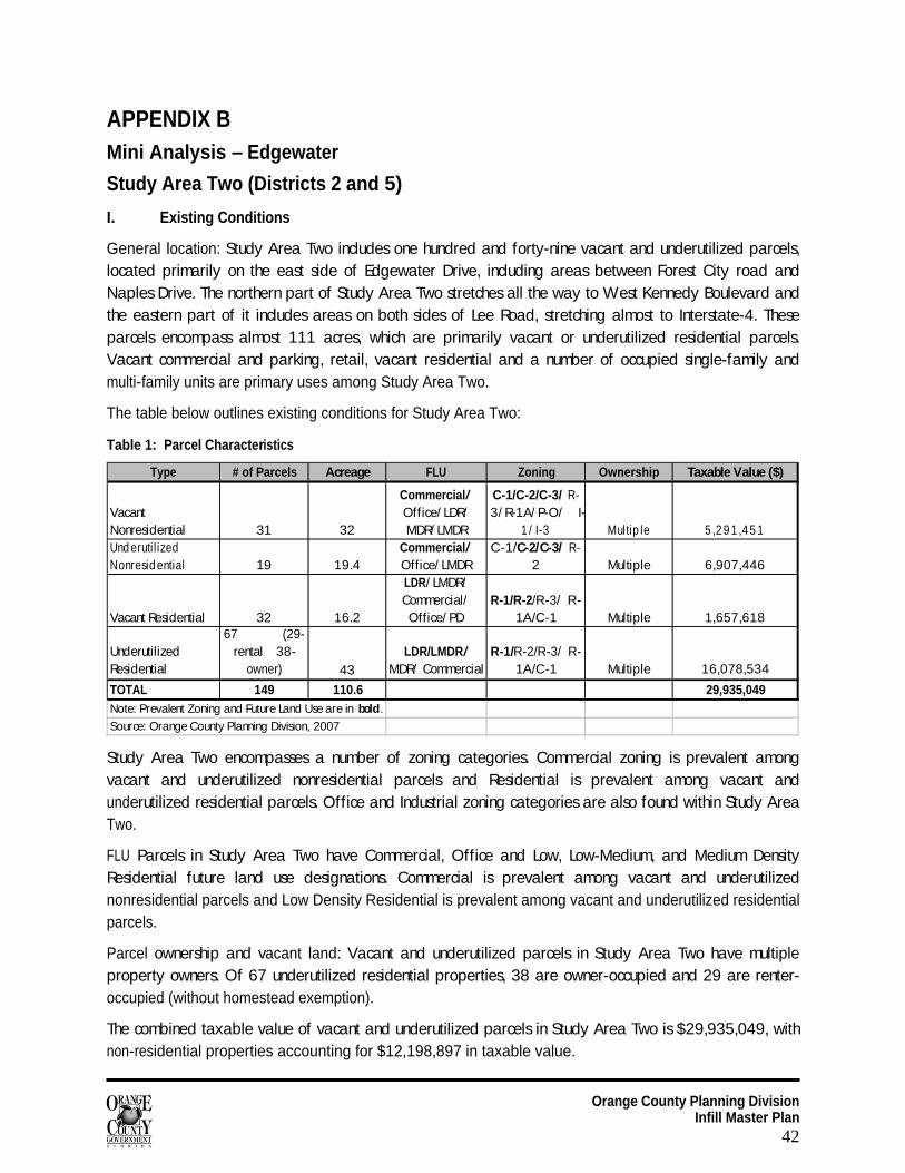
Orange County Planning Division Infill Master Plan
42
APPENDIX B Mini Analysis – Edgewater
Study Area Two (Districts 2 and 5)
I. Existing Conditions
General location: Study Area Two includes one hundred and forty-nine vacant and underutilized parcels, located primarily on the east side of Edgewater Drive, including areas between Forest City road and Naples Drive. The northern part of Study Area Two stretches all the way to West Kennedy Boulevard and the eastern part of it includes areas on both sides of Lee Road, stretching almost to Interstate-4. These parcels encompass almost 111 acres, which are primarily vacant or underutilized residential parcels. Vacant commercial and parking, retail, vacant residential and a number of occupied single-family and multi-family units are primary uses among Study Area Two.
The table below outlines existing conditions for Study Area Two:
Table 1: Parcel Characteristics
Type # of Parcels Acreage FLU Zoning Ownership Taxable Value ($)
Vacant Nonresidential 31 32
Commercial/ Office/ LDR/ MDR/ LMDR
C-1/C-2/C-3/ R-3/ R-1A/ P-O/ I-
1 / I-3 Multip le 5 ,2 9 1 ,4 5 1Und eruti l ized Nonresid ential 19 19.4
Commercial/ Office/ LMDR
C-1/C-2/C-3/ R-2 Multiple 6,907,446
Vacant Residential 32 16.2
LDR/ LMDR/ Commercial/ Office/ PD
R-1/R-2/R-3/ R-1A/C-1 Multiple 1,657,618
Underutilized Residential
67 (29-rental 38-
owner) 43LDR/LMDR/
MDR/ CommercialR-1/R-2/R-3/ R-
1A/C-1 Multiple 16,078,534
TOTAL 149 110.6 29,935,049Note: Prevalent Zoning and Future Land Use are in bold.
Source: Orange County Planning Division, 2007
Study Area Two encompasses a number of zoning categories. Commercial zoning is prevalent among vacant and underutilized nonresidential parcels and Residential is prevalent among vacant and underutilized residential parcels. Office and Industrial zoning categories are also found within Study Area Two.
FLU Parcels in Study Area Two have Commercial, Office and Low, Low-Medium, and Medium Density Residential future land use designations. Commercial is prevalent among vacant and underutilized nonresidential parcels and Low Density Residential is prevalent among vacant and underutilized residential parcels.
Parcel ownership and vacant land: Vacant and underutilized parcels in Study Area Two have multiple property owners. Of 67 underutilized residential properties, 38 are owner-occupied and 29 are renter-occupied (without homestead exemption).
The combined taxable value of vacant and underutilized parcels in Study Area Two is $29,935,049, with non-residential properties accounting for $12,198,897 in taxable value.
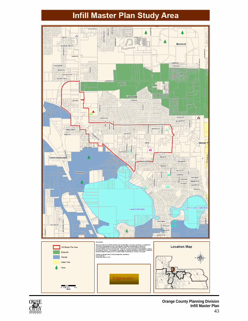
Orange County Planning Division Infill Master Plan
43
Edgewater
Orange County Planning Division Infill Master Plan
44
Schools: Study Area Two has four elementary, three middle and one high school within a 1.5 mile radius.
Table 2: Local Public Schools
Elementary Schools Middle Schools High Schools Riverside ES Hungerford MS Princeton House Charter Robert Hungerford Prep Lee MS Killarney ES Lockhart MS Lake Weston ES Source: Orange County Parks & Recreation Division, 2007
II. Community Characteristics
CPTED assessment: Study Area Two is an area of mixed land uses, with commercial uses along Lee Road and Edgewater Drive, industrial uses along All American Boulevard, and residential in areas away from the main roads.
Natural Surveillance: Parking lot lighting in older shopping centers appears to be inadequate for nighttime visibility. Blank walls on some buildings along Edgewater Drive prevent views to the sides and rear of those buildings. Properly maintained landscaping on residential properties (keeping tree branches trimmed high and hedges trimmed low) will enhance visibility.
Natural Access Control:
The residential areas and newer commercial developments showed better access control than the older commercial developments. The design of the Lake Weston Pointe apartments off of Forest City Road clearly directs residents and visitors to the development through a single entrance road and signage. The Kingswood Manor neighborhood has several entry points but with a main entry road off of Lee Road lined with houses overlooking it, providing “eyes on the street.” The Shoppes at Lee Road, at the southeast corner of Lee Road and Kingswood Drive, is a new commercial development that has limited access points and well-defined parking areas. By contrast, older commercial developments often have multiple curb cuts and little landscaping in parking lots to direct traffic. Many of the commercial developments along Lee Road and Edgewater Drive are not designed for access control, such as the Northgate Shopping Center.
Territorial Reinforcement:
The use of neighborhood identification signs helps with territorial reinforcement. Kingswood Manor and the Weston Lake Condominiums are two examples of neighborhoods using entrance signs to help define area boundaries. The use of perimeter landscaping can help define a development’s boundaries and clearly distinguish a public area from semi-public and private spaces. The Forest Edge shopping center shows good use of landscaping to define its boundaries as well as access control. Other developments, particularly commercial sites near the Edgewater Drive/ Lee Road intersection, have poor boundary definition, with little or no landscaping separating the public sidewalk along the street from parking lots. Many businesses in the study area use chain link fencing, some with barbed wire on top. Fencing does help to define property boundaries, but chain link fencing is not a good choice from a CPTED perspective because it can be easily climbed. Vertical-type fencing is a better choice because it is difficult to climb.
Workforce housing inventory: In Study Area Two, there are 641 parcels, 371 (58 percent) of which are single family residences. Of these 371, 95 percent are considered workforce housing units as the assessed value is less than $219,000. Of the 351, 71 percent are owner occupied while the remaining units are likely rental properties (no homestead exemption).
Orange County Planning Division Infill Master Plan
45
Organization Name Address ReNewSafe
Neighborhoods
Crime Prevention
GrantCatalina Park Community Association, Inc. P.O. Box 940222 $1,266 -0- -0-Biltmore Shores Community Club, Inc.
1036 Sherrington Rd. -0- -0- -0-
Twin Oak Property Owners Association, Inc. P.O. Box 547662 -0- -0- -0-Town & Country Manufactured Home Community 2806 Nowark Drive -0- -0- -0-Kingswood Manor Association, Inc. P.O. Box 607383 $17,503 -0- -0-Greater Rosemont Neighborhood Association 4452 N Lane -0- -0- -0-*Lee Road Safe Neighborhood 5417 Locksley Ave. -0- $194,500 -0-
Source: Orange County Neighborhood Services Division, 2007
*Safe Neighborhood Association administered by Neighborhood Services
**Safe Neighborhood Association administered by the Orange Blossom Trail Development Board
Parks and open space inventory: Study Area Two exceeds the current adopted LOS standard for activity-based recreation. There two existing County operated parks and eight city parks in the Area.
Table 3: Parks and Recreation Local Resources
Orange County Parks City Parks Riverside Acres Maitland Ball Field Complex Interlaken Lake Lucien
Hamlet
Dubsdread Golf Course
Lake Fairview
Trotters
Rosemont Preserve
Rosemont Park Source: Orange County Parks & Recreation Division, 2007
Neighborhood initiatives currently in place: There are seven community groups presently listed in the Neighborhood Organization Directory that serve Study Area Two. Among these groups is the Lee Road Safe Neighborhood Association. To date, this safe neighborhood group has received $194,500 in Safe Neighborhood funds since 2000 to implement projects to improve neighborhood and resident safety. Neighborhood organizations in this area have successfully sought $18,769 in ReNEW funds.
Table 4: Neighborhood Involvement
Design scorecard: The Edgewater Drive area achieved higher marks as an indicator of the mixture of uses presented and the inclusion of other aesthetic qualities. This higher score was the primary rationale for taking the area a step further and conducting an in-house charrette for the area. The Design Scorecard for Edgewater Drive is presented below.
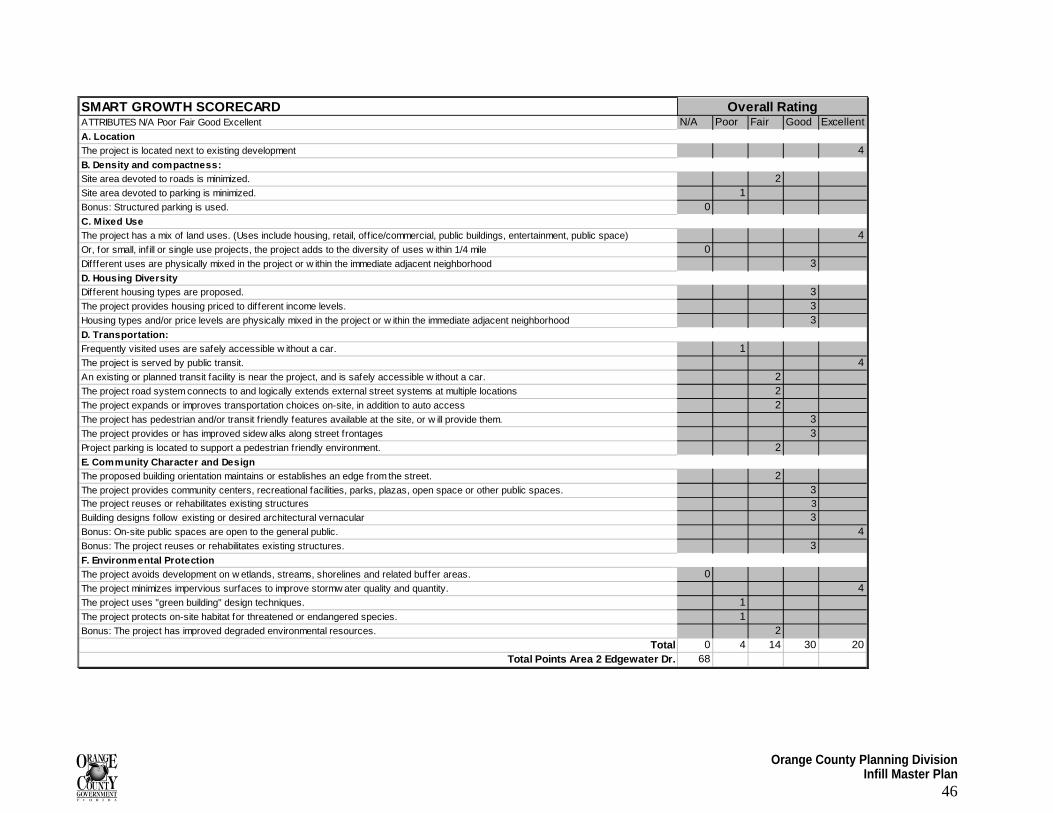
Orange County Planning Division Infill Master Plan
46
SMART GROWTH SCORECARDATTRIBUTES N/A Poor Fair Good Excellent N/A Poor Fair Good ExcellentA. LocationThe project is located next to existing development 4B. Density and compactness:Site area devoted to roads is minimized. 2Site area devoted to parking is minimized. 1Bonus: Structured parking is used. 0C. Mixed UseThe project has a mix of land uses. (Uses include housing, retail, off ice/commercial, public buildings, entertainment, public space) 4Or, for small, infill or single use projects, the project adds to the diversity of uses w ithin 1/4 mile 0Diffferent uses are physically mixed in the project or w ithin the immediate adjacent neighborhood 3D. Housing Diversity Different housing types are proposed. 3The project provides housing priced to different income levels. 3Housing types and/or price levels are physically mixed in the project or w ithin the immediate adjacent neighborhood 3D. Transportation:Frequently visited uses are safely accessible w ithout a car. 1The project is served by public transit. 4An existing or planned transit facility is near the project, and is safely accessible w ithout a car. 2The project road system connects to and logically extends external street systems at multiple locations 2The project expands or improves transportation choices on-site, in addition to auto access 2The project has pedestrian and/or transit friendly features available at the site, or w ill provide them. 3The project provides or has improved sidew alks along street frontages 3Project parking is located to support a pedestrian friendly environment. 2E. Community Character and DesignThe proposed building orientation maintains or establishes an edge from the street. 2The project provides community centers, recreational facilities, parks, plazas, open space or other public spaces. 3The project reuses or rehabilitates existing structures 3
Building designs follow existing or desired architectural vernacular 3Bonus: On-site public spaces are open to the general public. 4Bonus: The project reuses or rehabilitates existing structures. 3F. Environmental ProtectionThe project avoids development on w etlands, streams, shorelines and related buffer areas. 0The project minimizes impervious surfaces to improve stormw ater quality and quantity. 4The project uses "green building" design techniques. 1The project protects on-site habitat for threatened or endangered species. 1Bonus: The project has improved degraded environmental resources. 2
Total 0 4 14 30 20Total Points Area 2 Edgewater Dr. 68
Overall Rating
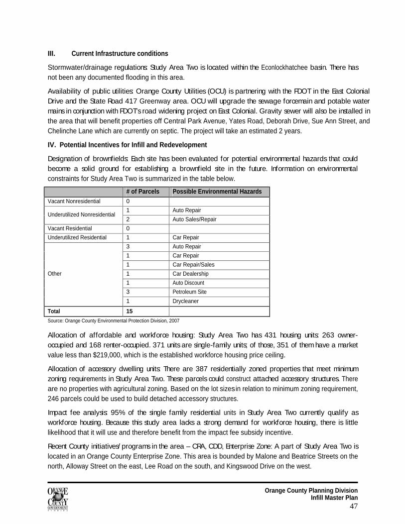
Orange County Planning Division Infill Master Plan
47
III. Current Infrastructure conditions
Stormwater/drainage regulations: Study Area Two is located within the Econlockhatchee basin. There has not been any documented flooding in this area.
Availability of public utilities: Orange County Utilities (OCU) is partnering with the FDOT in the East Colonial Drive and the State Road 417 Greenway area. OCU will upgrade the sewage forcemain and potable water mains in conjunction with FDOT’s road widening project on East Colonial. Gravity sewer will also be installed in the area that will benefit properties off Central Park Avenue, Yates Road, Deborah Drive, Sue Ann Street, and Chelinche Lane which are currently on septic. The project will take an estimated 2 years.
IV. Potential Incentives for Infill and Redevelopment
Designation of brownfields: Each site has been evaluated for potential environmental hazards that could become a solid ground for establishing a brownfield site in the future. Information on environmental constraints for Study Area Two is summarized in the table below.
# of Parcels Possible Environmental Hazards Vacant Nonresidential 0
1 Auto Repair Underutilized Nonresidential
2 Auto Sales/Repair
Vacant Residential 0
Underutilized Residential 1 Car Repair
3 Auto Repair
1 Car Repair
1 Car Repair/Sales
1 Car Dealership
1 Auto Discount
3 Petroleum Site
Other
1 Drycleaner
Total 15
Source: Orange County Environmental Protection Division, 2007
Allocation of affordable and workforce housing: Study Area Two has 431 housing units: 263 owner-occupied and 168 renter-occupied. 371 units are single-family units; of those, 351 of them have a market value less than $219,000, which is the established workforce housing price ceiling.
Allocation of accessory dwelling units: There are 387 residentially zoned properties that meet minimum zoning requirements in Study Area Two. These parcels could construct attached accessory structures. There are no properties with agricultural zoning. Based on the lot sizes in relation to minimum zoning requirement, 246 parcels could be used to build detached accessory structures.
Impact fee analysis: 95% of the single family residential units in Study Area Two currently qualify as workforce housing. Because this study area lacks a strong demand for workforce housing, there is little likelihood that it will use and therefore benefit from the impact fee subsidy incentive.
Recent County initiatives/ programs in the area – CRA, CDD, Enterprise Zone: A part of Study Area Two is located in an Orange County Enterprise Zone. This area is bounded by Malone and Beatrice Streets on the north, Alloway Street on the east, Lee Road on the south, and Kingswood Drive on the west.
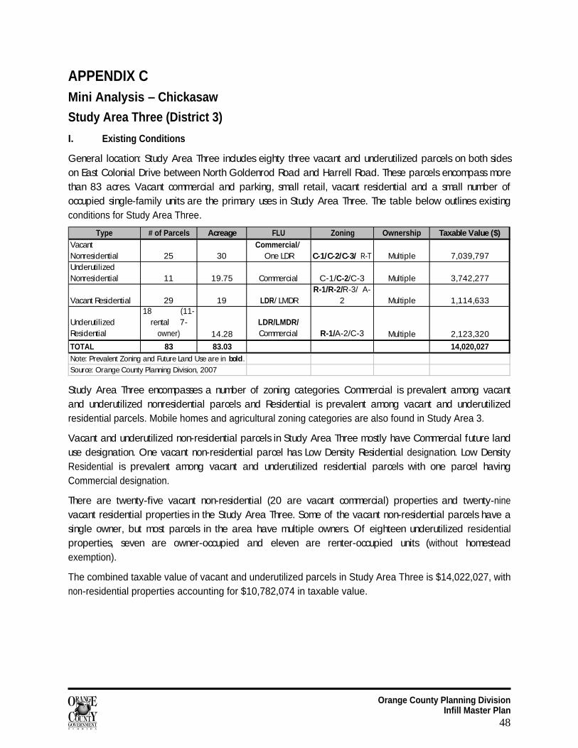
Orange County Planning Division Infill Master Plan
48
APPENDIX C Mini Analysis – Chickasaw
Study Area Three (District 3)
I. Existing Conditions
General location: Study Area Three includes eighty three vacant and underutilized parcels on both sides on East Colonial Drive between North Goldenrod Road and Harrell Road. These parcels encompass more than 83 acres. Vacant commercial and parking, small retail, vacant residential and a small number of occupied single-family units are the primary uses in Study Area Three. The table below outlines existing conditions for Study Area Three.
Type # of Parcels Acreage FLU Zoning Ownership Taxable Value ($)Vacant Nonresidential 25 30
Commercial/ One LDR C-1/C-2/C-3/ R-T Multiple 7,039,797
Underutilized Nonresidential 11 19.75 Commercial C-1/C-2/C-3 Multiple 3,742,277
Vacant Residential 29 19 LDR/ LMDRR-1/R-2/R-3/ A-
2 Multiple 1,114,633
Underutilized Residential
18 (11-rental 7-
owner) 14.28LDR/LMDR/ Commercial R-1/A-2/C-3 Multiple 2,123,320
TOTAL 83 83.03 14,020,027Note: Prevalent Zoning and Future Land Use are in bold.
Source: Orange County Planning Division, 2007
Study Area Three encompasses a number of zoning categories. Commercial is prevalent among vacant and underutilized nonresidential parcels and Residential is prevalent among vacant and underutilized residential parcels. Mobile homes and agricultural zoning categories are also found in Study Area 3.
Vacant and underutilized non-residential parcels in Study Area Three mostly have Commercial future land use designation. One vacant non-residential parcel has Low Density Residential designation. Low Density Residential is prevalent among vacant and underutilized residential parcels with one parcel having Commercial designation.
There are twenty-five vacant non-residential (20 are vacant commercial) properties and twenty-nine vacant residential properties in the Study Area Three. Some of the vacant non-residential parcels have a single owner, but most parcels in the area have multiple owners. Of eighteen underutilized residential properties, seven are owner-occupied and eleven are renter-occupied units (without homestead exemption).
The combined taxable value of vacant and underutilized parcels in Study Area Three is $14,022,027, with non-residential properties accounting for $10,782,074 in taxable value.
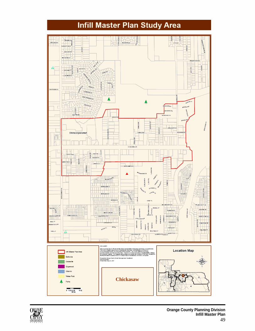
Orange County Planning Division Infill Master Plan
49
Chickasaw
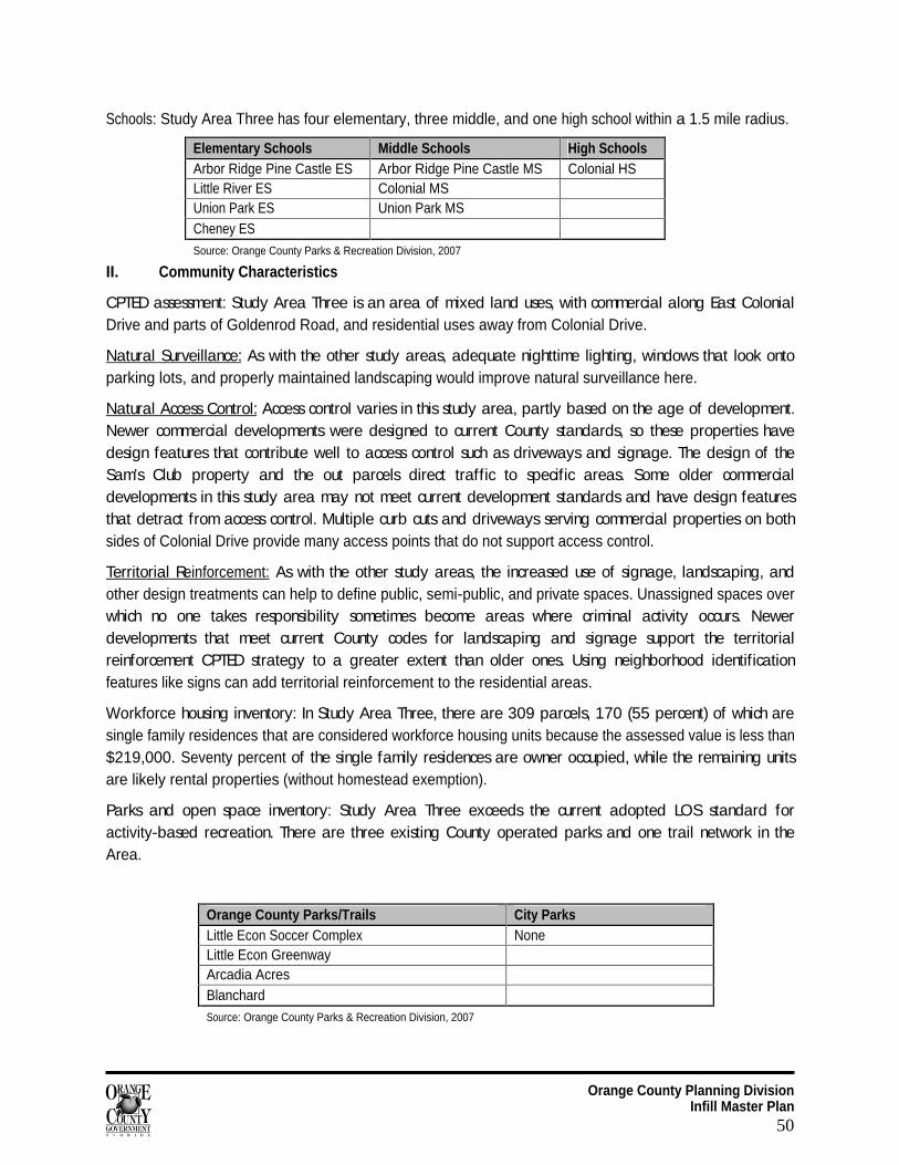
Orange County Planning Division Infill Master Plan
50
Schools: Study Area Three has four elementary, three middle, and one high school within a 1.5 mile radius.
Elementary Schools Middle Schools High Schools Arbor Ridge Pine Castle ES Arbor Ridge Pine Castle MS Colonial HS Little River ES Colonial MS Union Park ES Union Park MS Cheney ES Source: Orange County Parks & Recreation Division, 2007
II. Community Characteristics
CPTED assessment: Study Area Three is an area of mixed land uses, with commercial along East Colonial Drive and parts of Goldenrod Road, and residential uses away from Colonial Drive.
Natural Surveillance:
As with the other study areas, adequate nighttime lighting, windows that look onto parking lots, and properly maintained landscaping would improve natural surveillance here.
Natural Access Control:
Access control varies in this study area, partly based on the age of development. Newer commercial developments were designed to current County standards, so these properties have design features that contribute well to access control such as driveways and signage. The design of the Sam’s Club property and the out parcels direct traffic to specific areas. Some older commercial developments in this study area may not meet current development standards and have design features that detract from access control. Multiple curb cuts and driveways serving commercial properties on both sides of Colonial Drive provide many access points that do not support access control.
Territorial Reinforcement:
As with the other study areas, the increased use of signage, landscaping, and other design treatments can help to define public, semi-public, and private spaces. Unassigned spaces over which no one takes responsibility sometimes become areas where criminal activity occurs. Newer developments that meet current County codes for landscaping and signage support the territorial reinforcement CPTED strategy to a greater extent than older ones. Using neighborhood identification features like signs can add territorial reinforcement to the residential areas.
Workforce housing inventory: In Study Area Three, there are 309 parcels, 170 (55 percent) of which are single family residences that are considered workforce housing units because the assessed value is less than $219,000. Seventy percent of the single family residences are owner occupied, while the remaining units are likely rental properties (without homestead exemption).
Parks and open space inventory: Study Area Three exceeds the current adopted LOS standard for activity-based recreation. There are three existing County operated parks and one trail network in the Area.
Orange County Parks/Trails City Parks Little Econ Soccer Complex None Little Econ Greenway Arcadia Acres Blanchard Source: Orange County Parks & Recreation Division, 2007
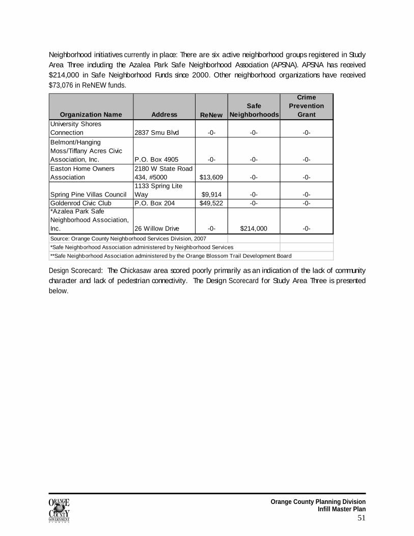
Orange County Planning Division Infill Master Plan
51
Neighborhood initiatives currently in place: There are six active neighborhood groups registered in Study Area Three including the Azalea Park Safe Neighborhood Association (APSNA). APSNA has received $214,000 in Safe Neighborhood Funds since 2000. Other neighborhood organizations have received $73,076 in ReNEW funds.
Organization Name Address ReNewSafe
Neighborhoods
Crime Prevention
GrantUniversity Shores Connection 2837 Smu Blvd -0- -0- -0-
Belmont/Hanging Moss/Tiffany Acres Civic Association, Inc. P.O. Box 4905 -0- -0- -0-Easton Home Owners Association
2180 W State Road 434, #5000 $13,609 -0- -0-
Spring Pine Villas Council1133 Spring Lite Way $9,914 -0- -0-
Goldenrod Civic Club P.O. Box 204 $49,522 -0- -0-*Azalea Park Safe Neighborhood Association, Inc. 26 Willow Drive -0- $214,000 -0-
Source: Orange County Neighborhood Services Division, 2007
*Safe Neighborhood Association administered by Neighborhood Services
**Safe Neighborhood Association administered by the Orange Blossom Trail Development Board
Design Scorecard: The Chickasaw area scored poorly primarily as an indication of the lack of community character and lack of pedestrian connectivity. The Design Scorecard for Study Area Three is presented below.
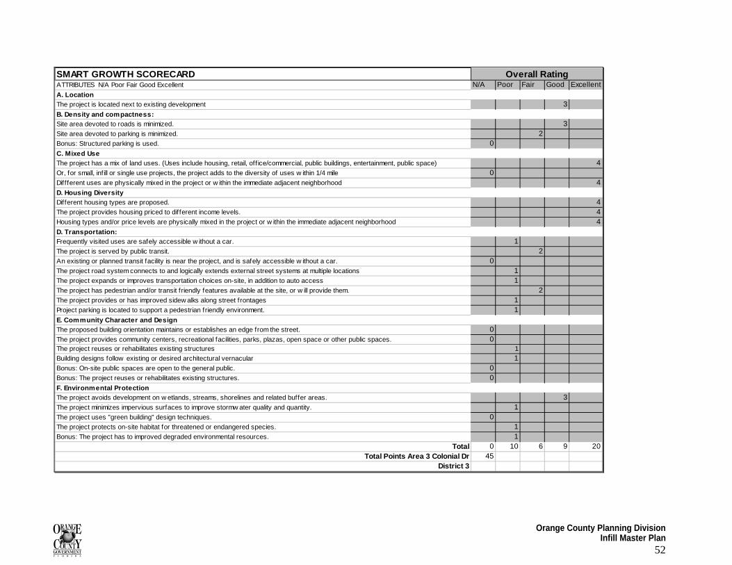
Orange County Planning Division Infill Master Plan
52
SMART GROWTH SCORECARDATTRIBUTES N/A Poor Fair Good Excellent N/A Poor Fair Good ExcellentA. LocationThe project is located next to existing development 3B. Density and compactness:Site area devoted to roads is minimized. 3Site area devoted to parking is minimized. 2Bonus: Structured parking is used. 0C. Mixed UseThe project has a mix of land uses. (Uses include housing, retail, off ice/commercial, public buildings, entertainment, public space) 4Or, for small, infill or single use projects, the project adds to the diversity of uses w ithin 1/4 mile 0Diffferent uses are physically mixed in the project or w ithin the immediate adjacent neighborhood 4D. Housing Diversity Different housing types are proposed. 4The project provides housing priced to different income levels. 4Housing types and/or price levels are physically mixed in the project or w ithin the immediate adjacent neighborhood 4D. Transportation:Frequently visited uses are safely accessible w ithout a car. 1The project is served by public transit. 2An existing or planned transit facility is near the project, and is safely accessible w ithout a car. 0The project road system connects to and logically extends external street systems at multiple locations 1The project expands or improves transportation choices on-site, in addition to auto access 1The project has pedestrian and/or transit friendly features available at the site, or w ill provide them. 2The project provides or has improved sidew alks along street frontages 1Project parking is located to support a pedestrian friendly environment. 1E. Community Character and DesignThe proposed building orientation maintains or establishes an edge from the street. 0The project provides community centers, recreational facilities, parks, plazas, open space or other public spaces. 0The project reuses or rehabilitates existing structures 1
Building designs follow existing or desired architectural vernacular 1Bonus: On-site public spaces are open to the general public. 0Bonus: The project reuses or rehabilitates existing structures. 0F. Environmental ProtectionThe project avoids development on w etlands, streams, shorelines and related buffer areas. 3The project minimizes impervious surfaces to improve stormw ater quality and quantity. 1The project uses "green building" design techniques. 0The project protects on-site habitat for threatened or endangered species. 1Bonus: The project has to improved degraded environmental resources. 1
Total 0 10 6 9 20Total Points Area 3 Colonial Dr 45
District 3
Overall Rating
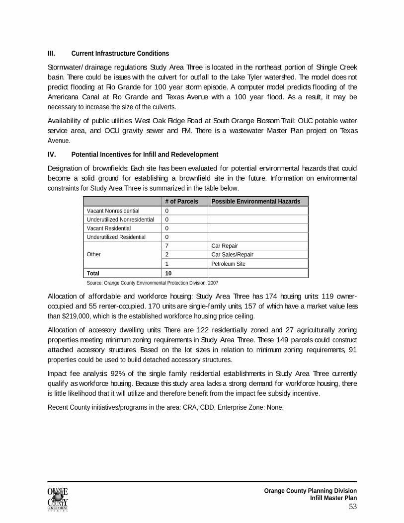
Orange County Planning Division Infill Master Plan
53
III. Current Infrastructure Conditions
Stormwater/ drainage regulations: Study Area Three is located in the northeast portion of Shingle Creek basin. There could be issues with the culvert for outfall to the Lake Tyler watershed. The model does not predict flooding at Rio Grande for 100 year storm episode. A computer model predicts flooding of the Americana Canal at Rio Grande and Texas Avenue with a 100 year flood. As a result, it may be necessary to increase the size of the culverts.
Availability of public utilities: West Oak Ridge Road at South Orange Blossom Trail: OUC potable water service area, and OCU gravity sewer and FM. There is a wastewater Master Plan project on Texas Avenue.
IV. Potential Incentives for Infill and Redevelopment
Designation of brownfields: Each site has been evaluated for potential environmental hazards that could become a solid ground for establishing a brownfield site in the future. Information on environmental constraints for Study Area Three is summarized in the table below.
# of Parcels Possible Environmental Hazards Vacant Nonresidential 0
Underutilized Nonresidential 0
Vacant Residential 0
Underutilized Residential 0
7 Car Repair
2 Car Sales/Repair Other
1 Petroleum Site
Total 10
Source: Orange County Environmental Protection Division, 2007
Allocation of affordable and workforce housing: Study Area Three has 174 housing units: 119 owner-occupied and 55 renter-occupied. 170 units are single-family units, 157 of which have a market value less than $219,000, which is the established workforce housing price ceiling.
Allocation of accessory dwelling units: There are 122 residentially zoned and 27 agriculturally zoning properties meeting minimum zoning requirements in Study Area Three. These 149 parcels could construct attached accessory structures. Based on the lot sizes in relation to minimum zoning requirements, 91 properties could be used to build detached accessory structures.
Impact fee analysis: 92% of the single family residential establishments in Study Area Three currently qualify as workforce housing. Because this study area lacks a strong demand for workforce housing, there is little likelihood that it will utilize and therefore benefit from the impact fee subsidy incentive.
Recent County initiatives/programs in the area: CRA, CDD, Enterprise Zone: None.
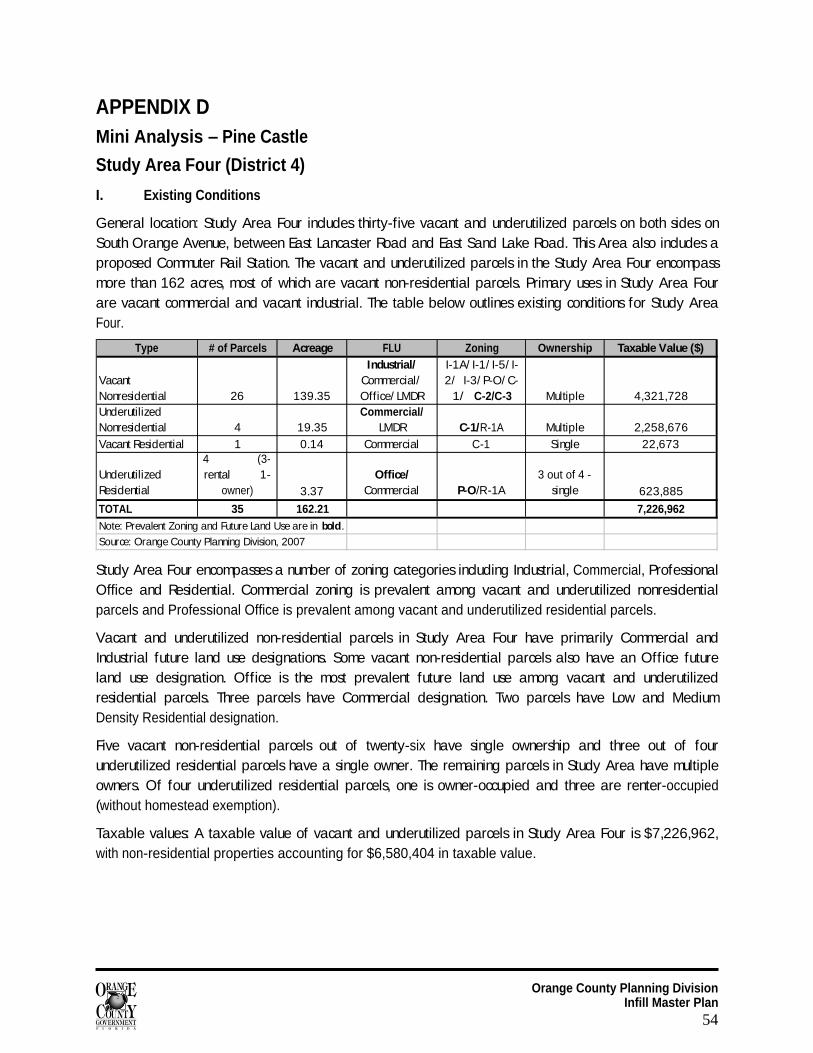
Orange County Planning Division Infill Master Plan
54
APPENDIX D Mini Analysis – Pine Castle
Study Area Four (District 4)
I. Existing Conditions
General location: Study Area Four includes thirty-five vacant and underutilized parcels on both sides on South Orange Avenue, between East Lancaster Road and East Sand Lake Road. This Area also includes a proposed Commuter Rail Station. The vacant and underutilized parcels in the Study Area Four encompass more than 162 acres, most of which are vacant non-residential parcels. Primary uses in Study Area Four are vacant commercial and vacant industrial. The table below outlines existing conditions for Study Area Four.
Type # of Parcels Acreage FLU Zoning Ownership Taxable Value ($)
Vacant Nonresidential 26 139.35
Industrial/ Commercial/ Office/ LMDR
I-1A/ I-1/ I-5/ I-2/ I-3/ P-O/ C-
1/ C-2/C-3 Multiple 4,321,728Underutilized Nonresidential 4 19.35
Commercial/ LMDR C-1/R-1A Multiple 2,258,676
Vacant Residential 1 0.14 Commercial C-1 Single 22,673
Underutilized Residential
4 (3-rental 1-
owner) 3.37Office/
Commercial P-O/R-1A3 out of 4 -
single 623,885
TOTAL 35 162.21 7,226,962Note: Prevalent Zoning and Future Land Use are in bold.
Source: Orange County Planning Division, 2007
Study Area Four encompasses a number of zoning categories including Industrial, Commercial, Professional Office and Residential. Commercial zoning is prevalent among vacant and underutilized nonresidential parcels and Professional Office is prevalent among vacant and underutilized residential parcels.
Vacant and underutilized non-residential parcels in Study Area Four have primarily Commercial and Industrial future land use designations. Some vacant non-residential parcels also have an Office future land use designation. Office is the most prevalent future land use among vacant and underutilized residential parcels. Three parcels have Commercial designation. Two parcels have Low and Medium Density Residential designation.
Five vacant non-residential parcels out of twenty-six have single ownership and three out of four underutilized residential parcels have a single owner. The remaining parcels in Study Area have multiple owners. Of four underutilized residential parcels, one is owner-occupied and three are renter-occupied (without homestead exemption).
Taxable values: A taxable value of vacant and underutilized parcels in Study Area Four is $7,226,962, with non-residential properties accounting for $6,580,404 in taxable value.
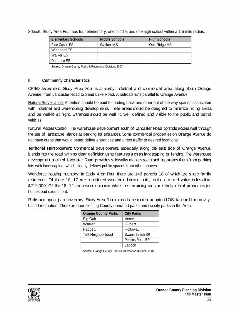
Orange County Planning Division Infill Master Plan
55
Schools: Study Area Four has four elementary, one middle, and one high school within a 1.5 mile radius.
Elementary Schools Middle Schools High Schools Pine Castle ES Walker MS Oak Ridge HS Winegard ES Walker ES Durrance ES Source: Orange County Parks & Recreation Division, 2007
II. Community Characteristics
CPTED assessment: Study Area Four is a mostly industrial and commercial area along South Orange Avenue, from Lancaster Road to Sand Lake Road. A railroad runs parallel to Orange Avenue.
Natural Surveillance: Attention should be paid to loading dock and other out of the way spaces associated with industrial and warehousing developments. These areas should be designed to minimize hiding areas and be well-lit at night. Entrances should be well lit, well defined and visible to the public and patrol vehicles.
Natural Access Control:
The warehouse development south of Lancaster Road controls access well through the use of landscape islands at parking lot entrances. Some commercial properties on Orange Avenue do not have curbs that would better define entrances and direct traffic to desired locations.
Territorial Reinforcement:
Commercial development, especially along the east side of Orange Avenue, blends into the road with no clear definition using features such as landscaping or fencing. The warehouse development south of Lancaster Road provides sidewalks along streets and separates them from parking lots with landscaping, which clearly defines public spaces from other spaces.
Workforce housing inventory: In Study Area Four, there are 143 parcels, 18 of which are single family residences. Of these 18, 17 are considered workforce housing units, as the assessed value is less than $219,000. Of the 18, 12 are owner occupied while the remaining units are likely rental properties (no homestead exemption).
Parks and open space inventory: Study Area Four exceeds the current adopted LOS standard for activity-based recreation. There are four existing County operated parks and six city parks in the Area.
Orange County Parks City Parks Big Oak Venetian Warren Gilbert Padgett Holloway Taft Neighborhood Swann Beach BR
Perkins Road BR
Lagoon Source: Orange County Parks & Recreation Division, 2007
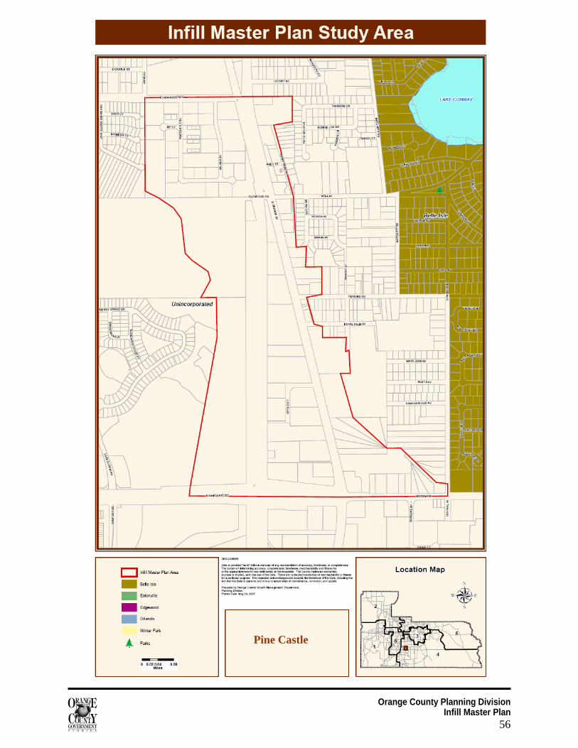
Orange County Planning Division Infill Master Plan
56
Pine Castle
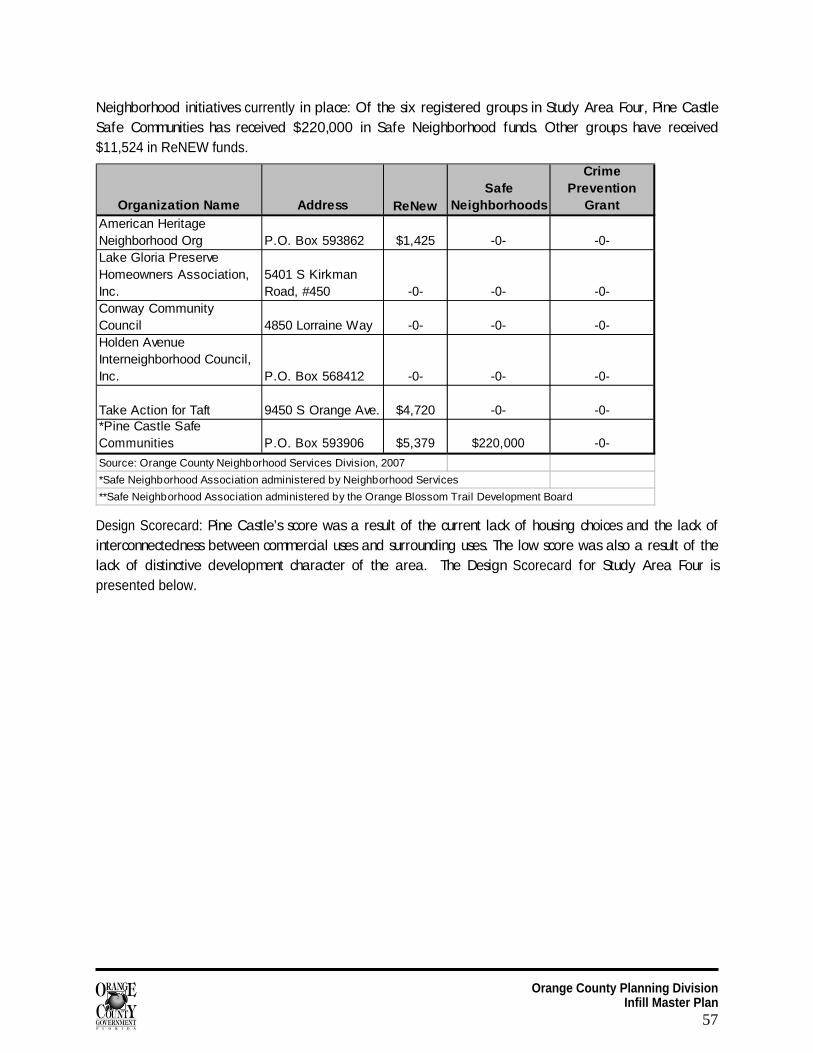
Orange County Planning Division Infill Master Plan
57
Neighborhood initiatives currently in place: Of the six registered groups in Study Area Four, Pine Castle Safe Communities has received $220,000 in Safe Neighborhood funds. Other groups have received $11,524 in ReNEW funds.
Organization Name Address ReNewSafe
Neighborhoods
Crime Prevention
GrantAmerican Heritage Neighborhood Org P.O. Box 593862 $1,425 -0- -0-Lake Gloria Preserve Homeowners Association, Inc.
5401 S Kirkman Road, #450 -0- -0- -0-
Conway Community Council 4850 Lorraine Way -0- -0- -0-Holden Avenue Interneighborhood Council, Inc. P.O. Box 568412 -0- -0- -0-
Take Action for Taft 9450 S Orange Ave. $4,720 -0- -0-*Pine Castle Safe Communities P.O. Box 593906 $5,379 $220,000 -0-
Source: Orange County Neighborhood Services Division, 2007
*Safe Neighborhood Association administered by Neighborhood Services
**Safe Neighborhood Association administered by the Orange Blossom Trail Development Board
Design Scorecard: Pine Castle’s score was a result of the current lack of housing choices and the lack of interconnectedness between commercial uses and surrounding uses. The low score was also a result of the lack of distinctive development character of the area. The Design Scorecard for Study Area Four is presented below.
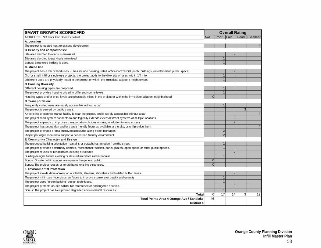
Orange County Planning Division Infill Master Plan
58
SMART GROWTH SCORECARDATTRIBUTES N/A Poor Fair Good Excellent N/A Poor Fair Good ExcellentA. LocationThe project is located next to existing development 4B. Density and compactness:Site area devoted to roads is minimized. 2Site area devoted to parking is minimized. 1Bonus: Structured parking is used. 1C. Mixed UseThe project has a mix of land uses. (Uses include housing, retail, off ice/commercial, public buildings, entertainment, public space) 2Or, for small, inf ill or single use projects, the project adds to the diversity of uses w ithin 1/4 mile 1Diffferent uses are physically mixed in the project or w ithin the immediate adjacent neighborhood 1D. Housing Diversity Different housing types are proposed. 1The project provides housing priced to dif ferent income levels. 1Housing types and/or price levels are physically mixed in the project or w ithin the immediate adjacent neighborhood 0D. Transportation:Frequently visited uses are safely accessible w ithout a car. 1The project is served by public transit. 3An existing or planned transit facility is near the project, and is safely accessible w ithout a car. 4The project road system connects to and logically extends external street systems at multiple locations 2The project expands or improves transportation choices on-site, in addition to auto access 2The project has pedestrian and/or transit friendly features available at the site, or w ill provide them. 4The project provides or has improved sidew alks along street frontages 2Project parking is located to support a pedestrian friendly environment. 2E. Community Character and DesignThe proposed building orientation maintains or establishes an edge from the street. 1The project provides community centers, recreational facilities, parks, plazas, open space or other public spaces. 1The project reuses or rehabilitates existing structures 2
Building designs follow existing or desired architectural vernacular 1Bonus: On-site public spaces are open to the general public. 0Bonus: The project reuses or rehabilitates existing structures. 0F. Environmental ProtectionThe project avoids development on w etlands, streams, shorelines and related buffer areas. 2The project minimizes impervious surfaces to improve stormw ater quality and quantity. 1The project uses "green building" design techniques. 1The project protects on-site habitat for threatened or endangered species. 2Bonus: The project has to improved degraded environmental resources. 1
Total 0 17 14 3 12Total Points Area 4 Orange Ave / Sandlake 46
District 4
Overall Rating
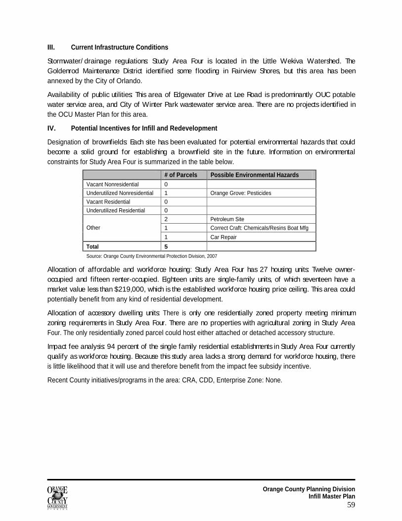
Orange County Planning Division Infill Master Plan
59
III. Current Infrastructure Conditions
Stormwater/ drainage regulations: Study Area Four is located in the Little Wekiva Watershed. The Goldenrod Maintenance District identified some flooding in Fairview Shores, but this area has been annexed by the City of Orlando.
Availability of public utilities: This area of Edgewater Drive at Lee Road is predominantly OUC potable water service area, and City of Winter Park wastewater service area. There are no projects identified in the OCU Master Plan for this area.
IV. Potential Incentives for Infill and Redevelopment
Designation of brownfields: Each site has been evaluated for potential environmental hazards that could become a solid ground for establishing a brownfield site in the future. Information on environmental constraints for Study Area Four is summarized in the table below.
# of Parcels Possible Environmental Hazards Vacant Nonresidential 0
Underutilized Nonresidential 1 Orange Grove: Pesticides
Vacant Residential 0
Underutilized Residential 0
2 Petroleum Site
1 Correct Craft: Chemicals/Resins Boat Mfg Other
1 Car Repair
Total 5
Source: Orange County Environmental Protection Division, 2007
Allocation of affordable and workforce housing: Study Area Four has 27 housing units: Twelve owner-occupied and fifteen renter-occupied. Eighteen units are single-family units, of which seventeen have a market value less than $219,000, which is the established workforce housing price ceiling. This area could potentially benefit from any kind of residential development.
Allocation of accessory dwelling units: There is only one residentially zoned property meeting minimum zoning requirements in Study Area Four. There are no properties with agricultural zoning in Study Area Four. The only residentially zoned parcel could host either attached or detached accessory structure.
Impact fee analysis: 94 percent of the single family residential establishments in Study Area Four currently qualify as workforce housing. Because this study area lacks a strong demand for workforce housing, there is little likelihood that it will use and therefore benefit from the impact fee subsidy incentive.
Recent County initiatives/programs in the area: CRA, CDD, Enterprise Zone: None.
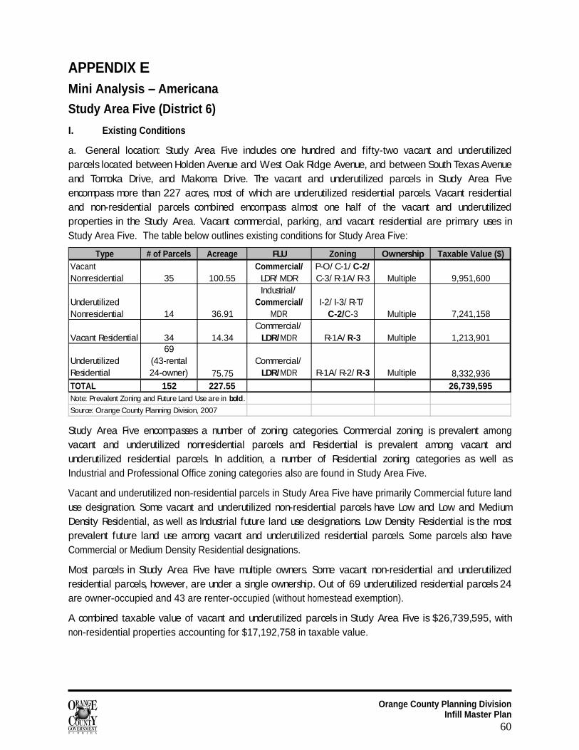
Orange County Planning Division Infill Master Plan
60
APPENDIX E Mini Analysis – Americana
Study Area Five (District 6)
I. Existing Conditions
a. General location: Study Area Five includes one hundred and fifty-two vacant and underutilized parcels located between Holden Avenue and West Oak Ridge Avenue, and between South Texas Avenue and Tomoka Drive, and Makoma Drive. The vacant and underutilized parcels in Study Area Five encompass more than 227 acres, most of which are underutilized residential parcels. Vacant residential and non-residential parcels combined encompass almost one half of the vacant and underutilized properties in the Study Area. Vacant commercial, parking, and vacant residential are primary uses in Study Area Five. The table below outlines existing conditions for Study Area Five:
Type # of Parcels Acreage FLU Zoning Ownership Taxable Value ($)Vacant Nonresidential 35 100.55
Commercial/ LDR/ MDR
P-O/ C-1/ C-2/ C-3/ R-1A/ R-3 Multiple 9,951,600
Underutilized Nonresidential 14 36.91
Industrial/ Commercial/
MDRI-2/ I-3/ R-T/
C-2/C-3 Multiple 7,241,158
Vacant Residential 34 14.34Commercial/
LDR/MDR R-1A/ R-3 Multiple 1,213,901
Underutilized Residential
69 (43-rental 24-owner) 75.75
Commercial/ LDR/MDR R-1A/ R-2/ R-3 Multiple 8,332,936
TOTAL 152 227.55 26,739,595Note: Prevalent Zoning and Future Land Use are in bold.
Source: Orange County Planning Division, 2007
Study Area Five encompasses a number of zoning categories. Commercial zoning is prevalent among vacant and underutilized nonresidential parcels and Residential is prevalent among vacant and underutilized residential parcels. In addition, a number of Residential zoning categories as well as Industrial and Professional Office zoning categories also are found in Study Area Five.
Vacant and underutilized non-residential parcels in Study Area Five have primarily Commercial future land use designation. Some vacant and underutilized non-residential parcels have Low and Low and Medium Density Residential, as well as Industrial future land use designations. Low Density Residential is the most prevalent future land use among vacant and underutilized residential parcels. Some parcels also have Commercial or Medium Density Residential designations.
Most parcels in Study Area Five have multiple owners. Some vacant non-residential and underutilized residential parcels, however, are under a single ownership. Out of 69 underutilized residential parcels 24 are owner-occupied and 43 are renter-occupied (without homestead exemption).
A combined taxable value of vacant and underutilized parcels in Study Area Five is $26,739,595, with non-residential properties accounting for $17,192,758 in taxable value.
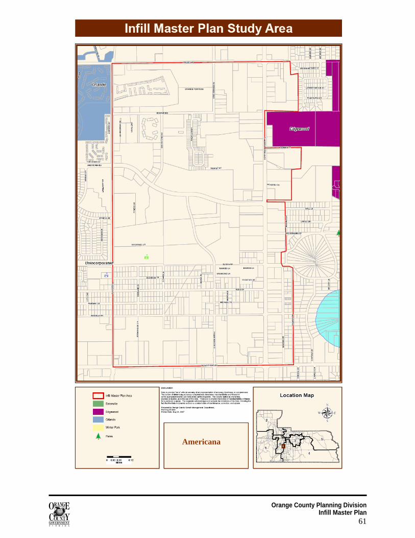
Orange County Planning Division Infill Master Plan
61
Americana
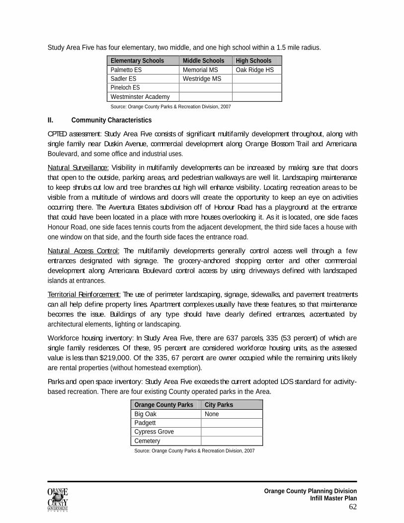
Orange County Planning Division Infill Master Plan
62
Study Area Five has four elementary, two middle, and one high school within a 1.5 mile radius.
Elementary Schools Middle Schools High Schools Palmetto ES Memorial MS Oak Ridge HS Sadler ES Westridge MS Pineloch ES Westminster Academy Source: Orange County Parks & Recreation Division, 2007
II. Community Characteristics
CPTED assessment: Study Area Five consists of significant multifamily development throughout, along with single family near Duskin Avenue, commercial development along Orange Blossom Trail and Americana Boulevard, and some office and industrial uses.
Natural Surveillance:
Visibility in multifamily developments can be increased by making sure that doors that open to the outside, parking areas, and pedestrian walkways are well lit. Landscaping maintenance to keep shrubs cut low and tree branches cut high will enhance visibility. Locating recreation areas to be visible from a multitude of windows and doors will create the opportunity to keep an eye on activities occurring there. The Aventura Estates subdivision off of Honour Road has a playground at the entrance that could have been located in a place with more houses overlooking it. As it is located, one side faces Honour Road, one side faces tennis courts from the adjacent development, the third side faces a house with one window on that side, and the fourth side faces the entrance road.
Natural Access Control:
The multifamily developments generally control access well through a few entrances designated with signage. The grocery-anchored shopping center and other commercial development along Americana Boulevard control access by using driveways defined with landscaped islands at entrances.
Territorial Reinforcement:
The use of perimeter landscaping, signage, sidewalks, and pavement treatments can all help define property lines. Apartment complexes usually have these features, so that maintenance becomes the issue. Buildings of any type should have clearly defined entrances, accentuated by architectural elements, lighting or landscaping.
Workforce housing inventory: In Study Area Five, there are 637 parcels, 335 (53 percent) of which are single family residences. Of these, 95 percent are considered workforce housing units, as the assessed value is less than $219,000. Of the 335, 67 percent are owner occupied while the remaining units likely are rental properties (without homestead exemption).
Parks and open space inventory: Study Area Five exceeds the current adopted LOS standard for activity-based recreation. There are four existing County operated parks in the Area.
Orange County Parks City Parks Big Oak None Padgett Cypress Grove Cemetery Source: Orange County Parks & Recreation Division, 2007
Orange County Planning Division Infill Master Plan
63
Neighborhood initiatives currently in place: This area is home to 29 groups that have registered with Orange County, including Pine Castle Safe Communities, which has received $220,000 in Safe Neighborhood Funds. The Orange Blossom Trail Safe Neighborhood has received $875,000. In addition, the South Point Action Group has received a total of $12,720 in crime prevention grants. Neighborhood organizations in this area have received $254,087 in ReNEW funds.
Design Scorecard: Americana was lacking, specifically with respect to transportation issues and the mixture of uses. Although there were areas in close proximity to the study area, that exhibited good inclusion of attributes, they did not carry over to the study area and therefore the area scored low. The Design Scorecard for Study Area Five is presented below.
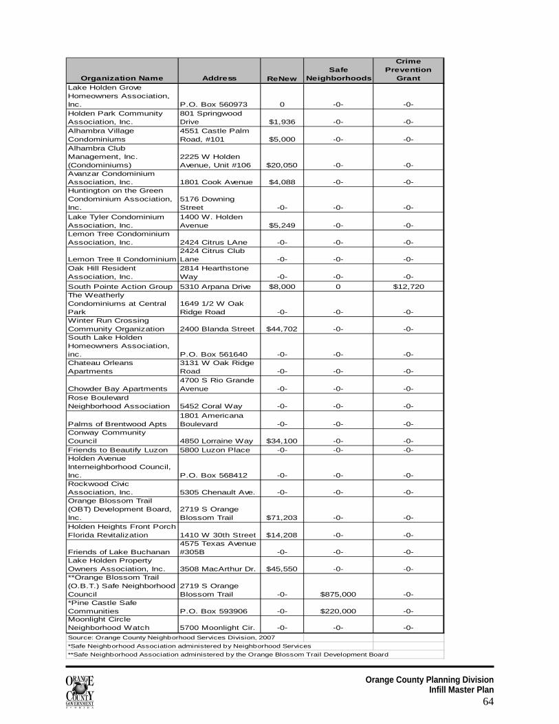
Orange County Planning Division Infill Master Plan
64
Organization Name Address ReNewSafe
Neighborhoods
Crime Prevention
GrantLake Holden Grove Homeowners Association, Inc. P.O. Box 560973 0 -0- -0-Holden Park Community Association, Inc.
801 Springwood Drive $1,936 -0- -0-
Alhambra Village Condominiums
4551 Castle Palm Road, #101 $5,000 -0- -0-
Alhambra Club Management, Inc. (Condominiums)
2225 W Holden Avenue, Unit #106 $20,050 -0- -0-
Avanzar Condominium Association, Inc. 1801 Cook Avenue $4,088 -0- -0-Huntington on the Green Condominium Association, Inc.
5176 Downing Street -0- -0- -0-
Lake Tyler Condominium Association, Inc.
1400 W. Holden Avenue $5,249 -0- -0-
Lemon Tree Condominium Association, Inc. 2424 Citrus LAne -0- -0- -0-
Lemon Tree II Condominium2424 Citrus Club Lane -0- -0- -0-
Oak Hill Resident Association, Inc.
2814 Hearthstone Way -0- -0- -0-
South Pointe Action Group 5310 Arpana Drive $8,000 0 $12,720 The Weatherly Condominiums at Central Park
1649 1/2 W Oak Ridge Road -0- -0- -0-
Winter Run Crossing Community Organization 2400 Blanda Street $44,702 -0- -0-South Lake Holden Homeowners Association, inc. P.O. Box 561640 -0- -0- -0-Chateau Orleans Apartments
3131 W Oak Ridge Road -0- -0- -0-
Chowder Bay Apartments4700 S Rio Grande Avenue -0- -0- -0-
Rose Boulevard Neighborhood Association 5452 Coral Way -0- -0- -0-
Palms of Brentwood Apts1801 Americana Boulevard -0- -0- -0-
Conway Community Council 4850 Lorraine Way $34,100 -0- -0-Friends to Beautify Luzon 5800 Luzon Place -0- -0- -0-Holden Avenue Interneighborhood Council, Inc. P.O. Box 568412 -0- -0- -0-Rockwood Civic Association, Inc. 5305 Chenault Ave. -0- -0- -0-Orange Blossom Trail (OBT) Development Board, Inc.
2719 S Orange Blossom Trail $71,203 -0- -0-
Holden Heights Front Porch Florida Revitalization 1410 W 30th Street $14,208 -0- -0-
Friends of Lake Buchanan4575 Texas Avenue #305B -0- -0- -0-
Lake Holden Property Owners Association, Inc. 3508 MacArthur Dr. $45,550 -0- -0-**Orange Blossom Trail (O.B.T.) Safe Neighborhood Council
2719 S Orange Blossom Trail -0- $875,000 -0-
*Pine Castle Safe Communities P.O. Box 593906 -0- $220,000 -0-Moonlight Circle Neighborhood Watch 5700 Moonlight Cir. -0- -0- -0-
Source: Orange County Neighborhood Services Division, 2007
*Safe Neighborhood Association administered by Neighborhood Services
**Safe Neighborhood Association administered by the Orange Blossom Trail Development Board
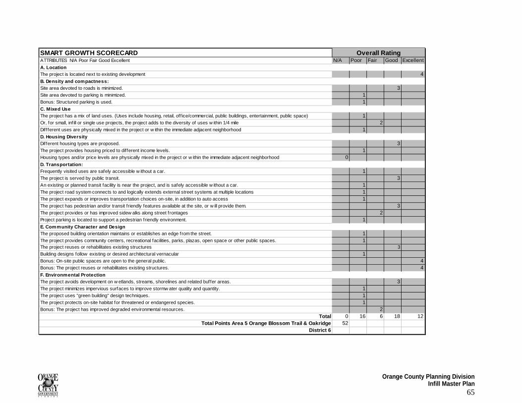
Orange County Planning Division Infill Master Plan
65
SMART GROWTH SCORECARDATTRIBUTES N/A Poor Fair Good Excellent N/A Poor Fair Good ExcellentA. LocationThe project is located next to existing development 4B. Density and compactness:Site area devoted to roads is minimized. 3Site area devoted to parking is minimized. 1Bonus: Structured parking is used. 1C. Mixed UseThe project has a mix of land uses. (Uses include housing, retail, off ice/commercial, public buildings, entertainment, public space) 1Or, for small, inf ill or single use projects, the project adds to the diversity of uses w ithin 1/4 mile 2Diffferent uses are physically mixed in the project or w ithin the immediate adjacent neighborhood 1D. Housing Diversity Different housing types are proposed. 3The project provides housing priced to dif ferent income levels. 1Housing types and/or price levels are physically mixed in the project or w ithin the immediate adjacent neighborhood 0D. Transportation:Frequently visited uses are safely accessible w ithout a car. 1The project is served by public transit. 3An existing or planned transit facility is near the project, and is safely accessible w ithout a car. 1The project road system connects to and logically extends external street systems at multiple locations 1The project expands or improves transportation choices on-site, in addition to auto access 1The project has pedestrian and/or transit friendly features available at the site, or w ill provide them. 3The project provides or has improved sidew alks along street frontages 2Project parking is located to support a pedestrian friendly environment. 1E. Community Character and DesignThe proposed building orientation maintains or establishes an edge from the street. 1The project provides community centers, recreational facilities, parks, plazas, open space or other public spaces. 1The project reuses or rehabilitates existing structures 3
Building designs follow existing or desired architectural vernacular 1Bonus: On-site public spaces are open to the general public. 4Bonus: The project reuses or rehabilitates existing structures. 4F. Environmental ProtectionThe project avoids development on w etlands, streams, shorelines and related buffer areas. 3The project minimizes impervious surfaces to improve stormw ater quality and quantity. 1The project uses "green building" design techniques. 1The project protects on-site habitat for threatened or endangered species. 1Bonus: The project has improved degraded environmental resources. 2
Total 0 16 6 18 12Total Points Area 5 Orange Blossom Trail & Oakridge 52
District 6
Overall Rating
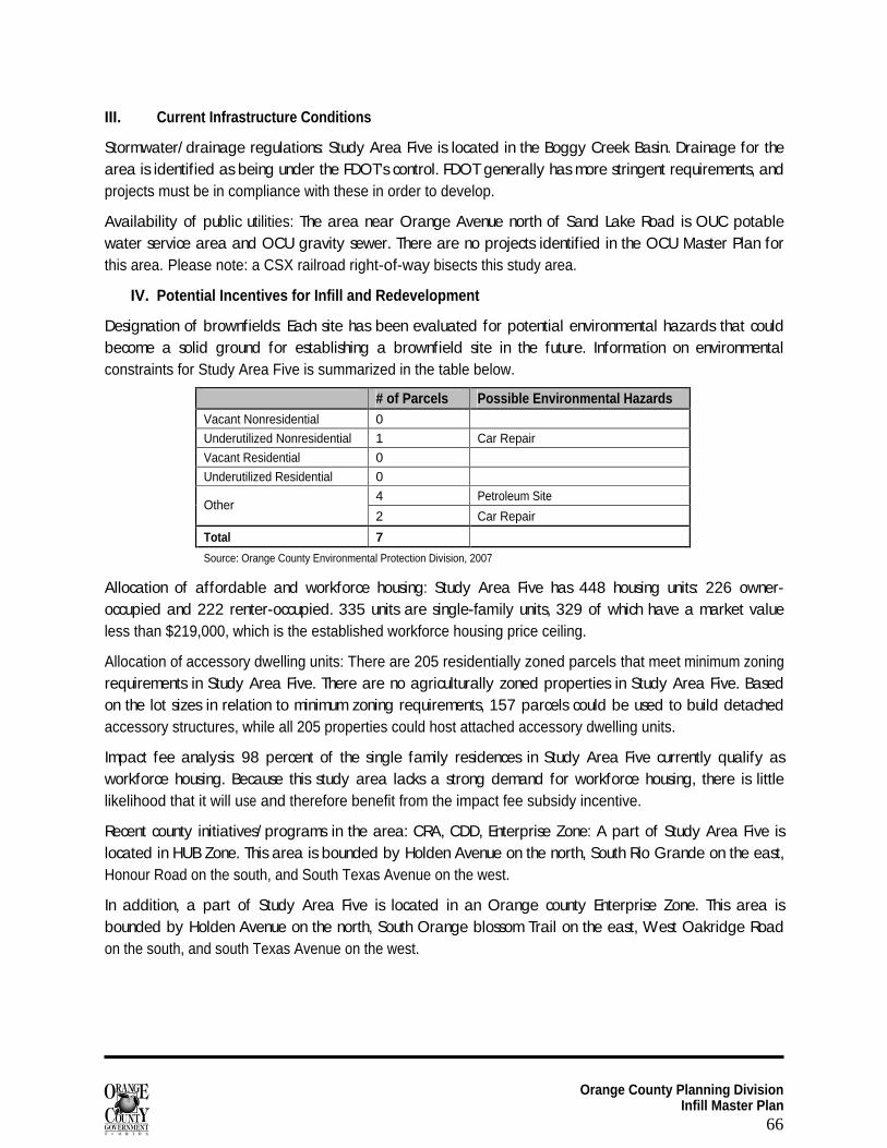
Orange County Planning Division Infill Master Plan
66
III. Current Infrastructure Conditions
Stormwater/ drainage regulations: Study Area Five is located in the Boggy Creek Basin. Drainage for the area is identified as being under the FDOT’s control. FDOT generally has more stringent requirements, and projects must be in compliance with these in order to develop.
Availability of public utilities: The area near Orange Avenue north of Sand Lake Road is OUC potable water service area and OCU gravity sewer. There are no projects identified in the OCU Master Plan for this area. Please note: a CSX railroad right-of-way bisects this study area.
IV. Potential Incentives for Infill and Redevelopment
Designation of brownfields: Each site has been evaluated for potential environmental hazards that could become a solid ground for establishing a brownfield site in the future. Information on environmental constraints for Study Area Five is summarized in the table below.
# of Parcels Possible Environmental Hazards Vacant Nonresidential 0
Underutilized Nonresidential 1 Car Repair
Vacant Residential 0
Underutilized Residential 0
4 Petroleum Site Other
2 Car Repair
Total 7
Source: Orange County Environmental Protection Division, 2007
Allocation of affordable and workforce housing: Study Area Five has 448 housing units: 226 owner-occupied and 222 renter-occupied. 335 units are single-family units, 329 of which have a market value less than $219,000, which is the established workforce housing price ceiling.
Allocation of accessory dwelling units: There are 205 residentially zoned parcels that meet minimum zoning requirements in Study Area Five. There are no agriculturally zoned properties in Study Area Five. Based on the lot sizes in relation to minimum zoning requirements, 157 parcels could be used to build detached accessory structures, while all 205 properties could host attached accessory dwelling units.
Impact fee analysis: 98 percent of the single family residences in Study Area Five currently qualify as workforce housing. Because this study area lacks a strong demand for workforce housing, there is little likelihood that it will use and therefore benefit from the impact fee subsidy incentive.
Recent county initiatives/ programs in the area: CRA, CDD, Enterprise Zone: A part of Study Area Five is located in HUB Zone. This area is bounded by Holden Avenue on the north, South Rio Grande on the east, Honour Road on the south, and South Texas Avenue on the west.
In addition, a part of Study Area Five is located in an Orange county Enterprise Zone. This area is bounded by Holden Avenue on the north, South Orange blossom Trail on the east, West Oakridge Road on the south, and south Texas Avenue on the west.
Orange County Planning Division Infill Master Plan
67
APPENDIX F Brownfields Program A Brownfield is a piece of real estate that has, or is perceived to have, environmental contamination. Due to the presence or potential presence of environmental issues, the property is typically vacant, underutilized or abandoned. As interpreted from its definition, the object is to rejuvenate abandoned, vacant, or underutilized properties and use them to their greatest potential. The Brownfields Program provides financial assistance for redevelopment and liability relief when cleaning up any discovered contamination. A Brownfields designation opens the door to federal, state, and local incentives that might not otherwise be available, including job creation bonuses.
Brownfield designation process
The local government with jurisdiction over the proposed Brownfield area or Brownfield site may designate the property a Brownfield area for rehabilitation. Designated listed areas include community redevelopment areas, enterprise zones, empowerment zones, closed military bases or designated EPA Brownfield Pilot Areas. For any area that is proposed for Brownfield designation, the local government shall follow the following procedures; the resolution shall be adopted in accordance with the procedures outlined in §125.66, F.S., except the notice for the public hearings on the proposed resolution must be in the form established in §125.66(4)(b)2., F.S. (See flowchart in Appendix A.1.1, Designation Process, Flowchart I.).
For areas where a person who owns or controls a potential brownfield site that is outside an existing designated brownfield area may requests designation of a brownfield area in accordance to the provisions of the Act. The person must meet the following requirements in §376.80(2)(b), F.S.:
Agrees to rehabilitate and redevelop the brownfield site;
The rehabilitation and redevelopment of the proposed brownfield site will result in economic productivity of the area, along with the creation of at least 5 new permanent jobs (this to be changed in new law 2006) at the brownfield site, whether full-time or part-time, which are not associated with the implementation of the brownfield site rehabilitation agreement and are not associated with redevelopment project demolition or construction activities pursuant to the redevelopment agreement required under paragraph 376.80(5)(i), F.S.;
The redevelopment of the proposed brownfield site is consistent with the local comprehensive plan and is a permissible use under the applicable local land development regulations;
Notice of the proposed rehabilitation of the brownfield area has been provided to neighbors and nearby residents of the proposed area to be designated, and the person proposing the area for designation has afforded to those receiving notice the opportunity for comments and suggestions about rehabilitation. Notice pursuant to this subsection must be made in a newspaper of general circulation in the area, at least 16 square inches in size, and the notice must be posted in the affected area; and
The person proposing the area for designation has provided reasonable assurance that he or she has sufficient financial resources to implement and complete the rehabilitation agreement and redevelopment plan.
Orange County Planning Division Infill Master Plan
68
Brownfield redevelopment incentives
Brownfield redevelopment activities are opportunities to significantly improve the utilization, general condition, and appearance of real estate that has, or is perceived to have, environmental contamination. Federal State and local redevelopment incentives are available for this purpose, as an ongoing public investment in infrastructure and services, to help eliminate the public health and environmental hazards, and to promote the creation of jobs in these areas. Such incentives may include financial, regulatory, and technical assistance to persons and businesses involved in the redevelopment of the Brownfield pursuant to this act.
Economic incentives for redevelopment may include:
Tax increment financing through community redevelopment agencies pursuant to part III of FS chapter 163.
Enterprise zone tax exemptions for businesses pursuant to FS chapters 196 and 290.
Safe neighborhood improvement districts as provided in FS 163.501-163.523.
Waiver, reduction, or limitation by line of business with respect to business taxes pursuant to FS chapter 205.
Tax exemption for historic properties as provided in FS 196.1997.
Residential electricity exemption of up to the first 500 kilowatts of use may be exempted from the municipal public service tax pursuant to FS 166.231.
Minority business enterprise programs as provided in FS 287.0943.
Electric and gas tax exemption as provided in FS 166.231(6).
Economic development tax abatement as provided in FS 196.1995.
Grants, including community development block grants.
Pledging of revenues to secure bonds.
Low-interest revolving loans and zero-interest loan pools.
Local grant programs for facade, storefront, signage and other business improvements.
Governmental coordination of loan programs with lenders, such as microloans, business reserve fund loans, letter of credit enhancements, gap financing, land lease and sublease loans, and private equity.
Payment schedules over time for payment of fees, within criteria, and marginal cost pricing.
Regulatory incentives may include:
Cities' absorption of developers' concurrency needs.
Developers' performance of certain analyses.
Exemptions and lessening of state and local review requirements.
Water and sewer regulatory incentives.
Waiver of transportation impact fees and permit fees.
Zoning incentives to reduce review requirements for redevelopment changes in use and occupancy; establishment of code criteria for specific uses; and institution of credits for previous use within the area.
Flexibility in parking standards and buffer zone standards.
Environmental management through specific code criteria and conditions allowed by current law.
Maintenance standards and activities by ordinance and otherwise and increased security and crime prevention measures available through special assessments.
Orange County Planning Division Infill Master Plan
69
Traffic-calming measures.
Historic preservation ordinances, loan programs, and review and permitting procedures.
One-stop permitting and streamlined development and permitting process.
Technical assistance incentives may include:
Expedited development applications.
Formal and informal information on business incentives and financial programs.
Site design assistance.
Marketing and promotion of projects or areas.
More information can be found at http://www.dep.state.fl.us/waste/categories/brownfields/pages/economic_incentives.htm