Embed Size (px)
Citation preview

Oracle Logo
Oracle’s Spatial Technologies
Oracle LocatorOracle Spatial
Oracle Application Server MapViewer
Agenda
• Geospatial Technology Trends• Oracle Locator and Spatial
– Oracle Geospatial Object Types and Indexing– SQL Operators and Functions– Oracle Locator and Spatial Usage & Feature
Comparison– Oracle Spatial Technologies and Models
• Oracle Application Server MapViewer • Oracle Locator, Spatial and MapViewer
Technology Partners
Geospatial Technology Trends

Challenge of Incorporating Location Based Information• Specialty GIS/RS servers
• Data isolation• High systems admin
and management costs• Scalability problems• High training costs• Complex support problems
• Information not aligned with Business Processes
Spatial Data
TabularData
GIS/Design MIS
Enterprise DataServer
Geo Engineering Server
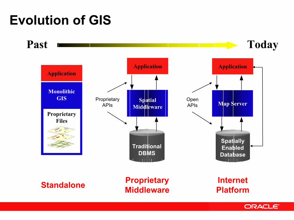
Evolution of GIS
Past Today
Application
MonolithicGIS
ProprietaryFiles
TraditionalDBMS
Spatial Middleware
Application
ProprietaryAPIs
Spatially Enabled Database
Map Server
Application
OpenAPIs
ProprietaryMiddleware
Internet PlatformStandalone
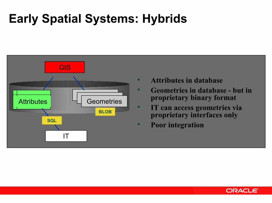
Early Spatial Systems: Hybrids
AttributesGeometriesGeometriesGeometries
GIS
IT
SQL
BLOB
• Attributes in database• Geometries in database - but in
proprietary binary format• IT can access geometries via
proprietary interfaces only• Poor integration
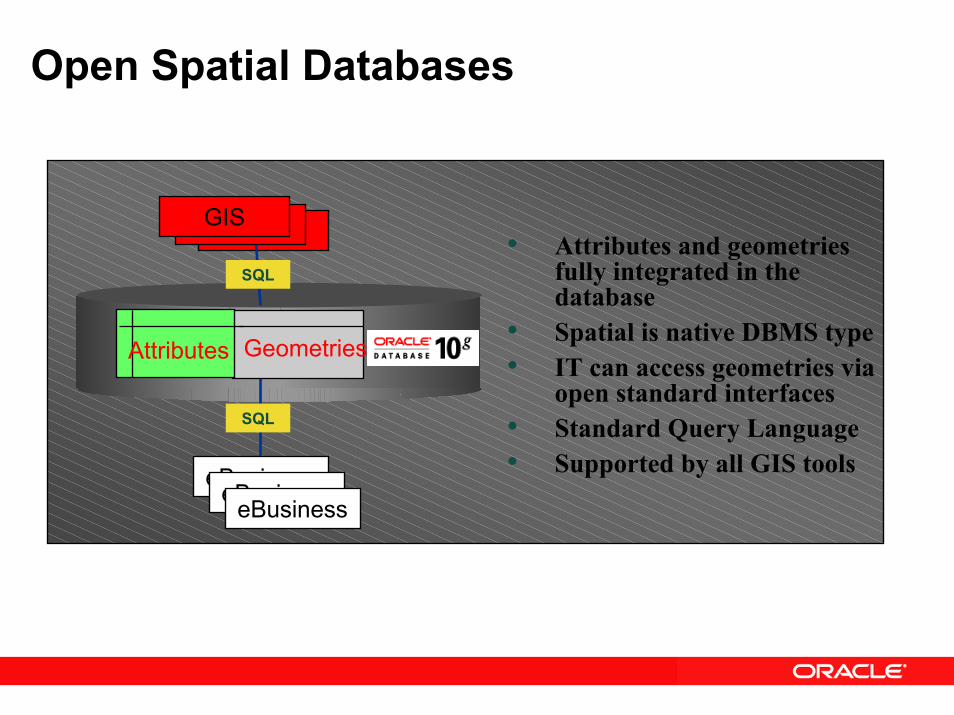
Open Spatial Databases
• Attributes and geometries fully integrated in the database
• Spatial is native DBMS type• IT can access geometries via
open standard interfaces• Standard Query Language• Supported by all GIS tools
GIS
eBusiness
GeometriesAttributes
SQL
SQL
GISGIS
eBusinesseBusiness
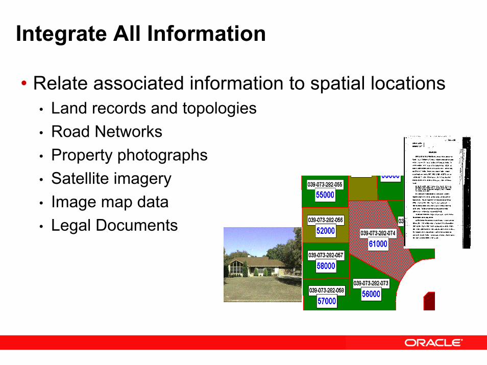
Integrate All Information
• Relate associated information to spatial locations • Land records and topologies• Road Networks• Property photographs• Satellite imagery• Image map data• Legal Documents
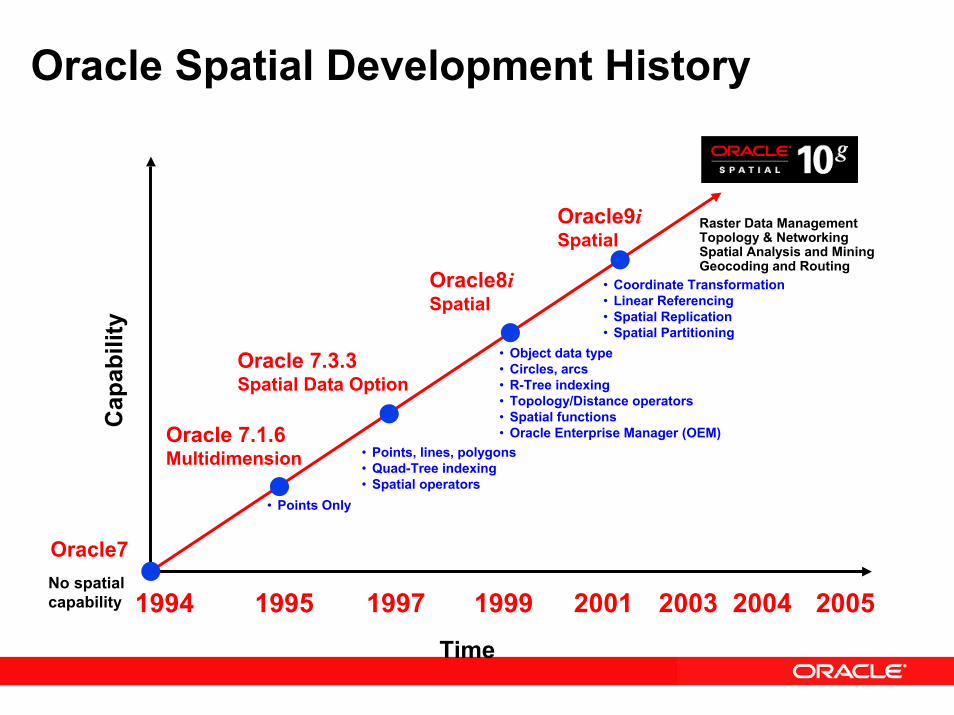
Oracle Spatial Development HistoryC
apab
ility
Oracle 7.1.6Multidimension
Oracle 7.3.3Spatial Data Option
Oracle8iSpatial
• Points Only
• Points, lines, polygons• Quad-Tree indexing• Spatial operators
• Coordinate Transformation• Linear Referencing• Spatial Replication• Spatial Partitioning
Oracle7No spatial capability
Raster Data ManagementTopology & NetworkingSpatial Analysis and MiningGeocoding and Routing
1994
Oracle9iSpatial
• Object data type • Circles, arcs• R-Tree indexing• Topology/Distance operators• Spatial functions• Oracle Enterprise Manager (OEM)
1995 1997 1999 2001 2003 2004 2005Time
Value Propositions:
• Integrated enterprise data management for LARGE datasets and VLDBs
• Consolidated management of spatial operations • Greater security and interoperability• Enhanced decision support and business intelligence• Reduced training requirements• Spatially enabled applications
Oracle Locator and Spatial

Relational and GIS Data in a Hybrid SetupNO Data Integration
RoadSURFACE
Asphalt
Asphalt
Asphalt
LANES
4
2
2
GIS
“How can I integrate all of my location (GIS) information with my ERP, CRM and multiple location technologies when my location information is ‘owned’ by my GIS?”
ROAD_ID
1
2
3
NAME
Homestead
Bellomy
Santa Clara
Geospatial Data in Oracle Tables
RoadROAD_ID
1
2
3
SURFACE
Asphalt
Asphalt
Asphalt
LANES
4
2
2
NAME
Homestead
Bellomy
Santa Clara
Data Types and Models:SDO_GEOMETRY
SDO_TOPO_GEOMETRY
SDO_GEORASTER
Vector
Raster
LOCATION
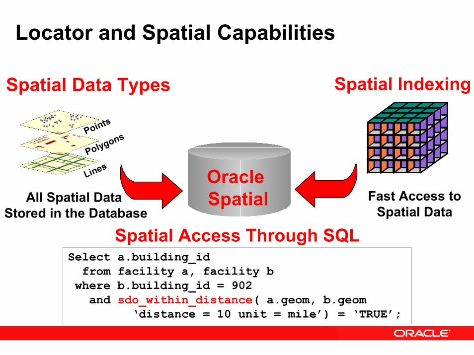
Locator and Spatial Capabilities
Spatial Data Types Spatial Indexing
Fast Access toSpatial Data
All Spatial Data Stored in the Database
Points
Polygons
Lines Oracle Spatial
Spatial Access Through SQLSelect a.building_idfrom facility a, facility b
where b.building_id = 902and sdo_within_distance( a.geom, b.geom
‘distance = 10 unit = mile’) = ‘TRUE’;
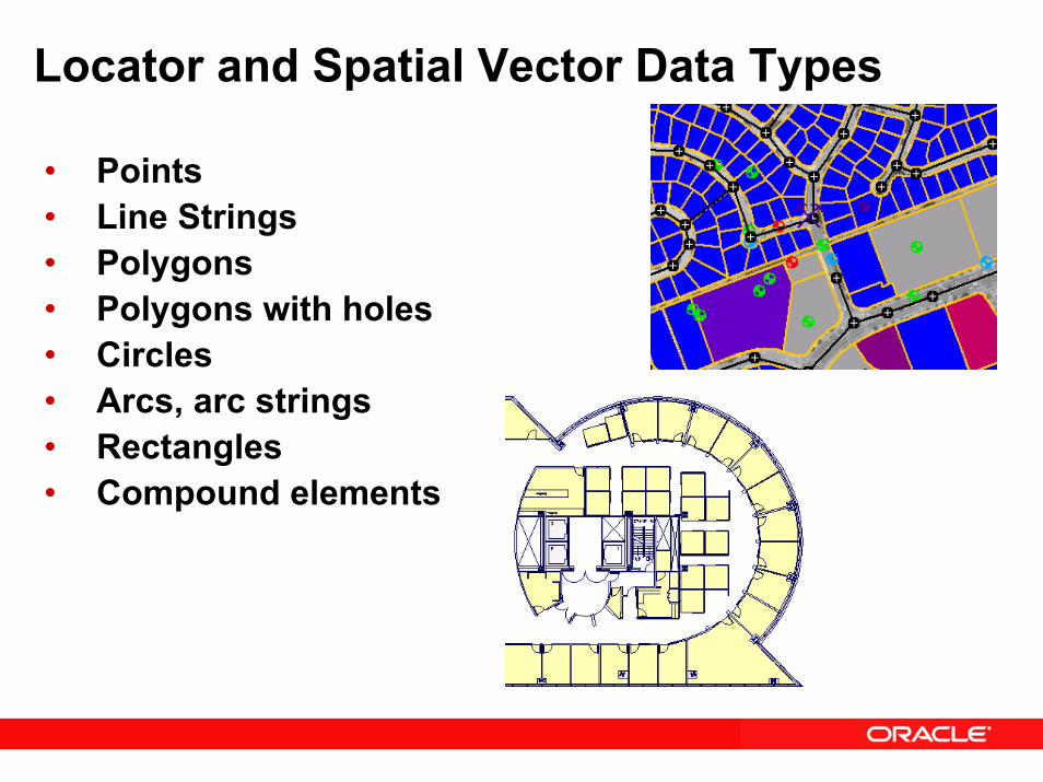
Locator and Spatial Vector Data Types
• Points• Line Strings• Polygons• Polygons with holes• Circles• Arcs, arc strings• Rectangles• Compound elements
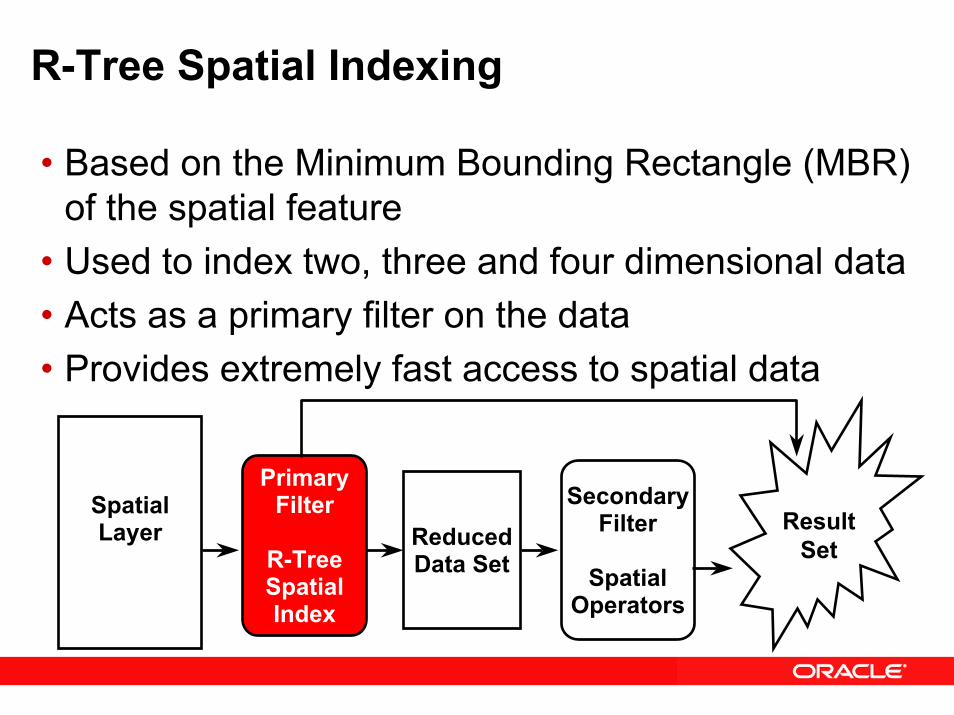
R-Tree Spatial Indexing
• Based on the Minimum Bounding Rectangle (MBR) of the spatial feature
• Used to index two, three and four dimensional data• Acts as a primary filter on the data• Provides extremely fast access to spatial data
SpatialLayer
PrimaryFilter
R-TreeSpatialIndex
ReducedData Set
SecondaryFilter
SpatialOperators
ResultSet
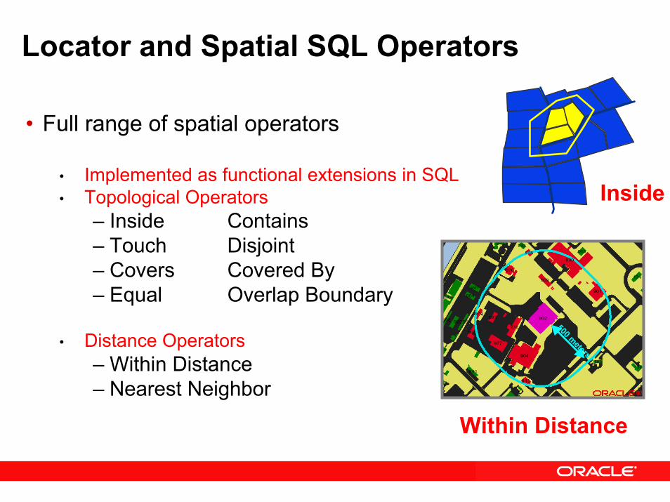
Locator and Spatial SQL Operators
Inside
• Full range of spatial operators
• Implemented as functional extensions in SQL• Topological Operators
– Inside Contains– Touch Disjoint– Covers Covered By– Equal Overlap Boundary
• Distance Operators– Within Distance– Nearest Neighbor
500 meters
Within Distance

Locator and Spatial Query Via SQL
Find all buildings within 500 meters of building 902
SQL> SELECT a.building_id 2> FROM base_buildings a, 3> base_buildings b 4> WHERE b.building_id = 9025> AND MDSYS.SDO_WITHIN_DISTANCE(6> a.Location, b.Location,7> ‘distance=500 unit=meter’) 8> = ‘TRUE’;
500 meters
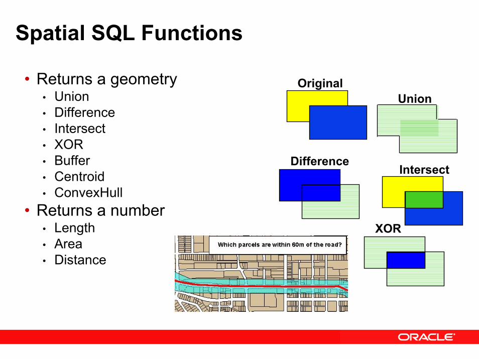
Spatial SQL Functions
Union
XOR
Intersect
Original
Difference
• Returns a geometry• Union• Difference• Intersect• XOR• Buffer• Centroid• ConvexHull
• Returns a number• Length• Area• Distance

Coordinate Systems• Support for geodetic, whole earth model (latitude/longitude)
• Great circle computations• Accurate distance and area calculations (unit support)• Support for geometries that span the poles and the 180 meridian
• Support for EPSG coordinate systems• Based on European Petroleum Survey Group (EPSG) data model and data
set • Comes with Oracle Database 10g Release 2 (10.2) and higher
• Support for U.S. National Grid• Point coordinate representation using a single alphanumeric coordinate (for
example, 18SUJ2348316806479498)• Convert from U.S. National Grid text format to SDO_GEOMETRY
• Support for projected coordinate systems• Cartesian computations• Many supported: UTM, State Plane, and many more…• Geometries fall off the edges of the projection
• Support for non-Earth coordinates (e.g., floor plan)
Oracle Locator and Spatial:A Comparison
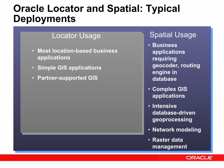
Oracle Locator and Spatial: Typical Deployments
Spatial UsageLocator Usage
• Most location-based business applications
• Simple GIS applications
• Partner-supported GIS
• Business applications requiring geocoder, routing engine in database
• Complex GIS applications
• Intensive database-driven geoprocessing
• Network modeling
• Raster data management
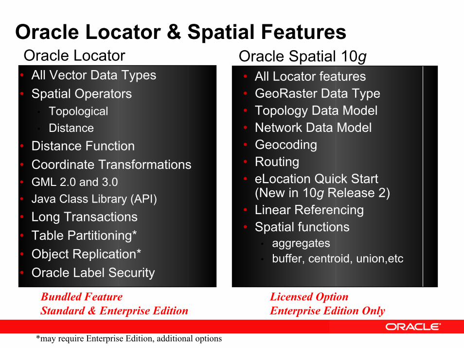
• All Vector Data Types• Spatial Operators
• Topological• Distance
• Distance Function• Coordinate Transformations• GML 2.0 and 3.0 • Java Class Library (API)• Long Transactions• Table Partitioning*• Object Replication*• Oracle Label Security
• All Locator features• GeoRaster Data Type• Topology Data Model• Network Data Model• Geocoding• Routing• eLocation Quick Start
(New in 10g Release 2)• Linear Referencing• Spatial functions
• aggregates• buffer, centroid, union,etc
Bundled FeatureStandard & Enterprise Edition
Licensed OptionEnterprise Edition Only
Oracle Locator Oracle Spatial 10gOracle Locator & Spatial Features
*may require Enterprise Edition, additional options
Oracle SpatialTechnologies and Models
Oracle SpatialLinear Referencing System (LRS)
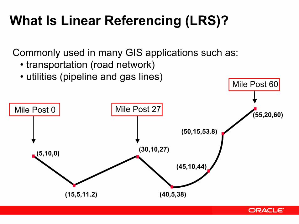
What Is Linear Referencing (LRS)?
Commonly used in many GIS applications such as:• transportation (road network)• utilities (pipeline and gas lines)
Mile Post 60
(5,10,0)
(50,15,53.8)
(55,20,60)
(45,10,44)
Mile Post 0 Mile Post 27
(30,10,27)
(15,5,11.2) (40,5,38)
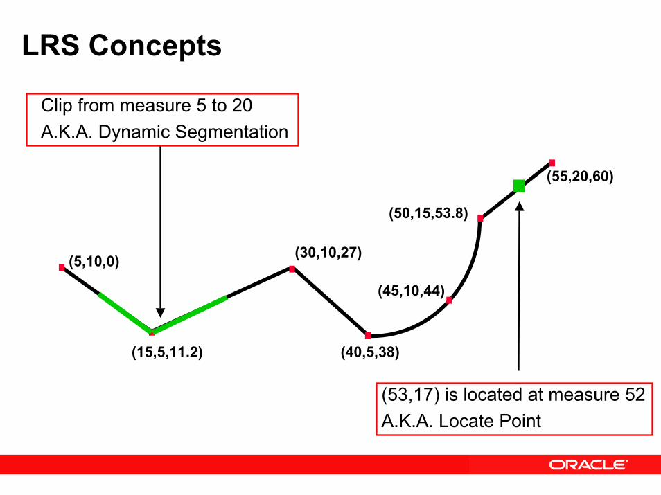
LRS Concepts
(5,10,0)
(50,15,53.8)
(55,20,60)
(45,10,44)
Clip from measure 5 to 20A.K.A. Dynamic Segmentation
(30,10,27)
(15,5,11.2) (40,5,38)
(53,17) is located at measure 52A.K.A. Locate Point
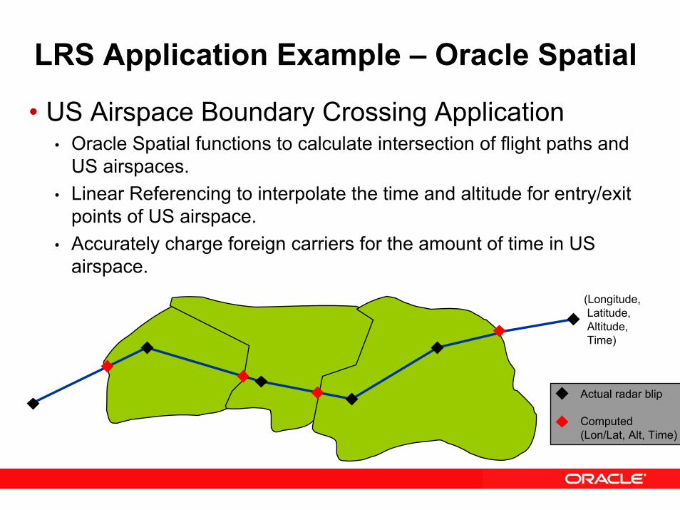
LRS Application Example – Oracle Spatial
• US Airspace Boundary Crossing Application• Oracle Spatial functions to calculate intersection of flight paths and
US airspaces. • Linear Referencing to interpolate the time and altitude for entry/exit
points of US airspace.• Accurately charge foreign carriers for the amount of time in US
airspace.
Actual radar blip
Computed(Lon/Lat, Alt, Time)
(Longitude,Latitude,Altitude,Time)
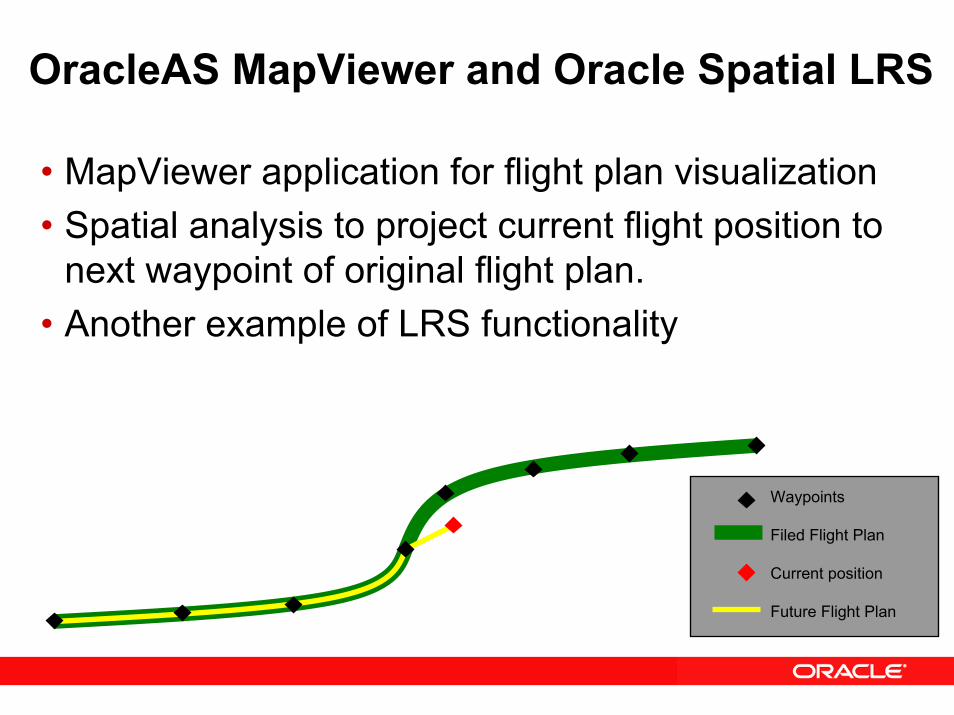
OracleAS MapViewer and Oracle Spatial LRS
• MapViewer application for flight plan visualization • Spatial analysis to project current flight position to
next waypoint of original flight plan.• Another example of LRS functionality
Waypoints
Filed Flight Plan
Current position
Future Flight Plan
Oracle SpatialSpatial Aggregate Functions
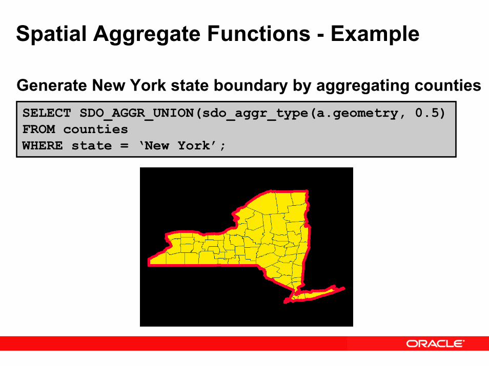
Spatial Aggregate Functions - Example
Generate New York state boundary by aggregating countiesSELECT SDO_AGGR_UNION(sdo_aggr_type(a.geometry, 0.5)FROM countiesWHERE state = ‘New York’;
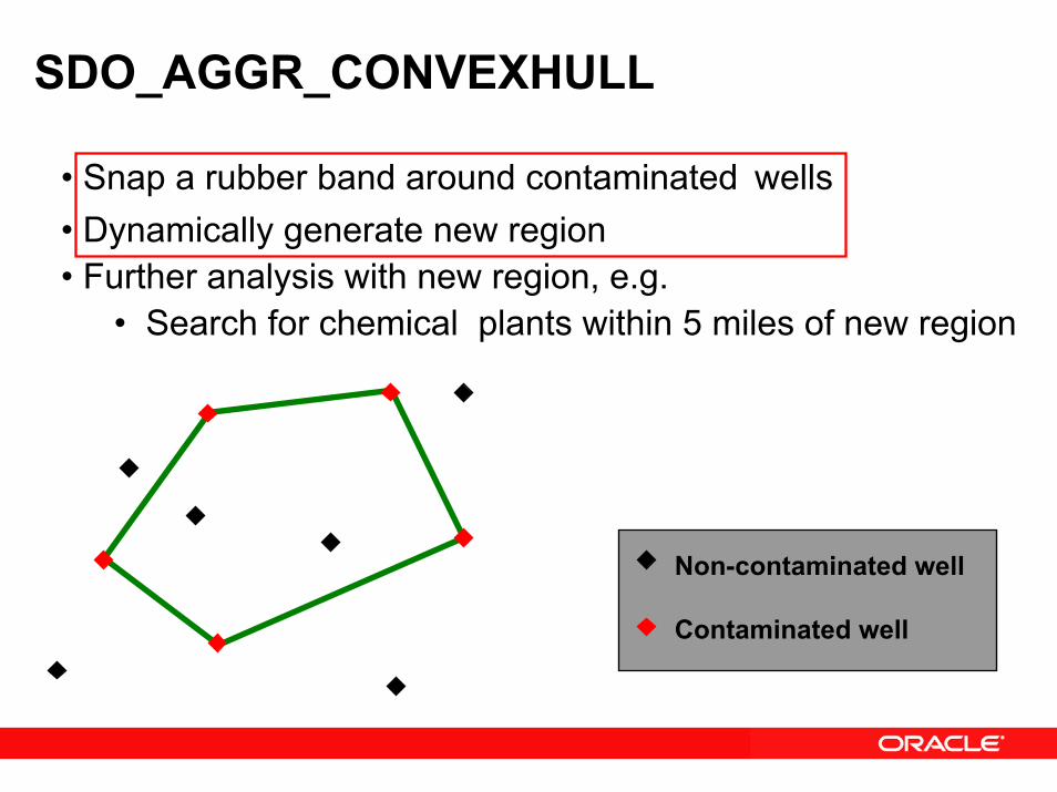
SDO_AGGR_CONVEXHULL
Non-contaminated well
Contaminated well
• Snap a rubber band around contaminated wells• Dynamically generate new region• Further analysis with new region, e.g.
• Search for chemical plants within 5 miles of new region
Oracle Spatial 10gGeocoding
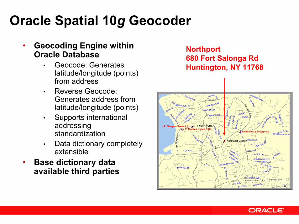
Oracle Spatial 10g Geocoder
• Geocoding Engine within Oracle Database
• Geocode: Generates latitude/longitude (points) from address
• Reverse Geocode: Generates address from latitude/longitude (points)
• Supports international addressing standardization
• Data dictionary completely extensible
• Base dictionary data available third parties
Northport680 Fort Salonga RdHuntington, NY 11768
Oracle Spatial 10gRouting Engine
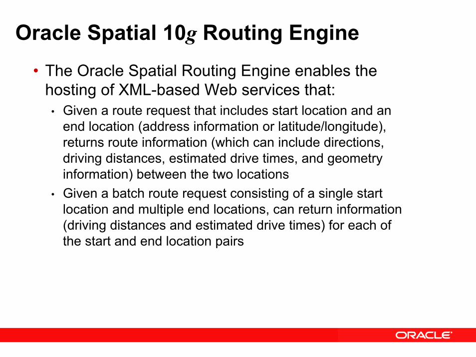
Oracle Spatial 10g Routing Engine• The Oracle Spatial Routing Engine enables the
hosting of XML-based Web services that:• Given a route request that includes start location and an
end location (address information or latitude/longitude), returns route information (which can include directions, driving distances, estimated drive times, and geometry information) between the two locations
• Given a batch route request consisting of a single start location and multiple end locations, can return information (driving distances and estimated drive times) for each of the start and end location pairs
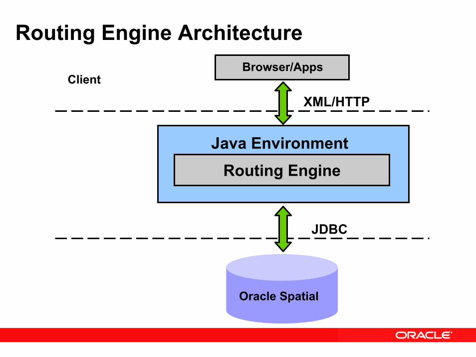
Routing Engine ArchitectureBrowser/Apps
Client
Routing EngineJava Environment
XML/HTTP
JDBC
Oracle Spatial
Routing Query
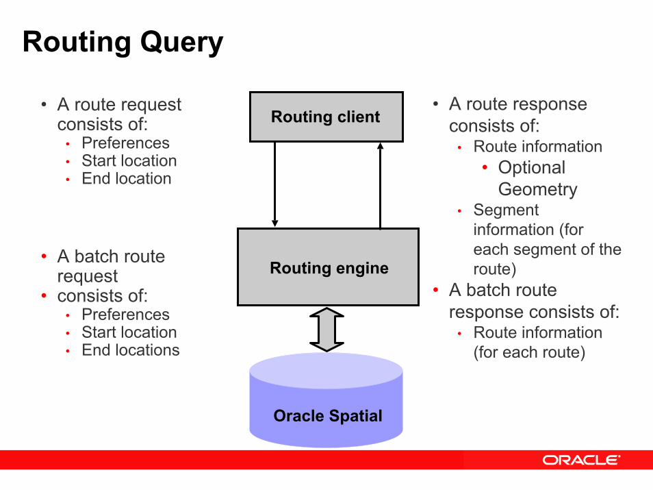
Routing engine
Routing client
Oracle Spatial
• A route response consists of:
• Route information• Optional
Geometry• Segment
information (for each segment of the route)
• A batch route response consists of:
• Route information (for each route)
• A route request consists of:
• Preferences• Start location• End location
• A batch route request
• consists of:• Preferences• Start location• End locations
Oracle Spatial 10g eLocation Quick Start
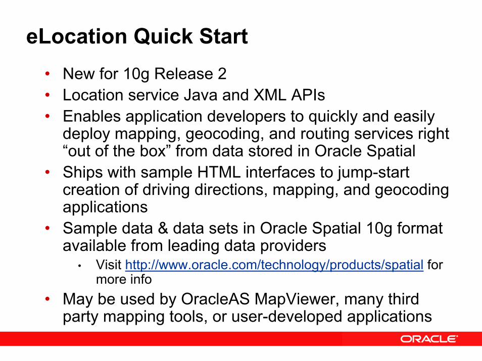
eLocation Quick Start• New for 10g Release 2• Location service Java and XML APIs • Enables application developers to quickly and easily
deploy mapping, geocoding, and routing services right “out of the box” from data stored in Oracle Spatial
• Ships with sample HTML interfaces to jump-start creation of driving directions, mapping, and geocoding applications
• Sample data & data sets in Oracle Spatial 10g format available from leading data providers
• Visit http://www.oracle.com/technology/products/spatial for more info
• May be used by OracleAS MapViewer, many third party mapping tools, or user-developed applications
Oracle Spatial 10gGeoRaster Support
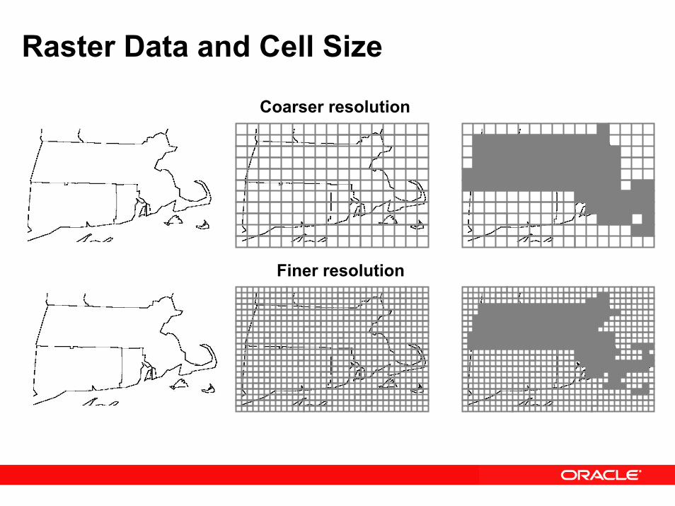
Raster Data and Cell Size
Coarser resolution
Finer resolution
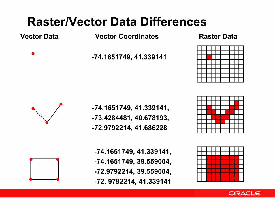
Raster/Vector Data DifferencesVector Data Vector Coordinates Raster Data
-74.1651749, 41.339141
-74.1651749, 41.339141,-73.4284481, 40.678193,-72.9792214, 41.686228
-74.1651749, 41.339141,-74.1651749, 39.559004,-72.9792214, 39.559004,-72. 9792214, 41.339141
Raster Data Concepts
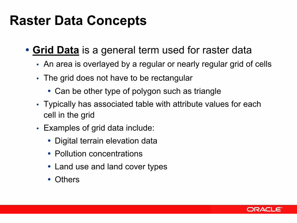
Grid Data is a general term used for raster dataAn area is overlayed by a regular or nearly regular grid of cells
The grid does not have to be rectangularCan be other type of polygon such as triangle
Typically has associated table with attribute values for each cell in the gridExamples of grid data include:
Digital terrain elevation dataPollution concentrationsLand use and land cover typesOthers
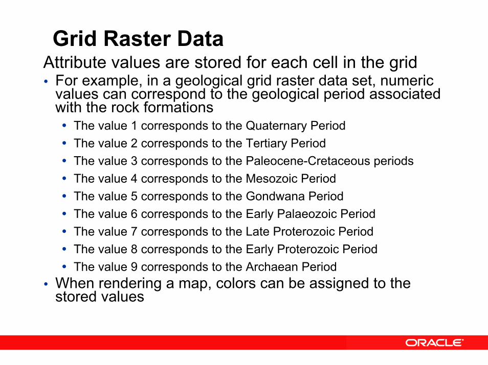
Grid Raster DataAttribute values are stored for each cell in the grid
For example, in a geological grid raster data set, numeric values can correspond to the geological period associated with the rock formations
The value 1 corresponds to the Quaternary PeriodThe value 2 corresponds to the Tertiary PeriodThe value 3 corresponds to the Paleocene-Cretaceous periodsThe value 4 corresponds to the Mesozoic PeriodThe value 5 corresponds to the Gondwana PeriodThe value 6 corresponds to the Early Palaeozoic PeriodThe value 7 corresponds to the Late Proterozoic PeriodThe value 8 corresponds to the Early Proterozoic PeriodThe value 9 corresponds to the Archaean Period
When rendering a map, colors can be assigned to the stored values
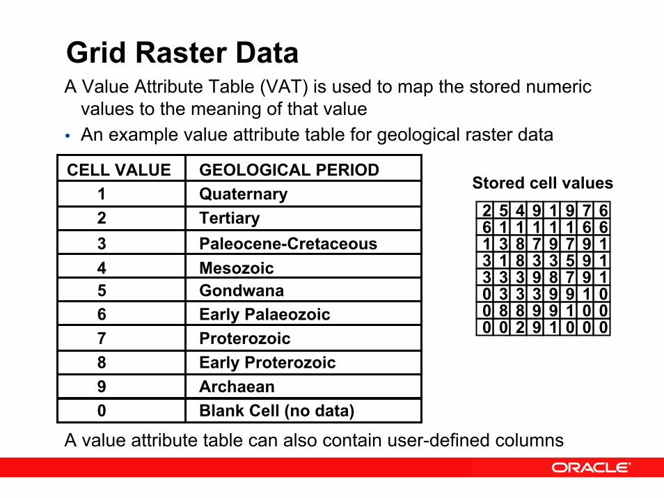
Grid Raster DataA Value Attribute Table (VAT) is used to map the stored numeric
values to the meaning of that valueAn example value attribute table for geological raster data
A value attribute table can also contain user-defined columns
Stored cell values
6 1 1 1 1 6611 3 8 7 9 1973 1 8 3 3 1953 3 3 9 8 1970 3 3 3 9 0190 8 8 9 9 0010 0 2 9 1 000
2 5 4 9 1 679
CELL VALUE GEOLOGICAL PERIOD1 Quaternary 2 Tertiary 3 Paleocene-Cretaceous4 Mesozoic5 Gondwana6 Early Palaeozoic7 Proterozoic8 Early Proterozoic9 Archaean0 Blank Cell (no data)

Grid Raster Data
A COLORMAP table is used to map the stored numeric values to the display characteristics of that valueAn example COLORMAP table for geological raster data
6 1 1 1 1 6611 3 8 7 9 1973 1 8 3 3 1953 3 3 9 8 1970 3 3 3 9 0190 8 8 9 9 0010 0 2 9 1 000
2 5 4 9 1 679CELL VALUE Red Green Blue
1 255 255 02 82 123 673 142 230 984 96 121 2285 145 231 2436 255 51 07 203 188 2248 195 135 759 204 102 2550 0 0 0
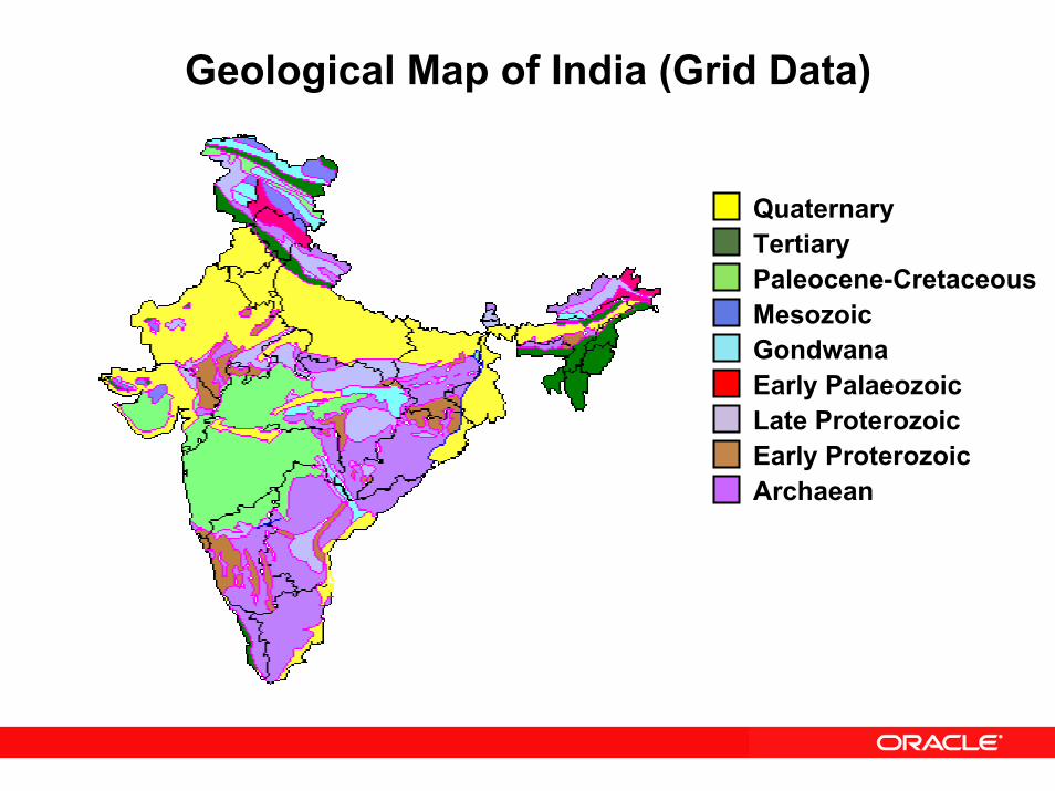
Geological Map of India (Grid Data)
QuaternaryTertiaryPaleocene-CretaceousMesozoicGondwanaEarly PalaeozoicLate ProterozoicEarly ProterozoicArchaean
Raster Data Concepts – (continued)• Digital Imagery - a specialized type of raster data
Two dimensional array of regularly spaced picture elements (pixels)Created from optical or other sensor dataUsually doesn’t require attribute tableGeoreferencing allows each cell in the image to be mapped to its location on the surface of the EarthGeorectification is the process of assigning ground control points (GCPs) to digital images and processing the image to better map it to the surface of the Earth
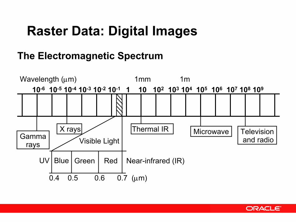
Raster Data: Digital Images
The Electromagnetic Spectrum
Wavelength (µm) 1mm 1m10-6 10-5 10-4 10-3 10-2 10-1 1 10 102 103 104 105 106 107 108 109
Television and radio
Microwave Thermal IRX rays Visible Light
UV Near-infrared (IR)
Gammarays
Blue Green Red
0.4 0.5 0.6 0.7 (µm)
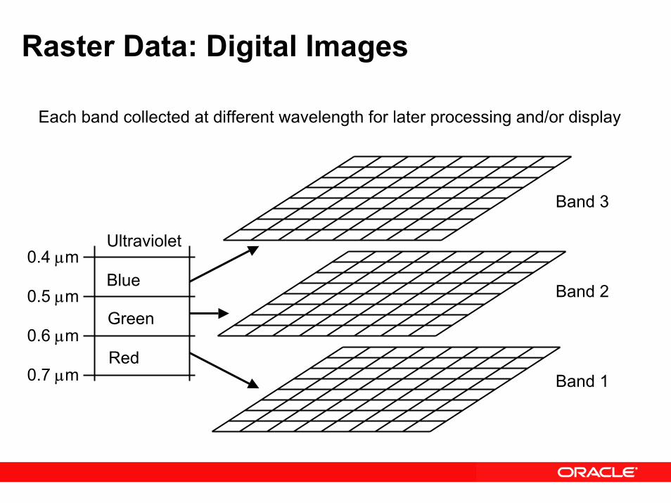
Raster Data: Digital Images
Each band collected at different wavelength for later processing and/or display
Band 2
Band 3
Ultraviolet
Band 1Red
Blue
Green
0.4 µm
0.5 µm
0.6 µm
0.7 µm
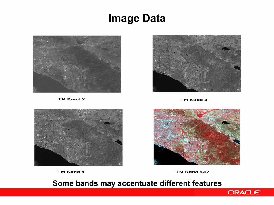
Image Data
Some bands may accentuate different features
GeoRaster Data Support • Some of the types of data supported by
GeoRaster, classified by:• Data source:
– Satellite imagery– Airborne photographs– Thematic grid maps– Digital terrain/elevation models– Lattice GIS data– Scanned maps and graphs– Raster data associated with geology, geophysics, and
geochemistry– Medical images– Others

GeoRaster Data Support • Number of bands/layers in a data set:
• Single band/layer (grid layers, black and white images)• Multiple band/layer (multispectral imagery, true color
photos)• Hyperspectral (hyperspectral imagery)
• Base data types:• 1, 2, and 4 bit data types• 8, 16 bit signed/unsigned integers• 32 bit (integer and floating point)• 64 bit (floating point)
GeoRaster Data Support • Georectification:
• Georectified (typically georeferenced)• Non georectified (georeferenced or non georeferenced)
• Georeferenced:• Georeferenced• Non georeferenced
GeoRaster Data Support• GeoRaster support for loaders and exporters:
• TIFF/GeoTIFF• ESRI World File• JPEG• GIF• BMP• PNG• Others
• Oracle Application Server MapViewer provides simple support for visualization of GeoRaster data

GeoRaster: Compression• Natively support two industry standard compression
techniques (New for 10g Release 2)• JPEG (lossy)
– JPEG-B (abbreviated baseline JPEG format)– JPEG-F (full-format baseline JPEG format)
• DEFLATE (lossless)– (a.k.a. ZIP)
• each block is compressed and uncompressed individually
• All GeoRaster operations work on compressed/uncompressed GeoRaster objects• Automatic decompression on sub-set operations
Oracle Spatial 10gPersistent Topology Model
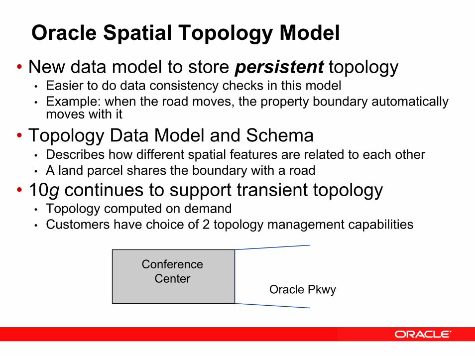
Oracle Spatial Topology Model• New data model to store persistent topology
• Easier to do data consistency checks in this model• Example: when the road moves, the property boundary automatically
moves with it
• Topology Data Model and Schema• Describes how different spatial features are related to each other• A land parcel shares the boundary with a road
• 10g continues to support transient topology• Topology computed on demand• Customers have choice of 2 topology management capabilities
Conference Center
Oracle Pkwy
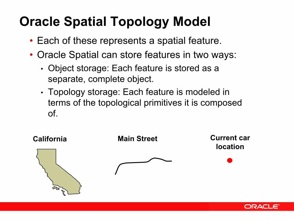
Oracle Spatial Topology Model• Each of these represents a spatial feature.• Oracle Spatial can store features in two ways:
• Object storage: Each feature is stored as a separate, complete object.
• Topology storage: Each feature is modeled in terms of the topological primitives it is composed of.
Current carlocation
Main StreetCalifornia
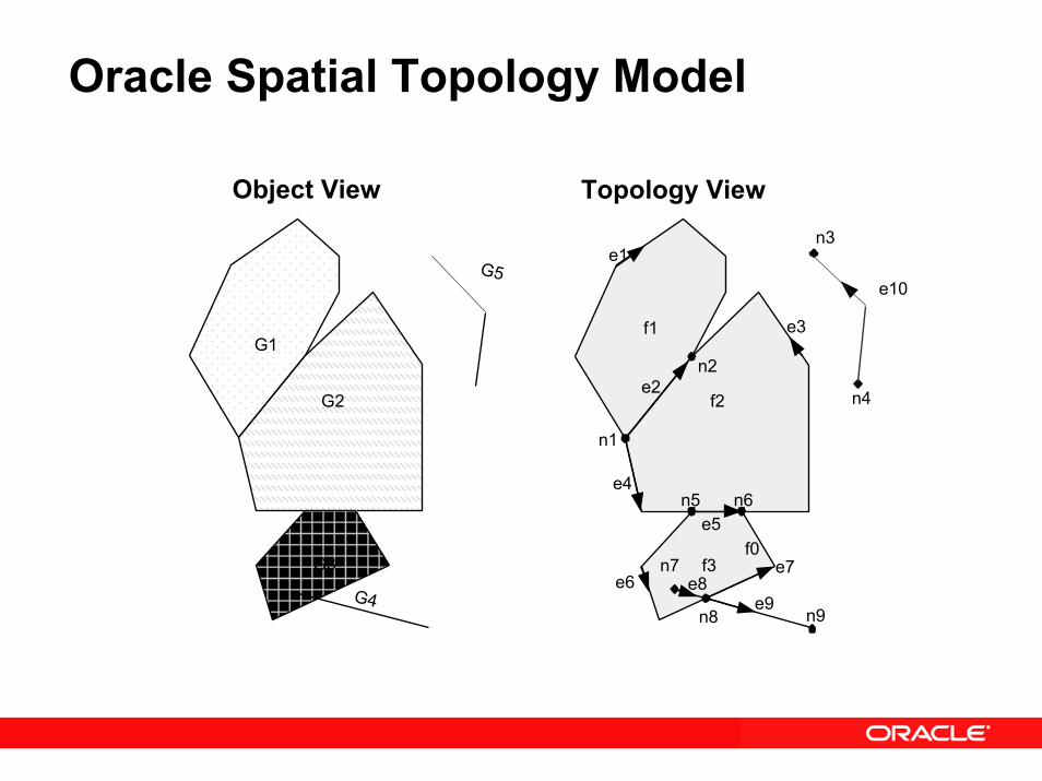
Oracle Spatial Topology Model
G1
G2
G3
G4
G5
f1
f2
f3f0
n1
n2
n3
n4
n5 n6
n7
n8 n9
e1
e2
e3
e4
e5
e6e7
e8e9
e10
Object View Topology View
Topology Example
• Land parcel features• Land Parcel 1 associated with face F1 • Land Parcel 2 associated with face F2• Both faces include edge E3.
• Stream features• Stream 1 associated with edge E3 (and edges E1 and
E5)
N1E5
N4N3N2E1
E4E3
E2
F2
F1
Land Parcel 2
Land Parcel 1
Stream 1
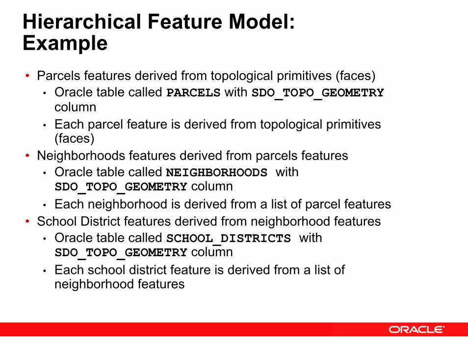
Hierarchical Feature Model:Example• Parcels features derived from topological primitives (faces)
• Oracle table called PARCELS with SDO_TOPO_GEOMETRYcolumn
• Each parcel feature is derived from topological primitives (faces)
• Neighborhoods features derived from parcels features• Oracle table called NEIGHBORHOODS with SDO_TOPO_GEOMETRY column
• Each neighborhood is derived from a list of parcel features• School District features derived from neighborhood features
• Oracle table called SCHOOL_DISTRICTS with SDO_TOPO_GEOMETRY column
• Each school district feature is derived from a list of neighborhood features
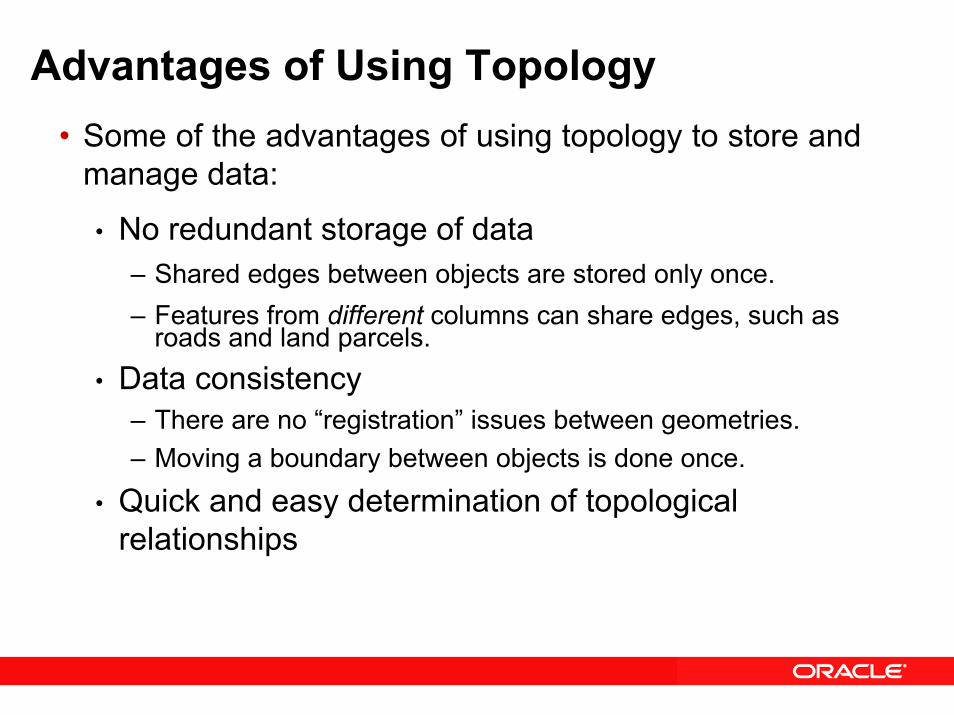
Advantages of Using Topology• Some of the advantages of using topology to store and
manage data:
• No redundant storage of data– Shared edges between objects are stored only once.– Features from different columns can share edges, such as
roads and land parcels.• Data consistency
– There are no “registration” issues between geometries.– Moving a boundary between objects is done once.
• Quick and easy determination of topological relationships
Oracle Spatial 10gNetwork Data Model
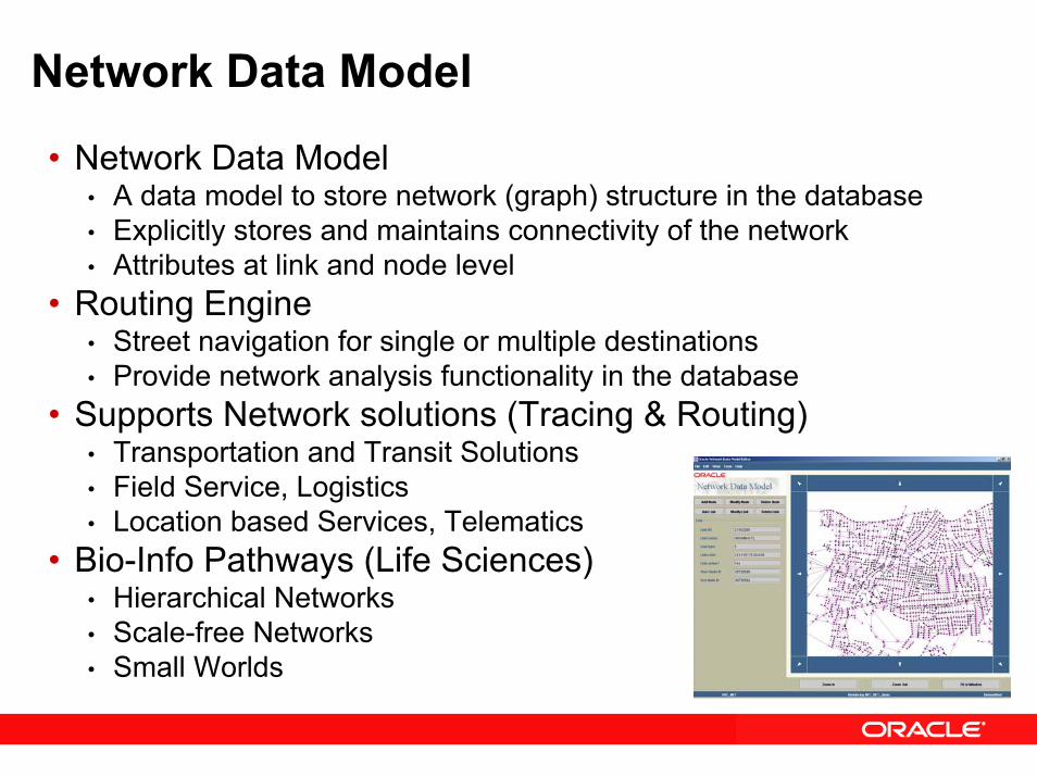
Network Data Model
• Network Data Model• A data model to store network (graph) structure in the database• Explicitly stores and maintains connectivity of the network• Attributes at link and node level
• Routing Engine• Street navigation for single or multiple destinations• Provide network analysis functionality in the database
• Supports Network solutions (Tracing & Routing)• Transportation and Transit Solutions• Field Service, Logistics• Location based Services, Telematics
• Bio-Info Pathways (Life Sciences)• Hierarchical Networks• Scale-free Networks• Small Worlds
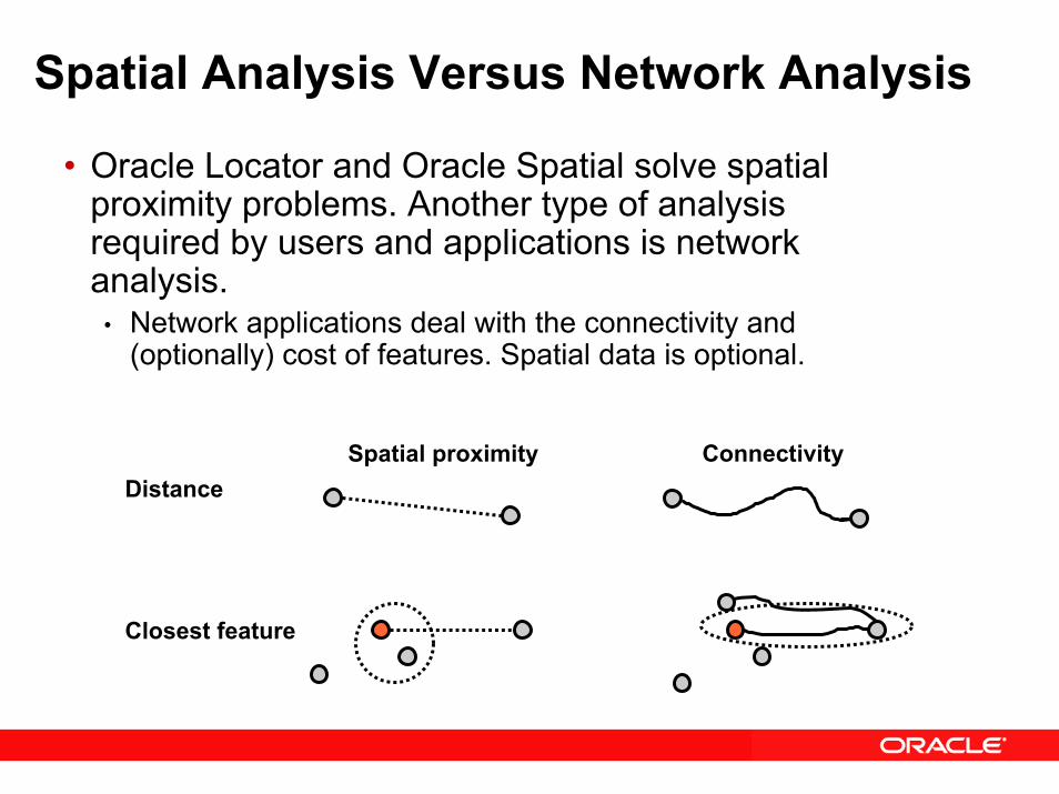
Spatial Analysis Versus Network Analysis
• Oracle Locator and Oracle Spatial solve spatial proximity problems. Another type of analysis required by users and applications is network analysis.
• Network applications deal with the connectivity and (optionally) cost of features. Spatial data is optional.
Distance
Closest feature
Spatial proximity Connectivity

What Is a Network?
• A network (also called a graph) is a model that represents relationships between objects of interest.
• In a network model, objects of interest are defined as nodes.– A cost may be associated with a node
• A direct relationship between two objects (nodes) is defined as a link. A link connects two nodes.– A link may have associated cost (time or distance).– Links can be directed or bidirected.
• The ability to traverse links to go from one node to another node is known as accessibility.
• The sets of ordered links between two nodes is called a path.
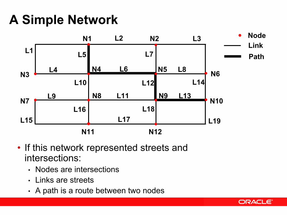
A Simple NetworkNodeLinkPath
N1 N2
N6N5
N7N8 N9
N10
N11 N12
N4N3
L1L2 L3
L4L14
L13
L18
L10
L7L5
L8L6
L9
L17L15L16
L11
L12
L19
• If this network represented streets and intersections:
• Nodes are intersections• Links are streets• A path is a route between two nodes
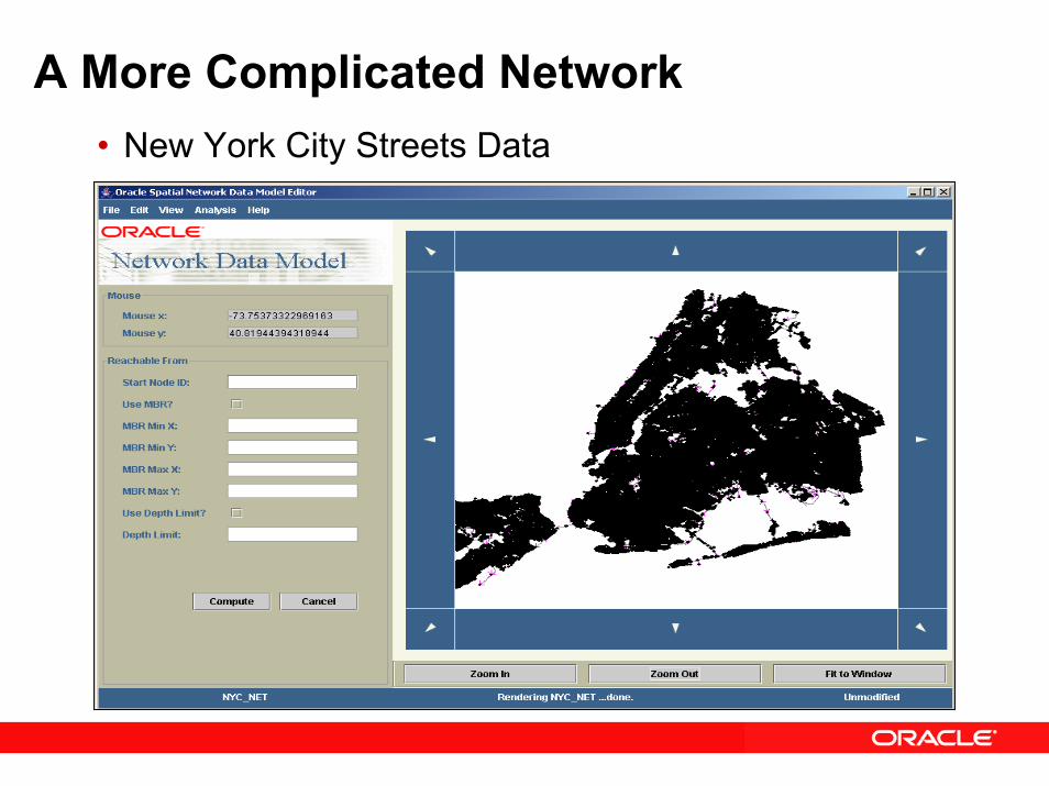
A More Complicated Network• New York City Streets Data
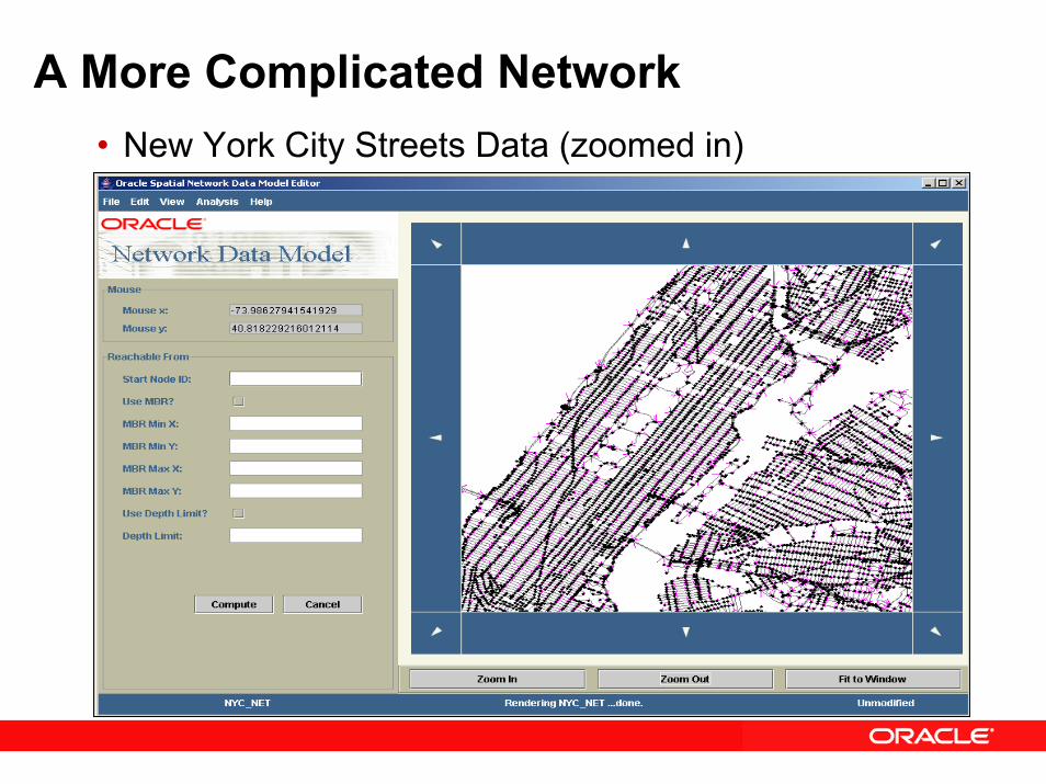
A More Complicated Network• New York City Streets Data (zoomed in)
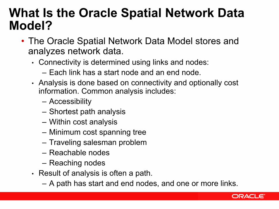
What Is the Oracle Spatial Network Data Model?
• The Oracle Spatial Network Data Model stores and analyzes network data.
• Connectivity is determined using links and nodes:– Each link has a start node and an end node.
• Analysis is done based on connectivity and optionally cost information. Common analysis includes:– Accessibility – Shortest path analysis – Within cost analysis – Minimum cost spanning tree – Traveling salesman problem– Reachable nodes– Reaching nodes
• Result of analysis is often a path.– A path has start and end nodes, and one or more links.
Oracle Spatial 10gSpatial Analysis and Mining
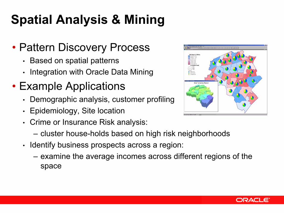
Spatial Analysis & Mining
• Pattern Discovery Process• Based on spatial patterns• Integration with Oracle Data Mining
• Example Applications• Demographic analysis, customer profiling• Epidemiology, Site location• Crime or Insurance Risk analysis:
– cluster house-holds based on high risk neighborhoods• Identify business prospects across a region:
– examine the average incomes across different regions of the space
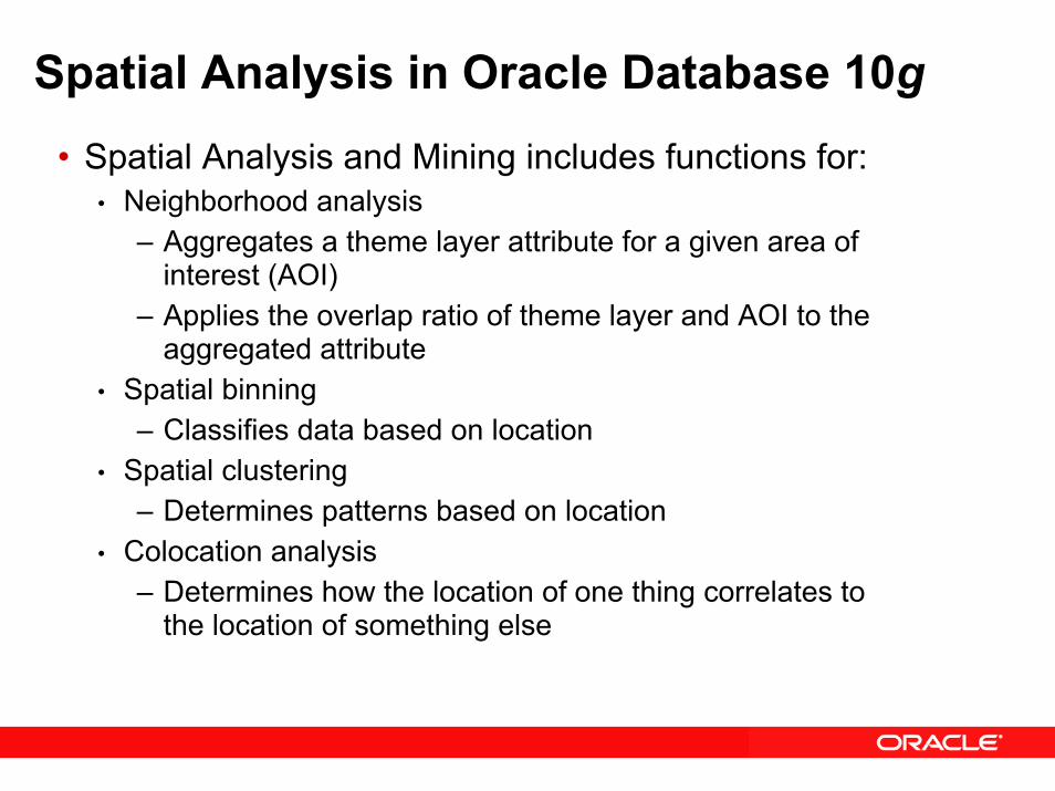
Spatial Analysis in Oracle Database 10g• Spatial Analysis and Mining includes functions for:
• Neighborhood analysis– Aggregates a theme layer attribute for a given area of
interest (AOI)– Applies the overlap ratio of theme layer and AOI to the
aggregated attribute• Spatial binning
– Classifies data based on location • Spatial clustering
– Determines patterns based on location• Colocation analysis
– Determines how the location of one thing correlates to the location of something else
Oracle Locator & Oracle Spatial: Summary of 10g Release 2
Enhancements
Oracle Locator: 10g Release 2 Enhancements
• Coordinate system support for European Petroleum Survey Group (EPSG) specification
• Explicit coordinate transformations (new to Locator in 10g Release 2)
• Utility package (new to Locator in 10g Release 2)• Tuning functions and procedures (new to Locator in 10g
Release 2)
Oracle Spatial:10g Release 2 Enhancements• Coordinate system support for European Petroleum
Survey Group (EPSG) specification• eLocation Quick Start• GeoRaster compression
• JPEG baseline (lossy)• DEFLATE (lossless)
• Topology Data Model – feature level spatial transactions• Network Data Model – PL/SQL interface for creating,
editing, analyzing network data• Routing engine support for Western Europe• Reverse & batch geocoding• RDF Data Model
Oracle Application ServerMapViewer
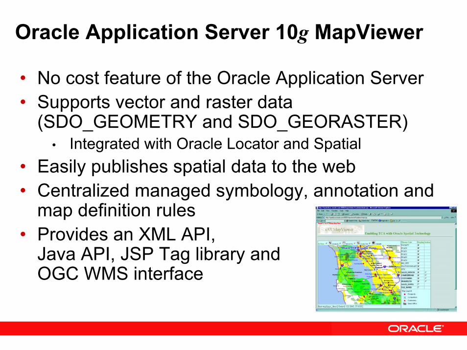
Oracle Application Server 10g MapViewer
• No cost feature of the Oracle Application Server• Supports vector and raster data
(SDO_GEOMETRY and SDO_GEORASTER)• Integrated with Oracle Locator and Spatial
• Easily publishes spatial data to the web• Centralized managed symbology, annotation and
map definition rules• Provides an XML API,
Java API, JSP Tag library andOGC WMS interface
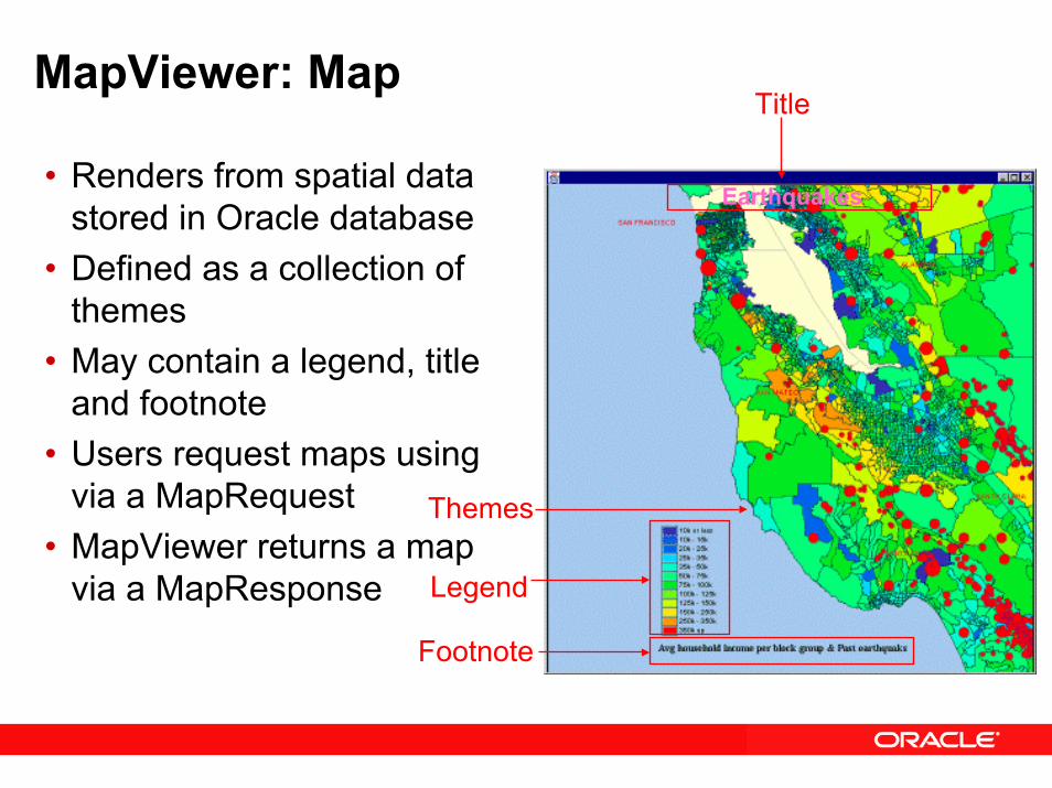
MapViewer: Map
• Renders from spatial data stored in Oracle database
• Defined as a collection of themes
• May contain a legend, title and footnote
• Users request maps using via a MapRequest
• MapViewer returns a map via a MapResponse
Footnote
Legend
Themes
Earthquakes
Title
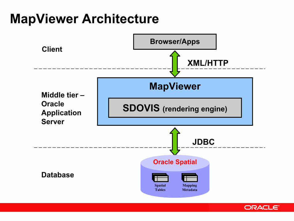
MapViewer ArchitectureBrowser/Apps
Client
SDOVIS (rendering engine)
MapViewer
XML/HTTP
Middle tier –Oracle Application Server
Oracle Spatial
Mapping Metadata
SpatialTables
JDBC
Database
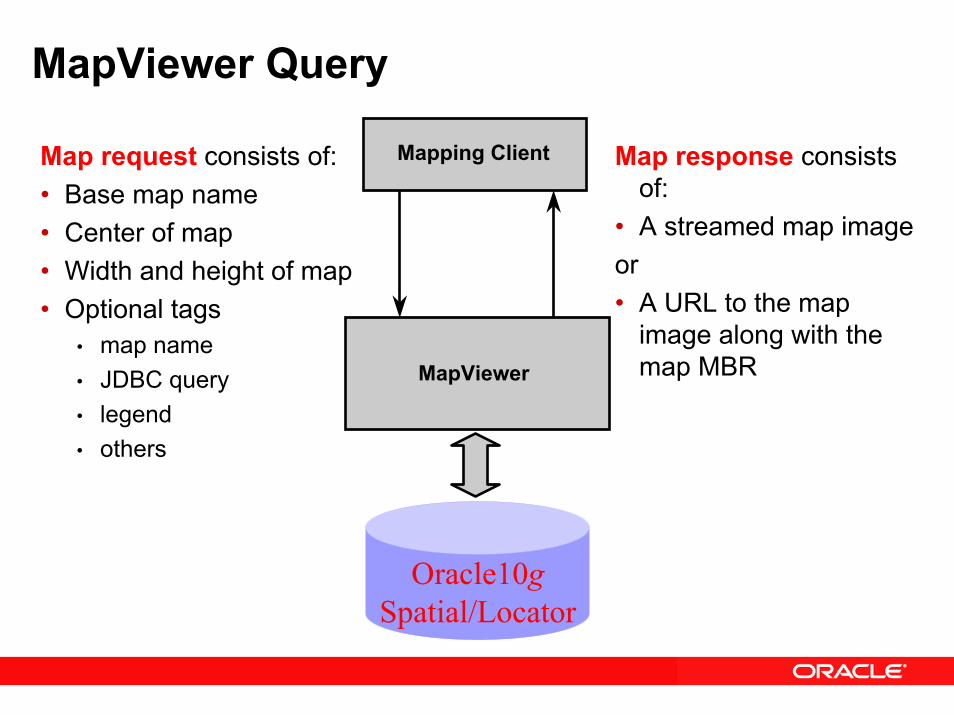
MapViewer Query
Map request consists of:• Base map name• Center of map• Width and height of map• Optional tags
• map name• JDBC query• legend• others
Map response consists of:
• A streamed map image or • A URL to the map
image along with the map MBRMapViewer
Mapping Client
Oracle10gSpatial/Locator
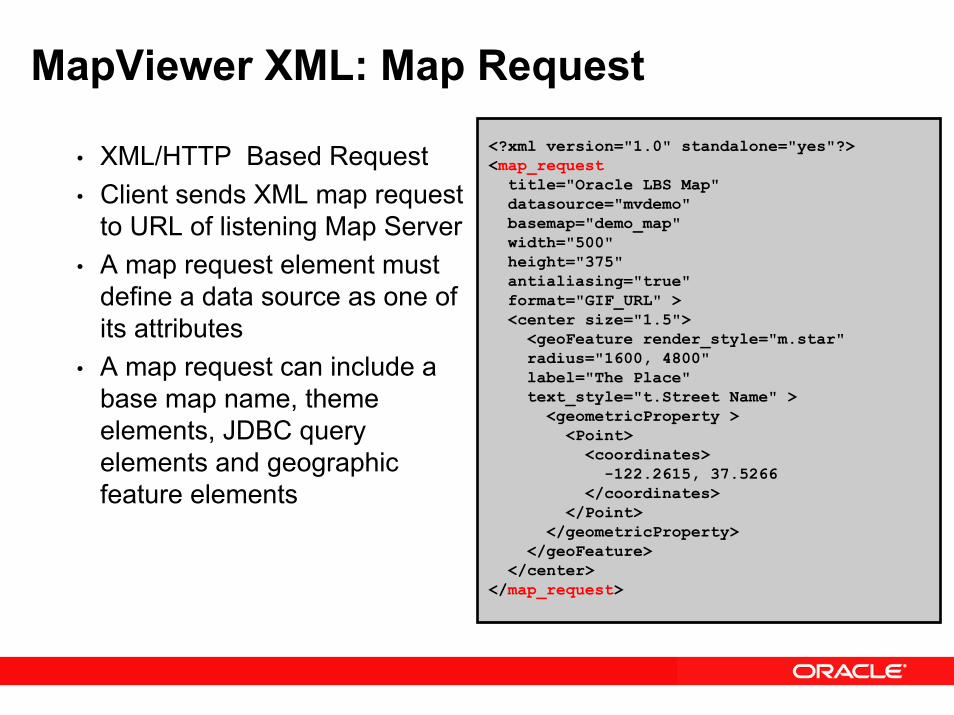
MapViewer XML: Map Request<?xml version="1.0" standalone="yes"?><map_request
title="Oracle LBS Map"datasource="mvdemo" basemap="demo_map"width="500"height="375" antialiasing="true"format="GIF_URL" ><center size="1.5">
<geoFeature render_style="m.star"radius="1600, 4800" label="The Place"text_style="t.Street Name" >
<geometricProperty ><Point>
<coordinates>-122.2615, 37.5266
</coordinates> </Point>
</geometricProperty></geoFeature>
</center></map_request>
• XML/HTTP Based Request • Client sends XML map request
to URL of listening Map Server• A map request element must
define a data source as one of its attributes
• A map request can include a base map name, theme elements, JDBC query elements and geographic feature elements
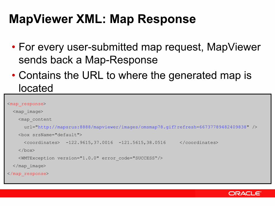
MapViewer XML: Map Response
• For every user-submitted map request, MapViewer sends back a Map-Response
• Contains the URL to where the generated map is located
<map_response>
<map_image>
<map_content
url="http://mapsrus:8888/mapviewer/images/omsmap78.gif?refresh=66737789482409838" />
<box srsName="default">
<coordinates> -122.9615,37.0016 -121.5615,38.0516 </coordinates>
</box>
<WMTException version="1.0.0" error_code="SUCCESS“/>
</map_image>
</map_response>
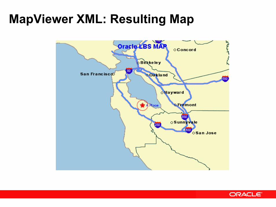
MapViewer XML: Resulting Map
MapViewer Oracle Workspace Manager Support
• Workspace Manager• Oracle Database feature that lets you version-enable
one or more tables in the database• Users can create workspaces• Users can go to workspaces• Edits to versioned enabled tables in a workspacace,
can only be seen by users in that workspace• MapViewer supports map requests from:
• A specific workspace• A savepoint in a workspace
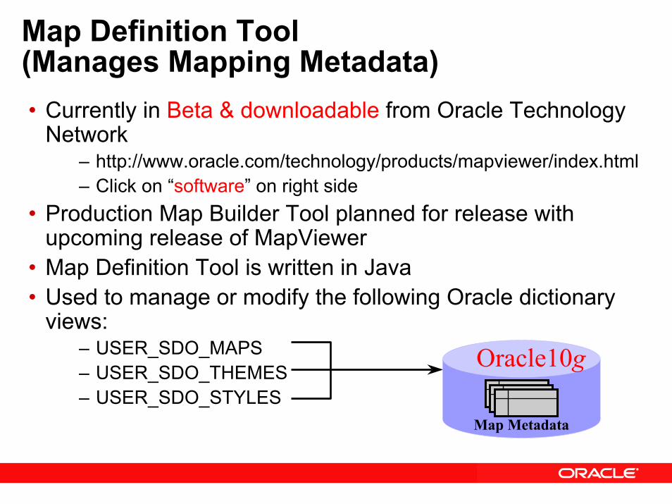
Map Definition Tool(Manages Mapping Metadata)• Currently in Beta & downloadable from Oracle Technology
Network – http://www.oracle.com/technology/products/mapviewer/index.html– Click on “software” on right side
• Production Map Builder Tool planned for release with upcoming release of MapViewer
• Map Definition Tool is written in Java• Used to manage or modify the following Oracle dictionary
views:– USER_SDO_MAPS– USER_SDO_THEMES– USER_SDO_STYLES
Map Metadata
Oracle10g
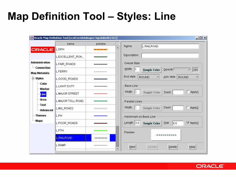
Map Definition Tool – Styles: Line
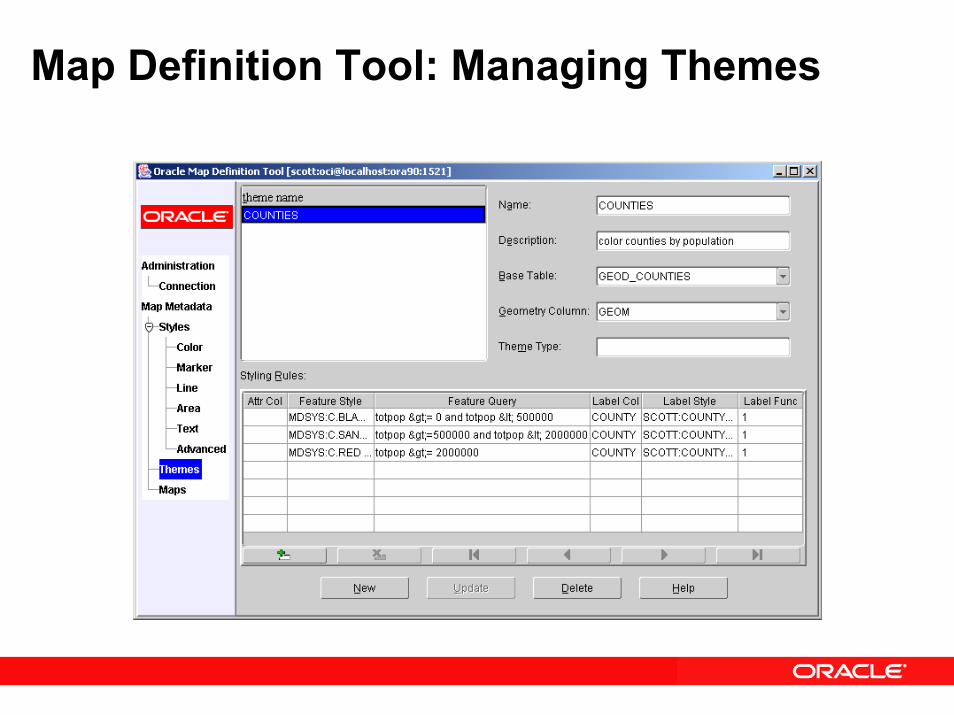
Map Definition Tool: Managing Themes
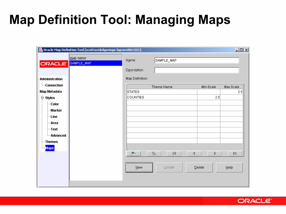
Map Definition Tool: Managing Maps

Oracle Application Server 10g MapViewer Enhancement Summary
• Support for Spatial 10g features• GeoRaster• Topology data model• Network data model
• Workspace Manager support• SVG, JPEG, transparent PNG, HTML imagemap
support• Open Geospatial Consortium’s Web Map Service 1.1
interface• Dynamic coordinate transformations, multiple
datasources per map, and temporary styles in a map request
Oracle Spatial Technology Partners
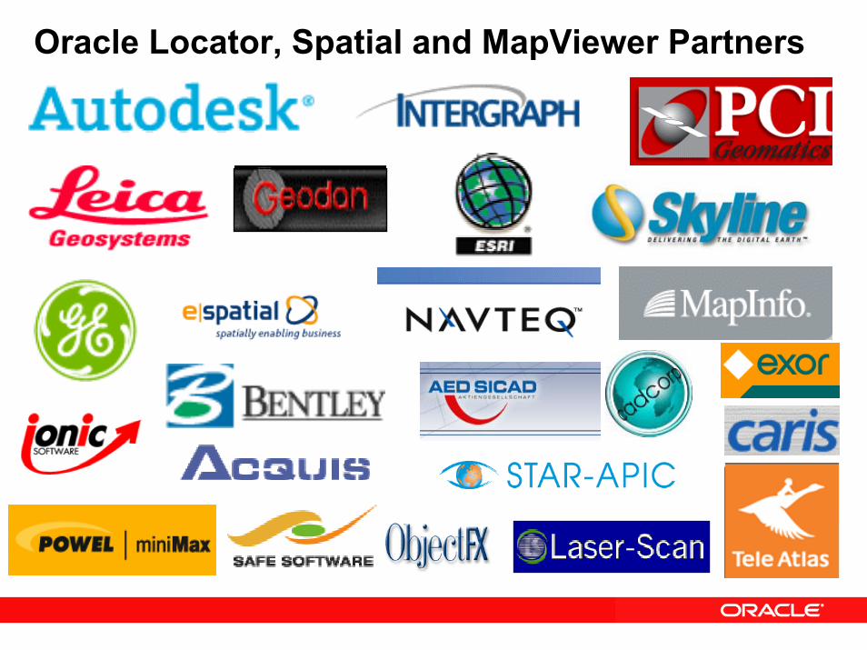
Oracle Locator, Spatial and MapViewer Partners
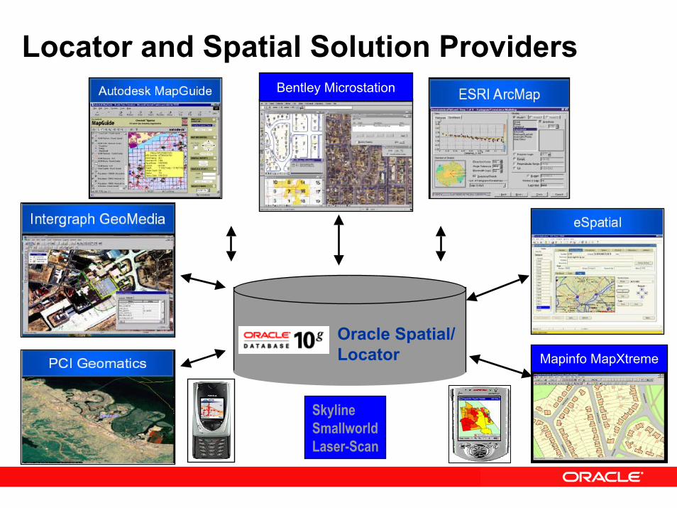
Locator and Spatial Solution Providers
Oracle Spatial/Locator Mapinfo MapXtreme
Bentley Microstation
SkylineSmallworldLaser-Scan
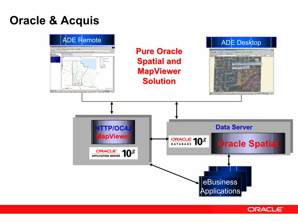
Oracle & AcquisADE Remote ADE Desktop
Pure Oracle Pure Oracle Spatial and Spatial and MapViewer MapViewer
SolutionSolution
HTTP/OC4JMapViewer
Oracle Spatial
Data Server
eBusinessApplications
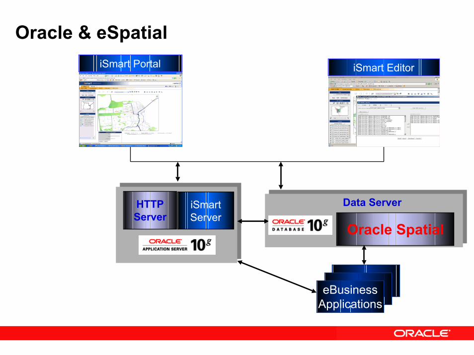
Oracle & eSpatialiSmart Portal iSmart Editor
HTTPServer
Oracle Spatial
Data Server
eBusinessApplications
iSmartServer
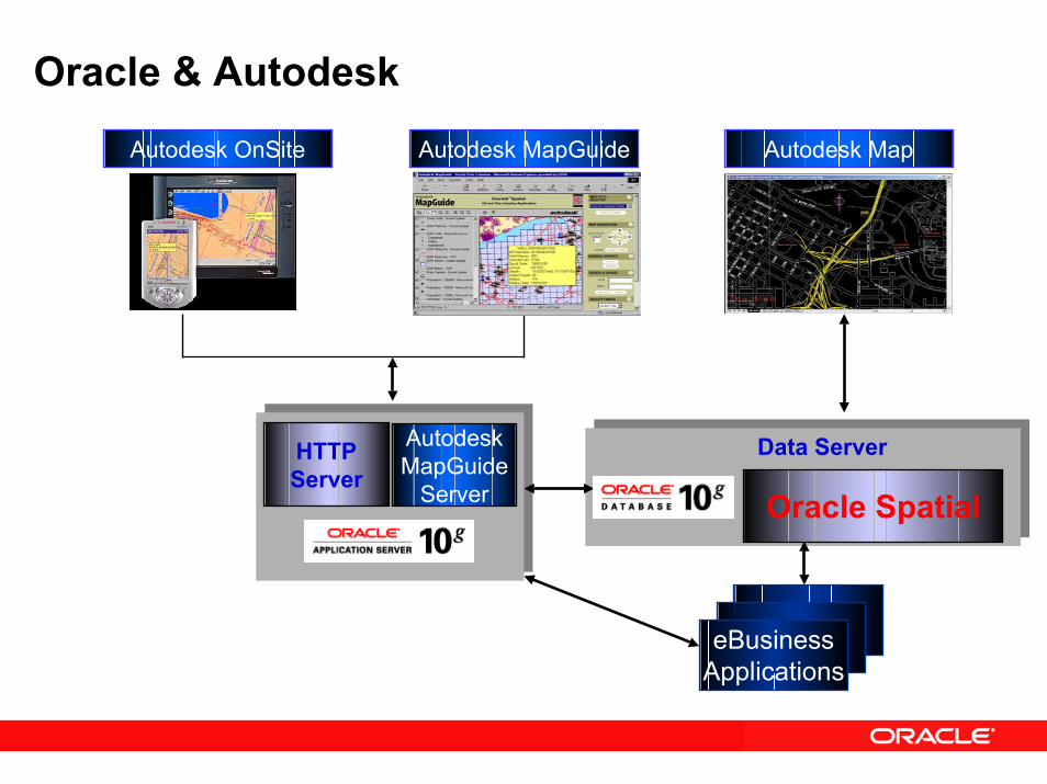
Oracle & Autodesk
Autodesk MapGuide Autodesk MapAutodesk OnSite
AutodeskMapGuide
Server
HTTPServer
Oracle Spatial
Data Server
eBusinessApplications
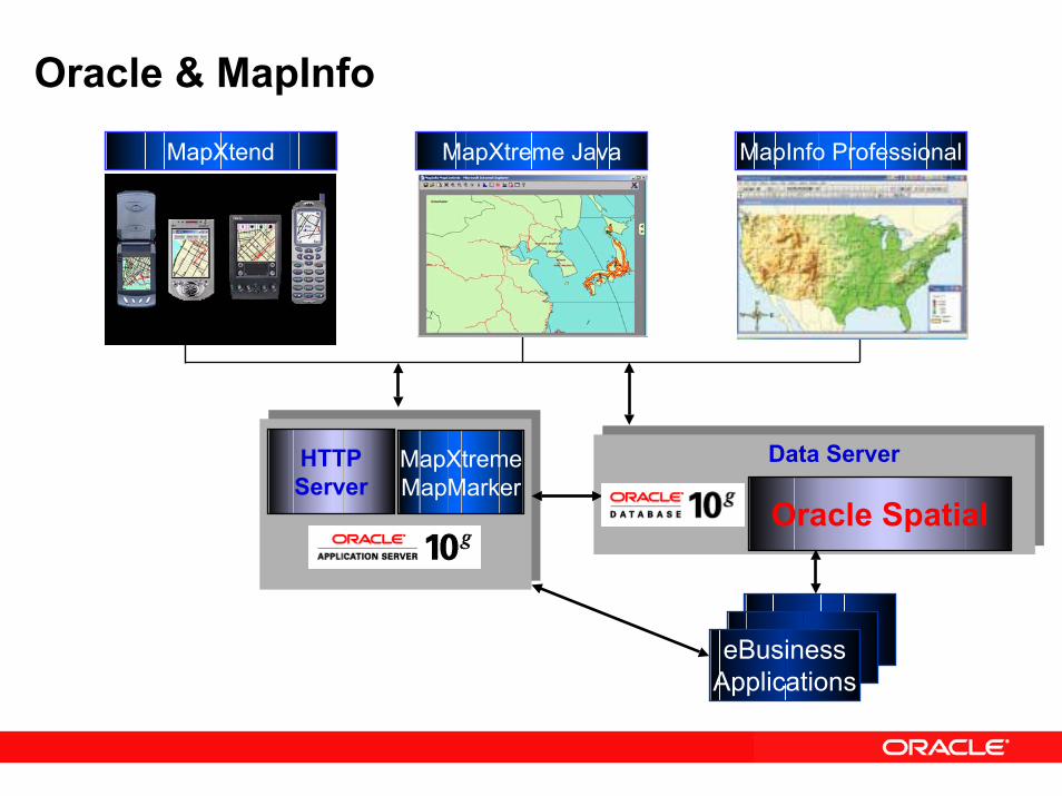
Oracle & MapInfo
MapXtreme Java MapInfo ProfessionalMapXtend
MapXtremeMapMarker
HTTPServer
Oracle Spatial
Data Server
eBusinessApplications
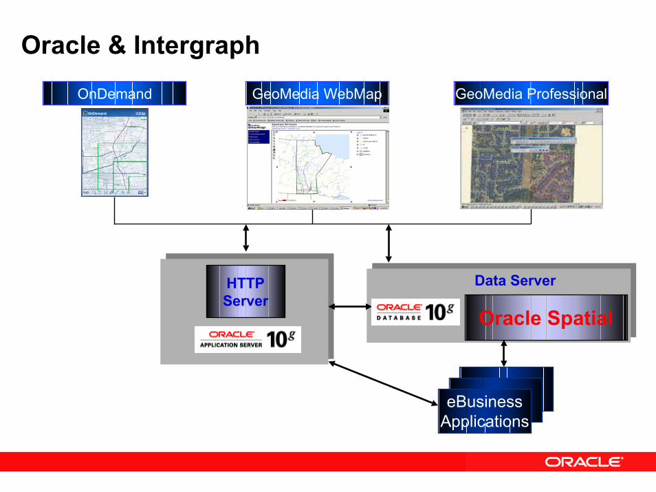
Oracle & Intergraph
GeoMedia WebMapOnDemand GeoMedia Professional
HTTPServer
Oracle Spatial
Data Server
eBusinessApplications
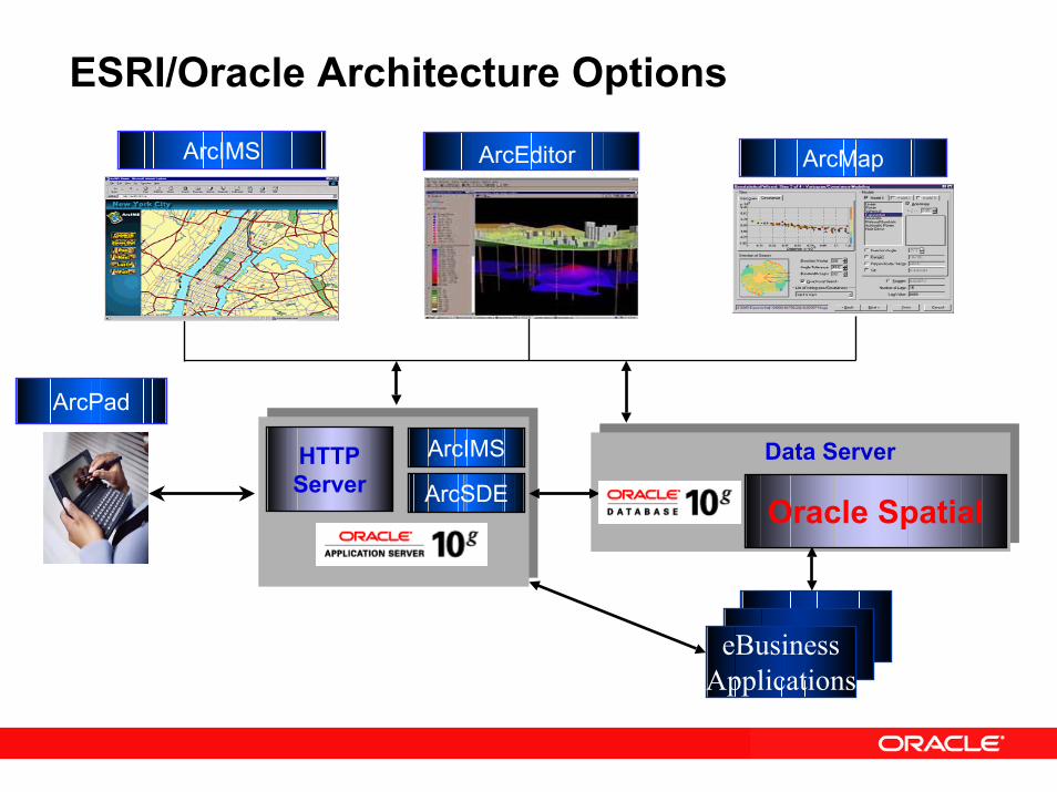
ESRI/Oracle Architecture Options
ArcEditorArcIMS ArcMap
ArcIMSHTTPServer ArcSDE Oracle Spatial
Data Server
eBusinessApplications
ArcSDE Server Direct ConnectArcPad
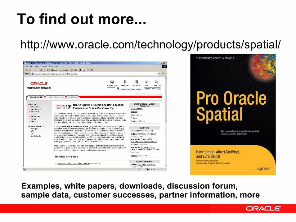
To find out more...http://www.oracle.com/technology/products/spatial/
Examples, white papers, downloads, discussion forum, sample data, customer successes, partner information, more