Embed Size (px)
Citation preview
GINIE: Geographic Information Network in Europe IST-2000-29493
Survey of National Geographic Information
Associations in Europe
GINIE D3.1.1
Author: Anton Wolfkamp Partner: EUROGI Date: 16 February 2003
Projector Co-ordinator University of Sheffield – USFD
Partners
European Umbrella Organisation for Geographic Information – EUROGI Joint Research Centre of the European Commission – JRC
Open GIS Consortium (Europe) - OGCE
Survey of national GI associations - 2 -
Survey of National Geographic Information
Associations in Europe
GINIE D3.1.1
Author: Anton Wolfkamp Issue: 1.2 Date: 16 February 2003
Disclaimer: The views and opinions expressed in this report are those of the authors and editors alone and do not necessarily represent either those individuals that contributed to the survey of national geographic association survey or the organisations that they represented.
Survey of national GI associations - 3 -
Contents
Introduction ____________________________________________________________ 9
1 Austria: Austrian Umbrella Organisation for Geographic Information (AGEO)____________________________________________________________ 11
1.1 General information about the national GI association _________________ 11 1.2 Mission and objectives/strategy ___________________________________ 11 1.3 Key roles _____________________________________________________ 12 1.4 Actions ______________________________________________________ 12 1.5 Structure _____________________________________________________ 12 1.6 Resources ____________________________________________________ 14 1.7 Communication________________________________________________ 14
2 Belgium: Co-ordination Committee for digital GI (CC Belgium) ________ 15 2.1 General information about the national GI association _________________ 15 2.2 Mission and objectives/strategy ___________________________________ 15 2.3 Key roles _____________________________________________________ 15 2.4 Actions ______________________________________________________ 16 2.5 Structure _____________________________________________________ 16 2.6 Resources ____________________________________________________ 16 2.7 Communication________________________________________________ 17
3 Bosnia and Herzegovina__________________________________________ 18
4 Bulgaria _______________________________________________________ 19 4.1 General information about the national GI association _________________ 19 4.2 Mission and objectives/strategy ___________________________________ 19 4.3 Key roles _____________________________________________________ 19 4.4 Actions ______________________________________________________ 20 4.5 Structure _____________________________________________________ 20 4.6 Resources ____________________________________________________ 20 4.7 Communication________________________________________________ 20
5 Cyprus ________________________________________________________ 21 5.1 General information about the national GI Association _________________ 21
6 Czech Republic: Czech Association for Geoinformation (CAGI) ________ 22 6.1 General information about the national GI association _________________ 22 6.2 Mission and objectives/strategy ___________________________________ 22 6.3 Key roles _____________________________________________________ 23 6.4 Actions ______________________________________________________ 23 6.5 Structure _____________________________________________________ 26 6.6 Resources ____________________________________________________ 29 6.7 Communication________________________________________________ 30
7 Denmark, Geoforum Denmark – Society for Geographical Information __ 31 7.1 General information about the national GI association _________________ 31 7.2 Mission and objectives/strategy ___________________________________ 31 7.3 Key roles _____________________________________________________ 31
Survey of national GI associations - 4 -
7.4 Actions ______________________________________________________ 32 7.5 Structure _____________________________________________________ 32 7.6 Communication________________________________________________ 34
8 Estonia ________________________________________________________ 35 8.1 General information about the national GI association _________________ 35 8.2 Mission and objectives/strategy ___________________________________ 35 8.3 Key roles _____________________________________________________ 35 8.4 Actions ______________________________________________________ 35 8.5 Structure _____________________________________________________ 37 8.6 Resources _____________________________________________________ 37 8.7 Communication_________________________________________________ 37
9 Finland: Finnish Association for Geographic Information (ProGIS) _____ 38 9.1 General information about the national GI association _________________ 38 9.2 Mission and objectives/strategy _____________________________________ 38 9.3 Key roles _____________________________________________________ 38 9.4 Actions ______________________________________________________ 38 9.5 Structure _____________________________________________________ 39 9.6 Resources ____________________________________________________ 39 9.7 Communication________________________________________________ 40
10 France: Association Française pour l'Information Géographique (AFIGÉO) and Conseil National de l’ Information Géographique (CNIG) ______________ 41
10.1 General information about the national GI association _______________ 41 10.2 Mission and objectives/strategy _________________________________ 41 10.3 Key roles ___________________________________________________ 42 10.4 Actions _____________________________________________________ 42 10.5 Structure ____________________________________________________ 43 10.6 Resources __________________________________________________ 47 10.7 Communication______________________________________________ 48 10.8 Burning issues________________________________________________ 48
11 Germany: German umbrella organisation for Geographic Information (DDGI) ____________________________________________________________ 49
11.1 General information about the national GI association _______________ 49 11.2 Mission and objectives/strategy _________________________________ 49 11.3 Key roles ___________________________________________________ 50 11.4 Actions ____________________________________________________ 50 11.5 Structure ___________________________________________________ 50 11.6 Resources __________________________________________________ 52 11.7 Communication______________________________________________ 52
12 Greece: Hellenic Geographic Information Society (Hellas GI) __________ 53 12.1 General information about the national GI association _______________ 53 12.2 Mission and objectives/strategy ___________________________________ 53 12.3 Key roles ___________________________________________________ 53 12.4 Actions ____________________________________________________ 53 12.5 Structure ____________________________________________________ 54
Survey of national GI associations - 5 -
12.6 Resources ___________________________________________________ 54 12.7 Communication_______________________________________________ 54
13 Hungary: Hungarian Association for Geo-Information (HUNAGI) ______ 55 13.1 General information about the national GI association _______________ 55 13.2 Mission and objectives/strategy ___________________________________ 55 13.3 Key roles ___________________________________________________ 55 13.4 Actions ____________________________________________________ 55 13.5 Structure ___________________________________________________ 56 13.6 Resources __________________________________________________ 58 13.7 Communication______________________________________________ 58
14 Iceland: LISA, Organisation for GI (LISA)__________________________ 59 14.1 General information about the national GI association _______________ 59 14.2 Mission and objectives/strategy _________________________________ 59 14.3 Key roles ___________________________________________________ 59 14.4 Actions ____________________________________________________ 59 14.5 Structure ___________________________________________________ 60 14.6 Resources ___________________________________________________ 61 14.7 Communication______________________________________________ 61
15 Ireland: Irish Organisation for Geographic Information (IRLOGI) _____ 62 15.1 General information about the national GI association _______________ 62 15.2 Mission and objectives/strategy ___________________________________ 62 15.3 Key roles ___________________________________________________ 62 15.4 Actions ____________________________________________________ 62 15.5 Structure ___________________________________________________ 63 15.6 Resources __________________________________________________ 63 15.7 Communication______________________________________________ 64
16 Italy: Automated Mapping/Facilities Management (AM/FM Italia)______ 65 16.1 General information about the national GI association _______________ 65 16.2 Mission and objectives/strategy ___________________________________ 65 16.3 Key roles ___________________________________________________ 65 16.4 Actions ____________________________________________________ 65 16.5 Structure ____________________________________________________ 66 16.6 Resources __________________________________________________ 67 16.7 Communication______________________________________________ 67
17 Lithuania ______________________________________________________ 68 17.1 General information about the national GI association _______________ 68
18 Luxembourg: Inter ministerial working group on GIS (GTIM SIG) _____ 69 18.1 General information about the national GI association _______________ 69 18.2 Mission and objectives/strategy _________________________________ 69 18.3 Key roles ___________________________________________________ 69 18.4 Actions _____________________________________________________ 69 18.5 Structure ____________________________________________________ 69 18.6 Resources __________________________________________________ 70 18.7 Communication______________________________________________ 70
Survey of national GI associations - 6 -
19 Malta _________________________________________________________ 71 19.1 General information about the national GI association ___________________ 71 19.2 Mission and objectives/strategy ___________________________________ 71 19.3 Key roles ___________________________________________________ 71 19.4 Actions ____________________________________________________ 72 19.5 Structure ___________________________________________________ 72 19.6 Resources __________________________________________________ 72 19.7 Communication______________________________________________ 72
20 Netherlands: Foundation Ravi, network for Geo-information (RAVI)____ 73 20.1 General information about the national GI association _______________ 73 20.2 Mission and objectives/strategy _________________________________ 73 20.3 Key roles ___________________________________________________ 73 20.4 Actions ____________________________________________________ 73 20.5 Structure ____________________________________________________ 74 20.6 Resources ___________________________________________________ 74 20.7 Communication_______________________________________________ 74
21 Norway: Geoforum ______________________________________________ 75 21.1 General information about the national GI association _______________ 75 21.2 Mission and objectives/strategy ___________________________________ 75 21.3 Key roles ___________________________________________________ 75 21.4 Actions ____________________________________________________ 75 21.5 Structure ____________________________________________________ 76 21.6 Resources __________________________________________________ 76 21.7 Communication______________________________________________ 77
22 Poland: the National Land Information Users Association (GISPOL) ____ 78 22.1 General information about the national GI association _______________ 78 22.2 Mission and objectives/strategy ___________________________________ 78 22.3 Key roles ___________________________________________________ 78 22.4 Actions _____________________________________________________ 78 22.5 Structure ____________________________________________________ 78 22.6 Resources ___________________________________________________ 78 22.7 Communication_______________________________________________ 78
23 Portugal: Instituto Geográfico Português (IGP) ______________________ 79 23.1 General information about the national GI association _______________ 79 23.2 Mission and objectives/strategy ___________________________________ 79 23.3 Key roles ___________________________________________________ 79 23.4 Actions _____________________________________________________ 79 23.5 Structure ____________________________________________________ 80 23.6 Resources ___________________________________________________ 80 23.7 Communication_______________________________________________ 80
24 Romania_______________________________________________________ 81 24.1 Romanian Cartographic Association (Asociatia Romana de Cartografie) _ 81
24.1.1 General information about the national association ______________ 81 24.1.2 Mission and objectives/strategy _____________________________ 81
Survey of national GI associations - 7 -
24.1.3 Key roles _______________________________________________ 81 24.1.4 Actions _________________________________________________ 81 24.1.5 Structure ________________________________________________ 82 24.1.6 Resources ______________________________________________ 82 24.1.7 Communication__________________________________________ 82
24.2 Romanian Society for Photogrammetry and Remote Sensing __________ 82 24.2.1 General information about the national association ______________ 82 24.2.2 Mission and objectives/strategy _______________________________ 82 24.2.3 Key roles _______________________________________________ 83 24.2.4 Actions _________________________________________________ 83 24.2.5 Structure ________________________________________________ 83 24.2.6 Resources _______________________________________________ 83 24.2.7 Communication___________________________________________ 83
24.3 National Association of IT specialists from Public Administration __________ 83 24.3.1 General information about the national GI association _______________ 83 24.3.2 Mission and objectives/strategy _______________________________ 84 24.3.3 Key roles _______________________________________________ 84 24.3.4 Actions _________________________________________________ 84 24.3.5 Structure ________________________________________________ 84 24.3.6 Resources ______________________________________________ 86 24.3.7 Communication__________________________________________ 86
25 Russia: GIS association __________________________________________ 87 25.1 General information about the national GI association ___________________ 87 25.2 Mission and objectives/strategy _________________________________ 87 25.3 Key roles ___________________________________________________ 87 25.4 Actions ____________________________________________________ 87 25.5 Structure ___________________________________________________ 87 25.6 Resources ___________________________________________________ 88 25.7 Communication_______________________________________________ 88
26 Slovakia: Slovak Association for Geoinformatics (SAGI) ______________ 89 26.1 General information about the national GI association _______________ 89 26.2 Mission and objectives/strategy ___________________________________ 89 26.3 Key roles ___________________________________________________ 89 26.4 Actions ____________________________________________________ 89 26.5 Structure ____________________________________________________ 90 26.6 Resources ___________________________________________________ 90 26.7 Communication_______________________________________________ 91
27 Slovenia: Geo Information Centre (GIC Slovenia) ____________________ 92
28 Spain: Spanish Association for Geographic Information Systems (AESIG) 93 28.1 General information about the national GI association _______________ 93 28.2 Mission and objectives/strategy _________________________________ 93 28.3 Key roles ___________________________________________________ 93 28.4 Actions ____________________________________________________ 93 28.5 Structure ____________________________________________________ 94 28.6 Resources ___________________________________________________ 94
Survey of national GI associations - 8 -
28.7 Communication_______________________________________________ 94
29 Sweden: Swedish development council for Land Information (ULI) _____ 95 29.1 General Information __________________________________________ 95 29.2 Mission and objectives/strategy ___________________________________ 95 29.3 Key roles ___________________________________________________ 95 29.4 Actions ____________________________________________________ 95 29.5 Structure ____________________________________________________ 96 29.6 Resources ___________________________________________________ 97 29.7 Communication_______________________________________________ 97
30 Switzerland: Swiss Organisation for Geo-Information (SOGI) __________ 98 30.1 General information about the national GI association _______________ 98 30.2 Mission and objectives/strategy ___________________________________ 98 30.3 Key roles ___________________________________________________ 98 30.4 Actions ____________________________________________________ 99 30.5 Structure ____________________________________________________ 99 30.6 Resources __________________________________________________ 100 30.7 Communication______________________________________________ 101
31 Turkey _______________________________________________________ 102 31.1 General information about the national GI association __________________ 102 31.2 Mission and objectives/strategy __________________________________ 102 31.3 Key roles __________________________________________________ 102 31.4 Actions ____________________________________________________ 102 31.5 Structure ___________________________________________________ 102 31.6 Resources __________________________________________________ 102 31.7 Communication______________________________________________ 103
32 United Kingdom: Association for Geographic Information (AGI) ______ 104 32.1 General information about the national GI association ______________ 104 32.2 Mission and objectives/strategy __________________________________ 105 32.3 Key roles __________________________________________________ 105 32.4 Actions ____________________________________________________ 106 32.5 Structure ___________________________________________________ 106 32.6 Resources _________________________________________________ 112 32.7 Communication______________________________________________ 113
Annex A: The questionnaire ______________________________________________ 115
Annex B: List of contact persons ________________________________________ 117
Survey of national GI associations - 9 -
Introduction This report provides the current position and status of national Geographic Information (GI) Associations in Europe as at February 2003. The position has been ascertained by undertaking a survey in the latter half of 2002 using the questionnaire shown in the annex of this document. The EURopean umbrella Organisation for Geographic Information (EUROGI) undertook the survey within the framework of the European Commission (EC) funded project: Geographic Information Network In Europe (GINIE). When there is one single organisation representing the GI community in a country and that organisation is a EUROGI member, then this organisation is taken into account for this survey. In other cases a description of the current situation in the country has been given whether there are different organisations acting in the field of GI or there is no specific GI association at all. The European dimension This report should be placed in the perspective of the recently undertaken project, workshops and seminars that have the objective of raising the awareness of the use of GI across the whole of Europe. Some important workshops were: - The EUROGI-EC workshop “GI and the enlargement of the European Union (EU)” in Brussels,
2000; - The EU workshop: “Cadastral data as a component of Spatial Data Infrastructure in support of
agri-environmental programmes” in Budapest, 2001, organised by EUROGI, HUNAGI and the JRC. The delegates attending represented a broad range of disciplines, coming from all the countries of Europe.
Developments in the GI sector are becoming more and more enabled within the Europe. National GI Associations and Pan European organisations like EUROGI provide a forum for the establishment of GI at both the National and European level. Background This report is based on a study carried out by Koen van Biesen, researcher of the Dutch Kadaster in the latter part of 2000. The study was initiated by EUROGI to obtain an insight into the environmental, organisational and financial aspects of national GI associations. National Associations that bring together all the potential players on both the demand and supply side of the GI sector irrespective of whether they are in the public or private sectors play a fundamental role in developing the GI capacity within each nation. Such organisations provide a conduit through which information flows between the GI sector and Government at all levels as well as the society at large. Evidence would indicate that where there is a strong sustainable national GI Association there is also a growing sustainable GI market. The effective implementation of a European GI Strategy will be heavily influenced by the presence of strong national GI Associations that enable all with an interest in GI to be engaged in the development and implementation of such a European strategy. By creating an insight into the profiles of national GI associations in Europe, a major step forward can be taken to strengthen and enable national GI associations in Europe The profiles contained within this document are the results of the survey.
Survey of national GI associations - 10 -
The objective of the survey was to provide an insight into the current situation in each European country whether they have a national GI association or not. This survey does not only contain all the countries with a national GI association, but also those countries, which filled in the questionnaire, setting out which body or bodies in the country are the main actors in terms of co-ordination in the field of GI. This report contains those European countries that submitted a completed questionnaire or in the absence of a completed questionnaire copied from the EUROGI web site. Report Structure Each chapter in this report deals with the profile of one association. The profiles are in alphabetic order and follow a fixed template. The profiles provide an insight into the following aspects: - General information about the national GI association. (Name, address, website, date of foundation) - Mission and objectives/strategy.
(Mission describes the constitution and the reason for existence) (Objectives/strategy describes the way the organisation will achieve its mission).
- Key roles (Roles fulfilled by the association)
- Actions. (Actions are the short-term activities of the organisation to achieve the objectives) - Structure. (Boards, working groups, secretariat, membership, partnerships) - Financial resource information. (Income, expenses) 1 - Communication. (Newsletters, bulletins, web site etc) The above template is used for every organisation presented within this report. For consistency the information about each organisation is presented under the same chapter number. If no information was provided to a question the response has been left blank. In the case of Romania there are three actors co-ordinating activities. Website The profiles in this document will be presented at both the EUROGI and GINIE websites www.eurogi.org and www.ec-gis.org/ginie. The profiles will be updated on a regular basis by EUROGI. Updates in the details of an association should be sent to the EUROGI Secretariat via email [email protected]. Acknowledgement I wish to express my sincere thanks to all the people contacted and to the GI associations and the key people in each country. Thanks to their effort I could produce the survey. My special thanks are going to Chris Corbin, the EUROGI GINIE project manger, who gave me advice and who was always willing to discuss the topics.
1 The figures are not always related to the same year. They are within the range from 2000 up till 2002
Survey of national GI associations - 11 -
1 Austria: Austrian Umbrella Organisation for Geographic Information (AGEO)
1.1 General information about the national GI association
Name: Austrian Umbrella Organisation for Geographic Information Österreichischer Dachverband für Geographische Information
Address: Buergerstrasse 34, A-6010 Innsbruck Telephone: +43 512 588411-60 Fax: +43 512 588411-61 Email: [email protected] Website: www.ageo.at Date of foundation: 4 July 1998
In what way is the association recognised by the government? The government does not recognise the association. The registration is in accordance with Austrian law for umbrella organisations, which ensures that it is a unique umbrella organisation for the registered purpose in Austria. It is not possible to establish a second umbrella organisation in Austria for the same purpose. So far there is no institutional involvement of AGEO into GI matters in Austria but as AGEO represents a wide field of GI actors there is a rather dense network within the public and private sectors. At the time of foundation there was a need for a platform for GI matters and a need for a co-ordination of different interests of GI players in Austria. The group of proponents for the foundation represented a wide field of GI actors and interests.
1.2 Mission and objectives/strategy Mission - To promote the efficient application of GI. - To promote the interdisciplinary use of GI by providing information to the public. Exchange of
information. - Co-ordination and use of GI. - To provide information about the availability and use of GI. - To promote education and Continuous Professional Development (CPD). AGEO represents the interests of GI in Austria towards international associations and interest groups. Objectives/strategy To provide information and publications about GI and the progress made by initiatives in the developments at the technical and methodological levels by “best practice” within Austria provide a strong place for GI. AGEI initiatives include: - Set up of an inventory “GI in Austria”.
Survey of national GI associations - 12 -
- Start of an Austrian Geographic Information Infrastructure. - Work on public sector information on GI. - Provision of information about standards. - Stimulation of professional education.
1.3 Key roles
1 GI policy maker Yes2 Knowledge and information supplier Yes3 Public relations, awareness raising and promotion of GI Yes4 Program assistance and support No5 Political interface, lobbyist Yes6 Mediator, negotiator Yes7 Promoter of standards, certification No8 Facilitator for education (professional development) and training Yes9 Research No
1.4 Actions
1 Workshops Not yet AGEO participates in Workshops as co-organiser only within for example conferences. No special organised workshops by AGEO.
2 Seminars Yes One annual seminar on burning issues of GI in Austria has been held since foundation. About 80-120 participants from all sectors of GI including private, public, related professions, decision makers, national and international sector attended. Participation mainly free of charge for AGEO members, reasonable fee for guests.
3 Conferences No Participation of AGEO members in conferences to represent AGEO there.
4 Projects No Participation Yes (GINIE). AGEO itself does not participate in projects due to missing permanent officers. All officers are volunteers
5 Publications Yes AGEO Newsletter 3-4 times/year, edition 1000 copies. Published on occasion of e.g. Global GIS Day, Annual seminar, and AGIT conference, to support distribution and get best as possible promotion for the newsletter.
6 Lobbying Yes For burning issues lobbying is done mostly at regional decision makers and by personal contacts to raise awareness for GI matters and problems and to show necessity of GI.
7 Other Yes Contribution on local level to e.g. seminars, conferences Negotiation of licenses for university courses by AGEO to enhance activities at student level. Market analysis for metadata services in Austria carried out by AGEO, co-funded by the Federal Ministry of Economics and Labour to investigate the need for a metadata service
1.5 Structure General board 10 members that represent the different member groups as best as possible. Discusses and decides strategy, representation of AGEO, reports to General Assembly
Survey of national GI associations - 13 -
Executive board None Working groups There are three Working Groups:
- Education. - Economic Geodata Management. - Spatial Data Infrastructure.
The working groups use different measures for their tasks, this might be web-services for curricula or they act as discussion forums or as co-ordination groups for certain matters. Members of working groups do not need to be members of AGEO. Secretariat One volunteer organises the association activities, seminars, member promotions, administration and runs the daily activities. Membership Categories and number in each category, target groups;
No fixed categories, 48 member institutions (no individual members):
Category Percentage Number Companies 37 18 University Institutes 15 7 Associations 8 4 Public Institutions 10 5 Licensed surveyors 17 8 Energy supply companies 13 6 Total 100 48
Which are the benefits for the members, related to each category;
Benefits are for all to exchange information, to have a discussion forum, to be represented by one organisation, to get issues into discussion between members who would not have any contact without AGEO. Part of the membership fee can be re-granted by reduction of seminar fees, funds for congress participation fees for AGEO members possibly up to 25% of their membership fee.
Is the membership separated in a public and private part and how are they brought together No separation, all together around the table. There is a very good co-operation.
Partnerships Some times there is co-operation with other associations, if they share the same interests. Organisational scheme No

Survey of national GI associations - 14 -
1.6 Resources Income: €24.000 Dues for each type of membership €500 year/member €500 application fee for new members except foundation members Funding in kind/secondment: no Sponsorship: no, initially sponsors for web site have been invited, no interest. Other donations: advertisements in the AGEO newsletter cover about 5% of printing costs. Expenses: €24.000 Running costs for the secretariat about €2500. e.g. material, telephone, Other costs: Annual Seminar about €5000, for buffet, travel costs reimbursement Printing costs for newspaper and hosting and running web-site including services about €12000, per year. Subsidies for members to conference fees, about €2500 per year Travel costs for members of Executive Board to meetings about €2000, per year
1.7 Communication
1 Newsletters Yes 3-4 times a year, distributed to members and about 500 interested persons and occasionally to seminar participants
2 Bulletins No 3 Reports No 4 Web site Yes www.ageo.at with job-service, online news service for members
on their own disposal 5 Magazines No 6 E mail Yes [email protected]
Survey of national GI associations - 15 -
2 Belgium: Co-ordination Committee for digital GI (CC Belgium)
2.1 General information about the national GI association
Name: Coördinatiecomité voor Numerieke Geografische Informatie Comité de Coordination de l’Information Géographique Co-ordination committee for digital geographical information
Address: c/o Institut Géographique National Abbaye de la Cambre 13, B-1000 Bruxelles, Belgium
Telephone: +32 2 629 84 71 Fax: +32 2 629 82 12 Email: Website: Date of foundation: 18 September 1986
In what way is the association recognised by the government? The Co-ordination committee associates representatives of all Belgian users and producers of geographical information, both in the private and the public sector
2.2 Mission and objectives/strategy Mission It aims to optimise the exchange and the multiple use of digital GI. Objectives/strategy - Advise the Belgian Institute for Normalisation on pre-European Norms concerning GI. - Stimulate the use and the improvement of the existing meta databases - Advise on the legal and the financial aspects of GI. - Encourage research and development in GI. - Follow international activities in GI and to report on these.
2.3 Key roles No information provided.
1 GI policy maker 2 Knowledge and information supplier 3 Public relations, awareness raising and promotion of GI 4 Program assistance and support 5 Political interface, lobbyist 6 Mediator, negotiator 7 Promoter of standards, certification 8 Facilitator for education (professional development) and training 9 Research
Survey of national GI associations - 16 -
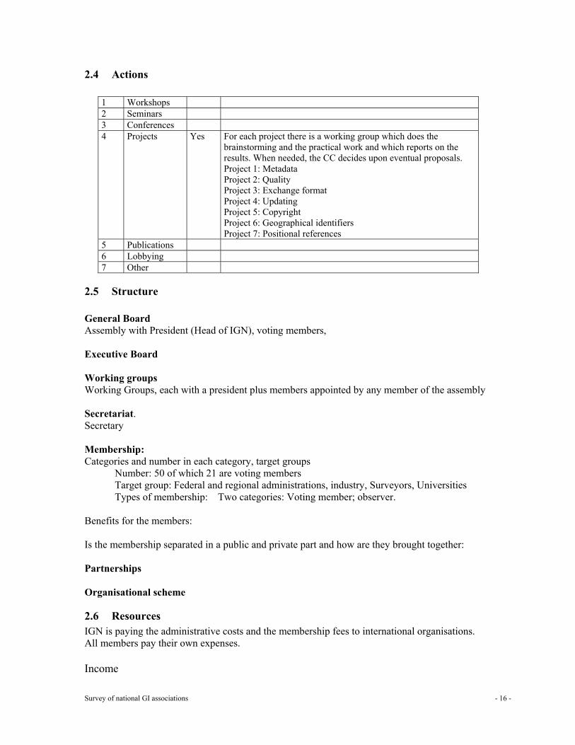
2.4 Actions
1 Workshops 2 Seminars 3 Conferences 4 Projects Yes For each project there is a working group which does the
brainstorming and the practical work and which reports on the results. When needed, the CC decides upon eventual proposals. Project 1: Metadata Project 2: Quality Project 3: Exchange format Project 4: Updating Project 5: Copyright Project 6: Geographical identifiers Project 7: Positional references
5 Publications 6 Lobbying 7 Other
2.5 Structure General Board Assembly with President (Head of IGN), voting members, Executive Board Working groups Working Groups, each with a president plus members appointed by any member of the assembly Secretariat. Secretary Membership: Categories and number in each category, target groups
Number: 50 of which 21 are voting members Target group: Federal and regional administrations, industry, Surveyors, Universities Types of membership: Two categories: Voting member; observer.
Benefits for the members: Is the membership separated in a public and private part and how are they brought together: Partnerships Organisational scheme
2.6 Resources IGN is paying the administrative costs and the membership fees to international organisations. All members pay their own expenses. Income
Survey of national GI associations - 17 -
Dues for each type of membership Funding in kind/secondment Sponsorship Other donations
Expenses: Running costs for the secretariat: Other costs:
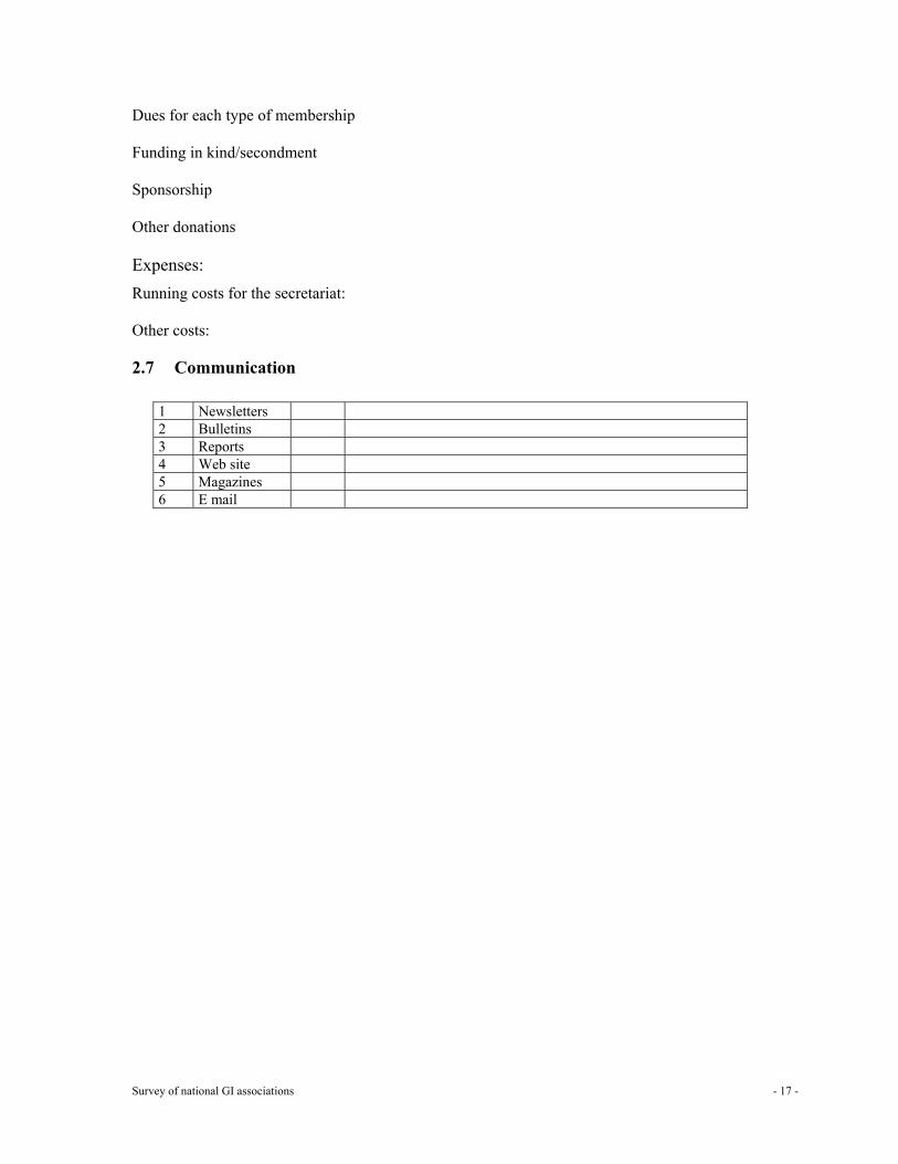
2.7 Communication
1 Newsletters 2 Bulletins 3 Reports 4 Web site 5 Magazines 6 E mail
Survey of national GI associations - 18 -
3 Bosnia and Herzegovina Bosnia and Herzegovina does not have a national GI association. Within the framework of collaboration between the South East European countries: Geographic Information South East Europe (GISEE) they are working together with Bulgaria, Romania and others to strengthen GI in their country. At this moment there is no more information available.
Survey of national GI associations - 19 -
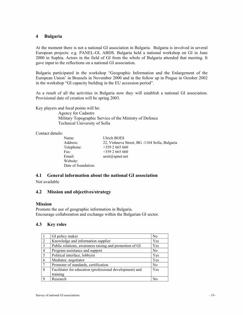
4 Bulgaria At the moment there is not a national GI association in Bulgaria. Bulgaria is involved in several European projects: e.g. PANEL-GI, ABDS. Bulgaria held a national workshop on GI in June 2000 in Sophia. Actors in the field of GI from the whole of Bulgaria attended that meeting. It gave input to the reflections on a national GI association. Bulgaria participated in the workshop “Geographic Information and the Enlargement of the European Union’ in Brussels in November 2000 and in the follow up in Prague in October 2002 in the workshop “GI capacity building in the EU accession period”. As a result of all the activities in Bulgaria now they will establish a national GI association. Provisional date of creation will be spring 2003. Key players and focal points will be:
Agency for Cadastre Military Topographic Service of the Ministry of Defence Technical University of Sofia
Contact details:
Name: Ulrich BOES Address: 22, Vishneva Street, BG -1164 Sofia, Bulgaria Telephone: +359 2 665 660 Fax: +359 2 665 660 Email: [email protected] Website: Date of foundation:
4.1 General information about the national GI association Not available
4.2 Mission and objectives/strategy Mission Promote the use of geographic information in Bulgaria. Encourage collaboration and exchange within the Bulgarian GI sector.
4.3 Key roles
1 GI policy maker No 2 Knowledge and information supplier Yes 3 Public relations, awareness raising and promotion of GI Yes 4 Program assistance and support No 5 Political interface, lobbyist Yes 6 Mediator, negotiator Yes 7 Promoter of standards, certification No 8 Facilitator for education (professional development) and
training Yes
9 Research No
Survey of national GI associations - 20 -
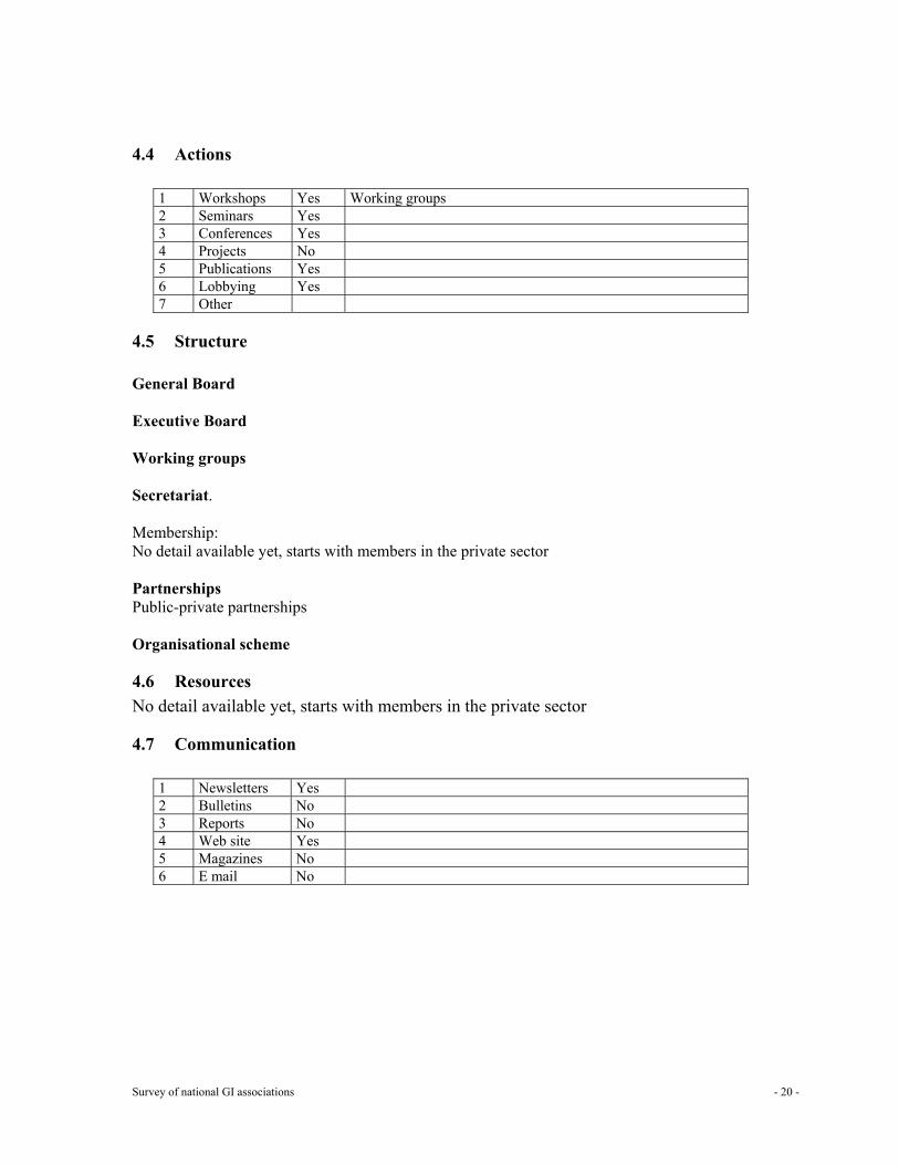
4.4 Actions
1 Workshops Yes Working groups 2 Seminars Yes 3 Conferences Yes 4 Projects No 5 Publications Yes 6 Lobbying Yes 7 Other
4.5 Structure General Board Executive Board Working groups Secretariat. Membership: No detail available yet, starts with members in the private sector Partnerships Public-private partnerships Organisational scheme
4.6 Resources No detail available yet, starts with members in the private sector
4.7 Communication
1 Newsletters Yes 2 Bulletins No 3 Reports No 4 Web site Yes 5 Magazines No 6 E mail No
Survey of national GI associations - 21 -
5 Cyprus
5.1 General information about the national GI Association A GI Association does not exist yet in Cyprus. Cyprus urgently needs Europe’s help, so that activities can be planned towards the establishment of a GI Association. In this respect, they are ready to co-operate with EUROGI or any other interested colleagues and organisations in Europe, to ensure that they will follow the correct procedures and rules. There is a lot of interest from many professional organisations, Government Departments, Semi-Government Authorities, Utilities, Local Government, and professional individuals in setting up a national GI Association. Focal points for GI The Government in 1994 created a Land Information Council after a Council of Ministers Decision. This Council consists of a total of 11 permanent members coming from several Ministries, Government Departments, Utilities, and Local Government. Its role is to regulate the GI activities in Cyprus (mainly Government, semi-Government, Local Government and utilities), so that duplication will be avoided, and to ensure uniform and homogeneous coverage of spatial and a spatial data for the whole island. All considerable GI activities in Cyprus are currently mainly carried out by the Department of Lands and Surveys, which are the National Cadastral and Mapping Agency (NMA) of the country.
Survey of national GI associations - 22 -
6 Czech Republic: Czech Association for Geoinformation (CAGI)
6.1 General information about the national GI association Name: Česká asociace pro geoinformace
Czech Association for Geoinformation Address: Italská 34, Praha 2, 120 00, Czech Republic Mailing address P.O.B. 22, post 015 Na Frantisku 32,
110 15 Prague 1, Czech Republic Telephone: +420-224816868, +420-233324472 Fax: +420-224819161 Email: [email protected]; [email protected] Website: www.cagi.cz Date of foundation: 12 June 1997
In what way is the association recognised by the government?
6.2 Mission and objectives/strategy CAGI is registered as the civil professional association of the citizens and legal persons (individual and collective members) working in the sphere of geoinformation in the Czech Republic Mission To support the use of spatial information, data and related technologies in favour of the benefit of the citizens and good governance. (An internal debate on supporting GI utilisation in business was opened in 2002. This probably will be reflected in an enlarged mission in 2003.) Objectives/strategy CAGI improves, encourages, and supports development and use of geoinformation. It acts in the name of geoinformation community in the Czech Republic. It participates in this development in Europe. • The aims of CAGI in the conditions of the Czech Republic are particularly regarded as the
following: • Create conditions for a universal development of geoinformation systems and for a wide use
of geoinformation in all areas. • Support and provide a tight working contact of all involved subjects, to exchange
information, knowledge and experience among the members (in the form of meetings, seminars, conferences, special publications and electronic information service).
• Participate in solving particular tasks of common interests as initiating and processing of projects, suggestions and studies of the chosen subjects which condition to the development of geoinformation systems and utilisation of appropriate information technologies (comparative and evaluative studies, pilot projects, national geoinformation infrastructure project, geoinformation standards).
• Represent the Czech geoinformation community at public authorities, to support activities of public authorities in the areas of subject matter and to provide effective co-operation with them in the development of spatial information systems and the utilisation of appropriate information technologies in the public sector (participation on co-ordination and working groups, standpoints to key questions, suggestions and measures, presentation of own initiatives and so on).
Survey of national GI associations - 23 -
• Provide consulting and expert activities for the bodies responsible for public information systems.
• Provide consulting and expert activities for the members of CAGI. • Transfer and spread experience from abroad. • Create conditions for the universal accessibility of the basic infrastructure data of
geoinformation character. • Create and to run metainformation system on the sources of geodata sets. • Provide international contacts with European and international associations in the area of
subject matter - particularly with European Umbrella Organisation for Geographical Information (EUROGI) - and to support CAGI members’ activities and representation of Czech national interests in these societies.
• Promote members’ rights and interests and push ahead their professional, special and social concerns.
• Create conditions and place for open professional discussion leading to solutions of conceptual, technical, economical and legal problems in spatial information systems and appropriate information technologies.
• Educate (short- and long-term seminars, courses, conferences) with the aim to advance the common awareness of spatial information systems‘ usage and possibilities.
• Support and ensure contacts among all interested subjects within the Czech Republic, transfer and exchange of information, preservation of knowledge and experience among CAGI members together with formulating further common interests.
• Participate in preparation and creation of particular conditions for extensive geoinformation usage in all branches.
• Provide contacts and co-operation with government offices, participate in the development of national information system, spatially oriented information systems and usage of these information systems in public sphere.
• Provide contacts with local, foreign and international societies and non-governmental organisations.
6.3 Key roles
1 GI policy maker Medium 2 Knowledge and information supplier Medium 3 Public relations, awareness raising and promotion of GI Strong 4 Program assistance and support Strong 5 Political interface, lobbyist Medium 6 Mediator, negotiator Medium 7 Promoter of standards, (certification – not yet) Strong 8 Facilitator for education (professional development) and training Medium 9 Research – development of pilot applications Strong
6.4 Actions
1 Workshops Yes CAGI organises or participates in organising workshops, which are thematically linked and organised in the scope of conferences mentioned above.
2 Seminars Yes CAGI organises subject-oriented seminars for its members and participates in organising seminars together with other partners.
3 Conferences Yes CAGI participates in organising conferences, both national and
Survey of national GI associations - 24 -
international 4 Projects Yes Expert groups, Expert commissions. Experts’ groups have meetings any
time they need to discuss the problems, which are not solved in other ways (email, phone, and fax). CAGI initiated or participated in a series of projects dealing with geoinformation. To accomplish this, expert groups and committees are established with their own budgets and organisation structure, whilst controlled by the board.
5 Publications Yes Printed booklets, annual report, CD-ROM, web pages 6 Lobbying Yes Participation in policy making or/and law preparation in form of
supporting awareness raising activities and consultation 7 Other Yes Exhibitions, contests and awarding
Events in 2001 a) Conferences (participation in organisation, provision of direction or support) VIII. GIS Ostrava٭ – January, Ostrava IS in Agriculture and Forestry – February, Seč Internet in the State Administration and Self-Government٭ – March, Hradec Králové, (the independent GI bloc of the program was awarded as the second best by the participants ISSS 2001) AGILE٭ – April, Brno Strategic planning of cities and information technology٭ – April, Mnichovo Hradiště GIS in Public Administration 2001٭ – June, Seč Urban and Landscape Planning and GIS – July, Vranov Second biennial Transportation Planning in the area of CIS, Transportation and ET, September, Prague b) Seminars and workshops (organisation and provision) Series of seminars for the CAGI members in the centre Labyrinth, Prague 1 - Discussed topics: NGII (March), international trends (May), authentic rights in the fields of geodata and geoinformation (May), terminology (June), European Projects CPA3 and Content (September) Suggestion of a norm in structure and exchangeable format of Urban and Landscape Planning documentation at a town level – March, Znojmo; April, Prague Meeting of leading workers of member companies with the manager and chairman of CAGI – June, Seč CIS Vysočina – December, Jihlava Participation in organisation of seminars of the Assembly Nemoforum concerning the matters of register of properties and NGII (September – November 2001) GIS Tours – first actions presenting education at individual universities in the fields of geoinformatics and geomathematics (November, Palackého University of Science, Olomouc) Distance education – December, Prague Com. Activities marked * were international c) Contests Organisation of the contest Geoapplication in co-operation with the Ministry of the Interior of the Czech Republic and the Union of Towns and Municipalities of the Czech Republic – 26 projects took part in the second year, ceremonial advertisement of winners took part at the conference ISSS in Hradec Králové again
Survey of national GI associations - 25 -
The representatives of CAGI were members of juries during the contests that were held within the branch conferences etc. – GIS Ostrava, GIS Seč, 10. Conference of users of GIS ESRI and ERDAS in the Czech Republic, Gisáček and the others Events in 2002 (main) a) Conferences: GIS Ostrava GIS in Agriculture and Forestry / Sec GIS in Public Administration / Sec ISSS - Internet in Public Administration and Government (March, Hradec Králové) MIS/UDMS (October, Prague) CAGI members (collective and individual) actively participate in different ICT exhibitions (as Invex Brno) and conferences (as FIG Prague). b) Seminars Access to GI (January, Prague) GIS in Urban and Landscape Planning (June, Vranov) Together with Nemoforum – workshop with the Dutch Kadastre
- GI in international affairs CAGI 5th Anniversary CAGI Members Meeting (December, Prague) c) Workshop GINIE – “GI Capacity Building in the EU Accession Period” (September, Prague) d) Exhibitions A city in a computer (February, Prague) Urban and landscape planning digitally (autumn, Prague) Projects (2002) a) Metainformation system MIDAS (B.Horáková, Š.Kafka and others) The development of SW continued in 2001 with the support of ÚVIS. MIDAS comprised descriptions of 3500 data collections all over the Czech Republic. In the course of the transformation of the Public Administration, MIDAS largely helped with the registration of existing data and other sources of the working places of the GIS regional offices. The vastly spread use proceeded for the needs of ÚVIS and ISVS. The Program of Development NGII certificated MIDAS as an essential meta-information system of the National geoinformation infrastructure. b) Geoapplication of the year (E. Pauknerová and others) CAGI held the second round of contest with the support of the Foundation OSF Prague and in co-operation with the Assembly for ecological education TEREZA, and a booklet in colours concerning the matters of the contest was subsequently made and published. On twenty examples it explains the practical use of geoinformation and GIT in the Public Administration. Both the contest and publication found vast use and positive feedback in the Czech Republic as well as abroad; for example within educational projects and cultural activities for the Public Administration which was in the project “Value of GI for the Society” etc. c) PAN – spatial analysis of unemployment (J. Horák and others)
Survey of national GI associations - 26 -
The pilot project concerning spatial analysis of the labour market, and intended for the labour offices in the Czech Republic was created in co-operation with MPSV at VŠB TU Ostrava, and proceeded with the participation of a consortium of the persons who had been successful to find the solution, and where 10 CAGI member organisation were represented. d) Education and awareness raising for workers of the Public Administration. (E. Pauknerová and others) The pilot project CAGI and MV followed the general educational program that was intended for the workers of the Public Administration and that had been formulated in the year 2000. The possibilities and capacities of GIS/T in the Public Administration as well as present regulations, documents, and results were presented in forms of lectures, seminars, and workshops that were intended for the workers of The Regional and District Administration towards the end of the year. An outline of lectures in the fields of geomatics and geoinformation science at universities was compiled and published. Also additional materials were made – a Czech version of an International Publication Panel GI-Compendium, CD-ROM “Geo-data and geoinformation systems in the Public Administration,” and an overlook of convenient GI materials for type-kind administration agendas. The solution-seeking team made up of representatives of universities from all over the Czech Republic discussed the questions of remote education, and the structure of both educational requirements and supply for various groups in the PA. e) Education for public, children and youth. (E. Pauknerová and others) The education actions for public and participation in educational activities for children and youth proceeded in co-operation with the Assembly for ecological education TEREZA (for ex. Within two projects we plant trees and pursue community and the international project GLOBE). These activities usefully combine the work of adults and youth. The exhibitions and performances of the CAGI projects serves as clear illustrations at the programs of education that are intended for the environmental protection. They help to the pupils and students to perceive spatial and interdisciplinary correlation, and understand different aspects while taking decisions about land and its administration. The young people learn to look up useful geoinformation on the Internet, work with them, and using the help of spatial information they perform their own knowledge about certain phenomena and areas.
6.5 Structure General Board General assembly The highest body of the association. It is called together once a year by the board, in two years since the last general assembly at the latest. It decides about the articles’ changes, the extension of association, it elects the chairman, members of the board and members of revision commission. It certifies internal regulations. It certifies the decisions of the board about commissions, groups, committees and branches. It discusses and certifies the report of revision commission. It sets membership fees. It decides about memberships in local, foreign, multinational societies and non-governmental organisations. Executive Board Chairman, vice chairmen, members. The highest executive and co-ordinating body of the association in the period between general assemblies. It is responsible for its decisions and executions to the general assembly.
Survey of national GI associations - 27 -
It consists of the chairman, two vice-chairmen and 23 members (in 2001-2). It ensures fulfilment and implementation of general assembly decisions. It calls together the general assembly and prepares the materials for agenda proceedings, It establishes and cancels expert groups, expert commissions, national committees, and regional branches. It discusses the opinions, recommendations and remarks of revision commission. It certifies annual programs and economical agenda of the association. The heads of the Expert commissions and Expert groups are mainly represented in the Board. Working groups Expert commissions Expert commissions are tightly connected with the branches, which are presented in the association. They are responsible to the board for their activities. There have been 6 expert commissions in 2001.
-Standardisation and terminology (5 sub-commissions); -Meta-information system; -Conferences, awarding and other events; -Editing and information service; -Education and awareness raising (3 sub-commissions); -Nemoforum
Expert groups There have been eight subject oriented expert groups working in 2001-2002: GIS in urban and physical planning; spatial identification and registries; GIS in transport planning; real estate cadastre; national geo-information infrastructure (NGII); copy-right; commercial aspects of GI; GIS in architecture Ad hoc working groups There were 3 project teams organised in so called ad hoc WG’s concerning the realisation of the Geo-Application Contest; GI oriented consultation and support in the period of transforming Czech public administration; PAN – spatial analysis of unemployment National committee Besides the above mentioned, there is a national committee since the establishment of CAGI. Its objective is to promote results of the Czech geoinformation community abroad, and provide communication with similar foreign organisations. It provides to CAGI members’ information about special actions, international projects, grant programs, and other sources in the foreign countries. Pursuing the goal to support international co-operation of CAGI and its members, the National Committee provides contacts between Czech and foreign partners in establishing consortiums of the project solvers. It provides contacts and references for representation of Czech experts in national teams and advising groups, and it helps in preparations of international excursions in the Czech Republic and vice-versa. It provides processing of national profiles in the domain GIS/GIT spatial infrastructure for international comparison studies. The CAGI executive director chairs this committee. Revision commission This commission is an independent controlling body of association. It is responsible to the general assembly. It controls the observation of valid rulings and internal regulations. It controls the economical management of the association.
Survey of national GI associations - 28 -
Secretariat: Executive Director (0,5-job) Secretary (0,3) Accountant (0,2) Web-pages editor (0,3) • The secretariat registers memberships and ensures members‘ evidence. • It ensures fulfilment and implementation of Board decisions. • It regularly organises the Board meetings (every second month). It supports the chair to call
together the Board and it prepares the materials for agenda proceedings. • It ensures the economical, financial, social, statistical and other agendas with association
activities. • It co-operates with the expert commissions and expert groups; organises and runs the
information system and communication in CAGI and with the partner organisations. • It supports the projects administration and publishing. • The executive director chairs the national committee and the GI awareness raising sub-
commission of CAGI. She also represents CAGI in the national wide platform called Nemoforum (vice-president for the professional platform joining the private and academic sphere).
Membership: Categories and number in each category, target groups Number: Individual members: 125
Collective members: 38 Target group: Members of CAGI are legal entities (collective members) e.g.
Companies - producers and distributors of information technologies, designers and processors of applications of spatial information systems, Organisations - managers of technical infrastructure, Professional associations, Universities, research and academic units, Other organisations, entities and groups Individual members (citizens): Specialists of public administration, Specialists working in the areas of subject matter Students.
Types of membership: individual, collective Benefits for the members: Is the membership separated in a public and private part and how are they brought together:
About 60% of the collective members represent the private sector. Both the public sector and private organisations and also the individual members are represented in the CAGI Board. There is a slight dominance of the representatives of public sector working in the expert commissions and groups. Distinction of collective members of CAGI according to the types of organisations:
Professional organisations Workplace within universities Research institutions
Survey of national GI associations - 29 -
Towns and organisations founded by them Others Companies up to 10 employees/11-50 employees/Over 50 employees.
Partnerships According to the Czech law, no governmental organisation or body is allowed to be a member of a civic association. To enable a broader debate and co-operation a national platform called Nemoforum focused on the information on real estate, cadastre and spatial data was established in 1998. It is not a legal entity. • CAGI has a wide range of partner organisations. • EUROGI is the key partner organisation at the international level. • There are also contacts and different forms of co-operation with AGILE, FIG, UDMS and
several national GI associations as AGEO, AGI or Geoforum. • CAGI bilaterally co-operates with the Ministry of Interior, Ministry for Regional
Development, Ministry of Labour and Social Affairs, Office for Public Information Systems, Czech Office for Surveying, Mapping and Cadastre, Union of Towns and Cities of the Czech Republic.
• The Open Society Fund, Prague and the Foundation supported several CAGI projects for Development of Civic Society (Phare EC Funds).
• Several awareness-raising activities were organised and realised together with the Association for Ecological Education – TEREZA.
• Subject oriented seminars and events have been organised together with other professional organisations as Czech geographic society, universities or commercial organisations as TRIADA.
Organisational scheme
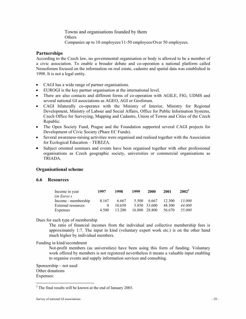
6.6 Resources
Income in year (in Euro) s
1997 1998 1999 2000 2001 20022
Income - membership 8.167 6.667 5.500 6.667 12.300 13.000 External resources 0 10.650 5.850 33.600 48.300 44.000 Expenses 4.500 13.200 16.800 28.800 56.670 55.000
Dues for each type of membership
The ratio of financial incomes from the individual and collective membership fees is approximately 1:7. The input in kind (voluntary expert work etc.) is on the other hand much higher by individual members.
Funding in kind/secondment Not-profit members (as universities) have been using this form of funding. Voluntary work offered by members is not registered nevertheless it means a valuable input enabling to organise events and supply information services and consulting.
Sponsorship – not used Other donations
Expenses: 2 The final results will be known at the end of January 2003.
Survey of national GI associations - 30 -
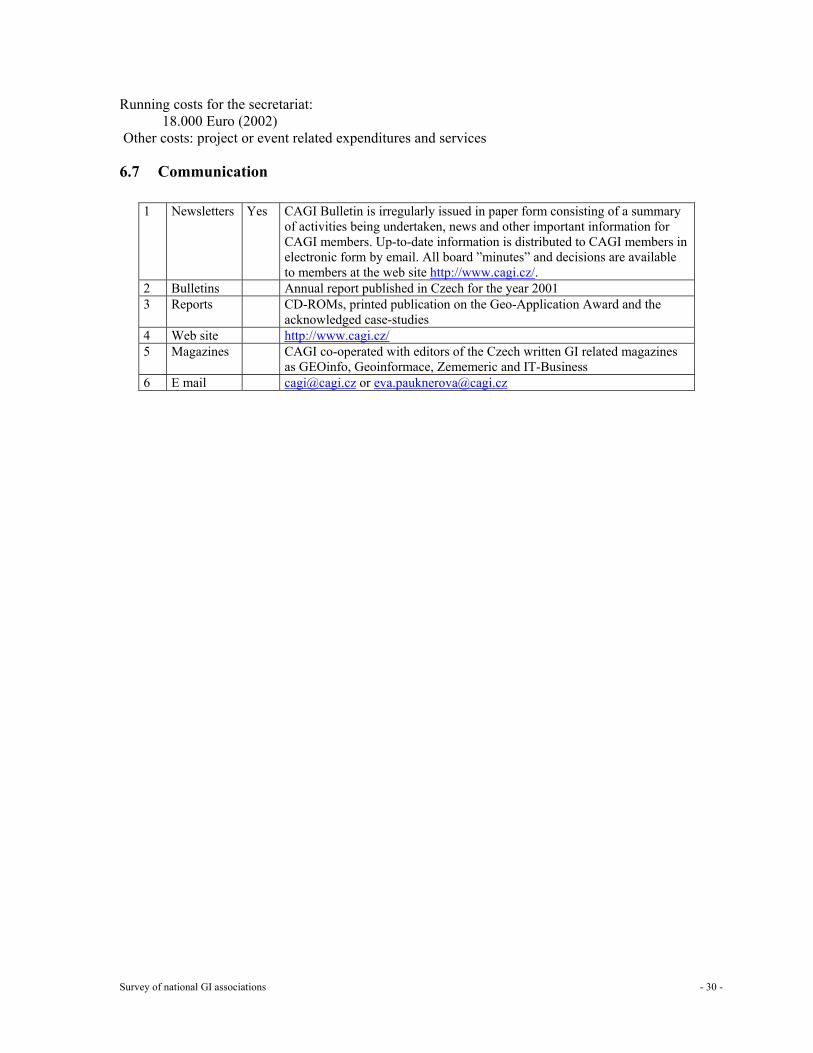
Running costs for the secretariat: 18.000 Euro (2002)
Other costs: project or event related expenditures and services
6.7 Communication
1 Newsletters Yes CAGI Bulletin is irregularly issued in paper form consisting of a summary of activities being undertaken, news and other important information for CAGI members. Up-to-date information is distributed to CAGI members in electronic form by email. All board ”minutes” and decisions are available to members at the web site http://www.cagi.cz/.
2 Bulletins Annual report published in Czech for the year 2001 3 Reports CD-ROMs, printed publication on the Geo-Application Award and the
acknowledged case-studies 4 Web site http://www.cagi.cz/ 5 Magazines CAGI co-operated with editors of the Czech written GI related magazines
as GEOinfo, Geoinformace, Zememeric and IT-Business 6 E mail [email protected] or [email protected]
Survey of national GI associations - 31 -
7 Denmark, Geoforum Denmark – Society for Geographical Information
7.1 General information about the national GI association Name: Geoforum Denmark – Society for Geographical Information Address: Lindevangs Allé 4, DK 2000 Frederiksberg Telephone: + 45 38 86 10 75 Fax: + 45 38 86 02 52 Email: [email protected] Website: http://www.geoforum.dk Date of foundation: 1 January 2001
In what way is the association recognised by the government? Geoforum was created through a merger of Danish Society for Photogrammetry and Surveying, Danish Cartographic Association and Danish Academy of Spatial Information. Recognition: No formal recognition. Co-operation with the Ministry of Environment is on an ad hoc basis. The Ministry is heading the newly build “Service Provision Board for Geographic Information”.
7.2 Mission and objectives/strategy Mission
Encourage the wider use of spatial information in society
Objectives/strategy
The association aims at realising this mission by: • Creating an active and visible dialogue about development, production and utilisation of
geographic information technically as well as politically. • Information and advice of the professionals, politicians, government, municipalities and
county administrations as well as the public in general. • Encouraging co-operation between organisations, private companies, institutions and
individuals working with geographical information. • Working for improvement on the professional competence by education, seminars and
workshops and supplementary professional activities. • Supporting education, research and technical development. • Provision of competent professionals for working groups and public research. • Provision of professional response to public hearings. • Representing Danish interests in international associations for the use of spatial information. • Publishing of a Journal and other professional media.
7.3 Key roles
1 GI policy maker to a limited extent. Ambitions are high for the future Yes 2 Knowledge and information supplier Yes 3 Public relations limited, awareness raising and promotion of GI: Yes 4 Program assistance and support No 5 Political interface, lobbyist: to a limited extent. Ambitions are high for the future Yes
Survey of national GI associations - 32 -
6 Mediator, negotiator No 7 Promoter of standards, Yes, certification No Yes/No 8 Facilitator for education (professional development) and training: mainly as short
term courses (2 -3 days) Yes
9 Research not yet No
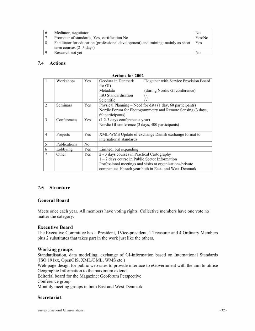
7.4 Actions
Actions for 2002 1 Workshops Yes Geodata in Denmark (Together with Service Provision Board
for GI) Metadata (during Nordic GI conference) ISO Standardisation (-) Scientific (-)
2 Seminars Yes Physical Planning – Need for data (1 day, 60 participants) Nordic Forum for Photogrammetry and Remote Sensing (3 days, 60 participants)
3 Conferences Yes (1 2-3 days conference a year) Nordic GI conference (3 days, 400 participants)
4 Projects Yes XML-WMS Update of exchange Danish exchange format to international standards
5 Publications No 6 Lobbying Yes Limited, but expanding 7 Other Yes 2 - 3 days courses in Practical Cartography
1 – 2 days course in Public Sector Information Professional meetings and visits at organisations/private companies: 10 each year both in East- and West-Denmark
7.5 Structure General Board Meets once each year. All members have voting rights. Collective members have one vote no matter the category. Executive Board The Executive Committee has a President, 1Vice-president, 1 Treasurer and 4 Ordinary Members plus 2 substitutes that takes part in the work just like the others. Working groups Standardisation, data modelling, exchange of GI-information based on International Standards (ISO 191xx, OpenGIS, XML/GML, WMS etc.) Web-page design for public web-sites to provide interface to eGovernment with the aim to utilise Geographic Information to the maximum extend Editorial board for the Magazine: Geoforum Perspective Conference group Monthly meeting groups in both East and West Denmark Secretariat.
Survey of national GI associations - 33 -
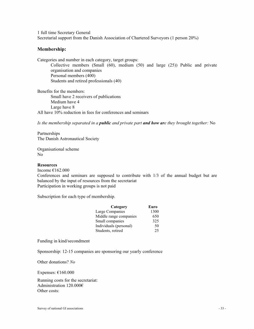
1 full time Secretary General Secretarial support from the Danish Association of Chartered Surveyors (1 person 20%) Membership: Categories and number in each category, target groups:
Collective members (Small (60), medium (50) and large (25)) Public and private organisation and companies Personal members (400) Students and retired professionals (40)
Benefits for the members:
Small have 2 receivers of publications Medium have 4 Large have 8
All have 10% reduction in fees for conferences and seminars Is the membership separated in a public and private part and how are they brought together: No Partnerships The Danish Astronautical Society Organisational scheme No Resources Income €162.000 Conferences and seminars are supposed to contribute with 1/3 of the annual budget but are balanced by the input of resources from the secretariat Participation in working groups is not paid Subscription for each type of membership.
Category Euro Large Companies 1300 Middle range companies 650 Small companies 325 Individuals (personal) 50 Students, retired 25
Funding in kind/secondment Sponsorship: 12-15 companies are sponsoring our yearly conference Other donations? No
Expenses: €160.000
Running costs for the secretariat: Administration 120.000€ Other costs:
Survey of national GI associations - 34 -
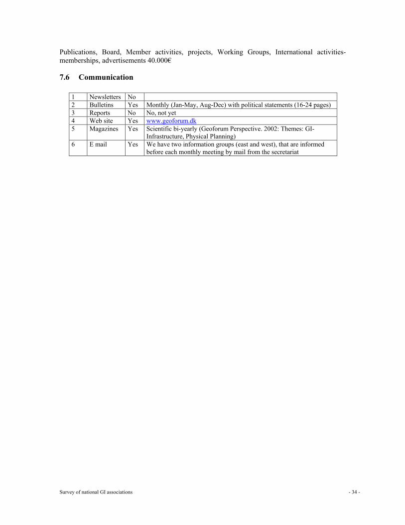
Publications, Board, Member activities, projects, Working Groups, International activities-memberships, advertisements 40.000€
7.6 Communication
1 Newsletters No 2 Bulletins Yes Monthly (Jan-May, Aug-Dec) with political statements (16-24 pages) 3 Reports No No, not yet 4 Web site Yes www.geoforum.dk 5 Magazines Yes Scientific bi-yearly (Geoforum Perspective. 2002: Themes: GI-
Infrastructure, Physical Planning) 6 E mail Yes We have two information groups (east and west), that are informed
before each monthly meeting by mail from the secretariat
Survey of national GI associations - 35 -
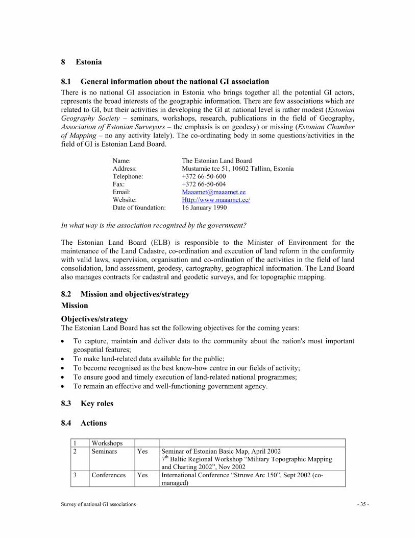
8 Estonia
8.1 General information about the national GI association There is no national GI association in Estonia who brings together all the potential GI actors, represents the broad interests of the geographic information. There are few associations which are related to GI, but their activities in developing the GI at national level is rather modest (Estonian Geography Society – seminars, workshops, research, publications in the field of Geography, Association of Estonian Surveyors – the emphasis is on geodesy) or missing (Estonian Chamber of Mapping – no any activity lately). The co-ordinating body in some questions/activities in the field of GI is Estonian Land Board.
Name: The Estonian Land Board Address: Mustamäe tee 51, 10602 Tallinn, Estonia Telephone: +372 66-50-600 Fax: +372 66-50-604 Email: [email protected] Website: Http://www.maaamet.ee/ Date of foundation: 16 January 1990
In what way is the association recognised by the government? The Estonian Land Board (ELB) is responsible to the Minister of Environment for the maintenance of the Land Cadastre, co-ordination and execution of land reform in the conformity with valid laws, supervision, organisation and co-ordination of the activities in the field of land consolidation, land assessment, geodesy, cartography, geographical information. The Land Board also manages contracts for cadastral and geodetic surveys, and for topographic mapping.
8.2 Mission and objectives/strategy Mission
Objectives/strategy The Estonian Land Board has set the following objectives for the coming years:
• To capture, maintain and deliver data to the community about the nation's most important geospatial features;
• To make land-related data available for the public; • To become recognised as the best know-how centre in our fields of activity; • To ensure good and timely execution of land-related national programmes; • To remain an effective and well-functioning government agency.
8.3 Key roles
8.4 Actions
1 Workshops 2 Seminars Yes Seminar of Estonian Basic Map, April 2002
7th Baltic Regional Workshop “Military Topographic Mapping and Charting 2002”, Nov 2002
3 Conferences Yes International Conference “Struwe Arc 150”, Sept 2002 (co-managed)
Survey of national GI associations - 36 -
4 Projects Yes 5 Publications 6 Lobbying 7 Other
Projects GI(S) projects: Cadastral Information System (CIS). CIS constitutes one part of the Estonian National Land Information System (NLIS) and consists of Land Register (i.e. the Estonian name for cadastral register), cadastral maps and archive. CIS can be divided into two parts: Data Registration Application and Public Services System. Data registration application – tool for data registration. The main feature of the new CIS is integrated alphanumerical and GIS data and functionality. Integration of different data and development of registration tools for different types of data. Graphical data of cadastral and administrative boundaries were reviewed and transferred into a central database covering the whole Estonia. As a result a dataset was formed that would serve as basis for the cadastral index map in the Public Service System and for the development of the map of administrative boundaries. Public Service System – tool for achieving one of ELB´s main objectives, i.e. to provide the society with land related information. It also enables public access to spatial data maintained by ELB. The Public Service System is a group of services based on the Land Board's datasets and map server and offered via Internet. Besides several new services are under development and testing: Universal Presentation Service (UPS) will enable users to integrate LIS data into their own applications using OpenGIS WebMapService protocol. Universal Registration Service (URS) will enable users to store their own data into LIS. Universal Information Service (UIS) will serve spatial data using standard XML-GML format; Universal Extraction or Printing Service (UES/UPS) gives possibility to get formatted data with defined layers, symbols, output format (DGN, MIF/MID, ESRI shape), etc. cover defined area. Output Task for Land Surveyor – designed for a certain group of users like land surveyors, local municipality officials, etc. Before land surveying the surveyor can look at the different maps, geodetic information and cadastral data of the area he is interested in via Internet and he can print out a surveying extract. Land Information Service for Public User - designed especially for the public, the service is free; it’s a web map application. Users can see administrative boundaries, the Estonian Base Map, zooming further the user can choose for displaying either the Estonian Basic Map or digital orthophotos, both at the scale 1: 10 000. Also the cadastral and geodetic information is available. It is possible to display on the screen geodetic points and the parcel boundary layer, and by clicking in the point or parcel the alphanumerical information is displayed in a pop-up window or as a tool tip. Cadastral Unit (CU) Data for Public User - designed for public usage and is free of charge. Using different queries it is possible to get alphanumeric data from the cadastre (suitable in cases when users has no interest on graphical cadastral data). Creation of the Estonian National Topographic Database (ENTD). Models of Spatial Data – creation preconditions for maintaining spatial data of different Estonian state registers and databases in the same system and allowing cross-reference between them.
Survey of national GI associations - 37 -
Mapping Projects Estonian Basic Map – topographic digital database 1:10 000; Estonian Base Map – GI digital database 1:50 000; Estonian Soil Map and Maps of Land Value Zones – GI digital database 1:10 000; Maps of urban areas – topographic digital databases 1:2000; Thematic maps – different thematic maps both as digital databases and paper maps; MapBSR - digital database 1:1000 000 produced in international co-operation between the states inside Baltic Sea area; EuroGlobalMap – digital database 1:1000 000 for the whole Europe produced under EuroGeographics conforming to GlobalMap specifications. Geodetic works: Establishment of third order horizontal network (densification network) on the islands of West-Estonia; Improvement of local networks; Improvement of vertical network; Densification of gravimetric network; Completing the geodetic database. Reconnaissance and co-ordination of the Struve Geodetic Arc (completed); Re-measuring of calibration baseline in Vääna test field (completed).
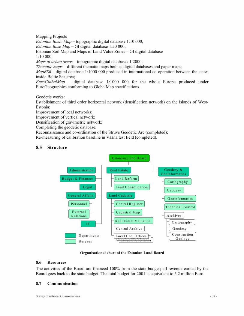
8.5 Structure
Organisational chart of the Estonian Land Board
8.6 Resources The activities of the Board are financed 100% from the state budget; all revenue earned by the Board goes back to the state budget. The total budget for 2001 is equivalent to 5.2 million Euro.
8.7 Communication
Estonian Land Board
Administration
Budget & Finances
Legal
General Affairs
Personnel
ExternalRelations
Real Estate
Land Reform
Land Consolidation
Geodesy &Geoinformatics
Cartography
Geodesy
Geoinformatics
Technical Control
Archives
Cartography
Geodesy
ConstructionGeology
IT
Land Cadastre
Central Register
Cadastral M ap
Real Estate Valuation
Central Archive
Local Cad. OfficesLocal Cad. OfficesLocal Cad. OfficesDepartments
Bureaus
Survey of national GI associations - 38 -
9 Finland: Finnish Association for Geographic Information (ProGIS)
9.1 General information about the national GI association Name: Finnish Association for Geographic Information Address: Ministry of Agriculture and Forestry
PO Box 30, FIN-00023 Government, Finland Telephone: +358-9-160 88 629 Fax: +358-9-160 2450 Email: [email protected] Website: http://www.progis.fi Date of foundation: 11 October 1993
In what way is the association recognised by the government?
9.2 Mission and objectives/strategy ProGIS is the national association for the individuals and organisations working in the field of geographic information and related technology. Mission To promote the use and awareness of geographic information for the benefit of the society.
Objectives/strategy To act as a forum of collaboration. To carry out feasibility studies. To organise seminars.
9.3 Key roles
1 GI policy maker 2 Knowledge and information supplier 3 Public relations, awareness raising and promotion of GI 4 Program assistance and support 5 Political interface, lobbyist 6 Mediator, negotiator 7 Promoter of standards, certification 8 Facilitator for education (professional development) and training 9 Research
9.4 Actions
1 Workshops Yes 2 Seminars Yes 3 Conferences 4 Projects Yes Projects are generally custom made 5 Publications 6 Lobbying 7 Other
Survey of national GI associations - 39 -
Events in 2000 Meetings: 7 Board meetings Conferences: None Workshops 1) ISO Overview, Feature cataloguing methodology, Quality principles and
Quality evaluation procedures. 2) OpenGIS-standardisation. 3) ISO Metadata and Spatial Schema.
Seminars 1) Digital press- and prepress technologies in map production (with Cartographic Society) 2) Spring seminar: Usability of the GIS data in Finland - experiences and comments 3) Autumn seminar: National mapping policy (2001) and national 'GI Core initiative
9.5 Structure General Board Executive Board Board meetings Working groups Secretariat. Membership: Categories and number in each category, target groups
42 organisations, 195 individual persons Target group: any governmental, regional or local authority as well as any private company working in the field of geographic information. Types of membership: organisations and individuals
Benefits for the members: Is the membership separated in a public and private part and how are they brought together: Partnerships Organisational scheme
9.6 Resources Income 8 400 € Dues for each type of membership. Membership fees 80%, Subscription fees 20 % Funding in kind/secondment Sponsorship
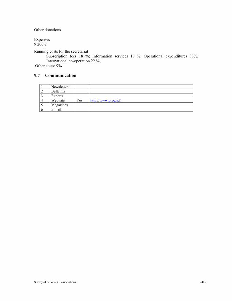
Survey of national GI associations - 40 -
Other donations
Expenses 9 200 €
Running costs for the secretariat Subscription fees 18 %; Information services 18 %, Operational expenditures 33%, International co-operation 22 %,
Other costs: 9%
9.7 Communication
1 Newsletters 2 Bulletins 3 Reports 4 Web site Yes http://www.progis.fi 5 Magazines 6 E mail
Survey of national GI associations - 41 -
10 France: Association Française pour l'Information Géographique (AFIGÉO) and Conseil National de l’ Information Géographique (CNIG)
10.1 General information about the national GI association AFIGÉO
Name: Association Française pour l'Information Géographique Address: 136 bis, Rue de Grenelle,75700 PARIS 07 SP,France Telephone: +33 1 43 98 8262 Fax: +33 1 43 98 85 66 Email: [email protected] Website: http://www.cnig.fr/ Date of foundation: March 1986
CNIG Name: Conseil National de l’information géographique Address: 136 bis, Rue de Grenelle,75700 PARIS 07 SP,France Telephone: +33 1 43 98 83 12 Fax: +33 1 43 98 85 66 Email: [email protected] Website: http://www.cnig.gouv.fr Date of foundation: July 1985
In what way is the association recognised by the government? AFIGEO is an association under the 1901 French law authorising any groups of individuals or entities to associate in view of not-for profit activities. CNIG is an inter-ministerial entity installed by decree 85-790 dated 26 July 1985, modified by decrees 92-706 of 21 July 1992 and 99-843 of 28 September 1999.
10.2 Mission and objectives/strategy Mission AFIGéO’s mission is to favour the development of geographic information in France for the benefit of all public and private actors, the industry, producers, publishers, researchers, teachers, technical services of state and local governments, and other users. Contributing to the tasks of the National Council for Geographic Information (CNIG: Conseil National de l'Information Géographique) AFIGéO’s objective is to enlarge the work towards all professionals and users in order to ensure that needs and technical improvements are better taken into consideration within the national policies. Its ambition is to federate the activities of scientific and technical organisations as well as professional unions maintaining constant relations with them CNIG mission is threefold. It advises the French government and the French administration on national policies having an effect on or being affected by GI. It contributes to the development and the promotion of GI taking into account the requirements of the users. It monitors and surveys the technological and methodological development in the GI sector in order to ensure national policies take it into account. Objectives/strategy AFIGéO strategy is to bring together all operational actors of the GI sector (either public, semi-public or private, either national, regional or local, either legal bodies or individuals). It is then to propose and suggest new orientations to national and local policies such as data sharing among
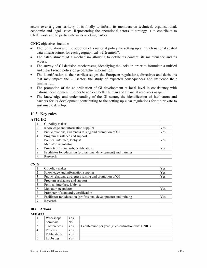
Survey of national GI associations - 42 -
actors over a given territory. It is finally to inform its members on technical, organisational, economic and legal issues. Representing the operational actors, it strategy is to contribute to CNIG work and to participate in its working parties CNIG objectives include: • The formulation and the adoption of a national policy for setting up a French national spatial
data infrastructure, for each geographical “référentiels”. • The establishment of a mechanism allowing to define its content, its maintenance and its
access. • The survey of GI decision mechanisms, identifying the lacks in order to formulate a unified
and clear French policy on geographic information. • The identification at their earliest stages the European regulations, directives and decisions
that may impact the GI sector, the study of expected consequences and influence their finalisation.
• The promotion of the co-ordination of GI development at local level in consistency with national development in order to achieve better human and financial resources usage.
• The knowledge and understanding of the GI sector, the identification of facilitators and barriers for its development contributing to the setting up clear regulations for the private to sustainable develop.
10.3 Key roles AFIGÉO
1 GI policy maker 2 Knowledge and information supplier Yes 3 Public relations, awareness raising and promotion of GI Yes 4 Program assistance and support 5 Political interface, lobbyist Yes 6 Mediator, negotiator 7 Promoter of standards, certification Yes 8 Facilitator for education (professional development) and training 9 Research
CNIG
1 GI policy maker Yes 2 Knowledge and information supplier Yes 3 Public relations, awareness raising and promotion of GI Yes 4 Program assistance and support 5 Political interface, lobbyist 6 Mediator, negotiator Yes 7 Promoter of standards, certification 8 Facilitator for education (professional development) and training Yes 9 Research
10.4 Actions AFIGÉO
1 Workshops Yes 2 Seminars No 3 Conferences Yes 1 conference per year (in co-ordination with CNIG) 4 Projects Yes 5 Publications Yes 6 Lobbying Yes
Survey of national GI associations - 43 -
7 Other Yes Working groups
CNIG 1 Workshops No 2 Seminars No 3 Conferences Yes 1 conference per year (in co-ordination with AFIGéO) 4 Projects No 5 Publications Yes 6 Lobbying No 7 Other Yes Commission and working groups
10.5 Structure AFIGéO General Board General assembly of the members: 1 general assembly per year Executive Board Management board of 16 members: four to six meetings a year A president, a secretary general (same individual as for CNIG) a treasurer The president and secretary general of CNIG are both mandatory members Working groups Participation of AFIGéO members to CNIG commissions and WG. Topic oriented Working Groups AFIGéO Club Export Secretariat. One half-time communication officer One half-time treasurer Shared secretariat with CNIG Membership: Categories and number in each category, target groups:
3 benefactors, 13 level 1 member, 28 level 2 members, 23 individual members Target groups are all actors having interest in GI (either public, private or individual): currently there are associations, local governments, consultants, publisher or data producer, training companies, chartered surveyors, utilities, GIS vendors, etc
Benefits for the members Be the French forum for GI Single entry point for all topics related to GI Lobbyist Expertise mobiliser Funding catalyst GI awareness raising place GI standardisation contributor “Référentiel” think-tank French GI expertise promoter for the International market European link
Is the membership separated in a public and private part and how are they brought together: No Partnerships CNIG, ministerial departments, French association for the prevention of natural catastrophe, Organisational scheme
Survey of national GI associations - 44 -
See CNIG section CNIG General Board The Geographic information National Council composed of 35 members 1 president designated by the prime minister 4 local government elected people 17 representatives of ministries 2 qualified individuals (currently from the private sector) 7 public sector data producers 4 representatives of the trade unions Executive Board Not applicable Working groups See organisational chart Secretariat. 1 secretary general designated by the ministries in charge of the budget and of the public works 4 senior engineers 1 webmaster (vacant) 2 secretaries (one being vacant) Membership: Categories and number in each category, target groups: Not applicable Benefits for the members: Not applicable Is the membership separated in a public and private part and how are they brought together: CNIG working parties include private sector members Partnerships Not applicable Organisational Scheme
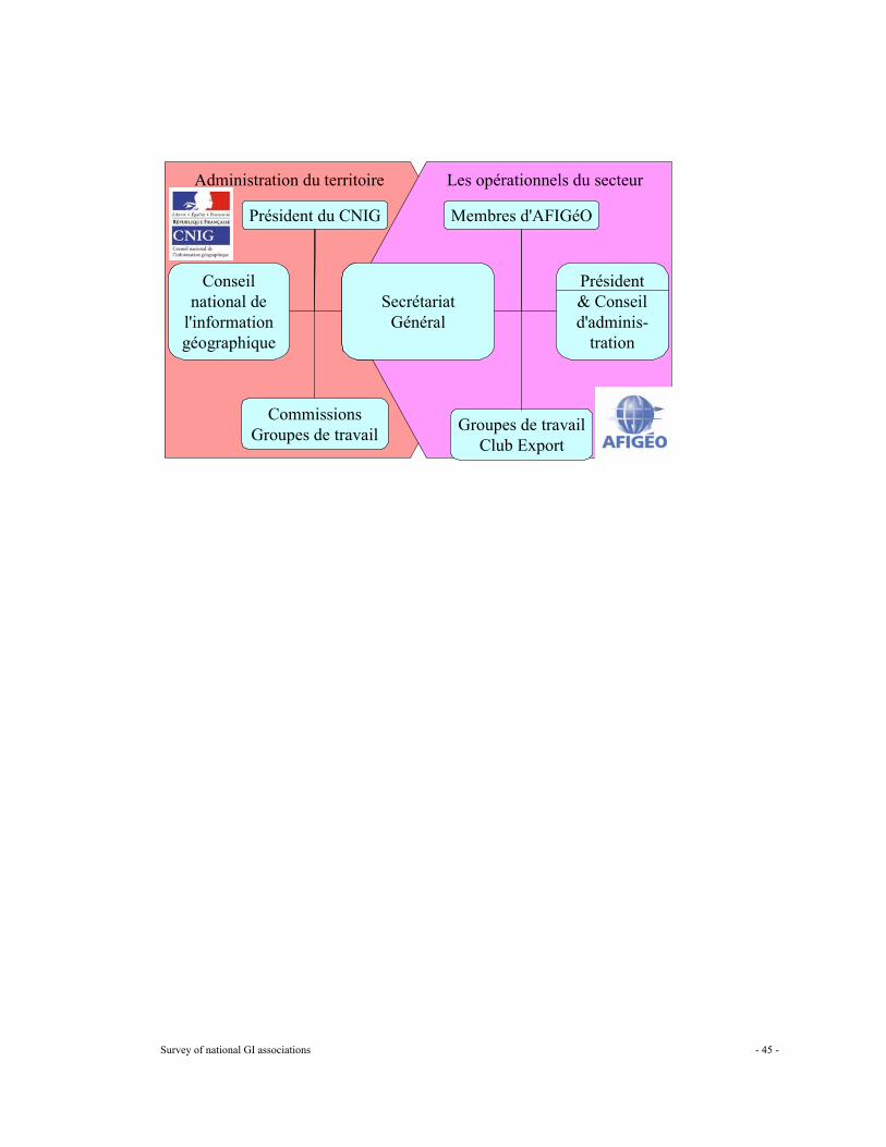
Survey of national GI associations - 45 -
Administration du territoire
Conseil national de
l'information géographique
CommissionsGroupes de travail
Président du CNIG
Secrétariat Général
Les opérationnels du secteur
Secrétariat Général
Groupes de travailClub Export
Membres d'AFIGéO
Président& Conseil d'adminis-
tration
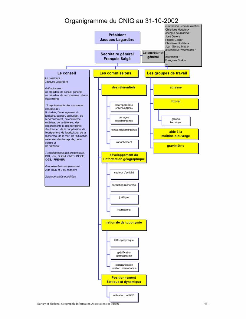
Survey of National Geographic Information Associations in Europe - 46 -
Organigramme du CNIG au 31-10-2002
Le président :Jacques Lagardère
4 élus locaux :un président de conseil généralun président de communauté urbainedeux maires
17 représentants des ministèreschargés de :l'industrie, l'aménagement duterritoire, du plan, du budget, del'environnement, du commerceextérieur, de la défense, desdépartements et des territoiresd'outre-mer, de la coopération, del'équipement, de l'agriculture, de larecherche, de la mer, de l'éducationnationale, des transports, de laculture etde l'intérieur
7 représentants des producteurs :DGI, IGN, SHOM, CNES, INSEE,OGE, IFREMER
4 représentants du personnel :2 de l'IGN et 2 du cadastre
2 personnalités qualifiées
information - communicationChristiane Hortefeuxchargés de mission :José DeversPatrice GeigerChristiane HortefeuxJean-Gérard Mathébureautique Webmestre :...secrétariat :Françoise Coulon...
Le secrétariatgénéral
Le conseil
Interopérabilité(CNIG-ATICA)
zonagesréglementaires
textes réglementaires
rattachement
des référentiels
secteur d'activité
formation recherche
juridique
international
développement del'information géographique
BDToponymique
spécificationnormalisation
communicationrelation internationale
nationale de toponymie
utilisation du RGP
PositionnementStatique et dynamique
Les commissions
adresse
groupetechnique
littoral
aide à lamaîtrise d'ouvrage
gravimétrie
Les groupes de travail
Secrétaire généralFrançois Salgé
PrésidentJacques Lagardère
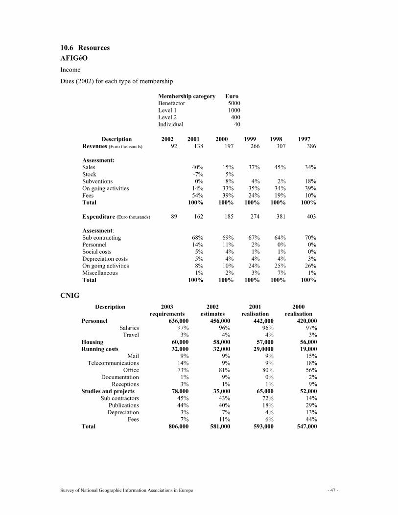
Survey of National Geographic Information Associations in Europe - 47 -
10.6 Resources AFIGéO Income
Dues (2002) for each type of membership
Membership category Euro Benefactor 5000 Level 1 1000 Level 2 400 Individual 40
Description 2002 2001 2000 1999 1998 1997
Revenues (Euro thousands) 92 138 197 266 307 386 Assessment: Sales 40% 15% 37% 45% 34% Stock -7% 5% Subventions 0% 8% 4% 2% 18% On going activities 14% 33% 35% 34% 39% Fees 54% 39% 24% 19% 10% Total 100% 100% 100% 100% 100% Expenditure (Euro thousands) 89 162 185 274 381 403 Assessment: Sub contracting 68% 69% 67% 64% 70% Personnel 14% 11% 2% 0% 0% Social costs 5% 4% 1% 1% 0% Depreciation costs 5% 4% 4% 4% 3% On going activities 8% 10% 24% 25% 26% Miscellaneous 1% 2% 3% 7% 1% Total 100% 100% 100% 100% 100%
CNIG
Description 2003 requirements
2002 estimates
2001 realisation
2000 realisation
Personnel 636,000 456,000 442,000 420,000 Salaries 97% 96% 96% 97%
Travel 3% 4% 4% 3% Housing 60,000 58,000 57,000 56,000 Running costs 32,000 32,000 29,0000 19,000
Mail 9% 9% 9% 15% Telecommunications 14% 9% 9% 18%
Office 73% 81% 80% 56% Documentation 1% 9% 0% 2%
Receptions 3% 1% 1% 9% Studies and projects 78,000 35,000 65,000 52,000
Sub contractors 45% 43% 72% 14% Publications 44% 40% 18% 29% Depreciation 3% 7% 4% 13%
Fees 7% 11% 6% 44% Total 806,000 581,000 593,000 547,000
Survey of National Geographic Information Associations in Europe - 48 -
10.7 Communication AFIGéO 1 Newsletters Yes Lettre d’AFIGéO (e-mail sent) one per month now separated from CNIG new letter 2 Bulletins 3 Reports Yes As results of studies 4 Web site Yes http://www.afigeo.asso.fr/ 5 Magazines No 6 E mail Yes [email protected]
CNIG 1 Newsletters Yes Lettre du CNIG (e-mail sent) one per month now separated from AFIGéO new letter2 Bulletins 3 Reports Yes As results of studies 4 Web site Yes http://www.cnig.gouv.fr/ 5 Magazines No 6 E mail Yes [email protected]
10.8 Burning issues The burning issues are the same for AFIGéO and CNIG (they share the concerns) Référentiel géographique à grande échelle: • Technical aspects: content, specification and quality, address and urban area specificities • Legal aspects: subsidized products and public procurement, licensing • Financial aspects: licence fees, public funding level • Organisational aspects: role of local governments GI development • Observatory of the GI sector: definition study, • Role of the local governments: Comité départementaux de l’information géographique • Legal issues: access to and exploitation of public data • Data sharing and interoperability between administration information systems Usage of GI: bringing together GI and discipline experts to analyse GI use in a discipline (littoral areas, flooding risks, local governments) Education and training: geo-portal and evaluation of high-level GI training offer International: French know-how export, French international strategy, and EUROGI activities Technology Permanent GPS network Toponomy Common framework for Interoperability between information systems of the public sector Accuracy level of topographic surveys funded by the public sector
Survey of National Geographic Information Associations in Europe - 49 -
11 Germany: German umbrella organisation for Geographic Information (DDGI)
11.1 General information about the national GI association Name: Deutscher Dachverband für Geoinformation e.V. (DDGI) Address: c/o GeoForschungsZentrum Potsdam, Telegrafenberg A3, 14473
Potsdam, Germany Telephone: +49 (0) 331 288 1680 Fax: +49 (0) 331 288 1703 Email: [email protected] Website: www.ddgi.de Date of foundation: 14 June 1994
In what way is the association recognised by the government? Non-profit umbrella association, representing the interdisciplinary German interests in the area of Geoinformation.
11.2 Mission and objectives/strategy Mission Promoting, stimulating, encouraging and co-ordinating the construction and the application of Geoinformation on national and international level. Objectives/strategy Strategy Creating and promoting political awareness: an important milestone was reached 2001 when Geoinformation was on the agenda of the German Parliament (Bundestag) for the first time. Both, the ruling and opposition parties underlined the overall importance of Geoinformation for the information society, for modern governance and for the economic development of the country. After the plenary debate a resolution was accepted that points the way ahead for the promotion of Geoinformation in multiple fields of economical and governmental use and calls for increased R&D spending in application and market development. The inter-governmental co-ordination committee IMAGI was committed to regular reporting to the Bundestag Stimulation of strategic thinking and innovative actions through communication between the different discipline areas and organisations in economy, science and administration. Supporting the development of a German Geodata Infrastructure based on accepted data and system interoperability standards. Stimulating activities in the area of research and development through the formulation of the demand in the area of geoinformation. Accelerating technical developments through proclamation and spreading of information. Co-ordination Improvement of the co-operation between all institutions dealing with geoinformation through adopting the role as "central information-stock exchange". Reducing redundant activities through supplying information about all the currently running activities. Reducing the disadvantage of the federal state-form through adopting the role of an "integrating forum". Services
Survey of National Geographic Information Associations in Europe - 50 -
Stimulating and intensifying the inner-German communication through the building up of suitable "communication-canals". Following specific GI topics by different working groups as there are: data standards, metadata and system interoperability for GI infrastructures etc.
11.3 Key roles 1 GI policy maker No 2 Knowledge and information supplier:
Website, publications, association organ (GeoBIT/GIS), participation in conferences and trade fares, following GI topics by specific working groups
Yes
3 Public relations, awareness raising and promotion of GI Website, publications, association organ (GeoBIT/GIS), participation in conferences and trade fares, submission of a media award, invitation of parliamentarians etc.
Yes
4 Program assistance and support No 5 Political interface, lobbyist
Employment of a political lobbyist, formulation and communication of postulations to the German government, invitation of parliamentarians etc., European lobbying
Yes
6 Mediator, negotiator Bringing together the different groups bothered by GI: authorities, industry, professional associations, research institutions and universities
Yes
7 Promoter of standards, certification Following these topics by specific working groups, bearing of the first world-wide association for certification of spatial data, the “Gesellschaft zur Zertifizierung von Geo-Information (GZGI)”
Yes
8 Facilitator for education (professional development) and training No 9 Research No
11.4 Actions
1 Workshops 2 Seminars 3 Conferences Yes Participation in conferences 4 Projects Yes Working groups 5 Publications Yes 6 Lobbying Yes 7 Other
11.5 Structure General Board General Meeting, the members’ representatives Executive Board One representative per interest group plus two representatives of the group of sponsors Working groups Strategic public relations Standardisation Legal issues 3D
Survey of National Geographic Information Associations in Europe - 51 -
Training & education Spatial data infrastructure for utility enterprises Geodata Secretariat. Secretary general, secretary, webmaster Membership Categories and number in each category, target groups:
56 full members in following interest groups: academia, authority, professional association, and economy Sponsors: mostly representatives of economy Individual members: individuals Corresponding members: members having accomplished particular merits, to be designated
Benefits for the members: Participation in DDGI’s activities Exertion of influence on the political level of GI by the association’s lobby Participation on working groups and access to their results Free of charge obtainment of the associations organ “GIS”/”GeoBIT” and of actual information about GI activities via http://www.ddgi.de Publication via DDGI’s supplement to “GIS”/”GeoBIT” Participation on events such as conferences
Is the membership separated in a public and private part and how are they brought together: The category “Individual member” was introduced in 2000. Individuals - not representing authorities, industry, professional associations, research institutions and universities - now have the possibility to take part in the activities of DDGI.
Partnerships DDGI is member of EUROGI and integrated in European activities and also world wide activities, for example GSDI. Organisational scheme
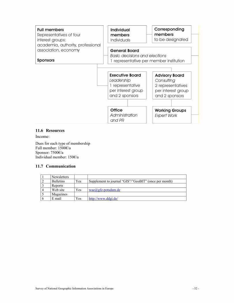
Survey of National Geographic Information Associations in Europe - 52 -
11.6 Resources Income: Dues for each type of membership Full member: 1500€/a Sponsor: 7500€/a Individual member: 150€/a
11.7 Communication
1 Newsletters 2 Bulletins Yes Supplement to journal “GIS”/”GeoBIT” (once per month) 3 Reports 4 Web site Yes [email protected] 5 Magazines 6 E mail Yes http://www.ddgi.de/
Survey of National Geographic Information Associations in Europe - 53 -
12 Greece: Hellenic Geographic Information Society (Hellas GI)
12.1 General information about the national GI association Name: Hellenic Geographic Information Society Address: Telephone: Fax: Email: [email protected] Website: www.hellasgi.gr Date of foundation: May 1998
In what way is the association recognised by the government?
12.2 Mission and objectives/strategy Mission
Objectives/strategy
12.3 Key roles
1 GI policy maker 2 Knowledge and information supplier Yes 3 Public relations, awareness raising and promotion of GI Yes 4 Program assistance and support 5 Political interface, lobbyist 6 Mediator, negotiator 7 Promoter of standards, certification 8 Facilitator for education (professional development) and training 9 Research
12.4 Actions
1 Workshops 2 Seminars Yes 3 Conferences Yes 4 Projects Yes 5 Publications 6 Lobbying 7 Other
In June 2002 there was a two days event in Salonica (the first event out of Athens) on GIS and Social Practices. In this event there were about 30 presentations and more than 150 attendance. HellasGI organised this event.
On October 30 and 31 the 5th INSPIRE meeting was held in Athens. The Greek representatives in INSPIRE meeting (Dr. Kavouras and Dr. Doganis are Members of steering Committee of HellasGI. On November 1st there was a day event on the National Spatial Data Infrastructure. In this event the main Hellenic SDI stakeholders presented their plans (2003 - 2008) for the infrastructure. In this meeting there was a presentation from Dr. Alessandro Annoni of he INSPIRE to the Hellenic GIS community. HellasGI organised this event.
Survey of National Geographic Information Associations in Europe - 54 -
12.5 Structure General Board Executive Board 11 members Dr Doganis Thanos (Terra Ltd.) Mr., Salachoris Michalis (Orion Ltd.) Mr. Chalaris George (Hellenic Army Geography Service) Prof. Mrs. Karnavou Eleftheria (Aristotle University of Thessaloniki) Dr. Nikologianni Evaggelia (Ktimatologio S.A) The State company responsible for the cadastral issues in Greece) Dr. Prastakos Poulicos (Institute for Technology and Research - Crete) Prof. Kavouras Marinos (National Technical University of Athens) Mr. Zambelis Christos (Director of Planning, Ministry of Environment and Planning) Dr. Potsiou Chrissi (Vice President of FIG commission 3 - Spatial Data) Working groups Secretariat. Membership: Categories and number in each category, target groups:
289 members Benefits for the members: Is the membership separated in a public and private part and how are they brought together: Partnerships Organisational scheme
12.6 Resources Annual budget is approximately €10.000 Income
Dues for each type of membership Funding in kind/secondment Sponsorship Other donations
Expenses:
Running costs for the secretariat: Other costs:
12.7 Communication
1 Newsletters 2 Bulletins 3 Reports 4 Web site Yes www.hellasgi.gr 5 Magazines 6 E mail Yes [email protected]
Survey of National Geographic Information Associations in Europe - 55 -
13 Hungary: Hungarian Association for Geo-Information (HUNAGI)
13.1 General information about the national GI association Name: Hungarian Association for Geo-Information (HUNAGI) Address: Legal address: HU-1123 Budapest, Alkotás u. 25
Visiting address: H-1860 Budapest, Kossuth tér 11 (Department of Lands and Mapping, Ministry of Agriculture and Rural Development) Room 441 Postal address: c/o FVM FTF, P.O. Box 1 H-1860 Budapest 55, Hungary
Telephone: +36 1 3014052 Fax: +36 1 3014691 Email: [email protected] (during office hours)
[email protected] (short messages only) Website: www.hunagi.hu Date of foundation: 9 November1994
In what way is the association recognised by the government? As national GI association, consultancy and co-operating NGO partner
13.2 Mission and objectives/strategy Mission 1) To promote, stimulate, encourage and support the development and use of GI and its associated technologies 2) To strengthen the institutional links between the multidisciplinary GI communities in Hungary and in abroad.
Objectives/strategy The objective of the Hungarian GI Association is to provide representation and visibility of the GI community's interests in the European Umbrella Organisation for Geographic Information (EUROGI), and to build up contacts with similar national GI associations. HUNAGI carries out actions related to the EUROGI membership and provides representation of its members' interest on international fora.
13.3 Key roles
1 GI policy maker Yes 2 Knowledge and information supplier Yes 3 Public relations, awareness raising and promotion of GI Yes 4 Program assistance and support Yes 5 Political interface, lobbyist Yes 6 Mediator, negotiator 7 Promoter of standards, certification 8 Facilitator for education (professional development) and training Yes 9 Research
13.4 Actions
1 Workshops Yes 4th EC GIS Workshop (partner: DG JRC), 1998, 1st EU Cadastral Workshop, 2002 (partners: DG JRC, EUROGI)
2 Seminars Yes PECS Seminar, September 2002 (partners: European Space Agency, Hungarian Space Research Office)
3 Conferences Yes 6th GSDI Conference September 2002 (partners: GSDI Secretariat, EUROGI) 4 Projects Yes Participation in international projects:
PANEL-GIS (Pan-European Link for Geographical Information), ABDS
Survey of National Geographic Information Associations in Europe - 56 -
(Administrative Boundary Database Service), IST CAP3 GSDI6, GINIE Contribution to: OISE (Proposal), ETeMII (by invitation in Potsdam 2001,and Antwerp 2002), ESMI (European Spatial Metadata Infrastructure (by invitation in Lisbon and Budapest), GEIX (by invitation in Budapest), OLLO, SDILA
5 Publications Yes Contributions to: Proceedings of the EU Workshop on Cadastre (published by the European Commission in August, 2002) Models of national GI associations in Europe (published by EUROGI) Panel GI Compendium A guide to GI and GIS (published by GISIG) Proceedings of the EC GI/GIS Workshops (Leuven, Stresa, Lyon, Budapest, Dublin) A strategic View of GIS research and technology development for Europe 2nd Edition (published by DG JRC), Proceedings of EUGISES Conference 2000, Proceedings of EUROGI/AFIGÉO Day “Cadastre and NSDI in Europe” Paris, April 2000, Proceedings of GIS Day 2001 Budapest (CD) and others
6 Lobbying Yes April 2001: at the Expert Meeting of the Parliamentary Committee on Regional Development on the role and importance of GI infrastructure in natural disaster mitigation
7 Other Yes HUNAGI Forum at GIS/LIS CE (1995, 1996), GIS Day (2000, 2001), support of annual GIS conferences (NGIS in Szolnok, GIS Open in Székesfehérvár, LIS in Kaposvár, Agroinformatics in Debrecen, GIS in Education in Budapest) Joined actions planned for 2003: GIS day forum; GITA Conference; School in Land Management
13.5 Structure General Board General Board, meeting takes place annually. Approves reports on operation, finance and monitoring, as well as strategy updates, action plan, financial plan. Special in 2002: expected feedback for extended SWOT analysis on efficiency and effectiveness. Executive Board Presidential Executive Board operates on continuous basis. Formal meetings take place at least once per calendar year. Decides on strategy updates, membership policy, applications and matters as regulated by the Statute, which was updated and accepted by Court decision in August 2002. Working groups No permanent committees. Topic-oriented ad hoc task force groups are established when needed. Secretariat. The Secretary General runs the secretariat supported by the Treasurer (both on voluntary basis). Tasks include: • Elaboration membership policy development and direct membership contacts, • Administration and archive, information gathering, evaluation and dissemination, • Co-operation development, co-ordination and awareness raising. • Keep contact with EUROGI and partner national GI associations • Preparing plans, documents, keeps records on activities including photo archive • Provide web page development with voluntary assistance of members (FOMI, WebHU and
Autodesk Hungary). • A 3-member Control Committee, elected by the General Assembly keeps control on the overall
operation. Membership Categories and number in each category, target groups:
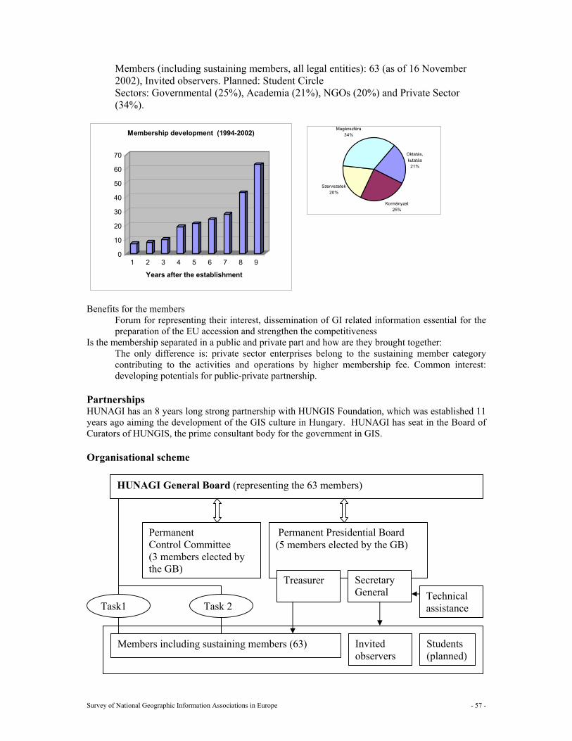
Survey of National Geographic Information Associations in Europe - 57 -
0
10
20
30
40
50
60
70
1 2 3 4 5 6 7 8 9
Years after the establishment
Membership development (1994-2002)
Members (including sustaining members, all legal entities): 63 (as of 16 November 2002), Invited observers. Planned: Student Circle Sectors: Governmental (25%), Academia (21%), NGOs (20%) and Private Sector (34%).
Oktatás, kutatás
21%
Kormányzat25%
Szervezetek20%
Magánszféra34%
Benefits for the members Forum for representing their interest, dissemination of GI related information essential for the preparation of the EU accession and strengthen the competitiveness
Is the membership separated in a public and private part and how are they brought together: The only difference is: private sector enterprises belong to the sustaining member category contributing to the activities and operations by higher membership fee. Common interest: developing potentials for public-private partnership.
Partnerships HUNAGI has an 8 years long strong partnership with HUNGIS Foundation, which was established 11 years ago aiming the development of the GIS culture in Hungary. HUNAGI has seat in the Board of Curators of HUNGIS, the prime consultant body for the government in GIS. Organisational scheme
HUNAGI General Board (representing the 63 members)
Permanent Control Committee (3 members elected by the GB)
Permanent Presidential Board (5 members elected by the GB)
Secretary General
Treasurer
Members including sustaining members (63) Invited observers
Students (planned)
Technical assistance Task1 Task 2
Survey of National Geographic Information Associations in Europe - 58 -
13.6 Resources Income
Dues for each type of membership Government/Academia/NGOs. 60 € Budget based organisation having regular incomes: 150 € Enterprises (sustaining member category): min 200 € Large area based territorial organisations/public benefit companies 420 € In very few cases memberships are based on special agreement (mutual zero membership)
Funding in kind Department of Lands and Mapping of the Ministry of Agriculture and Rural Development providing partial infrastructure for the secretariat. National Programme for the Adoption for the Acquis Communautaire in Lands and Mapping (1999- 2003) framework partner.
Other donations Ministry of Education, Under State Secretariat for Research and Development (in competition environment) Technical assistance provided by FÖMI, WebHU and Autodesk Ltd on continuous basis.
Expenses:
Running costs for the secretariat: Expected figure by the end of the year: about 8300 €
Other costs: EUROGI membership fee 7000 € (50-50% shared by MoE R+D Under State Secretariat and by FÖMI in MoARD NPAA framework) Related to the GSDI6 Conference Related to INSPIRE
13.7 Communication
1 Newsletters Yes Electronic 2 Bulletins Yes Periodic 3 Reports Yes Annual 4 Web site Yes www.hunagi.hu 5 Magazines Yes Regular publications in leading domestic and sometimes in
international GIS journals 6 E mail Yes [email protected] (during office hours)
[email protected] (short messages only)
Survey of National Geographic Information Associations in Europe - 59 -
14 Iceland: LISA, Organisation for GI (LISA)
14.1 General information about the national GI association
Name: LISA, Organisation for Geographical Information in Iceland for all Samtök um landupplýsingar á Íslandi fyrir alla
Address: PO Box 8441,128 Reykjavik, Iceland Telephone: + 354 530 9110 Fax: + 354 530 9101 Email: [email protected] Website: http://vefur2.rvk.is/lisa/ Date of foundation: 24 March 1994
In what way is the association recognised by the government? - As the official contact for Iceland in international GI policy issues, - As members of EUROGI, with government financial support. - As consulting partners in GI policy issues. - As a national forum for development, raising awareness of GI issues in Iceland.
14.2 Mission and objectives/strategy Mission • Promote co-ordination in the exchange of geographical data. • Promote technical co-ordination in the field of geographical information systems • Promote the creation and use of common standards and the use of geocoding systems, data
communications, and other factors in the field of geographical information systems. • Take care of Iceland’s interests, particularly in light of its special circumstances, through
participation in international co-operation in the field of geographical information systems. • Call for education, courses, and promotion in the field of geographical information systems. • Encourage the systematic organisation of data sets, for example, with regard to their usefulness
and increased accessibility. Objectives/strategy LÍSA´s main task is to promote co-operation with geographical information systems and encourage joint use of databases between partners.
14.3 Key roles
1 GI policy maker much Yes 2 Knowledge and information supplier much Yes 3 Public relations, awareness raising and promotion of GI very much Yes 4 Program assistance and support little Yes 5 Political interface, lobbyist Yes 6 Mediator, negotiator little Yes 7 Promoter of standards, certification much Yes 8 Facilitator for education (professional development) and training Yes 9 Research little Yes
14.4 Actions
1 Workshops Yes 2 Seminars Yes
Survey of National Geographic Information Associations in Europe - 60 -
3 Conferences Yes 4 Projects Yes 5 Publications Yes Newsletter 6 Lobbying Yes 7 Other
Seminars: Half day-one day seminars, about GI definitions- terms, development, establishing GI in municipalities and institutes. Conferences: Year 2002: March: A conference about a co-ordinated GI database on the nature of Iceland. (100 people) October: A conference for designers in planning, about GI rules and practice; classification, co-ordinates, etc. (32 people) October: A conference about remote sensing, new development and examples of use in Iceland. (94 people) November: A conference about GI and municipalities, (70 people) December: A meeting to launch a new national feature catalogue (ISO ISO/TC 211 19110) ( 50 people) Projects: 1. Workgroup: GI Dictionary English – Icelandic and Icelandic- English 2. Workgroup: Education, co-ordination and proposal for action 3. A Technical workgroup about GIS founded by IT sector board of the Icelandic council for standardisation in co-operation with LISA. Their main work is to structure future care for Iceland's interests in international work within the field of GIS, especially standardisation and development of national standards. In close co-operation with the National Land Survey, two workgroups on: a. National feature classification system IS0 19110 b. A website for digital geographical data about Iceland containing metadata maintained by institutes, municipalities and companies: www.lmi.is/landlysing, Publications: Leaflet about a website for digital geographical data in Iceland containing metadata maintained, with the National Land Survey Conference material, seminar material, rapports and papers, published on Lisa’s web page. Workgroup rapports. Newsletter: LISUFRETTIR
14.5 Structure General Board Annual meeting: Holds supreme power in all matters concerning the organisation. Executive Board The executive committee of LISA consist of seven members. Meeting every fortnight, were decisions are taken on activities and policy Working groups Assigned by the board to initiate and carried out by volunteers LISA does have several working groups Secretariat. One employee: executive manager that deals with day-to-day business and short-term actions.
Survey of National Geographic Information Associations in Europe - 61 -
Membership: Categories and number in each category, target groups (128)
• Full membership (fee €660) on the one hand, held by the principal representative • Associate membership (fee €330) on the other hand, held by additional representatives. • Individual membership (fee. €55) with limited rights. • Membership for retired people, (fee €25) with limited rights.
Full members are company, institute or municipalities. One and the same party may have several representatives and/or general members in the organisation. If there is more than one representative, one of them shall be the principal representative whereas the others shall be additional representatives. The representatives shall hold full rights in the organisation, including the right to vote at the meetings and be eligible to hold office in the organisation. A principal representative may appoint an alternate to represent him in his absence and the alternate shall have the same rights and duties. There is also a membership for retired people, (fee €25) but there are not full members (yet). Retired and individual members have the right to attend all meetings, the right for proposal and the right to receive all distributed documents, but not hold the right to vote or be eligible to hold office in the organisation. Full members, are involved in policy work and conferences. Benefits for the members:
All members receive a discount at conferences and are invited to special meetings on co-ordination, standardisation and policy work.
Is the membership separated in a public and private part and how are they brought together: There is no separation in a public and a private part.
Partnerships Organisational scheme
14.6 Resources Income €63.500 Dues for each type of membership Total membership dues. 2002: €47000 Funding in kind/secondment. Members provide facilities for the Secretariat. The Secretariat is moved approximately every third year between members who volunteer to provide office facilities for three years. Conferences and meetings prognoses. 2002: €10.000: Sponsorship Other donations: 2002: €6500 Expenses: €64.000 Running costs for the secretariat:
€64.000 Other costs:
14.7 Communication 1 Newsletters Yes “Lísufréttir” 2 Bulletins Yes 3 Reports Yes 4 Web site Yes 5 Magazines 6 E mail Yes http://vefur2.rvk.is/lisa/
Survey of National Geographic Information Associations in Europe - 62 -
15 Ireland: Irish Organisation for Geographic Information (IRLOGI)
15.1 General information about the national GI association
Name: Irish Organisation for Geographic Information Address: Museum Building, Trinity College, Dublin 2, Ireland Telephone: +353-1-6082544 Fax: +353-1-6773072 Email: [email protected] Website: www.irlogi.ie Date of foundation: February 1995
IRLOGI is a registered company with liability limited by guarantee. In what way is the association recognised by the government? As an independent national umbrella organisation serving all sectors of the Geographic information industry in the Republic of Ireland
15.2 Mission and objectives/strategy Mission To represent the Irish GI community at home and abroad (particularly within the EU) and to stimulate the development and effective use of Geographic Information in the Republic of Ireland.
Objectives/strategy
• Acting as focus for the collection, exchange and dissemination of geographic information. • Encouraging the development and adoption of quality and reliability standards for GI. • Representing the interests of the Irish GI community nationally and internationally. • Encouraging and supporting education and training in GI.
15.3 Key roles
1 GI policy maker No 2 Knowledge and information supplier Yes 3 Public relations, awareness raising and promotion of GI Yes 4 Program assistance and support No 5 Political interface, lobbyist Yes 6 Mediator, negotiator No 7 Promoter of standards, certification No 8 Facilitator for education (professional development) and training Yes 9 Research Yes
15.4 Actions 1 Workshops Yes Technical workshop planned for early 2003
Regular ‘Breakfast Briefings’ 2 Seminars Yes Seminar on aspects of an NSDI planned 3 Conferences Yes GIS IRELAND Conference & Trade Show held annually in October 4 Projects Yes GEO-ID metadata service launched May 2000. Currently being updated. 5 Publications Yes GIS IRELAND newsletter issued four times a year
GI Industry Survey is currently on-going 6 Lobbying Yes Individuals dealing with IT and GIS strategies in a number of government
departments, government sponsored agencies and semi-state bodies
Survey of National Geographic Information Associations in Europe - 63 -
7 Other Yes Close liaison with national mapping agency (Osi) and other data providers, such as Geological Survey of Ireland, Duchas - The Heritage Service and Local Government Computer Services Board
15.5 Structure General board None Executive board An Executive Committee (or Board) of ten persons is elected annually at an Annual General Meeting. The Executive consists of a Chairperson (elected bi-annually), a Vice-Chairperson, Honorary Secretary, Honorary Treasurer and six other members.
Working groups (standing committees); There are currently no standing committees, but ad-hoc sub-committees are formed for special purposes, such as the annual conference, and special projects, such as the GEO-ID meta database.
Secretariat (employees, volunteers, task); The Executive Committee is serviced by a part-time paid Executive Director who is, in turn, supported by secretarial and other administrative facilities. There is also a part-time paid Webmaster servicing the IRLOGI web site.
Membership Categories and number in each category, target groups;
Sponsor Members (6), Corporate Member (50), Individual Members (75) Sponsor Members are key organisations or companies having an active and strategic interest in GI or GIS; Corporate Members are organisations or companies with an active involvement in any aspect of GI or GIS; Individual Members are Individuals having an active interest in any aspect of GI or GIS
Which are the benefits for the members, related to each category; Regular free Newsletter, including multiple copies to Sponsors and Corporate Members; Substantial concessions for Sponsors and Corporate Members on exhibition stand charges at conferences and other events; Discounted fees at all events for all members; Breakfast Briefings free of charge for all members; Opportunity to influence the development of the Irish GI industry to the mutual benefit of all its Members.
Is the membership separated in a public and private part and how are they brought together; No Partnerships Member of Geodetic Survey Liaison Group which includes the Irish Institution of Surveyors, The Irish Society for Surveying, Photogrammetry & Remote Sensing, Society of Chartered Surveyors, Dublin Institute of Technology, Ordnance Survey Ireland, Land Registry Office Irish Marine Data Centre. Organisational scheme
15.6 Resources Income: €34.150
Survey of National Geographic Information Associations in Europe - 64 -
Annual Dues for each type of membership Sponsor Member €1400 Corporate Member €350 Individual Member €30 Funding in kind/secondment None Sponsorship None Other donations Net income from annual conference and trade show €15,000 Expenses: €34.500 Running costs for the secretariat
€18500 Other costs
EUROGI €7000 Newsletter €5000 Web €2000 GEO-ID €2000
15.7 Communication
1 Newsletters Yes GIS IRELAND 16pp newsletter 4 times per year 2 Bulletins No 3 Reports No 4 Web site Yes www.irlogi.ie Maintained by webmaster based in Italy 5 Magazines No 6 E mail Yes E-mail used to communicate with members. Hyperlinks on web site to
sponsors and corporate members
Survey of National Geographic Information Associations in Europe - 65 -
16 Italy: Automated Mapping/Facilities Management (AM/FM Italia)
16.1 General information about the national GI association Name: Automated Mapping/Facilities Management /Geographic Information System Address: Viale America, 11 - 00144 Roma - Italy Telephone: +39 (06) 5910604 Fax: +39 (06) 54229665 Email: [email protected] Website: www.amfm.it Date of foundation: March 1990
In what way is the association recognised by the government? The association is not recognised by the government.
16.2 Mission and objectives/strategy Mission To foster the development in Italy of the geographical information, of technologies and applications GI related. Specific effort is given to the development of models of collaboration and of GIS projects co-ordinated with different levels of the Public Administration (Central, Regional and Local), with the private sector of software/hardware and services providers. Objectives/strategy
16.3 Key roles
1 GI policy maker 2 Knowledge and information supplier Yes 3 Public relations, awareness raising and promotion of GI Yes 4 Program assistance and support Yes 5 Political interface, lobbyist Yes 6 Mediator, negotiator Yes 7 Promoter of standards YES, certification NO Yes/No 8 Facilitator for education (professional development) and training 9 Research
16.4 Actions
1 Workshops Yes 2 Seminars Yes 3 Conferences Yes 4 Projects Yes 5 Publications Yes 6 Lobbying Yes 7 Other Yes
Events in 2000 Conferences: Torino, December 12 2000 "Il Catasto e i Comuni: esperienze e
prospettive"
Survey of National Geographic Information Associations in Europe - 66 -
Workshops Livorno, November 30 2000 "Diffusione e condivisione del patrimonio dati georeferenziati delle aziende di servizi pubblici"
Seminars La Spezia, June 23 ,2000 "Pianificazione Urbanistica: l'innovazione negli strumenti e nelle metodologie".
Savona, May 19 2000 "Catasto-Enti Locali: Il sistema di interscambio. Nuove prospettive in ambito ligure"
Other: ASITA Conference 2000, Genova October 2000
Events in 2001 Workshop: Imperia, June 19 2001 "Verso la creazione del mercato europeo
dell'Informazione Geografica: soluzioni Italiane e Francesi a confronto"
Conferences: ASITA Conference 2001, Rimini, October 2001 Events in 2002 Meetings: Roma, February 19-20 "Sale Operative: la geomatica per la sicurezza
e l'emergenza" Workshop: Livorno, April 18 "Verso il piano urbano generale dei servizi nel
sottosulo" Bergamo, May 7 "Il decentramento del Catasto ai Comuni" Seminars: Genova, March 20 "L'infrastruttura a banda larga nelle medie e
piccole città: iniziative e proposte per favorirne la realizzazione" Roma, December 5-6 "Tecnologie elettroniche a supporto della lotta contro il terrorismo"
Conferences: ASITA Conference 2002, Perugia, November 2002
16.5 Structure General Board 15 members Executive Board President Cesare M. Ottavi [email protected] Vice President Sergio Farruggia [email protected] Secretary/Treasurer Andrea Margaria [email protected] Working groups Cadastre & Local Government Facilities & Public Utilities Secretariat. AM/FM Italia - viale America 11 - 00144 ROME - Italy [email protected] Membership: Categories and number in each category, target groups:
About 100 members: GIS Vendors (15%), GIS Users + public sector organisation and Authorities (25%), Professional Individuals + Universities + students (60%)
Benefits for the members Discount 30% to ASITA Conference
Is the membership separated in a public and private part and how are they brought together: Partnerships EUROGI ASITA
Survey of National Geographic Information Associations in Europe - 67 -
Organisational scheme
16.6 Resources Income € 40.000 Dues for each type of membership GIS Vendors: € 500,00 GIS Users, public sector organisation and Authorities: € 250,00 Individuals and Universities: € 50,00 Students: € 25,00 50% Members annual subscription, 50% commercial revenues (events organisation). Funding in kind/secondment Sponsorship € 1800 Other donations
Expenses: €40.000 Running costs for the secretariat: € 10.000. Other costs: € 30.000.
16.7 Communication
1 Newsletters Yes AM/FM Newsletter. 2 Bulletins 3 Reports 4 Web site Yes www.amfm.it 5 Magazines Yes [email protected] 6 E mail [email protected]
Survey of National Geographic Information Associations in Europe - 68 -
17 Lithuania
17.1 General information about the national GI association Lithuania does not yet have a national Geographical Information Association, but the country has plans for setting up it in the near future. This year the Government has confirmed the Strategy of Development of the Integral System of the State Registers. The Information Society Development Committee under the Government of the Republic of Lithuania is responsible for this strategy. The main focal points for GI in Lithuania: • GI is as background for Information Society; • Co-operation and partnership between Government, public sector and private sector; sharing data
between different sectors; • Promotion of standards and specifications; • Licensing policy. The National Land Service (NLS) under the Ministry of Agriculture co-ordinates national geographic information. They provide geo-referential and cartographic databases. Other players in the GI field are: The agency for the State Land Cadastre and Register The National Geological Survey The National Forestry Institute The Rural Business Development and Information Centre The National Centre of Remote Sensing and Geoinformatics “GIS-Centre” Institute of Aerial Geodesy Ltd Other State and private companies Municipalities NLS have signed GI exchange agreements with Latvia, Estonia, Poland and Belarus. They also have border projects.
Survey of National Geographic Information Associations in Europe - 69 -
18 Luxembourg: Inter ministerial working group on GIS (GTIM SIG)
18.1 General information about the national GI association Name: Groupe de Travail Interministériel SIG Address: C/o Administration du Cadastre et de la Topographie
54, Ave Gaston Diderich, BP 1761, L-1017 Luxembourg, Luxembourg Telephone: +35244901272 Fax: +35244901288 Email: [email protected] Website: No web page Date of foundation: 13 July 1992
In what way is the association recognised by the government? Working group installed by the government and composed with representatives of the public departments dealing with GI ( no individual members and no membership fee).
18.2 Mission and objectives/strategy Mission Define the needs of geographic information in the public sector, co-ordinate the efforts and propose a common solution for the whole public sector in the domain of geographic information; promote the use of the existing public databases in the public sector and the sector of municipalities.
Objectives/strategy Co-ordinate the public efforts in the domain of geographic information; support the main producer of data (administration du Cadastre et de la topographie) in the realisation of products that come as nearly as possible to everyone’s needs.
18.3 Key roles
1 GI policy maker No 2 Knowledge and information supplier No 3 Public relations, awareness raising and promotion of GI Yes 4 Program assistance and support Yes 5 Political interface, lobbyist No 6 Mediator, negotiator No 7 Promoter of standards, certification No 8 Facilitator for education (professional development) and training No 9 Research No
18.4 Actions No specific actions, only common and co-ordination of national public GI projects
18.5 Structure General Board Executive Board President: delegate of administration du Cadastre et de la Topographie (ACT); Working groups Working group composed of the delegates of the ministerial departments; Technical sub-group composed of delegates at a technical level.
Survey of National Geographic Information Associations in Europe - 70 -
Secretariat. Secretary: delegate of the ministry of interior Membership 12 members Categories and number in each category, target groups:
Ministerial departments dealing with geographic information (12) delegates of the ministerial departments
Benefits for the members: Is the membership separated in a public and private part: No Partnerships Organisational scheme
18.6 Resources Income
Annual Dues for each type of membership No revenues Projects
Money allocated by the government in the ordinary annual budget and related to a specific project. (+ 50 000 EUR/year)
Funding in kind/secondment None Sponsorship None Other donations None
Expenses:
Running costs for the secretariat: Other costs:
18.7 Communication No specific communication tools.
Survey of National Geographic Information Associations in Europe - 71 -
19 Malta Malta does not have a national GI association. At present Maltese GI professionals are members of the Association for Geographic Information in UK. The main provider of GI is the National Mapping Agency that forms part of the Malta Environment and Planning Authority, whilst other organisations are developing information systems include the Land Registry, the Central Office of Statistics and the Local councils. Although they do not have a national GI association, there are several developments worthwhile to mention.
19.1 General information about the national GI association Malta intends to set up a national GI association over the next two years, the following points may be taken into consideration: The current focal points for GI include the following: • The setting-up of a spatial infrastructure around a Web-GIS, through which the benefits of GIS are
given over for public participation. A system already exists as developed by the MEPA (Malta Environment and Planning Authority) which system covers the planning development database, and environmental and archaeology data, amongst other. Users can extract information from aerial imagery, base maps and print reports and data.
• The initiation of laws regarding information and access to same information. • The spreading of GI knowledge across major interested parties and development of GI in such
areas as crime, cadastral layers, utilities and environmental areas. • Growing interest in the private sector, which is however restricted by the limitations of a very
small market though this may develop into a Mediterranean-wide initiative. In the near future a move will be made to get an association set-up. To date little has been done in the association area and Malta hopes EUROGI could give help by an introductory letter on how it operates at an EU level and any material that could be used in addition to that what will be prepared for a local Association set-up, such as Statutes, etc.
19.2 Mission and objectives/strategy Possible Mission (describes the constitution and the reason for existence)
Reason for the setting up of a national GI association would be to develop all data in a spatial infrastructure on one single Web-GIS solution allowing cross-discipline interaction.
19.3 Key roles Which roles can a possible association fulfil:
1 GI policy maker Yes 2 Knowledge and information supplier No 3 Public relations, awareness raising and promotion of GI No 4 Program assistance and support No 5 Political interface, lobbyist No 6 Mediator, negotiator No 7 Promoter of standards, certification Yes 8 Facilitator for education (professional development) and training Yes 9 Research Yes
Survey of National Geographic Information Associations in Europe - 72 -
19.4 Actions
Possible actions for the short term: 1 Workshops Yes 2 Seminars No 3 Conferences Yes 4 Projects No 5 Publications Yes 6 Lobbying No 7 Other
Initially these activities would entail introductory sessions, and then the aim would be to develop a series of seminars/courses for users and policy makers on the use and potential of GIS.
19.5 Structure The GI Association will be based on a broad membership structure, through the sponsorship of the MEPA with members comprising public and private organisations, academics, professionals and student members.
19.6 Resources
19.7 Communication Newsletters, Bulletins Reports Website Magazines Electronic mail with hyperlinks
Survey of National Geographic Information Associations in Europe - 73 -
20 Netherlands: Foundation Ravi, network for Geo-information (RAVI)
20.1 General information about the national GI association Name: Foundation Ravi, network for geo-information Address: P.O. Box 508, 3800 AM Amersfoort Telephone: +31 33 4604100 Fax: +31 33 4656457 Email: [email protected] Website: www.ravi.nl Date of foundation: 3 December 1993
In what way is the association recognised by the government? Ravi is an independent network for geo-information, financially supported by the Ministry of Housing, Spatial Planning and Environment, which is the co-ordination ministry for geo-information policies.
20.2 Mission and objectives/strategy Mission Ravi focuses on spatial development of the Netherlands. It fulfils a role as a catalyst in search for solutions for issues related to society and geo-information. Ravi encourages business to renew them and find solutions that meet the requirements of society. Objectives/strategy • Create consensus and influence the creation of new law; • Advance the National Geographic Information Infrastructure; • Support the development of a knowledge infrastructure; • Encourage innovation; • Ravi stresses on being a public platform, caring for knowledge development and being a program
office.
20.3 Key roles
1 GI policy maker Yes 2 Knowledge and information supplier Yes 3 Public relations, awareness raising and promotion of GI Yes 4 Program assistance and support Yes 5 Political interface, lobbyist Yes 6 Mediator, negotiator Yes 7 Promoter of standards, certification Yes 8 Facilitator for education (professional development) and training Yes 9 Research No
20.4 Actions
1 Workshops Yes Mobilise the GI community within the framework of the program: Space for Geo-information
2 Seminars Yes 3 Conferences Yes International regional co-operation North Rhine Westphalia (NRW) and
The Netherlands 4 Projects Yes Programs for standardisation, Space for Geo-information
Survey of National Geographic Information Associations in Europe - 74 -
5 Publications Yes Monthly Ravi newsletter, published in VI-Matrix 6 Lobbying Yes Public platform 7 Other Organise citizen participation
20.5 Structure General board General board with participation of representatives of the geo-information field. Executive board Yes, 4 persons Working groups (standing committees); steering committee: Space for Geo-information
Secretariat (employees, volunteers, task); 6 employees; enlargement is foreseen up to 15.
Membership Categories and number in each category, target groups;
Public platform: Ministries of VROM, LNV, V&W, BZK, Inter Provincial Council (IPO); Cadastre, NITG-TNO, Union of Water boards, Business platform: Members are private companies
Benefits for the members, related to each category; Newsletter, participation in standardisation processes, lobbying effects Is the membership separated in a public and private part and how are they brought together;
At the business platform Ravi works close together with the “Foundation Business platform Geo-information” (BGI) that is the umbrella organisation for private companies.
Partnerships (whether associations work in partnership with other organisations to deliver its mission and objectives): EUROGI, NSDI, NRW Organisational scheme
20.6 Resources Income:
Dues for each type of membership Membership public platform € 182.000 Sponsoring: Subsidy Ministry of VROM € 285.000 Execution of programs: € 400.000 Expenses:
Running costs for the secretariat € 820.000 Other costs € 50.000
20.7 Communication
1 Newsletters Yes Monthly newsletter Ravi in VI Matrix 2 Bulletins 3 Reports Yes Ravi reports 4 Web site Yes www.ravi.nl with communication about standardisation 5 Magazines 6 E mail Yes Electronic newsletter: Space for Geo-information
Survey of National Geographic Information Associations in Europe - 75 -
21 Norway: Geoforum
21.1 General information about the national GI association Name: GeoForum Address: Storgaten 11, N-3510 Hønefoss, Norway Telephone: +47 32 12 31 66 Fax: +47 32 12 06 16 Email: [email protected] Website: www.geoforum.no and www.geonorge.no Date of foundation: 1969
In what way is the association recognised by the government? GeoForum is a nation wide ideal and independent membership association within the field of geomatics. GeoForum is “The spokesman” of the GI-community. Due to its broad geographical and professional representation, the Association is an important source of advice and is available to the authorities for performing special studies, such as, for example, evaluations of municipal statistics on Geographical Information.
21.2 Mission and objectives/strategy Mission The goal of GeoForum is to promote and develop the use of geodesy, surveying and hydrography, photogrammetry and remote sensing, cartography, geographic information systems, cadastral planning and mapping and land use planning in a strictly professional manner.
Objectives/strategy Inform about the profession, promote co-operation, and contribute to increase the professional level, promote education and research, appoint competent personnel for committees, make statements to authorities, participate internationally and work for the edition of periodicals.
21.3 Key roles
1 GI policy maker Yes 2 Knowledge and information supplier Yes 3 Public relations, awareness raising and promotion of GI Yes 4 Program assistance and support No 5 Political interface, lobbyist Yes 6 Mediator, negotiator No 7 Promoter of standards, certification Yes 8 Facilitator for education (professional development) and training Yes 9 Research Yes
21.4 Actions The Association regularly provides up to date information to the membership concerning new laws, regulations, standards and technology. Professional training on actual subjects is arranged in the form of a wide variety of conferences, seminars, short courses and meetings. Additionally, every year GeoForum arranges a series of “National Mapping Days” which are routinely attended by upwards of 500 professionals, including non-members, from all over the country.
1 Workshops Yes Usually together with the government or other authorities. 2 Seminars Yes Together with our 15 local branches
3 Conferences Yes Mainly 4 large (100 – 600 participants)
Survey of National Geographic Information Associations in Europe - 76 -
4 Projects Yes Mainly on commission of the government or other authorities
5 Publications Yes “Posisjon” 8 issues. App. 2500 example per issue. 6 Lobbying Yes
7 Other
21.5 Structure General board Yes. 7 persons Executive board No Working groups (standing committees); The Municipality Committee The Utility Mapping Committee The Educational Committee The Construction Committee (The surveying and mapping part)
Secretariat Yes. 3 employees. Membership The Association has local branches covering all the 19 counties of Norway. There are no formal membership requirements. The Association serves professionals at all levels from government, county and municipal departments, institutions and private companies. There are approximately 1800 individual members distributed over 15 local branches. Some 350 government institutions, municipal departments and private companies are affiliated to GeoForum as supporting members.
Categories and number in each category, target groups: Individual (1800) Institutional (350)
Benefits for the members: Influence, Newsletters, Reduced price on seminars and conferences, Part of a professional community …
Is the membership separated in a public and private part and how are they brought together: No
Partnerships GeoForum is the Norwegian representative member of EUROGI, ISPRS and ICA. Similarly, the Association, jointly with the Norwegian Association of Surveyors (NJKF), is also the Norwegian representative member of FIG. Meanwhile, the Association functions as the Secretariat of the GI - Nordic Region.
The Association also offers services connected to technical aid in developing countries.
Organisational scheme
21.6 Resources Income: 620.000 € Dues for each type of membership
From individual: 76.000€
Survey of National Geographic Information Associations in Europe - 77 -
From institutions: 69.000€ Seminars and conferences: 356.000€ Projects: 20.000€ Newsletter/www: 69.000€ Local branches: 30.000 €
Expenses: 585.000 Running costs for the secretariat: 235.000€ Other costs: 350.000€
21.7 Communication GeoForum publishes eight times a year a magazine entitled Posisjon. Additionally the Association according to an arrangement with the NJKF distributes the professional journal “Kart og Plan” to the members of the Association. Information on GeoForum, the Association’s activities and connected technical papers can be found on the Internet address www.geoforum.no.
1 Newsletters Yes www.posisjon.no 2 Bulletins 3 Reports 4 Web site Yes www.geoforum.no en www.geonorge.no 5 Magazines 6 E mail Yes [email protected]
Survey of National Geographic Information Associations in Europe - 78 -
22 Poland: the National Land Information Users Association (GISPOL) GISPOL did not submit information about the national GI association. Therefore it is only possible to give an overview of the current status based on the EUROGI web site information.
22.1 General information about the national GI association Name: GISPOL: the National Land Information Users Association Address: ul. Urbanowicza 37, 41-500 Chorzow, Poland Telephone: +48226423189 Fax: Email: [email protected] Website: www.gispol.org.pl Date of foundation: 16 May 1996
The association is a non-profit organisation and its activity is based upon the voluntary work of its members
22.2 Mission and objectives/strategy Unify efforts leading to create an aggregated GIS. The association members particularly concentrate on its continuous updating and making it accessible to all interested parties.
22.3 Key roles
22.4 Actions
22.5 Structure General Board Executive Board Working groups Secretariat. Membership: Categories and number in each category, target groups:
The organisation unites all who are involved in creating a homogeneous aggregated spatial information system based on geodetic co-ordinates. 22 supporting members and 123 individual members
Partnerships Organisational scheme
22.6 Resources Income Expenses:
22.7 Communication
1 Newsletters Yes Information bulletin in Polish and English 2 Bulletins 3 Reports 4 Web site www.gispol.org.pl 5 Magazines 6 E mail [email protected]
Survey of National Geographic Information Associations in Europe - 79 -
23 Portugal: Instituto Geográfico Português (IGP)
23.1 General information about the national GI association Name: Instituto Geográfico Português (IGP) Address: Rua Artilharia Um,107 ,1099-052 LISBOA, PORTUGAL Telephone: +351 213819600 Fax: +351 213819699 Email: [email protected] Website: http://www.igeo.pt Date of foundation: January 2002
In what way the association is recognised by the government?
IGP is a governmental institute for GI from the central public administration, resulting from the merge of the National Centre for Geographic Information (CNIG) and the National Institute for the Cadastral and Cartographic Information (IPCC), and it is recognised as the National Authority for Cartography.
23.2 Mission and objectives/strategy The Portuguese Geographical Institute (IGP) is part of the Ministry for the Cities, Land Use Planning and Environment, and is responsible for the implementation of the national policy on geographical information.
Mission IGP mission is mainly to be the National Authority for Cartography, including the:
Production of official GI (geodesy, cartographic and cadastral data) Development and co-ordination of the National System for GI (SNIG), the national spatial data infrastructure (SDI) Research on GI Science and Technology (geodesy, cartography, remote sensing, cadastral information, environmental, land use planning and social-economical analysis research areas) Scientific and technical educational activities for geographical sciences Contribution to the development of the Information Society
23.3 Key roles 1 GI policy maker Yes 2 Knowledge and information supplier Yes 3 Public relations, awareness raising and promotion of GI No 4 Program assistance and support No 5 Political interface, lobbyist No 6 Mediator, negotiator No 7 Promoter of standards, certification Yes 8 Facilitator for education (professional development) and training Yes 9 Research Yes
23.4 Actions 1 Workshops Yes . 2 Seminars Yes 3 Conferences Yes 4 Projects Yes 5 Publications No 6 Lobbying No 7 Other
Survey of National Geographic Information Associations in Europe - 80 -
IGP promotes and supports by sponsoring several workshops, seminars and conferences related with GI interests. The Institute is also involved in several research and production projects concerning GI and associated technologies at national and international level. As you can see below there are several communication supports of IGP and publications is one of them.
23.5 Structure General Board Executive Board Working groups Secretariat. Membership: Partnerships Organisational scheme IGP is a public administration institute and not an association. It is organised according to the rules that apply to this type of institutes. You can find a detailed explanation of the Institute organizational structure on the website.
23.6 Resources Income Expenses: Being a public administration institute, IGP has an annual budget from the Government Budget and it gets revenues out of services and information.
23.7 Communication
1 Newsletters Yes 2 Bulletins Yes 3 Reports Yes 4 Web site Yes http://www.igeo.pt 5 Magazines Yes 6 E mail Yes [email protected]
Survey of National Geographic Information Associations in Europe - 81 -
24 Romania Although there is not a single national GI association in Romania, there is a good co-operation between the public sector (represented by the State administration and the authorities at the local and central level) and the private level (represented by licensed surveyors, specialised firms for geodetic measurements and collection of cadastral data and private notaries with a public function). More and more GI data are available from various sources. Users are demanding desktop workflow access and MIS managers need to integrate geographic information with their existing business information. In March 2001 the “Group for Promotion of Information Technology” was instituted and acts as a task force, led by the Prime Minister. The group includes government officials, private sector representatives, representatives of NGO’s and representatives of international bodies. The mission is to ensure the transition into the Information society in Romania. This group is the driving force for ICT development, including GI. So far the set up of a single national GI association is not taken into consideration. In this chapter an overview of the main GI associations will be given.
24.1 Romanian Cartographic Association (Asociatia Romana de Cartografie)
24.1.1 General information about the national association Name: Romanian Cartographic Association (Asociatia Romana de Cartografie) Address: Bd. Mihalache 124- 126, Sector 1, Bucuresti (Bucharest) Telephone: 0722214695
Fax: Email: mailto:[email protected] (e-mail of the president) Website: Date of foundation: 1990
In what way is the association recognised by the government? Non Governmental Association.
24.1.2 Mission and objectives/strategy • Unification of effort of specialists in cartography for introduction of new technologies. • Participation to international activities. • Representation from Romania as member in International Cartographic Association. • Improve experience in the field of mapping. • Education in cartography.
24.1.3 Key roles 1. GI policy maker using cartography; 2. Knowledge and information supplier 3. Public relations, awareness raising and promotion of cartography 4. Promoter of standards, without certification 5. Facilitator for education (professional development) and training
24.1.4 Actions Workshops in co-operation with other government and private organisations
Survey of National Geographic Information Associations in Europe - 82 -
Seminars in co-operation with universities Publications
24.1.5 Structure Executive Board: President, 2 vice-presidents, secretary and the presidents of six commissions Working groups Six commissions or working groups Secretariat (volunteer) Membership 50 members Categories individual members and companies for cartography from universities, public sector and private sector The benefits for the members, Participation to the technical sessions, to the international congresses of Photogrammetry and RS or to other activities. The membership is separated in a public and private part, but they will be brought together; Partnerships with Romanian Society for Photogrammetry and Remote Sensing and Union of Geodesist of Romania
24.1.6 Resources Income: Dues Sponsorship Other donations Expenses: Running costs for the secretariat Due to ICA
24.1.7 Communication Magazines. Bulletin of Photogrammetry and Remote Sensing Electronic mail with hyperlinks - not yet
24.2 Romanian Society for Photogrammetry and Remote Sensing
24.2.1 General information about the national association Name: Romanian Society for Photogrammetry and Remote Sensing (Societatea
Romana de Fotogrammetrie si Teledetectie) Address: Bd. Lacul Tei, 124, Sector 2, Bucuresti (Bucharest) Telephone: 2421208/int. 292 Fax: Email: Website: Date of foundation: 1920 (1990 renewed.)
In what way is the association recognised by the government? Non Governmental Association
24.2.2 Mission and objectives/strategy • Unification of effort of specialists in photogrammetry and remote sensing for introduction of new
technologies. • Participation to international activities. • Represents Romania as member in International Society for Photogrammetry and Remote
Sensing; • Improve experience in the field.
Survey of National Geographic Information Associations in Europe - 83 -
• Education in photogrammetry and remote sensing.
24.2.3 Key roles 1. GI policy maker using photogrammetry and remote sensing; 2. Knowledge and information supplier 3. Public relations, awareness raising and promotion of photogrammetric and remote sensing data 4. Promoter of standards, without certification 5. Facilitator for education (professional development) and training
24.2.4 Actions Workshops in co-operation with other government and private organisations Seminars in co-operation with universities Publications
24.2.5 Structure Executive Board President, 2 vice-presidents, secretary and the presidents of seven commissions. Working groups Seven commissions or working groups - The commission no. 4 is GIS and computer assisted cartography.
Secretariat (volunteer)
Membership: 60
Categories Members from universities, government sector and private sector categories Benefits: participation to the technical sessions, to the international congresses of photogrammetric and remote sensing or to other activities. The membership is not separated in a public and private part; they are brought together; Partnerships with Romanian Association of Cartography and Union of Geodesist of Romania
24.2.6 Resources Income: Dues Sponsorship Other donations Expenses: Running costs for the secretariat Due to ISPRS
24.2.7 Communication Magazines. Bulletin of Photogrammetry and Remote Sensing
24.3 National Association of IT specialists from Public Administration
24.3.1 General information about the national GI association Name: National Association of IT specialists from Public Administration - ANIAP Address: 51, TOMIS ST , CONSTANTA – 8700 , ROMANIA Telephone: +40-241-708528 Fax: +40-241-708528 Email: [email protected] Website: www.aniap.ro Date of foundation: 27 October 2000
Survey of National Geographic Information Associations in Europe - 84 -
In what way is the association recognised by the government? Official partner for Romanian Local Authorities Federation (www.falr.ro) for implementing the e-government principles (protocol signed May 2002) Member of the e-administration management national commission at the Ministry of Public Administration (since November 2001) Main negotiator on behalf of local governments with the central government for any electronic law that involves local governments
24.3.2 Mission and objectives/strategy Mission The National Association of IT Specialists from Public Administration activates as an independent, non-political, non-profit and non-governmental professional association. Main goals are to promote and protect the professional interests of the membership, to accomplish a unitary information system in the public sector and a national network of public administration in accordance with national objectives and EU standards in order to allow public access to information. Objectives Drawing up legislative proposals for the recognition of the importance of the IT and IT professionals in the public administration; Working out standards for the promotion of an integrated and professional management of information systems; Providing professional training for association members; Developing applications and systems for the public administration sector
24.3.3 Key roles 1. Knowledge and information supplier 2. Public relations, awareness raising and promotion of GI 3. Program assistance and support 4. Political interface, lobbyist 5. Mediator, negotiator 6. Promoter of standards, certification 7. Facilitator for education (professional development) and training
24.3.4 Actions Meetings: 4 general assembly per year Conferences: 1 conference per year Workshops: 10 workshops Seminars: 5 seminars Training courses 15 per year Other: vendor conferences Projects: National databases standards – structure & communication;
GIS implementing in all local governments; National Certification Software Application for Local Public Administration; IT Audit System
24.3.5 Structure Boards the following bodies represent the leadership of the Association:
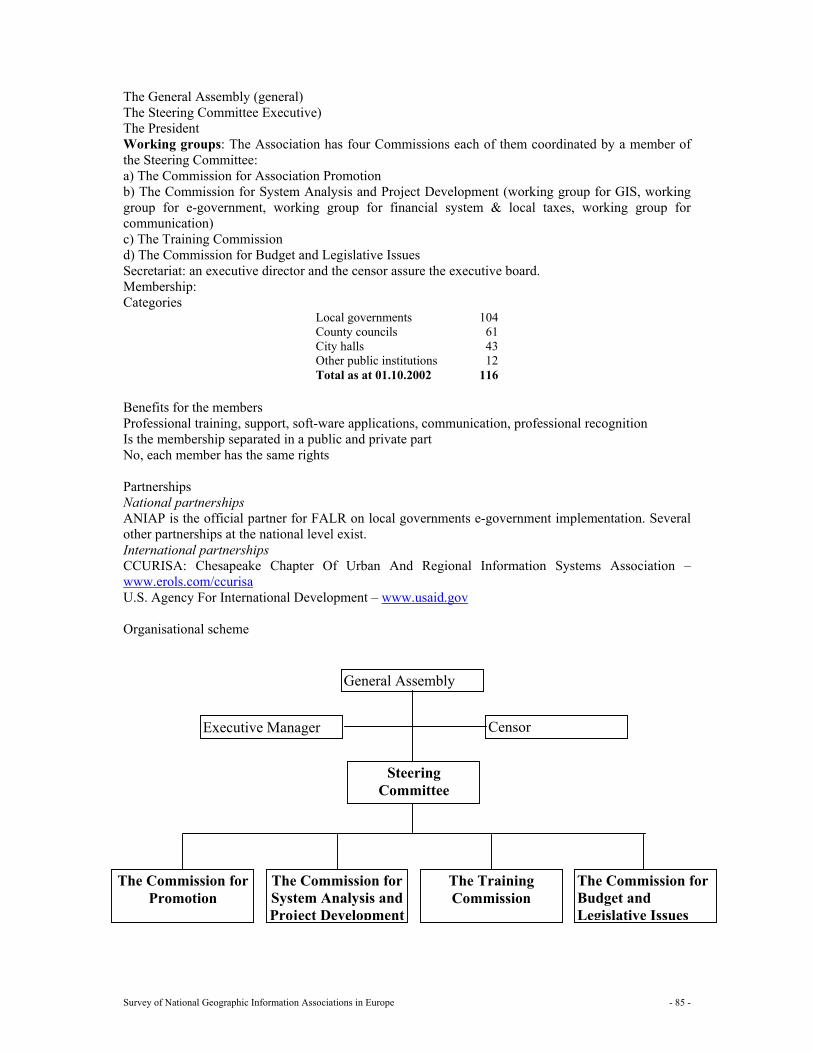
Survey of National Geographic Information Associations in Europe - 85 -
The General Assembly (general) The Steering Committee Executive) The President Working groups: The Association has four Commissions each of them coordinated by a member of the Steering Committee: a) The Commission for Association Promotion b) The Commission for System Analysis and Project Development (working group for GIS, working group for e-government, working group for financial system & local taxes, working group for communication) c) The Training Commission d) The Commission for Budget and Legislative Issues Secretariat: an executive director and the censor assure the executive board. Membership: Categories
Local governments 104 County councils 61 City halls 43 Other public institutions 12 Total as at 01.10.2002 116
Benefits for the members Professional training, support, soft-ware applications, communication, professional recognition Is the membership separated in a public and private part No, each member has the same rights Partnerships National partnerships ANIAP is the official partner for FALR on local governments e-government implementation. Several other partnerships at the national level exist. International partnerships CCURISA: Chesapeake Chapter Of Urban And Regional Information Systems Association – www.erols.com/ccurisa U.S. Agency For International Development – www.usaid.gov Organisational scheme
General Assembly
Executive Manager Censor
The Commission for Promotion
The Commission for System Analysis and Project Development
The Training Commission
The Commission for Budget and Legislative Issues
Steering Committee
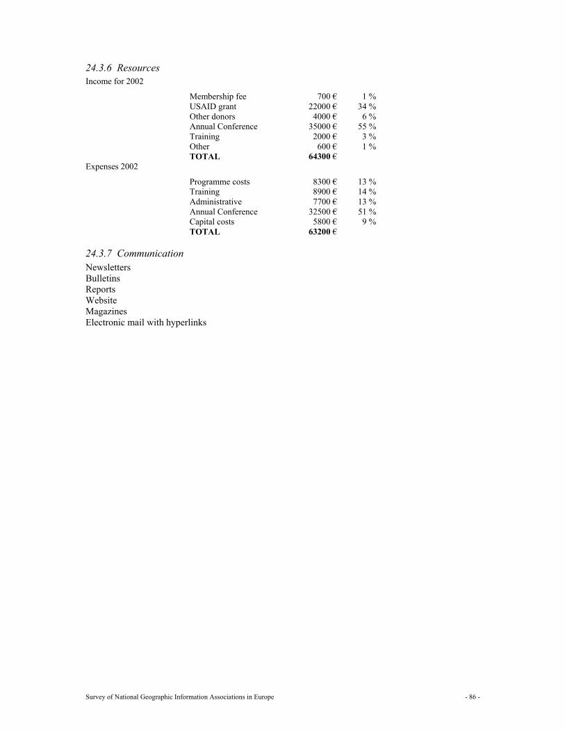
Survey of National Geographic Information Associations in Europe - 86 -
24.3.6 Resources Income for 2002
Membership fee 700 € 1 % USAID grant 22000 € 34 % Other donors 4000 € 6 % Annual Conference 35000 € 55 % Training 2000 € 3 % Other 600 € 1 % TOTAL 64300 €
Expenses 2002
Programme costs 8300 € 13 % Training 8900 € 14 % Administrative 7700 € 13 % Annual Conference 32500 € 51 % Capital costs 5800 € 9 % TOTAL 63200 €
24.3.7 Communication Newsletters Bulletins Reports Website Magazines Electronic mail with hyperlinks
Survey of National Geographic Information Associations in Europe - 87 -
25 Russia: GIS association
25.1 General information about the national GI association The GIS-association of Russia was established in 1995, as a non-state and non-commercial public organisation. The association was created to join the experts of higher educational institutions, researchers and practitioners, who act on the territory of former USSR in the field of development and application of geographic information engineering.
25.2 Mission and objectives/strategy Mission
Main directions of activity of Association are: • Issuing and support of issuing of the special publications (magazine "the Newsletter of GIS-
ASSOCIATION", GIS-YEAR-BOOK, tutorials, dictionary on geoinformation, and separate publications in a mass media);
• Realisation of special exhibitions, conferences; • Consulting of software tools and marketing examinations; • Development of the recommendations on standardisation of the geographical data and on
improvement of legal basis; • Operation on perfecting legal basis on territory of former USSR.
25.3 Key roles
1 GI policy maker 2 Knowledge and information supplier Yes 3 Public relations, awareness raising and promotion of GI Yes 4 Program assistance and support 5 Political interface, lobbyist 6 Mediator, negotiator 7 Promoter of standards, certification Yes 8 Facilitator for education (professional development) and training 9 Research
25.4 Actions
1 Workshops 2 Seminars 3 Conferences Yes 4 Projects 5 Publications Yes 6 Lobbying 7 Other Yes Exhibitions
25.5 Structure The leading body of Association is annual conference, which elects Board. C.A. Miller is President, E.G.Kapralov is Vice-president
Survey of National Geographic Information Associations in Europe - 88 -
Secretariat. V.V. Kozinov is Executive Manager. Membership: Members of the Association can be anyone, who has an interest in geoinformation. The Association includes today more than 450 members. Partnerships No information available Organisational scheme
25.6 Resources No information available
25.7 Communication
1 Newsletters Yes 2 Bulletins 3 Reports Yes 4 Web site 5 Magazines Yes 6 E mail
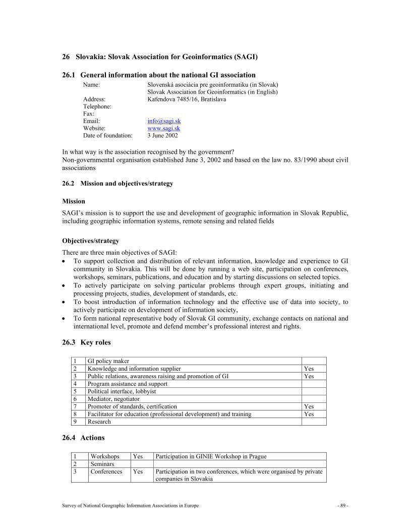
Survey of National Geographic Information Associations in Europe - 89 -
26 Slovakia: Slovak Association for Geoinformatics (SAGI)
26.1 General information about the national GI association Name: Slovenská asociácia pre geoinformatiku (in Slovak)
Slovak Association for Geoinformatics (in English) Address: Kafendova 7485/16, Bratislava Telephone: Fax: Email: [email protected] Website: www.sagi.sk Date of foundation: 3 June 2002
In what way is the association recognised by the government? Non-governmental organisation established June 3, 2002 and based on the law no. 83/1990 about civil associations
26.2 Mission and objectives/strategy Mission
SAGI’s mission is to support the use and development of geographic information in Slovak Republic, including geographic information systems, remote sensing and related fields
Objectives/strategy
There are three main objectives of SAGI: • To support collection and distribution of relevant information, knowledge and experience to GI
community in Slovakia. This will be done by running a web site, participation on conferences, workshops, seminars, publications, and education and by starting discussions on selected topics.
• To actively participate on solving particular problems through expert groups, initiating and processing projects, studies, development of standards, etc.
• To boost introduction of information technology and the effective use of data into society, to actively participate on development of information society,
• To form national representative body of Slovak GI community, exchange contacts on national and international level, promote and defend member’s professional interest and rights.
26.3 Key roles
1 GI policy maker 2 Knowledge and information supplier Yes 3 Public relations, awareness raising and promotion of GI Yes 4 Program assistance and support 5 Political interface, lobbyist 6 Mediator, negotiator 7 Promoter of standards, certification Yes 8 Facilitator for education (professional development) and training Yes 9 Research
26.4 Actions
1 Workshops Yes Participation in GINIE Workshop in Prague 2 Seminars 3 Conferences Yes Participation in two conferences, which were organised by private
companies in Slovakia
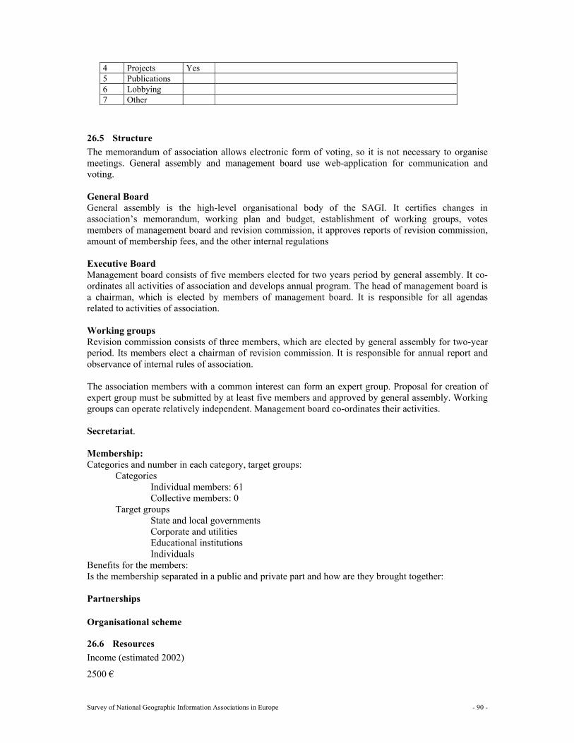
Survey of National Geographic Information Associations in Europe - 90 -
4 Projects Yes 5 Publications 6 Lobbying 7 Other
26.5 Structure The memorandum of association allows electronic form of voting, so it is not necessary to organise meetings. General assembly and management board use web-application for communication and voting. General Board General assembly is the high-level organisational body of the SAGI. It certifies changes in association’s memorandum, working plan and budget, establishment of working groups, votes members of management board and revision commission, it approves reports of revision commission, amount of membership fees, and the other internal regulations Executive Board Management board consists of five members elected for two years period by general assembly. It co-ordinates all activities of association and develops annual program. The head of management board is a chairman, which is elected by members of management board. It is responsible for all agendas related to activities of association. Working groups Revision commission consists of three members, which are elected by general assembly for two-year period. Its members elect a chairman of revision commission. It is responsible for annual report and observance of internal rules of association. The association members with a common interest can form an expert group. Proposal for creation of expert group must be submitted by at least five members and approved by general assembly. Working groups can operate relatively independent. Management board co-ordinates their activities. Secretariat. Membership: Categories and number in each category, target groups:
Categories Individual members: 61 Collective members: 0
Target groups State and local governments Corporate and utilities Educational institutions Individuals
Benefits for the members: Is the membership separated in a public and private part and how are they brought together: Partnerships Organisational scheme
26.6 Resources Income (estimated 2002)
2500 €
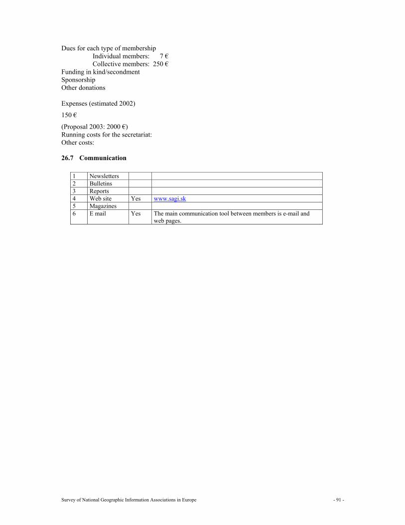
Survey of National Geographic Information Associations in Europe - 91 -
Dues for each type of membership Individual members: 7 € Collective members: 250 €
Funding in kind/secondment Sponsorship Other donations
Expenses (estimated 2002)
150 €
(Proposal 2003: 2000 €) Running costs for the secretariat: Other costs:
26.7 Communication
1 Newsletters 2 Bulletins 3 Reports 4 Web site Yes www.sagi.sk 5 Magazines 6 E mail Yes The main communication tool between members is e-mail and
web pages.
Survey of National Geographic Information Associations in Europe - 92 -
27 Slovenia: Geo Information Centre (GIC Slovenia) GIC Slovenia (Geo Information Centre) was formally organised inside Ministry of Environment and Spatial Planning of the Republic of Slovenia from 1991 to 2001. In June 2001 Geo Information Centre merged with the Surveying and Mapping Authority of the Republic of Slovenia after a decision of the Minister. The new organisational structure influences the work program and staff occupation. GIC Slovenia tried to establish a Slovenian national geographic information infrastructure together with the Slovenian Association of Surveyors, but at that moment there was not enough interest of all the participants to establish an umbrella organisation for geographic information.
Survey of National Geographic Information Associations in Europe - 93 -
28 Spain: Spanish Association for Geographic Information Systems (AESIG)
28.1 General information about the national GI association Name: Asociatión Española de Sistemas de Información Geográfica
Spanish Association for Geographic Information systems Address: Cardenal Silíceo 37 B1, 28002 Madrid, Spain Telephone: +34914136687 Fax: Email: [email protected] Website: Date of foundation: 1989
In what way is the association recognised by the government?
28.2 Mission and objectives/strategy Mission
Objectives/strategy • Promote the introduction, use and development of geographic information technologies. • Act as a forum for debate and discussions between individuals, groups and organisations, users
and providers of these technologies. • Establish and standardise common technologies. • Stimulate technological investigations and developments. • Promote, represent and defend the interests of the GIS sector. • Collaborate with public and private organisations concerned with GIS.
28.3 Key roles
1 GI policy maker 2 Knowledge and information supplier 3 Public relations, awareness raising and promotion of GI 4 Program assistance and support 5 Political interface, lobbyist 6 Mediator, negotiator 7 Promoter of standards, certification 8 Facilitator for education (professional development) and training 9 Research
28.4 Actions
1 Workshops 2 Seminars 3 Conferences 4 Projects 5 Publications 6 Lobbying 7 Other
Survey of National Geographic Information Associations in Europe - 94 -
28.5 Structure General Board Executive Board Working groups Secretariat. Membership: Categories and number in each category, target groups:
Individuals 145 Companies 57 Universities and public sector organisations 32
Benefits for the members: Is the membership separated in a public and private part and how are they brought together: Partnerships Organisational scheme
28.6 Resources Budget €50.000
28.7 Communication
1 Newsletters 2 Bulletins 3 Reports 4 Web site 5 Magazines 6 E mail [email protected]
Survey of National Geographic Information Associations in Europe - 95 -
29 Sweden: Swedish development council for Land Information (ULI)
29.1 General Information Name: ULI, The Swedish Development Council for Land Information Address: SE-801 82, Gävle, SWEDEN Telephone: +46 26 611 050 Fax: +46 26 613 277 Email: [email protected] Website: www.uli.se Date of foundation: October 1986
In what way is the association recognised by the government? ULI is an independent non-profit association. ULI informs and act as an expert in specific issues for the ministry. ULI is acting for the protection of its members´ interests in geographic information. ULI is supposed to contribute where the organisation can carry out a task better than any other organisation. ULI will first and foremost work as a catalyst to initiate achievements, which can be performed by others. ULI informs members and others about the development within the field of geographic information.
29.2 Mission and objectives/strategy Mission To increase, broaden, and make the use of geographic information more efficient
Objectives/strategy The strategy is to work and act within the areas of:
• Competence, education, and information distribution. • Financing and pricing of geographic information. • Quality, metadata, standardisation, and harmonisation. • Ethics and geographic information.
29.3 Key roles 1 GI policy maker Yes 2 Knowledge and information supplier Yes 3 Public relations, awareness raising and promotion of GI Yes 4 Program assistance and support No 5 Political interface, lobbyist Yes 6 Mediator, negotiator No 7 Promoter of standards, certification Yes 8 Facilitator for education (professional development) and training Yes 9 Research - YES (to support) Yes
29.4 Actions
1 Workshops No 2 Seminars Yes To put issues mentioned above into focus and by that create
networks for people and organisations 3 Conferences Yes Always new issues and questions. To put both technique, usage
and customer into focus
Survey of National Geographic Information Associations in Europe - 96 -
4 Projects Yes 2-3 every year. Investigations in different areas. 5 Publications Yes 1 new this year 6 Lobbying Yes By arranging meetings, seminars, acting as expert towards the
ministries and so on. 7 Other
29.5 Structure General board 9+3 The highest court is the annual meeting where all members have a vote.
Executive board None Working groups None Secretariat 1 secretary general + 1 information officer Membership Membership is open for Swedish organisations. ULI currently (December 2002) has 218 member organisations, which have the same right to vote and the same member benefits. The fees vary between type and size of organisation.
Categories and number in each category, target groups; Municipalities: 81 Private companies: 59 National government authorities: 17 Regional government authorities: 21 Research institute and universities: 18 Other organisations: 17
Benefits for the members; Newsletters (4 per year) Free GI-magazines (4 per year) E-News (6-8 per year) Reports and investigations (2-3 per year) Access to ULI’s web pages Discounts on conferences and seminars The right to send in opinions and other questions, which should be driven by ULI
Is the membership separated in a public and private part and how are they brought together; The membership fees are separated, but not strategic questions. We try to find common solutions on delicate questions. We try to find new commercial platforms for our companies and authorities as well
Partnerships ULI works with other associations in specific questions, like conferences, publications, newsletters, etc. There will be more partnerships in the future
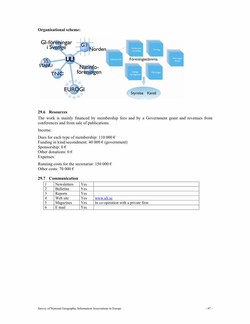
Survey of National Geographic Information Associations in Europe - 97 -
Organisational scheme:
29.6 Resources The work is mainly financed by membership fees and by a Government grant and revenues from conferences and from sale of publications.
Income:
Dues for each type of membership: 110 000 € Funding in kind/secondment: 40 000 € (government) Sponsorship: 0 € Other donations: 0 € Expenses:
Running costs for the secretariat: 150 000 € Other costs: 70 000 €
29.7 Communication 1 Newsletters Yes 2 Bulletins Yes 3 Reports Yes 4 Web site Yes www.uli.se 5 Magazines Yes In co-operation with a private firm 6 E mail Yes
Survey of National Geographic Information Associations in Europe - 98 -
30 Switzerland: Swiss Organisation for Geo-Information (SOGI)
30.1 General information about the national GI association Name: SOGI / OSIG
Schweizerische Organisation fuer Geo-Information Organisation Suisse pour l'Information Geographique Organizzazione Svizzera per l’Informazione Geografica Swiss Organisation for Geographic Information
Address: Sekretariat SOGI, c/o AKM, P.O. Box 6, CH-4005 Basel Telephone: +41 61 6867777 Fax: +41 61 6867788 Email: [email protected] Website: www.sogi.ch Date of foundation: January 1994
In what way is the association recognised by the government?
30.2 Mission and objectives/strategy The Swiss Organisation for Geo-Information (SOGI) is the umbrella organisation for public and private institutions and individual members concerned with the promotion and handling of Geo-information in Switzerland. Mission SOGI unites interested organisations to encourage the use of Geo-Information and their interdisciplinary application. Objectives/strategy SOGI promotes and supports: • The exchange of experience and the co-operation of its members in the branch of geo-information,
mainly in the area of practical application • The interdisciplinary exchange of information in the use of modern information technology,
mainly for the set-up and the operation of geo-information systems • The information on the importance, the advantage and the useful application of geo-information • The spreading and the use of geo-information in Switzerland • The use of powerful processing tools and methods for the management, the query and the
distribution of geo-information • The use of standards for the development of geo-information applications, for the exchange of
geo-information and the transfer between different systems • The education of producers and users of geo-information.
30.3 Key roles 1 GI policy maker Yes 2 Knowledge and information supplier Yes 3 Public relations, awareness raising and promotion of GI Yes 4 Program assistance and support Yes 5 Political interface, lobbyist Yes 6 Mediator, negotiator Yes 7 Promoter of standards, certification Yes 8 Facilitator for education (professional development) and training Yes 9 Research No
Survey of National Geographic Information Associations in Europe - 99 -
30.4 Actions
1 Workshops Yes Cost of GI 2 Seminars Yes Information seminars 1-2 x each year 3 Conferences Yes National conference on GI and GIS every two years 4 Projects Yes Geo standards 5 Publications Yes Member’s bulletin 6 Lobbying Yes At the moment very limited 7 Other
For achieving their aims SOGI is able to: • Organise seminars and conferences. • Ask working groups to deal with problems in the professional field. • Work out technical recommendations. • Disseminate information of common interest. • Make recommendations for the division and pricing of data and data exchange between members
and third parties. • Carry out projects of common interest. • Edit publications. • Participate in all activities, which promote the use of geographic information.
30.5 Structure General Board No Executive Board Head: Sigi Heggli Amt für Umweltschutz Kt. St.Gallen Lämmlisbrunnenstr. 54 CH-9001 St.Gallen Tel: +41 71 229 42 47 [email protected] The Executive Board consists out of 11 members including the presidents of the 6 working groups. There is no General board Working groups Working group conferences and workshops Working group co-ordination international Working group co-ordination of GI in the country Working group GI-technology Working group standards Working group education/formation Secretariat. Professional Secretariat: Thomas Glatthard Museggstr. 31 CH-6004 Luzern Tel: +41 41 410 22 67 [email protected]
Survey of National Geographic Information Associations in Europe - 100 -
Administrative Secretariat: SOGI c/o AKM P.O. Box 6 CH-4005 Basel Tel.: +41 61 686 77 77 Fax: +41 61 686 77 88 Email: [email protected] Membership: Categories and number in each category, target groups
Types of members: Organisations (cat. A) 15 Institutions from research, industry and government (cat B) 30 Sponsors (cat. C) 12 individual members (cat. D) 70 Students (cat. E) 2 Total 129
Benefits for the members: Is the membership separated in a public and private part and how are they brought together: No Partnerships Organisational scheme
30.6 Resources Income € 42.300 Dues for each type of membership:
Membership Category
Euro per year
A 670 B 300 C 600 D 60 E 30
Assessment of revenues: 65 % (€ 27'500) from membership fees,
35 % (€ 14'800) from organisation of GIS conference Funding in kind/secondment Sponsorship Other donations: Expenses € 42.300 Running costs for the secretariat 40% (€ 17.000) Secretariat Other costs: 30% (€ 13.000) EUROGI membership fee and Executive Committee travel expenses
8% (€ 3.300) Organisation of conferences 17% (€ 7.000) Miscellaneous expenses (travel etc.) 5% (€ 2.000) National Membership
Survey of National Geographic Information Associations in Europe - 101 -
30.7 Communication
1 Newsletters Yes 4 x each year 2 Bulletins Yes 4 x each year 3 Reports Yes Costs of GI 4 Web site Yes www.sogi.ch 5 Magazines No 6 E mail Yes [email protected]
Survey of National Geographic Information Associations in Europe - 102 -
31 Turkey
31.1 General information about the national GI association There is no national GI association in Turkey yet. However its foundation is under consideration. There are currently a chamber, a national committee and two governmental institutions that mainly involve with GI in Turkey. The names of these organisations are as follows: Chamber of Surveying Engineers Coordination and Planning Committee for Map Works among Ministries General Directorate of Land Registry and Cadastre General Command of Mapping Several universities like Istanbul Technical University, Yildiz Technical University and Black Sea Technical University and etc. are also involved with GI.
31.2 Mission and objectives/strategy Mission
Organise GI circulation within GI sector. Provide feedback on GI technology. Organise internal training in the GI sector. Encourage collaboration. Prepare and propose policies for GI sector.
Objectives/strategy
31.3 Key roles Not available
31.4 Actions Chamber of Surveying Engineers currently and generally run the following activities. Workshops Seminars Conferences Projects Publications Lobbying Other actions The new association might also run similar activities
31.5 Structure Not available
31.6 Resources Each of the following items might be considered for resources of new GI association Income:
• Dues for each type of membership • Funding in kind/secondment • Sponsorship • Other donations
Expenses:
• Running costs for the secretariat • Other costs
Survey of National Geographic Information Associations in Europe - 103 -
31.7 Communication Chamber of Surveying Engineers currently and generally run the following activities. Newsletters, Bulletins Reports Website Magazines Electronic mail with hyperlinks The new association might also run similar communication activities.
Survey of National Geographic Information Associations in Europe - 104 -
32 United Kingdom: Association for Geographic Information (AGI)
32.1 General information about the national GI association Name: Association for geographic information Address: Block C, 4th Floor, Morelands, 5-23 Old Street, London, EC1V 9HL Telephone: +44 (0)20 7253 5211 Fax: +44 (0)20 7251 4505 Email: [email protected] Website: www.agi.org.uk Date of foundation: 18 January 1989
The Association for Geographic Information represents the varied interests of its members and the wider geographic information (GI) community. The Association plays an important role in ensuring that GI remains high on the political agenda and that the benefits GI can bring are fully recognised at all levels within the private and public sectors. In what way is the association recognised by the government? AGI – Government The AGI is independent of Government. It receives no income from Government although many parts of government are members of the AGI. Government consults the AGI from time to time. The AGI is a member of the Parliamentary IT Committee. The AGI has made three presentations to PITCOM to raise the awareness of GI and to present the issues that the AGI believes politicians should resolve. The presentations were made in 1992, 1997, and 2000. AGI Sponsor members sponsored the costs of mounting the presentations in 1997 and 2000. In 1997 the AGI and PITCOM jointly produced a supplement on GI, which was circulated to all members of the House of Commons and the House of Lords, senior grades within the civil service and all libraries and Universities. The AGI responds to government consultations documents were it is applicable to do so. As time has progressed the AGI has responded to an increasing number of Government consultations and inquiries. During 2002 the AGI has considered and responded to the to a number of consultations which have included: 1. The House of Commons Transport, Local Government and the Regions Select committee’s sub committee on Urban Affairs, that held an inquiry into the Ordnance Survey of Great Britain. The AGI submitted written evidence during the enquiry and at least five occasions and also came before the committee in the House of Commons to give oral evidence. The AGI Director and the AGI Senior vice Chair gave this oral evidence. The AGI contributions to this inquiry are available both on the House of Commons web site and in Report number 10 for the current parliamentary session published by the select committee. 2. The HMSO consultation of Licensing of Crown Copyright – HMSO Regulatory framework. 3. The eEnvoys consultation on Addresses and Government data standards. 4. Towards a national strategy for local eGovernment. 5. Access to Information in Local Government. 6. Government policy on Privacy and data sharing. 7. Northern Ireland Executive Draft Programme for Government Reinvestment and Reform consultation. (Response made by AGI Northern Ireland). As an example of how the AGI takes proactive action to engage politicians. During the period May 1998 through to February 2001 the AGI ran the London initiative, which used the formation of the
Survey of National Geographic Information Associations in Europe - 105 -
Greater London Authority (GLA) as a catalyst to raise the awareness of all within London of the value of GI. The initiative involved over 50+ politicians (who were standing in the election as Assembly members for the GLA) who had their manifesto’s and contact details on the London Initiative web site during the election period. This initiative developed a working relationship with the GLA Assembly member’s, which has been maintained since. The GLA has asked if the AGI London Information Service could be used in a similar way in future GLA elections. The AGI connections with Government have steadily evolved over time. The following diagram shows how the AGI interfaces too politicians at all levels and the public servants that work within the government administration.
32.2 Mission and objectives/strategy Mission "to maximise the use of geographic information for the benefit of the citizen, good governance and commerce"
Objectives/strategy The AGI delivers its mission through: Informing
The membership is kept up to date through a regular newsletter, e-mails, mailings, seminars, publications and articles.
Influencing Many AGI members work in government, allowing access to decision-makers at the highest level. The AGI is a member of the Parliamentary IT Committee. The AGI is also active in Europe, being a founder member of EUROGI – the European umbrella body for geographic information.
Acting Whenever necessary, the AGI takes decisive action to ensure that its members' legitimate interests are promoted and, by consulting with members, the AGI can give the GI industry a respected voice at the appropriate level.
32.3 Key roles
1 GI policy maker Yes 2 Knowledge and information supplier Yes 3 Public relations, awareness raising and promotion of GI Yes 4 Program assistance and support Yes 5 Political interface, lobbyist Yes 6 Mediator, negotiator Yes 7 Promoter of standards YES, certification NO Yes/No 8 Facilitator for education (professional development) and training 9 Research
The AGI funds the secretariat expenditure of the British Standards Institute Geographic Information committee IST/36. The AGI also appoints the chair of this committee who reports to the Direct Action committee within the AGI structure. Members of the IST/36 committee also serve on CEN and ISO Standard making committees. The AGI has a formal policy making process approved during 2002. All AGI members can propose policy. AGI Council considers the proposed policy statements and approves whether a policy statement (s) become adopted AGI policy. The AGI also has a formal campaign procedure
Survey of National Geographic Information Associations in Europe - 106 -
32.4 Actions
1 Workshops Yes Workshops of the Special Interest Groups 2 Seminars Yes Seminars of the regions, Special Interest Groups 3 Conferences Yes Annual AGI conference 4 Projects No Not undertaken at the current time 5 Publications Yes AGI source book, surveys, ad hoc reports, seminar proceedings 6 Lobbying Yes Lobbying events, 7 Other Yes Round table discussions, and press releases
The AGI provide a number of active web based services. 1. GIgateway In September 2001 the AGI entered into a contract with the Ordnance Survey of Great Britain (OS-GB) to operate and develop the askGIraffe services (subsequently renamed by the AGI as GI_gateway). The Office of the Deputy Prime Minister (ODPM) provides a grant to the OS-GB to undertake work that is in the national interest. The money is predominantly used by the OS-GB to update the nations rural mapping. The National Interest Mapping Services Agreement (NIMSA) contains a small element devoted to the development of web services in the national interest: e.g. a meta data service. It is the web based services and the team that manages and develops them that has been contracted to the AGI. Further details on the NIMSA agreement can be found on the OS-GB and the ODPM’s web sites. 2. London Information Service The London Information Service is a service that demonstrates for the whole of the greater London area how geographic information can be delivered using a combination of images (such as aerial photography) and text (such as demographic data). The service was first developed as part of the AGI’s London initiative during the period 1998 through to January 2001 when the AGI used the election of the Greater London Authority assembly the value of geographic information. The service is sponsored by AGI members and managed and operated by the AGI. The services will contain a 3D London fly through application, which will enable viewers to visualise London from the sky. The Deputy Mayor of London will launch the service early in 2003. The London Information Service comprises of two separate services. London Information Service for the public. This service will be used by the AGI to support its campaigns and possibly during election periods to promote awareness using an election to promote GI. This service can be accessed at the following URL. (If you wish to use a postcode use the SW1A 1AA) http://london.agi.org.uk London Information Service for schools. This service is run by the AGI and is specifically set up for schools. The AGI works in partnership with the Royal Geographical Society with the Institute of British Geographers who provides the front-end support services to the Schools. This version of the service once completed will not be touch or varied for a period of three years as requested by schoolteachers so that the associated teaching materials do not have to be changed. The service provides a very simple tool for teaching that does not involve the teacher setting up any geographic information service in order to teach. The site contains simple teaching materials that will be built up over time. This service can be accessed at the following URL. (If you wish to use a postcode use the SW1A 0AA) http://schools.agi.org.uk
32.5 Structure Regional branches in Northern Ireland, Scotland and Wales The objective of these regional initiatives is: • To promote awareness on GI and how it could benefit the citizen, commerce and good governance
within the region:
Survey of National Geographic Information Associations in Europe - 107 -
• To gain access to government at the local level; • To bring together people with an interest in GI within the region with the intention of forming a • regional group of the AGI. • To tune and deliver membership benefits to the regional member; • To encourage AGI membership at the grass roots level within the regions General Board The structure of the AGI Council during the period 1989 to 1992 was by representation from nine special interest groups each of which had three members. This structure proved to be inflexible and was becoming increasingly difficult to manage as GI became pervasive. At the AGM in 1992 the Council structure was changed to election from a common list. At the EGM in November 1999 the Council structure was changed to reserve one Council seat for each of the devolved regions Northern Ireland, Scotland and Wales and as a result reduced the number of seats on the common list to 24. The elected Council members are the Directors of the AGI under the UK Companies Act. The AGI Council is the governing body of the AGI. The 27 Council members are elected by the AGI membership. Each member has one vote. Each year one third of the Council members stand down from Council so that an election can take place. Executive Board Each year the AGI Council members elected the Chair, Senior vice chair and Junior vice Chair, Hon. Secretary and the Hon Treasurer, the Chairs of the working committees and two ex officio posts. This group forms the AGI Management committee. The Chair serves for one year. Continuity in the AGI is maintained through a four-year cycle whereby the Chair passes through four distinct roles serving as:
Junior vice Chair Senior vice Chair Current Chair Past Chair
The four Chairs’ plus the AGI Director form the Chairs group that deals with fast track policy processes. Working groups Corporate affairs committee The purpose of the Committee is to ensure that good advice is given under the AGI name and thereby influence the opinions of others, wherever these bear on the better handling of geographic information Direct action committee The Direct Action Committee (DAC) exists in order to identify subjects relevant to the geographic community where major direct action may be required, and bring this to the attention of the AGI Council. The DAC makes recommendations to Council on the most appropriate course of action e.g. arranging for round table discussions, the publication of an article, lobbying government etc. Education committee The eCommittee of the AGI is involved with education, training and research aspects of geospatial information. Its aims and objectives include: a. Promoting of management and use of geospatial information. b. Promoting the use of geospatial information in education, from the school curriculum to advanced courses at universities.
Survey of National Geographic Information Associations in Europe - 108 -
c. Organising and encouraging meetings on education, training and research issues. d. Promoting research associated with geographic information systems (GIS) and geospatial information. e. Assessing and keeping under review national needs of and for GIS professionals and facilitating the provision of appropriate training. f. Maintaining a dialogue with relevant groups in order to provide effective communication across the geo-spatial information community. g. Publishing research reports and information relevant to geospatial information. Special interest groups: Where a group of members has a common interest, then they may form a Special Interest Group (SIG).
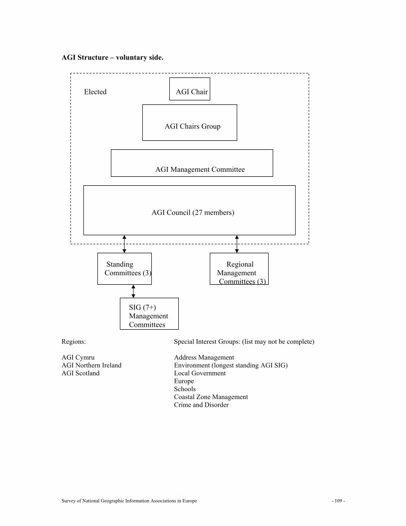
Survey of National Geographic Information Associations in Europe - 109 -
AGI Structure – voluntary side. Elected AGI Chair AGI Chairs Group AGI Management Committee AGI Council (27 members) Standing Regional Committees (3) Management Committees (3) SIG (7+) Management Committees Regions: Special Interest Groups: (list may not be complete) AGI Cymru Address Management AGI Northern Ireland Environment (longest standing AGI SIG) AGI Scotland Local Government Europe Schools Coastal Zone Management Crime and Disorder
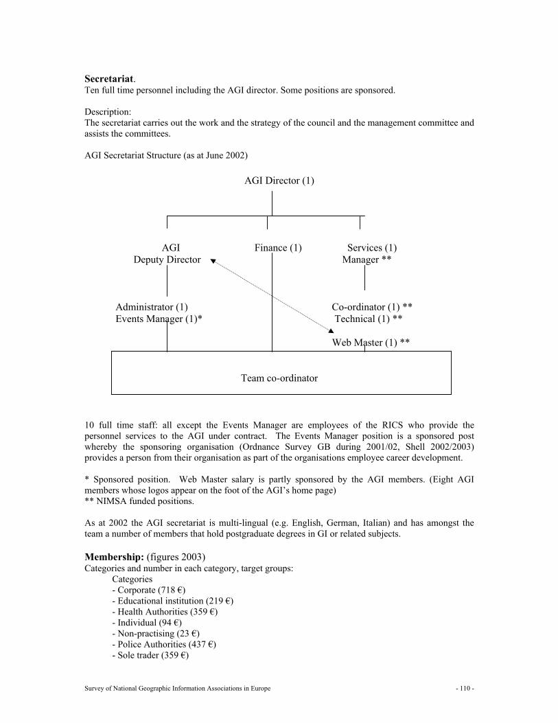
Survey of National Geographic Information Associations in Europe - 110 -
Secretariat. Ten full time personnel including the AGI director. Some positions are sponsored. Description: The secretariat carries out the work and the strategy of the council and the management committee and assists the committees. AGI Secretariat Structure (as at June 2002)
AGI Director (1)
AGI Finance (1) Services (1) Deputy Director Manager ** Administrator (1) Co-ordinator (1) ** Events Manager (1)* Technical (1) ** Web Master (1) **
Team co-ordinator
10 full time staff: all except the Events Manager are employees of the RICS who provide the personnel services to the AGI under contract. The Events Manager position is a sponsored post whereby the sponsoring organisation (Ordnance Survey GB during 2001/02, Shell 2002/2003) provides a person from their organisation as part of the organisations employee career development. * Sponsored position. Web Master salary is partly sponsored by the AGI members. (Eight AGI members whose logos appear on the foot of the AGI’s home page) ** NIMSA funded positions. As at 2002 the AGI secretariat is multi-lingual (e.g. English, German, Italian) and has amongst the team a number of members that hold postgraduate degrees in GI or related subjects. Membership: (figures 2003) Categories and number in each category, target groups:
Categories - Corporate (718 €) - Educational institution (219 €) - Health Authorities (359 €) - Individual (94 €) - Non-practising (23 €) - Police Authorities (437 €) - Sole trader (359 €)

Survey of National Geographic Information Associations in Europe - 111 -
- Sponsor (Non-Trading) (4992 €) - Sponsor (Trading Funds Status) (5928 €) - Overseas uplift (39 €) - Student (23 €) - Local authority >100K: (515 €) < 100K: (328 €) Number: 1200 Target group: Central government
Local government Education Corporate Utilities Individuals
Types of membership: The AGI is a membership organisation, drawing members from all sectors including users, software suppliers and vendors, consultants, government departments, local authorities, emergency services, educational establishments and individuals.
Benefits for the members: A membership-based organisation such as the AGI has to continually balance its activities and resources between the direct and indirect benefits. The benefits are also related to the category of membership: i.e. a sponsor member enjoys a greater range of benefits than an individual member does.
Direct Benefits E.g. newsletter, conference, CPD, seminars, workshops, SIG’s, publications, WWW, regional groups, networking, CV service, student placement scheme, and other membership service’s. Etc. Indirect Benefits E.g. membership of EUROGI, PITCOM. Work on standards, working with partners, political lobbying, public relations, involvement in infrastructure development, GI-gateway, London Information Service. Etc. The AGI activities can be grouped in a variety of ways. One grouping that is of particular importance to AGI members is that of classifying AGI activities as either a direct membership benefit or an indirect membership benefit. The two categories are closely related and are mutually supportive. For the AGI to perform many of its indirect activities there has to be a base of knowledge and information available for the AGI to perform the representative indirect activities in a coherent, justifiable and professional way. Much of the knowledge and information flows through from the activities that are categorised as direct membership benefits and vice a versa. The direct benefits can be considered as short-term objectives as they have to be delivered each year to encourage the member to renew their annual membership subscription. Where as the indirect benefits are medium to longer term and although important have a low priority when a member is justifying their annual subscription payment to the AGI. All AGI members receive: - Access to the members’ – only area of the web site. - Free quarterly AGI newsletter - Discounts on publications. - Free subscriptions to GI News & GEOconnexion. - Discounts to attend AGI meetings and seminars. - Discount to attend the AGI annual conference.
Survey of National Geographic Information Associations in Europe - 112 -
- The opportunity to stand for AGI Council or the Executive Board of AGI Cymru. Northern Ireland and Scotland.
- The opportunity to serve on one of the sub-committees - The opportunity to join one of the Special Interest Groups. - The opportunity to participate in the AGI CPD scheme. In addition AGI Corporate members receive: - Multiple discounts to AGI meetings and seminars. - The right to use the AGI logo. - Discounted optional entry in the AGI Source book. - Free copy of the AGI Source book. - 5% discount on a stand at GIS Exhibition. - 5 discounted places at the AGI annual conference. - 20% first year discount on a subscription to GEOUK. - 10 additional names on the AGI database. In addition AGI sponsor members received all of the above and: - A hot link from the AGI web site. - The first invitation to exhibit at AGI events. - The first opportunity to sponsor AGI events and activities. - Their name on AGI letterhead. - A mention in AGI publications and the Newsletter. - 20 additional names on the AGI database. - One mailing per year to the AGI membership database. - One advert/link per year on an e-mail to the AGI membership. - The opportunity to host meetings. - 10% discount on a stand at GIS exhibition plus 2 free or 10 discounted places at Conference. - If not exhibiting, 4 free or 15 discounted places at the annual AGI conference.
Is the membership separated in a public and private part and how are they brought together: No not separated. Partnerships Organisational scheme Listed above
32.6 Resources AGI annual accounts are audited by the Auditors that are appointed by a motion moved each year at the AGM. Income € 1.056.120 (budget 2002) Dues for each type of membership Listed under “members” Funding in kind/secondment Sponsorship The AGI also receives financial sponsorship to enable specific events and activities to occur. The AGI has a sponsorship policy, which, sets out the conditions under which sponsorship is accepted. AGI sponsor member’s are always given the first opportunity to bid for sponsoring specific AGI events after which it is opened up to AGI Corporate members. All accepted financial sponsorship results in an AGI invoice being raised and the income appears in the AGI published accounts under the events sponsored.
Note: The following table is not complete. Annual award € 2.340
Survey of National Geographic Information Associations in Europe - 113 -
Other € 31.200 Other donations Income expressed as a percentage of the total (budget 2002) Membership subscriptions 32% Conference 11% Other 56% Interest 1%
Expenses: € 1.010.256 (budget 2002)
Running costs for the secretariat: € 943.176 Working Committees €64.740 Other costs € 2.340
32.7 Communication
1 Newsletters Yes GEOgraphic information 4 times a year; 3-32 pages 2 Bulletins 3 Reports Yes Ad hoc reports, surveys 4 Web site Yes The AGI web site is gradually being built up over time to become
the first stop shop for geographic information in the UK. One of the AGI’s key mediums for publishing and the dissemination of information is its web site www.agi.org.uk. It has two sections an open section for all web site visitors and a member only section. The latter contains many of the AGI’s free publications. The member’s only side of the web site contains a link through to the member’s only side of the EUROGI web site with out the need for passwords or user names. This gives all AGI members full access to the content on all parts of the EUROGI web site.
5 Magazines Yes Source book 6 E mail Yes The AGI Secretariat started using email in 1994. The volume of
email has grown significantly and is now one of the main methods that the Secretariat communicates with members. This is especially the case with regard to those members serving on Council, working committees, regional groups and SIG’s. The AGI Secretariat on average receives over 200 emails per day from members and other interested parties. Over 80% of the AGI membership now has an email account and the AGI uses this medium as one of its main channels of communication with its members.
AGI Annual Conference – number of published papers presented: 45 on CD-rom The 2001 source book was published on CD-ROM. Due to the changes underway on the AGI web site the online sourcebook database was dropped temporarily. PDF copies of the latest AGI source book are available on the member’s only side of the AGI web site. The AGI Public Relations policy includes the following: - Production and distribution of press releases. - Regular columns in GEOconnexion and GI News. - Articles in various magazines. - Ad hoc contracts using a PR agency to undertake specific tasks. The AGI had a regular column in Mapping Awareness from 1994 until Mapping Awareness ceased publication at the end of 1999.
Survey of National Geographic Information Associations in Europe - 114 -
The AGI had a regular column in GeoEurope from 1994 until GeoEurope ceased publication in November 2001. The AGI logo appears in its head noted paper and all publications that it produces. Sponsor and Corporate members are entitled to use the logo to demonstrate their support and affiliation to the AGI. Third parties with agreement also use the AGI logo when the AGI has an involvement in the event: e.g. a seminar, an award. To support the regional identity regional logos have been introduced. To support the AGI CPD scheme the CPD logo appears on those events that carry a CPD rating.
Survey of National Geographic Information Associations in Europe - 115 -
Annex A: The questionnaire Q1 General information about the national GI association
Name Address Telephone Fax Email Website Date of Foundation
In what way is the association recognised by the government? - When a national GI association does not exist in your country, you are kindly invited to explain the
current status of GI: - Which are the focal points for GI; - Are you considering the set up of a national GI association? - Is it possible to give some general information about the questions below? Q2 Mission and objectives/strategy - Mission (describes the constitution and the reason for existence) - Objectives/strategy (describe the way the organisation will achieve its mission. It consists out of the
goals set for the longer term) Q3 Key roles Which roles fulfils your association:
GI policy maker Knowledge and information supplier Public relations, awareness raising and promotion of GI Program assistance and support Political interface, lobbyist Mediator, negotiator Promoter of standards, certification Facilitator for education (professional development) and training Research
Q4 Actions Actions are the short-term activities of the organisation to achieve the objectives like:
Workshops Seminars Conferences Projects Publications Lobbying Other actions
Can you give a brief description of actions related to each role as mentioned above? Q5 Structure - Board (general: deals with mission and strategy);
Survey of National Geographic Information Associations in Europe - 116 -
- Board (executive: deals with day to day business and short term actions); - Working groups (standing committees); - Secretariat (employees, volunteers, task); -Membership:
-Categories and number in each category, target groups; - Which are the benefits (promised and received) for the members, related to each category; - Is the membership separated in a public and private part and how are they brought together;
-Partnerships (whether associations work in partnership with other organisations to deliver its mission and objectives) -Does an organisational scheme for the organisation exist? If yes, please draw. Q6 Resources
Income: Dues for each type of membership Funding in kind/secondment Sponsorship Other donations
Expenses: Running costs for the secretariat Other costs
Q7 Communication
Newsletters, Bulletins Reports Website Magazines Electronic mail with hyperlinks
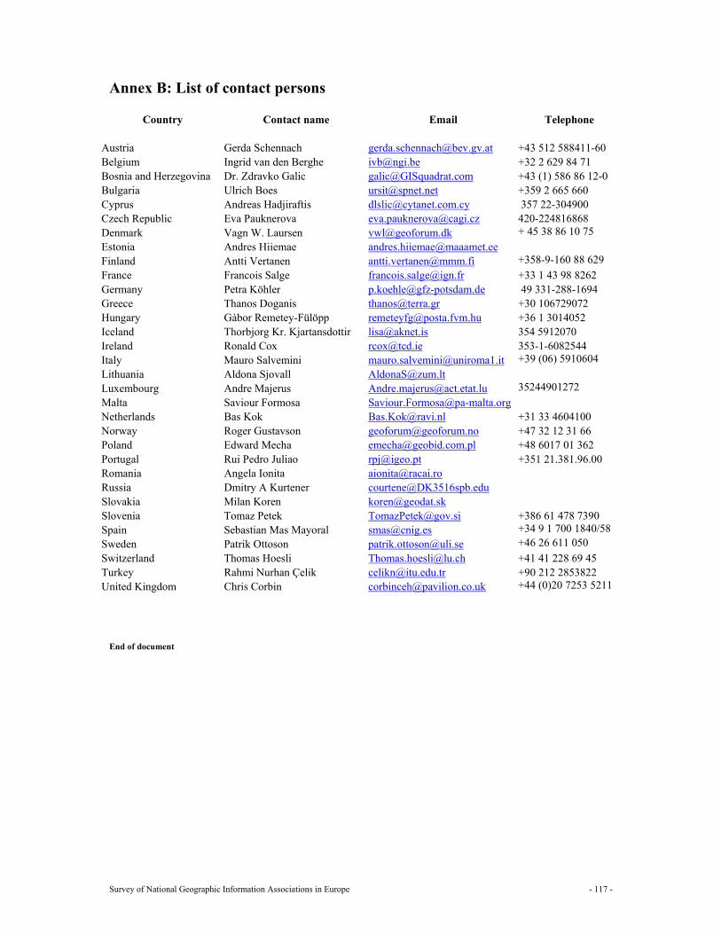
Survey of National Geographic Information Associations in Europe - 117 -
Annex B: List of contact persons
Country Contact name Email Telephone Austria Gerda Schennach [email protected] +43 512 588411-60 Belgium Ingrid van den Berghe [email protected] +32 2 629 84 71 Bosnia and Herzegovina Dr. Zdravko Galic [email protected] +43 (1) 586 86 12-0 Bulgaria Ulrich Boes [email protected] +359 2 665 660 Cyprus Andreas Hadjiraftis [email protected] 357 22-304900 Czech Republic Eva Pauknerova [email protected] 420-224816868 Denmark Vagn W. Laursen [email protected] + 45 38 86 10 75 Estonia Andres Hiiemae [email protected] Finland Antti Vertanen [email protected] +358-9-160 88 629 France Francois Salge [email protected] +33 1 43 98 8262 Germany Petra Köhler [email protected] 49 331-288-1694 Greece Thanos Doganis [email protected] +30 106729072 Hungary Gàbor Remetey-Fülöpp [email protected] +36 1 3014052 Iceland Thorbjorg Kr. Kjartansdottir [email protected] 354 5912070 Ireland Ronald Cox [email protected] 353-1-6082544 Italy Mauro Salvemini [email protected] +39 (06) 5910604 Lithuania Aldona Sjovall [email protected] Luxembourg Andre Majerus [email protected] 35244901272 Malta Saviour Formosa [email protected] Netherlands Bas Kok [email protected] +31 33 4604100 Norway Roger Gustavson [email protected] +47 32 12 31 66 Poland Edward Mecha [email protected] +48 6017 01 362 Portugal Rui Pedro Juliao [email protected] +351 21.381.96.00 Romania Angela Ionita [email protected] Russia Dmitry A Kurtener [email protected] Slovakia Milan Koren [email protected] Slovenia Tomaz Petek [email protected] +386 61 478 7390 Spain Sebastian Mas Mayoral [email protected] +34 9 1 700 1840/58 Sweden Patrik Ottoson [email protected] +46 26 611 050 Switzerland Thomas Hoesli [email protected] +41 41 228 69 45 Turkey Rahmi Nurhan Çelik [email protected] +90 212 2853822 United Kingdom Chris Corbin [email protected] +44 (0)20 7253 5211
End of document