Embed Size (px)
Citation preview

As a requirement of Mitigation Measure 4.4-3 from the Peace II Subsequent EnvironmentalImpact Report (EIR), Watermaster, Inland Empire Utilities Agency (IEUA) and Orange CountyWater District (OCWD) began to develop a Prado Basin Habitat Sustainability Program.Included within this program will be the Prado Basin Habitat Sustainability AdaptiveManagement Plan, the installation of up to 17 monitoring wells at nine separate sites, andvegetative monitoring.
Calibration was completed at the Daniels Street horizontal extensometer, which is located acrossthe City of Chino observed zone of surface ground fissuring.
A location was identified in February 2012, and construction began in April 2012 on the ChinoCreek Well Field (CCWF) vertical cable extensometer (located South of Chino Airport).
The Chino Basin Recharge Master Plan Update Steering Committee continued to meet and toidentify additional cost-effective recharge opportunities and projects that could be undertakenin the future. The Steering Committee developed and approved a scope of work and reportoutline and commenced with the execution of the work. The scope of work was responsive to theOctober 2010 and December 2011 Court Orders and the December 2011 Board direction.The Steering Committee’s final report will include nine sections with technical appendices. TheFinal Draft of Sections One through Four of the Report was completed and approved by theWatermaster Board on May 24, 2012. These four sections fulfilled the requirements of the JuneStatus Report deadline to the Court, which was filed on May 31, 2012. Work on the remainderof the Recharge Master Plan Update continues expeditiously.
Watermaster and the IEUA continue to work together toward the creation of a fifth retentionfacility at the Turner Basin. Following completion in 2014, the expansion project is projected torecharge an addition 300 acre-feet of storm runoff annually.
In June 2012, the Western Municipal Water District (WMWD) was awarded a $51 million stategrant from the California Department of Public Health for the desalter expansion project underProposition 50 Chapter 4b.
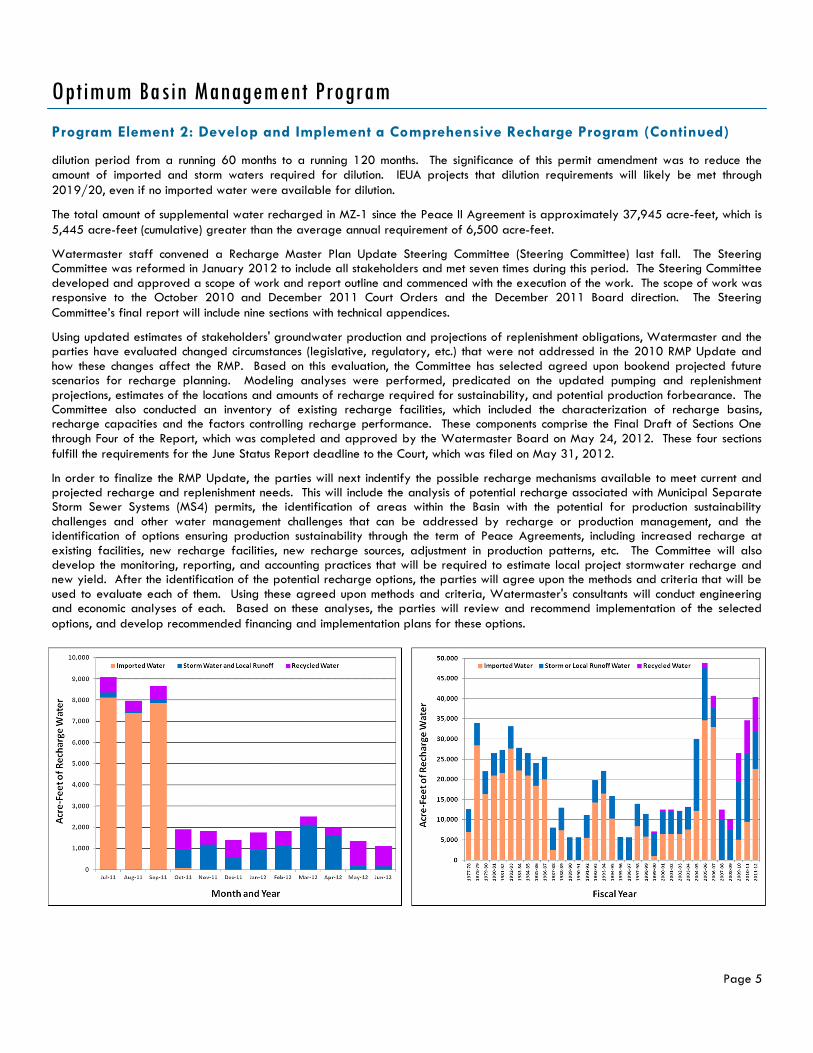
During the fiscal year, approximately 9,271 acre-feet of stormwater, 8,634 acre-feet ofrecycled water, and 23,449 acre-feet of imported water were recharged.
Highlighted Activities
Program Element 1: Develop and Implement a Comprehensive MonitoringProgram
Groundwater Level Monitoring
Watermaster initiated a comprehensive monitoring program as part of the implementation of theOBMP. The current groundwater level monitoring program is comprised of about 700 wells. At about500 of these wells, water levels are measured by well owners, which include municipal wateragencies, the California Department of Toxic Substance Control (DTSC), the County of SanBernardino, and various private consulting firms. The measurement frequency is typically about onceper month. Watermaster collects these water level data quarterly. The remaining 200 wells aremainly south of the 60 Freeway and assess hydraulic control, land subsidence, impacts from thedesalter wells, and are monitored in support of the triennial re-computation of ambient water quality
Important CourtHearings and Orders
APRIL 10 - COURT OF
APPEAL OPINION
(REGARDGING
PARAGRAPH 31)
JUNE 13 - COURT OF
APPEAL REMITTITUR
(REGARDING
PARAGRAPH 31)
JUNE 15 -
SUPPLEMENTAL ORDER
AFTER HEARING ON
MOTION FOR
APPROVAL OF
WATERMASTER
RESOLUTION
2010-04
JUNE 29 - ORDER
POST APPEAL
(REGARDING
PARAGRAPH 31)
Optimum Basin Management Program (OBMP)
C H I N O B A S I N W A T E R M A S T E R
Optimum Basin Management ProgramStaff Status Report 2012-1: January to June 2012
in the Chino-North Management Zone. Watermaster manually measures water levels at these wells monthly or by using pressuretransducers that record data in 15-minute increments. These data are quality control checked, loaded into a relational database, andused to develop groundwater level contour maps and implementation assumptions.
Groundwater Quality Monitoring
Watermaster initiated a comprehensive monitoring program as part of the implementation of the OBMP. The groundwater qualitymonitoring program consists of the following four components:
1. An Annual Key Well Water Quality Monitoring Program consisting of 120 wells which are mostly privately owned agriculturalwells in the southern portion of Chino Basin that are otherwise not included in an established sampling program. Twenty of thesewells are sampled every year; the remaining wells are sampled every three years. The wells sampled annually are for thecontinuous monitoring of areas of concern associated with the southern edge of the Archibald South (formerly OIA) volatileorganic compound (VOC) plume, the southern region of the Chino Airport Plume, and the Kaiser Steel Plume which includes thetwo multi-port MZ-3 monitoring wells. Data obtained for the Key Well Quality Monitoring Program are used for the triennialambient water quality analysis, hydraulic control assessment, the Biennial State of the Basin Report, and to assess the overallhealth of the Basin.
2. Annual sampling at nine HCMP multi-port monitoring wells strategically placed between the Chino Basin Desalter well fields andthe Santa Ana River. Results of the annual sampling are used to analyze the effect of desalter pumping over time by comparingwater quality of the native groundwater and the Santa Ana River.
3. Monthly sampling at four near-river wells to characterize the Santa Ana River's influence to nearby groundwater. These shallowmonitoring wells along the Santa Ana River consist of two former United States Geologic Survey (USGS) National Water QualityAssessment Program (NAWQA) wells (Archibald 1 and Archibald 2), and two wells (Well 9 and Well 11) owned by the SantaAna River Water Company (SARWC).
4. A cooperative basin-wide data collection effort known as the Chino Basin Data Collection (CBDC) program which relies onmunicipal producers and other government agencies to supply groundwater quality data on a cooperative basis. These sourcesinclude the Appropriators, Department of Toxic Substance Control (DTSC), Regional Water Quality Control Board (RWQCB), USGeological Survey (USGS), the Counties, and other cooperators. All water quality data are routinely collected, QA/QC'd, andloaded into Watermaster's relational database. Watermaster’s database is used to create detailed maps and for modelingpurposes.
Groundwater Production Monitoring
All active wells (except for minimum user wells) are now metered. Watermaster reads the agricultural production data from themeters on a quarterly basis and enters these data into Watermaster's relational database.
Surface Water Monitoring
Water Quality and Quantity in Recharge Basins. Watermaster measures the quantity of storm and supplemental water entering therecharge basins. Pressure transducers or staff gauges are used to measure water levels during recharge operations. In addition tothese quantity measurements, imported water quality data for State Water Project water are obtained from the Metropolitan WaterDistrict of Southern California (MWDSC) and recycled water quality data for the RP-1 and RP-4 treatment plant effluents areobtained from IEUA. Combining the measured flow data with the respective water qualities enables the calculation of the blendedwater quality in each recharge basin, the "new yield" to the Chino Basin, and the adequate dilution of recycled water.
Surface Water Monitoring in the Santa Ana River (SAR). Watermaster measures the discharge of the River and selected waterquality parameters to determine those reaches of the SAR that are gaining flow from the Chino Basin and/or, conversely, thosereaches that are losing flow into the Chino Basin. These bi-weekly flow and water quality measurements are combined with dischargedata from permanent USGS stream gauges and discharge data from publicly owned treatment works (POTWs). These data are usedalong with groundwater modeling to assess the extent of hydraulic control.
Program Element 1: Develop and Implement a Comprehensive Monitoring Program (Continued)
Page 2
Optimum Basin Management Program

Hydraulic Control
In January 2004, the RWQCB amended the Water Quality Control Plan (Basin Plan) for the Santa Ana River Basin to incorporate anupdated total dissolved solids (TDS) and nitrogen (N) management plan. The Basin Plan Amendment includes both "antidegradation"and "maximum benefit" objectives for TDS and nitrate-nitrogen for the Chino and Cucamonga groundwater management zones. Theapplication of the "maximum benefit" objectives relies on Watermaster and IEUA's implementation of a specific program of projectsand requirements, which are an integral part of the OBMP. On April 15, 2005, the RWQCB adopted resolution R8-2005-0064; thusapproving the Surface Water Monitoring Program and Groundwater Monitoring Program in support of maximum benefit commitmentsin the Chino and Cucamonga Basins.
Pursuant to the Basin Plan and the Watermaster/IEUA permit to recharge recycled water, Watermaster and IEUA have conductedgroundwater and surface water monitoring programs since 2004. During this reporting period, Watermaster measured 445 manualwater levels at private wells throughout the Chino Basin, conducted two quarterly downloads at the 112 wells containing pressuretransducers, collected 24 groundwater quality samples, 169 surface water quality samples, and 39 direct discharge streammeasurements. Quarterly Surface Water Monitoring Program Reports that summarize data collection efforts were submitted to theRWQCB in January and April of 2012. The Chino Basin Maximum Benefit Monitoring Program 2011 Annual Report was submitted tothe RWQCB on April 16, 2012.
During this reporting period, as a requirement of Mitigation Measure 4.4-3 from the Peace II Subsequent EIR, Watermaster, IEUA andOCWD began to develop a Prado Basin Habitat Sustainability Program. Included within this program will be the Prado Basin HabitatSustainability Adaptive Management Plan, the installation of up to 17 monitoring wells at nine separate sites, and vegetativemonitoring.
Chino Basin Groundwater Recharge Program
Watermaster, IEUA, the Chino Basin Water Conservation District (CBWCD),and the San Bernardino County Flood Control District (SBCFCD) jointly sponsorthe Chino Basin Groundwater Recharge Program. This is a comprehensivewater supply program to enhance water supply reliability and improve thegroundwater quality in local drinking water wells throughout the Chino Basinby increasing the recharge of storm water, imported water, and recycledwater. The recharge program is regulated under RWQCB Order No. R8-2007-0039 and Monitoring and Reporting Program No. R8-2007-0039.
Recharge Activities. On-going recycled water recharge occurred in theBrooks, 7th Street, 8th Street, Turner, Victoria, San Sevaine, Ely, Hickory,DeClez, RP-3, and Banana Basins this reporting period. Stormwater wasrecharged at 19 recharge basins across all management zones of the ChinoBasin during this reporting period. No imported water was recharged thisreporting period.
Monitoring Activities. Watermaster and IEUA collect weekly water quality samples from recharge basins that are actively rechargingrecycled water and from lysimeters installed within those recharge basins. During this reporting period, approximately 261 rechargebasin and lysimeter samples were collected and 27 recycled water samples were collected for alternative monitoring plans thatinclude the application of a correction factor for soil-aquifer treatment determined from each recharge basin's start-up period.Monitoring wells located down-gradient of the recharge basins were sampled quarterly at a minimum, however, some monitoringwells were sampled more frequently during the reporting period for a total of 87 samples.
Reporting. Watermaster and IEUA completed the following required reports concerning the recharge program during the reportingperiod:
4Q-2011 Quarterly Report, submitted to the RWQCB – February 2012
1Q-2012 Quarterly Report, submitted to the RWQCB – May 2012
2011 Annual Report, submitted to the RWQCB – May 2012
Program Element 1: Develop and Implement a Comprehensive Monitoring Program (Continued)
Page 3
Optimum Basin Management Program
Recharging the Chino Basin at Upland Basin
Land Surface Monitoring
In response to land subsidence in the City of Chino, Watermaster submitted the MZ-1 Subsidence Management (MZ-1) Plan to theCourt for approval and, in November 2007, the Court ordered its implementation (see Program Element 4: Develop and Implement aComprehensive Groundwater Management Plan for Management Zone 1). The MZ-1 Plan proposed several monitoring andmitigation measures to minimize or abate land subsidence and ground fissuring in the western Chino Basin. These measures andactivities include:
Continue water level monitoring, within the Managed Area, comparable to that which occurred during development of the MZ-1Plan.
Expand aquifer and land subsidence monitoring into other areas of MZ-1, and the Chino Basin, where data indicate a potentialconcern for subsidence and ground fissuring.
Construct a horizontal strain monitor (extensometer) across the observed fissure zone.
Evaluate the potential contribution of groundwater production, in northern MZ-1, on conditions in southern MZ-1.
Provide for recovery of MZ-1 groundwater levels, while conducting additional testing and monitoring to refine the PA-7Guidance Criteria.
Develop an alternative pumping plan for producers impacted by the MZ-1 Plan and post the PA-7 groundwater levels on theWatermaster website to guide its use.
Construct, and comparison test, vertical and cable extensometers at Ayala Park.
Evaluate and compare ground-level surveying with Interferometric Synthetic Aperture Radar (InSAR), and recommend futuremonitoring protocols for both techniques.
Conduct an ASR (aquifer storage recovery) feasibility study at a City of Chino Hills MZ-1 production well (Well 16).
Watermaster undertook the following monitoring and testing activities called for in the MZ-1 Plan:
The Watermaster Land Subsidence Committee (LSC) met twice during the period, to assess future monitoring priorities andidentify funding support for those activities.
Compared vertical and cable extensometers at Ayala Park, to validate use of the more cost-effective cable system forapplication in other parts of the Basin, as necessary.
Evaluated InSAR data from alternate satellite system, which may be further analyzed to detect potential land surfacedisplacement (subsidence) in early 2012.
Continued implementation of the MZ-1 Managed Area Monitoring Program with the goals of: (1) refining the Guidance Criteria;(2) confirming existence of the Riley Barrier; (3) testing ASR feasibility in the Managed Area; and (4) evaluating the effect ofgroundwater production and injection on subsidence and recovery in the fissure zone.
Completed calibration of the Daniels Street horizontal extensometer across the City of Chino observed zone of surface groundfissuring.
Identified a location in February 2012 and began to construct the Chino Creek Well Field (CCWF) vertical cable extensometer(located South of Chino Airport) in April 2012. Construction is expected to be completed in July 2012.
Page 4
Optimum Basin Management Program
Program Element 1: Develop and Implement a Comprehensive Monitoring Program (Continued)
Program Element 2: Develop and Implement a Comprehensive Recharge Program
The theoretical average stormwater recharge capacity of the Chino Basin Facilities Improvement Program (CBFIP) facilities isapproximately 14,000 acre-feet/yr (AFY) and the theoretical supplemental water recharge capacity is 99,000 AFY. Stormwaterrecharge during this period was about 6,162 acre-feet. Recycled water recharge during this period was about 4,361 acre-feet. TheIEUA and Watermaster recharge permit was amended in fiscal year 2009/10 to allow for underflow dilution and extended the
Program Element 2: Develop and Implement a Comprehensive Recharge Program (Continued)
Page 5
Optimum Basin Management Program
dilution period from a running 60 months to a running 120 months. The significance of this permit amendment was to reduce theamount of imported and storm waters required for dilution. IEUA projects that dilution requirements will likely be met through2019/20, even if no imported water were available for dilution.
The total amount of supplemental water recharged in MZ-1 since the Peace II Agreement is approximately 37,945 acre-feet, which is5,445 acre-feet (cumulative) greater than the average annual requirement of 6,500 acre-feet.
Watermaster staff convened a Recharge Master Plan Update Steering Committee (Steering Committee) last fall. The SteeringCommittee was reformed in January 2012 to include all stakeholders and met seven times during this period. The Steering Committeedeveloped and approved a scope of work and report outline and commenced with the execution of the work. The scope of work wasresponsive to the October 2010 and December 2011 Court Orders and the December 2011 Board direction. The SteeringCommittee’s final report will include nine sections with technical appendices.
Using updated estimates of stakeholders' groundwater production and projections of replenishment obligations, Watermaster and theparties have evaluated changed circumstances (legislative, regulatory, etc.) that were not addressed in the 2010 RMP Update andhow these changes affect the RMP. Based on this evaluation, the Committee has selected agreed upon bookend projected futurescenarios for recharge planning. Modeling analyses were performed, predicated on the updated pumping and replenishmentprojections, estimates of the locations and amounts of recharge required for sustainability, and potential production forbearance. TheCommittee also conducted an inventory of existing recharge facilities, which included the characterization of recharge basins,recharge capacities and the factors controlling recharge performance. These components comprise the Final Draft of Sections Onethrough Four of the Report, which was completed and approved by the Watermaster Board on May 24, 2012. These four sectionsfulfill the requirements for the June Status Report deadline to the Court, which was filed on May 31, 2012.
In order to finalize the RMP Update, the parties will next indentify the possible recharge mechanisms available to meet current andprojected recharge and replenishment needs. This will include the analysis of potential recharge associated with Municipal SeparateStorm Sewer Systems (MS4) permits, the identification of areas within the Basin with the potential for production sustainabilitychallenges and other water management challenges that can be addressed by recharge or production management, and theidentification of options ensuring production sustainability through the term of Peace Agreements, including increased recharge atexisting facilities, new recharge facilities, new recharge sources, adjustment in production patterns, etc. The Committee will alsodevelop the monitoring, reporting, and accounting practices that will be required to estimate local project stormwater recharge andnew yield. After the identification of the potential recharge options, the parties will agree upon the methods and criteria that will beused to evaluate each of them. Using these agreed upon methods and criteria, Watermaster's consultants will conduct engineeringand economic analyses of each. Based on these analyses, the parties will review and recommend implementation of the selectedoptions, and develop recommended financing and implementation plans for these options.

MZ-1 Management Plan
Because of the historical occurrence of pumping-induced land subsidence and ground fissuring in southwestern Chino Basin (southernMZ-1), the OBMP called for the development and implementation of an Interim Management Plan (IMP) for MZ-1 that would:
Minimize subsidence and fissuring in the short-term,
Collect information necessary to understand the extent, rate, and mechanisms of subsidence and fissuring, and
Formulate a management plan to reduce to tolerable levels or abate future subsidence and fissuring.
From 2001-2005, Watermaster developed, coordinated, and conducted an InterimMonitoring Program (IMP) under the guidance of the MZ-1 Technical Committee. Theinvestigation provided enough information for Watermaster to develop Guidance Criteriafor the MZ-1 producers in the investigation area that, if followed, would minimize thepotential for subsidence and fissuring during the completion of the MZ-1 Plan. The GuidanceCriteria included a listing of Managed Wells and their owners subject to the criteria, a mapof the so-called Managed Area, and an initial threshold water level (Guidance Level) of 245feet below the top of the PA-7 well casing. The MZ-1 Summary Report and the GuidanceCriteria were adopted by the Watermaster Board in May 2006. The Guidance Criteriaformed the basis for the MZ-1 Plan, which was approved by Watermaster in October 2007.The Court approved the MZ-1 Plan in November 2007 and ordered its implementation.
During this reporting period, Watermaster continued implementation of the MZ-1 Plan.Drawdown at the PA-7 piezometer did not fall below the Guidance Level during thereporting period, and very little, if any, permanent compaction was recorded at the AyalaPark Extensometer. The ongoing monitoring program called for by the MZ-1 Plan continuesto be implemented.
The MZ-1 Technical Committee has since been expanded to LSC. The LSC met on February16 and March 22, and continues to implement elements of the MZ-1 Plan including InSARmonitoring and construction of the Chino Creek Well Field Cable Extensometer.
Program Element 4: Develop and Implement a Comprehensive Groundwater Management Planfor Management Zone 1
Page 6
Optimum Basin Management Program
Chino Basin Subsidence Monitoring Programin Management Zone 1
Construction of the Chino I Desalter Expansion and the Chino II Desalter facilities was completed in February 2006. As currentlyconfigured, the Chino I Desalter provides 2.6 million gallons per day (MGD) of treated (air stripping for VOC removal) water fromWell Nos. 1-4, 4.9 MGD of treated (ion exchange for nitrate removal) water from Well Nos. 5-15, and 6.7 MGD of treated (reverseosmosis for nitrate and TDS removal) water from Well Nos. 5-15 for a total of 14.2 MGD (15,900 AFY). The Chino II Desalterprovides 4.0 MGD of ion exchange treated water and 6.0 MGD of reverse osmosis treated water from eight additional wells for atotal of 10.0 MGD (11,200 AFY).
Planning continued between the Chino Desalter Authority (CDA) and the WMWD to expand the Chino II Desalter by 10.5 MGD(11,800 AFY). Raw water will be drawn from existing CDA II wells, and possible additional new wells, if needed. In addition, a newChino Creek Desalter Well Field, required for the hydraulic control commitment associated with Maximum Benefit, will provideadditional raw water to the Chino I Desalter, enabling some existing wells to direct production to the expanded Chino II Desalterfacility. Watermaster and the CDA demonstrated continued progress on the RWQCB approved project schedule of June 2010, whichshould be completed sometime in 2015. Existing design contracts for pipeline, well and pump facilities continue to lead toward taskand eventual project completion.
In June 2012, the WMWD was awarded a $51 million state grant from the California Department of Health for the desalterexpansion project.
Program Element 3: Develop and Implement Water Supply Plan for the Impaired Areas of theBasin; andProgram Element 5: Develop and Implement Regional Supplemental Water Program

Page 7
Optimum Basin Management Program
Program Element 6: Develop and Implement Cooperative Programs with the Regional WaterQuality Control Board, Santa Ana Region (Regional Board) and Other Agencies to Improve BasinManagement; andProgram Element 7: Develop and Implement a Salt Management Program
Archibald South Plume
In July 2005, The Regional Water Quality Control Board (Regional Board) prepared draft Cleanup and Abatement Orders (CAOs)for six Ontario International Airport (OIA) parties with regard to the Archibald South (trichloroethene [TCE]) Plume. Four of thoseparties (Aerojet, Boeing, General Electric [GE], and Lockheed Martin, also known as ABGL) formed a group to work jointly on aremedial investigation. Northrop Grumman declined to participate in the group, while the US Air Force, in cooperation with the USArmy Corps of Engineers, funded the installation of one of the four clusters of monitoring wells installed by the ABGL.
On October 13, 2011, Erler & Kalinowski, Inc. (EKI) published a Remedial Investigation (RI) Report on behalf of the ABGL concerningthe Archibald South Plume. On November 4, 2011, Geoscience Support Services, Inc. issued its technical report on the Archibald SouthPlume on behalf of the City of Ontario. Both technical reports were submitted to the Regional Board.
Chino Airport
The County of San Bernardino, Department of Airports is working under Regional Board CAO No. R8-2008-0064. Beginning in 2007,Tetra Tech, the consultant to the County, conducted several off-site plume characterization studies to delineate the areal and verticalextent of the plume. Tetra Tech will be publishing two reports in the next period describing the progress of this work to date: TheSemiannual Groundwater Monitoring Report, Winter and Spring 2012, and the Phase I Monitoring Well Installation Report.Watermaster has collected samples from dedicated monitoring wells and private wells in and around the Chino Airport plume area.The County and Watermaster have been sharing these investigation data so that both parties can utilize a robust data set for plumecharacterization. Watermaster has also used its calibrated groundwater model to estimate cleanup times and contaminantconcentrations in the Chino Creek Well Field. This work will be updated, given new information about the extent of contamination,subsurface hydrogeology, well performance, and the need for habitat sustainability in the Prado Basin.
Other Water Quality Issues
Watermaster continues to track monitoring programs and mitigation measures associated other point sources in the Chino Basin,including: Alumax Aluminum Recycling, the California Institute for Men, Crown Coach, GE Test Cell and Flatiron, Kaiser Steel, MillikenLandfill, Upland Landfill, and the Stringfellow National Priorities List sites.
Recent events demonstrate the importance of groundwater storage to the Chino Basin. Watermaster has committed to investigate thetechnical and management implications of Local Storage Agreements, improve related policies and procedures, and then revisit allexisting applications of Local Storage Agreements.
The existing Watermaster/IEUA/MWDSC/Three Valley Municipal Water District (TVMWD) Dry-Year Yield (DYY) program continuedduring the reporting period. By April 30, 2011, all DYY program construction projects and a full “put” and “take” cycle had beencompleted, leaving the storage account with a zero balance. Watermaster, IEUA, and MWDSC are negotiating potentialamendments to the current contract.
Program Element 8: Develop and Implement a Groundwater Storage Management Program; andProgram Element 9: Develop and Implement a Storage and Recovery Program