Embed Size (px)
Citation preview

Operative
Bay of Plenty Regional Water and Land Plan
Working with our communities for a better environment E mahi ngatahi e pai ake ai te taiao

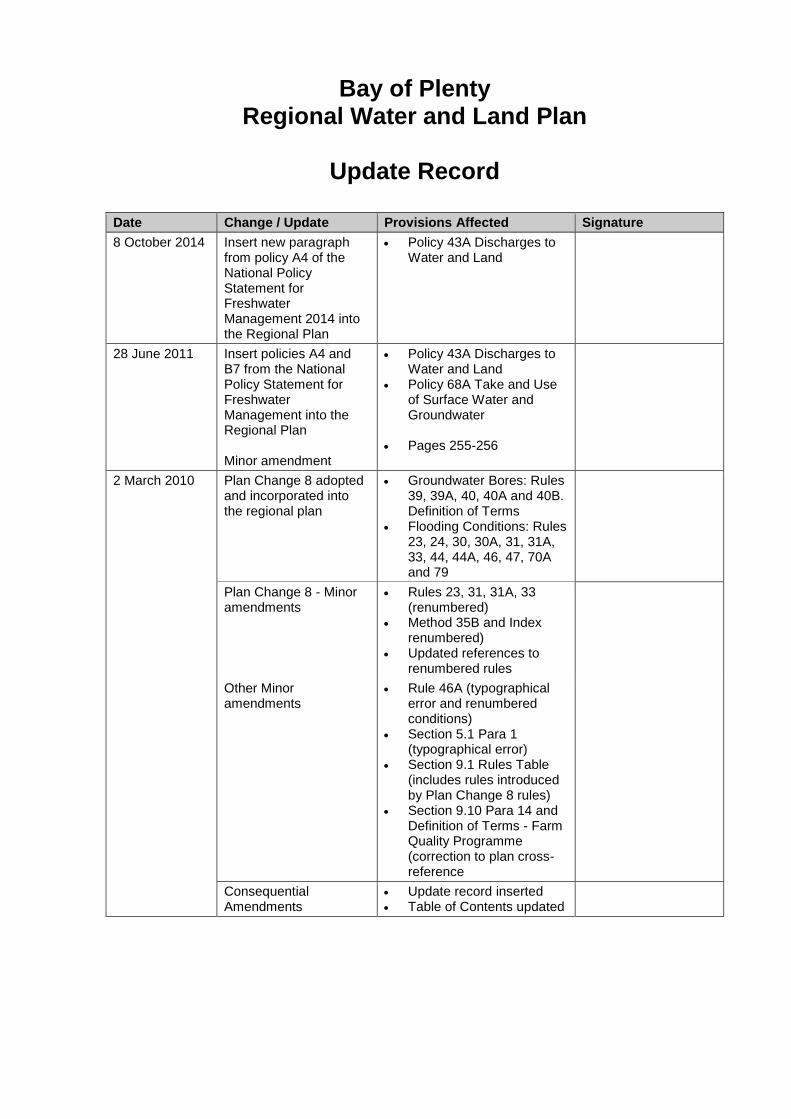
Bay of Plenty Regional Water and Land Plan
Update Record
Date Change / Update Provisions Affected Signature
8 October 2014 Insert new paragraph from policy A4 of the National Policy Statement for Freshwater Management 2014 into the Regional Plan
Policy 43A Discharges to Water and Land
28 June 2011 Insert policies A4 and B7 from the National Policy Statement for Freshwater Management into the Regional Plan Minor amendment
Policy 43A Discharges to Water and Land
Policy 68A Take and Use of Surface Water and Groundwater
Pages 255-256
2 March 2010 2 March 2010
Plan Change 8 adopted and incorporated into the regional plan
Groundwater Bores: Rules 39, 39A, 40, 40A and 40B. Definition of Terms
Flooding Conditions: Rules 23, 24, 30, 30A, 31, 31A, 33, 44, 44A, 46, 47, 70A and 79
Plan Change 8 - Minor amendments
Rules 23, 31, 31A, 33 (renumbered)
Method 35B and Index renumbered)
Updated references to renumbered rules
Other Minor amendments
Rule 46A (typographical error and renumbered conditions)
Section 5.1 Para 1 (typographical error)
Section 9.1 Rules Table (includes rules introduced by Plan Change 8 rules)
Section 9.10 Para 14 and Definition of Terms - Farm Quality Programme (correction to plan cross-reference
Consequential Amendments
Update record inserted Table of Contents updated


Bay of Plenty Regional Council PO Box 364 Whakatane New Zealand Strategic Policy Publication 2008/06 ISSN 1176 4112
BAY OF PLENTY REGIONAL WATER AND LAND PLAN
1 December 2008
Plan Change 8 (Groundwater Bores and Flooding Conditions) incorporated on 2 March 2010
Amended 28 June 2011 as required by National Policy Statement for Freshwater Management 2011
Amended 8 October 2014 as required by National Policy Statement for Freshwater Management 2014
Bay of Plenty Regional Council


1 December 2008 Bay of Plenty Regional Water and Land Plan Reader’s Guide
i
READER’S GUIDE
There may be some parts of this regional plan that are of particular interest to the reader. To find these parts, the following guide gives a brief summary of what each chapter is about.
Section 1 Introduction: names the regional plan; defines its geographical coverage and the resource management issues within its scope; and outlines the purpose of the regional plan.
Section 2 Kaitiakitanga: provisions to address section 6(e), 7(a) and 8 of the Resource Management Act 1991.
Section 3 The Integrated Management of Land and Water: provisions to address the integrated management of land and water resources in the Bay of Plenty region. Includes surface water and groundwater quality, soil conservation and land management practice issues (including riparian management), and effects of land cover on water quantity.
Section 4 Discharges to Water and Land: specific provisions to manage the adverse effects of discharges of contaminants to water and land, discharges of water to water, stormwater discharges, and discharges from existing contaminated sites. This chapter relates to section 15 of the Resource Management Act 1991.
Section 5 Water Quantity and Allocation: provisions to allocate surface and groundwater, manage the adverse effects of damming and diversion, address the artificial control of lake water levels, and manage flood hazards. This chapter relates to section 14 of the Resource Management Act 1991. Instream minimum flow requirements are established in this chapter.
Section 6 Beds of Rivers, Streams, Lakes and Wetlands: provisions to manage the effects of activities in, on, under or over the beds of rivers, streams, lakes, and land drainage canals. Covers structures, disturbances of the bed, deposition of substances, reclamation and drainage, introduction or removal of plants, and stock presence in the beds of surface water bodies. This chapter relates to section 13 of the Resource Management Act 1991.
Section 7 Geothermal Resources: provisions to manage the allocation, damming and diversion, discharge of geothermal heat, fluid and energy. Drilling of geothermal bores and geothermal hazards are also addressed. This chapter relates to sections 14 and 15 of the Resource Management Act 1991.
Section 8 Wetlands: provisions to protect and maintain wetlands in the region, and encourage the creation of new wetlands in appropriate areas.
Section 9 Regional Rules: contains regional rules relating to sections 3 to 8 of this regional plan.
Section 10 Financial Contributions: defines circumstances where financial contributions may be used in relation to activities controlled by this regional plan, and the amount of the financial contribution.
Section 11 Information to be submitted with Resource Consent Applications: directs resource consent applicants to contact Environment Bay of Plenty to ensure sufficient information is submitted with a consent application.
Section 12 Anticipated Environmental Results: the environmental outcomes that are expected as a result of provisions in this regional plan.
Section 13 Cross Boundary Issues: the methods and processes that will be used to identify and address resource management issues that cross the boundaries between districts, and between regional councils.
Section 14 Plan Review Process: the process that will be used to review this regional plan, and assess the effectiveness and efficiency of its provisions.
Schedules 1 to 14: Contain more detailed information and data related to the above sections necessary to the provisions and requirements of the regional plan.
Definition of Terms used in this regional plan.
Bibliography

Reader’s Guide Bay of Plenty Regional Water and Land Plan 1 December 2008
ii

1 December 2008 Bay of Plenty Regional Water and Land Plan Contents (updated 8 October 2014)
iii
Contents
Part I
1 Introduction ............................................................................................................................. 1 1.1 Citation ...................................................................................................................................... 1 1.2 Scope of Plan ............................................................................................................................ 1 1.3 Purpose of Plan ........................................................................................................................ 5 1.4 Role of Environment Bay of Plenty under the Act..................................................................... 6 1.5 Management of Land and Water Resources under the Act ..................................................... 9 1.6 Statutory Acknowledgements ................................................................................................... 9 1.7 Use of Guidelines and Standards ........................................................................................... 11 1.8 He Whakamohiotanga mo te Mahere a-Rohe e pa ana ki nga Wai me nga Whenua ............ 11
2 Kaitiakitanga .......................................................................................................................... 15 2.1 Kaitiakitanga............................................................................................................................ 18
Part II
3 The Integrated Management of Land and Water................................................................ 27 3.1 Issues ...................................................................................................................................... 27 3.2 Objectives ............................................................................................................................... 33 3.3 Policies .................................................................................................................................... 35 3.4 Methods of Implementation ..................................................................................................... 37 3.5 Explanation/Principal Reasons ............................................................................................... 50
4 Discharges to Water and Land ............................................................................................ 63 4.1 Discharges of Contaminants or Water to Water, and Discharges of Contaminants to
Land ........................................................................................................................................ 63 4.2 Discharge of Stormwater ........................................................................................................ 75 4.3 Contaminated Land ................................................................................................................. 84
5 Water Quantity and Allocation............................................................................................. 91 5.1 Take and Use of Surface Water and Groundwater................................................................. 91 5.2 Damming and Diversion of Water ......................................................................................... 108 5.3 Management of Flood Hazards and Land Drainage ............................................................. 112 5.4 Control of Water Levels in Natural Lakes ............................................................................. 115
6 Beds of Rivers, Streams, Lakes and Wetlands ................................................................ 121 6.1 Activities in the Beds of Rivers, Streams and Lakes ............................................................ 121 6.2 Stock in Surface Water Bodies ............................................................................................. 133
7 Geothermal Resources ....................................................................................................... 139 7.1 Geothermal Resources ......................................................................................................... 139
8 Wetlands .............................................................................................................................. 155 8.1 Wetlands ............................................................................................................................... 155
Part III
9 Regional Rules .................................................................................................................... 165 9.1 Guide to Rules ...................................................................................................................... 165 9.2 Land and Soil Disturbance Activities .................................................................................... 168 9.3 Grazing and Stock in the Beds of Surface Water Bodies ..................................................... 196 9.4 Discharges of Nitrogen or Phosphorus from Land Use and Discharge Activities in the
Rotorua Lakes Catchments .................................................................................................. 203 9.5 Discharges to Water and Land ............................................................................................. 219 9.6 Take and Use of Water ......................................................................................................... 242 9.7 Damming and Diversion of Water ......................................................................................... 248 9.8 Motu River and Specified Tributaries .................................................................................... 258

Contents Bay of Plenty Regional Water and Land Plan 1 December 2008 (updated 8 October 2014)
iv
9.9 Artificial Control of Water Levels in Natural Lakes ............................................................... 259 9.10 Activities in the Beds of Rivers, Streams, and Lakes ........................................................... 259 9.11 Geothermal Water, Heat or Energy ...................................................................................... 305 9.12 Wetlands .............................................................................................................................. 311
Part IV
10 Financial Contributions ..................................................................................................... 319 10.1 Circumstances, Purpose and Amount .................................................................................. 320 10.2 Matters to be considered ...................................................................................................... 322 10.3 General Provisions ............................................................................................................... 323
11 Information to be Submitted with Resource Consent Applications ............................. 325 11.1 General Information.............................................................................................................. 325 11.2 Land and Soil Disturbance Activities .................................................................................... 325 11.3 Activities Controlled by Rules in Section 9.4 ........................................................................ 326 11.4 Discharges to Water and Land ............................................................................................. 326 11.5 Take and Use of Water ........................................................................................................ 326 11.6 Activities in the Beds of Rivers, Streams or Lakes .............................................................. 327 11.7 Geothermal Resources ........................................................................................................ 327 11.8 Wetlands .............................................................................................................................. 328
12 Anticipated Environmental Results .................................................................................. 329 12.1 Kaitiakitanga ......................................................................................................................... 329 12.2 Water Quality ........................................................................................................................ 329 12.3 Soil Resources ..................................................................................................................... 330 12.4 Water Quantity ..................................................................................................................... 330 12.5 Beds of Streams, Rivers and Lakes ..................................................................................... 331 12.6 Geothermal Resources ........................................................................................................ 331 12.7 Wetlands .............................................................................................................................. 331 12.8 Ecosystems .......................................................................................................................... 331 12.9 Community Awareness of Environmental Issues ................................................................. 332
13 Cross Boundary Issues ..................................................................................................... 333 13.1 Processes to Address Cross-Boundary Issues .................................................................... 333
14 Plan Review Process ......................................................................................................... 335
Schedule 1 – Aquatic Ecosystem Areas ......................................................................................... 337
Schedule 2 – Fish Spawning and Migration Calendar ................................................................... 353
Schedule 3 – Watercourses in Land Drainage Schemes with Ecological Values ...................... 355
Schedule 4 – High Risk Facilities ..................................................................................................... 357
Schedule 5 – Maintenance Areas of River Schemes and Land Drainage Schemes ................... 359
Schedule 6 – Floodways in the Bay of Plenty ................................................................................ 371
Schedule 7 – Instream Minimum Flow Requirements ................................................................... 373
Schedule 8 – Approved Quality Assurance Programmes and Environmental Management Plans375
Schedule 9 – Water Quality Classification Standards and Criteria .............................................. 377 1 Natural State (Lake) Water Quality Classification ................................................................ 378 2 Natural State (River) Water Quality Classification ............................................................... 379 3 Managed State (Lake) Water Quality Classification ............................................................ 380 4 Aquatic Ecosystem (Bay of Plenty) Water Quality Classification ......................................... 380

1 December 2008 Bay of Plenty Regional Water and Land Plan Contents (updated 2 March 2010)
v
5 Contact Recreation Water Quality Classification ................................................................. 381 6 Water Supply Water Quality Classification........................................................................... 382 7 Modified Watercourses with Ecological Values Water Quality Classification ...................... 383 8 Drain Water Quality Classification........................................................................................ 384 9 Regional Baseline (Bay of Plenty) Water Quality Classification .......................................... 384
Schedule 10 – Freshwater Bathing Sites ........................................................................................ 387
Schedule 11 – Lawfully Existing Hydroelectric Power Schemes ................................................. 389
Schedule 12 – Forestry Operators Accreditation System............................................................. 391
Schedule 13 – Statutory Acknowledgements in the Bay of Plenty Region................................. 421
Schedule 14 – Standards for the Construction, Reconstruction, Maintenance or Decommissioning of Holes, Bores, Wells and Infiltration Galleries ............................................ 423
Definition of Terms............................................................................................................................ 425
Bibliography....................................................................................................................................... 449
Index.................................................................................................................................................... 451
Appendix 1 – Relevant Rules in Tarawera River Catchment (see inside back cover)
List of Figures
Figure 1 – Link between Identified Values and Environmental Standards...................................... 6
Figure 2 – Riparian Area ..................................................................................................................... 31
Figure 3 – Lake Water Quality Management Timetable ................................................................... 60
Figure 4 – Lake Action Plans and Regulation .................................................................................. 61
Figure 5 – Water Allocation Program ................................................................................................ 97
Figure 6 – Instream Minimum Flow Requirements Process ......................................................... 107
Figure 7 – Coverage of Rule 16 and 21............................................................................................ 225
Figure 8 – Measurement of Dam Height in Rule 46........................................................................ 253
Figure 9 – Upstream Ramp Design for Drift Decks........................................................................ 290
Figure 10 – Typical Cross Section Of The Rangitaiki Floodway .................................................. 372
Figure 11 – Bed of a River ................................................................................................................ 427
Figure 12 – Types of Wetlands......................................................................................................... 444
List of Maps
Map 1 – Bay of Plenty Region .............................................................................................................. 3
Map 2 – Rotorua Geothermal Field as Covered by the Rotorua Geothermal Regional Plan ..... 141
Map 3 – Geothermal Fields in the Bay of Plenty ............................................................................ 145

1 December 2008 Bay of Plenty Regional Water and Land Plan Contents (updated 2 March 2010)
vi
Map 4 – Upper Kaituna River Scheme Maintenance Area............................................................. 360
Map 5 – Lower Kaituna River Scheme Maintenance Area............................................................. 361
Map 6 – Tarawera River Scheme Maintenance Area...................................................................... 362
Map 7 – Rangitaiki River Scheme Maintenance Area I .................................................................. 363
Map 8 – Rangitaiki River Scheme Maintenance Area II ................................................................. 364
Map 9 – Whakatane-Waimana Rivers Scheme Maintenance Area ............................................... 365
Map 10 – Waiotahi River Scheme Maintenance Area..................................................................... 366
Map 11 – Waioeka-Otara River Scheme Maintenance ................................................................... 367
Map 12 – Lower Kaituna River Major Scheme Drainage Area ...................................................... 368
Map 13 – Waiotahi and Huntress Creek Drainage Districts .......................................................... 368
Map 14 – Rangitaiki Drainage District ............................................................................................. 369
Map 15 - Rangitaiki Floodway .......................................................................................................... 371
List of Tables
Table 1 – Environment Bay of Plenty’s Functions under the Act..................................................... 7
Table 2 – Methods of Promoting and Encouraging Sustainable Land and Water Management Practices........................................................................................................................ 38
Table 3 – Promotion of Environmental Programmes....................................................................... 43
Table 4 – Water Quality Classification Criteria................................................................................. 49
Table 5 – Trophic Level Indices (TLI) – Current and Management Goals...................................... 51
Table 6 – Explanation of TLI in Objective 11 .................................................................................... 53
Table 7 – Methods to Manage Lake Water Quality ........................................................................... 54
Table 8 – NERMN Modules Relevant to the Regional Plan.............................................................. 56
Table 9 – Lake Water Quality Programme (at 2005) ......................................................................... 56
Table 10 – Contaminant Discharge Requirements........................................................................... 67
Table 11 – Responsibilities for Stormwater Management............................................................... 82
Table 12 – Responsibilities for Contaminated Land ........................................................................ 87
Table 13 – Water Allocation Methodology ........................................................................................ 94
Table 14 – Water Allocation on Surface Water bodies with Hydroelectric Power Schemes ...... 95
Table 15 – Water Management during Drought and Low Flow Events ........................................ 102
Table 16 – Instream Minimum Flow Requirement Methodology .................................................. 103

1 December 2008 Bay of Plenty Regional Water and Land Plan Contents (updated 2 March 2010)
vii
Table 17 – Protection Levels for Aquatic Life................................................................................. 105
Table 18 – Environmental Standards for Damming and Diversion Activities ............................. 110
Table 19 – Requirements for the Artificial Control of Lake Water Levels.................................... 118
Table 20 – Potential Adverse Environmental Effects from Activities in, on, under or over the Beds of Streams, Rivers and Lakes .......................................................................................... 122
Table 21 – Requirements for Activities in, on, under or over the Beds of Streams, Rivers and Lakes ........................................................................................................................................... 125
Table 22 – Management of the Effects of the Use and Development of Geothermal Resources .......................................................................................................................................... 142
Table 23 – Geothermal Resource Allocation Methodology........................................................... 146
Table 24 – Management of the Discharge of Geothermal Water .................................................. 146
Table 25 – Classification of Geothermal Fields.............................................................................. 150
Table 26 – NERMN modules relevant to Geothermal Resources ................................................. 153
Table 27 – Responsibilities for Wetland Management................................................................... 162
Table 28 – Permitted Limits for Earthworks and Quarries ............................................................ 169
Table 29 – Controlled Earthworks.................................................................................................... 172
Table 30 – Restricted Discretionary Earthworks and Quarries .................................................... 174
Table 31 – Riparian Retirement Distance........................................................................................ 180
Table 32 – Permitted Vegetation Clearance in the Riparian Management Zone......................... 181
Table 33 – Permitted Threshold Limits for Forestry Earthworks by Accredited Operators ...... 186
Table 34 – Permitted Limits for Clearance of Vegetation by Burning.......................................... 190
Table 35 – Locations Where Cultivation is Not Permitted (Discretionary activity under Rule 5A) .............................................................................................................................................. 194
Table 36 – Rules in Rotorua Lakes .................................................................................................. 204
Table 37 – Section 9.4 Activities and Associated Rules................................................................ 205
Table 38 – Rule 11A-11E Mandatory Review Clause...................................................................... 206
Table 39 – Rule 11B Nutrient Benchmark Information Requirements ......................................... 210
Table 40 – Rule 11C Nutrient Benchmark Information Requirements ......................................... 212
Table 41 – Agrichemical Application in Riparian Areas ................................................................ 224
Table 42 – Rules for Damming and Diversion Activities ............................................................... 249
Table 43 – Rules for Structure and Bed Disturbance Activities ................................................... 260
Table 44 – Streams and Rivers for Rule 70A .................................................................................. 299
Table 45 – Exclusion Periods for Canal Maintenance Works ....................................................... 302

1 December 2008 Bay of Plenty Regional Water and Land Plan Contents (updated 2 March 2010)
viii
Table 46 – Circumstances and Purposes of Financial Contributions.......................................... 320
Table 47 – Whitebait and Juvenile Migration Summary ................................................................ 354
Table 48 – Spawning Summary........................................................................................................ 354
Flow Diagrams
Flow Diagram 1 – Earthworks and Quarries ................................................................................... 176
Flow Diagram 2 – Vegetation Clearance ......................................................................................... 185
Flow Diagram 3 – Forest Harvesting and Earthworks ................................................................... 189
Flow Diagram 4 – Clearance of Vegetation by Burning................................................................. 193
Flow Diagram 5 – Cultivation ........................................................................................................... 196
Flow Diagram 6 – Stock in the Bed of a River or Stream .............................................................. 200
Flow Diagram 7 – Controlled Stock Crossings .............................................................................. 202
Flow Diagram 8 – Discharges and Land Use Activities in the Rotorua Lakes Catchments ...... 218
Flow Diagram 9 – Stormwater Discharges...................................................................................... 237

1 December 2008 Bay of Plenty Regional Water and Land Plan Contents
ix
List of Abbreviations and Acronyms Act/The Act Resource Management Act 1991
AEP Annual Exceedance Probability
CSC Comprehensive Stormwater Consents
Environment Bay of Plenty Bay of Plenty Regional Council
IFIM Instream Flow Incremental Methodology
IMFR Instream Minimum Flow Requirement
LTCCP Long Term Council Community Plan
MALF Mean Annual Low Flow
NERMN Natural Environment Regional Monitoring Network
NZTA New Zealand Transport Agency
OSET Plan On-Site Effluent Treatment Regional Plan
RHYHABSIM River Hydraulic Habitat simulation
The/this regional plan Regional Water and Land Plan
TLI Trophic Level Index
WMA Wetland Management Agreement