Embed Size (px)
Citation preview

OpenSpirit "OpenSpirit "CartoCarto" Service" Service
The Next GenerationThe Next Generation

0204 2
Integration Problems
Applications can’t readily access data– Inconsistent, limited, or missing project
catalogs– Inconsistent formats– Mixed platforms– Wrong/unknown units and coordinates– Allowable values differ
UNIX Windows UNIX
Applications don’t interoperate– No sharing of user interaction
events– No sharing of data change events– Inconsistent user interface
conventions– No shared displays

0204 3
Approaches to Integration
One unified “standard” database– POSC– PPDM
Buy applications from a single vendor
Transfer data– Geoshare– other
- OpenSpirit CopySync
Use common middleware– OpenSpirit

0204 4
OpenSpirit IntegrationMake your G&G data available
through your GIS toolsView data from any project anywhere in your network
Kingdom*
Integration Framework
Plus applications from 24+ other
vendors
ArcView ExtensionSection Viewer Well ViewerOne-step data transfer between any OpenSpirit enabled datstore
Connect Your Applications
CopySync Excel Adapter Scan Utility3D Viewerdata access
user interaction
user interaction
data access
Connect Your Databases SEGY Gocad Finder OpenWorks GeoFrame Other…
* = in development
0204 5
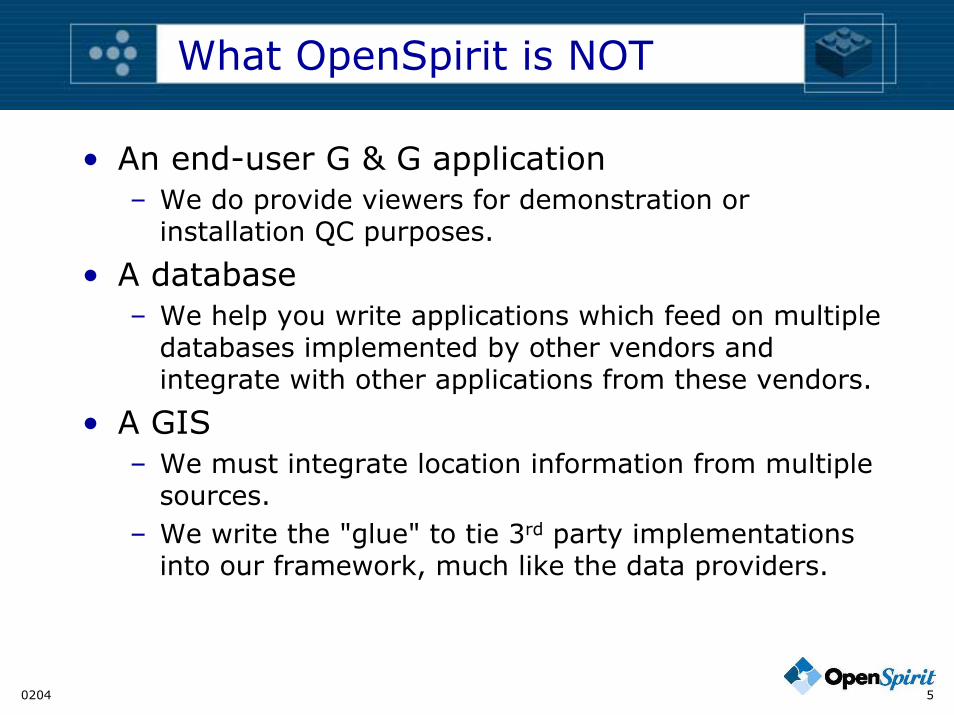
What OpenSpirit is NOT
• An end-user G & G application– We do provide viewers for demonstration or
installation QC purposes.
• A database– We help you write applications which feed on multiple
databases implemented by other vendors and integrate with other applications from these vendors.
• A GIS– We must integrate location information from multiple
sources.– We write the "glue" to tie 3rd party implementations
into our framework, much like the data providers.

0204 6
OpenSpirit Enabled Applications Currently Available
Application Vendor Application Application Vendor ApplicationA2D Silverwire Adaptor * Peleton Wellview *Earth Decision Sciences Gocad
Prime Geoscience PrimeViewESRI (OpenSpirit ArcView Exension) ArcView
Seismic Micro-Technology KingdomHampson-Russell (Veritas) eLog
Emerge SIS, GeoQuest CharismaISMap FlogridPRO4D GeoVizStrata IESX
Inside RealityKnowledge Systems Inc. Predict MathCube
PowerPlanMicrosoft (OpenSpirit Excel Adaptor) Excel SimCube
VarianceCube
Nutec Energy Services PrimaSIS, Merak (OpenSpirit Adaptor) Peep
Norsar Seismic Modeling
OpenSpirit Corporation 3D Viewer SIS, Petrel PetrelDataSelectorScan Utility VoxelVision GigaVizSection Viewer TerraStudioTabSelector * - prototype

0204 7
Framework Components
ServicesProjectProjectsetWellbore ListWellWellbore Well LogWell PickWell Velocity Drilling Target Earth ModelHorizon and Horizon Properties Fault2D Seismic Line and Dataset3D Seismic Survey and Dataset
Stratigraphic Grid
Platform/Bay/SlotTrajectory & Trajectory StationsDrill String & BHA ComponentsCasing/Liner
Business Objects
SubsurfaceData
Module
DrillingData
Module
in development
Attribute QueryCopyReference Value UnitsCoordinateData Store DescriptorUser AliasNotification (events)
Interaction Events
Object Selection Data SelectionData Change Area of Interest (AOI)Point of Interest (POI)Cursor LocationGIS Feature Selection

0204 8
Problem: Multiple Sources
GeoFrame
SEGY
OpenWorks

0204 9
Problem: Normalize Specifications
Projection parameter names from OWLoad Data OpenWorks
OSP Data Provider Normalize projectionparameter names
GeoFrame
Display CRS
CRS
LocCRS
Projection parametername mappings
OpenSpirit
Gocad
Finder
Metadata

0204 10
Problem: Broad platform req's
• Languages:– Java– C#– C++
• Operating Systems– Windows– UNIX
• Difficulties and solutions not discussed here

0204 11
Primary Functions of Carto
• "Tag" all locations with a CRS– Done by "data providers", which are written by
developers unfamiliar with geodesy
• Transform between CRS's when necessary– End-users are mostly unfamiliar with geodesy
• Express CRS in various ways for save/restore and exchange with other software
• Support custom system creation– I.e., support dialogs such as currently in OpenWorks
and GeoFrame applications.

0204 12
Implementation
OpenSpirit API
API Implementation
OpenSpirit SPI(Service Provider Interface)
OpenSpirit Metadata& EPSG DB
......ESRI SPI Impl BM SPI ImplMentor SPI Impl
ESRI Mentor Blue Marble
0204 13
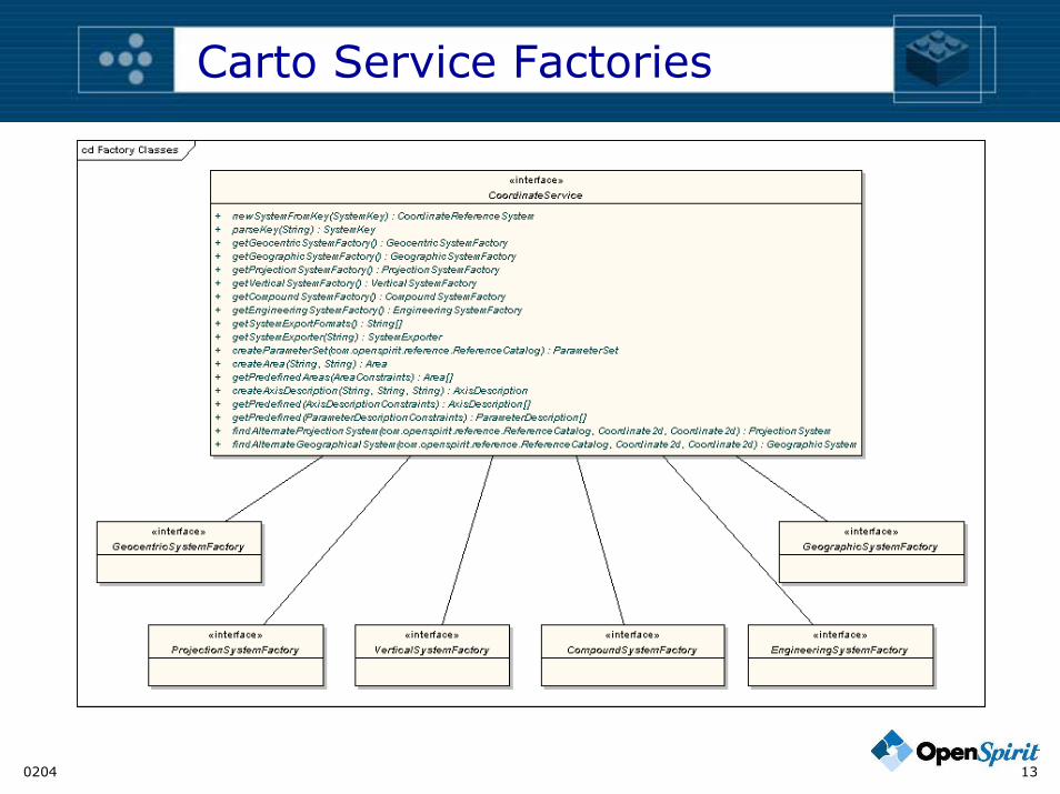
Carto Service Factories
0204 14
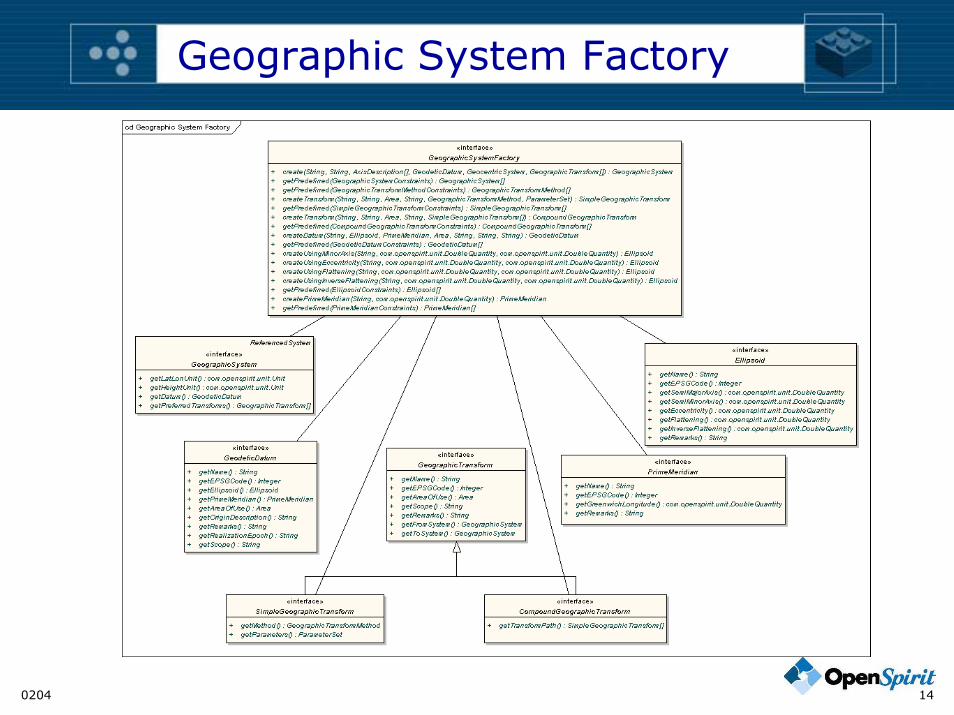
Geographic System Factory

0204 15
Supported System Types

0204 16
Compound Systems
CompoundSystemCompoundSystem CompoundSystem
VerticalSystem VerticalSystemVerticalSystem
GeographicSystem(2D)
GeographicSystem(3D)ProjectedSystem
VerticalSystem defines offset fromzero defined by GeographicSystem.
VerticalSystem defines vertical axis VerticalSystem defines vertical axis
0204 17
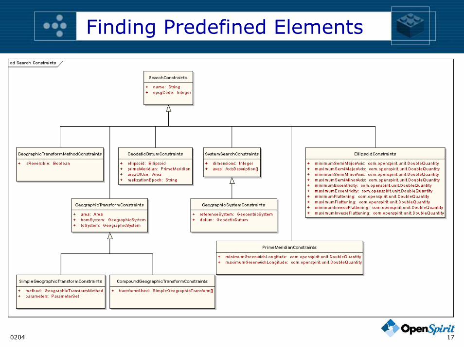
Finding Predefined Elements

0204 18
Alternate Systems
C1C1 Calt Calt
C2 C2Application Application
Server S Server S
C1
Carto Data Carto Data

0204 19
Systems, Conversions, Transforms
ProjectionVertical
CompoundEngineeringConversion
Engineering Engineering
Compound
Projection Vertical
ProjectionConversion Geographic
GeographicTransforms
GeocentricGeocentricTransforms
GeodeticDatum
ProjectionTransforms
Geographic
Geocentric

0204 20
Quality & Validity Boxes
Qua
lity
Validity Validity

0204 21
Normalizing Datum "Binding"
"Early binding" ofdatum & transform (to WGS84)
From ToED50 WGS84
Capture CRS definition in OSP terms,including "early binding" info
Display CRS
CRS
Loc
Transform
Separate datum& transform
CRS
From ToED50 WGS84
Metadata
Load Data OpenWorks
OSP Data Provider
OpenSpirit

0204 22
Conversions and Transforms

0204 23
Special Transform Conditions
• Ellipsoid-to-ellipsoid– GeographicSystem with "null" or unknown reference
GeocentricSystem.
• Skipping all geographic transformation– ProjectionSystem with "null" or unknown reference
GeographicSystem.
Prj Prj
GG
GC
NAD27
GC
GC
NULL GG
ED50GGNULL GC
WGS84
0204 24
Other Questions For APSG
• What implementations would most appeal to your users?
• Does EPSG have plans for any implementations?
• Does EPSG have plans for certification of providers of carto implementations?– How do we know the quality of the implementations
& metadata?